rbep 5.4 geologic hazards and resources - … are mapped to the southwest and northwest of the...
TRANSCRIPT

5.4 GEOLOGICAL HAZARDS AND RESOURCES
IS120911143723SAC/424103/122480006 5.4-1
5.4 Geological Hazards and ResourcesThis section presents an evaluation of the Redondo Beach Energy Project (RBEP) in terms of potential exposure togeological hazards and potential to affect geologic resources of commercial, recreational, or scientific value.Section 5.4.1 describes the existing environment that could be affected, including regional and local geology andgeological hazards. Section 5.4.2 identifies potential environmental effects from project development.Section 5.4.3 discusses potential cumulative effects. Section 5.4.4 discusses possible mitigation measures.Section 5.4.5 presents the laws, ordinances, regulations, and standards (LORS) applicable to geological hazardsand resources. Section 5.4.6 identifies regulatory agencies and agency contacts and Section 5.4.7 describes therequired permits. Section 5.4.8 provides the references used to develop this section.
5.4.1 Setting and Affected Environment
RBEP is a 496-megawatt (MW)1 natural-gas-fired power plant, consisting of one 3-on-1 combined-cycle gasturbine power block. The power block includes three combustion turbine generators (CTG), three supplemental-fired heat recovery steam generators (HRSG), one steam turbine generator (STG), an air-cooled condenser, andrelated ancillary equipment. RBEP will be constructed entirely within the existing approximately 50-acre RedondoBeach Generating Station site in Redondo Beach, California. The project will use the existing onsite potable water,natural gas, stormwater, process wastewater, and sanitary pipelines and electrical transmission facilities. Nooffsite linear developments are proposed as part of the project.
RBEP will use potable water, provided by the California Water Service Company, for construction water and foroperational process and sanitary uses. During RBEP operation, stormwater and process wastewater will bedischarged to a retention basin and then ultimately to the Pacific Ocean via an existing permitted outfall. Sanitarywastewater will be conveyed to the Los Angeles County Sanitation District via the existing City of Redondo Beachsewer connection. A new onsite 230–kilovolt (kV) transmission interconnection will connect the RBEP power blockto the existing onsite Southern California Edison (SCE) 230-kV switchyard.
Construction and demolition activities at the project site are anticipated to last 60 months, from January 2016until December 2020. The first activities to occur on site will be the dismantling and partial removal of existingUnits 1–4. The major generating equipment including steam turbines, generators, boilers, and duct work will beremoved, leaving the administration building and western portion of the building that houses Units 1–4 intact.These buildings will be left standing temporarily to provide screening between the construction site of the newpower block and Harbor Drive. Construction of the new power block will begin in the first quarter of 2017 andcontinue through to the end of the second quarter 2019, when it will be ready for commercial operation. Althoughoperational, construction will continue through 2019 including construction of the new control building and therelocation of the Wyland Whaling Wall. The existing Units 5–8 and auxiliary boiler no. 17 will remain in serviceuntil the second quarter of 2018. Units 5–8 and auxiliary boiler no. 17 will be demolished starting the first quarterof 2019 through the fourth quarter of 2020. During the demolition and removal of Units 5–8, the Wyland WhalingWall will be dismantled and moved to a new location directly in front of the new power block. Finally, theremaining buildings and structures left standing will be demolished and removed by the end of 2020.
All laydown and construction parking areas will be located within the existing Redondo Beach Generating Stationfence line, as shown in Figure 2.1-1. Approximately 17 acres onsite will be used for construction laydown andparking. All construction equipment and supplies will be trucked directly to the site.
5.4.1.1 Regional Geology
The project site is located on a gently sloping coastal terrace above the King Harbor marina in the northwest partof the city of Redondo Beach. The topography of site ranges from approximately 3 to 20 feet above mean sealevel (MSL). The RBEP site is bordered by North Harbor Drive and the King Harbor marina to the west, HerondoStreet to the north, and commercial properties to the east and south. The project site is situated in the
1 Referenced to site ambient average temperature (SAAT) conditions of 63.3°F dry bulb and 58.5°F wet bulb temperature.

5.4 GEOLOGICAL HAZARDS AND RESOURCES
5.4-2 IS120911143723SAC/424103/122480006
Los Angeles Basin at the northwest end of the Peninsular Ranges geomorphic province of southern California.Geologically, the Los Angeles Basin and vicinity is a region divided into four structural blocks that include upliftedzones and synclinal depressions. The structural blocks are generally bounded by north-northwest-trending faultswith both strike-slip and reverse motions. Many of the principal faults in the area have recent Holocene activity.The RBEP site is positioned within the Southwestern block which is bounded on the northeast by the onshoresegment of the Newport-Inglewood Fault Zone and on the southwest by the Palos Verdes Fault. The on-shoresegment of the Newport-Inglewood Fault is located approximately 7.5 miles northeast of the site and a segmentof the Palos Verdes Fault is located about 1 mile southwest of the site (Ninyo & Moore, 2011).
5.4.1.2 Local Geology and Stratigraphy
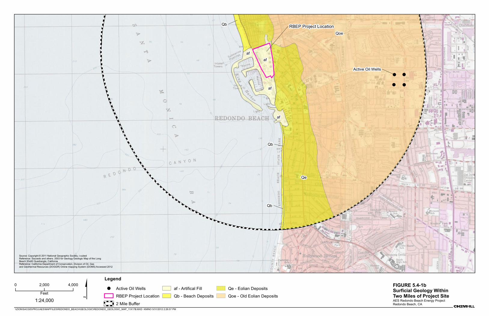
Available geologic mapping indicates that the RBEP site is underlain by artificial fill (Figure 5.4-1a,b). Eoliandeposits are mapped north and south of the project site and older eolian deposits are mapped to the east. Beachsediments are mapped to the southwest and northwest of the project site and form the shoreline of Santa MonicaBay from Redondo Beach southward to the Palos Verdes Peninsula. Artificial fill is mapped west of the project sitearound King Harbor. Subsurface geotechnical surveys were conducted by URS in 2001 and by Ninyo & Moore in2011 (see Appendix 5.4A). Ninyo & Moore (2011) indicate that the project site is underlain by artificial fill, youngerdune sand deposits, marsh deposits, and older dune sand deposits. Artificial fill was encountered at depthsranging from approximately 1 to 8 feet below ground surface (bgs). URS stated that fill ranges from 2 to 10 feetthick, and up to 20 feet thick in some places (Ninyo & Moore, 2011). Younger dune sand deposits primarilyconsisting of loose to dense, sand, silty sand, and clayey sand were encountered below the artificial fill to thedepths ranging from approximately 15 to 33 feet bgs. Marsh deposits were encountered in the central andsouthern parts of the project site interlayered with the younger dune sand deposits. The marsh deposits wereencountered from approximately 9 to 14 feet bgs and consist of firm, clayey silt and soft, sandy clay. URS statedthat marsh deposits are approximately 5 to 15 feet thick (Ninyo & Moore, 2011). The older dune sand depositswere encountered below the younger dune deposits and marsh deposits to the depths explored of approximately51.5 feet and consist primarily of very dense, sand and silty sand (Ninyo & Moore, 2011). Pleistocene, Pliocene,and Miocene rocks and sediments extend several thousand feet below these upper units and are important for oiland natural gas production (Department of Natural Resources, Division of Oil and Gas [DNRDOG], 1956). Beneaththese units and extending to unknown depths lies the crystalline basement rock of presumed Jurassic age(DNRDOG, 1956).
The California Geologic Survey (CGS) Seismic Hazard Zone report for the area indicates that the historical highgroundwater in the vicinity of the site is approximately 10 feet below the ground surface (Ninyo & Moore, 2011).Groundwater was observed during the 2011 subsurface geotechnical surveys at depths ranging from less than onefoot to approximately 14 feet below the existing site grades. Reported groundwater levels in 1952 ranged from2 feet above to 1 foot below MSL, which were similar to groundwater levels reported by URS in 2001 (Ninyo &Moore, 2011).
The 2011 Ninyo & Moore report is provided in Appendix 5.4A and has been used as a primary source ofinformation to support this geologic hazards and resources analysis. A second, more extensive geotechnicalinvestigation may be conducted to further assess site conditions to complete engineering design details prior tocommencement of site foundation construction activities.
5.4.1.3 Seismic Setting
Based on background review and site reconnaissance conducted by Ninyo & Moore (2011), the project site is nottransected by known active or potentially active faults. Known principal active faults within approximately20 miles of the project site include the Palos Verdes, Newport-Inglewood, Santa Monica, Puente Hills (blindthrust), Malibu Coast, Hollywood, Upper Elysian Park (blind thrust), and Anacapa-Dume (Table 5.4-1). The activeSan Andreas Fault zone is located approximately 50 miles northeast of the site. The San Joaquin Hills, Puente Hills,and Upper Elysian Park blind thrust faults are not mapped. Blind thrust faults are low-angle faults at depth that donot break the surface and are, therefore, not shown on the map. Although blind thrust faults do not have asurface trace, they can be capable of generating damaging earthquakes and are included in Table 5.4-1.

!
! !
!
af
af
Qb
Qoe
af
Qe
Qb
af
Qb RBEP Project Location
Active Oil Wells
\\ZION\SACGIS\PROJ\AES\MAPFILES\REDONDO_BEACH\GEOLOGIC\REDONDO_GEOLOGIC_MAP_11X17A.MXD KMINO 5/31/2012 2:25:39 PM
FIGURE 5.4-1aSurficial Geology Within Two Miles of Project SiteAES Redondo Beach Energy ProjectRedondo Beach, CA
$0 2,000 4,000Feet
Legend! Active Oil Wells
RBEP Project Location2 Mile Buffer
af - Artifical FillQb - Beach Deposits
Qe - Eolian DepositsQoe - Old Eolian Deposits1:24,000
Source: Copyright:© 2011 National Geographic Society, i-cubedReference: Saucedo and others. 2003 for Geology Geologic Map of the LongBeach 30x60 Quadrangle, CaliforniaReference: California Department of Conservation, Division of Oil, Gasand Geothermal Resources (DOGGR) Online mapping System (DOMS) Accessed 2012
!
! !
!
af
af
Qb
Qoe
Qe
af
Qb
af
Qb RBEP Project Location
Active Oil Wells
\\ZION\SACGIS\PROJ\AES\MAPFILES\REDONDO_BEACH\GEOLOGIC\REDONDO_GEOLOGIC_MAP_11X17B.MXD KMINO 5/31/2012 2:26:57 PM
FIGURE 5.4-1bSurficial Geology Within Two Miles of Project SiteAES Redondo Beach Energy ProjectRedondo Beach, CA
$0 2,000 4,000Feet
Legend! Active Oil Wells
RBEP Project Location2 Mile Buffer
af - Artifical FillQb - Beach Deposits
Qe - Eolian DepositsQoe - Old Eolian Deposits1:24,000
Source: Copyright:© 2011 National Geographic Society, i-cubedReference: Saucedo and others. 2003 for Geology Geologic Map of the LongBeach 30x60 Quadrangle, CaliforniaReference: California Department of Conservation, Division of Oil, Gasand Geothermal Resources (DOGGR) Online mapping System (DOMS) Accessed 2012

5.4 GEOLOGICAL HAZARDS AND RESOURCES
IS120911143723SAC/424103/122480006 5.4-7
The seismicity of the RBEP site area can be characterized as an area of moderate seismic activity, with potentiallylarge-magnitude earthquakes. Principal faults within 25 miles of the RBEP site are shown on Figure 5.4-2 Thesefaults include the Palos Verdes Fault (1.1 miles southeast), Newport-Inglewood Fault (7.7 miles east), SantaMonica Fault (13.7 miles north), Malibu Coast Fault (14.8 miles northwest), Hollywood Fault (16.2 milesnortheast), Anacapa-Dume Fault (17.6 miles northwest), Northridge (East Oak Ridge) Fault (21.1 miles northwest),Raymond Fault (21.2 miles northeast), Verdugo Fault (23.1 miles north), and the Whittier Fault (23.5 milesnortheast). Blind thrust faults such as the Puente Hills and Upper Elysian Park are not shown on the map (forreasons mentioned above) and are located 14.7 miles and 17.6 miles northeast of the RBEP site, respectively.
Other faults located between 25 and 50 miles farther to the east, north, and south include the Sierra Madre,San Joaquin Hills (blind thrust), Clamshell-Sawpit Canyon, San Jose, Santa Susana, San Gabriel, Simi-Santa Rosa,Chino-Central Avenue (Elsinore), Holser, Cucamonga, San Cayetano, Coronado Bank, and San Andreas faults.Some of these faults are capable of generating maximum earthquake magnitudes of 6.4 to 7.4 (Cao et al., 2003).These fault zones represent a significant potential seismic hazard to the project site. No faults have been mappedcrossing the RBEP site. The site is not within an Alquist-Priolo Special Studies Zone (CGS, 2007).
TABLE 5.4-1Regional Principal Active Faults
FaultApproximate Fault to Site
Distance Miles (km)a
Maximum MomentMagnitude (Mmax)
b Significant Historic Earthquakesc
Palos Verdes 1.1 (1.7) 7.3 —
Newport-Inglewood (L.A. Basin) 7.7 (12.4) 7.1 M6.4 Long Beach, 3/10/1933
Santa Monica 13.7 (22.1) 6.6 —
Puente Hills (Blind Thrust) 14.7 (23.6) 7.1 —
Malibu Coast 14.8 (23.8) 6.7 —
Hollywood 16.2 (26.0) 6.4 —
Upper Elysian Park (Blind Thrust) 17.6 (28.3) 6.4 —
Anacapa-Dume 19.6 (31.6) 7.5 —
Northridge (East Oak Ridge) 21.1 (34.0) 7.0 M6.7 Northridge, 1/7/1994
Raymond 21.2 (34.1) 6.5 —
Verdugo 23.1 (37.2) 6.9 —
Whittier 23.5 (37.8) 6.8 M5.9 Wittier Narrows, 10/1/1987(Workman Hill fault extension)
Sierra Madre 27.5 (44.3) 7.2 —
San Joaquin Hills (Blind Thrust) 28.5 (45.9) 6.6 —
Clamshell–Sawpit Canyon 32.0 (51.5) 6.5 M5.8 Sierra Madre, 6/28/1991
San Jose 32.1 (51.6) 6.4 M4.7 Upland, 6/28/1988M5.4 Upland, 2/28/1990
Santa Susana 32.3 (52.0) 6.7 —
San Gabriel 33.0 (53.1) 7.2 —
Simi-Santa Rosa 35.9 (57.7) 7.0 —
Chino-Central Ave. (Elsinore) 35.2 (56.6) 6.8 M6 Elsinore, 5/15/1910
Holser 37.2 (59.8) 6.5 —
Cucamonga 42.6 (68.6) 6.9 —
San Cayetano 45.7 (73.5) 7.0 —
Coronado Bank 48.3 (77.7) 7.6 —
San Andreas – Mojave/1857 Rupture 50.7 (81.5) 7.4 M7.9 Fort Tejon, 1/9/1857aBlake, 2001
bCao, et al., 2003
cSouthern California Earthquake Center (SCEC), 2004
From Ninyo & Moore (2011)

5.4 GEOLOGICAL HAZARDS AND RESOURCES
5.4-8 IS120911143723SAC/424103/122480006
5.4.1.4 Potential Geological Hazards
The following subsections discuss the potential geological hazards that might occur in the project area.
5.4.1.4.1 Ground Rupture
Ground rupture is caused when an earthquake event along a fault creates rupture at the surface. As discussedabove, the existing Redondo Beach Generating Station is not transected by known active or potentially active faults,thus the potential for surface fault rupture affecting the project is relatively low (Ninyo & Moore, 2011). The site isnot within an Alquist-Priolo Special Studies Zone (CGS, 2007).
5.4.1.4.2 Seismic Shaking
The project area has experienced seismic activity with strong ground motion during past earthquakes, and it islikely that strong earthquakes causing seismic shaking will occur in the future. The significant geological hazard atthe RBEP site is strong ground-shaking due to an earthquake. Ground shaking from a magnitude 7.4 earthquakecould occur within an approximately 50-mile radius of the project site (Blake, 2004).
In order to evaluate the level of ground shaking that might be anticipated at the project location, an analysis wasperformed by Ninyo & Moore. The 2010 California Building Code (CBC) recommends that the design of structuresbe based on the horizontal peak ground acceleration (PGA) having a 2 percent probability of exceedance in50 years, which is defined as the Maximum Considered Earthquake (MCE).
Using the U.S. Geological Survey ground motion calculator, the probabilistic horizontal peak ground accelerationMaximum Considered Earthquake (PGAMCE) for the project site was estimated to be 0.81g. The design peakground acceleration design basis earthquake (PGADBE) was estimated to be 0.54g using the USGS ground motioncalculator. These estimates of ground motion do not include near-source factors that may be applicable to thedesign of structures onsite. The guidelines of the governing jurisdictions and the 2010 CBC will be considered inthe project design. These potential levels of ground shaking could impact the RBEP without appropriate designmitigation, and will be considered during the detailed design phase of the project (Ninyo & Moore, 2011).
5.4.1.4.3 Liquefaction
During strong ground shaking, loose, saturated, cohesionless soils can experience a temporary loss of shearstrength and act as a fluid. This phenomenon is known as liquefaction. Liquefaction depends on the depth towater, grain size distribution, relative soil density, degree of saturation, and intensity and duration of theearthquake. The potential hazard associated with liquefaction is seismically induced settlement.
The RBEP site is mapped in a State of California Seismic Hazard Zone as potentially liquefiable. The evaluation ofthe potential for liquefaction included the results of cone penetration test (CPT) soundings, exploratory boringsand laboratory test results of representative soil samples. The liquefaction analysis was based on the NationalCenter for Earthquake Engineering Research (NCEER) procedure developed from the methods originallyrecommended by Seed and Idriss using the computer program LiquefyPro. A depth to groundwater of 2 feet wasused in the analysis. A PGADBE of 0.54g was used in the analysis for a design earthquake magnitude of 7.7. Theanalysis of soil profiles at the four CPT locations indicated that scattered saturated sandy alluvial layers locatedbetween depths of approximately 2 and 38 feet are potentially liquefiable during the design basis earthquakeevent (Ninyo & Moore, 2011).
To evaluate the potential impact from liquefaction, an analysis to estimate the magnitude of dynamic settlementdue to liquefaction was performed. Analyses indicate that liquefaction-induced settlement at the project sitewould be approximately 2 inches or less (Ninyo & Moore, 2011). Liquefaction-induced settlement estimates byURS ranged from 1 to 7 inches in various locations at the project site (Ninyo & Moore, 2011).
Ninyo and Moore’s Borings B-1 and B-2 located in the area of the new power block encountered medium dense tovery dense sandy soils, which are generally favorable soil conditions. Loose sandy soils were encountered in theCPT-2 boring on the southern edge of the power block area. The results of the liquefaction analysis of the datafrom CPT-2 indicated a potential for approximately 1.5 inches of liquefaction-induced settlement in the sandy soilsextending to a depth of approximately 16 feet.

&
&
&
&
&
&
&
&
&
&
&
&
&
&
&
&
&
&
&
&
&
PacificOcean
NEWPORT-
INGLEWOOD
FAULT
ZONE
PALOSVERDES
FAULTZONE
SANTA M
ONICA
FAULT
HOLLYW
OOD
FAULT RAYMO
ND FAULT
WHITTIERFAULT
SIERRA MADRE FAULT ZONECLAM
SHELL S
AWPIT
CANYON
FAULT
SAN FERNANDOFAULT
VERDUGO FAULT
MALIBU COAST FAULT
SIMIFAUL
T
OAKRIDGEFAULT
SAN CAYETANO
FAULT
SAN GABRIELFAULT
ZONE
SIERRA MADREFAULT ZONE
·|}þ60§̈¦710
§̈¦5
§̈¦10
§̈¦5
§̈¦405
§̈¦405
§̈¦110
§̈¦710
§̈¦10
§̈¦105
CHATSWORTH FAULT
CHARNOCKFAULT
CHINO- CENTRAL
AVE.FAULT
SANJOSE
FAULT
CUCAMO
NGAFAU
LT
§̈¦405
§̈¦5
§̈¦5
·|}þ91·|}þ91
§̈¦15
OFFSHOR
OF DEFO
SITE
Irvine
Orange
Pomona
Downey
Ontario
Van Nuys
Alhambra
PasadenaGlendale
Torrance
El Monte
Fullerton
Santa Ana
Inglewood
West CovinaLos Angeles
Simi Valley
Laguna Beach
Santa Monica
Newport Beach
GIS DATA SOURCE: CALIFORNIA GEOLOGICAL SURVEY (CGS); ENVIRONMENTAL SYSTEMS RESEARCH INSTITUTE (ESRI)
±10 0 10
Miles
REFERENCE: JENNINGS, 1994, FAULT ACTIVITY MAP OF CALIFORNIA AND ADJACENT AREAS
NOTE: ALL DIMENSIONS, DIRECTIONS, AND LOCATIONS ARE APPROXIMATE
LEGENDFAULT ACTIVITY:
QUATERNARY (POTENTIALLY ACTIVE)
HISTORICALLY ACTIVE
HOLOCENE ACTIVE
LATE QUATERNARY(POTENTIALLY ACTIVE)
COUNTY BOUNDARIES
Source: Ninyo & Moore, 10/2011.
IS120911143723SAC Figure_5.4-2.ai tdaus 05.30.2012
FIGURE 5.4-2Fault Locations AES Redondo Beach Energy ProjectRedondo Beach, California

5.4 GEOLOGICAL HAZARDS AND RESOURCES
IS120911143723SAC/424103/122480006 5.4-11
The results of the Ninyo and Moore exploration and the previous geotechnical evaluations at the site indicate thatthe area where the power block will be situated will take advantage of the most favorable conditions on the site.This area will also include the presence of some adverse soil conditions, including potentially compressible soilsand soils with potential for liquefaction-induced settlement. Additional detailed subsurface exploration will beperformed to further evaluate the subsurface conditions in the area of new construction prior to final design.
Lateral spreading of the ground surface during an earthquake usually takes place along weak shear zones thathave formed within a liquefiable soil layer. Lateral spread has generally been observed to take place in thedirection of a free-face (such as, retaining wall, slope, channel) but has also been observed to a lesser extent onground surfaces with gentle slopes. Based on analysis of sampler blow counts and the generally discontinuousnature of the underlying soil layers, the project site is not considered susceptible to significant seismically inducedlateral spread (Ninyo & Moore, 2011).
5.4.1.4.4 Compressible/Collapsible Soils
Compressible soils generally consist of soils that undergo consolidation when exposed to new loading, such as fillor foundation loads. Soil collapse is a phenomenon where the soils undergo a significant decrease in volume uponincrease in moisture content, with or without an increase in external loads. Buildings, structures and otherimprovements may be subject to excessive settlement-related distress when compressible soils or collapsible soilsare present. Subsurface exploration and background review conducted during the various geotechnicalinvestigations indicate that the project site is underlain by existing fill soils, alluvial deposits, marsh deposits, andolder dune sand deposits. Older, undocumented fill soils are considered potentially compressible (Ninyo & Moore,2011). In addition, some relatively softer (firm) marsh deposits and soft clayey alluvium were encountered, whichare considered potentially compressible. Due to the high groundwater levels encountered at the site and thereported historically high groundwater, Ninyo & Moore (2011) concluded that the site soils are not susceptible tohydro-collapse. The site-specific potential for compressible soils at the RBEP site will be evaluated during thedetailed design stage of the project to provide recommendations to mitigate the potential impacts ofcompressible soils (Ninyo & Moore, 2011).
5.4.1.4.5 Mass Wasting
Mass wasting depends on steepness of the slope, underlying geology, surface soil strength, and moisture in thesoil. Significant excavating, grading, or fill work during construction might introduce mass wasting hazards at theproject site. RBEP construction would result in ground surface disruption during demolition, excavation, grading,and trenching that would create the potential for erosion to occur. However, a Storm Water Pollution PreventionProgram incorporating best management practices for erosion control will be prepared prior to the start ofconstruction. In addition, the topographic gradients at the project site are relatively gentle, which would tend toreduce the potential for offsite runoff and erosion. During RBEP operation, surface drainage design provisions andsite maintenance will manage soil erosion at the site. Therefore, the potential impacts due to mass wasting anderosion are considered to be relatively low (Ninyo & Moore, 2011).
5.4.1.4.6 Subsidence
Subsidence can be caused by natural phenomena during tectonic movement, consolidation, hydrocompaction, orrapid sedimentation. Subsidence also can occur from human activities, such as withdrawal of water orhydrocarbons in the subsurface soils. Historic oil and gas withdrawal has resulted in significant ground subsidencein areas of the City of Long Beach. The RBEP site is not located in an area of significant oil or gas development. Afew scattered oil wells are present within approximately 2,000 feet east of the site, but major oil fielddevelopments are located in Torrance and Wilmington, located approximately 3 miles or more to the east andsoutheast (Ninyo & Moore, 2011). The project site is not located in an area of known historic subsidence.Therefore, the potential for subsidence is relatively low.
5.4.1.4.7 Expansive Soils
Expansive soils shrink and swell with wetting and drying. The shrink-swell capacity of expansive soils can result indifferential movement beneath foundations. Based on our subsurface exploration, the near-surface soils at the

5.4 GEOLOGICAL HAZARDS AND RESOURCES
5.4-12 IS120911143723SAC/424103/122480006
RBEP site predominantly consist of silty sand and sand which typically have a low-expansion potential, but clayey(expansive) soils have been encountered at depth. The site-specific potential for expansive soils at the RBEP sitewill be evaluated during the detailed design stage of the project to provide recommendations to mitigate thepotential impacts of expansive soils (Ninyo & Moore, 2011).
5.4.1.4.8 Seiches and Tsunamis
Tsunamis are seismically induced ocean waves with very long periods. Tsunamis may be manifested in the form ofwave bores or a gradual upwelling of sea level and can be caused by landslides or earthquakes. Water surgecaused by tsunamis is measured by distance of run-up on the shore. Tsunamis are relatively uncommon hazards inCalifornia. Seven tsunamis have been recorded in California. In southern California, a significant tsunami wasassociated with the 1960 Chile Earthquake. Damage occurred in the Long Beach–Los Angeles harbor, where5-foot-high waves surged back and forth in channels, causing damage to small boats and yachts. Tsunami tidalsurge occurred in the Long Beach Harbor due to the magnitude 8.8 Chile earthquake in February 2010, and minoreffects were reported at King Harbor in Redondo Beach and in Long Beach Harbor due to the March 2011 Japantsunami.
Seiches are defined as oscillations in confined or semi-confined bodies of water due to earthquake shaking. Ofmost concern are seiches that are caused by tsunamis captured and reflected within the enclosed area of an innerharbor such as those that occurred in Los Angeles–Long Beach following the 1964 Alaskan earthquake. Seichearea damage would be most severe in the same areas as tsunami hazards.
The RBEP site is not located in a State of California Tsunami Inundation Area mapped for susceptibility run-uphazard (Ninyo & Moore, 2011). Therefore, there is a low potential for tsunami run-up at the project site. However,the western side of the project site is located along the border of a tsunami run-up hazard zone. Because thewestern side of the project site is located along the border of a tsunami run-up hazard zone, it may be appropriateto evaluate the potential effects of tsunami run-up hazard for this part of the site during the detailed design phaseof the project (Ninyo & Moore, 2011).
5.4.1.4.9 Groundwater
Based on the background review conducted by Ninyo & Moore (2011), historical high groundwater levels at theRBEP site have been mapped at a depth of approximately 10 feet (California Department of Conservation, Divisionof Mines and Geology [CDMG], 1997). During subsurface exploration, groundwater was encountered at depthsranging from less than 1 foot to approximately 14 feet below the ground surface. The groundwater depthvariability encountered in the borings was primarily due to the difference in the ground surface elevations of theborings. Further, Dames & Moore reportedly recorded groundwater levels in 1952 ranging from approximately2 feet above to 1 foot below MSL, and URS recorded similar groundwater levels in 2001 (Ninyo & Moore, 2011).Based on the reported data by Dames & Moore and URS, and the groundwater levels encountered by Ninyo &Moore (2011), the groundwater at the project site has been documented at an elevation ranging fromapproximately 2 feet above to 1 foot below MSL. Therefore, groundwater may be encountered during excavationactivities in the lower areas of the site (Ninyo & Moore, 2011). Groundwater, if encountered, could have potentialimpacts on project-related excavations and construction activities. Therefore, the potential impacts ofgroundwater should be evaluated prior to detailed design and construction, particularly in areas of deeperexcavations.
5.4.1.5 Geologic Resources of Recreational, Commercial, or Scientific Value
The CGS and the State Mining and Geology Board (SMGB) classify the regional significance of mineral resources inaccordance with the California Surface Mining and Reclamation Act of 1975. The SMGB uses a classificationsystem that divides land into four mineral resource zones (MRZ) that have been designated based on quality andsignificance of mineral resources. According to the State of California, the RBEP site is located in an area classifiedas MRZ-3, which is defined as “areas containing mineral the significance of which cannot be evaluated fromavailable data.” At the RBEP site, the geologic units at the surface and in the subsurface are widespread alluvialand dune sand deposits that occur throughout the Redondo Beach area; these units are not unique in terms ofrecreational, commercial, or scientific value (Ninyo & Moore, 2011). Significant mineral deposits are not present

5.4 GEOLOGICAL HAZARDS AND RESOURCES
IS120911143723SAC/424103/122480006 5.4-13
in the project area as identified in the Los Angeles County General Plan (Mineral and Energy Resources)(Los Angeles County, 2011). In 1982, the CDMG published a comprehensive mineral land classification foraggregate materials in the Los Angeles County area. Based on this investigation, the RBEP site is mapped as anarea with no aggregate significance. Based on the Los Angeles County General Plan (Los Angeles County, 2011)and the City of Redondo Beach General Plan (City of Redondo Beach, 1992) there are no known active areas ofmining for mineral resources near the RBEP site.
The city of Redondo Beach lies within the Torrance oil field, but major oil field developments are locatedapproximately 3 miles or more to the east and southeast in the city of Torrance and even further east/southeasttoward the city of Wilmington. According to online maps of the California Division of Oil, Gas and GeothermalResources (CDOGGR) (2012), the majority of oil wells within the Torrance oil field in the vicinity of the RBEP sitehave been plugged and are no longer active, including all wells within the City of Redondo Beach field locatedadjacent to the southwestern portion of the project site. Four active oil wells are located approximately 1.5 mileseast of the project site (Figure 5.4-1a,b).
There are no known geologic resources of recreational, commercial, or scientific value present at the RBEP site,thus, project construction would have no effect on oil and gas production or on other geologic resources ofcommercial value or on the availability of such resources.
5.4.2 Environmental AnalysisThe potential effects from construction and operation of RBEP, and the demolition of the existing Units 1–8 atRedondo Beach Generating Station on geologic resources and risks to life and property from geological hazardsare presented in the following sections. With the implementation of the mitigation measures presented below,RBEP will not result in significant direct, indirect, or cumulative geology-related impacts.
5.4.2.1 Significance Criteria
According to Appendix G of the California Environmental Quality Act, a project would have a significantenvironmental impact in terms of geological hazards and resources if it would do the following:
Expose people or structures to potential substantial adverse effects, including the risk of loss, injury, or deathinvolving:
Rupture of a known earthquake fault (Alquist-Priolo Fault Zone) Strong seismic ground shaking Seismic-related ground failure, including liquefaction
Be located on a geologic unit or soil that is unstable or that would become unstable as a result of the project,and potentially result in on- or offsite landslide, lateral spreading, subsidence, liquefaction, collapse,expansion, or consolidation settlement
Result in the loss of availability of a known mineral resource that would be of value to the region and theresidents of the state
Result in the loss of availability of a locally important mineral resource recovery site delineated on a localplan, specific plan, or other land use plan
5.4.2.2 Geological Hazards
There is significant potential for seismic ground shaking to affect the RBEP site in the event of a large-magnitudeearthquake occurring on fault segments near the project site. RBEP, however, is not located within anAlquist-Priolo Special Studies Zone or within the trace of any known active fault. RBEP would, therefore, not belikely to cause direct human exposure to ground rupture. Seismic hazards will be minimized by conformance withthe recommended seismic design criteria of the 2010 CBC. Liquefaction potential, potential for consolidationsettlement, potential for expansive soils, and elevated groundwater levels present at the project site will beconsidered during project design. If, during project design, it is determined that the above mentioned geologic
5.4 GEOLOGICAL HAZARDS AND RESOURCES
5.4-14 IS120911143723SAC/424103/122480006
hazards are present at the project site, then the following mitigation alternatives could be implemented to reducethe potential risk to a less than significant level.
Mitigation alternatives for potential dynamic settlement related to liquefaction include supporting structures ondeep pile foundations that extend through the liquefiable zones into competent material. Alternatively,densification of the liquefiable soils using in situ ground improvement techniques such as vibro-replacementstone columns, rammed aggregate piers or compaction grouting would mitigate the liquefaction hazard and thenew structures could then be supported on shallow foundation systems (Ninyo & Moore, 2011).
To mitigate potential settlement at the site, the major power generating structures can be supported on pilefoundations or in situ ground improvement zones designed to limit settlement to acceptable levels so thatstructures are not adversely affected. To mitigate potential settlement for other relatively light, minor structures,new pavements and hard-scape, loose/soft soils encountered at the subgrade and foundation levels of theseimprovements during construction can be removed and replaced with suitable compacted fill, based on detaileddesign stage recommendations (Ninyo & Moore, 2011).
The potential for expansive soils to affect project improvements can be mitigated by techniques such as removalof near-surface expansive soils and replacement with low expansive material during construction, or designingproject improvements to resist the effects of expansive soils (Ninyo & Moore, 2011).
During the design phase of the project, additional evaluation of groundwater and fluctuations in groundwaterlevels should be performed. The near-term impacts associated with groundwater are anticipated to involveconstruction excavations and possible belowgrade structures. Excavations that extend below groundwater wouldinvolve construction dewatering to maintain excavations in a relatively dry condition. Belowgrade structures thatextend below groundwater, including pipelines, vaults, and retention basins, would be designed to resisthydrostatic uplift pressures due to groundwater and would involve waterproofing, as appropriate. Long-termgroundwater impacts may involve rising groundwater levels associated with predicted sea level rises.
The probability of mass wasting, subsidence, or flooding at the project site is low to negligible.
In summary, compliance with the 2010 CBC requirements will reduce the exposure of people to the risksassociated with large seismic events, liquefaction potential, expansive soils, and compressive soils toless-than-significant levels. Additionally, major structures will be designed to withstand the strong ground motionof a Design Basis Earthquake (DBE), as defined by the 2010 CBC. Through compliance with CBC standards, impactsassociated with geological hazards will be less than significant.
5.4.2.3 Geological Resources
RBEP will not result in a loss of availability of a known mineral resource that would be of value to the region andthe residents of the state. Additionally, RBEP will not result in the loss of availability of a locally important mineralresource recovery site delineated on a local plan, specific plan, or other land use plan. There are no suchresources that have been identified on or near the site, so there will be no adverse impacts on geologicalresources.
5.4.3 Cumulative EffectsA cumulative impact refers to a proposed project’s incremental effect together with other closely related past,present, and reasonably foreseeable future projects whose impacts may compound or increase the incrementaleffect of the proposed project (Public Resources Code § 21083; California Code of Regulations, Title 14,§ 15064(h), 15065(c), 15130, and 15355).
Because structures will be designed to meet seismic requirements of the 2010 CBC, the RBEP will not cause anexposure of people or property to geological hazards. There are no minor impacts related to geological hazardsthat could combine cumulatively with those of other projects. RBEP will have no impact on geological resources,and does not have the potential to cause cumulative impacts on geological resources. Thus, the project will notresult in a cumulatively considerable impact.
5.4 GEOLOGICAL HAZARDS AND RESOURCES
IS120911143723SAC/424103/122480006 5.4-15
5.4.4 Mitigation MeasuresTo address potential impacts related to geological hazards, the following mitigation measures are proposed forthe RBEP:
Structures will be designed to meet seismic requirements of the 2010 CBC. Moreover, the design of plantstructures and equipment will be in accordance with 2010 CBC earthquake design requirements to withstandthe ground motion of a DBE.
A geotechnical engineer will be assigned to the project to carry out the duties required by the CBC to assessgeologic conditions during construction and approve actual measures used to protect the facility from thegeological hazards discussed in Section 5.4.2.2.
With the implementation of these mitigation measures, RBEP will not result in significant direct, indirect, orcumulative geology-related impacts.
5.4.5 Laws, Ordinances, Regulations, and StandardsThe LORS that may apply to RBEP related to geologic resources and hazards are summarized in Table 5.4-2. Thelocal LORS discussed in this section are ordinances, plans, or policies of the City of Redondo Beach. There are nofederal LORS that apply to geological hazards and resources.
5.4.5.1 State LORS
5.4.5.1.1 California Building Code
The CBC provides specific and acceptable design criteria for excavations and structures for static and dynamicloading conditions. The CBC is based on the Federal Uniform building Code. The project will comply with the CBCby ensuring that RBEP design and construction meet the criteria for the seismic design and load-bearing capacity(see Section 5.4.2).
5.4.5.1.2 Alquist-Priolo Earthquake Fault Zoning Act
The main purpose of the Alquist-Priolo Earthquake Fault Zoning Act is to prevent the construction of buildingsused for human occupancy on the surface trace of active faults. Although the project is subject to the Alquist-Priolo Earthquake Fault Zoning Act, the project features are not located within areas identified as subject tosurface rupture from active faults (see Section 5.4.2).
5.4.5.1.3 Seismic Hazards Mapping Act
The purpose of the Seismic Hazards Mapping Act is to ensure public safety from the effects of strong groundshaking, liquefaction, landslides, or other ground failure, and other hazards caused by earthquakes. The projectwill conform to this Act by conducting analysis for potential seismic hazards at the RBEP site (see Section 5.4.2).
5.4.5.2 Local LORS
5.4.5.2.1 City of Redondo Beach
The Environmental Hazards Element of the City’s General Plan is intended to protect the public from the effects ofnatural geologic hazards. According to the City General Plan, new construction must comply with the UniformBuilding Code to withstand geologic hazards including groundshaking and liquefaction. The project will conform tothis element of the City’s General Plan (see Section 5.4.2).
5.4 GEOLOGICAL HAZARDS AND RESOURCES
5.4-16 IS120911143723SAC/424103/122480006
TABLE 5.4-2Laws, Ordinances, Regulations, and Standards for Geological Hazards and Resources
LORSRequirements/
Applicability Administering AgencyAFC Section Explaining
Conformance
State
2010 CBC Acceptable design criteria forstructures with respect toseismic design and load-bearingcapacity
California Code, State ofCalifornia, and City of RedondoBeach
Section 5.4.2.2
Alquist-Priolo EarthquakeFault Zoning Act (Title 14,Division 2, Chapter 8,Subchapter 1, Article 3,California Code of Regulations)
Identifies areas subject tosurface rupture from activefaults
California Building StandardsCommission, State of California,and City of Redondo Beach
Section 5.4.2.2
The Seismic Hazards MappingAct (Title 14, Division 2, Chapter8, Subchapter 1, Article 10,California Code of Regulations)
Identifies non-surface faultrupture earthquake hazards,including liquefaction andseismically induced landslides
California Building StandardsCommission, State of California,and City of Redondo Beach
Section 5.4.2.2
Local
City of Redondo BeachMunicipal Code (City ofRedondo Beach, 2012), Title 9,Building Regulations
Requires compliance with 2010California Building Code
City of Redondo Beach Section 5.4.2.2
5.4.6 Agencies and Agency ContactsThere are no agencies or contacts associated with geologic hazards and resources.
5.4.7 Permits and Permit ScheduleBecause the project falls under the exclusive jurisdiction of the California Energy Commission, no permits arerequired for compliance with geological LORS.
5.4.8 ReferencesBlake, T.F. 2004. EQSEARCH, A Computer Program for the Estimation of Peak Acceleration from CaliforniaEarthquake Catalogs.
California Building Code. 2010 Edition, July.
California Division of Oil, Gas, and Geothermal Resources (CDOGGR). 2012. Oil and Gas Field Maps.http://www.consrv.ca.gov/dog.- Accessed April 2012.
California Department of Conservation, Division of Mines and Geology (CDMG). 1997. Guidelines for Evaluatingand Mitigating Seismic Hazards in California: Special Publication 117, 74 p.
California Geological Survey (CGS). 2007. Special Publication 42 (Interim Revision 2007). Fault-Rupture HazardZones in California. Alquist-Priolo Earthquake Fault Zoning Act. California Department of Conservation.
Cao, T., W. A. Bryant, B. Rowshandel, D. Branum, David, and C. J. Wills. 2003. The Revised 2002 CaliforniaProbabilistic Seismic Hazard Maps, Adapted by California Geological Survey (CGS). June.
City of Redondo Beach (Redondo Beach). 1992. City of Redondo Beach General Plan. May.
City of Redondo Beach (Redondo Beach). 2012. City of Redondo Beach Municipal Code. February.
Department of Natural Resources, Division of Oil and Gas (DNRDOG). 1956. Summary of Operations, California OilFields. Forty Second Annual Report of the State Oil and Gas Supervisor, 42:2, 226 p.
5.4 GEOLOGICAL HAZARDS AND RESOURCES
IS120911143723SAC/424103/122480006 5.4-17
Los Angeles County Department of Regional Planning. 2011. Los Angeles County Draft General Plan 2035.http://planning.lacounty.gov/generalplan/draft
Ninyo & Moore. 2011. Preliminary Geotechnical Evaluation, Redondo Beach Generating Station 1100 NorthHarbor Drive, Redondo Beach, California. October
Southern California Earthquake Center. 2004. Index of Faults of California.http://www.data.scec.org/fault_index/, dated June 17.