stormwater utility manual city of racine, wisconsin€¦ · alderman sollman ___-___, 2004...
TRANSCRIPT

Stormwater Utility Manual City of Racine, Wisconsin ______________________________________________________________________________________________
TABLE OF CONTENTS
Section 1 STORMWATER UTILITY ORDINANCE SECTION 98-201 2 STORMWATER UTILITY RATE RESOLUTION 3 STORMWATER UTILITY CREDITS RESOLUTION 4 STORMWATER UTILITY CREDITS AND REBATES MANUAL 5 CREDIT AND REBATE EXAMPLES 6 SAMPLE CUSTOMER BILLS AND BILL INSERT (2004) 7 STORMWATER UTILITY PROCEDURAL FLOW CHARTS - Demolition - Additions - New Construction - New Paving 8 CONSTRUCTION SITE EROSION CONTROL
- Ordinance Section 98-301 - Erosion Control Permit Flow Chart - Erosion Control Plan Checklist - Erosion Control Diary/Inspection Form 9 POST-CONSTRUCTION STORMWATER MANAGEMENT ORDINANCE SECTION 98-401 - Ordinance Section 98-401 - Post Construction Flow Chart - Stormwater Management Plan Checklist 10 BILLING FILE UPDATE TIMELINE 11 ROOT RIVER GROUP WPDES (WDNR NR216) STORMWATER DISCHARGE PERMIT 12 STORMWATER UTILITY BUDGET
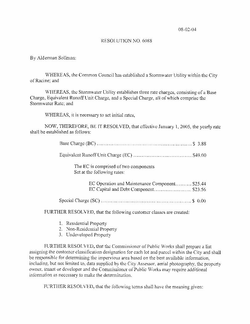
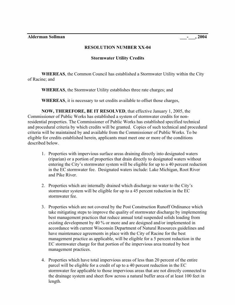
Alderman Sollman ___-___, 2004
RESOLUTION NUMBER XX-04
Stormwater Utility Credits
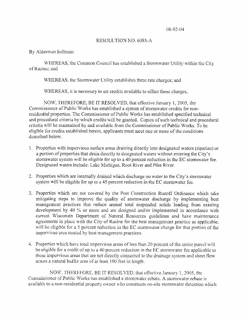
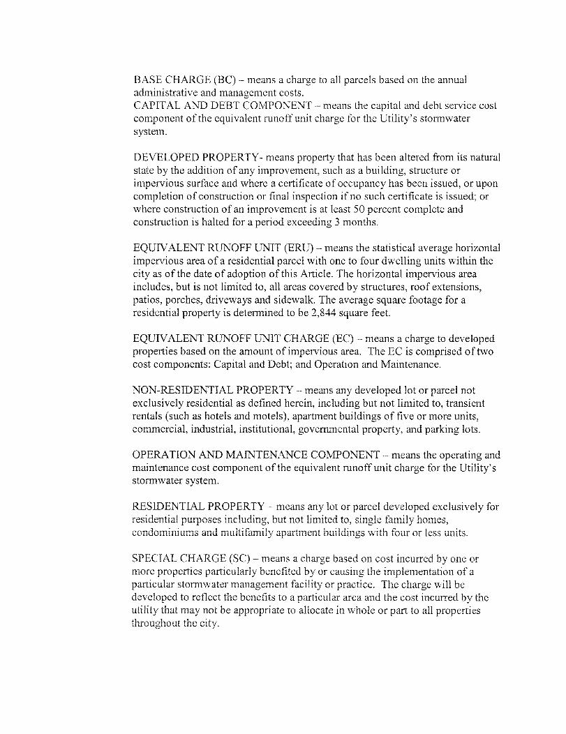
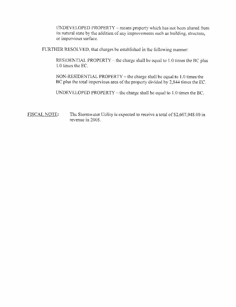
WHEREAS, the Common Council has established a Stormwater Utility within the City of Racine; and WHEREAS, the Stormwater Utility establishes three rate charges; and WHEREAS, it is necessary to set credits available to offset those charges, NOW, THEREFORE, BE IT RESOLVED, that effective January 1, 2005, the Commissioner of Public Works has established a system of stormwater credits for non-residential properties. The Commissioner of Public Works has established specified technical and procedural criteria by which credits will be granted. Copies of such technical and procedural criteria will be maintained by and available from the Commissioner of Public Works. To be eligible for credits established herein, applicants must meet one or more of the conditions described below.
1. Properties with impervious surface areas draining directly into designated waters (riparian) or a portion of properties that drain directly to designated waters without entering the City’s stormwater system will be eligible for up to a 40 percent reduction in the EC stormwater fee. Designated waters include: Lake Michigan, Root River and Pike River.
2. Properties which are internally drained which discharge no water to the City’s
stormwater system will be eligible for up to a 45 percent reduction in the EC stormwater fee.
3. Properties which are not covered by the Post Construction Runoff Ordinance which
take mitigating steps to improve the quality of stormwater discharge by implementing best management practices that reduce annual total suspended solids loading from existing development by 40 % or more and are designed and/or implemented in accordance with current Wisconsin Department of Natural Resources guidelines and have maintenance agreements in place with the City of Racine for the best management practice as applicable, will be eligible for a 5 percent reduction in the EC stormwater charge for that portion of the impervious area treated by best management practices.
4. Properties which have total impervious areas of less than 20 percent of the entire
parcel will be eligible for a credit of up to a 40 percent reduction in the EC stormwater fee applicable to those impervious areas that are not directly connected to the drainage system and sheet flow across a natural buffer area of at least 100 feet in length.
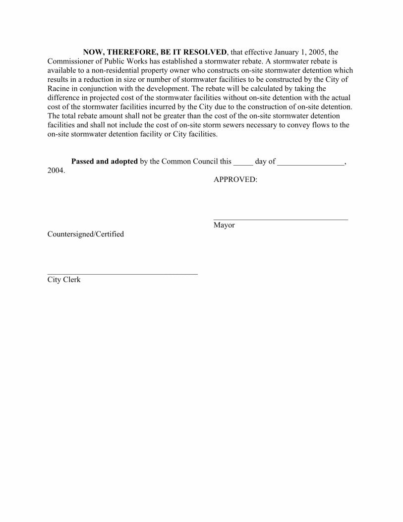
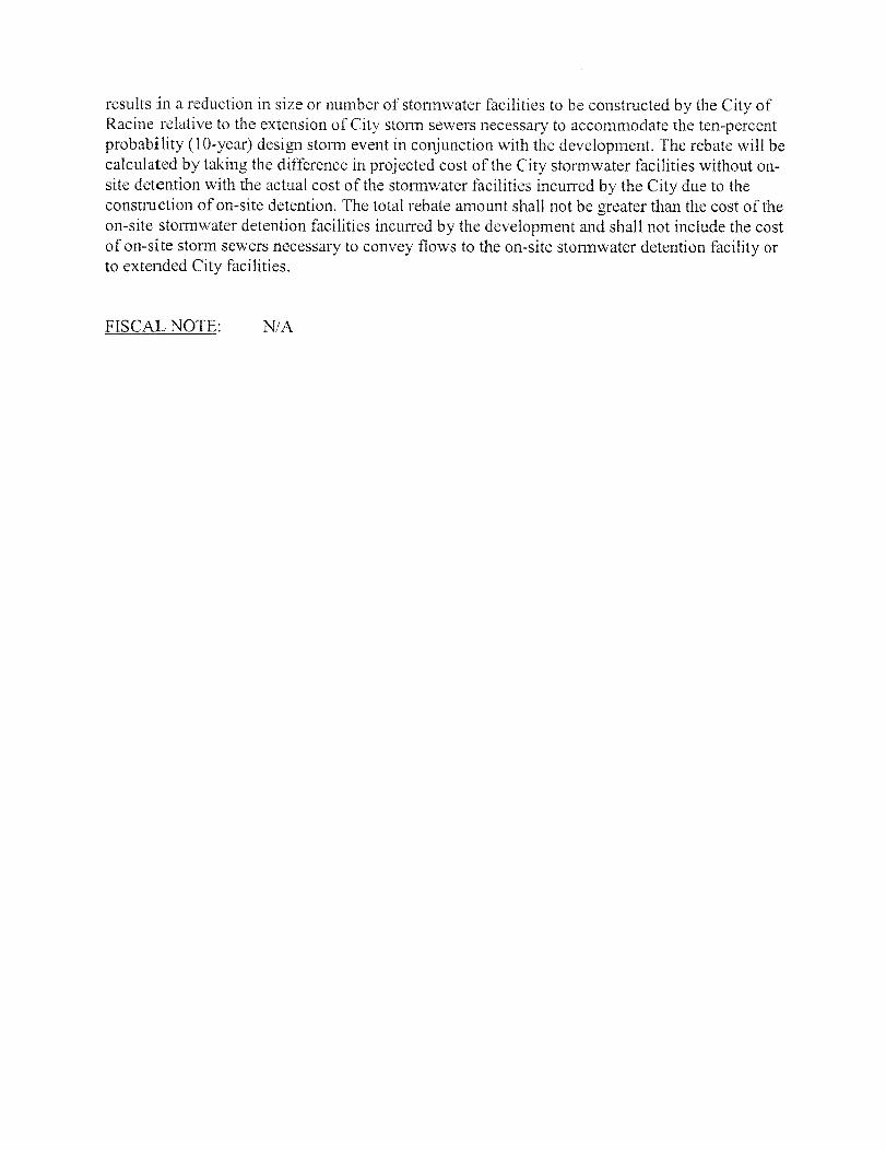
NOW, THEREFORE, BE IT RESOLVED, that effective January 1, 2005, the Commissioner of Public Works has established a stormwater rebate. A stormwater rebate is available to a non-residential property owner who constructs on-site stormwater detention which results in a reduction in size or number of stormwater facilities to be constructed by the City of Racine in conjunction with the development. The rebate will be calculated by taking the difference in projected cost of the stormwater facilities without on-site detention with the actual cost of the stormwater facilities incurred by the City due to the construction of on-site detention. The total rebate amount shall not be greater than the cost of the on-site stormwater detention facilities and shall not include the cost of on-site storm sewers necessary to convey flows to the on-site stormwater detention facility or City facilities. Passed and adopted by the Common Council this _____ day of _________________, 2004. APPROVED: __________________________________ Mayor Countersigned/Certified ______________________________________ City Clerk
Report
Stormwater Utility Credits and Rebates Manual Prepared for the:
City of Racine Prepared by: 730 Washington Avenue Racine, WI 53403 Prepared by: Earth Tech, Inc. 1020 N. Broadway, Suite 400 Milwaukee, WI 53202 January 2005
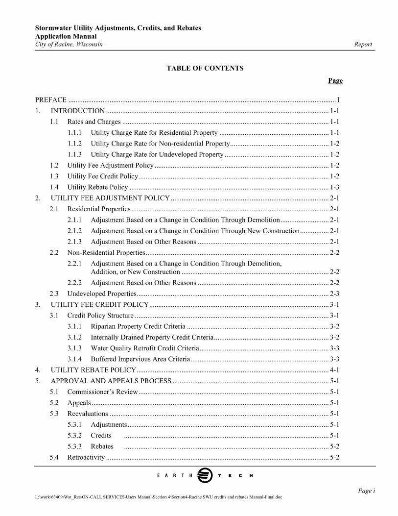
Stormwater Utility Adjustments, Credits, and Rebates Application Manual City of Racine, Wisconsin Report
e
TABLE OF CONTENTS
Page PREFACE ..................................................................................................................................................... I 1. INTRODUCTION ............................................................................................................................ 1-1
1.1 Rates and Charges ................................................................................................................... 1-1 1.1.1 Utility Charge Rate for Residential Property ............................................................. 1-1 1.1.2 Utility Charge Rate for Non-residential Property....................................................... 1-2 1.1.3 Utility Charge Rate for Undeveloped Property .......................................................... 1-2
1.2 Utility Fee Adjustment Policy ................................................................................................. 1-2 1.3 Utility Fee Credit Policy.......................................................................................................... 1-2 1.4 Utility Rebate Policy ............................................................................................................... 1-3
2. UTILITY FEE ADJUSTMENT POLICY........................................................................................ 2-1 2.1 Residential Properties .............................................................................................................. 2-1
2.1.1 Adjustment Based on a Change in Condition Through Demolition........................... 2-1 2.1.2 Adjustment Based on a Change in Condition Through New Construction................ 2-1 2.1.3 Adjustment Based on Other Reasons ......................................................................... 2-1
2.2 Non-Residential Properties...................................................................................................... 2-2 2.2.1 Adjustment Based on a Change in Condition Through Demolition,
Addition, or New Construction .................................................................................. 2-2 2.2.2 Adjustment Based on Other Reasons ......................................................................... 2-2
2.3 Undeveloped Properties........................................................................................................... 2-3 3. UTILITY FEE CREDIT POLICY.................................................................................................... 3-1
3.1 Credit Policy Structure ............................................................................................................ 3-1 3.1.1 Riparian Property Credit Criteria ............................................................................... 3-2 3.1.2 Internally Drained Property Credit Criteria................................................................ 3-2 3.1.3 Water Quality Retrofit Credit Criteria........................................................................ 3-3 3.1.4 Buffered Impervious Area Criteria............................................................................. 3-3
4. UTILITY REBATE POLICY........................................................................................................... 4-1 5. APPROVAL AND APPEALS PROCESS ....................................................................................... 5-1
5.1 Commissioner’s Review.......................................................................................................... 5-1 5.2 Appeals .................................................................................................................................... 5-1 5.3 Reevaluations .......................................................................................................................... 5-1
5.3.1 Adjustments................................................................................................................ 5-1 5.3.2 Credits .................................................................................................................. 5-1 5.3.3 Rebates .................................................................................................................. 5-2
5.4 Retroactivity ............................................................................................................................ 5-2
Page i L:\work\63409\Wat_Res\ON-CALL SERVICES\Users Manual\Section 4\Section4-Racine SWU credits and rebates Manual-Final.doc
Stormwater Utility Adjustments, Credits, and Rebates Application Manual City of Racine, Wisconsin Report
e
LIST OF APPENDICES Appendix A City of Racine Stormwater Utility Fee Adjustment Submittal Requirements and Form B City of Racine Stormwater Utility Fee Credit Submittal Requirements and Form
C. City of Racine Stormwater Utility Rebate Submittal Requirements and Form
Page ii L:\work\63409\Wat_Res\ON-CALL SERVICES\Users Manual\Section 4\Section4-Racine SWU credits and rebates Manual-Final.doc
Stormwater Utility Adjustments, Credits, and Rebates Application Manual City of Racine, Wisconsin Report
e
PREFACE
Send Application Forms to: City of Racine Department of Public Works Attn: Stormwater Utility Credit 730 Washington Avenue Racine, WI 53403
For Questions Regarding the Application, Contact: James Blazek, P.E. City Engineer Jim.Blazekcityofracine.org (262) 636-9191
This document outlines the policies and procedures for providing adjustments, credits, and rebates to customers of the City of Racine stormwater utility. Only non-residential properties are eligible for credits and rebates. Both residential and non-residential properties are eligible for adjustments. The application procedure for the Racine Stormwater Utility is summarized below. Application Procedure: 1. Each applicant must complete the required form(s) and furnish the required information. Forms may be found
with this application, or on the City web page: http://www.cityofracine.org. 2. A one-time application fee of $200 must accompany each application. Application fees are non-refundable
unless noted otherwise. Make Checks Payable to: City of Racine.
3. The Department of Public Works (Department) will conduct an initial review of the application to check the application forms for completeness and accuracy.
4. If the application is found to be complete and accurate, a letter will be sent to the applicant’s contact person
within thirty (30) calendar days of receipt notifying approval of the requested change. 5. If deficiencies are found during the review, a deficiency letter will be sent to the applicant’s contact person.
Upon receipt of additional and complete information from the applicant, the review will resume and be completed within thirty (30) calendar days of receipt of the additional information.
6. Submittal of any application form is an acknowledgement of the City of Racine’s (City) right-of-entry to
inspect and verify the information submitted on said application. 7. Once approved, adjustments and credits will be granted retroactive to the most recently paid stormwater
utility bill only, if applicable. Adjustments and credits will be reflected on future billings as long as the conditions that warranted the change are still applicable and any necessary subsequent compliance reviews are satisfactory. Rebates are paid out after approval and no modification to future billings is necessary.
Page I L:\work\63409\Wat_Res\ON-CALL SERVICES\Users Manual\Section 4\Section4-Racine SWU credits and rebates Manual-Final.doc
Stormwater Utility Adjustments, Credits, and Rebates Application Manual City of Racine, Wisconsin Report
e
8. If an application is denied, a letter explaining the reasons for the denial will be provided to the applicant. 9. The applicant has the right to appeal this decision, in accordance with the procedures outlined in Section 98-
202(i) of the City of Racine Municipal Code (adopted May, 2004) relating to the Stormwater Utility.
Page II L:\work\63409\Wat_Res\ON-CALL SERVICES\Users Manual\Section 4\Section4-Racine SWU credits and rebates Manual-Final.doc
Stormwater Utility Adjustments, Credits, and Rebates Application Manual City of Racine, Wisconsin Report 1. INTRODUCTION
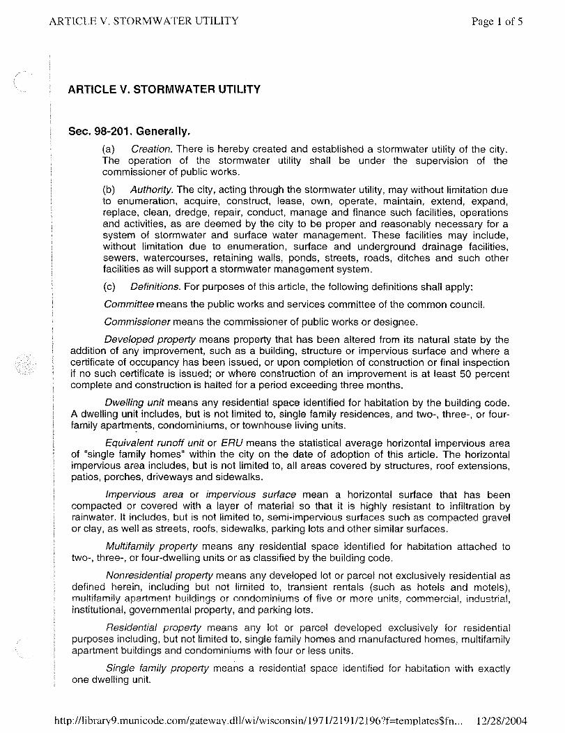
The Common Council of the City of Racine, Wisconsin created a stormwater utility by ordinance (Section 98-201 of the Municipal Code) in May of 2004 to provide an equitable, stable funding source for the City's stormwater management services. The primary revenue source for the stormwater utility is a fee charged to all developed properties in the City. Stormwater service charges to a property are related to the relative cost of services provided to safely and properly collect, convey, store, treat, and dispose of the stormwater runoff from the property.
The area of impervious surfaces is the most important factor influencing the cost of the stormwater management services, systems, and facilities for developed properties and is therefore the most appropriate parameter for calculating a periodic stormwater service charge for developed properties. An Equivalent Runoff Unit or "ERU" means the statistical average horizontal impervious area of “single family homes” within the City on the date of adoption of the ordinance. The horizontal impervious area includes, but is not limited to, all areas covered by structures, roof extensions, patios, porches, driveways and sidewalks. One ERU is equal to 2,844 square feet of impervious area. 1.1 Rates and Charges
The rate structure components are established for all properties in the City of Racine according to Section 98-202 of the Municipal Code and the Common Council establishes current rates through resolution. The three rate components are: 1. Base charge (BC); 2. Equivalent runoff unit charge (EC); and 3. Special charge (SC). 1. Base charge: means a charge to all parcels based on the annual administrative and management costs.
2. Equivalent runoff unit charge: means a charge to developed properties based on the amount of impervious
area. The EC is comprised of two cost components: Capital and Debt; and Operation and Maintenance. 3. Special charge. Means a charge based on cost incurred by one or more properties particularly benefited or
served by or causing the implementation of a particular stormwater management facility or practice. The charge will be developed to reflect the equitable allocation of the costs incurred by the utility that may not be appropriate to allocate in whole or part to all properties throughout the City.
The Common Council has elected to set rates for the Base charge (BC) and Equivalent runoff unit charge (EC). The Common Council has not elected to establish a rate for the Special charge (SC) at this time. 1.1.1 Utility Charge Rate for Residential Property
Residential property means any lot or parcel developed exclusively for residential purposes including, but not limited to, single family homes and manufactured homes, multifamily apartment(s) of four or less units, and condominiums.
e
Page 1-1 L:\work\63409\Wat_Res\ON-CALL SERVICES\Users Manual\Section 4\Section4-Racine SWU credits and rebates Manual-Final.doc
Stormwater Utility Adjustments, Credits, and Rebates Application Manual City of Racine, Wisconsin Report
e
The residential property charge is equal to 1.0 times the BC rate plus 1.0 times the EC rate. Residential properties are NOT eligible for Credits or Rebates but may be eligible for an adjustment if the impervious area on the property is less than 285 square feet. 1.1.2 Utility Charge Rate for Non-residential Property
Non-residential property means any developed lot or parcel not exclusively residential as defined herein, including but not limited to, transient rentals (such as hotels and motels), multifamily apartment(s) of five or more units, commercial, industrial, institutional, governmental property, and parking lots. The non-residential property charge is equal to 1.0 times the BC rate plus the total impervious area of the property in square feet divided by the ERU (2,844 square feet) times the EC rate. 1.1.3 Utility Charge Rate for Undeveloped Property
Undeveloped property means property which has not been altered from its natural state by the addition of any improvements such as building, structure, or impervious surface. The undeveloped charge is equal to 1.0 times the BC rate. Undeveloped properties are NOT eligible for Adjustments, Credits, or Rebates. 1.2 Utility Fee Adjustment Policy
The number of ERUs assigned to properties will remain fixed unless physical changes are made that alter the amount of the impervious surface area, or in the event that the original impervious area was improperly calculated. Typically, these changes will be triggered through the building or demolition permitting process. In these cases, billing changes will be made by the beginning of the next billing period. Residential properties are assigned one ERU. This value will not change unless the parcel has less than 285 square feet of impervious surfaces to make it essentially undeveloped. Undeveloped properties are NOT eligible for adjustments. This policy is further discussed in Section 2 of this document. 1.3 Utility Fee Credit Policy
The City of Racine has developed a system of credits for non-residential stormwater service customers who: 1. Discharge all or a portion of the stormwater directly into the Lake Michigan, the Root River or the Pike River
without entering a municipal stormwater conveyance system (riparian properties).
2. Are internally drained and discharge no stormwater to the municipal stormwater conveyance system (internally drained properties).
3. Construct facilities or have controls in place to treat stormwater runoff from their property, thereby reducing the impact of flow and improving runoff water quality to receiving waters (water quality retrofit).
Page 1-2 L:\work\63409\Wat_Res\ON-CALL SERVICES\Users Manual\Section 4\Section4-Racine SWU credits and rebates Manual-Final.doc
Stormwater Utility Adjustments, Credits, and Rebates Application Manual City of Racine, Wisconsin Report
e
4. Have impervious areas totaling less than 20 percent of the entire parcel area and where those impervious areas drain across at least 100 feet of vegetative (native vegetation or grassed) area prior to entering the municipal conveyance system.
Undeveloped and residential properties are NOT eligible for credits. This policy is further discussed in Chapter 3 of this document. 1.4 Utility Rebate Policy
The City of Racine has developed a system to allow a one-time rebate for non-residential stormwater service customers that construct on-site stormwater detention facilities that reduce the size or number of City facilities necessary to be extended to serve the development. Undeveloped and residential properties are NOT eligible for rebates. This policy is further discussed in Chapter 4 of this document.
Page 1-3 L:\work\63409\Wat_Res\ON-CALL SERVICES\Users Manual\Section 4\Section4-Racine SWU credits and rebates Manual-Final.doc
Stormwater Utility Adjustments, Credits, and Rebates Application Manual City of Racine, Wisconsin Report
e
2. UTILITY FEE ADJUSTMENT POLICY
The purpose of this Chapter is to present the process for making numeric adjustments to the ERU value assigned to a particular property. In general, the number of ERUs assigned to a property will remain fixed unless physical changes are made that alter the amount of the impervious surface area, or in the event that the original impervious area was improperly calculated. Property owners are required to submit adjustment applications on or before February 28th to be eligible for a refund of any portion of the prior year’s fees. Applications received after February 28th will have any appropriate adjustment applied to the following years only and will not receive a credit on the prior year payment. 2.1 Residential Properties
Developed residential properties are assigned one ERU. This value will not change unless the parcel has less than 285 square feet of impervious surfaces to make it essentially undeveloped. 2.1.1 Adjustment Based on a Change in Condition Through Demolition
If the residential and garage structures are demolished on a residential parcel and it is determined that the remaining impervious surfaces, if any, are not significant contributors to the City’s stormwater system, an adjustment can be made to reduce the fee component of the residential stormwater utility charge to that of an undeveloped property, which requires only that the base charge be assessed. No building, garage, structure, or other impervious surfaces totaling 285 square feet or greater should remain on the property to be considered not a significant contributor. The necessary application forms, fees, and requirements are outlined by the City of Racine Building Department. There are no additional application forms, fees, or requirements necessary to make this adjustment. Upon completion of the demolition approval process, the City will make the fee adjustment for subsequent billings. No retroactive payment is due the owner through this process. The resulting future charge will be equal to 1.0 times the BC rate. 2.1.2 Adjustment Based on a Change in Condition Through New Construction
If a property is undeveloped, and the owner builds a residence or other structure or installs significant impervious surfaces, an adjustment must be made to increase the fee component of the residential stormwater utility charge to that of a developed residential property, requiring that the base charge and equivalent runoff unit charge be assessed. Buildings, garages, structures, and other impervious surfaces totaling 285 square feet or greater are considered significant. The necessary application forms, fees, and requirements are outlined by the City of Racine Building Department. There are no additional application forms, fees, or requirements necessary to make this adjustment. Upon completion of the construction permit approval process, the City will make the fee adjustment for subsequent billings. The resulting future charge will be equal to 1.0 times the BC rate plus 1.0 times the EC rate. 2.1.3 Adjustment Based on Other Reasons
If a property owner believes their property is eligible for an adjustment for other reasons, such as past demolition or other conditions that may not have been incorporated during the development of the stormwater utility, or if the owner feels that the remaining impervious surfaces, if any, are not significant contributors to the City’s stormwater system,
Page 2-1 L:\work\63409\Wat_Res\ON-CALL SERVICES\Users Manual\Section 4\Section4-Racine SWU credits and rebates Manual-Final.doc

Stormwater Utility Adjustments, Credits, and Rebates Application Manual City of Racine, Wisconsin Report
e
the owner can apply for an adjustment. No building, garage, structure, or other impervious surfaces totaling 285 square feet or greater should remain on the property to be considered not a significant contributor. The necessary application form including the fee and other information requirements is available in the Appendix section of this document. If the applicant is successful through the application and review process in showing that they are due an adjustment, the Application Fee will be refunded along with the prior paid charge equal to 1.0 times the EC rate. The resulting future charge will be equal to 1.0 times the BC rate. 2.2 Non-Residential Properties
Non-residential properties are assigned an ERU value by taking the total impervious area of the property in square feet, and dividing by 2,844 square feet (one ERU). 2.2.1 Adjustment Based on a Change in Condition Through Demolition, Addition, or New Construction
If a non-residential property experiences a change in development condition through demolition, addition, or new construction of impervious area, an adjustment will be made to appropriately reduce or increase the number of ERUs for the property. The necessary application forms, fees, and requirements are outlined by the City of Racine Building Department. There are no additional application forms, fees, or requirements necessary to make this adjustment. Upon completion of the demolition process, the City will make the fee adjustment for subsequent billings. No retroactive payment is due to or from the owner through this process. The resulting future non-residential property charge will be equal to 1.0 times the BC rate plus the new total impervious area of the property in square feet, divided by 2,844 square feet (one ERU) times the EC rate. 2.2.2 Adjustment Based on Other Reasons
If a property owner believes their property is eligible for an adjustment for other reasons, such as past demolition, suspected inaccuracy in the impervious area calculation, or other conditions that may not have been incorporated during the development of the stormwater utility, the owner can apply for an adjustment. The necessary application form including fee and other information requirements is available in the Appendix section of this document. The applicant will be refunded (or additionally charged) an amount equal to the difference in ERUs between the original and newly calculated value times the EC rate. In addition, if the applicant is successful through the application and review process in showing that they are due an adjustment based on an impervious area calculation error and the total adjustment results in an impervious area change (increase or decrease) greater than or equal to five percent (5%), the Application Fee will also be refunded. The new field measured impervious area will be used in subsequent billing calculations because it is assumed that the field measurement is more accurate than that measured from the aerial photo. The resulting future non-residential property charge will be equal to 1.0 times the BC rate plus the new total impervious area of the property divided by 2,844 square feet (one ERU) times the EC rate.
Page 2-2 L:\work\63409\Wat_Res\ON-CALL SERVICES\Users Manual\Section 4\Section4-Racine SWU credits and rebates Manual-Final.doc
Stormwater Utility Adjustments, Credits, and Rebates Application Manual City of Racine, Wisconsin Report
e
2.3 Undeveloped Properties
The undeveloped properties are not assigned an ERU value and are only charged 1.0 times the BC rate. Undeveloped properties are NOT eligible for adjustments.
Page 2-3 L:\work\63409\Wat_Res\ON-CALL SERVICES\Users Manual\Section 4\Section4-Racine SWU credits and rebates Manual-Final.doc
Stormwater Utility Adjustments, Credits, and Rebates Application Manual City of Racine, Wisconsin Report
e
3. UTILITY FEE CREDIT POLICY
The purpose of this chapter is to establish a system of credits for non-residential properties. The stormwater utility credit policy is to encourage actions by non-residential property owners within the utility district to: 1) reduce stormwater flows and pollutant loads; and 2) reduce the utility district’s costs in providing proper management of stormwater runoff. Credits to user fees will only be allowed when it can be demonstrated by the customer that a condition or activity on the property results in a direct reduction in costs for Stormwater Utility services or is a reflection of the extent of services utilized by the property.
Undeveloped and residential properties are NOT eligible for credits. A credit application will not be considered complete and will not be processed unless accompanied by the application fee and all appropriate forms and information as required in this manual. Furthermore, the credit review process will not be initiated unless the current stormwater utility fees are paid in full. A pending application for credit shall not constitute a valid reason for non-payment of the current Stormwater Service Charges.
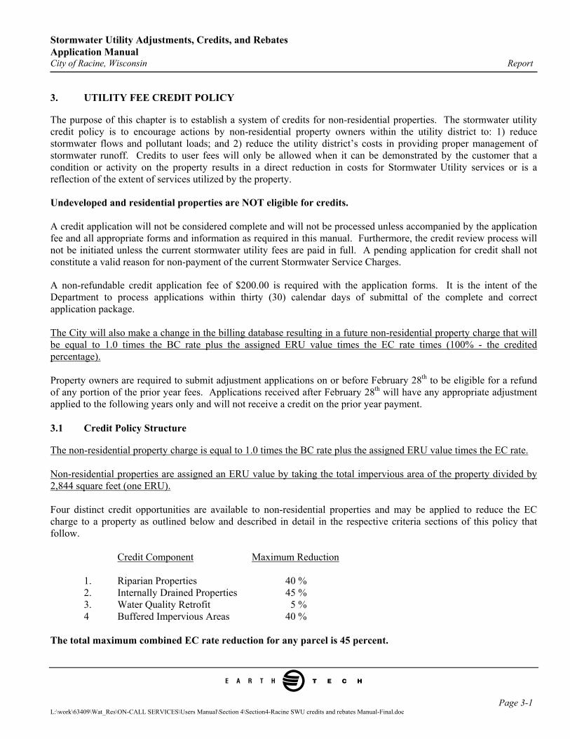
A non-refundable credit application fee of $200.00 is required with the application forms. It is the intent of the Department to process applications within thirty (30) calendar days of submittal of the complete and correct application package. The City will also make a change in the billing database resulting in a future non-residential property charge that will be equal to 1.0 times the BC rate plus the assigned ERU value times the EC rate times (100% - the credited percentage). Property owners are required to submit adjustment applications on or before February 28th to be eligible for a refund of any portion of the prior year fees. Applications received after February 28th will have any appropriate adjustment applied to the following years only and will not receive a credit on the prior year payment. 3.1 Credit Policy Structure
The non-residential property charge is equal to 1.0 times the BC rate plus the assigned ERU value times the EC rate. Non-residential properties are assigned an ERU value by taking the total impervious area of the property divided by 2,844 square feet (one ERU). Four distinct credit opportunities are available to non-residential properties and may be applied to reduce the EC charge to a property as outlined below and described in detail in the respective criteria sections of this policy that follow. Credit Component Maximum Reduction 1. Riparian Properties 40 % 2. Internally Drained Properties 45 % 3. Water Quality Retrofit 5 % 4 Buffered Impervious Areas 40 % The total maximum combined EC rate reduction for any parcel is 45 percent.
Page 3-1 L:\work\63409\Wat_Res\ON-CALL SERVICES\Users Manual\Section 4\Section4-Racine SWU credits and rebates Manual-Final.doc
Stormwater Utility Adjustments, Credits, and Rebates Application Manual City of Racine, Wisconsin Report
e
The same credit processes described below that result in a reduction in the EC rate charged to a property may also be applicable in reducing the SC rate. For simplification purposes, since the same requirements apply and because the SC rate is not currently used, only the EC rate component is discussed in the remainder of this policy document. Credit percentages were developed by estimating and categorizing cost components of the City of Racine Stormwater Utility over a 10 year period. Revenue collected through the BC rate component and a minimum of 55 percent of the EC rate component are considered necessary to support the stormwater management program and are not eligible for credit. 3.1.1 Riparian Property Credit Criteria
Non-residential properties with impervious surface areas draining directly into designated waters (riparian) without entering the City’s stormwater system may be eligible for up to a 40 percent reduction in the EC stormwater charge. Designated waters include: Lake Michigan, Root River, and Pike River. The percent reduction in the EC stormwater charge will be directly proportional to the amount of impervious area that is determined to be riparian. This is calculated by taking the riparian impervious surface area divided by the entire impervious surface area times 40 percent. For example, if 5,000 square feet of impervious area (1.76 ERUs) was determined to be riparian and the total impervious area was 10,000 square feet (3.52 ERUs), the credit percentage would be:
5,000 square feet/10,000 square feet * 40% = 20% or 1.76 ERUs/3.52ERUs * 40%= 20%
The necessary application form, fee, and other information requirements is available in the Appendix section of this document. If the applicant is successful through the application and review process in showing that they are due a credit, the applicant will be refunded an amount equal to the credited percentage multiplied by the EC rate. The resulting future non-residential property charge will be equal to 1.0 times the BC rate plus the assigned ERU value times the EC rate times (100% - the credited percentage). 3.1.2 Internally Drained Property Credit Criteria
Non-residential properties with impervious surface areas that are internally drained and discharge no water to the City’s stormwater system may be eligible for up to a 45 percent reduction in the EC stormwater charge. The percent reduction in the EC stormwater charge will be directly proportional to the amount of impervious area that is determined to be internally drained. This is calculated by taking the internally drained impervious surface area divided by the entire impervious surface area times 45 percent. For example, if 2,000 square feet of impervious area (0.70 ERUs) was determined to be internally drained and the total impervious area was 10,000 square feet (3.52 ERUs), the credit percentage would be:
2,000 square feet/10,000 square feet * 45% = 9% or 0.70 ERUs/3.52ERUs * 45%= 9% The necessary application form, fee, and other information requirements is available in the Appendix section of this document. If the applicant is successful through the application and review process in showing that they are due a credit, the applicant will be refunded an amount equal to the credited percentage multiplied by the EC charge.
Page 3-2 L:\work\63409\Wat_Res\ON-CALL SERVICES\Users Manual\Section 4\Section4-Racine SWU credits and rebates Manual-Final.doc
Stormwater Utility Adjustments, Credits, and Rebates Application Manual City of Racine, Wisconsin Report
e
The resulting future non-residential property charge will be equal to 1.0 times the BC rate plus the assigned ERU value times the EC rate times (100% - the credited percentage). 3.1.3 Water Quality Retrofit Credit Criteria
Non-residential properties which are not covered by the Post Construction Runoff Ordinance which take mitigating steps to improve the quality of stormwater discharge by implementing best management practices that reduce the average annual loadings of total suspended solids from existing development by 40 percent or more and are designed and/or implemented in accordance with current Wisconsin Department of Natural Resources guidelines and have maintenance agreements in place with the City of Racine for the best management practice as applicable, may be eligible for a 5 percent reduction in the EC stormwater charge for that portion of the impervious area treated by best management practices. The percent reduction in the EC stormwater charge will be directly proportional to the amount of impervious area that is determined to be treated by the best management practices. This is calculated by taking the impervious surface area treated by best management practices divided by the entire impervious surface area times 5 percent. For example, if 8,000 square feet of impervious area (2.81 ERUs) was determined to be treated by best management practices and the total impervious area was 10,000 square feet (3.52 ERUs), the credit percentage would be:
8,000 square feet/10,000 square feet * 5% = 4% or 2.81 ERUs/3.52ERUs * 5%= 4%
The necessary application form, fee, and other information requirements is available in the Appendix section of this document. If the applicant is successful through the application and review process in showing that they are due a credit, the applicant will be refunded an amount equal to the credited percentage multiplied by the EC charge. The resulting future non-residential property charge will be equal to 1.0 times the BC rate plus the assigned ERU value times the EC rate times (100% - the credited percentage). 3.1.4 Buffered Impervious Area Criteria
Non-residential properties that have a total impervious area of less than 20 percent of the entire parcel may be eligible for a credit of up to a 40 percent reduction in the EC stormwater charge. The credit will be applicable to those impervious areas that sheet flow across a natural buffer area of at least 100 feet in length and are not directly connected to the drainage system. The percent reduction in the EC stormwater charge will be directly proportional to the amount of impervious area that is determined to be buffered as described above. This is calculated by taking the buffered impervious surface area divided by the entire impervious surface area times 40 percent. For example, if the runoff from 5,000 square feet (1.76 ERUs) of impervious area was determined to sheet flow across 100 feet of vegetated buffer and the total impervious area was 10,000 square feet (3.52 ERUs) and the total parcel is greater than 50,000 square feet, the credit percentage would be:
5,000 square feet/10,000 square feet * 40% = 20% or 1.76 ERUs/3.52ERUs * 40%= 20%
Page 3-3 L:\work\63409\Wat_Res\ON-CALL SERVICES\Users Manual\Section 4\Section4-Racine SWU credits and rebates Manual-Final.doc
Stormwater Utility Adjustments, Credits, and Rebates Application Manual City of Racine, Wisconsin Report
e
The necessary application form including fee and other information requirements is available in the Appendix section of this document. If the applicant is successful through the application and review process in showing that they are due a credit, the applicant will be refunded an amount equal to the credited percentage multiplied by the EC rate. The resulting future non-residential property charge will be equal to 1.0 times the BC rate plus the assigned ERU value times the EC rate times (100% - the credited percentage).
Page 3-4 L:\work\63409\Wat_Res\ON-CALL SERVICES\Users Manual\Section 4\Section4-Racine SWU credits and rebates Manual-Final.doc
Stormwater Utility Adjustments, Credits, and Rebates Application Manual City of Racine, Wisconsin Report
e
4. UTILITY REBATE POLICY
A one-time stormwater rebate is available to a non-residential property owner who constructs on-site stormwater detention which results in a reduction in size or number of stormwater facilities proposed to be constructed by the City of Racine relative to the extension of City storm sewers necessary to accommodate the ten-percent probability (10-year) design storm event in conjunction with the development. The rebate will be calculated by taking the difference in projected cost of the City stormwater facilities without on-site detention with the actual cost of the stormwater facilities incurred by the City due to the construction of on-site detention. The total rebate amount shall not be greater than the cost of the on-site stormwater detention facilities incurred by the development and shall not include the cost of on-site storm sewers necessary to convey flows to the on-site stormwater detention facility or to extended City facilities. Undeveloped and residential properties are NOT eligible for rebates.
Page 4-1 L:\work\63409\Wat_Res\ON-CALL SERVICES\Users Manual\Section 4\Section4-Racine SWU credits and rebates Manual-Final.doc
Stormwater Utility Adjustments, Credits, and Rebates Application Manual City of Racine, Wisconsin Report
e
5. APPROVAL AND APPEALS PROCESS
5.1 Commissioner’s Review
As outlined in the Application Procedure in the Preface Section of this document, the Commissioner shall have thirty (30) days to review adjustment, credit, and rebate applications, whereupon the Commissioner may approve all or part of the application as submitted, or provide comments and request further information, or deny the application. In the event of a request for additional information, the thirty-day period referred to above shall begin again pending the receipt of all requested information. No additional fee is required to be accompanied with follow-up information related to the request for additional information provided the information is submitted within sixty (60) days of the information request.
5.2 Appeals
The applicant has the right to appeal the Commissioners decision, in accordance with the procedures outlined in Section 98-202(i) of the City of Racine Municipal Code (adopted May, 2004) relating to the Stormwater Utility. Additional information on the appeals process is also contained in Sections 98-202(j), 98-202(k), and 98-202(l).
5.3 Reevaluations
In order to verify that the conditions that warranted a credit or rebate, including any required monitoring and maintenance per agreement with the City, the City will conduct annual reevaluations. Reevaluations may require access to portions of sites that receive an annual credit towards their stormwater utility bill or received a one-time rebate. No fees are assessed to property owners for these reevaluations.
5.3.1 Adjustments
No re-evaluations are required for adjustments.
5.3.2 Credits
All best management practices associated with the applicant successfully receiving a credit to reduce their stormwater utility fee shall be subject to an annual review for compliance with the current year’s credit policy. The City reserves the right to vary or eliminate credits or credit percentages over time subject to the terms of the current year’s credit policy. It is the responsibility of the billed customer to provide the Commissioner with any and all changes to the conditions of the onsite best management practices and to document appropriate monitoring and maintenance as may be required per agreement with the City. Changes in conditions, or failure to appropriately conduct required monitoring and maintenance may affect the credit applicability for the site. Violations of the terms and/or conditions that allowed the approval of a credit request may be subject to collection of credited utility fees retroactive to the date of the violation.
Page 5-1 L:\work\63409\Wat_Res\ON-CALL SERVICES\Users Manual\Section 4\Section4-Racine SWU credits and rebates Manual-Final.doc
Stormwater Utility Adjustments, Credits, and Rebates Application Manual City of Racine, Wisconsin Report
e
5.3.3 Rebates
All best management practices associated with the applicant successfully receiving a one-time rebate shall be subject to an annual review. It is the responsibility of the billed customer to provide the Commissioner with any and all changes to the conditions of the onsite best management practices and to document appropriate monitoring and maintenance as may be required per agreement with the City. Changes in conditions, or failure to appropriately conduct required monitoring and maintenance may constitute a violation of the terms and/or conditions under which the rebate was granted. Violations of the terms and/or conditions that allowed the approval of a rebate request may be subject to repayment of some or all of the rebated monies by the applicant.
5.4 Retroactivity
Any adjustments or credits approved are applicable to the current billing period associated with the credit request only and not retroactive to any previous years’ charges. There is no retroactivity associated with rebates.
Page 5-2 L:\work\63409\Wat_Res\ON-CALL SERVICES\Users Manual\Section 4\Section4-Racine SWU credits and rebates Manual-Final.doc
Stormwater Utility Adjustments, Credits, and Rebates Application Manual City of Racine, Wisconsin Report
e
APPENDIX A
City of Racine Stormwater Utility Fee Adjustment Submittal Requirements and Form
L:\work\63409\Wat_Res\ON-CALL SERVICES\Users Manual\Section 4\Section4-Racine SWU credits and rebates Manual-Final.doc
Stormwater Utility Adjustments, Credits, and Rebates Application Manual City of Racine, Wisconsin Report
e
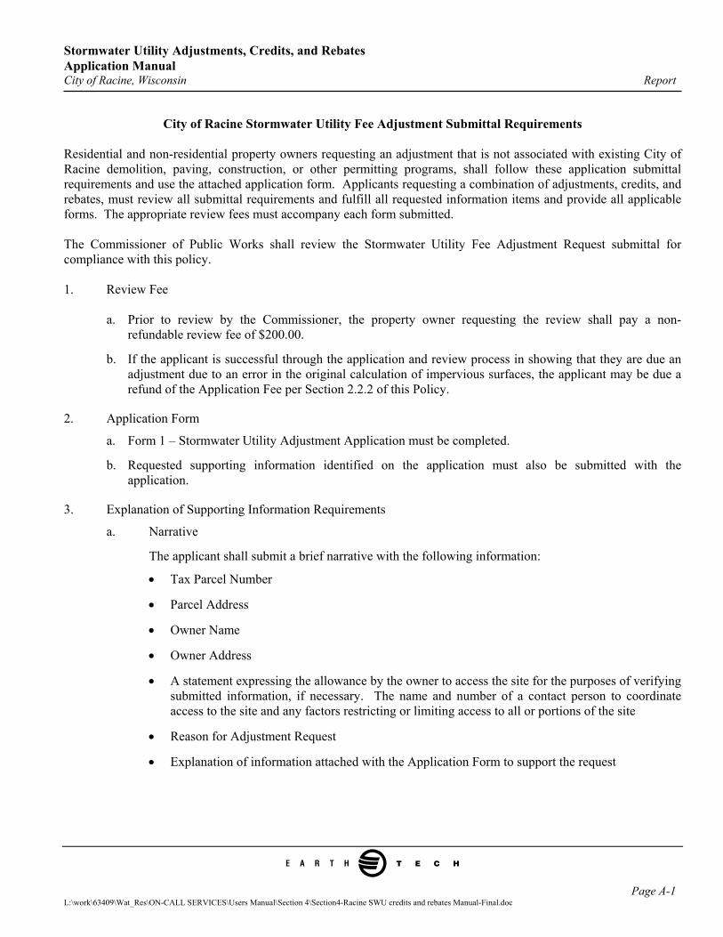
City of Racine Stormwater Utility Fee Adjustment Submittal Requirements Residential and non-residential property owners requesting an adjustment that is not associated with existing City of Racine demolition, paving, construction, or other permitting programs, shall follow these application submittal requirements and use the attached application form. Applicants requesting a combination of adjustments, credits, and rebates, must review all submittal requirements and fulfill all requested information items and provide all applicable forms. The appropriate review fees must accompany each form submitted. The Commissioner of Public Works shall review the Stormwater Utility Fee Adjustment Request submittal for compliance with this policy. 1. Review Fee
a. Prior to review by the Commissioner, the property owner requesting the review shall pay a non-refundable review fee of $200.00.
b. If the applicant is successful through the application and review process in showing that they are due an adjustment due to an error in the original calculation of impervious surfaces, the applicant may be due a refund of the Application Fee per Section 2.2.2 of this Policy.
2. Application Form
a. Form 1 – Stormwater Utility Adjustment Application must be completed.
b. Requested supporting information identified on the application must also be submitted with the application.
3. Explanation of Supporting Information Requirements
a. Narrative
The applicant shall submit a brief narrative with the following information:
• Tax Parcel Number
• Parcel Address
• Owner Name
• Owner Address
• A statement expressing the allowance by the owner to access the site for the purposes of verifying submitted information, if necessary. The name and number of a contact person to coordinate access to the site and any factors restricting or limiting access to all or portions of the site
• Reason for Adjustment Request
• Explanation of information attached with the Application Form to support the request
Page A-1 L:\work\63409\Wat_Res\ON-CALL SERVICES\Users Manual\Section 4\Section4-Racine SWU credits and rebates Manual-Final.doc
Stormwater Utility Adjustments, Credits, and Rebates Application Manual City of Racine, Wisconsin Report
e
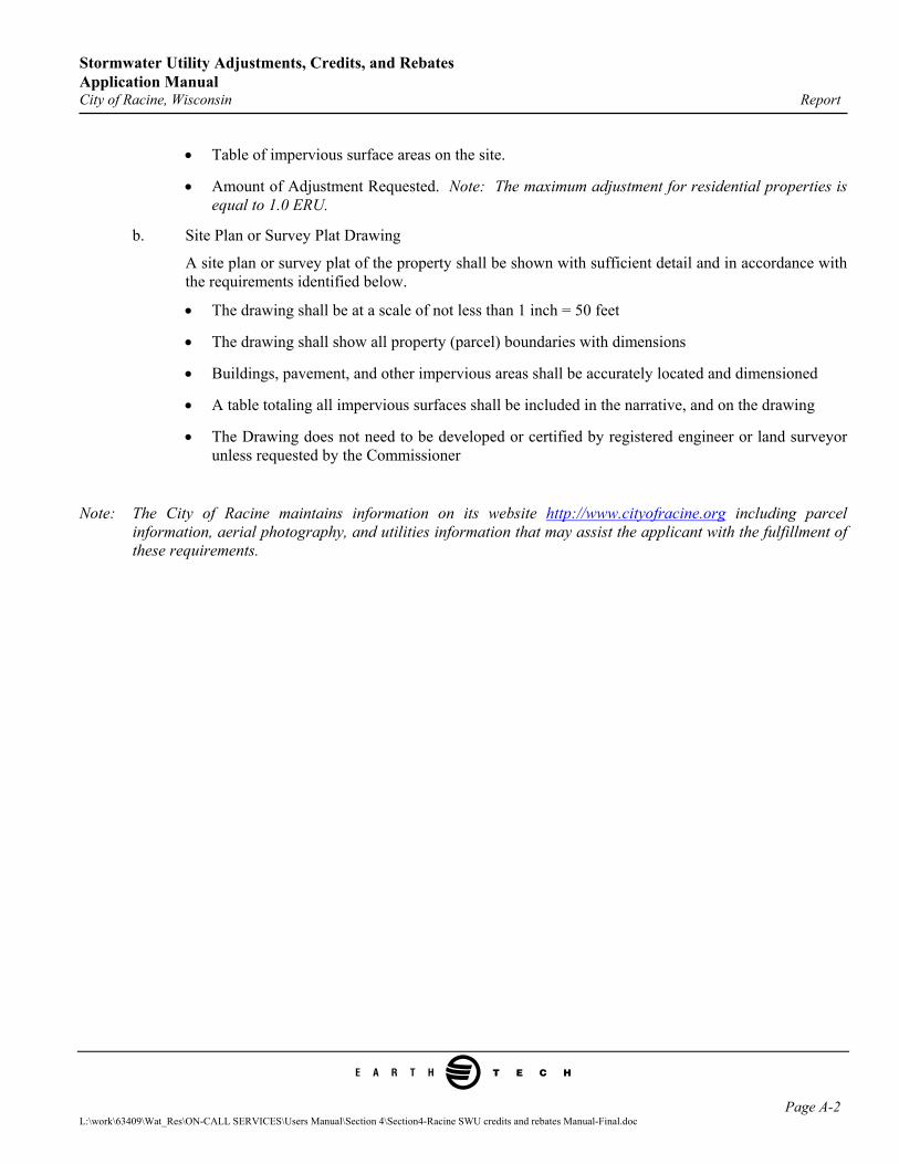
• Table of impervious surface areas on the site.
• Amount of Adjustment Requested. Note: The maximum adjustment for residential properties is equal to 1.0 ERU.
b. Site Plan or Survey Plat Drawing
A site plan or survey plat of the property shall be shown with sufficient detail and in accordance with the requirements identified below.
• The drawing shall be at a scale of not less than 1 inch = 50 feet
• The drawing shall show all property (parcel) boundaries with dimensions
• Buildings, pavement, and other impervious areas shall be accurately located and dimensioned
• A table totaling all impervious surfaces shall be included in the narrative, and on the drawing
• The Drawing does not need to be developed or certified by registered engineer or land surveyor unless requested by the Commissioner
Note: The City of Racine maintains information on its website http://www.cityofracine.org including parcel information, aerial photography, and utilities information that may assist the applicant with the fulfillment of these requirements.
Page A-2 L:\work\63409\Wat_Res\ON-CALL SERVICES\Users Manual\Section 4\Section4-Racine SWU credits and rebates Manual-Final.doc
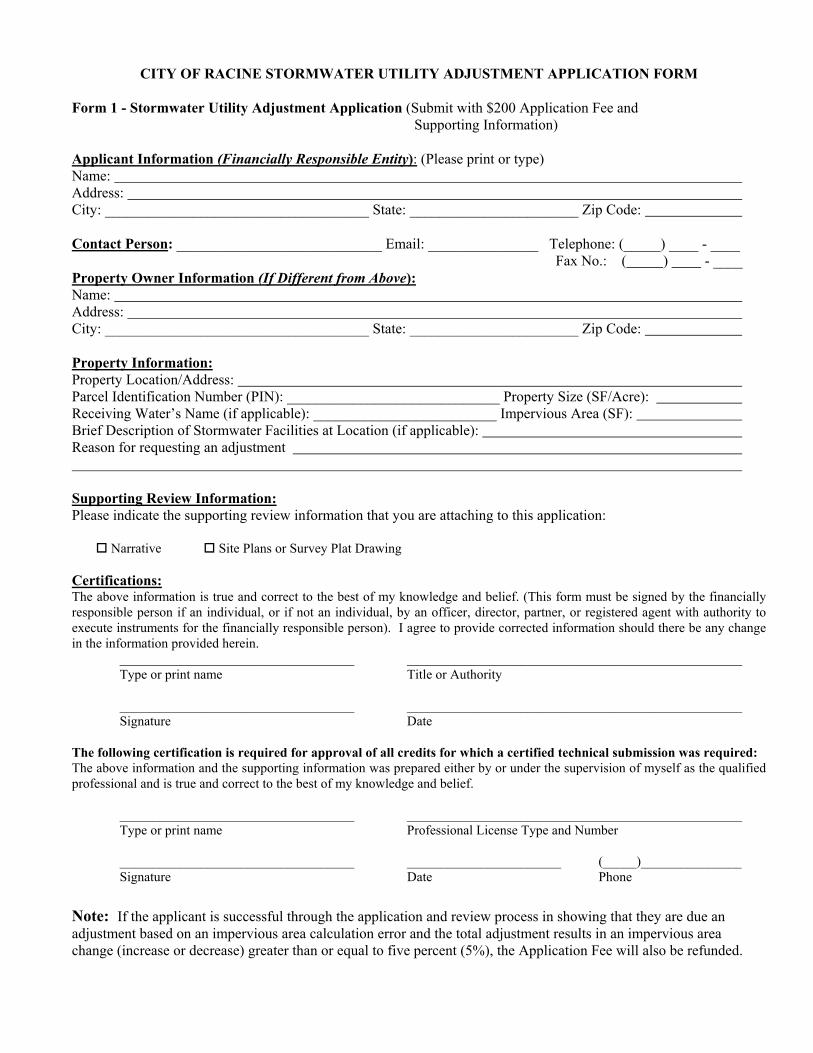
CITY OF RACINE STORMWATER UTILITY ADJUSTMENT APPLICATION FORM Form 1 - Stormwater Utility Adjustment Application (Submit with $200 Application Fee and Supporting Information) Applicant Information (Financially Responsible Entity): (Please print or type) Name: Address: City: ____________________________________ State: _______________________ Zip Code: Contact Person: ____________________________ Email: _______________ Telephone: (_____) ____ - ____ Fax No.: ( ) - ____ Property Owner Information (If Different from Above): Name: Address: City: ____________________________________ State: _______________________ Zip Code: Property Information: Property Location/Address: Parcel Identification Number (PIN): _____________________________ Property Size (SF/Acre): Receiving Water’s Name (if applicable): _________________________ Impervious Area (SF): Brief Description of Stormwater Facilities at Location (if applicable): Reason for requesting an adjustment Supporting Review Information: Please indicate the supporting review information that you are attaching to this application:
Narrative Site Plans or Survey Plat Drawing
Certifications: The above information is true and correct to the best of my knowledge and belief. (This form must be signed by the financially responsible person if an individual, or if not an individual, by an officer, director, partner, or registered agent with authority to execute instruments for the financially responsible person). I agree to provide corrected information should there be any change in the information provided herein.
___________________________________ __________________________________________________ Type or print name Title or Authority ___________________________________ __________________________________________________ Signature Date
The following certification is required for approval of all credits for which a certified technical submission was required: The above information and the supporting information was prepared either by or under the supervision of myself as the qualified professional and is true and correct to the best of my knowledge and belief. ___________________________________ __________________________________________________
Type or print name Professional License Type and Number ___________________________________ _______________________ (_____)_______________
Signature Date Phone Note: If the applicant is successful through the application and review process in showing that they are due an adjustment based on an impervious area calculation error and the total adjustment results in an impervious area change (increase or decrease) greater than or equal to five percent (5%), the Application Fee will also be refunded.

Stormwater Utility Adjustments, Credits, and Rebates Application Manual City of Racine, Wisconsin Report
e
APPENDIX B
City of Racine Stormwater Utility Fee Credit Submittal Requirements and Form
L:\work\63409\Wat_Res\ON-CALL SERVICES\Users Manual\Section 4\Section4-Racine SWU credits and rebates Manual-Final.doc
Stormwater Utility Adjustments, Credits, and Rebates Application Manual City of Racine, Wisconsin Report
e
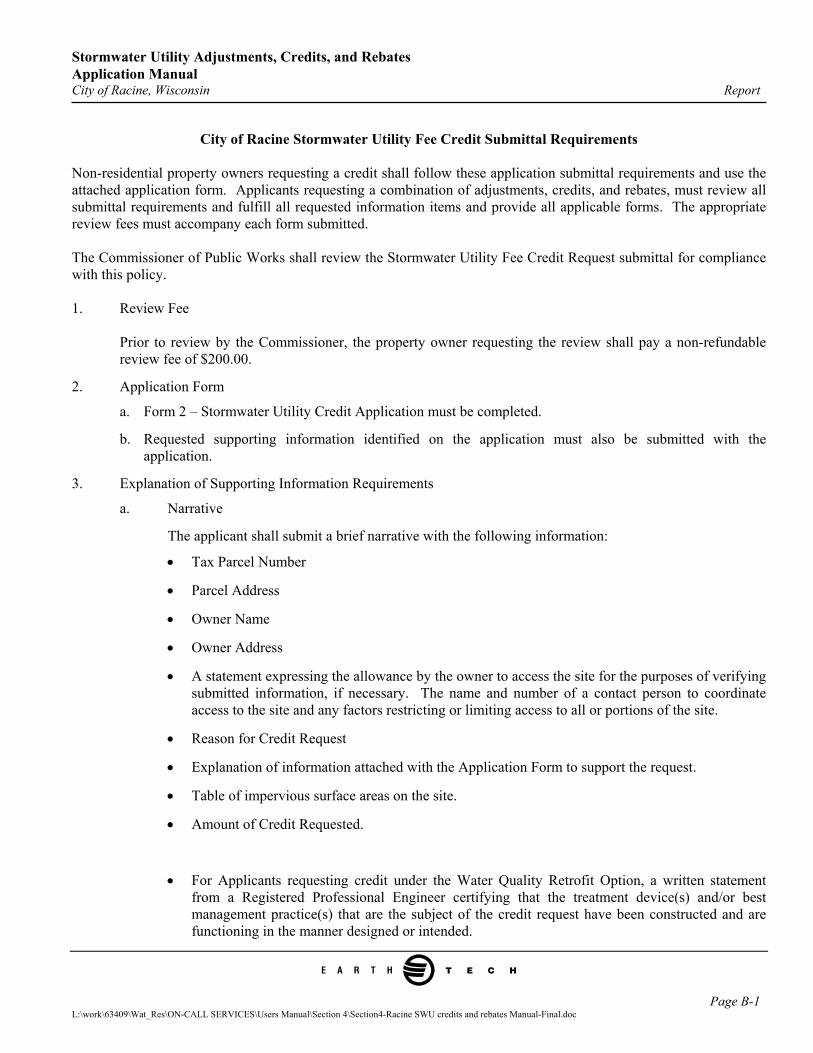
City of Racine Stormwater Utility Fee Credit Submittal Requirements Non-residential property owners requesting a credit shall follow these application submittal requirements and use the attached application form. Applicants requesting a combination of adjustments, credits, and rebates, must review all submittal requirements and fulfill all requested information items and provide all applicable forms. The appropriate review fees must accompany each form submitted. The Commissioner of Public Works shall review the Stormwater Utility Fee Credit Request submittal for compliance with this policy. 1. Review Fee
Prior to review by the Commissioner, the property owner requesting the review shall pay a non-refundable review fee of $200.00.
2. Application Form
a. Form 2 – Stormwater Utility Credit Application must be completed.
b. Requested supporting information identified on the application must also be submitted with the application.
3. Explanation of Supporting Information Requirements
a. Narrative
The applicant shall submit a brief narrative with the following information:
• Tax Parcel Number
• Parcel Address
• Owner Name
• Owner Address
• A statement expressing the allowance by the owner to access the site for the purposes of verifying submitted information, if necessary. The name and number of a contact person to coordinate access to the site and any factors restricting or limiting access to all or portions of the site.
• Reason for Credit Request
• Explanation of information attached with the Application Form to support the request.
• Table of impervious surface areas on the site.
• Amount of Credit Requested.
• For Applicants requesting credit under the Water Quality Retrofit Option, a written statement from a Registered Professional Engineer certifying that the treatment device(s) and/or best management practice(s) that are the subject of the credit request have been constructed and are functioning in the manner designed or intended.
Page B-1 L:\work\63409\Wat_Res\ON-CALL SERVICES\Users Manual\Section 4\Section4-Racine SWU credits and rebates Manual-Final.doc
Stormwater Utility Adjustments, Credits, and Rebates Application Manual City of Racine, Wisconsin Report
e
OR
• For applicants requesting credit under the Riparian Property, Internally Drained Property, or Buffered Impervious Area Option, the applicant shall provide a written statement certifying that the property or portion of property applicable for credit under Criteria Items 1, 2, or 4 and supporting information is accurate.
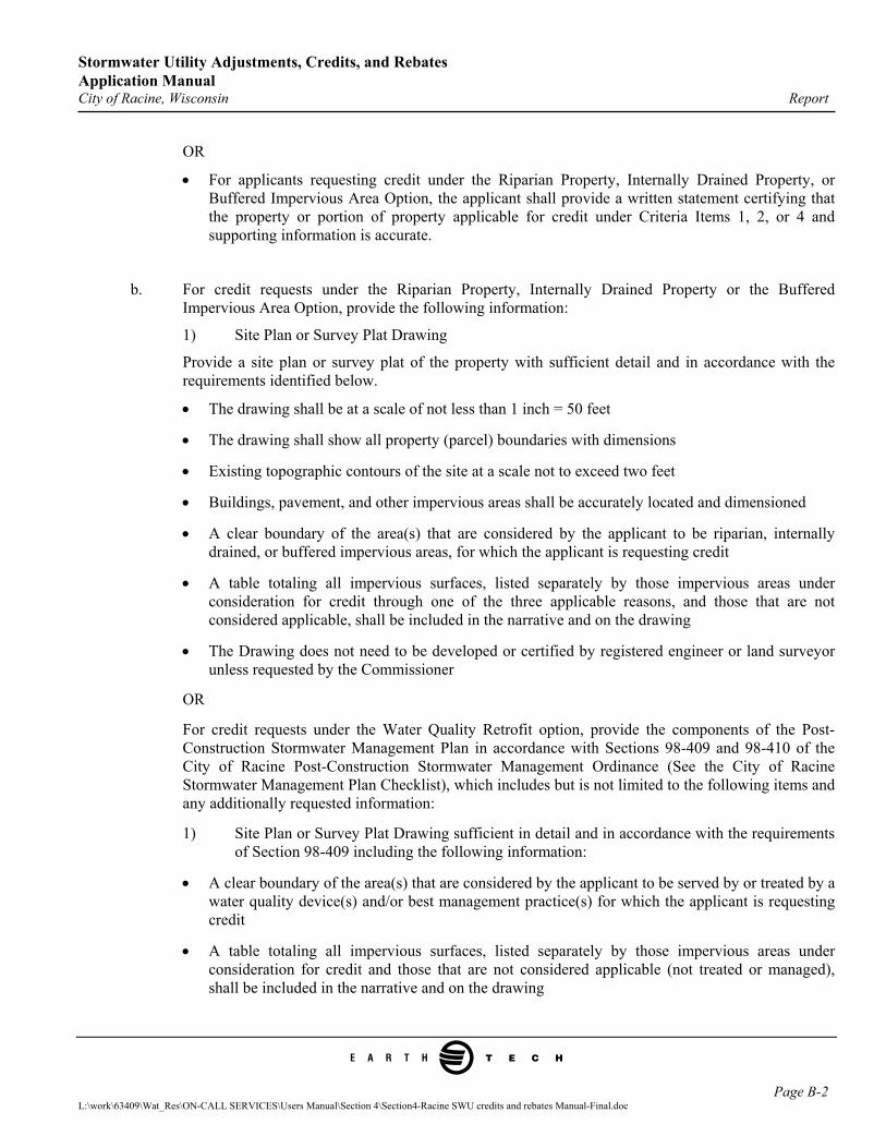
b. For credit requests under the Riparian Property, Internally Drained Property or the Buffered Impervious Area Option, provide the following information:
1) Site Plan or Survey Plat Drawing
Provide a site plan or survey plat of the property with sufficient detail and in accordance with the requirements identified below.
• The drawing shall be at a scale of not less than 1 inch = 50 feet
• The drawing shall show all property (parcel) boundaries with dimensions
• Existing topographic contours of the site at a scale not to exceed two feet
• Buildings, pavement, and other impervious areas shall be accurately located and dimensioned
• A clear boundary of the area(s) that are considered by the applicant to be riparian, internally drained, or buffered impervious areas, for which the applicant is requesting credit
• A table totaling all impervious surfaces, listed separately by those impervious areas under consideration for credit through one of the three applicable reasons, and those that are not considered applicable, shall be included in the narrative and on the drawing
• The Drawing does not need to be developed or certified by registered engineer or land surveyor unless requested by the Commissioner
OR
For credit requests under the Water Quality Retrofit option, provide the components of the Post-Construction Stormwater Management Plan in accordance with Sections 98-409 and 98-410 of the City of Racine Post-Construction Stormwater Management Ordinance (See the City of Racine Stormwater Management Plan Checklist), which includes but is not limited to the following items and any additionally requested information:
1) Site Plan or Survey Plat Drawing sufficient in detail and in accordance with the requirements of Section 98-409 including the following information:
• A clear boundary of the area(s) that are considered by the applicant to be served by or treated by a water quality device(s) and/or best management practice(s) for which the applicant is requesting credit
• A table totaling all impervious surfaces, listed separately by those impervious areas under consideration for credit and those that are not considered applicable (not treated or managed), shall be included in the narrative and on the drawing
Page B-2 L:\work\63409\Wat_Res\ON-CALL SERVICES\Users Manual\Section 4\Section4-Racine SWU credits and rebates Manual-Final.doc
Stormwater Utility Adjustments, Credits, and Rebates Application Manual City of Racine, Wisconsin Report
e
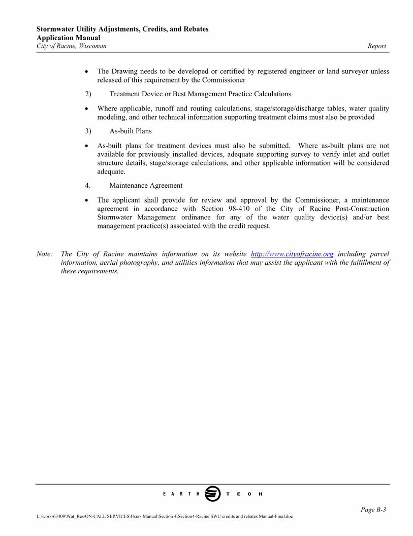
• The Drawing needs to be developed or certified by registered engineer or land surveyor unless released of this requirement by the Commissioner
2) Treatment Device or Best Management Practice Calculations
• Where applicable, runoff and routing calculations, stage/storage/discharge tables, water quality modeling, and other technical information supporting treatment claims must also be provided
3) As-built Plans
• As-built plans for treatment devices must also be submitted. Where as-built plans are not available for previously installed devices, adequate supporting survey to verify inlet and outlet structure details, stage/storage calculations, and other applicable information will be considered adequate.
4. Maintenance Agreement
• The applicant shall provide for review and approval by the Commissioner, a maintenance agreement in accordance with Section 98-410 of the City of Racine Post-Construction Stormwater Management ordinance for any of the water quality device(s) and/or best management practice(s) associated with the credit request.
Note: The City of Racine maintains information on its website http://www.cityofracine.org including parcel information, aerial photography, and utilities information that may assist the applicant with the fulfillment of these requirements.
Page B-3 L:\work\63409\Wat_Res\ON-CALL SERVICES\Users Manual\Section 4\Section4-Racine SWU credits and rebates Manual-Final.doc
L:\work\63409\Wat_Res\ON-CALL SERVICES\Users Manual\Section 4\Section4-Racine SWU credits and rebates Manual-Final.doc
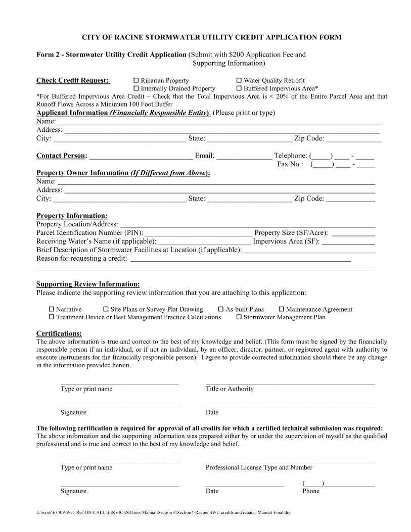
CITY OF RACINE STORMWATER UTILITY CREDIT APPLICATION FORM Form 2 - Stormwater Utility Credit Application (Submit with $200 Application Fee and Supporting Information) Check Credit Request: Riparian Property Water Quality Retrofit Internally Drained Property Buffered Impervious Area* *For Buffered Impervious Area Credit – Check that the Total Impervious Area is < 20% of the Entire Parcel Area and that Runoff Flows Across a Minimum 100 Foot Buffer Applicant Information (Financially Responsible Entity): (Please print or type) Name: _______________________________________________________________________________________ Address: _____________________________________________________________________________________ City: ____________________________________ State: _______________________ Zip Code: _______________ Contact Person: ____________________________ Email: _______________ Telephone: (_____) ____ - _____ Fax No.: ( ) - _____ Property Owner Information (If Different from Above): Name: Address: City: ____________________________________ State: _______________________ Zip Code: Property Information: Property Location/Address: Parcel Identification Number (PIN): _____________________________ Property Size (SF/Acre): Receiving Water’s Name (if applicable): _________________________ Impervious Area (SF): Brief Description of Stormwater Facilities at Location (if applicable): Reason for requesting a credit: Supporting Review Information: Please indicate the supporting review information that you are attaching to this application:
Narrative Site Plans or Survey Plat Drawing As-built Plans Maintenance Agreement Treatment Device or Best Management Practice Calculations Stormwater Management Plan
Certifications: The above information is true and correct to the best of my knowledge and belief. (This form must be signed by the financially responsible person if an individual, or if not an individual, by an officer, director, partner, or registered agent with authority to execute instruments for the financially responsible person). I agree to provide corrected information should there be any change in the information provided herein.
___________________________________ __________________________________________________ Type or print name Title or Authority ___________________________________ __________________________________________________ Signature Date
The following certification is required for approval of all credits for which a certified technical submission was required: The above information and the supporting information was prepared either by or under the supervision of myself as the qualified professional and is true and correct to the best of my knowledge and belief. ___________________________________ __________________________________________________
Type or print name Professional License Type and Number ___________________________________ _______________________ (_____)_______________
Signature Date Phone
Stormwater Utility Adjustments, Credits, and Rebates Application Manual City of Racine, Wisconsin Report
e
APPENDIX C
City of Racine Stormwater Utility Rebate Submittal Requirements and Form
L:\work\63409\Wat_Res\ON-CALL SERVICES\Users Manual\Section 4\Section4-Racine SWU credits and rebates Manual-Final.doc
Stormwater Utility Adjustments, Credits, and Rebates Application Manual City of Racine, Wisconsin Report
e
City of Racine Stormwater Utility Rebate Submittal Requirements Non-residential property owners requesting a rebate shall follow these application submittal requirements and use the attached application form. Applicants requesting a combination of adjustments, credits, and rebates, must review all submittal requirements and fulfill all requested information items and provide all applicable forms. The appropriate review fees must accompany each form submitted. The Commissioner of Public Works shall review the Stormwater Utility Rebate Request submittal for compliance with this policy. 1. Review Fee
Prior to review by the Commissioner, the property owner requesting the review shall pay a non-refundable review fee of $200.00.
2. Application Form
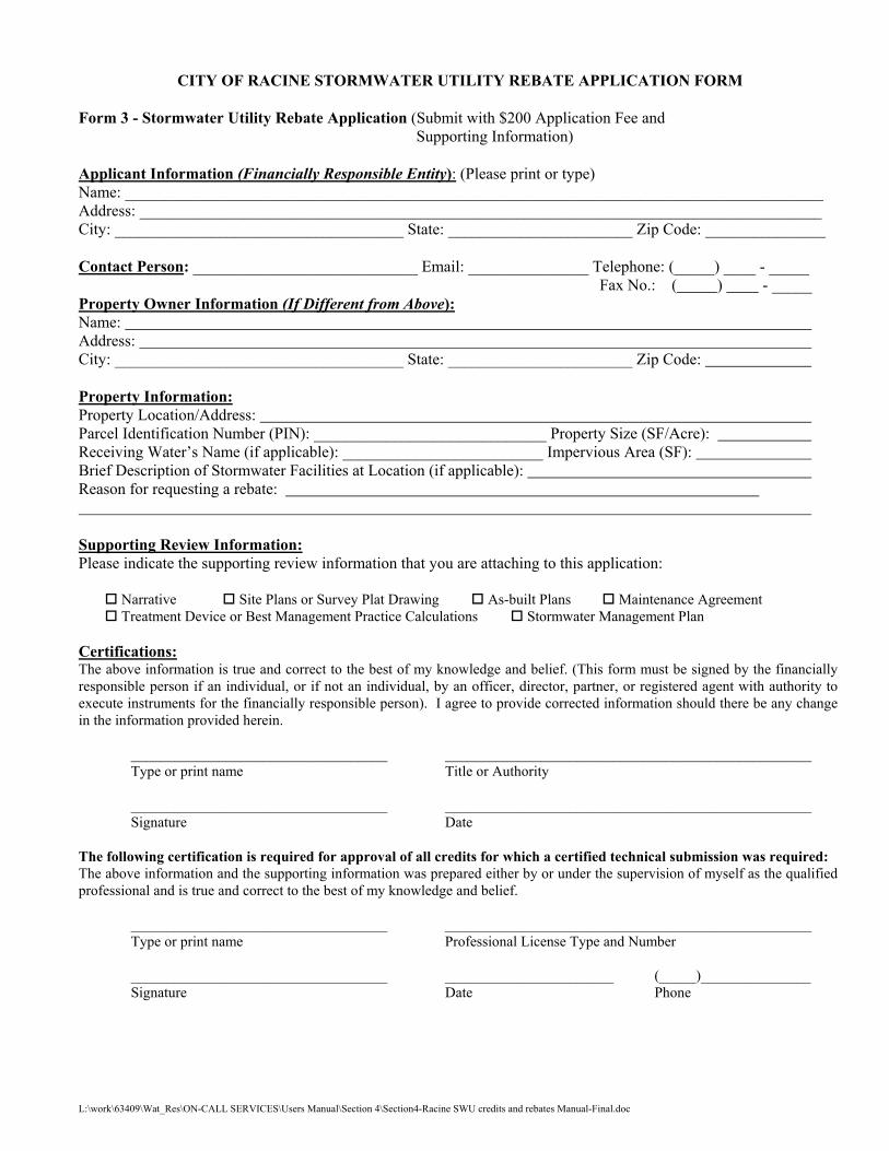
a. Form 3 – Stormwater Utility Rebate Application must be completed.
b. Requested supporting information identified on the application must also be submitted with the application.
3. Explanation of Supporting Information Requirements
a. Narrative
The applicant shall submit a brief narrative with the following information:
• Tax Parcel Number
• Parcel Address
• Owner Name
• Owner Address
• A statement expressing the allowance by the owner to access the site for the purposes of verifying submitted information, if necessary. The name and number of a contact person to coordinate access to the site and any factors restricting or limiting access to all or portions of the site.
• Reason for Rebate Request
• A written statement from a Registered Professional Engineer certifying that the treatment device(s) and/or best management practice(s) that are the subject of the rebate request have been constructed and are functioning in the manner designed or intended.
• Explanation of information attached with the Application Form to support the request.
• Estimated and actual bid and construction quantities and amounts
• Table of impervious surface areas on the site.
• Amount of Rebate Requested.
Page C-1 L:\work\63409\Wat_Res\ON-CALL SERVICES\Users Manual\Section 4\Section4-Racine SWU credits and rebates Manual-Final.doc
Stormwater Utility Adjustments, Credits, and Rebates Application Manual City of Racine, Wisconsin Report
e
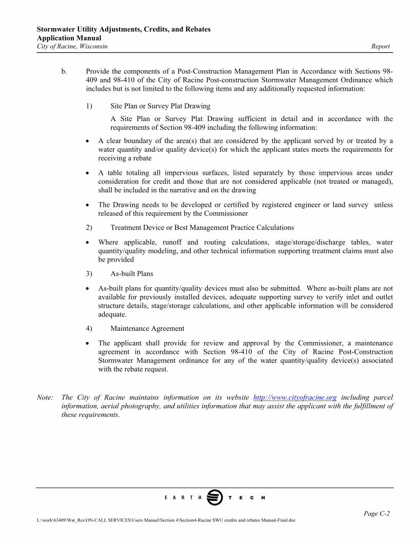
b. Provide the components of a Post-Construction Management Plan in Accordance with Sections 98-409 and 98-410 of the City of Racine Post-construction Stormwater Management Ordinance which includes but is not limited to the following items and any additionally requested information:
1) Site Plan or Survey Plat Drawing
A Site Plan or Survey Plat Drawing sufficient in detail and in accordance with the requirements of Section 98-409 including the following information:
• A clear boundary of the area(s) that are considered by the applicant served by or treated by a water quantity and/or quality device(s) for which the applicant states meets the requirements for receiving a rebate
• A table totaling all impervious surfaces, listed separately by those impervious areas under consideration for credit and those that are not considered applicable (not treated or managed), shall be included in the narrative and on the drawing
• The Drawing needs to be developed or certified by registered engineer or land survey unless released of this requirement by the Commissioner
2) Treatment Device or Best Management Practice Calculations
• Where applicable, runoff and routing calculations, stage/storage/discharge tables, water quantity/quality modeling, and other technical information supporting treatment claims must also be provided
3) As-built Plans
• As-built plans for quantity/quality devices must also be submitted. Where as-built plans are not available for previously installed devices, adequate supporting survey to verify inlet and outlet structure details, stage/storage calculations, and other applicable information will be considered adequate.
4) Maintenance Agreement
• The applicant shall provide for review and approval by the Commissioner, a maintenance agreement in accordance with Section 98-410 of the City of Racine Post-Construction Stormwater Management ordinance for any of the water quantity/quality device(s) associated with the rebate request.
Note: The City of Racine maintains information on its website http://www.cityofracine.org including parcel information, aerial photography, and utilities information that may assist the applicant with the fulfillment of these requirements.
Page C-2 L:\work\63409\Wat_Res\ON-CALL SERVICES\Users Manual\Section 4\Section4-Racine SWU credits and rebates Manual-Final.doc
L:\work\63409\Wat_Res\ON-CALL SERVICES\Users Manual\Section 4\Section4-Racine SWU credits and rebates Manual-Final.doc
CITY OF RACINE STORMWATER UTILITY REBATE APPLICATION FORM Form 3 - Stormwater Utility Rebate Application (Submit with $200 Application Fee and Supporting Information) Applicant Information (Financially Responsible Entity): (Please print or type) Name: _______________________________________________________________________________________ Address: _____________________________________________________________________________________ City: ____________________________________ State: _______________________ Zip Code: _______________ Contact Person: ____________________________ Email: _______________ Telephone: (_____) ____ - _____ Fax No.: ( ) - _____ Property Owner Information (If Different from Above): Name: Address: City: ____________________________________ State: _______________________ Zip Code: Property Information: Property Location/Address: Parcel Identification Number (PIN): _____________________________ Property Size (SF/Acre): Receiving Water’s Name (if applicable): _________________________ Impervious Area (SF): Brief Description of Stormwater Facilities at Location (if applicable): Reason for requesting a rebate: Supporting Review Information: Please indicate the supporting review information that you are attaching to this application:
Narrative Site Plans or Survey Plat Drawing As-built Plans Maintenance Agreement Treatment Device or Best Management Practice Calculations Stormwater Management Plan
Certifications: The above information is true and correct to the best of my knowledge and belief. (This form must be signed by the financially responsible person if an individual, or if not an individual, by an officer, director, partner, or registered agent with authority to execute instruments for the financially responsible person). I agree to provide corrected information should there be any change in the information provided herein.
___________________________________ __________________________________________________ Type or print name Title or Authority ___________________________________ __________________________________________________ Signature Date
The following certification is required for approval of all credits for which a certified technical submission was required: The above information and the supporting information was prepared either by or under the supervision of myself as the qualified professional and is true and correct to the best of my knowledge and belief. ___________________________________ __________________________________________________
Type or print name Professional License Type and Number ___________________________________ _______________________ (_____)_______________
Signature Date Phone
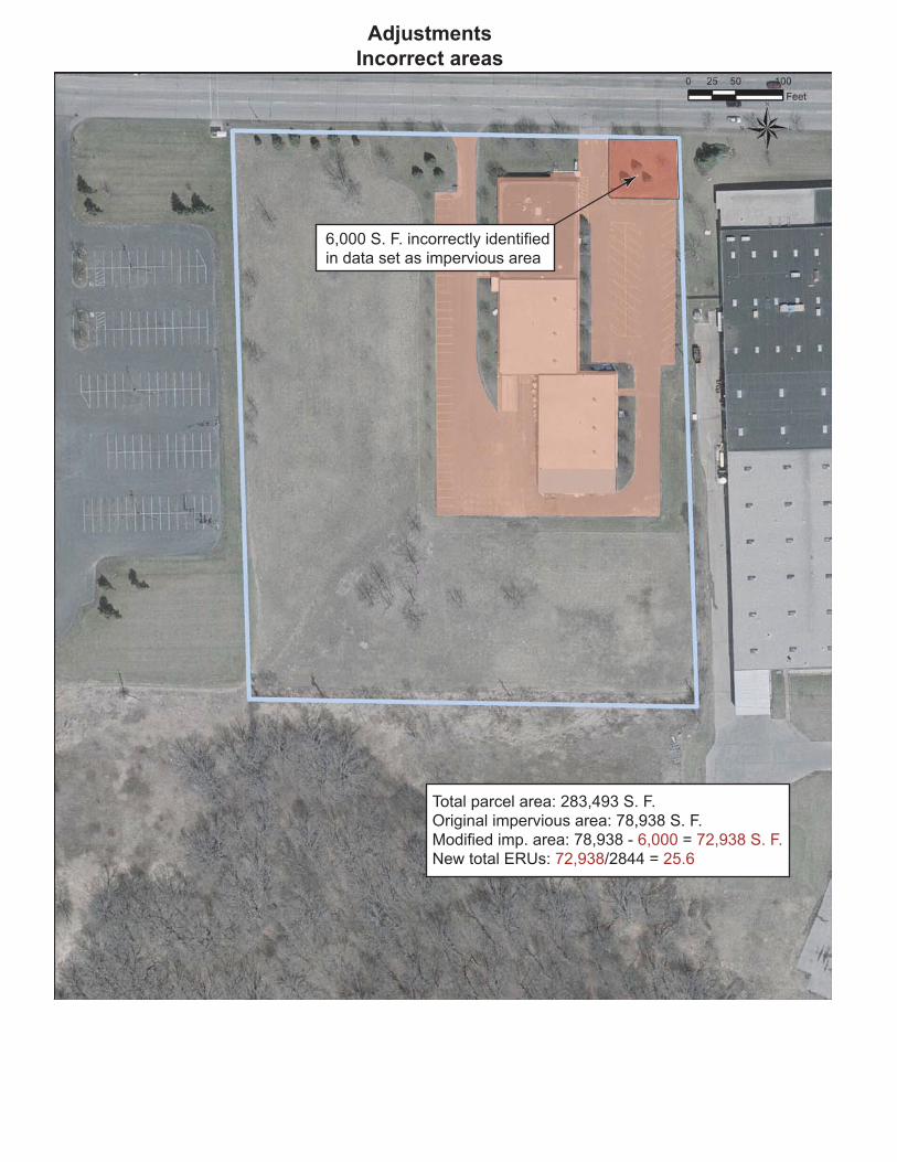
Total parcel area: 283,493 S. F.
Original impervious area: 78,938 S. F.
Modified imp. area: 78,938 - 6,000 = 72,938 S. F.
New total ERUs: 72,938/2844 = 25.6
6,000 S. F. incorrectly identified
in data set as impervious area
Adjustments
Incorrect areas
Adjustments
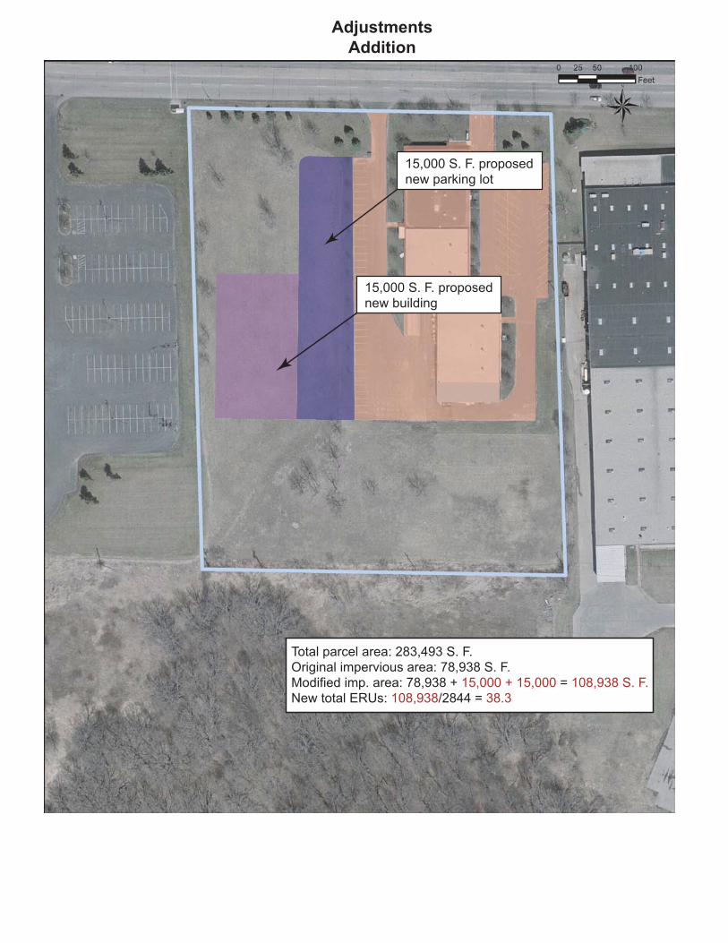
Addition
Total parcel area: 283,493 S. F.
Original impervious area: 78,938 S. F.
Modified imp. area: 78,938 + 15,000 + 15,000 = 108,938 S. F.
New total ERUs: 108,938/2844 = 38.3
15,000 S. F. proposed
new parking lot
15,000 S. F. proposed
new building
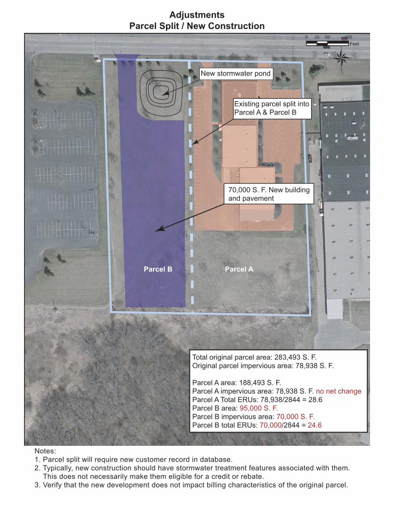
Parcel AParcel B
Total original parcel area: 283,493 S. F.
Original parcel impervious area: 78,938 S. F.
Parcel A area: 188,493 S. F.
Parcel A impervious area: 78,938 S. F. no net change
Parcel A Total ERUs: 78,938/2844 = 28.6
Parcel B area: 95,000 S. F.
Parcel B impervious area: 70,000 S. F.
Parcel B total ERUs: 70,000/2844 = 24.6
70,000 S. F. New building
and pavement
Existing parcel split into
Parcel A & Parcel B
New stormwater pond
Adjustments
Parcel Split / New Construction
Notes:
1. Parcel split will require new customer record in database.
2. Typically, new construction should have stormwater treatment features associated with them.
This does not necessarily make them eligible for a credit or rebate.
3. Verify that the new development does not impact billing characteristics of the original parcel.
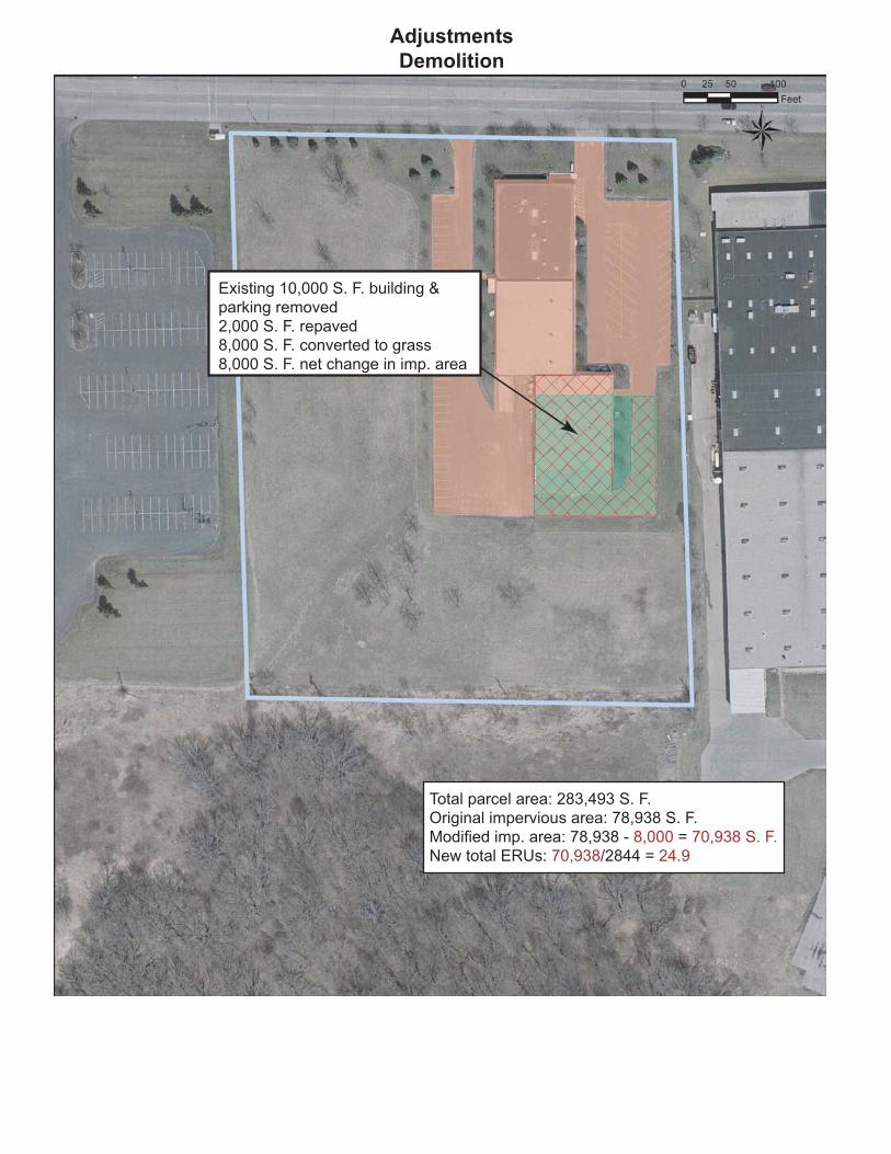
Total parcel area: 283,493 S. F.
Original impervious area: 78,938 S. F.
Modified imp. area: 78,938 - 8,000 = 70,938 S. F.
New total ERUs: 70,938/2844 = 24.9
Existing 10,000 S. F. building &
parking removed
2,000 S. F. repaved
8,000 S. F. converted to grass
8,000 S. F. net change in imp. area
Adjustments
Demolition
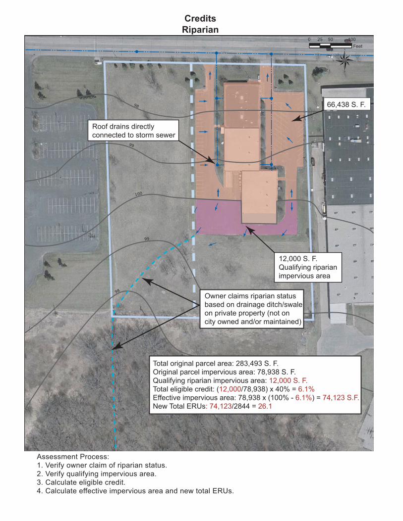
98
99
100
99
98
Roof drains directly
connected to storm sewer
Owner claims riparian status
based on drainage ditch/swale
on private property (not on
city owned and/or maintained)
66,438 S. F.
12,000 S. F.
Qualifying riparian
impervious area
Total original parcel area: 283,493 S. F.
Original parcel impervious area: 78,938 S. F.
Qualifying riparian impervious area: 12,000 S. F.
Total eligible credit: (12,000/78,938) x 40% = 6.1%
Effective impervious area: 78,938 x (100% - 6.1%) = 74,123 S.F.
New Total ERUs: 74,123/2844 = 26.1
Credits
Riparian
Assessment Process:
1. Verify owner claim of riparian status.
2. Verify qualifying impervious area.
3. Calculate eligible credit.
4. Calculate effective impervious area and new total ERUs.
98
99
100
99
98
Total original parcel area: 683,493 S. F.
Original parcel impervious area: 78,938 S. F.
Impervious area to total area check: (78,938/683,493) x 100%=11.5%
Qualifying riparian impervious area: 12,000 S. F.
Total eligible credit: (12,000/78,938) x 40% = 6.1%
Effective impervious area: 78,938 x (100% - 6.1%) = 74,123 S.F.
New Total ERUs: 74,123/2844 = 26.1
66,438 S. F.
12,000 S. F.
Qualifying buffered
impervious area
Roof drains directly
connected to storm sewer
10
0'
Min
.
Assessment Process:
1. Verify owner claim of buffered impervious area status.
a. Verify original impervious area is less than 20% of total parcel area
b. Verify "100 foot rule"
2. Verify qualifying impervious area.
3. Calculate eligible credit.
4. Calculate effective impervious area and new total ERUs.
Credits
Buffered Impervious Area
99
98
97
98
99
100
Total original parcel area: 283,493 S. F.
Original parcel impervious area: 78,938 S. F.
Qualifying riparian impervious area: 12,000 S. F.
Total eligible credit: (12,000/78,938) x 45% = 6.8%
Effective impervious area: 78,938 x (100% - 6.8%) = 73,570 S.F.
New Total ERUs: 73,570/2844 = 25.9
Assessment Process:
1. Verify owner claim of riparian status.
2. Verify qualifying impervious area.
3. Verify low area is capable of storing runoff from the qualifying area.
4. Calculate eligible credit.
5. Calculate effective impervious area and new total ERUs.
Credits
Internally Drained
Roof drains directly
connected to storm sewer
12,000 S. F. Qualifying
internally drained
impervious area
Owner claims internally
drained status based on
low area in back of lot
66,438 S. F.
66,438 S. F.
Drains to pond
12,000 S. F. does
not drain to pond
200 S. F. 300 S. F.
Newly Constructed
Wet Detention Pond
Total original parcel area: 283,493 S. F.
Original parcel impervious area: 78,938 S. F.
Qualifying treated area: 78,938 - 12,000 -200 - 300 = 66,438 S. F.
Total eligible credit: (66,438/78,938) x 5% = 4.2%
Effective impervious area: 78,938 x (100% - 4.2%) = 75,616 S.F.
New Total ERUs: 75,616/2844 = 26.6
Note:
Owner may be eligible for additional credit for
areas not draining to pond.
Assessment Process:
1. Verify owner claim of area to new detention pond.
2. Verify owner claim of detention pond efficiency.
3. Calculate eligible credit.
4. Calculate effective impervious area.
Credits
Water Quality Retrofit
Parcel B Parcel A
Proposed 24" RCP Required 12" RCP
Existing 24" RCP
Extent of existing
City sewer
City storm sewer
extension
Total original parcel area: 283,493 S. F.
Original parcel impervious area: 78,938 S. F.
Parcel A area: 188,493 S. F.
Parcel A impervious area: 78,938 S. F. no net change
Parcel A Total ERUs: 78,938/2844 = 28.6
Parcel B area: 95,000 S. F.
Parcel B impervious area: 70,000 S. F.
Parcel B total ERUs: 70,000/2844 = 25.6
Rebate Example
Assessment Process:1. Verify owner claim that on-site facilities allow for a reduction in size
of extended sewer (now, because of pond, only a 12" is required).
2. Determine potential rebate amount based on difference between cost of
orig. prop. sewer (24") and actual reqd. sewer (12") using bid documents.
3. Verify potential rebate amount does not exceed owner cost of on-site facility.
4. Set up new customer charge for parcel B based on full impervious area.
Notes:1. New development is typically required
to detain stormwater per city ordinance.
2. Example assumes that new development
requires city storm sewer extension.
3. Under city design standards proposed
storm sewer would be 24".
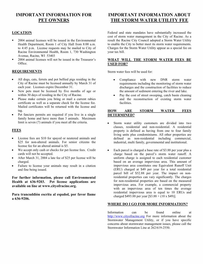
IMPORTANT INFORMATION FOR PET OWNERS
LOCATION 2004 animal licenses will be issued in the Environmental
Health Department, Room 1 of City Hall from 8:00 a.m. to 4:45 p.m. License requests may be mailed to City of Racine Environmental Health, Room 1, 730 Washington Avenue, Racine, WI 53403
2004 animal licenses will not be issued in the Treasurer’s Office.
REQUIREMENTS • All dogs, cats, ferrets and pot bellied pigs residing in the
City of Racine must be licensed annually by March 31 of each year. Licenses expire December 31.
• New pets must be licensed by five months of age or within 30 days of residing in the City of Racine.
• Please make certain you bring or mail a current rabies certificate as well as a separate check for the license fee. Mailed certificates will be returned with the license and tag.
• Pet fanciers permits are required if you live in a single family home and have more than 3 animals. Maximum limit is seven (7) animals if you meet all the criteria.
FEES • License fees are $10 for spayed or neutered animals and
$25 for non-altered animals. For senior citizens the license fee for an altered animal is $5.
• We accept only cash or checks for pet license fees. Credit cards will not be accepted.
• After March 31, 2004 a late fee of $25 per license will be charged.
• Failure to license your animals may result in a citation and fine being issued.
For further information, please call Environmental Health at 636-9203. Pet license applications are available on line at www.cityofracine.org. Para trancuddión escrita al español, por favor llame a 636-9206.
IMPORTANT INFORMATION ABOUT THE STORM WATER UTILITY FEE
Federal and state mandates have substantially increased the cost of storm water management in the City of Racine. As a result the Racine City Council adopted a Storm Water Utility to enable the City to better meet its storm water requirements. Charges for the Storm Water Utility appear as a special fee on your tax bill. WHAT WILL THE STORM WATER FEES BE USED FOR? Storm water fees will be used for:
•
•
Compliance with new DNR storm water requirements including the monitoring of storm water discharges and the construction of facilities to reduce the amount of sediment entering the river and lake. Pay the cost of street sweeping, catch basin cleaning and the reconstruction of existing storm water facilities.
HOW ARE STORM WATER FEES DETERMINED? • Storm water utility customers are divided into two
classes, residential and non-residential. A residential property is defined as having from one to four family living units plus condominiums. All other properties are defined as non-residential including commercial, industrial, multi family, governmental and institutional.
• Each parcel is charged a base rate of $3.88 per year plus a
charge based on the parcel’s storm water runoff. A uniform charge is assigned to each residential customer based on an average impervious area. This amount of impervious area constitutes one Equivalent Runoff Unit (ERU) charged at $49 per year for a total residential parcel bill of $52.88 per year. The impact on non-residential properties can vary significantly. The charges for non-residential properties are based on the measured impervious area. For example, a commercial property with an impervious area of ten times the average residential impervious area is equal to 10 ERUs and charged $493.88 per year [$3.88 + (10 x $49)].
WHERE DO I GO FOR MORE INFORMATION? Information can be found online at http://www.cityofracine.org For more information about the Stormwater Management Utility, or if you have specific concerns about stormwater management issues, please call the Stormwater Information Line at 262/619-2550.
IMPORTANT INFORMATION FOR CITY OF RACINE TAXPAYERS
If this is not your tax bill, please return it to the City of Racine Treasurer’s Office. PAYMENTS
• Mail your payment and coupon to our bank in the enclosed envelope. The most convenient and efficient way to pay property tax is to mail a check with the payment coupon in the enclosed envelope. Payments mailed to this lock box address will be receipted promptly. Receipts will be returned to the owner of record for parcels paid in full or parcels with a delinquent balance.
• Endorse your two party mortgage escrow check.
• Do not combine any other payments with your property taxes. A separate check must be remitted for property taxes. Including any other payment with your tax payment will significantly delay receipt of your taxes.
• Pay by CREDIT CARD over the telephone or Internet. To pay your taxes by credit card call the toll-free number, 1-800-2PAY-TAX (1-800-272-9829) or visit www.cityofracine.org. Official Payments Corporation, the credit card service provider, charges a convenience fee based on the amount of the transaction. To use this service you will be required to enter the jurisdiction code 5870, your eight-digit real estate parcel number or nine-digit personal property parcel number (found on the front of the tax bill) as well as your credit card information.
• WE CANNOT ACCEPT CREDIT CARD PAYMENTS IN PERSON OR BY MAIL.
• Cash refunds of $10 or less will be made in the treasurer’s office. If your payment is mailed, refunds under $5 must be picked up at the treasurer’s office. Refunds $5 and over will be mailed.
• All overpayment refund checks will be held for 4 weeks before disbursement. Due to high number of NSF and stop payments we receive on both personal and mortgage company checks, we are forced to hold all refunds until payments have cleared the banking system.
• LONG LINES ARE EXPECTED DURING TAX COLLECTION SEASON. The Treasurer’s office is located in Room 105 of City Hall. Property tax payments will be receipted from 8:00 a.m. to 4:45 p.m. Monday through Friday. We will be closed on the following days: Christmas Eve, Wednesday, December 24, 2003; Christmas Day, Thursday, December 25, 2003: New Years Eve, Wednesday, December 31, 2003; New Years Day, Thursday, January 1, 2004.
RECEIPT DATE
• Receipt date is determined by the date paid in person, the postmark date or the date of the credit card transaction. 2003 payments will be accepted in the office through December 30, 2003. Mailed payments must be postmarked by December 31, 2003 to be receipted with a 2003 date. Payments made in person after December 30, 2003, postmarked after December 31, 2003 or made through Official Payments after December 31, 2003 will be receipted with a 2004 date.
DUE DATES/LATE FEES
• Either payment in full or the first installment is due by February 2, 2004. If your tax bill qualifies and you chose to pay in installments, due dates for subsequent installments are March 31, 2004, May 31, 2004 and August 2, 2004. If any installment is late, you no longer qualify for the installment plan and the entire remaining balance will be considered delinquent. Per Wisconsin statute and City of Racine ordinance all delinquent taxes are subject to interest and penalty of 1.5% per month or fraction of a month from February 1 until paid.
Inform Assessor’s Office, (262) 636-9119, in Room 107 of City Hall of any address or ownership change.
Use the City of Racine web site www.cityofracine.org to inquire on tax balance and/or status.
City of Racine Environmental Health Department now processes animal licensing! (Please see reverse for animal licensing information.)
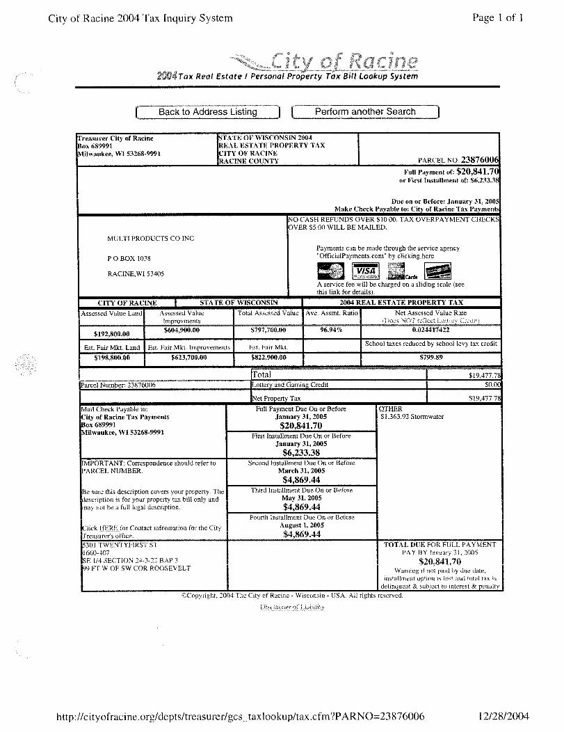
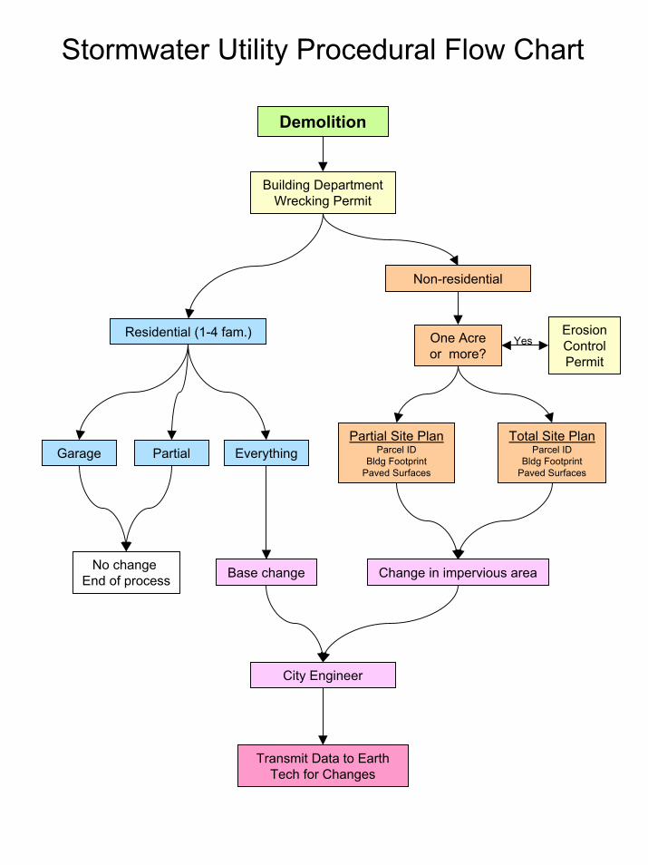
Stormwater Utility Procedural Flow Chart
Demolition
Building DepartmentWrecking Permit
Non-residential
Residential (1-4 fam.) One Acre or more?
EverythingTotal Site Plan
Parcel IDBldg Footprint
Paved Surfaces
City Engineer
Change in impervious area
Partial
No change End of process
Erosion Control Permit
Yes
Partial Site PlanParcel ID
Bldg FootprintPaved Surfaces
Garage
Base change
Transmit Data to Earth Tech for Changes
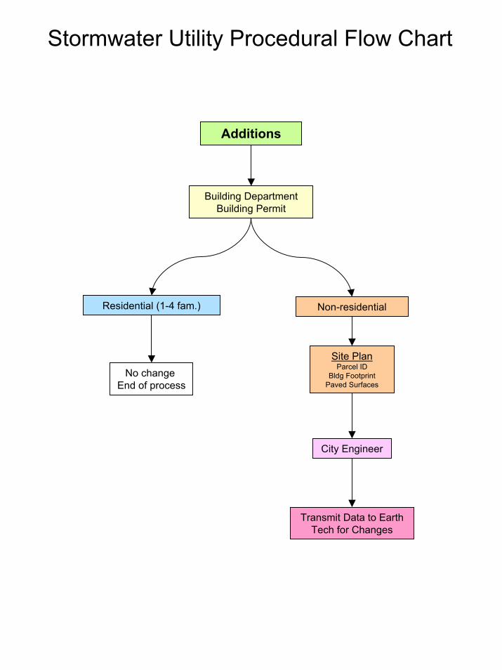
Stormwater Utility Procedural Flow Chart
Additions
Building DepartmentBuilding Permit
Residential (1-4 fam.) Non-residential
Site PlanParcel ID
Bldg FootprintPaved Surfaces
No change End of process
Transmit Data to Earth Tech for Changes
City Engineer
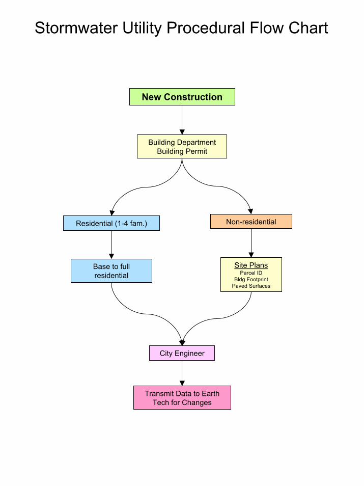
Stormwater Utility Procedural Flow Chart
New Construction
Building DepartmentBuilding Permit
Non-residentialResidential (1-4 fam.)
Site PlansParcel ID
Bldg FootprintPaved Surfaces
Base to full residential
Transmit Data to Earth Tech for Changes
City Engineer
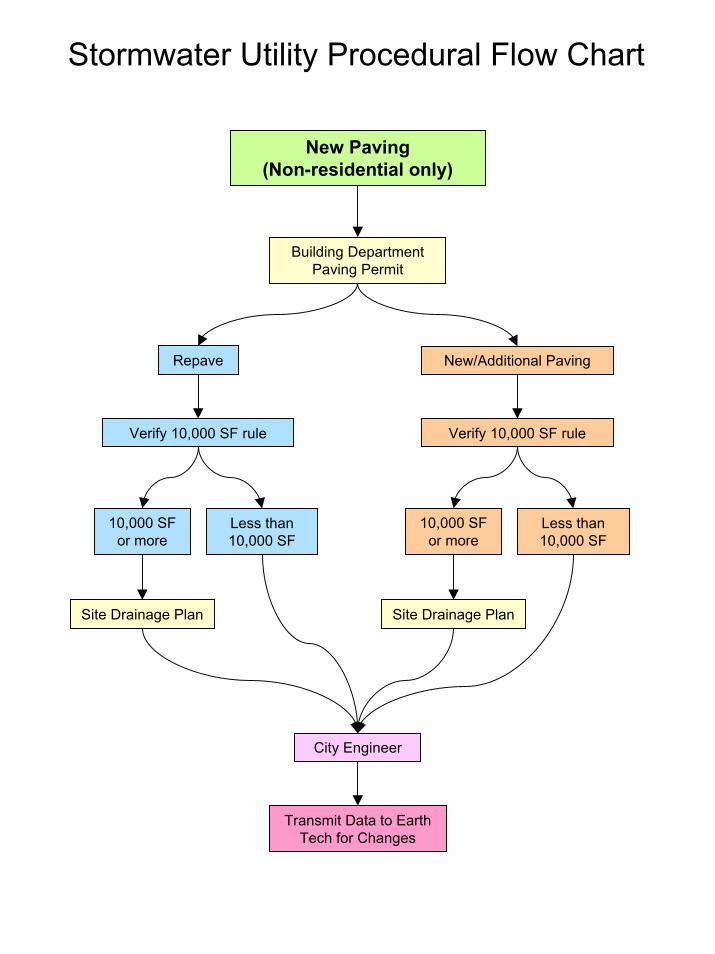
Stormwater Utility Procedural Flow Chart
New Paving(Non-residential only)
Building DepartmentPaving Permit
Repave New/Additional Paving
City Engineer
10,000 SF or more
Less than 10,000 SF
Site Drainage Plan Site Drainage Plan
Verify 10,000 SF rule Verify 10,000 SF rule
10,000 SF or more
Less than 10,000 SF
Transmit Data to Earth Tech for Changes
07-20-04 By Alderman Sollman:
ORDINANCE NO. 20-04
To create Chapter 98 Article VI of the Municipal Code of the City of Racine,
Wisconsin relating to the control of construction site erosion resulting from land disturbing
construction activities.
The purpose of this provision is to require use of best management practices to reduce
the amount of sediment and other pollutants resulting from land disturbing construction
activities on sites that do not include the construction of a building and are otherwise
regulated by the Wisconsin Department of Commerce in Wis. Adm. Code s. Comm 21.125 or
50.115. Adoption of this provision will foster consistent, statewide application of the
construction site performance standards for new development and redevelopment contained
in subchapters III and V of ch. NR 151, Wis. Adm. Code.
The Common Council of the City of Racine do ordain as follows:
Part 1:
Chapter 98 Article VI of the Municipal Code of the City of Racine is hereby created
to read as follows:
"ARTICLE VI CONSTRUCTION SITE EROSION
Sec. 98-301. Authority.
(1) This article is adopted under the authority granted by Wis. Stat. s. 62.234, and supersedes all provisions of a ordinances previously enacted that relate to construction site erosion control. Except as otherwise specified in Wis. Stat. s. 62.234, Wis. Stat. s. 62.23 applies to this article and to any amendments thereof.
(2) The provisions of this article are deemed not to limit any other lawful
regulatory powers of the city.
(3) The commissioner of public works or designee ("commissioner") shall
administer and enforce the provisions of this article. (4) This article does not pre-empt more stringent erosion and sediment control
requirements that may be imposed by any of the following:
(a) Wisconsin Department of Natural Resources ("WDNR") administrative rules, permits or approvals, including those authorized under Wis. Stat. ss. 281.16 and 283.33.
(b) Targeted non-agricultural performance standards promulgated in rules
by DNR under Wis. Adm. Code s. NR 151.004.
Sec. 98-302. Findings of fact.
The common council finds that runoff from land disturbing construction activity carries a significant amount of sediment and other pollutants to the waters of the state in the city. Sec. 98-303. Purpose.
It is the purpose of this article to further the maintenance of safe and healthful conditions; prevent and control water pollution; prevent and control soil erosion; protect spawning grounds, fish and aquatic life; control building sites, placement of structures and land uses; preserve ground cover and scenic beauty; and promote sound economic growth, by minimizing the amount of sediment and other pollutants carried by runoff or discharged from land disturbing construction activity to waters of the state in the city. Sec. 98-304. Applicability and jurisdiction.
(1) Applicability.
(a) This article applies to any construction site that has one or more acres of land disturbing construction activities, except as provided under sub. (b):
(b) This article does not apply to the following:
1. Land disturbing construction activity that includes the construction of a building and is otherwise regulated by the Wisconsin Department of Commerce under s. Comm 21.125 or 50.115, Wis. Adm. Code.
2. A construction project that is exempted by federal statutes or regulations from the requirement to have a national pollutant discharge elimination system permit issued under article 40,
Code of Federal Regulations, part 122, for land disturbing construction activity.
3. Nonpoint discharges from agricultural facilities and practices. 4. Nonpoint discharges from silviculture activities. 5. Routine maintenance for project sites under 5 acres of land
disturbance if performed to maintain the original line and grade, hydraulic capacity or original purpose of the facility.
(c) Notwithstanding the applicability requirements in par. (a), this article
applies to construction sites of any size that, in the opinion of the commissioner, are likely to result in runoff that exceeds the safe capacity of the existing drainage facilities or receiving body of water, that causes undue channel erosion, that increases water pollution by scouring or the transportation of particulate matter or that endangers property or public safety.
(2) Jurisdiction. This article applies to land disturbing construction activity on construction
sites located within the city limits.
(3) Exclusions.
This article is not applicable to activities conducted by a state agency, as defined under Wis. Stat. s. 227.01, nor to the office of district attorney, which is subject to the state plan promulgated or a memorandum of understanding entered into under Wis. Stat. s. 281.33(2). Sec. 98-305. Definitions.
The following words, terms and phrases, when used in this article, shall have the meanings given in this section, except where the context clearly indicates a different meaning:
Agricultural facilities and practices has the meaning stated in Wis. Stat. s.281.16(1).
Average annual rainfall means a calendar year of precipitation, excluding snow, which is considered typical.
Best management practice or "BMP" means structural or non-structural measures, practices, techniques or devices employed to avoid or minimize soil, sediment or pollutants carried in runoff to waters of the state.
Business day means a day the office of the department of public works is routinely and customarily open for business.
Cease and desist order means a court-issued order to halt land disturbing construction activity that is being conducted without the required permit.
Construction site means an area upon which one or more land disturbing construction
activities occurs, including areas that are part of a larger common plan of development or sale where multiple separate and distinct land disturbing construction activities may be taking place at different times on different schedules but under one plan.
Division of land means the creation of two or more parcels from one parcel or building site.
Erosion means the process by which the land's surface is worn away by the action of
wind, water, ice or gravity. Erosion and sediment control plan means a comprehensive plan developed to address
pollution caused by erosion and sedimentation of soil particles or rock fragments during construction.
Extraterritorial means the unincorporated area within 3 miles of the corporate limits
of a first, second, or third class city, or within 1.5 miles of a fourth class city or village. Final stabilization means that all land disturbing construction activities at the
construction site have been completed and that a uniform perennial vegetative cover has been established, with a density of at least 70 percent of the cover for the unpaved areas and areas not covered by permanent structures, or that employ equivalent permanent stabilization measures.
Governing body means the common council. Land disturbing construction activity means any man-made alteration of the land
surface resulting in a change in the topography or existing vegetative or non-vegetative soil cover, that may result in runoff and lead to an increase in soil erosion and movement of sediment into waters of the state. Land disturbing construction activity includes clearing and grubbing, demolition, excavating, pit trench dewatering, filling and grading activities.
Maximum extent practicable or "MEP" means a level of implementing best
management practices in order to achieve a performance standard specified in this article which takes into account the best available technology, cost effectiveness and other competing issues such as human safety and welfare, endangered and threatened resources, historic properties and geographic features. MEP allows flexibility in the way to meet the performance standards and may vary based on the performance standard and site conditions.
Performance standard means a narrative or measurable number specifying the
minimum acceptable outcome for a facility or operation.
Permit means the commissioner's written authorization to the applicant to conduct land disturbing construction activity or to discharge post-construction runoff to waters of the state.
Pollutant has the meaning stated in Wis. Stat. s. 283.01(13). Pollution has the meaning stated in Wis. Stat. s. 281.01(10). Responsible party means any entity holding fee title to the property or performing
services to meet the performance standards of this article through a contract or other agreement.
Runoff means stormwater or precipitation including rain, snow or ice melt or similar
water that moves on the land surface via sheet or channelized flow. Sediment means settleable solid material that is transported by runoff, suspended
within runoff or deposited by runoff away from its original location. Separate storm sewer means a conveyance or system of conveyances including roads
with drainage systems, streets, catch basins, curbs, gutters, ditches, constructed channels or storm drains, which meets all of the following criteria:
(a) Is designed or used for collecting water or conveying runoff. (b) Is not part of a combined sewer system. (c) Discharges directly or indirectly to waters of the state. Site means the entire area included in the legal description of the land on which the
land disturbing construction activity is proposed in the permit application. Stop work order means an order issued by the commissioner that requires that all
construction activity on the site be stopped. Technical standard means a document that specifies design, predicted performance
and operation and maintenance specifications for a material, device or method. Waters of the state has the meaning stated in Wis. Stat. s. 281.01(18).
Sec. 98-306. Technical Standards. (1) Design criteria, standards and specifications. All BMPs required to comply with this article shall meet the design criteria, standards and specifications based on any of the following:
(a) Applicable design criteria, standards and specifications identified in the Wisconsin Construction Site Best Management Practice Handbook, WDNR Pub. WR-222 November 1993 Revision.
(b) Other design guidance and technical standards identified or developed by the WDNR under subchapter V of chapter NR 151, Wis. Adm. Code.
(c) For this article, average annual basis is calculated using the
appropriate annual rainfall or runoff factor, also referred to as the R factor, or an equivalent design storm using a type II distribution, with consideration given to the geographic location of the site and the period of disturbance.
(2) Other standards. Other technical standards not identified or developed in
sub. (1), may be used, provided that the commissioner has approved the methods. Sec. 98-307. Performance Standards.
(1) Responsible party. The responsible party shall implement an erosion and sediment control plan, developed in accordance with s. 98-309, that incorporates the requirements of this section.
(2) Plan. A written plan shall be developed in accordance with s. 98-309 and implemented for each construction site.
(3) Erosion and other pollutant control requirements. The plan required under sub. (2) shall include the following:
(a) BMPs that, by design, achieve to the maximum extent practicable, a reduction of 80% of the sediment load carried in runoff, on an average annual basis, as compared with no sediment or erosion controls until the construction site has undergone final stabilization. No person shall be required to exceed an 80% sediment reduction to meet the requirements of this section. Erosion and sediment control BMPs may be used alone or in combination to meet the requirements of this paragraph. Credit toward meeting the sediment reduction shall be given for limiting the duration or area, or both, of land disturbing construction activity, or other appropriate mechanism.
(b) Notwithstanding par. (a), if BMPs cannot be designed and
implemented to reduce the sediment load by 80%, on an average annual basis, the plan shall include a written and site-specific explanation as to why the 80% reduction goal is not attainable and the sediment load shall be reduced to the maximum extent practicable.
(c) Where appropriate, the plan shall include sediment controls to do all
of the following to the maximum extent practicable: 1. Prevent tracking of sediment from the construction site onto
roads and other paved surfaces.
2. Prevent the discharge of sediment as part of site dewatering. 3. Protect the separate storm drain inlet structure from receiving
sediment.
(d) The use, storage and disposal of chemicals, cement and other compounds and materials used on the construction site shall be managed during the construction period to prevent their entrance into waters of the state, excepting that projects that require the placement of these materials in waters of the state, such as constructing bridge footings or BMP installations, are not prohibited by this paragraph.
(4) Location. The BMPs used to comply with this section shall be located prior
to runoff entering waters of the state.
(5) Alternate Requirements. The commissioner may establish stormwater management requirements more stringent than those set forth in this section if the commissioner determines that an added level of protection is needed for sensitive resources. Sec. 98-308. Permitting requirements, procedures and fees.
(1) Permit Required. No responsible party may commence a land disturbing construction activity subject to this article without first receiving approval of an erosion and sediment control plan for the site and a permit from the commissioner.
(2) Permit application and fees. At least one responsible party desiring to undertake a land disturbing construction activity subject to this article shall submit an application for a permit and an erosion and sediment control plan that meets the requirements of s. 98-309, and shall pay an application fee of $75.00 to the commissioner. By submitting an application, the applicant is authorizing the commissioner to enter the site to obtain information required for the review of the erosion and sediment control plan.
(3) Review and approval of permit application. The commissioner shall review
any permit application that is submitted with an erosion and sediment control plan, and the required fee. The following approval procedure shall be used:
(a) Within 30 days after receipt of a complete permit application, as required by sub. (2), the commissioner shall inform the applicant whether the application and plan are approved or disapproved based on the requirements of this ordinance.
(b) If the permit application and plan are approved, the commissioner
shall issue the permit. (c) If the permit application or plan is disapproved, the commissioner
shall state in writing the reasons for disapproval.
(d) The commissioner may request additional information from the applicant. If additional information is submitted, the commissioner shall have 30 days from the date the additional information is received to inform the applicant that the plan is either approved or disapproved.
(e) Failure by the commissioner to inform the permit applicant of a decision within 40 days of a required submittal shall be deemed to mean approval of the submittal and the applicant may proceed as if a permit had been issued.
(4) Bond. As a condition of approval and issuance of the permit, the
commissioner may require the applicant to deposit a surety bond, cash bond or irrevocable letter of credit to guarantee good faith execution of the approved erosion control plan and any permit conditions, all of which work shall be completed not later than 12 months after issuance of the occupancy permit or expiration of the building permit or other construction authorization, or any extension thereof. If, upon inspection, such work is complete, the bond or letter of credit shall be promptly released or the cash bond promptly returned. If such work has not been completed within the prescribed period, the commissioner may have the surety perform such work, or may go on the land and commence the work after issuing the responsible party a notice of intent to have such work performed. The cost of the work performed by the commissioner, under contract, plus interest at the rate authorized by the common council, shall be invoiced to the responsible party. Funds from the surety, the letter of credit or cash bond shall also be used therefor. If a responsible party fails to pay the amount due within the period specified, the clerk shall enter the amount due on the tax rolls and collect it as a special assessment against the property, pursuant to Wis. Stat., ch. 66, subch. VII.
(5) Permit Requirements. All permits shall require the responsible party to:
(a) Notify the commissioner within 48 hours of commencing any land
disturbing construction activity.
(b) Notify the commissioner of completion of any BMPs within 14 days after their installation.
(c) Obtain permission in writing from the commissioner prior to any
modification of the erosion and sediment control plan pursuant to s. 98-309(3).
(d) Install all BMPs as identified in the approved erosion and sediment
control plan. (e) Maintain all road drainage systems, stormwater drainage systems,
BMPs and other facilities identified in the erosion and sediment control plan.
(f) Repair any siltation or erosion damage to adjoining surfaces and drainage ways resulting from land disturbing construction activities and document repairs in a site erosion control log.
(g) Inspect the BMPs within 24 hours after each rain of 0.5 inches or
more which results in runoff during active construction periods, and at least once each week make needed repairs and document the findings of the inspections in a site erosion control log with the date of inspection, the name of the person conducting the inspection, and a description of the present phase of the construction at the site.
(h) Allow the commissioner to enter the site for the purpose of inspecting
compliance with the erosion and sediment control plan or for performing any work necessary to bring the site into compliance with the control plan.
(i) Keep a copy of the erosion and sediment control plan at the
construction site.
(6) Permit conditions. Permits issued under this section may include conditions established by the commissioner in addition to the requirements set forth in sub. (5), where necessary to assure compliance with the performance standards in s. 98-307.
(7) Permit duration. Permits issued under this section shall be valid for a period of 180 days, or the length of the building permit or other construction authorizations, whichever is longer, from the date of issuance. The commissioner may extend the period one or more times for up to an additional 180 days. The commissioner may require additional BMPs as a condition of the extension if they are necessary to meet the requirements of this article.
(8) Maintenance. The responsible party throughout the duration of the construction activities shall maintain all BMPs necessary to meet the requirements of this article until the site has undergone final stabilization. Sec. 98-309. Erosion and sediment control plan, statement, and amendments.
(1) Erosion and sediment control plan.
(a) The responsible party shall prepare an erosion and sediment control plan and submit it to the commissioner.
(b) The erosion and sediment control plan shall be designed to meet the
performance standards in s. 98-307 and other requirements of this article.
(c) The erosion and sediment control plan shall address pollution caused
by soil erosion and sedimentation during construction and through
final stabilization of the site. The erosion and sediment control plan shall include, at a minimum, the following items:
1. The name(s) and address(es) of the owner or developer of the
site and of any consulting firm retained by the applicant, together with the name of the applicant's principal contact at such firm and the start and end dates for construction.
2. Description of the site and the nature of the construction
activity, including representation of the limits of land disturbance on a United States Geological Service 7.5 minute series topographic map.
3. A sequence of construction of the development site, including
stripping and clearing; rough grading; construction of utilities, infrastructure and buildings, and final grading and landscaping. Sequencing shall identify the expected date on which clearing will begin, the estimated duration of exposure of cleared areas, areas of clearing, installation of temporary erosion and sediment control measures, and establishment of permanent vegetation.
4. Estimates of the total area of the site and the total area of the
site that is expected to be disturbed by construction activities.
5. Estimates, including calculations, if any, of the runoff coefficient of the site before and after construction activities are completed.
6. Calculations to show the expected percent reduction in the
average annual sediment load carried in runoff as compared to no sediment or erosion controls.
7. Existing data describing the surface soil as well as subsoils. 8. Depth to groundwater, as indicated by Natural Resources
Conservation Service soil information, where available.
9. Name of the immediate named receiving water from the United States Geological Service 7.5 minute series topographic maps.
(d) The erosion and sediment control plan shall include a site map which
shall show the location of the site within the city. The site map shall include the following items and shall be at a scale not greater than 50 feet per inch and at a contour interval not to exceed two feet.
1. Existing topography, vegetative cover, natural and engineered drainage systems, roads and surface waters. Lakes, streams, wetlands, channels, ditches and other watercourses on and immediately adjacent to the site shall be shown. Any identified 100-year flood plains, flood fringes and floodways shall also be shown.
2. Boundaries of the construction site.
3. Drainage patterns and approximate slopes anticipated after
major grading activities.
4. Areas of soil disturbance.
5. Location of major structural and non-structural controls identified in the plan.
6. Location of areas where stabilization practices will be
employed.
7. Areas which will be vegetated following construction.
8. A real extent of wetland acreage on the site and locations where stormwater is discharged to a surface water or wetland.
9. Locations of all surface waters and wetlands within one mile
of the construction site.
10. An alphanumeric or equivalent grid overlying the entire construction site map.
(e) Each erosion and sediment control plan shall include a description of
appropriate controls and measures that will be performed at the site to prevent pollutants from reaching waters of the state. The plan shall clearly describe the appropriate control measures for each major activity and the timing during the construction process that the measures will be implemented. The description of erosion controls shall include, when appropriate, the following minimum requirements:
1. Description of interim and permanent stabilization practices,
including an implementation schedule. Site plans shall ensure that existing vegetation is preserved where attainable and that disturbed portions of the site are stabilized.
2. Description of structural practices to divert flow away from
exposed soils, store flows or otherwise limit runoff and the
discharge of pollutants from the site. Unless otherwise specifically approved in writing by the commissioner, structural measures shall be installed on upland soils.
3. Management of overland flow at all sites, unless otherwise
controlled by outfall controls.
4. Trapping of sediment in channelized flow.
5. Staging construction to limit bare areas subject to erosion.
6. Protection of downslope drainage inlets where they occur. 7. Minimization of tracking at all sites. 8. Clean up of off-site sediment deposits. 9. Proper disposal of building and waste materials at all sites. 10. Stabilization of drainage ways. 11. Control of soil erosion from dirt stockpiles.
12. Installation of permanent stabilization practices as soon as
possible after final grading.
13. Minimization of dust to the maximum extent practicable.
(f) The erosion and sediment control plan shall require that velocity dissipation devices be placed at discharge locations and along the length of any outfall channel, as necessary, to provide a non-erosive flow from the structure to a watercourse so that the natural physical and biological characteristics and functions are maintained and protected.
(2) Erosion and sediment control plan statement. For each construction site
identified under s. 98-304 (1)(c), the responsible party shall prepare an erosion and sediment control plan and submit the statement to the commissioner. The statement shall briefly describe the site, including a site map. Further, it shall also include the best management practices that will be used to meet the requirements of the article, including the site development schedule.
(3) Amendments. The applicant shall amend the plan if any of the following occur:
(a) There is a change in design, construction, operation or maintenance at the site which has the reasonable potential for the discharge of
pollutants to waters of the state and which has not otherwise been addressed in the plan.
(b) The actions required by the plan fail to reduce the impacts of
pollutants carried by construction site runoff.
(c) The commissioner notifies the applicant of changes needed in the plan.
Sec. 98-310. Fee schedule.
The fees referred to in other sections of this ordinance shall be established by the common council and may from time to time be modified by resolution. A schedule of fees shall be available for review in Room 303, City Hall, 730 Washington Av., Racine, Wisconsin. Sec. 98-311. Inspection.
If land disturbing construction activities are being carried out without a permit required by this article, the commissioner may enter the land pursuant to the provisions of Wis. Stat. ss. 66.0119(1),(2) and (3). Sec. 98-312. Enforcement.
(1) The commissioner may post a stop-work order if any of the following occurs:
(a) Any land disturbing construction activity regulated under this article is being undertaken without a permit; or
(b) The erosion and sediment control plan is not being implemented in a
good faith manner; or
(c) The conditions of the permit are not being met.
(2) If the responsible party does not cease activity as required in a stop- work order posted under this section or fails to comply with the erosion and sediment control plan or permit conditions, the commissioner may revoke the permit.
(3) If the responsible party, where no permit has been issued, does not cease the activity after being notified by the commissioner, or if a responsible party violates a stop-work order posted under sub. (1), the commissioner may issue a citation for violation of this article, or request the district attorney or city attorney to obtain a cease and desist order in any court with jurisdiction.
(4) The commissioner may retract the stop-work order issued under sub. (1) or the permit revocation under sub. (2).
(5) After posting a stop-work order under sub. (1), the commissioner may issue
the responsible party a notice of intent to have the necessary work performed to comply with this article. The commissioner may have the surety perform the work, or may go on the land and commence the work after issuing the notice of intent. The cost of the work performed by the commissioner, under contract, plus interest at the rate authorized by the common council, shall be invoiced to the responsible party. Funds from the surety, the letter of credit or cash bond shall also be used therefor. In the event a responsible party fails to pay the amount due within the period specified, the clerk shall enter the amount due on the tax rolls and collect it as a special assessment against the property, pursuant to Wis. Stat., ch. 66, subch. VII.
(6) Any person found to be in violation any of the provisions of this article shall be subject to a forfeiture of not less than $100 nor more than $1,000 and the costs of prosecution for each violation. Each day a violation exists shall constitute a separate offense.
(7) Compliance with the provisions of this article may also be enforced by
injunction in any court with jurisdiction. It shall not be necessary to prosecute for forfeiture or a cease and desist order before resorting to injunctive proceedings.
Sec. 98-313. Appeals.
(1) The public works and services committee:
(a) Shall hear and decide appeals where it is alleged that there is error in any order, decision or determination made by the commissioner in administering this article, except for cease and desist orders obtained under s. 98-312 (3).
(b) Upon appeal, may authorize variances from the provisions of this
article where such variances are not contrary to the public interest and, where owing to special conditions, a literal enforcement of the provisions of the article will result in unnecessary hardship.
(c) Shall use the rules, procedures, duties and powers authorized by
statute in hearing and deciding appeals and authorizing variances.
(2) Who may appeal. Appeals may be taken by any aggrieved person or by any office, department, or board of the city affected by any decision of the commissioner." Part 2: This ordinance shall take effect upon passage and the day after publication. Passed by the Common Council _______________________________ Approved _______________________________
_______________________________
Mayor Attest: ______________________________ City Clerk FISCAL NOTE: N/A
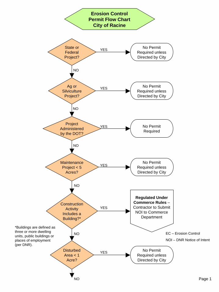
Page 1
Erosion Control Permit Flow Chart
City of Racine
Ag or Silviculture
Project?
State or Federal Project?
No Permit Required unless Directed by City
YES
No Permit Required unless Directed by City
YES
NO
NO
*Buildings are defined as three or more dwelling units, public buildings or places of employment (per DNR).
EC – Erosion Control
NOI – DNR Notice of Intent
Project Administered by the DOT?
No Permit Required
YES
NO
Disturbed Area < 1
Acre?
Construction Activity
Includes a Building?*
NO
No Permit Required unless Directed by City
YES
Regulated Under Commerce Rules –Contractor to Submit NOI to Commerce
Department
YES
NO
Maintenance Project < 5
Acres?
No Permit Required unless Directed by City
YES
NO
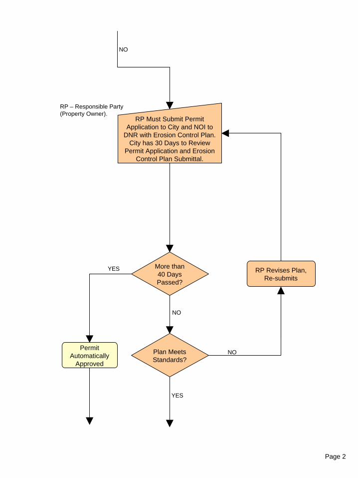
Page 2
RP – Responsible Party (Property Owner).
RP Must Submit Permit Application to City and NOI to
DNR with Erosion Control Plan. City has 30 Days to Review
Permit Application and Erosion Control Plan Submittal.
More than 40 Days Passed?
YES
NO
RP Revises Plan, Re-submits
Plan Meets Standards?
NO
YES
NO
Permit Automatically
Approved
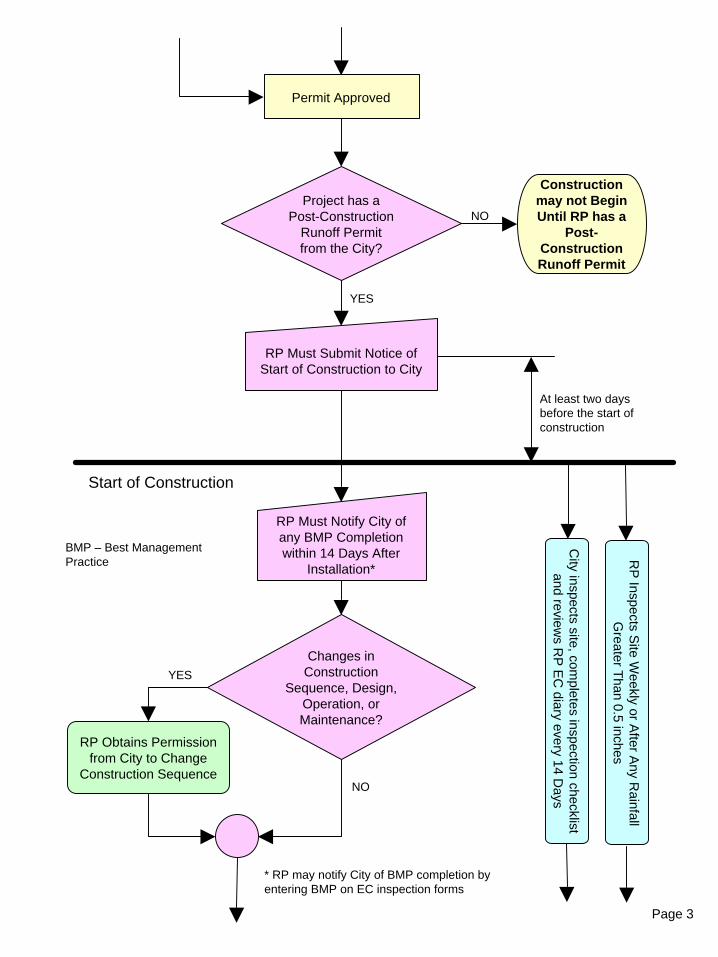
Page 3
At least two days before the start of construction
Permit Approved
RP Must Submit Notice of Start of Construction to City
Changes in Construction
Sequence, Design, Operation, or Maintenance?
YES
NO
RP Obtains Permission from City to Change
Construction Sequence
Start of Construction
RP Must Notify City of any BMP Completion within 14 Days After
Installation*
RP
Inspects Site W
eekly or After A
ny Rainfall
Greater T
han 0.5 inches
* RP may notify City of BMP completion by entering BMP on EC inspection forms
City inspects site, com
pletes inspection checklist and review
s RP
EC
diary every 14 Days
BMP – Best Management Practice
Project has a Post-Construction
Runoff Permit from the City?
YES
Construction may not Begin Until RP has a
Post-Construction Runoff Permit
NO
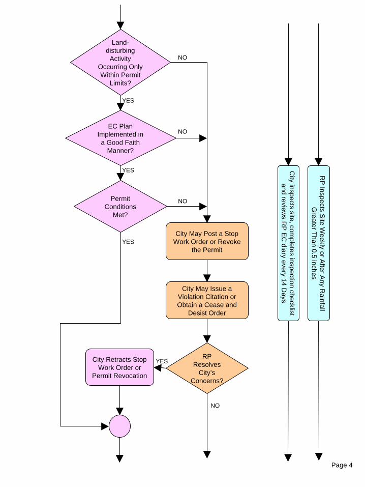
Page 4
Land-disturbing
Activity Occurring Only Within Permit
Limits?
EC Plan Implemented in a Good Faith
Manner?
YES
NO
City May Post a Stop Work Order or Revoke
the Permit
RP
Inspects Site W
eekly or After A
ny Rainfall
Greater T
han 0.5 inches
Permit Conditions
Met?
YES
YES
NO
NO
City May Issue a Violation Citation or Obtain a Cease and
Desist Order
RP Resolves
City’s Concerns?
YES
NO
City Retracts Stop Work Order or
Permit Revocation
City inspects site, com
pletes inspection checklist and review
s RP
EC
diary every 14 Days
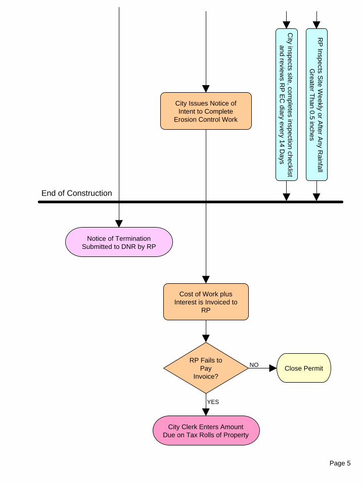
Page 5
End of Construction
Notice of Termination Submitted to DNR by RP
RP
Inspects Site W
eekly or After A
ny Rainfall
Greater T
han 0.5 inches
City Issues Notice of Intent to Complete
Erosion Control Work
RP Fails to Pay
Invoice?
YES
NO
Cost of Work plus Interest is Invoiced to
RP
City Clerk Enters Amount Due on Tax Rolls of Property
Close Permit
City inspects site, com
pletes inspection checklist and review
s RP
EC
diary every 14 Days
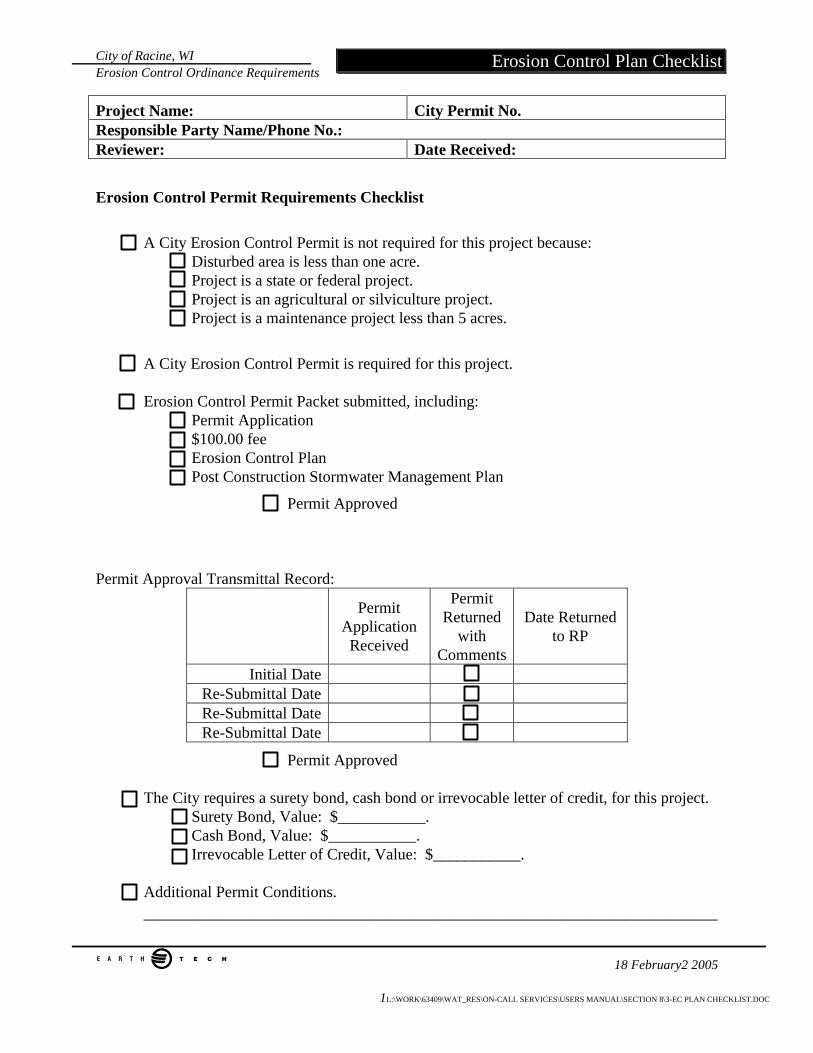
City of Racine, WI Erosion Control Ordinance Requirements
e 18 February2 2005 1L:\WORK\63409\WAT_RES\ON-CALL SERVICES\USERS MANUAL\SECTION 8\3-EC PLAN CHECKLIST.DOC
Erosion Control Plan Checklist
Project Name: City Permit No. Responsible Party Name/Phone No.: Reviewer: Date Received:
Erosion Control Permit Requirements Checklist
A City Erosion Control Permit is not required for this project because: Disturbed area is less than one acre. Project is a state or federal project. Project is an agricultural or silviculture project. Project is a maintenance project less than 5 acres.
A City Erosion Control Permit is required for this project.
Erosion Control Permit Packet submitted, including: Permit Application $100.00 fee Erosion Control Plan Post Construction Stormwater Management Plan
Permit Approved
Permit Approval Transmittal Record:
Permit Application Received
Permit Returned
with Comments
Date Returned to RP
Initial Date Re-Submittal Date Re-Submittal Date Re-Submittal Date
Permit Approved
The City requires a surety bond, cash bond or irrevocable letter of credit, for this project. Surety Bond, Value: $___________. Cash Bond, Value: $___________. Irrevocable Letter of Credit, Value: $___________.
Additional Permit Conditions. ______________________________________________________________
City of Racine, WI Erosion Control Ordinance Requirements
e 18 February2 2005 2L:\WORK\63409\WAT_RES\ON-CALL SERVICES\USERS MANUAL\SECTION 8\3-EC PLAN CHECKLIST.DOC
Erosion Control Plan Checklist
__________________________________________________________________________________________________________________________________________________________________________________________
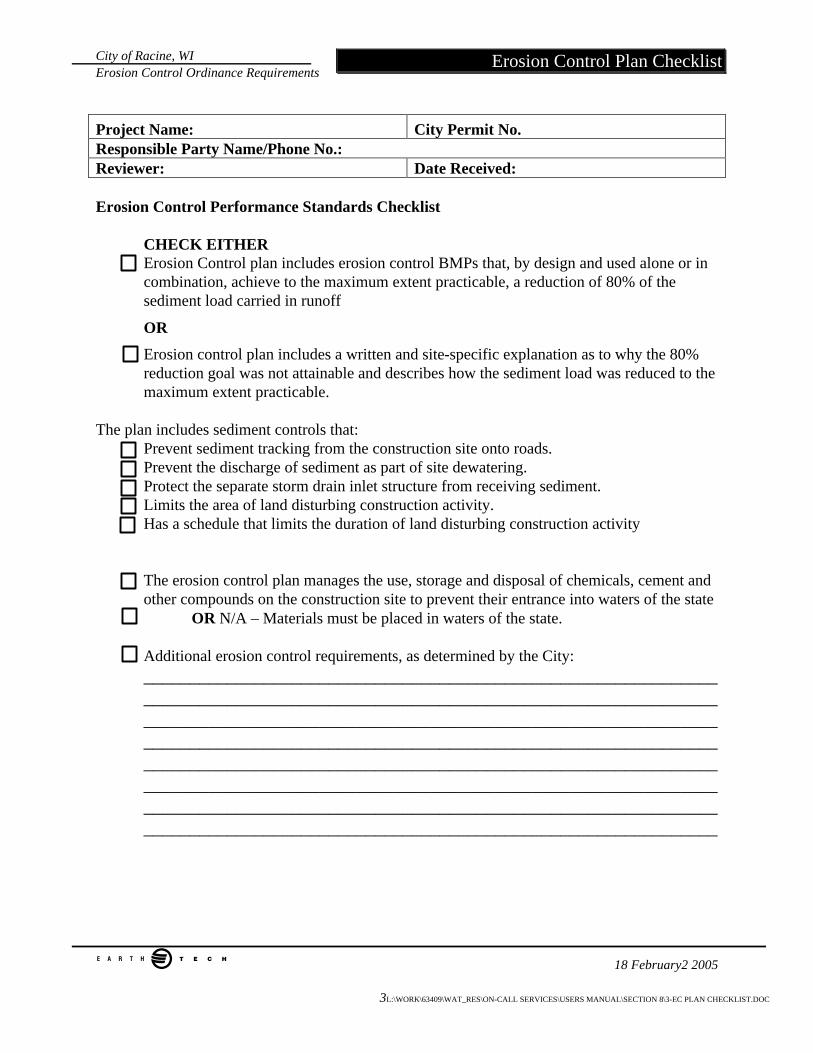
City of Racine, WI Erosion Control Ordinance Requirements
e 18 February2 2005 3L:\WORK\63409\WAT_RES\ON-CALL SERVICES\USERS MANUAL\SECTION 8\3-EC PLAN CHECKLIST.DOC
Erosion Control Plan Checklist
Project Name: City Permit No. Responsible Party Name/Phone No.: Reviewer: Date Received: Erosion Control Performance Standards Checklist
CHECK EITHER Erosion Control plan includes erosion control BMPs that, by design and used alone or in
combination, achieve to the maximum extent practicable, a reduction of 80% of the sediment load carried in runoff
OR
Erosion control plan includes a written and site-specific explanation as to why the 80% reduction goal was not attainable and describes how the sediment load was reduced to the maximum extent practicable.
The plan includes sediment controls that:
Prevent sediment tracking from the construction site onto roads. Prevent the discharge of sediment as part of site dewatering. Protect the separate storm drain inlet structure from receiving sediment.
Limits the area of land disturbing construction activity. Has a schedule that limits the duration of land disturbing construction activity
The erosion control plan manages the use, storage and disposal of chemicals, cement and other compounds on the construction site to prevent their entrance into waters of the state
OR N/A – Materials must be placed in waters of the state.
Additional erosion control requirements, as determined by the City: ________________________________________________________________________________________________________________________________________________________________________________________________________________________________________________________________________________________________________________________________________________________________________________________________________________________________________________________________________________________________________________
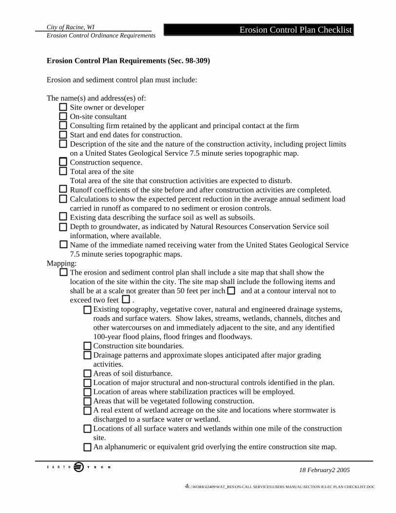
City of Racine, WI Erosion Control Ordinance Requirements
e 18 February2 2005 4L:\WORK\63409\WAT_RES\ON-CALL SERVICES\USERS MANUAL\SECTION 8\3-EC PLAN CHECKLIST.DOC
Erosion Control Plan Checklist
Erosion Control Plan Requirements (Sec. 98-309) Erosion and sediment control plan must include: The name(s) and address(es) of:
Site owner or developer On-site consultant Consulting firm retained by the applicant and principal contact at the firm Start and end dates for construction. Description of the site and the nature of the construction activity, including project limits on a United States Geological Service 7.5 minute series topographic map. Construction sequence. Total area of the site Total area of the site that construction activities are expected to disturb. Runoff coefficients of the site before and after construction activities are completed. Calculations to show the expected percent reduction in the average annual sediment load carried in runoff as compared to no sediment or erosion controls. Existing data describing the surface soil as well as subsoils. Depth to groundwater, as indicated by Natural Resources Conservation Service soil information, where available. Name of the immediate named receiving water from the United States Geological Service 7.5 minute series topographic maps.
Mapping: The erosion and sediment control plan shall include a site map that shall show the location of the site within the city. The site map shall include the following items and shall be at a scale not greater than 50 feet per inch and at a contour interval not to exceed two feet .
Existing topography, vegetative cover, natural and engineered drainage systems, roads and surface waters. Show lakes, streams, wetlands, channels, ditches and other watercourses on and immediately adjacent to the site, and any identified 100-year flood plains, flood fringes and floodways. Construction site boundaries. Drainage patterns and approximate slopes anticipated after major grading activities. Areas of soil disturbance. Location of major structural and non-structural controls identified in the plan. Location of areas where stabilization practices will be employed. Areas that will be vegetated following construction. A real extent of wetland acreage on the site and locations where stormwater is discharged to a surface water or wetland. Locations of all surface waters and wetlands within one mile of the construction site. An alphanumeric or equivalent grid overlying the entire construction site map.
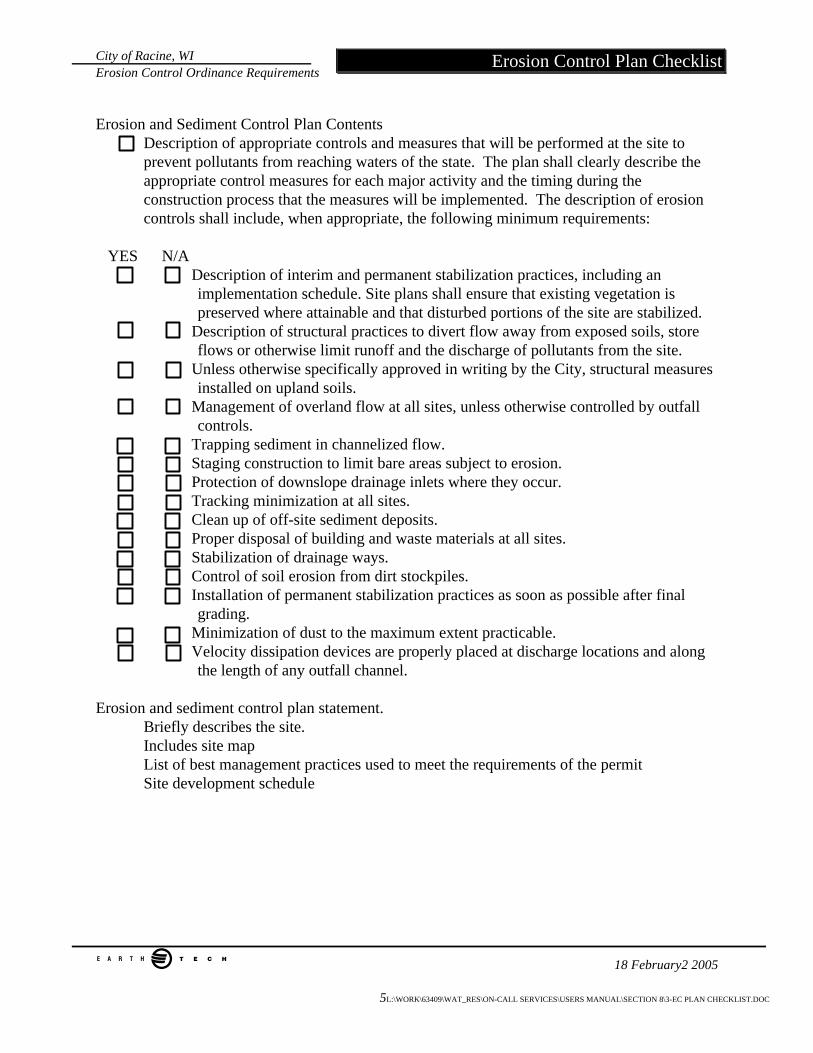
City of Racine, WI Erosion Control Ordinance Requirements
e 18 February2 2005 5L:\WORK\63409\WAT_RES\ON-CALL SERVICES\USERS MANUAL\SECTION 8\3-EC PLAN CHECKLIST.DOC
Erosion Control Plan Checklist
Erosion and Sediment Control Plan Contents
Description of appropriate controls and measures that will be performed at the site to prevent pollutants from reaching waters of the state. The plan shall clearly describe the appropriate control measures for each major activity and the timing during the construction process that the measures will be implemented. The description of erosion controls shall include, when appropriate, the following minimum requirements:
YES N/A Description of interim and permanent stabilization practices, including an
implementation schedule. Site plans shall ensure that existing vegetation is preserved where attainable and that disturbed portions of the site are stabilized.
Description of structural practices to divert flow away from exposed soils, store flows or otherwise limit runoff and the discharge of pollutants from the site.
Unless otherwise specifically approved in writing by the City, structural measures installed on upland soils.
Management of overland flow at all sites, unless otherwise controlled by outfall controls.
Trapping sediment in channelized flow. Staging construction to limit bare areas subject to erosion. Protection of downslope drainage inlets where they occur. Tracking minimization at all sites. Clean up of off-site sediment deposits. Proper disposal of building and waste materials at all sites. Stabilization of drainage ways. Control of soil erosion from dirt stockpiles. Installation of permanent stabilization practices as soon as possible after final
grading. Minimization of dust to the maximum extent practicable. Velocity dissipation devices are properly placed at discharge locations and along
the length of any outfall channel. Erosion and sediment control plan statement.
Briefly describes the site. Includes site map List of best management practices used to meet the requirements of the permit Site development schedule
07-20-04 By Alderman Sollman:
ORDINANCE NO. 21-04
To create Chapter 98, Article VII of the Municipal Code of the City of Racine,
Wisconsin relating to the control of post-construction runoff.
The intent of this ordinance is to reduce the amount of post-construction
stormwater and associated pollutants reaching waters of the state. Adoption of this
ordinance by the city will foster the consistent statewide application of post-construction
performance standards for new development and redevelopment contained in subchapters
III and IV of chapter NR 151, Wis. Adm. Code.
The Common Council of the City of Racine do ordain as follows:
Part 1:
Chapter 98 Article VII of the Municipal Code of the City of Racine is hereby
created to read as follows:
"ARTICLE VII POST-CONSTRUCTION STORMWATER
MANAGEMENT Sec. 98-401. Authority.
(1) This article is adopted by the common council under the authority granted by Wis. Stat. s. 62.234. This article supersedes all provisions enacted under Wis. Stat. s. 62.23 that relate to stormwater management regulations. Except as otherwise specified in Wis. Stat. s. 62.234, Wis. Stat. s. 62.23 applies to this article and to any amendments to this article.
(2) The provisions of this article are deemed not to limit any other lawful regulatory powers of the common council.
(3) The common council hereby designates the commissioner of public works or designee ("commissioner") to administer and enforce the provisions of this article.
(4) The requirements of this article do not preempt more stringent stormwater
management requirements that may be imposed by any of the following:
(a) Wisconsin Department of Natural Resources administrative rules, permits or approvals including those authorized under Wis. Stat. ss. 281.16 and 283.33.
(b) Targeted non-agricultural performance standards promulgated in
rules by the Wisconsin Department of Natural Resources under Wis. Adm. Code s. NR 151.004.
Sec. 98-402. Findings of fact.
The common council finds that uncontrolled, post-construction runoff has a significant impact upon water resources and the health, safety and general welfare of the community and diminishes the public enjoyment and use of natural resources. Specifically, uncontrolled post-construction runoff can:
(1) Degrade physical stream habitat by increasing stream bank erosion, increasing streambed scour, diminishing groundwater recharge, diminishing stream base flows and increasing stream temperature.
(2) Diminish the capacity of lakes and streams to support fish, aquatic life, recreational and water supply uses by increasing pollutant loading of sediment, suspended solids, nutrients, heavy metals, bacteria, pathogens and other urban pollutants.
(3) Alter wetland communities by changing wetland hydrology and by increasing pollutant loads.
(4) Reduce the quality of groundwater by increasing pollutant loading.
(5) Threaten public health, safety, property and general welfare by overtaxing storm sewers, drainage ways, and other minor drainage facilities.
(6) Threaten public health, safety, property and general welfare by increasing major flood peaks and volumes.
(7) Undermine floodplain management efforts by increasing the incidence and levels of flooding. Sec. 98-403. Purpose and intent.
(1) Purpose. The general purpose of this article is to establish long-term, post- construction runoff management requirements that will diminish the threats to public health, safety, welfare and the aquatic environment. Specific purposes are to:
(a) Further the maintenance of safe and healthful conditions.
(b) Prevent and control the adverse effects of stormwater; prevent and control soil erosion; prevent and control water pollution; protect spawning grounds, fish and aquatic life; control building sites, placement of structures and land uses; preserve groundcover and scenic beauty, and promote sound economic growth.
(c) Control exceedance of the safe capacity of existing drainage
facilities and receiving water bodies; prevent undue channel erosion; control increases in the scouring and transportation of particulate matter, and prevent conditions that endanger downstream property.
(2) Intent. It is the intent of the common council that this article regulate post-
construction stormwater discharges to waters of the state. This article may be applied on a site-by-site basis. The common council acknowledges that the preferred method of achieving the stormwater performance standards set forth in this article is through the preparation and implementation of comprehensive, systems-level stormwater management plans that cover hydrologic units, such as watersheds, on a municipal and regional scale. Such plans may prescribe regional stormwater devices, best management practices or systems, any of which may be designed to treat runoff from more than one site prior to discharge to waters of the state. Where such plans are in conformance with the performance standards developed under Wis. Stat. s. 281.16, for regional stormwater management measures and have been approved by the common council, it is the intent of this article that the approved plan be used to identify post-construction management measures acceptable for the community. Sec. 98-404. Applicability and jurisdiction.
(1) Applicability.
(a) Where not otherwise limited by law, this article applies after final stabilization to a site of land disturbing construction activity meeting any of the criteria in this paragraph, unless the site is otherwise exempt under paragraph (b).
1. A post construction site that had 5 or more acres of land
disturbing construction activity.
2. A post-development construction site that had one or more acres of land disturbing construction activity after March 10, 2003.
(b) A site that meets any of the criteria in this paragraph is exempt
from the requirements of this ordinance.
1. A redevelopment post-construction site with no increase in exposed parking lots or roads.
2. A post-construction site with less than 10% connected imperviousness based on complete development of the post-construction site, provided the cumulative area of all parking lots and rooftops is less than one acre.
3. Nonpoint discharges from agricultural facilities and practices.
4. Nonpoint discharges from silviculture activities. 5. Routine maintenance for project sites under 5 acres of land
disturbance if performed to maintain the original line and grade, hydraulic capacity or original purpose of the facility.
6. Underground utility construction such as water, sewer and fiberoptic lines. This exemption does not apply to the construction of above ground structures associated with utility construction.
(c) Notwithstanding the applicability requirements in par. (a), this
article applies to post-construction sites of any size that, in the opinion of the commissioner, are likely to result in runoff that exceeds the safe capacity of the existing drainage facilities or receiving body of water, that causes undue channel erosion, that increases water pollution by scouring or the transportation of particulate matter or that endangers property or public safety.
(2) Jurisdiction.
This article applies to post construction sites within the boundaries and
jurisdiction of the city.
(3) Exclusions.
This article is not applicable to activities conducted by a state agency, as defined under Wis. Stat. s. 227.01(1), but also including the office of district attorney, which is subject to the state plan promulgated or a memorandum of understanding entered into under Wis. Stat. s. 281.33(2).
Sec. 98-405. Definitions. The following words, terms and phrases, when used in this article, shall have the meanings given in this section, except where the context clearly indicates a different meaning:
Agricultural facilities and practices has the meaning given in Wis. Stat. s. 281.16.
Average annual rainfall means a calendar year of precipitation, excluding snow, which is considered typical.
Best management practice or "BMP" means structural or non-structural measures, practices, techniques or devices employed to avoid or minimize sediment or pollutants carried in runoff to waters of the state.
Business day means a day the office of the commissioner is routinely and customarily open for business.
Cease and desist order means a court-issued order to halt land disturbing
construction activity that is being conducted without the required permit.
Combined sewer system means a system for conveying both sanitary sewage and storm- water runoff.
Connected imperviousness means an impervious surface that is directly connected to a separate storm sewer or water of the state via an impervious flow path.
Design storm means a hypothetical discrete rainstorm characterized by a specific duration, temporal distribution, rainfall intensity, return frequency, and total depth of rainfall.
Development means residential, commercial, industrial or institutional land uses and associated roads.
Division of land means the creation of two or more parcels or building sites from one parcel.
Effective infiltration area means the area of the infiltration system that is used to infiltrate runoff and does not include the area used for site access, berms or pretreatment.
Erosion means the process by which the land's surface is worn away by the action of wind, water, ice or gravity.
Exceptional resource waters means waters listed in Wis. Adm. Code s. NR 102.11.
Extraterritorial means the unincorporated area within 3 miles of the corporate limits of a first, second, or third class city, or within 1.5 miles of a fourth class city or village.
Final stabilization means that all land disturbing construction activities at the construction site have been completed and that a uniform, perennial, vegetative cover has been established, with a density of at least 70% of the cover, for the unpaved areas and areas not covered by permanent structures, or employment of equivalent permanent stabilization measures.
Financial guarantee means a performance bond, maintenance bond, surety bond, cash bond, irrevocable letter of credit, or similar guarantee submitted to the commissioner by the responsible party to assure that requirements of the article are carried out in compliance with the stormwater management plan.
Governing body means the common council.
Impervious surface means an area that releases as runoff all or a large portion of the precipitation that falls on it, excepting frozen soil. Rooftops, sidewalks, driveways, parking lots and streets are examples of areas that typically are impervious.
In-fill area means an undeveloped area of land located within existing development.
Infiltration means the entry of precipitation or runoff into or through the soil.
Infiltration system means a device or best management practice such as a basin, trench, rain garden or swale designed specifically to encourage infiltration, but does not include natural infiltration in pervious surfaces such as lawns, redirecting of rooftop downspouts onto lawns or minimal infiltration from practices, such as swales or road side channels designed for conveyance and pollutant removal only.
Karst feature means an area or surficial geologic feature subject to bedrock dissolution so that it is likely to provide a conduit to groundwater, and may include caves, enlarged fractures, mine features, exposed bedrock surfaces, sinkholes, springs, seeps or swallets.
Land disturbing construction activity means any man-made alteration of the land surface resulting in a change in the topography or existing vegetative or non-vegetative soil cover, that may result in runoff and lead to an increase in soil erosion and movement of sediment into waters of the state. Land disturbing construction activity includes, but is not limited to, clearing and grubbing, demolition, excavating, pit trench dewatering, filling and grading activities.
Maintenance agreement means a legal document that provides for long- term maintenance of storm water management practices.
"MEP" or maximum extent practicable means a level of implementing best management practices in order to achieve a performance standard specified in this article which takes into account the best available technology, cost effectiveness and other competing issues, such as human safety and welfare, endangered and threatened resources, historic properties and geographic features. MEP allows flexibility in the way to meet the performance standards and may vary based on the performance standard and site conditions.
New development means development resulting from the conversion of previously undeveloped land or agricultural land uses.
Off-site means located outside the property boundary described in the permit application.
On-site means located within the property boundary described in the permit application.
Ordinary high-water mark has the meaning given in Wis. Adm. Code s. NR 115.03(6).
Outstanding resource waters means waters listed in Wis. Adm. Code s. NR 102.10.
Percent fines means the percentage of a given sample of soil, which passes through a # 200 sieve.
Performance standard means a narrative or measurable number specifying the minimum acceptable outcome for a facility or practice.
Permit means the commissioner's written authorization to the applicant to conduct land disturbing construction activity or to discharge post-construction runoff to waters of the state.
Permit administration fee means an amount of money paid to the commissioner by the permit applicant for the purpose of recouping the expenses incurred by the city in administering the permit.
Pervious surface means an area that releases as runoff a small portion of the precipitation that falls on it. Lawns, gardens, parks, forests or other similar vegetated areas are examples of surfaces that typically are pervious.
Pollutant has the meaning given in Wis. Stat. s. 283.01(13).
Pollution has the meaning given in Wis. Stat. s. 281.01(10).
Post-construction site means a construction site following the completion of land disturbing construction activity and final site stabilization.
Pre-development condition means the extent and distribution of land cover types present before the initiation of land disturbing construction activity, assuming that all land uses prior to development activity are managed in an environmentally sound manner.
Preventive action limit has the meaning given in Wis. Adm. Code s. NR 140.05(17).
Redevelopment means areas where development is replacing older development.
Responsible party means any entity holding fee title to the property or other person contracted or obligated by other agreement to implement and maintain post-construction storm-water BMPs.
Runoff means stormwater or precipitation including rain, snow or ice melt or similar water that moves on the land surface via sheet or channelized flow.
Separate storm sewer means a conveyance or system of conveyances including roads with drainage systems, streets, catch basins, curbs, gutters, ditches, constructed channels or storm drains, which meets all of the following criteria:
(a) Is designed or used for collecting water or conveying runoff.
(b) Is not part of a combined sewer system.
(c) Discharges directly or indirectly to waters of the state.
Site means the entire area included in the legal description of the land on which the land disturbing construction activity occurred.
Stop work order means an order issued by the commissioner that requires all construction activity on the site to be stopped.
Stormwater management plan means a comprehensive plan designed to reduce the discharge of pollutants from stormwater after the site has under gone final stabilization following completion of the construction activity.
Stormwater management system plan is a comprehensive plan designed to reduce the discharge of runoff and pollutants from hydrologic units on a regional or municipal scale.
Technical standard means a document that specifies design, predicted performance and operation and maintenance specifications for a material, device or method.
Top of the channel means an edge, or point on the landscape, landward from the ordinary high-water mark of a surface water of the state, where the slope of the land begins to be less than 12% continually for at least 50 feet. If the slope of the land is 12% or less continually for the initial 50 feet, landward from the ordinary high-water mark, the top of the channel is the ordinary high-water mark.
TR-55 means the United States Department of Agriculture, Natural Resources Conservation Service (previously Soil Conservation Service), Urban Hydrology for Small Watersheds, Second Edition, Technical Release 55, June 1986.
Type II distribution means a rainfall type curve as established in the "United States Department of Agriculture, Soil Conservation Service, Technical Paper 149, published 1973". The Type II curve is applicable to all of Wisconsin and represents the most intense storm pattern.
Waters of the state has the meaning given in Wis. Stat. s. 281.01(18). Sec. 98-406. Technical standards.
The following methods shall be used in designing the water quality, peak flow shaving and infiltration components of stormwater practices needed to meet the water quality standards of this ordinance:
(1) Technical standards identified, developed or disseminated by the Wisconsin Department of Natural Resources ("WDNR") under subchapter V of article NR 151, Wis. Adm. Code.
(2) Where technical standards have not been identified or developed by the WDNR, other technical standards may be used provided that the methods have been approved by the commissioner.
(3) In this article, the following year and location has been selected as average annual rainfalls: Milwaukee, 1969 (Mar. 28-Dec. 6). Sec. 98-407. Performance standards.
(1) Responsible Party. The responsible party shall implement a post-construction stormwater management plan that incorporates the requirements of this section.
(2) Plan. A written stormwater management plan in accordance with s. 98-409 shall be developed and implemented for each post-construction site.
(3) Requirements. The plan required under sub. (2) shall include the following:
(a) Total suspended solids. BMPs shall be designed, installed and maintained to control total suspended solids carried in runoff from the post-construction site as follows:
1. For new development, by design, reduce to the maximum
extent practicable, the total suspended solids load by 80%, based on the average annual rainfall, as compared to no runoff management controls. No person shall be required to exceed an 80% total suspended solids reduction to meet the requirements of this subdivision.
2. For redevelopment, by design, reduce to the maximum
extent practicable, the total suspended solids load by 40%, based on the average annual rainfall, as compared to no runoff management controls. No person shall be required to exceed a 40% total suspended solids reduction to meet the requirements of this subdivision.
3. For in-fill development under 5 acres that occurs within 10
years after October 1, 2002, by design, reduce to the maximum extent practicable, the total suspended solids load by 40%, based on an average annual rainfall, as compared to no runoff management controls. No person shall be required to exceed a 40% total suspended solids reduction to meet the requirements of this subdivision.
4. For in-fill development that occurs 10 or more years after
October 1, 2002, by design, reduce to the maximum extent practicable, the total suspended solids load by 80%, based on an average annual rainfall, as compared to no runoff management controls. No person shall be required to exceed an 80% total suspended solids reduction to meet the requirements of this subdivision.
5. Notwithstanding sub-sections 1. to 4., if the design cannot
achieve the applicable total suspended solids reduction specified, the stormwater management plan shall include a written and site-specific explanation why that level of
reduction is not attained and the total suspended solids load shall be reduced to the maximum extent practicable.
(b) Peak Discharge.
1. By design, BMPs shall be employed to maintain or reduce
the peak runoff discharge rates, to the maximum extent practicable, as compared to pre-development conditionally the 2-year, 24-hour design storm applicable to the post-construction site. Pre-development conditions shall assume "good hydrologic conditions" for appropriate land covers as identified in TR-55 or an equivalent methodology. The meaning of "hydrologic soil group" and "runoff curve number" are as determined in TR-55. However, when pre-development land cover is cropland, rather than using TR-55 values for cropland, the runoff curve numbers in Table 1 shall be used.
------------------------------------------------------------------------------- Table 1 - Maximum Pre-Development Runoff Curve Numbers for Cropland Areas ------------------------------------------------------------------------------- Hydrologic Soil Group A B C D ----------------------------------------------------------------------------- Runoff Curve Number 56 70 79 83 -------------------------------------------------------------------------------
2. This subsection of the article does not apply to any of the following:
a. A post-construction site where the change in
hydrology due to development does not increase the existing surface water elevation at any point within the downstream receiving water by more than 0.01 of a foot for the 2-year, 24-hour storm event.
b. A redevelopment post-construction site.
c. An in-fill development area less than 5 acres
(c) Infiltration. BMPs shall be designed, installed, and maintained to infiltrate runoff to the maximum extent practicable in accordance with the following, except as provided in subds. 5. through 8.
1. For residential developments one of the following shall be
met:
a. Infiltrate sufficient runoff volume so that the post-development infiltration volume shall be at least 90% of the pre-development infiltration volume, based on an average annual rainfall. However, when designing appropriate infiltration systems to meet this requirement, no more than 1% of the project site is required as an effective infiltration area.
b. Infiltrate 25% of the post-development runoff from
the 2 year -24 hour design storm with a type II distribution. Separate curve numbers for pervious and impervious surfaces shall be used to calculate runoff volumes and not composite curve numbers as defined in TR-55. However, when designing appropriate infiltration systems to meet this requirement, no more than 1% of the project site is required as an effective infiltration area.
2. For non-residential development, including commercial,
industrial and institutional development, one of the following shall be met:
a. Infiltrate sufficient runoff volume so that the post-
development infiltration volume shall be at least 60% of the pre-development infiltration volume, based on an average annual rainfall. However, when designing appropriate infiltration systems to meet this requirement, no more than 2% of the project site is required as an effective infiltration area.
b. Infiltrate 10% of the runoff from the 2 year - 24
hour design storm with a type II distribution. Separate curve numbers for pervious and impervious surfaces shall be used to calculate runoff volumes, and not composite curve numbers as defined in TR-55. However, when designing appropriate infiltration systems to meet this
requirement, no more than 2% of the project site is required as an effective infiltration area.
3. Pre-development condition shall be the same as in par. (b).
4. Before infiltrating runoff, pretreatment shall be required for
parking lot runoff and for runoff from new road construction in commercial, industrial and institutional areas that will enter an infiltration system. The pretreatment shall be designed to protect the infiltration system from clogging prior to scheduled maintenance and to protect groundwater quality in accordance with sub-section 8. Pretreatment options may include, but are not limited to, oil/grease separation, sedimentation, biofiltration, filtration, swales or filter strips.
5. Exclusions. The runoff from the following areas are
prohibited from meeting the requirements of section 98-407.
a. Areas associated with tier 1 industrial facilities
identified in Wis. Adm. Code s. 216.21(2)(a), including storage, loading, rooftop and parking.
b. Storage and loading areas of tier 2 industrial
facilities identified in Wis. Adm. Code s. NR 216.21(2)(b).
c. Fueling and vehicle maintenance areas.
d. Areas within 1000 feet upgradient or within 100
feet downgradient of karst features.
e. Areas with less than 3 feet separation distance from the bottom of the infiltration system to the elevation of seasonal high groundwater or the top of bedrock, except this sub-section 5.e. does not prohibit infiltration of roof runoff.
f. Areas with runoff from industrial, commercial and
institutional parking lots and roads and residential arterial roads with less than 5 feet separation distance from the bottom of the infiltration system to the elevation of seasonal high groundwater or the top of bedrock.
g. Areas within 400 feet of a community water system
well as specified in Wis. Adm. Code s. NR 811.16(4), or within 100 feet of a private well as specified in Wis. Adm. Code s. NR 812.08(4), for runoff infiltrated from commercial, industrial and institutional land uses or regional devices for residential development.
h. Areas where contaminants of concern, as defined in
Wis. Adm. Code s. NR 720.03(2) are present in the soil through which infiltration will occur.
i. Any area where the soil does not exhibit one of the
following soil characteristics between the bottom of the infiltration system and the seasonal high groundwater and top of bedrock: at least a 3-foot soil layer with 20% fines or greater; or at least a 5-foot soil layer with 10 percent fines or greater. This does not apply where the soil medium within the infiltration system provides an equivalent level of protection. This sub-section 5.i. does not prohibit infiltration of roof runoff.
6. Exemptions. The following are not required to meet the
requirements of section 98-407.
a. Areas where the infiltration rate of the soil is less than 0.6 inches/hour measured at the site.
b. Parking areas and access roads less than 5,000
square feet for commercial and industrial development.
c. Redevelopment post-construction sites.
d. In-fill development areas less than 5 acres.
e. Infiltration areas during periods when the soil on the
site is frozen.
f. Roads in commercial, industrial and institutional land uses, and arterial residential roads.
7. Additional provisions.

a. Infiltration systems designed in accordance with
this paragraph shall, to the extent technically and economically feasible, minimize the level of pollutants infiltrating to groundwater and shall maintain compliance with the preventive action limit at a point of standards application in accordance with Wis. Adm. Code ch. NR 140. However, if site specific information indicates that compliance with a preventive action limit is not achievable, the infiltration BMP may not be installed or shall be modified to prevent infiltration to the maximum extent practicable.
b. Notwithstanding par. a., the discharge from BMPs shall remain below the enforcement standard at the point of standards application.
(d) Protective areas.
1. "Protective area" means an area of land that commences at
the top of the channel of lakes, streams and rivers, or at the delineated boundary of wetlands, and that is the greatest of the following widths, as measured horizontally from the top of the channel or delineated wetland boundary to the closest impervious surface. However, in this paragraph, "protective area" excludes any area of land adjacent to any stream enclosed within a pipe or culvert, such that runoff cannot enter the enclosure at this location.
a. For outstanding resource waters and exceptional
resource waters, and for wetlands in areas of special natural resource interest as specified in s. NR 103.04, 75 feet.
b. For perennial and intermittent streams identified on
a United States geological survey 7.5-minute series topographic map, or a county soil survey map, whichever is more current, 50 feet.
c. For lakes, 50 feet.
d. For highly susceptible wetlands, 50 feet. Highly
susceptible wetlands include the following types: fens, sedge meadows, bogs, low prairies, conifer
swamps, shrub swamps, other forested wetlands, fresh wet meadows, shallow marshes, deep marshes and seasonally flooded basins. Wetland boundary delineations shall be made in accordance with s. NR 103.08(1m). This sub-paragraph does not apply to wetlands that have been completely filled in accordance with all applicable state and federal regulations. The protective area for wetlands that have been partially filled in accordance with all applicable state and federal regulations shall be measured from the wetland boundary delineation after fill has been placed.
e. For less susceptible wetlands, 10 percent of the
average wetland width, but no less than 10 feet nor more than 30 feet. Less susceptible wetlands include degraded wetlands dominated by invasive species such as reed canary grass.
f. In sub-sections 1.a., d. and e., determinations of the
extent of the protective area adjacent to wetlands shall be made on the basis of the sensitivity and runoff susceptibility of the wetland in accordance with the standards and criteria in s. NR 103.03.
g. For concentrated flow channels with drainage areas
greater than 130 acres, 10 feet.
2. This paragraph applies to post-construction sites located within a protective area, except those areas exempted pursuant to sub-section 4.
3. The following requirements shall be met:
a. Impervious surfaces shall be kept out of the
protective area to the maximum extent practicable. The stormwater management plan shall contain a written site-specific explanation for any parts of the protective area that are disturbed during construction.
b. Where land disturbing construction activity occurs
within a protective area, and where no impervious surface is present, adequate sod or self- sustaining vegetative cover of 70% or greater shall be
established and maintained. The adequate sod or self-sustaining vegetative cover shall be sufficient to provide for bank stability, maintenance of fish habitat and filtering of pollutants from upslope overland flow areas under sheet flow conditions. Non-vegetative materials, such as rock riprap, may be employed on the bank as necessary to prevent erosion, such as on steep slopes or where high velocity flows occur.
c. Best management practices such as filter strips,
swales, or wet detention basins that are designed to control pollutants from non-point sources may be located in the protective area.
4. This paragraph (d) does not apply to:
a. Redevelopment post-construction sites.
b. In-fill development areas less than 5 acres.
c. Structures that cross or access surface waters such
as boat landings, bridges and culverts.
d. Structures constructed in accordance with Wis. Stat. s. 59.692(1v).
e. Post-construction sites from which runoff does not
enter the surface water, except to the extent that vegetative ground cover is necessary to maintain bank stability.
(e) Fueling and vehicle maintenance areas. Fueling and vehicle
maintenance areas shall, to the maximum extent practicable, have BMPs designed, installed and maintained to reduce petroleum within runoff, such that the runoff that enters waters of the state contains no visible petroleum sheen.
(f) Swale treatment for transportation facilities.
1. Applicability. Except as provided in sub-section 2.,
transportation facilities that use swales for runoff conveyance and pollutant removal meet all of the requirements of this section, if the swales are designed to the maximum extent practicable to do all of the following:
a. Be vegetated. However, where appropriate, non-
vegetative measures may be employed to prevent erosion or provide for runoff treatment, such as rock riprap stabilization or check dams.
b. Carry runoff through a swale for 200 feet or more in
length that is designed with a flow velocity no greater than 1.5 feet per second for the peak flow generated using either a 2-year, 24-hour design storm or a 2-year storm with a duration equal to the time of concentration as appropriate. If a swale of 200 feet in length cannot be designed with a flow velocity of 1.5 feet per second or less, then the flow velocity shall be reduced to the maximum extent practicable.
2. Exemptions. The commissioner may, consistent with water
quality standards, require other provisions of this section be met on a transportation facility with an average daily travel of vehicles greater than 2500 and where the initial surface water of the state that the runoff directly enters is any of the following:
a. An outstanding resource water.
b. An exceptional resource water.
c. Waters listed in s. 303(d) of the federal clean water
act that are identified as impaired in whole or in part, due to nonpoint source impacts.
d. Waters where targeted performance standards are
developed under Wis. Adm. Code s. NR 151.004, to meet water quality standards.
(4) General considerations for on-site and off-site stormwater management
measures.
The following considerations shall be observed in managing runoff:
(a) Natural topography and land cover features such as natural swales, natural depressions, native soil infiltrating capacity, and natural groundwater recharge areas shall be preserved and used, to the extent possible, to meet the requirements of this section.
(b) Emergency overland flow for all storm water facilities shall be
provided to prevent exceeding the safe capacity of downstream drainage facilities and prevent endangerment of downstream property or public safety.
(5) Location and regional treatment option.
(a) The BMPs may be located on-site or off-site as part of a regional
storm- water device, practice or system.
(b) Post-construction runoff within a non-navigable surface water that flows into a BMP, such as a wet detention pond, is not required to meet the performance standards of this article. Post-construction BMPs may be located in non-navigable surface waters.
(c) Except as allowed under par. (d), post-construction runoff from
new development shall meet the post-construction performance standards prior to entering a navigable surface water.
(d) Post-construction runoff from any development within a navigable
surface water that flows into a BMP is not required to meet the performance standards of this article if:
1. The BMP was constructed prior to the effective date of this
article and the BMP either received a permit issued under Wis. Stat. ch. 30, or the BMP did not require a Wis. Stat. ch. 30 permit; and
2. The BMP is designed to provide runoff treatment from
future upland development.
(e) Runoff from existing development, redevelopment and in-fill areas shall meet the post-construction performance standards in accordance with this paragraph.
1. To the maximum extent practicable, BMPs shall be located
to treat runoff prior to discharge to navigable surface waters.
2. Post-construction BMPs for such runoff may be located in
a navigable surface water if allowable under all other applicable federal, state and local regulations such as Wis. Adm. Code ch. NR 103, and Wis. Stat. ch. 30.
(f) The discharge of runoff from a BMP, such as a wet detention pond, or after a series of such BMPs is subject to this article.
(g) The commissioner may approve off-site management measures
provided that all of the following conditions are met:
1. The post-construction runoff is covered by a stormwater management system plan that is approved by the city and that contains management requirements consistent with the purpose and intent of this article.
2. The off-site facility meets all of the following conditions:
a. The facility is in place.
b. The facility is designed and adequately sized to
provide a level of stormwater control equal to or greater than that which would be afforded by on-site practices meeting the performance standards of this article.
c. The facility has a legally obligated entity
responsible for its long- term operation and maintenance.
(h) Where a regional treatment option exists such that the
commissioner exempts the applicant from all or part of the minimum on-site stormwater management requirements, the applicant shall be required to pay a one-time fee in an amount calculated by multiplying the total cost of the regional treatment facility by the percentage of the total flow to the regional treatment facility contributed by the applicant's property.
(6) Alternate requirements. The commissioner may establish stormwater
management requirements more stringent than those set forth in this section if he determines that an added level of protection is needed to protect sensitive resources. Sec. 98-408. Permitting requirements, procedures and fees.
(1) Permit required. No responsible party may undertake or commence a land disturbing construction activity without first receiving a post-construction runoff permit from the commissioner.
(2) Permit application and fees. Unless specifically excluded by this article, any responsible party desiring a permit shall submit a permit application to the commissioner on a form provided by the commissioner.
(a) Unless otherwise excepted by this article, a permit application must be accompanied by a stormwater management plan, a maintenance agreement and a non-refundable permit administration fee of $250.
(b) The stormwater management plan shall be prepared to meet the
requirements of ss. 98-407 and 98-409, the maintenance agreement shall be prepared to meet the requirements of s. 98-410, the financial guarantee shall meet the requirements of s. 98-411, and fees shall be as set forth in s. 98-412.
(3) Review and approval of permit application. The commissioner shall
review any permit application that is submitted with a storm water management plan, maintenance agreement, and the required fee. The following approval procedure shall be used:
(a) Within 30 days of the receipt of a complete permit application, including all items as required by sub. (2), the commissioner shall inform the applicant whether the application, plan and maintenance agreement are approved or disapproved based on the requirements of this article.
(b) If the stormwater permit application, plan and maintenance
agreement are approved, or if an agreed upon payment of fees in lieu of stormwater management practices is made, the commissioner shall issue the permit.
(c) If the stormwater permit application, plan or maintenance
agreement is disapproved, the commissioner shall detail in writing the reasons for disapproval.
(d) The commissioner may request additional information from the
applicant. If additional information is submitted, the commissioner shall have 30 days from the date the additional information is received to inform the applicant that the plan and maintenance agreement are either approved or disapproved.
(e) Failure by the commissioner to inform the permit applicant of a
decision within 40 days of a required submittal shall be deemed to mean approval of the submittal and the applicant may proceed as if a permit had been issued.
(4) Permit requirements. All permits issued under this article shall be subject
to the following conditions, and holders of permits issued under this ordinance shall be deemed to have accepted these conditions. The commissioner may suspend or revoke a permit for violation of a permit condition, following written notification of the responsible party. An action by the commissioner to suspend or revoke this permit may be appealed in accordance with s. 98-414.
(a) Compliance with this permit does not relieve the responsible party of the responsibility to comply with other applicable federal, state, and local laws and regulations.
(b) The responsible party shall design and install all structural and
non- structural stormwater management measures in accordance with the approved stormwater management plan and this permit.
(c) The responsible party shall notify the commissioner at least 3
business days before commencing any work in conjunction with the stormwater management plan, and within 5 business days upon completion of the stormwater management practices. If required as a special condition under sub. (5), the responsible party shall make additional notification according to a schedule set forth by the commissioner so that installations can be inspected during construction.
(d) Installations required as part of this article shall be certified "as
built" by a licensed professional engineer. Completed stormwater best management practices must pass a final inspection by the commissioner to determine if they are in accordance with the approved stormwater management plan and this article. The commissioner shall notify the responsible party in writing of any changes required in such practices to bring them into compliance with the conditions of the permit.
(e) The responsible party shall notify the commissioner of any
significant modifications it intends to make to an approved stormwater management plan. The commissioner may require that the proposed modifications be submitted for approval prior to incorporation into the stormwater management plan and execution by the responsible party.
(f) The responsible party shall maintain all stormwater management
practices in accordance with the storm water management plan until the practices become the responsibility of the city or are
transferred to subsequent private owners, as specified in the approved maintenance agreement.
(g) The responsible party authorizes the commissioner to perform any
work or operations necessary to bring stormwater management measures into conformance with the approved stormwater management plan, and consents to a special assessment or charge against the property as authorized under Wis. Stat., ch. 66, subch. VII, or to charging such costs against the financial guarantee posted under s. 98-411.
(h) If so directed by the commissioner the responsible party shall, at its
own expense, repair all damage to adjoining municipal facilities and drainage ways caused by runoff, where such damage is caused by activities that are not in compliance with the approved stormwater management plan.
(i) The responsible party shall permit the commissioner to access the
property for the purpose of inspecting the property for compliance with the approved stormwater management plan and this permit.
(j) Where site development or redevelopment involves changes in
direction, increases in peak rate and/or total volume of runoff from a site, the commissioner may require the responsible party to make appropriate legal arrangements with affected property owners concerning the prevention of endangerment to property or public safety.
(k) The responsible party is subject to the enforcement actions and
penalties detailed in s. 98-413, if the responsible party fails to comply with the terms of this permit.
(5) Permit conditions. Permits issued under this subsection may include
conditions established by commissioner in addition to the requirements necessary to meet the performance standards in s. 98-407 or a financial guarantee as provided for in s. 98-411.
(6) Permit duration. Permits issued under this section shall be valid from the date of issuance through the date the commissioner notifies the responsible party that all stormwater best management practices have passed the final inspection required under sub. (4)(d). Sec. 98-409. Stormwater management plan.
(1) Plan requirements. The stormwater management plan required under s. 98-408 (2) shall contain at a minimum the following information:
(a) Name, address, and telephone number for the following or their designees: landowner; developer; project engineer for practice design and certification; person(s) responsible for installation of stormwater management practices; and person(s) responsible for maintenance of stormwater management practices prior to the transfer, if any, of maintenance responsibility to another party.
(b) A location map and legal description of the property proposed to
be developed, referenced to the U.S. Public Land Survey system or to block and lot numbers within a recorded land subdivision plat.
(c) Pre-development site conditions, including:
1. One or more site maps at a scale of not less than 1 inch
equals 50 feet. The site maps shall show the following: site location and legal description of the property; predominant soil types and hydrologic soil groups; existing cover type and condition; topographic contours of the site at a scale not to exceed two feet; topography and drainage network including enough of the contiguous properties to show runoff patterns onto, through, and from the site; watercourses that may affect or be affected by runoff from the site; flow path and direction for all stormwater conveyance sections; watershed boundaries used in hydrology determinations to show compliance with performance standards; lakes, streams, wetlands, channels, ditches, and other watercourses on and immediately adjacent to the site; limits of the 100 year floodplain; location of wells and wellhead protection areas covering the project area and delineated pursuant to Wis. Adm. Code s. NR 811.16.
2. Hydrology and pollutant loading computations as needed to
show compliance with performance standards. All major assumptions used in developing input parameters shall be clearly stated. The geographic areas used in making the calculations shall be clearly cross-referenced to the required map(s).
(d) Post-development site conditions, including:
1. Explanation of the provisions to preserve and use natural topography and land cover features to minimize changes in peak flow runoff rates and volumes to surface waters and wetlands.
2. Explanation of any restrictions on stormwater management
measures in the development area imposed by wellhead protection plans and ordinances.
3. One or more site maps at a scale of not less than 1 inch
equals 50 feet showing the following: post-construction pervious areas including vegetative cover type and condition; impervious surfaces including all buildings, structures, and pavement; post-construction topographic contours of the site at a scale not to exceed two feet; post-construction drainage network including enough of the contiguous properties to show runoff patterns onto, through, and from the site; locations and dimensions of drainage easements; locations of maintenance easements specified in the maintenance agreement; flow path and direction for all stormwater conveyance sections; location and type of all stormwater management conveyance and treatment practices, including the on-site and off-site tributary drainage area; location and type of conveyance system that will carry runoff from the drainage and treatment practices to the nearest adequate outlet such as a curbed street, storm drain, or natural drainage way; watershed boundaries used in hydrology and pollutant loading calculations and any changes to lakes, streams, wetlands, channels, ditches, and other watercourses on and immediately adjacent to the site.
4. Hydrology and pollutant loading computations as needed to
show compliance with performance standards. The computations shall be made for each discharge point in the development, and the geographic areas used in making the calculations shall be clearly cross-referenced to the required map(s).
5. Results of investigations of soils and groundwater required
for the placement and design of stormwater management measures. Detailed drawings including cross-sections and profiles of all permanent stormwater conveyance and treatment practices.
(e) A description and installation schedule for the stormwater management practices needed to meet the performance standards in s. 98-407.
(f) A maintenance plan developed for the life of each stormwater
management practice including the required maintenance activities and maintenance activity schedule.
(g) Cost estimates for the construction, operation, and maintenance of
each stormwater management practice.
(h) Other information requested in writing by the commissioner to determine compliance of the proposed stormwater management measures with the provisions of this article
(i) All site investigations, plans, designs, computations, and drawings
shall be certified by a registered professional engineer licensed in the State of Wisconsin to be prepared in accordance with accepted engineering practice and requirements of this article
(2) Alternate requirements. The commissioner may prescribe alternative
submittal requirements for applicants seeking an exemption to on-site stormwater management performance standards under s. 98-407(5). Sec. 98-410. Maintenance agreement.
(1) Maintenance agreement required. The maintenance agreement required under s. 98-408 (2) for stormwater best management practices shall be an agreement between the city and the responsible party to provide for maintenance of stormwater practices beyond the duration period of this permit. The maintenance agreement shall be recorded with the County Register of Deeds as a property deed restriction so that it is binding upon all subsequent owners of the land served by the stormwater management practices.
(2) Agreement provisions. The maintenance agreement shall contain the following information and provisions and be consistent with the maintenance plan required by s. 98-409(1)(f):
(a) Identification of the stormwater facilities and designation of the drainage area served by the facilities.
(b) A schedule for regular maintenance of each aspect of the
stormwater management system consistent with the stormwater management plan required under s. 98-408 (2).
(c) Identification of the party responsible for long term maintenance of the stormwater management practices identified in the stormwater management plan required under s. 98-408 (2).
(d) Requirement that the responsible party shall maintain stormwater
management practices in accordance with the schedule included in par. (b).
(e) Authorization for the commissioner to access the property to
conduct inspections of stormwater management practices as necessary to ascertain that the practices are being maintained and operated in accordance with the agreement.
(f) A requirement that the commissioner inform the party responsible
for maintenance of any corrective actions required to bring the stormwater management practice into proper working condition.
(g) Agreement that the party designated under par. (c), as responsible
for long term maintenance of the storm water management practices, shall be notified by the commissioner of maintenance problems which require correction. The specified corrective actions shall be undertaken within a reasonable time frame as set by the commissioner.
(h) Authorization of the commissioner to perform the corrective
actions identified in the inspection report if the responsible party designated under par. (c) does not make the required corrections in the specified time period. The commissioner shall enter the amount due on the tax rolls and collect the money as a special charge against the property pursuant to Wis. Stat., ch. 66, subch. VII.
Sec. 98-411. Financial Guarantee.
(1) Establishment of the guarantee. The commissioner may require the submittal of a financial guarantee in the form of a surety bond, cash bond or irrevocable letter of credit. The financial guarantee shall be in an amount determined by the commissioner to be the estimated cost of construction of the stormwater management system. The financial guarantee shall give the commissioner the authorization to use the funds to complete the stormwater management system if the responsible party defaults, upon written notice to the responsible party by the administering authority that the requirements of this article have not been met.
(2) Conditions for release. Conditions for the release of the financial guarantee are as follows: The commissioner shall release the portion of the financial guarantee established under this section, less any costs incurred by the commissioner to complete installation of the system, upon submission of "as built plans" by a registered professional engineer licensed in the State of Wisconsin. The commissioner may make provisions for a partial pro-rata release of the financial guarantee based on the completion of various development stages. Sec. 98-412. Fee schedule.
The fees referred to in other sections of this article shall be established by the common council and may from time to time be modified by resolution. A schedule of the fees shall be available for review in City Hall, Room 303, 730 Washington Av., Racine, Wis. Sec. 98-413. Enforcement.
(1) Any land disturbing construction activity or post-construction runoff initiated after the effective date of this article by any person, firm, association, or corporation subject to this article shall be deemed a violation unless conducted in accordance with the requirements of this article.
(2) The commissioner shall by registered mail, return receipt requested, or personal service or, if the responsible party cannot be served after reasonable efforts have been made to locate and serve the responsible party, by a class 1 publication of notice, notify the responsible party of any non-complying land disturbing construction activity or post-construction runoff. The notice shall describe the nature of the violation, remedial actions needed, a schedule for remedial action, and additional enforcement action which may be taken.
(3) Upon receipt of written notification from the commissioner or publication
of notice under sub. (2), the responsible party shall correct work that does not comply with the stormwater management plan or other provisions of this permit. The responsible party shall make corrections as necessary to meet the specifications and schedule set forth by the commissioner in the notice.
(4) If the violations to a permit issued pursuant to this article are likely to result in damage to properties, public facilities, or waters of the state, the commissioner may enter the land and take emergency actions necessary to prevent such damage. The costs incurred by the commissioner plus interest and legal costs shall be billed to the responsible party.
(5) The commissioner is authorized to post a stop work order on all land disturbing construction activity that is in violation of this article, issuance a citation, or request the city attorney to obtain a cease and desist order in any court with jurisdiction.
(6) The commissioner may revoke a permit issued under this article for non-compliance with provisions of this article.
(7) Any permit revocation, stop work order, or cease and desist order shall remain in effect unless retracted by the commissioner or by a court with jurisdiction.
(8) The commissioner is authorized to refer any violation of this article, or of a stop work order or cease and desist order issued pursuant to this article, to the city attorney for the commencement of further legal proceedings in any court with jurisdiction.
(9) Upon conviction, any person, firm, association, or corporation who does not comply with the provisions of this article shall forfeit an amount of not less than $500 dollars nor more than $1,000 dollars per offense, together with the costs of prosecution. Each day that the violation exists shall constitute a separate offense.
(10) Compliance with the provisions of this article may also be enforced by injunction in any court with jurisdiction. It shall not be necessary to prosecute for forfeiture or a cease and desist order before resorting to injunctive proceedings.
(11) When the commissioner determines that the holder of a permit issued pursuant to this article has failed to follow practices set forth in the stormwater management plan, or has failed to comply with schedules set forth in said stormwater management plan, the commissioner or a party designated by the commissioner may enter upon the land and perform the work or other operations necessary to bring the condition of said lands into conformance with requirements of the approved plan. The commissioner shall keep a detailed accounting of the costs and expenses of performing this work. These costs and expenses shall be deducted from any financial security posted pursuant to s. 98-411 of this article. Where such a security has not been established, or where such a security is insufficient to cover these costs, the costs and expenses shall be entered on the tax roll as a special charge against the property and collected with any other taxes levied thereon for the year in which the work is completed. Sec. 98-414. Appeals.
(1) The public works and services committee shall hear and decide appeals where it is alleged that there is error in any order, decision or determination made by the commissioner in administering this article. The committee shall also use the rules, procedures, duties, and powers authorized by statute in hearing and deciding appeals. Upon appeal, the committee may authorize variances from the provisions of this article
that are not contrary to the public interest, and where owing to special conditions a literal enforcement of the article will result in unnecessary hardship.
(2) Who may appeal. Appeals may be taken by any aggrieved person or by an officer, department, or board city affected by any decision of the commissioner." Part 2: This ordinance shall take effect upon passage and the day after publication. Passed by the Common Council _________________________________ Approved _________________________________ _________________________________ Mayor Attest: ________________________________ City Clerk FISCAL NOTE: N/A
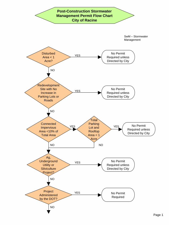
Page 1
Post-Construction Stormwater Management Permit Flow Chart
City of Racine
Redevelopment Site with No Increase in
Parking Lots or Roads
Disturbed Area < 1
Acre?
Ag, Underground
Utility or Silviculture
Project?
Connected Impervious
Area <10% of Total Area
NO
No Permit Required unless Directed by City
YES
YES
No Permit Required unless Directed by City
YES
NO
No Permit Required unless Directed by City
YES
NO
NO
SwM – Stormwater Management
No Permit Required unless Directed by City
Total Parking Lot and Rooftop Area < 1
Acre
YES
NO
Project Administered by the DOT?
No Permit Required
YES
NO
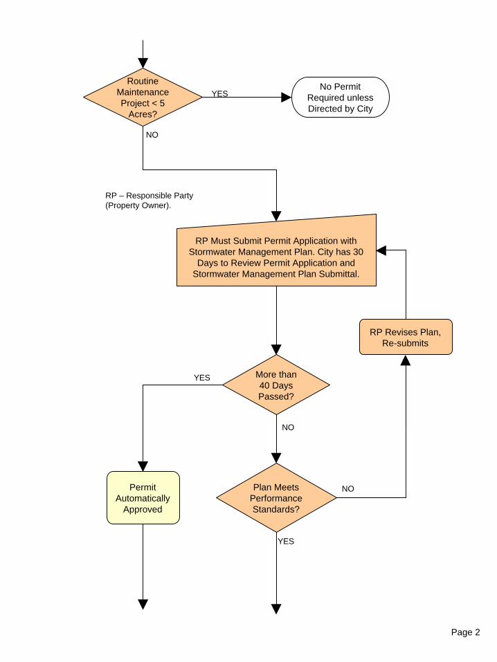
Page 2
RP – Responsible Party (Property Owner).
RP Must Submit Permit Application with Stormwater Management Plan. City has 30
Days to Review Permit Application and Stormwater Management Plan Submittal.
More than 40 Days Passed?
YES
NO
RP Revises Plan, Re-submits
Plan Meets Performance Standards?
NO
YES
NO
Routine Maintenance Project < 5
Acres?
No Permit Required unless Directed by City
YES
Permit Automatically
Approved
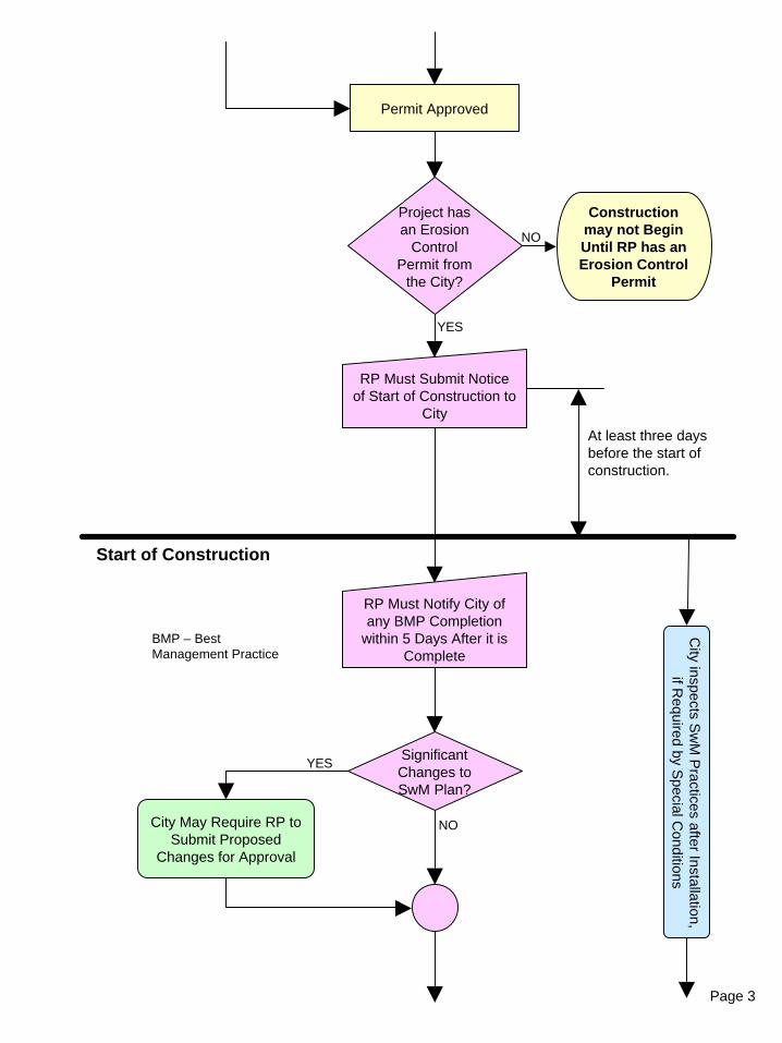
Page 3
At least three days before the start of construction.
Permit Approved
RP Must Submit Notice of Start of Construction to
City
Significant Changes to SwM Plan?
YES
NOCity May Require RP to Submit Proposed
Changes for Approval
Start of Construction
RP Must Notify City of any BMP Completion
within 5 Days After it is Complete
City inspects S
wM
Practices after Installation,
if Required by S
pecial Conditions
BMP – Best Management Practice
Project has an Erosion
Control Permit from
the City?
YES
Construction may not Begin Until RP has an Erosion Control
Permit
NO
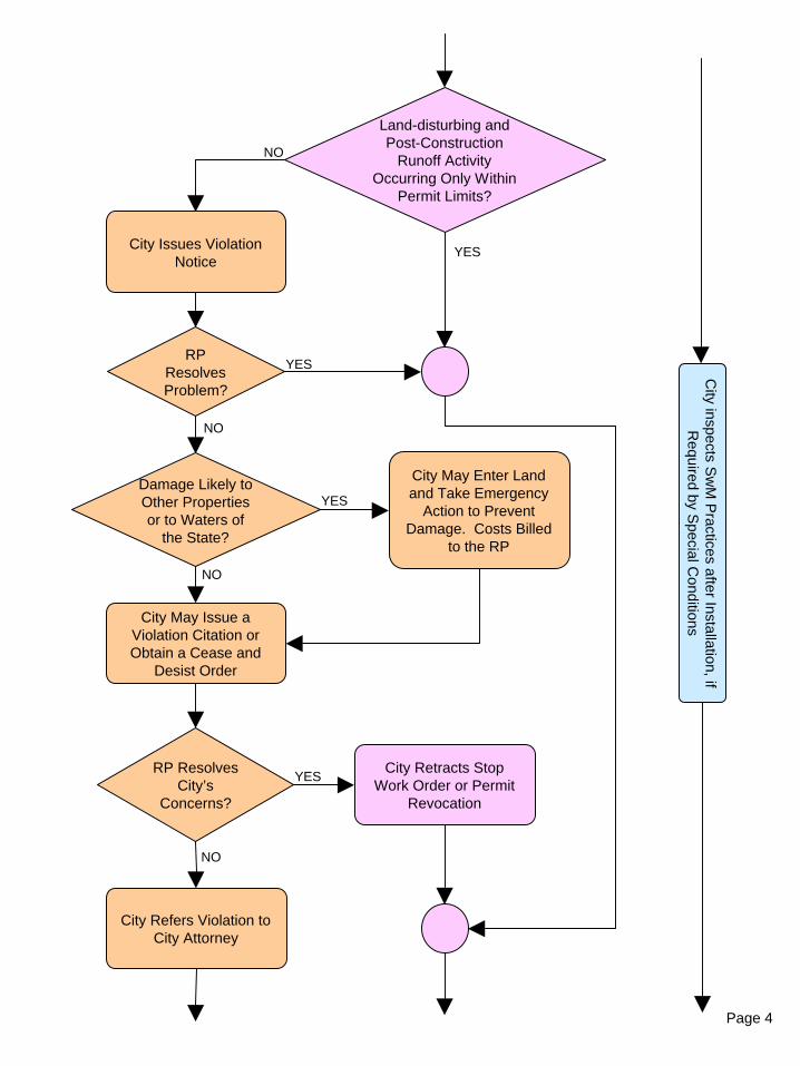
Page 4
Land-disturbing and Post-Construction
Runoff Activity Occurring Only Within
Permit Limits?
RP Resolves Problem?
YES
NO
City Issues Violation Notice
Damage Likely to Other Properties or to Waters of
the State?
YES
NO
NO
City May Issue a Violation Citation or Obtain a Cease and
Desist Order
RP Resolves City’s
Concerns?
YES
NO
City Retracts Stop Work Order or Permit
Revocation
City inspects
Sw
MP
ractices after Installation, if R
equired by Special C
onditions
YES
City May Enter Land and Take Emergency
Action to Prevent Damage. Costs Billed
to the RP
City Refers Violation to City Attorney
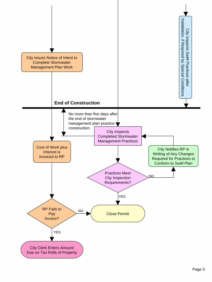
Page 5
End of Construction
City Issues Notice of Intent to Complete Stormwater
Management Plan Work
RP Fails to Pay
Invoice?
YES
NO
Cost of Work plus Interest is
Invoiced to RP
City Clerk Enters Amount Due on Tax Rolls of Property
Close Permit
City inspects
Sw
MP
ractices after Installation, if R
equired by Special C
onditions
No more than five days after the end of stormwater management plan practice construction.
City Inspects Completed Stormwater Management Practices
Practices Meet City Inspection Requirements?
YES
NO
City Notifies RP in Writing of Any Changes Required for Practices to
Conform to SwM Plan
City of Racine, WI Stormwater Management Ordinance Requirements
e 18 February2 2005 1
Stormwater Management Plan Checklist
Project Name: City Permit No. Responsible Party Name/Phone No.: Reviewer: Date Received: Stormwater Management Plan Permit Requirements Checklist
A City Stormwater Management Permit is not required for this project because: It is a redevelopment post-construction site with no increase in exposed parking lots or roads. Disturbed area is less than one acre. Project is a post-construction site with less than 10% connected imperviousness based on complete development of the post-construction site and the cumulative area of all parking lots and rooftops is less than one acre. Project is an agricultural or silviculture project. Project is a routine maintenance project less than 5 acres.
A City Stormwater Management Permit is required for this project.
Stormwater Management Permit Packet submitted, including: Permit Application $250.00 fee Stormwater Management Plan Maintenance Agreement
Permit Approval Transmittal Record:
Permit Application Received
Permit Returned
with Comments
Date Returned to RP
Initial Date Re-Submittal Date Re-Submittal Date Re-Submittal Date
Permit Approved
The City requires a surety bond, cash bond or irrevocable letter of credit, for this project. Surety Bond, Value: $___________. Cash Bond, Value: $___________. Irrevocable Letter of Credit, Value: $___________.
Licensed design professional submitted the ‘as-built’ plans or licensed design professional certified that the project, as constructed, meets post-construction stormwater management requirements.
City of Racine, WI Stormwater Management Ordinance Requirements
e 18 February2 2005 2
Stormwater Management Plan Checklist
Additional Permit Conditions. ____________________________________________________________________________________________________________________________________________________________________________________________________________________________________________________________________________________________________________________________________________________
Permit Duration Site Classification: Total Site Area ___________ ac
Disturbed Area ___________ ac Land Uses: Residential Commercial Industrial Institutional
Development Type: New Development Re-Development In-Fill Development – Area _____ ac.
Applicable Standards: Total Suspended Solids Peak Discharge Infiltration Protective Areas Fueling and Vehicle Maintenance Area Swale Treatment for Transportation Facility Area Regional Treatment Alternate Requirements
Start Construction Date
Date City Notified Responsible Party that all Stormwater Best Management Practices have passed Final Inspection
City of Racine, WI Stormwater Management Ordinance Requirements
e 18 February2 2005 3
Stormwater Management Plan Checklist
Project Name: City Permit No. Responsible Party Name/Phone No.: Reviewer: Date Received: Stormwater Management Maintenance Agreement Checklist (Sec. 98-410) The Stormwater Management Maintenance Agreement must include:
Identification of the stormwater facilities and designation of the drainage area served by the facilities.
A schedule for regular maintenance of each aspect of the stormwater management system.
Identification of the party responsible for long term maintenance of the stormwater management practices identified in the stormwater management plan.
Requirement that the responsible party shall maintain stormwater management practices.
Authorization for the City to access the property to conduct inspections of stormwater management practices as necessary.
Notice that the City will inform the party responsible for maintenance of any corrective actions required to bring the stormwater management practice into proper working condition.
Notice that the City will inform the party responsible for maintenance problems that requires correction to bring the stormwater management practice into proper working condition within a reasonable time frame as determined by the City.
Authorization for the City to perform the corrective actions identified in the inspection report if the responsible party does not make the required corrections in the specified time period at the expense of the responsible party.
Notice that if the responsible party does not pay the City for any corrective action or maintenance the City performs, the City will enter the amount due on the tax rolls and collect the money as a special charge against the property
City of Racine, WI Stormwater Management Ordinance Requirements
e 18 February2 2005 4
Stormwater Management Plan Checklist
Project Name: City Permit No. Responsible Party Name/Phone No.: Reviewer: Date Received: Stormwater Management Plan Requirements Checklist (Sec. 98-409)
The Stormwater Management Plan must include: The name(s), address(es) and phone numbers of:
Site owner or developer Design engineer On-site construction manager Person responsible for maintenance Location map and legal description of the property, referenced to the U.S. Public Land Survey system or to block and lot numbers within a recorded land subdivision plat.
Pre-Development Site Conditions Site Map showing: Location of the site at a scale not greater than 50 feet per inch and at a contour interval not to exceed two feet Legal description of property Predominant soil types and hydrologic soil groups Existing cover type and condition Topography and drainage network including enough of the contiguous properties to show runoff patterns onto, through, and from the site Watercourses that may affect or be affected by runoff from the site N/A Flow path and direction for all stormwater conveyance sections Watershed boundaries used in hydrology determinations Lakes, streams, wetlands, channels, ditches, and other watercourses on and immediately adjacent to the site N/A 100-Year floodplain N/A Location of wells and wellhead protection areas, with description of information source N/A
Post-Development Site Conditions Site Map showing: Location of the site at a scale not greater than 50 feet per inch and at a contour interval not to exceed two feet Impervious surfaces including all buildings, structures, and pavement Locations of maintenance easements specified in the maintenance agreement N/A Post-construction pervious areas including vegetative cover type and condition N/A Post-construction drainage network including enough of the contiguous properties to show runoff patterns onto, through, and from the site Locations and dimensions of drainage easements N/A Flow path and direction for all stormwater conveyance sections Watershed boundaries used in hydrology and pollutant loading calculations Changes to lakes, streams, wetlands, channels, ditches, and other watercourses on and immediately adjacent to the site N/A
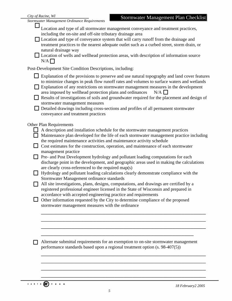
City of Racine, WI Stormwater Management Ordinance Requirements
e 18 February2 2005 5
Stormwater Management Plan Checklist
Location and type of all stormwater management conveyance and treatment practices, including the on-site and off-site tributary drainage area Location and type of conveyance system that will carry runoff from the drainage and treatment practices to the nearest adequate outlet such as a curbed street, storm drain, or natural drainage way Location of wells and wellhead protection areas, with description of information source N/A
Post-Development Site Condition Descriptions, including:
Explanation of the provisions to preserve and use natural topography and land cover features to minimize changes in peak flow runoff rates and volumes to surface waters and wetlands Explanation of any restrictions on stormwater management measures in the development area imposed by wellhead protection plans and ordinances N/A Results of investigations of soils and groundwater required for the placement and design of stormwater management measures Detailed drawings including cross-sections and profiles of all permanent stormwater conveyance and treatment practices
Other Plan Requirements
A description and installation schedule for the stormwater management practices Maintenance plan developed for the life of each stormwater management practice including the required maintenance activities and maintenance activity schedule Cost estimates for the construction, operation, and maintenance of each stormwater management practice Pre- and Post Development hydrology and pollutant loading computations for each discharge point in the development, and geographic areas used in making the calculations are clearly cross-referenced to the required map(s) Hydrology and pollutant loading calculations clearly demonstrate compliance with the Stormwater Management ordinance standards All site investigations, plans, designs, computations, and drawings are certified by a registered professional engineer licensed in the State of Wisconsin and prepared in accordance with accepted engineering practice and requirements Other information requested by the City to determine compliance of the proposed stormwater management measures with the ordinance ____________________________________________________________________________________________________________________________________________________________________________________________________________________ Alternate submittal requirements for an exemption to on-site stormwater management performance standards based upon a regional treatment option (s. 98-407(5)) ________________________________________________________________________________________________________________________________________________________________________________________________________________________
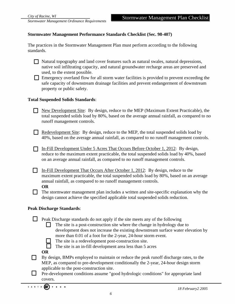
City of Racine, WI Stormwater Management Ordinance Requirements
e 18 February2 2005 6
Stormwater Management Plan Checklist
Stormwater Management Performance Standards Checklist (Sec. 98-407) The practices in the Stormwater Management Plan must perform according to the following standards.
Natural topography and land cover features such as natural swales, natural depressions, native soil infiltrating capacity, and natural groundwater recharge areas are preserved and used, to the extent possible. Emergency overland flow for all storm water facilities is provided to prevent exceeding the safe capacity of downstream drainage facilities and prevent endangerment of downstream property or public safety.
Total Suspended Solids Standards:
New Development Site: By design, reduce to the MEP (Maximum Extent Practicable), the total suspended solids load by 80%, based on the average annual rainfall, as compared to no runoff management controls.
Redevelopment Site: By design, reduce to the MEP, the total suspended solids load by 40%, based on the average annual rainfall, as compared to no runoff management controls.
In-Fill Development Under 5 Acres That Occurs Before October 1, 2012: By design, reduce to the maximum extent practicable, the total suspended solids load by 40%, based on an average annual rainfall, as compared to no runoff management controls.
In-Fill Development That Occurs After October 1, 2012: By design, reduce to the maximum extent practicable, the total suspended solids load by 80%, based on an average annual rainfall, as compared to no runoff management controls. OR The stormwater management plan includes a written and site-specific explanation why the design cannot achieve the specified applicable total suspended solids reduction.
Peak Discharge Standards:
Peak Discharge standards do not apply if the site meets any of the following The site is a post-construction site where the change in hydrology due to development does not increase the existing downstream surface water elevation by more than 0.01 of a foot for the 2-year, 24-hour storm event. The site is a redevelopment post-construction site. The site is an in-fill development area less than 5 acres
OR By design, BMPs employed to maintain or reduce the peak runoff discharge rates, to the MEP, as compared to pre-development conditionally the 2-year, 24-hour design storm applicable to the post-construction site. Pre-development conditions assume "good hydrologic conditions" for appropriate land covers.
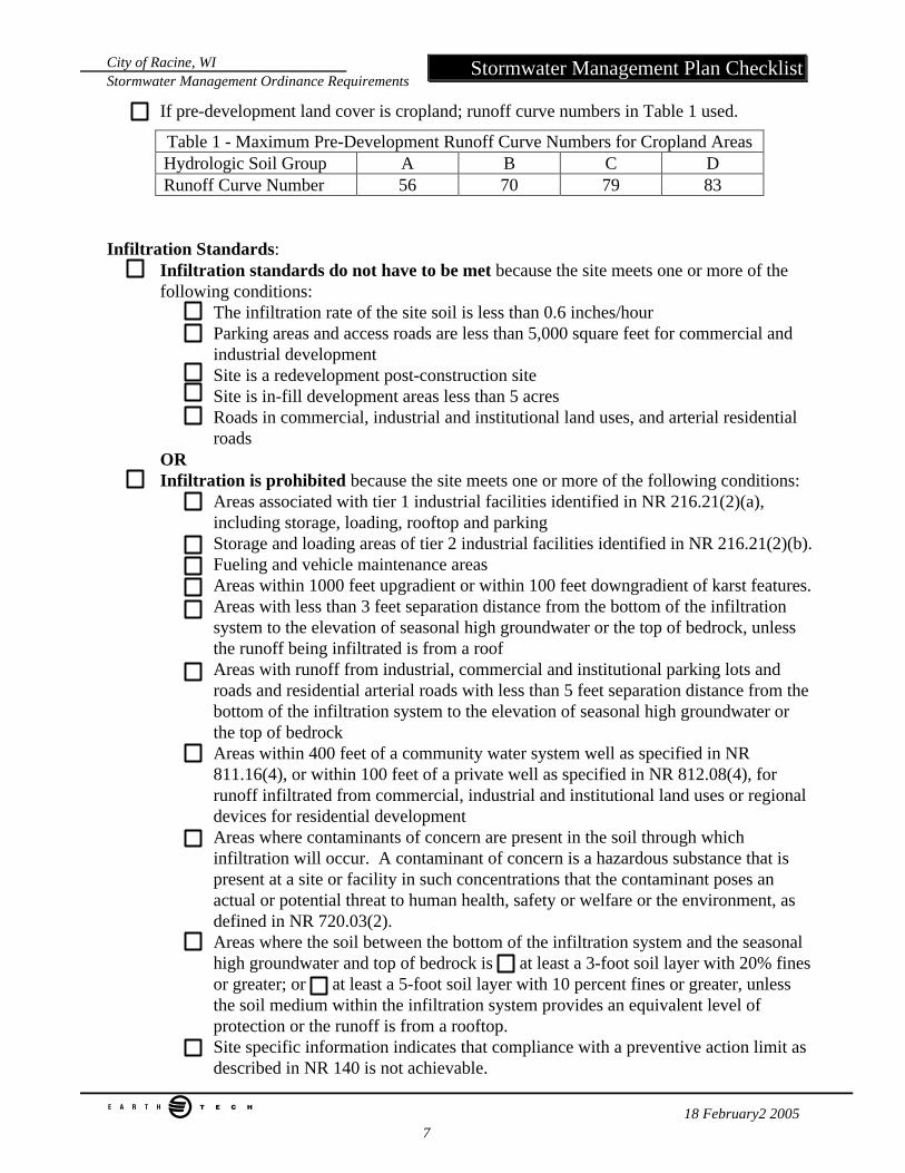
City of Racine, WI Stormwater Management Ordinance Requirements
e 18 February2 2005 7
Stormwater Management Plan Checklist
If pre-development land cover is cropland; runoff curve numbers in Table 1 used.
Table 1 - Maximum Pre-Development Runoff Curve Numbers for Cropland Areas Hydrologic Soil Group A B C D Runoff Curve Number 56 70 79 83
Infiltration Standards: Infiltration standards do not have to be met because the site meets one or more of the following conditions:
The infiltration rate of the site soil is less than 0.6 inches/hour Parking areas and access roads are less than 5,000 square feet for commercial and industrial development Site is a redevelopment post-construction site Site is in-fill development areas less than 5 acres Roads in commercial, industrial and institutional land uses, and arterial residential roads
OR Infiltration is prohibited because the site meets one or more of the following conditions:
Areas associated with tier 1 industrial facilities identified in NR 216.21(2)(a), including storage, loading, rooftop and parking Storage and loading areas of tier 2 industrial facilities identified in NR 216.21(2)(b). Fueling and vehicle maintenance areas Areas within 1000 feet upgradient or within 100 feet downgradient of karst features. Areas with less than 3 feet separation distance from the bottom of the infiltration system to the elevation of seasonal high groundwater or the top of bedrock, unless the runoff being infiltrated is from a roof Areas with runoff from industrial, commercial and institutional parking lots and roads and residential arterial roads with less than 5 feet separation distance from the bottom of the infiltration system to the elevation of seasonal high groundwater or the top of bedrock Areas within 400 feet of a community water system well as specified in NR 811.16(4), or within 100 feet of a private well as specified in NR 812.08(4), for runoff infiltrated from commercial, industrial and institutional land uses or regional devices for residential development Areas where contaminants of concern are present in the soil through which infiltration will occur. A contaminant of concern is a hazardous substance that is present at a site or facility in such concentrations that the contaminant poses an actual or potential threat to human health, safety or welfare or the environment, as defined in NR 720.03(2). Areas where the soil between the bottom of the infiltration system and the seasonal high groundwater and top of bedrock is at least a 3-foot soil layer with 20% fines or greater; or at least a 5-foot soil layer with 10 percent fines or greater, unless the soil medium within the infiltration system provides an equivalent level of protection or the runoff is from a rooftop. Site specific information indicates that compliance with a preventive action limit as described in NR 140 is not achievable.
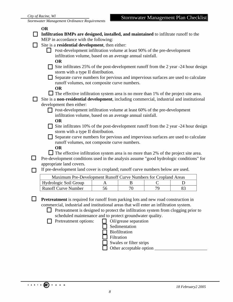
City of Racine, WI Stormwater Management Ordinance Requirements
e 18 February2 2005 8
Stormwater Management Plan Checklist
OR Infiltration BMPs are designed, installed, and maintained to infiltrate runoff to the MEP in accordance with the following: Site is a residential development, then either:
Post-development infiltration volume at least 90% of the pre-development infiltration volume, based on an average annual rainfall. OR Site infiltrates 25% of the post-development runoff from the 2 year -24 hour design storm with a type II distribution. Separate curve numbers for pervious and impervious surfaces are used to calculate runoff volumes, not composite curve numbers. OR The effective infiltration system area is no more than 1% of the project site area.
Site is a non-residential development, including commercial, industrial and institutional development then either:
Post-development infiltration volume at least 60% of the pre-development infiltration volume, based on an average annual rainfall. OR Site infiltrates 10% of the post-development runoff from the 2 year -24 hour design storm with a type II distribution. Separate curve numbers for pervious and impervious surfaces are used to calculate runoff volumes, not composite curve numbers. OR The effective infiltration system area is no more than 2% of the project site area.
Pre-development conditions used in the analysis assume "good hydrologic conditions" for appropriate land covers. If pre-development land cover is cropland; runoff curve numbers below are used.
Maximum Pre-Development Runoff Curve Numbers for Cropland Areas Hydrologic Soil Group A B C D Runoff Curve Number 56 70 79 83
Pretreatment is required for runoff from parking lots and new road construction in commercial, industrial and institutional areas that will enter an infiltration system.
Pretreatment is designed to protect the infiltration system from clogging prior to scheduled maintenance and to protect groundwater quality. Pretreatment options: Oil/grease separation
Sedimentation Biofiltration Filtration Swales or filter strips Other acceptable option _______________________
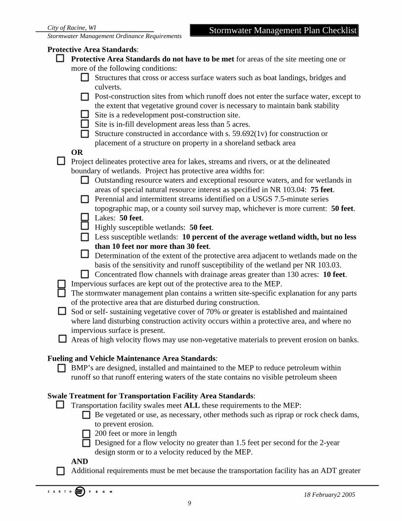
City of Racine, WI Stormwater Management Ordinance Requirements
e 18 February2 2005 9
Stormwater Management Plan Checklist
Protective Area Standards: Protective Area Standards do not have to be met for areas of the site meeting one or more of the following conditions:
Structures that cross or access surface waters such as boat landings, bridges and culverts. Post-construction sites from which runoff does not enter the surface water, except to the extent that vegetative ground cover is necessary to maintain bank stability Site is a redevelopment post-construction site. Site is in-fill development areas less than 5 acres. Structure constructed in accordance with s. 59.692(1v) for construction or placement of a structure on property in a shoreland setback area
OR Project delineates protective area for lakes, streams and rivers, or at the delineated boundary of wetlands. Project has protective area widths for:
Outstanding resource waters and exceptional resource waters, and for wetlands in areas of special natural resource interest as specified in NR 103.04: 75 feet. Perennial and intermittent streams identified on a USGS 7.5-minute series topographic map, or a county soil survey map, whichever is more current: 50 feet. Lakes: 50 feet. Highly susceptible wetlands: 50 feet. Less susceptible wetlands: 10 percent of the average wetland width, but no less than 10 feet nor more than 30 feet. Determination of the extent of the protective area adjacent to wetlands made on the basis of the sensitivity and runoff susceptibility of the wetland per NR 103.03. Concentrated flow channels with drainage areas greater than 130 acres: 10 feet.
Impervious surfaces are kept out of the protective area to the MEP. The stormwater management plan contains a written site-specific explanation for any parts of the protective area that are disturbed during construction. Sod or self- sustaining vegetative cover of 70% or greater is established and maintained where land disturbing construction activity occurs within a protective area, and where no impervious surface is present. Areas of high velocity flows may use non-vegetative materials to prevent erosion on banks.
Fueling and Vehicle Maintenance Area Standards:
BMP’s are designed, installed and maintained to the MEP to reduce petroleum within runoff so that runoff entering waters of the state contains no visible petroleum sheen
Swale Treatment for Transportation Facility Area Standards:
Transportation facility swales meet ALL these requirements to the MEP: Be vegetated or use, as necessary, other methods such as riprap or rock check dams, to prevent erosion. 200 feet or more in length Designed for a flow velocity no greater than 1.5 feet per second for the 2-year design storm or to a velocity reduced by the MEP.
AND Additional requirements must be met because the transportation facility has an ADT greater
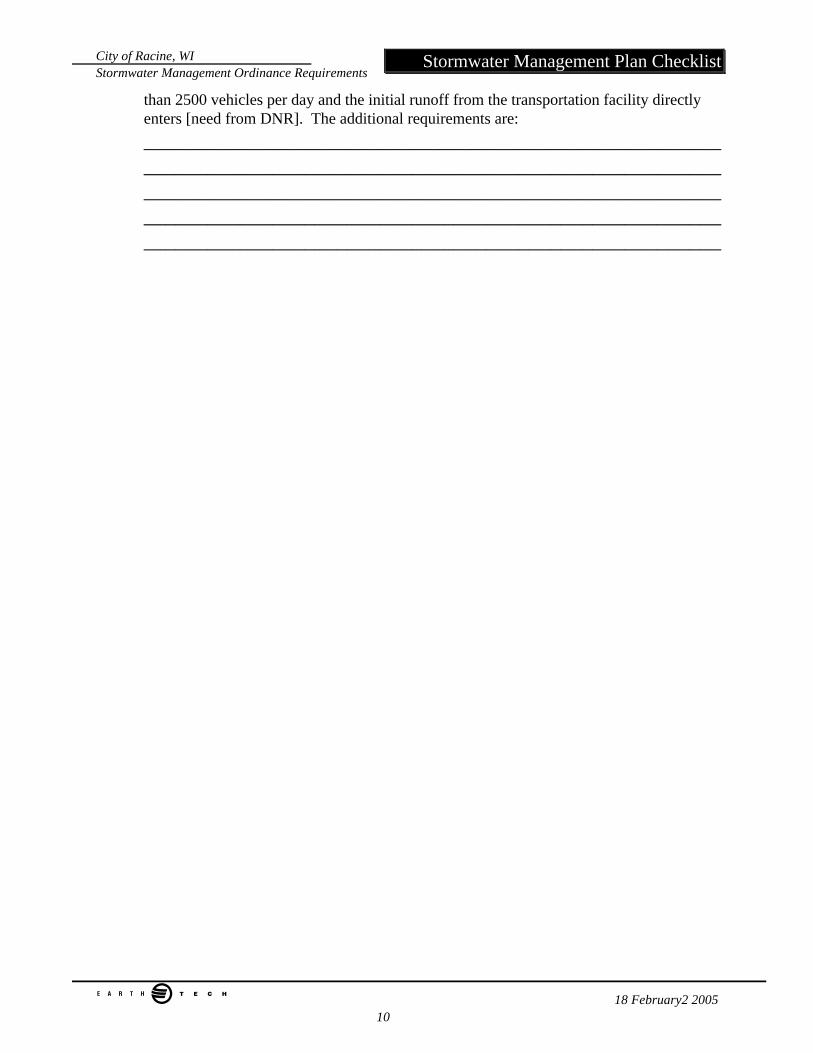
City of Racine, WI Stormwater Management Ordinance Requirements
e 18 February2 2005 10
Stormwater Management Plan Checklist
than 2500 vehicles per day and the initial runoff from the transportation facility directly enters [need from DNR]. The additional requirements are: ______________________________________________________________________________________________________________________________________________________________________________________________________________________________________________________________________________
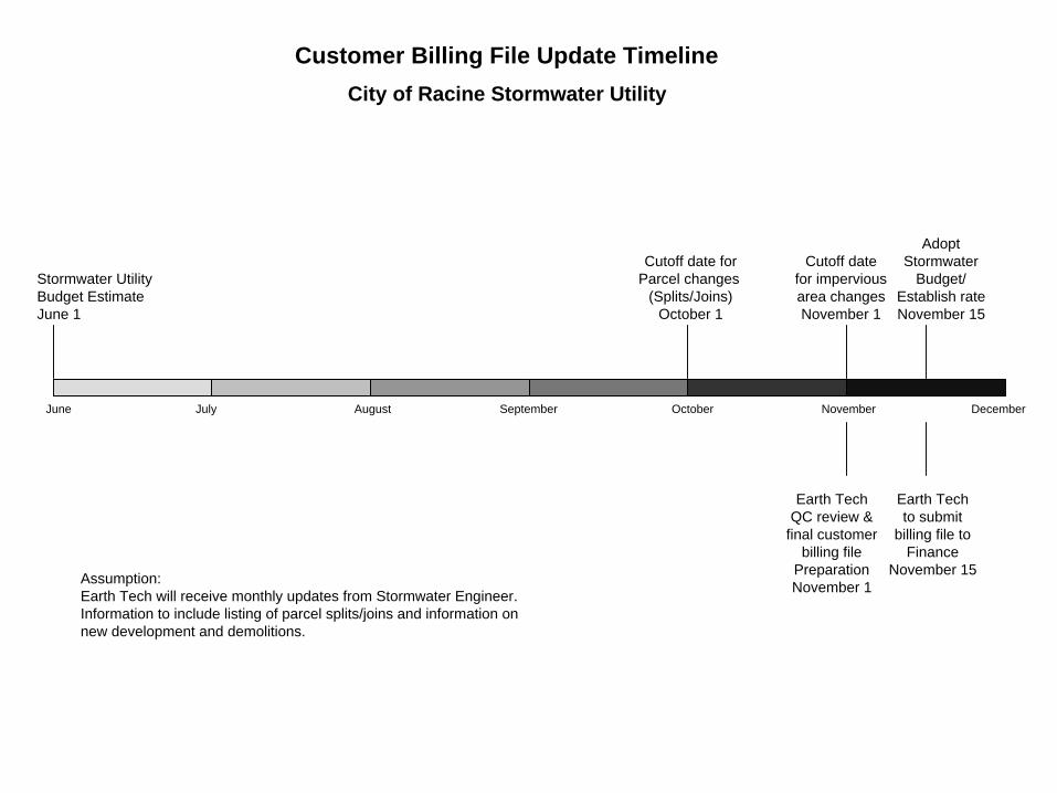
June July August September October November December
Stormwater UtilityBudget EstimateJune 1
Cutoff date forParcel changes
(Splits/Joins)October 1
Cutoff datefor imperviousarea changesNovember 1
AdoptStormwater
Budget/Establish rateNovember 15
Earth TechQC review &
final customerbilling file
PreparationNovember 1
Earth Techto submit
billing file toFinance
November 15Assumption:Earth Tech will receive monthly updates from Stormwater Engineer.Information to include listing of parcel splits/joins and information onnew development and demolitions.
Customer Billing File Update Timeline
City of Racine Stormwater Utility
WPDES Permit No. WI-S050059-1 Root River Group
TABLE OF CONTENTS Part I. Applicability Part II. Group Conditions Part III. Individual Conditions Part IV. Compliance Schedule Part V. General Conditions Part VI. Definitions GENERAL DESCRIPTION AND PURPOSE OF THE WPDES STORM WATER PERMIT
FOR THE ROOT RIVER GROUP The City of Racine, City of New Berlin, City of Franklin, Village of Greendale, Village of Hales Corners, Village of Mount Pleasant and Town of Caledonia own and operate municipal separate storm sewer systems that discharge to waters of the state. These seven municipalities are collectively described as the Root River Group for the purposes of this permit. Discharges from storm sewer systems may consist of runoff from rain events or snow melt and fluids from spills or illicit connections. Pollutants of concern found in storm sewer system discharges include organic materials, suspended solids, metals, nutrients, bacteria, pesticides, fertilizer, and traces of toxic materials. This WPDES permit will regulate discharges from the Root River Group municipal separate storm sewer systems in accordance with s. 283, Wis. Stats. and ch. NR 216, Wis. Adm. Code. The permit requirements are intended to restore and maintain the chemical, physical, and biological integrity of waters of the state through management and treatment of urban storm water runoff.
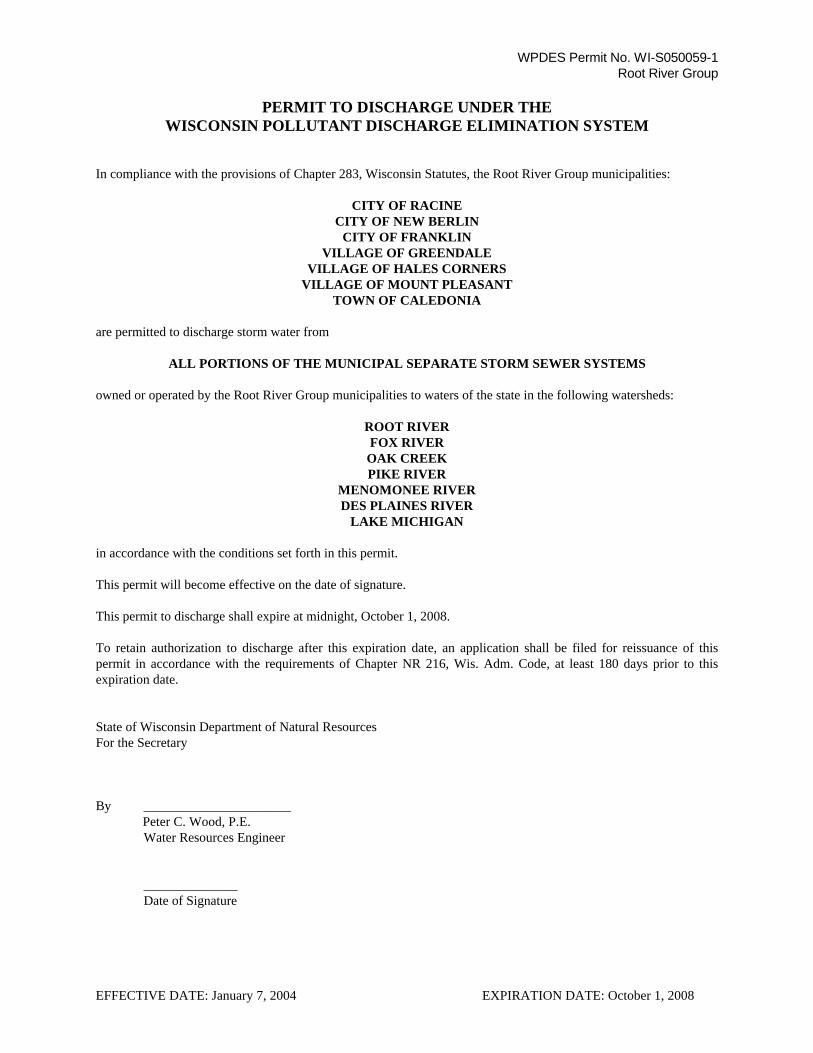
WPDES Permit No. WI-S050059-1 Root River Group
PERMIT TO DISCHARGE UNDER THE WISCONSIN POLLUTANT DISCHARGE ELIMINATION SYSTEM
In compliance with the provisions of Chapter 283, Wisconsin Statutes, the Root River Group municipalities: CITY OF RACINE
CITY OF NEW BERLIN CITY OF FRANKLIN
VILLAGE OF GREENDALE VILLAGE OF HALES CORNERS
VILLAGE OF MOUNT PLEASANT TOWN OF CALEDONIA
are permitted to discharge storm water from
ALL PORTIONS OF THE MUNICIPAL SEPARATE STORM SEWER SYSTEMS owned or operated by the Root River Group municipalities to waters of the state in the following watersheds:
ROOT RIVER FOX RIVER
OAK CREEK PIKE RIVER
MENOMONEE RIVER DES PLAINES RIVER
LAKE MICHIGAN in accordance with the conditions set forth in this permit. This permit will become effective on the date of signature. This permit to discharge shall expire at midnight, October 1, 2008. To retain authorization to discharge after this expiration date, an application shall be filed for reissuance of this permit in accordance with the requirements of Chapter NR 216, Wis. Adm. Code, at least 180 days prior to this expiration date. State of Wisconsin Department of Natural Resources For the Secretary By ______________________ Peter C. Wood, P.E. Water Resources Engineer ______________ Date of Signature EFFECTIVE DATE: January 7, 2004 EXPIRATION DATE: October 1, 2008
Page 3 of 14 WPDES Permit No. WI-S050059-1
A. PERMITTED AREA: This permit covers all areas within the jurisdiction of the Root River Group municipalities that contribute to discharges from the municipal separate storm sewer systems owned or operated by the Root River Group municipalities. Municipal separate storm sewer system means a conveyance or system of conveyances designed or used for the collection or conveyance of storm water. These include, but are not limited to; storm sewers, roads with drainage systems, municipal streets, catch basins, inlets, curbs, gutters, ditches, constructed channels or storm drains.
B. AUTHORIZED DISCHARGES: This permit authorizes storm water point source discharges to waters of the
state from the municipal separate storm sewer systems in the permitted area. This permit also authorizes the discharge of storm water commingled with flows contributed by process wastewater, non-process wastewater, and storm water associated with industrial activity, provided the discharges are regulated by other WPDES permits or are discharges which are not considered illicit discharges.
C. WATER QUALITY STANDARDS: This permit specifies the conditions under which storm water can be
discharged to waters of the state for the purpose of achieving water quality standards contained in chs. NR 102 though NR 105, Wis. Adm. Code. For the term of this permit, compliance with water quality standards will be addressed by adherence to general narrative-type storm water discharge limitations and implementation of storm water management programs and practices. Specific numeric performance standards or effluent limitations may be included in subsequent permits when such standards or limits are promulgated for storm water discharges.
D. GENERAL STORM WATER DISCHARGE LIMITATIONS: The Root River Group municipalities may not
discharge the following substances from the municipal separate storm sewer systems in amounts that have an unreasonable effect on receiving water quality or aquatic life:
1. Solids that may settle to form putrescence or otherwise objectionable sludge deposits. 2. Oil, grease, and other floating material that form noticeable accumulations of debris, scum, foam, or sheen.
3. Color or odor that is unnatural and to such a degree as to create a nuisance.
4. Toxic substances in amounts toxic to aquatic life, wildlife, or humans.
5. Nutrients conductive to the excessive growth of aquatic plants and algae to the extent that such growths are
detrimental to desirable forms of aquatic life, create conditions that are unsightly, or are a nuisance.
6. Any other substances that may impair, or threaten to impair, beneficial uses of the receiving water. E. INDIVIDUAL RESPONSIBILITY: Each Root River Group municipality is responsible for compliance with
conditions of this permit relating to discharges from those portions of the municipal separate storm sewer system where the municipality is the owner or operator.
F. SHARED RESPONSIBILITY: The Root River Group municipalities may share implementation of one or more
of the conditions of this permit if the shared responsibility is approved by the Department. Part II. GROUP CONDITIONS
PART I. APPLICABILITY
Page 4 of 14 WPDES Permit No. WI-S050059-1
The following permit conditions shall apply collectively to the Root River Group: A. STORM WATER MONITORING: The Root River Group shall participate in or contribute funding to a storm
water monitoring project to evaluate the effectiveness of a storm water quality management practice.
1. The storm water management practice selected for the monitoring project must be suitable for implementation by the Root River Group municipalities.
2. The Root River Group shall be directly involved in the monitoring project or make a financial contribution
to the monitoring project. B. PUBLIC EDUCATION AND OUTREACH: The Root River Group shall implement a public education and
outreach program to distribute materials to the public or conduct equivalent public outreach to increase the awareness of storm water impacts on waters of the state. The program shall include the following elements:
1. Promote detection and elimination of illicit discharges into municipal separate storm sewer systems. 2. Inform and educate the public to facilitate the proper management of materials and change human
behavior that may cause storm water pollution from sources including automobiles, pets, household hazardous waste and household practices.
3. Promote beneficial onsite reuse of leaves and grass clippings and proper use of lawn and garden fertilizers
and pesticides.
4. Promote the management of streambanks and shorelines by riparian landowners to minimize erosion and restore and enhance the ecological value of waterways.
5. Promote infiltration of residential storm water runoff from rooftop downspouts.
6. Inform and educate those responsible for the design, installation, and maintenance of construction site
erosion control practices and storm water management facilities.
7. Inform and educate lawn care companies and restaurants on methods of storm water pollution prevention.
8. Promote environmentally sensitive land development designs by developers and designers. C. ILLICIT DISCHARGE NOTIFICATION: In the case of an illicit discharge which originates from any Root
River Group municipality and which discharges directly to a storm sewer or property under the jurisdiction or any other Root River Group municipality, the municipality discovering the discharge shall notify the affected municipality within one working day.
Part III. INDIVIDUAL CONDITIONS
Page 5 of 14 WPDES Permit No. WI-S050059-1
The following permit conditions shall apply to each municipality in the Root River Group: A. PUBLIC INVOLVEMENT AND PARTICIPATION: Each municipality shall implement a program to notify
the public of activities required by this permit and to encourage input and participation from the public regarding these activities.
B. ILLICIT DISHCHARGE DETECTION AND ELIMINATION: Each municipality shall implement a program to
detect and remove illicit connections and discharges to the municipal separate storm sewer system. The program shall include:
1. An ordinance or other regulatory mechanism to prevent and eliminate illicit discharges and connections to
the municipal separate storm sewer system. At a minimum, the ordinance or other regulatory mechanism shall:
a. Prohibit the discharge, spill or dumping of non-storm water substances or material into waters of the
state or the storm sewer system. b. Identify non-storm water discharges or flows that are not considered illicit discharges. Non-storm
water discharges that are not considered illicit discharges including water line flushing, landscape irrigation, diverted stream flows, uncontaminated groundwater infiltration, uncontaminated pumped groundwater, discharges from potable water sources, foundation drains, air conditioning condensation, irrigation water, lawn watering, individual residential car washing, flows from riparian habitats and wetlands and fire fighting.
c. Establish inspection and enforcement authority.
2. Initial field screening at all major outfalls during dry weather periods. At a minimum, field screening shall
include:
a. Visual Observation - A narrative description of visual observations including color, odor, turbidity, oil sheen or surface scum, flow rate and any other relevant observations regarding the potential presence of non-storm water discharges or illegal dumping.
b. Field Analysis - If flow is observed, field analysis shall be conducted to determine the presence of illicit
non-storm water discharges or illegal dumping. The field analysis shall include sampling for pH, total chlorine, total copper, total phenol and detergents unless the municipality obtains approval from the Department to perform alternative sampling that is more effective to detect illicit discharges.
3. On-going dry weather field screening of outfalls during the term of the permit. Outfalls that will be
evaluated on an on-going basis and the field screening frequency shall be identified. 4. Procedures for responding to known or suspected illicit discharges. At a minimum, procedures shall be
established for:
a. Investigating portions of the municipal separate storm sewer system that, based on the results of field screening or other information, indicate a reasonable potential for containing illicit discharges or other sources of non-storm water discharges.
b. Responding to spills that discharge into and/or from the municipal separate storm sewer system
including tracking the source of the spill if unknown.
c. Eliminating or minimizing leakage from sanitary conveyance systems into the municipal separate storm sewer system.
C. CONSTRUCTION SITE POLLUTANT CONTROL. Each municipality shall implement and enforce a program
to reduce the discharge of sediment from construction sites. The program shall include:
Page 6 of 14 WPDES Permit No. WI-S050059-1
1. An ordinance or other regulatory mechanism to require erosion and sediment control at construction sites
and establish sanctions to ensure compliance. At a minimum, the ordinance or other regulatory mechanism shall establish or include:
a. Applicability and jurisdiction. b. Design criteria, standards and specifications equivalent to the Wisconsin Construction Site Best
Management Practices Handbook or other technical standards published by the Department.
c. Construction site performance standards in s. NR 151.11 and s. NR 151.23.
d. Erosion and sediment control plan requirements.
e. Permitting requirements, procedures and fees.
f. Inspection and enforcement authority.
2. Procedures for construction site inspection and enforcement of erosion and sediment control measures. At a minimum, the procedures shall establish:
a. Municipal departments or staff responsible for construction site inspections and enforcement. b. Construction site inspection frequency.
c. Construction site inspection documentation.
d. Enforcement mechanisms that will be used to achieve compliance.
D. POST-CONSTRUCTION STORM WATER MANAGEMENT. Each municipality shall implement a program
to control the quantity and quality of discharges from areas of new development and significant redevelopment, after construction is completed. The program shall include:
1. An ordinance or other regulatory mechanism to regulate post-construction storm water discharges from new
development and re-development. At a minimum, the ordinance or other regulatory mechanism shall establish or include:
a. Applicability and jurisdiction. b. Design criteria, standards and specifications equivalent to the Wisconsin Storm Water Manual or other
technical standards published by the Department.
c. Post-construction performance standards as established in s. NR 151.12 and s. NR 151.24.
d. Storm water plan requirements.
e. Permitting requirements, procedures and fees.
f. Long-term maintenance requirements.
g. Enforcement authority.
2. Procedures that will be used to ensure the long-term maintenance of storm water management facilities.
E. POLLUTION PREVENTION: Each municipality shall implement a pollution prevention program. The program shall include:
Page 7 of 14 WPDES Permit No. WI-S050059-1
1. Routine inspection and maintenance of municipal owned or operated structural storm water management
facilities. 2. Routine street sweeping and catch basin cleaning.
3. Proper disposal of street sweeping and catch basin cleaning waste.
4. Application of road salt to the minimum amount necessary to maintain public safety.
5. Proper collection and disposal of leaves and grass clippings.
6. Storm water pollution prevention planning for municipal garages, storage areas and other municipal sources
of storm water pollution.
7. Application of lawn and garden fertilizers on municipally controlled properties, with pervious surfaces over 5 acres each, in accordance with a site-specific nutrient application schedule based on appropriate soil tests.
F. STORM WATER QUALITY MANAGEMENT: Each municipality shall implement a municipal storm water management program. The storm water management program shall achieve compliance with the developed urban area performance standards of s. NR 151.13(2) for those areas of the municipality that were not subject to the post-construction performance standards of s. NR151.12 or s. NR 151.24. The program shall include:
1. Implementation of storm water management practices necessary to achieve a 20% reduction in total
suspended solids in runoff that enters waters of the state as compared to no controls, to the maximum extent practicable, by October 1, 2008.
2. Evaluation of all municipal owned or operated structural flood control facilities to determine the feasibility
of retrofitting to incorporate water quality features.
3. Assessment of compliance with s. NR 151.13(2) by conducting a pollutant-loading analysis using a model such as SLAMM, P8 or equivalent methodology approved by the Department. At a minimum, the average annual total suspended solids and phosphorus loads shall be determined at all outfalls for the controls and no controls conditions. If the assessment of compliance indicates that compliance with s. NR 151.13(2) will not be achieved by October 1, 2008, a compliance plan and schedule shall be developed.
G. STORM SEWER SYSTEM MAP. Each municipality shall maintain a municipal separate storm sewer system
map. The municipal storm sewer system map shall include:
Page 8 of 14 WPDES Permit No. WI-S050059-1
1. Identification of waters of the state, watershed boundaries, storm water drainage basin boundaries and municipal separate storm sewer conveyance systems.
2. Identification of all known municipal storm sewer system outfalls discharging to waters of the state or other
municipal separate storm sewer systems. Major outfalls shall be uniquely identified.
3. Location of any known discharge to the municipal separate storm sewer system that has been issued a WPDES permit by the Department.
4. Location of structural storm water facilities including detention basins, infiltration basins, and manufactured
treatment devices.
5. Identification of publicly owned parks, recreational areas and other open lands.
6. Location of municipal garages and other public works facilities. H. ANNUAL REPORT. Each municipality shall submit an annual report for each calendar year. The municipal
governing body, interest groups and the general public shall be encouraged to review and comment on the annual report. The annual report shall include:
1. The status of implementing the permit requirements and compliance with permit schedules. 2. A fiscal analysis which includes the annual expenditures and budget for the reporting year, and the budget
for the next year.
3. A summary of the number and nature of inspections and enforcement actions conducted to ensure compliance with the required ordinances.
4. Identification of water quality improvements or degradation.
5. A duly authorized representative of each municipality shall sign and certify the annual report and include a
statement or resolution that the municipal governing body or delegated representatives have reviewed or been appraised of the content of the annual report. A signed copy of the annual report and other required reports shall be submitted to the DNR Sturtevant Service Center, 9531 Rayne Road, Sturtevant, WI 53177.
Page 9 of 14 WPDES Permit No. WI-S050059-1
PART IV. COMPLIANCE SCHEDULE The Root River Group municipalities shall achieve compliance with the special permit conditions contained in Parts II. and III. in accordance with the following schedule:
PART II. GROUP CONDITIONS
A. STORM WATER MONITORING: A monitoring project proposal shall be submitted to the Department by
December 31, 2006. The Root River Group shall participate in or contribute funding to the monitoring project when Department approval is obtained and the monitoring project is initiated.
B. PUBLIC EDUCATION AND OUTREACH: A public education and outreach program proposal shall be
submitted to the Department by December 31, 2005. The Root River Group shall implement the public education and outreach program when Department approval is obtained.
PART III. INDIVIDUAL CONDITIONS A. PUBLIC INVOLVEMENT AND PARTICIPATION: Each municipality shall submit a public involvement and
participation program proposal to the Department by December 31, 2005. The public involvement and participation program shall be implemented when Department approval is obtained.
B. ILLICIT DISCHARGE DETECTION AND ELIMINATION:
1. Each municipality shall submit a proposed illicit discharge and elimination ordinance to the Department by December 31, 2004. Each municipality shall adopt the illicit discharge and elimination ordinance within 6 months after Department approval is obtained.
2. Each municipality shall complete initial field screening by December 31, 2005.
3. Each municipality shall submit an on-going field screening proposal to the Department by December 31,
2005. On-going field screening shall be implemented when Department approval is obtained.
4. Each municipality shall submit proposed illicit discharge response procedures to the Department by December 31, 2004. Illicit discharge response procedures shall be implemented when Department approval is obtained.
C. CONSTRUCTION SITE POLLUTANT CONTROL:
1. Each municipality shall submit a proposed construction site pollutant control ordinance to the Department by December 31, 2004. Each municipality shall adopt the construction site pollutant control ordinance within 6 months after Department approval is obtained. Existing construction site pollutant control ordinances shall be enforced until Department approved ordinances are adopted.
2. Each municipality shall submit proposed construction site inspection and enforcement procedures to the
Department by December 31, 2004. The procedures shall be implemented when Department approval is obtained.
D. POST-CONSTRUCTION STORM WATER MANAGEMENT:
1. Each municipality shall submit a proposed post-construction storm water management ordinance to the Department by December 31, 2004. Each municipality shall adopt the post-construction storm water management ordinance within 6 months after Department approval is obtained. Existing post-construction storm water management ordinances shall be enforced until Department approved ordinances are adopted.
2. Each municipality shall submit proposed long-term maintenance procedures to the Department by
December 31, 2004. The procedures shall be implemented when Department approval is obtained.
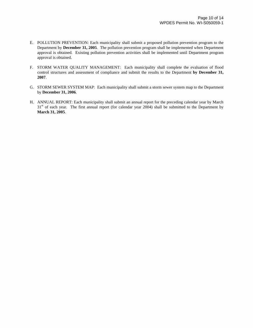
Page 10 of 14 WPDES Permit No. WI-S050059-1
E. POLLUTION PREVENTION: Each municipality shall submit a proposed pollution prevention program to the
Department by December 31, 2005. The pollution prevention program shall be implemented when Department approval is obtained. Existing pollution prevention activities shall be implemented until Department program approval is obtained.
F. STORM WATER QUALITY MANAGEMENT: Each municipality shall complete the evaluation of flood
control structures and assessment of compliance and submit the results to the Department by December 31, 2007.
G. STORM SEWER SYSTEM MAP: Each municipality shall submit a storm sewer system map to the Department
by December 31, 2006. H. ANNUAL REPORT: Each municipality shall submit an annual report for the preceding calendar year by March
31st of each year. The first annual report (for calendar year 2004) shall be submitted to the Department by March 31, 2005.
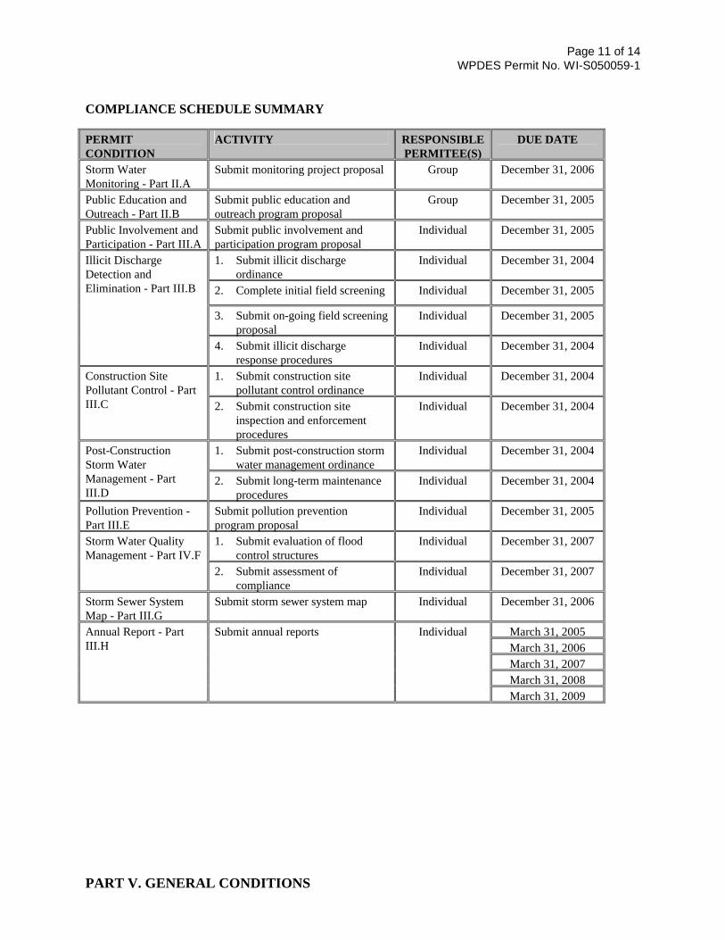
Page 11 of 14 WPDES Permit No. WI-S050059-1
COMPLIANCE SCHEDULE SUMMARY PERMIT CONDITION
ACTIVITY RESPONSIBLE PERMITEE(S)
DUE DATE
Storm Water Monitoring - Part II.A
Submit monitoring project proposal Group December 31, 2006
Public Education and Outreach - Part II.B
Submit public education and outreach program proposal
Group December 31, 2005
Public Involvement and Participation - Part III.A
Submit public involvement and participation program proposal
Individual December 31, 2005
1. Submit illicit discharge ordinance
Individual December 31, 2004
2. Complete initial field screening Individual December 31, 2005
3. Submit on-going field screening proposal
Individual December 31, 2005
Illicit Discharge Detection and Elimination - Part III.B
4. Submit illicit discharge response procedures
Individual December 31, 2004
1. Submit construction site pollutant control ordinance
Individual December 31, 2004 Construction Site Pollutant Control - Part III.C 2. Submit construction site
inspection and enforcement procedures
Individual December 31, 2004
1. Submit post-construction storm water management ordinance
Individual December 31, 2004 Post-Construction Storm Water Management - Part III.D
2. Submit long-term maintenance procedures
Individual December 31, 2004
Pollution Prevention - Part III.E
Submit pollution prevention program proposal
Individual December 31, 2005
1. Submit evaluation of flood control structures
Individual December 31, 2007 Storm Water Quality Management - Part IV.F
2. Submit assessment of compliance
Individual December 31, 2007
Storm Sewer System Map - Part III.G
Submit storm sewer system map Individual December 31, 2006
March 31, 2005 March 31, 2006 March 31, 2007 March 31, 2008
Annual Report - Part III.H
Submit annual reports Individual
March 31, 2009 PART V. GENERAL CONDITIONS
Page 12 of 14 WPDES Permit No. WI-S050059-1
The conditions in ss. NR 205.07(1) and NR 205.07(3), Wis. Adm. Code, are included by reference in this permit. The Root River Group municipalities shall be responsible for meeting these requirements. Some of these requirements are outlined below in paragraph A. through R.. Requirements not specifically outlined below can be found in ss. NR 205.07(1) and NR 205.07(3), Wis. Adm. Code. A. DUTY TO COMPLY: The municipalities shall comply with all conditions of the permit. Any permit
noncompliance is a violation of the permit and is grounds for enforcement action, permit revocation or modification, or denial of a permit reissuance application.
B. COMPLIANCE SCHEDULES: Reports of compliance or noncompliance with interim and final requirements
contained in any compliance schedule of the permit shall be submitted in writing within 14 days after the schedule date, except that progress reports shall be submitted in writing on or before each schedule date for each report. Any report of noncompliance shall include the cause of noncompliance, a description of remedial actions taken, and an estimate of the effect of the noncompliance on the municipality's ability to meet the remaining schedule dates.
C. NONCOMPLIANCE NOTIFICATION:
1. Upon becoming aware of any permit noncompliance that may endanger public health or the environment, the municipalities shall report this information by a telephone call to the Department within 24 hours. A written report describing the noncompliance shall be submitted to the Department within 5 days after the municipalities became aware of the noncompliance. The Department may waive the written report on a case-by-case basis based on the oral report received within 24 hours. The written report shall contain a description of the noncompliance and its cause; the period of noncompliance, including exact dates and times; the steps taken or planned to reduce, eliminate, and prevent reoccurrence of the noncompliance; and if the noncompliance has not been corrected, the length of time it is expected to continue.
2. Reports of any other noncompliance not covered under General Condition's B., C.1., or E. shall be submitted
with the annual report. The reports shall contain all the information listed in General Condition C.1.. D. DUTY TO MITIGATE: The municipalities shall take all reasonable steps to minimize or prevent any adverse
impact on the waters of the state resulting from noncompliance with the permit. E. SPILL REPORTING: The municipalities shall notify the Department, in accordance with ch. NR 706, Wis.
Adm. Code, in the event of a spill or accidental release of hazardous substances which results in a discharge of pollutants into waters of the state. The Department shall be notified via the 24-hour spill hotline (1-800-943-0003).
F. PROPER OPERATION AND MAINTENANCE: The municipalities shall at all times properly operate and
maintain all facilities and systems of treatment and control which are installed or used by the municipalities to achieve compliance with the conditions of the permit and the storm water management plan.
G. BYPASS: The municipalities may temporarily bypass storm water treatment facilities if necessary for
maintenance, or due to runoff from a storm event which exceeds the design capacity of the treatment facility, or during an emergency.
H. DUTY TO HALT OR REDUCE ACTIVITY: Upon failure or impairment of best management practices
identified in the storm water management program, the municipalities shall, to the extent practicable and necessary to maintain permit compliance, modify or curtail operations until the best management practices are restored or an alternative method of storm water pollution control is provided.
I. REMOVED SUBSTANCES: Solids, sludges, filter backwash or other pollutants removed from or resulting
Page 13 of 14 WPDES Permit No. WI-S050059-1
from treatment or control of storm water shall be stored and disposed of in a manner to prevent any pollutant from the materials from entering the waters of the state, and to comply with all applicable Federal, State, and Local regulations.
J. ADDITIONAL MONITORING: If a municipality monitors any pollutant more frequently than required by the
permit, the results of that monitoring shall be recorded and reported in accordance with this chapter. Results of this additional monitoring shall be included in the calculation and reporting of the data submitted in the annual report.
K. INSPECTION AND ENTRY: The municipalities shall allow an authorized representative of the Department,
upon the presentation of credentials, to:
1. Enter upon the municipal premises where a regulated facility or activity is located or conducted, or where records are required under the conditions of the permit.
2. Have access to and copy, at reasonable times, any records that are required under the conditions of the permit.
3. Inspect at reasonable times any facilities, equipment (including monitoring and control equipment), practices or operations regulated or required under the permit.
4. Sample or monitor at reasonable times, for the purposes of assuring permit compliance, any substances or parameters at any location.
L. DUTY TO PROVIDE INFORMATION: The municipalities shall furnish the Department, within a reasonable
time, any information which the Department may request to determine whether cause exists for modifying, revoking or reissuing the permit or to determine compliance with the permit. The municipalities shall also furnish the Department, upon request, copies of records required to be kept by the municipality.
M. PROPERTY RIGHTS: The permit does not convey and property rights of any sort, or any exclusive privilege.
The permit does not authorize any injury or damage to private property or an invasion of personal rights, or any infringement of federal, state or local laws or regulations.
N. DUTY TO REAPPLY: If the Root River Group wishes to continue an activity regulated by the permit after the
expiration date of the permit, the Root River Group shall apply for a new permit at least 180 days prior to the expiration date of the permit. If the permit is not reissued by the time the existing permit expires, the existing permit remains in effect.
O. OTHER INFORMATION: Where the municipalities becomes aware that it failed to submit any relevant facts in
a permit application or submitted incorrect information in a permit application or in any report to the department, it shall promptly submit such facts or correct information to the department.
P. RECORDS RETENTION: The municipalities shall retain records of all monitoring information, copies of all
reports required by the permit, and records of all data used to complete the application for the permit for a period of at least 3 years from the date of the sample, measurement, report or application. The Department may request that this period be extended by issuing a public notice to modify the permit to extend this period.
Q. PERMIT ACTIONS: As provided in s. 283.53, Wis. Stats., after notice and opportunity for a hearing the permit
may be modified or revoked and reissued for cause. If the municipalities file a request for a permit modification, revocation or reissuance, or a notification of planned changes or anticipated noncompliance, this action by itself does not relieve the municipalities of any permit condition.
R. SIGNATORY REQUIREMENT: All applications, reports or information submitted to the Department shall be
signed for by a ranking elected official, or other person authorized by them who has responsibility for the overall operation of the municipal separate storm sewer system and storm water management program activities regulated by the permit. The representative shall certify that the information was gathered and prepared under their supervision and based on inquiry of the people directly under their supervision that, to the best of their knowledge, the information is true, accurate, and complete.
Page 14 of 14 WPDES Permit No. WI-S050059-1
PART VI. DEFINITIONS Definitions for some of the terms found in this permit are as follows: Controls Condition means a pollutant-loading analysis that includes pollutant reductions from storm water management practices. Department means Department of Natural Resources. Illicit Connection means any man-made conveyance connecting an illicit discharge directly to a municipal separate storm sewer system. Illicit Discharge means any discharge to a municipal separate storm sewer system that is not composed entirely of storm water except discharges authorized by a WPDES permit or other discharge not requiring a WPDES permit such as water line flushing, landscape irrigation, individual residential car washing, fire fighting and similar discharges. Infiltration means the entry and movement of precipitation or runoff into or through soil. Major Outfall means a municipal separate storm sewer outfall that meets one of the following criteria:
1. A single pipe with an inside diameter of 36 inches or more or equivalent conveyance (cross sectional area of
1,018 square inches) which is associated with a drainage area of more than 50 acres. 2. A single pipe with an inside diameter of 12 inches or more or equivalent conveyance (cross sectional area of 113
square inches) which receives runoff from land zoned for industrial activity and is associated with a drainage area of more than 2 acres.
Maximum Extent Practicable means a level of implementing management practices in order to achieve a performance standard specified in NR151 which takes into account the best available technology, cost effectiveness and other competing issues such as human safety and welfare, endangered and threatened resources, historic properties and geographic features. Outfall means the point at which storm water is discharged to waters of the state or leaves one municipality and enters another. No Controls Condition means a pollutant-loading analysis that does not include pollutant reductions from storm water management practices. Riparian Landowners are the owners of lands bordering lakes and rivers. Storm Water Management Practice means structural or non-structural measures, practices, techniques or devices employed to avoid or minimize soil, sediment or pollutants carried in runoff to waters of the state. Storm Water Pollution Prevention Planning refers to the development of a site-specific plan that describes the measures and controls that will be used to prevent and/or minimize pollution of storm water. Structural Storm Water Management Facilities are engineered and constructed systems that are designed to provide storm water quality control such as wet detention ponds, constructed wetlands, infiltration basins and grassed swales. Waters of the State include surface waters, groundwater and wetlands.
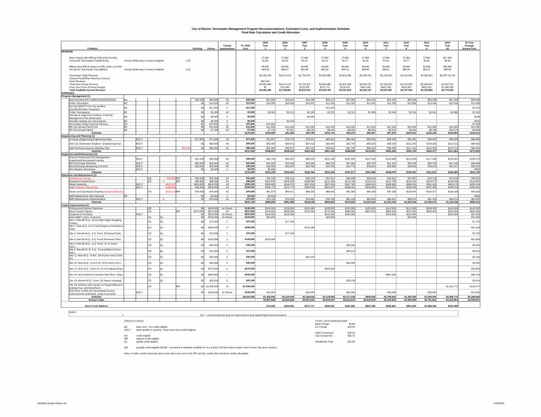
City of Racine: Stormwater Management Program Recommendations, Estimated Costs, and Implementation ScheduleFinal Rate Calculation and Credit Allocation
2005 2006 2007 2008 2009 2010 2011 2012 2013 2014 10-YearFY 2004 Year Year Year Year Year Year Year Year Year Year Average
Existing Future Cost 1 2 3 4 5 6 7 8 9 10 Annual CostREVENUE
Base Charge (BC) Billing Units (City Parcels) 27,084 27,084 27,084 27,084 27,084 27,084 27,084 27,084 27,084 $27,084Annual BC Stormwater Fee($/Parcel) Annual inflationary increase multiplier: 1.03 $3.88 $4.00 $4.12 $4.24 $4.37 $4.50 $4.63 $4.77 $4.92 $5.06
Billing Units (ERUs based on ERU value of 2,844) 50,840 50,840 50,840 50,840 50,840 50,840 50,840 50,840 50,840 $50,840Annual EC Stormwater Fee ($/ERU) Annual inflationary increase multiplier: 1.03 $49.00 $50.47 $51.98 $53.54 $55.15 $56.80 $58.51 $60.26 $62.07 $63.93
Stormwater Utility Revenue $2,596,246 $2,674,133 $2,754,357 $2,836,988 $2,922,098 $3,009,761 $3,100,053 $3,193,055 $3,288,847 $3,387,512.06General Fund/Other Revenue SourcesGrant Revenue $87,250Total New Annual Revenue $2,683,496 $2,674,133 $2,754,357 $2,836,988 $2,922,098 $3,009,761 $3,100,053 $3,193,055 $3,288,847 $3,387,512Carry Over From Previous Budget $0 $75,548 $125,055 $271,771 $229,522 $341,396 $827,538 $593,963 $851,022 $1,388,028Total Available Annual Revenue $2,683,496 $2,749,681 $2,879,412 $3,108,759 $3,151,619 $3,351,157 $3,927,591 $3,787,018 $4,139,869 $4,775,540
EXPENSES
Administration(PW ADMIN?ENGINEERING) BC $25,500 $50,000 All $50,000 $51,500 $53,045 $54,636 $56,275 $57,964 $59,703 $61,494 $63,339 $65,239 $67,196 $59,039Public Information BC $0 $10,000 All $10,000 $10,300 $10,609 $10,927 $11,255 $11,593 $11,941 $12,299 $12,668 $13,048 $13,439 $11,808Formal SWPPP's for City facilities (Zoo/DPW/Public Transport)
BC $0 $11,000 4 $11,000 $12,020 $1,202
Public Participation BC $0 $2,000 All $2,000 $2,060 $2,122 $2,185 $2,251 $2,319 $2,388 $2,460 $2,534 $2,610 $2,688 $2,362Develop & Implement Fertilizer, Pesticide, Management Plan (Municipal)
BC $0 $5,000 3 $5,000 $5,305 $530
Develop roadway de-icing program BC $0 $5,000 2 $5,000 $5,150 $515Stormwater Utility Financial Services BC $0 $75,000 1 $75,000 $75,000 $7,500NR 216 Annual Permit Fee BC $0 $12,500 All $12,500 $12,500 $12,500 $12,500 $12,500 $12,500 $12,500 $12,500 $12,500 $12,500 $12,500 $12,500NR 216 Annual Report BC $0 $7,500 All $7,500 $7,725 $7,957 $8,195 $8,441 $8,695 $8,955 $9,224 $9,501 $9,786 $10,079 $8,856
Subtotal $178,000 $159,085 $91,383 $93,749 $102,743 $93,070 $95,487 $97,976 $100,541 $103,182 $105,902 $104,312
In-House Engineering-Engineering Dept WQ-F $71,900 $71,900 All $71,900 $74,057 $76,279 $78,567 $80,924 $83,352 $85,852 $88,428 $91,081 $93,813 $96,628 $84,898
Add City Stormwater Engineer -Engineering Dept WQ-F $0 $80,000 All $80,000 $82,400 $84,872 $87,418 $90,041 $92,742 $95,524 $98,390 $101,342 $104,382 $107,513 $94,462
Add Plumbing Inspector-Building Dept. WQ-F $63,843 $0 $80,000 All $80,000 $82,400 $84,872 $87,418 $90,041 $92,742 $95,524 $98,390 $101,342 $104,382 $107,513 $94,462Subtotal $231,900 $238,857 $246,023 $253,403 $261,005 $268,836 $276,901 $285,208 $293,764 $302,577 $311,654 $273,823
Erosion Control and SW Management Inspection/Enforcement/Training
WQ-F $21,400 $90,000 All $90,000 $92,700 $95,481 $98,345 $101,296 $104,335 $107,465 $110,689 $114,009 $117,430 $120,952 $106,270
Illicit Discharge Detection WQ-F $50,000 $50,000 All $50,000 $51,500 $53,045 $54,636 $56,275 $57,964 $59,703 $61,494 $63,339 $65,239 $67,196 $59,039Illicit Discharge Monitoring & Control WQ-F $30,000 $30,000 All $30,000 $30,900 $31,827 $32,782 $33,765 $34,778 $35,822 $36,896 $38,003 $39,143 $40,317 $35,423Wet Weather Monitoring WQ-F $0 $6,000 1 $6,000 $6,000 $600
Subtotal $176,000 $181,100 $180,353 $185,764 $191,336 $197,077 $202,989 $209,079 $215,351 $221,811 $228,466 $201,333
Solid Waste Garage CE $33,200 RIP $33,200 $33,200 All $33,200 $34,196 $35,222 $36,279 $37,367 $38,488 $39,643 $40,832 $42,057 $43,318 $44,618 $39,202Equipment Maintenance CE $ - RIP $99,000 $99,000 All $99,000 $101,970 $105,029 $108,180 $111,425 $114,768 $118,211 $121,758 $125,410 $129,173 $133,048 $116,897Street Sweeping WQ-F $424,327 $300,000 $300,000 All $300,000 $309,000 $318,270 $327,818 $337,653 $347,782 $358,216 $368,962 $380,031 $391,432 $403,175 $354,234Leaf Collection (Recycling) WQ-F $260,000 $63,000 $259,000 All $259,000 $266,770 $274,773 $283,016 $291,507 $300,252 $309,260 $318,537 $328,093 $337,936 $348,074 $305,822
Sewer and Catchbasin Cleaning-(Sewers &Drains) CE $132,214 RIP $79,000 $79,000 All $79,000 $81,370 $83,811 $86,325 $88,915 $91,583 $94,330 $97,160 $100,075 $103,077 $106,169 $93,282
BMP Maintenance Plan (Manual) BC $0 $3,500 1 $3,500 $3,500 $350BMP Maintenance Implementation WQ-F $ - $0 $70,000 All $70,000 $72,100 $74,263 $76,491 $78,786 $81,149 $83,584 $86,091 $88,674 $91,334 $94,074 $82,655
Subtotal $843,700 $868,906 $891,368 $918,109 $945,653 $974,022 $1,003,243 $1,033,340 $1,064,340 $1,096,270 $1,129,159 $992,441
Principal and Interest Payments CE $0 $140,000 As Shown $140,000 $140,000 $136,000 $132,000 $128,000 $124,000 $120,000 $116,000 $112,000 $108,000 $104,000 $122,000Storm Sewer Projects CE RIP $570,000 $670,000 All $670,000 $700,000 $800,000 $750,000 $775,000 $800,000 $825,000 $850,000 $875,000 $900,000 $925,000 $820,000Equipment Purchases WQ-F $0 $975,000 As Shown $975,000 $125,000 $125,000 $125,000 $125,000 $125,000 $225,000 $125,000 $97,500Inline BMP's (misc. locations) CE QL $0 $150,000 As Shown $150,000 $50,000 $50,000 $50,000 $15,000Site 1: Retrofit W.Q.. Pond (High Ridge Shopping Center)
CE QL $0 $75,000 2 $75,000 $77,250 $7,725
Site 2: New W.Q. & Q. Pond (Regency Point/Sams Club)
CE QL $0 $200,000 3 $200,000 $212,180 $21,218
Site 3: Retrofit W.Q.. & Q. Pond (Pritchard Park) CE QL $0 $75,000 2 $75,000 $77,250 $7,725
Site 4: Retrofit W.Q.. & Q. Pond (Reservoir Park) CE QL $0 $125,000 1 $125,000 $125,000 $12,500
Site 5: Retrofit W.Q.. & Q. Pond (N. of Jones Schl.)
CE QL $0 $45,000 5 $45,000 $50,648 $5,065
Site 6: Retrofit W. Q. & Q.. Pond (Mallard Shores Sub.)
CE QL $0 $75,000 5 $75,000 $84,413 $8,441
Site 11: New W.Q.. In-line (De Koven Ave & Clark St.)
CE QL $0 $40,000 3 $40,000 $42,436 $4,244
Site 12: New W.Q.. In-Line (N. of De Koven Ave.) CE QL $0 $40,000 5 $40,000 $45,020 $4,502
Site 13: New W.Q.. Inline (N. of 21st Indiana-Ohio) CE QL $0 $275,000 4 $275,000 $300,500 $30,050
Site 15: New Sediment Chamber Blue River Valley CE QL $0 $500,000 7 $500,000 $597,026 $59,703
Site 18: Retrofit W.Q.. Pond (St. Mary's Hospital) CE QL $0 $25,000 5 $25,000 $28,138 $2,814
Site 19: Enhance Stormsewer on Rupart (Between Graham Ave. and Root River)
CE RIP $0 $1,000,000 10 $1,000,000 $1,304,773 $130,477
Root River Outfall and Streambank Erosion Improvements (estimated, study in process)
WQ-F $0 $100,000 As Shown $100,000 $20,000 $20,000 $20,000 $20,000 $20,000 $10,000
Subtotal $4,510,000 $1,160,000 $1,215,500 $1,156,616 $1,378,500 $1,277,219 $945,000 $1,708,026 $1,262,000 $1,028,000 $2,458,773 $1,358,963Annual Totals $2,607,948 $2,624,626 $2,607,641 $2,879,237 $2,810,223 $2,523,619 $3,333,629 $2,935,996 $2,751,841 $4,233,954 $2,930,871
End of Year Balance $75,548 $125,055 $271,771 $229,522 $341,396 $827,538 $593,963 $851,022 $1,388,028 $541,586
Notes:1 3% = cost increase per year for most services and capital improvements projects
CREDITS CODES YEAR 1 RATE BREAKDOWNBase Charge $3.88
BC base cost - non credit eligible EC Charge $49.00WQ-F water quality or quantity - fixed costs (non-credit eligible)
O&M Component $26.28CE credit eligible Cap Component $22.72RIP riparian credit eligibleQL quality credit eligible Residential Total $52.88
QN quantity credit eligible (NONE - converted to Rebates available for $ or portion of $ that reduce sewer sizes of new City storm sewers)
Note: A buffer credit component also exists that is the sum of the RIP and QL credits (the maximum credits allowable)
Capital Improvement (1)
Year(s) ImplementedCategory
Operation and Maintenance (1)
Program Management (1)
Engineering and Planning (1)
Inspection and Enforcement (1)
SWUtility Budget Master.xls 2/18/2005