reading borough council · reading borough council strategic flood risk assessment j:\27560 rbc...
TRANSCRIPT
On behalf of:
Project Ref: 27560/4001 | Rev: FIRST ISSUE | Date: June 2017
Office Address: Caversham Bridge House, Waterman Place, Reading, Berkshire RG1 8DN T: +44 (0)118 950 0761 +44 (0)118 959 7498 E: [email protected]
Reading Borough Council Strategic Flood Risk Assessment

Reading Borough Council Strategic Flood Risk Assessment
J:\27560 RBC LLFA support\4002 - Reading SFRA\wp\Report\27560_4001_Reading SFRA_rmf_June17.docx
1
Contents
Glossary ................................................................................................................................................. 6
1 Introduction ................................................................................................................................. 9
1.1 Borough Setting ............................................................................................................. 9
1.2 SFRA Scope and Structure ........................................................................................... 9
1.3 Outputs of the SFRA ................................................................................................... 10
1.4 A Proactive Approach – Reduction in Flood Risk ....................................................... 10
1.5 A Living Document ...................................................................................................... 10
1.6 Disclaimer .................................................................................................................... 10
2 Study Area ................................................................................................................................. 12
2.1 Geographical Location ................................................................................................ 12
2.2 Topography ................................................................................................................. 13
2.3 Watercourses and Catchments ................................................................................... 14
2.4 Geology ....................................................................................................................... 14
2.5 Growth of Reading Borough ........................................................................................ 15
2.6 Future Development Implications ................................................................................ 16
3 Approach and Methodology ..................................................................................................... 18
3.1 Objectives of SFRA ..................................................................................................... 18
3.2 Data Collection ............................................................................................................ 18
3.3 Integration of Flood Risk Documentation .................................................................... 23
4 National Planning Policy .......................................................................................................... 25
4.1 Overview of National Planning Policy.......................................................................... 25
4.2 National Planning Policy (NPPF), 2012 ...................................................................... 25
4.3 NPPF Planning Practice Guidance, updated April 2015 ............................................. 25
4.4 Flood Risk Regulations, 2009 ..................................................................................... 25
4.5 Flood and Water Management Act, 2010 ................................................................... 26
4.6 Water Framework Directive, 2000 ............................................................................... 26
4.7 River Basin Management Plan –Thames River Basin District, updated 2015 ............ 27
4.8 Thames Catchment Flood Management Plan, 2009 ................................................... 28
4.9 Flood Risk Assessments: Climate Change Allowances, 2016 .................................... 28
5 Local Planning Policy ............................................................................................................... 30
5.1 Reading Core Strategy ................................................................................................ 30
5.2 Reading Central Area Action Plan (RCAAP) ............................................................... 31
5.3 Sites and Detailed Policies Document (January 2015) ............................................... 31
Reading Borough Council Strategic Flood Risk Assessment
J:\27560 RBC LLFA support\4002 - Reading SFRA\wp\Report\27560_4001_Reading SFRA_rmf_June17.docx
2
5.4 Revised Sustainable Design and Construction SPG (July 2011) ............................... 31
5.5 Reading’s Climate Change Strategy 2013-2020 (Sept 2013) ..................................... 32
6 Sources of Flood Risk .............................................................................................................. 33
6.1 Sources of Flooding..................................................................................................... 33
6.2 Fluvial (River) Flooding ............................................................................................... 34
6.3 Surface Water Flooding ............................................................................................... 42
6.4 Flooding from Impounded Bodies of Water (Reservoirs and Canals) ......................... 43
6.5 Groundwater Flooding ................................................................................................. 47
6.6 Sewer Flooding ............................................................................................................ 48
7 Flood Defences .......................................................................................................................... 50
7.1 Types of Flood Defences ............................................................................................ 50
7.2 Green Park Flood Management Strategy (GPFMS) ................................................... 50
7.3 RBC Asset Register..................................................................................................... 52
8 Historic Fluvial Flooding Records ........................................................................................... 53
8.1 Historic Fluvial Flood Events ....................................................................................... 53
8.2 Thames and Kennet Lock Records ............................................................................. 54
9 Overview of Flood Risk across Borough ................................................................................ 58
9.1 RBC Character Areas .................................................................................................. 58
9.2 Reading North – Caversham, Hemdean Bottom and Emmer Green .......................... 58
9.3 Central Reading ........................................................................................................... 60
9.4 Reading South/East – The Mount, Earley, Whitley and Whitley Wood ....................... 61
9.5 Reading West – Tilehurst and Southcote .................................................................... 63
10 Planning and New Development Considerations .................................................................. 65
10.1 Definition of NPPF Flood Zones .................................................................................. 65
10.2 Consideration of Climate Change ............................................................................... 66
10.3 Residual Risk of Flooding ............................................................................................ 69
10.4 Site Specific FRA Requirements ................................................................................. 70
10.5 EA Engagement .......................................................................................................... 71
11 Flood Risk Management - Planning ........................................................................................ 73
11.1 Sequential Approach to Locating Development .......................................................... 73
11.2 Flood Risk Vulnerability and Compatibility .................................................................. 73
11.3 Application of the Sequential Test ............................................................................... 75
11.4 Undertaking the Exception Test .................................................................................. 76
Reading Borough Council Strategic Flood Risk Assessment
J:\27560 RBC LLFA support\4002 - Reading SFRA\wp\Report\27560_4001_Reading SFRA_rmf_June17.docx
3
12 Flood Risk Management - Design ............................................................................................ 77
12.1 Reducing Flood Risk through Design .......................................................................... 77
12.2 Sequential Approach ................................................................................................... 77
12.3 Ground Floor Levels .................................................................................................... 77
12.4 Building Design ............................................................................................................ 78
12.5 Floodplain Storage Capacity ....................................................................................... 79
12.6 Conservation of Flow Routes ...................................................................................... 80
12.7 Safe Access Arrangements ......................................................................................... 81
12.8 Building Extensions ..................................................................................................... 84
12.9 Changes of Use and Minor Development ................................................................... 84
13 Surface Water Management ..................................................................................................... 85
13.1 What are SuDS? .......................................................................................................... 85
13.2 Suitability of SuDS Measures ...................................................................................... 85
13.3 SuDS Requirements for New Development ................................................................ 88
13.4 Design Criteria ............................................................................................................. 88
13.5 Designing for Exceedance .......................................................................................... 89
13.6 Adoption and Maintenance Considerations ................................................................ 90
14 Local Flood Risk Management ................................................................................................ 91
14.1 Development of RBC Local Flood Risk Management Strategy .................................. 91
14.2 LFRMS Action Plan ..................................................................................................... 91
14.3 Emergency Planning ................................................................................................... 92
14.4 Insurance ..................................................................................................................... 94
15 Conclusion and Recommendations ........................................................................................ 96
16 SFRA Review and Update ........................................................................................................ 97
Reading Borough Council Strategic Flood Risk Assessment
J:\27560 RBC LLFA support\4002 - Reading SFRA\wp\Report\27560_4001_Reading SFRA_rmf_June17.docx
4
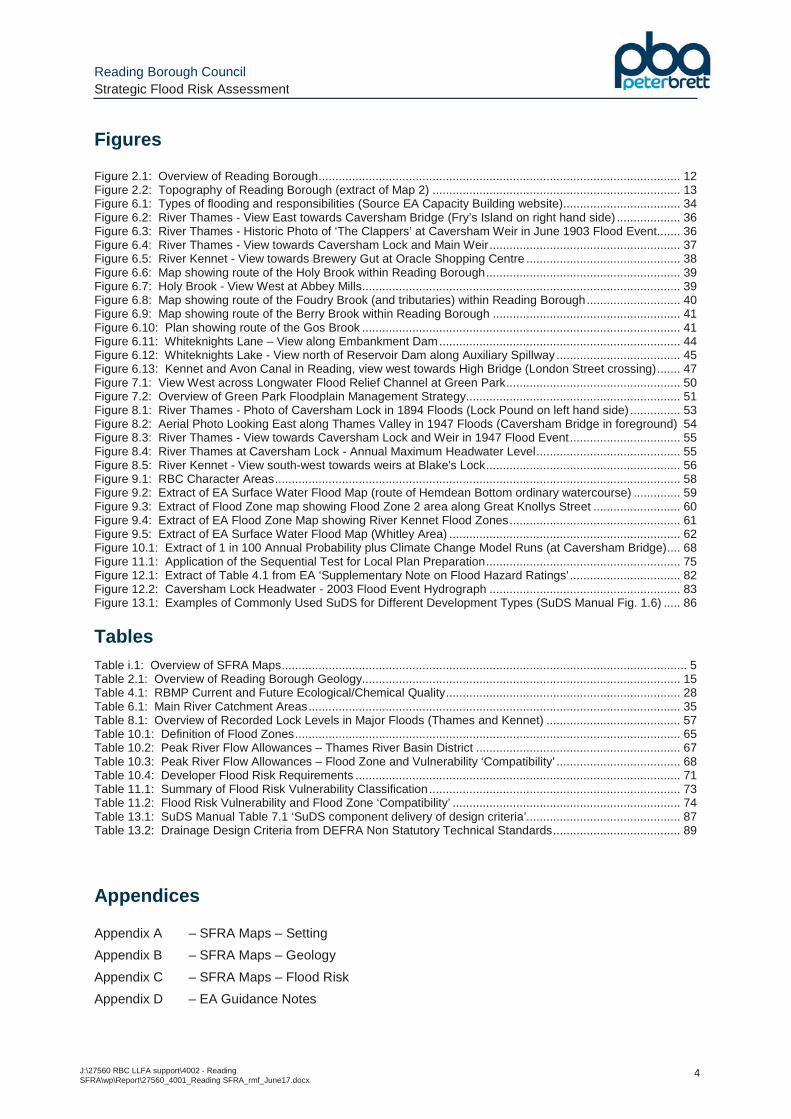
Figures
Figure 2.1: Overview of Reading Borough ............................................................................................................ 12 Figure 2.2: Topography of Reading Borough (extract of Map 2) .......................................................................... 13 Figure 6.1: Types of flooding and responsibilities (Source EA Capacity Building website) ................................... 34 Figure 6.2: River Thames - View East towards Caversham Bridge (Fry’s Island on right hand side) ................... 36 Figure 6.3: River Thames - Historic Photo of ‘The Clappers’ at Caversham Weir in June 1903 Flood Event ....... 36 Figure 6.4: River Thames - View towards Caversham Lock and Main Weir ......................................................... 37 Figure 6.5: River Kennet - View towards Brewery Gut at Oracle Shopping Centre .............................................. 38 Figure 6.6: Map showing route of the Holy Brook within Reading Borough .......................................................... 39 Figure 6.7: Holy Brook - View West at Abbey Mills ............................................................................................... 39 Figure 6.8: Map showing route of the Foudry Brook (and tributaries) within Reading Borough ............................ 40 Figure 6.9: Map showing route of the Berry Brook within Reading Borough ........................................................ 41 Figure 6.10: Plan showing route of the Gos Brook ............................................................................................... 41 Figure 6.11: Whiteknights Lane – View along Embankment Dam ........................................................................ 44 Figure 6.12: Whiteknights Lake - View north of Reservoir Dam along Auxiliary Spillway ..................................... 45 Figure 6.13: Kennet and Avon Canal in Reading, view west towards High Bridge (London Street crossing) ....... 47 Figure 7.1: View West across Longwater Flood Relief Channel at Green Park .................................................... 50 Figure 7.2: Overview of Green Park Floodplain Management Strategy ................................................................ 51 Figure 8.1: River Thames - Photo of Caversham Lock in 1894 Floods (Lock Pound on left hand side) ............... 53 Figure 8.2: Aerial Photo Looking East along Thames Valley in 1947 Floods (Caversham Bridge in foreground) 54 Figure 8.3: River Thames - View towards Caversham Lock and Weir in 1947 Flood Event ................................. 55 Figure 8.4: River Thames at Caversham Lock - Annual Maximum Headwater Level ........................................... 55 Figure 8.5: River Kennet - View south-west towards weirs at Blake's Lock .......................................................... 56 Figure 9.1: RBC Character Areas ......................................................................................................................... 58 Figure 9.2: Extract of EA Surface Water Flood Map (route of Hemdean Bottom ordinary watercourse) .............. 59 Figure 9.3: Extract of Flood Zone map showing Flood Zone 2 area along Great Knollys Street .......................... 60 Figure 9.4: Extract of EA Flood Zone Map showing River Kennet Flood Zones ................................................... 61 Figure 9.5: Extract of EA Surface Water Flood Map (Whitley Area) ..................................................................... 62 Figure 10.1: Extract of 1 in 100 Annual Probability plus Climate Change Model Runs (at Caversham Bridge) .... 68 Figure 11.1: Application of the Sequential Test for Local Plan Preparation .......................................................... 75 Figure 12.1: Extract of Table 4.1 from EA ‘Supplementary Note on Flood Hazard Ratings’ ................................. 82 Figure 12.2: Caversham Lock Headwater - 2003 Flood Event Hydrograph ......................................................... 83 Figure 13.1: Examples of Commonly Used SuDS for Different Development Types (SuDS Manual Fig. 1.6) ..... 86
Tables Table i.1: Overview of SFRA Maps ......................................................................................................................... 5 Table 2.1: Overview of Reading Borough Geology ............................................................................................... 15 Table 4.1: RBMP Current and Future Ecological/Chemical Quality ...................................................................... 28 Table 6.1: Main River Catchment Areas ............................................................................................................... 35 Table 8.1: Overview of Recorded Lock Levels in Major Floods (Thames and Kennet) ........................................ 57 Table 10.1: Definition of Flood Zones ................................................................................................................... 65 Table 10.2: Peak River Flow Allowances – Thames River Basin District ............................................................. 67 Table 10.3: Peak River Flow Allowances – Flood Zone and Vulnerability ‘Compatibility’ ..................................... 68 Table 10.4: Developer Flood Risk Requirements ................................................................................................. 71 Table 11.1: Summary of Flood Risk Vulnerability Classification ........................................................................... 73 Table 11.2: Flood Risk Vulnerability and Flood Zone ‘Compatibility’ .................................................................... 74 Table 13.1: SuDS Manual Table 7.1 ‘SuDS component delivery of design criteria’.............................................. 87 Table 13.2: Drainage Design Criteria from DEFRA Non Statutory Technical Standards ...................................... 89
Appendices
Appendix A – SFRA Maps – Setting
Appendix B – SFRA Maps – Geology
Appendix C – SFRA Maps – Flood Risk
Appendix D – EA Guidance Notes
Reading Borough Council Strategic Flood Risk Assessment
J:\27560 RBC LLFA support\4002 - Reading SFRA\wp\Report\27560_4001_Reading SFRA_rmf_June17.docx
5
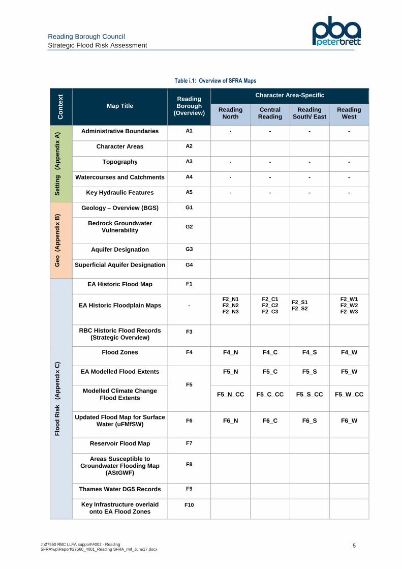
Table i.1: Overview of SFRA Maps
Con
text
Map Title Reading Borough
(Overview)
Character Area-Specific
Reading North
Central Reading
Reading South/ East
Reading West
Set
ting
(A
ppen
dix
A)
Administrative Boundaries A1 - - - -
Character Areas A2
Topography A3 - - - -
Watercourses and Catchments A4 - - - -
Key Hydraulic Features A5 - - - -
Geo
(A
ppen
dix
B)
Geology – Overview (BGS) G1
Bedrock Groundwater Vulnerability
G2
Aquifer Designation G3
Superficial Aquifer Designation G4
Flo
od R
isk
(A
ppen
dix
C)
EA Historic Flood Map F1
EA Historic Floodplain Maps - F2_N1 F2_N2 F2_N3
F2_C1 F2_C2 F2_C3
F2_S1 F2_S2
F2_W1 F2_W2 F2_W3
RBC Historic Flood Records (Strategic Overview)
F3
Flood Zones F4 F4_N F4_C F4_S F4_W
EA Modelled Flood Extents
F5
F5_N F5_C F5_S F5_W
Modelled Climate Change Flood Extents F5_N_CC F5_C_CC F5_S_CC F5_W_CC
Updated Flood Map for Surface Water (uFMfSW)
F6 F6_N F6_C F6_S F6_W
Reservoir Flood Map F7
Areas Susceptible to Groundwater Flooding Map
(AStGWF) F8
Thames Water DG5 Records F9
Key Infrastructure overlaid onto EA Flood Zones
F10
Reading Borough Council Strategic Flood Risk Assessment
J:\27560 RBC LLFA support\4002 - Reading SFRA\wp\Report\27560_4001_Reading SFRA_rmf_June17.docx
6
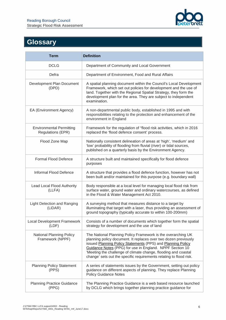
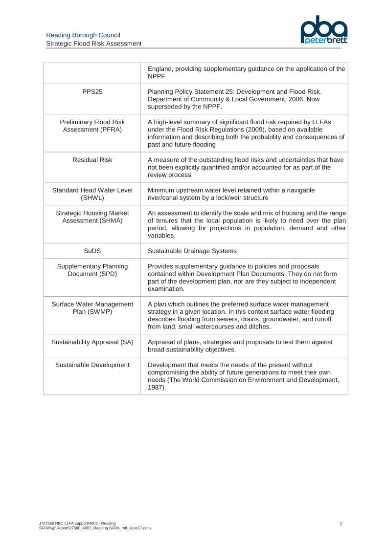
Glossary
Term Definition
DCLG Department of Community and Local Government
Defra Department of Environment, Food and Rural Affairs
Development Plan Document (DPD)
A spatial planning document within the Council’s Local Development Framework, which set out policies for development and the use of land. Together with the Regional Spatial Strategy, they form the development plan for the area. They are subject to independent examination.
EA (Environment Agency)
A non-departmental public body, established in 1995 and with responsibilities relating to the protection and enhancement of the environment in England
Environmental Permitting Regulations (EPR)
Framework for the regulation of “flood risk activities, which in 2016 replaced the ‘flood defence consent’ process.
Flood Zone Map Nationally consistent delineation of areas at ‘high’, ‘medium’ and ‘low’ probability of flooding from fluvial (river) or tidal sources, published on a quarterly basis by the Environment Agency.
Formal Flood Defence A structure built and maintained specifically for flood defence purposes
Informal Flood Defence A structure that provides a flood defence function, however has not been built and/or maintained for this purpose (e.g. boundary wall)
Lead Local Flood Authority (LLFA)
Body responsible at a local level for managing local flood risk from surface water, ground water and ordinary watercourses, as defined in the Flood & Water Management Act 2010.
Light Detection and Ranging (LiDAR)
A surveying method that measures distance to a target by illuminating that target with a laser, thus providing an assessment of ground topography (typically accurate to within 100-200mm)
Local Development Framework (LDF)
Consists of a number of documents which together form the spatial strategy for development and the use of land
National Planning Policy Framework (NPPF)
The National Planning Policy Framework is the overarching UK planning policy document. It replaces over two dozen previously issued Planning Policy Statements (PPS) and Planning Policy Guidance Notes (PPG) for use in England. NPPF Section 10 ‘Meeting the challenge of climate change, flooding and coastal change’ sets out the specific requirements relating to flood risk.
Planning Policy Statement (PPS)
A series of statements issues by the Government, setting out policy guidance on different aspects of planning. They replace Planning Policy Guidance Notes
Planning Practice Guidance (PPG)
The Planning Practice Guidance is a web based resource launched by DCLG which brings together planning practice guidance for
Reading Borough Council Strategic Flood Risk Assessment
J:\27560 RBC LLFA support\4002 - Reading SFRA\wp\Report\27560_4001_Reading SFRA_rmf_June17.docx
7
England, providing supplementary guidance on the application of the NPPF
PPS25 Planning Policy Statement 25: Development and Flood Risk. Department of Community & Local Government, 2006. Now superseded by the NPPF.
Preliminary Flood Risk Assessment (PFRA)
A high-level summary of significant flood risk required by LLFAs under the Flood Risk Regulations (2009), based on available information and describing both the probability and consequences of past and future flooding
Residual Risk A measure of the outstanding flood risks and uncertainties that have not been explicitly quantified and/or accounted for as part of the review process
Standard Head Water Level (SHWL)
Minimum upstream water level retained within a navigable river/canal system by a lock/weir structure
Strategic Housing Market Assessment (SHMA)
An assessment to identify the scale and mix of housing and the range of tenures that the local population is likely to need over the plan period, allowing for projections in population, demand and other variables.
SuDS Sustainable Drainage Systems
Supplementary Planning Document (SPD)
Provides supplementary guidance to policies and proposals contained within Development Plan Documents. They do not form part of the development plan, nor are they subject to independent examination.
Surface Water Management Plan (SWMP)
A plan which outlines the preferred surface water management strategy in a given location. In this context surface water flooding describes flooding from sewers, drains, groundwater, and runoff from land, small watercourses and ditches.
Sustainability Appraisal (SA) Appraisal of plans, strategies and proposals to test them against broad sustainability objectives.
Sustainable Development Development that meets the needs of the present without compromising the ability of future generations to meet their own needs (The World Commission on Environment and Development, 1987).

Reading Borough Council Strategic Flood Risk Assessment
J:\27560 RBC LLFA support\4002 - Reading SFRA\wp\Report\27560_4001_Reading SFRA_rmf_June17.docx
8
Reading Borough Council Strategic Flood Risk Assessment
J:\27560 RBC LLFA support\4002 - Reading SFRA\wp\Report\27560_4001_Reading SFRA_rmf_June17.docx
9
1 Introduction
1.1 Borough Setting
1.1.1 Reading Borough Council (RBC) is a unitary authority located in the centre of the Thames Valley. Significant areas of the Borough are potentially at risk of fluvial flooding from the River Thames and the River Kennet (and tributaries), as well as from other sources such as surface water, sewers and groundwater.
1.1.2 It is important to recognise that some of those areas that are at risk of flooding in the Borough are under pressure from future development. It is essential therefore that the Council are in a position to take informed decisions, providing a careful balance between the risk of flooding and other unrelated planning constraints that may place pressure upon ‘at risk’ areas.
1.1.3 The RBC Strategic Flood Risk Assessment (SFRA) endeavours to provide specific advice to assist the Council in this regard.
1.2 SFRA Scope and Structure
1.2.1 This report (and the supporting mapping) represents an update to the original Level 1 SFRA (March 2009), and should be used by the Council to inform planning decisions and the application of the Sequential Test.
1.2.2 The SFRA has been prepared based on the Government’s requirements set out online at the following web address:
https://www.gov.uk/guidance/local-planning-authorities-strategic-flood-risk-assessment
1.2.3 Following the application of the Sequential Test, the Council may consider it necessary to develop a Level 2 SFRA should it be shown that proposed site allocations fall within a flood affected area of the Borough. The Level 2 SFRA should consider the risk of flooding in greater detail within a local context to ensure that the site can be developed in a safe and sustainable manner.
1.2.4 This SFRA has been developed with reference to the suite of flood risk documentation prepared by RBC to consider the differing aspects of flood risk throughout the Borough and further reference to these documents should be made where appropriate:
• The Reading Preliminary Flood Risk Assessment (PFRA), June 2011;
• The Reading Surface Water Management Plan (SWMP), June 2013;
• The Reading Local Flood Risk Management Strategy (LFRMS), July 2015.
1.2.5 The structure of the SFRA is set out as follows:
• Sections 1-3 – Overview of study area geographical setting and approach of SFRA;
• Sections 4-5 – Planning policy context (national and local);
• Sections 6-9 – Overview of flood risk issues across Borough, including potential sources of flooding, location and standard of flood defences, and summary of available flooding information;
Reading Borough Council Strategic Flood Risk Assessment
J:\27560 RBC LLFA support\4002 - Reading SFRA\wp\Report\27560_4001_Reading SFRA_rmf_June17.docx
10
• Sections 10-14 – Implications of flood risk on new development, including planning considerations and mitigation requirements;
1.3 Outputs of the SFRA
1.3.1 The outputs of this SFRA to inform the planning process include the following: – delineation of Flood Zones across Borough based on the currently available EA modelling/mapping
• Delineation of Flood Zones across the Borough;
• Identification of historic flooding information and potential localised flooding issues to highlight ‘at risk’ areas;
• Identification of measures proposed or underway within the Borough to address flooding issues;
• Specify measures for incorporation in new development, to ensure development in the Borough is safe, sustainable and does not detrimentally impact on flood risk to third parties (ideally providing a reduction in flood risk).
1.4 A Proactive Approach – Reduction in Flood Risk
1.4.1 It is crucial to recognise that the NPPF considers not only the risk of flooding posed to new development, but that it also seeks to positively reduce the risk of flooding posed to existing properties within the Borough. It is strongly recommended that this principle be adopted as the underlying ‘goal’ for developers and Council development management teams within Reading Borough.
1.4.2 Developers are encouraged to demonstrate that their proposal will deliver a positive reduction in flood risk to the Borough, whether that be by reducing the frequency or severity of flooding (for example, through the introduction of SuDS), or by reducing the impact that flooding may have on the community (for example, through a reduction in the number of people within the site that may be at risk).
1.5 A Living Document
1.5.1 This document is an update to the original SFRA produced in 2007. Since the publication of the original SFRA, there have been significant changes in national and local planning policy and associated guidance, combined with improvements in the understanding of flood risk within the Borough building on the ongoing research in flood risk management.
1.5.2 As there are continual developments in flood risk management guidance and policy a periodic review of the SFRA is imperative to ensure the information and recommendations remain valid. It is recommended that the SFRA is reviewed on a regular (annual) basis. A number of key questions to be addressed as part of the SFRA review process (i.e. triggering whether or not a comprehensive review is required) are provided in Section 15 .
1.6 Disclaimer
1.6.1 It is important to recognise that the information provided within this SFRA is the best available data at time of issue of the report. The mapping of flood risk is not an exact science, and the risk to a specific area can change over time as greater knowledge on localised flooding is obtained.
1.6.2 The SFRA is a strategic-level document intended to support and inform the spatial planning process and it will trigger the requirement for more detailed site-specific Flood Risk

Reading Borough Council Strategic Flood Risk Assessment
J:\27560 RBC LLFA support\4002 - Reading SFRA\wp\Report\27560_4001_Reading SFRA_rmf_June17.docx
11
Assessments to accompany applications for new development; it is anticipated that such reports will further refine and improve the assessment of flood risk at a localised level with the most up-to-date information at the time.
Reading Borough Council Strategic Flood Risk Assessment
J:\27560 RBC LLFA support\4002 - Reading SFRA\wp\Report\27560_4001_Reading SFRA_rmf_June17.docx
12
2 Study Area
2.1 Geographical Location
2.1.1 The Reading Borough Council (RBC) unitary authority comprises an area of 40.4km2 in the heart of Berkshire, located 58km west of central London, 39km south-east of Oxford and 110km east of Bristol – see Maps in Appendix A .
2.1.2 Reading Borough is bordered by South Oxfordshire District to the north, West Berkshire District to the south-west and Wokingham Borough to the south-east.
Figure 2.1: Overview of Reading Borough
2.1.3 The Borough is centred on Reading town centre and the meadows along the River Thames, and includes the surrounding areas of Caversham and Emmer Green to the north, Tilehurst and Southcote to the west and Whitley to the south-east. The Borough is a highly urbanised area, with the notable exception being the water meadows centred around the network of link channels and tributaries of the River Kennet in the south-western part of the Borough.
2.1.4 Thames Water Utilities Ltd is the local sewer utility provider and potable water supplier.
Reading Borough Council Strategic Flood Risk Assessment
J:\27560 RBC LLFA support\4002 - Reading SFRA\wp\Report\27560_4001_Reading SFRA_rmf_June17.docx
13
2.2 Topography
2.2.1 The historic centre of Reading lies on a nominal ridge of high ground between the River Thames and the River Kennet, reflecting the town’s history as a river port.
2.2.2 Map A3 in Appendix A provides an overview of the topography across the Borough, based on ‘Light Detection and Ranging’ (LiDAR) remote sensed survey data, and illustrates how the topography is sharply divided between the low lying corridors of land which form the floodplain along the corridors of the River Thames and River Kennet, through the centre and to the south-west of the Borough respectively.
Figure 2.2: Topography of Reading Borough (extract of Map A3)
2.2.3 The low lying land along the Thames – typically at 37m AOD to 38m AOD - extends by up to 1 kilometre either side of the main river channel passing west to east between Reading town centre and Caversham.
Reading Borough Council Strategic Flood Risk Assessment
J:\27560 RBC LLFA support\4002 - Reading SFRA\wp\Report\27560_4001_Reading SFRA_rmf_June17.docx
14
2.2.4 The highest parts of Reading Borough lie over Tilehurst to the west, the Whiteknights/University area to the south-east, and the Caversham Heights/Caversham Park areas to the north (where the highest ground levels within the Borough are marginally below 100m AOD).
2.3 Watercourses and Catchments
2.3.1 In addition to the River Thames and River Kennet, the ‘main river’ watercourses of the Holy Brook, the Foudry Brook, the Berry Brook and the Gos Brook flow through the Borough.
2.3.2 The Kennet and Avon Canal also runs through the Borough, within – or alongside – the main River Kennet channel, to its eastern limit at the confluence with the River Thames at Kennetmouth.
2.4 Geology
2.4.1 An overview of the geology across the Borough has been obtained from the publically available data from the British Geological Survey (BGS). This provides an overview of the Bedrock geology and presence of Superficial Deposits.
2.4.2 The Borough is situated within the north-west edge of the London Basin with the Chiltern Hills marking the northern edge of the basin, just north of the River Thames. The strata dip gently to the south-east towards the centre of the basin.
2.4.3 The Seaford Chalk and Newhaven Chalk Formations (undifferentiated) part of the White Chalk Subgroup locally outcrop in the northern part of the Borough and along the River Kennet locally under a mantle of Superficial Deposits. The Chalk is underlain by the Upper Greensand and the Gault Formation at depth.
2.4.4 The Chalk is overlain by younger Lambeth Group deposits present to the south of the River Kennet, and on the higher ground in the northern and western parts of the Borough. The London Clay Formation is present in the south-eastern part of the Borough, and on the higher ground directly above the Lambeth Group in the western and northern parts of the Borough.
2.4.5 The solid geology is covered with Superficial Deposits of Quaternary Age in many parts of the Borough. River Terrace Deposits are present in several terraces across the Borough from the higher ground of the Chilterns Hills to the river valley floor. Head Deposits formed by natural geomorphological processes and consisting typically of weathered and softened London Clay and Lambeth Group intermixed with superficial soils are locally present on the higher ground. Recent Alluvium is present alongside the Rivers Thames and Kennet and their tributaries with a veneer of Langley Silt locally overlying the River Terrace Deposits in the valley of the River Thames.
2.4.6 The natural soils are locally overlain by Made Ground associated with the former and present developments.
2.4.7 A summary of the natural ground conditions at the Borough are presented in the Table 2.1 .
Reading Borough Council Strategic Flood Risk Assessment
J:\27560 RBC LLFA support\4002 - Reading SFRA\wp\Report\27560_4001_Reading SFRA_rmf_June17.docx
15
Table 2.1: Overview of Reading Borough Geology
Strata Typical Description Occurrence
Superficial Deposits (Quaternary Age)
Alluvium Clay, silt, sand and peat Alongside the River Thames and the River Kennet and their tributaries
Head Deposits Intermix of clay, silt sand and gravel
Locally present on the higher ground in the northeast, southeast and west parts of the Borough
Langley Silt Silt and clay Locally present in floor of the River Thames valley
River Terrace Deposits
Predominately sand and gravel with lenses of silt, clay and peat
Present in a several terraces across the Borough from the higher ground in the Chiltern Hills to the floor of the river valleys
Solid Geology
London Clay Formation (Eocene Age)
Fissured clay with thin beds or partings of silt and little fine sand
Present throughout the south-eastern part of the Borough, and on the higher ground in the northern and western parts of the Borough
Lambeth Group (Palaeocene Age)
Interbedded multi-coloured clays and sands with beds of gravel
Present to the south of the River Kennet, and on the higher ground in the northern and western parts of the Borough
White Chalk Subgroup (Cretaceous Age)
Chalk with nodules of flint Outcrop in the northern part of the Borough and along the valley of the River Kennet
2.4.8 Maps showing the geological context of the Borough are provided in Appendix B .
2.4.9 The underlying geology is a key factor – alongside the topography and groundwater level – in determining the suitability of Sustainable Drainage Systems (SuDS), to control and manage surface water runoff (and volume) from new development. Surface water drainage is discussed further in Section 13 .
2.5 Growth of Reading Borough
2.5.1 By the 11th Century the settlement of Reading was sited on a ridge beside the River Kennet to the south and the floodplain of the River Thames to the north, and in 1086 the Domesday Book records that Reading had grown into a town and was a royal borough.
2.5.2 The key historic event that affected the fortune of the town was in in 1121, when Henry I (the son of William the Conqueror) founded a large monastery at Reading. Reading Abbey was intended to be Henry’s place of burial, so the town and significant funds were given to the Abbey. Henry was buried in the Abbey church in 1136.
2.5.3 Historically, Reading is known as ‘the town of the three B's’ - Biscuits, Beer and Bulbs – with the economy heavily established in the manufacturing industry (the term relates primarily to Huntley & Palmers biscuit makers, Simonds Brewery and Suttons Seeds (garden seeds) respectively, which were all based in the town). In addition to these, bricks and tiles have been made in Reading and the surrounding area since the medieval period; the name of the suburb of Tilehurst testifies to the antiquity of this industry in the area.
Reading Borough Council Strategic Flood Risk Assessment
J:\27560 RBC LLFA support\4002 - Reading SFRA\wp\Report\27560_4001_Reading SFRA_rmf_June17.docx
16
2.6 Future Development Implications
2.6.1 Reading lies at the centre of the Thames Valley - a successful high performing economy second only in the UK to London in gross value added (GVA) per capita terms - and is regarded as the unofficial capital of the region. Although not officially a ‘city’, Reading, as part of the wider Reading/Wokingham urban area, has a current population of 318,000 (2011), and this is set to grow to 362,400 by 2037.
2.6.2 The Borough hosts the headquarters of several British companies and the UK offices of foreign multinationals, and - as part of the ‘M4 corridor’ – has become a hub for the global technology sector (partly as a result of the early presence in the town of International Computers Limited and Digital). These companies include Microsoft and Oracle at Thames Valley Park, Cisco Systems and Huawei at Green Park, and Verizon at the Reading International Business Park.
2.6.3 The financial company ING Direct had its headquarters in Reading, as does Yell Group and the BG Group. The insurance company Prudential has an administration centre in the town, whilst PepsiCo and Holiday Inn also have major offices.
2.6.4 The University of Reading is also a key driver for development and enterprise within the Borough. The main Whiteknights campus lies just on the Borough boundary to the south-east (i.e. across Reading and Wokingham Borough), with numerous other sites dispersed across the town. The university, established in 1892, is ranked one of the top 200 universities in the world and is one of the UK’s leading research-based universities with close ties to private sector businesses through its Science and Technology Centre and Reading Enterprise Hub.
2.6.5 Reading is well served by wider transport links, with the M4 Motorway providing a direct link east and west, to London (and Heathrow Airport) and Bristol/Wales respectively. The town’s recently upgraded railway station provides a frequent train service to London, the West Country and Wales as well as trains to Birmingham, the North and the South Coast.
2.6.6 The rail use will only increase further once the Crossrail project (the Elizabeth Line) is completed. This new railway – one of the most significant infrastructure projects in the UK – will be a high frequency, high capacity service linking 40 stations between Reading in the west, to Shenfield and Abbey Wood in the east via 21km of new twin-bore tunnels under central London and Docklands. It has been estimated that Crossrail will bring an additional 1.5 million people within 45 minutes commuting distance of London's key business districts.
2.6.7 Around 200 million passengers will travel on Crossrail each year and the route will provide a 10% increase to rail capacity in central London. It will enable more direct journeys and better interchanges.
2.6.8 RBC is currently preparing a new Local Plan which will set out plans for future development in the Borough over the next 20 years up to 2036. The Council consulted on ‘Issues and Options’ at the start of 2016.
2.6.9 The new Local Plan is being prepared further to the publication of the Berkshire Strategic Housing Market Assessment (SHMA) (2016), which identified a need for 699 homes a year in the Borough, based on demographic projections, economic growth and household formation rates. This requirement represents a substantially higher need than that which has previously been planned for in the Borough – the current Core Strategy (2008) requires 572 homes a year to be provided.
2.6.10 The ‘Issues and Options’ consultation set out 4 potential scenarios for planned housing delivery in the new Local Plan – 699 homes per year (based on the SHMA); 600 homes per year (based on previous delivery rates); 630 homes per year (based on the SHMA but avoiding greenfield land and employment areas); or 700+ homes per year (to further significantly boost
Reading Borough Council Strategic Flood Risk Assessment
J:\27560 RBC LLFA support\4002 - Reading SFRA\wp\Report\27560_4001_Reading SFRA_rmf_June17.docx
17
housing/affordable housing). The Draft Local Plan, published for consultation on 3rd May 2017, proposes planning for a figure of 658 homes per annum.
2.6.11 Flood risk is a key constraint to future development in the Reading area, and future planning applications for those sites within zones of ‘High’ and ‘Medium’ probability of flooding (as well as sites over 1 hectare in areas of ‘Low’ probability of flooding) will need to be accompanied by Flood Risk Assessments (FRAs) to demonstrate compliance with national and local flood risk policy.
2.6.12 It is also important to note the new EA climate change guidance in Section 4.9 and Section 10.2 which needs to be fully considered in development proposals and could have a significant bearing on the form and layout of future development in areas impacted by the fluvial floodplain.
Reading Borough Council Strategic Flood Risk Assessment
J:\27560 RBC LLFA support\4002 - Reading SFRA\wp\Report\27560_4001_Reading SFRA_rmf_June17.docx
18
3 Approach and Methodology
3.1 Objectives of SFRA
3.1.1 The NPPF PPG defines a SFRA as “a study carried out by one or more local planning authorities to assess the risk to an area from flooding from all sources, now and in the future, taking account of the impacts of climate change, and to assess the impact that land use changes and development in the area will have on flood risk”.
3.1.2 A ‘Level 1’ SFRA is prepared based on available information from the Environment Agency (EA), the Local Authority, the Lead Local Flood Authority (LLFA), sewerage undertakers and any other relevant bodies. The key aims of this are:
• To provide an overview of the flood risk across a study area, identifying all known sources of flooding that may affect existing and future development within the Borough;
• To delineate the Flood Zones to identify areas at ‘Low’, ‘Medium’ and ‘High’ probability of river or sea flooding across the Borough, and to define and delineate Flood Zone 3b ‘Functional Floodplain’;
• To allow the application of the NPPF Sequential Test to the location of development and to identify whether development can be allocated outside high and medium flood risk areas;
• To identify the requirements for site-specific flood risk assessments in particular locations, including those at risk from sources other than river and sea flooding;
• To determine the acceptability of flood risk in relation to emergency planning capability;
• To provide guidance on the application and suitability of mitigation measures in new development, and to consider opportunities to reduce flood risk to existing communities and developments through provision for conveyance and storage for flood water and better management of surface water (which has become particularly relevant in light of the new powers transferred to RBC as the LLFA).
3.2 Data Collection
3.2.1 A significant amount of background knowledge exists with respect to flooding within the Borough. This data has been sourced from RBC and the EA and is listed below, with an overview of the source of the information and its relevance/application within the SFRA process.
Topographical and Geological Data
3.2.2 The topography of land across the Borough has been determined through the provision of LiDAR data. LiDAR data is typically quoted to have accuracy of between +/-5cm to +/-15cm, with the spatial resolutions ranging from 25cm to 2 metres. The data undergoes a filtering process to show a 'bare earth' ground model (i.e. excluding building footprints).
3.2.3 An overview of the geology across the Borough has been obtained from the publically available data from the British Geological Survey (BGS).
EA Flood Zone Map
3.2.4 The EA have provided their Flood Zone extents, which delineates the Borough into zones of ‘Low’, ‘Medium’ and ‘High’ probability of river or sea flooding, ignoring the presence of flood
Reading Borough Council Strategic Flood Risk Assessment
J:\27560 RBC LLFA support\4002 - Reading SFRA\wp\Report\27560_4001_Reading SFRA_rmf_June17.docx
19
defences. These are referred to as the ‘Flood Map for Planning’ on the GOV.UK website and the definition of these Flood Zones is detailed in Section 10.1 .
3.2.5 The Flood Zone extents are based on a combination of a national scale generalised computer model (‘JFLOW’), more detailed hydraulic modelling where available, and in some cases ‘worst historic’ flood outlines. The availability of EA detailed hydraulic modelling in the Borough is discussed below.
3.2.6 The EA’s knowledge of the floodplain, and the associated extent of the Flood Zones, is continuously being improved through ongoing studies, river flow gauging and level monitoring and the impacts of floods. The Flood Zone maps are updated on a quarterly basis.
EA Surface Water Flood Map
3.2.7 The EA have provided their updated ‘Flood Map for Surface Water’ (‘uFMfSW’) released in 2013 as their third iteration of a national scale surface water modelling exercise. This follows the ‘Areas Susceptible to Surface Water Flooding Maps’ released in 2008, and the ‘Flood Map for Surface Water’ released in 2010.
3.2.8 Whilst the management responsibility for flood risk from surface water lies with the LLFA, this works forms part of the EA’s ‘strategic overview’ role established following the Pitt Review (‘The Pitt Review - Learning Lessons from the 2007 floods’, Sir Michael Pitt, June 2008), and allows LLFAs to use these maps to meet the requirements of the Flood Risk Regulations – i.e. to produce flood hazard maps for surface water in any designated ‘Flood Risk Areas’ defined in the PFRA. PFRA Section 6 confirms that Reading is not identified as an indicative Flood Risk Area for England and therefore local flood risk ‘hotspots’ have been identified within the study area as part of the Surface Water Management Plan (SWMP).
EA Groundwater Flood Map
3.2.9 The EA have provided their ‘Areas Susceptible to Groundwater Flooding’ (AStGWF) data for the area. This is a strategic scale map showing groundwater flood probability areas on a 1km square grid. The data is annotated to show what percentage of the 1km area could be susceptible to groundwater flooding, thus providing an indication of the degree of probability of groundwater flooding that is present within a broad area.
3.2.10 The accompanying guidance specifies that “these data [sic] show likelihood of groundwater flooding occurring and is therefore a hazard not risk-based dataset” (emphasis added).
EA Reservoir Flood Map
3.2.11 Paragraph 014 of the NPPF states:
‘The failure of a reservoir has the potential to cause catastrophic damage due to the sudden release of large volumes of water. The local planning authority will need to evaluate the potential damage to buildings or loss of life in the event of dam failure, compared to other risks, when considering development downstream of a reservoir. Local planning authorities will also need to evaluate in Strategic Flood Risk Assessments (and when applying the Sequential Test) how an impounding reservoir will modify existing flood risk in the event of a flood in the catchment it is located within, and/or whether emergency draw-down of the reservoir will add to the extent of flooding’.
3.2.12 One of the key recommendations of the Pitt Review of the summer 2007 floods was that flood maps be prepared for reservoirs, to assess risks and plan for contingency, warning and evacuation.
Reading Borough Council Strategic Flood Risk Assessment
J:\27560 RBC LLFA support\4002 - Reading SFRA\wp\Report\27560_4001_Reading SFRA_rmf_June17.docx
20
3.2.13 The EA have provided Reservoir Flood Maps (RFMs) showing the potential extent of flooding in the event of a breach from large reservoirs (over 25,000 cubic metres of water). This mapping study assumes a worst-case scenario; i.e. that a breach occurs for the full height and width of the impounding structure when the water level is near the crest.
3.2.14 The extent provided by the EA has been further refined based on delineation of speed and depth of flooding over the affected area, as identified on the RFM on the EA website.
3.2.15 The flood risk associated with potential reservoir breach is discussed in Section 6.4. It is important to emphasise that the results of this study do not provide an assessment of the probability of such an event occurring, nor does it in any way reflect the structural integrity of the embankment.
EA Detailed Hydraulic Modelling
3.2.16 The EA have provided detailed hydraulic modelling outputs from two detailed hydraulic modelling studies of watercourses running through the Borough as follows:
� River Thames (Reading Complex Change) Flood Alleviat ion Study (completed June 2011): This 1D-2D (ISIS-Tuflow) modelling study was carried out to update the modelled flood maps for the Reading area, resulting in an improved channel and floodplain representation of River Thames between the model boundaries of Whitchurch Lock and Shiplake Lock. A 2D model component represents the floodplain between Mapledurham and Sonning and accounts for the introduction of the Redgrave Pinsent Rowing Lake since the construction of the previous model. Modelled flood outlines are available for the River Thames through the Borough for the following events:
o 1 in 5 (20%) annual probability
o 1 in 20 (5%) annual probability
o 1 in 100 (1%) annual probability (used to define Flood Zone 3a)
o 1 in 1000 (0.1%) annual probability (used to define Flood Zone 2)
� River Kennet Flood Study (dated 2007): This 1D-2D (ISIS-Tuflow) modelling study encompasses the River Kennet/Kennet and Avon Canal from Tyle Mill (2km west of Theale) to the confluence with the River Thames in Reading. The model includes other significant watercourses within the Borough; the Holy Brook and the Foudry Brook (downstream of the M4 culvert).
o 1 in 5 (20%) annual probability;
o 1 in 20 (5%) annual probability;
o 1 in 100 (1%) annual probability (used to define Flood Zone 3a)
3.2.17 It should be noted that the detailed hydraulic models developed on behalf of the EA assume ‘typical’ conditions within the respective river systems that are being analysed. The predicted water levels may change if the operating regimes of the rivers involved are altered, either due to, for example, engineering works which may be implemented in the future, or poor maintenance (if culverts become blocked, or if the condition of the river channel is allowed to deteriorate).
3.2.18 As part of this SFRA process, PBA have re-run the EA River Thames and River Kennet models to generate the flood extents based on the EA climate change allowances guidance discussed in Section 4.9 . The EA also confirmed that they are in the process of updating the hydraulic
Reading Borough Council Strategic Flood Risk Assessment
J:\27560 RBC LLFA support\4002 - Reading SFRA\wp\Report\27560_4001_Reading SFRA_rmf_June17.docx
21
models through the Reading area, with outputs currently anticipated in late 2017/early 2018 as follows:
� River Thames (Mapledurham to Hurley): Study to improve the quality of the flood modelling from upstream of the Reading area down to Hurley by utilising the existing 1D modelling (from Sonning downstream) into an integrated 1D-2D model. The modelling shall take into account proposed weir refurbishment projects along the stretch of river and their impacts on flood risk. The study area lies along the River Thames from Mapledurham to Hurley covering a length of approximately 20km and including North Reading. The model shall start upstream of Mapledurham Lock and finish downstream of Hurley Lock to overlap with other models.
� Lower Kennet (Tyle Mill to Thames Confluence): A study to update the hydrology estimates and apply to the hydraulic model - which should be updated if there are any major issues found in the model review. The 1 in 1000 annual probability flood is also to be modelled as part of the study.
EA Flood Defence Information
3.2.19 Information has been provided by the EA from their national flood defences database as part of the Flood Zones package of information discussed above. The data has been provided in three discrete GIS layers as follows:
• Flood defences - the location of linear raised flood defences such as embankments and walls;
• Flood storage areas - land designated and operated to store flood water;
• Land that may benefit from the presence of major defences during a 1% fluvial or 0.5% tidal flood event - these are areas that would flood if the defence were not present, but may not flood because the defence is present (areas benefiting from flood storage areas may be remote from the flood defence structure).
3.2.20 A review of the information from the EA Geostore website confirmed that the relevant flood
defence layers did not contain any information, but a review of the EA Flood Zone maps do indicate there is a single formal flood defence identified within the Borough in the Green Park area off the A33 (this is a flood storage and conveyance area rather than formal raised defences and the is discussed further in Section 7 ).
EA Flood Warning Areas/ Flood Information Service
3.2.21 The EA flood information service provides flood warning information in addition to a 5-day flood risk and monitoring of nearby river levels. The EA have confirmed that the following flood alerts and flood warnings operate within Reading Borough Council’s area -
Flood Alerts:
• River Enborne and Foudry Brook • River Kennet from Thatcham down to Reading • River Thames from Mapledurham to Sonning
Flood Warnings:
• Foundry Brook from Stratfield Mortimer to Green Park • River Kennet from Theale down to Reading • Properties closest to the River Kennet Between Shenfield Mill, Theale and Reading
town centre
Reading Borough Council Strategic Flood Risk Assessment
J:\27560 RBC LLFA support\4002 - Reading SFRA\wp\Report\27560_4001_Reading SFRA_rmf_June17.docx
22
• River Thames at Reading and Caversham • Properties closest to the River Thames from Scours Lane, Reading to Caversham
Lakes 3.2.22 The use of flood warnings and their application in local flood risk management is discussed
further in Section 12.7 and Section 14.3 .
EA Lock Records
3.2.23 The EA have provided daily recorded maximum headwater and tailwater levels for the following locations:
• The River Thames at:
o Mapledurham Lock (November 1995 – March 2016)
o Caversham Lock (November 1995 – November 2015)
o Sonning Lock (November 1995 – March 2016)
• The River Kennet at Blakes Lock (January 1991 to November 2015)
3.2.24 The EA data has been reviewed and summarised to provide annual maxima data and this has been supplemented for the River Thames by information provided within the archive ‘Thames Water Authority – Thames Conservancy Division – Statistics of Rainfall, Flow and Levels extending records to 92 years – 1883 to 1974’.
3.2.25 Further information on the key River Kennet flood events and associated recorded flood levels was obtained from the document ‘Kennet Valley Study – Reading to Theale’ (Thames Water River Division, June 1987).
3.2.26 The combined information provides a useful reference of the recorded flood levels, encompassing the two most severe River Thames floods since the 1800’s – i.e. the flood events of 1894 and of 1947 – as well as major flood events of recent times, such as the 2003 flood event. This information is discussed further in Section 8.
EA Historic Flooding Records and Photos
3.2.27 The EA have provided their dataset of ‘Recorded Flood Outlines’ (RFO’s) for the Borough. This shows the “the extents of known flooding from rivers, the sea and groundwater” over the study area and in this case the EA have provided RFOs for the following fluvial flood events:
• March 1947
• June 1971 (River Kennet only)
• November 1974
• August 1977
• September 1992
• October 1993
• December 2000
• January 2003
• July 2007
• Winter 2013/2014
Reading Borough Council Strategic Flood Risk Assessment
J:\27560 RBC LLFA support\4002 - Reading SFRA\wp\Report\27560_4001_Reading SFRA_rmf_June17.docx
23
3.2.28 The EA have also provided a range of historic photos of flooding across the Reading area from their archive. This specifically includes River Thames floods of 1897, 1925 and 1947, and the River Kennet flood of 1971.
RBC Historic Flooding Records
3.2.29 RBC have been contacted to obtain an updated set of flooding records. The RBC Highways Department have provided a package of flooding records, primarily consisting of highways flooding records (typically of unspecified source) as well as an EA-provided flood extent of the November 2012 River Thames flood over Lower Caversham.
3.2.30 This data has been incorporated with previously provided information from RBC, supplied and collated to inform the PFRA and SWMP, and the information is presented in Map F3 in Appendix C .
Thames Water DG5 Records
3.2.31 Water companies are required to record all instances of internal flooding of properties. These are categorised on their cause (i.e. either hydraulic overloading of the sewers – where the sewer pipe is too small or at too shallow a gradient – or other causes such as blocked or collapsed sewers, pumping station failure, etc.). In addition, the companies are required to maintain a register of properties which are at risk of internal flooding due to hydraulic overloading and this is usually known as the ‘DG5 Register’.
3.2.32 The register does not provide a specific location of flooding incidents; rather it provides a total number of flooding incidents over the past ten-year period for a particular postcode prefix area.
3.2.33 Details of the DG5 Register for the Reading area were provided by Thames Water for inclusion within the SFRA, the outputs from which are displayed in Map F9 in Appendix C .
3.3 Integration of Flood Risk Documentation
3.3.1 This SFRA has been developed with reference to the suite of flood risk documentation prepared by RBC to provide an integrated approach to flood risk. These documents all address critical aspects of flood risk throughout the Borough and further reference should be made where appropriate:
Preliminary Flood Risk Assessment (PFRA), June 2011
3.3.2 The preparation of a Preliminary Flood Risk Assessment (PFRA) was a requirement for all Lead Local Flood Authorities (LLFAs) under the Flood Risk Regulations (see Section 4.4 ), in order to provide a high level screening exercise to facilitate effective management of flood risk within the area.
3.3.3 The Reading PFRA was released in June 2011 and draws together information on local sources of flooding – i.e. surface water, groundwater, ordinary watercourses and canals – with the exception of main river and reservoir flooding.
Surface Water Management Plan (SWMP), June 2013
3.3.4 RBC was ranked 16th out of 77 local authorities considered most at risk from surface water flooding by DEFRA and were consequently awarding funding to develop and prepare a Surface Water Management Plan (SWMP), the requirement for which emerged primarily out of the Floods and Water Management Act (see Section 4.4 ).
Reading Borough Council Strategic Flood Risk Assessment
J:\27560 RBC LLFA support\4002 - Reading SFRA\wp\Report\27560_4001_Reading SFRA_rmf_June17.docx
24
3.3.5 The SWMP is a four stage process – preparation, risk assessment, options, implementation – which is designed to facilitate the production and delivery of the new requirements and responsibilities for local flood risk management. This is intended to provide a framework for identifying and understanding the nature of local flood risks from surface water, and the available options for future mitigation and management.
3.3.6 The development of the SWMP is a partnership approach bringing together the key stakeholders – i.e. RBC, the EA and Thames Water Utilities Ltd. - who work together sharing information and data - to ensure that all sources of local flood risk can be considered together and consolidated into a single (GIS) platform. The Plan considers surface water flood risk not only from sewers and drains, but also ordinary watercourses, groundwater, overland flow, springs and ditch networks. This then allows a holistic analysis of local flood risk scenarios and identification of significant risk areas.
Local Flood Risk Management Strategy (LFRMS), July 2015
3.3.7 The Flood and Water Management Act 2010 requires all LLFAs to ‘develop, maintain, apply and monitor a strategy for local flood risk management in its area’, the result of which is the RBC ‘Local Flood Risk Management Strategy’ (‘LFRMS’), dated July 2015.
3.3.8 The LFRMS consists of the following:
� An overview of the existing sources of flood risk in the Borough;
� Establishment of priorities for managing local flood risk;
� Identification of how the Council will work with stakeholders to manage flood risk;
� An overview of on-going mitigation works and the long term strategy for managing flood risk
3.3.9 The first stage in undertaking the production of the RBC Local Strategy was the completion of an Overarching Flood Risk Management Strategy for the wider Berkshire area. This report was produced for the ‘Berkshire 5’ group, which comprises five of the unitary authorities - and hence the LLFAs - within Berkshire. The Berkshire 5 Strategy highlights priority areas within the county which should be investigated further within the individual authorities’ local strategies
3.3.10 Section 14 of this SFRA provides an overview of the LFRMS and the associated Action Plan, which forms one of the outputs of the Strategy.
Reading Borough Council Strategic Flood Risk Assessment
J:\27560 RBC LLFA support\4002 - Reading SFRA\wp\Report\27560_4001_Reading SFRA_rmf_June17.docx
25
4 National Planning Policy
4.1 Overview of National Planning Policy
4.1.1 The following section provides an overview of the relevant national and local policy frameworks in relation to development and flood risk. A framework of national and regional policy is in place, providing guidance and direction to local planning authorities. Ultimately, it is the responsibility of the Council to establish robust policies that will ensure future sustainability with respect to flood risk.
4.2 National Planning Policy (NPPF), 2012
4.2.1 The ‘National Planning Policy Framework’ (‘NPPF’) was issued by the Communities and Local Government Office in March 2012 as part of the Government’s reforms of the planning system of England and Wales to reduce complexity, improve accessibility, protect the environment and promote sustainable growth.
4.2.2 The previous planning policy requirements for floodplain development in areas at risk of flooding was detailed in Planning Policy Statement 25: Development and Flood Risk (PPS25). PPS25 provided a ‘risk based approach’ where risk is defined as a combination of probability and consequence as confirmed in the Flood and Water Management Act 2010 at Paragraph 2(1).
4.2.3 The NPPF follows the same overarching principles of PPS25, i.e. ‘Inappropriate development in areas at risk of flooding should be avoided by directing development away from areas at highest risk, but where development is necessary, making it safe without increasing flood risk elsewhere’. A significant amount of the NPPF and the Planning Practice Guidance is imported directly from PPS25 and the PPS25 Practice Guide.
4.3 NPPF Planning Practice Guidance, updated April 2015
4.3.1 The NPPF is supplemented by the online ‘Planning Practice Guidance’ (‘PPG’) (http://planningguidance.planningportal.gov.uk/) which became available in March 2014 and replaced the interim ‘Technical Guidance to the NPPF’. In addition to the NPPF policy document itself, the website provides guidance on all aspects of planning policy, including a detailed section on ‘Flood Risk and Coastal Change’.
4.3.2 The online PPG is updated on an interim basis following key changes in national policy. As of December 2016, the most recent update to the PPG ‘Flood Risk and Coastal Change’ section occurred in November 2016.
4.4 Flood Risk Regulations, 2009
4.4.1 In response to cross border European flooding in 2000 and 2004 in central Europe the EU Flood Directive was published in 2007, which places key requirements for member states to identify and communicate flood risk, through preparation of Preliminary Flood Risk Assessments (PFRA), flood risk and hazard maps and introduction of Flood Risk Management Plans.
4.4.2 The Flood Risk Regulations (‘FRR’) , 2009, transpose key requirements of the EU Flood Directive into UK law. They have a clearly defined set of responsibilities and deliverables with an associated timetable, for both the EA, in relation to flood risk from main rivers, reservoirs and the sea, and Lead Local Flood Authorities (LLFA) for all other sources of flooding:
� Part 2 imposes duties on LLFAs to prepare Preliminary Flood Risk Assessment (PFRAs) reports of past and potential future flooding in each river basin district;
Reading Borough Council Strategic Flood Risk Assessment
J:\27560 RBC LLFA support\4002 - Reading SFRA\wp\Report\27560_4001_Reading SFRA_rmf_June17.docx
26
� Part 3 imposes duties on LLFAs to prepare Flood Risk and Flood Hazard Maps;
� Part 4 imposes duties on LLFAs to prepare Flood Risk Management Plans.
� Part 6 imposes duties on the EA and local authorities to co-operate with each other for the purposes of the regulations.
The assessments, mapping and planning functions defined by the FRR above will be reviewed on a continual six yearly cycle with the first review of the PFRA to be published in 2017.
4.5 Flood and Water Management Act, 2010
4.5.1 The Flood and Water Management Act (‘FWMA’) introduces powers for local authorities to manage flood risk and allows water companies to restrict water use during shortages.
4.5.2 The Act established ‘Lead Local Flood Authorities’ (LLFAs) who are responsible for local flood risk management. This role is performed by the unitary authority of an area or, where no unitary authority exists, the County Council. In this case, the LLFA is Reading Borough Council and from 15th April 2015, the LLFA became statutory consultees for surface water on planning applications for ‘major development’, which is defined as either:
� an application for 10 dwellings or more; or
� an outline application for residential on sites of 0.5 hectares or more; or
� an application for offices, general industrial, storage and distribution and shops where the floor space exceeds 1000sq m.
4.5.3 Under the Act, Local Planning Authorities are required to ensure that appropriate Sustainable Drainage Systems (SuDS) are provided for the management of runoff. Local Planning authorities must also ensure there are clear arrangements in place for the ongoing maintenance of SuDS for the lifetime of the development through planning conditions or obligations.
4.6 Water Framework Directive, 2000
4.6.1 The Water Framework Directive (WFD) (Commission of the European Communities, 2000) establishes a framework for a European wide approach to action in the field of water policy.
4.6.2 The WFD was transposed into law in England and Wales by the Water Environment Regulations 2003 . These Regulations implement a holistic approach to the management, protection and monitoring of the water environment. The aim of the WFD is to prevent further deterioration in water resources (volume and quality); protect and enhance the status of aquatic ecosystems and associated wetlands; promote sustainable water consumption; and, contribute to mitigating the effects of floods and droughts.
4.6.3 The key objectives of the WFD are to prevent deterioration in the status of water bodies and aim to achieve good ecological and chemical status/potential (including quantitative status in groundwater bodies) by 2021. Water bodies must also comply with standards and objectives of Protected Areas (i.e. an area designated under another European Directive, such as an SAC or SPA), where these apply. In addition, discharges, emissions and losses of priority substances to surface water bodies must be progressively reduced and emissions of priority hazardous substances prevented. Finally, action must be taken to reverse any identified sustained upward trend in pollution concentrations in groundwater bodies.
Reading Borough Council Strategic Flood Risk Assessment
J:\27560 RBC LLFA support\4002 - Reading SFRA\wp\Report\27560_4001_Reading SFRA_rmf_June17.docx
27
4.7 River Basin Management Plan –Thames River Basin District, updated 2015
4.7.1 In order to implement the WFD, River Basin Management Plans (RBMPs) have been prepared for all waters in the UK. In England and Wales, the EA is the 'competent authority' that will be tasked with analysing the characteristics of the 11 River Basin Districts in England and Wales, assessing the impact of human activity on the water bodies within these districts and preparing and consulting on RBMPs. The RBMP of relevance to the site is the Thames River Basin District.
4.7.2 The original RBMPs released in 2009 set out a Programme of Measures (POM) which needs to be undertaken in order for each water body to maintain or reach ‘good’ status by 2015, as the first of a series of six-year planning cycles. The Plans also set out the various standards that each water body has to meet in order to be classified as having good status
4.7.3 The RBMP was updated in December 2015 at the end of this initial cycle to set out the aims of the subsequent six-year cycle to 2021. The RBMP makes clear that, although there has been great progress in protecting water bodies in the Thames Basin, a range of challenges still remain. The key issues include:
o point source pollution from water industry sewage works;
o physical modification of water bodies;
o diffuse pollution from agricultural activities;
o abstraction; and,
o diffuse pollution from urban sources.
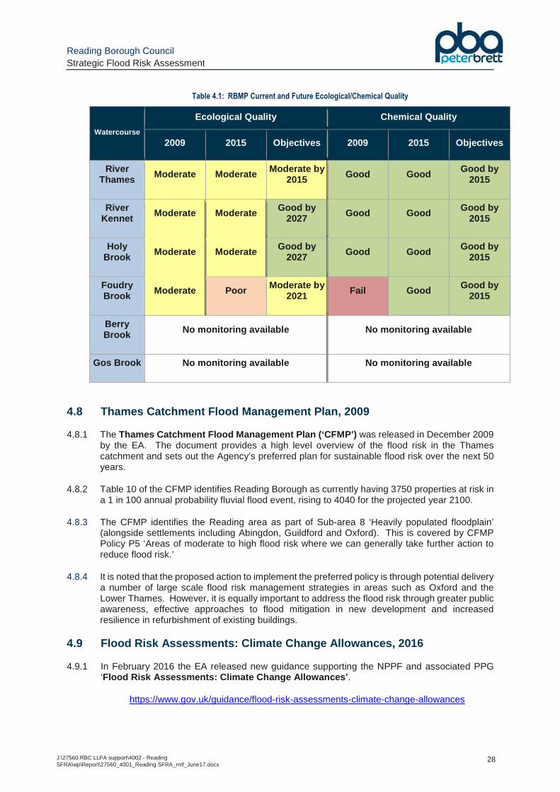
4.7.4 Table 4.1 provides an overview of the ecological and chemical status of the main river watercourses within the Borough, showing the original 2009 status, the recorded 2015 status and the current objectives.
4.7.5 The EA Catchment Data Explorer web application is used to view catchment summaries and download data. The northern part of Reading Borough lies within the ‘River Thames - Southern Chilterns’ operational catchment, whereas the southern part lies within the Kennet operational catchment, an overview of each is located here:
http://environment.data.gov.uk/catchment-planning/OperationalCatchment/3412
http://environment.data.gov.uk/catchment-planning/OperationalCatchment/3242
Reading Borough Council Strategic Flood Risk Assessment
J:\27560 RBC LLFA support\4002 - Reading SFRA\wp\Report\27560_4001_Reading SFRA_rmf_June17.docx
28
Table 4.1: RBMP Current and Future Ecological/Chemical Quality
Watercourse
Ecological Quality Chemical Quality
2009 2015 Objectives 2009 2015 Objectives
River Thames Moderate Moderate Moderate by
2015 Good Good Good by 2015
River Kennet Moderate Moderate Good by
2027 Good Good Good by
2015
Holy Brook Moderate Moderate Good by
2027 Good Good Good by
2015
Foudry Brook Moderate Poor Moderate by
2021 Fail Good Good by 2015
Berry Brook No monitoring available No monitoring available
Gos Brook No monitoring available No monitoring available
4.8 Thames Catchment Flood Management Plan, 2009
4.8.1 The Thames Catchment Flood Management Plan (‘CFMP’) was released in December 2009 by the EA. The document provides a high level overview of the flood risk in the Thames catchment and sets out the Agency’s preferred plan for sustainable flood risk over the next 50 years.
4.8.2 Table 10 of the CFMP identifies Reading Borough as currently having 3750 properties at risk in a 1 in 100 annual probability fluvial flood event, rising to 4040 for the projected year 2100.
4.8.3 The CFMP identifies the Reading area as part of Sub-area 8 ‘Heavily populated floodplain’ (alongside settlements including Abingdon, Guildford and Oxford). This is covered by CFMP Policy P5 ‘Areas of moderate to high flood risk where we can generally take further action to reduce flood risk.’
4.8.4 It is noted that the proposed action to implement the preferred policy is through potential delivery a number of large scale flood risk management strategies in areas such as Oxford and the Lower Thames. However, it is equally important to address the flood risk through greater public awareness, effective approaches to flood mitigation in new development and increased resilience in refurbishment of existing buildings.
4.9 Flood Risk Assessments: Climate Change Allowances, 2016
4.9.1 In February 2016 the EA released new guidance supporting the NPPF and associated PPG ‘Flood Risk Assessments: Climate Change Allowances’ .
https://www.gov.uk/guidance/flood-risk-assessments-climate-change-allowances
Reading Borough Council Strategic Flood Risk Assessment
J:\27560 RBC LLFA support\4002 - Reading SFRA\wp\Report\27560_4001_Reading SFRA_rmf_June17.docx
29
4.9.2 One of the key principles of the NPPF is ensuring that development is safe from flooding ‘for the lifetime of the development’ – i.e. with due consideration of the potential impacts of climate change on aspects such as peak rainfall, sea level rise and increases in peak river flow.
4.9.3 The peak river flow allowances table provides a range of allowances according to percentile (i.e. the degree of certainty of an event occurring, based on the range of climate change scenarios assessed through scientific investigations). The provided allowances are also subject to the vulnerability classification of the proposed use and the river basin district of the site.
4.9.4 The potential increases in rainfall intensity require consideration in the proposed surface water drainage strategy for new development.
4.9.5 Further details on the recommended application of the EA climate change guidance in the Thames area is provided in the ‘Thames Area Climate Change Allowances – Guidance for their use in Flood Risk Assessments’ (August 2016), a copy of which is included in Appendix D.
4.9.6 The implications of this new guidance are detailed further in Section 10.2 .
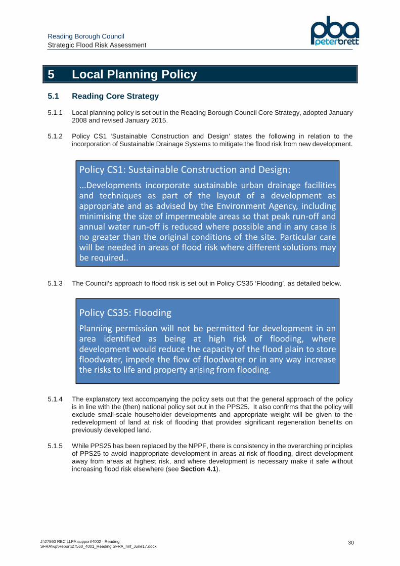
Reading Borough Council Strategic Flood Risk Assessment
J:\27560 RBC LLFA support\4002 - Reading SFRA\wp\Report\27560_4001_Reading SFRA_rmf_June17.docx
30
5 Local Planning Policy
5.1 Reading Core Strategy
5.1.1 Local planning policy is set out in the Reading Borough Council Core Strategy, adopted January 2008 and revised January 2015.
5.1.2 Policy CS1 ‘Sustainable Construction and Design’ states the following in relation to the incorporation of Sustainable Drainage Systems to mitigate the flood risk from new development.
5.1.3 The Council’s approach to flood risk is set out in Policy CS35 ‘Flooding’, as detailed below.
5.1.4 The explanatory text accompanying the policy sets out that the general approach of the policy is in line with the (then) national policy set out in the PPS25. It also confirms that the policy will exclude small-scale householder developments and appropriate weight will be given to the redevelopment of land at risk of flooding that provides significant regeneration benefits on previously developed land.
5.1.5 While PPS25 has been replaced by the NPPF, there is consistency in the overarching principles of PPS25 to avoid inappropriate development in areas at risk of flooding, direct development away from areas at highest risk, and where development is necessary make it safe without increasing flood risk elsewhere (see Section 4.1 ).
Policy CS1: Sustainable Construction and Design:
...Developments incorporate sustainable urban drainage facilitiesand techniques as part of the layout of a development asappropriate and as advised by the Environment Agency, includingminimising the size of impermeable areas so that peak run-off andannual water run-off is reduced where possible and in any case isno greater than the original conditions of the site. Particular carewill be needed in areas of flood risk where different solutions maybe required..
Policy CS35: Flooding
Planning permission will not be permitted for development in anarea identified as being at high risk of flooding, wheredevelopment would reduce the capacity of the flood plain to storefloodwater, impede the flow of floodwater or in any way increasethe risks to life and property arising from flooding.
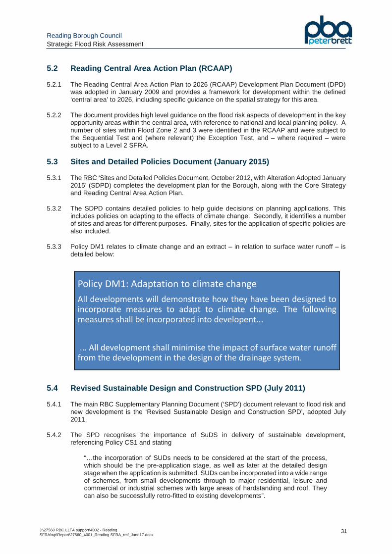
Reading Borough Council Strategic Flood Risk Assessment
J:\27560 RBC LLFA support\4002 - Reading SFRA\wp\Report\27560_4001_Reading SFRA_rmf_June17.docx
31
5.2 Reading Central Area Action Plan (RCAAP)
5.2.1 The Reading Central Area Action Plan to 2026 (RCAAP) Development Plan Document (DPD) was adopted in January 2009 and provides a framework for development within the defined ‘central area’ to 2026, including specific guidance on the spatial strategy for this area.
5.2.2 The document provides high level guidance on the flood risk aspects of development in the key opportunity areas within the central area, with reference to national and local planning policy. A number of sites within Flood Zone 2 and 3 were identified in the RCAAP and were subject to the Sequential Test and (where relevant) the Exception Test, and – where required – were subject to a Level 2 SFRA.
5.3 Sites and Detailed Policies Document (January 2015)
5.3.1 The RBC ‘Sites and Detailed Policies Document, October 2012, with Alteration Adopted January 2015’ (SDPD) completes the development plan for the Borough, along with the Core Strategy and Reading Central Area Action Plan.
5.3.2 The SDPD contains detailed policies to help guide decisions on planning applications. This includes policies on adapting to the effects of climate change. Secondly, it identifies a number of sites and areas for different purposes. Finally, sites for the application of specific policies are also included.
5.3.3 Policy DM1 relates to climate change and an extract – in relation to surface water runoff – is detailed below:
5.4 Revised Sustainable Design and Construction SPD (July 2011)
5.4.1 The main RBC Supplementary Planning Document (‘SPD’) document relevant to flood risk and new development is the ‘Revised Sustainable Design and Construction SPD’, adopted July 2011.
5.4.2 The SPD recognises the importance of SuDS in delivery of sustainable development, referencing Policy CS1 and stating
“…the incorporation of SUDs needs to be considered at the start of the process, which should be the pre-application stage, as well as later at the detailed design stage when the application is submitted. SUDs can be incorporated into a wide range of schemes, from small developments through to major residential, leisure and commercial or industrial schemes with large areas of hardstanding and roof. They can also be successfully retro-fitted to existing developments”.
Policy DM1: Adaptation to climate change
All developments will demonstrate how they have been designed toincorporate measures to adapt to climate change. The followingmeasures shall be incorporated into developent...
... All development shall minimise the impact of surface water runofffrom the development in the design of the drainage system.
Reading Borough Council Strategic Flood Risk Assessment
J:\27560 RBC LLFA support\4002 - Reading SFRA\wp\Report\27560_4001_Reading SFRA_rmf_June17.docx
32
5.5 Reading’s Climate Change Strategy 2013-2020 (Sept 2013)
5.5.1 ‘Reading Means Business on Climate Change’ is Reading’s Climate Change Strategy for the period spanning 2013-2020. The report sets out a vision for Reading, with the ultimate aim to reduce the carbon footprint by 34% from 2005 levels by 2020. In this respect it identifies eight priority areas: energy supply; low carbon development; the natural environment; water supply and flooding; transport; purchasing, supply and consumption; education, communication and influencing behaviour and community.
5.5.2 A number of key successes in the delivery of the action plan during the first 18 months include:
• Reading's relocated Civic Offices - opened in late 2014 - are expected to use 75 per cent less energy than the previous offices, through use of solar panels, energy efficient LED lighting and new ventilation systems;
• 50% of Reading Buses total fleet is lower emission (CNG, hybrid and Euro 6 engine vehicles);
• In January 2015, installation of solar panels on council houses began, providing free renewable energy to tenants and saving over 600 tonnes of carbon dioxide emissions per annum. Panels on 450 houses have been completed so far;
• Over the 2014/15 winter, 186 vulnerable people were helped to heat their homes by the Council's Winter Watch project;
• A total of 71 trees were planted across the borough in winter/spring 2015;
• Over 100 small and medium-sized companies took part in the Re-Start Local Project,
working to develop the green economy;
• ReadyBike launched in June 2014 with 200 bicycles available to hire at 29 locations around Reading. 39,057 rentals and 9,345 total subscriptions to date;
• Reading Bike Kitchen has been established, seeking to bring old bikes back into use.
5.5.3 The latest data (December 2015) shows RBC has reduced its carbon emissions by 27 per cent
per head since 2005. This puts Reading as the top performing Local Authority in Berkshire and amongst the best per carbon emission reductions of the 413 Local Authorities in the UK.
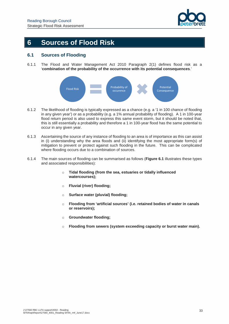
Reading Borough Council Strategic Flood Risk Assessment
J:\27560 RBC LLFA support\4002 - Reading SFRA\wp\Report\27560_4001_Reading SFRA_rmf_June17.docx
33
6 Sources of Flood Risk
6.1 Sources of Flooding
6.1.1 The Flood and Water Management Act 2010 Paragraph 2(1) defines flood risk as a ‘combination of the probability of the occurrence with its potential consequences .’
6.1.2 The likelihood of flooding is typically expressed as a chance (e.g. a ‘1 in 100 chance of flooding in any given year’) or as a probability (e.g. a 1% annual probability of flooding). A 1 in 100-year flood return period is also used to express this same event storm, but it should be noted that, this is still essentially a probability and therefore a 1 in 100-year flood has the same potential to occur in any given year.
6.1.3 Ascertaining the source of any instance of flooding to an area is of importance as this can assist in (i) understanding why the area floods and (ii) identifying the most appropriate form(s) of mitigation to prevent or protect against such flooding in the future. This can be complicated where flooding occurs due to a combination of sources.
6.1.4 The main sources of flooding can be summarised as follows (Figure 6.1 illustrates these types and associated responsibilities):
o Tidal flooding (from the sea, estuaries or tidally influenced watercourses);
o Fluvial (river) flooding;
o Surface water (pluvial) flooding;
o Flooding from ‘artificial sources’ (i.e. retained bodies of water in canals or reservoirs);
o Groundwater flooding;
o Flooding from sewers (system exceeding capacity or burst water main).
Flood RiskProbability of
occurencePotential
Consequence
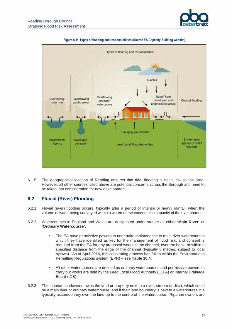
Reading Borough Council Strategic Flood Risk Assessment
J:\27560 RBC LLFA support\4002 - Reading SFRA\wp\Report\27560_4001_Reading SFRA_rmf_June17.docx
34
Figure 6.1: Types of flooding and responsibilities (Source EA Capacity Building website)
6.1.5 The geographical location of Reading ensures that tidal flooding is not a risk to the area.
However, all other sources listed above are potential concerns across the Borough and need to be taken into consideration for new development.
6.2 Fluvial (River) Flooding
6.2.1 Fluvial (river) flooding occurs, typically after a period of intense or heavy rainfall, when the volume of water being conveyed within a watercourse exceeds the capacity of the river channel.
6.2.2 Watercourses in England and Wales are designated under statute as either ‘Main River’ or ‘Ordinary Watercourse’.
• The EA have permissive powers to undertake maintenance to main river watercourses which they have identified as key for the management of flood risk, and consent is required from the EA for any proposed works in the channel, over the bank, or within a specified distance from the edge of the channel (typically 8 metres, subject to local bylaws). As of April 2016, this consenting process has fallen within the Environmental Permitting Regulations system (EPR) – see Table 10.4 .
• All other watercourses are defined as ordinary watercourses and permissive powers to carry out works are held by the Lead Local Flood Authority (LLFA) or Internal Drainage Board (IDB).
6.2.3 The ‘riparian landowner’ owns the land or property next to a river, stream or ditch, which could
be a main river or ordinary watercourse, and if their land boundary is next to a watercourse it is typically assumed they own the land up to the centre of the watercourse. Riparian owners are
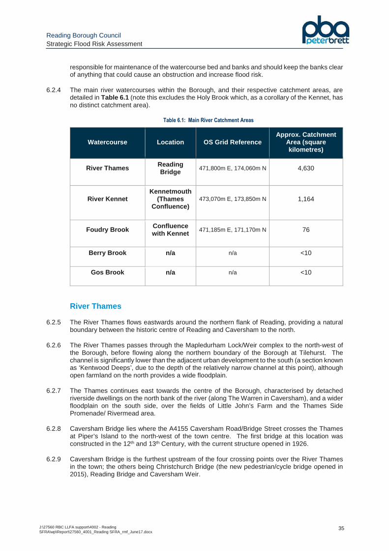
Reading Borough Council Strategic Flood Risk Assessment
J:\27560 RBC LLFA support\4002 - Reading SFRA\wp\Report\27560_4001_Reading SFRA_rmf_June17.docx
35
responsible for maintenance of the watercourse bed and banks and should keep the banks clear of anything that could cause an obstruction and increase flood risk.
6.2.4 The main river watercourses within the Borough, and their respective catchment areas, are detailed in Table 6.1 (note this excludes the Holy Brook which, as a corollary of the Kennet, has no distinct catchment area).
Table 6.1: Main River Catchment Areas
Watercourse Location OS Grid Reference Approx. Catchment
Area (square kilometres)
River Thames Reading Bridge
471,800m E, 174,060m N 4,630
River Kennet Kennetmouth
(Thames Confluence)
473,070m E, 173,850m N 1,164
Foudry Brook Confluence with Kennet
471,185m E, 171,170m N 76
Berry Brook n/a n/a <10
Gos Brook n/a n/a <10
River Thames
6.2.5 The River Thames flows eastwards around the northern flank of Reading, providing a natural boundary between the historic centre of Reading and Caversham to the north.
6.2.6 The River Thames passes through the Mapledurham Lock/Weir complex to the north-west of the Borough, before flowing along the northern boundary of the Borough at Tilehurst. The channel is significantly lower than the adjacent urban development to the south (a section known as ‘Kentwood Deeps’, due to the depth of the relatively narrow channel at this point), although open farmland on the north provides a wide floodplain.
6.2.7 The Thames continues east towards the centre of the Borough, characterised by detached riverside dwellings on the north bank of the river (along The Warren in Caversham), and a wider floodplain on the south side, over the fields of Little John’s Farm and the Thames Side Promenade/ Rivermead area.
6.2.8 Caversham Bridge lies where the A4155 Caversham Road/Bridge Street crosses the Thames at Piper’s Island to the north-west of the town centre. The first bridge at this location was constructed in the 12th and 13th Century, with the current structure opened in 1926.
6.2.9 Caversham Bridge is the furthest upstream of the four crossing points over the River Thames in the town; the others being Christchurch Bridge (the new pedestrian/cycle bridge opened in 2015), Reading Bridge and Caversham Weir.
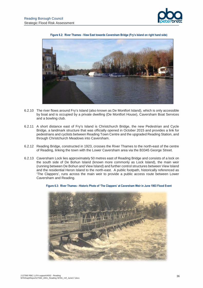
Reading Borough Council Strategic Flood Risk Assessment
J:\27560 RBC LLFA support\4002 - Reading SFRA\wp\Report\27560_4001_Reading SFRA_rmf_June17.docx
36
Figure 6.2: River Thames - View East towards Caversham Bridge (Fry’s Island on right hand side)
6.2.10 The river flows around Fry’s Island (also known as De Montfort Island), which is only accessible by boat and is occupied by a private dwelling (De Montfort House), Caversham Boat Services and a bowling club.
6.2.11 A short distance east of Fry’s Island is Christchurch Bridge, the new Pedestrian and Cycle Bridge, a landmark structure that was officially opened in October 2015 and provides a link for pedestrians and cyclists between Reading Town Centre and the upgraded Reading Station, and through Christchurch Meadows into Caversham.
6.2.12 Reading Bridge, constructed in 1923, crosses the River Thames to the north-east of the centre of Reading, linking the town with the Lower Caversham area via the B3345 George Street.
6.2.13 Caversham Lock lies approximately 50 metres east of Reading Bridge and consists of a lock on the south side of De Bohun Island (known more commonly as Lock Island), the main weir (running between De Bohun and View Island) and further control structures between View Island and the residential Heron Island to the north-east. A public footpath, historically referenced as ‘The Clappers’, runs across the main weir to provide a public access route between Lower Caversham and Reading.
Figure 6.3: River Thames - Historic Photo of ‘The Clappers’ at Caversham Weir in June 1903 Flood Event
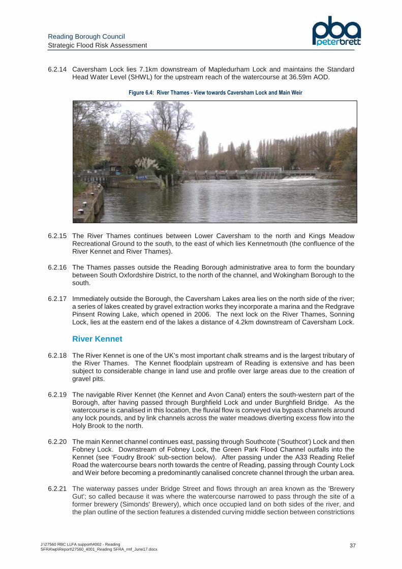
Reading Borough Council Strategic Flood Risk Assessment
J:\27560 RBC LLFA support\4002 - Reading SFRA\wp\Report\27560_4001_Reading SFRA_rmf_June17.docx
37
6.2.14 Caversham Lock lies 7.1km downstream of Mapledurham Lock and maintains the Standard Head Water Level (SHWL) for the upstream reach of the watercourse at 36.59m AOD.
Figure 6.4: River Thames - View towards Caversham Lock and Main Weir
6.2.15 The River Thames continues between Lower Caversham to the north and Kings Meadow Recreational Ground to the south, to the east of which lies Kennetmouth (the confluence of the River Kennet and River Thames).
6.2.16 The Thames passes outside the Reading Borough administrative area to form the boundary between South Oxfordshire District, to the north of the channel, and Wokingham Borough to the south.
6.2.17 Immediately outside the Borough, the Caversham Lakes area lies on the north side of the river; a series of lakes created by gravel extraction works they incorporate a marina and the Redgrave Pinsent Rowing Lake, which opened in 2006. The next lock on the River Thames, Sonning Lock, lies at the eastern end of the lakes a distance of 4.2km downstream of Caversham Lock.
River Kennet
6.2.18 The River Kennet is one of the UK’s most important chalk streams and is the largest tributary of the River Thames. The Kennet floodplain upstream of Reading is extensive and has been subject to considerable change in land use and profile over large areas due to the creation of gravel pits.
6.2.19 The navigable River Kennet (the Kennet and Avon Canal) enters the south-western part of the Borough, after having passed through Burghfield Lock and under Burghfield Bridge. As the watercourse is canalised in this location, the fluvial flow is conveyed via bypass channels around any lock pounds, and by link channels across the water meadows diverting excess flow into the Holy Brook to the north.
6.2.20 The main Kennet channel continues east, passing through Southcote (‘Southcot’) Lock and then Fobney Lock. Downstream of Fobney Lock, the Green Park Flood Channel outfalls into the Kennet (see ‘Foudry Brook’ sub-section below). After passing under the A33 Reading Relief Road the watercourse bears north towards the centre of Reading, passing through County Lock and Weir before becoming a predominantly canalised concrete channel through the urban area.
6.2.21 The waterway passes under Bridge Street and flows through an area known as the 'Brewery Gut'; so called because it was where the watercourse narrowed to pass through the site of a former brewery (Simonds' Brewery), which once occupied land on both sides of the river, and the plan outline of the section features a distended curving middle section between constrictions
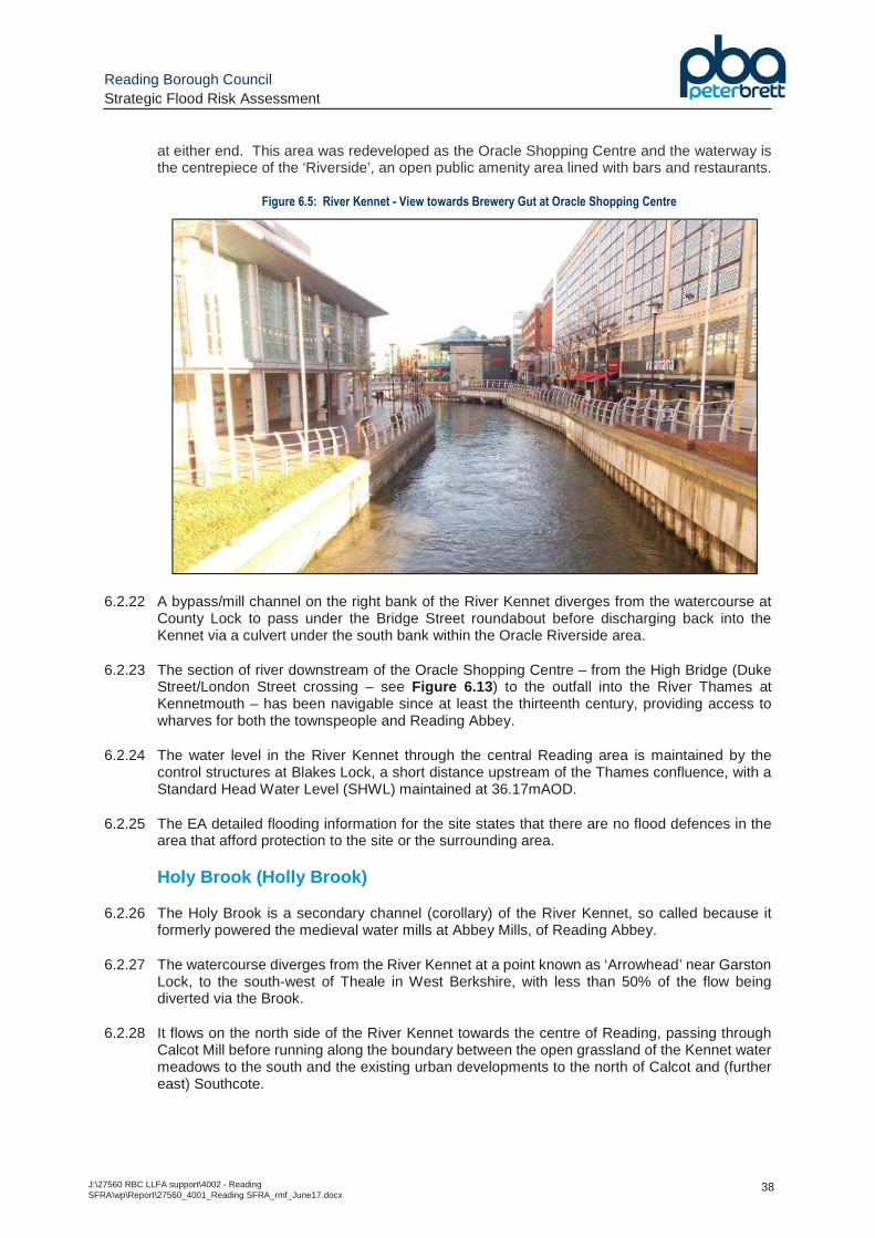
Reading Borough Council Strategic Flood Risk Assessment
J:\27560 RBC LLFA support\4002 - Reading SFRA\wp\Report\27560_4001_Reading SFRA_rmf_June17.docx
38
at either end. This area was redeveloped as the Oracle Shopping Centre and the waterway is the centrepiece of the ‘Riverside’, an open public amenity area lined with bars and restaurants.
Figure 6.5: River Kennet - View towards Brewery Gut at Oracle Shopping Centre
6.2.22 A bypass/mill channel on the right bank of the River Kennet diverges from the watercourse at County Lock to pass under the Bridge Street roundabout before discharging back into the Kennet via a culvert under the south bank within the Oracle Riverside area.
6.2.23 The section of river downstream of the Oracle Shopping Centre – from the High Bridge (Duke Street/London Street crossing – see Figure 6.13 ) to the outfall into the River Thames at Kennetmouth – has been navigable since at least the thirteenth century, providing access to wharves for both the townspeople and Reading Abbey.
6.2.24 The water level in the River Kennet through the central Reading area is maintained by the control structures at Blakes Lock, a short distance upstream of the Thames confluence, with a Standard Head Water Level (SHWL) maintained at 36.17mAOD.
6.2.25 The EA detailed flooding information for the site states that there are no flood defences in the area that afford protection to the site or the surrounding area.
Holy Brook (Holly Brook)
6.2.26 The Holy Brook is a secondary channel (corollary) of the River Kennet, so called because it formerly powered the medieval water mills at Abbey Mills, of Reading Abbey.
6.2.27 The watercourse diverges from the River Kennet at a point known as ‘Arrowhead’ near Garston Lock, to the south-west of Theale in West Berkshire, with less than 50% of the flow being diverted via the Brook.
6.2.28 It flows on the north side of the River Kennet towards the centre of Reading, passing through Calcot Mill before running along the boundary between the open grassland of the Kennet water meadows to the south and the existing urban developments to the north of Calcot and (further east) Southcote.
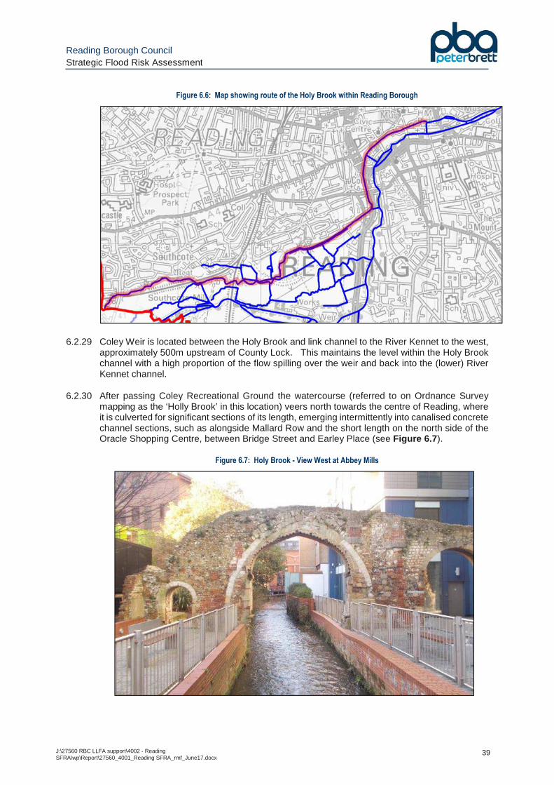
Reading Borough Council Strategic Flood Risk Assessment
J:\27560 RBC LLFA support\4002 - Reading SFRA\wp\Report\27560_4001_Reading SFRA_rmf_June17.docx
39
Figure 6.6: Map showing route of the Holy Brook within Reading Borough
6.2.29 Coley Weir is located between the Holy Brook and link channel to the River Kennet to the west, approximately 500m upstream of County Lock. This maintains the level within the Holy Brook channel with a high proportion of the flow spilling over the weir and back into the (lower) River Kennet channel.
6.2.30 After passing Coley Recreational Ground the watercourse (referred to on Ordnance Survey mapping as the ‘Holly Brook’ in this location) veers north towards the centre of Reading, where it is culverted for significant sections of its length, emerging intermittently into canalised concrete channel sections, such as alongside Mallard Row and the short length on the north side of the Oracle Shopping Centre, between Bridge Street and Earley Place (see Figure 6.7 ).
Figure 6.7: Holy Brook - View West at Abbey Mills
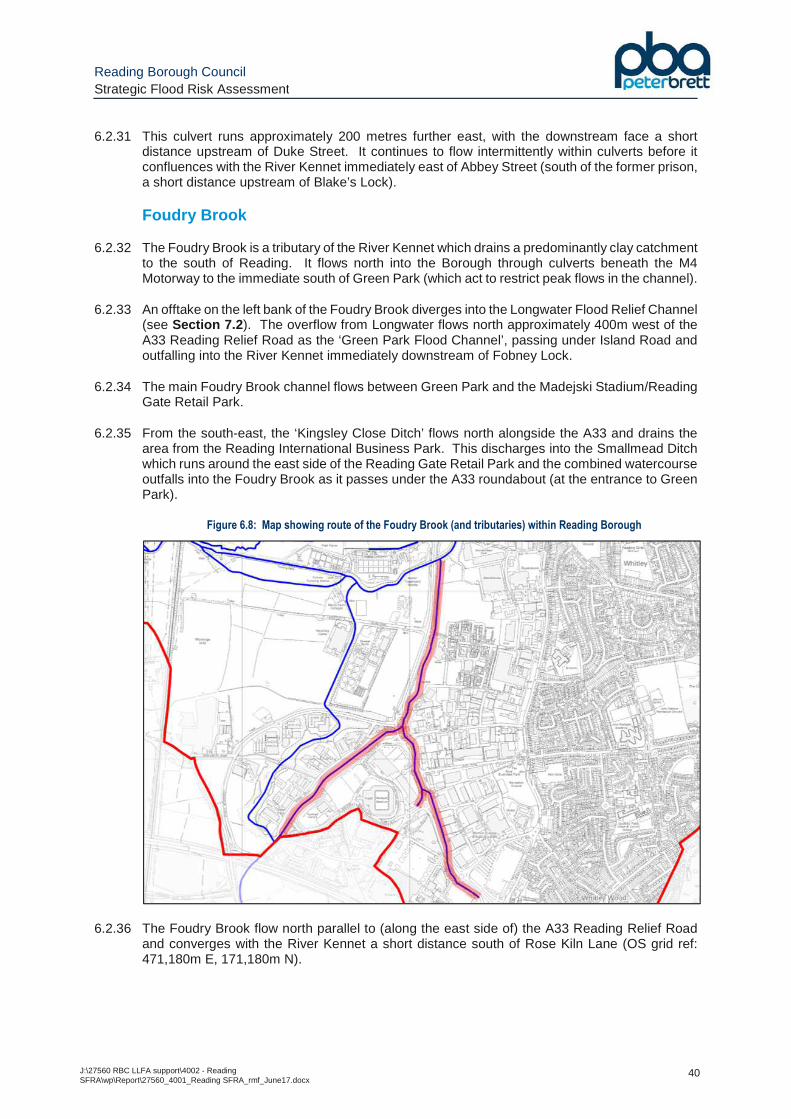
Reading Borough Council Strategic Flood Risk Assessment
J:\27560 RBC LLFA support\4002 - Reading SFRA\wp\Report\27560_4001_Reading SFRA_rmf_June17.docx
40
6.2.31 This culvert runs approximately 200 metres further east, with the downstream face a short distance upstream of Duke Street. It continues to flow intermittently within culverts before it confluences with the River Kennet immediately east of Abbey Street (south of the former prison, a short distance upstream of Blake’s Lock).
Foudry Brook
6.2.32 The Foudry Brook is a tributary of the River Kennet which drains a predominantly clay catchment to the south of Reading. It flows north into the Borough through culverts beneath the M4 Motorway to the immediate south of Green Park (which act to restrict peak flows in the channel).
6.2.33 An offtake on the left bank of the Foudry Brook diverges into the Longwater Flood Relief Channel (see Section 7.2 ). The overflow from Longwater flows north approximately 400m west of the A33 Reading Relief Road as the ‘Green Park Flood Channel’, passing under Island Road and outfalling into the River Kennet immediately downstream of Fobney Lock.
6.2.34 The main Foudry Brook channel flows between Green Park and the Madejski Stadium/Reading Gate Retail Park.
6.2.35 From the south-east, the ‘Kingsley Close Ditch’ flows north alongside the A33 and drains the area from the Reading International Business Park. This discharges into the Smallmead Ditch which runs around the east side of the Reading Gate Retail Park and the combined watercourse outfalls into the Foudry Brook as it passes under the A33 roundabout (at the entrance to Green Park).
Figure 6.8: Map showing route of the Foudry Brook (and tributaries) within Reading Borough
6.2.36 The Foudry Brook flow north parallel to (along the east side of) the A33 Reading Relief Road and converges with the River Kennet a short distance south of Rose Kiln Lane (OS grid ref: 471,180m E, 171,180m N).
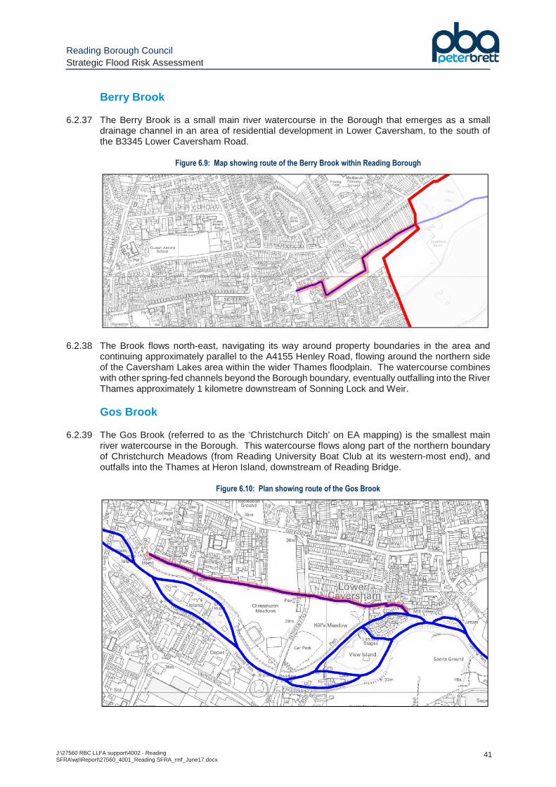
Reading Borough Council Strategic Flood Risk Assessment
J:\27560 RBC LLFA support\4002 - Reading SFRA\wp\Report\27560_4001_Reading SFRA_rmf_June17.docx
41
Berry Brook
6.2.37 The Berry Brook is a small main river watercourse in the Borough that emerges as a small drainage channel in an area of residential development in Lower Caversham, to the south of the B3345 Lower Caversham Road.
Figure 6.9: Map showing route of the Berry Brook within Reading Borough
6.2.38 The Brook flows north-east, navigating its way around property boundaries in the area and continuing approximately parallel to the A4155 Henley Road, flowing around the northern side of the Caversham Lakes area within the wider Thames floodplain. The watercourse combines with other spring-fed channels beyond the Borough boundary, eventually outfalling into the River Thames approximately 1 kilometre downstream of Sonning Lock and Weir.
Gos Brook
6.2.39 The Gos Brook (referred to as the ‘Christchurch Ditch’ on EA mapping) is the smallest main river watercourse in the Borough. This watercourse flows along part of the northern boundary of Christchurch Meadows (from Reading University Boat Club at its western-most end), and outfalls into the Thames at Heron Island, downstream of Reading Bridge.
Figure 6.10: Plan showing route of the Gos Brook
Reading Borough Council Strategic Flood Risk Assessment
J:\27560 RBC LLFA support\4002 - Reading SFRA\wp\Report\27560_4001_Reading SFRA_rmf_June17.docx
42
6.2.40 Along its route, a number of Thames Water surface water sewers draining the adjacent urban area to the north feed the watercourse, which also serves to drain Christchurch Meadows (particularly after flooding occurs from the River Thames).
6.3 Surface Water Flooding
6.3.1 The Flood and Water Management Act (FWMA) defines surface water flooding as:
"The flooding that takes place from the 'surface runoff' generated by rainwater (including snow and other precipitation) which: (a) is on the surface of the ground (whether or not it is moving), and (b) has not yet entered a watercourse, drainage system or public sewer."
6.3.2 The EA data provided in the ‘updated Flood Map for Surface Water’ (‘uFMfSW’) has been produced from a combination of (i) the EA’s national scale surface water flood mapping, and (ii) appropriate locally produced mapping from LLFAs. These two sources have been combined with the aim to provide the best single source of surface water flood risk.
6.3.3 The latest mapping assesses flooding resulting from severe rainfall events based on the following three scenarios:
• 1 in 30 (3.3%) annual probability rainfall event;
• 1 in 100 (1%) annual probability rainfall event;
• 1 in 1000 (0.1%) annual probability rainfall event.
6.3.4 It should be noted that the national scale modelling does not take account of any specific local information on below-ground drainage infrastructure and infiltration, although a runoff co-efficient adjustment is included in urban areas to account for the impact of sewerage and a standard infiltration allowance based on soil type. As such, subject to the incorporation of the locally produced LLFA mapping, the modelling can only provide a guide to potentially vulnerable areas based on the general topography of an area.
6.3.5 A number of ordinary watercourses within the Borough have been largely subsumed within the urban drainage system as a result of outward urban growth, and now are largely culverted for significant lengths as part of the Thames Water public sewer system. Such areas are likely to be at some risk of flooding, particularly where normally “dry” valleys drain into them, where the topography will concentrate flows and where the culverts may be susceptible to blockage. Areas of potential concern are not represented on the EA Flood Zone outlines for fluvial flooding but are highlighted on the EA Surface Water flood map and include:
• The culverted watercourse between the outlet of Whiteknights Park Lake and the Kennet near Kennetmouth.
• Hemdean Bottom/Hemdean Road, Caversham, with a culvert draining to the Thames near the University boathouses.
• The Dee Road/Norcot Road area with a culvert draining to the Thames at Scours Lane.
• The Rodway Road/Kentwood Hill/Overdown Road area with a culvert draining under the railway to the Thames at the Kentwood roundabout on Oxford Road (this roundabout was affected by flooding in July 2007).
6.3.6 Due to the modelling techniques used, the mapping picks out depressions in the ground surface and simulates some flow along natural drainage channels, rivers, low areas in floodplains, and flow paths between buildings. Although the maps appear to show flooding from ordinary
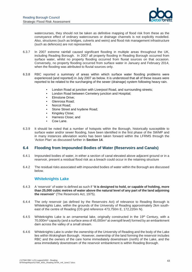
Reading Borough Council Strategic Flood Risk Assessment
J:\27560 RBC LLFA support\4002 - Reading SFRA\wp\Report\27560_4001_Reading SFRA_rmf_June17.docx
43
watercourses, they should not be taken as definitive mapping of flood risk from these as the conveyance effect of ordinary watercourses or drainage channels is not explicitly modelled. Also, structures (such as bridges, culverts and weirs) and flood risk management infrastructure (such as defences) are not represented.
6.3.7 In 2007 extreme rainfall caused significant flooding in multiple areas throughout the UK, including Reading Borough. In 2007 all property flooding in Reading Borough occurred from surface water, whilst no property flooding occurred from fluvial sources on that occasion. Conversely, no property flooding occurred from surface water in January and February 2014, when the flooding was attributed to fluvial sources only.
6.3.8 RBC reported a summary of areas within which surface water flooding problems were experienced (and reported) in July 2007 as below. It is understood that all of these issues were reported to be related to the surcharging of the sewer (drainage) system following heavy rain.
• London Road at junction with Liverpool Road, and surrounding streets; • London Road between Cemetery junction and Hospital; • Elmstone Drive; • Glenrosa Road; • Norcot Road; • Stone Street and Ivydene Road; • Kingsley Close; • Harness Close; and • Cow Lane.
6.3.9 It should be noted that a number of hotspots within the Borough, historically susceptible to surface water and/or sewer flooding, have been identified in the first phase of the SWMP and in many instances alleviation works has been taken forward within the LFRMS through the ‘Action Plan’ as discussed further in Section 14 .
6.4 Flooding from Impounded Bodies of Water (Reservoirs and Canals)
6.4.1 Impounded bodies of water, in either a section of canal elevated above adjacent ground or in a reservoir, present a residual flood risk as a breach could occur in the retaining structure
6.4.2 The residual risks associated with impounded bodies of water within the Borough are discussed below.
Whiteknights Lake
6.4.3 A ‘reservoir’ of water is defined as such if “it is designed to hold, or capable of holding, more than 25,000 cubic metres of water above the natural level of any part of the land adjoining the reservoir ” (The Reservoirs Act, 1975).
6.4.4 The only reservoir (as defined by the Reservoirs Act) of relevance to Reading Borough is Whiteknights Lake, within the grounds of the University of Reading approximately 2km south-east of the centre of Reading (OS grid reference 473,750m E, 172,220m N).
6.4.5 Whiteknights Lake is an ornamental lake, originally constructed in the 19th Century, with a 70,000m3 capacity (and a surface area of 45,000m2 at overspill level) formed by an embankment dam across the valley of a small stream.
6.4.6 Whiteknights Lake is under the ownership of the University of Reading and the body of the Lake lies within Wokingham Borough. However, ownership of the land forming the reservoir includes RBC and the owners of the care home immediately downstream (north) of the Lake, and the area immediately downstream of the reservoir embankment is within Reading Borough.
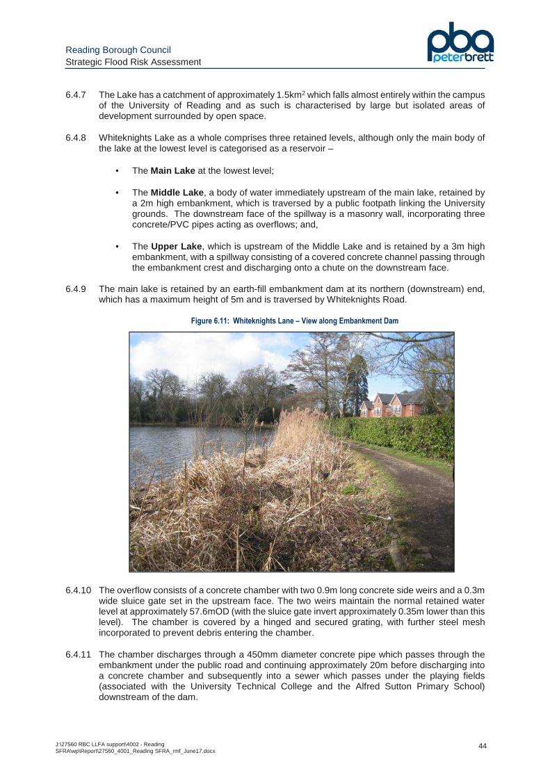
Reading Borough Council Strategic Flood Risk Assessment
J:\27560 RBC LLFA support\4002 - Reading SFRA\wp\Report\27560_4001_Reading SFRA_rmf_June17.docx
44
6.4.7 The Lake has a catchment of approximately 1.5km2 which falls almost entirely within the campus of the University of Reading and as such is characterised by large but isolated areas of development surrounded by open space.
6.4.8 Whiteknights Lake as a whole comprises three retained levels, although only the main body of the lake at the lowest level is categorised as a reservoir –
• The Main Lake at the lowest level;
• The Middle Lake , a body of water immediately upstream of the main lake, retained by a 2m high embankment, which is traversed by a public footpath linking the University grounds. The downstream face of the spillway is a masonry wall, incorporating three concrete/PVC pipes acting as overflows; and,
• The Upper Lake , which is upstream of the Middle Lake and is retained by a 3m high
embankment, with a spillway consisting of a covered concrete channel passing through the embankment crest and discharging onto a chute on the downstream face.
6.4.9 The main lake is retained by an earth-fill embankment dam at its northern (downstream) end,
which has a maximum height of 5m and is traversed by Whiteknights Road.
Figure 6.11: Whiteknights Lane – View along Embankment Dam
6.4.10 The overflow consists of a concrete chamber with two 0.9m long concrete side weirs and a 0.3m wide sluice gate set in the upstream face. The two weirs maintain the normal retained water level at approximately 57.6mOD (with the sluice gate invert approximately 0.35m lower than this level). The chamber is covered by a hinged and secured grating, with further steel mesh incorporated to prevent debris entering the chamber.
6.4.11 The chamber discharges through a 450mm diameter concrete pipe which passes through the embankment under the public road and continuing approximately 20m before discharging into a concrete chamber and subsequently into a sewer which passes under the playing fields (associated with the University Technical College and the Alfred Sutton Primary School) downstream of the dam.
Reading Borough Council Strategic Flood Risk Assessment
J:\27560 RBC LLFA support\4002 - Reading SFRA\wp\Report\27560_4001_Reading SFRA_rmf_June17.docx
45
6.4.12 No further details of the route of the pipe system downstream of the reservoir are available but a review of the topography of the area alongside the Thames Water sewer assets suggests that it may outfall into the Thames Water surface water sewer running north-west along Wokingham Road and draining towards the River Kennet.
6.4.13 A care home lies to the immediate downstream of the embankment dam. On the eastern side of the care home is a 20m wide auxiliary spillway above the line of the outfall pipe, the sides of which are retained by gabion walls (see Figure 6.12 ). The reservoir will only begin to discharge over the auxiliary spillway if the reservoir water level exceeds approximately 0.8m above the invert level of the main spillway, soon after spilling onto Whiteknights Road.
Figure 6.12: Whiteknights Lake - View north of Reservoir Dam along Auxiliary Spillway
6.4.14 In the event of floodwater spilling over the auxiliary spillway, it would subsequently follow the natural fall of land north, across the playing fields and towards the base of the Thames/Kennet river valleys, potentially being intercepted by highways drainage along this route.
6.4.15 As detailed in Section 3.2 , the EA have provided outputs from their Reservoir Flood Map (RFM) showing the risk of flooding in the event of a breach in the Whiteknights Lake embankment.
6.4.16 Map F7 in Appendix C confirms that in the event of a catastrophic breach, floodwater would flow northwards across the playing fields downstream of the spillway, dispersing out into a broader zone of inundation that encompasses Palmer Park, the Reading Old Cemetery and the residential area along both sides of the A329 Wokingham Road. The main overland flow routes continue north through the Newtown area to discharge into the River Kennet, with a shallower secondary route flowing north-east (outside the Borough boundary), through Thames Valley Park before discharging into the River Thames.
6.4.1 Under Schedule 4 of the Flood and Water Management Act 2010, the EA has designated Whiteknights Reservoir as a “high risk” (Category A) large raised reservoir, because in the event of an uncontrolled release of water from the reservoir, the Environment Agency believes that human life could be endangered. As such Whiteknights Reservoir is subject to the full requirements of the amended Reservoirs Act 1975.
6.4.2 The risk of failure of the embankment dam, resulting in a breach, can never be reduced to zero but can be reduced to a tolerable level through effective maintenance and through acting on the
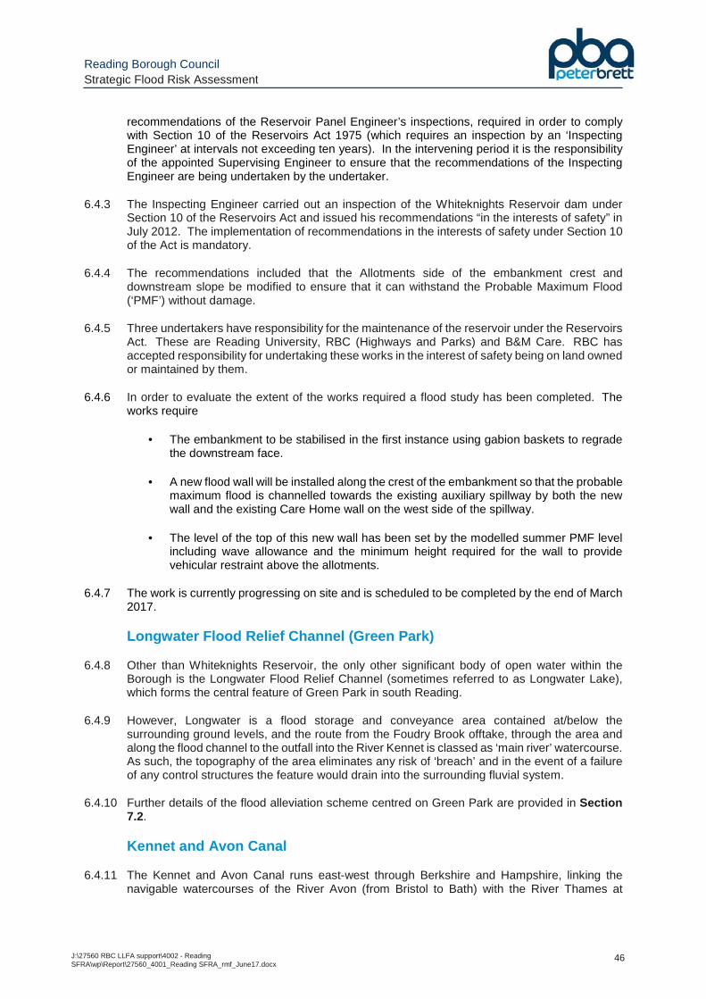
Reading Borough Council Strategic Flood Risk Assessment
J:\27560 RBC LLFA support\4002 - Reading SFRA\wp\Report\27560_4001_Reading SFRA_rmf_June17.docx
46
recommendations of the Reservoir Panel Engineer’s inspections, required in order to comply with Section 10 of the Reservoirs Act 1975 (which requires an inspection by an ‘Inspecting Engineer’ at intervals not exceeding ten years). In the intervening period it is the responsibility of the appointed Supervising Engineer to ensure that the recommendations of the Inspecting Engineer are being undertaken by the undertaker.
6.4.3 The Inspecting Engineer carried out an inspection of the Whiteknights Reservoir dam under Section 10 of the Reservoirs Act and issued his recommendations “in the interests of safety” in July 2012. The implementation of recommendations in the interests of safety under Section 10 of the Act is mandatory.
6.4.4 The recommendations included that the Allotments side of the embankment crest and downstream slope be modified to ensure that it can withstand the Probable Maximum Flood (‘PMF’) without damage.
6.4.5 Three undertakers have responsibility for the maintenance of the reservoir under the Reservoirs Act. These are Reading University, RBC (Highways and Parks) and B&M Care. RBC has accepted responsibility for undertaking these works in the interest of safety being on land owned or maintained by them.
6.4.6 In order to evaluate the extent of the works required a flood study has been completed. The works require
• The embankment to be stabilised in the first instance using gabion baskets to regrade the downstream face.
• A new flood wall will be installed along the crest of the embankment so that the probable maximum flood is channelled towards the existing auxiliary spillway by both the new wall and the existing Care Home wall on the west side of the spillway.
• The level of the top of this new wall has been set by the modelled summer PMF level including wave allowance and the minimum height required for the wall to provide vehicular restraint above the allotments.
6.4.7 The work is currently progressing on site and is scheduled to be completed by the end of March 2017.
Longwater Flood Relief Channel (Green Park)
6.4.8 Other than Whiteknights Reservoir, the only other significant body of open water within the Borough is the Longwater Flood Relief Channel (sometimes referred to as Longwater Lake), which forms the central feature of Green Park in south Reading.
6.4.9 However, Longwater is a flood storage and conveyance area contained at/below the surrounding ground levels, and the route from the Foudry Brook offtake, through the area and along the flood channel to the outfall into the River Kennet is classed as ‘main river’ watercourse. As such, the topography of the area eliminates any risk of ‘breach’ and in the event of a failure of any control structures the feature would drain into the surrounding fluvial system.
6.4.10 Further details of the flood alleviation scheme centred on Green Park are provided in Section 7.2.
Kennet and Avon Canal
6.4.11 The Kennet and Avon Canal runs east-west through Berkshire and Hampshire, linking the navigable watercourses of the River Avon (from Bristol to Bath) with the River Thames at
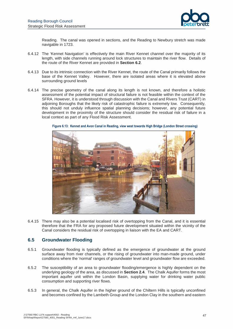
Reading Borough Council Strategic Flood Risk Assessment
J:\27560 RBC LLFA support\4002 - Reading SFRA\wp\Report\27560_4001_Reading SFRA_rmf_June17.docx
47
Reading. The canal was opened in sections, and the Reading to Newbury stretch was made navigable in 1723.
6.4.12 The ‘Kennet Navigation’ is effectively the main River Kennet channel over the majority of its length, with side channels running around lock structures to maintain the river flow. Details of the route of the River Kennet are provided in Section 6.2 .
6.4.13 Due to its intrinsic connection with the River Kennet, the route of the Canal primarily follows the base of the Kennet Valley. However, there are isolated areas where it is elevated above surrounding ground levels
6.4.14 The precise geometry of the canal along its length is not known, and therefore a holistic assessment of the potential impact of structural failure is not feasible within the context of the SFRA. However, it is understood through discussion with the Canal and Rivers Trust (CART) in adjoining Boroughs that the likely risk of catastrophic failure is extremely low. Consequently, this should not unduly influence spatial planning decisions; however, any potential future development in the proximity of the structure should consider the residual risk of failure in a local context as part of any Flood Risk Assessment.
Figure 6.13: Kennet and Avon Canal in Reading, view west towards High Bridge (London Street crossing)
6.4.15 There may also be a potential localised risk of overtopping from the Canal, and it is essential therefore that the FRA for any proposed future development situated within the vicinity of the Canal considers the residual risk of overtopping in liaison with the EA and CART.
6.5 Groundwater Flooding
6.5.1 Groundwater flooding is typically defined as the emergence of groundwater at the ground surface away from river channels, or the rising of groundwater into man-made ground, under conditions where the 'normal' ranges of groundwater level and groundwater flow are exceeded.
6.5.2 The susceptibility of an area to groundwater flooding/emergence is highly dependent on the underlying geology of the area, as discussed in Section 2.4 . The Chalk Aquifer forms the most important aquifer unit within the London Basin, supplying water for drinking water public consumption and supporting river flows.
6.5.3 In general, the Chalk Aquifer in the higher ground of the Chiltern Hills is typically unconfined and becomes confined by the Lambeth Group and the London Clay in the southern and eastern

Reading Borough Council Strategic Flood Risk Assessment
J:\27560 RBC LLFA support\4002 - Reading SFRA\wp\Report\27560_4001_Reading SFRA_rmf_June17.docx
48
parts of the Borough. The groundwater flows from the higher ground of the Chiltern Hills where the aquifer recharges, in general direction to the south-east towards the centre of the London Basin with local variations associated with the Rivers Thames and Kennet.
6.5.4 Chalk Aquifer groundwater levels are reported on the Hydrogeological Map of the area (BGS, 1984) to be approximately 40m. AOD along the northern and western boundaries of the Borough, falling to approximately 30m. AOD along the south-eastern boundary of the Borough.
6.5.5 The groundwater in the Chalk Aquifer is in hydraulic continuity with the Rivers Thames and Kennet. The groundwater in the Rivers Thames and Kennet are in continuity with the River Terrace Deposits and partially connected with the Alluvium where these Superficial Deposits lie directly over the Chalk.
6.5.6 Perched groundwater bodies are locally present in the sand layers of the Lambeth Group where significant thickness of Lambeth Group clays is present above the Chalk. Perched groundwater bodies are also present in the River Terrace Deposits where they are situated above the Lambeth Group or the London Clay Formation where clays act as a low permeability barrier (an ‘aquiclude’) between the groundwater in the River Terrace Deposits and the Chalk Aquifer.
6.5.7 Raised water levels within adjacent rivers and streams can raise the water table beneath the surface, resulting in localised groundwater flooding through permeable gravel ‘lenses’.
6.5.8 The risk of groundwater flooding across the Reading area is typically considered to be low, but it is noted that the historic records from RBC (Map F3 in Appendix C ) identify some isolated records of groundwater flooding; these are typically low lying areas in close proximity to the River Thames (and therefore where groundwater levels would potentially be at seasonal shallow depths).
6.5.9 Where a potential risk of groundwater is identified, it may be appropriate to manage the risk by suitable waterproof sealing of any low level/basement areas (i.e. water resisting construction in accordance with CIRIA Report 139 Table 2.3), appropriate drainage and/or the raising of entry thresholds to mitigate possible damage. The adopted design will need to ensure that it does not result in any worsening to the risk posed to adjoining properties.
6.5.10 Another consideration with respect to groundwater is the effectiveness (or otherwise) of SuDS. The design of proposed developments should carefully consider the impact that raised groundwater levels may have upon the operation of SuDS during periods of heavy rainfall
6.6 Sewer Flooding
6.6.1 Sewer flooding can occur where sewage is unable to drain away in sewerage pipes, and emerges at the surface. There are generally three types of sewer in a drainage network:
• Foul sewers – these are designed to convey wastewater only from connected properties.
• Surface water sewers – these are designed to convey rainwater only arising in storm conditions where the rainwater is from roofs, yards and highways which are legitimately connected to the surface water sewers.
• Combined sewers – these are normally in the older parts of towns where wastewater and surface water is conveyed in the same pipe.
6.6.2 Sewer flooding occurs when the drainage network becomes overwhelmed and surcharges or cannot manage the volume of water entering the system. This occurs during heavy rainfall or if the sewer is under capacity. Water then emerges from the sewer causing flooding. Sewer
Reading Borough Council Strategic Flood Risk Assessment
J:\27560 RBC LLFA support\4002 - Reading SFRA\wp\Report\27560_4001_Reading SFRA_rmf_June17.docx
49
flooding can also occur due to blockages or failure to the system; or when outfalls are surcharged owing to the sea levels.
6.6.3 Sewer flooding can be aggravated by groundwater flooding which gets into the systems as either emerging as surface water that enters through gullies or through infiltration through damaged pipes.
6.6.4 Water companies are required to record all instances of internal flooding of properties. These are categorised on their cause, either hydraulic overloading of the sewers (the sewer pipe is too small or at too shallow a gradient) or other causes (blocked or collapsed sewers, pumping station failure, etc.). In addition, the companies are required to maintain a register of properties which are at risk of internal flooding due to hydraulic overloading and this is usually known as the ‘DG5 at risk register’.
6.6.5 Thames Water were contacted as part of the SFRA update to obtain their DG5 records across the Reading area. This information is provided on Map F9 in Appendix C .
6.6.6 Detailed analysis of the sewer system across RBC has been undertaken as part of the SWMP and LFRMS, the results of which are discussed in Section 14 .
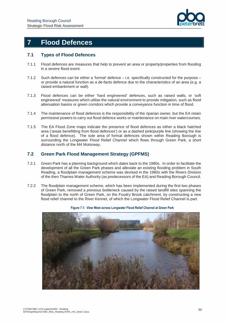
Reading Borough Council Strategic Flood Risk Assessment
J:\27560 RBC LLFA support\4002 - Reading SFRA\wp\Report\27560_4001_Reading SFRA_rmf_June17.docx
50
7 Flood Defences
7.1 Types of Flood Defences
7.1.1 Flood defences are measures that help to prevent an area or property/properties from flooding in a severe flood event.
7.1.2 Such defences can be either a ‘formal’ defence – i.e. specifically constructed for the purpose – or provide a natural function as a de-facto defence due to the characteristics of an area (e.g. a raised embankment or wall).
7.1.3 Flood defences can be either ‘hard engineered’ defences, such as raised walls, or ‘soft engineered’ measures which utilise the natural environment to provide mitigation, such as flood attenuation basins or green corridors which provide a conveyance function in time of flood.
7.1.4 The maintenance of flood defences is the responsibility of the riparian owner, but the EA retain permissive powers to carry out flood defence works or maintenance on main river watercourses.
7.1.5 The EA Flood Zone maps indicate the presence of flood defences as either a black hatched area (‘areas benefitting from flood defences’) or as a dashed pink/purple line (showing the line of a flood defence). The sole area of formal defences shown within Reading Borough is surrounding the Longwater Flood Relief Channel which flows through Green Park, a short distance north of the M4 Motorway.
7.2 Green Park Flood Management Strategy (GPFMS)
7.2.1 Green Park has a planning background which dates back to the 1980s. In order to facilitate the development of all the Green Park phases and alleviate an existing flooding problem in South Reading, a floodplain management scheme was devised in the 1980s with the Rivers Division of the then Thames Water Authority (as predecessors of the EA) and Reading Borough Council.
7.2.2 The floodplain management scheme, which has been implemented during the first two phases of Green Park, removed a previous bottleneck caused by the raised landfill sites spanning the floodplain to the north of Green Park, on the Foudry Brook catchment, by constructing a new flood relief channel to the River Kennet, of which the Longwater Flood Relief Channel is part.
Figure 7.1: View West across Longwater Flood Relief Channel at Green Park
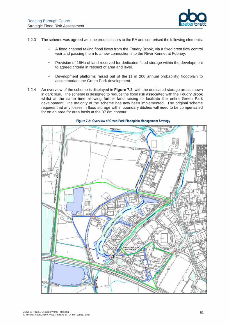
Reading Borough Council Strategic Flood Risk Assessment
J:\27560 RBC LLFA support\4002 - Reading SFRA\wp\Report\27560_4001_Reading SFRA_rmf_June17.docx
51
7.2.3 The scheme was agreed with the predecessors to the EA and comprised the following elements:
• A flood channel taking flood flows from the Foudry Brook, via a fixed crest flow control weir and passing them to a new connection into the River Kennet at Fobney.
• Provision of 16Ha of land reserved for dedicated flood storage within the development to agreed criteria in respect of area and level.
• Development platforms raised out of the (1 in 200 annual probability) floodplain to
accommodate the Green Park development.
7.2.4 An overview of the scheme is displayed in Figure 7.2 , with the dedicated storage areas shown in dark blue. The scheme is designed to reduce the flood risk associated with the Foudry Brook whilst at the same time allowing further land raising to facilitate the entire Green Park development. The majority of the scheme has now been implemented. The original scheme requires that any losses in flood storage within boundary ditches will need to be compensated for on an area for area basis at the 37.8m contour.
Figure 7.2: Overview of Green Park Floodplain Management Strategy
Reading Borough Council Strategic Flood Risk Assessment
J:\27560 RBC LLFA support\4002 - Reading SFRA\wp\Report\27560_4001_Reading SFRA_rmf_June17.docx
52
7.2.5 As a consequence of the completion of the scheme so far, and in accordance with the aspirations of Thames Water Authority and Reading Borough Council at the time, flood levels in this area of South Reading have been lowered providing relief to properties with historic flooding problems. During the intervening years since the construction of the Flood Relief Channel, a period of betterment over that designed for has been experienced. This is because, effectively, the flood compensation for the wider scheme ground raising was constructed in advance.
7.2.6 There have been previous consents for development on the wider site that acknowledge that the implemented floodplain management scheme allows development of the entire Green Park scheme. Most notably these include the Green Park Village and Station Interchange schemes which were granted planning permission in numerous applications since December 2007 by RBC and WBDC.
7.2.7 The provision of these measures allows the development implemented to date and further ground raising within the extent of permissible development over Green Park to at or above the 1 in 200 annual probability flood level.
7.2.8 Further phases of development within the permissible development area do not require bespoke level-for-level flood compensation, as the mitigation has already been provided for the wider scheme at the outset. The only exception to this rule would be if such development encroaches onto the dedicated flood storage areas identified in Figure 7.2 .
7.3 RBC Asset Register
7.3.1 Under Section 21 of the FWMA, a LLFA has to establish and maintain a register of structures which have an effect on flood risk and must keep a record of information about each structure (to include ownership, state of repair etc.). This register allows members of the public to identify significant flood risk assets managed by them as private individuals or partner organisations in their locality.
7.3.2 RBC has compiled a Register of Structures Affecting Flood Risk which is incorporated into the SWMP GIS database and will be maintained and updated.
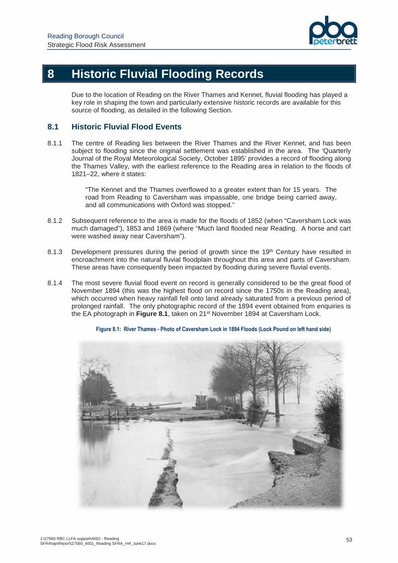
Reading Borough Council Strategic Flood Risk Assessment
J:\27560 RBC LLFA support\4002 - Reading SFRA\wp\Report\27560_4001_Reading SFRA_rmf_June17.docx
53
8 Historic Fluvial Flooding Records
Due to the location of Reading on the River Thames and Kennet, fluvial flooding has played a key role in shaping the town and particularly extensive historic records are available for this source of flooding, as detailed in the following Section.
8.1 Historic Fluvial Flood Events
8.1.1 The centre of Reading lies between the River Thames and the River Kennet, and has been subject to flooding since the original settlement was established in the area. The ‘Quarterly Journal of the Royal Meteorological Society, October 1895’ provides a record of flooding along the Thames Valley, with the earliest reference to the Reading area in relation to the floods of 1821–22, where it states:
“The Kennet and the Thames overflowed to a greater extent than for 15 years. The road from Reading to Caversham was impassable, one bridge being carried away, and all communications with Oxford was stopped.”
8.1.2 Subsequent reference to the area is made for the floods of 1852 (when “Caversham Lock was much damaged”), 1853 and 1869 (where “Much land flooded near Reading. A horse and cart were washed away near Caversham”).
8.1.3 Development pressures during the period of growth since the 19th Century have resulted in encroachment into the natural fluvial floodplain throughout this area and parts of Caversham. These areas have consequently been impacted by flooding during severe fluvial events.
8.1.4 The most severe fluvial flood event on record is generally considered to be the great flood of November 1894 (this was the highest flood on record since the 1750s in the Reading area), which occurred when heavy rainfall fell onto land already saturated from a previous period of prolonged rainfall. The only photographic record of the 1894 event obtained from enquiries is the EA photograph in Figure 8.1 , taken on 21st November 1894 at Caversham Lock.
Figure 8.1: River Thames - Photo of Caversham Lock in 1894 Floods (Lock Pound on left hand side)
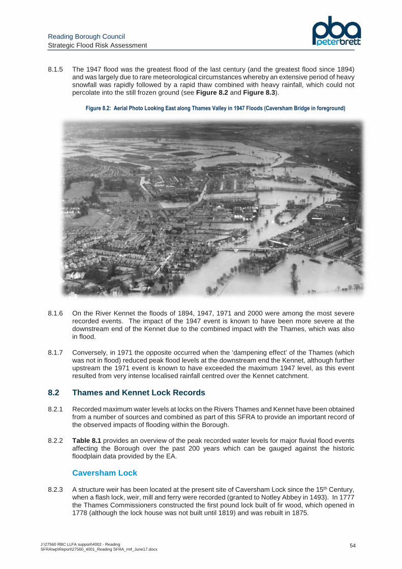
Reading Borough Council Strategic Flood Risk Assessment
J:\27560 RBC LLFA support\4002 - Reading SFRA\wp\Report\27560_4001_Reading SFRA_rmf_June17.docx
54
8.1.5 The 1947 flood was the greatest flood of the last century (and the greatest flood since 1894) and was largely due to rare meteorological circumstances whereby an extensive period of heavy snowfall was rapidly followed by a rapid thaw combined with heavy rainfall, which could not percolate into the still frozen ground (see Figure 8.2 and Figure 8.3 ).
Figure 8.2: Aerial Photo Looking East along Thames Valley in 1947 Floods (Caversham Bridge in foreground)
8.1.6 On the River Kennet the floods of 1894, 1947, 1971 and 2000 were among the most severe recorded events. The impact of the 1947 event is known to have been more severe at the downstream end of the Kennet due to the combined impact with the Thames, which was also in flood.
8.1.7 Conversely, in 1971 the opposite occurred when the ‘dampening effect’ of the Thames (which was not in flood) reduced peak flood levels at the downstream end the Kennet, although further upstream the 1971 event is known to have exceeded the maximum 1947 level, as this event resulted from very intense localised rainfall centred over the Kennet catchment.
8.2 Thames and Kennet Lock Records
8.2.1 Recorded maximum water levels at locks on the Rivers Thames and Kennet have been obtained from a number of sources and combined as part of this SFRA to provide an important record of the observed impacts of flooding within the Borough.
8.2.2 Table 8.1 provides an overview of the peak recorded water levels for major fluvial flood events affecting the Borough over the past 200 years which can be gauged against the historic floodplain data provided by the EA.
Caversham Lock
8.2.3 A structure weir has been located at the present site of Caversham Lock since the 15th Century, when a flash lock, weir, mill and ferry were recorded (granted to Notley Abbey in 1493). In 1777 the Thames Commissioners constructed the first pound lock built of fir wood, which opened in 1778 (although the lock house was not built until 1819) and was rebuilt in 1875.
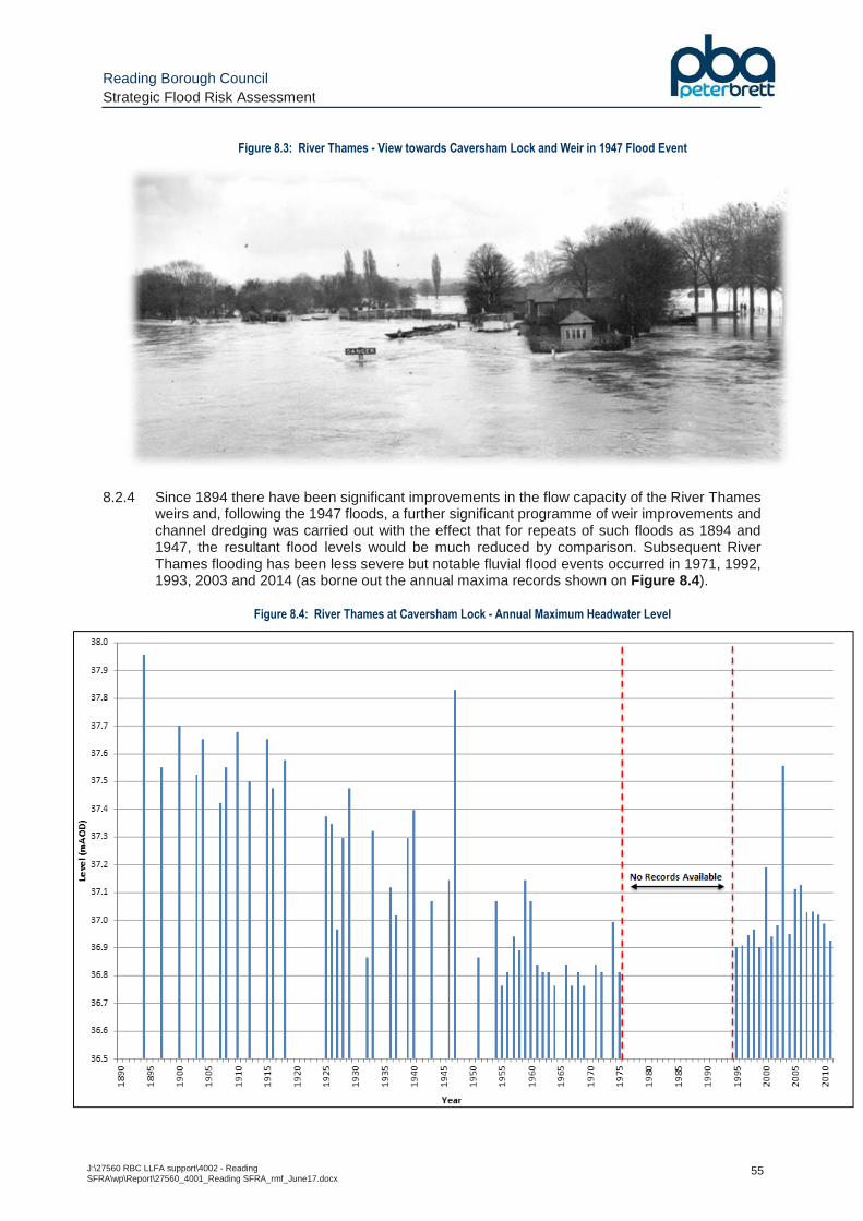
Reading Borough Council Strategic Flood Risk Assessment
J:\27560 RBC LLFA support\4002 - Reading SFRA\wp\Report\27560_4001_Reading SFRA_rmf_June17.docx
55
Figure 8.3: River Thames - View towards Caversham Lock and Weir in 1947 Flood Event
8.2.4 Since 1894 there have been significant improvements in the flow capacity of the River Thames weirs and, following the 1947 floods, a further significant programme of weir improvements and channel dredging was carried out with the effect that for repeats of such floods as 1894 and 1947, the resultant flood levels would be much reduced by comparison. Subsequent River Thames flooding has been less severe but notable fluvial flood events occurred in 1971, 1992, 1993, 2003 and 2014 (as borne out the annual maxima records shown on Figure 8.4 ).
Figure 8.4: River Thames at Caversham Lock - Annual Maximum Headwater Level
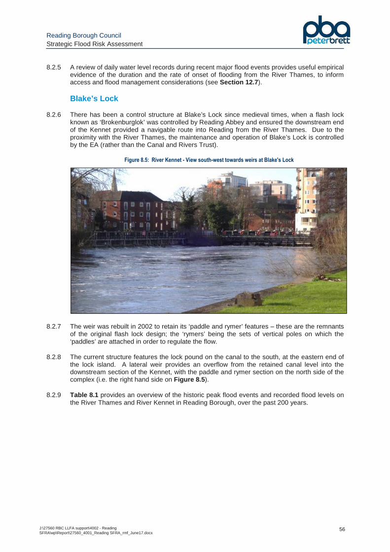
Reading Borough Council Strategic Flood Risk Assessment
J:\27560 RBC LLFA support\4002 - Reading SFRA\wp\Report\27560_4001_Reading SFRA_rmf_June17.docx
56
8.2.5 A review of daily water level records during recent major flood events provides useful empirical evidence of the duration and the rate of onset of flooding from the River Thames, to inform access and flood management considerations (see Section 12.7 ).
Blake’s Lock
8.2.6 There has been a control structure at Blake’s Lock since medieval times, when a flash lock known as ‘Brokenburglok’ was controlled by Reading Abbey and ensured the downstream end of the Kennet provided a navigable route into Reading from the River Thames. Due to the proximity with the River Thames, the maintenance and operation of Blake’s Lock is controlled by the EA (rather than the Canal and Rivers Trust).
Figure 8.5: River Kennet - View south-west towards weirs at Blake's Lock
8.2.7 The weir was rebuilt in 2002 to retain its ‘paddle and rymer’ features – these are the remnants of the original flash lock design; the ‘rymers’ being the sets of vertical poles on which the ‘paddles’ are attached in order to regulate the flow.
8.2.8 The current structure features the lock pound on the canal to the south, at the eastern end of the lock island. A lateral weir provides an overflow from the retained canal level into the downstream section of the Kennet, with the paddle and rymer section on the north side of the complex (i.e. the right hand side on Figure 8.5 ).
8.2.9 Table 8.1 provides an overview of the historic peak flood events and recorded flood levels on the River Thames and River Kennet in Reading Borough, over the past 200 years.
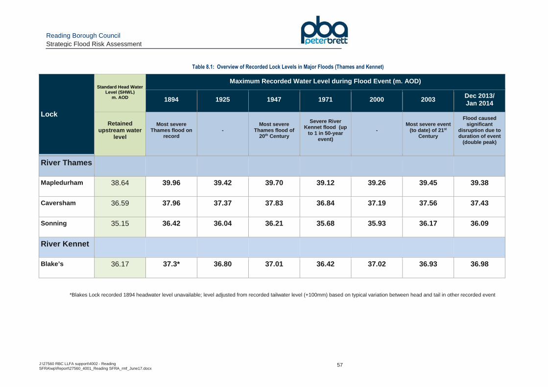
Reading Borough Council Strategic Flood Risk Assessment
J:\27560 RBC LLFA support\4002 - Reading SFRA\wp\Report\27560_4001_Reading SFRA_rmf_June17.docx
57
Table 8.1: Overview of Recorded Lock Levels in Major Floods (Thames and Kennet)
Lock
Standard Head Water Level (SHWL)
m. AOD
Maximum Recorded Water Level during Flood Event (m. AOD)
1894 1925 1947 1971 2000 2003 Dec 2013/ Jan 2014
Retained upstream water
level
Most severe Thames flood on
record -
Most severe Thames flood of
20th Century
Severe River Kennet flood (up
to 1 in 50-year event)
- Most severe event
(to date) of 21 st Century
Flood caused significant
disruption due to duration of event
(double peak)
River Thames
Mapledurham 38.64 39.96 39.42 39.70 39.12 39.26 39.45 39.38
Caversham 36.59 37.96 37.37 37.83 36.84 37.19 37.56 37.43
Sonning 35.15 36.42 36.04 36.21 35.68 35.93 36.17 36.09
River Kennet
Blake’s 36.17 37.3* 36.80 37.01 36.42 37.02 36.93 36.98
*Blakes Lock recorded 1894 headwater level unavailable; level adjusted from recorded tailwater level (+100mm) based on typical variation between head and tail in other recorded event
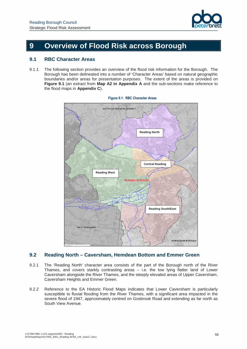
Reading Borough Council Strategic Flood Risk Assessment
J:\27560 RBC LLFA support\4002 - Reading SFRA\wp\Report\27560_4001_Reading SFRA_rmf_June17.docx
58
9 Overview of Flood Risk across Borough
9.1 RBC Character Areas
9.1.1 The following section provides an overview of the flood risk information for the Borough. The Borough has been delineated into a number of ‘Character Areas’ based on natural geographic boundaries and/or areas for presentation purposes. The extent of the areas is provided on Figure 9.1 (an extract from Map A2 in Appendix A and the sub-sections make reference to the flood maps in Appendix C ).
Figure 9.1: RBC Character Areas
9.2 Reading North – Caversham, Hemdean Bottom and Emmer Green
9.2.1 The ‘Reading North’ character area consists of the part of the Borough north of the River Thames, and covers starkly contrasting areas – i.e. the low lying flatter land of Lower Caversham alongside the River Thames, and the steeply elevated areas of Upper Caversham, Caversham Heights and Emmer Green.
9.2.2 Reference to the EA Historic Flood Maps indicates that Lower Caversham is particularly susceptible to fluvial flooding from the River Thames, with a significant area impacted in the severe flood of 1947, approximately centred on Gosbrook Road and extending as far north as South View Avenue.
Reading North
Reading West
Central Reading
Reading South/East
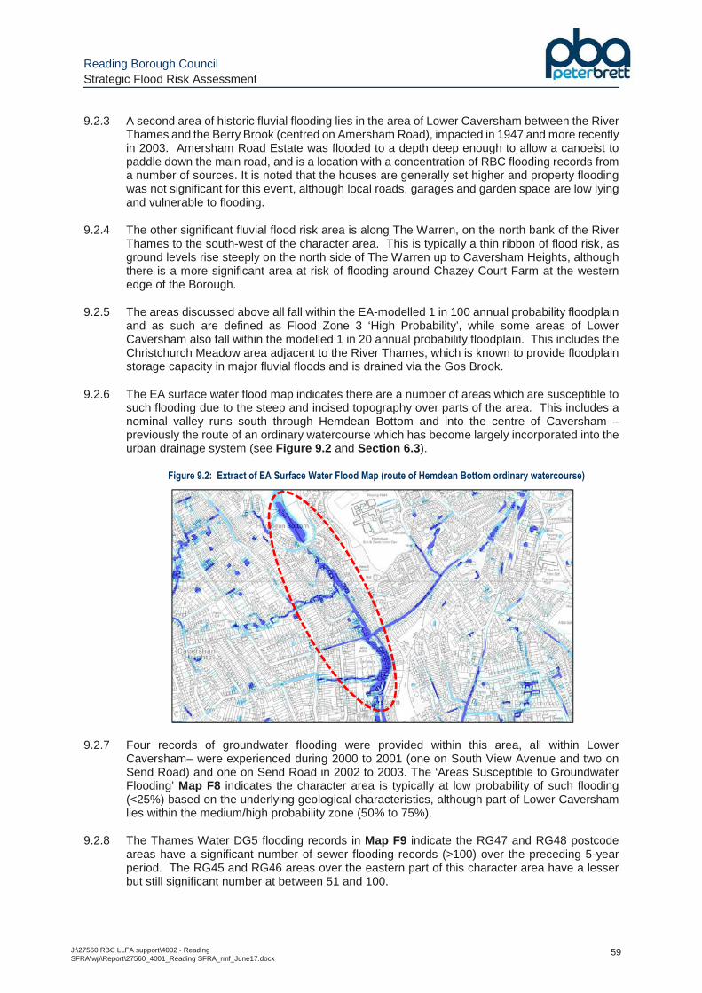
Reading Borough Council Strategic Flood Risk Assessment
J:\27560 RBC LLFA support\4002 - Reading SFRA\wp\Report\27560_4001_Reading SFRA_rmf_June17.docx
59
9.2.3 A second area of historic fluvial flooding lies in the area of Lower Caversham between the River Thames and the Berry Brook (centred on Amersham Road), impacted in 1947 and more recently in 2003. Amersham Road Estate was flooded to a depth deep enough to allow a canoeist to paddle down the main road, and is a location with a concentration of RBC flooding records from a number of sources. It is noted that the houses are generally set higher and property flooding was not significant for this event, although local roads, garages and garden space are low lying and vulnerable to flooding.
9.2.4 The other significant fluvial flood risk area is along The Warren, on the north bank of the River Thames to the south-west of the character area. This is typically a thin ribbon of flood risk, as ground levels rise steeply on the north side of The Warren up to Caversham Heights, although there is a more significant area at risk of flooding around Chazey Court Farm at the western edge of the Borough.
9.2.5 The areas discussed above all fall within the EA-modelled 1 in 100 annual probability floodplain and as such are defined as Flood Zone 3 ‘High Probability’, while some areas of Lower Caversham also fall within the modelled 1 in 20 annual probability floodplain. This includes the Christchurch Meadow area adjacent to the River Thames, which is known to provide floodplain storage capacity in major fluvial floods and is drained via the Gos Brook.
9.2.6 The EA surface water flood map indicates there are a number of areas which are susceptible to such flooding due to the steep and incised topography over parts of the area. This includes a nominal valley runs south through Hemdean Bottom and into the centre of Caversham – previously the route of an ordinary watercourse which has become largely incorporated into the urban drainage system (see Figure 9.2 and Section 6.3 ).
Figure 9.2: Extract of EA Surface Water Flood Map (route of Hemdean Bottom ordinary watercourse)
9.2.7 Four records of groundwater flooding were provided within this area, all within Lower Caversham– were experienced during 2000 to 2001 (one on South View Avenue and two on Send Road) and one on Send Road in 2002 to 2003. The ‘Areas Susceptible to Groundwater Flooding’ Map F8 indicates the character area is typically at low probability of such flooding (<25%) based on the underlying geological characteristics, although part of Lower Caversham lies within the medium/high probability zone (50% to 75%).
9.2.8 The Thames Water DG5 flooding records in Map F9 indicate the RG47 and RG48 postcode areas have a significant number of sewer flooding records (>100) over the preceding 5-year period. The RG45 and RG46 areas over the eastern part of this character area have a lesser but still significant number at between 51 and 100.
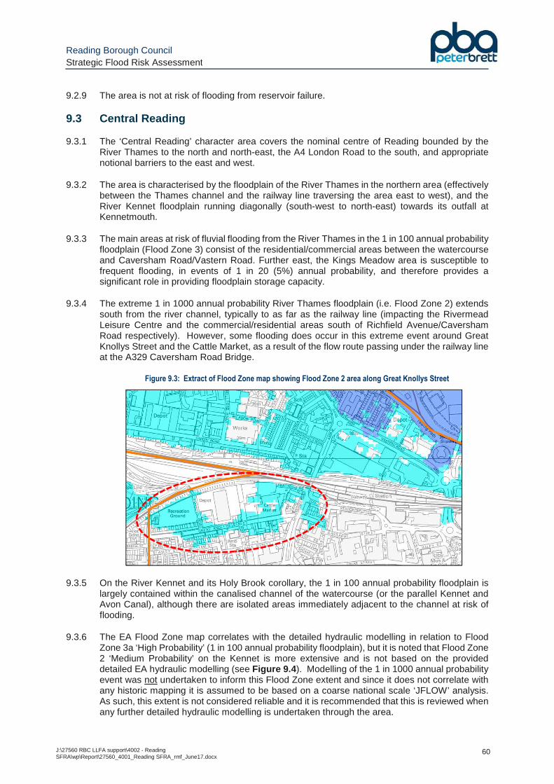
Reading Borough Council Strategic Flood Risk Assessment
J:\27560 RBC LLFA support\4002 - Reading SFRA\wp\Report\27560_4001_Reading SFRA_rmf_June17.docx
60
9.2.9 The area is not at risk of flooding from reservoir failure.
9.3 Central Reading
9.3.1 The ‘Central Reading’ character area covers the nominal centre of Reading bounded by the River Thames to the north and north-east, the A4 London Road to the south, and appropriate notional barriers to the east and west.
9.3.2 The area is characterised by the floodplain of the River Thames in the northern area (effectively between the Thames channel and the railway line traversing the area east to west), and the River Kennet floodplain running diagonally (south-west to north-east) towards its outfall at Kennetmouth.
9.3.3 The main areas at risk of fluvial flooding from the River Thames in the 1 in 100 annual probability floodplain (Flood Zone 3) consist of the residential/commercial areas between the watercourse and Caversham Road/Vastern Road. Further east, the Kings Meadow area is susceptible to frequent flooding, in events of 1 in 20 (5%) annual probability, and therefore provides a significant role in providing floodplain storage capacity.
9.3.4 The extreme 1 in 1000 annual probability River Thames floodplain (i.e. Flood Zone 2) extends south from the river channel, typically to as far as the railway line (impacting the Rivermead Leisure Centre and the commercial/residential areas south of Richfield Avenue/Caversham Road respectively). However, some flooding does occur in this extreme event around Great Knollys Street and the Cattle Market, as a result of the flow route passing under the railway line at the A329 Caversham Road Bridge.
Figure 9.3: Extract of Flood Zone map showing Flood Zone 2 area along Great Knollys Street
9.3.5 On the River Kennet and its Holy Brook corollary, the 1 in 100 annual probability floodplain is largely contained within the canalised channel of the watercourse (or the parallel Kennet and Avon Canal), although there are isolated areas immediately adjacent to the channel at risk of flooding.
9.3.6 The EA Flood Zone map correlates with the detailed hydraulic modelling in relation to Flood Zone 3a ‘High Probability’ (1 in 100 annual probability floodplain), but it is noted that Flood Zone 2 ‘Medium Probability’ on the Kennet is more extensive and is not based on the provided detailed EA hydraulic modelling (see Figure 9.4 ). Modelling of the 1 in 1000 annual probability event was not undertaken to inform this Flood Zone extent and since it does not correlate with any historic mapping it is assumed to be based on a coarse national scale ‘JFLOW’ analysis. As such, this extent is not considered reliable and it is recommended that this is reviewed when any further detailed hydraulic modelling is undertaken through the area.
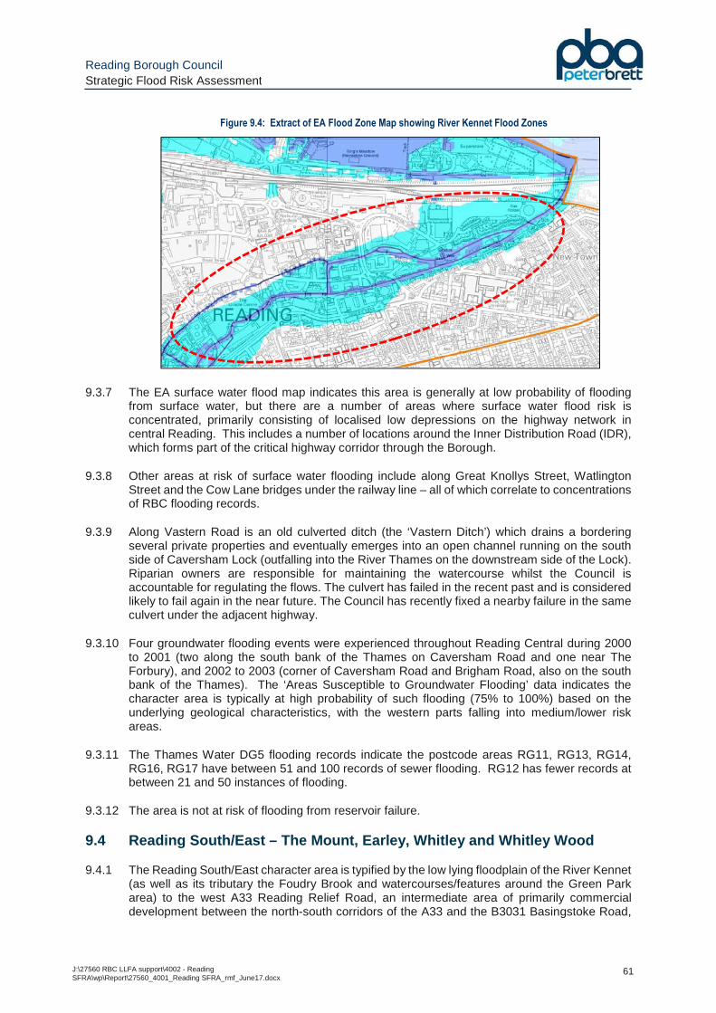
Reading Borough Council Strategic Flood Risk Assessment
J:\27560 RBC LLFA support\4002 - Reading SFRA\wp\Report\27560_4001_Reading SFRA_rmf_June17.docx
61
Figure 9.4: Extract of EA Flood Zone Map showing River Kennet Flood Zones
9.3.7 The EA surface water flood map indicates this area is generally at low probability of flooding from surface water, but there are a number of areas where surface water flood risk is concentrated, primarily consisting of localised low depressions on the highway network in central Reading. This includes a number of locations around the Inner Distribution Road (IDR), which forms part of the critical highway corridor through the Borough.
9.3.8 Other areas at risk of surface water flooding include along Great Knollys Street, Watlington Street and the Cow Lane bridges under the railway line – all of which correlate to concentrations of RBC flooding records.
9.3.9 Along Vastern Road is an old culverted ditch (the ‘Vastern Ditch’) which drains a bordering several private properties and eventually emerges into an open channel running on the south side of Caversham Lock (outfalling into the River Thames on the downstream side of the Lock). Riparian owners are responsible for maintaining the watercourse whilst the Council is accountable for regulating the flows. The culvert has failed in the recent past and is considered likely to fail again in the near future. The Council has recently fixed a nearby failure in the same culvert under the adjacent highway.
9.3.10 Four groundwater flooding events were experienced throughout Reading Central during 2000 to 2001 (two along the south bank of the Thames on Caversham Road and one near The Forbury), and 2002 to 2003 (corner of Caversham Road and Brigham Road, also on the south bank of the Thames). The ‘Areas Susceptible to Groundwater Flooding’ data indicates the character area is typically at high probability of such flooding (75% to 100%) based on the underlying geological characteristics, with the western parts falling into medium/lower risk areas.
9.3.11 The Thames Water DG5 flooding records indicate the postcode areas RG11, RG13, RG14, RG16, RG17 have between 51 and 100 records of sewer flooding. RG12 has fewer records at between 21 and 50 instances of flooding.
9.3.12 The area is not at risk of flooding from reservoir failure.
9.4 Reading South/East – The Mount, Earley, Whitley and Whitley Wood
9.4.1 The Reading South/East character area is typified by the low lying floodplain of the River Kennet (as well as its tributary the Foudry Brook and watercourses/features around the Green Park area) to the west A33 Reading Relief Road, an intermediate area of primarily commercial development between the north-south corridors of the A33 and the B3031 Basingstoke Road,

Reading Borough Council Strategic Flood Risk Assessment
J:\27560 RBC LLFA support\4002 - Reading SFRA\wp\Report\27560_4001_Reading SFRA_rmf_June17.docx
62
and finally the more elevated areas to the east of Whitley, Whitley Wood, the Mount and, further east, the land encircling Reading University and centred on the A329 Wokingham Road towards Earley.
9.4.2 The main areas at risk of fluvial flooding correspondingly lie in the western part of the character area, although the main area of the Kennet water meadows lies within the Reading West character area. South of the water meadows, the area has historically been subject to extensive fluvial flooding, most significantly in 1977, but following the construction of Green Park and the associated Flood Management Strategy (including Longwater Lake and the Flood Relief Channel), the EA-modelled 1 in 100 annual probability floodplain is contained within the river channel (or their immediate proximity) over significant areas, with some notable exceptions - areas west of Green Park, the land on the south side of the main River Kennet channel, and the Reading Gate Retail Park (it is understood the buildings and road are above the 1 in 20 annual probability, whilst the nearby parallel-running footpath and cycleway along the Foudry Brook lies within the 1 in 5 annual probability floodplain)
9.4.3 This is reflected in the extent of Flood Zone 3 ‘High Probability’ on the EA Flood Zone map over this character area. As noted in Section 9.3 , the extent of Flood Zone 2 ‘Medium Probability’ associated with the River Kennet catchment is extensive and is not based on the latest detailed hydraulic model of the watercourse, but is assumed to be generated from coarse national scale JFLOW modelling.
9.4.4 The EA surface water flood map indicates several areas at risk of flooding in the northern part of the character area, primarily along highways running north-south including Southampton Street, Redlands Road, Eastern Avenue and the A329 Wokingham Road.
9.4.5 In the central and southern parts of this area, the pattern is more of highways corridors at risk of surface water flooding running east-west, along the general fall in topography over the Whitley area. This includes parallel channels of flooding either side of The Cowsey recreational area, merging and flowing west centred along Stockton Road to the north of the John Madejski Academy) (see Figure 9.5 ). Another area lies further south, centred on Whitley Wood Road.
Figure 9.5: Extract of EA Surface Water Flood Map (Whitley Area)
9.4.6 This character area includes significant concentrations of RBC highways flooding records in a number of locations in the Whitley Wood area (corresponding with the surface water flood map).

Reading Borough Council Strategic Flood Risk Assessment
J:\27560 RBC LLFA support\4002 - Reading SFRA\wp\Report\27560_4001_Reading SFRA_rmf_June17.docx
63
These include Whitley Wood Road, a section of the B3031 Basingstoke Road (east of Acre Business Park), Kingsley Close and off Stockton Road.
9.4.7 One groundwater flooding event was experienced in Reading South during 2000 to 2001 near Elgar Road South. The ‘Areas Susceptible to Groundwater Flooding’ data indicates the eastern part of the character area is typically at low probability of flooding (less than 25%, or 25% to 50%), whereas the lower lying Kennet floodplain over the western part lies within medium/high risk zones.
9.4.8 The Thames Water DG5 flooding records indicate the postcode area RG28 has the highest number of sewer flooding records (over 100). Areas RG15, RG16, RG20 and RG27 have between 51 and 100 records each, while RG26 has the lowest number, between 1 and 5 records.
9.4.9 The Borough boundary over part of this character area runs along Whiteknights Road, which traverses the downstream embankment of Whiteknights Lake reservoir (the body of water itself lying outside Reading Borough). Map F7 provides details of the reservoir and the associated reservoir flood map, simulating the potential impacts of a breach in the reservoir embankment. This shows flood flows in such a scenario would be conveyed north-east across the nearby playing fields, through Palmer Park and across the Newtown area to eventually spill into the River Kennet channel close to its confluence with the River Thames.
9.4.10 As discussed in Section 6.4 , because failure of the reservoir would cause a risk to human life the associated embankment is classified as a Category A dam, and as such requires the most stringent maintenance and safety checks to minimise the risk of such an occurrence, such that the risk of such an occurrence could be considered negligible.
9.4.11 Although the high design standard and maintenance under the Reservoirs Act help to ensure that the probability of such an occurrence is extremely low, it is recommended that an undeveloped corridor between the dam and Wokingham Road remains to avoid increasing the population at risk of flooding.
9.5 Reading West – Tilehurst and Southcote
9.5.1 The Reading West character area consists of the urban areas of Southcote, Tilehurst, Prospect Park, Coley and Coley Park. It is bounded by the River Thames to the north, the River Kennet to the east and the Kennet and Avon Canal to the south.
9.5.2 The River Thames floodplain lies predominantly between the river channel and the railway line in the north of the character area. This land consists largely of the Thames Promenade, giving way to open agricultural land or other uses further west (e.g. allotments, sports fields) and has historically been subject to frequent fluvial flooding, as the historic floodplain maps confirm. There are three areas on the south side of the railway line that have historically been impacted by fluvial flooding from the Thames (in the flood events of 1947 and 1977):
• The commercial area centred on Scours Lane (flood flow routes from the Thames via an underpass);
• The land centred on the eastern end of Portman Road (flood flow routes through the Cow Lane bridges); and,
• The railway works/sidings, immediately east of the area discussed above (and affected via the same flow route).
9.5.3 To the south of Southcote and Coley lies the wide floodplain of the River Kennet, which covers the Kennet Water Meadows and Fobney Meadows and is subject to frequent flooding. The meadows area consists of a wide network of interconnected channels between the River
Reading Borough Council Strategic Flood Risk Assessment
J:\27560 RBC LLFA support\4002 - Reading SFRA\wp\Report\27560_4001_Reading SFRA_rmf_June17.docx
64
Kennet/Kennet and Avon Canal and the Holy Brook. This low lying area is almost all within the 1 in 100 annual probability floodplain (Flood Zone 3).
9.5.4 The extent of Flood Zone 3 is contained within the river channel further north-east, where the surrounding commercial development falls within Flood Zone 2; although an exception is the area along Garnet Road and Brook Street West near the Holy Brook in Coley, which is shown as Flood Zone 3 (and is also shown as being at risk of surface water flooding).
9.5.5 The EA surface water flood map indicates several areas at risk of flooding in the character area, typified as narrow corridors of land at risk of flooding which follow the route of a highway or natural depression through the area. As mentioned in Section 6.3 , some of these follow the route of former watercourses through the area which have become subsumed within the urban area – one such former watercourse drains the Blundell’s Copse/Dee Road/Norcot Road towards Scours Lane and on to the Thames, while a second is formed by a number of tributaries along/through Rodway Road, KentwoodHill and Overdown Road (around the Arthur Newbery Park) and under the railway near the Kentwood roundabout.
9.5.6 Other surface water flooding hotspots include parts of the A329 Oxford Road, the Cow Lane bridges, along Water Road/the Meadway and the lower lying areas adjacent to the Holy Brook.
9.5.7 One groundwater flooding event were experienced throughout Reading West during 2000 to 2001 near Appleford Road. The ‘Areas Susceptible to Groundwater Flooding’ data indicates the higher north-western part of the character area is typically at low probability of such flooding (less than 25%) based on the underlying geological characteristics, with Kennet meadows area to the south at high probability of groundwater flooding
9.5.8 The Thames Water DG5 flooding records indicate the postcode areas RG303 (Southcote/Tilehurst) has the fewest number of sewer flooding records within the character area (between 21 and 50). Postcode areas RG16, and RG20 have between 51 and 100 records of sewer flooding.
9.5.9 The area is not at risk of flooding from reservoir failure.
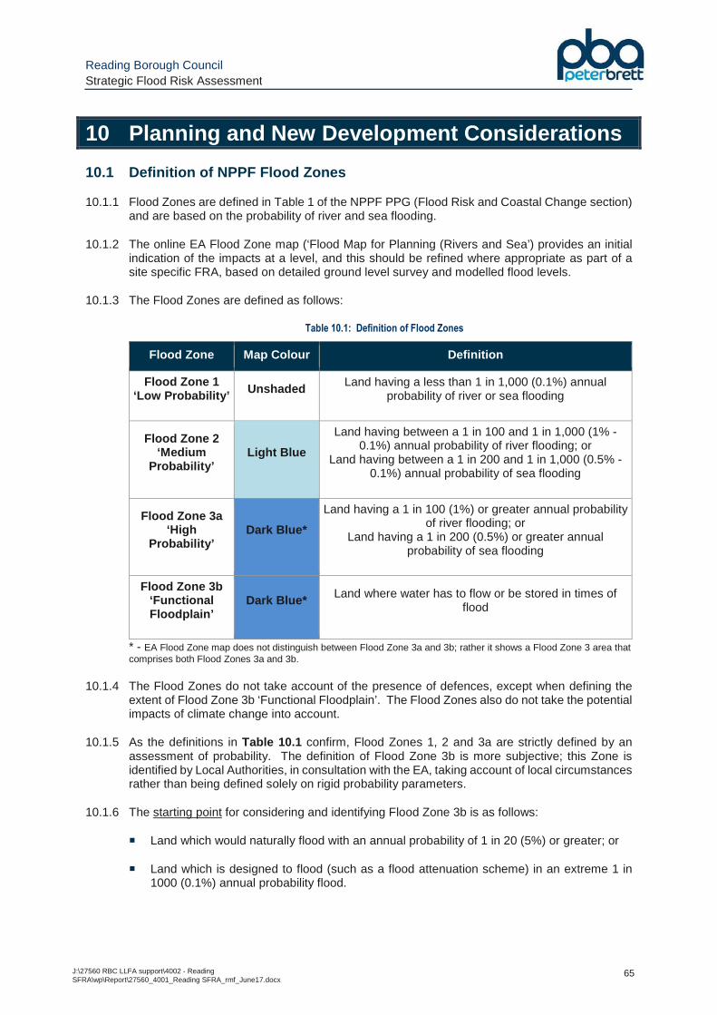
Reading Borough Council Strategic Flood Risk Assessment
J:\27560 RBC LLFA support\4002 - Reading SFRA\wp\Report\27560_4001_Reading SFRA_rmf_June17.docx
65
10 Planning and New Development Considerations
10.1 Definition of NPPF Flood Zones
10.1.1 Flood Zones are defined in Table 1 of the NPPF PPG (Flood Risk and Coastal Change section) and are based on the probability of river and sea flooding.
10.1.2 The online EA Flood Zone map (‘Flood Map for Planning (Rivers and Sea’) provides an initial indication of the impacts at a level, and this should be refined where appropriate as part of a site specific FRA, based on detailed ground level survey and modelled flood levels.
10.1.3 The Flood Zones are defined as follows:
Table 10.1: Definition of Flood Zones
Flood Zone Map Colour Definition
Flood Zone 1 ‘Low Probability’ Unshaded Land having a less than 1 in 1,000 (0.1%) annual
probability of river or sea flooding
Flood Zone 2 ‘Medium
Probability’ Light Blue
Land having between a 1 in 100 and 1 in 1,000 (1% - 0.1%) annual probability of river flooding; or
Land having between a 1 in 200 and 1 in 1,000 (0.5% - 0.1%) annual probability of sea flooding
Flood Zone 3a ‘High
Probability’ Dark Blue*
Land having a 1 in 100 (1%) or greater annual probability of river flooding; or
Land having a 1 in 200 (0.5%) or greater annual probability of sea flooding
Flood Zone 3b ‘Functional Floodplain’
Dark Blue* Land where water has to flow or be stored in times of flood
* - EA Flood Zone map does not distinguish between Flood Zone 3a and 3b; rather it shows a Flood Zone 3 area that comprises both Flood Zones 3a and 3b.
10.1.4 The Flood Zones do not take account of the presence of defences, except when defining the extent of Flood Zone 3b ‘Functional Floodplain’. The Flood Zones also do not take the potential impacts of climate change into account.
10.1.5 As the definitions in Table 10.1 confirm, Flood Zones 1, 2 and 3a are strictly defined by an assessment of probability. The definition of Flood Zone 3b is more subjective; this Zone is identified by Local Authorities, in consultation with the EA, taking account of local circumstances rather than being defined solely on rigid probability parameters.
10.1.6 The starting point for considering and identifying Flood Zone 3b is as follows:
� Land which would naturally flood with an annual probability of 1 in 20 (5%) or greater; or
� Land which is designed to flood (such as a flood attenuation scheme) in an extreme 1 in 1000 (0.1%) annual probability flood.
Reading Borough Council Strategic Flood Risk Assessment
J:\27560 RBC LLFA support\4002 - Reading SFRA\wp\Report\27560_4001_Reading SFRA_rmf_June17.docx
66
10.1.7 The consideration of Flood Zone 3b should take into account the effects of defences, natural topography and other flood risk management infrastructure which may prevent regular flooding. Areas which are prevented from doing so by existing defences, infrastructure or solid buildings, will not normally be considered as Functional Floodplain. The ‘starting point’ for considering the extent of Flood Zone 3b based on the 1 in 20 annual probability flood extent is detailed on the modelled flood extents in Appendix C and areas subject to flooding in a 1 in 20 (5%) annual probability fluvial flood event have been delineated into two sub-categories:
• Flood Zone 3b ‘Developed’ – areas of ‘previously developed land’, which are considered equivalent to Flood Zone 3a for planning purposes, and;
• Flood Zone 3b ‘Functional Floodplain’ – areas of existing open space that are subject to flooding.
10.1.8 The NPPF defines ‘previously developed land’ as follows (emphasis added):
“Land which is or was occupied by a permanent structure, including the curtilage of the developed land (although it should not be assumed that the whole of the curtilage should be developed) and any associated fixed surface infrastructure . This excludes: land that is or has been occupied by agricultural or forestry buildings; land that has been developed for minerals extraction or waste disposal by landfill purposes where provision for restoration has been made through development control procedures; land in built-up areas such as private residential gardens, parks, recreation grounds and allotments; and land that was previously-developed but where the remains of the permanent structure or fixed surface structure have blended into the landscape in the process of time”.
10.1.9 Final consideration of whether a site is Flood Zone 3b should be made by the Council on a site-specific basis and according to local circumstances.
10.2 Consideration of Climate Change
10.2.1 There is clear scientific evidence that the effects of climate change are happening now, with record breaking extreme weather occurring over summer and winter months across the UK. Some of these changes could reflect natural variation, but the broad trends are consistent with the projected pattern from climate models, with above average rainfall and temperatures in summers and milder, wetter winters.
10.2.2 The winter of 2013/14 in the UK was the wettest winter on UK record, dominated by an exceptional clustering of intense low-pressure storms which caused tidal surge and wave damage across coastal regions, and their rainfall led to saturated ground and flooding.
10.2.3 More recently, December 2015 was record breaking in terms of its warmth and rainfall; The UK mean temperature (1-29 December) was a record breaking 8.0 °C (4.1 °C above the long-term average), and record amounts of rainfall were recorded in Scotland, Wales and Northern England.
10.2.4 The United Nations Paris climate deal agreed in late 2015 by 195 countries is the first-ever universal and legally binding agreement of its kind. This consists of a global action plan to put the world on track to avoid dangerous climate change by limiting global warming to well below 2°C and to drive efforts to limit the temperature increase even further to 1.5 °C above pre-industrial levels.
10.2.5 The European Union is heading for a 24% reduction in greenhouse gas emissions by 2020 with current measures in place, and a 25% reduction with additional measures already being planned in Member States. However, further action is required to meet the target of a 40% reduction by 2030.
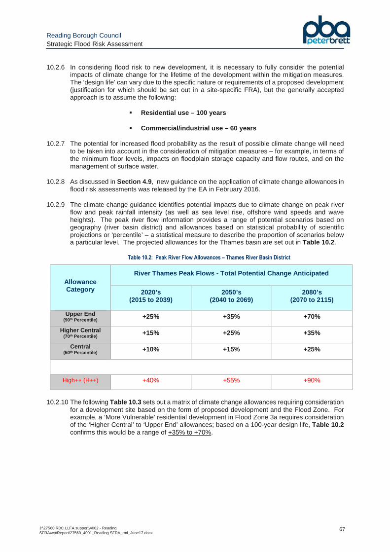
Reading Borough Council Strategic Flood Risk Assessment
J:\27560 RBC LLFA support\4002 - Reading SFRA\wp\Report\27560_4001_Reading SFRA_rmf_June17.docx
67
10.2.6 In considering flood risk to new development, it is necessary to fully consider the potential impacts of climate change for the lifetime of the development within the mitigation measures. The ‘design life’ can vary due to the specific nature or requirements of a proposed development (justification for which should be set out in a site-specific FRA), but the generally accepted approach is to assume the following:
� Residential use – 100 years
� Commercial/industrial use – 60 years
10.2.7 The potential for increased flood probability as the result of possible climate change will need to be taken into account in the consideration of mitigation measures – for example, in terms of the minimum floor levels, impacts on floodplain storage capacity and flow routes, and on the management of surface water.
10.2.8 As discussed in Section 4.9 , new guidance on the application of climate change allowances in flood risk assessments was released by the EA in February 2016.
10.2.9 The climate change guidance identifies potential impacts due to climate change on peak river flow and peak rainfall intensity (as well as sea level rise, offshore wind speeds and wave heights). The peak river flow information provides a range of potential scenarios based on geography (river basin district) and allowances based on statistical probability of scientific projections or ‘percentile’ – a statistical measure to describe the proportion of scenarios below a particular level. The projected allowances for the Thames basin are set out in Table 10.2 .
Table 10.2: Peak River Flow Allowances – Thames River Basin District
Allowance Category
River Thames Peak Flows - Total Potential Change Anticipated
2020’s (2015 to 2039)
2050’s (2040 to 2069)
2080’s (2070 to 2115)
Upper End (90th Percentile) +25% +35% +70%
Higher Central (70th Percentile) +15% +25% +35%
Central (50th Percentile) +10% +15% +25%
High++ (H++) +40% +55% +90%
10.2.10 The following Table 10.3 sets out a matrix of climate change allowances requiring consideration
for a development site based on the form of proposed development and the Flood Zone. For example, a ‘More Vulnerable’ residential development in Flood Zone 3a requires consideration of the ‘Higher Central’ to ‘Upper End’ allowances; based on a 100-year design life, Table 10.2 confirms this would be a range of +35% to +70%.
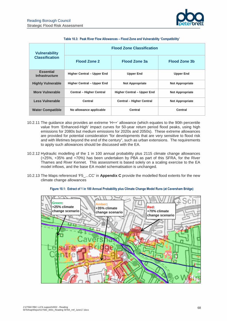
Reading Borough Council Strategic Flood Risk Assessment
J:\27560 RBC LLFA support\4002 - Reading SFRA\wp\Report\27560_4001_Reading SFRA_rmf_June17.docx
68
Table 10.3: Peak River Flow Allowances – Flood Zone and Vulnerability ‘Compatibility’
Vulnerability Classification
Flood Zone Classification
Flood Zone 2 Flood Zone 3a Flood Zone 3b
Essential Infrastructure
Higher Central – Upper End Upper End Upper End
Highly Vulnerable Higher Central – Upper End Not Appropriate Not Appropriate
More Vulnerable Central – Higher Central Higher Central – Upper End Not Appropriate
Less Vulnerable Central Central – Higher Central Not Appropriate
Water Compatible No allowance applicable Central Central
10.2.11 The guidance also provides an extreme ‘H++’ allowance (which equates to the 90th percentile
value from ‘Enhanced-High’ impact curves for 50-year return period flood peaks, using high emissions for 2080s but medium emissions for 2020s and 2050s). These extreme allowances are provided for potential consideration “for developments that are very sensitive to flood risk and with lifetimes beyond the end of the century”, such as urban extensions. The requirements to apply such allowances should be discussed with the EA.
10.2.12 Hydraulic modelling of the 1 in 100 annual probability plus 2115 climate change allowances (+25%, +35% and +70%) has been undertaken by PBA as part of this SFRA, for the River Thames and River Kennet. This assessment is based solely on a scaling exercise to the EA model inflows, and the base EA model schematisation is unchanged.
10.2.13 The Maps referenced ‘F5_...CC’ in Appendix C provide the modelled flood extents for the new climate change allowances
Figure 10.1: Extract of 1 in 100 Annual Probability plus Climate Change Model Runs (at Caversham Bridge)
Amber : +35% climate change scenario
Green: +25% climate change scenario
Red: +70% climate change scenario
Reading Borough Council Strategic Flood Risk Assessment
J:\27560 RBC LLFA support\4002 - Reading SFRA\wp\Report\27560_4001_Reading SFRA_rmf_June17.docx
69
10.2.14 These climate change flood extents should be used by RBC when considering flood risk to sites put forward for allocation based on the appropriate criteria – i.e. ‘More Vulnerable’ proposed residential development in Flood Zone 2 needs to consider the impact of the Central (+25%) and Higher Central (+35%) allowances and consider the feasibility of such development based on the flood risk constraints. As mentioned in Section 3.2 , the EA have advised that they are undertaking a rerun of their River Thames and River Kennet hydraulic models and results from this work should be considered against the SFRA mapping in due course to ensure.
10.2.15 In the absence of site-specific climate change modelled data the EA Thames Area guidance in Appendix D provides three methods to generate these flood levels, subject to the type/scale/Flood Zone of the proposed development:
• ‘Basic’ : The developer adds a fixed amount on to the provided 1 in 100 annual probability flood level to account for potential climate change impacts. In the Thames area these allowances are:
� 500mm (Central allowance)
� 700mm (Higher Central allowance)
� 1000mm (Upper End allowance)
• ‘Intermediate’ : The Developer uses existing modelled flood and flow data to generate a stage-discharge rating curve. This can be extrapolated using a ‘best fit’ curve to identify the flood level correlating to the climate change allowance percentage increase to peak flow apply to the ‘design flood’ (1 in 100 annual probability event) flow.
• ‘Detailed’ : A hydraulic model (either the EA’s existing model or a purpose built model) is run with the specified climate change allowances to generate the resultant flood levels at the site.
10.2.16 The EA should be contacted in the first instance for their modelled flood data, but since the new climate change allowances have, in general, not been subject to detailed hydraulic modelling, it is incumbent on the developer to generate suitably robust estimates of the flood level using the methods above, before applying the appropriate freeboard for mitigation (as discussed in Section 12 ).
10.3 Residual Risk of Flooding
10.3.1 It is essential that the risk of flooding is minimised over the lifetime of the development in all instances. It is important to recognise however that flood risk can never be fully mitigated, and there will always be a residual risk of flooding. This residual risk is associated with a number of potential risk factors including (but not limited to):
� A flooding event that exceeds that for which the local drainage system has been designed;
� The residual danger posed to property and life as a result of flood defence failure; and,
� General uncertainties inherent in the prediction of flooding.
10.3.2 The modelling of flood flows and flood levels is not an exact science; therefore, there are inherent uncertainties in the prediction of flood levels used in the assessment of flood risk. The adopted flood zones are largely based upon detailed river modelling within the Borough. Whilst these provide a robust depiction of flood risk from a strategic perspective, all detailed modelling requires the making of core assumptions and the use of empirical estimations. The broad-scale nature of the models means that small scale features that may impact on overland flow pathways are not necessarily represented.

Reading Borough Council Strategic Flood Risk Assessment
J:\27560 RBC LLFA support\4002 - Reading SFRA\wp\Report\27560_4001_Reading SFRA_rmf_June17.docx
70
10.3.3 The recommended flood risk management measures set out in Section 12 incorporate measures, such as ground floor level freeboard recommendations, to allow for this inherent residual risk within new development.
10.4 Site Specific FRA Requirements
10.4.1 It should be emphasised that the SFRA is a strategic-level document that provides an overview of flood risk throughout the area. It is imperative that a site-specific Flood Risk Assessment (FRA) is prepared by the developer for all proposed developments within Flood Zones 2 and 3 and for all developments greater than 1 hectare in Flood Zone 1, and this should be submitted as an integral part of the planning application.
10.4.2 The FRA should be commensurate with the risk of flooding to the proposed development. For example, where – following site-specific investigations – the risk of flooding to the site is considered to be negligible (e.g. Zone 1 Low Probability), there is little benefit to be gained in a detailed analysis of the potential risk to life and/or property as a result of flooding. Rather, emphasis should be placed on ensuring that surface water runoff from the site does not exacerbate flooding lower in the catchment.
10.4.3 Government guidance and EA standing advice for developers, setting out where a FRA is needed, and the scope and requirements for any FRA, are available via the following link:
https://www.gov.uk/guidance/flood-risk-assessment-for-planning-applications
10.4.4 The NPPF PPG also includes a ‘site-specific FRA checklist’ setting out the typical scope and requirements for a FRA via the following link:
https://www.gov.uk/guidance/flood-risk-and-coastal-change#Site-Specific-Flood-Risk-Assessment-checklist-section
10.4.5 The required FRA content in the aforementioned link can be summarised under the following headings:
• Development site and location
• Development proposals
• Sequential Test
• Climate Change
• Site specific flood risk
• Surface water management
• Occupants and users of the development
• Exception Test
• Residual Risk
• Flood risk assessment credentials
10.4.6 A summary of potential requirements in relation to flood risk, and the associated online Government guidance, is outlined below.
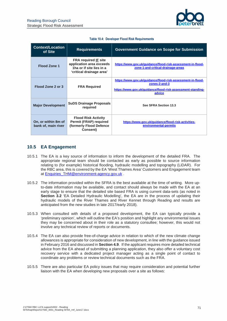
Reading Borough Council Strategic Flood Risk Assessment
J:\27560 RBC LLFA support\4002 - Reading SFRA\wp\Report\27560_4001_Reading SFRA_rmf_June17.docx
71
Table 10.4: Developer Flood Risk Requirements
Context/Location of Site Requirements Government Guidance on Scope for Submission
Flood Zone 1
FRA required IF site application area exceeds
1ha or if site lies in a ‘critical drainage area’
https://www.gov.uk/guidance/flood-risk-assessment-in-flood-zone-1-and-critical-drainage-areas
Flood Zone 2 or 3 FRA Required
https://www.gov.uk/guidance/flood -risk -assessment -in-flood -zones-2-and-3
https://www.gov.uk/guidance/flood-risk-assessment-standing-advice
Major Development SuDS Drainage Proposals required
See SFRA Section 13.3
On, or within 8m of bank of, main river
Flood Risk Activity Permit (FRAP) required (formerly Flood Defence
Consent )
https://www.gov.uk/guidance/flood-risk-activities-environmental-permits
10.5 EA Engagement
10.5.1 The EA is a key source of information to inform the development of the detailed FRA. The appropriate regional team should be contacted as early as possible to source information relating to (for example) historical flooding, hydraulic modelling and topography (LiDAR). For the RBC area, this is covered by the EA ‘West Thames Area’ Customers and Engagement team at [email protected] .
10.5.2 The information provided within the SFRA is the best available at the time of writing. More up-to-date information may be available, and contact should always be made with the EA at an early stage to ensure that the detailed site based FRA is using current data-sets (as noted in Section 3.2 ‘EA Detailed Hydraulic Modelling’, the EA are in the process of updating their hydraulic models of the River Thames and River Kennet through Reading and results are anticipated from the new studies in late 2017/early 2018).
10.5.3 When consulted with details of a proposed development, the EA can typically provide a ‘preliminary opinion’, which will outline the EA’s position and highlight any environmental issues they may be concerned about in their role as a statutory consultee; however, this would not involve any technical review of reports or documents.
10.5.4 The EA can also provide free-of-charge advice in relation to which of the new climate change allowances is appropriate for consideration of new development, in line with the guidance issued in February 2016 and discussed in Section 4.9 . If the applicant requires more detailed technical advice from the EA ahead of submitting a planning application, they also offer a voluntary cost recovery service with a dedicated project manager acting as a single point of contact to coordinate any problems or review technical documents such as the FRA.
10.5.5 There are also particular EA policy issues that may require consideration and potential further liaison with the EA when developing new proposals over a site as follows:
Reading Borough Council Strategic Flood Risk Assessment
J:\27560 RBC LLFA support\4002 - Reading SFRA\wp\Report\27560_4001_Reading SFRA_rmf_June17.docx
72
Buffer Zone
10.5.6 For developments in the vicinity of a main river watercourse, the EA seek to include a ‘buffer zone’ between the top of the river bank and the built development over the site (including footpaths, landscaping, lighting and fencing etc.) This zone was a requirement from the Thames land drainage byelaws and this has now been consolidated into the Environmental Permitting (England and Wales) (Amendment) (No. 2) Regulations 2016. It is intended to allow EA access for river maintenance, removal of fallen trees and other river blockages etc.
10.5.7 This buffer also serves an intention on biodiversity, to try and protect the integrity of the river corridor and prevent encroachment on the river. Undisturbed buffer strips are considered essential in reducing disturbance impacts to the ecology, allow some lateral movement of river without having to resort to hard bank protection, and form a vital wildlife corridor allowing movement of species through the landscape. In terms of planning, the buffer will vary depending on the sensitivity of the watercourse, and existing conditions of the site.
Deculverting of Watercourses
10.5.8 The EA encourage developers to open up and naturalise any culverted sections of watercourse where feasible, in line with the aims of the Water Framework Directive (see Section 4.6 ).
10.5.9 For the purposes of this policy, the EA define a culvert as an enclosed artificial channel or pipe that is used to continue a watercourse beneath the ground or a structure. Culverting can exacerbate the risks of flooding, and increase maintenance requirements and costs. It also destroys wildlife habitats, damages an attractive natural amenity and interrupts the continuity of the linear corridor of a watercourse. Detrimental effects are likely to include:
� increased likelihood of flooding due to obstruction of flow and risk of blockages, and loss of floodwater storage leading to increased impact of flooding;
� loss of and adverse effects on natural morphology, fisheries and wildlife habitat including substrate;
� the creation of barriers to fish passage through increased water velocities, shallow depths and eroded culvert entrances;
� increased river bank and bed erosion downstream of culverted sections;
� greater difficulties in providing for drainage connections;
� increased liabilities and costs due to the need to maintain, repair and replace culverts;
� increased health and safety hazards, notably for workers clearing blockages and for children in urban areas;
� locally reduced groundwater recharge;
� increased difficulty in detecting the origins of pollution and in monitoring water quality.
10.5.10 The EA promote this policy to planners and developers, and use it to inform their responses to applications involving culvert watercourses. They will encourage and promote the removal of culverts where possible to restore a more natural river environment in both urban and rural settings.
10.5.11 Conversely, any culverting of a watercourse, or the alteration of an existing culvert, require an Environmental Permit from the EA under the terms of the Environmental Permitting Regulations 2016 (see Table 10.4 ).
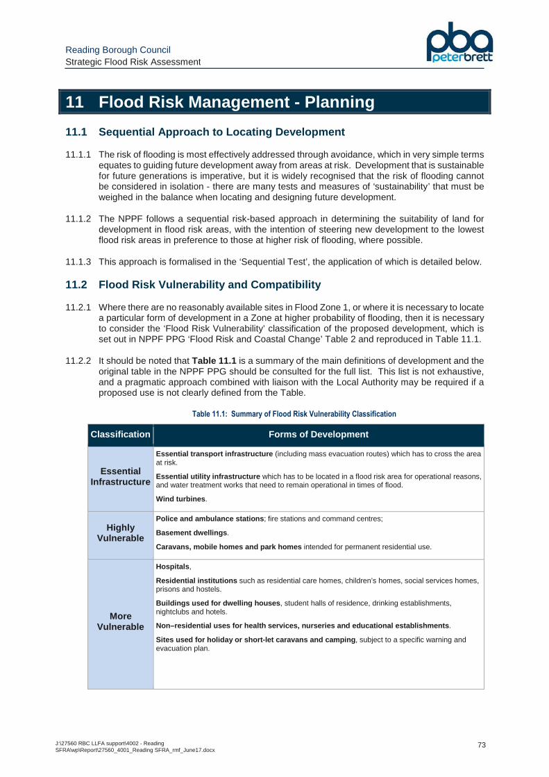
Reading Borough Council Strategic Flood Risk Assessment
J:\27560 RBC LLFA support\4002 - Reading SFRA\wp\Report\27560_4001_Reading SFRA_rmf_June17.docx
73
11 Flood Risk Management - Planning
11.1 Sequential Approach to Locating Development
11.1.1 The risk of flooding is most effectively addressed through avoidance, which in very simple terms equates to guiding future development away from areas at risk. Development that is sustainable for future generations is imperative, but it is widely recognised that the risk of flooding cannot be considered in isolation - there are many tests and measures of ‘sustainability’ that must be weighed in the balance when locating and designing future development.
11.1.2 The NPPF follows a sequential risk-based approach in determining the suitability of land for development in flood risk areas, with the intention of steering new development to the lowest flood risk areas in preference to those at higher risk of flooding, where possible.
11.1.3 This approach is formalised in the ‘Sequential Test’, the application of which is detailed below.
11.2 Flood Risk Vulnerability and Compatibility
11.2.1 Where there are no reasonably available sites in Flood Zone 1, or where it is necessary to locate a particular form of development in a Zone at higher probability of flooding, then it is necessary to consider the ‘Flood Risk Vulnerability’ classification of the proposed development, which is set out in NPPF PPG ‘Flood Risk and Coastal Change’ Table 2 and reproduced in Table 11.1.
11.2.2 It should be noted that Table 11.1 is a summary of the main definitions of development and the original table in the NPPF PPG should be consulted for the full list. This list is not exhaustive, and a pragmatic approach combined with liaison with the Local Authority may be required if a proposed use is not clearly defined from the Table.
Table 11.1: Summary of Flood Risk Vulnerability Classification
Classification Forms of Development
Essential Infrastructure
Essential transport infrastructure (including mass evacuation routes) which has to cross the area at risk.
Essential utility infrastructure which has to be located in a flood risk area for operational reasons, and water treatment works that need to remain operational in times of flood.
Wind turbines .
Highly Vulnerable
Police and ambulance stations ; fire stations and command centres;
Basement dwellings .
Caravans, mobile homes and park homes intended for permanent residential use.
More Vulnerable
Hospitals ,
Residential institutions such as residential care homes, children’s homes, social services homes, prisons and hostels.
Buildings used for dwelling houses , student halls of residence, drinking establishments, nightclubs and hotels.
Non–residential uses for health services, nurseries and educational establishments .
Sites used for holiday or short-let caravans and camping , subject to a specific warning and evacuation plan.
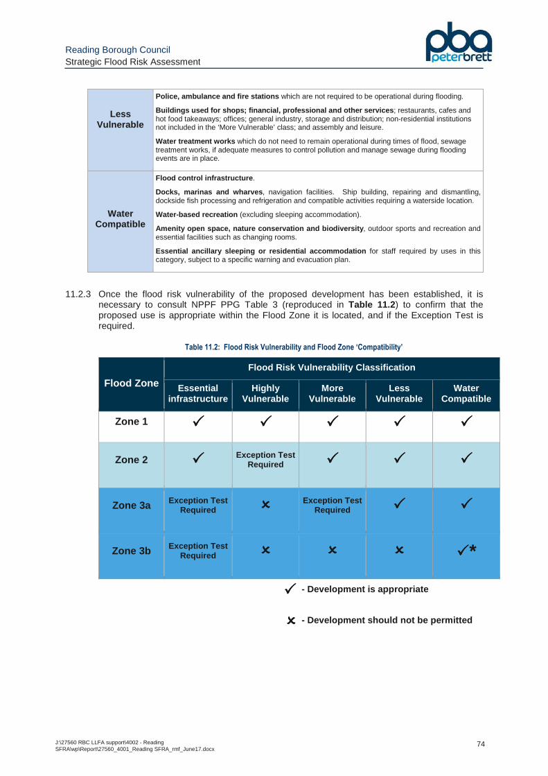
Reading Borough Council Strategic Flood Risk Assessment
J:\27560 RBC LLFA support\4002 - Reading SFRA\wp\Report\27560_4001_Reading SFRA_rmf_June17.docx
74
Less Vulnerable
Police, ambulance and fire stations which are not required to be operational during flooding.
Buildings used for shops; financial, professional and other services ; restaurants, cafes and hot food takeaways; offices; general industry, storage and distribution; non-residential institutions not included in the ‘More Vulnerable’ class; and assembly and leisure.
Water treatment works which do not need to remain operational during times of flood, sewage treatment works, if adequate measures to control pollution and manage sewage during flooding events are in place.
Water Compatible
Flood control infrastructure .
Docks, marinas and wharves , navigation facilities. Ship building, repairing and dismantling, dockside fish processing and refrigeration and compatible activities requiring a waterside location.
Water-based recreation (excluding sleeping accommodation).
Amenity open space, nature conservation and biodiversity , outdoor sports and recreation and essential facilities such as changing rooms.
Essential ancillary sleeping or residential accommodation for staff required by uses in this category, subject to a specific warning and evacuation plan.
11.2.3 Once the flood risk vulnerability of the proposed development has been established, it is necessary to consult NPPF PPG Table 3 (reproduced in Table 11.2 ) to confirm that the proposed use is appropriate within the Flood Zone it is located, and if the Exception Test is required.
Table 11.2: Flood Risk Vulnerability and Flood Zone ‘Compatibility’
Flood Zone
Flood Risk Vulnerability Classification
Essential infrastructure
Highly Vulnerable
More Vulnerable
Less Vulnerable
Water Compatible
Zone 1 ���� ���� ���� ���� ����
Zone 2 ���� Exception Test Required ���� ���� ����
Zone 3a Exception Test Required ���� Exception Test
Required ���� ����
Zone 3b Exception Test Required ���� ���� ���� ����*
���� - Development is appropriate
���� - Development should not be permitted
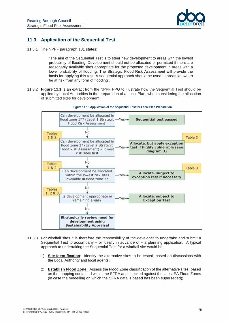
Reading Borough Council Strategic Flood Risk Assessment
J:\27560 RBC LLFA support\4002 - Reading SFRA\wp\Report\27560_4001_Reading SFRA_rmf_June17.docx
75
11.3 Application of the Sequential Test
11.3.1 The NPPF paragraph 101 states:
“The aim of the Sequential Test is to steer new development to areas with the lowest probability of flooding. Development should not be allocated or permitted if there are reasonably available sites appropriate for the proposed development in areas with a lower probability of flooding. The Strategic Flood Risk Assessment will provide the basis for applying this test. A sequential approach should be used in areas known to be at risk from any form of flooding”.
11.3.2 Figure 11.1 is an extract from the NPPF PPG to illustrate how the Sequential Test should be applied by Local Authorities in the preparation of a Local Plan, when considering the allocation of submitted sites for development.
Figure 11.1: Application of the Sequential Test for Local Plan Preparation
11.3.3 For windfall sites it is therefore the responsibility of the developer to undertake and submit a Sequential Test to accompany – or ideally in advance of – a planning application. A typical approach to undertaking the Sequential Test for a windfall site would be:
1) Site Identification : Identify the alternative sites to be tested, based on discussions with the Local Authority and local agents;
2) Establish Flood Zone: Assess the Flood Zone classification of the alternative sites, based on the mapping contained within the SFRA and checked against the latest EA Flood Zones (in case the modelling on which the SFRA data is based has been superseded);
Reading Borough Council Strategic Flood Risk Assessment
J:\27560 RBC LLFA support\4002 - Reading SFRA\wp\Report\27560_4001_Reading SFRA_rmf_June17.docx
76
3) Assess Availability of Alternative Sites : A desk-based assessment based on publically available information, of whether the alternative sites identified are ‘reasonably available’. This could consider issues such as:
• When is the site available for development?
• Is the site currently occupied/in use?
• Can the owner be identified or are there multiple ownerships?
• Has there been any planning activity (a review of the planning history)?
• Is the site being pursued by other third parties?
• Are there any known development constraints?
11.3.4 It is for RBC, as the ‘decision maker’ to consider and approve any submitted Sequential Test. RBC must notify the EA – as statutory consultee on flood risk matters – that they consider the Test to be passed so that the EA can undertake a review of the technical flood risk matters during the planning application consultation period.
11.4 Undertaking the Exception Test
11.4.1 The NPPF paragraph 102 states:
“If, following application of the Sequential Test, it is not possible, consistent with wider sustainability objectives, for the development to be located in zones with a lower probability of flooding, the Exception Test can be applied if appropriate. For the Exception Test to be passed:
• it must be demonstrated that the development provides wider sustainability benefits to the community that outweigh flood risk, informed by a Strategic Flood Risk Assessment where one has been prepared; and
• a site-specific flood risk assessment must demonstrate that the development will be safe for its lifetime taking account of the vulnerability of its users, without increasing flood risk elsewhere, and, where possible, will reduce flood risk overall.”
11.4.2 Following the application of the Sequential Test, the Exception Test is carried out in certain circumstances – as set out in Table 11.2 – to set out to demonstrate that the site is safe from flooding and provides ‘wider sustainability benefits’ that outweigh the flood risk.
Reading Borough Council Strategic Flood Risk Assessment
J:\27560 RBC LLFA support\4002 - Reading SFRA\wp\Report\27560_4001_Reading SFRA_rmf_June17.docx
77
12 Flood Risk Management - Design
12.1 Reducing Flood Risk through Design
12.1.1 If, following application of the Sequential Test (and potentially the Exception Test), it is considered appropriate to locate new development in an area of Flood Zone 2 or 3, then the proposed development must be appropriately designed to ensure (i) the occupants/users are safe from flooding, and (ii) the development does not increase flood risk to third parties.
12.1.2 The following Section provides guidance on the general principles of flood mitigation – in terms of the siting of new development, freeboard and safe access requirements, building design, floodplain management – which should form an integral element of any new development within a flood risk area.
12.2 Sequential Approach
12.2.1 The first stage of addressing flood risk when considering new development on a site is through applying the ‘sequential approach’ during the master planning stage at a site-specific level; i.e. locating the more vulnerable elements of the proposed development on the areas at lowest probability of flooding.
12.2.2 Where development is considered necessary in an area susceptible to flooding, the mitigation measures set out in the following sections should be incorporated into the development where applicable.
12.3 Ground Floor Levels
12.3.1 Standard requirements for ground floor levels of new development are set out in the British Standards document BS8533:2011 ‘Assessing and Managing Flood Risk in New Development – Code of Practice’.
12.3.2 The applicable allowance for climate change is dependent on the EA climate change allowances guidance discussed in Section 4.9 and Section 10.2 .
12.3.3 In accordance with Section 5.5.2 of the BS, it is recommended that floor levels of new development are set a minimum of 300mm above the modelled 1 in 100 annual probability plus appropriate allowance for climate change fluvial flood level .
12.3.4 The floor level requirements based on the new climate change allowances should be considered on a site by site basis, but the generally accepted approach is to use the lower end of the specified range of climate change allowances as a baseline for mitigation requirements, and the higher end as a sensitivity test, to consider residual risk and inform freeboard requirements. A worked example of this approach is set out below.
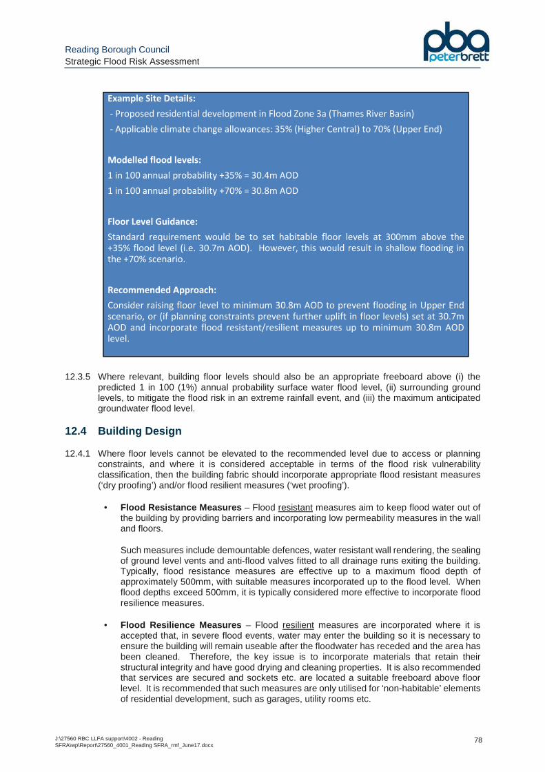
Reading Borough Council Strategic Flood Risk Assessment
J:\27560 RBC LLFA support\4002 - Reading SFRA\wp\Report\27560_4001_Reading SFRA_rmf_June17.docx
78
12.3.5 Where relevant, building floor levels should also be an appropriate freeboard above (i) the predicted 1 in 100 (1%) annual probability surface water flood level, (ii) surrounding ground levels, to mitigate the flood risk in an extreme rainfall event, and (iii) the maximum anticipated groundwater flood level.
12.4 Building Design
12.4.1 Where floor levels cannot be elevated to the recommended level due to access or planning constraints, and where it is considered acceptable in terms of the flood risk vulnerability classification, then the building fabric should incorporate appropriate flood resistant measures (‘dry proofing’) and/or flood resilient measures (‘wet proofing’).
• Flood Resistance Measures – Flood resistant measures aim to keep flood water out of the building by providing barriers and incorporating low permeability measures in the wall and floors.
Such measures include demountable defences, water resistant wall rendering, the sealing of ground level vents and anti-flood valves fitted to all drainage runs exiting the building. Typically, flood resistance measures are effective up to a maximum flood depth of approximately 500mm, with suitable measures incorporated up to the flood level. When flood depths exceed 500mm, it is typically considered more effective to incorporate flood resilience measures.
• Flood Resilience Measures – Flood resilient measures are incorporated where it is accepted that, in severe flood events, water may enter the building so it is necessary to ensure the building will remain useable after the floodwater has receded and the area has been cleaned. Therefore, the key issue is to incorporate materials that retain their structural integrity and have good drying and cleaning properties. It is also recommended that services are secured and sockets etc. are located a suitable freeboard above floor level. It is recommended that such measures are only utilised for ‘non-habitable’ elements of residential development, such as garages, utility rooms etc.
Example Site Details:
- Proposed residential development in Flood Zone 3a (Thames River Basin)
- Applicable climate change allowances: 35% (Higher Central) to 70% (Upper End)
Modelled flood levels:
1 in 100 annual probability +35% = 30.4m AOD
1 in 100 annual probability +70% = 30.8m AOD
Floor Level Guidance:
Standard requirement would be to set habitable floor levels at 300mm above the+35% flood level (i.e. 30.7m AOD). However, this would result in shallow flooding inthe +70% scenario.
Recommended Approach:
Consider raising floor level to minimum 30.8m AOD to prevent flooding in Upper Endscenario, or (if planning constraints prevent further uplift in floor levels) set at 30.7mAOD and incorporate flood resistant/resilient measures up to minimum 30.8m AODlevel.
Reading Borough Council Strategic Flood Risk Assessment
J:\27560 RBC LLFA support\4002 - Reading SFRA\wp\Report\27560_4001_Reading SFRA_rmf_June17.docx
79
If floor levels are proposed that would potentially be subject to greater than 500mm depths of flooding, then flood resilience measures are likely to be more appropriate than flood resistance measures.
12.4.2 Resistance and resilience measures are unlikely to be suitable as the only mitigation measure to manage flood risk, but they may be suitable in some circumstances, such as:
• Water-compatible and less vulnerable uses where temporary disruption is acceptable and an appropriate flood warning is provided; or,
• In some instances where the use of an existing building is to be changed and it can be demonstrated that no other measure is practicable (see Section 12.9 ).
12.4.3 Further guidance on the available measures and their application in new development is detailed in the guidance document ‘Improving the Flood Performance of New Buildings – Flood Resilient Construction’ (2007) jointly produced by the Department for Communities and Local Government, the EA and DEFRA.
12.4.4 Flood resistance and flood resilience measures may also be appropriate in the design of buildings located behind flood defences, where a residual flood risk exists
12.4.5 Basement dwellings are considered as ‘highly vulnerable’ development and, as such, not appropriate in Flood Zone 3 (and only acceptable in Flood Zone 2 if the Exception Test has been passed). However, basement areas used for parking/storage may be appropriate within Zones 2 or 3a, provided (i) they incorporate water resisting construction in accordance with CIRIA Report 139 Table 2.3 and (ii) the thresholds of any such areas are set (ideally 300mm) above the modelled 1 in 100 annual probability plus appropriate allowance for climate change fluvial flood level.
12.4.6 Appropriate internal emergency escape routes from basement areas should also be incorporated into the design to ensure that there is a safe route from the basement to a higher part of the development in accordance with health and safety requirements (potentially with the inclusion of a Flood Management/Evacuation Plan, if appropriate).
12.5 Floodplain Storage Capacity
12.5.1 Any new development located in the vicinity of a watercourse should be constructed such that it does not reduce the available floodplain storage capacity over a site, which could potentially cause an increase in flood levels on-site or elsewhere.
12.5.2 Where a development site encroaches within the modelled 1 in 100 (1%) annual probability plus allowance for climate change floodplain, a floodplain storage analysis should be undertaken as part of any site-specific FRA to compare the floodplain capacity pre- and post- development, demonstrating no detrimental impact and ideally an improvement over the existing situation.
12.5.3 This is normally undertaken on a ‘level-for-level’ basis considering the impacts in (typically) 100mm to 200mm depth level bands, to ensure the characteristics of the floodplain are mimicked at all stages of the hydrograph, up to the reference modelled 1 in 100 (1%) annual probability plus allowance for climate change flood level. However, there may be some site-specific considerations where a more flexible approach is considered acceptable – i.e. if conventional level-for-level gains cannot be fully met it may still be acceptable if there is a significant over-provision of overall floodplain storage capacity (i.e. total volume).
12.5.4 In some more complex circumstances, such as larger scale development with significant interaction with watercourses, it may be acceptable instead to demonstrate the impacts of a scheme through hydraulic modelling to demonstrate no detriment, and ideally a betterment as a result of the proposals.
Reading Borough Council Strategic Flood Risk Assessment
J:\27560 RBC LLFA support\4002 - Reading SFRA\wp\Report\27560_4001_Reading SFRA_rmf_June17.docx
80
12.5.5 Floodplain ‘compensation’ for any new development should ideally be provided through ground lowering across the site and removal of non-floodable building footprints/structures.
12.5.6 Where it is not possible to provide floodplain compensation through the above measures, then it may be acceptable to mitigate the loss of floodplain storage through incorporation of floodable elements at ground level of new development– i.e.
• Open floodable areas , such as ground level/undercroft parking provision (potentially with the main development on an upper level); and/or,
• Floodable voids below the proposed buildings, with the underside of the ground floor slab set a minimum elevation of the reference 1 in 100 (1%) annual probability plus allowance for climate change flood level and with regular openings – a minimum of 1m opening in every 5m length of wall – on all sides to allow free flow of floodwater in and out of the void area (security bars can be incorporated into the perimeter wall openings to control access to the void area).
12.5.7 Incorporation of such measures should be discussed with RBC and – if considered acceptable – may require a planning condition to be imposed to ensure (i) the voids remain open in perpetuity, (ii) the capacity of the void space is not compromised and (iii) a maintenance plan is submitted to demonstrate the void will remain functional for the lifetime of the development.
12.5.8 In certain circumstances an applicant may propose new development on a site, with the provision of compensatory floodplain storage at a different location. Under such circumstances, the land would need to meet particular requirements as follows:
• The land proposed for ground lowering would need to be in the control of the developer;
• The land would need to be in an area ‘hydraulically relevant’ to the subject site (i.e. within the same reach of the watercourse, and not separated by hydraulic control structures), such that the compensation volume can be considered to be of direct benefit to the area impacted by any loss of flood storage;
• The ground levels would need to at a suitable elevation to ensure the volume gained is within the equivalent level bands as the volumes lost on the subject site (i.e. level-for-level);
• The alternative site would need to be in ‘hydraulic connectivity’ with the fluvial floodplain for the area (i.e. either land within the floodplain or located along the outer boundary of the floodplain) to ensure floodwater would be able to flow into the area where ground lowering is to take place.
12.6 Conservation of Flow Routes
12.6.1 Any new development located in the vicinity of a watercourse should be constructed such that it does not detrimentally impact on flow routes over a site; which could potentially cause an increase in flood levels elsewhere through backing up or diversion of flood flows.
12.6.2 While flood compensation measures would typically address any potential impacts of development on floodplain volume within the site, this does not necessarily take into account the impacts on flood risk if a flow route exists through the site.
12.6.3 Blockage or constriction of such a flow route by development could potentially have a more significant cumulative effect than impacts on floodplain storage capacity. As such, development should carefully consider the presence of any flood routing through the site and ensure such routes – and their capacity - are allowed for to ensure no detrimental impact to third parties either upstream or downstream of the site.
Reading Borough Council Strategic Flood Risk Assessment
J:\27560 RBC LLFA support\4002 - Reading SFRA\wp\Report\27560_4001_Reading SFRA_rmf_June17.docx
81
12.7 Safe Access Arrangements
12.7.1 It is necessary to consider safe access arrangements as part of the mitigation for any new development, to ensure the occupants/users of development are safe in times of flooding and can achieve access/egress to or from the wider area safely for the lifetime of the development.
12.7.2 Proposed ‘more vulnerable’ uses are particularly sensitive as such development may incorporate sleeping accommodation; therefore, introducing the risk of a site being impacted by flooding while occupants are asleep and unaware of the potential impacts to their mobility and access to services.
12.7.3 Safe access should be considered for the lifetime of the development, and therefore the impacts should be assessed for the 1 in 100 annual probability flood event, plus appropriate allowance for climate change (see Section 10.2 ).
12.7.4 The starting point, and preference when considering a proposed development, should be the provision of a fully dry access route which remains unaffected in a major flood event. Should a fully ‘dry’ route not be achievable then it may be possible to demonstrate a ‘very low hazard’ based on the flood hazard ratings along the route (as discussed below).
12.7.5 Another option, where a safe access route at the peak of the flood event is not feasible, is to consider the suitability of ‘safe refuge’ measures. This is where the proposed development is designed to ensure it remains safe and operational even if flooding impacts the surrounding area (and cuts off wider safe access to land outside the floodplain). The anticipated duration of any flooding – during which any safe access route may be cut off – is a key factor in determining the suitability of such an approach. If considered appropriate, it is recommended that a Flood Management Plan is provided for the development, setting out details of measures to take before, during and after a flood event, so the occupants are aware of the potential impacts of flooding (a key aspect of such a Plan is reference to the Flood Information Service discussed from paragraph 12.7.14 ).
12.7.6 Proposed development may be located on an area of high ground that becomes a ‘dry island’ surrounded by potentially significant depths of floodwater in a major flood event – for example, the Portman Road area, land south of Richfield Avenue and areas around the A33. While the development may be outside the floodplain, it is important to fully consider the impact on safe access routes from the site to the wider land outside the floodplain. This should include consideration of the duration that the access route is impacted in addition to the depths along the route. For example, if the area is affected by the floodplain of the River Thames this could be for a prolonged period and this would be a material factor when considering the safety of future occupants, as residents are unlikely to have access to medicines, food, water and utilities (i.e. electricity and telephone). It is essential that any future development within these areas considers carefully the emergency response in times of flood.
12.7.7 For ‘less vulnerable’ uses, where sleeping accommodation is not provided within the development, safe access is still a significant concern but can potentially be addressed more effectively through the incorporation of management systems including, in the event of widespread flooding, closure of the site in advance of flooding affecting the area and re-opening after the flooding has receded.
12.7.8 EA Thames Area provides a guidance statement (‘Safe access/egress for LPAs’, August 2016) to Local Planning Authorities in relation to safe access, which is included in Appendix D for reference.
Flood Hazard
12.7.9 Consideration of the safety of any pedestrian route has been based on the guidance in the EA document ‘Supplementary Note on Flood Hazard Ratings and Thresholds for Development
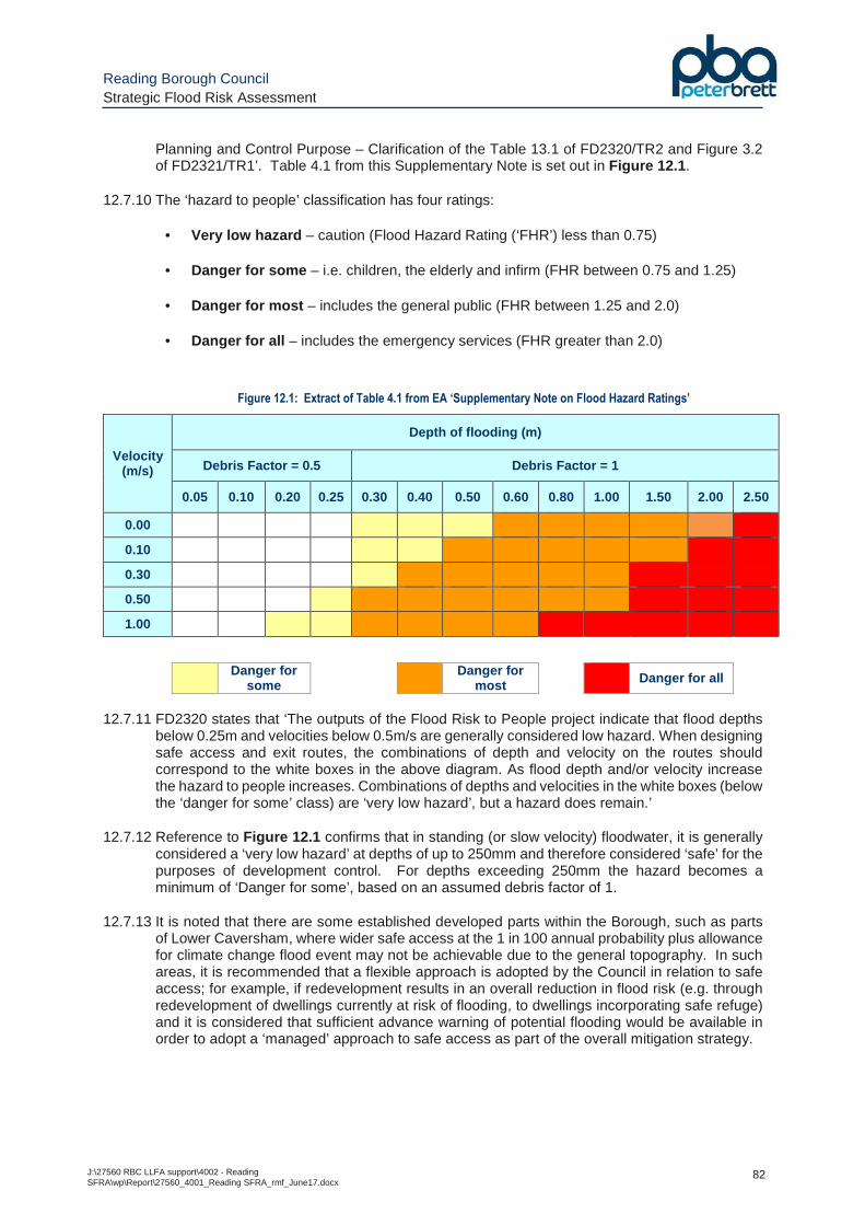
Reading Borough Council Strategic Flood Risk Assessment
J:\27560 RBC LLFA support\4002 - Reading SFRA\wp\Report\27560_4001_Reading SFRA_rmf_June17.docx
82
Planning and Control Purpose – Clarification of the Table 13.1 of FD2320/TR2 and Figure 3.2 of FD2321/TR1’. Table 4.1 from this Supplementary Note is set out in Figure 12.1 .
12.7.10 The ‘hazard to people’ classification has four ratings:
• Very low hazard – caution (Flood Hazard Rating (‘FHR’) less than 0.75)
• Danger for some – i.e. children, the elderly and infirm (FHR between 0.75 and 1.25)
• Danger for most – includes the general public (FHR between 1.25 and 2.0)
• Danger for all – includes the emergency services (FHR greater than 2.0)
Figure 12.1: Extract of Table 4.1 from EA ‘Supplementary Note on Flood Hazard Ratings’
Velocity (m/s)
Depth of flooding (m)
Debris Factor = 0.5 Debris Factor = 1
0.05 0.10 0.20 0.25 0.30 0.40 0.50 0.60 0.80 1.00 1.50 2.00 2.50
0.00
0.10
0.30
0.50
1.00
Danger for some
Danger for most
Danger for all
12.7.11 FD2320 states that ‘The outputs of the Flood Risk to People project indicate that flood depths
below 0.25m and velocities below 0.5m/s are generally considered low hazard. When designing safe access and exit routes, the combinations of depth and velocity on the routes should correspond to the white boxes in the above diagram. As flood depth and/or velocity increase the hazard to people increases. Combinations of depths and velocities in the white boxes (below the ‘danger for some’ class) are ‘very low hazard’, but a hazard does remain.’
12.7.12 Reference to Figure 12.1 confirms that in standing (or slow velocity) floodwater, it is generally considered a ‘very low hazard’ at depths of up to 250mm and therefore considered ‘safe’ for the purposes of development control. For depths exceeding 250mm the hazard becomes a minimum of ‘Danger for some’, based on an assumed debris factor of 1.
12.7.13 It is noted that there are some established developed parts within the Borough, such as parts of Lower Caversham, where wider safe access at the 1 in 100 annual probability plus allowance for climate change flood event may not be achievable due to the general topography. In such areas, it is recommended that a flexible approach is adopted by the Council in relation to safe access; for example, if redevelopment results in an overall reduction in flood risk (e.g. through redevelopment of dwellings currently at risk of flooding, to dwellings incorporating safe refuge) and it is considered that sufficient advance warning of potential flooding would be available in order to adopt a ‘managed’ approach to safe access as part of the overall mitigation strategy.
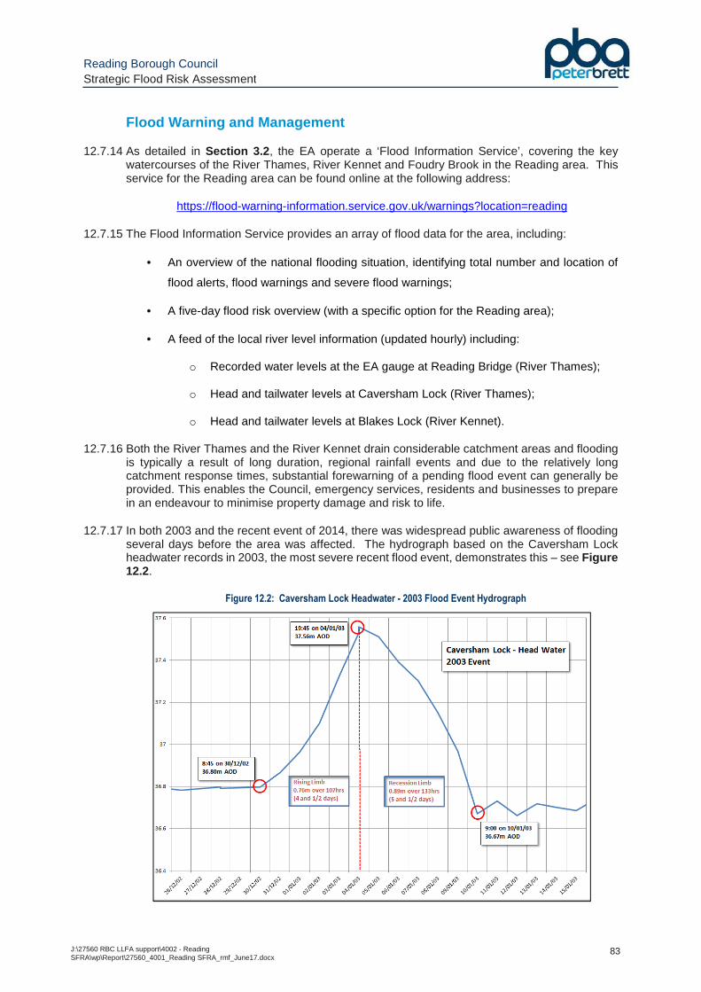
Reading Borough Council Strategic Flood Risk Assessment
J:\27560 RBC LLFA support\4002 - Reading SFRA\wp\Report\27560_4001_Reading SFRA_rmf_June17.docx
83
Flood Warning and Management
12.7.14 As detailed in Section 3.2 , the EA operate a ‘Flood Information Service’, covering the key watercourses of the River Thames, River Kennet and Foudry Brook in the Reading area. This service for the Reading area can be found online at the following address:
https://flood-warning-information.service.gov.uk/warnings?location=reading
12.7.15 The Flood Information Service provides an array of flood data for the area, including:
• An overview of the national flooding situation, identifying total number and location of
flood alerts, flood warnings and severe flood warnings;
• A five-day flood risk overview (with a specific option for the Reading area);
• A feed of the local river level information (updated hourly) including:
o Recorded water levels at the EA gauge at Reading Bridge (River Thames);
o Head and tailwater levels at Caversham Lock (River Thames);
o Head and tailwater levels at Blakes Lock (River Kennet).
12.7.16 Both the River Thames and the River Kennet drain considerable catchment areas and flooding is typically a result of long duration, regional rainfall events and due to the relatively long catchment response times, substantial forewarning of a pending flood event can generally be provided. This enables the Council, emergency services, residents and businesses to prepare in an endeavour to minimise property damage and risk to life.
12.7.17 In both 2003 and the recent event of 2014, there was widespread public awareness of flooding several days before the area was affected. The hydrograph based on the Caversham Lock headwater records in 2003, the most severe recent flood event, demonstrates this – see Figure 12.2.
Figure 12.2: Caversham Lock Headwater - 2003 Flood Event Hydrograph
Reading Borough Council Strategic Flood Risk Assessment
J:\27560 RBC LLFA support\4002 - Reading SFRA\wp\Report\27560_4001_Reading SFRA_rmf_June17.docx
84
12.7.18 The hydrograph illustrates that there was a period of over 4 days from the initial increase of water levels to the peak of the event, and a subsequent period of over 5 days until water levels receded back to normal levels.
12.7.19 Comparison with the EA hydraulic model outputs indicates that the 2003 flood was equivalent to approximately a 1 in 20 annual probability event. If a more severe event was to occur it would be reasonable to assume there would be a similar period of warning during which appropriate action could be undertaken (i.e. additional temporary flood defence measures, evacuation of dwellings).
12.8 Building Extensions
12.8.1 Floor levels of proposed building extensions should also address flood risk in accordance with the guidance in Section 12.3 . However, it is accepted that these may be constrained by existing building thresholds. If the guidance above is not achievable then ground floor levels should be set a minimum of the existing floor level and consideration given to flood resistant/resilient measures (see Section 12.4 ).
12.8.2 There is a concern that the cumulative impact of extensions and outbuildings is progressively eroding fluvial floodplain storage capacity, and such development is often allowable under permitted development rights. While there is no clear solution to this problem, at a local level the detrimental impact can be minimised by seeking the provision of compensatory floodplain storage, particularly for larger scale extensions, and through the retrofitting of flood resistant/resilient measures within the existing property as part of any application.
12.9 Changes of Use and Minor Development
12.9.1 The NPPF PPG states “The Sequential and Exception Tests do not need to be applied to minor developments and changes of use, except for a change of use to a caravan, camping or chalet site, or to a mobile home or park home site’. However, they should still meet the requirements for site-specific Flood Risk Assessments.
12.9.2 A proposed change of use may result in a change in the flood risk vulnerability classification of a site (e.g. a change of use from commercial to residential results in a change from ‘less vulnerable’ to ‘more vulnerable’ development), and therefore a potential increase in the flood risk to a site.
12.9.3 Minor development consists of any of the following:
• Minor non-residential extensions: industrial/commercial/leisure extensions with a footprint less than 250 square metres;
• Alterations: development that does not increase the size of buildings (e.g. alterations to external appearance);
• Householder development: For example; sheds, garages, games rooms etc. within the curtilage of the existing dwelling, in addition to physical extensions to the existing dwelling itself. This definition excludes any proposed development that would create a separate dwelling within the curtilage of the existing dwelling (e.g. subdivision of houses into flats).
12.9.4 Under such circumstances it will be necessary for the developer to ensure the proposed use is compatible with the Flood Zone in which it is located, and demonstrate that the future users of the development remain safe from flooding for the lifetime of the development. As such, additional mitigation may be necessary within the fabric of the building to enhance its safety for the proposed use (which would be detailed in the submitted FRA).
Reading Borough Council Strategic Flood Risk Assessment
J:\27560 RBC LLFA support\4002 - Reading SFRA\wp\Report\27560_4001_Reading SFRA_rmf_June17.docx
85
13 Surface Water Management
13.1 What are SuDS?
13.1.1 The NPPF recognises that flood risk and other environmental damage can be managed by minimising changes in the volume and rate of surface runoff from development sites. It recommends that priority is given to the use of Sustainable Drainage Systems (SuDS) in new development, this being complementary to the control of development within the floodplain.
13.1.2 SuDS aim to (i) control surface water close to its source, (ii) replicate, as closely as possible, the natural (pre-development) drainage regime of a site, whilst (iii) minimising the transfer of pollution to receiving waters.
13.1.3 There are a number of overarching policy, guidance documents and other sources of information relating to surface water management that set out the key requirements, approach and design criteria for the management of surface water. These should be consulted at an early stage to ensure any new development meets current requirements in this regard:
� ‘The SuDS Manual’ (CIRIA document reference C753, updated 2015);
� ‘Sustainable Drainage Systems - Non statutory technical standards for sustainable drainage systems’ (DEFRA, March 2015);
� ‘Flood Risk Assessments: Climate Change Allowances’ (EA, February 2016 – see Section 4.9 );
� CIRIA sustainable drainage website http://www.susdrain.org/ ;
� RBC Local Flood Risk Management Strategy (PBA, July 2015).
13.1.4 The SuDS Manual states the following in relation to SuDS:
13.2 Suitability of SuDS Measures
13.2.1 As the intention of SuDS is to mimic the natural drainage regime of the undeveloped site, the NPPF PPG states the following (consistent with the Building Regulations H3 hierarchy):
Sustainable Drainage Systems (SuDS) are designed to maximise theopportunities and benefits we can secure from surface water management.
There are four main categories of benefits that can be achieved by SuDS: waterquantity, water quality, amenity and biodiversity. These are referred to as thefour pillars of SuDS design.
SuDS can take many forms, both above and below ground. Some types of SuDSinclude planting, others include proprietary/manufactured products. In generalterms, SuDS that are designed to manage and use rainfall close to where it falls,on the surface and incorporating vegetation, tend to provide the greatestbenefits. Most SuDS schemes use a combination of SuDS components toachieve the overall design objective s for the site.
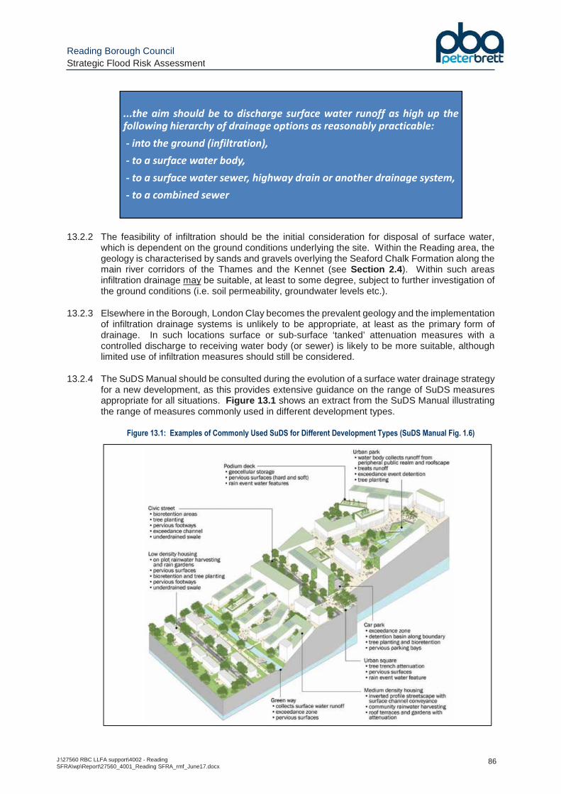
Reading Borough Council Strategic Flood Risk Assessment
J:\27560 RBC LLFA support\4002 - Reading SFRA\wp\Report\27560_4001_Reading SFRA_rmf_June17.docx
86
13.2.2 The feasibility of infiltration should be the initial consideration for disposal of surface water, which is dependent on the ground conditions underlying the site. Within the Reading area, the geology is characterised by sands and gravels overlying the Seaford Chalk Formation along the main river corridors of the Thames and the Kennet (see Section 2.4 ). Within such areas infiltration drainage may be suitable, at least to some degree, subject to further investigation of the ground conditions (i.e. soil permeability, groundwater levels etc.).
13.2.3 Elsewhere in the Borough, London Clay becomes the prevalent geology and the implementation of infiltration drainage systems is unlikely to be appropriate, at least as the primary form of drainage. In such locations surface or sub-surface ‘tanked’ attenuation measures with a controlled discharge to receiving water body (or sewer) is likely to be more suitable, although limited use of infiltration measures should still be considered.
13.2.4 The SuDS Manual should be consulted during the evolution of a surface water drainage strategy for a new development, as this provides extensive guidance on the range of SuDS measures appropriate for all situations. Figure 13.1 shows an extract from the SuDS Manual illustrating the range of measures commonly used in different development types.
Figure 13.1: Examples of Commonly Used SuDS for Different Development Types (SuDS Manual Fig. 1.6)
...the aim should be to discharge surface water runoff as high up thefollowing hierarchy of drainage options as reasonably practicable:
- into the ground (infiltration),
- to a surface water body,
- to a surface water sewer, highway drain or another drainage system,
- to a combined sewer
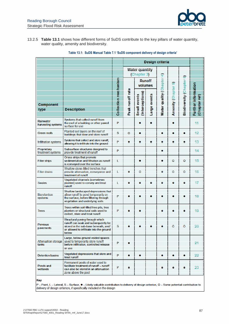
Reading Borough Council Strategic Flood Risk Assessment
J:\27560 RBC LLFA support\4002 - Reading SFRA\wp\Report\27560_4001_Reading SFRA_rmf_June17.docx
87
13.2.5 Table 13.1 shows how different forms of SuDS contribute to the key pillars of water quantity, water quality, amenity and biodiversity.
Table 13.1: SuDS Manual Table 7.1 ‘SuDS component delivery of design criteria’
Reading Borough Council Strategic Flood Risk Assessment
J:\27560 RBC LLFA support\4002 - Reading SFRA\wp\Report\27560_4001_Reading SFRA_rmf_June17.docx
88
13.3 SuDS Requirements for New Development
13.3.1 As of April 2015, the Lead Local Flood Authority (LLFA) has become the statutory consultee for surface water management on planning applications for ‘major development’. As the LLFA, RBC are therefore responsible for the approval of surface water drainage systems within such development. Major development consists of any of the following:
o The provision of dwelling houses where residential development of 10 or more units; or where the development is to be carried out on a site having an area of 0.5 hectares or more and the number of units is not known;
o The provision of a building or buildings where the floor space to be created by the development is 1,000 square metres or more; or,
o Development carried out on a site having an area of 1 hectare or more.
13.3.2 As detailed on the RBC planning application validation checklist, all applications for major development need to be accompanied by details of the SuDS proposals to manage surface water runoff from the development, including:
o “Detailed designs for the drainage system including (components, levels, volumes of storage).
o Infiltration tests of the existing ground.
o Design calculations to show that the runoff from the site post development is no greater than the existing runoff from the site for a 1 in 100 year, 6 hour rainfall event, that no flooding occurs anywhere on site for a 1 in 30 year rainfall event and no flooding occurs in any building (including basement) or any utility plant susceptible to water during a 1 in 100 year rainfall event.
o Connection details to existing watercourse and drainage networks if infiltration methods are not used together with acceptance of these connections from the relevant approving body (EA, LFA, Canal and River trust, Sewage undertaker).”
13.4 Design Criteria
13.4.1 Surface water drainage systems for new development should be designed in accordance with the principles of the NPPF, i.e. the occupants/users of the new development are safe from flooding, and the development does not increase (and ideally decreases) flood risk elsewhere.
13.4.2 To avoid compromising the functionality and capacity of SuDS attenuation features such as detention basins or ponds, these should be located outside the fluvial 1 in 100 annual probability plus allowance for climate change floodplain. The new EA climate change allowances for fluvial flooding could cause implications on where they are located and careful consideration is required when locating such measures over a development site and in ensuring there is sufficient space over the site if fluvial flood risk is also a key design constraint.
13.4.3 The key design criteria for aspects of the surface water drainage system are detailed in the DEFRA ‘Non statutory technical standards for sustainable drainage systems’ and can be summarised in Table 13.2 .
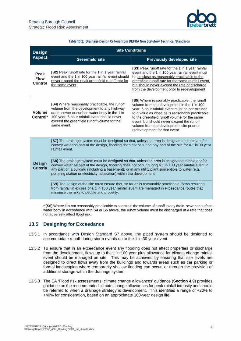
Reading Borough Council Strategic Flood Risk Assessment
J:\27560 RBC LLFA support\4002 - Reading SFRA\wp\Report\27560_4001_Reading SFRA_rmf_June17.docx
89
Table 13.2: Drainage Design Criteria from DEFRA Non Statutory Technical Standards
Design Aspect
Site Conditions
Greenfield site Previously developed site
Peak Flow
Control
[S2] Peak runoff rate for the 1 in 1 year rainfall event and the 1 in 100 year rainfall event should never exceed the peak greenfield runoff rate for the same event.
[S3] Peak runoff rate for the 1 in 1 year rainfall event and the 1 in 100 year rainfall event must be as close as reasonably practicable to the greenfield runoff rate for the same rainfall event, but should never exceed the rate of discharge from the development prior to redevelopment
Volume Control*
[S4] Where reasonably practicable, the runoff volume from the development to any highway drain, sewer or surface water body in the 1 in 100 year, 6 hour rainfall event should never exceed the greenfield runoff volume for the same event.
[S5] Where reasonably practicable, the runoff volume from the development in the 1 in 100 year, 6 hour rainfall event must be constrained to a value as close as is reasonably practicable to the greenfield runoff volume for the same event, but should never exceed the runoff volume from the development site prior to redevelopment for that event.
Design Criteria
[S7] The drainage system must be designed so that, unless an area is designated to hold and/or convey water as part of the design, flooding does not occur on any part of the site for a 1 in 30 year rainfall event.
[S8] The drainage system must be designed so that, unless an area is designated to hold and/or convey water as part of the design, flooding does not occur during a 1 in 100 year rainfall event in any part of: a building (including a basement); or in any utility plant susceptible to water (e.g. pumping station or electricity substation) within the development.
[S9] The design of the site must ensure that, so far as is reasonably practicable, flows resulting from rainfall in excess of a 1 in 100 year rainfall event are managed in exceedance routes that minimise the risks to people and property.
* [S6] Where it is not reasonably practicable to constrain the volume of runoff to any drain, sewer or surface water body in accordance with S4 or S5 above, the runoff volume must be discharged at a rate that does not adversely affect flood risk.
13.5 Designing for Exceedance
13.5.1 In accordance with Design Standard S7 above, the piped system should be designed to accommodate runoff during storm events up to the 1 in 30 year event.
13.5.2 To ensure that in an exceedance event any flooding does not affect properties or discharge from the development, flows up to the 1 in 100 year plus allowance for climate change rainfall event should be managed on site. This may be achieved by ensuring that site levels are designed to direct flows away from the buildings and towards areas such as car parking or formal landscaping where temporarily shallow flooding can occur, or through the provision of additional storage within the drainage system.
13.5.3 The EA ‘Flood risk assessments: climate change allowances’ guidance (Section 4.9 ) provides guidance on the recommended climate change allowances for peak rainfall intensity and should be referred to when a drainage strategy is development. This identifies a range of +20% to +40% for consideration, based on an approximate 100-year design life.
Reading Borough Council Strategic Flood Risk Assessment
J:\27560 RBC LLFA support\4002 - Reading SFRA\wp\Report\27560_4001_Reading SFRA_rmf_June17.docx
90
13.6 Adoption and Maintenance Considerations
13.6.1 Long term management of surface water drainage assets, including any SuDS components, is essential to ensure they continue to function to their design standard. As such, there should be consideration of the management and maintenance requirements in order to ensure any systems continue to work effectively.
13.6.2 Advisory information on the typical operation and maintenance requirements for specific forms of SuDS drainage are set out in the SuDS Manual, which confirms there are broadly three types of maintenance activities associated with surface water drainage systems, defined as:
� Regular Maintenance – ‘basic tasks undertaken on a frequent and predictable schedule’ including vegetation management, litter and debris removal, and inspections.’
� Occasional Maintenance – ‘tasks that are likely to be required periodically, but on a much less frequent and predictable basis than the routine tasks (sediment removal is an example.’
� Remedial Maintenance – ‘intermittent tasks that may be required to rectify faults associated with the system, although the likelihood of faults can be minimised by good design. Where remedial work is found to be necessary, it is likely to be due to site-specific characteristics or unforeseen events, and as such timings are difficult to predict.’
13.6.3 RBC should be satisfied that the proposed minimum standards of operation are appropriate and that there are clear arrangements in place for ongoing maintenance.
13.6.4 The final strategy for adoption of SuDS and the SuDS maintenance plan, including a maintenance schedule and details of easements and outfalls for the drainage system, should be provided at the detailed design stage, once details of SuDS features to be incorporated into a new development have been finalised.
Reading Borough Council Strategic Flood Risk Assessment
J:\27560 RBC LLFA support\4002 - Reading SFRA\wp\Report\27560_4001_Reading SFRA_rmf_June17.docx
91
14 Local Flood Risk Management
14.1 Development of RBC Local Flood Risk Management Strategy
14.1.1 The RBC Local Flood Risk Management Strategy (LFRMS), as outlined in Section 3.3 , aims to; increase awareness of local flood risk issues; provide an overview of the on-going flood risk mitigation work underway across Reading; and set out the long term strategy for flood risk management.
14.1.2 It identifies the extent of flood risk in Reading, establishes priorities for managing local flood risk, and identifies how RBC will work together with other Risk Management Authorities, stakeholders, and local communities to manage local flood risk.
14.1.3 A range of sources of information, including the EA surface water flood maps, historic flooding records and Thames Water sewer maps, were compiled and analysed to identify the ‘Local Flood Risk Priority Areas’. There are also areas where flooding has been observed, which do not coincide with published modelling extents, which require further investigation to ascertain the cause of flooding and any possible mitigation measures that could be undertaken or have already been implemented.
14.1.4 One of the key outputs from the LFRMS was the identification of ‘Local Flood Risk Areas’ and the formalising of an Action Plan, that sets out a range of initiatives and measures which have been undertaken, or are currently planned to be carried out, to mitigate and reduce the flood risk identified in these areas (reference Section 4 of the Reading LFRMS).
14.2 LFRMS Action Plan
14.2.1 The Action Plan identifies 8 specific locations where action was to be (or is being) undertaken, summarised as follows:
� Blundell’s Copse – Thames Water works (mini pumping stations and sewer improvements) to alleviate flood risk in Keswick Close area;
� William Street – Community awareness programme to address basement flood risk
issues;
� Stockton Road – Residential area at downstream end of drainage catchment and subject
to overland flow routes with limited sewer capacity. Flood defence works undertaken;
� Stone Street – small residential area at low point of sewer sub catchment. Foul pumping
station proposed by Thames Water to alleviate issues;
� Circuit Lane – a residential area near the Holy Brook, which lies at the low point of a local
catchment where the local sewer network may be under capacity. Potential engineering measures to be incorporated to reduce flood risk, subject to funding;
� Harness Close – an area in Whitley Wood where 12 homes have been flooded.
Investigations are ongoing by RBC and Thames Water to establish the source and determine mitigation options;
� Holy Brook – increased flood risk to nearby residential properties due to erosion of the
bank and footpath. Proposed reinstatement work is planned to footpath to ensure flood flows are directed away from residential areas and into defined floodplain area;
Reading Borough Council Strategic Flood Risk Assessment
J:\27560 RBC LLFA support\4002 - Reading SFRA\wp\Report\27560_4001_Reading SFRA_rmf_June17.docx
92
� Island Road – In heavy rains water levels within the Foudry Brook can rise significantly
and lead to flooding along Island Road. Existing ditches are to be maintained and a penstock gate is to be incorporated at the existing outfall headwall to control water flows and levels along the watercourse.
14.2.2 Other key requirements set out in the Action Plan include:
� Undertake an update to the Reading SFRA;
� Investigate development of planning policy for sites in risk areas to reduce surface water runoff rates to greenfield rates, or to contribute to local flood mitigation schemes, to provide reduction in flood risk;
� Review RBC emergency response strategies and sand bagging policy for fluvial events;
� Undertake investigation and reporting of all events that result in internally flooded properties.
14.3 Emergency Planning
14.3.1 The Council is designated as a Category 1 Responder under the Civil Contingencies Act 2004. As such, the Council has defined responsibilities to assess risk, and respond appropriately in case of an emergency, including (for example) a major flooding event. The Council’s primary responsibilities are1:
� From time to time assess the risk of an emergency occurring.
� From time to time assess the risk of an emergency making it necessary or expedient for the person or body to perform any of his or its functions.
� Maintain plans for the purpose of ensuring that, so far as is reasonably practicable, if an emergency occurs the person or body is able to continue to perform his or its functions.
� Maintain plans for the purpose of ensuring that if an emergency occurs or is likely to occur the person or body is able to perform his or its functions so far as necessary or desirable for the purpose of:
- preventing the emergency;
- reducing, controlling or mitigating its effects; or
- taking other action in connection with it.
14.3.2 The FWMA also puts responsibility on LLFAs to take a lead in response to flooding events with an emphasis on co-operation with adjoining authorities, emergency services, utility providers and the EA.
14.3.3 The SFRA provides a concise summary of the possible sources of flooding within the Borough, and may be used to inform the assessment of flood risk in response to the requirements of the Act.
14.3.4 The EA monitors river levels within the River Thames and the River Kennet. Based upon weather predictions provided by The Met Office, the Agency makes an assessment of the anticipated maximum water level that is likely to be reached within the proceeding hours (and/or days). Where these predicted water levels are expected to result in the inundation of populated
1 Civil Contingencies Act 2004
Reading Borough Council Strategic Flood Risk Assessment
J:\27560 RBC LLFA support\4002 - Reading SFRA\wp\Report\27560_4001_Reading SFRA_rmf_June17.docx
93
areas, the EA will issue a series of flood warnings within defined flood warning areas, encouraging residents that are signed up to the service to take action to avoid damage to property in the first instance.
14.3.5 The EA advises that people and key infrastructure may be vulnerable at different stages of flooding:
� Before – lack of preparedness – ensure people are aware (sign up to Flood Warnings Direct) infrastructure is protected or resilient.
� During - property and infrastructure is flood-resistant, escape and access is appropriate, refuge areas are provided.
� After – recovery is maximised - ensure emergency services can reach those most at risk/affected, no basement-only properties in areas if most flood risk, ensuring properties are properly flood-resilient.
14.3.6 As water levels rise and begin to pose a risk to life and/or livelihood, it is the responsibility of the emergency services to coordinate the evacuation of residents. This evacuation will be supported by the Council. It is essential that a robust plan is in place that clearly sets out (as a minimum):
� Roles and responsibilities.
� Paths of communication.
� Evacuation routes.
� Community centres to house evacuated residents.
� Contingency plans in case of loss of power and/or communication.
14.3.7 Co-ordination with the emergency services and the EA is imperative to ensure the safety of residents in time of flood. A significant proportion of the Borough is at risk from fluvial flooding. Flooding of this nature will typically occur following relatively long duration rainfall events, and consequently forewarning will generally be provided to encourage preparation in an effort to minimise property damage and risk to life. It is worth highlighting however that the benefits of flood warning systems are often compromised to a large degree by the lack of ‘take up’ within the local community. This emphasises the extreme importance of raising local awareness with respect to the potential risks of flooding.
14.3.8 Areas suffering from localised flooding issues will tend to be at greater risk. These areas are susceptible to ‘flash’ flooding, associated with storm cells that pass over the Borough resulting in high intensity, often relatively localised, rainfall. It is anticipated that events of this nature will occur more often as a result of possible climate change over the coming decades (see Section 4.9 and Section 10.2 ). Events of this nature are difficult to predict accurately, and the rapid runoff that follows will often result in flooding that cannot be sensibly forewarned. All urbanised areas are potentially at some degree risk of localised flooding due to heavy rainfall. The blockage of gullies and culverts as a result of litter and/or leaves is commonplace, and this will inevitably lead to localised problems that can only realistically be addressed by reactive maintenance.
14.3.9 To support the emergency planning process, Map F10 in Appendix C indicates the locations of key infrastructure, vulnerable sites and emergency services. The emergency planning team (and prospective developers) should use this information in combination with the outputs of surface water flood modelling to identify routes that may be susceptible to flooding.
Reading Borough Council Strategic Flood Risk Assessment
J:\27560 RBC LLFA support\4002 - Reading SFRA\wp\Report\27560_4001_Reading SFRA_rmf_June17.docx
94
14.3.10 Floodplain management and emergency response activities must have a focus on key infrastructure such as the underground network and other properties that are below sea level. Emergency planning would include refuge areas in vulnerable areas, and aim to increase the number of people who sign up to Flood Warnings Direct.
14.3.11 It is important to reiterate that flood risk can be lessened by reducing both the probability and the consequences of flooding. If the probability is uncertain, the consequences can still be reduced by increasing flood awareness and flood preparedness, assisting members of the community to help themselves in case of flooding by providing forewarning of a flood event. Those at flood risk should be encouraged to sign up to the EA’s Flood Warnings Direct.
14.3.12 It is recommended that RBC advises the local Resilience Forum of the risks raised in light of the SFRA, ensuring that the planning for future emergency response can be reviewed accordingly.
14.4 Insurance
14.4.1 Many residents and business owners perceive insurance to be a final safeguard should damages be sustained as a result of a natural disaster such as flooding. Considerable media interest followed the widespread flooding of 2000 when it became clear that the insurance industry was rigorously reviewing their approach to providing insurance protection to homes and businesses situated within flood affected areas. The widespread flooding of July 2007 further exacerbated the discussion surrounding the future of insurance for householders and business owners situated within flood affected areas.
14.4.2 Flood insurance has to date been safeguarded to households at high risk of flooding due to a series of voluntary agreements on the provision of insurance between the Government and the Association of British Insurers (ABI). The most recent of these was the 2008 “Statement of Principles” agreement.
14.4.3 Due to limitations in the Statement of Principles – including the affordability of such insurance and the fact that it only applied to the original signatories in 2000 – there have been ongoing discussions between Government and the ABI to find an alternative solution to address the issue moving forward.
14.4.4 The preferred approach is to introduce legislation to create a ‘Flood Reinsurance’ scheme – ‘Flood Re’ – with the aim of ensuring that residential properties deemed to be at a high risk of flooding can still obtain affordable flood insurance. Legislation was required as the Flood Re model depends on a cross-subsidy in the form of a statutory levy on the industry.
14.4.5 Flood Re is designed to be a mid-term solution (up to 25 years), to allow time for flood risk to be reduced following investments in flood defences, and house prices to adjust accordingly. It is notable that the Flood Re scheme will only be made available to properties built before 1st January 2009, so as not to incentivise inappropriate development in high flood risk areas.
14.4.6 In years of exceptional flood, Flood Re will cover losses up to those expected in a 1 in 100 (1%) annual probability event, with the remainder being the primary responsibility of government who will work with the insurance industry and Flood Re to distribute any available resources to Flood Re policyholders.
14.4.7 A Memorandum of Understanding was agreed between the Government and the UK insurance industry in June 2013 providing the mandate for the development of Flood Re, with a legislative approach (through powers in the Water Act and its associated Regulations) chosen as the most effective way of ensuring that all relevant insurers are treated equally in terms of the costs of Flood Re.
Reading Borough Council Strategic Flood Risk Assessment
J:\27560 RBC LLFA support\4002 - Reading SFRA\wp\Report\27560_4001_Reading SFRA_rmf_June17.docx
95
14.4.8 This new Flood Re model was launched in Summer 2016. Under the scheme, flood risk premiums will be calculated based on council tax banding and capped according to the council tax band. The money for the fund will come from a small annual levy on all home insurance policies.
14.4.9 In summary, for the time being, residents and business owners can be assured that insurance for buildings constructed before January 2009 will be available to assist in recovery following a flood event. However, the future availability of flood insurance within the UK is likely to be heavily dependent upon commitment from the government to reduce the risk of flooding over time, particularly given the anticipated impacts of climate change. Investment continues to be required in flood defence and improving the capacity of sewage and drainage infrastructure, however it is also essential to ensure that spatial planning decisions do not place property within areas at risk of flooding.
Reading Borough Council Strategic Flood Risk Assessment
J:\27560 RBC LLFA support\4002 - Reading SFRA\wp\Report\27560_4001_Reading SFRA_rmf_June17.docx
96
15 Conclusion and Recommendations
15.1.1 This Strategic Flood Risk Assessment (SFRA) has been prepared in accordance with the requirements of the National Planning Policy Framework (NPPF), and developed in consultation with Reading Borough Council (RBC) and the Environment Agency (EA).
15.1.2 A number of properties within the Borough of Reading are at risk of flooding from a range of sources, including river flooding, localised runoff and sewer flooding.
• It is recommended that RBC continue the ongoing cycles of work associated with the Local Flood Risk Management Strategy, utilising the data in the SFRA and other documents to refine the assessment of flood risk through the Borough and address local flooding concerns through the associated Action Plan.
15.1.3 The Borough has been broken down into zones of ‘High’, ‘Medium’ and ‘Low’ probability of fluvial flooding in accordance with the Flood Zones defined within the NPPF, providing the basis for the application of the NPPF Sequential Test.
• It is recommended that RBC consider hydraulic modelling of the extreme 1 in 1000 annual probability event on the River Kennet, in order to provide a refinement of the extent of Flood Zone 2 ‘Medium Probability’ associated with the watercourse through the centre of Reading (note the EA have advised they are currently updating this model but this is not anticipated to be available until 2018).
15.1.4 It is necessary to ensure proposals incorporate mitigation designed for the lifetime of the development. Modelling of the climate change allowances based on the current EA guidance (February 2016) has been undertaken as part of the SFRA to provide an overview of the impacts across the Reading area. Developers should liaise with the EA at the earliest opportunity to ensure the appropriate climate change allowances are applied based on the latest guidance.
• It is recommended that RBC liaise with the EA to ensure any updated modelled flood data associated with the new EA climate change allowance requirements becomes available in order to inform development within the Borough;
15.1.5 A planning solution to flood risk management should be sought wherever possible, steering vulnerable development away from areas affected by flooding in accordance with the Sequential Test.
15.1.6 Where other planning considerations must guide the allocation of sites and the Sequential Test has been applied, specific recommendations in relation to mitigation measures have been provided to assist the Council and the developer to meet the Exception Test.
15.1.7 Council policy is essential to ensure that the recommended development control conditions can be imposed consistently at the planning application stage. This is essential to achieve future sustainability within the Borough with respect to flood risk management.
• It is recommended that emerging Council policy incorporates, where appropriate, recommendations presented in the Reading Borough SFRA.
15.1.8 Emergency planning is imperative to minimise the risk to life posed by flooding within the Borough. It is recommended that the Council advises the local Resilience Forum of the risks raised in light of the Reading SFRA, ensuring that the planning for future emergency response can be reviewed accordingly.

Reading Borough Council Strategic Flood Risk Assessment
J:\27560 RBC LLFA support\4002 - Reading SFRA\wp\Report\27560_4001_Reading SFRA_rmf_June17.docx
97
16 SFRA Review and Update
16.1.1 The SFRA has been developed building heavily upon existing knowledge with respect to flood risk within the Borough. However, knowledge of flood risk is continuously evolving and flood mapping is regularly being updated. This, in addition to observed flooding that may occur throughout a year, will improve the current knowledge of flood risk within the Borough and may marginally alter predicted flood extents within the study area.
16.1.2 Given that this is the case, a periodic review of the Reading SFRA is imperative. It is recommended that the SFRA is reviewed on a regular basis, and a number of key questions to be addressed as part of the SFRA review process (i.e. triggering whether or not a comprehensive review is required) are provided below.
Question 1: Has any flooding been observed within the Borough since the previous review?
16.1.3 If so, the following information should be captured as an addendum to the SFRA:
� What was the mapped extent of the flooding?
� On what date did the flooding occur?
� What was the perceived cause of the flooding?
� If possible, what was the indicative statistical probability of the observed flooding event? (i.e. how often, on average, would an event of that magnitude be observed within the Borough?)
� If fluvial flooding occurred, are the observed flood extents situated outside of the current Flood Zone 3a? If it is estimated that the severity of flooding does not exceed the 1 in 100 (1%) annual probability event then the flooded areas should be incorporated into Zone 3a to inform future planning decision making.
Question 2: Have any amendments to the NPPF or associated PPG been implemented?
16.1.4 If so, the following key questions should be tested:
� Does the revision to the policy guidance alter the definition of the NPPF Flood Zones presented within the SFRA?
� Does the revision to the policy guidance alter the decision making process required to satisfy the Sequential Test?
� Does the revision to the policy guidance alter the application of the Exception Test?
� Does the revision to the policy guidance alter the categorisation of land use vulnerability, presented within Table 2 of the PPG?
16.1.5 If the answer to any of these core questions is ‘yes’ then a review of the SFRA recommendations in light of the identified policy change should be carried out.
Reading Borough Council Strategic Flood Risk Assessment
J:\27560 RBC LLFA support\4002 - Reading SFRA\wp\Report\27560_4001_Reading SFRA_rmf_June17.docx
98
Question 3: Has the EA issued any amendments to their flood risk mapping and/or standing guidance since the previous policy review?
16.1.6 If so:
� Has any further detailed fluvial flood risk mapping been completed within the Borough, resulting in a change to the 1 in 20 year, 1 in 100 or 1 in 1000 annual probability flood outlines? If yes, then the Flood Zone extents should be reviewed and updated accordingly.
� Has the assessment of the impacts that climate change may have upon rainfall and/or river flows over time altered? If yes, then a review of the impacts that climate change may have upon the Borough is required.
� Do the flood risk management recommendations provided in Section 12 and 13 of the SFRA in any way contradict emerging advice with respect to (for example) the provision of emergency access, the setting of floor levels and the integration of sustainable drainage techniques? If yes, then a discussion with the EA is required to ensure an agreed suite of development management requirements are in place.
16.1.7 It is highlighted that the EA review the Flood Zone Map on a quarterly basis. If this has been revised within the Borough, the updated Flood Zones will be automatically forwarded to the Council for their reference. It is recommended that only those areas that have been amended by the EA since the previous SFRA review are reflected in Zone 3 and Zone 2 of the SFRA flood maps. This ensures that the more rigorous analyses carried out as part of the SFRA process are not inadvertently lost by a simple global replacement of the SFRA flood maps with the Flood Zone Maps.
Question 4: Has the implementation of the SFRA within the spatial planning and/or development management functions of the Council raised any particular issues or concerns that need to be reviewed as part of the SFRA process?