real-time crisis mapping using language distributionfredmors/paperpdfs/sampson_icdm15.pdf · by...
TRANSCRIPT
Real-Time Crisis Mapping using Language Distribution
Justin Sampson∗, Fred Morstatter∗, Reza Zafarani †, and Huan Liu∗∗Computer Science and Engineering, Arizona State University, Tempe, Arizona
†Department of EECS, Syracuse University, Syracuse, New York∗{justin.sampson, fred.morstatter, huan.liu}@asu.edu, †[email protected]
Abstract—With the increase in GPS-enabled devices, socialmedia sites, such as Twitter, are quickly becoming a primeoutlet for timely geo-spatial data. Such data can be leveragedto aid in emergency response planning and recovery oper-ations. Unfortunately, the information overload poses signif-icant difficulty to the quick discovery and identification ofemergency situation areas. The system tackles this challengeby providing real-time mapping of influence areas based onautomatic analysis of the flow of discussion using languagedistributions. The workflow is then further enhanced throughthe addition of keyword surprise mapping which projects thegeneral divergence map onto specific task-level keywords forprecise and focused response.
Keywords-Information Overload; Crisis Mapping; Data Vi-sualization; Social Media
I. INTRODUCTION
The use of sensors to detect, plan, and respond to emer-gency and disaster situations has grown dramatically in thepast decade. Such sensors allow us to track earthquake activ-ity, predict the extent of hurricane-based flooding, and savelives by enabling swift and accurate situational awareness.Recently, the idea of using a network of individuals as“social sensors” has gained significant traction and shownpromise. With the advent of social media, in-particularlymicro-blogging sites such as Twitter, the volume and rangeof data has skyrocketed. Additionally, the culture of socialmedia promotes hasty dissemination of information. Thiswas illustrated by Sakaki et al. where Twitter generated datawas detected and used as an early warning system that wassometimes able to alert users to an incoming earthquakefaster than time it takes for the earthquake to travel at theiraverage movement rate of 3-7 km/s [1]. In some areas ithas become common to post new emergency informationto social media sites even before contacting emergencyresponse agencies.
Many characteristics of social sensors make them ex-tremely favorable in disaster response, however, there arealso difficulties involved in harnessing this data source.Firstly, social media data is undoubtedly “big data”. Twitteralone generates over five hundred million tweets per day1.First response coordination efforts do not have the time orability to search through individual messages resulting in
1https://about.twitter.com/company
what is now referred to as “information overload”. There-fore, we need new methods to find pertinent, accurate, andactionable information within the flood of data. Secondly,while much can be accomplished with social media data, it isimperative that first response resources must be allocated insuch a way that is not wasteful. Unfortunately, it is difficultto gauge the authoritativeness and accuracy of individualsensors. In order to avoid these pitfalls, we propose asolution that leverages surprising changes in the languageprobability distributions with the intuition that a shift inthe normal language distribution of an area more stronglyindicates unusually occurring events. This is in contrast tostandard analysis which leverages keyword occurrence rates.
II. DIVERGENCE SYSTEM ARCHITECTURE
The process of transforming streamed geospatially taggedsocial media data into a useful and easily manageable rep-resentation follows a number of steps. First, the sparsenessinherent to GPS-generated location data needs to be resolvedthrough the use of geo-coded regions, or bins. Second, statis-tical analysis of each geo-coded region using a combinationof bootstrapping [2] and Jensen-Shannon divergence[3] al-lows us to create a macro level representation of the trackedarea to further hone the information retrieval process. Third,a metric of surprise is defined which translates the statisticallanguage representation into a keyword weighting systemallowing first response planning at the micro level withoutprior or complete knowledge of the most important eventkeywords for tracking.
In order to gather actionable and timely spatio-temporaldata, we target the Twitter stream focusing solely on datawith GPS device coordinates. While the volume of dataavailable from this source is relatively small when comparedto the complete Twitter stream, the resulting nine milliontweets per day still represents a significant challenge to dataanalysis for the purpose of timely emergency response.
Since the system operates on data captured and storedfrom the Twitter stream, it is capable of rebuilding the startstate for any area on the globe from historical data as wellas other stored data sources. This process only takes a fewminutes and upon completion it can be iteratively updatedin real-time from live sources. At that point, all calculationsand analysis are performed on-the-fly and response time is

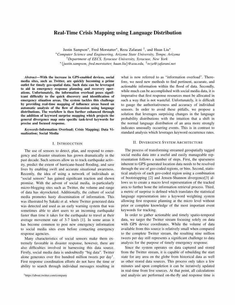
Figure 1. An overview of the system. Seen at (a) the multi-layeredgeographic visualization can be used to inspect macro-level divergenceacross a region. At (b) the surprise trend line allows for discovery ofsegments of time with high cumulative surprise rates. (c) shows thesurprising words over the selected period of time as a focus for task-level searching. (d) provides a search term interface to add keywords tobe mapped by surprise. (e) is a micro-level display useful for inspectingthe cause of divergence in a given region.
subject to volume of data specified by the search parame-ters. Two tuning parameters are also available: resolution,the total number of regions, and length of time betweenchunks. The high resolution of GPS-generated coordinatesmeans that users who are making posts from within thesame building are likely to generate very different locationdata. Instead of forcing a specific region size, the systemmaintains its flexibility through this resolution parameterwhere the number and size of each geo-coded region isdetermined from the combination of the desired region tomap over and the resolution specified. After generating theseregions, each streamed tweet can be quickly assigned to aspecific region.
The system workflow acts as a progression betweentwo layers of abstraction. The macro-level divergence layerfocuses on the task of identifying regions that possessinteresting language distribution characteristics. The micro-level surprise layer targets task-specific keyword mapping toallow for targeted emergency response.
A. Macro-level Divergence Mapping
The highest level view, the divergence layer, leverages thelanguage distribution of the given layer when compared toprevious language distributions. It has been shown by Ryooand Moon that the language of geographical regions can beused to identify the source of text to within 10 kilometersfor 60% of users [4]. Intuitively, it is expected that thelanguage representation of a region will shift as topics
change. However, these changes tend be small while largelanguage divergence represent surprising, sudden, or extremefluctuation in the normal language of a region. To comparea given region during a specific period of time we generatea probability distribution for this period, r, as well as anexpected distribution generated from previous periods at thesame time of day using a bootstrapping [2] method to createan expected distribution, rb, using fifty randomly chosensamples. The divergence between the two distributions isthen calculated using Jensen-Shannon divergence [3]. Thesedivergence values are normalized against the size of thevocabulary. This reduces noise caused in extremely smallpopulation areas where the small volume of data wouldresult in large divergence values regardless of actual events.The resulting equation is as follows:
r ∈ R,NormDiv(r) =|Vr||VR|
(H(
1
2(r+rb))−
1
2(H(r)+H(rb))
),
where R ∈ Rkxl is the geo-coded matrix containing thelanguage probability distribution for each region r withcoordinates k and l, V is the vocabulary. H is the Shannonentropy [3] using the distribution from the test period of theregion as r and the expected distribution created during thebootstrapping step as rb.
B. Micro-level Surprise and Volume Mapping
Though the high level view allows emergency responseagencies to discover points of interest, a task which diver-gence is ideally suited for, an additional metric is necessaryin order perform queries at the micro level. Since thedivergence level for a specific region is related directly tothe change between the distributions, directly examining theprobability distributions can give additional insights intothe reason for the divergence. To determine the differencebetween a normal distribution we take the average of pre-vious distributions for the region as a vector and subtractout the distribution vector of the desired test period tocreate a new vector. In this way, we can understand theimpact of the difference between each word probability.Under this scheme, words that are used commonly withina language distribution should appear at roughly the samerate between each distribution and contribute little to thediscovery of interesting keywords. After taking the differ-ence between each distribution, the common words withthese characteristics should become small values around zerowhich is ideal. Words that normally have a high probabilityin previous distributions but fail to be represented in thetest set represent a shift in communication topic that alsoprovides little information as to the current situation of anarea. This type of word will continue to be hold the largestpositive values. The last, and most useful, type of wordsare those that were not previously represented but show asudden and large increase in probability. Since these wordshave not previously been well represented, they are the most

informative source of information to the current situation ofan area. As a result, this type of word will take the largestnegative values.
The use of surprise, which we define as the range of valuesdiscovered in the above process, as a metric has severaladvantage. First, further mitigation of information overloadcan be achieved by calculating the cumulative surprise overa period of time in order to gain a high-level view ofthe keywords that explain spikes in the divergence. Thecombination of the divergence map along with the surprisemetric are effective for quick identification of regions andkeywords of interest. Second, once keywords have beenidentified, surprise in each geo-coded region can be mappedbased on individual keywords in order to further “drill down”to the micro-level impact details of each keyword over anevent period. In this way, the first response planning flowbecomes simplified and streamlined as automatic discoveryof important keywords is accomplished entirely by thesystem. Third, crowd wisdom is leveraged inherently by thesurprise metric as, by definition, the most surprising wordswill be those that show large and constant growth.
Volume mapping, where the keywords are mapped totheir corresponding regions based on keyword frequencyinstead of surprise, is included for the purpose of directcomparison to standard frequency-based filtering methods.Surprise, as a function of language distribution probability,remains linked to the volume of a given keyword within thegeo-coded region with some important differences. Volumemapped keywords suffer from population bias that can bedifficult to account for while the surprise metric is inherentlynormalized to the language distribution of a given geo-codedregion. Additionally, frequently occurring words that do notprovide significant information, such as references to citynames or holidays, dominate frequency-based methods. Thisforces additional time and effort to be expended to separateuseful keywords from those that are simply common.
Figure 2. A small event discovered by the divergence map. On the left,the divergence map along with the surprising keywords that explain themap are shown. On the right is the actual location of the event within theregion according to Google Maps.
Figure 3. Using the geo-coding system, the impact of the keyword “water”can be mapped based on frequency of use as well as surprise. The coloredmappings are displayed over the FEMA Final Surge Impact Assessmentreport which can be seen in gray. On the left in blue, the frequencymap indicates regions with a high volume of conversation containing thespecified keyword while on surprise-based map in green can be seen onthe right.
III. CASE STUDY: HURRICANE SANDY
Though the system is designed to operate on streameddata, we focus on a test dataset containing 14,528,732 tweetswith GPS device coordinates originating anywhere in theworld. Each tweet is introduced in the order that they werereceived from the stream and encompass dates betweenOctober 18, 2012 at 21:00 GMT and October 31, 2012 at23:00 GMT.
Initial landfall of Hurricane Sandy was made on October29th at 18:00 GMT. Additional data from the stream beforethe landfall event is used by the system to create a baselineas well as to provide qualitative comparison between systemresults over the period of standard conversation precedingthe disaster event with the conversation during and after. Itis important to note that since the system gathers and storesall geographically significant tweets, it is not necessary tohave foreknowledge of the event to be tracked in order tocreate the initial divergence baselines as they can be createdand analyzed retroactively.
Beginning the initial analysis workflow of the HurricaneSandy area surrounding Manhatten, New York, an immediateoverview of the can be found in the Surprise Trend graph.Several hills are distinguishable that indicate shifts in thetopic flow of the area. Taking a closer look at the surpriseat the macro level is accomplished by selecting appropriatestart dates on the appropriate sliders. Conversation topicsbefore the hurricane include mundane conversation wordssuch as “college”, “hotel”, and “visiting”, however, initialmentions of the hurricane and the weather grow significantlyin the days before landfall. Emerging words and topics atthe divergent points display interesting surprising words suchas “roseland”, “ballroom”, and “#gracejones” which refer tothe Grace Jones show at the Roseland Ballroom on October27th, 2012. This event is mapped within minutes of thestarting time of the concert as well as the correct location

as shown in Figure 2. Other interesting events discoveredin this way including a football game held at Kenneth P.Lavalle Stadium shortly before landfall. Many of these eventlocations become evident based on their divergence withinas few as thirty tweets.
When selecting regions of time after landfall the topwords become increasingly weighted towards the disasterevent. Standard conversation terms drop out of the over-all view and are replaced by such as “storm”, “power”,“hurricane”, “support”, and “help”. These terms becomeuseful as they highlight searches to be targeted for specificforms of aid. For example, shortly after the storm hit, theCon Edison power plant suffered an explosion that resultedin large blackout regions. Within minutes the divergencemap discovers the event, and using the keywords “power”,“explosion”, and “blackout” as suggested by the system amap is generated of the surprise area for immediate aid.While this is a small event, the same work flow can beapplied to flooding as a result of the hurricane. Figure 3illustrates this by showing the volume-based mapping andsurprise-based mapping of the discovered keyword “water”over the course of the heaviest impact of the hurricane ontop of the Storm Surge Impact Analysis released by FEMA2
on February 14th, 2013, several months later. As can beseen, the volume-based method displays population bias aswell as a tendency to over-predict impact regions while thesurprise-based method provides another view leveraging thedifference in the language.
IV. RELATED WORK
The use of social sensors as a supplemental data source forcrisis detection and response can be useful when standarddata gathering methods are not available. Schnebele et al.used social media data to fill the data gaps during the 2013Calgary flooding when satellite imaging was obstructed bycloud cover [5]. This method performs well but relies ontargeted keywords which may not necessarily be well knownat the time of the event. Middleton et al. approached theproblem by gaining additional information from gazetteersto target at risk areas [6]. They succeeded in showing thatsocial media data performs well in comparison to “gold-standard post-event impact assessment”.
In order to use divergence as a measure of topic shift,the standard language of a given geographic location shouldbe consistent. Han et al. show that is possible to inferthe location of a non-geographically tagged tweet based onmodels built from exclusively geographically tagged tweets.Additionally, they discovered that general language modelsthat include multiple languages are increasingly effectiveas the inclusion of extra languages into the model provideadditional discriminating factors [7]. Morstatter et al. ap-proached the geo-location task by using language features
2http://arcg.is/McDSPO
to determine if a tweet originates from within a region ofcrisis [8]. The consistent success of language-based locationinference provides us with the groundwork required to applyour method.
V. CONCLUSION
The dual system architecture employed gives emergencyresponse planners a new and effective tool to combat in-formation overload and extract useful geo-spatial informa-tion from social media. At the highest level, divergenceserves as a general filter providing detailed information onsuddenly emerging topics as well as their area of impact.Additional low level inspection and planning tasks can thenmake use of the surprise-based search functionality to targetspecific types of response based on discovered situationalneeds. The system provides a high level of flexibility andis able to detect events ranging from local concerts andsports gatherings to state-wide flooding and power outages.This provides a highly streamlined process of informationdiscovery and extraction which aims to shift the workloadfrom the shoulders of the emergency responder to that of adynamic intelligent system.
VI. ACKNOWLEDGMENTS
This work is sponsored, in part, by Office of NavalResearch grant N000141410095.
REFERENCES
[1] T. Sakaki, M. Okazaki, and Y. Matsuo, “Earthquake ShakesTwitter Users: Real-time Event Detection by Social Sensors,”in Proceedings of the 19th International Conference on WorldWide Web, 2010, pp. 851–860.
[2] B. Efron, The Jackknife, the Bootstrap and Other ResamplingPlans. SIAM, 1982, vol. 38.
[3] J. Lin, “Divergence Measures Based on the Shannon Entropy,”Information Theory, IEEE Transactions on, vol. 37, no. 1, pp.145–151, 1991.
[4] K. Ryoo and S. Moon, “Inferring Twitter User Locations with10km Accuracy,” in Proceedings of the companion publicationof the 23rd international conference on World wide web com-panion. International World Wide Web Conferences SteeringCommittee, 2014, pp. 643–648.
[5] E. Schnebele, G. Cervone, S. Kumar, and N. Waters, “RealTime Estimation of the Calgary Floods using Limited RemoteSensing Data,” Water, vol. 6, no. 2, pp. 381–398, 2014.
[6] S. E. Middleton, L. Middleton, and S. Modafferi, “Real-timeCrisis Mapping of Natural Disasters using Social Media,”Intelligent Systems, IEEE, vol. 29, no. 2, pp. 9–17, 2014.
[7] B. Han, P. Cook, and T. Baldwin, “Text-based Twitter UserGeolocation Prediction,” Journal of Artificial Intelligence Re-search, pp. 451–500, 2014.
[8] F. Morstatter, N. Lubold, H. Pon-Barry, J. Pfeffer, and H. Liu,“Finding Eyewitness Tweets During Crises,” in ACL 2014Workshop on Language Technologies and Computational So-cial Science, 2014.