rec. area to reach lake chabot marina , exit at …
TRANSCRIPT
cubic yards of earth to create the dam. Enjoy the history walk at Lake Chabot; park at San Leandro’s Chabot Park at Estudillo Avenue and Sylvan Circle and enter Lake Chabot’s West Shore Trail along the paved path. The entire walking tour is about 1 mile (2 miles roundtrip) with several panels located in close proxim-ity on the other side of the dam.
The southern half of Anthony Chabot Regional Park is within the 27,722-acre Rancho San Lorenzo, granted to Don Guillermo Castro in 1843. These rancho lands were used primarily for cattle grazing. When Castro sold the land in the 1860s it was subdivided into nine ranches. American settlers developed ranches in the northern portion of the park, including the largest, the 525-acre Grass Valley Ranch.
Most of these lands were consolidated into watershed property for the City of Oakland in the 1900s by the People’s Water Company. The last major addition to Anthony Chabot Regional Park was Lake Chabot, EB-MUD’s reserve water supply for Oakland. Through a lease to the Park District, it opened to the public in 1966.LAKE CHABOT RESERVOIR was built in 1874-75 as a primary water source for the East Bay. The 315-acre lake was closed to recreation for 91 years. In the 1960s it was opened for controlled recreational uses. Today the lake is an emergency water supply. For this reason swimming is not allowed and dogs are not allowed to enter the water.FISHING The lake is well-stocked and is a popular Bay Area fishing destination. All California Fish and Wildlife regulations apply. A current California Fish-ing License with stamps and an EBRPD Daily Fishing Access Permit are required for all anglers aged 16 and older. Fishing licenses and EBRPD permits may be purchased at the Marina Cafe. Senior Fishing Access Permits, valid for one year from date of purchase, are available to those age 62 and older. Permits are valid at all Park District lakes and reservoirs.
No live fish may be used as bait. All other legal bait and lures are permitted. Fish may be cleaned only at the cleaning station along the walk near the parking lot (see Lake Chabot Marina detail map at right). Catch-and-re-lease angling is encouraged for bass, bluegill, and crappie. However, the release of badly hooked game fish and all non-game fish is not allowed. Please bring to the Marina any unwanted and tagged fish and your completed creel census card (on the back of your fishing permit).DAILY BAG LIMITS for Lake Chabot are: black bass (12-inch minimum)–5; trout–5; catfish–5;
HISTORY Today’s Anthony Chabot and Lake Chabot Regional Parks are located within the ancestral land of the Jalquin, an Ohlone- and Bay Miwok-speak-ing tribe. The combined 5,059 acres of parkland and lake are named for Anthony Chabot, who designed and led the construction of Lake Chabot in 1874. The dam was built by laborers, blacksmiths, teamsters, masons and miners from Ireland, Portugal, England and China. 800 Chinese workers moved over 600,000
From Rancho to Recreation
East Bay Regional Park District2950 Peralta Oaks Court, Oakland, CA 94605-0381 1-888-327-2757 (1-888-EBPARKS) (TRS 711) www.ebparks.org Reprint 9/20
crappie–25; striped bass (18-inch minimum)–2. Bluegill, sunfish, carp–no limit.BOATING AT LAKE CHABOT MARINA The marina offers rental boats, tour boat rides, the Marina Cafe, and picnicking at reservable and first-come, first-served picnic areas. Swimming is not permitted. Rental boats include row boats, canoes, pedal boats, kayaks, and boats with electric trolling motors. Canoes, kayaks, and scull craft 20 feet and under may be carried in and launched (launching fee). Rafts and inflatable vessels with 2 or fewer chambers are not permitted on the lake.MARINA CAFE AND BAIT SHOP The Lake Chabot Marina Cafe, open year round, features a well-stocked bait and tackle shop and a restaurant that serves snacks, breakfast, and lunch. The Marina Cafe (510-247-2526) is closed Thanksgiving and Christmas.LAKE TOUR BOAT Tour the lake on the Chabot Queen on summer weekends and holidays. Charter a tour by calling (510) 247-2526. Naturalist-led tours may be scheduled by calling (510) 544-3187.SWIMMING is not permitted in Lake Chabot. Dogs are not allowed to enter the water at Lake Chabot.REDWOOD CANYON PUBLIC GOLF COURSE This 18-hole public golf course is open daily, 7:00am to sunset. The driving range is open from 7:00am to 6:30pm. Events and restaurant: 510-537-8001, ext. 226. Pro Shop: 510-537-8001, ext. 221.ANTHONY CHABOT FAMILY CAMPGROUND Year-round camping is available in a eucalyptus grove overlooking Lake Chabot. Spacious tent sites, disabled accessible sites and facilities, RV hookup sites (max length 35 feet; sewage, water, 30-amp electric), and hot showers are available. Daily Fishing Access Permits and firewood are sold at the campground. Registered campers park free at the Lake Chabot Marina. Stay Limit: 15 consecutive days; 30 total days per year with a 2-day minimum break following the first 15-day visit. There are fees for tent camping and for full hookup sites, for second or visiting vehicles, and for dogs. Res-ervations are recommended year-round. Campground gates close at 10:00pm.GROUP CAMPING Seven overnight camping areas are available by reservation. Organized groups are encouraged to use these group camps rather than the family campground. Information and reservations: 888-327-2757, option 2. Make reservations at least 14 days in advance. There is limited vehicle parking.
TO REACH LAKE CHABOT MARINAFrom I-580 in San Leandro, exit at Fairmont Drive and go east (uphill). (Note that Fairmont Drive becomes Lake Chabot Road.) The Marina entrance will be on the left at the bottom of the hill (parking fee). From I-580 westbound in Castro Valley, take the Strobridge Avenue exit. Turn right on Strobridge, right on Castro Valley Boulevard, and left on Lake Chabot Road. The Marina is about two miles ahead on the right. From I-580 eastbound in Castro Valley, take the Redwood Road exit and turn left onto Redwood Road, left at Castro Valley Boulevard, right at Lake Chabot Road, and follow the directions above.
TO REACH ANTHONY CHABOT REGIONAL PARKFrom I-580 westbound in Castro Valley, take the Redwood Road exit and turn right on Redwood Road. From I-580 eastbound, take the Redwood Road exit and turn left at Redwood Road. You will reach Proc-tor Staging Area, Redwood Canyon Public Golf Course, and the Marciel Gate hiking and equestrian staging area. Farther along Redwood Road you will find Bort Meadow Staging Area, MacDonald and Big Bear staging areas, and the Skyline Ranch Equestrian Center. Public Transit: www.511.org or dial 511 (TDD/TTY: 800-448-9790); BART: 510-441-BART; 925-676-BART; (TDD/TTY: 510-839-2220).
REDWOOD
DAVIS ST.
North
01
34
Mile
s2
BART
BART
BART
BART
SAN
LE
AN
DR
O
CA
STR
OV
ALL
EY
ALA
MED
A
OR
IND
A
BER
KELE
Y
OA
KLA
ND
EL
CER
RIT
O
Up
pe
r Sa
n L
ea
nd
ro R
ese
rvo
ir
Lake
M
erri
tt
San
Pab
lo
Rese
rvo
ir
13
24
185
61
185
123
13
61
580
80
980
880
580
80
880
580
238
580
WILDCA
T C
YN.
SOLANO AV.MARIN AV.
GRI
ZZLY
PEAK
BL.
S. PA
RK D
R.
ROAD
SHAT
TUCK
A
V.
UNIVERSITY AV.
CLAREMONT
AV.
TELE
GRAPH
AV.
SPRU
CEOX
FORD
ASHBY A
V.
SAN
PAB
LO A
V.
FISH
RA
NCH
ROAD
WEB
STER
CENTRAL AV.
ENCI
NAL
AV.
MORAGAAV.
GRAN
D AV.
BROAD WAY
AV.
GRA
ND
BROADWAY
McK
AY
AV.
JOAQUIN
MILLER
LINCOLN
AV.
SHEPHERD
CANYON RD.
PIN
EHUR
ST
PARK BL.
FRUITVALE A
V.
BL.
ST.
E. 1
4TH
SKYL
INE
PARK ST.
HIGH ST.
SKYL
INE
CANYON
ROAD ROA
D
ROA
D
HIGH ST.
AV.35TH
Mac
ARTH
UR
BL.
LAKE
CHAB
OT
EAST
14T
H S
T.
WAS
HIN
GTO
N
EAST
14
TH
ST.
KELLER AV.
BL.
STAN
LEY
AV.
FOOT
-HI
LL
BL.
HEGEN
BERG
ER
GOLF LIN
KS R
D.
PERA
LTA
OAK
S CT
. AV.
106TH
MARINA BL.
ESTUDILLO
DOO
LITT
LE
DR.
AV.98TH
ROAD
ROAD
CASTROVALL
EYBL
.
SEVENHILLS ROAD
HEYER AV.
GROVEWAY
BL.
LEWELLING
BL.
MIS
SIO
NFO
OTH
ILL
BL. BL
.
CENTER ST.
HESP
ERIA
N
CU
LL CYN RD.
CROWCYN RD.
AV.
TERR.
MAR
CIEL
RD.
REDW
OOD
CA
NO
ND
R.
C. P
ARK
DR.
ARLIN
GTO
N A
V.
SAN
PA
BLO
DAM
RO
AD
CAM
INO
PA
BLO
MOR
AGA
WAY
BEAR
CRE
EK R
OAD
CU
TTIN
GBL
.
Tild
en
Reg
iona
l P
ark
Wild
cat
Can
yon
Reg
iona
l Par
kTi
lden
Nat
ure
Are
a
Kenn
edy
Gro
ve
Reg
iona
l R
ecre
atio
n A
rea
Leon
a C
anyo
n O
pen
Spac
e R
egio
nal P
rese
rve
Red
woo
d R
egio
nal P
ark
Ant
hony
Cha
bot
Reg
iona
l
Par
k
Sibl
ey
Volc
anic
Pres
erve
Cla
rem
ont
Can
yon
Reg
. Pr
eser
ve
Bot
anic
G
arde
n
Rob
erts
R
egio
nal
Rec
. Are
a
Oys
ter
Bay
R
eg.
Shor
elin
e
Mar
tin
Luth
er K
ing,
Jr.
Reg
. Sho
relin
e
Lake
Cha
bot
Reg
iona
l Par
k
Tem
esca
l R
eg.R
ec.
Are
a
Cro
wn
Bea
ch
& C
rab
Cov
e
Park
Dis
tric
t H
eadq
uart
ers
Don Castro RegionalRec. Area
Cha
bot
Fam
ily
Cam
pgro
und
Mar
ina
Poin
t Is
abel
R
eg.
Shor
elin
e
Bro
oks
Isla
nd R
eg.
Pres
erve
McL
augh
linEa
stsh
ore
St
ate
Par
k
Huc
kleb
erry
B
otan
ic
Reg
iona
l Pr
eser
ve
Cul
l Can
yon
Reg
iona
lR
ec. A
rea
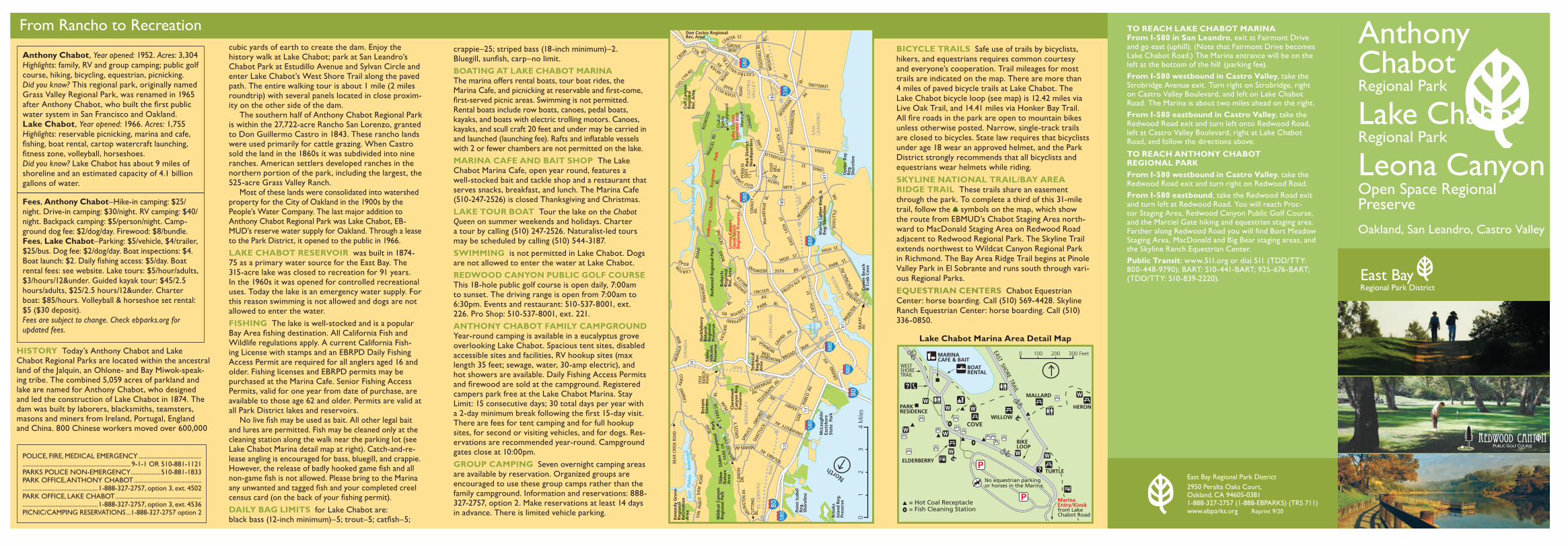
MARINA CAFE & BAIT
PARKRESIDENCE
BOATRENTAL
TURTLE
MALLARD
HERON
WILLOWCOVE
ELDERBERRY
MarinaEntry/Kiosk from LakeChabot Road
BIKELOOP
= Hot Coal Receptacle= Fish Cleaning Station
No equestrian parking or horses in the Marina.
EAST SHORE TRAIL
WESTSHORETRAIL
0 300 Feet100 200
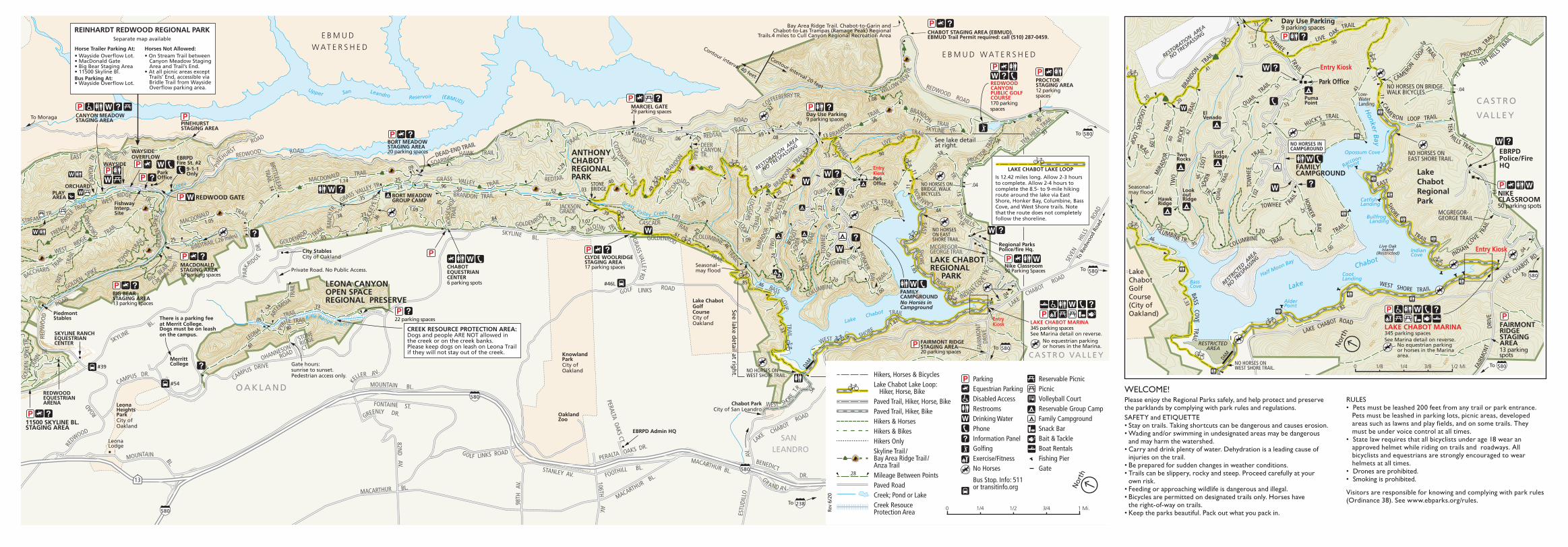
BICYCLE TRAILS Safe use of trails by bicyclists, hikers, and equestrians requires common courtesy and everyone’s cooperation. Trail mileages for most trails are indicated on the map. There are more than 4 miles of paved bicycle trails at Lake Chabot. The Lake Chabot bicycle loop (see map) is 12.42 miles via Live Oak Trail, and 14.41 miles via Honker Bay Trail. All fire roads in the park are open to mountain bikes unless otherwise posted. Narrow, single-track trails are closed to bicycles. State law requires that bicyclists under age 18 wear an approved helmet, and the Park District strongly recommends that all bicyclists and equestrians wear helmets while riding.SKYLINE NATIONAL TRAIL/BAY AREA RIDGE TRAIL These trails share an easement through the park. To complete a third of this 31-mile trail, follow the symbols on the map, which show the route from EBMUD’s Chabot Staging Area north-ward to MacDonald Staging Area on Redwood Road adjacent to Redwood Regional Park. The Skyline Trail extends northwest to Wildcat Canyon Regional Park in Richmond. The Bay Area Ridge Trail begins at Pinole Valley Park in El Sobrante and runs south through vari-ous Regional Parks.EQUESTRIAN CENTERS Chabot Equestrian Center: horse boarding. Call (510) 569-4428. Skyline Ranch Equestrian Center: horse boarding. Call (510) 336-0850.
Anthony ChabotRegional Park
Lake ChabotRegional Park
Leona CanyonOpen Space Regional PreserveOakland, San Leandro, Castro Valley
POLICE, FIRE, MEDICAL EMERGENCY ........................................ ..................................................................... 9-1-1 OR 510-881-1121PARKS POLICE NON-EMERGENCY ...................510-881-1833PARK OFFICE, ANTHONY CHABOT ...........................................................................................1-888-327-2757, option 3, ext. 4502PARK OFFICE, LAKE CHABOT .......................................................................................................1-888-327-2757, option 3, ext. 4536 PICNIC/CAMPING RESERVATIONS ...1-888-327-2757 option 2
Anthony Chabot, Year opened: 1952. Acres: 3,304 Highlights: family, RV and group camping; public golf course, hiking, bicycling, equestrian, picnicking. Did you know? This regional park, originally named Grass Valley Regional Park, was renamed in 1965 after Anthony Chabot, who built the first public water system in San Francisco and Oakland. Lake Chabot, Year opened: 1966. Acres: 1,755 Highlights: reservable picnicking, marina and cafe, fishing, boat rental, cartop watercraft launching, fitness zone, volleyball, horseshoes.Did you know? Lake Chabot has about 9 miles of shoreline and an estimated capacity of 4.1 billion gallons of water.
Fees, Anthony Chabot–Hike-in camping: $25/night. Drive-in camping: $30/night. RV camping: $40/night. Backpack camping: $5/person/night. Camp-ground dog fee: $2/dog/day. Firewood: $8/bundle.Fees, Lake Chabot–Parking: $5/vehicle, $4/trailer, $25/bus. Dog fee: $2/dog/day. Boat inspections: $4. Boat launch: $2. Daily fishing access: $5/day. Boat rental fees: see website. Lake tours: $5/hour/adults, $3/hours/12&under. Guided kayak tour: $45/2.5 hours/adults, $25/2.5 hours/12&under. Charter boat: $85/hours. Volleyball & horseshoe set rental: $5 ($30 deposit).Fees are subject to change. Check ebparks.org for updated fees.
Lake Chabot Marina Area Detail Map
920
300
500
300
300
300
400
500
500
500
400 300
400300
500
700
600
738
800
800
800
600
700
1000
900
700800
900
1047
800
900
1000
1100
1200
700
600
700 500
900
1175
1100
800
600
800
895
800
700600
500
400
500
300
1100
900
800900
800
700
700
600
500 400300
600
700900800
300
300
600
600
800
600
600
600
1000
1000
700
.36
1005
TRAIL
QUAIL TRAIL
TOW
HEE
TR.
HONKER BAY TRAIL
TWO
ROC
KS T
R.
MIR
ADO
R TR
AIL
BRANDON
TRAIL
BR
ANDON
COFFEEBERRY TR.
TRAIL
BRANDON
TOWHEE
LIVE OAK
HUCK’S TRAIL
WILLOW VIEW
BRANDON
TEN H
ILLS T
RAIL
TR.
CAMERON
LOOP
SHO
RE
TRAIL
WEST SHORE
TRAIL
ESCON
DIDO
COTTONTAIL
TRAILCASCADE
BIRD TRAIL (.26 miles)
BIG BEAR
TR.
MACDONALD
BRITTLELEAF
TRAIL
TRAIL
GOLDENROD
GRASS VALLEY
BRANDON TRAIL
REDTAIL
TRAIL REDTAIL T
RAIL
COVE
BASS
GOLDENROD
TOWHEE TR.
SOARING HAWK TRAIL
TRAIL
TR.
TO
YON
WEST RIDGE TR.
TATE
TRAI
L WESTRIDGE FRENCH ORC
HARD
CA
NYON
TR
.EASTRIDGE
TR.
TRAIL
TRAILTRAIL
PYRITE
ARTEMISIA
TRA
IL
GO
LDEN
SPIK
E TR.
GOLDENSPIKE
GOLD
EN S
PIKE
TR.
BACCHARIS T
RAIL
COLUMBINE TRAIL
COLUMBINE
GOLDENROD TR.
TRAIL
MACDONALD
(.38 mile
loop)
GRASS VALLEY TR.
JACKSONGRADE
LEONA
WEST SHORE T
R.
TRAIL
TRAIL
EAST
LOGGERS
TRAI
L
TRAIL
TRAIL
TRAIL
TRAIL TRAI
L
MCGREGOR- GEORGE TRAIL
JALQUIN TR.
SKYLINE TR.
DEER CANYON TR.
DUNN
TRAI
LHO
RSES
HOE
STREAMTR.
INDIAN
COVE T
R.
TR.
DEAD-END TRAIL
TR.
TRAIL
PROCTOR T
RAIL
RANC
HTR.
TRAIL
LOST RIDGE
QUAI
LTR
AIL
B RIDLE
TR.
TRAIL
TR.
TEN HILLSTR.LOOP
BUCK
EYE
TR.
SEVE
N
HILL
S
RO
AD
LAKE
CHABOT ROAD
ESTU
DILL
O
LAKE CHABOT
AV.
150TH AV.
BANCROFT AV. E.14TH ST.
98TH
AV
.
ROAD
GRASS VALLEY RD.
SKYLINE
GR AND A V.
FOOTHILL BL. STANLEY AV.
PERALTA OAKS CT.
AV.106THMACARTHUR BL.
KE
LLER
REDWOOD ROAD
PARK
RIDGE D
R.
RE
DWOOD
ROAD
REDWOOD ROAD
PINE
HURST
STONE
RIDGE
CT.
OHANNESONROAD
BL.
SKYLINE
ROAD
MOUNTAIN
BL.
FONTAINE
DR.
BENEDICT
ST.
MACARTHUR BL.
BL.
REDW
OO
D
ROAD
CAMPUS DR.
MOUNTAIN
LINKS
ROAD
PERALTA OAKS DR.
BL.
GOLF
LINKS ROAD GOLF
MARCIELROAD
MACARTHUR BL.
AV.
ROAD
CAMPUS DRIVE
DRI
VEFA
IRM
ON
T
82ND
AV.
GREENLY DR.
13 185
580
580
580
238
580
580
580
Redwood
Creek
Grass Creek
Upper San Leandro Reservoir (EBMUD)
Valley
Lake Chabot
Ri�e Range Branch
.25
1.05
.11
1.14
.09
.35
.65
.36
.35
.50.96
1.29
.66
.52 .03.40
.39
1.32 .18
.55
.61 .25
1.03
.46
.85
.37
.23
.45
.06
.36
1.39
.69
.42
.08
.40
.13
.27
.59
1.09
.08.20
.41
.60 .3
8 .07.22
.15
.28
.25
.46
1.00
.58
.55
.43
.90
.56 1.11
1.08
.45
.56
.93
.13
.58
.11
.44 .38
1.65
.04
.56
1.821.33
.54 .73
.05
1.20
.95
.80
.61
.14 .51
.15.49 .04
.73
.11
.13
.38
.24.25
.231.09
.84
.801.07
.33
1.02
.36 .26
.24
.09
CHABOT STAGING AREA (EBMUD).EBMUD Trail Permit required: call (510) 287-0459.
EBRPD Admin HQ
Regional Parks Police/�re Hq.
NO HORSES ON BRIDGE. WALK BICYCLES.
Bay Area Ridge Trail. Chabot-to-Garin and Chabot-to-Las Trampas (Ramage Peak) Regional
Trails.4 miles to Cull Canyon Regional Recreation Area
STONE BRIDGE
MerrittCollege
OaklandZoo
Seasonal–may �ood
SKYLINE RANCH EQUESTRIAN CENTER
City StablesCity of Oakland
EBRPD Fire St. #2
9-1-1 OnlyPark
Of�ce
WAYSIDEEntry KioskPark Of�ce
SANLEANDRO
O A K L A N D
Chabot Park City of San Leandro
Leona HeightsPark City of Oakland
To Moraga CANYON MEADOW STAGING AREA
KnowlandPark City of Oakland
LeonaLodge
To
To
Is 12.42 miles long. Allow 2-3 hours to complete. Allow 2-4 hours to complete the 8.5- to 9-mile hiking route around the lake via East Shore, Honker Bay, Columbine, Bass Cove, and West Shore trails. Note that the route does not completely follow the shoreline.
LEONA CANYON OPEN SPACE REGIONAL PRESERVE Lake Chabot
GolfCourseCity of Oakland
To
REDWOODEQUESTRIANARENA
PiedmontStables
FAMILY CAMPGROUNDNo Horses in Campground
See lake detail at right.
PINEHURST STAGING AREA
Horse Trailer Parking At:• Wayside Over�ow Lot.• MacDonald Gate• Big Bear Staging Area• 11500 Skyline Bl.Bus Parking At:• Wayside Over�ow Lot.
Horses Not Allowed:• On Stream Trail between Canyon Meadow Staging Area and Trail’s End.• At all picnic areas except Trails’ End, accessible via Bridle Trail from Wayside Over�ow parking area.
REINHARDT REDWOOD REGIONAL PARKSeparate map available
ANTHONYCHABOT REGIONAL PARK
To
LAKE CHABOT LAKE LOOP
NO HORSES ON WEST SHORE TRAIL.
NO HORSES ON EAST SHORE TRAIL.
ORCHARDPLAYAREA
See lake detailat right.
There is a parking feeat Merrit College.Dogs must be on leash on the campus.
Gate hours:sunrise to sunset.Pedestrian access only.
To R
edw
ood
Road
LAKE CHABOTREGIONAL PARK
BORT MEADOW GROUP CAMP
Private Road. No Public Access.
#39
RESTORATIO
N AREA
NO TRESPASSI
NG
CREEK RESOURCE PROTECTION AREA: Dogs and people ARE NOT allowed in the creek or on the creek banks. Please keep dogs on leash on Leona Trailif they will not stay out of the creek. C A S T R O VA L L E Y
See lake detail at rig
ht.
FishwayInterp. Site
REDWOOD GATE
11500 SKYLINE BL. STAGING AREA
WAYSIDEOVERFLOW
Contour interval 20 feet
Contour interval 40 feet
DAM
E B M U D
W AT E R S H E DE B M U D W AT E R S H E D
170 parking spaces
REDWOODCANYONPUBLIC GOLF COURSE
PROCTOR STAGING AREA12 parking spaces
CLYDE WOOLRIDGE STAGING AREA17 parking spaces
BORT MEADOW STAGING AREA20 parking spaces
Day Use Parking9 parking spaces
#54
#46L
MARCIEL GATE29 parking spaces
MACDONALD STAGING AREA12 parking spaces
BIG BEAR STAGING AREA13 parking spaces
CHABOT EQUESTRIANCENTER6 parking spots
22 parking spaces LAKE CHABOT MARINA345 parking spacesSee Marina detail on reverse. No equestrian parking or horses in the Marina.
Nike Classroom50 Parking Spaces
FAIRMONT RIDGE STAGING AREA20 parking spaces
Entry Kiosk
Hikers, Horses & BicyclesLake Chabot Lake Loop: Hiker, Horse, BikePaved Trail, Hiker, Horse, BikePaved Trail, Hiker, BikeHikers & HorsesHikers & BikesHikers OnlySkyline Trail / Bay Area Ridge Trail /Anza TrailMileage Between PointsPaved RoadCreek; Pond or LakeCreek Resouce Protection Area
ParkingEquestrian ParkingDisabled AccessRestroomsDrinking WaterPhoneInformation PanelGol�ngExercise/FitnessNo Horses
Bus Stop. Info: 511 or transitinfo.org
Reservable PicnicPicnicVolleyball CourtReservable Group CampFamily CampgroundSnack BarBait & Tackle Boat RentalsFishing Pier Gate
.28
0 1 Mi.1/4 3/41/2
Nor
th
Rev
6/20
920
300
500
300
300
300
400
500
500
500
400 300
400
700
600
738
500
400
500
600
300
300
600
600
QUAILTR
AIL
TOW
HEE
TRAIL
HON
KER
TRAIL
TWO
ROCK
STR
AIL
MIR
ADO
RTR
AIL
HUCK’S TRAIL
SHORE
TRAIL
TOWHEE TRAIL
COLUMBINE
LOGGERS
LOOP
INDIA N
CO
VE TRAIL
WEST SHORE TRAIL
MCGREGOR- GEORGE TRAIL
NO HORSES ON EAST SHORE TRAIL.
TENH ILLS TRAIL
CAMERON
LOOP
CAMERON LOOP TRAIL
TENHILL
S
TRAILLIVE OAK
TRAIL
TOW
HEE
TRAIL
BRAN
DON
TRAIL
TRAIL1.09
1.02
1.20
BAY
CO
LUMBINE TR.
BASSCO
VETRAIL
EAST
PROCTO R
TR
AIL
LOST
TR.
RIDGE
TRAIL
TRAIL
LAKE CHABOT RD.
FAIR
MON
T
LAKE CHABOT ROAD
DRIV
E
To 580
580
Lake
Chabot
BassCove
AlderPoint
CootLanding
IndianCove
Bullfrog Landing
Cat�shLanding
Honker
Bay
Opossum Cove
Half Moon Bay
Raccoon
Point
.13
.27
.20.20
.41
.60 .6
2 .15
.22
.28
.25
.46
1.00
.58
.55
.43
.90
.13
.58
.11
.44.38
1.65
.04
1.82
1.33
.95
.51
.15
.04
.73
.11
.13
PumaPoint
.07
QUAI
LTR
AIL.36 .26
Park Of�ce
NO HORSES ON WEST SHORE TRAIL.
DAM
NO HORSES ON BRIDGE.WALK BICYCLES.
El Venado
Lost RidgeTwo
Rocks
HawkRidge
LookoutRidge
Seasonal–may �ood
To
Live OakIsland
(Restricted)
Low-WaterLanding
RESTRICTEDAREA
RESTR
ICTE
D AREA
NO TRES
PASS
ING
NO HORSES INCAMPGROUND
LAKE CHABOT MARINA345 parking spacesSee Marina detail on reverse. No equestrian parking or horses in the Marina area.
Lake Chabot Regional Park
LakeChabotGolfCourse(City ofOakland)
C A S T R O
VA L L E Y
RESTORATIO
N AREA
NO TRESPASSI
NG9 parking spacesDay Use Parking
FAMILY CAMPGROUND
EBRPD Police/Fire HQ
NIKE CLASSROOM50 parking spots
FAIRMONTRIDGESTAGINGAREA 13 parking spots
Entry Kiosk
Entry Kiosk
0 1/2 Mi.1/8 3/81/4
Nor
th
WELCOME!Please enjoy the Regional Parks safely, and help protect and preserve the parklands by complying with park rules and regulations.SAFETY and ETIQUETTE• Stay on trails. Taking shortcuts can be dangerous and causes erosion. • Wading and/or swimming in undesignated areas may be dangerous and may harm the watershed.• Carry and drink plenty of water. Dehydration is a leading cause of injuries on the trail. • Be prepared for sudden changes in weather conditions. • Trails can be slippery, rocky and steep. Proceed carefully at your own risk. • Feeding or approaching wildlife is dangerous and illegal.• Bicycles are permitted on designated trails only. Horses have the right-of-way on trails. • Keep the parks beautiful. Pack out what you pack in.
RULES• Pets must be leashed 200 feet from any trail or park entrance. Pets must be leashed in parking lots, picnic areas, developed areas such as lawns and play fields, and on some trails. They must be under voice control at all times.• State law requires that all bicyclists under age 18 wear an approved helmet while riding on trails and roadways. All bicyclists and equestrians are strongly encouraged to wear helmets at all times.• Drones are prohibited.• Smoking is prohibited.
Visitors are responsible for knowing and complying with park rules (Ordinance 38). See www.ebparks.org/rules.