recognition and importance of amalgamated sandy meander...
TRANSCRIPT

GEOLOGY | Volume 43 | Number 8 | www.gsapubs.org 1
Recognition and importance of amalgamated sandy meander belts in the continental rock recordAdrian J. Hartley1, Amanda Owen1, Alistair Swan1, Gary S. Weissmann2, Barbara I. Holzweber1*, John Howell1, Gary Nichols3, and Louis Scuderi2
1Department of Geology and Petroleum Geology, University of Aberdeen, Aberdeen AB24 3UE, UK2University of New Mexico, Department of Earth and Planetary Sciences, MSC03 2040, Albuquerque, New Mexico 87131-0001, USA 3Nautilus Ltd., Ashfields Farm Industrial Estate, Priors Court Road, Hermitage, Berkshire RG18 9XY, UK
ABSTRACTMeandering fluvial channels and their meander belts are common in modern continental
sedimentary basins, yet compose a minor constituent of the reported fluvial rock record. Here we document exhumed amalgamated meander belt deposits from the upper Jurassic Mor-rison Formation, Utah (United States). The size of the amalgamated meander belt (9000 km2) is significantly larger than any documented previously and comparable in size to those from modern sedimentary basins. We describe a representative outcrop of sandy point bar deposits that shows features considered characteristic of both braided and meandering fluvial systems. Lateral accretion sets compose <5% of the outcrop area, yet point bar morphology is clearly visible in plan view. We suggest that difficulties in the identification of sandy, amalgamated meander belt deposits indicate that they have gone largely unrecognized in the rock record. Their recognition has important implications for basin-scale reconstructions of fluvial systems and interpretation of tectonic setting.
INTRODUCTIONRecognition of fluvial channel plan form in
the rock record is important because it is thought to control sandstone body shape, dimensions, connectivity, and internal heterogeneity (e.g., King, 1990; Bridge, 1993). For example, it is generally considered that braided rivers produce laterally extensive, amalgamated, sheet-like sandstone bodies with limited internal heteroge-neity (e.g., Moody-Stuart, 1966; Cant, 1982; Al-len, 1983; Friend, 1983; Gibling, 2006), whereas meandering channels produce relatively small, isolated to poorly connected sandstone bod-ies with a high degree of internal heterogeneity (Cant, 1982; Galloway and Hobday, 1996). The distinction between braided and meandering channel types is commonly made in the sedi-mentological literature, and many text books rec-ognize these two types as distinct end members with characteristic facies and facies associations (Galloway and Hobday, 1996). However, others have recognized a continuum between channel types and considerable overlap in facies (Jack-son, 1978; Bridge, 1985).
Gibling (2006), in an extensive review of fluvial deposits, concluded that braided channel deposits dominate the rock record and that me-andering river deposits form only a minor con-stituent. This braided river dominance of the rock record is somewhat surprising given that close to 50% of large distributive fluvial systems (DFSs) in modern sedimentary basins are dominated by meandering channels (Hartley et al., 2010). In ad-dition, axial river systems in many sedimentary
basins display a meandering plan form (e.g., Par-aguay-Paraná Basin, South America; Po River, Italy; Rhine River, Europe; Ebro River, Spain), as do most marine connected coastal plain and distributary channels, particularly along passive margins (e.g., Zambezi and Niger Rivers, Africa; Volga and Ural Rivers, Russia; Gulf of Mexico, North America). This suggests that either modern channel plan form types within actively aggrad-ing sedimentary basins are not representative of the rock record or that meandering channel sys-tems are not recognized.
Here we map the lateral extent of an amal-gamated meander belt in the Salt Wash fluvial system of the Morrison Formation, Utah (west-
ern USA), using satellite imagery and outcrop field studies. The system is significantly larger than any previously documented amalgamated meander belt and is similar in size to those of modern continental sedimentary basins. We de-scribe a representative outcrop of the meander belt that allows both plan form and vertical fa-cies relationships of a laterally extensive, sandy, amalgamated meandering channel complex to be determined. Plan form observations provide clear evidence for deposition from a meander-ing system, but the characteristics of vertical outcrop faces match previous descriptions of deposits by a braided fluvial system.
STUDY AREAThe Salt Wash fluvial system Morrison For-
mation comprises the Salt Wash and Tidwell Members of the upper Jurassic (Kimmeridgian). The deposits are exposed in south-central Utah and western Colorado (Fig. 1). They are as thick as 160 m, have low bed dips (mostly <10°) and are largely unfaulted. The succession is inter-preted to represent a large DFS that flowed in a north to northeast direction (Fig. 1; Craig et al., 1956; Mullens and Freeman, 1957; Owen et al., 2015a, 2015b). The system comprises large-scale amalgamated channel belt deposits that can ex-tend tens of kilometers laterally in the proximal
*Current address: Exploration Reservoir Con-sultants (ERCL), Dragon Court, 15 Station Road, Henley-on-Thames, Oxon RG9 1AT, UK.
GEOLOGY, August 2015; v. 43; no. 8; p. 1–4 | doi:10.1130/G36743.1 | Published online XX Month 2015
© 2015 Geological Society of America. For permission to copy, contact [email protected].
Figure 1. Location map showing approximate extent of Salt Wash distributive fluvial system (DFS) (Morrison Formation, southwestern USA) and identified meander belt. Yellow dots and gray letters show location of examples in Figure 2.

2 www.gsapubs.org | Volume 43 | Number 8 | GEOLOGY
region. Downstream, channel belts pass progres-sively into floodplain facies composed of poorly developed paleosols, ribbon channels, and minor lacustrine units (Owen et al., 2015b).
The meander belt is exposed on both flanks of the San Rafael Swell and extends south into the Henry Mountain area (Fig. 1). Outcrop locations displaying meander belt features in plan view are shown in Figures 1 and 2. Meander belt de-posits are identified in plan view on the basis of a combination of (1) curvature of beds between 90° and 180° that display geometries indicative of scroll bars such as internal truncation and subtle thickening and thinning, (2) curved beds dipping at an oblique angle to regional bedding, and (3) curved bed dips truncated against either adjacent scroll or channel deposits. Identifica-tion is restricted to relatively flat and planar bed surfaces in order to avoid ambiguity associated with outcrops modified by erosion. The major-ity of the preserved meander bend deposits occur within the upper 10 m of the Salt Wash Member, and although they cannot be constrained to be time equivalent, they probably represent indi-vidual channel belts that have become amalgam-ated both vertically and laterally through time. Although subject to postdepositional erosion, it seems reasonable to assume that the amalgam-ated meander belt deposits extended across this entire part of the DFS (140 km long, 80 km wide), covering at least 9000 km2.
We describe a representative point bar com-plex from an outcrop north of Caineville (Figs. 1 and 2), where it is possible to relate directly the preserved plan view geomorphology of a series of amalgamated point bar deposits to vertical out-crop faces. In plan view (Fig. 3A) the partially preserved scroll bar morphology is clearly vis-ible and the paleocurrent data from trough cross-strata trend oblique to parallel to scroll bar edges and curve for more than 180°. Trough cross-strata dominate the plan view perspective, accounting for >95% of the exposure. Scroll bar contacts are
represented by erosion surfaces that dip between 5° and 20° in either a downstream, orthogonal, or upstream direction relative to the direction of im-mediately adjacent trough cross-strata.
Figure 3 shows a single 6–8-m-thick story that cuts into underlying strata. The basal erosion surface is overlain by a pebble lag, often with mudstone intraclasts, that is in turn overlain by a series of pebbly and coarse- to medium-grained, poorly sorted sandstone displaying trough cross-strata with set heights of as much as 1 m. Sets are normally close to horizontal, although some dip 5°–10° in the same direction as the trough cross-strata. In the vertical panels occasional large-scale erosion surfaces (4–6 m in height)
truncate packages of trough cross-strata and are often overlain by parallel-dipping packages of sandstone as much as 1 m thick that scale to the same height as the story. Each erosion-surface bounded package comprises trough cross-strata, which show systematic changes in paleoflow of >180° when traced laterally around the outcrop (Fig. 3). The difference in direction between the dip of the erosion surface and the dip of the trough cross-strata varies from 0° to 35°.
The outcrop (Fig. 3) is interpreted to record the development of a bank-attached bar with trough cross-strata representing unit bars. Ar-cuate paleoflow trends that are close to paral-lel to the erosional bounding surfaces indicate
Figure 2. Examples of point bars and meander belts. Locations are shown in Figure 1. A: 38°24′21.41″N, 111°0′34.68″W. B: 38°50′9.90″N, 110°6′30.39″W. C: 39°10′15.43″N, 110° 51′57.86″W. D: 38°24′12.13″N, 111°2′6.59″W. Dashed box shows area of Figure 3.
Figure 3. A: Interpreted Google Earth® image of the Caineville (Utah, USA) exposure. Location is in Figure 3D. Black arrows—orientations of individual trough cross-strata; red arrows—trains of trough cross-strata. Rose diagram shows both cross-strata types. Note up-bar–verging paleoflow. White lines represent scroll bar bounding surfaces. B, C: Interpreted photopanels (locations in blue in A).

GEOLOGY | Volume 43 | Number 8 | www.gsapubs.org 3
that the unit bars form part of larger scale scroll bars defined by erosional bounding surfaces. The bounding surfaces are interpreted to record periods when point bar accretion was modified during waning flood and low-flow stage. Sand-stone packages paralleling the erosion surfaces are interpreted as lateral accretion deposits
DISCUSSIONThe ability to relate vertical sections and
planform exposures on the described outcrop highlights difficulties in recognizing sandy me-andering fluvial systems using standard vertical sedimentary logging techniques. The lack of a well-developed fining-upward motif, dominance of cross-strata, internal erosion surfaces, pres-ence of mudstone intraclasts, and lack of inter-bedded mud are widely recognized characteris-tics of both coarse-grained meandering (Jackson, 1978; Bridge, 1985) and braided (Cant, 1978; Bridge, 1985) channel deposits. Distinction be-tween the two planform types based on vertical logs is particularly difficult. As noted by Davies and Gibling (2010), the key criterion for distinc-tion between braided and meandering systems is the recognition of lateral accretion sets. If these cannot be identified, then an interpretation of a meandering channel deposit is difficult to justify.
Lateral accretion deposits make up <5% of the total Caineville outcrop area and are repre-sented by strata that show no significant grain-size change and display a dip direction similar to that of adjacent trough cross-strata, features normally considered characteristic of braid bar deposits (e.g., Bristow, 1993; Best et al., 2003). Even with exceptional vertical exposure, with-out a plan view perspective it would be difficult to identify these sandstones as point bar depos-its. Previous interpretations of the Salt Wash
Member from this and adjacent study areas have suggested a braided system (Peterson, 1984; Robinson and McCabe, 1998).
Given the problems of recognizing sandy meandering fluvial deposits in outcrop, it will be particularly difficult to recognize these sys-tems in the subsurface (Fralick and Zaniewski, 2012). Core-based studies and borehole imag-ing techniques are unlikely to be able to iden-tify the large-scale dipping surfaces that would allow recognition of lateral accretion sets. Con-sequently, it is likely that meandering channel systems are misinterpreted and significantly underrepresented in subsurface studies of sandy fluvial systems that are restricted to core, wire-line, and borehole image data. Meandering flu-vial channel geometries can sometimes be dif-ferentiated on seismic horizon slice amplitude displays (e.g., Carter, 2003), but documented ex-amples are encased within floodplain sediments and contain significant proportions of mudstone.
It is commonly assumed that amalgam-ated sheet-like sandstone bodies are formed by braided fluvial systems (e.g., Allen, 1983; Robinson and McCabe, 1998; Gibling, 2006). For example, Gibling (2006) considered that mobile-channel belts are mainly the deposits of braided and low-sinuosity rivers, and suggested that their overwhelming dominance throughout geological time reflects their link to tectonic activity, exhumation events, and high sediment supply. In contrast, Gibling (2006) noted that meandering river bodies are normally <38 m thick and <15 km wide, and considered the organized flow conditions necessary for their development to have been unusual, because they do not appear to have built basin-scale de-posits. This appears at odds with observations from many modern continental sedimentary ba-
sins that are dominated by meandering fluvial systems, particularly in their more distal parts (Davies and Gibling, 2010; Hartley et al., 2010). This evidence suggests that the deposits of me-andering fluvial systems could potentially form a significant proportion of the sedimentary re-cord if preserved.
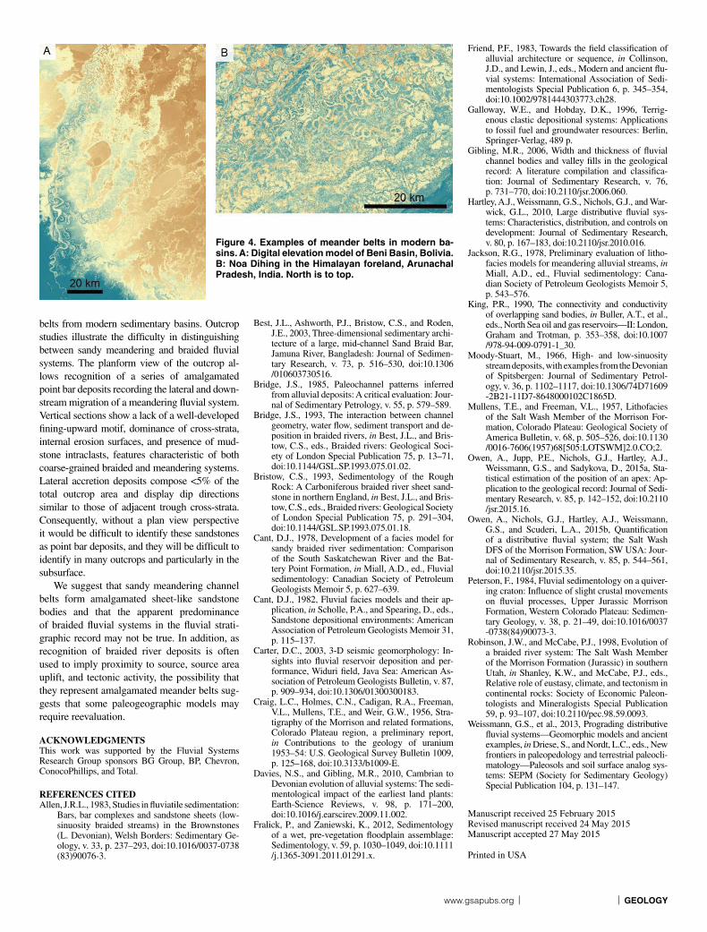
Analysis of satellite imagery from modern sedimentary basins (Table 1; Fig. 4) reveals a range of amalgamated meandering channel belts with dimensions that are comparable to those of the Salt Wash Member example. We document 16 examples here, located primarily in foreland basins, but also in rift (Okavango, East Africa) and passive margin (Ganges, India) settings, as well as valley confined systems developed along passive margins (Paraná, South America; Mississippi, USA). The amalgamated meander belts occur as part of distributive fluvial or axial fluvial systems, where meander belt deposits on DFS display a laterally extensive amalgamated form that results from channel-belt switching across the DFS (e.g., Weissmann et al., 2013). The location of the majority of these meander belts within actively subsiding sedimentary ba-sins suggests that they have significant preser-vation potential at a basin scale. The possibil-ity that sheet-like sandstones can be formed by amalgamated meander belts some distance from the basin margin has important implications for basin-scale reconstructions of fluvial systems.
CONCLUSIONSAn exhumed amalgamated meander belt can
be mapped over an area of 9000 km2 in the Salt Wash DFS of the Morrison Formation in south-eastern Utah. This represents one of the largest known exhumed amalgamated meander belts and is comparable in size to amalgamated meander
TABLE 1. MEANDER BELT DIMENSIONS FROM MODERN BASINS AND PASSIVE MARGINS
Location Tectonic setting Fluvial system Area(km2)
Maximum length (km2)
Maximum width (km2)
Lat Long
Beni Basin, Bolivia Foreland basin (retroarc) Single DFS 9387 125 100 13°48′8.49″S 67°9′46.38″WUcumara depression, Peru Foreland basin (retroarc) DFS–axial (degradational) 49529 330 180 5°37′43.24″S 75°0′5.78″WArauca Basin, Colombia and
VenezuelaForeland basin (retroarc) DFS 14381 214 75 7°20′22.49″N 70°55′37.71″W
Pilcomayo, Argentina and Paraguay
Foreland basin (retroarc) Single DFS 10012 151 80 22°53′29.88″S 62°17′3.78″W
Bermejo, Argentina Foreland basin (retroarc) Single DFS 11812 271 60 23°59′50.48″S 62°49′14.79″WNoa Dihing, India Foreland basin Amalgamated DFS 7444 73 160 27°18′20.82″N 95°11′5.48″EGandak, India Foreland basin DFS to axial 4359 122 40 26°35′51.50″N 84°48′14.95″EGhagara, India Foreland basin DFS to axial 11317 250 50 27°15′39.52″N 81°37′10.42″EGanges, India Foreland and/or passive
marginDFS—upper delta plain 22532 212 130 23°32′39.90″N 88°47′24.84″E
Indus, Pakistan Foreland basin Single DFS 8335 80 150 24°44′12.73″N 68°23′24.69″EIli-1, Kazakhstan Foreland basin Single DFS 6302 181 40 45°53′0.83″N 75°29′53.43″EIli-2, Kazakhstan Foreland basin Single DFS 7024 180 60 45°31′5.64″N 74°47′22.72″EOkavango, Zimbabwe Incipient rift Single DFS 7659 115 85 19°17′51.24″S 22°43′18.51″EMississippi, USA Passive margin Valley constrained 20894 250 110 33°21′11.33″N 90°45′0.55″WParagay, Paraguay and Brazil Backbulge—craton Axial DFS 8380 210 75 20°21′28.48″S 57°51′23.67″WParana, Argentina Craton–passive margin Axial (valley constrained) 6393 180 45 33°12′46.35″S 59°57′30.85″WSalt Wash, Utah, USA Foreland and/or backbulge Single DFS 9314 140 80 38°49′30.33″N 110°40′44.75″W
Note: Lat and long coordinates indicate the center of the meander belt. DFS—distributive fluvial system.
4 www.gsapubs.org | Volume 43 | Number 8 | GEOLOGY
belts from modern sedimentary basins. Outcrop studies illustrate the difficulty in distinguishing between sandy meandering and braided fluvial systems. The planform view of the outcrop al-lows recognition of a series of amalgamated point bar deposits recording the lateral and down-stream migration of a meandering fluvial system. Vertical sections show a lack of a well-developed fining-upward motif, dominance of cross-strata, internal erosion surfaces, and presence of mud-stone intraclasts, features characteristic of both coarse-grained braided and meandering systems. Lateral accretion deposits compose <5% of the total outcrop area and display dip directions similar to those of adjacent trough cross-strata. Consequently, without a plan view perspective it would be difficult to identify these sandstones as point bar deposits, and they will be difficult to identify in many outcrops and particularly in the subsurface.
We suggest that sandy meandering channel belts form amalgamated sheet-like sandstone bodies and that the apparent predominance of braided fluvial systems in the fluvial strati-graphic record may not be true. In addition, as recognition of braided river deposits is often used to imply proximity to source, source area uplift, and tectonic activity, the possibility that they represent amalgamated meander belts sug-gests that some paleogeographic models may require reevaluation.
ACKNOWLEDGMENTSThis work was supported by the Fluvial Systems Research Group sponsors BG Group, BP, Chevron, ConocoPhillips, and Total.
REFERENCES CITEDAllen, J.R.L., 1983, Studies in fluviatile sedimentation:
Bars, bar complexes and sandstone sheets (low-sinuosity braided streams) in the Brownstones (L. Devonian), Welsh Borders: Sedimentary Ge-ology, v. 33, p. 237–293, doi:10.1016/0037 -0738 (83) 90076-3.
Best, J.L., Ashworth, P.J., Bristow, C.S., and Roden, J.E., 2003, Three-dimensional sedimentary archi-tecture of a large, mid-channel Sand Braid Bar, Jamuna River, Bangladesh: Journal of Sedimen-tary Research, v. 73, p. 516–530, doi: 10.1306 /010603730516.
Bridge, J.S., 1985, Paleochannel patterns inferred from alluvial deposits: A critical evaluation: Jour-nal of Sedimentary Petrology, v. 55, p. 579–589.
Bridge, J.S., 1993, The interaction between channel geometry, water flow, sediment transport and de-position in braided rivers, in Best, J.L., and Bris-tow, C.S., eds., Braided rivers: Geological Soci-ety of London Special Publication 75, p. 13–71, doi: 10.1144 /GSL .SP .1993 .075.01.02.
Bristow, C.S., 1993, Sedimentology of the Rough Rock: A Carboniferous braided river sheet sand-stone in northern England, in Best, J.L., and Bris-tow, C.S., eds., Braided rivers: Geological Society of London Special Publication 75, p. 291–304, doi: 10.1144 /GSL.SP.1993.075.01.18.
Cant, D.J., 1978, Development of a facies model for sandy braided river sedimentation: Comparison of the South Saskatchewan River and the Bat-tery Point Formation, in Miall, A.D., ed., Fluvial sedimentology: Canadian Society of Petroleum Geologists Memoir 5, p. 627–639.
Cant, D.J., 1982, Fluvial facies models and their ap-plication, in Scholle, P.A., and Spearing, D., eds., Sandstone depositional environments: American Association of Petroleum Geologists Memoir 31, p. 115–137.
Carter, D.C., 2003, 3-D seismic geomorphology: In-sights into fluvial reservoir deposition and per-formance, Widuri field, Java Sea: American As-sociation of Petroleum Geologists Bulletin, v. 87, p. 909–934, doi:10.1306/01300300183.
Craig, L.C., Holmes, C.N., Cadigan, R.A., Freeman, V.L., Mullens, T.E., and Weir, G.W., 1956, Stra-tigraphy of the Morrison and related formations, Colorado Plateau region, a preliminary report, in Contributions to the geology of uranium 1953–54: U.S. Geological Survey Bulletin 1009, p. 125–168, doi:10.3133/b1009-E.
Davies, N.S., and Gibling, M.R., 2010, Cambrian to Devonian evolution of alluvial systems: The sedi-mentological impact of the earliest land plants: Earth-Science Reviews, v. 98, p. 171–200, doi:10.1016/j.earscirev.2009.11.002.
Fralick, P., and Zaniewski, K., 2012, Sedimentology of a wet, pre-vegetation floodplain assemblage: Sedimentology, v. 59, p. 1030–1049, doi: 10.1111 /j .1365 -3091 .2011 .01291.x.
Friend, P.F., 1983, Towards the field classification of alluvial architecture or sequence, in Collinson, J.D., and Lewin, J., eds., Modern and ancient flu-vial systems: International Association of Sedi-mentologists Special Publication 6, p. 345–354, doi: 10.1002 /9781444303773.ch28.
Galloway, W.E., and Hobday, D.K., 1996, Terrig-enous clastic depositional systems: Applications to fossil fuel and groundwater resources: Berlin, Springer-Verlag, 489 p.
Gibling, M.R., 2006, Width and thickness of fluvial channel bodies and valley fills in the geological record: A literature compilation and classifica-tion: Journal of Sedimentary Research, v. 76, p. 731–770, doi:10.2110/jsr.2006.060.
Hartley, A.J., Weissmann, G.S., Nichols, G.J., and War-wick, G.L., 2010, Large distributive fluvial sys-tems: Characteristics, distribution, and controls on development: Journal of Sedimentary Research, v. 80, p. 167–183, doi:10.2110 /jsr .2010 .016.
Jackson, R.G., 1978, Preliminary evaluation of litho-facies models for meandering alluvial streams, in Miall, A.D., ed., Fluvial sedimentology: Cana-dian Society of Petroleum Geologists Memoir 5, p. 543–576.
King, P.R., 1990, The connectivity and conductivity of overlapping sand bodies, in Buller, A.T., et al., eds., North Sea oil and gas reservoirs—II: London, Graham and Trotman, p. 353–358, doi: 10.1007 /978 -94 -009 -0791 -1_30.
Moody-Stuart, M., 1966, High- and low-sinuosity stream deposits, with examples from the Devonian of Spitsbergen: Journal of Sedimentary Petrol-ogy, v. 36, p. 1102–1117, doi:10.1306/74D71609 -2B21 -11D7 -8648000102C1865D.
Mullens, T.E., and Freeman, V.L., 1957, Lithofacies of the Salt Wash Member of the Morrison For-mation, Colorado Plateau: Geological Society of America Bulletin, v. 68, p. 505–526, doi: 10.1130 /0016-7606(1957)68[505:LOTSWM]2.0.CO;2.
Owen, A., Jupp, P.E., Nichols, G.J., Hartley, A.J., Weissmann, G.S., and Sadykova, D., 2015a, Sta-tistical estimation of the position of an apex: Ap-plication to the geological record: Journal of Sedi-mentary Research, v. 85, p. 142–152, doi: 10.2110 /jsr .2015.16.
Owen, A., Nichols, G.J., Hartley, A.J., Weissmann, G.S., and Scuderi, L.A., 2015b, Quantification of a distributive fluvial system; the Salt Wash DFS of the Morrison Formation, SW USA: Jour-nal of Sedimentary Research, v. 85, p. 544–561, doi:10.2110/jsr.2015.35.
Peterson, F., 1984, Fluvial sedimentology on a quiver-ing craton: Influence of slight crustal movements on fluvial processes, Upper Jurassic Morrison Formation, Western Colorado Plateau: Sedimen-tary Geology, v. 38, p. 21–49, doi:10.1016/0037 -0738 (84) 90073-3.
Robinson, J.W., and McCabe, P.J., 1998, Evolution of a braided river system: The Salt Wash Member of the Morrison Formation (Jurassic) in southern Utah, in Shanley, K.W., and McCabe, P.J., eds., Relative role of eustasy, climate, and tectonism in continental rocks: Society of Economic Paleon-tologists and Mineralogists Special Publication 59, p. 93–107, doi:10.2110/pec.98.59.0093.
Weissmann, G.S., et al., 2013, Prograding distributive fluvial systems—Geomorphic models and ancient examples, in Driese, S., and Nordt, L.C., eds., New frontiers in paleopedology and terrestrial paleocli-matology—Paleosols and soil surface analog sys-tems: SEPM (Society for Sedimentary Geology) Special Publication 104, p. 131–147.
Manuscript received 25 February 2015 Revised manuscript received 24 May 2015 Manuscript accepted 27 May 2015
Printed in USA
Figure 4. Examples of meander belts in modern ba-sins. A: Digital elevation model of Beni Basin, Bolivia. B: Noa Dihing in the Himalayan foreland, Arunachal Pradesh, India. North is to top.