recommendation - london borough of barnet off high road... · location land off high road/chandos...
TRANSCRIPT

Location Land Off High Road/Chandos Avenue, London N20 And Bretheren
Meeting Hall & Well Grove School, Well Grove, London, N20
Reference:
B/05370/14
Received: Andrew Dillon
Accepted: 1st October 2014
Ward: Oakleigh Expiry 31st December 2014
Applicant: David Wilson North Thames
Proposal: Section 73 material amendment application to vary condition 1 (Approved Plans), condition 5 (Compliance with Approved Plans) and condition 34 (Restricted Use Office/Community Building) pursuant to planning permission B/03068/11 dated 29/03/2012 for 'Demolition of existing buildings and redevelopment comprising of 70no dwellings (62no houses and 8no flats). Erection of 512sqm building for use class D1 purposes (Non-Residential Institution). Provision of associated car parking, landscaping and open space. Use of existing accesses from High Road and Well Grove. (Outline Application)' Amendments to include: Amendment to Description of Development to read 'Demolition of existing buildings and redevelopment comprising of 70 dwellings (60 no houses and 10 no flats). Erection of 512sqm building for use class D1 purposes (Non-Residential Institution). Provision of associated car parking, landscaping and open space. Use of existing accesses from High Road and Well Grove. (Outline Application)'; Updated List of approved plans listed in conditions 1 and 5; Alteration to wording of Condition 34 to include Children's Nursery within the permitted Use Class D1 uses that can occupy the Community Hub building; Alterations to plans contained within the S106 Agreement showing the proposed Public Open Space and Community Hub Land.
APPLICATION SUMMARY The application relates to a site in Whetstone located to the rear of Travelodge and Marks and Spencer which is accessed from the High Road and via Well Grove from Chandos Avenue. The site was owned by the Haringey Gospel Hall Trust (HGHT) who are a charitable trust linked to the Christian Brethren. Outline planning permission (reference B/03068/11) was granted on the 29th March 2012 for the redevelopment of the site to provide 70 residential dwellings (62no houses and 8no flats), along with the erection of a 512sqm building for use class D1 purposes (Non-Residential Institution), utilising the existing accesses from High Road and Well Grove. The site has recently been bought by David Wilson Homes, part of the Barratt Group, who are seeking to implement the planning permission. This application seeks approval for a material minor amendment under S73 of the Town and Country Planning Act 1990 to the outline planning permission (reference B/03068/11) approved on 29/03/2012 for the redevelopment of the site for housing and a community building. The changes proposed under the current application are as follows:
• Change of Description of development from

• Alterations to list of approved plans listed under Conditions 1 (Approved Plans) and 5 (Reserved Matters).
• Alterations to wording of Condition 34 (Restricted Use Office/ Community) from
• Alterations to S106 Agreement, including alterations to incorporate above changes and updated plans. As well as amended plans identifying proposed open space and community hub land, which is to be transferred to the Council.
• Minor changes to the proposed parameters RECOMMENDATION Approve subject to: Recommendation 1 The applicant and any other person having a requisite interest be invited to enter by way of an agreement into a planning obligation under Section 106 of the Town and Country Planning Act 1990 and any other legislation which is considered necessary for the purposes of seeking to secure the following:
(a) Legal Professional Costs Recovery
Paying the Council’s legal and professional costs of preparing the Agreement and any other enabling arrangements.
(b) Enforceability
All obligations listed below to become enforceable in accordance with a timetable to be agreed in writing with the Local Planning Authority.
(c) Affordable Housing
Provision of 20 affordable housing units on the site as follows: i) Affordable Rented Accommodation: 1 x 1 bedroom (2 person) flat 2 x 1 bedroom (2 person) w/c flat 2 x 2 bedroom (4 person) w/c flat 6 x 3 bedroom (5 person) house 2 x 4 bedroom (6 person) house ii) Shared Ownership Accommodation: 1 x 1 bedroom (2 person) flat 4 x 2 bedroom (3 person) flat 2 x 3 bedroom (5 person) houses
(d) Notting Hill Training Initiative
To enter into a formal agreement with the Notting Hill Housing Trust to include provision for the following:-

(a) The agreed number of trainee places to be provided on the site of the Affordable Housing Scheme and the duration of the each placement;
(b) A commitment by the Owners to pay a percentage of the build costs in respect of the Affordable Housing Scheme such payment to cover general running costs such as trainees’ fees fares and tools;
(c) a commitments by the Owners to pay a “provisional sum” expressed as a percentage of the build costs in respect of the Affordable Housing Scheme to cover trainees’ wages;
(e) Healthcare
A contribution of £93,636 towards improvements to health facilities within the borough as identified by the Local Health Authority;
(f) Education
A contribution of £662,560 index linked towards education provision in the borough;
(g) Libraries
A contribution of £17,716 index linked towards the provision of library facilities within the borough;
(h) Transfer of the Community Hub Land
The transfer of the freehold interest of the Community Hub Land to the Council;
(i) Community Hub Building
The provision of a permanent Community Hub building on the Community Hub Land within the site. The Community Hub Building shall provide for multi functional spaces to a specification and configuration to be agreed with the Council. The Community Hub Building shall have a gross external floorspace of at least 512m² and shall be delivered to a Shell and Core standard at a cost to the Developer not exceeding (unless otherwise agreed by the Developer) the sum of £776,000 BCIS index linked to a timescale to be agreed with the Local Planning Authority;
(j) Sport and Recreation
A contribution of £450,000 index linked towards the improvement and development of sport and recreational facilities, including associated buildings, for but not limited to cricket and football within 2.5km of the site;
(k) Provision of public open space
The provision of the area of public open space within the development to be landscaped and laid out in accordance with details to be agreed with the Local Planning Authority. The freehold interest of the public open space shall be transferred to the Council.
(l) Provision of LEAP within the site
The provision of a Locally Equipped Area of Play (LEAP) .to be provided within the area of public open space within the site. The LEAP shall include 6 pieces of play equipment comprising three pieces which cater for 0-6 and three pieces which cater for 6-12 age groups.

(m) Commuted Sum for maintenance of Open Space and LEAP
A contribution of £250,000 to the Council towards the maintenance of the public open space and LEAP within the development for a period of 25 years.
(n) Amendment to Local Traffic Order to Review Waiting Restrictions
A contribution of £5,000 index linked towards a review of waiting restrictions on the public highways adjacent to the access points into the site and to make any necessary amendments to the existing Traffic Management Order;
(o) Residential Travel Plan
Before the development is occupied a Local Level Residential Travel Plan that is Attributte complied and that seeks to reduce reliance on the use of the private car and to ensure the sustainability of the development shall be submitted to and approved by the Local Planning Authority. This should include the appointment of a Travel Plan Champion.
(p) Travel Plan Monitoring
A contribution of £5,000 index linked towards the monitoring of the Travel Plan for the development;
(q) Monitoring of the Section 106 Agreement
A contribution of £25,000 index linked towards the monitoring and management of the S106 planning obligations;
Recommendation 2:
That upon completion of the agreement specified in Recommendation 1, the Assistant Director of Planning and Development Management approve the planning application reference B/05370/14 under delegated powers subject to the following conditions and any changes to the wording of the conditions considered necessary by the Assistant Director for Planning and Development Management: 1 Approved Plans This development hereby permitted shall be carried out in accordance with the
following approved plans and documents: 12461_S_05_04-3-1 (Location Plan) 12461_S_05_02-3-8 (Site Layout) 12461_S_90_04-3-1 (Street Scenes) 12461_S_30_01-3-3 (Street Scenes) 12461_S_30_02-3-3 (Street Scenes) 12461_S_30_03-3-3 (Coloured Site Layout) 12461_S_30_04-3-3 (Pedestrian Movement) 12461_S_90_01-3-3 (Building Heights) 12461_S_05_07-3-1 (Community Hall) 12461_S_05_03-3-1 (Community Hub and Open Space) Open Space Assessment (June 2010) RAE; Design and Access Statement (September 2010) CMYK Ltd; Transport Statement (October 2010) Hyder Consulting; Bat Report (October 2010) Ecology Consultancy; Reptile Report (October 2010) Ecology Consultancy;

Education Provision Report (January 2010) RAE; Flood Risk Assessment and Addendum (October 2010 and November 2010) JNP;
Sustainable Design and Energy Statement (June 2011) DLA; Reason: For the avoidance of doubt and in the interests of proper planning. 2 Time Limit on Submission of Reserved Matters Applications for the approval of the reserved matters shall be made to the local
planning authority before the 29/03/2015. Reason: To comply with Section 92 of the Town and Country Planning Act, 1990. 3 Time Limit on Implementation The development to which this permission relates must be begun not later than two
years from the final approval of the reserved matters or, in the case of approval on different dates, the final approval of the last such matter to be approved.
Reason: To comply with Section 92 of the Town and Country Planning Act, 1990. 4 Reserved Matters Details of the design, external appearance and landscaping, (hereinafter called "the
reserved matters"), shall be submitted to and approved in writing by the local planning authority before any development begins and the development shall be carried out as approved.
Reason: To ensure a satisfactory development. 5 Reserved Matters ' compliance with approved plans Reserved matters applications pursuant to this permission shall be made
substantially in accordance with the following plans approved by this application unless otherwise agreed in writing with the local planning authority. The development shall be implemented in accordance with such details as approved.
12461_S_05_02-3-8 (Site Layout) 12461_S_90_01-3-3 (Building Heights) 12461_S_30_04-3-3 (Pedestrian Movement) Reason: To ensure that the development accords with the outline planning permission. 6 Levels Before this development is commenced, details of the levels of the building(s),
road(s) and footpath(s) in relation to adjoining land and highway(s) and any other changes proposed in the levels of the site shall be submitted to and approved in writing by the Local Planning Authority. The development shall be implemented in accordance with such details as approved.
Reason:
To ensure that the work is carried out at suitable levels in relation to the highway and adjoining land having regard to drainage, gradient of access and the amenities of adjoining occupiers and the health of any trees on the site.
7 Removal of Permitted Development Rights to Houses Notwithstanding the provisions of any development order made under Section 59 of
the Town and Country Planning Act 1990 (or any order revoking and re-enacting that Order) the houses hereby approved shall not be extended in any manner whatsoever without the prior specific permission of the Local Planning Authority.
Reason: To ensure that the development does not prejudice the character of the locality and
the enjoyment by existing and/or neighbouring occupiers of their properties. 8 London Plan Internal Space Standards The residential units hereby approved shall meet the internal space standards set
out in Table 3.3 of the London Plan. Information shall be submitted with the reserved matters demonstrating compliance with these standards.
Reason: To ensure that new homes of adequate size are provided and to comply with
London Plan (2011) Policy 3.5. 9 Lifetime Homes All of the new residential dwellings within the development hereby approved shall
be built to meet all Lifetime Homes standards. Reason: To comply with the requirements of policies 3.8 and 7.2 of the London Plan (2011). 10 Wheelchair adaptable homes A minimum of 10% of the residential dwellings within the development hereby
approved shall be built to wheelchair housing standards or easily adaptable for residents who are wheelchair users.
Reason: To comply with the requirements of policies 3.8 and 7.2 of the London Plan (2011). 11 Energy Strategy Prior to the commencement of the development hereby approved an Energy
Strategy shall be submitted to and approved by the Local Planning Authority which demonstrates how the development will achieve a 25% reduction in carbon dioxide emissions for the residential buildings based on 2010 Building Regulations (or any subsequent building regulations that may replace them). The strategy shall include an estimate of the regulated carbon dioxide emissions after each element of the London Plan energy hierarchy, together with the savings in tonnes of carbon dioxide per annum relative to the 2010 Building Regulations (or any subsequent building regulations that may replace them).
Reason: To ensure that the development is sustainable and to comply with London Plan
Policy 5.2.

12 Code for Sustainable Homes Level 4 The residential dwellings hereby approved shall achieve a Code Level 4 in
accordance with the Code for Sustainable Homes Technical Guide (October 2008) (or such national measure of sustainability for house design that replaces that scheme). No dwelling shall be occupied until a Final Code Certificate has been issued certifying that Code Level 4 has been achieved and this certificate has been submitted to and approved by the local planning authority.
Reason: To ensure that the development is sustainable and complies with policy GSD of the
adopted Unitary Development Plan (adopted 2006) and the adopted Sustainable Design and Construction Supplementary Planning Document (June 2007).
13 Landscaping Prior to the commencement of development a scheme for hard and soft
landscaping shall be submitted to and approved in writing by the local planning authority. The details of landscaping shall include the following:
the position and spread of all existing trees, shrubs and hedges to be retained; details of any proposed topping or lopping of any retained tree; a plan showing the location of, and allocating a reference number to, each existing
tree which has a stem with a diameter, measured over the bark at a point 1.5 metres above ground level, exceeding 75mm, showing which trees are to be retained and the crown spread of each retained tree;
details of the species, diameter (measured in accordance with paragraph (iii) above, and the approximate height, and an assessment of the general state of health and stability, of each retained tree;
new tree and shrub planting including species, plant sizes and planting densities; means of planting, staking and tying of trees, including tree guards; existing contours and any proposed alterations such as earth mounding; areas of hard landscape works including paving and details, including samples, of
proposed materials; trees to be removed; details of how the proposed landscaping scheme will contribute to wildlife habitat
(ranging from ground cover to mature tree canopy), to the satisfaction of the Local Planning Authority;
Timing of planting within each phase. Reason: To ensure a satisfactory appearance to the development in accordance with
policies D1, D2, D3 and D11 of the Barnet UDP 2006 and policy 7.21 of the London Plan 2011.
14 Landscaping - Implementation All work comprised in each phase of the approved scheme of landscaping shall be
carried out before the end of the first planting and seeding season following occupation of any part of the buildings within that phase or completion of the phase, whichever is sooner.
Reason: To ensure a satisfactory appearance to the development in accordance with
policies D1, D2, D3 and D11 of the Barnet UDP 2006 and policy 7.21 of the London Plan 2011.

15 Landscaping - Maintenance Any existing tree shown to be retained or trees or shrubs to be planted as part of
the approved landscaping scheme which are removed, die, become severely damaged or diseased within five years of the completion of development shall be replaced with trees or shrubs of appropriate size and species in the next planting season.
Reason: To ensure a satisfactory appearance to the development in accordance with
policies D1, D2, D3 and D11 of the Barnet UDP 2006 and policy 7.21 of the London Plan 2011.
16 Japanese Knot weed Prior to commencement of development or any demolition on site, a survey to map
the extent and location of Japanese Knotweed on the site and a management plan to ensure it is not spread either on or off the site shall be submitted to and approved in writing by the Local Planning Authority and the development shall be carried out in accordance with the details as approved.
Reason: In order to comply with Part II of Schedule 9 of the Wildlife and Countryside Act
1981 (as amended) in respect to Section 14(2). 17 Biodiversity Habitat Creation measures Prior to commencement of development details of habitat creation measures in
accordance with the recommendations in section 5.9 of the Phase 1 Habitat Survey dated June 2008 by The Ecology Consultancy shall be submitted to and approved in writing by the Local Planning Authority and the development shall be carried out in accordance with the details as approved.
Reason: To ensure improve the biodiversity of the site in order to comply with PPS9 and
Policy DM16 of the Development Management Policies DPD Submission Draft. 18 Details of Bat habitat enhancement Prior to commencement of development, details of bat enhancement measures in
accordance with the recommendations set out in the Bat Assessment report dated 22 October 2012 by The Ecology Consultancy shall be submitted to and approved in writing by the Local Planning Authority. The measures as approved shall be implemented in their entirety prior to the first occupation of the development.
Reason: To ensure improve the biodiversity of the site in order to comply with PPS9 and
Policy DM16 of the Development Management Policies DPD Submission Draft. 19 Drainage Strategy The development hereby permitted shall not commence until a drainage strategy
detailing any on and/or off site drainage works has been submitted to and approved by the local planning authority in consultation with the sewage undertaker. No discharge of foul or surface water from the site shall be accepted into the public system until the drainage works referred to in the strategy have been completed.
Reason:

The development may lead to sewage flooding; to ensure that sufficient capacity is made available to cope with the new development; and in order to avoid adverse environmental impact upon the community in accordance with policy 5.13 of the London Plan 2011.
20 Flood Risk Assessment The development permitted by this planning permission shall only be carried out in
accordance with the approved Environmental Impact Assessment (Flooding), Haringey Gospel Hall, Chandos Avenue, Whetstone, Ref: S82317 HAR (Rev B), 19 October 2011 and the following mitigation measures detailed within the assessment:
Limiting the surface water run-off generated by the 1 in 100 chance in any year critical storm, taking the effects of climate change into account, to 16l/s in order to minimise the risk of flooding off-site.
Provision storage on site to attenuate all storm events up to and including the 1 in 100 chance in any year event, taking the effects of climate change into account.
Provision of an alarmed back up power source for the drainage pump to ensure that the drainage system operates without unacceptable breaks, for the lifetime of the development.
Reason: To prevent increased flood risk by ensuring the satisfactory storage and disposal of
surface water from the site. 21 Surface Water Drainage Strategy Development shall not begin until a surface water drainage scheme for the site,
based on sustainable drainage principles and an assessment of the hydrological and hydro geological context of the development, has been submitted to and approved in writing by the local planning authority. The scheme shall subsequently be implemented in accordance with the approved details before the development is completed.
Reason: To minimise risk of flooding from the development. 22 Access and Estate Roads Prior to the commencement of the development, details of the access and estate
roads, including pedestrian access arrangements within the development, shall be submitted to and approved in writing by the Local Planning Authority. Highways Engineering Drawings and detailed Construction Specifications shall be submitted, with a minimum scale of 1:200. The estate road as approved shall be constructed in accordance with the approved details before the site is occupied. For further guidance and contact details please refer to the Development Team, Highways Group.
Reason: To ensure the safe form of access to the development and to protect the amenity of
the area and to conform with Policy M11 of the London Borough of Barnet Adopted Unitary Development Plan 2006.
23 Restriction on Gates To Access Roads No gates shall be erected at any of the entrances to the development or anywhere
along the access road or internal road layout.

Reason: To ensure that safe, public access is provided to the open space, LEAP and
community centre building. 24 Split in Vehicle Trips between High Road and Well Grove Notwithstanding the plans hereby approved, the final location and details of
removable bollards or other suitable vehicle control measure shall be submitted to and approved in writing by the Local Planning Authority. The location of the bollards shall ensure that the vehicle trips generated by the development shall be equally distributed between the High Road and Well Grove access points.
Reason: To ensure that the vehicle trips generated by the development are equally
distributed between the High Road and Well Grove assesses. 25 Car parking Before the development hereby permitted is occupied, car parking shall be provided
in accordance with a scheme to be submitted to and approved by the Planning Authority. The spaces as approved shall not be used for any purpose other than parking of vehicles in connection with the approved development. The parking layout should include provision of disable parking spaces for all elements of the development.
Reason: To ensure that adequate and satisfactory provision is made for the parking of
vehicles in the interests of pedestrian and highway safety and the free flow of traffic in accordance with Policies M11, M13 and M14 of the London Borough of Barnet Adopted Unitary Development Plan 2006.
26 Cycle parking Prior to occupation of the development hereby approved details of cycle parking
and storage facilities shall be submitted to and approved by the Planning Authority and the cycle parking spaces shall be permanently retained thereafter.
Reason: In the interests of promoting cycling as a mode of transport in accordance with
Policies M4 and M5 of the London Borough of Barnet Adopted Unitary Development Plan 2006.
27 Car Parking Management Plan Before the development hereby permitted commences a Car Parking Management
Plan detailing the allocation of car parking spaces, on site parking controls and charges, and enforcement of unauthorised parking has been submitted to and approved by the local planning authority. The plan shall be implemented before the building hereby permitted is occupied and maintained thereafter.
Reason: To ensure that parking is provided and managed in line with the council's standards
in the interests of highway and pedestrian safety in accordance with Policies M11, M13 and M14 of the London Borough of Barnet Adopted Unitary Development Plan 2006.

28 Hours of Construction No construction work in relation to the development hereby approved shall be
carried out on the premises at any time on Sundays, Bank or Public Holidays, before 8.00 am or after 1.00 pm on Saturdays, or before 8.00 am or after 6.00pm on other days unless previously approved in writing by the Local Planning Authority.
Reason: To ensure that the proposed development does not prejudice the amenities of
occupiers of adjoining residential properties in accordance with policies GBEnv1 and ENV12 of the Barnet UDP 2006.
29 Demolition and Construction Management Plan Obligation
Prior to the commencement of the development hereby approved a Demolition and Construction Management Plan shall be submitted to and approved in writing by the Local Planning Authority. The development shall thereafter be implemented in accordance with the approved details. The Demolition and Construction Management Plan shall include, but not be limited to, the following information:
details of proposed demolition; details of the routing of demolition and construction vehicles to the site, hours of
access and egress arrangements within the site and security procedures; site preparation and construction stages of the development; details of provisions for recycling of materials, the provision on site of a
storage/delivery area for all plant, site huts, site facilities and materials; details showing how all vehicles associated with the demolition and construction
works are properly washed and cleaned to prevent the passage to mud and dirt onto the adjoining highway;
the methods to be used and the measures to be undertaken to control the emission of dust, noise and vibration arising from demolition and construction works;
a suitable and efficient means of suppressing dust, including the adequate containment of stored or accumulated material so as to prevent it becoming airborne at any time and giving rise to nuisance;
noise mitigation measures for all plant and processors; details of contractors compound and car parking arrangements; Details of interim car parking management arrangements for the duration of
construction; Details of a community liaison contact for the duration of all works associated with
the development. Reason: To ensure that the proposed development does not prejudice the amenities of
occupiers of adjoining residential properties and in the interests of highway safety in accordance with policies GBEnv1, ENV7, ENV12, M2, M8, M10, M11, M12 and M14 of the Barnet UDP (2006) and polices 5.3, 5.18, 7.14 and 7.15 of the London Plan (2011).
30 Refuse Storage and Collection Prior to the commencement of the development hereby approved details of the
following shall be submitted to and approved in writing by the Local Planning Authority:
enclosures and screened facilities for the storage of recycling containers and wheeled refuse bins and/or other refuse storage containers where applicable;
a satisfactory point of collection; and details of any collection arrangements.

The refuse facilities shall be provided in accordance with the approved details
before each phase of the development is occupied. Reason: To ensure a satisfactory appearance for the development and satisfactory
accessibility and to protect the amenities of the area in accordance with policies D2, D3 of the Barnet UDP 2006.
31 Waiver of liability and indemnity Prior to the occupation of the development a Waiver of liability and indemnity
agreement must be signed by the developer and be submitted to and approved in writing by the Local Planning Authority. This is to indemnify the Council against any claims for consequential damage caused to private roads arising from and / or in connection with the collection of waste by the Council from the premises.
Reason: To ensure that the access is satisfactory in terms of highway safety development
and to protect the amenity of the area and in accordance with Policy M11 of the London Borough of Barnet Adopted Unitary Development Plan 2006.
32 Activities Management Plan Prior to occupation of the D1 community building hereby approved an Activities
Management Plan to manage events at the community Hall shall be submitted to and approved in writing by the Local Planning Authority.
Reason: In the interests of the amenities of neighbouring residential properties and
pedestrian and highway safety and the free flow of traffic. 33 Community Centre Travel Plan Before the community centre building hereby approved is occupied a Travel Plan
shall be submitted and to and approved by the Local Planning Authority. This should include the appointment of a Travel Plan Champion.
Reason: To encourage the use of sustainable forms of transport to the site in
accordance with policies GSD and M3 of the London Borough of Barnet Adopted Unitary Development Plan 2006.
34 Restricted Use Office/Community The Use Class D1 building within the development hereby approved shall only be
used for the purposes of a multi-use community hub, which may include a children's nursery, and for no other purpose (including any other purpose in Class D1 of the Schedule to the Town and Country Planning (Use Classes) Order, 1987, or in any provision equivalent to that Class in any statutory instrument revoking and re-enacting that Order, with or without modification).
Reason: To enable the Local Planning Authority to exercise control of the type of use within
the category in order to safeguard the amenities of the area. 35 Community Hub Hours of Opening

The Class D1 community hub building within the development hereby approved shall not be open before 8.00am or after 10.30pm from Monday to Sunday.
Reason: To safeguard the amenities of occupiers of adjoining residential properties. Informative(s): 1 Where the developer proposes to discharge to a public sewer, prior approval from
Thames Water Developer Services will be required. They can be contacted on 0845 850 2777.
2 Any details submitted in respect of the Demolition and Construction Management
Plan above shall control the hours, routes taken, means of access and security procedures for construction traffic to and from the site and the methods statement shall provide for the provision of on-site wheel cleaning facilities during demolition, excavation, site preparation and construction stages of the development, recycling of materials, the provision of on-site car parking facilities for contractors during all stages of development (Excavation, site preparation and construction) and the provision on site of a storage/delivery area for all plant, site huts, site facilities and materials and a community liaison contact and precautions to minimise damage to trees on or adjacent to the site.
3 Refuse collection points should be located within 10 metres of the Public Highway;
otherwise, unobstructed access needs to be provided to the refuse vehicle on the day of the collection. The development access needs to be designed and constructed to allow refuse vehicles to access the site. Alternatively, the dustbins will need to be brought to the edge of public highways on collection days. Any issues regarding refuse collection should be referred to the Cleansing Department.
4 The applicant is advised that the council will not adopt the estate road(s). However,
if the councils refuse vehicles are required to enter the site, the estate road(s) must be constructed to adoptable standards. Details of the road construction requirements can be obtained from, Building 4, North London Business Park (NLBP), Oakleigh Road South, London N11 1NP.
5 The applicant is advised that High Road is a Traffic Sensitive Road; deliveries
during the construction period should not take place between 8.00 am-9.30 am and 4.30 pm-6.30 pm Monday to Friday. Careful consideration must also be given to the optimum route(s) for construction traffic and the Environment and Operations should be consulted in this respect.
6 The applicant is advised that the development is located on a Strategic Road
Network (SRN) and is likely to cause disruption. The Traffic Management Act (2004) requires the Council to notify Transport for London (TfL) for implementation of construction works. The developer is expected to work with the Council to mitigate any adverse impact on public highway and would require TfL's approval before works can commence.
7 The costs of any associated works to public highway, including reinstatement
works, will be borne by the applicants and may require the Applicant to enter into Section 184 / 278 Agreement under the Highways Act 1980.

8 The London Plan promotes electric vehicle charging points with 20% active and
20% passive provision and should be provided. The parking layout should include provision of electric charging points for all elements of the development.
1. MATERIAL CONSIDERATIONS 1.1 Key Relevant Planning Policy Introduction Section 38(6) of the Planning and Compulsory Purchase Act (2004) requires that development proposals be determined in accordance with the development plan unless material considerations indicate otherwise. In this case, the development plan is The London Plan and the development plan documents in the Barnet Local Plan. These statutory development plans are the main policy basis for the consideration of this planning application. Barnet’s Local Plan is made up of a suite of documents, including the Core Strategy and Development Management Policies development plan documents. The Core Strategy and Development Management Policies documents were both adopted by the Council in September 2012. Since the adoption of the London Plan in July 2011 the Mayor has adopted (in October 2013) ‘Revised Early Minor Alterations’ to this document. These make a number of changes to policies and other text in the 2011 London Plan. A key objective of these changes is to ensure that the London Plan is consistent with the National Planning Policy Framework. They also seek to update the position on affordable housing (to reflect changes to national policy) and make changes to cycle parking standards. The changes to the London Plan as adopted under the ‘Revised Early Minor Alterations’ have been used as the basis for the assessment of this application. A number of other planning documents, including national planning guidance and supplementary planning guidance and documents are also material to the determination of this application. More detail on the policy framework relevant to the determination of this development and an appraisal of the proposal against the development plan policies of most relevance to the application is set out in subsequent sections of this report dealing with specific policy and topic areas. This is not repeated here. The officers have considered the development proposals very carefully against the relevant policy criteria and, for the reasons set out in this report, have concluded that that the development proposed is in broad accordance with the above policies. The application has therefore been recommended for approval on this basis. The London Plan The London Plan (2011 and 2013) is the development plan in terms of strategic planning policy for the purposes of the Planning and Compulsory Purchase Act (2004). The London Plan policies (arranged by chapter) most relevant to the determination of this application are:

Context and Strategy: 1.1 (Delivering the Strategic Vision and Objectives for London) London’s Places: 2.6 (Outer London: Vision and Strategy); 2.7 (Outer London: Economy); 2.8 (Outer London: Transport); and 2.18 (Green Infrastructure: the Network of Open and Green Spaces) London’s People: 3.1 (Ensuring Equal Life Chances for All); 3.2 (Improving Health and Addressing Health Inequalities); 3.3 (Increasing Housing Supply); 3.4 (Optimising Housing Potential); 3.5 (Quality and Design of Housing Developments); 3.6 (Children and Young People’s Play and Informal Recreation Facilities); 3.7 (Large Residential Developments); 3.8 (Housing Choice); 3.9 (Mixed and Balanced Communities); 3.10 (Definition of Affordable Housing); 3.11 (Affordable Housing Targets); 3.12 (Negotiating Affordable Housing on Individual Private Residential and Mixed Use Schemes); 3.13 (Affordable Housing Thresholds); 3.14 (Existing Housing); 3.16 (Protection and Enhancement of Social Infrastructure); 3.17 (Health and Social Care Facilities); and 3.18 (Education Facilities) London’s Economy: 4.1 (Developing London’s Economy); 4.2 (Offices); 4.3 (Mixed Use Development and Offices); and 4.12 (Improving Opportunities for All) London’s Response to Climate Change: 5.1 (Climate Change Mitigation); 5.2 (Minimising Carbon Dioxide Emissions); 5.3 (Sustainable Design and Construction); 5.5 (Decentralised Energy Networks); 5.6 (Decentralised Energy in Development Proposals); 5.7 (Renewable Energy); 5.9 (Overheating and Cooling); 5.10 (Urban Greening); 5.11 (Green Roofs and Development Site Environs); 5.12 (Flood Risk Management); 5.13 (Sustainable Drainage); 5.14 (Water Quality and Wastewater Infrastructure); 5.15 (Water Use and Supplies); 5.17 (Waste Capacity); and 5.21 (Contaminated Land) London’s Transport: 6.1 (Strategic Approach); 6.2 (Providing Public Transport Capacity and Safeguarding Land for Transport); 6.3 (Assessing Effects of Development on Transport Capacity); 6.4 (Enhancing London’s Transport Connectivity); 6.5 (Funding Crossrail and Other Strategically Important Transport Infrastructure); 6.7 (Better Streets and Surface Transport); 6.9 (Cycling); 6.10 (Walking); 6.11 (Smoothing Traffic Flow and Tackling Congestion); 6.12 (Road Network Capacity); and 6.13 (Parking) London’s Living Places and Spaces: 7.1 (Building London’s Neighbourhoods and Communities); 7.2 (Inclusive Environment); 7.3 (Designing Out Crime); 7.4 (Local Character); 7.5 (Public Realm); 7.6 (Architecture); 7.7 (Location of Tall and Large Buildings); 7.8 (Heritage Assets and Archaeology); 7.13 (Safety, Security and Resilience to Emergency); 7.14 (Improving Air Quality); 7.15 (Reducing Noise); 7.18 (Protecting Local Open Space and Addressing Local Deficiency); 7.19 (Biodiversity and Access to Nature); and 7.21 (Trees and Woodlands) Implementation, Monitoring and Review: 8.2 (Planning Obligations); and 8.3 (Community Infrastructure Levy) Barnet Local Plan
The development plan documents in the Barnet Local Plan constitute the development plan in terms of local planning policy for the purposes of the Planning and Compulsory Purchase Act (2004). The relevant documents comprise the Core Strategy and Development Management Policies documents, which were both adopted in September 2012. The Local Plan development plan policies of most relevant to the determination of this application are: Core Strategy (Adopted 2012): CS NPPF (National Planning Policy Framework – Presumption in favour of sustainable development) CS1 (Barnet’s Place Shaping Strategy – Protection, enhancement and consolidated growth – The three strands approach) CS3 (Distribution of growth in meeting housing aspirations) CS4 (Providing quality homes and housing choice in Barnet) CS5 (Protecting and enhancing Barnet’s character to create high quality places) CS7 (Enhancing and protecting Barnet’s open spaces) CS8 (Promoting a strong and prosperous Barnet) CS9 (Providing safe, effective and efficient travel) CS10 (Enabling inclusive and integrated community facilities and uses) CS11 (Improving health and well being in Barnet) CS12 (Making Barnet a safer place) CS13 (Ensuring the efficient use of natural resources) CS14 (Dealing with our waste) CS15 (Delivering the Core Strategy) Development Management Policies (Adopted 2012): DM01 (Protecting Barnet’s character and amenity) DM02 (Development standards) DM03 (Accessibility and inclusive design) DM04 (Environmental considerations for development) DM06 (Barnet’s Heritage and Conservation) DM07 (Protecting Housing in Barnet) DM08 (Ensuring a variety of sizes of new homes to meet housing need) DM10 (Affordable housing contributions) DM13 (Community and education uses) DM14 (New and existing employment space) DM15 (Green belt and open spaces) DM16 (Biodiversity) DM17 (Travel impact and parking standards) Supplementary Planning Guidance and Documents A number of local and strategic supplementary planning guidance (SPG) and documents (SPD) are material to the determination of the application. Local Supplementary Planning Documents: Sustainable Design and Construction (April 2013) Residential Design Guidance (April 2013) Planning Obligations (April 2013) Affordable Housing (February 2007 with updates in August 2010) Strategic Supplementary Planning Documents and Guidance: Accessible London: Achieving an Inclusive Environment (April 2004) Sustainable Design and Construction (May 2006)
Health Issues in Planning (June 2007) Wheelchair Accessible Housing (September 2007) Planning for Equality and Diversity in London (October 2007) All London Green Grid (March 2012) Land for Industry and Transport SPG (September 2012) Shaping Neighbourhoods: Play and Informal Recreation (September 2012) Housing (November 2012) Draft Shaping Neighbourhoods: Character and Context (February 2013) Draft Sustainable Design and Construction (July 2013) National Planning Guidance National planning policies are set out in the National Planning Policy Framework (NPPF). This 65 page document was published in March 2012 and it replaces 44 documents, including Planning Policy Guidance Notes, Planning Policy Statements and a range of other national planning guidance. The NPPF is a key part of reforms to make the planning system less complex and more accessible. The NPPF states that the purpose of the planning system is to contribute to the achievement of sustainable development and the document includes a ‘presumption in favour of sustainable development’. 1.2 Key Relevant Planning History
There is an extensive planning history for the site dating back to the 1960s. The planning history prior to 1986 relates to the site as the former Old Owens Sports Ground and associated applications for buildings related to this use. In relation to the most relevant history, this is set out below.
Application Reference:
B/03068/11
Case Officer: Peter Alsop
Proposal: Demolition of existing buildings and redevelopment comprising of 70no dwellings (62no houses and 8no flats). Erection of 512sqm building for use class D1 purposes (Non-Residential Institution). Provision of associated car parking, landscaping and open space. Use of existing accesses from High Road and Well Grove. (OUTLINE APPLICATION)
Stat Start Date 02/08/2011
Application Type Outline
Decision APL
Decision Date 29/03/2012
Application Reference:
14/07340/RMA
Case Officer: Harriet Beattie
Proposal: Reserved matters application seeking approval of access, appearance, landscaping, layout and scale for Chandos Avenue Redevelopment pursuant to Condition 4 of the Outline planning permission B/05370/14 for 'Demolition of existing buildings and redevelopment comprising of 70 dwellings (60 no

houses and 10 no flats). Erection of 512sqm building for use class D1 purposes (Non-Residential Institution). Provision of associated car parking, landscaping and open space. Use of existing accesses from High Road and Well Grove' and details of proposed internal floor spaces to show compliance with the London Plan in order to discharge condition 8.
Stat Start Date 14/11/2014
Application Type Reserved Matters
Decision
Decision Date Under Consideration
1.3 Public Consultation and Views Expressed A total of 601 local properties and businesses were consulted by letters dated the 7th October 2014. A site notice was displayed from the 16th October 2014 and a notice was placed in the local press. Statutory bodies were also consulted. Number of Reponses from Residents and Businesses 5 responses objecting to the proposal were received from residents. Comments from Residents and Businesses The comments made in objection to the application are summarised below:
• Scale, Density, Layout and Design of Houses not in keeping with character of area;
• Layout places houses too close to back fence;
• Height of properties difficult to visualise, should erect scaffolding
• Overlooking due to height of buildings, proximity to boundary and elevated position;
• Impact on local services, drainage etc;
• In event of approval trees should be planted along northern boundary;
• Traffic as a result of development particularly if nursery included;
• Surrounding roads are full and cannot cope with impact of additional vehicles as a result of the development;
• No access should take place from Wellgrove other than for emergency vehicles. Rather access should from High Road Whetstone.
Officer Response
– The principle of the development has already been established under the previous outline consent (Ref: B/03068/11). The quantum of development, number of units, general layout and means of access to the development from both Well Grove and High Road Whetstone is unchanged from the previously approved application. The scheme was assessed previously and found to have an acceptable relationship to surrounding properties. The principle of the proposed community building being used as a nursery was discussed and considered acceptable in the Committee Report pursuant to the Committee resolution to grant permission and this was also assessed in the Transport Assessment for the previous application The number of units and parking spaces for the development are also unchanged. The overall design and layout of the development is generally unchanged from the previous approval other that minor changes to layout and building form. These changes are discussed in further details in the relevant sections below.

Consultation Responses from Statutory Consultees and Other Bodies London Fire Brigade – No Objections to proposed Changes. Internal consultation responses Traffic and Development Team: No Objections raised 2. DESCRIPTION OF SITE AND PROPOSED DEVELOPMENT 2.1 Description of site and surrounding area The application relates to a site in Whetstone formerly owned and occupied by the Haringey Gospel Hall Trust (HGHT) who are a religious charitable trust part of the Christian Brethren. The site is located off the High Road to the rear of Travelodge and Marks and Spencer which forms the western boundary. The site is surrounded on the other three sides by houses on Chandos Avenue, Langton Avenue and Buckingham Avenue. There are two access points into to the site: one is from the High Road adjacent to the Travelodge / Halfords building; the other is from Chandos Avenue via Well Grove. Both provide vehicular and pedestrian access. The site extends to approximately 2.44 hectares and comprises four main elements as set out below (see plan at Appendix 2):
� Meeting Halls Roughly a third of the site is taken up by two meeting halls and an associated car park (approximately 0.83ha). The halls comprise a large hall of approximately 650sqm located to the rear of the Travelodge and M&S buildings, and a smaller hall to the north of this. A tarmac car park of 100 spaces surrounds the main meeting hall. The buildings are used by HGHT for their religious worship.
� Well Grove School
Located in the south east corner of the site the school occupies an area of approximately 0.41ha and comprises three single storey buildings including one permanent building of approximately 288sqm and two temporary buildings. These buildings are used as a faith school by the Wellgrove Education Trust which leases the site from the HGHT. The students attending the school all belong to the same Christian Brethren fellowship as is served by HGHT. The current school roll is 85 pupils from a maximum of 95. The school occupies the Study Centre building that was originally approved on the site. It has expanded over the years and includes a number of temporary buildings. The school are looking for alternative premises outside of the borough.
� Open Space
An area of private open space of approx. 0.83ha is located in the north eastern corner of the site. This area was previously used as the playing field for the Well

Grove School and is a remnant of the open space from when the site was historically used as the Old Owens Sports Ground over 25 years ago.
� Existing Bungalows
Two single storey bungalows occupy an area of approximately 0.15ha in the south-western corner of the site. These are owned by the applicants and are restricted to occupation by caretaker and dependants related to the Trust.
The remaining area (approximately 0.21ha) is taken up by the shared access road off Chandos Avenue via Well Grove and the access from the High Road. A line of Plane trees runs north to south through the centre of the site along the western edge of the open space. The north, east and southern boundaries benefit from substantial tree and hedge screens along much of their length. None of the trees on the site are protected by TPO. The Surrounding Area
The northern, eastern and southern boundaries of the site abut the gardens of large semi-detached and detached houses. These houses are traditional in appearance and generally two storeys with a brick and render finish and tiled hipped roofs. Many have accommodation in the roof space. The western boundary abuts a mixture of commercial properties of 3-5 storeys high and varying commercial designs. These mainly comprise the large warehouse retail unit occupied by Carpet Right and Marks and Spencer and the recently built mixed use Travelodge hotel and Halfords building. The site abuts the Whetstone Town Centre boundary as defined in the Development Management Policies DPD. Whetstone Town Centre includes shops, a supermarket, doctors, dentist, chemists and a variety of restaurants and cafes. Totteridge and Whetstone Tube Station is within 750m of the site and Oakleigh Park Train Station is approximately 650m from the site. The Dame Alice Owen’s Playing Fields are located within 150m to the south east of the site. This is a Council owned playing field that provides football and cricket pitches and also includes buildings which house the Pupil Referral Unit. Brook Farm Open Space is located on the west side of the High Road within walking distance of the site and Oak Hill Park is approximately 1km from the site to the east. 2.2 Description of Proposed Development Outline planning permission (reference B/03068/11) was granted on the 29th March 2012 for the redevelopment of the site to provide 70 residential dwellings (62no houses and 8no flats), along with the erection of a 512sqm building for use class D1 purposes (Non-Residential Institution), utilising the existing accesses from High Road and Well Grove. This application seeks approval for a material minor amendment under S73 of the Town and Country Planning Act 1990 to the outline planning for the redevelopment of the site for housing and a community building. The changes proposed under the current application are as follows:

• Change of Description of development from
‘Demolition of existing buildings and redevelopment comprising of 70no dwellings (62no houses and 8no flats). Erection of 512sqm building for use class D1 purposes (Non-Residential Institution). Provision of associated car parking, landscaping and open space. Use of existing accesses from High Road and Well Grove. (Outline Application)’ To ‘'Demolition of existing buildings and redevelopment comprising of 70 dwellings (60 no houses and 10 no flats). Erection of 512sqm building for use class D1 purposes (Non-Residential Institution). Provision of associated car parking, landscaping and open space. Use of existing accesses from High Road and Well Grove. (Outline Application)'
• Alterations to list of approved plans listed under Conditions 1 (Approved Plans) and 5 (Reserved Matters). The alterations to the plans incorporate the following changes: - Alteration to description of development incorporating reference to 60 houses
and 10 flats instead of 62 houses and 8 flats - Minor changes to layout and ridge and eve heights of houses
• Alterations to wording of Condition 34 (Restricted Use Office/ Community) from ‘The Use Class D1 building within the development hereby approved shall only be
used for the purposes of a multi-use community hub and for no other purpose (including any other purpose in Class D1 of the Schedule to the Town and Country Planning (Use Classes) Order, 1987, or in any provision equivalent to that Class in any statutory instrument revoking and re-enacting that Order, with or without modification).
Reason: To enable the Local Planning Authority to exercise control of the type of use within
the category in order to safeguard the amenities of the area.’ To
‘The Use Class D1 building within the development hereby approved shall only be
used for the purposes of a multi-use community hub, which may include a children's nursery, and for no other purpose (including any other purpose in Class D1 of the Schedule to the Town and Country Planning (Use Classes) Order, 1987, or in any provision equivalent to that Class in any statutory instrument revoking and re-enacting that Order, with or without modification).
Reason: To enable the Local Planning Authority to exercise control of the type of use within
the category in order to safeguard the amenities of the area.’
• Alterations to S106 Agreement, including alterations to incorporate above changes and updated plans. As well as amended plans identifying proposed open space and community hub land, which is to be transferred to the Council.

• Changes to the proposed parameters
The applicant proposes minor changes to the layout of the proposed houses along with building heights in order to conform with the proposed reserved matters drawings currently under consideration under planning application reference 14/07340/RMA. The details of these changes are discussed in further detail below.
2.3 Assessment The proposal provides for a number of changes to the approved outline permission (Ref: B/03068/11) as outlined above. The implications of each of the proposed changes is discussed below. Alterations to Description of Development The description of development on the approved outline permission (Ref: B/03068/11) provided for 62 houses and 8 flats. However the approved affordable housing schedule for the development as specified in the S106 agreement accompanying the decision specifies that 10 flats and 10 houses should be provided as affordable housing (30% in total), which would equate to 60 houses and 10 flats for the scheme as a whole which is at odds with the description of development. These figures are also specified in the affordable housing section of the officer committee report. As such it is clear that there is a discrepancy between the approved description of development and the affordable housing requirements as specified within the S106 which means that the affordable housing as secured in the s106 cannot be lawfully implemented under the planning permission with the description of development as it stands. To correct this, either the description of development or the S106 agreement needs to be amended so that the two figures match. In this case in the process of drawing up the reserved matters plans for the development, it has become clear that by providing a housing mix based on the affordable housing mix results in a more satisfactory layout of the houses on the entrance to the development to the south and also accords with discussions with Registered Social Landlords (RSL’s) concerning their preferred mix for providing affordable housing on the site. The Council’s Housing Officers also confirmed their preference to see the affordable mix delivered as per the section 106 agreement. London Plan (2011) Policy 3.8 requires new developments to offer a range of housing choices, in terms of the mix of housing sizes and types. It also encourages the provision of affordable family housing. Core Strategy policy CS4 aims to create successful communities by seeking to ensure a range of dwelling sizes and types are provided in developments. Policy DM08 of the Development Management Policies DPD Submission Draft requires development to provide, where appropriate, a mix of dwelling types and sizes in order to provide choice for a growing and diverse population for all households in the borough. It specifies the following dwelling size priorities:
i. For social rented housing – homes with 3 bedrooms are the highest priority

ii. For intermediate affordable housing – homes with 3/4 bedrooms are the highest priority
For market housing – homes with 4 bedrooms are the highest priority, homes with 3 bedroom are a medium priority The two tables below show the housing mix as originally granted under planning permission ref: B/03068/11 and shown on the approved plans, and the mix of affordable housing as secured in the section 106 agreement. Housing Mix under Outline Application B/03068/11 Dwelling type No. of units % of total
Private Housing
4 bed house 44 63% 5 bed house 6 8% Total 50
Affordable Housing
1 bed apartment 4 6% 2 bed apartment 4 6% 2 bed house 2 3% 3 bed house 8 11% 4 bed house 2 3% Total 20
OVERALL TOTAL 70 Units
Housing mix reflecting approved Section 106 Dwelling type No. of units % of total
Private Housing
4 bed house 44 63% 5 bed house 6 8% Total 50
Affordable Housing
1 bed apartment 4 6% 2 bed apartment 6 9% 3 bed house 8 11% 4 bed house 2 3% Total 20
OVERALL TOTAL 70 Units
The agreed affordable housing mix which was approved and secured in the section 106 agreement comprises two fewer affordable two bed houses which were replaced with two additional two bed affordable flats. The total number of affordable units remains the same (20 units) and the overall number of units in the development remains the same (70 units). Given the marginal nature of the change it is not considered that the proposed change to the description of the development would raise any significant land use concerns or

conflict with London Plan Policy 3.8 or Core Strategy Policy CS4. The proposal provides for a good mix of housing types including larger 3, 4 and 5 bed units as supported by policy. It is not considered that the proposed change to the description would raise any other planning considerations providing that the proposed apartment building does not increase in size beyond the parameters originally approved, and subject to satisfactory parking provision. The proposed change to the description of the development is necessary to correct a discrepancy with the original outline planning permission and the accompanying section 106 agreement and is considered to be acceptable. Alterations to Condition 34 The proposal provides for amendments to the wording of Condition 34 to read: ‘The Use Class D1 building within the development hereby approved shall only be used for the purposes of a multi-use community hub, which may include a children's nursery, and for no other purpose (including any other purpose in Class D1 of the Schedule to the Town and Country Planning (Use Classes) Order, 1987, or in any provision equivalent to that Class in any statutory instrument revoking and re-enacting that Order, with or without modification). Reason: To enable the Local Planning Authority to exercise control of the type of use within the category in order to safeguard the amenities of the area.’ The stated reason for the proposed change is to allow greater flexibility for the future users of this facility which will be transferred to the London Borough of Barnet following the completion of this building. The planning committee report pursuant to the last application noted that the application did not specify a specific use within Class D1 for the proposed community building and that following discussions with officers, indicative floor plans were submitted for two options: the first as a pre-school nursery and the second as a community centre. The original committee report stated that the pre-school nursery option could be accommodated in a 400sqm building designed to OFSTED standards with space for 65 children as follows:
- Fifteen under 2 year olds, - Twenty-five 2 year olds, and - Twenty-five 3 to 5 year olds. - Toilet facilities for children, together with separate staff toilets, on each floor; - Staff rest room; - Kitchen, including separate preparation area and store room; - General store rooms on each floor; - An office; - External, fully enclosed, play area; and - Car parking for 15 cars, including 5 drop-off/collection spaces. The committee report stated that the community centre option which could be provided on the same plot of land would comprise a building of 512sqm with space for the following:

- A one badminton court size hall measuring approximately 10 metres by 17 metres with an overhead clearance of at least 6.2 metres, where a range of activities could take place;
- A small meeting room; - Changing accommodation and separate toilet facilities; - A small kitchen; - An office; - Adequate storage facilities; - Car parking for 15 cars;
The Committee Report considered that both of the above options were acceptable in land use terms and it is considered that the proposed change to include reference to the nursery would not introduce a new element over the original outline approval (Ref: B/03068/11). The proposed change would remove any ambiguity concerning the wording of condition 34 and would allow for the resultant building to be used as a preschool nursery, or a community centre or a mixture of the two as intended under the original application. In relation to neighbouring amenity it is not considered that the potential use of the building as a pre school nursery would result in significant additional noise disturbance over and above the consented scheme. In relation to traffic and parking, the officer report accompanying the previous outline approval (Ref: B/03068/11) explained that the Transport Statement for the application assessed the traffic generation and parking requirements for use including as a nursery advising that: ‘To determine the suitability of a 15 space car parking provision, the applicant’s transport consultants have undertaken car parking accumulations based on the TRAVL and TRICS data respectively for both the nursery use during the day and the general community uses where its peak activity is often later during the evening. These calculations show a maximum on-site car parking accumulation of 22 spaces for the possible community centre use during 19:00-20:00hrs and 3 for the nursery use between 09:30-11:30. It should be noted that most vehicular activity for the nursery use is between 08:00 and 08:30 with 8 vehicles arriving and 7 departing with children being dropped off. Considering the drop-off nature of the nursery and the robustness of the TRICS community centre sites used for the calculations the proposed parking provision of 15 spaces for the 474sqm of D1 use is considered appropriate and is unlikely to lead to any overspill parking.’ Given that the parking provision and access is unchanged for the proposal, it is considered that the proposed change to the wording of Condition 34, would not raise any highway and parking issues over and above the approved scheme. Alterations to Conditions 1 (Approved Plans) and 5 (Reserved Matters) The application is seeking amendments to the referenced drawings listed under Condition 1 (Approved Plans) and 5 (Reserved Matters). The changes are needed for two reasons: firstly to update the housing schedule table shown on each of the approved plans to reflect the agreed mix of 60 houses and 10 flats, as discussed above; and secondly to update the plans to reflect minor modifications proposed by the applicant to the plot layout and ridge heights of the approved buildings. This is as a result of the detailed design work which has

taken place in the preparation of the reserved matters application (Ref: 14/07340/RMA) currently under consideration. Changes to Plot Layout Figure 1 below shows an overlay of the proposed layout over the approved layout to illustrate the relatively minor changes proposed. The properties along the northern boundary with properties in Buckingham Avenue generally accord with the rear boundary line of the approved scheme, with some changes to the position of plots. The position of properties along the eastern boundary with Langton Avenue, and the southern boundary with Chandos Avenue are located closer to the neighbouring properties than the extant scheme, with the exception of the two houses in the north eastern and south eastern corners of the site. The position of the houses in the centre are also changed as is the number of houses in the central southern block. The changes made are in order to improve the layout of the development and the relationship between properties, providing policy compliant privacy distances at the rear of proposed dwellings.
Fig.1 Overlay of proposed changes to housing layout
In relation to the impact upon neighbouring amenity, the proposed houses on the eastern edge of the development are located approximately 45m from the existing houses in Langton Avenue and 12m from the rear garden boundary. The proposed properties along the southern boundary are located in approximately 55m away from the rear of properties in Chandos Avenue and 15m to the rear garden. These distances comfortable exceed the Council’s minimum separation distance of 21m between elevations and 10.5m between

rear amenity areas. Due to these distances it is not considered that the proposed minor alterations in plot layout will significantly impact upon the amenities of neighbouring properties. In relation to ridge heights, the proposal does not alter the approved heights parameter plans which generally restrict housing to two storeys along the perimeter of the site (with two exceptions on the entrance from Chandos Avenue to the south), with larger 2.5 storey properties in the centre of the site. Comparison plans have been submitted comparing the current reserved matters scheme with the outline approval. Relevant street scene elevations are provided below. Properties backing onto Buckingham Avenue along northern boundary
Properties backing onto Langton Avenue along eastern boundary
Properties backing onto Chandos Avenue along southern boundary
The comparison drawings show that in relation to houses in the centre of the site, the proposed maximum heights would either accord with or be lower than the outline approval. In relation to houses along the periphery, the maximum ridge heights of proposed properties are higher than in the extant approval. In relation to properties along the northern boundary the maximum ridge height of proposed properties increases in height by between 1m and 2m. Along the western boundary of the site maximum ridge height dimensions are increased by approximately 2m and on the southern boundary, ridge heights are increased by 1.5m, with the two entrance feature gables being 4m higher than the extant plans to reflect an increase from 2 storeys to 3 storeys in this limited location. With the exception of these gateway features, all of the propose houses comply with the original parameter plans for number of storeys. i.e. they are either 2 storeys or 2.5 storeys. Whilst ridge heights have increased in height, the houses continue to have pitched roofs
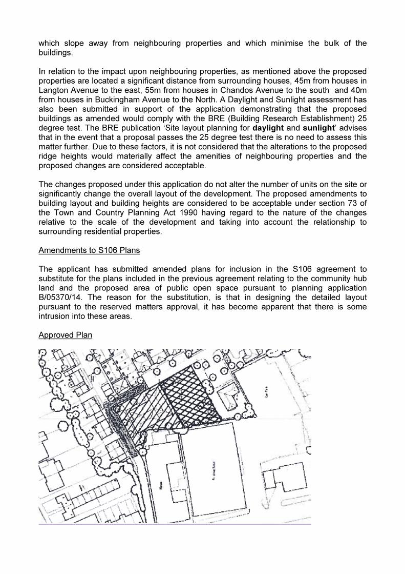
which slope away from neighbouring properties and which minimise the bulk of the buildings. In relation to the impact upon neighbouring properties, as mentioned above the proposed properties are located a significant distance from surrounding houses, 45m from houses in Langton Avenue to the east, 55m from houses in Chandos Avenue to the south and 40m from houses in Buckingham Avenue to the North. A Daylight and Sunlight assessment has also been submitted in support of the application demonstrating that the proposed buildings as amended would comply with the BRE (Building Research Establishment) 25 degree test. The BRE publication ‘Site layout planning for daylight and sunlight’ advises that in the event that a proposal passes the 25 degree test there is no need to assess this matter further. Due to these factors, it is not considered that the alterations to the proposed ridge heights would materially affect the amenities of neighbouring properties and the proposed changes are considered acceptable. The changes proposed under this application do not alter the number of units on the site or significantly change the overall layout of the development. The proposed amendments to building layout and building heights are considered to be acceptable under section 73 of the Town and Country Planning Act 1990 having regard to the nature of the changes relative to the scale of the development and taking into account the relationship to surrounding residential properties. Amendments to S106 Plans The applicant has submitted amended plans for inclusion in the S106 agreement to substitute for the plans included in the previous agreement relating to the community hub land and the proposed area of public open space pursuant to planning application B/05370/14. The reason for the substitution, is that in designing the detailed layout pursuant to the reserved matters approval, it has become apparent that there is some intrusion into these areas. Approved Plan
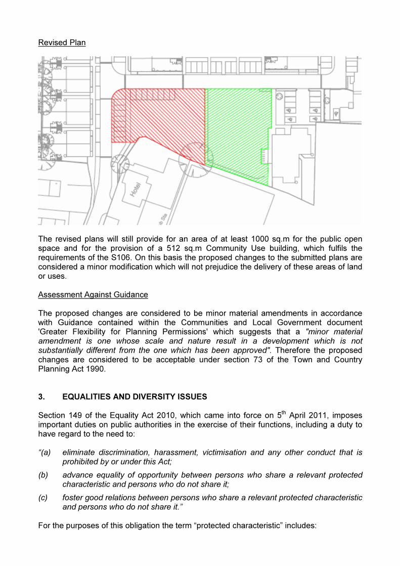
Revised Plan
The revised plans will still provide for an area of at least 1000 sq.m for the public open space and for the provision of a 512 sq.m Community Use building, which fulfils the requirements of the S106. On this basis the proposed changes to the submitted plans are considered a minor modification which will not prejudice the delivery of these areas of land or uses. Assessment Against Guidance The proposed changes are considered to be minor material amendments in accordance with Guidance contained within the Communities and Local Government document 'Greater Flexibility for Planning Permissions' which suggests that a "minor material amendment is one whose scale and nature result in a development which is not substantially different from the one which has been approved". Therefore the proposed changes are considered to be acceptable under section 73 of the Town and Country Planning Act 1990. 3. EQUALITIES AND DIVERSITY ISSUES Section 149 of the Equality Act 2010, which came into force on 5th April 2011, imposes important duties on public authorities in the exercise of their functions, including a duty to have regard to the need to: “(a) eliminate discrimination, harassment, victimisation and any other conduct that is
prohibited by or under this Act;
(b) advance equality of opportunity between persons who share a relevant protected characteristic and persons who do not share it;
(c) foster good relations between persons who share a relevant protected characteristic and persons who do not share it.”
For the purposes of this obligation the term “protected characteristic” includes:
- age; - disability; - gender reassignment; - pregnancy and maternity; - race; - religion or belief; - sex; - sexual orientation.
Officers have in considering this application and preparing this report had regard to the requirements of this section and have concluded that a decision to grant planning permission for the proposed amendments would not conflict with the Council’s statutory duty under this legislation, the Council’s Equalities Policy or the commitments set out in Barnet’s Equality Scheme. 5. COMMENTS ON GROUNDS OF OBJECTIONS The objections raised are all considered in the above appraisal and analysis. 6. CONCLUSION The proposed changes to the description of the development, along with the proposed alterations to the wording of conditions 1, 5 and 34 represent minor changes which correct previous inconsistencies as well as update the plans to reflect the design evolution of the scheme from outline to reserved matters stage. The proposed amendments would not raise any significant land use implications and would not have a significant impact on neighbouring residents, the character of the area or the local highway network beyond that of the original proposal. The same conditions and s.106 obligations imposed on the original consent have been carried forward onto this permission. All relevant policies contained within the development plan, as well as other relevant guidance and material considerations, have been carefully considered and taken into account by the Local Planning Authority. It is concluded that the proposed amendments to the approved outline planning permission (reference B/03068/11) dated 29/03/2012 are considered to be a material minor amendment under section 73 of the Town and Country Planning Act 1990. The proposal generally and taken overall accords with the relevant development plan policies. Accordingly, subject to the satisfactory completion of a deed of variation to the Section 106 Agreement, APPROVAL subject to conditions is recommended, as set out in the recommendations section at the beginning of this report.

Appendix 1 Site Location Plan