record packet copy - californiadocuments.coastal.ca.gov/reports/1996/8/th18a-8-1996.pdfp132 maintain...
TRANSCRIPT

CALIFORNIA COASTAL COMMISSION 89 South California Street, Suite 200 Ventura, CA 93001 (805) 641-0142
RECORD PACKET COPY
Filed: 7/8/96 49th Day: 8/26/96 180th Day: 114/96 Staff: CAREY StaffReport: 7/17/96 Hearing Date: 8/13-16/96 Commission Action:
STAFF REPORT: REGULAR CALENDAR
APPLICATION NO.: 4-93-206
APPLICANT: John Stevens AGENT: Sherman Stacey
PROJECT LOCATION: 31333 Mulholland Highway, Malibu, Los Angeles County
PROJECT DESCRIPTION: Subdivision of80 acres developed with one single family residence into 6lots, ranging in size from 10-acres to 15-acres, with 67,300 cu. yds. of grading (34,500 cu. yds. cut and 32,800 cu. yds. fill) to construct access driveway and 5 building pads, each over one-half acre in size.
Lot area: Building coverage: Pavement coverage: Landscape coverage: Parking spaces: Plan designation: Project density: Ht abv fin grade:
80 acres NIA NIA N/A NIA (1 du/2 ac), (l du/5 ac), (1 du/20 ac) 1 du/13.3 acres NIA
LOCAL APPROVALS RECEIVED: Los Angeles County Vesting Tentative Tract Map No. 49001, California Department ofFish and Game Streambed Alteration Agreement NO. 5-073-96
SUBSTANTIVE FILE DOCUMENTS: Malibu/Santa Monica Mountains Land Use Plan, 5-82-584 (Cariker), 5-83-711 (Pineridge ), 5-84-789 (Miller), , 5-85-652 (Stevens), 5-87-547 (Miller), 5-88-273 (Broekemeier), 5-89-549 (Keiper), 5-90-162 (Zamen), 5-90-32 (Thome), 5-90-146 (O'Connor), 5-91-376 (Hammersveld)
SUMMARY OF STAFF RECOMMENDATION:

4-93-206 (Stevens) August IS, 1996 Hearing
Page2
Staff recommends denial of the proposed project based on its inconsistency with the visual resource protection policies of the Coastal Act. While the proposed project could be found consistent with Sections 30253, 30244, and 30231 of the Coastal Act, the proposed project includes significant amounts of landfonn alteration for the creation of an access road and building pads. The proposed project site is located in a highly visible location just below an LUP designated significant ridge line. The proposed grading will result in large, manufactured slopes which will negatively impact the scenic and visual qualities of the surrounding area. The proposed project will be highly visible from public riding and hiking trails on public parkland nearby. As such, the proposed project does not confonn to the provisions of Section 30251 of the Coastal Act. The proposed project will not be sited and designed to minimize the alteration of naturallandfonns. Nor will it be visually compatible with the character of surrounding areas. Finally, the project as currently proposed, will not be subordinate to the character of its setting. Furthennore, there are feasible alternatives to the proposed project which, if implemented, would reduce the potential adverse impacts to visual resources. These alternatives include reduction of pad size, reduction of grading, incorporation of split pad designs, building future structures to the grade, and clustering development.
STAFF RECOMMENDATION:
The staff recommends that the Commission adopt the following resolution:
I. Denial.
The Commission hereby denies a pennit for the proposed development on the grounds that the development will not be in confonnity with the provisions of Chapter 3 of the California Coastal Act of 1976 and would prejudice the ability of the local government having jurisdiction over the area to prepare a Local Coastal Program confonning to the provisions of the Coastal Act.
II. Findings and Declarations.
The Commission hereby finds and declares:
A. PrQject Description.
The applicant proposes the subdivision of 80 acres developed with one single family residence into 6 lots, ranging in size from 1 0-acres to 15-acres, with 67,300 cu. yds. of grading (34,500 cu. yds. cut and 32,800 cu. yds. fill) to construct access driveway and 5 building pads, each over one-half acre in size. The proposed project site is located on Mulholland Highway in Malibu. Exhibit 1 shows the location of the proposed project site.

4-93-206 (Stevens) August 15, 1996 Heari11g
Page3
Additionally, the applicant proposes to alter a streambed in four locations to install three culverts to accommodate the proposed access road. The new structures will have reinforced concrete headwall inlets, concrete rip-rap outlet velocity dissipation pads, and new corrugated steel culverts. The stream involved is an unnamed tributary to Trancas Creek. While the creek is designated as a blue-line stream (intermittent) on the U.S.G.S. Quad Sheet for the area, it is not designated as an environmentally sensitive habitat area (ESHA) by the Malibu/Santa Monica Mountains Land Use Plan (LUP). Staff visit to the site indicated that there is no significant riparian vegetation within or adjacent to this drainage course.
B. Background.
The Commission bas previously considered an application for development on the subject project site. In Permit 5-85-652 (Stevens), the Commission approved the construction of a single family residence, accessory structure, road, corral, and septic system on the project site. This permit was approved with special conditions relating to: 1) an agreement that future development on the site would require a coastal permit; 2) recordation of an offer to dedicate a trail easement for the Backbone Trail; and 3) submittal of a final driveway plan. A significant amount of grading (6,822 cu. yds.) was approved for the construction of the horne. Findings were made that the applicant had significantly reduced the proposed amount of grading from a previously submitted design. The findings further stated that the grading would not be visible from Decker Road or Mulholland Highway.
The applicant did activate the permit and carry out the site grading and the construction of the residence. Because the grading involved cutting off the top 13 feet of a knoll, and involved relatively minor fill slopes, it is true that the grading itself is not visible from Decker or Mulholland below the house. However, the pad area is visible from trails within National Park Lands nearby. Further, the house and the fire clearance area are highly visible from these two roads, as well as from Encinal Canyon Road and trails and parklands in the area.
C. Landform AlterationNisual Resources.
Section 30251 ofthe Coastal Act states that:
The scenic and visual qualities of coastal areas shall be considered and protected as a resource of public importance. Permitted development shall be sited and designed to protect views to and along the ocean and scenic coastal areas, to minimize the alteration of natural land forms, to be visually compatible with the character of surrounding areas, and, where feasible, to restore and enhance visual quality in visually degraded areas. New development in highly scenic areas such as those designated in the Califomia Coastline Preservation and Recreation Plan prepared by the Department of Parks and Recreation and by local government shall be subordinate to the character of its setting.

4-93-206 (Stevens) August 15,1996 Hearing
Page4
In addition, the certified LUP contains the following policies regarding landform alteration and the protection of visual resources which are applicable to the proposed development The LUP policies cited below have been found to be consistent with the Coastal Act and therefore, may be looked to as guidance by the Commission in determining consistency of the proposed project with the Coastal Act.
P3 7 Design and locate trails and/or adjacent development so that neither intrudes unnecessarily on the environment of the other.
P82 Grading shall be minimized for all new development to ensure the potential negative effects of runoff and erosion on these resources are minimized.
P90 Grading plans in upland areas of the Santa Monica Mountains should minimize cut and fill operations in accordance with the requirements of the County Engineer.
P91 All new development shall be designed to minimize impacts and alterations of physical features, such as ravines and hillsides, and processes of the site (i.e., geological, soils, hydrological, water percolation and runoff) to the maximum extent feasible.
Pl25 New development shall be sited and designed to protect public views from LCPdesignated scenic highways to and along the shoreline and to scenic coastal areas, including public parklands. Where physically and economically feasible, development on sloped terrain should be set below road grade.
P129 Structures should be designed and located so as to create an attractive appearance and harmonious relationship with the surrounding environment.
Pl30 In highly scenic areas and along scenic highways, new development (including buildings, fences, paved areas, signs, and landscaping) shall:
be sited and designed to protect views to and along the ocean and to and along other scenic features, as defined and identified in the Malibu LCP.
minimize the alteration of natural landforms.
be landscaped to conceal raw-cut slopes.
be visually compatible with and subordinate to the character of its setting.
be sited so as not to significantly intrude into the skyline as seen from public viewing places.
P 131 Where feasible, prohibit placement of structures that will break the ridgeline view, as seen from public places.
P132 Maintain the character and value of Mulholland Scenic Corridor, as a scenic and recreational resource connecting public parklands within the Santa Monica Mountains.

4-93-106 (Stevens) August 15, 1996 Hearing
PageS
Pl34 Structures shall be sited to conform to the natural topography, as feasible. Massive grading and reconfiguration of the site shall be discouraged.
Pl35 Ensure that any alteration of the natural landscape from earthmoving activity blends with the existing terrain of the site and the surroundings.
Pl37 Clustering of development in suitable areas shall be encouraged as a means to facilitate greater view protection.
P141 Fencing or walls to be erected on the property shall be designed and constructed to allow for view retention from scenic roadways.
Pl42 New development along scenic roadways as designated in Figure 8 shall be set below the road grade on the down hill side wherever feasible, to protect designated scenic canyon and ocean views.
1. Site Description.
The proposed project site is rectangular in shape, comprises 80 acres, and is located at the western end of Los Angeles County's portion of the Santa Monica Mountains. [Exhibit 1 and 2 show the location of the project site.] The site is situated on the southern flank of Triunfo Ridge. This ridge is the crest of the Santa Monica Mountains in this area. The Triunfo Ridge Fire Road is located just above the property. The natural slopes on site are moderate to fairly steep, with total relief on the site being approximately 430 feet. Most of the site drains to the south and consists of a series of ridges that extend down from Triunfo Ridge. Additionally, several small knolls occur on the site. The site is heavily vegetated with chaparral-coastal sage scrub vegetation. The property was burned over in the 1985 Decker Canyon wildfire and the vegetation on site has recovered well since that time.
The proposed project site is currently developed with one single family residence (previous Commission action on this residence is discussed in Section B. above). The applicant takes access to the residence from Mulholland Highway on a 20-foot wide, paved access road. The house is constructed near the edge of a large flat pad which was created by removing the upper 13 feet of a prominent knoll in the center of the site. The residence, which is white in color, is highly visible from the surrounding area. Further, there is a very large fire clearance area extending down the sides of the knoll from the house which is almost devoid of any vegetation. This clearance area is very visible. The existing building is located at the highest elevation of any structure in the immediate area.
2.Jmmediate Area Descripti011.
The area below the proposed project site along Mulholland Highway and Decker Canyon Road is sparsely developed with single family residences. The existing residence on the

4-93-206 (Stevens) August IS, 1996 Hearing
Page6
proposed project site is located at the highest elevation of any structure in the immediate area. There are no structures to the west of the existing residence along Triunfo Ridge. Malibu Country Club golf course is located below and to the east of the project site in Trancas Canyon. There are significant areas of State Parks and National Park Service lands south and east of the project site along Decker Canyon and Encinal Canyon Roads.
3. Proposed Project Description.
The applicant proposes the subdivision of 80 acres developed with one single family residence into 6 lots, ranging in size from 1 0-acres to 15-acres, with 67,300 cu. yds. of grading (34,500 cu. yds. cut and 32,800 cu. yds. fill) to construct access driveway and 5 building pads, each over one-half acre in size.
The following chart gives a breakdown of the total proposed grading:
50 feet (cut) 70 feet
Lot2 28,000 sq. 40 feet (cut) ft. 40 feet
Lot4 24,500 sq. 40 feet ft. 70 feet (fill)
Lot 5&Lot 6 28,000 sq. Lot 5- 55 feet ft. each (fill), Lot 6-
60 feet Roadway N/A 5,700 cu. 1,800 cu. 7,500 cu. 60 feet (cut)
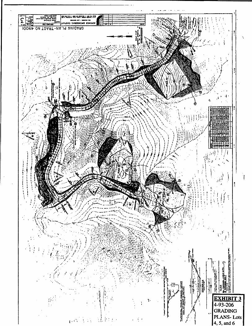
It can be noted from this breakdown that the applicant proposes very large pads of over one-half acre in size for each of the five proposed parcels. In order to construct such large pads on the moderate to steep terrain of the proposed project site, the applicant proposes significant amounts of grading for each parcel. For instance, Lot 1 would require 18,000 cu. yds. of grading and would include the construction of a cut slope behind the pad which would have an elevation change of 28 feet and would run 50 feet from top to bottom. Additionally, the grading for this parcel would involve a fill slope on the down slope side of the proposed pad with an elevation change of 30 feet and would run out 70 feet maximum in length from top to bottom. The length of the slope, which demonstrates the linear extent of the proposed slope, is measured from the bottom of the slope to the top. The applicant proposes the least amount of grading (5,500 cu. yds.) for the construction of a 28,000 sq. ft. pad on Lot 2. This pad would require a cut slope and a fill slope 40 feet in length, each.

4-93-206 (Stevens) August 15, 1996 Hearing
Page 7
The applicant proposes 13,000 cu. yds. of grading for construction of the building pad on Lot 4. This grading would involve a fill slope with an elevation change of28 feet and that would run 70 feet from top to bottom at the highest point. This fill slope would be located on the downslope edge of the pad. The cut slope above the pad would have a 22 foot change in elevation and a run of 40 feet. The resultant pad would be square in shape. The roadway improvements from the existing access road to Lots 4, 5, and 6 would require 7,500 cu. yds. of grading and would include cut slopes with over 35 feet of elevation change and with a run of 60 feet from top to bottom. Finally, the pads on Lots 5 and 6 would require 23,300 cu. yds. of grading (combined). Lot 5 would require the construction of a 55 foot long fill slope while a 60 foot long cut slope is proposed for Lot 6.
4. Visual Analvsis.
In order to assess the visual resources of the proposed project site and the surrounding area, staff has visited the site. In January, staff visited the proposed project site with the applicant and the applicant's engineers. As described previously, the site is located in a very visually prominent location. The existing home is constructed at the highest point of any structure in the area. Additionally, the area around the structure which the applicant has cleared (apparently for fuel modification) is very large and highly visible in contrast to the heavy chaparral-coastal sage scrub cover on the remainder of the site. There are existing graded roads/trails which cross the site. A very significant view exists from the project site down Trancas Canyon towards the ocean. On a clear day, the sand beach can be seen from the property. Given the visual prominence of the proposed project site, staff expressed their concern that landform alteration necessary to create pads and the road be minimized as much as possible in order to minimize adverse impacts to visual resources.
In addition to visiting the project site, staff visited the surrounding area to assess the visibility of the proposed project from different locations. Staff found that the site is in fact highly visible from several areas. From Mulholland Highway, a designated scenic highway, directly adjacent to the property entrance gate, the proposed grading on Lot 1 will be highly visible. Views may also be gained from Mulholland Highway as the highway turns southwest from the site. From this area, the proposed Lots 5 and 6 will be most visible. The site can also be seen from Decker Canyon Road southwest of the site. Traveling in the opposite direction, the site is very visible from Encinal Canyon Road to the south and southeast of the site. There are several public vista points along this roadway. While these views are from a further distance than those from Mulholland and Decker, the site is still highly visible and the existing home and clearance area is very prominent.
More recently, staff visited several park areas surrounding the site. The trails map (Exhibit 5) shows the location of these park areas in relation to the proposed project site. Staff hiked a National Park Service (NPS) trail which begins at Decker Canyon Road south of the proposed project site. This trail extends to the top of a knoll. From this

4-93-106 (Stevens) August 15, 1996 Hearing
Page8
vantage point, the site, particularly the western portion, was extremely visible. The grading proposed for lots 5, and 6 would be very visible. Staff also hiked an NPS trail, identified as Clarke Ranch Road on some maps, which begins at Mulholland Highway south of the proposed project site. From this trail, very clear views of the site may be gained. The whole site is visible from this point, but the proposed pads for Lots 4, 5, and 6 will be particularly visible. Staff also hiked a different portion of this same trail, located south of Encinal Canyon Road. From that vantage point, the site is visible while from a somewhat greater distance. The proposed pad for Lot 1 would be seen particularly well from this point.
Further east on Encinal Canyon Road, staff hiked an unnamed NPS trail from which views across the Malibu Country Club to the proposed project site may be gained. The proposed pad for Lot 1 would be particularly visible from this location. Finally, staff viewed the site from the NPS's Zuma Ridge Trail which is located further east, taking access from Encinal Canyon Road. While the view from this trail is more distant than from the others, the proposed project site is still prominent and the grading proposed for Lot 1 will be most visible.
With regard to potential visual impacts, the applicant has submitted a Visual Impact Analysis, dated 10/91, prepared by Environmental Planning Associates. This analysis was required by the County of Los Angeles in their consideration of the tentative tract approval. The introduction to this report states that:
Impacts considered to be "significant" to a viewshed and its attributes typically consist of the loss or obstruction of views to the horizon or scenic vistas. They can also include changes in the character of the viewshed, such as elimination of natural features, changes to the style or ambiance of a community, or the insertion of a prominent feature that challenges the original aesthetic values.
This report primarily addresses the potential impact of the proposed subdivision on the Mulholland Scenic Highway Corridor. The report states that: "The aesthetic value placed on [this corridor], particularly in the vicinity of the project site is very high, and deemed worth preserving ... " The report concludes that the greatest potential visual impacts from the proposed project would be most likely experienced from Mulholland adjacent to the existing entrance gate at the east end of the property. Three line-of-sight analyses were drawn from this portion of Mulholland across the site. These cross sections indicate that the proposed Lots 1 and 2 will be very visible from Mulholland Highway directly adjacent to the site. The visual analysis was conducted prior to the development of a final grading plan so the visual impacts of the proposed grading was not addressed. The report states that:
Although tentative locations for the housing pads on each of the six lots are proposed, grading plans have not yet been developed. Grading that is sensitive to the natural terrain,

4-93-206 (Stevens) August 15, 1996 Hearing
Page9
and takes existing views from Mulholland Highway into account, would reduce the visual impacts which can be associated with development in a Scenic Corridor.
The report also addresses the potential visual impacts of the proposed project on the Backbone Trail along the proposed easement which would cross the project site. The report concludes that the visual impacts on the trail would be insignificant given the existing level of development along the trail. However, the report does not address the adverse visual impacts to other riding and hiking trails in the surrounding area, such as the trails noted above. The report concludes that providing a landscape buffer along those portions of proposed dwelling units visible from Mulholland Highway and the Backbone Trail will mitigate the potential adverse visual impacts.
Based on staffs visits to the project site and surrounding area, the Commission finds that the proposed project site is visually prominent and that new development on the property will be very visible not only from a scenic highway and other roads in the surrounding area, but also from public riding and hiking trails within nearby parklands. The Commission agrees with the applicant's visual analysis with regard to the visibility of Lots 1 and 2 from Mulholland adjacent to the entrance gate and the need to for grading to be sensitive to the existing terrain. However, given that the report did not address the proposed grading or the visual impacts to existing NPS trails and parkland, the Commission cannot agree with the conclusion that landscape buffers will adequately minimize visual impacts. Additionally, the applicant has submitted no supplemental evidence concerning the effect of the proposed grading on visual resources.
5. Visual/ mpacts.
In detennining consistency of the proposed project with the visual resource protection provisions of Section 30251 of the Coastal Act, it is necessary to compare the visual aspects of the proposed project with the specific; language of the section as well as to look to past Commission actions and the policies of the Malibu/Santa Monica Mountains LUP for guidance. As noted above, Section 30251 requires the protection of the scenic and visual qualities of coastal areas. It specifically requires that pennitted development minimize the alteration of naturallandfonns and that it be visually compatible with the character of surrounding areas. The LUP policies noted above require that grading and landfonn alteration be minimized, both to minimize the visual impacts of altering natural landfonns and to minimize the potential impacts of increased runoff and erosion from grading natural sites and removing native vegetation.
In addition to the policies, the certified LUP includes a visual resources map (Exhibit 4) which designates significant ridgelines, scenic highways, viewsheds and scenic elements. The "Research Analysis and Appendices" prepared for the development of the LUP describes many of these features. The proposed project site is located on the boundary between the West Mulholland and Upper Zuma/Trancas Viewsheds. as depicted on the

4-93-206 (Stevens) August 15, 1996 Hearing
Page 10
Visual Resources Map. As such, views of the site may be gained from areas within both viewsheds.
Triunfo Ridge which is located just above the project site, is designated as a significant ridgeline. Significant ridgelines constitute a scenic resource of the coastal zone due to their high visibility from many vantage points. Ridgelines can be defined as the line separating drainage basins. Significant ridgelines are those whose ridge silhouettes the sky or ocean, and those which are clearly visible from scenic roads. The area between the scenic roadway and the significant ridgeline is also considered visually sensitive.
Mulholland Highway is designated as a scenic highway. This highway, which traverses the core of the Santa Monica Mountains, was given a "First Priority Highway" designation in the Los Angeles County Scenic Highway element. The views from Mulholland are generally of a rural character. Additionally, although they are not designated scenic highways by the LUP, Decker Canyon Road and Encinal Canyon Road do offer significant view opportunities. Decker Road extends from PCH to Mulholland Highway. Ocean Vistas, deep valleys, canyons, and rugged mountains are features of many scenic vistas. Encinal Canyon Road in the area of the proposed project site offers views into canyons and valleys, often backdropped by significant ridgelines. Further, there are large National Park Service and Santa Monica Mountains Conservancy holdings in the surrounding area. There are many public riding and/or hiking trails within these parklands. Such trails offer significant view opportunities of canyons and mountains. The proposed project is visible from several public trails in the area.
Given the significant visual resources identified near the proposed project site, it is especially important to protect the scenic and visual qualities of the site by ensuring that the proposed project conforms to Section 30251 and the policies of the certified LUP. In order to evaluate the potential impacts of the proposed project on visual resources, staff has visited the site and surrounding area, as described above. The conclusion that can be drawn from the visual analysis of the site, is that the proposed site is located in a visually prominent location and development on the site will be highly visible from a scenic highway, riding and hiking trails, and parkland in the surrounding area.
For instance, the pad for the proposed Lot 1 would require 18,000 cu. yds. of grading and would include the construction of a cut slope behind the pad and 50 feet in length. Additionally, a fill slope would be constructed downslope of the pad which would be and 70 feet in length. This pad would be very visible from Mulholland Highway directly adjacent to the site and from several public riding and hiking trails in the area. This large amount of grading results in a significant alteration of the natural landform and creates a 4'manufactured" unnatural landscape. This large cut and fill flat pad design clearly does not minimize grading or blend with the natural landform.
The proposed building pad for Lot 4 is also very large in size and involves 13,000 cu. yds. of grading. This pad would be 24,500 sq. ft. in size, would be square in shape and

4-93-206 (Stevens) August 15, 1996 Hearing
Page 11
would include slopes of 40 feet (cut) and 70 feet (fill) in length. Lots 5 and 6 would require a significant amount of grading to construct (23,300 cu. yds.). While the County of Los Angeles did require the applicant to retain two knoll features in order to screen the pads from Mulholland Highway, these two pads would still be visible from public trails and from Decker Canyon Road. Each pad would be 28,000 sq. ft. in size. Additionally, 7,500 cu.yds. of grading and cut slopes of 60 feet in length would be required to improve the access road to the western area of the site. As previously noted above, this large flat pad design does not blend with the natural landforms on site and clearly does not minimize grading and landform alteration as required by Section 30251 of the Coastal Act. Although the proposed pad for Lot 2 would be 28,000 sq. ft. in size, the pad is located on a flatter area of the site and would require less grading (5,500 cu. yds.) and smaller slopes to construct. Additionally, this pad is located on a lower area of the site and would be much less visible than the other proposed pads.
Further, the potential visual impact of the proposed project would not be limited to that from the grading and future structures. Each future residence would require a significant vegetation clearance area for fire protection. As evidenced by the clearance area surrounding the existing residence on the project site, areas cleared of vegetation can be very visible, even from a long distance. Given the size of each pad, some of the clearance zones for future residences may overlap, creating a large continuous area with little vegetation.
In this case, grading has not been minimized, as required by LUP policies P82, P90, P91, or P130. The proposed project includes very large, flat pad areas. Each proposed pad would be over one-half acre in size. As a point of comparison, the maximum pad size standard (Table 1 of the LUP) for properties within Significant Watershed areas is 10,000 sq. ft. In past permit actions, the Commission has found that a 10,000 sq. ft. pad is sufficiently large to allow for the construction of a single family residence and at least one ancillary structure like a guest house. The proposed project site is located just outside the Trancas Canyon Significant Watershed and would not be subject to this policy. However, it gives an idea of the size pad that the Commission has previously found would minimize impacts to sensitive areas.
Significant amounts of grading and very large manufactured slopes would be required to construct the 28,000 sq. ft. pads proposed by the applicant, especially given the mountainous terrain of the site. The design of the pads are what may be permitted in an area with more gentle terrain. The amount of grading is not necessitated in any way by the physical or geologic constraints of the site, but by the applicant's desire to create large pad areas for "estate" type homes. The proposed project has not been designed to avoid intruding unnecessarily on the environment of public trails in the area as required by LUP policy P37. The proposed pads will not create a harmonious relationship with the surrounding environment, as set forth in LUP policy Pl29. Finally, the proposed project will not protect the scenic and visual qualities, is not sited and designed to minimize the alteration of natural land forms, will not be visually compatible with the character of

4-93-206 (Stevens) August 15, 1996 Hearing
Page 12
surrounding areas, nor will it be subordinate to the character of its setting, as required by Section 30251 ofthe Coastal Act.
Given the concern about the amount of grading and landform alteration proposed in such a visually prominent location, staff met with the applicant and his engineers to explore strategies to reduce grading. Staff suggested alternatives for the proposed pads to conform more closely to the natural terrain of the site, reduce pad size, and reduce overall grading as a result. The applicant expressed his desire to retain the proposed design and he declined to revise the grading plan.
6. Past Commission Actions.
The Commission, in past permit actions, has also restricted grading for proposed developments in order to minimize landform alteration and impacts on scenic resources in many past permit actions both in undeveloped areas and existing developed areas on the coastal terrace. In many actions on land divisions and development in highly visible areas, the Commission has denied projects due to landform alteration and visual impacts or conditioned approval on reducing the amount of proposed grading or the applicant has agreed to reduce the grading due to concerns over impacts. In Permit 4-95-115 (Lauber), the Commission considered an application for a seven-lot subdivision on Kanan Dume Drive with 126,000 cu. yds. of grading (95,000 cu. yds of cut and 31,000 cu. yds. of fill). Staff conveyed to the applicant and the applicant's representative that the amount of proposed grading was not consistent with the policies of the Coastal Act and Malibu/Santa Monica Mountains Land Use Plan (LUP) which require the minimization of landform alteration. The majority of the proposed grading was for the construction of an access road across the site from Ramirez Canyon Road to Kanan Dume Road. The County required the applicant to construct the road not only to provide access to the project site but to provide an emergency route out of Ramirez Canyon. The County did allow some minor modifications to the road to reduce grading. Additionally, the applicant's engineer revised the proposed grading plan to: 1) reduce the graded area of the access road to the 42-foot width required by the County and to: 2) remove the fill pads on two of the seven lots. These changes significantly reduced the total amount of grading to 96,200 cu. yds. with the bulk of the grading for the road.
In Permit 4-93-056 (Vierich), for the subdivision of a 21-acre lot partially within a Significant Watershed area off Kanan Dume Road into two lots with the construction of a single family residence on each lot, the applicant originally proposed 9,600 cu. yds. of grading for the creation of two building pads. Staff recommended denial of the application because of the potential negative visual impacts that would result from excessive landform alteration and the placement of two excessively large building pads in a highly visible location. The applicant worked with staffto reduce the size of the proposed building pads, thus reducing the proposed grading to 3,500 cu. yds.

4-93-206 (Stevens) August 15, 1996 Hearing
Page 13
In 5-90-058 (Williams), for the subdivision of a 34.1 acre parcel into 5 lots off of Winding Way, the applicant's original project proposal included 128,674 cubic yards of grading for the construction of access roads and building pads. Due to concerns raised by staff relative to landform alteration and visual resource impacts the applicant revised the project design by eliminating grading on a prominent ridge, employing a split level pad design and reducing overall grading to 24,390 cubic yards. In 5-89-1149 (Thome), for the subdivision of 121.9 acres into 19 lots off of Latigo Canyon Road, the applicant's original project proposal included 280,000 cubic yards of grading for the construction of pad sites and access roads. Due to concerns raised by staff relative to grading and the associated visual and landform alteration impacts the applicant revised the project design by reducing building pad sizes and overall grading to 158,000 (79,000 cu. yds cut., 79,000 cu. yds. fill).
In approving 5-89-872 (Javid) for the subdivision of a 45 acre parcel into 25 lots and 345,000 cubic yards of grading (216,900 cu. yds cut, 127,450 cu. yds. fill) for pads and access roads off of Morning View Drive, the Commission required the applicant to cluster lots and modify the grading as a special condition of approval. The Commission eliminated all grading for building pads and limited all grading to what was necessary for the construction of access roads and driveways. The future residential structures would have to be built to natural grade. In 5-88-300 (Lachman/Preferred Financial), for the subdivision of a 6.54 acre parcel and the construction of 38 condominium units and a road extension at the northeast comer of Lunita Road and Bailard Road the applicant's original project submission included 74,000 cubic yards of grading and would have created essentially one large building pad for the project. Due to concerns raised by staff relative to grading and landform alteration the applicant revised the project design to step most units up and down the existing slopes to conform to the existing topography (by notching the units into the hillside rather than creating flat terraces). Overall grading was reduced by 55 percent to 33,000 cubic yards.
In approving permit no. 5-88-600 (Trancas Town Ltd.) for the subdivision of 35 acres on the west side ofTrancas Canyon Road into 15 single-family lots and 52 condominiums the Commission required the applicant to reduce overall grading and landform alteration as special conditions of approval. Specifically, the applicant was required to eliminate four single-family lots, redesign four other lots to place structures on multiple levels at natural grade, and reduce pad sites to a maximum of2,000 square feet and cut and fill slopes to a maximum of five feet. In approving permit no. 5-88-938 (Bennett) for the subdivision of 10 acres into four lots and 21 ,200 cubic yards of grading for pad sites and an access road on Sea View Drive north of the subject site the Commission also required the applicant to modify grading as a special condition of approval. The Commission restricted the pads to specific elevations on the site, limited pad size to 3000 square feet and restricted the height of cut and fill slopes to five feet at 2: l slope ratios and I 0 feet for 3: 1 slope ratios.
4-93-206 (Stevens) August 15,1996 Hearing
Page 14
In a subdivision project located on Latigo Canyon, a applicant applied for a permit in 1980 (#80-7570) for the subdivision of a 35 acre parcel into 12lots. The Commission denied the subdivision due to the cumulative impacts to coastal resources. Then in 1989 the project was before the Commission as a 9lot subdivision with 161,000 cubic yards of grading. The Commission denied the project due to landform alteration and adverse impacts on visual resources. The applicant reapplied for a 9 lot subdivision with grading reduced to 37,000 cubic yards (5-90-665, Vanjani). The Commission approved the project with conditions to further mitigate the visual impacts.
Finally, the Commission has, in past permit actions, approved a number of projects with large quantities of grading. However, in such cases, the grading was mainly necessitated by poor geologic conditions and the resulting grading had minimal visual impact. Permit 5-89-155 (Nesheim) was for a 4,567 sq. ft. single-family residence, pool, driveway with 18,300 cu. yds. of grading (balanced). Significant grading was required due to the presence of uncertified fill and alluvium. The material was required to be excavated and recompacted. Permit 5-88-683 (Felder) was for a 7,425 single-family residence, pool, guesthouse with 30,000 cubic yards of grading. However, grading was required to over excavate and recompact due to soil having poor bearing value. In permit 5-90-277 (Harrah) 15,436 cu. yds. of grading was approved for a 17,620 sq. ft. single-family residence, 750 sq. ft. guest house, pool, tennis court, tennis pavilion, garden storage structure and bluff restoration on a 7 acre site. The majority of the grading was for excavation with 36% for bluff restoration. The grading for the residence did not create any adverse visual impacts from the beach or surrounding area.
In comparing the currently proposed project with past Commission actions, it becomes apparent that this proposal includes an amount of landform alteration at the upper end of the range of projects that have been approved. The proposed grading will result in the creation of manufactured slopes which will be visible from surrounding area. It will be highly visible from a scenic highway and National Parks property. The applicant is proposing to create very large pads, especially given the project site's location in a mountainous area. The amount of grading is not necessitated by the physical constraints of the site but by the desire to create large flat pads. There are no identified geologic problems on the site that would require remediation.
7. Alternatives.
As noted above, the Commission has routinely denied or required redesign of projects in order to minimize landform alteration and impacts to visual resources where subdivisions involve significant grading and landform alteration as proposed. The Commission or staff has routinely made suggestions to applicants about alternative projects or modifications to projects which would serve to reduce grading. While such suggestions must be specific to the characteristics of each proposed project site, general ways in which grading has been reduced include: clustering lots on one area of a site; reduction of building pad size; building stmctures to the existing grade or "notching" structures into the hillside;

4-93-206 (Stevens) August 15, 1996 Hearing
Page 15
reducing road widths or increasing road grades; and reducing the total number of lots allowed in a subdivision.
In this case, the most obvious alternative would be for the applicant to reduce the size of the proposed building pads. With this modification, there would be a commensurate reduction in the amount of grading and in the overall height and length of the proposed manufactured slopes, consistent with LUP policies P82, P90, P91, Pl30, P134, and P135. Along with a reduction in size, the proposed pads could be redesigned to more closely conform to the natural terrain of the site. Large, rectangular pads are not consistent with the terrain of the project site. Contour grading techniques could be utilized so that the · pads would blend more with the natural topography, consistent with LUP policy P134. Split level pad design could be implemented to reduce overall grading. Additionally, several of the proposed parcels could be designed for future residences that would be built to the existing slope as much as possible, with just enough grading to construct a driveway and fire department turnaround area, thereby significantly reducing landform alteration. These measures could be implemented to redesign the proposed project to minimize the alteration of natural land forms, consistent with Section 30251 of the Coastal Act. Houses of significant size could still be constructed on smaller pads, while minimizing impacts to visual resources.
Another alternative would be to cluster development, consistent with LUP policy Pl37, near the more developed eastern portion of the site, eliminating the pad for the proposed Lots 5 and 6. This would reduce the significant amount of grading required for these pads, as well as that required for the extension of the road. Coupled with a reduction of grading on the pads for Lots 1 and 4, it appears an additional pad could be constructed on the downslope side of the existing road, near the proposed pad for Lot 2 in conformance with the landform alteration policies. This alternative would also minimize the total area of the site devoted to fuel modification.
Staff has met with the applicant and his engineers to discuss the project and to explore alternatives to the proposed grading design. Staff expressed concern about visual impacts associated with the proposed landform alteration, the amount of grading, and the size of the pads. The applicant expressed his desire to retain building pads of the sizes proposed in order to provide for the future construction of "estate" style residences. The applicant declined to redesign the project to incorporate any alternatives to the proposed project.
8. Conc/usio11.
To conclude, the Commission finds that the proposed project site is located in a scenic area. The proposed project would be highly visible from a scenic highway, public riding and hiking trails, and parkland in the surrounding area. The proposed project involves excessive landform alteration, is not sited to conform to the natural topography, would not be visually compatible with and subordinate to the character of its setting, and will result in signiticant adverse impacts to visual resources. There are alternatives to the

4-93-206 (Stevens) August 15,1996 Hearing
Page 16
proposed project, which if incorporated into the design of the project, could minimize adverse impacts to visual resources. As such, the Commission finds that the proposed project, as designed, is not consistent with Section 30251 of the Coastal Act or the visual resource protection policies of the Coastal Act.
D. Cumulative Impacts.
Section 30250(a) of the Coastal Act provides that new development be located within or near existing developed areas able to accommodate it, with adequate public services, and where it will not have significant adverse effects, either individually or cumulatively, on coastal resources:
(a) New residential, commercial, or industrial development, except as otherwise provided in this division, shall be located within, contiguous with, or in close proximity to, existing developed areas able to accommodate it or, where such areas are not able to accommodate it, in other areas with adequate public services and where it will not have significant adverse effects, either individually or cumulatively, on coastal resources. In addition, land divisions, other than leases for agricultural uses, outside existing developed areas shall be permitted only where 50 percent of the usable parcels in the area have been developed and the created parcels would be no smaller than the average size of surrounding parcels.
Section 30105.5 of the Coastal Act defines the term "cumulatively", as it is used in Section 30250(a) to mean that:
the incremental effects of an individual project shall be reviewed in conjunction with the effects of past projects, the effects of other current projects, and the effects of probable future projects.
In addition, the certified LUP contains the following policy regarding land divisions which is applicable to the proposed development. The LUP policy cited below has been found to be consistent with the Coastal Act and therefore, may be looked to as guidance by the Commission in determining consistency of the proposed project with the Coastal Act.
P273d In all other instances, land divisions shall be permitted consistent with the density designated by the Land Use Plan Map only if all parcels to be created contain sufficient area to site a dwelling or other principal structure consistent with the LUP. All land divisions shalt be considered to be a conditional use.
As described above, the applicant proposes the subdivision of an 80-acre parcel developed with one single family residence into six parcels, ranging in size from 1 0 to 15 acres. The certified LUP designates the property for three density categories: 1) M2 which allows one dwelling unit per 20 acres; 2) Rural Land II which allows one dwelling unit per 5 acres; and 3) Rural Land Ill which allows one dwelling unit per two acres. The following chart shows the total acreages in each category:

Acreages Dwelling Units
4-93-206 (Stevens) August 15, 1996 Hearing
Page 17
Based on these acreages, the Land Use designations would allow for a maximum of 6 dwelling units. It should be noted that the designations represent the maximum allowable density. It is possible that proposed subdivisions may not be able to conform with all other policies of the LUP and be permitted for the maximum density.
Although the certified LUP provides standards for density and intensity of development, the Commission must review subdivisions for consistency with the Coastal Act. In this case, because the proposed project site is located outside the developed coastal terrace area, the criteria provided in Section 30250 (a) is applicable. This section provides that subdivisions shall be permitted when: a) 50 percent of the useable parcels in the area have been developed; and b) the created parcels would be no smaller that the average size of the surrounding parcels. These requirements are to ensure that development is located in close proximity to existing development, in areas that have adequate public services. In other words, this policy is to prevent the "leap-frogging" of new development into undeveloped areas, thereby preventing the potential significant adverse impacts of such development on coastal resources. As such, it is possible for a proposed subdivision to be consistent with the maximum allowable density under the Land Use Plan, yet be inconsistent with Section 30250(a) of the Coastal Act because it does not meet the 50 percent or average lot size criteria.
The first technical requirement of Section 30250(a) of the Coastal Act is regarding new land divisions outside existing developed areas. That section requires that such land divisions shall be permitted only where 50 percent of the usable parcels in the area have been developed and where other criteria are met. The Commission found that "existing developed area" applied only to the urbanized strip, or coastal terrace, along Pacific Coast Highway and did not apply to the interior of the Santa Monica Mountains. The Commission further found that the area addressed by the 50% criterion was the market area, amounting to the entire Malibu/Santa Monica Mountains coastal zone. Within that area, a majority of existing parcels were not yet developed, thus causing all proposed land divisions outside the coastal terrace to fail the required test of Section 30250(a).
Based on these concerns, the Commission found no alternative to denial of a number of land divisions requested in the area (#507-77, Bel Mar Estates; #527-77, Schiff; #28-78, Brown). Faced with continuing applications, the Commission instituted the TDC program through a series of permit decisions (#155-78, Zal;:#158-78 Eide). The program was designed to address both the cumulative impact problem represented by the large
4-93-206 (Stevens) August 15, 1996 Hearing
Page 18
number of existing lots and the technical criteria of Section 302SO(a) regarding proposed land divisions outside the coastal terrace.
The TDC program acts in such a way as to ensure that no net increase in development occurs, even if land divisions are approved. The developability of existing parcels is extinguished at the same time new parcels are created, in order to accomplish this end. Because land divisions do not increase the number of potentially usable parcels, the technical criterion of30250(a) concerning 50% of the usable parcels in the area has, in effect, been met.
With regard to the average lot size standard, the first step to making the determination required under Section 30250(a) of the Coastal Act is to choose a "surrounding area" which is representative. Next, utilizing aerial photographs and assessor's records, the number of developed parcels within the surrounding area would be determined. Lastly, an average lot size analysis would be made on the surrounding area. To determine the appropriate surrounding area in the Santa Monica Mountains, the Commission has, in past permit decisions, considered the average and median lot size within one-quarter of a mile, taking into account major topographic features. In a court decision (Billings vs. the California Coastal Commission) the court examined the use of an arithmetic mean to determine the size of lots that was typical for a geographic area. In Billings, the court rejected the arbitrary delineation of a 1/4 radius as the sole criterion for determining the appropriate surrounding area, and instead found that it was appropriate to also take into consideration major topographic features such as ridgelines to determine the surrounding area. Also in Billings, the Court rejected the Commission's use of the arithmetic mean to determine the "average" lot size and rather found the use of a median or mode to be more appropriate. The Commission has found that the mode is a method of calculating the average that is of limited utility. Thus, the median is the best method of arriving at the average lot size.
In this case, the applicant's engineer submitted copies of the assessor's parcel maps for the surrounding area, but did not calculate the "average" lot size for purposes of this analysis. As such, staff determined the appropriate "surrounding area" and calculated the "average" lot size. A 1/4 mile radius was utilized, with the exception of the area to the north of the project site. In that area, lots were only included to the ridgeline. Since that ridge is the crest of the Santa Monica Mountains, it may be considered a major topographic feature for the purposes of defining the surrounding area. Additionally, most of the area north of this feature is outside of the Coastal Zone. Staff identified 59 lots within the "surrounding area". The median size within this area was calculated at 9.97 acres. Based on this analysis, the Commission finds that the proposed project would create no new parcels which are smaller than the average size of the surrounding parcels.
The Commission has repeatedly emphasized the need to address the cumulative impacts of new development in the Malibu/Santa Monica Mountains area in past permit actions. The cumulative impact problem stems, in large part, from the existence of thousands of

4-93-206 (Stevens) August 15, 1996 Hearing
Page 19
undeveloped and poorly sited parcels in the mountains along with the potential for creating additional parcels and/or residential units through subdivisions and multi-unit projects. Because of the large number of existing undeveloped lots and potential future development, the demands on road capacity, services, recreational facilities, and beaches, could be expected to grow tremendously. In addition, future build-out of many lots located in environmentally sensitive habitat areas would create adverse cumulative impacts on coastal resources.
The certified LUP recognizes the cumulative impact problem in the Malibu/Santa Monica Mountains Coastal Zone:
If all existing nonconforming Jots in the Malibu Coastal Zone were built out a significant portion of the proposed development capacity proposed in this Local Coastal Program would have to be reserved from utilization in otherwise more appropriate locations. Their development would demand the allocation of urban services not now available at these locations and could adversely affect the resources which remain in such locations.
While the above statement refers to nonconforming lots, it also points out a "development capacity" contained in the LUP and the demand on road capacity, services and recreation which would be exceeded by buildout of existing undeveloped lots. Therefore, any proposal to increase permitted density on a lot has the potential of adding to the cumulative impact burden on roads and services etc. even if the site is located in an existing developed area.
As a means of addressing the cumulative impact problem, the Commission has, in past permit actions, required consistency with the LUP land use designations for maximum density, as well as required participation in the Transfer of Development Credit (TDC) program as mitigation for new lot creation. As discussed above, the proposed six lot subdivision is consistent with the LUP designations for maximum density.
As noted above, in past actions, the Commission has consistently required, as a special condition to development permits for land divisions and multi-unit projects, participation in the Transfer of Development Credit (TDC) program as mitigation for the cumulative impacts of creating new parcels (155-78, Zal; 158-78, Eide; 182-81, Malibu Deville; 196-86, Malibu Pacifica; 5-83-43, Heathercliff; 5-83-591, Sunset-Regan; and 5-85-748, Ehrman & Coombs). The TDC program resulted in the retirement from development of existing, poorly-sited, and non-conforming parcels at the same time new parcels or units were created. The intent was to insure that no net increase in residential units resulted from the approval of land divisions or multi-family projects while allowing development to proceed consistent with the requirements of Section 30250(a).
In reviewing recent Commission action pertaining to mitigating cumulative impacts, the Commission notes that the Malibu/Santa Monica Mountains Land Use Plan (LUP) does not contain the TDC Program as a means of mitigating the cumulative impacts of the

4-93-206 (Stevens) August 15, 1996 Hearing
Page20
·r<-:
potential build-out of existing non-conforming lots. Instead the LUP contains in Policy 272, six alternative mitigation techniques, which are administered by Los Angeles County,· to prevent both the build-out of existing small lots and the development of lots of less than 20 acres in designated Significant Watersheds in order to insure that land divisions and multiple-unit projects are consistent with the requirements of Section 30250(a). The six basic components of Policy 272 are as follows:
I. Application of a residential building cap of 65 82 new units, of which no more than 1200 units shall be in designated small lot subdivisions;
2. Acquisition, by outright public purchase, non-conforming lots and lots in designated Significant Watersheds through the continuing acquisition programs of several agencies;
3. Offering tax delinquent lots to adjoining Jot owners, under attractive terms which would provide incentives for acquisition and consolidation into larger conforming parcels;
4. Offering incentives to owners of contiguous legally divided lots to voluntarily consolidate the lots into larger single holdings;
5. Empowering the County Community Redevelopment Agency to redevelop areas in order to achieve more appropriate lot and subdivision configurations and development sites;
6. Providing opportunities to owners of non-conforming lots to exchange their property for surplus governmental properties in more suitable development areas inside and outside the Coastal Zone.
The County currently does not have the mechanisms in place to implement any of these six programs. In several permit actions subsequent to certification of the LUP (5-86-592, Central Diagnostic Labs; 5-86-951, Ehrman and Coombs; 5-85-459A2, Ohanian; and 5-86-299A2 and A3, Young and Golling), the Commission found that until the County has the means to implement these programs, it is appropriate for the Commission to continue to require purchase ofTDC's as a way to mitigate the cumulative impacts of new subdivisions and multi-residential development. In approving these permit requests, the Commission found that none of the County's six mitigation programs were "selfimplementing" and that mitigation was still required to offset the cumulative impacts created by land divisions and multi-unit projects. The Commission found that the TDC program, or a similar technique to retire development rights on selected lots, remained a valid means of mitigating cumulative impacts in the interim period during which the County prepares its implementation program. Without some means of mitigation, the Commission would have no alternative but denial of such projects based on the provisions of Section 30250{a) of the Coastal Act.
More recently (May 1996), the Commission held a public workshop on the history and future operation of the TDC program. The Commission reviewed the intent, criteria and

4-93-206 (Stevens) August 15, 1996 Hearing
Pagel/
operation of the TDC program, took public testimony on the efficacy of the program and acknowledged its continued implementation.
The applicants propose to subdivide one existing 80-acre parcel of land into six residential lots. The proposed number of residential units and the residential unit density conform to the LUP designation on this site. The subject parcel is an existing legal parcel. Therefore, no cumulative impact mitigation requirements shall be imposed as a condition of approval of this permit regarding the legality of the underlying parcel.
As discussed above, the LUP contains six potential techniques to mitigate cumulative impacts, and none of which are easily implemented at the present time. The reason that these techniques may be considered as options is that these programs may be available at some future date. In the interim, the Commission has approved new subdivisions, but has continued to require purchase ofTDC's as one of the alternative mitigation strategies.
Coastal Act Section 30250 requires that new development, including subdivisions and multi-family projects, be permitted only where public services are adequate and only where public access and coastal resources will not be cumulatively affected by such development. Staff review indicates that the incremental contribution of the proposed project to cumulative impacts would be the creation of five additional lots. Impacts such as traffic, sewage disposal, recreational uses, visual scenic quality and resource degradation would be associated with the development of five additional lots in this area. As discussed in Section C above, the proposed grading plan would result in excessive landform alteration and have significant adverse impacts on visual resources. As such, the proposed project would have significant adverse cumulative effects on coastal resources, which is inconsistent with Section 30250 (a). In order for the proposed project to be found consistent with the Section 30250, The Commission finds that alternatives would have to be implemented to minimize landform alteration and visual impacts, and it would also be necessary to impose a requirement on the applicant to insure that the cumulative impacts of the creation of five additional legal buildable lots are adequately mitigated. The proposed project, only if so redesigned and conditioned to require the applicant to mitigate the cumulative impacts of the subdivision of this property, either through purchase of four ( 4) TDCs or by participation in one of the County's alternative programs is consistent with Section 30250(a) of the Coastal Act.
E. Geologic Stability.
Section 30253 of the Coastal Act states in part that new development shall:
(I) Minimize risks to life and property in areas of high geologic, flood, and fire hazard.
(2) Assure stability and structural integrity, and neither create nor contribute significantly to erosion, geologic instability, or destruction of the site or surrounding area or in any way

4-93-106 (Stevens) August 15, 1996 Hearing
Page11
'i.',- ... -'-
require the construction of protective devices that would substantially alter natural landforms along bluffs and cliffs.
The proposed development is located in the Santa Monica Mountains, an area which is generally considered to be subject to an unusually high amount of natural hazards. Geologic hazards common to the Santa Monica Mountains include landslides, erosion, and flooding. In addition, fire is an inherent threat to the indigenous chaparral community of the coastai mountains. Wild fires often denude hillsides in the Santa Monica Mountains of all existing vegetation, thereby contributing to an increased potential for erosion and landslides on property.
The applicant has submitted a Preliminary Geotechnical Investigation, dated 4/16/90; a Response to Los Angeles County Geologic and Geotechnical Engineering Review Report, dated 7/10/90; Geotechnical Feasibility Report, dated 10/3/91; and Review of Grading Plan, dated 12/3/91, all prepared by GeoSoils, Inc. These reports state that the proposed project site is underlain by bedrock of the Mid-Miocene age Conejo Volcanics. Along the natural ridges and slopes, the bedrock units are exposed in outcrop and manmade road cuts. Over the majority of the site, bedrock units are overlain by Holocene-age deposits of slopewashltopsoil and canyon bottom alluvium. Geologic structure on the site is relatively simple with bedrock units exhibiting a generally massive structure. The orientation of the bedrock is considered by the geologists to be favorable in relation to the proposed cut slopes for the road and pads. No faults were mapped on the property. The geologists concluded that:
Review of the proposed site development plan shows the plan to be acceptable in relation to the geotechnical and geologic environment of the site. The proposed building site is considered safe from landslide, settlement, or slippage. Proposed grading will not adversely affect off-site property. Safe and stable development ofthis property can be accomplished as long as recommendations included within this report are incorporated into final design and implemented during construction. ·
Therefore, the Commission finds that the project, would be consistent with Section 30253 of the Coastal Act so long as the recommendations of the geologist were incorporated into the project design. If the applicant is required to follow all recommendations of the consultants, the Commission finds that the proposed development, would be consistent with Section 30253 of the Coastal Act.
F. Archaeological Resources.
Section 30244 of the Coastal Act states that:
Where development would adversely impact archaeological or paleontological resources as identified by the State Historic Preservation Officer, reasonable mitigation measures shall be required.

4-91-206 (Stevens) August 15, 1996 Hearing
Page21
Archaeological resources are significant to an understanding of cultural, environmental, biological, and geological history. The Coastal Act requires the protection of such resources to reduce potential adverse impacts through the use of reasonable mitigation measures. Archaeological resources can be degraded if a project is not properly monitored and managed during earth moving activities conducted during construction. Site preparation can disturb and/or obliterate archaeological materials to such an extent that the information that could have been derived would be lost. As so many archaeological sites have been destroyed or damaged as a result of development activity or natural processes, the remaining sites, even though they may be less rich in materials, have become increasingly valuable. Further, because archaeological sites, if studied collectively, may provide information on subsistence and settlement patterns, the loss of individual sites can reduce the scientific value of the sites which remain intact. The greater province of the Santa Monica Mountains is the locus of one of the most important concentrations of archaeological sites in Southern California. Although most of the area has not been systematically surveyed to compile an inventory, the sites already recorded are sufficient in both number and diversity to predict the ultimate significance of these unique resources.
A Report of Archaeological Reconnaissance Survey, dated 5/31/91 was prepared for the proposed project site by the Northridge Center for Public Archaeology. This report notes that a search of existing records indicated that no historic or prehistoric sites had previously been identified within the project site area. However, within a one mile radius of the property, eight prehistoric sites had been identified. The report concludes that:
No historic archaeological sites were observed on the subject parcel during our survey. It should be noted that much of the subject parcel is comprised of steep hill slopes and narrow, sinuous ridge tops. Additionally, no perennial sources of water appear to be present on the property. Both of these factors likely discouraged aboriginal settlement.
Further, the report recommends that no additional reconnaissance be carried out on the site, but that if any archaeological resources are encountered during construction, work should be halted and a qualified archaeologist be retained to conduct further studies.
Due to the low probability of encountering cultural resources on the proposed project site, the Commission finds that in order to find the project consistent with Coastal Act Section 30244, it is not necessary to require monitors to be on-site during site grading. However, it is necessary to require the applicant to agree that if archaeological resources were encountered during site grading, construction would halt and a qualified archaeologist would be retained in order to ensure that archaeological resources, if any, would be properly identified and adequate mitigation measures, if necessary, would be implemented. The Commission finds that the proposed project, if so conditioned, is consistent with Section 30244 of the Coastal Act.
G. Septic System.

·-------- ~-------------------
4-93-206 (Stevens) August 15, 1996 Hearing
Page24
The Commission recognizes that the potential creation and build-out of lots in Malibu, and the resultant installation of septic systems, may contribute to adverse health effects and geologic hazards in the local area. Section 30231 of the Coastal Act states that:
. The biological productivity and the quality of coastal waters, streams, wetlands, estuaries, and lakes appropriate to maintain optimum populations of marine organisms and for the protection of human health shall be maintained and, where feasible, restored through, among other means, minimizing adverse effects of waste water discharges and entrainment, controlling runoff, preventing depletion of ground water supplies and substantial interference with surface water flow, encouraging waste water reclamation, maintaining natural vegetation buffer areas that protect riparian habitats, minimizing alteration of natural streams.
In addition, the Malibu/Santa Monica Mountains Land Use Plan contains the following policies concerning sewage disposal. The LUP policies cited below have been found to be consistent with the Coastal Act and therefore, may be looked to as guidance by the Commission in determining consistency of the proposed project with the Coastal Act.
P217 Wastewater management operations within the Malibu Coastal Zone shall not degrade streams or adjacent coastal waters or cause or aggravate public health problems.
P218 The construction of individual septic tank systems shall be permitted only in full compliance with building and plumbing codes ...
The applicant has submitted a On-Site Disposal Systems and Geohydrology Study, dated 4/7/93, prepared by GeoSoils, Inc. which addresses the capacity of the proposed project site to accept septic effluent. The report concludes it would be feasible to dispose of sewage effluent on Lots 1 and 2 in shallow leach fields and in deep seepage pits on lots 4,5 and 6. This study demonstrates that the site is adequate to provide for five additional septic systems on the site and the septic effluent would not contribute to any instability of the site or adjacent sites. Therefore, the Commission finds that the proposed project is consistent with Section 30231 of the Coastal Act.
H. Local Coastal Program.
Section 30604 of the Coastal Act states that:
(a) Prior to certification of the local coastal program, a coastal development permit shall be issued if the issuing agency, or the commission on appeal, finds that the proposed development is in conformity with the provisions of Chapter 3 (commencing with Section 30200) of this division and that the permitted development will not prejudice the ability of the local government to prepare a local program that is in conformity with the provisions of Chapter 3 (commencing with Section 30200).

4-93-206 (Stevens) August 15, 1996 Hearing
PagelS
Section 30604 (a) of the Coastal Act provides that the Commission shall issue a coastal development permit only if the project will not prejudice the ability of the local government having jurisdiction to prepare a Local Coastal Program which conforms with Chapter 3 policies of the Coastal Act. On December 11, 1986, the Commission certified the Land Use Plan portion of the Malibu/Santa Monica Mountains LCP. The Certified LUP contains policies to guide the types, locations and intensity of future development in the Malibu/Santa Monica Mountains area. Among these policies are those specified in the preceding sections regarding landform alteration and visual impacts, cumulative impacts, geology, archaeological resources, and water quality (septic). As discussed above, the Commission finds that approval of the proposed developed, as designed, will not be consistent with Section 30251 of the Coastal Act or the landform alteration/visual resource policies of the certified LUP. As such, the Commission finds that approval of the proposed development would prejudice the ability of the County of Los Angeles to prepare a certifiable Local Coastal Program that is consistent with all the policies of Chapter 3 of the Coastal Act.
I. California Environmental Quality Act.
Section 13096(a) of the Commission's administrative regulations requires Commission approval of Coastal Development Permit applications to be supported by a finding showing the application, as conditioned, to be consistent with any applicable requirement of the California Environmental Quality Act (CEQA). Section 21080.5(d)(2)(i) ofCEQA prohibits a proposed development from being approved if there are feasible alternatives or feasible mitigation measures available which would substantially lessen any significant adverse impact which the activity may have on the environment.
As discussed in the preceding sections, there are feasible alternatives to the proposed development which could be implemented in order to lessen the impact on the environment. In this case, the most obvious alternative would be for the applicant to reduce the size of the proposed building pads. With this modification, there would be a commensurate reduction in the amount of grading and in the overall height and length of the proposed manufactured slopes, consistent with LUP policies P82, P90, P91, P130, P134, and Pl35. Along with a reduction in size, the proposed pads could be redesigned to more closely conform to the natural terrain of the site. Large, rectangular pads are not consistent with the terrain of the project site. Contour grading techniques could be utilized so that the pads would blend more with the natural topography, consistent with LUP policy P134. Split pad design could be implemented to reduce overall grading. Additionally, several of the proposed parcels could be designed for future residences that would be built to the existing slope as much as possible, with just enough grading to construct a driveway and fire department turnaround area, thereby significantly reducing landform alteration. These measures could be implemented to redesign the proposed project to minimize the alteration of natural land forms, consistent with Section 30251 of the Coastal Act.

4-93-206 (Stevens) August 15, 1996 Hearing
Page26
Another alternative would be to cluster development, consistent with LUP policy Pl37, near the more developed eastern portion of the site, eliminating the pad for the proposed Lots 5 and 6. This would reduce the significant amount of grading required for these pads, as well as that required for the extension of the road. Coupled with a reduction of grading on the pads for Lots 1 and 4, it appears an additional pad could be constructed on· the downslope side of the existing road, near the proposed pad for Lot 2 in conformance with the landform alteration policies. This alternative would also minimize the total area of the site devoted to fuel modification.
The Commission, therefore, finds that the proposed project is not the least damaging feasible alternative and cannot be found to conform to the requirements of CEQA.
BCSTEV.DOC


--------------------·----~"--·--· ~ - . --·-·~·----· --·-- ------.--·1-· ·~·---·-- .. ,
~~~~·~· ~~=· ~,til--~~ ~l..,';;ii.ol--...,.,,...,=.,.::.!=-i ~ • - 2! - ii;~ 'l-=·--1 ... -< -:..'·_:.··~ ... _ .....
" i I
. i.
; : I !' .. :· \ I ~ ' I ,
I'
'i
... . ; .........
\
I
.I
I ...... .:
... '
.' i .. \
{ I• I , l I
.'
I t
; I
,' ;"/ .... I ~ + :~/ /''
' I I I
I I I I : I
r ' ' ; ! I
i l I I
' J ' I I I I I I
I '
I I
. i .
, I' ' .. ~I ' J
1 ' t , I I I
I,
·I,
:1 I 'i ,,, l•, .
·:~1.,;;: ;J ',.· .....
I .. \
" .. ,~:, ·, ·, ' :.i. ''\' \ ~ ~ :
,\U,\1 \ .! :
. · ··.\\ l ' I I .. '- II I
; l I t
I I I I I I I 1 I I I I I I I
I 1 I
' •,
'I
I,
..
;.
~·.
' . ,) ,;ld
I'
'
•' .. }
i.
i I
PLANS-Lots 4, s. and 6

'7Q
I I
~~~ I I d
I I ..... EXHIB-IT~4 § 4-93-206
IS 1 1 1
& LUP Visual i Resources

•
. .
. '\. .<
f ·' v .,-a.... _'# ...
•.t.t.-._fl' .... ~ ·.
. ~.
· ...
. :._ ·';.' .· ' ... ::. ·.:}
.. , .
1627
·. •, -''•'::, .'·· .. ~·
···J··
:!080
LAS VIRGENES MUNICIPAL WATER DISTRICT
t$oG
21~
·. -.: ,•,,·.· .
· .. :
'.· .. :
Malibu Country Club
\·.: ... . ··
./
'1 r
.-.
,···'
...
· .. "::.
. ./-------1 r . ! .. . I ! / NPS i l /:' . . i ,--·-·-------.•
20S6 •• ""'!
L~bc
-:·'If .. -
•· l' .
'""'-..·· ..
"'· . .J~:· :.::.'
. L."'="
'· . ! __ •
IBif