recovery #27 part one - colvin cre was able to obtain the copies of v. colvin’s field notes that...
TRANSCRIPT
RECOVERY #27 Part one
A report on the activities of the Colvin Crew in and around the Town of Lake Pleasant, Hamilton Co.
July 27 & 28, 2013 With summer time weather upon us, the “crew” relocated to the waters of Lake Pleasant and Sacandaga Lake1 for a two day boating & hiking recovery in an area not yet visited in force by the crew. Owing to the generous assistance provided to me by members of the N.Y.S. Department of Environmental Conservations, Land Survey Department in Albany N.Y., I was able to obtain the copies of V. Colvin’s field notes that would make this recovery possible.
------------------An incomplete history of V. Colvin’s activities ----------------- The Lake Pleasant area is rich in Colvin history and it could be said that Colvin and the Adirondack
Park both got their start here. What do I mean by that? well, it was here in 1868 at the “Newton’s Corners” 2 Post Office located near the northeast shore of the Lake Pleasant, that Verplanck Colvin at the ripe old age of 21 gave what is generally considered to be one of the earliest public speeches calling for the creation of the Adirondack Park. It would be four more years until Colvin would start his official duties for N.Y.S.3
Following a successful winter bear hunt along the nearby Kunjamuck, Colvin would pen his now famous “Narrative of a Bear Hunt” which was read before a meeting of the Albany Institute on January 18, 18684. Based upon the limited amount of notes I have seen, it appears that Colvin started surveying in this area in 1872 with signals being erected on the nearby summits of Speculator and Snowy mountains.5
For the purposes of our recovery, 1888 &1896 would be the operative years, wherein Colvin pens the
following: “The south line of Township Two, in Totten and Crossfield's Purchase, extends for a great portion of its length
over the lake at the headwaters of the Sacondaga (sic) River called Lake Pleasant. From the time of the earliest surveys, and the earliest history of this State, the length of this line across the lake—as far as the records of the State are concerned—had been placed at different distances or, in fact, not given. This distance; which was susceptible of very exact measurement upon the ice; was yet, up to the present time, the weak spot in the whole system of surveys in this section. Superintendent Colvin had, during surveys made in previous years, found that this section of the township line, thus extending almost the entire length of Lake Pleasant, commanded all of the principal landmarks to the north and south of this broad valley, including the high summits of Mt. Hamilton and Mt. Speculator on the south, and Fawn mountain to the northwest—besides numerous subordinate points. It was noticed that this line, if accurately measured as a standard baseline, could be made to control and prevent errors in all future surveys in this section. From observations made by Mr. Colvin in the winter of 1888— when he made some preliminary measurements upon the ice of this lake—he ascertained that, if this line, extending nearly the whole length of Lake Pleasant could be measured as a standard base-line, it could be expanded trigonometrically to the signals on the mountain summits in such a manner as to develop a perfect system of triangulation, independently of the lines of the United States Survey. While it was desirable to maintain connection at different points with the U. S. Government work— which is designed for general purposes—it was also
1 Formerly Round Lake and not to be confused with Great Sacandaga Reservoir 2 Present day Speculator 3 May 23, 1872, State Legislators passed a law creating “A Commission of State Parks for the State of New York” wherein Colvin was appointed as one of seven Commissioners and made Secretary 4 See www.colvincrew.org/core/wp-content/uploads/BearHunt.pdf for a copy of this narrative 5 See page 436, 1897 Report for the year 1896.

2. desirable to have a system of checks and proofs so that any errors of the United States surveys should not affect
the work of the State Land Survey. Heretofore means had not been provided sufficient to meet the expense of such a measurement, with the degree of precision necessary on a primary base-line. Moderate means being now at hand, sufficient—it was thought—to obtain this measurement; estimates were prepared and a plan of survey perfected for the measurement of this important line. In this plan it was provided that, if the weather proved favorable and the means allotted were sufficient, a survey of the shore line of Lake Pleasant, and adjacent lakes would also be made during the winter. Plans for this work were perfected about the latter portion of February and Assistant Holliday and Surveyor Wilson were assigned to this section of the work, with such force of men as might be needed from time to time to assist them in their measurements. In accordance with instructions, the work was commenced the last week in February”.6
Lake Pleasant February 27, 1896: The easterly terminus of this
great baseline is established with a bolt stamped “30” on an “enormous boulder about twenty feet north of the Twp. line there being no convenient rock on line” and a small signal was erected. The westerly terminus was already marked with a flat headed copper bolt stamped “22”.
February 28, 1896: Range stakes are set on line between the points.
March 3, 1896: More range stakes are placed and at every 2,000 feet, a hole is dug in the ice and wood posts bearing a fine tack are set flush with the ice.
March 6, 1896: The baseline is measured forward and back totaling over 31,000 feet with the use of a 2,000 foot steel tape.
March 11, 1896: The baseline is re-measured “and a close agreement found with the first measurement”.
Sacandaga Lake March 5, 1896: The “Northeast” and
“Southwest” baseline points are set.7 March 10, 1896: Range stakes set between
points. March 25, 1896: The “principle” baseline was
measured. I have little information for the signals on
Francisco and Speculator Mts. other than already mentioned above. One item of note though, is Mt. Francisco being named after Jacob Francisco who was one of Colvin’s top surveyors.
------ Recovery Notes of the “Colvin Crew” -------
Saturday July 27, 2013 The day’s recovery was split into two separate trips: 1. A paddle trip on Lake Pleasant to search for the two points along the great baseline (Twp. line between
6 Pages 246-248, 1897 Report for the year 1896, emphasis added. 7 I have no date for the “North Base” shown in the accompanying sketch.
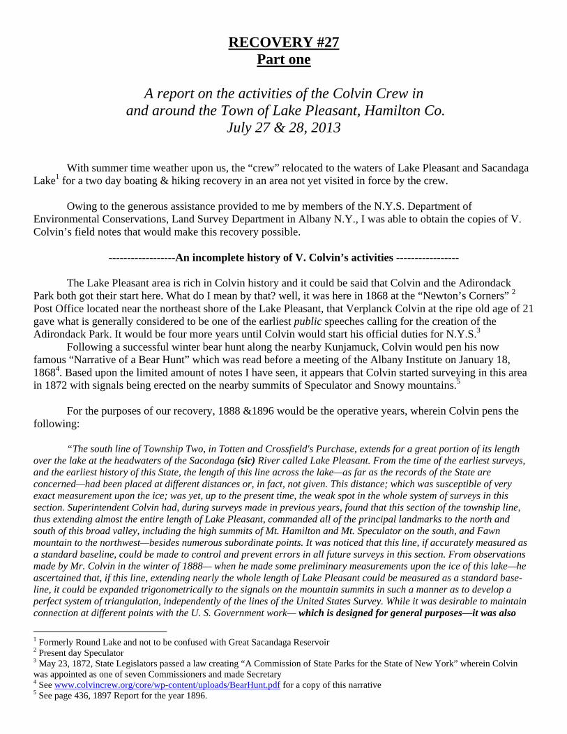
3. Lots 1 & 2 of the T.C.P.) and lesser misc. baseline points. 2. A short hiking trip to the summit of Mt. Francisco. The crew would expend seven± hours in pursuit of this recovery. Eleven members of the Colvin Crew, including the superintendent, assembled at the town beach parking lot located on the east side of Lake Pleasant. By prior arrangement, the Superintendent had made an introduction with the owners of the property where the “easterly terminus” point was located. While waiting for our appointed time, a brief search was made of the town beach for a known point. No evidence of this point was found as it looked like the beach had been cleared of its rocks. After a short walk south, we were graciously admitted onto private property to conduct our main search for the “easterly terminus” of the Lake Pleasant baseline. The point was described as being located about 20 feet north of the Twp. Line in an “enormous boulder”. Sure enough, there resting in the middle of an immaculately maintained sand beach was a large, lone, glacial till boulder untouched due to its massive size in 117 years. Obvious from ground level was an eye-bolt protruding from the top of the boulder8.
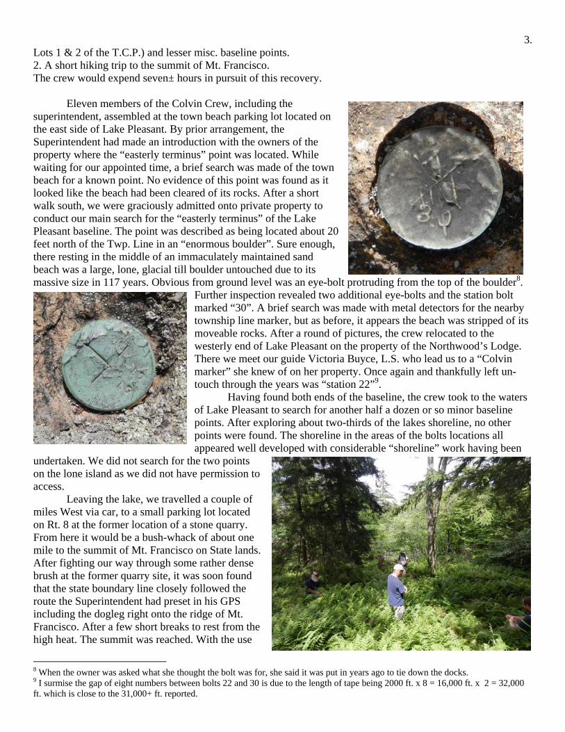
Further inspection revealed two additional eye-bolts and the station bolt marked “30”. A brief search was made with metal detectors for the nearby township line marker, but as before, it appears the beach was stripped of its moveable rocks. After a round of pictures, the crew relocated to the westerly end of Lake Pleasant on the property of the Northwood’s Lodge. There we meet our guide Victoria Buyce, L.S. who lead us to a “Colvin marker” she knew of on her property. Once again and thankfully left un-touch through the years was “station 22”9. Having found both ends of the baseline, the crew took to the waters of Lake Pleasant to search for another half a dozen or so minor baseline points. After exploring about two-thirds of the lakes shoreline, no other points were found. The shoreline in the areas of the bolts locations all appeared well developed with considerable “shoreline” work having been
undertaken. We did not search for the two points on the lone island as we did not have permission to access. Leaving the lake, we travelled a couple of miles West via car, to a small parking lot located on Rt. 8 at the former location of a stone quarry. From here it would be a bush-whack of about one mile to the summit of Mt. Francisco on State lands. After fighting our way through some rather dense brush at the former quarry site, it was soon found that the state boundary line closely followed the route the Superintendent had preset in his GPS including the dogleg right onto the ridge of Mt. Francisco. After a few short breaks to rest from the high heat. The summit was reached. With the use
8 When the owner was asked what she thought the bolt was for, she said it was put in years ago to tie down the docks. 9 I surmise the gap of eight numbers between bolts 22 and 30 is due to the length of tape being 2000 ft. x 8 = 16,000 ft. x 2 = 32,000 ft. which is close to the 31,000+ ft. reported.
4. of a metal detector, four eye-bolts were soon found. By intersection of string lines, a refined search area was identified and with the removal of a small amount of duff, a lone drill hole was found marking the station center. Having accomplished the day’s objectives, it was time to retire to the “rustic” accommodations of fellow crew member Bert Winnie III cabin for refreshment. Upon arrival at our lodgings for the night, the crew was greeted with an excellent diorama of a typical mountain top as occupied by V. Colvin that was constructed by crew member Jim Schaller. Following numerous rounds of appetizers, a buffet style potluck dinner and a glowing bonfire, the crew retired for the evening at 11:00 pm.
---------------- Sunday July 28, 2013 ---------------- The day broke cool with light wind and rain. We reformed once again at the town beach pavilion and now numbering fourteen, were treated to a reading of V. Colvin’s “Narrative of a Bear Hunt” by long time member Doug Mcllroy. With more rain forecasted ahead, a change of the day’s itinerary was made. We would concentrate our efforts on searching for the three baseline bolts located on Sacandaga Lake in order to stay away from a wet bush-whack up Speculator Mountain. Following a short car ride to the DEC boat launch on Moffit Beach, we entered the waters and commenced paddling northwestwardly along the northerly shoreline of Sacandaga Lake. After about 40 minutes, we reached our objective and once again the bolts location was given away by an
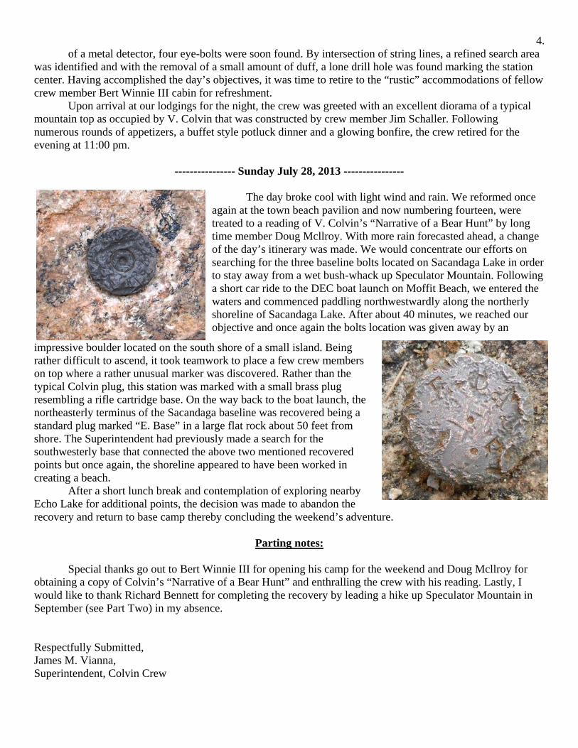
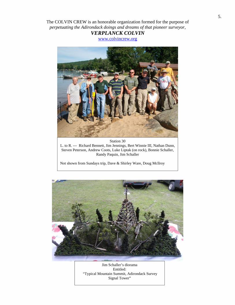
impressive boulder located on the south shore of a small island. Being rather difficult to ascend, it took teamwork to place a few crew members on top where a rather unusual marker was discovered. Rather than the typical Colvin plug, this station was marked with a small brass plug resembling a rifle cartridge base. On the way back to the boat launch, the northeasterly terminus of the Sacandaga baseline was recovered being a standard plug marked “E. Base” in a large flat rock about 50 feet from shore. The Superintendent had previously made a search for the southwesterly base that connected the above two mentioned recovered points but once again, the shoreline appeared to have been worked in creating a beach. After a short lunch break and contemplation of exploring nearby Echo Lake for additional points, the decision was made to abandon the recovery and return to base camp thereby concluding the weekend’s adventure.
Parting notes:
Special thanks go out to Bert Winnie III for opening his camp for the weekend and Doug Mcllroy for obtaining a copy of Colvin’s “Narrative of a Bear Hunt” and enthralling the crew with his reading. Lastly, I would like to thank Richard Bennett for completing the recovery by leading a hike up Speculator Mountain in September (see Part Two) in my absence. Respectfully Submitted, James M. Vianna, Superintendent, Colvin Crew
5. The COLVIN CREW is an honorable organization formed for the purpose of
perpetuating the Adirondack doings and dreams of that pioneer surveyor, VERPLANCK COLVIN
www.colvincrew.org
Station 30 L. to R. --- Richard Bennett, Jim Jennings, Bert Winnie III, Nathan Dunn, Steven Peterson, Andrew Coots, Luke Liptak (on rock), Bonnie Schaller,
Randy Paquin, Jim Schaller
Not shown from Sundays trip, Dave & Shirley Ware, Doug Mcllroy
Jim Schaller’s diorama Entitled:
“Typical Mountain Summit, Adirondack Survey Signal Tower”

October 6, 2013
RE: Recovery 27 - Part 2, Mt. Speculator
Dear Superintendent Vianna:
A few members of the Crew, consisting of Jim and Bonnie Schaller, Burt Winne, Rob Harris, Rob’s wife Penny Watt and their daughter Rose Harris, and I assembled at the Town of Speculator Parking Lot around 10:00 AM in a slight drizzle. Shortly thereafter we drove to a scenic parking area along South Shore Road to begin the hike.
View of Mt. Speculator from Town Beach, Oct. 3, 2013
After following South Shore Road a short distance to the Col. Peck Roadside Marker, we left the road and proceeded along an earthen road and trail, passing the small Col. Peck Cemetery to a small swampy area at the foot of the mountain.
The slight drizzle increased to steady rain. After crossing a swampy area we bushwhacked our way to the summit of mountain reaching the same at 1:00 PM.
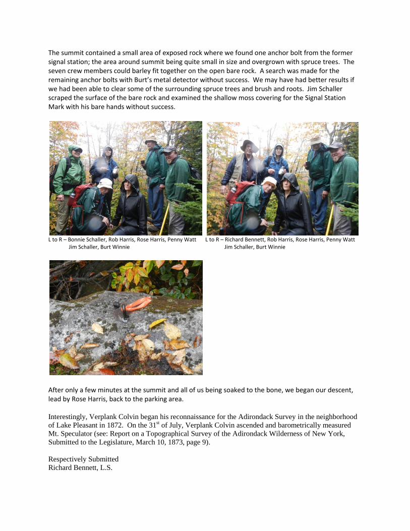
The summit contained a small area of exposed rock where we found one anchor bolt from the former signal station; the area around summit being quite small in size and overgrown with spruce trees. The seven crew members could barley fit together on the open bare rock. A search was made for the remaining anchor bolts with Burt’s metal detector without success. We may have had better results if we had been able to clear some of the surrounding spruce trees and brush and roots. Jim Schaller scraped the surface of the bare rock and examined the shallow moss covering for the Signal Station Mark with his bare hands without success.
L to R – Bonnie Schaller, Rob Harris, Rose Harris, Penny Watt L to R – Richard Bennett, Rob Harris, Rose Harris, Penny Watt Jim Schaller, Burt Winnie Jim Schaller, Burt Winnie
After only a few minutes at the summit and all of us being soaked to the bone, we began our descent, lead by Rose Harris, back to the parking area. Interestingly, Verplank Colvin began his reconnaissance for the Adirondack Survey in the neighborhood
of Lake Pleasant in 1872. On the 31st of July, Verplank Colvin ascended and barometrically measured
Mt. Speculator (see: Report on a Topographical Survey of the Adirondack Wilderness of New York,
Submitted to the Legislature, March 10, 1873, page 9).
Respectively Submitted
Richard Bennett, L.S.