reference: site: 15/00513/ful thermalite ltd -...
TRANSCRIPT

Planning Committee 13.08.2015 Application Reference: 15/00513/FUL
Reference:15/00513/FUL
Site: Thermalite LtdMotherwell WayWest ThurrockEssexRM20 3LB
Ward:West Thurrock And South Stifford
Proposal: Erection of industrial/distribution units (Classes B1(c), B2 & B8) and a trade park (Classes B1(c), B2, B8 with trade counters and ancillary showrooms) including access and servicing arrangements, car parking, landscaping and associated works.
Plan Number(s):Reference Name ReceivedLP-01 Site Location Plan 7 May 2015KP-107-TP-01 Rev. J Site Plan 7 May 2015KP-107-TP-02 Rev. C Unit A – Ground Floor Plan, Elevations &
Section7 May 2015
KP-107-TP-03 Rev C Unit A – First Floor and Roof Plans 7 May 2015KP-107-TP-04 Rev. C Unit B – Ground Floor Plan, Elevations &
Section7 May 2015
KP-107-TP-05 Rev. C Unit B – First & Second Floors and Roof Plans
7 May 2015
KP-107-TP-06 Rev. C Unit C – Ground Floor Plan, Elevations & Section
7 May 2015
KP-107-TP-07 Rev. C Unit C – First & Second Floors and Roof Plans
7 May 2015
KP-107-TP-08 Rev. C Unit D – Floor Plans, Elevations & Section 7 May 2015KP-107-TP-09 Rev. C Units 1-4 – Plans, Elevations & Section 7 May 2015KP-107-TP-10 Rev. C Units 5-8 – Plans, Elevations & Section 7 May 2015KP-107-TP-11 Rev. C Units 9-12 – Plans, Elevations & Section 7 May 2015KP-1-7-TP-13 Existing Site Plan 7 May 201520223 OGL Rev. 1 Utility Survey 7 May 201520223_OGL Rev. 1 Topographical Survey 7 May 2015544-01 Rev. A Overall Landscape Proposals 7 May 2015
The application is also accompanied by:
Planning Statement; Design and Access Statement; Transport Assessment and Addendum; Travel Plan Framework;

Planning Committee 13.08.2015 Application Reference: 15/00513/FUL
Phase 1 Ecological Assessment; Flood Risk Assessment; Noise Assessment; BREEAM Pre-Assessment; Energy Statement; Utilities Statement; and Geo-Environmental Risk Assessment.
Applicant:Kier Thurrock Ltd.
Validated: 8 May 2015Date of expiry: 7 August 2015
Recommendation: Approve, subject to conditions and s.106 Agreement.
1. DESCRIPTION OF PROPOSAL
1.1 A summary of the main elements of the proposal is provided in the table below:
Site Area 4.7 hectaresUnit A 2,930 sq.m. ground floor, 365 sq.m. first floor
– TOTAL 3,295 sq.m. Use Classes B1(c) / B2 / B8
Unit B 3,935 sq.m. ground floor, 245 sq.m. first floor, 245 sq.m. second floor – TOTAL 4,425 sq.m. Use Classes B1(c) / B2 / B8
Unit C 5,060 sq.m. ground floor, 310 sq.m. first floor, 310 sq.m. second floor – TOTAL 5,680 sq.m. Use Classes B1(c) / B2 / B8
Unit D 2,645 sq.m. ground floor, 320 sq.m. first floor – TOTAL 2,965 sq.m. Use Classes B1(c) / B2 / B8
Unit 1 459 sq.m. ground floor, 123 sq.m. first floor – TOTAL 582 sq.m. Classes B1(c) / B2 / B8
Unit 2 324 sq.m. ground floor, 64 sq.m. first floor – TOTAL 388 sq.m. Classes B1(c) / B2 / B8
Unit 3 347 sq.m. ground floor, 70 sq.m. first floor – TOTAL 417 sq.m. Classes B1(c) / B2 / B8
Unit 4 370 sq.m. ground floor, 123 sq.m. first floor – TOTAL 493 sq.m. Classes B1(c) / B2 / B8
Unit 5 760 sq.m. ground floor, 99 sq.m. first floor – TOTAL 859 sq.m. Classes B1(c) / B2 / B8
Floorspace(GIA)
Unit 6 679 sq.m. ground floor, 85 sq.m. first floor –
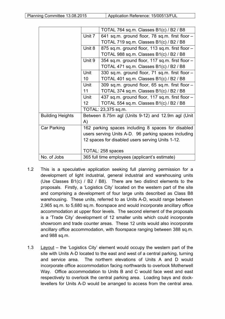
Planning Committee 13.08.2015 Application Reference: 15/00513/FUL
TOTAL 764 sq.m. Classes B1(c) / B2 / B8Unit 7 641 sq.m. ground floor, 78 sq.m. first floor –
TOTAL 719 sq.m. Classes B1(c) / B2 / B8Unit 8 875 sq.m. ground floor, 113 sq.m. first floor –
TOTAL 988 sq.m. Classes B1(c) / B2 / B8Unit 9 354 sq.m. ground floor, 117 sq.m. first floor –
TOTAL 471 sq.m. Classes B1(c) / B2 / B8Unit 10
330 sq.m. ground floor, 71 sq.m. first floor – TOTAL 401 sq.m. Classes B1(c) / B2 / B8
Unit 11
309 sq.m. ground floor, 65 sq.m. first floor – TOTAL 374 sq.m. Classes B1(c) / B2 / B8
Unit 12
437 sq.m. ground floor, 117 sq.m. first floor – TOTAL 554 sq.m. Classes B1(c) / B2 / B8
TOTAL: 23,375 sq.m.Building Heights Between 8.75m agl (Units 9-12) and 12.9m agl (Unit
A)Car Parking 162 parking spaces including 8 spaces for disabled
users serving Units A-D. 96 parking spaces including 12 spaces for disabled users serving Units 1-12.
TOTAL: 258 spacesNo. of Jobs 365 full time employees (applicant’s estimate)
1.2 This is a speculative application seeking full planning permission for a development of light industrial, general industrial and warehousing units (Use Classes B1(c) / B2 / B8). There are two distinct elements to the proposals. Firstly, a ‘Logistics City’ located on the western part of the site and comprising a development of four large units described as Class B8 warehousing. These units, referred to as Units A-D, would range between 2,965 sq.m. to 5,680 sq.m. floorspace and would incorporate ancillary office accommodation at upper floor levels. The second element of the proposals is a ‘Trade City’ development of 12 smaller units which could incorporate showroom and trade counter areas. These 12 units would also incorporate ancillary office accommodation, with floorspace ranging between 388 sq.m. and 988 sq.m.
1.3 Layout – the ‘Logistics City’ element would occupy the western part of the site with Units A-D located to the east and west of a central parking, turning and service area. The northern elevations of Units A and D would incorporate office accommodation facing northwards to overlook Motherwell Way. Office accommodation to Units B and C would face west and east respectively to overlook the central parking area. Loading bays and dock-levellers for Units A-D would be arranged to access from the central area.

Planning Committee 13.08.2015 Application Reference: 15/00513/FUL
The ‘Trade City’ part of the development would be located on the eastern part of the site with the 12 no. units arranged within three terraces arranged around a central access.
1.4 Access – the proposals involve the formation of two new accesses onto Motherwell Way (on the northern boundary of the site), one serving the ‘Logistics City’ development and one serving the ‘Trade City’ development. Two existing accesses onto Motherwell Way (located on the eastern site boundary) would be closed.
1.5 Appearance – the units would be of a conventional modern design with shallow pitched roof forms of grey-coloured cladding. External walls would be finished with silver and grey-coloured cladding, with contrast green coloured cladding to the office elements and entrances of each unit. The northern elevations of Units A and D would comprise office elements facing onto Motherwell Way. Similarly the northern elevations of Units 1 and 12 comprise office elements.
1.6 Parking – all of the ‘Logistics City’ development (Units A-D) would be allocated a secure yard area and dedicated car, cycle and powered two-wheeler parking spaces. The smaller units within the ‘Trade City’ element would be allocated smaller yards and parking areas
1.7 Landscaping – an ‘Overall Landscape Proposals’ drawing has been submitted showing a ribbon of tree and shrub planting to the northern and western boundaries of the site. More fragmented areas of tree, shrub and hedge planting are indicated within the site. Existing vegetation at the top of the cliff (located to the south of the site) would be managed.
1.8 Other Works – remedial works are proposed as part of the development in order to improve the stability of the cliff face located to the south of the site. These works will involve the installation of secured netting to the cliff face.
2. SITE DESCRIPTION
2.1 The site comprises the former Hanson Thermalite site located on Motherwell Way to the west of its junction with Euclid Way. The site is 4.7 hectares in area and rectangular in shape, measuring approximately 285m (east-west) and 165m (north-south). The site has been recently cleared of all buildings, apart from a temporary gatehouse structure. A number of piles of material associated with the demolition remain on-site. There are currently two accesses onto Motherwell Way located on the western site boundary.

Planning Committee 13.08.2015 Application Reference: 15/00513/FUL
2.2 Opposite the site on the northern side of Motherwell Way is the ‘Junction 31 Park’ comprising small-scale commercial, business and warehousing units. Larger footprint warehousing units are located on Eastern Avenue to the west. Commercial uses are also located to the east of the site along Motherwell Way, with the B&Q and Ikea uses further east. To the south of the site are residential properties in First Avenue, Second Avenue, Fifth Avenue and Hilltop Road.
2.3 The site is flat and low-lying with levels ranging between 3.2m and 3.6m AOD. The site is within the high risk flood zone (Zone 3). The cliff face associated with the former chalk quarry is to the south of the site, with ground levels at the top of the cliff generally 10-13m higher than levels at the site.
2.4 The site is located within a Primary Industrial and Commercial Area as defined by the LDF Adopted Interim Proposals Map. The site is not within an area of known ecological interest and, aside from the cliff face, there are no substantial soft landscaping features on the site.
3. RELEVANT HISTORY
3.1 The relevant history for the site is set out in the table below:
Reference Description Decision63/00778/OUT Factory & ancillary buildings for the
manufacture of lightweight concrete unitsApproved
63/00778A/REM Construction of access road Approved63/00778B/REM Factory for manufacture of concrete
componentsApproved
63/00778C/REM Temporary office block Approved70/00553/FUL Extension to factory Approved00/00113/FUL Pulverised fuel ash (PFA) storage
including building of silos and associated plant
Approved
04/00848/FUL Erection and installation of sealed silos and blowing system for the storage and handling of dry PFA
Approved
13/00616/DMI Prior notification of proposed demolition Approved
3.2 The site is located at the southern-end of the Lakeside basin and was subject to chalk quarrying during from the 1940’s. In 1964 permission was granted for factory buildings to be used for the manufacture of concrete bricks and blocks. Further planning permissions for new and extended

Planning Committee 13.08.2015 Application Reference: 15/00513/FUL
buildings associated with this use were granted during the 1970’s. The site was later operated by Hanson, who ceased manufacturing operations in 2012. The site was recently cleared of all buildings and above-ground structures.
4. CONSULTATIONS AND REPRESENTATIONS
4.1 Detailed below is a summary of the consultation responses received. Full text versions are available on the Council’s web-site at: www.thurrock.gov.uk/planning/15/00513/FUL
4.2 PUBLICITY:
The application has been publicised by the display of site notices, a newspaper advertisement and consultation with neighbouring properties and relevant consultees. The proposals have been advertised as a major development.
4.3 Neighbour consultation letters have been sent to 85 surrounding properties. No responses have been received. Members will be updated should any letters of representation be received.
4.4 ANGLIAN WATER:
No objection, subject to condition.
4.5 ENVIRONMENT AGENCY:
No objection, subject to conditions addressing the issue of contaminated land.
4.6 ESSEX COUNTY COUNCIL (ARCHAEOLOGY):
No objection.
4.7 HIGHWAYS ENGLAND:
No objection.
4.8 CIVIL PROTECTION OFFICER:
No objection.
4.9 ENVIRONMENTAL HEALTH:

Planning Committee 13.08.2015 Application Reference: 15/00513/FUL
No objection, subject to conditions addressing contamination, a construction management plan and noise.
4.10 FLOOD RISK MANAGER:
No objection, subject to a condition addressing surface water drainage.
4.11 HIGHWAYS:
No objections subject to conditions and obligations– a s.106 contribution towards improving connectivity would be required.
4.12 LANDSCAPE & ECOLOGY:
No objection – subject to a condition requiring a detailed landscape scheme.
4.13 TRAVEL PLAN CO-ORDINATOR:
No objection.
5. POLICY CONTEXT
5.1 National Planning Policy Framework (NPPF)
The NPPF was published on 27th March 2012. Paragraph 13 of the Framework sets out a presumption in favour of sustainable development. Paragraph 196 of the Framework confirms the tests in s.38 (6) of the Planning and Compulsory Purchase Act 2004 and s.70 of the Town and Country Planning Act 1990 and that the Framework is a material consideration in planning decisions. Paragraph 197 states that in assessing and determining development proposals, local planning authorities should apply the presumption in favour of sustainable development.
The following headings and content of the NPPF are relevant to the consideration of the current proposals:
1. Building a strong, competitive economy 4. Promoting sustainable transport 7. Requiring good design 8. Promoting healthy communities 10. Meeting the challenge of climate change, flooding and coastal change
Planning Committee 13.08.2015 Application Reference: 15/00513/FUL
5.2 Planning Practice Guidance (PPG)
In March 2014 the Department for Communities and Local Government (DCLG) launched its planning practice guidance web-based resource. This was accompanied by a Written Ministerial Statement which includes a list of the previous planning policy guidance documents cancelled when the NPPF was launched. PPG contains 42 subject areas, with each area containing several sub-topics. Those of particular relevance to the determination of this planning application comprise:
• Climate change• Design• Determining a planning application• Flood Risk and Coastal Change• Land affected by contamination• Land Stability• Light pollution• Noise• Planning obligations• Renewable and low carbon energy• Travel plans, transport assessments and statements in decision-taking• Use of Planning Conditions
5.3 Local Planning Policy
Thurrock Local Development Framework (2011)
The Council adopted the “Core Strategy and Policies for the Management of Development Plan Document” in December 2011. The Adopted Interim Proposals Map shows the site as falling within a Primary Industrial and Commercial Area.
Part of the Core Strategy Spatial Vision for 2026 is that “Lakeside will be transformed into a Regional Centre (town centre) providing a range of retail, leisure, employment, housing and new transport facilities” (Para 3.10, p27). Para 3.11 goes on to state that “the Council and its regeneration partners will prioritise efforts to bring about the transformation of Lakeside into a Regional Centre and in doing so, will create an image, re-shape perceptions and consequently encourage and drive forward inward investment. The level of investment in Lakeside by both private and public sectors will create confidence throughout the Borough”.

Planning Committee 13.08.2015 Application Reference: 15/00513/FUL
The LDF identifies ‘Lakeside and West Thurrock’ as a ‘Key Areas of Regeneration and Growth’ (para 3.19, p28). Para 3.24-3.26 go onto describe the Spatial Vision for this area in more detail:
“3.24 The great majority of new housing, employment and associated development in the Borough will be located in the Lakeside/West Thurrock Regeneration Area. A mix of 3,300 new dwellings will be located to the south and east of Lakeside; new Neighbourhood Areas will be developed at West Thurrock and South Stifford including community and health facilities, primary schools and shopping facilities.
3.25 The Lakeside Basin will be transformed into a Regional Centre (town centre), and, together with the wider area, will provide between 7,000 and 9,000 jobs. Development will include a substantial expansion of retail floorspace (50,000 sq.m. net of comparison floorspace) to serve sub-regional needs and additional convenience and service retail, office and leisure floorspace to broaden the mix of uses. There will be an additional 3,000 dwellings improved open space, and more community and health facilities.
3.26 The transport network will be redesigned and improved including East facing slip roads to Lakeside Shopping Centre from the A13, a relocated bus station and environmental improvements surrounding the Shopping Centre, including road and parking alterations.
3.27 The Plan proposes the provision of a new railway station at West Thurrock, introduces the South Essex Rapid Transit and will ensure pedestrian access will be improved, including north-south access from the river through Lakeside and West Thurrock to the Green Belt and beyond to Ockendon.
3.28 There will be improved public access to and along the riverfront at Wouldham Works and West Thurrock. New urban open spaces will be incorporated, as part of the Greengrid network”.
The following Core Strategy policies apply to the proposals:
SPATIAL POLICIES - CSSP2: Sustainable Employment Growth- CSSP3: Sustainable Infrastructure - OSDP1: Promotion of Sustainable Growth and Regeneration in Thurrock1
THEMATIC POLICIES

Planning Committee 13.08.2015 Application Reference: 15/00513/FUL
- CSTP6: Strategic Employment Provision- CSTP7: Network of Centres- CSTP14: Transport in the Thurrock Urban Area: Purfleet to Tilbury3
- CSTP15: Transport in Greater Thurrock- CSTP16: National and Regional Transport Networks3
- CSTP17: Strategic Freight Movement and Access to Ports- CSTP22: Thurrock Design- CSTP25: Addressing Climate Change2
- CSTP26: Renewable or Low-Carbon Energy Generation2
- CSTP27: Management and Reduction of Flood Risk2
POLICIES FOR MANAGEMENT OF DEVELOPMENT- PMD1: Minimising Pollution and Impacts on Amenity2
- PMD2: Design and Layout2- PMD8: Parking Standards3
- PMD9: Road Network Hierarchy - PMD10: Transport Assessments and Travel Plans2
- PMD11: Freight Movement- PMD12: Sustainable Buildings2
- PMD13: Decentralised, Renewable and Low Carbon Energy Generation- PMD15: Flood Risk Assessment2- PMD16: Developer Contributions2
[Footnote: 1New Policy inserted by the Focused Review of the LDF Core Strategy. 2Wording of LDF-CS Policy and forward amended either in part or in full by the Focused Review of the LDF Core Strategy. 3Wording of forward to LDF-CS Policy amended either in part or in full by the Focused Review of the LDF Core Strategy].
5.4 Focused Review of the LDF Core Strategy (2014)
This Review was commenced in late 2012 with the purpose to ensure that the Core Strategy and the process by which it was arrived at are not fundamentally at odds with the NPPF. There are instances where policies and supporting text are recommended for revision to ensure consistency with the NPPF. The Review was submitted to the Planning Inspectorate for independent examination in August 2013. An Examination in Public took place in April 2014. The Inspector concluded that the amendments were sound subject to recommended changes. The Core Strategy and Policies for Management of Development Focused Review: Consistency with National Planning Policy Framework Focused Review was adopted by Council on the 28th February 2015.
5.5 Draft Site Specific Allocations and Policies DPD

Planning Committee 13.08.2015 Application Reference: 15/00513/FUL
The Core Strategy advises that work on the future expansion of Lakeside is to be incorporated into the Sites Specific Allocations Development Plan Document (SSADPD) with delivery and implementation matters to be set out in a ‘Lakeside Supplementary Planning Document’. While the Core Strategy Policy CSTP7 (Network of Centres) commits to the expansion of Lakeside, it devolves the detail to the SSADPD.
The Consultation Draft Issues and Options SSADPD was subject to 12 weeks of consultation concluding on the 8th June 2012. The SSADPD covers all types of development site across the Borough, including a major Inset Plan on the future development of Lakeside as a Regional Town Centre. Chapter 9 sets out options for the future development of Lakeside. The Council commissioned a suite of technical studies to provide supporting evidence for the development and policy options. The Draft Site Specific Allocations DPD ‘Further Issues and Options’ was the subject of a further round of consultation during 2013.
5.6 Thurrock Core Strategy Position Statement and Approval for the Preparation of a New Local Plan for Thurrock
The above report was considered at the February 2014 meeting of the Cabinet. The report highlighted issues arising from growth targets, contextual changes, impacts of recent economic change on the delivery of new housing to meet the Borough’s Housing Needs and ensuring consistency with Government Policy. The report questioned the ability of the Core Strategy Focused Review and the Core Strategy ‘Broad Locations & Strategic Sites’ to ensure that the Core Strategy is up-to-date and consistent with Government Policy and recommended the ‘parking’ of these processes in favour of a more wholesale review. Members resolved that the Council undertake a full review of Core Strategy and prepare a new Local Plan.
6. ASSESSMENT
6.1 The issues for consideration in this case are:
I. Principle of the development;II. Layout and design issues;
III. Highways issues;IV. Impact on amenity;V. Sustainability and energy;
VI. Flood risk and drainage.

Planning Committee 13.08.2015 Application Reference: 15/00513/FUL
6.2 I. PRINCIPLE OF THE DEVELOPMENT
The site is located within a Primary Industrial and Commercial Area, as defined by the LDF Core Strategy Adopted Interim Proposals Map, where Core Strategy policies CSSP2 and CSTP6 apply. Spatial Policy CSSP2 (Sustainable Employment Growth) describe the Lakeside Basin / West Thurrock as a Key Strategic Economic Hub where the Council will promote and support economic development. Thematic Policy CSTP6 (Strategic Employment Provision) states, inter-alia, that “Primary and Secondary Industrial and Commercial areas will be reserved for employment generating uses falling within Class B1, B2, and B8 and sui generis uses.” The proposed use of the site is considered to be consistent with the aims and requirements of these adopted Core Strategy policies.
6.3 As set out in paragraph 5.3 above, the Core Strategy also refers to the vision of transforming Lakeside into a Regional Centre (Town Centre). The Regional Spatial Strategy (RSS) identified the need for further work to be done to provide a strategic planning framework to govern the transformation of the Lakeside Basin into a Regional Town Centre. A single issue review was undertaken to address this requirement and this resulted in a revision to the RSS in January 2010 to provide a dedicated policy (Policy ETG2: Thurrock Key Centre for Development and Change) to promote the redevelopment of the Basin as a Regional Town Centre, subject to a number of preconditions being met, including the preparation and adoption of local development plan policy.
6.4 Although the RSS was revoked by the Secretary of State in January 2013, the guidance set out in Policy ETG2 remain useful in providing a context for the Council’s ongoing work in planning for future transformation of the Lakeside Basin.
6.5 As required by the RSS, the Core Strategy sets out a series of overarching policies to guide the future development of Lakeside as a Regional Town Centre, as part of a wider network of centres across the Borough. Following the adoption of the Core Strategy in December 2011, work commenced in preparing the Site Allocations Local Plan with the intention of establishing a clear vision and a detailed planning framework to guide the future evolution of Lakeside into a Regional Town Centre consistent with the principles first established in Policy ETG2 and the Core Strategy.
6.6 In both March 2012 and January 2013, the Council undertook public consultation on its emerging Site Allocations Local Plan (SALP) - Issues and Options. Both versions of the consultation document included a draft

Planning Committee 13.08.2015 Application Reference: 15/00513/FUL
Lakeside Regional Town Centre Inset Plan which set out a range of alternative strategies and options for developing Lakeside as a new Regional Town Centre. The site is identified as within Zone D1 (Land north and south of Motherwell Way (West)) of the Lakeside Study Area where the preferred spatial options of the 2012 and 2013 consultations promoted residential development.
6.7 To help inform the development of a final preferred strategy for Lakeside, the draft Inset Plan also committed the Council to undertaking the preparation of a detailed master plan. Consultants have been appointed to complete this work and the final master plan will be published as part of the evidence for the new Local Plan for Thurrock.
6.8 However, at present, the adopted allocation for the site is as set out in the LDF Core Strategy Adopted Interim Proposals Map, where the site has an allocation as a Primary Industrial and Commercial Area. Therefore, as assessed against the adopted development plan, the principle of the land uses proposed is acceptable.
6.9 As the proposals are speculative, the application seeks flexibility in the range of uses for each of the buildings and permission is sought for Class B1(c) (light industrial), B2 (general industrial) and B8 (storage and distribution) across the site. Nevertheless, the applicant’s Planning Statement states that Units A-D will comprise warehouse (Class B8) units and given the large footprint of these buildings this is a reasonable assumption. On the basis that Units A-D will the occupied by warehouse operators, the proposed ‘Logistics City’ floorspace could be expected to generate approximately 200 FTE jobs (based on the Employment Densities Guide produced by the HCA (2010)).
6.10 Permission is also sought for light industrial, general industrial and warehousing uses for the smaller units within the ‘Trade City’ element of the proposals. However, the applicant’s Planning Statement notes that the 12 units within Trade City will include trade counters and ancillary showrooms “required by many trade operators”, although the trade / counter areas “will not exceed 30% of any individual unit.” Warehouses used as a sales place for the retail sale of goods to visiting members of the public (generally described as retail warehouses) clearly fall within the Class A1 retail use class. However, trade warehouses are generally held to be within the B8 use class where sales are ancillary and incidental to the ‘main’ storage use. The applicant suggests that it is ‘industry standard’ for up to 30% of the floorspace for this type of smaller unit to be used as a trade counter / showroom and is agreeable to a planning condition to this effect. Elsewhere along this part of Motherwell Way a number of small-scale
Planning Committee 13.08.2015 Application Reference: 15/00513/FUL
modern commercial units are being operated with an element of retail and showroom floorspace (e.g. Tile Style and Screwfix). Nevertheless, a degree of judgement is required to assess whether the potential trade counters / showrooms are genuinely ancillary to the ‘main’ Class B1(c) / B2 / B8. As a planning condition is offered by the applicant, this provides some comfort that retail uses would be an ancillary component.
6.11 Using the HCA Employment Densities referred to above, it is estimated that the Trade City element of the proposals could generate between 90 and 130 full-time equivalent jobs, depending upon the precise mix of uses. For the purposes of comparison, the floorspace of the former factory buildings on-site had the capacity to accommodate approximately 335 jobs, again based upon the HCA Employment Densities.
6.12 II. LAYOUT AND DESIGN ISSUES
The proposed layout of the site locates the four larger Class B8 warehousing units on the western part of the site accessed separately from the ‘Trade City’ element. This arrangement is logical and separates the potential logistics operators from the smaller commercial buildings to the east.
6.13 Current vehicular and pedestrian access to the site is only available on the shorter western boundary of the site. The proposals include the stopping-up of two vehicle access to this boundary with the reinstatement of the public footbath resulting in an uninterrupted pavement to this boundary. Currently there is no access into the site along its northern boundary. The proposals would introduce two vehicular and pedestrian accesses along this boundary, to replace the two accesses removed from the western boundary. A new 2m wide footpath is shown to the northern boundary. This footpath would replace the current ramp feature which features along the vast majority of this boundary and discourages pedestrian use. The proposals would also remove the concrete panel and post boundary treatment topped with barbed wire which runs along the majority of the northern and western boundary. Overall it is considered that the proposals would improve pedestrian linkages along this part of Motherwell Way.
6.14 The proposed west-facing elevations of Units C and D comprise the rear elevations and as such there is limited articulation or breaking-up of the building form of the warehousing along this boundary of the site. Nevertheless, this arrangement is similar to existing warehouse buildings located on the opposite site of Motherwell Way. The visual impact of the

Planning Committee 13.08.2015 Application Reference: 15/00513/FUL
western elevation would be mitigated by proposed soft landscaping such that, compared to the western elevation of the former factory building, there would be no material harm.
6.15 The northern elevations of Units A and D (Logistics City) and Units 1 and 12 (Trade City) comprise two-storey office elements with extensive glazed areas. The proposed northern frontage of the site would therefore be active with units facing towards Motherwell Way. The northern elevations would represent a considerable improvement to the quality of the streetscene in this part of Motherwell Way.
6.16 There are no objections to the design or elevational treatments of the units, which are modern in appearance would be similar to existing commercial units located closeby on Motherwell way.
6.17 III. HIGHWAYS ISSUES
Parking – the Draft Thurrock Parking Standards and Good Practice (2012) suggest car parking provision of 1 car parking space per 150 sq.m. for Class B8 development, 1 space per 50 sq.m. for Class B2 development and 1 space per 30 sq.m. for Class B1. In the case of the ‘Logistics City’ element of the proposals the intended provision of 162 car parking spaces (including spaces for disables users) complies with the draft standard for Class B8 warehousing development with ancillary Class B1 offices. As Motherwell Way is only served by one bus route, a relaxation of the draft parking standards is not appropriate. Each of the four units within ‘Logistics City’ would also include cycle and powered two-wheeler parking within the layout. The layout provides satisfactory arrangements for the parking and turning of HGV’s and service vehicles in accordance with the 2012 document.
6.18 Proposed car parking provision for the ‘Trade City’ element would comfortably exceed the suggested standard for Class B8 warehousing development. Although, assuming an entirely Class B1 or B2 development of these units, the draft standards would not be met. Across the ‘Trade City’ development as a whole it would be reasonable to assume a mix of Class B1, B2 and B8 uses with ancillary retail elements. Consequently, the Council’s Highways Officer raises no objection to the level of car parking provision. Paragraph 39 of the NPPF addresses the issue of car parking and a Ministerial Statement, dated March 2015, inserted the following wording into the NPPF:
“Local Planning authorities should only impose local parking standards for residential and non-residential development where there is clear and

Planning Committee 13.08.2015 Application Reference: 15/00513/FUL
compelling justification that it is necessary to manage their local road network.”
In light of this update it is considered that the proposed car parking arrangements are acceptable.
6.19 Access Arrangements – as noted above, the proposals involve the stopping-up of two existing accesses on the western boundary of the site and replacement accesses on the northern boundary with Motherwell Way. The Highways Officer has confirmed that the relocation of access points is acceptable in principle. Although the original Transport Assessment (TA) concluded that the proposed junction arrangements would not affect the free flow of vehicles on Motherwell Way, the Highways Officer noted that the TA should assume full occupation of the Junction 31 commercial park opposite the site. An addendum to the TA has been prepared assessing right turn movements on this assumption. At the time of writing, updated comments from the Highways Officer are awaited and an update will be provided to the Committee.
6.20 Road Junctions – Members will be aware of the traffic congestion which can occur within the Lakeside Basin. As the original TA did not include an assessment of impact on the Motherwell Way / London Road junction and the B186 / A126 (Lancaster) junction an addendum to the TA has been submitted for consideration. As above, updated comments from the Highways Officer are awaited and an update will be provided to the Committee.
6.21 The applicant’s TA Addendum presents the results of a recent traffic count for the Motherwell Way / London Road and Lancaster roundabout junctions for the AM and PM peak period, with future growth in traffic factored-in for the with and without development scenarios (2020 base year). The applicant’s modelling suggests that the Motherwell Way / London Road junction will operate within capacity with minimal queue lengths for both the with and without development scenarios.
6.22 Modelling for the Lancaster roundabout junction for the 2020 base year (without development) confirms that during the AM peak lane 1 of the A126 (north) arm operates close to capacity, with other arms within capacity. However, during the PM peak both lanes of the B186 (West Thurrock Way) operate over capacity with significant queues on the approach to the junction. For the 2020 base with the proposed development queue lengths for lanes 1 and 2 of the B186 increase by 5 and 7 vehicles respectively. Although the TA Addendum concludes by stating that there will be no noticeable impact on the operational characteristics of the Lancaster

Planning Committee 13.08.2015 Application Reference: 15/00513/FUL
roundabout and that there will only be minimal changes to queue length, it is clear that the B186 arm of this junction is already over capacity in the PM peak and that the development would add to queue lengths.
6.23 Members will be aware that paragraph 32 of the NPPF states that decisions should, inter-alia, take account of whether:
improvements can be undertaken within the transport network that cost effectively limit the significant impacts of the development. Development should only be prevented or refused on transport grounds where the residual cumulative impacts of development are severe [emphasis added].
6.24 The Highways Officer notes that intervention to mitigate the impact of the development on this junction is required particularly as this junction has experienced the highest number of accidents in the Borough over the last three years. Any increase in traffic at this junction will likely increase the instances of accidents on the network. Therefore, it is considered reasonable for any planning permission to be subject to an obligation requiring the applicant to formulate and implement a scheme to mitigate the impact of the development on the capacity and traffic queue lengths at the A126 / B186 Lancaster roundabout junction.
6.25 Framework Travel Plan (FTP) – the application is accompanied by a FTP which sets indicative targets to reduce single-occupier car trips through measures including:
provision of travel information; car sharing; cycling / walking strategy; and appointment of a travel plan co-ordinator.
6.26 Following the receipt of comments from the Travel Plan Co-ordinator an updated FTP has been submitted and agreed. A planning condition can be used to ensure implementation of the agreed measures.
6.27 IV. IMPACT ON AMENITY
Existing commercial occupiers are located to the north, east and west of the site and these occupiers would be unlikely to experience loss of amenity by reason of noise, privacy or loss of daylight / sunlight.

Planning Committee 13.08.2015 Application Reference: 15/00513/FUL
6.28 Residential receptors are located to the immediate south of the site at First Avenue, Second Avenue, Fifth Avenue and Hillcrest Avenue. However, as noted in paragraph 2.3 (above) these neighbouring dwellings are located at original ground levels and are therefore 10-13m higher than the site levels of the adjoining former quarry. This difference in ground levels and the effect of existing substantial vegetation to the cliff face and cliff top would largely screen views of the new buildings from these adjoining dwellings.
6.29 Due to the position of the application site to the north of neighbouring dwellings, there would be no harm to adjoining amenity by reason of loss of sunlight or daylight.
6.30 The application is accompanied by an “Acoustic Planning Report” which assesses the likely impact of noise from the operation of the development on sensitive residential receptors to the north. The report assesses the ‘worst case scenario’ of a 35 tonne delivery vehicle accessing the service yards of the development and concludes that recommended internal noise levels at the dwellings are satisfied, with windows both closed and open. However, as specific details of plant associated with individual buildings is not yet available, the Council’s Environmental Health Officer (EHO) recommends that a condition is attached to any grant of planning permission requiring details of plant with noise output. The EHO also recommends that any fork-lifts proposed to be used permanently on site should be fitted with smart reversing alarm as opposed to the conventional beeper type.
6.31 The proposals would have no implications for air quality. If planning permission were to be granted a condition requiring the submission, approval and compliance with a construction management plan would be necessary to protect amenity during construction activities.
V. SUSTAINABILITY AND ENERGY
6.32 Paragraph 7 of the NPPF sets out three dimensions to sustainable development: namely an economic role; a social role and an environmental role. It is considered that the proposals would contribute towards the economic role of sustainable development by way of responding to demand for employment generating floorspace within a designated Primary Industrial and Commercial Area. The social dimension of sustainable development includes the creation of a high quality built environment. As noted above, the proposals would deliver some improvements to connectivity and the quality of the public realm. Consequently the proposals fulfil this aspect of sustainable development. The proposed

Planning Committee 13.08.2015 Application Reference: 15/00513/FUL
layout of the site would incorporate elements of new tree, shrub and hedge planting. Although new planting would be limited in its extent, it would nevertheless represent a net benefit compared to the existing situation and would represent an improvement to biodiversity in compliance with the NPPF.
6.33 Adopted Core Strategy policy PMD12 (Sustainable Buildings) requires that major non-residential development should achieve the ‘very good’ BREEAM standard up to the year 2016. The planning application is accompanied by a BREEAM Pre-Assessment Report which concludes that the ‘very good’ rating will be achieved if recommendations within the report are followed. A standard planning condition could be attached to any grant of planning permission requiring that the ‘very good’ BREEAM rating is validated by the submission of a post-construction completion certificate.
6.34 Core Strategy policy PMD13 (Decentralised, Renewable and Low-Carbon Energy Generation) requires the generation of at least 15% of predicted energy requirements from renewable sources from 2015. The applicant’s Energy and Water Statement considers a range of low and zero carbon technologies and concludes that there is potential for air source heat pumps to be deployed at the site to provide space heating and hot water to office element within units. In addition, there is some limited potential for solar PV panel located on roof-tops which are free from shade. The applicant’s Statement concludes that these technologies will meet, and in all likelihood exceed Policy PMD13 requirements. Any planning permission could be subject to a condition requiring implementation of the proposed technologies.
VII. FLOOD RISK AND DRAINAGE
6.35 The site is located within the high risk flood zone (Zone 3a), although the West Thurrock area benefits from flood defences and the Environment Agency has confirmed that “the site is protected up to the 1 in 1000 year current day tidal event by the Thames tidal defences”.
6.36 Paragraph 104 of the NPPF notes that for individual developments on sites allocated in development plans through the Sequential Test, applicants need not apply the Sequential Test. As the application is allocated within the adopted Core Strategy as a primary industrial and commercial area it is not necessary to consider the matter of the Sequential Test further.
6.37 The proposed commercial use of the site is described as “less vulnerable” within the Flood Risk Vulnerability Classification at Table 2 of PPG. With

Planning Committee 13.08.2015 Application Reference: 15/00513/FUL
reference to Table 3 of PPG (Flood Risk Vulnerability and Flood Zone Compatibility) less vulnerable development can be considered appropriate in Flood Zone 3a.
6.38 The consultation response received from the Environment Agency (EA) notes that, despite the presence of tidal defences which protect the site up to the 1 in 1000 year event, there is a residual risk of flooding in the event failure of the tidal defences. A Flood Risk Assessment (FRA) accompanies the application which refers to EA modelling confirming that flood waters are not expected to reach the site in the event of either a 1 in 200 year or 1 in 1000 year event. Therefore, the risk of the site flooding in the event of a breach in tidal defences is negligible. As the EA modelling confirms that the site will remain dry during a tidal flood event, the Civil Protection Officer does not require the submission of a Flood Warning and Evacuation Plan in this case.
6.39 With reference to surface water drainage, the exiting site is almost entirely covered in hardstandings and is therefore impermeable. Existing surface water run-off from the site discharges to the Anglian Water surface water system via a single outfall pipe at the northern boundary. Proposed surface water drainage arrangements will restrict the rate of discharge to the existing Anglian Water surface water sewer to 103 litres / second. This rate represents a significant reduction in existing run-off rates. The Council’s Flood Risk Manager confirms that the proposed surface water drainage arrangements would provide significant betterment to the current situation, with a 83% reduction compared to peak run-off rates. Runoff volumes will be attenuated under parking and access roads, in voids located within the sub base material. Water quality treatment will be provided through the filtering effects of the sub-base material before discharge to the existing Anglian Water sewer. The Flood Risk Manager raises no object to the proposals, subject to a planning condition requiring details for the surface water drainage scheme. Anglian Water also request that details of the scheme for surface water drainage should be secured by planning condition.
6.40 Anglian Water notes that although there is capacity to treat waste water from the development, there is a risk of flooding of the foul sewerage network downstream. A planning condition is therefore required to require the submission and approval of a foul water strategy for the development.
VII. PLANNING OBLIGATIONS:
6.41 The March 2015 meeting of the Cabinet considered a Community Infrastructure Levy (CIL) and Planning Obligations Update report. Cabinet

Planning Committee 13.08.2015 Application Reference: 15/00513/FUL
agreed that work on the emerging CIL be suspended and that the preparation of a new CIL, to be developed alongside the emerging Local Plan, be supported. The Cabinet also noted that until the new CIL is prepared, developer contributions would continue to be sought in accordance with the Core Strategy (as amended) including Policy PMD16 – Developer Contributions. To assist in the negotiation of potential contributions, an Infrastructure Requirements List (IRL) is currently in preparation. The current draft version of the IRL identifies a range of infrastructure types (physical / social / green) by ward for a variety of different development scenarios. For the commercial development proposed, the draft IRL identifies items of physical infrastructure within the Lakeside Basin area, including the Lakeside Public Transport Interchange (Phase 1) and the ‘Active’ Links Public Realm Enhancement Project (Phase 1). However, the costs and timescale for these items of infrastructure are currently unknown. Nevertheless, the IRL also identifies revenue funding (£300,000 per annum) to improve bus services at various locations within the West Thurrock & South Stifford Ward including at Motherwell Way.
6.42 The Draft IRL notes the requirements of the NPPF that planning obligations should only be sought where they meet all of the following tests:
necessary to make the development acceptable in planning terms; directly related to the development; and fairly and reasonably related in scale and kind to the development.
6.43 Having regard to the above and in under this heading, it is considered necessary, directly related and reasonable to secure a developer contribution in this instance towards the improvement of linkages in the Lakeside Basin.
7. CONCLUSIONS AND REASON(S) FOR APPROVAL
7.1 The principal of the proposed land uses is considered acceptable within the Primary Industrial and Commercial Area and redevelopment of this vacant industrial site as proposed will create employment opportunities. The proposed layout of the site would improve footway access locally and the appearance of the development would be appropriate in its context. Subject to planning conditions, there are no objections to the proposals on matters of flood risk, impact on neighbouring amenity or environmental sustainability.
7.2 The development proposals would add to existing traffic congestion at the Lancaster roundabout and in particular to the degree of saturation and

Planning Committee 13.08.2015 Application Reference: 15/00513/FUL
vehicle queue lengths on the B186 arm during the PM peak. Mitigation is therefore sought via s.106 in respect of this impact and to enhance bus services locally.
8. RECOMMENDATION
8.1 Grant planning permission subject to:
A. the applicant entering into a s106 legal agreement with the following heads of terms:
the applicant to design a scheme to mitigate the impact of the development on the capacity and traffic queue lengths at the A126 / B186 Lancaster roundabout junction and to implement the scheme prior to the occupation of the development; and
a financial contribution towards improved bus service provision within the Lakeside Basin to be used for either improved bus service frequency, extension of bus services into the evening and at weekends, or provision towards a hopper bus service around the Basin (as identified in the Council’s emerging Infrastructure Requirement List.
B the following planning conditions:
Time Limit
1. The development hereby permitted must be begun not later than the expiration of 3 years from the date of this permission.
Reason: In order to comply with Section 51 of the Planning and Compulsory Purchase Act 2004.
Accordance with Plans
2. The development hereby permitted shall be carried out in accordance with the following approved plans:
Reference NameLP-01 Site Location PlanKP-107-TP-01 Rev. J Site PlanKP-107-TP-02 Rev. C Unit A – Ground Floor Plan, Elevations &

Planning Committee 13.08.2015 Application Reference: 15/00513/FUL
SectionKP-107-TP-03 Rev C Unit A – First Floor and Roof PlansKP-107-TP-04 Rev. C Unit B – Ground Floor Plan, Elevations &
SectionKP-107-TP-05 Rev. C Unit B – First & Second Floors and Roof PlansKP-107-TP-06 Rev. C Unit C – Ground Floor Plan, Elevations &
SectionKP-107-TP-07 Rev. C Unit C – First & Second Floors and Roof PlansKP-107-TP-08 Rev. C Unit D – Floor Plans, Elevations & SectionKP-107-TP-09 Rev. C Units 1-4 – Plans, Elevations & SectionKP-107-TP-10 Rev. C Units 5-8 – Plans, Elevations & SectionKP-107-TP-11 Rev. C Units 9-12 – Plans, Elevations & SectionKP-1-7-TP-13 Existing Site Plan20223 OGL Rev. 1 Utility Survey20223_OGL Rev. 1 Topographical Survey544-01 Rev. A Overall Landscape Proposals
Reason: For the avoidance of doubt and in the interest of proper planning.
Landscaping
3. No development shall take place above ground level until there has been submitted to, and approved in writing by, the local planning authority a scheme of hard and soft landscaping, which shall include management and maintenance of the cliff top and cliff face areas. All planting, seeding or turfing comprised in the approved scheme shall be carried out in the first planting and seeding season following completion of the development (or phase thereof) and any trees or plants which within a period of 5 years from the completion of the development die, are removed or become seriously damaged or diseased shall be replaced in the next planting season with others of similar size and species, unless the local planning authority gives written consent to any variation.
Reason: To ensure that the proposed development is satisfactorily integrated with its immediate surroundings and provides for landscaping as required by policies CSTP18 and PMD2 of the adopted Thurrock LDF Core Strategy and Policies for the Management of Development DPD [2011].
Boundary Treatments

Planning Committee 13.08.2015 Application Reference: 15/00513/FUL
4. No operational use shall take place until there has been submitted to and approved in writing by the local planning authority details of the locations, heights, designs, materials and types of all boundary treatments to be erected on site. The boundary treatments shall be completed in accordance with the approved details before the buildings hereby permitted are occupied.
Reason: In the interests of visual amenity, privacy and to ensure that the proposed development is satisfactorily integrated with its immediate surroundings as required by policies CSTP22 and PMD2 of the adopted Thurrock LDF Core Strategy and Policies for the Management of Development DPD [2011].
External Storage
5. Unless otherwise agreed in writing by the local planning authority there shall be no external storage of goods, machinery, plant or other materials on the site.
Reason: In the interests of visual amenity and to ensure that the proposed development is integrated within its surroundings as required by policy PMD1 of the adopted Thurrock LDF Core Strategy and Policies for the Management of Development DPD [2011].
Outside Working
6. Unless otherwise agreed in writing by the local planning authority no manufacturing, fabrication or other industrial processes shall take place outside the buildings on the site.
Reason: In the interests of amenity and to ensure that the proposed development is integrated within its surroundings as required by policy PMD1 of the adopted Thurrock LDF Core Strategy and Policies for the Management of Development DPD [2011].
External Lighting
7. Prior to the first occupation of the development (or part thereof) details of any external lighting, including details of the spread and intensity of light together with the size, scale and design of any light fittings and supports, shall be submitted to and agreed in writing by the local planning authority. Thereafter external lighting shall only be provided and operated in accordance with the agreed details or in accordance with any variation agreed in writing by the local planning
Planning Committee 13.08.2015 Application Reference: 15/00513/FUL
authority.
Reason: In the interests of amenity and to ensure that the proposed development is integrated within its surroundings as required by policy PMD1 of the adopted Thurrock LDF Core Strategy and Policies for the Management of Development DPD [2011].
Ancillary Offices
8. The offices hereby permitted shall be used solely for purposes in conjunction with and ancillary to the main use of the buildings for light industrial / general industrial / warehousing use and shall not be occupied separately.
Reason: In order to accord with the submitted proposals and ensure that adequate car parking provision is available in accordance with policy PMD8 of the Thurrock Core Strategy and Policies for the Management of Development DPD [2011].
BREEAM
9. Unless otherwise agreed in writing by the Local Planning Authority, the development hereby permitted shall be built as a minimum to the Building Research Establishment Environmental Assessment Method [BREEAM] ‘very good’ standard.
Prior to first use of each commercial building hereby permitted a copy of the Post-Construction Completion Certificate for the building verifying that the ‘very good’ BREEAM rating has been achieved shall be submitted to the local planning authority.
Reason: In order to reduce carbon dioxide emissions in the interests of sustainable development, as required by policy PMD12 of the Thurrock LDF Core Strategy and Policies for the Management of Development DPD [2011].
Car Parking
10. Prior to the first occupation of the development or part thereof the car parking spaces shown on the approved plans shall be provided and delineated on-site in accordance with the approved plans. Notwithstanding the Town and Country Planning (General Permitted Development) (England) Order 2015 [or any order revoking and re-enacting that Order with or without modification] no development

Planning Committee 13.08.2015 Application Reference: 15/00513/FUL
shall be carried out on the site so as to preclude the use of those car parking spaces. The car parking spaces shall be available in their entirety during the whole of the time that the buildings are open to users and visitors of the site.
Reason: In the interests of highway safety and amenity and to ensure that adequate car parking provision is available in accordance with policy PMD8 of the Thurrock Core Strategy and Policies for the Management of Development DPD [2011].
Cycle / PTW Parking
11. Prior to the first occupation of the development or part thereof details of the number, size, location, design and materials of secure and weather protected cycle parking and powered two wheeler facilities to serve the buildings shall be submitted to and agreed in writing with the local planning authority. The agreed facilities shall be installed on site prior to the first occupation of the building[s] and shall thereafter be retained for use by users and visitors of the development.
Reason: To reduce reliance on the use of private cars, in the interests of sustainability, highway safety and amenity in accordance with Policies PMD2 and PMD8 of the Adopted Thurrock Local Development Framework Core Strategy and Policies for the Management of Development DPD [2011].
Framework Travel Plan
12. The measures and procedures for monitoring and review set out within the submitted Framework Travel Plan [ref. 14/048 dated June 2015] shall be implemented during the construction and operational phases of the development and maintained throughout the lifetime of the development, unless otherwise agreed in writing by the local planning authority.
Reason: To reduce reliance on private cars in the interests of sustainability, highway safety and amenity in accordance with Policy PMD10 of the adopted Thurrock LDF Core Strategy and Policies for the Management of Development DPD [2011].
Finishing Materials
13. No development above ground level shall take place until samples of

Planning Committee 13.08.2015 Application Reference: 15/00513/FUL
the materials to be used in the construction of the external surfaces of the buildings hereby permitted have been submitted to and approved in writing by the local planning authority. Development shall be carried out in accordance with the approved details unless otherwise agreed in writing by the local planning authority.
Reason: In the interests of visual amenity and to ensure that the proposed development is satisfactorily integrated with its surroundings in accordance with Policy PMD2 of the adopted Thurrock LDF Core Strategy and Policies for the Management of Development DPD [2011].
Renewable Energy
14. Prior to the construction above ground level of any of the buildings details of measures to demonstrate that the development will achieve the generation of at least 15% of its energy needs through the use of decentralised, renewable or low carbon technologies shall be submitted to and approved in writing by the local planning authority. The approved measures shall be implemented and operational upon the first use or occupation of the buildings hereby permitted and shall thereafter be retained in the agreed form unless otherwise agreed in writing by the local planning authority.
Reason: To ensure that development takes place in an environmentally sensitive way in accordance with Policy PMD13 of the adopted Thurrock LDF Core Strategy and Policies for the Management of Development DPD [2011].
CEMP
15. No demolition or construction works shall commence until a Construction Environmental Management Plan [CEMP] has been submitted to and approved in writing by the local planning authority in writing. The CEMP should contain or address the following matters:
(a) working days / hours for the breaking-out of existing concrete;(b) working days / hours for general construction activities;(c) wheel washing and sheeting of vehicles transporting loose
aggregates or similar materials on or off site, (d) mitigation measures to control the emissions of dust during
construction and demolition activities

Planning Committee 13.08.2015 Application Reference: 15/00513/FUL
Works on site shall only take place in accordance with the approved CEMP.
Reason: In order to minimise any adverse impacts arising from the demolition and construction of the development in accordance with Policy PMD1 of the Adopted Thurrock Local Development Framework Core Strategy and Policies for the Management of Development DPD [2011].
Foul Water Drainage
16. No development shall commence until a foul water drainage strategy has been submitted to and approved in writing by the local planning authority. The approved measures within the strategy shall be implemented prior to the first use of the development or part thereof unless otherwise agreed in writing by the local planning authority.
Reason: To prevent environmental and amenity problems arising from flooding of the foul sewerage network.
Surface Water Drainage
17. No development shall take place until a surface water drainage scheme for the site has been submitted to and approved in writing by the local planning authority. The submitted details shall:
i. provide information about the design storm period and intensity, the method employed to delay and control the surface water discharged from the site and the measures taken to prevent pollution of the receiving groundwater and/or surface waters;
ii. include a period for its implementation; andiii. provide a management and maintenance plan of the
development which shall include the arrangements for adoption by any public authority or statutory undertaker and any other arrangements to secure the operation of the scheme throughout its lifetime
The approved measures within the scheme shall be implemented prior to the first use of the development or part thereof unless otherwise agreed in writing by the local planning authority.
Reason: To prevent environmental and amenity problems arising from surface water drainage.

Planning Committee 13.08.2015 Application Reference: 15/00513/FUL
Contamination
18. No development approved by this planning permission shall take place until a scheme that includes the followinga scheme that includes the following components to deal with the risks associated with contamination of the site shall each be submitted to and approved, in writing, by the local planning authority:
1) a preliminary risk assessment which has identified:
all previous uses potential contaminants associated with those uses a conceptual model of the site indicating sources, pathways
and receptors potentially unacceptable risks arising from contamination at
the site.
2) a site investigation scheme, based on (1) to provide information for a detailed assessment of the risk to all receptors that may be affected, including those off site.
3) the results of the site investigation and detailed risk assessment referred to in (2) and, based on these, an options appraisal and remediation strategy giving full details of the remediation measures required and how they are to be undertaken.
4) a verification plan providing details of the data that will be collected in order to demonstrate that the works set out in the remediation strategy in (3) are complete and identifying any requirements for longer-term monitoring of pollutant linkages, maintenance and arrangements for contingency action.
Any changes to these components require the express written consent of the local planning authority. The scheme shall be implemented as approved.
Reason: To protect and prevent the pollution of controlled waters (particularly the Principal aquifer, Source Protection Zone (SPZ3) and EU Water Framework Directive Drinking Water Protected Area) from potential pollutants associated with current and previous land uses in line with National Planning Policy Framework (NPPF; paragraphs 109 and 121), EU Water Framework Directive, Anglian River Basin Management Plan and Environment Agency Groundwater Protection: Principles and Practice (GP3 v.1.1, 2013)

Planning Committee 13.08.2015 Application Reference: 15/00513/FUL
position statements A4 – A6, J1 – J7 and N7.Verification report
19. No occupation of the development or part thereof shall take place until a verification report demonstrating completion of works set out in the approved remediation strategy and the effectiveness of the remediation has been submitted to and approved, in writing, by the local planning authority. The report shall include results of sampling and monitoring carried out in accordance with the approved verification plan to demonstrate that the site remediation criteria have been met. It shall also include any plan (a "long-term monitoring and maintenance plan") for longer-term monitoring of pollutant linkages, maintenance and arrangements for contingency action, as identified in the verification plan. The long-term monitoring and maintenance plan shall be implemented as approved.
Reason: To protect and prevent the pollution of controlled waters (particularly the Principal aquifer, Source Protection Zone (SPZ3) and EU Water Framework Directive Drinking Water Protected Area) from potential pollutants associated with current and previous land uses in line with National Planning Policy Framework (NPPF; paragraphs 109 and 121), EU Water Framework Directive, Anglian River Basin Management Plan and Environment Agency Groundwater Protection: Principles and Practice (GP3 v.1.1, 2013) position statements A4 – A6, J1 – J7 and N7.
Monitoring and maintenance plan - contamination
20. No development should take place until a long-term monitoring and maintenance plan in respect of contamination including a timetable of monitoring and submission of reports to the local planning authority, has been submitted to and approved in writing by the local planning authority. Reports as specified in the approved plan, including details of any necessary contingency action arising from the monitoring, shall be submitted to and approved in writing by the local planning authority. Any necessary contingency measures shall be carried out in accordance with the details in the approved reports. On completion of the monitoring specified in the plan a final report demonstrating that all long-term remediation works have been carried out and confirming that remedial targets have been achieved shall be submitted to and approved in writing by the local planning authority.
Reason: To protect and prevent the pollution of controlled waters

Planning Committee 13.08.2015 Application Reference: 15/00513/FUL
(particularly the Principal aquifer, Source Protection Zone (SPZ3) and EU Water Framework Directive Drinking Water Protected Area) from potential pollutants associated with current and previous land uses in line with National Planning Policy Framework (NPPF; paragraphs 109 and 121), EU Water Framework Directive, Anglian River Basin Management Plan and Environment Agency Groundwater Protection: Principles and Practice (GP3 v.1.1, 2013) position statements A4 – A6, J1 – J7 and N7.
Unforeseen contamination
21. If, during development, contamination not previously identified is found to be present at the site then no further development (unless otherwise agreed in writing with the local planning authority) shall be carried out until the developer has submitted a remediation strategy to the local planning authority detailing how this unsuspected contamination shall be dealt with and obtained written approval from the local planning authority. The remediation strategy shall be implemented as approved.
Reason: To protect and prevent the pollution of controlled waters (particularly the Principal aquifer, Source Protection Zone (SPZ3) and EU Water Framework Directive Drinking Water Protected Area) from potential pollutants associated with current and previous land uses in line with National Planning Policy Framework (NPPF; paragraphs 109 and 121), EU Water Framework Directive, Anglian River Basin Management Plan and Environment Agency Groundwater Protection: Principles and Practice (GP3 v.1.1, 2013) position statements A4 – A6, J1 – J7 and N7.
Piling Methods
22. Any piling or other foundation designs using penetrative methods shall not be permitted other than with the express written consent of the local planning authority, which may be given for those parts of the site where it has been demonstrated that there is no resultant unacceptable risk to groundwater. The development shall be carried out in accordance with the approved details.
Reason: Piling or other penetrative ground improvement methods can increase the risk to the water environment by introducing preferential pathways for the movement of contamination into the underlying aquifer and/or impacting surface water quality. For development involving piling or other penetrative ground

Planning Committee 13.08.2015 Application Reference: 15/00513/FUL
improvement methods on a site potentially affected by contamination or where groundwater is present at a shallow depth, a suitable Foundation Works Risk Assessment based on the results of the site investigation and any remediation should be undertaken. This assessment should underpin the choice of founding technique and any mitigation measures employed, to ensure the process does not cause, or create preferential pathways for, the movement of contamination into the underlying aquifer, or impacting surface water quality.
Mezzanine Floors
23. Notwithstanding the provision of the Town and Country Planning (General Permitted Development) (England) Order 2015 [or any order revoking or re-enacting that Order with or without modification], no mezzanine floors in addition to those approved by this permission or other additional floorspace shall be formed within the buildings hereby permitted without the grant of additional planning permission by the local planning authority.
Reason: In order to accord with the submitted proposals and ensure that adequate car parking provision is available in accordance with policy PMD8 of the Thurrock Core Strategy and Policies for the Management of Development DPD [2011].
Showrooms / Trade Counters
24. Showroom / trade counter areas shall be limited to the ground floor areas of Units 1 to 12 only (as identified on drawing number KP-107-TP-01 Rev. J) and shall occupy no more than 30% of the ground floor area of any Unit.
Reason: In order to accord with the submitted proposals and ensure that adequate car parking provision is available in accordance with policy PMD8 of the Thurrock Core Strategy and Policies for the Management of Development DPD [2011].
Noise from Plant
25. Maximum noise emission level (LAeq,T) for fixed mechanical plant shall not exceed the following limits, as measured 1m from the façade of the closes noise sensitive properties:

Planning Committee 13.08.2015 Application Reference: 15/00513/FUL
Location Period Minimum Representative Measured LA90, 5
min
Plant Noise Emission Limit
(LAr, 5min)
Daytime 49 54All sensitive receptors Night-time 45 50
Reason: In the interests of the amenity and to mitigate the impact of development in accordance with by policy PMD1 of the adopted Thurrock LDF Core Strategy and Policies for the Management of Development DPD [2011].
Details of Access
26. Prior to the commencement of development details showing the layout, dimensions and construction specification of the proposed access to the highway shall be submitted to and agreed in writing by the local planning authority. The agreed details shall be implemented before first occupation of the development hereby permitted.
Reason: In the interests of highway safety and efficiency.
Visibility Splays
27. Sight splays of 2.4 metres x 60 metres shall be provided at the proposed access points and thereafter maintained at all times so that no obstruction is present within such area above the level of the adjoining highway carriageway.
Reason: In the interests of highway safety and efficiency.
Documents: All background documents including application forms, drawings and other supporting documentation relating to this application can be viewed online: www.thurrock.gov.uk/planning/15/00513/FUL
Alternatively, hard copies are also available to view at Planning, Thurrock Council, Civic Offices, New Road, Grays, Essex, RM17 6SL.

Planning Committee 13.08.2015 Application Reference: 15/00513/FUL