referral form - planning · referral form the environment ... the proposed extension will enable...
TRANSCRIPT
Version 5: July 2013
REFERRAL OF A PROJECT FOR A DECISION ON THE NEED FOR ASSESSMENT UNDER THEENVIRONMENT EFFECTS ACT 1978
REFERRAL FORM
The Environment Effects Act 1978 provides that where proposed works may have asignificant effect on the environment, either a proponent or a decision-maker may referthese works (or project) to the Minister for Planning for advice as to whether anEnvironment Effects Statement (EES) is required.
This Referral Form is designed to assist in the provision of relevant information inaccordance with the Ministerial Guidelines for assessment of environmental effects underthe Environment Effects Act 1978 (Seventh Edition, 2006). Where a decision-maker isreferring a project, they should complete a Referral Form to the best of their ability,recognising that further information may need to be obtained from the proponent.
It will generally be useful for a proponent to discuss the preparation of a Referralwith the Impact Assessment Unit (IAU) at the Department of Environment, Land,Water and Planning (DELWP) before submitting the Referral.
If a proponent believes that effective measures to address environmental risks areavailable, sufficient information could be provided in the Referral to substantiate this view.In contrast, if a proponent considers that further detailed environmental studies will beneeded as part of project investigations, a more general description of potential effects andpossible mitigation measures in the Referral may suffice.
In completing a Referral Form, the following should occur:
· Mark relevant boxes by changing the font colour of the ‘cross’ to black and provideadditional information and explanation where requested.
· As a minimum, a brief response should be provided for each item in the ReferralForm, with a more detailed response provided where the item is of particularrelevance. Cross-references to sections or pages in supporting documents shouldalso be provided. Information need only be provided once in the Referral Form,although relevant cross-referencing should be included.
· Responses should honestly reflect the potential for adverse environmental effects. AReferral will only be accepted for processing once IAU is satisfied that it has beencompleted appropriately.
· Potentially significant effects should be described in sufficient detail for a reasonableconclusion to be drawn on whether the project could pose a significant risk toenvironmental assets. Responses should include:
- a brief description of potential changes or risks to environmental assetsresulting from the project;
- available information on the likelihood and significance of such changes;
- the sources and accuracy of this information, and associated uncertainties.
· Any attachments, maps and supporting reports should be provided in a secure folderwith the Referral Form.
· A CD or DVD copy of all documents will be needed, especially if the size ofelectronic documents may cause email difficulties. Individual documents shouldnot exceed 2MB as they will be published on the Department’s website.

Version 5: July 2013
ii
· A completed form would normally be between 15 and 30 pages in length. Responsesshould not be constrained by the size of the text boxes provided. Text boxes shouldbe extended to allow for an appropriate level of detail.
· The form should be completed in MS Word and not handwritten.
The party referring a project should submit a covering letter to the Minister for Planningtogether with a completed Referral Form, attaching supporting reports and otherinformation that may be relevant. This should be sent to:
Postal address Couriers
Minister for Planning Minister for PlanningGPO Box 2392 Level 20, 1 Spring StreetMELBOURNE VIC 3001 MELBOURNE VIC 3001In addition to the submission of the hardcopy to the Minister, separate submission of anelectronic copy of the Referral via email to [email protected] is required. Thiswill assist the timely processing of a referral.
______________________________________________________________

Version 5: July 2013
PART 1 PROPONENT DETAILS, PROJECT DESCRIPTION & LOCATION
1. Information on proponent and person making Referral
Name of Proponent: Hillview Quarries Pty Ltd
Authorised person for proponent: Paul Nitas
Position: Chief Executive Officer
Postal address: Hillview Quarry Drive, Dromana VIC 3936
Email address: [email protected] number: T (03) 5987 2600 M (0459) 800 930Facsimile number: N/A
Person who prepared Referral: Deb Neumann
Position: Technical Director
Organisation: Jacobs Group (Australia) Pty Ltd
Postal address: PO Box 312, Flinders Lane, Melbourne 8009
Email address: [email protected]
Phone number: 0414 811 290
Facsimile number: N/A
Available industry &environmental expertise: (areas of‘in-house’ expertise & consultancyfirms engaged for project)
Hillview Quarries – Sally Harle (in-house)· Project management & coordination· Noise (external consultant)
Jacobs (Consultant)· Project management and coordination· Land Use and environmental planning· Heritage (Aboriginal and historical)· Ecology (terrestrial and aquatic)· Spatial
The Primary Group· Communications and stakeholder engagement
and support
2. Project – brief outline
Project title:Hillview Quarries – Boundary Road Quarry extensionProject location: (describe location with AMG coordinates and attach A4/A3 map(s) showingproject site or investigation area, as well as its regional and local context)
The site is located at 115 and 121 Boundary Road in Dromana. It is located approximately 80 kmsouth-east of Melbourne and 3 km east of Dromana. It is bounded by:
· Boundary Road to the north· Eatons Cutting to the east· Rural residential dwellings to the south, and· Arthurs Seat State Park and cleared agricultural land (161 Boundary Road) to the west.
Latitude: 38˚21’18.94”Longitude: 144˚59’24.48”
AMG coordinates: 12 AMG coordinates for the site boundaries are provided on the site map at
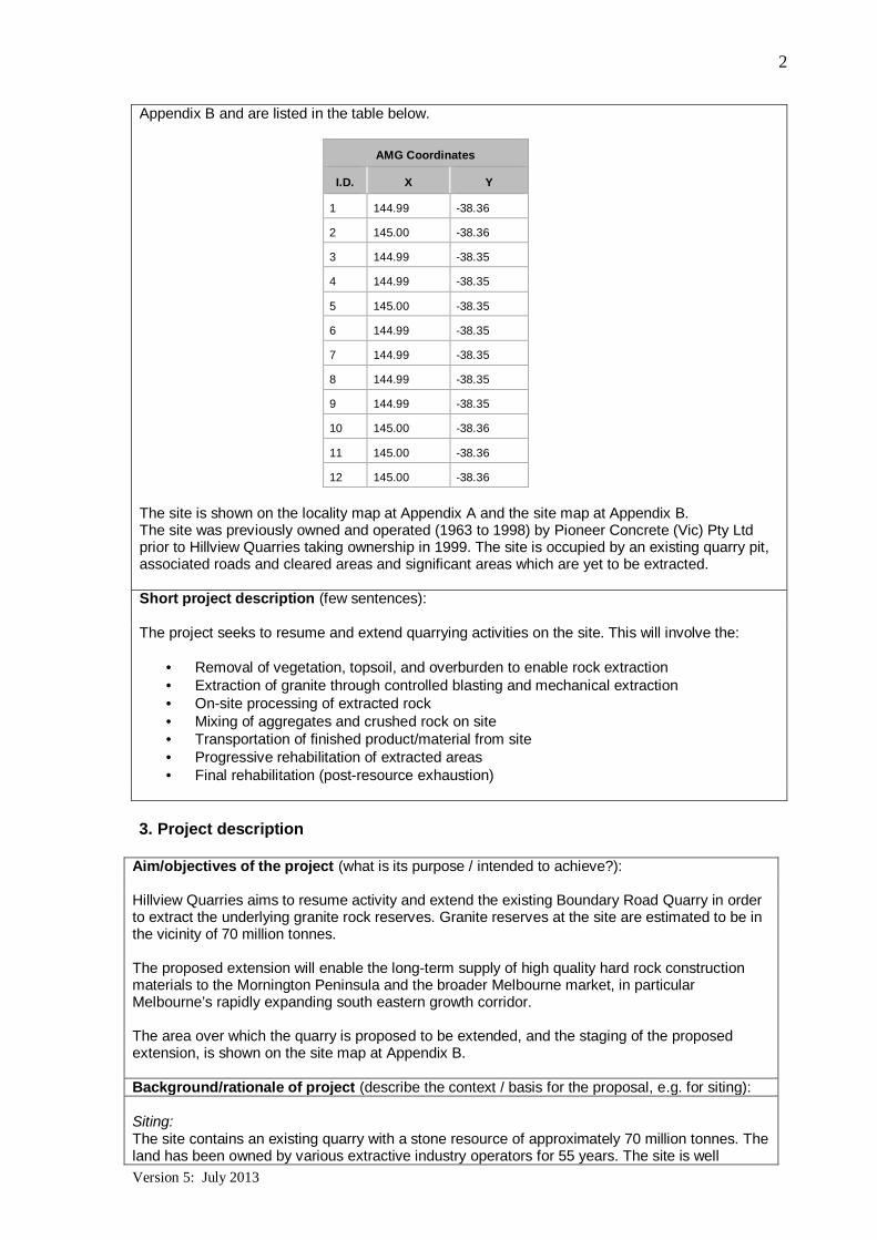
Version 5: July 2013
2
Appendix B and are listed in the table below.
AMG Coordinates
I.D. X Y
1 144.99 -38.36
2 145.00 -38.36
3 144.99 -38.35
4 144.99 -38.35
5 145.00 -38.35
6 144.99 -38.35
7 144.99 -38.35
8 144.99 -38.35
9 144.99 -38.35
10 145.00 -38.36
11 145.00 -38.36
12 145.00 -38.36
The site is shown on the locality map at Appendix A and the site map at Appendix B.The site was previously owned and operated (1963 to 1998) by Pioneer Concrete (Vic) Pty Ltdprior to Hillview Quarries taking ownership in 1999. The site is occupied by an existing quarry pit,associated roads and cleared areas and significant areas which are yet to be extracted.
Short project description (few sentences):
The project seeks to resume and extend quarrying activities on the site. This will involve the:
· Removal of vegetation, topsoil, and overburden to enable rock extraction· Extraction of granite through controlled blasting and mechanical extraction· On-site processing of extracted rock· Mixing of aggregates and crushed rock on site· Transportation of finished product/material from site· Progressive rehabilitation of extracted areas· Final rehabilitation (post-resource exhaustion)
3. Project description
Aim/objectives of the project (what is its purpose / intended to achieve?):
Hillview Quarries aims to resume activity and extend the existing Boundary Road Quarry in orderto extract the underlying granite rock reserves. Granite reserves at the site are estimated to be inthe vicinity of 70 million tonnes.
The proposed extension will enable the long-term supply of high quality hard rock constructionmaterials to the Mornington Peninsula and the broader Melbourne market, in particularMelbourne’s rapidly expanding south eastern growth corridor.
The area over which the quarry is proposed to be extended, and the staging of the proposedextension, is shown on the site map at Appendix B.
Background/rationale of project (describe the context / basis for the proposal, e.g. for siting):
Siting:The site contains an existing quarry with a stone resource of approximately 70 million tonnes. Theland has been owned by various extractive industry operators for 55 years. The site is well

Version 5: July 2013
3
located to supply development on the Mornington Peninsula as well in the urban growth areas ofsouth-east Melbourne. Current land use and planning controls in the area suggest that urbandevelopment will not further encroach on the boundaries of the quarry site.
At 60 Manna Street Dromana (Lot 1, TP447069) Hillview Quarries owns and operates the“Hillview Quarry Drive site”. The Hillview Quarry on Hillview Quarry Drive site is locatedapproximately 1.1 km to the west of the subject site and does not form part of the site subject ofthis referral.
The Boundary Road Quarry is intended to replace the Hillview Quarry Drive site as the permittedreserves at the latter is approximately less than 8 years. The exact timing of the cessation ofquarrying at the Hillview Quarry Drive site will depend on market demand (which drives the rate ofextraction).
Rationale:The site has a significant reserve of high quality granite rock available for extraction. Assuming aremoval volume of 1 million tonnes per annum, the site is anticipated to have a lifespan of over 70years. However, the rate of extraction will vary with demand, so this assumed lifespan is not fixed.
Strategic Importance:Melbourne has significant granite resources. However, access to these is mostly constrained byincompatible land uses with planning constraints restricting the amount of granite available for theMelbourne market (MSA, 2003).
Victoria’s demand for quarry resources is expected to almost double by 2050 according toExtractive Resources in Victoria: Demand and Supply Study 2015-2050, Final Report1 (theDemand and Supply Study). The site has a significant reserve of high quality granite that willenable continued supply to the local Mornington Peninsula market. It is identified as a criticalregion for the future supply into the Melbourne market, in particular for the expanding southeastern growth corridor.
Due to the weight of quarry resources, transportation costs are comparatively high, as are theinfrastructure costs to provide and maintain roads for large volume truck movements. To keepbuilding costs down, the Demand and Supply Study identifies the importance of sourcing the rawresources as close as possible to the construction sites.
The Victorian Commissioner for Better Regulation recently reviewed the performance of theVictorian mining and extractives regulator, the Earth Resources Regulator. As a result, a six-pointplan to improve mine and quarry regulation was announced by the Minister for Resources, TimPallas, on 20 December 20172. The Minister noted that the ongoing significant governmentinvestment in infrastructure is underpinned by the earth resources sector, stating:
“Improving the regulation of the earth resources sector will ensure the Victorian industryoperates at its best, providing materials for our record infrastructure investment whileprotecting communities’ interests”.
The Boundary Road Quarry is a regionally significant hard rock resource. The granite resource iscritical for the local requirements of the Mornington Peninsula and to the delivery of the State’sinfrastructure program as the site is well located to supply Melbourne’s south east growthcorridor.
1 Department of Economic Development, Jobs, Transport and Resources (2016).2 http://www.timpallas.com.au/media-releases/six-point-plan-to-improve-mine-and-quarry-regulation/

Version 5: July 2013
4
Main components of the project (nature, siting & approx. dimensions; attach A4/A3 plan(s) ofsite layout if available):
Extraction of stone:Stone is proposed to be extracted from approximately 43.4 ha of the 83.59 ha site. This areaincorporates the existing quarry pit. The resource will be extracted in two stages as shown on thesite map at Appendix B.
Boundary setback:
Clause 14.03 (Resource exploration and extraction) of the Victoria Planning Provisions states thatbuffer areas between extractive activities and sensitive land uses should be determined onconsideration of matters such as:
· “Appropriate limits on effects can be met at the sensitive locations using practical andreadily available technology.
· Whether a change of land use in the vicinity of the extractive industry is proposed.· Use of land within the buffer areas is not limited by adverse effects created by the
extractive activities.· Performance standards identified under the relevant legislation.· Types of activities within land zoned for public use”.
Clause 52.09-7 (Stone Extraction and Extractive Industry Interest Areas - Requirements for theuse and development of land for Stone extraction) of the Victoria Planning Provisions specifiesthat:
“Except with a permit, no alteration may be made to the natural condition or topography ofthe land within 20 metres of the boundary of the land. This does not apply to driveways,drains, bund walls or landscaping”.
This provision provides a setback of quarrying activities from adjoining land use of at least 20metres (as a minimum). The overall setback to be maintained from quarrying activities will bedetermined as appropriate for the surrounding uses, taking into account the guidance provided bythe planning provisions referenced above and the guidance of EPA Publication 1518Recommended separation distances for industrial residual air emissions (March 2013). This latterdocument is particularly relevant to the process of obtaining a Works Approval for the quarry.
Processing of material:A processing plant will be established in the cleared area north of the existing pit, as shown onthe site map at Appendix B. The processing plant will be sited to accept and process the rawproduct which will then be distributed via an existing internal road connecting to Boundary Roadto the north.
The processing plant contains primary, secondary and tertiary processing equipment, withstockpiling of material between stages. Aggregate will be mixed on-site to make road base, wet-mix and cement treated products.
Site access:Access will be via the existing internal road and access point to Boundary Road. The intersectionof the existing internal road and Boundary Road will be upgraded.
Ancillary components of the project (e.g. upgraded access roads, new high-pressure gaspipeline; off-site resource processing):
There are no ancillary project components, with the exception of the upgraded intersection at theentry to the site from Boundary Road noted above.
Key construction activities:
The key construction activities involve the extension of the quarry pit over an area ofapproximately 27.3 ha at Stage 1, and a further extension eastwards over approximately 16.1 ha

Version 5: July 2013
5
at Stage 2. This combined extension area of 43.4 ha is currently vegetated and will be cleared toenable the extensions, subject to refinements to the footprint after site investigations are finalised.
The pit will be excavated to an approximate depth of 190 m. Quarry walls will be batteredappropriately and the site will be fenced.
An existing laydown/staging/stockpile area immediately north of the existing quarry pit will be re-established along with the processing plant (see Appendix B).
The existing vehicle access road from the plant and stockpiling area to Boundary Road isproposed to be upgraded to accommodate heavy vehicle movements.
Key operational activities:
Extraction:Stone will be progressively extracted from the site using mechanical excavation and blastingwhere required. A front end loader or excavator will load material into haul trucks. The frequencyof blasting will vary from a few to several times monthly, as necessary to respond to marketdemand.
Processing:Stone is processed in stages with primary, secondary and tertiary scalping occurring beforematerial is screened and mixed to produce product for market.
Stockpiling and SalesStone is stockpiled between processing stages and between final screening, mixing anddistribution. A final stockpile sales area is contained within the site and the final products such ascrushed rock and aggregates are stored in this area prior to being sold to various customers tosupply infrastructure and construction project.
TransportTransportation of raw material and final product will occur throughout the operation of the quarry.Transportation is predominately via trucks which transport final product from the sales stockpilearea offsite via the main access road.
Employment: Operation of the quarry will require employment for about 35 people.
Key decommissioning activities (if applicable):
The site will be progressively rehabilitated as the resource is extracted from discrete areas of thesite.
Following extraction, the site will be made safe and stable and rehabilitated in accordance with arehabilitation plan to be approved as part of the site work plan.
Section 79 of the Mineral Resources (Sustainable Development) Act 1990 (MRSDA) requires thepreparation of a rehabilitation plan that:
· responds to any special characteristics of the land and the surrounding environment· stabilises the land· seeks to return land as close as is reasonably possible to its state before the extraction
and,· address the potential for long term degradation.
The MRSDA requires a bond to be provided to DEDJTR to ensure the site will be appropriatelyrehabilitated by the proponent.Is the project an element or stage in a larger project?
r No r Yes If yes, please describe: the overall project strategy for delivery of allstages and components; the concept design for the overall project; and the intendedscheduling of the design and development of project stages).
Version 5: July 2013
6
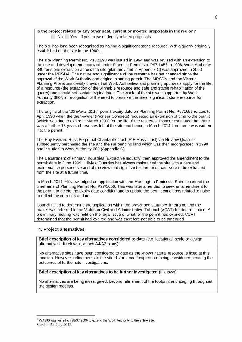
Is the project related to any other past, current or mooted proposals in the region?r No r Yes If yes, please identify related proposals.
The site has long been recognised as having a significant stone resource, with a quarry originallyestablished on the site in the 1960s.
The site Planning Permit No. P1322/93 was issued in 1994 and was revised with an extension tothe use and development approved under Planning Permit No. P97/1656 in 1998. Work Authority380 for stone extraction across the site (plan provided in Appendix C) was approved in 2000under the MRSDA. The nature and significance of the resource has not changed since theapproval of the Work Authority and original planning permit. The MRSDA and the VictoriaPlanning Provisions clearly provide that Work Authorities and planning approvals apply for the lifeof a resource (the extraction of the winnable resource and safe and stable rehabilitation of thequarry) and should not contain expiry dates. The whole of the site was supported by WorkAuthority 3803, in recognition of the need to preserve the sites’ significant stone resource forextraction.
The origins of the “23 March 2014” permit expiry date on Planning Permit No. P971656 relates toApril 1998 when the then-owner (Pioneer Concrete) requested an extension of time to the permit(which was due to expire in March 1999) for the life of the reserves. Pioneer estimated that therewas a further 15 years of reserves left at the site and hence, a March 2014 timeframe was writteninto the permit.
The Roy Everard Ross Perpetual Charitable Trust (R E Ross Trust) via Hillview Quarriessubsequently purchased the site and the surrounding land which was then incorporated in 1999and included in Work Authority 380 (Appendix C).
The Department of Primary Industries (Extractive Industry) then approved the amendment to thepermit date in June 1999. Hillview Quarries has always maintained the site with a care andmaintenance perspective and of the view that significant stone resources were to be extractedfrom the site at a future time.
In March 2014, Hillview lodged an application with the Mornington Peninsula Shire to extend thetimeframe of Planning Permit No. P97/1656. This was later amended to seek an amendment tothe permit to delete the expiry date condition and to update the permit conditions related to noiseto reflect the current standards.
Council failed to determine the application within the prescribed statutory timeframe and thematter was referred to the Victorian Civil and Administrative Tribunal (VCAT) for determination. Apreliminary hearing was held on the legal issue of whether the permit had expired. VCATdetermined that the permit had expired and was therefore not able to be amended.
4. Project alternatives
Brief description of key alternatives considered to date (e.g. locational, scale or designalternatives. If relevant, attach A4/A3 plans):
No alternative sites have been considered to date as the known natural resource is fixed at thislocation. However, refinements to the site disturbance footprint are being considered pending theoutcomes of further site investigations.
Brief description of key alternatives to be further investigated (if known):
No alternatives are being investigated, beyond refinement of the footprint and staging throughoutthe design process.
3 WA380 was varied on 28/07/2000 to extend the Work Authority to the entire site.

Version 5: July 2013
7
5. Proposed exclusions
Statement of reasons for the proposed exclusion of any ancillary activities or furtherproject stages from the scope of the project for assessment:
No further ancillary activities or project stages are proposed beyond what is described in thisreferral.
6. Project implementation
Implementing organisation (ultimately responsible for project, i.e. not contractor):
· Hillview Quarries Pty Ltd. - http://www.hvq.com.au/
Implementation timeframe (Estimated):
· Assessment and approvals process (estimated duration of 15 months)· Pre-construction preparation immediately post-approval (estimated duration 12 months)· Design, fabricate, construct, build and commission (estimated duration 24 months)· Operation to commence between 2023-2025 to the life of the resource· Staged rehabilitation and revegetation will occur on terminal faces throughout the life of
the resource· Rehabilitation to be finalised post-resource depletion, with interim rehabilitation to occur
progressively
Proposed staging (if applicable):
The resource will be extracted in two stages as shown in Appendix B.
7. Description of proposed site or area of investigation
Has a preferred site for the project been selected?r No rYes If no, please describe area for investigation.If yes, please describe the preferred site in the next items (if practicable).
General description of preferred site, (including aspects such as topography/landform, soiltypes/degradation, drainage/ waterways, native/exotic vegetation cover, physical features, builtstructures, road frontages; attach ground-level photographs of site, as well as A4/A3aerial/satellite image(s) and/or map(s) of site & surrounds, showing project footprint):
The site ranges in elevation from approximately 80 m to 200 m Australian Height Datum (AHD),excluding the existing quarry pit. The site is located on the northern flank of a ridge formed fromthe Devonian-aged Dromana Granite, at an elevation of approximately 200 m (AHD). Theunderlying Dromana Granite extends west and south west towards the coast, and Quaternary-aged colluvial sediments overlay on lower slopes to the north. The Mornington Volcanic group ispresent to the east and south of the site.
The site is located down-gradient of the nearby OT Dam, and is intersected by Sheepwash Creek(West Branch), which originates at the OT Dam and runs north towards the site, along thewestern boundary and then north and north-west to Safety Beach. An unnamed stream is presentapproximately 500 m east of the site, running adjacent to Eaton’s Cutting before joiningSheepwash Creek. The site is within the Port Phillip and Western Port Catchment ManagementAuthority operational area.
The site adjoins the Arthurs Seat State Park to the east and west. The site and surrounding areais within the Gippsland Plain Bioregion which is characterised by flat to gently undulating terrainwith a mix of low lying alluvial and coastal plains. Typical vegetation types include HeathyWoodlands, and Damp Sands Herb-rich Woodlands.

Version 5: July 2013
8
Seven Ecological Vegetation Classes (EVCs) were mapped on-site during field surveysundertaken on the project site in January 2018.
The map at Appendix H identifies the EVCs associated with 115 and 121 Boundary Road, whichis where extension of the quarry is proposed.
Site area (if known):· 83.59 ha (total site)
Route length (for linear infrastructure) ……N/A…(km) and width ……N/A…….. (m)
Current land use and development:
Extractive industry reserve
Description of local setting (e.g. adjoining land uses, road access, infrastructure, proximity toresidences & urban centres):
Adjoining land uses:· North: Boundary Road adjoins the northern boundary of the site. North of Boundary
Road, land is in a Green Wedge Zone and is used for low density residential andagricultural purposes. This land has largely been cleared of native vegetation
· East: Eatons Cutting within the Arthurs Seat State Park adjoins the south-easternboundary of the site. This land is in a Public Conservation and Resource Zone. North ofEatons Cutting and adjoining the site is land in a Green Wedge Zone (used for lowdensity residential and agricultural activities.
· South: Land adjoining the southern boundary of the site is in a Green Wedge Zone and isused for low density residential and agricultural activities.
· West: The Arthurs Seat State Park also adjoins the western boundary of the site. Thisland is in a Public Conservation and Resource Zone .
Road access:Road access to and from the site is via Boundary Road, which connects to the MorningtonPeninsula Freeway to the west and White Hill Road to the east and onto the Nepean Highway.
Infrastructure:· Mornington Peninsula Freeway is accessed approximately 3 km to the west via the quarry
access road and Boundary Road.
Proximity to residences and urban centres (distances measured point to point):· The site is approximately 3 km east of Dromana and 3.7 km north-east of Safety Beach.· The closest dwellings to the site are to the south and north-east within a Green Wedge
Zone. There are dwellings to the north across Boundary Road also within a Green WedgeZone.
· The nearest land in a residential zone is located off Boundary Road, north- west of thesite. This is zoned Low Density Residential and is currently undeveloped. Developed landin a General Residential Zone is located further to the west away from the site.
· Developed land in the Green Wedge Zone is also located to the south of the site, south ofArthurs Seat Road.
Planning context (eg. strategic planning, zoning & overlays, management plans):
The strategic nature of the stone resources at the two hard rock quarries at Dromana was initiallyrecognised in the 1986 draft Extractive Industries Strategy Plan for Melbourne4. At this time, theMornington Peninsula was considered to represent a ‘somewhat closed supply/demandsystem’5.This report included all major quarries which supplied hard rock to Melbourne and itssuburbs including the Mornington Peninsula.
4 Extractive Industries Strategy Plan Interdepartmental Committee, Extractive Industries Strategy Plan for Melbourne – ADraft Report Stage 2, Melbourne, 1986.5 Parliament of Victoria Environment and Natural Resources Committee, Report on Planning Issues for Extractive Industriesin Victoria, Melbourne, 1994 p 12

Version 5: July 2013
9
The then-Department of Energy and Minerals provided hard rock demand forecast data forinclusion within the Report on Planning Issues in 1994 which included production in grantedlicences and those under application. The report identified the locations of the hard rock quarrieswhich generally produce more than 50,000 tonnes per annum (i.e. medium to large). The HillviewQuarry Drive and Boundary Road Quarry (the latter being the site subject of this referral) were theonly hard rock quarries identified on the Mornington Peninsula. It is likely that the Boundary RoadQuarry would have been included in the production estimates as the original planning permit wasgranted prior to the finalisation of this report. This supports the view that the resource within thisquarry is essential to the continual supply of hard rock into the future.
In 1993, the then-Department of Energy and Minerals released a report designating the ExtractiveIndustry Interest Areas (EIIAs) in the Melbourne Supply Area (MSA). This report was reviewed in1996 and 2003. While no EIIAs were declared on the Mornington Peninsula, the studies clearlyrecognise that the location of the resource is isolated and, given the planning circumstances ofthe area, it was unlikely that new approvals for greenfield sites would be issued for hard rockquarry sites on the Mornington Peninsula. As a consequence, it is critical that existing sites beapproved to enable the continuation of the existing resource extraction on this site.
The EIIA Review 2003 highlighted that the limited stone resources on the Mornington Peninsula(Hillview Quarries’ two sites being the only hard rock sources on the Mornington Peninsula) maygive rise to increased costs for future stone supply within the region. The review also highlightedthe need to ensure that the existing resources are protected in order to supply the establishedmarket at a reasonable cost. This review also led to the introduction of the requirements at Clause52.09-8 of the Victoria Planning Provisions which introduced requirements for the giving of noticeof planning permit applications for dwellings proposed within 500 m of land on which a proposedor existing work authority existed.
This review clearly highlights the intent of the Victorian State Government to protect the primarygranite rock reserves on the Mornington Peninsula. The contribution of these establishedreserves to the continuous supply of construction material into the future has been factored intosupply forecasts. Given that land within the Mornington Peninsula is largely sterilised from furtherquarry development due to planning constraints, these quarries represent the last remaininggranite resources. There is a demonstrated need to continue to protect this resource given thelimited opportunities for granite extraction on the Mornington Peninsula, therefore the value of theresource is significant.
The Plan Melbourne Refresh 2015 paper states:
“The value of the production from quarries in Victoria is estimated to be about $760million per year. The availability of a reliable supply within economic transport distancesfrom demand is an important factor for the Victorian economy”.
It further states
Areas set aside for quarries more than 30 years ago are now depleted or unavailable dueto the spread of the city and protection of native grassland areas. Strategic resourcesneeded for future supply out to 2051 may be at risk due to other land uses encroaching.
These statements provide strategic planning support for the need to protect and make use ofexisting resources which are close to the demand areas. The site clearly meets these parametersin that it is close to the markets it supplies. Other than the Hillview Quarry site to the west, thereare no other high quality hard rock quarries within 65 km of this site.
This is supported by the Cement Concrete and Aggregates Association (CCAA) who previouslystated that:
Current forecasts indicate demand for sand in Melbourne will exceed supply in 2019 andfor hard rock in 2027’ (CCAA 2013).6
Fluctuations in the market are common and as stated below, reflect the domestic demand from
6 ibid, pps 5

Version 5: July 2013
10
the building and construction sector. The key is to ensure that there is a continual supply of stoneproducts available within the local market to meet this fluctuating demand.
As of 30 June 2013, there were 882 quarries operating under the Mineral Resources(Sustainable Development) Act 1990 (MRSDA) in Victoria. Of those 882, 535 quarriesreported production in 2012/13 with total sales volume being 47.4 million tonnes. Sales ofquarry products fluctuate from year to year, reflecting domestic demand from the buildingand construction sector.7
The site is subject to the provisions of the Mornington Peninsula Planning Scheme. The strategicnature of stone resources and the need to protect these resources on the Mornington Peninsulahave been identified by the State Government and by the Mornington Peninsula Shire for manyyears. The State and Local Planning Policy Frameworks in the Mornington Peninsula PlanningScheme recognise that:
· Extractive industry makes a significant contribution to the Victorian economy· Stone resources should be protected from incompatible land uses· Stone resources need to be available when required and located close to local markets to
ensure competitive supply· Planning schemes should not prohibit extractive industry or include conditions which
require the use to cease by a specified date, and· Extractive industry must be carried out in accordance with acceptable environmental
standards.
The relevant clauses of the State and Local Planning Policy Frameworks have remained largelyunchanged since 1999, reflecting the strategic value of the resource and intent to continue topreserve access to identified resources while balancing the conservation objectives of thePlanning Scheme.
In addition, the Mornington Peninsula Localised Planning Statement July 20148 states:
Extractive industries will be contained to carefully limited works and sites.
More recently, the draft Mornington Peninsula Green Wedge Management Plan 2018 recognises:
The objectives of the green wedge zone are to recognise, protect and conserve greenwedge land for its agricultural, environmental, historic, landscape, recreational andtourism opportunities, and mineral and stone resources.
The Particular Provision of the planning scheme for the earth and energy resource industry(Clause 52.08) aims to:
· encourage land to be used and developed for exploration and extraction of earth andenergy resources in accordance with acceptable environmental standards
· ensure that mineral extraction, geothermal energy extraction, greenhouse gassequestration and petroleum extraction are not prohibited land uses
· ensure that planning controls for the use and development of land for the exploration andextraction of earth and energy resources are consistent with other legislation governingthese land uses.
State Planning Policy Framework (SPPF)
The relevant clauses to be addressed under the SPPF in relation to the permitting of extractiveindustry are:
· Clause 12.01 - Biodiversity· Clause 12.04 - Significant environments and landscapes
7 Victoria’s Minerals, Petroleum and Extractive Industries 2012/2013 Statistical Report p 198 A Reference Document to Clause 11.05-2 (Distinctive areas of state significance) of the planning scheme.
Version 5: July 2013
11
· Clause 13.03-2 - Erosion and landslip· Clause 13.04-1 - Noise abatement· Clause 13.04-2 - Air quality· Clause 13.05 - Bushfire· Clause 14.02 - Water· Clause 14.03 - Resource exploration and extraction.
Local Planning Policy Framework (LPPF)
The relevant clauses to be addressed under the LPPF in relation to the permitting of extractiveindustry include:
· Clause 21.02 - Profile of the Mornington Peninsula· Clause 21.09-2 - Supporting Agriculture and Primary Production· Clause 21.12 - Reference Documents· Clause 22.05 - Aboriginal Cultural Heritage· Clause 22.11 - Mornington Peninsula Fire Protection Policy· Clause 22.14 - Mornington Peninsula Land Units· Clause 22. 20 - Landslide Susceptibility.
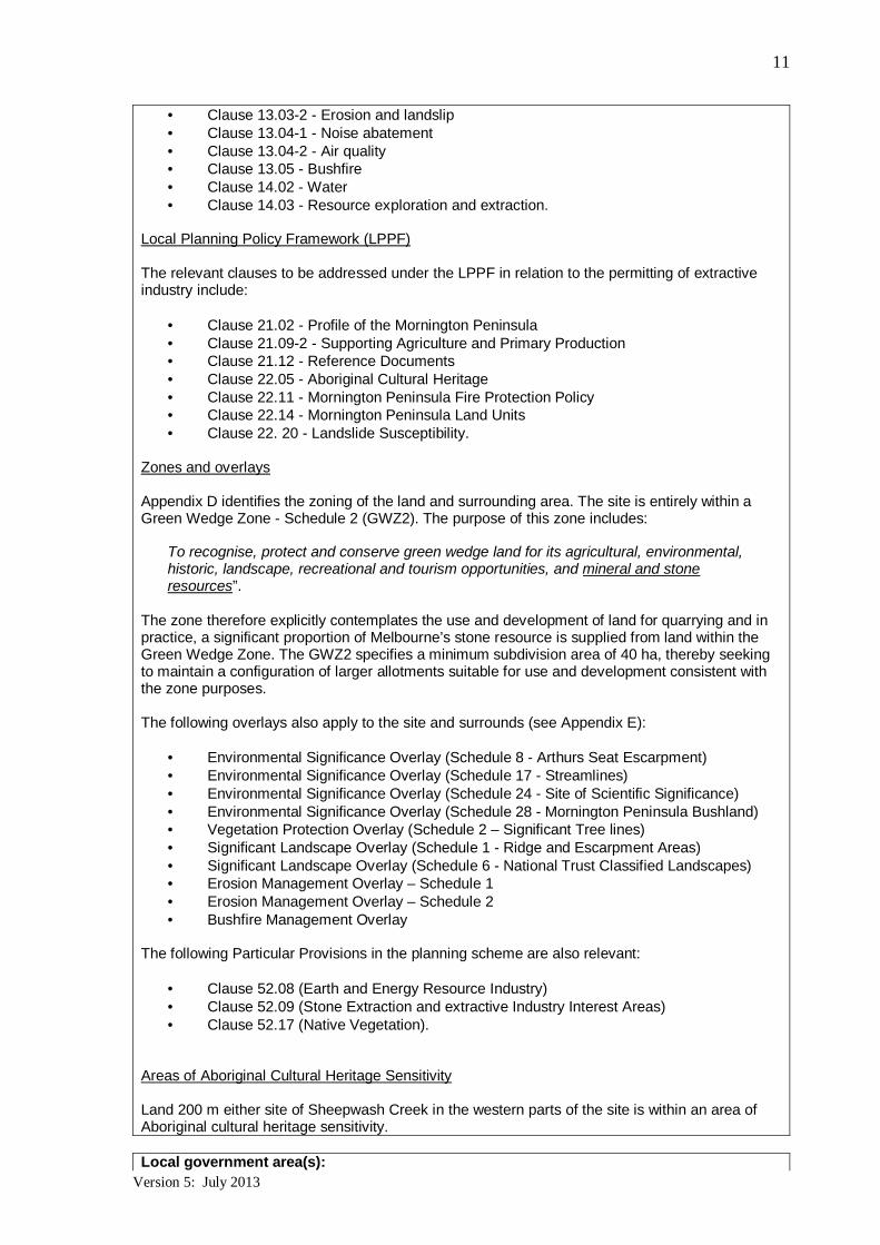
Zones and overlays
Appendix D identifies the zoning of the land and surrounding area. The site is entirely within aGreen Wedge Zone - Schedule 2 (GWZ2). The purpose of this zone includes:
To recognise, protect and conserve green wedge land for its agricultural, environmental,historic, landscape, recreational and tourism opportunities, and mineral and stoneresources”.
The zone therefore explicitly contemplates the use and development of land for quarrying and inpractice, a significant proportion of Melbourne’s stone resource is supplied from land within theGreen Wedge Zone. The GWZ2 specifies a minimum subdivision area of 40 ha, thereby seekingto maintain a configuration of larger allotments suitable for use and development consistent withthe zone purposes.
The following overlays also apply to the site and surrounds (see Appendix E):
· Environmental Significance Overlay (Schedule 8 - Arthurs Seat Escarpment)· Environmental Significance Overlay (Schedule 17 - Streamlines)· Environmental Significance Overlay (Schedule 24 - Site of Scientific Significance)· Environmental Significance Overlay (Schedule 28 - Mornington Peninsula Bushland)· Vegetation Protection Overlay (Schedule 2 – Significant Tree lines)· Significant Landscape Overlay (Schedule 1 - Ridge and Escarpment Areas)· Significant Landscape Overlay (Schedule 6 - National Trust Classified Landscapes)· Erosion Management Overlay – Schedule 1· Erosion Management Overlay – Schedule 2· Bushfire Management Overlay
The following Particular Provisions in the planning scheme are also relevant:
· Clause 52.08 (Earth and Energy Resource Industry)· Clause 52.09 (Stone Extraction and extractive Industry Interest Areas)· Clause 52.17 (Native Vegetation).
Areas of Aboriginal Cultural Heritage Sensitivity
Land 200 m either site of Sheepwash Creek in the western parts of the site is within an area ofAboriginal cultural heritage sensitivity.
Local government area(s):
Version 5: July 2013
12
The site is located within the Shire of Mornington Peninsula.
8. Existing environment
Overview of key environmental assets/sensitivities in project area and vicinity (cf. generaldescription of project site/study area under section 7):
The project area is located on freehold land owned by Hillview Quarries. The site is accessedfrom Boundary Road and supports a large extraction (quarry) and surrounding vegetated areas,both of which are maintained by Hillview Quarries.
The site and general area has a history of stone extraction dating back to the 1930s. The specificsite has a history of extraction dating from 1963 through to 1998.
The land adjoins the Arthurs Seat State Park which covers a large area to the west of the projectarea.
Key environmental attributes of the project area may include:
· Native vegetation· Powerful owl· Invasive weed species.
The closest dwelling is 120 m from the Eastern site boundary(85 Boundary Road adjacent to the Eastern boundary of the site).
9. Land availability and control
Is the proposal on, or partly on, Crown land?r No rYes If yes, please provide details.
The access road leading off Boundary Road through 115 Boundary Road and to the northernarea of 121 Boundary Road is Crown land (local government road). No extraction is proposed onthis parcel. The proposed quarry (extractive) footprint does not affect any Crown land.
Current land tenure (provide plan, if practicable):
Certificates of Title for the site are included at Appendix F.
115 Boundary Road consists of:
- Lot 1, TP099256T – Vol 9528 Fol 114
121 Boundary Road consists of:
- Lot 1 TP 665869 – Vol 8383 Fol 740.- Lot 2 TP 665869 – Vol 8383 Fol 740- CA 7E Parish of Kangerong, Vol 10565 Fol. 131
Both 115 and 121 Boundary Road are owned by the R E Ross Trust
Intended land tenure (tenure over or access to project land):
No change in land tenure is proposed
Other interests in affected land (e.g. easements, native title claims):
A review of the Native Title Vision GIS database on 11 October 2017 indicated there are noNative Title claims that affect the site, or within 1000 m of the site.

Version 5: July 2013
13
10. Required approvals
State and Commonwealth approvals required for project components (if known):
Commonwealth Environment Protection and Biodiversity Conservation Act 1999 (EPBC Act)
As the project has the potential to impact on Matters of National Environmental Significance(MNES) a referral will be submitted to the Commonwealth Department of Environment andEnergy (DoEE) who may determine that the project is a ‘controlled action.’ A controlled action is amatter that requires assessment and approval by the Commonwealth. However, a bilateralagreement exists between the Victorian and Commonwealth Governments which enables theVictorian Government to assess potential impacts to MNES through an accredited assessmentprocess (under the Planning and Environment Act 1987 and Environment Effects Act 1978).
Mineral Resources (Sustainable Development) Act 1990
A work plan and work authority are required pursuant to the MRSD Act.
The work plan requires extensive technical detail to be provided about the operation and design ofthe quarry, along with a comprehensive community engagement plan. In addition to developingthe work plan, the proponent is required to consult with all agencies with an interest in the site(these agencies include those identified through the planning scheme). The removal of nativevegetation, noise and dust emissions, impacts on surface and groundwater quality and therehabilitation of the site are all managed through the work plan process. The work plan isendorsed by the Earth Resources Regulation division of the Department of EconomicDevelopment, Jobs, Transport and Resources (DEDJTR) to ensure it is of an acceptable standardbefore a planning assessment process commences. The work plan may need to be amendedafter the planning assessment before it is approved by Earth Resources Regulation.
Planning and Environment Act 1987
Clause 52.08 (Earth and Energy Resources) requires a planning permit to use and develop theland for earth and energy resources industry. However, the clause states that no permit isrequired if the following condition is met:
· Complies with Section 77T of the MRSDA
If an EES is required, no planning permit is required, where a work plan is prepared and that workplan is consistent with the Minister for Planning’s assessment of the EES.
Clause 52.17 (Native Vegetation) states that a planning permit is not required for the removal ofnative vegetation associated with stone extraction:
· To enable the carrying out of Stone extraction in accordance with a work plan approvedunder the Mineral Resources (Sustainable Development) Act 1990 and authorised by awork authority granted under that Act.
Aboriginal Heritage Act 2006
A Cultural Heritage Management Plan (CHMP) is required for the project as the proposal is a highimpact activity (extractive industry) within an area of cultural heritage sensitivity.
Water Act 1989
Section 188A (1) of this Act specifies that any waterway in the management district of MelbourneWater is a “designated” waterway, along with land to 20 m either side of the waterway. Thesection of Sheepwash Creek between the northern side of the existing cleared laydown area andthe northern site boundary is designated under the act. The section of the creek affected by the
Version 5: July 2013
14
proposed extension (i.e. between the OT Dam and the existing cleared laydown area) is notdesignated9. If the project design encroaches onto the designated section of Sheepwash Creek, apermit for works within the waterway will be required from Melbourne Water prior to construction.
Environment Protection Act 1970
This Act provides State Environment Protection Policies (SEPPs) which need to be addressed aspart of the project. SEPPs are in place for ground and surface water management, landcontamination, noise and air quality.
Stormwater discharges from disturbed areas of the site should be managed to ensure that surfacewater runoff that leaves the site is of sufficient quality to not contaminate any protected waterbodies that it enters. Similarly, controls will need to be devised to ensure that the potential fordischarges of contaminants from machinery and processing activities to land and water (bothsurface and groundwater) is appropriately managed.
A Works Approval may be required to legitimise discharges from the proposed quarry to water.This matter will be investigated with the Environment Protection Authority in due course.
Have any applications for approval been lodged?r No rYes If yes, please provide details.
Approval agency consultation (agencies with whom the proposal has been discussed):
Discussions about the project have been undertaken with:
· Mornington Peninsula Shire· Department of Environment, Land, Water and Planning· Department of Economic Development, Jobs, Transport and Resources - Earth
Resources Regulation· Parks Victoria· Environment Protection Authority
Other agencies consulted:
VicRoads, Southern Rural Water, Commonwealth Department of Environment and Energy.
9 Melbourne Water has provided mapping which identifies the “designated” section of Sheepwash Creek as extending northfrom a point approximately level with the northern extent of the existing cleared laydown area.

Version 5: July 2013
15
PART 2 POTENTIAL ENVIRONMENTAL EFFECTS
11. Potentially significant environmental effects
Overview of potentially significant environmental effects (identify key potential effects andcomment on their significance and likelihood, as well as key uncertainties):
Cultural heritage· Identified (mapped) areas of cultural heritage significance (i.e. the western part of the
site10) will be subject to a “high impact activity”11. As a result, a CHMP Management Planwill be required to be prepared for all proposed impact areas associated with the project.
· Field investigation associated with the preparation of a CHMP may locate sites of culturalsignificance requiring management and / or mitigation measures to be implemented. As aCHMP has not yet been prepared, it is not yet known if the project might have extensiveor major impacts on Aboriginal cultural heritage. It is noted that ESO24 that applies to 115Boundary Road seeks to conserve specific sites of archaeological, botanical, geologicalor zoological value or significance.
Environment
· Environment Significance Overlays ESO8, ESO17 and ESO28 apply wholly or partly tothe site. ESO17 applies specifically to Sheepwash Creek. These overlays seek toadvance environmental objectives including the maintenance, protection andconservation of waterways, natural flows, water quality and riparian and stream habitat.The ESO24 applies to 115 Boundary Road (i.e. excludes the area of the existing quarrywithin 115 Boundary Road) and seeks the following environmental objectives:
- “To ensure the conservation of specific areas of archaeological, botanical, geologicalor zoological value or significance.
- To maintain the environmental context of archaeological, botanical, geological andzoological sites; and,
- To avoid any modification to sites of scientific significance, including the modificationby grazing or cropping, and to ensure that any development within the overlay areaare necessary to maintain or enhance the archaeological, botanical, geological andzoological values of the site”.
· The site has been subject to a recent desktop flora and fauna assessment and fieldsurvey conducted in January 2018. An Ecology Assessment Report (attached asAppendix G) describes the findings of both the desktop assessment and the field surveyfor the project. Previous flora and fauna surveys were undertaken on the site in 2013-2014. These surveys focussed on the quarry works area including the pit (5.9ha) andquarry face (6.7ha). Due to disturbance from the quarry, the area contains areas devoidof native vegetation or of low quality native vegetation. The area of the quarry was notassessed again in January 2018. The results from the 2018 field survey are discussed inSection 12 (Native vegetation, flora and fauna).
· Removal of more than 30 ha of native vegetation is proposed. The 2018 desktop floraand fauna assessment for the site found that the core quality of vegetation (asrepresented by a Site Condition Score) is likely to be moderate to high. This wasconfirmed by a field assessment which identified the vegetation quality of the project site(See Appendix G to I) ‘Edge effect’ issues (weeds, nutrients etc.) are likely to diminish thequality of the native vegetation towards the boundaries of the site.
10 Regulation 23(1), Aboriginal Heritage Regulations 2007.11 Regulation 48, Aboriginal Heritage Regulations 2007.

Version 5: July 2013
16
·
· Proposed native vegetation removal will affect seven (7) Ecological Vegetation Classes(EVCs) as listed in section 12 of this referral. Of note, EVC 53 (Swamp Scrub) and EVC175 (Grassy Woodland) are both categorised as being of “Endangered” ConservationSignificance, while the other five EVCs are all categorised as being of “Vulnerable”Conservation Significance.
· Given the large area of native vegetation on-site and the contiguous nature of the sitevegetation with adjoining habitat in state parks, it is considered that threatened speciesare likely to occur. These species are listed in the table below along with their status andlikelihood of presence (Table from Jacobs Ecology Assessment Report, 2018 inAppendix G).
Name (Scientific/Common) Status Likelihood of Presence
Stylidium dilatatum(syn. S. armeria subsp. armeria)
Tasman Triggerplant
Vic.Adv.
Poorly known
High – possible component ofwoodland/forest areas.
Caladenia dilatata s.s.
Green-comb Spider-orchid
Vic.Adv.
Poorly knownHigh – suitable habitat present on the site.
Geranium solanderi var. solanderi s.s.
Austral Crane's-bill
Vic.Adv.
Vulnerable
Moderate – suitable habitat present inforested areas adjoining drainage line onthe site, but limited local records.
Lachnagrostis rudis subsp. rudis
Rough Blown-grass
Vic.Adv.
Rare
Moderate – may adjoin drainage linehabitat in forested areas on the site.
Oxalis rubens
Dune Wood-sorrel
Vic.Adv.
Rare
Moderate – potential habitat is present onthe site.
Prasophyllum lindleyanum
Green Leek-orchid
Vic.Adv.
Vulnerable
Moderate – possible component ofwoodland/forest areas.
Pteris comans
Netted brake
Vic.Adv.
Rare
Moderate – may occur in shaded fern-richgullies.
Euphrasia collina subsp. muelleri
Purple Eyebright
EPBCEndangered
FFG
Vic.Adv.Endangered
Moderate – marginal habitat is present onsite, the species generally occurs drierheathlands than present on-site, but stillsome potential to occur.
Glossostigma diandrum
Spoon-leaf Mud-mat
Vic.Adv.
Vulnerable
Moderate-Low – may occur in swampyareas in the lower section of SheepwashCreek
Desmodium varians
Slender Tick-trefoil
Vic.Adv.
Poorly known
Moderate-Low – parts of the site presentsuitable habitat for the species but limitedrecords

Version 5: July 2013
17
Name (Scientific/Common) Status Likelihood of Presence
Glycine latrobeana
Clover Glycine
EPBCVulnerable
FFG
Vic.Adv.Vulnerable
Low-Moderate – possible component ofwoodland/forest areas but not optimumhabitat and limited nearby records.
· Ecological survey has revealed that the project may affect habitat for, “Endangered” or“Critically Endangered” fauna species listed under the EPBC Act.. The report in AppendixG identifies two (2) EPBC Act-listed species for which a “Moderate” or “Moderate-Low”likelihood of a significant impact was recorded. It is recommended that further field surveybe undertaken for presence of these species on site to further assess potential impact. AllEPBC Act threatened fauna, FFG Act listed fauna and that listed on the VictorianAdvisory List are listed in the table below along with their status and likelihood ofsignificant impact (Table 4.4 from Jacobs Ecology Assessment Report, 2018 in AppendixG)
Name (Scientific/Common) Status Likelihood of Significant Impact
Accipiter novaehollandiaenovaehollandiae
Grey Goshawk
FFG
Vic.Adv.Vulnerable
High – Records exist on elevated ridge line,potentially associated with breeding site.
Ninox strenuaPowerful Owl
FFG
Vic.Adv.Vulnerable
High – The proposal will impact high qualitybreeding roosts utilised by the species.
Lissolepis coventryi
Swamp Skink
FFG
Vic.Adv.Vulnerable
High- While prime habitat on-site is not proposed tobe impacted, further up the catchment potentialhabitat such as HZ17 is expected to be impacted
Pseudemoia rawlinsoni
Glossy Grass Skink
Vic.Adv.
Vulnerable
High- While prime habitat on-site is not proposed tobe impacted, further up the catchment, potentialhabitat such as HZ17 is expected to be impacted.
Pseudophrynesemimarmorata
Southern Toadlet
Vic.Adv.Vulnerable
High – Species is likely to be present in forestedhabitat on the site.
Dromaius novaehollandiae
Emu
Vic.Adv.Near threatened
Moderate – habitat loss would fragment the widervegetated landscape, reducing the foragingcapability for the species in the area.
Haliaeetus leucogaster
White-bellied Sea-Eagle
FFG
Vic.Adv.Vulnerable
Moderate – Home range likely to encompass widervegetated area that takes in the adjoining statepark.
Isoodon obesulus obesulus
Southern Brown Bandicoot
EPBCEndangeredFFG
Vic.Adv.Near threatened
Moderate – Potential to occur on site.

Version 5: July 2013
18
Hirundapus caudacutus
White-throated Needletail
Vic.Adv.Vulnerable
Moderate – Species likely to make use of the siteand other vegetated ridge tops present in thevicinity of the site.
Sminthopsis leucopus
White-footed Dunnart
FFG
Vic.Adv.Near threatened
Moderate-Low – Species potentially occurs on site.
Name (Scientific/Common) Status Likelihood of Significant Impact
Ninox connivens connivens
Barking Owl
FFG
Vic.Adv.Endangered
Moderate-Low – Barking Owl appears unlikely tomake significant use of the site.
Varanus varius
Lace Monitor
Vic.Adv.Endangered Moderate-Low - Site constitutes suitable habitat.
Lathamus discolour
Swift Parrot
EPBCCritically Endangered
FFG
Vic.Adv.Endangered
Moderate-Low - While vegetation on site does notconstitute breeding habitat, vegetation is within themigration corridor which may provide roosting areasto support the species.
· The review of species listed on the Victorian Biodiversity Atlas revealed that for 45species there is a “Low” likelihood of a significant impact associated with the project. For12 species there is a “Moderate” likelihood of a significant impact being generated by theproject. For 6 species, there is a “High” likelihood of impact associated with the project.The findings in Appendix G identifies the 24 species that are moderately or highly likely tobe significantly impacted by the project.
· Impacts on matters listed under the FFG Act are a relevant consideration in determiningthe referral of a project under the Environment Effects Act 1978. The desktop and fieldsurvey identifies that 32 species listed under the FFG Act are potentially impacted by theproject. Of these 32 species, four (4) species have a “Moderate” likelihood of a significantimpact, while a further three (3) species have a “High” likelihood of a significant impactassociated with the project (see Appendix G).
· Additional seasonal field surveys will need to be undertaken to confirm the likelihood andsignificance of the project’s potential adverse effects on flora and fauna.
Management and / or contamination of surface and /or ground water
· Further excavation of the site for quarrying and associated processing activities present apotential risk of impacts to surface and ground water quality. The quarry works mayimpact surface water in downstream reaches of Sheepwash Creek, which currently leadsdirectly through the quarry extension area in two branches. The project may also impactgroundwater depending on the depth to the aquifer beneath the site, geologicalconditions, groundwater flows and quality.
· It is anticipated that the section of Sheepwash Creek within 115 Boundary Road thatintersects the proposed quarry extension area (approximately 540 m over two branchesof the waterway) will be potentially affected through stormwater run-off and/or dischargesfrom the quarry pit (subject to EPA Approval).
· Technical studies are required to understand the likelihood, nature and significance ofany potential effects on surface waterways and groundwater. Water quality monitoringregimes may be required to enable ongoing testing and management of project impactson water quality.
Erosion

Version 5: July 2013
19
· The carrying out of earthworks associated with any quarry extension has the potential tocause erosion onsite, particularly given the undulating topography of the site and thesteep batters required to be created for the pit. The site is subject to land instability, asreflected by the two Erosion Management Overlays that apply, being:
- Erosion Management Overlay: Schedule 1 (EMO1). The EMO1 applies to the landadjoining the eastern and southern sides of the existing quarry pit.
- Erosion Management Overlay: Schedule 2. The EMO2 applies to land adjoining thewestern side of the existing quarry pit.
· While methods exist to mitigate and manage the potential for erosion to occur, the exactnature of geotechnical constraints are currently unclear and will require furtherinvestigation.
Public land interface
· The site directly adjoins the Arthurs Seat State Park to the east and west. The park isused for bushwalking and mountain biking. Vantage points provide views into the sitefrom the park. The carrying out of quarrying operations will generate emissions of noise,dust and ground vibration associated with the movement of heavy vehicles, blasting androck processing. The significance of these effects on the aesthetic and amenity values ofthe adjoining state park are unknown at this time and will require further investigation
Amenity
Alteration of landform
· Stone extraction will alter landforms on the site over the portion of the site to be quarried.This area ranges in elevation from approximately 110m AHD in the north-eastern area ofland to be quarried in Stage 2 (see Appendix B) to a ridge in the south-east corner of thesite at approximately 200 m AHD elevation. Quarrying will reduce these landforms tosignificantly lower levels. Views into the site from adjacent ridgelines in the Arthurs SeatState Park, such as from the south-east at 81 Eatons Cutting and to the west fromelevated areas near Rock Salt Track may reveal this excavation area. More distant viewssuch as from dwellings and the wider locality may also reveal changes to the sitelandform.
· The SLO1 and SLO6 that apply recognise the visual values associated with the landformson site. The ESO24 also seeks to protect and conserve sites of geological significance.As such, the alteration of these landforms may have the potential to adversely affect theintegrity of the landscapes sought to be protected by these overlays.
Views of overburden, stockpiles and plant
· Views into the site would extend to these areas. The introduction of these elements willrepresent a departure from the context of the surroundings, given the extent of proposedvegetation removal and typical visual appearance of a working quarry.
Dust Emissions
· Quarrying activity at this site raises the potential for emissions of dust that may affectproperties along Boundary Road, Eatons Cutting and Arthurs Seat Road. Thesignificance of effects on neighbouring properties will depend on weather conditions atthe time emissions are released and the effectiveness of any mitigation measuresimplemented to control dust.
Noise Emissions
· Emissions of noise may affect properties along Boundary Road, Eatons Cutting andArthurs Seat Road, recreational users of the adjoining State Park and visitors to the widerarea. Preliminary modelling of predicted noise emissions from the quarry was undertakenin 2017. Noise sources considered in this assessment included mobile crushing andscreening plant, a secondary crusher, diesel powered screens, an excavator, a wheeledloader and sales trucks to cart finished saleable product.

Version 5: July 2013
20
· The significance of noise emissions will vary with meteorology, the frequency, timing andduration of emissions, the type of plant/equipment used, topography and the location ofthe noise source/s, among other variables.
· Noise modelling was conducted on three scenarios of normal plant operations, earlymorning pre-start checks and evening plant operation with no extraction. Furthermodelling will be undertaken as necessary to identify the effects of noise emissions, asproject design and investigations progress. Predicted noise level as the nearest dwellingto the project will comply with EPA guidelines for Noise from Industry in Regional Victoria(October 2011) for recommended maximum noise levels (RMNL).
· Reduced plant operations during the early morning periods are required to meet theRecommended Maximum Noise Levels for night-time.
· Insulated enclosures are required to be installed around the primary and tertiary crushingplant and screens for evening operations. Broadband reversing beepers will also need tobe fitted.
Air Blast
· Blasting usually results in ground and airborne vibration. The latter includes audible noiseand vibration known as “airblast”. This can cause objects to rattle and make noise.
· Air blast may affect properties along Boundary Road, Eatons Cutting and Arthurs SeatRoad as well as users of the adjoining public land. Specialist investigations into air blasteffects will need to be undertaken to better understand the potential significance of thiseffect, and mitigation measures (if necessary).
Ground Vibration
· The use of explosives in quarry gives rise to the potential for ground vibration to affectproperties along Boundary Road, Eatons Cutting and Arthurs Seat Road and users of theadjoining public land. Specialist technical advice is required to be obtained before thesignificance of this effect can be more clearly understood.
· Air blast and ground vibration are both matters that are to be considered having regard toThe Guidelines for Ground Vibration and Airblast Limits for Blasting in Mines andQuarries12
Traffic
The resumption of quarrying will necessitate the haulage of processed stone to distributors andcustomers. This may alter the source of traffic generation during the transitional period betweenthe Hillview Quarry Drive site and the subject site. However, the overall quantum of trafficmovements is unlikely to increase, given the Boundary Road Quarry is intended to operate as areplacement for, rather than a parallel to, the Hillview Quarry Drive site.
A transportation assessment will be prepared to assess the potential for, and significance of, anycumulative effects associated with road maintenance requirements, emissions of noise and dustand heavy vehicle movements.
12 http://earthresources.vic.gov.au/earth-resources-regulation/licensing-and-approvals/minerals/guidelines-and-codes-of-practice/ground-vibration-and-airblast-limits-for-blasting-in-mines-and-quarries

Version 5: July 2013
21
12. Native vegetation, flora and fauna
Native vegetationIs any native vegetation likely to be cleared or otherwise affected by the project?
r NYD r No r Yes If yes, answer the following questions and attach details.
What investigation of native vegetation in the project area has been done? (briefly describe)
Investigations of native vegetation in the project area consist of:
· 115 and 121 Boundary Road – an Ecological Impact Assessment in 2013. This focusedon areas around the pit and laydown area.
· 121 Boundary Road - a targeted flora and fauna assessment in 2014. This included fishand nocturnal bird assessments.
· 115 Boundary Road:
- Desktop assessment of flora and fauna values of 115 Boundary Road in 2017.
- Preliminary Field Assessment Report in 2018
Further field surveys of certain species will need to be undertaken at future dates when ecologicalvariables (such as seasonal patterns) allow.
In summary, the findings of the Preliminary Flora and Fauna Assessment are:
· The site contains seven EVCs including two with an “Endangered” conservation status.
· The two properties (115 and 121 Boundary Road) are estimated to contain 74 hectares ofnative vegetation amounting to 45 habitat hectares. Of this area, 9.203 habitat hectares(14.899 hectares) is comprised of vegetation with an “Endangered” conservation status.
· The site may host a number of flora and fauna species categorised at differing levels ofconservation status.
· 11 species listed under the Flora and Fauna Guarantee Act 1988 (FFG Act) may occur onthe site.
· Four species listed under the Commonwealth EPBC Act may occur on the site.
· 24 species listed under the Victorian Advisory List are potentially relevant to the site.
What is the maximum area of native vegetation that may need to be cleared?r NYD Estimated area <38 hectares
How much of this clearing would be authorised under a Forest Management Plan or FireProtection Plan?
r N/A ………………………. approx. percent (if applicable)
Which Ecological Vegetation Classes may be affected? (if not authorised as above) NYD X Preliminary/detailed assessment completed. If assessed, please list.
EVC Number EVC Name Area (ha) Conservation significance
16 Lowland Forest 21.5 Vulnerable
23 Herb-Rich Foothills Forest 5.8 Vulnerable
53 Swamp Scrub 0.1 Endangered
59 Riparian Thicket 0.6 Vulnerable
175 Grassy Woodland 9.6 Endangered

Version 5: July 2013
22
Have potential vegetation offsets been identified as yet?r NYD r Yes If yes, please briefly describe.
Assessments to date have identified the presence of ecologically significant vegetation on-site.The removal of such vegetation may necessitate the procurement of significant vegetation offsets.The availability of relevant vegetation and registered credits in the region will be a matter forfurther consideration.
Given the large areas of native vegetation to be retained on-site, there is potential that some ofthe project native vegetation offset obligations could be satisfied by on-site offsetting. Thispotential was acknowledged in the 2013 ecological assessment of the site.
The Guidelines for the removal, destruction or lopping of native vegetation (DELWP, December2017) reflect State planning policy at Clause 12.01 Biodiversity of the Victoria PlanningProvisions. The ‘three-step approach’ prioritises the avoidance of native vegetation, theminimisation of vegetation removal where possible and offsetting the removal of native vegetationwhere its removal cannot be avoided. Given the existing vegetation coverage, the fixed location ofthe resource and the nature of quarrying development, there is no ability to avoid nativevegetation removal. However, refinement of the work area footprint may facilitate some localisedavoidance of higher quality areas of native vegetation.
Other information/comments? (e.g. accuracy of information)None
Flora and fauna
What investigations of flora and fauna in the project area have been done?
A number of studies have considered flora and fauna across the site, as noted in the sectionabove relating to native vegetation.
Recent investigations have included the desktop and field assessments by Jacobs’ ecologists,discussed below.
Desktop AssessmentA Desktop Flora and Fauna Assessment was undertaken using information from NatureKit, theVictorian Biodiversity Atlas and the Protected Matters Search Tool. The desktop assessmentfound that the site potentially contains habitat for numerous flora and fauna species of local,regional, state and Commonwealth significance.
Site vegetation is characterised by EVCs that have been subject to widespread historic removal inthe bioregion. These impacts are reflected in bioregional conservation significance ratings ofVulnerable or Endangered for site EVCs.
Recent records indicate the presence of a number of threated species in the vicinity of the site.The site contains habitat that is potentially relevant to these species.
The extensive areas of native vegetation on-site link the two adjoining areas of the Arthurs SeatState Park. The native vegetation potentially impacted by the project is considered to be importantat a local/regional scale given the limited extent of remnant native vegetation present on theMornington Peninsula.
Field AssessmentA field assessment of 115 Boundary Road was undertaken in early January 2018 (see AppendixG). The outputs of the field survey were a report to detail the EVCs on-site and calculations of thequality of on-site vegetation using the Habitat Hectare methodology. The report also providedconsideration of the potential for rare or threatened taxa to utilise the site.
The field survey confirmed the presence of seven EVCs on-site, as identified in the table above.These EVCs are scattered across 19 Habitat Zones.

Version 5: July 2013
23
Have any threatened or migratory species or listed communities been recorded from thelocal area?
r NYD r No r Yes If yes, please:· List species/communities recorded in recent surveys and/or past observations.· Indicate which of these have been recorded from the project site or nearby.
Yes. The field survey confirmed the presence of seven EVCs on-site (see Appendix G). Listedthreatened Ecological Communities, listed threatened species and migratory species areidentified in the Protected Matters Search Tool report provided as Appendix E of the EcologyReport (Appendix G of this referral) Not all of these listed species were identified as part of therecent January 2018 field survey. Those likely to be potential species identified by the field surveyare listed in the table below.
Name (Scientific/Common) Status Likelihood of Presence
Flora
Euphrasia collina subsp. muelleri
Purple Eyebright
EPBCEndangered
FFG
Vic.Adv.Endangered
Moderate – marginal habitat is present onsite, the species generally occurs drierheathlands than present on-site, but stillsome potential to occur.
Glycine latrobeana
Clover Glycine
EPBCVulnerable
FFG
Vic.Adv.Vulnerable
Low-Moderate – possible component ofwoodland/forest areas but not optimumhabitat and limited nearby records.
Flora
Isoodon obesulus obesulus
Southern Brown Bandicoot
EPBCEndangeredFFG
Vic.Adv.Near threatened
Moderate – Potential to occur on site.
Lathamus discolour
Swift Parrot
EPBCCriticallyEndangered
FFG
Vic.Adv.Endangered
Moderate-Low - While vegetation on sitedoes not constitute breeding habitat,vegetation is within the migration corridorwhich may provide roosting areas to supportthe species.
Migratory
Hirundapus caudacutus
White-throated Needletail
Vic.Adv.Vulnerable
Moderate – Species likely to make use ofthe site and other vegetated ridge topspresent in the vicinity of the site.
If known, what threatening processes affecting these species or communities may beexacerbated by the project? (e.g. loss or fragmentation of habitats) Please describe briefly.
The removal of native vegetation more than 30 ha to facilitate quarrying has the potential to resultin significant impact on threatened species and communities, as well as adverse effectsassociated with reduced habitat extent in a bioregion that has been subject to widespread historichabitat removal. Further investigations are required to determine.

Version 5: July 2013
24
Are any threatened or migratory species, other species of conservation significance orlisted communities potentially affected by the project?
r NYD r No r Yes If yes, please:
· List these species/communities:· Indicate which species or communities could be subject to a major or extensive impact
(including the loss of a genetically important population of a species listed or nominatedfor listing) Comment on likelihood of effects and associated uncertainties, if practicable.
Is mitigation of potential effects on indigenous flora and fauna proposed?r NYD r No r Yes If yes, please briefly describe.
Further site surveys are required to be carried out to confirm the use of the site by variousspecies. As noted above, the site contains a variety of habitat types that may serve toaccommodate numerous species of differing conservation status.
Other information/comments? (e.g. accuracy of information)
13. Water environments
Will the project require significant volumes of fresh water (e.g. > 1 Gl/yr)?r NYD r No r Yes If yes, indicate approximate volume and likely source.
No – the site is self-sustaining. Currently, the run off from the site’s surface water enters into theexisting quarry pit. The flow of water from the OT Dam is diverted around the pit.
Will the project discharge waste water or runoff to water environments?r NYD r No r Yes If yes, specify types of discharges and which environments.
Further project scoping is required to determine whether it is necessary or appropriate todischarge to water environments.
Are any waterways, wetlands, estuaries or marine environments likely to be affected?r NYD r No r Yes If yes, specify which water environments, answer the followingquestions and attach any relevant details.

Version 5: July 2013
25
Sheepwash Creek is the only waterway in proximity of the site and was previously the point ofdischarge. The EPA licence which allowed this to occur was requested to be surrendered in 2010.A new licence will be required for any discharge into the creek.
Given the existing alignment of Sheepwash Creek through the centre of the proposed quarryextension area, the two branches of the waterway will need to be diverted, diverted subject to theapproval of Melbourne Water. However, only the northern part of Sheepwash Creek (north of theexisting laydown area) is a declared waterway.
Are any of these water environments likely to support threatened or migratory species?r NYD r No r Yes If yes, specify which water environments.
There are a number of species listed as threatened in Victoria that potentially occur within orutilise the water environments. These include:
· Eastern Great Egret (Vulnerable, FFG)· Hardhead (Vulnerable)· White-bellied Sea Eagle (Vulnerable, FFG)· Lewin’s Rail (Vulnerable, FFG)· Freckled Duck (Endangered, FFG)· Swamp Skink (Vulnerable, FFG)· Glossy Grass Skink (Vulnerable)
Are any potentially affected wetlands listed under the Ramsar Convention orin 'A Directory of Important Wetlands in Australia'?
r NYD r No r Yes If yes, please specify.
Could the project affect streamflows?r NYD r No r Yes If yes, briefly describe implications for streamflows.
Streamflows may be affected by the diversion of Sheepwash Creek around the extended area ofexcavation. Discharges to the creek would be subject to the requirements of an EPA licence,regulating discharges and any pumping from the creek.
Could regional groundwater resources be affected by the project?r NYD r No r Yes If yes, describe in what way.
Previous quarrying operations on the site have not intersected groundwater. However further siteinvestigations would be required to confirm any potential for extended quarrying activity tointersect groundwater.
Could environmental values (beneficial uses) of water environments be affected?r NYD r No r Yes If yes, identify waterways/water bodies and beneficial uses(as recognised by State Environment Protection Policies)
It has not yet been determined if any environmental values (beneficial uses) of waterenvironments will be affected.
Could aquatic, estuarine or marine ecosystems be affected by the project?r NYD r No r Yes If yes, describe in what way.
The aquatic ecosystem associated with Sheepwash Creek may be affected by the removal ofvegetation, diversion of the stream and potentially by discharges (if authorised via an EPAlicence).

Version 5: July 2013
26
Is there a potential for extensive or major effects on the health or biodiversity of aquatic,estuarine or marine ecosystems over the long-term?
r NYD r No r Yes If yes, please describe. Comment on likelihood of effectsand associated uncertainties, if practicable.
It has not yet been determined if there is potential for extensive or major effects on the health orbiodiversity of aquatic, estuarine or marine ecosystems over the long-term. These risks will needto be studied before a determination can be made.
Is mitigation of potential effects on water environments proposed?r NYD r No r Yes If yes, please briefly describe.
Yes, in accordance with the requirements of the work plan and any EPA discharge licence.
Other information/comments? (e.g. accuracy of information)
14. Landscape and soils
LandscapeHas a preliminary landscape assessment been prepared?
r No r Yes If yes, please attach.
A preliminary landscape assessment is yet to be completed.
Is the project to be located either within or near an area that is:· Subject to a Landscape Significance Overlay or Environmental Significance
Overlay?r NYD r No r Yes If yes, provide plan showing footprint relative to overlay.
The site is subject to:
· Environmental Significance Overlay (Schedule 8 - Arthurs Seat Escarpment)· Environmental Significance Overlay (Schedule 17 - Streamlines)· Environmental Significance Overlay (Schedule 24 - Site of Scientific Significance)· Environmental Significance Overlay (Schedule 28 - Mornington Peninsula Bushland)· Significant Landscape Overlay (Schedule 1 - Ridge and Escarpment Areas)· Significant Landscape Overlay (Schedule 6 - National Trust Classified Landscapes)
Plans showing the overlay extents relative to the site features are contained in Appendix E.
Identified as of regional or State significance in a reputable study of landscape values?r NYD r No r Yes If yes, please specify.
The site is a private property, bound to the south east and west by the Arthurs Seat State Park(land in the Public Conservation and Resource Zone).
The Mornington Peninsula Thematic Study (edited July 2013)13 notes that the slopes of ArthursSeat are of scenic value. The site (being part of Arthurs Seat) is identified on mapping to, and atpage 101 of, the Westernport Region Conservation Survey14 as being of “Rank 1” scenic value.
The Preservation of the Mornington Peninsula and Western Port15 reiterates that Arthurs Seat is aNational Trust16-classified area, described as:
“A ridge, approximately 1,000 feet above sea level, carrying near-natural stands of
13 Graeme Butler & Associates (2008), edited by Context Pty. Ltd (2013). A Reference Document specified at Clause 21.12(Reference Documents) of the planning scheme.14 Conservation Council of Victoria (1974). A Reference Document specified at Clause 21.12 (Reference Documents) of theplanning scheme.15 National Trust of Australia (Victoria), May 1974, p 18. A Reference Document specified at Clause 21.12 (ReferenceDocuments) of the planning scheme.16 It is noted that the National Trust is a non-statutory body.

Version 5: July 2013
27
vegetation interspersed with pastures, residential allotments and orchards. Fineseascapes and landscapes can be viewed from selected vantage points”.
This latter study states that “The classified area excludes built up segments, the chairlift andquarried areas”17. Therefore, the inclusion of the entire site in the SLO1 and SLO6 capturesquarried areas that were not considered to have scenic value in the study.
Within or adjoining land reserved under the National Parks Act 1975?r NYD r No r Yes If yes, please specify.
The site adjoins Arthurs Seat State Park, which is reserved under the National Parks Act 1975.
Within or adjoining other public land used for conservation or recreational purposes?r NYD r No r Yes If yes, please specify.
The site is a private property bound to the east and west by land within the Public Conservationand Resource Zone.
Is any clearing vegetation or alteration of landforms likely to affect landscape values?r NYD r No r Yes If yes, please briefly describe.
Having regard to the extent of the proposed quarrying activity and associated vegetation removal,as well as views into the site from different vantage points, the project may have the potential togenerate adverse visual impacts on the values specified by the Significant Landscape Overlays.
Methods to ensure the project responds appropriately to the visual, natural and cultural heritagevalues identified by the SLO1 and SLO6 will be informed by landscape assessments to beundertaken as part of the package of further site investigations.
Is there a potential for effects on landscape values of regional or State importance?r NYD r No r Yes Please briefly explain response.
As noted in the preceding section, the site is subject to Significant Landscape Overlays in theMornington Peninsula Planning Scheme. In particular, the SLO6 reflects the classification of thearea by the National Trust as containing significant landscape values. The potential for effects onlandscape values will need to be determined by landscape assessment.
Is mitigation of potential landscape effects proposed?r NYD r No r Yes If yes, please briefly describe.
Progressive rehabilitation and the staging of extraction will assist in mitigating potential landscapeeffects.
Other information/comments? (e.g. accuracy of information)
The standard note referring to wind energy facilities has been removed from theform.
SoilsIs there a potential for effects on land stability, acid sulphate soils or highly erodible soils?
r NYD r No r Yes If yes, please briefly describe.
Yes - A small part of 121 Boundary Road (southern part of the allotment) is subject to the EMO(Schedule 1). Much of 115 Boundary Road is also subject to the EMO (Schedule 1) and smallerparts of that allotment are subject to the EMO (Schedule 2). Refer to Appendix E for the locationof these overlays relative to the proposed quarry extension area.
17 Ibid, p 22.

Version 5: July 2013
28
Are there geotechnical hazards that may either affect the project or be affected by it?r NYD r No r Yes If yes, please briefly describe.
Geotechnical hazards that may be present are unknown at present. This matter will need to beassessed by an appropriately qualified specialist.
Other information/comments? (e.g. accuracy of information)
15. Social environments
Is the project likely to generate significant volumes of road traffic, during construction oroperation?
r NYD r No r Yes If yes, provide estimate of traffic volume(s) if practicable.
Traffic generation will primarily be associated with the sale of product from the land. It isanticipated that traffic volumes associated with current sales volumes will not change significantlyfrom the situation that exists in relation to the Hillview Drive Quarry site. Given the BoundaryRoad Quarry is intended to replace the Hillview Drive Quarry, there will be a transition betweenthe sites that will alter the source of traffic generation, however in the immediate term the overallquantum of traffic movements is not anticipated to increase.
Is there a potential for significant effects on the amenity of residents, due to emissions ofdust or odours or changes in visual, noise or traffic conditions?
r NYD r No r Yes If yes, briefly describe the nature of the changes in amenityconditions and the possible areas affected.
If un-mitigated, potentially significant adverse effects may include:
· Alteration of landscapes subject to SLOs, views of overburden, stockpiles and plant· Visual impacts associated with the removal of vegetation and further development of the
quarry and processing facilities· Potential for dust to affect properties along Boundary Road, Eatons Cutting and Arthurs
Seat Road and adjoining public land in Arthurs Seat State Park· Potential for noise to affect properties along Boundary Road, Eatons Cutting and Arthurs
Seat Road and adjoining public land in Arthurs Seat State Park· Potential for air blast to affect properties along Boundary Road, Eatons Cutting and
Arthurs Seat Road and adjoining public land in Arthurs Seat State Park· Potential for ground vibration to affect properties along Boundary Road, Eatons Cutting
and Arthurs Seat Road and adjoining public land in Arthurs Seat State Park.
Additional traffic movements along Boundary Road will require modifications at the entrance ofthe site and may generate road maintenance requirements.
Is there a potential for exposure of a human community to health or safety hazards, due toemissions to air or water or noise or chemical hazards or associated transport?
r NYD r No r Yes If yes, briefly describe the hazards and possible implications.·· If un-mitigated, the project may create potential for the exposure of human communities
to health and safety hazards such as:·· Traffic conditions: Increased traffic volumes and change in type of traffic (road haulage
trucks)· Noise conditions: Noise emissions will be generated by the processing plant and from
vehicle movements around and to and from the site.· Emissions to air: Air quality assessment and reporting will be undertaken to ascertain the
significance of, and risk associated with, emissions of dust to air. This will enableappropriate mitigation measures to be prepared (if necessary) to ensure air quality ismaintained at an appropriate standard for employees and the occupants of nearbyproperties.
Is there a potential for displacement of residences or severance of residential access to

Version 5: July 2013
29
community resources due to the proposed development?r NYD r No r Yes If yes, briefly describe potential effects.
Are non-residential land use activities likely to be displaced as a result of the project?r NYD r No r Yes If yes, briefly describe the likely effects.
No. The project is situated on private property.
Do any expected changes in non-residential land use activities have a potential to causeadverse effects on local residents/communities, social groups or industries?
r NYD r No r Yes If yes, briefly describe the potential effects.No. The project is situated on private property.
Is mitigation of potential social effects proposed?r NYD r No r Yes If yes, please briefly describe.
Other information/comments? (e.g. accuracy of information)
Cultural heritage
Have relevant Indigenous organisations been consulted on the occurrence of Aboriginalcultural heritage within the project area?
r No If no, list any organisations that it is proposed to consult.r Yes If yes, list the organisations so far consulted.
It is proposed to consult the Boon Wurrung Foundation, through preparation of the CHMP.
What investigations of cultural heritage in the project area have been done?(attach details of method and results of any surveys for the project & describe their accuracy)
No investigations have been undertaken for the areas of the site proposed for the extension ofquarrying.
Is any Aboriginal cultural heritage known from the project area?r NYD r No r Yes If yes, briefly describe:
· Any sites listed on the AAV Site Register· Sites or areas of sensitivity recorded in recent surveys from the project site or nearby· Sites or areas of sensitivity identified by representatives of Indigenous organisations
Are there any cultural heritage places listed on the Heritage Register or the ArchaeologicalInventory under the Heritage Act 1995 within the project area?
r NYD r No r Yes If yes, please list.
Is mitigation of potential cultural heritage effects proposed?r NYD r No r Yes If yes, please briefly describe.
A CHMP would be required to be prepared for the site. This document would providemanagement recommendations in relation to cultural heritage identified through field survey.
Other information/comments? (e.g. accuracy of information)
16. Energy, wastes & greenhouse gas emissions
What are the main sources of energy that the project facility would consume/generate?
r Electricity network. If possible, estimate power requirement/outputr Natural gas network. If possible, estimate gas requirement/output

Version 5: July 2013
30
r Generated on-site. If possible, estimate power capacity/output ……………………….r Other. Please describe.Please add any relevant additional information.
The power requirement is yet to be determined.
What are the main forms of waste that would be generated by the project facility?r Wastewater. Describe briefly.r Solid chemical wastes. Describe briefly.r Excavated material. Describe briefly.r Other. Describe briefly.Please provide relevant further information, including proposed management of wastes.
The volume and treatment of wastewater generated on-site is yet to be determined.
What level of greenhouse gas emissions is expected to result directly from operation ofthe project facility?
r Less than 50,000 tonnes of CO2 equivalent per annumr Between 50,000 and 100,000 tonnes of CO2 equivalent per annumr Between 100,000 and 200,000 tonnes of CO2 equivalent per annumr More than 200,000 tonnes of CO2 equivalent per annumPlease add any relevant additional information, including any identified mitigation options.
Yet to be determined.
17. Other environmental issues
Are there any other environmental issues arising from the proposed project?r No r Yes If yes, briefly describe.
18. Environmental management
What measures are currently proposed to avoid, minimise or manage the main potentialadverse environmental effects? (if not already described above)
r Siting: Please describe briefly
r Design: Please describe briefly minimise impact – work plan.
r Environmental management: Please describe briefly.
r Other: Please describe briefly
Add any relevant additional information.
As described earlier in this referral.
Further investigations will be carried out into the potential ecological, heritage, ground and surfacewater, geotechnical, acoustic, transport, social and amenity effects of the project. Mitigation andmanagement measures will be investigated as appropriate having regard to the nature andsignificance of effects.
19. Other activities
Are there any other activities in the vicinity of the proposed project that have a potentialfor cumulative effects?
r NYD r No r Yes If yes, briefly describe.

Version 5: July 2013
31
Hillview Quarries currently operates the Hillview Quarry Drive site at 60 Manna Street, Dromana,approximately 1.1 km to the west of the subject site. The two sites are separated by public land inthe Arthurs Seat State Park (refer to the locality plan at Appendix A).
There will be a period of overlap between the two sites, after the commencement of quarrying atthe Boundary Road Quarry and before quarrying at the Hillview Quarry Drive site ceases.
The duration of the overlap period is uncertain however, as the time at which the Hillview QuarryDrive site will be exhausted depends on market demand. It is currently estimated to haveapproximately 8 years of permitted reserves remaining for extraction and the Boundary RoadQuarry is not expected to be operational until 2023-2025.
Cumulative impacts have the potential to occur during any overlap period, including additionaltraffic movements, noise and dust emissions, landscape effects, effects on the recreationalamenity of the Arthurs Seat State Park and the removal of habitat for a range of flora and faunaspecies. The significance of any such cumulative effects is yet to be determined. However, it isnot expected to be significant because the Boundary Road Quarry is intended to operate as areplacement for, rather than a parallel to, the Hillview Quarry Drive site.
20. Investigation program
Study programHave any environmental studies not referred to above been conducted for the project?
r No r Yes If yes, please list here and attach if relevant.
A program for further environmental studies is currently being prepared.
Has a program for future environmental studies been developed?r No r Yes If yes, briefly describe.
A program for future environmental studies will be developed for the project.
Consultation programHas a consultation program conducted to date for the project?
r No r Yes If yes, outline the consultation activities and the stakeholder groups ororganisations consulted.
A consultation program is currently being prepared.
Has a program for future consultation been developed?r NYD r No r Yes If yes, briefly describe.
A consultation program is currently being prepared.

Version 5: July 2013
32
Authorised person for proponent:I, …Paul Nitas……………………(full name),
……CEO, Hillview Quarries …(position), confirm that the information contained in thisform is, to my knowledge, true and not misleading.
Signature _ Date 13/4/18_____
Person who prepared this referral:I, Deb Neumann (full name), Principal, Land Use Planning and Approvals: Jacobs Group(Australia) Pty. Ltd. (position), confirm that the information contained in this form is, to myknowledge, true and not misleading.
Signature Date _____13/4/18__