regional and local connectivity for jaguars in the ... · regional and local connectivity for...
TRANSCRIPT

Regional and Local Connectivity for
Jaguars in the Atlantic Forest
Carlos De Angelo
Julia Martínez Pardo Agustín Paviolo
SCGIS Meeting 2016
www.proyectoyaguarete.org.ar
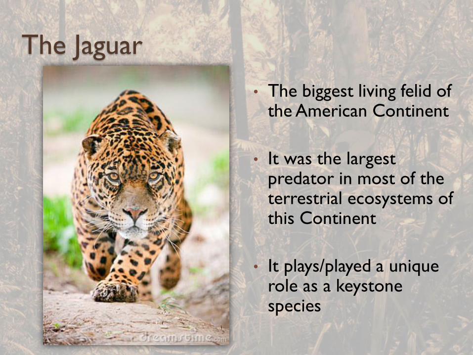
The Jaguar
• The biggest living felid of the American Continent
• It was the largest predator in most of the terrestrial ecosystems of this Continent
• It plays/played a unique role as a keystone species

Jaguar Conservation
• Jaguar Conservation
Units (JCUs)
• Least Cost Corridors
among JCUs
Sanderson et al (2002); Rabinowitz & Zeller (2010)
Atlantic Forest
Jaguars

The Atlantic Forest of South America
• The Atlantic Forest is a
Biodiversity Hotspot
(Olson et al. 2001)

The Atlantic Forest of South America
• The Atlantic Forest is a
Biodiversity Hotspot
• One of the most
endangered environments
of the world
Myers et al. (2000); Mittermeier et al. (2004)

Jaguar Conservation
• Jaguar Conservation
Units (JCUs)
• Least Cost Corridors
among JCUs
Sanderson et al (2002); Rabinowitz & Zeller (2010)
Atlantic Forest
Jaguars

The Jaguar in the
Atlantic Forest
Galetti et al. (2013)

The Jaguar in
the Atlantic
Forest
• International effort
to re-define the AF
JCUs
• Presence data
• Habitat modeling
• Camera-trap surveys
• Management
priorities
Paviolo et al. (under review)

Objectives
1) To assess the potential connectivity remaining
among the populations and subpopulations of
jaguars in the Atlantic Forest
Importance, potentiality and priority of connectivity for
the JCUs of the AF.

Methods (1)
We created a resistance to movement surface,
which was calculated as an inverse function of the
habitat suitability model.
Mateo-Sánchez et al .(2013); Paviolo et al (under review)

Methods (1)
We created a resistance to movement surface,
which was calculated as an inverse function of the
habitat suitability model.
We developed a least-cost connectivity analysis
to evaluate potential corridors among jaguar
subpopulations:
◦ Linkage Mapper 0.9
◦ Corridor and Least-Cost Path tools of Spatial
Analyst in ArcGIS 10.3
Mateo-Sánchez et al .(2013); Rabinowitz & Zeller (2010);
www.circuitscape.org/linkagemapper

Results (1)
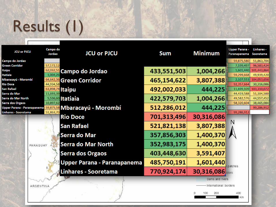
Results (1)

The Green Corridor JCU
Green
Corridor
JCU

Jaguar Action Plan for the Green Corridor
“The Conservation Landscape”
Approved in 2011 it has specific recommendation for
the main corridors between the core areas
De Angelo et al. (2013)

Forest Protection Law
• Law implemented at a
property level in the
Green Corridor

Objectives
1) To assess the potential connectivity among the
populations and subpopulations of jaguars in the
Atlantic Forest
2) To analyze the connectivity among the core
areas of the largest JCUs of the AF.
To apply these results in management recommendations at
the scale used by the managers.

Methods (2)
We used graph-based models and Conefor 2.6
to determine the relative importance of the
remaining forest patches in these areas for
maintaining habitat connectivity
Minor & Urban (2007), Pascual-Hortal & Saura (2006); Saura Martínez de Toda (2013)

Methods (2)
• Node definition

Methods (2)
• Link definition (least-
cost paths) and model
parameters (indirect
movement probability)
• Data from three female
jaguars

Results (2) Probability of
Connectivity
Indexes: dPC, BC(PC) &
dPCconnector
Matínez Pardo et al. (in prep.)

Results (2)
• Combination of
the connectivity
indexes
• Selection of the
most important
patches according
the different
indexes
Matínez Pardo et al. (in prep.)

Results
Matínez Pardo et al.
(in prep.)

Conclusions
Different connectivity analysis tools offered specific solutions for jaguar conservation in the Atlantic Forest.
Least-cost corridors served as a practical tool for identifying the most isolated subpopulations at a regional scale.
Graph-based models were important for finding specific forest patches where local actions will have a huge impact for preserving jaguars in the main subpopulations.

¡Muchas gracias!

Acknowledgments • Special thanks to: SCGIS, ESRI
Conservation Program, Juniper GIS, Blue Oak Ranch Reserve-UC, John Schaeffer, Sasha Yumakaev, Leslie Backus, Charles Convis, Mike Hamilton and all the SCGIS people.
• Financial support (AF): WWF (International, Switzerland, USA and Germany); EFN; Lincoln Park Zoo; Panthera; Conservation Leadership Program (CLP); Club de Amigos del Yaguareté; Administración de Parques Nacionales; Fundación Vida Silvestre Argentina; CONICET.
• Institutional support: Fundación Vida Silvestre Argentina; Administración de Parque Nacionales; Ministerio de Ecología, Recursos Naturales Renovables de Misiones.
Contact: [email protected]
www.proyectoyaguarete.org.ar
www.facebook.com/proyaguarete
www.twitter.com/proyaguarete
