regional flexible funds active transportation
TRANSCRIPT

Regional Flexible Funds Active Transportation


Willamette Blvd Active Transportation Corridor
MLK Jr BlvdSafety & Access to Transit
Cully / ColumbiaFreight Improvements
Parkrose/Sumner Station Area
Access Improvements
Airport Way ITS Freight Improvements
122nd AveCorridorImprovements(Phase 2)Stark / Washington
Corridor Improvements
Springwater to 17thTrail Connection
Central City in Motion:Belmont / Morrison
SW Taylors Ferry Walkway & Bikeway
2022-2024 RFFA Project Candidates
A
B
C
D
E
F
I
H
G
J

A: N Willamette BlvdActive Transportation Corridor
Project context and background
This project is needed to provide a major low-stress bikeway connection from the rapidly-growing St Johns Town Center to the rest of Portland. This was prioritized in the Bicycle Plan for 2030 and builds on recent and upcoming improvements on Rosa Parks, Willamette, and Greeley east of the project area. An improved Willamette can serve as an active transportation ‘super-highway’ and help function as a primary route to connect future investments in walking and biking. North Portland is growing and residents will need safe, comfortable and clearly defined travel options. By improving biking and access to transit for people in North Portland, we will give more residents the ability to chose travel options beyond single-occupancy vehicles.
FOR MORE INFORMATIONZef Wagner Portland Bureau of Transportation - Planner [email protected]
N Greeley Ave Bikeway
and Multi-Use Path (2019)
N Greeley Ave Bikeway
and Multi-Use Path (2019)
N P
orts
mou
th A
ve
N Id
a Av
e
N Rosa Parks Protected Bikeway (2018)
N Willamette BlvdNeigborhood Greenway (2019)
N B
ucha
nan
Ave
N Reno Ave
N W
ools
ey A
ve
N F
iske
Ave
Project Details
The signature element of this project is a two-way protected cycle track on the south side of N Willamette between N Rosa Parks Way and the University of Portland campus. This investment would also include a north-bound protected directional bike lane, improved transit amenities, and enhanced pedestrian crossings. The project scope is currently under development and will likely include sections of N Willamette further north providing a continuous bikeway connection to St Johns.
Project Cost Estimate: TBD
Crossing and/or Transit Improvement
Bikeway Improvements on N Willamette Blvd:
• Two-way protected bikeway on the bluff side of Willamette and directional protected northbound bike lane (N Rosa Parks to University of Portland)
• Enhanced bike facilities from University of Portland to N Richmond.
• Neighborhood greenway treatments from N Richmond to N Reno.
DRAFT
N WILLAMETTE BLVD | ACTIVE TRANSPORTATION CORRIDORUPDATED: 11 MARCH 2019

NE KILLINGSWORTH ST
NE SHAVER ST
NE SKIDMORE ST
NE FREMONT ST
NE ALBERTA ST
NE PRESCOTT ST
NE
7TH
AVE
NE
GAR
FIEL
D A
VE
NE
GRA
ND
AVE
NE
6TH
AVE
NE
ROD
NEY
AVE
NE
MAL
LORY
AVE
NE GOING ST
NE BEECH ST
NE MASON ST
NE FAILING ST
NE IVY ST
NE COOK ST
NE WYGANT ST
NE FARGO ST
NE SUMNER ST
NE WEBSTER ST
NE EMERSON ST
NE SKIDMORE ST
NE ROSELAWN ST
NE EMERSON ST
NE
ROD
NEY
AVE
NE
MAL
LORY
AVE
NE FARGO ST
NE IVY ST
NE COOK ST
NE
ROD
NEY
AVE
NE JESSUP ST
NE SUMNER ST
NE
MA
RTIN
LU
THER
KIN
G JR
BLV
D
Tran
sit I
mpr
ovem
ents
Tran
sit I
mpr
ovem
ents
Upgrade Existing Crossing
Add Protected Left Turn
Add Protected Left Turn
Upgrade Existing Crossing
Upgrade Existing Crossing
Upgrade Existing Crossing
B: MLK Jr BlvdSafety & Access to TransitProject context and background
NE MLK Jr Blvd already has on of Portland’s highest concentrations of affordable housing, and a great deal more is in the pipeline. Pedestrian activity is increasing along the corridor, which leads to conflicts with the high voluemes of high speed traffic on this major thoroughfare.
The PBOT Safe Routes to School Plan also identified several crossing needs along the corridor. This project will focus on providing enhanced pedestrian crossings at regular spacing along MLK Jr Blvd to ensure safety and access to transit.
FOR MORE INFORMATIONZef WagnerPortland Bureau of Transportation - Project [email protected]
Project details
Construct high-priority enhanced pedestrian crossings and signal upgrades along NE MLK Jr Blvd to improve pedestrian/bicycle safety and access to transit.
Project Cost Estimate: $TBD
SIGNAL UPGRADE (add protected for vehicles turning onto MLK )
NEW ENHANCED CROSSING (existing marked crossing exists, project will upgrade)
EXISTING/ FUNDED MARKED CROSSING
FUNDED UPGRADED PED CROSSING
EXISTING SIGNALIZED INTERSECTION
NE MLK JR BLVD | SAFETY & ACCESS TO TRANSITUPDATED: 11 MARCH 2019

C: Columbia/Cully/Alderwood Intersection Improvements
Project context and background
The Columbia corridor is a key link in Portland’s regional freight network, connecting major freight destinations, including the airport and USPS facilities, to the I-5 and I-205 freeways and the rest of the region. The intersections of Columbia Blvd at Alderwood Rd and at Cully Blvd are seeing increased traffic and trucking demand from the US Postal Service facility and airport in recent years, causing congestion that impacts freight reliability as well as contributing to dangerous conditions for all road users. In addition to increased freight and vehicular traffic, this area is seeing much more pedestrian and bicycle traffic due to job growth along the Columbia corridor, as well as popularity of several Parks facilities nearby. The Columbia/Cully/Alderwood
projects were identified as a transportation need in the Airport Futures Plan, to accommodate anticipated traffic growth associated with PDX Airport. They aim to enhance freight mobility and access by making it easier to make left turns onto and off of Columbia Blvd, while also improving safety for all road users.
FOR MORE INFORMATIONWinston Sandino Portland Bureau of Transportation - Project [email protected]
PRESCOTT
COLUMBIA
CORNFOOT
AIRPORT WAY
60TH
82N
D
CULL
Y
ALDE
RWO
OD
SANDY
105T
H
PORTLAND HWY
MARINE
47TH
72N
D
KILLINGSWORTH
MT
ST H
ELEN
S
82N
D
205
Cully Park
SacajaweaPark
Colwood Golf
Center
Whitaker Ponds Park
Portland International
Airport
US Postal Service
COLUMBIA/CULLY/ALDERWOOD IMPROVEMENTSUPDATED: 4 FEBRUARY 2019
DRAFT

Project map
Project details
MULTI-USE PATH Along Columbia to connect to future path connecting Alderwood to Cornfoot
SIDEWALKS On the south side of Columbia and both sides of Cully
COLUMBIA
CULL
Y
ALD
ERW
OO
DNE
COLW
OO
D W
AY
ROW acquisition for future road widening
LEFT TURN LANES Added left turn lanes for vehicles turning onto Alderwood and Cully will ease traffic and increase safety
NEW TRAFFIC SIGNALS Signals and rebuilt curb ramps at Alderwood and Cully will make turning movements safer and easier.
RAILROAD CROSSING A new railroad crossing on Cully will make it safer for people crossing over the rail tracks
A funded project slated for construction in 2020 will reconstruct the intersection of Alderwood Rd at NE Columbia Blvd, install a permanent traffic signal at this intersection, construct sidewalks along the south side of NE Columbia Blvd from Alderwood Rd to Cully Blvd and a multi-use path on the north side of Columbia Blvd between Cully and Alderwood that continues north on Alderwood. Operations will be improved with an exclusive right turn lane from Alderwood to westbound Columbia and dual side by side left turn pockets on Columbia Blvd between Alderwood and Cully. PBOT is also applying for funding to construct sidewalks on Cully, improve the intersection of Cully and Columbia with a left turn lane and signal, and use previously acquired right-of-way to widen the road along Columbia between Cully and Alderwood.
Cully Project Cost Estimate: $5,084,193
� �
COLUMBIA/CULLY/ALDERWOOD IMPROVEMENTSUPDATED: 4 FEBRUARY 2019

NE SANDY BLVD
NE
122nd
AVE
NE
105th
AVE
NE
102nd
AVE
NE FREMONT ST
NE
112th
AVE
NE
92nd
AVE
NE SHAVER ST
NE
111th
DR
NE SKIDMORE ST
NE
91st A
VE
NE
82nd
AVE
NE FREMONT ST
NE SANDY BLVD
NE
82nd
AVE
NE
108th
AVE
NE
121st
PL
NE PRESCOTT STNE
96th
Ave
Parkrose SumnerTransit Center
MaywoodPark
D: Parkrose/Sumner Station Area Access Improvements
Project background and details
The Parkrose/Sumner project is one of the few remaining East Portland in Motion projects that has not yet been built. Prescott is a major route to a number of area schools, serves buses 71 and 73, and is a missing bike network link over I-205. 96th Ave, which is currently unpaved, would provide easy access to the Parkrose /Sumner Transit Center MAX station.
This project will improve a key east-west segment of NE Prescott St in the underserved Sumner and Parkrose neighborhoods by adding bike lanes and filling in remaining sidewalk gaps. In addition to
improvements on Prescott, 96th Ave will be paved and sidewalks constructed, creating a natural connection to the Parkrose/Sumner Transit Center MAX station.
FOR MORE INFORMATIONZef Wagner Portland Bureau of Transportation - Planner [email protected]
Striped Bike Lane
Improved Street &Neighborhood Greenway
Sidewalk Infill
New Enhanced Crossing
I-205 Trail
Existing & Funded Bike Network
MAX Light Rail
PRO
JEC
T PR
OPO
SAL
EXIS
TIN
G
CON
DIT
ION
S
PARKROSE/SUMNER STATION AREA ACCESS IMPROVEMENTSUPDATED: 6 FEBRUARY 2019
DRAFT

E: NE Airport Way Intelligent Transportation Systems
Project context and background
Airport way runs parallel to I-84 and serves as an alternate route for commuter and truck traffic. Currently there is limited capacity for a coordinated response between the Oregon Department of Transportation (ODOT) and the City of Portland Bureau of Transportation (PBOT) to handle incidents that impact travel in this corridor when they occur.
The City is proposing to install Intelligent Transportation Systems (ITS) infrastructure along Airport Way from 82nd to Riverside Parkway. The project will install electronic message signs, CCTV cameras, truck signal priority, traffic monitoring
stations, fiber communication, update traffic signal controllers and integrate these devices with the City’s, ODOT’s, and TriMet’s Transportation Operation Centers. This project is part of the larger City and Regional Advanced Traffic Management System (ATMS) and provides the minimum project elements that will yield significant benefits to the corridor. It will also allow PBOT to provide more efficient and safe operation of our traffic signal system.
NE MARX ST
NE
181S
T AV
ENE FREMONT ST
NE
82N
D A
VE
NE
122N
D A
VE
NE
102N
D A
VE NE PRESCOTT ST
NE
162N
D A
VE
NE
92N
D D
R
NE
148T
H A
VE
NE MARINE DR
NE AIRPORT WAY
NE SANDY BLVD
205
Project extent/ planned fiber installation CCTV and Traffic Controller UpdatesTraffic Controller Updates (no CCTV planned)
84
NE AIRPORT WAY ITSUPDATED: 6 FEBRUARY 2019

E: NE Airport Way Intelligent Transportation Systems
Project details
CCTV Installations at Holman, Win Sivers, 122nd, 138th, 148th, 158th, and Riverside
Traffic Controller Updates at I-205 northbound and southbound ramps, Holman, Win Sivers, 122nd, 138th, 148th, 158th, and Riverside
Fiber Communications Installation from 82nd to Riverside
Variable Message Signs - three locations to be identified
Truck Priority and Count Stations - five locations to be identified
Detection and Count Stations - 11 locations to be identified
Travel Time Devices - seven locations to be identified
Connected Vehicle Devices - 11 locations to be identified FOR MORE INFORMATION
Willie Rotich, PE Portland Bureau of Transportation - Senior ITS [email protected]
Total Cost Estimate: $1,628,250
NE AIRPORT WAY ITSUPDATED: 6 FEBRUARY 2019
DRAFT

F: SE Belmont & SE Morrison Transit and Bike Improvements
Project background and details
Belmont and Morrison are key east/west connections in the Central Eastside, providing important retail, freight, and transit access. This project is included in the recently adopted Central City in Motion Plan and improves transit access and speed with new transit islands and bus and turn (BAT) lanes, improves pedestrian crossings, and provides protected bike lanes.
Note: Bikeway enhancements west of SE MLK Jr Blvd are located beneath the viaducts, providing a connection for people biking to SW Water Ave.
SE STARK ST
SE 1
1TH
AVE
SE 1
2TH
AVE
SE 7
TH A
VE
SE M
LK B
LVD
SE G
RAN
D A
VE
SE BELMONT ST
SE W
ATER
AVE
SE MORRISON STSE
6TH
AVE
SE 9
TH A
VE
SE MADISON ST
Bikeway Enhancements
Protected Bike Lanes
Bus and Turn Lanes
Pedestrian Crossing
FOR MORE INFORMATIONGabriel Graff Portland Bureau of Transportation - Project [email protected]
BELMONT/MORRISON TRANSIT AND BIKE IMPROVEMENTSUPDATED: 6 FEBRUARY 2019

G: Stark/Washington Corridor Improvements
Project background and details
The Stark/Washington couplet is one of the major business hubs in Gateway, but is currently very auto-oriented and sees high rates of crashes, with three to four lanes in each direction, difficult pedestrian crossings, and narrow sidewalks and bike lanes. This project will transform this area into a more ped/bike/transit oriented hub for East Portland, with safety improvements ranging from protected bike lanes to bus lanes and transit islands to enhanced crossings. This is a Vision Zero project on a High Crash Corridor and serves a high equity need. This project was also prioritized in the Growing Transit Communities Plan, adopted in 2017.
STARK
BURNSIDE
WASHINGTON
102N
D
92N
D
CHERRY BLOSSOM
SE PINE ST
SE ANKENY ST
SE 9
9TH
AVE
SE 9
6TH
AVE
SE 1
05TH
AVE
SE 9
4TH
AVE
SE 1
08TH
AVE
SE 9
7TH
AVE
SE 9
1ST
AVE
SE 1
09TH
AVE
Safety Improvements (road reorganization, protected bike lanes, transit islands, etc.)
Enhanced PedestrianCrossings
205
FOR MORE INFORMATIONDavid Backes Portland Bureau of Transportation - Project [email protected]
STARK/WASHINGTON CORRIDOR IMPROVEMENTSUPDATED: 11 MARCH 2019
DRAFT

H: 122nd Ave Safety, Access & TransitProject context and background
Currently, 122nd Ave is a High Crash Corridor that does not adequately serve all modes. Five of the City’s thirty highest crash intersections are along 122nd Ave. Since 2010, there have been over 400 people injured while traveling on 122nd, including 127 people walking and biking. Nine people have died in the past 8 years.
122nd Ave is a difficult and stressful environment to walk, bike, cross the street and access transit. The street is typically a five-lane arterial with on-street parking and narrow bike lanes that becomes turn lanes at major signalized intersection. The sidewalks are often narrow and substandard. Most of 122nd Avenue does not meet the City’s new guidelines for marked crosswalk spacing. Buses experience delay, including slow average speeds, high dwell time at stops and significant travel speed variability during peak travel times.
PBOT is developing a plan to identify improvements on 122nd Ave, between SE Foster and NE Marine Dr., with the goal to increase safety for all, improve pedestrian & bicycle access and support better transit while balancing needs of freight & other modes, identify improvements to help eliminate serious injuries and fatalities, and remove 122nd Ave from the Vision Zero High Crash Corridor network.
FOR MORE INFORMATION
April BertelsenPortland Bureau of TransportationTransit Coordinator [email protected]
Project details
PBOT is developing a scope of improvements that will draw from staff recommendations and public stakeholder feedback on elements of the draft 122nd Ave Plan: Safety, Access and Transit. The types of improvements likely to be included in this project phase:
• More lighting to improve safety and personal security. • More enhanced crossings from the recommended new crossings on the adjacent
map to improve safety and access, and meet the City’s new crosswalk spacing guidelines.
• Protected or enhanced lanes for biking and scooting to improve safety and comfort for people of all ages and abilities to bicycle, skate, or use a scooter.
• Enhanced Transit priority treatments approaching congested signalized intersections to reduce transit delay.
• Signal changes to reduce conflicts and improve safety. • Median treaments in focused locations at major signals and enhanced crossings to
reduce conflicts and improve safety. 8:
8:
8:
8:
8:
8:
8:
8:
8:
8:
8:
8:
8:
8:
8:
8:
GLISAN
STARK
DIVISION
CLINTON
KELLY
RHONE
GLADSTONE
MALL
POWELL
BURNSIDE
HOLGATE
BOISE
BUSH
WOODWARD
LINCOLN
SHERMAN
STEPHENS
HAROLD
RAYMOND
STEELE
MARTINS
SCHILLER
SPRINGWATER
FOSTER
FREMONT
FARGO
BEECH
MARKET
MADISON
SHAVER
SKIDMORE
SANDY
MARX
WHITAKER
AIRPORT WAY
MARINE DRIVE
SAN RAFAEL
MAIN
MORRISON
WASHINGTON
MILL
PINE
RUSSELL
STANTON
HOLLADAY
OREGON
HALSEY
WASCO
RUSSELL
DAVIS
FLANDERS
Traffic signal
Existing marked crossing
New crossing - Tier 1
New crossing - Tier 2
New crossing - Tier 3
Pedestrian district &Comprehensive Plan Center
8:
Schools
Rossi Farm
8:
8:
8:
8:
8:
8:
8:
8:
8:
8:
8:
8:
8:
8:
8:
8:
GLISAN
STARK
DIVISION
CLINTON
KELLY
RHONE
GLADSTONE
MALL
POWELL
BURNSIDE
HOLGATE
BOISE
BUSH
WOODWARD
LINCOLN
SHERMAN
STEPHENS
HAROLD
RAYMOND
STEELE
MARTINS
SCHILLER
SPRINGWATER
FOSTER
FREMONT
FARGO
BEECH
MARKET
MADISON
SHAVER
SKIDMORE
SANDY
MARX
WHITAKER
AIRPORT WAY
MARINE DRIVE
SAN RAFAEL
MAIN
MORRISON
WASHINGTON
MILL
PINE
RUSSELL
STANTON
HOLLADAY
OREGON
HALSEY
WASCO
RUSSELL
DAVIS
FLANDERS
Traffic signal
Existing marked crossing
New crossing - Tier 1
New crossing - Tier 2
New crossing - Tier 3
Pedestrian district &Comprehensive Plan Center
8:
Schools
Rossi Farm
122ND AVE | SAFETY & ACCESS TO TRANSITUPDATED: 11 MARCH 2019

I: SW Taylors Ferry Rd Walkway and Bikeway
Project context and background
SW Taylors Ferry Rd from SW 49th to SW Capitol Hwy is the only route to the Barbur Transit Center and other community destinations for neighbors living west of Capitol Hwy and Interstate 5. Today the street lacks bicycle facilities and has a degraded, substandard walkway on one side of the street..
The project would build upon and connect to funded complete street upgrades of Capitol Hwy, extending the reach of those investments. The project implements the 2035 Comprehensive plan by making connections to and through the West Portland Town Center, an important growth area in Southwest Portland. SW Taylors Ferry Road is designated as a City Bikeway and City Walkway in the Portland Transportation System Plan 2016). The project is on the Primary Investment Route for Markham Elementary School in the Portland Safe Routes to School plan (2018). TriMet identified this project as Tier 1 priority to improve access to the Barbur Boulevard Transit Center as a part of the TriMet Bike Plan (2016).
FOR MORE INFORMATIONNick Falbo Portland Bureau of Transportation - Senior [email protected]
MARKHAM K-5
JACKSON MS
SW TAYLORS FERRY RDSW 4
8TH
AVE
SW BARBUR BLVD
SW C
APIT
OL
HW
Y
SW 3
5TH
AVE
BARBUR TRANSIT CENTER
SW 5
5TH
AVE
SW ALICE ST
SW 4
0TH
AVE
SW 5
3RD
AVE
SW 5
2ND
AVE
SW COMUS ST
SW 5
0TH
AVE
SW DICKINSON ST
SW 4
9TH
AVE
SW 5
7TH
PL
SW 4
2ND
AVE
SW ALFRED ST
SW 48
TH D
R
SW 4
1ST
AVE
SW WILBARD ST
SW 5
4TH
AVE
SW LURADEL ST
SW CARAWAY CT
SW MARICARA STSW 4
3RD
AVE
SW BRUGGER ST
SW 5
6TH
AVE
SW 5
7TH
AVE
SW BAIRD ST
SW WOOD PKWY
SW 3
6TH
PL
SW LURADEL ST
SW BRUGGER ST
SW COMUS ST
SW 5
7TH
PL
SW ALICE ST
Project detailsConstruct a sidewalk and widen the roadway to provide bicycle lanes on SW Taylors Ferry Rd between SW Capitol Hwy and SW 49th Ave. Retaining walls may be needed to address grades, maintain access to properties and provide necessary width for these improvements.
Collaborate with the Bureau of Environmental Services to understand opportunities to extend the culvert at Woods Creek.
Preliminary Cost Estimate: $5,002,450
SW TAYLORS FERRY RD WALKWAY AND BIKEWAYUPDATED: 11 MARCH 2019
DRAFT
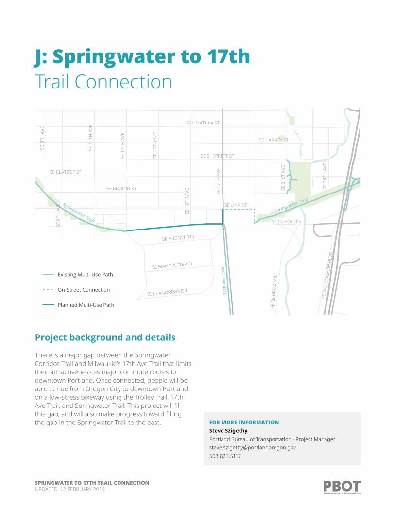
J: Springwater to 17th Trail Connection
Project background and details
There is a major gap between the Springwater Corridor Trail and Milwaukie’s 17th Ave Trail that limits their attractiveness as major commute routes to downtown Portland. Once connected, people will be able to ride from Oregon City to downtown Portland on a low-stress bikeway using the Trolley Trail, 17th Ave Trail, and Springwater Trail. This project will fill this gap, and will also make progress toward filling the gap in the Springwater Trail to the east.
SE LINN ST
SE OCHOCO ST
SE UMATILLA ST
SE MARION ST
SE SHERRETT ST
SE CLATSOP ST
SE 9
TH A
VE
SE 1
1TH
AVE
SE 1
3TH
AVE
SE 1
6TH
AVE
SE 1
5TH
AVE
SE 1
7TH
AVE
SE HARNEY ST
SE 2
1ST
AVE
SE ST ANDREWS DR
SE M
CBRO
D A
VE
SE M
CLO
UG
HLI
N B
LVD
SE ANDOVER PL
SE 8
TH A
VE
SE MANCHESTER PL
SE 2
4TH
AVE
Springwater Trail
17th
Ave
Tra
il
Springwater Trail
Existing Multi-Use Path
On-Street Connection
Planned Multi-Use Path
FOR MORE INFORMATIONSteve Szigethy Portland Bureau of Transportation - Project [email protected]
SPRINGWATER TO 17TH TRAIL CONNECTIONUPDATED: 12 FEBRUARY 2019

DRAFT