regional land use by parish undeveloped land prepared by the regional planning commission, february,...
TRANSCRIPT

Regional Land Use by Parish
Undeveloped LandPrepared by the Regional Planning Commission, February,
2003
The land use files developed by each parish in cooperation with the Regional Planning Commission developed varying ways of noting land not in development. The vacant land category was not used for this effort. Vacant land is land that may or may not have been developed in the past, but is presently not serving a dedicated land use. Several parishes noted land outside the levee system as undeveloped. In parishes which did not produce an “undeveloped” category, the entire land use file was used as an overlay to the parish outline and geographically subtracted. This is a generalized way of saying, “that which is not in developed land use, is undeveloped.” This will not be accurate at precise levels of detail, but for the present it is a tool we can use to achieve a regional glance at undeveloped land for the five parishes submitting their land use data. As land use data is corrected and the effort extends into more of the outlaying parish lands, a clearer, more precise view can be anticipated.

The Regional Planning Commission makes no warranty as to the accuracy of this data. The user assumes all responsibilities for verifying the accuracy of any feature or dimension which may be critical to the intended use of this data.
Land Cover Southeast Louisiana
10 Parish AnalysisUSGS GAP Land Cover
Area_sqmi 9,342.105Water_sqmi 5145.979Land (land & wet soils, no water)_sqmi 4196.126Urban Area_sqmi 339.329
Wet soils (marsh & wetland categories) 2043.455% Water of Total 10 Parish Area 55.08% Wet soils Total 10 Parish Area 21.874% Urban Area/Land (land & wet soils, no water) 8.09% Urban Area/Solid land (no wet soils, no water) 15.76Census 1990 Pop 1,414,164Census 1990 Urban Pop 1,226,494Census 2000 Pop 1,482,240Census 2000 Urban Pop 1,313,714
Density in 10 Parish Land Area
persons/sq mile of Land (land & w et soils, no w ater)
1990 Census 337
2000 Census 353Density in 10 Parish Urban Area urban persons/sq mile of urban area (total urban pop/urban area)
1990 Census 3,6142000 Census 3,872
10 Parishes of Southeast Louisiana

The Regional Planning Commission makes no warranty as to the accuracy of this data. The user assumes all responsibilities for verifying the accuracy of any feature or dimension which may be critical to the intended use of this data.
Land Cover Southeast Louisiana
Orleans Parish AnalysisUSGS GAP Land Cover
Area_sqmi 350.911Water_sqmi 193.902Land (land & wet soils, no water)_sqmi 157.010Urban Area_sqmi 69.791Wet soils (marsh & wetland categories) 66.273% Water of Total Parish Area 55.26% Wet soils Total Parish Area 18.89% Urban Area/Land (land & wet soils, no water) 44.45% Urban Area/Solid land (no wet soils, no water) 76.92Census 1990 Pop 496,938Census 1990 Urban Pop 496,738Census 2000 Pop 484,674Census 2000 Urban Pop 481,424
Density in Parish Land Area
persons/sq mile of Land (land & w et soils, no w ater)
1990 Census 3,165
2000 Census 3,087Density in Parish Urban Area urban persons/sq mile of urban area (total urban pop/urban area)
1990 Census 7,1172000 Census 6,898
Orleans Parish, Louisiana
The Regional Planning Commission makes no warranty as to the accuracy of this data. The user assumes all responsibilities for verifying the accuracy of any feature or dimension which may be critical to the intended use of this data.
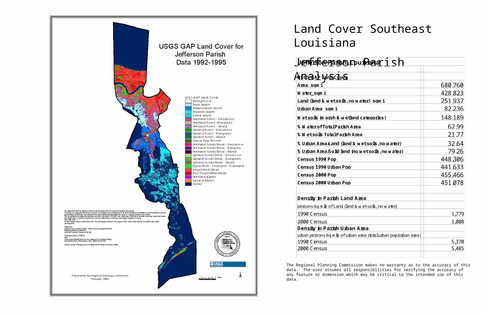
Land Cover Southeast Louisiana
Jefferson Parish AnalysisUSGS GAP Land Cover
Area_sqmi 680.760Water_sqmi 428.823Land (land & wet soils, no water)_sqmi 251.937Urban Area_sqmi 82.236
Wet soils (marsh & wetland categories) 148.189
% Water of Total Parish Area 62.99% Wet soils Total Parish Area 21.77
% Urban Area/Land (land & wet soils, no water) 32.64% Urban Area/Solid land (no wet soils, no water) 79.26Census 1990 Pop 448,306Census 1990 Urban Pop 441,633Census 2000 Pop 455,466Census 2000 Urban Pop 451,078
Density in Parish Land Area
persons/sq mile of Land (land & w et soils, no w ater)
1990 Census 1,779
2000 Census 1,808Density in Parish Urban Area urban persons/sq mile of urban area (total urban pop/urban area)
1990 Census 5,3702000 Census 5,485
Jefferson Parish, Louisiana

The Regional Planning Commission makes no warranty as to the accuracy of this data. The user assumes all responsibilities for verifying the accuracy of any feature or dimension which may be critical to the intended use of this data.
Land Cover Southeast Louisiana
Plaquemines Parish AnalysisUSGS GAP Land Cover
Area_sqmi 2,514.831Water_sqmi 1,989.602Land (land & wet soils, no water)_sqmi 525.229Urban Area_sqmi 19.577Wet soils (marsh & wetland categories) 427.861% Water of Total Parish Area 79.11% Wet soils Total Parish Area 17.01% Urban Area/Land (land & wet soils, no water) 3.73% Urban Area/Solid land (no wet soils, no water) 20.11Census 1990 Pop 25,575Census 1990 Urban Pop 21,134Census 2000 Pop 26,757Census 2000 Urban Pop 18,327
Density in Parish Land Area
persons/sq mile of Land (land & w et soils, no w ater)
1990 Census 49
2000 Census 51Density in Parish Urban Area urban persons/sq mile of urban area (total urban pop/urban area)
1990 Census 1,0802000 Census 936
Plaquemines Parish, Louisiana

The Regional Planning Commission makes no warranty as to the accuracy of this data. The user assumes all responsibilities for verifying the accuracy of any feature or dimension which may be critical to the intended use of this data.
Land Cover Southeast Louisiana
St. Bernard Parish AnalysisUSGS GAP Land Cover
Area_sqmi 2,160.260Water_sqmi 1,804.877Land (land & wet soils, no water)_sqmi 355.383Urban Area_sqmi 14.934Wet soils (marsh & wetland categories) 309.737% Water of Total Parish Area 83.55% Wet soils Total Parish Area 14.34% Urban Area/Land (land & wet soils, no water) 4.20% Urban Area/Solid land (no wet soils, no water) 32.72Census 1990 Pop 66,631Census 1990 Urban Pop 63,663Census 2000 Pop 67,229Census 2000 Urban Pop 64,534
Density in Parish Land Area
persons/sq mile of Land (land & w et soils, no w ater)
1990 Census 187
2000 Census 189Density in Parish Urban Area urban persons/sq mile of urban area (total urban pop/urban area)
1990 Census 4,2632000 Census 4,321
St. Bernard Parish, Louisiana

The Regional Planning Commission makes no warranty as to the accuracy of this data. The user assumes all responsibilities for verifying the accuracy of any feature or dimension which may be critical to the intended use of this data.
Land Cover Southeast Louisiana
St. Charles Parish AnalysisUSGS GAP Land Cover
Area_sqmi 409.378Water_sqmi 151.870Land (land & wet soils, no water)_sqmi 257.508Urban Area_sqmi 19.857Wet soils (marsh & wetland categories) 198.601% Water of Total Parish Area 37.10% Wet soils Total Parish Area 48.51% Urban Area/Land (land & wet soils, no water) 7.71% Urban Area/Solid land (no wet soils, no water) 33.71Census 1990 Pop 42,437Census 1990 Urban Pop 37,820Census 2000 Pop 48,072Census 2000 Urban Pop 41,342
Density in Parish Land Area
persons/sq mile of Land (land & w et soils, no w ater)
1990 Census 165
2000 Census 187Density in Parish Urban Area urban persons/sq mile of urban area (total urban pop/urban area)
1990 Census 1,9052000 Census 2,082
St. Charles Parish, Louisiana

The Regional Planning Commission makes no warranty as to the accuracy of this data. The user assumes all responsibilities for verifying the accuracy of any feature or dimension which may be critical to the intended use of this data.
Land Cover Southeast Louisiana
St. James Parish AnalysisUSGS GAP Land Cover
Area_sqmi 254.684Water_sqmi 22.152Land (land & wet soils, no water)_sqmi 232.532Urban Area_sqmi 12.802Wet soils (marsh & wetland categories) 143.579% Water of Total Parish Area 8.70% Wet soils Total Parish Area 56.38% Urban Area/Land (land & wet soils, no water) 5.51% Urban Area/Solid land (no wet soils, no water) 14.39Census 1990 Pop 20,879Census 1990 Urban Pop 7,399Census 2000 Pop 21,216Census 2000 Urban Pop 13,796
Density in Parish Land Area
persons/sq mile of Land (land & w et soils, no w ater)
1990 Census 90
2000 Census 91Density in Parish Urban Area urban persons/sq mile of urban area (total urban pop/urban area)
1990 Census 5782000 Census 1,078
St. James Parish, Louisiana

The Regional Planning Commission makes no warranty as to the accuracy of this data. The user assumes all responsibilities for verifying the accuracy of any feature or dimension which may be critical to the intended use of this data.
Land Cover Southeast Louisiana
St. John the Baptist Parish AnalysisUSGS GAP Land Cover
Area_sqmi 351.035Water_sqmi 141.376Land (land & wet soils, no water)_sqmi 209.659Urban Area_sqmi 13.253Wet soils (marsh & wetland categories) 162.396% Water of Total Parish Area 40.27% Wet soils Total Parish Area 46.26% Urban Area/Land (land & wet soils, no water) 6.32% Urban Area/Solid land (no wet soils, no water) 28.04Census 1990 Pop 39,996Census 1990 Urban Pop 38,905Census 2000 Pop 43,044Census 2000 Urban Pop 36,817
Density in Parish Land Area
persons/sq mile of Land (land & w et soils, no w ater)
1990 Census 191
2000 Census 205Density in Parish Urban Area urban persons/sq mile of urban area (total urban pop/urban area)
1990 Census 2,9362000 Census 2,778
St. John the Baptist Parish, Louisiana
The Regional Planning Commission makes no warranty as to the accuracy of this data. The user assumes all responsibilities for verifying the accuracy of any feature or dimension which may be critical to the intended use of this data.
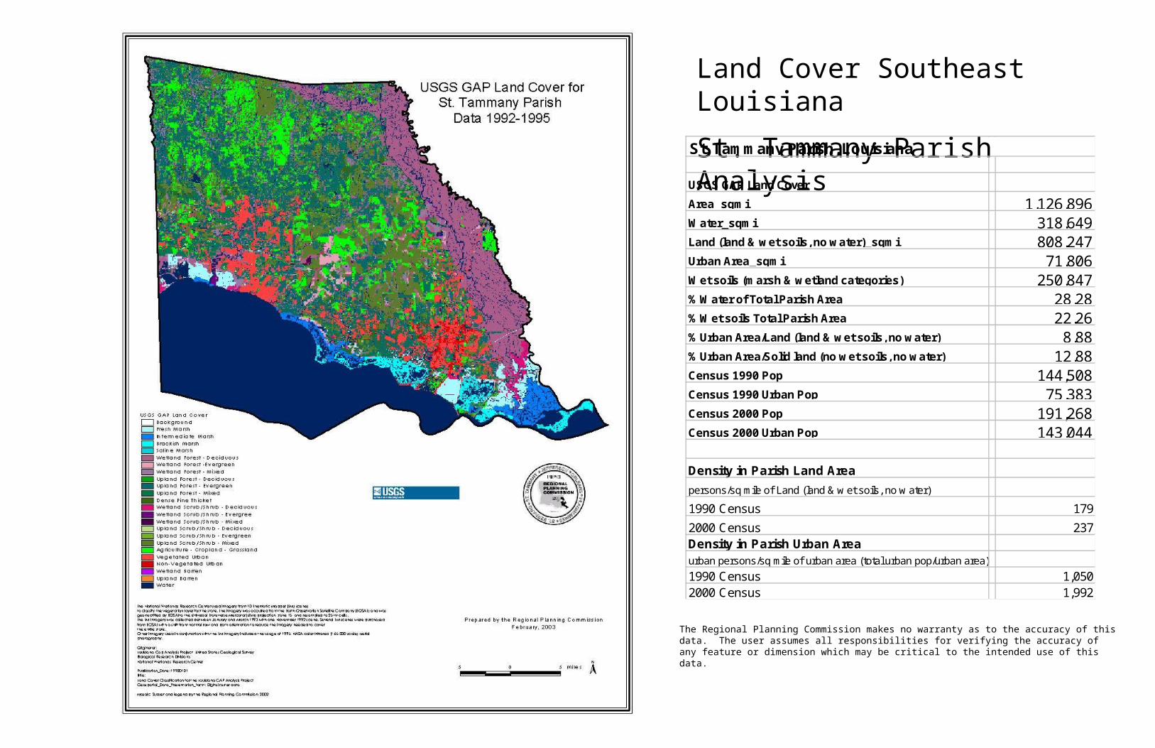
Land Cover Southeast Louisiana
St. Tammany Parish AnalysisUSGS GAP Land Cover
Area_sqmi 1,126.896Water_sqmi 318.649Land (land & wet soils, no water)_sqmi 808.247Urban Area_sqmi 71.806Wet soils (marsh & wetland categories) 250.847% Water of Total Parish Area 28.28% Wet soils Total Parish Area 22.26% Urban Area/Land (land & wet soils, no water) 8.88% Urban Area/Solid land (no wet soils, no water) 12.88Census 1990 Pop 144,508Census 1990 Urban Pop 75,383Census 2000 Pop 191,268Census 2000 Urban Pop 143,044
Density in Parish Land Area
persons/sq mile of Land (land & w et soils, no w ater)
1990 Census 179
2000 Census 237Density in Parish Urban Area urban persons/sq mile of urban area (total urban pop/urban area)
1990 Census 1,0502000 Census 1,992
St. Tammany Parish, Louisiana

The Regional Planning Commission makes no warranty as to the accuracy of this data. The user assumes all responsibilities for verifying the accuracy of any feature or dimension which may be critical to the intended use of this data.
Land Cover Southeast Louisiana
Tangipahoa Parish AnalysisUSGS GAP Land Cover
Area_sqmi 824.766Water_sqmi 66.092Land (land & wet soils, no water)_sqmi 758.674Urban Area_sqmi 24.065Wet soils (marsh & wetland categories) 196.221% Water of Total Parish Area 8.01% Wet soils Total Parish Area 23.79% Urban Area/Land (land & wet soils, no water) 3.17% Urban Area/Solid land (no wet soils, no water) 4.28Census 1990 Pop 85,709Census 1990 Urban Pop 25,532Census 2000 Pop 100,588Census 2000 Urban Pop 46,690
Density in Parish Land Area
persons/sq mile of Land (land & w et soils, no w ater)
1990 Census 113
2000 Census 133Density in Parish Urban Area urban persons/sq mile of urban area (total urban pop/urban area)
1990 Census 1,0612000 Census 1,940
Tangipahoa Parish, Louisiana

The Regional Planning Commission makes no warranty as to the accuracy of this data. The user assumes all responsibilities for verifying the accuracy of any feature or dimension which may be critical to the intended use of this data.
Land Cover Southeast Louisiana
Washington Parish AnalysisUSGS GAP Land Cover
Area_sqmi 676.933Water_sqmi 34.345Land (land & wet soils, no water)_sqmi 642.588Urban Area_sqmi 11.233Wet soils (marsh & wetland categories) 141.099% Water of Total Parish Area 5.07% Wet soils Total Parish Area 20.84% Urban Area/Land (land & wet soils, no water) 1.75% Urban Area/Solid land (no wet soils, no water) 2.24Census 1990 Pop 43,185Census 1990 Urban Pop 18,287Census 2000 Pop 43,926Census 2000 Urban Pop 16,662
Density in Parish Land Area
persons/sq mile of Land (land & w et soils, no w ater)
1990 Census 67
2000 Census 68Density in Parish Urban Area urban persons/sq mile of urban area (total urban pop/urban area)
1990 Census 1,6282000 Census 1,483
Washington Parish, Louisiana