relating to: lot 4 spratts green farm for sale by … · nr4 6rw and jonathan paul webster of oriel...
TRANSCRIPT
AUCTION PACK
Relating to:
Lot 4 SPRATTS GREEN FARM AYLSHAM NORWICH NORFOLK
FOR SALE BY AUCTION
30 October 2018
The Pines 50 Connaught Road
Attleborough Norfolk
NR17 2BP DX No: 44000
Telephone: 01953 453143 Fax: 01953 453970

INDEX
1. Memorandum of Sale 2. Special Conditions of Sale
3. Transfer of Part 4. Plan of Lot 4
5. Local Authority Search No. 2018/01778 6. Environmental Search dated 24.09.2018 7. Chancel Repair Search dated 26.09.2018
8. Hazard Summary Report dated 24.09.2018 9. Office Copy Entries and Filed Plan NK404642 10. Official Copy (Conveyance) 16.10.1996
Telephone: 01953 453143
The Pines 50 Connaught Road
Attleborough Norfolk
NR17 2BP Fax: 01953 453970
DX No: 44000

Dra
in
Pond
Pond
Drain
25.2m
Tra
ck
19.2m
21.4m
GP
10.3m
MS
Tra
ck
20.9m
Pond
16.1m
Tra
ck
Spratt's Green Farm
Track
Bure V
alley Railw
ay
MP 0.5
East Cottage
Cottage
Fern
12.0m
LCGatehouse
The
0m 50m 100m 150m
IRELANDS Chartered Surveyors2 Harford Centre, Hall Road, Norwich, Norfolk, NR4 6DG
www.irelands.co.uk
OS Licence No: ES100005416 TWC/299 Date: 25.09.18
Plan of Lot 4: Land at Spratts Green Farm, Aylsham,Norwich, Norfolk, NR11 6TX
Ordnance Survey © Crown Copyright 2018. All rights reserved.
Licence number 100022432. Plotted Scale - 1:2500

MEMORANDUM OF SALE
Property address: Lot 4 being land at Spratts Green Farm Spratts Green Aylsham Norwich NR11 6TX The Seller: Charles Richard Tobias Harris and Jonathan Paul Webster The Buyer: ………………………………………………………………………... The Price: …………………………….. It is agreed that the Seller sells and the Buyer buys the property described in the accompanying particulars and conditions of sale subject to their provisions and the terms and stipulations in them at the price above mentioned. Purchase Price: £…………………………….. Less Deposit: £…………………………….. Balance: £…………………………….. Dated: …………………………………………… Signed: …………………………………………… Authorised Agent for the Seller As Agents for the Seller we acknowledge receipt of the deposit in the form of a cheque. Dated: …………………………………………… Signed: …………………………………………… The Buyer Buyers Solicitors: ............................................................... ……………………………………………………………………….................................................. ……………………………………………………………………….................................................. :……………….............................................................................................................................. Telephone: …………………………………................................ Sellers Solicitors: Spire Solicitors LLP Telephone: 01953 453143

SPECIAL CONDITIONS OF SALE FOR
LOT 4 SPRATTS GREEN FARM AYLSHAM NORWICH NORFOLK
1. “The Property” is the freehold property at Spratts Green Farm Aylsham Norwich Norfolk
shown more particularly delineated in red on the plan attached to this contract and being part of the land registered at HM Land Registry with title absolute under title number NK404642 (“the Title”) and “the Seller” is Charles Richard Tobias Harris of 35 Constable Road Norwich NR4 6RW and Jonathan Paul Webster of Oriel House 5 Nethergate Street Bungay NR35 1HE.
2. The Property is sold subject to the RICS Common Auction Conditions (Edition 3) (“the Auction Conditions”) and to The Standard Conditions of Sale (5th Edition) (“the Standard Conditions”) so far as those two sets of conditions are not inconsistent with the following conditions. In the case of any inconsistency between the Auction Conditions and the Standard Conditions the former shall prevail so far as they are not inconsistent with the following conditions.
3. The contract rate of interest under the Standard Conditions shall be 5% above the Base Rate
of Barclays Bank PLC from time to time in force. 4. The Particulars of Sale and general remarks and stipulations are deemed to be included in
these conditions but in the case of any inconsistency or variation between those Particulars and general remarks and stipulations and these conditions, these conditions shall prevail.
5. The deposit shall be held as agent for the Seller and Standard Conditions 2.2.5 and 2.2.6
shall not apply. 6. The Property is sold as seen on completion subject to the Holdover pursuant to clause 18 of
these Special Conditions. 7. The sale shall be completed on 27 November 2018. 8. The Seller sells with limited title guarantee. 9. The Seller’s title having been available for inspection at the offices of Spire Solicitors LLP
prior to auction and at the auction house prior to the auction it shall be deemed to have been accepted by the Buyer and no requisitions shall be raised. The Seller warrants that the Property forms part of the land included in the filed plan of the Title but due to the size and scale of the filed plan the electronic version of the filed plan is not available.
10. The Property is sold with the benefit of and subject to all incumbrances and other matters
contained or referred to in the title available for inspection at the offices of Spire Solicitors LLP prior to auction except all charges securing money on the property (other than rent charges) and Standard Conditions 3.1.1 and 3.1.2 are amended accordingly.
11. The Buyer acknowledges that:
11.1 (save for the warranty contained in special condition 9) no warranty or representation has been made by the Seller or its agents or by Spire Solicitors LLP in relation to or in connection with the Property;
11.2 this agreement contains the entire agreement between the parties; and
11.3 the Buyer has inspected the property and purchases it with full knowledge of its actual
state and condition and takes the Property as it stands.

12. Any fixtures and fittings belonging to any public utility board or undertaking are excluded from
the sale. 13. On completion, the Buyer shall reimburse the Seller the cost of all searches. 14. The sale of the Property is subject to a reserve price and the right of the Seller by himself or
through his agent or through the auctioneer to bid up to and beyond such reserve price and to withdraw the Property unsold without declaring such reserve.
15. The transfer to the Buyer will be in the agreed form annexed to this contract. 16. Each amount stated to be payable by the Buyer to the Seller under or pursuant to this
contract is exclusive of VAT (if any). If any VAT is chargeable on any supply made by the Seller under or pursuant to this contract, the Buyer will on receipt of a valid VAT invoice, pay the Seller an amount equal to that VAT as additional consideration on completion.
17. Tenant Right
17.1 For the purposes of this clause 17 Tenant Right means the following items:
(a) growing crops and enhancement where appropriate, seeds sown, cultivations,
fallows and acts of husbandry since the removal of the last preceding crop;
(b) residual and unexhausted values of manure, fertiliser, soil improvers and digestate
(whether organic or inorganic), lime and slag applied to the Property;
(c) hay, straw and silage made on the Property and retained on the Property but
excluding any that the Seller has any right to sell or to remove from the Property;
(d) seeds, sprays, fertilisers, chemicals, fuel and oil in store, usable and in date, and
retained on the Property but excluding any that the Seller has any right to sell or to
remove from the Property; and
(e) any other items classified as Tenant right.
17.2 There will be no ingoing valuation and no Tenant Right payments.
18. Holdover 18.1 The Holdover Period means the period from and including the date of completion to
and including 31 January 2019.
18.2 The Growing Crops means the sugar beet crops growing or harvested on the Property at the time of completion. The Growing Crops are reserved to the Seller and are excluded from the sale.
18.3 The Services means the supply of electricity and water and other services to the Property during the Holdover Period.
18.4 The Seller, and all persons authorised by the Seller and reasonably required by the Seller to exercise the rights in this clause, shall have the following rights during the Holdover Period:
(a) the right to retain and harvest the Growing Crops;
(b) the right to store and dry the Growing Crops; and
(c) the right to enter onto the Property with or without vehicles, plant and machinery for
the purposes referred to in this clause.
18.5 The exercise of the rights listed in clause 18.4 are subject to the Seller:
(a) paying to the Buyer the cost of the Services used in connection with the exercise of
those rights;
(b) causing as little damage as practicable to the Property; and
(c) indemnifying the Buyer and keeping the Buyer indemnified against all losses, claims,
demands, actions, proceedings, damages, costs, expenses or other liability in any
way arising from the exercise of those rights.
18.6 The items listed in clause 18.4 are stored at the Seller's own risk and the Buyer is not liable for any loss or deterioration of the items, however occurring, including occurring as a result of any interruption or disruption to the provision of any of the Services save where within the reasonable control of the Buyer.
19. Entitlements 19.1 In this clause 19 the following definitions apply:
Basic Payment Scheme: the basic payment scheme established by Regulation (EU) No
1307/2013 and any similar replacement scheme and any similar additional scheme, whether
resulting from CAP Reform or otherwise, and including any similar or analogous scheme
established under domestic legislation.
CAP: Common Agricultural Policy.
CAP Reform: the implementation of the agreement on the reform of the CAP under
Regulations (EU) 1305/2013, 1306/2013, 1307/2013 and 1308/2013 of the European
Parliament and of the Council and any similar replacement or additional legislative
instruments and all associated delegated and implementing acts, and all legislation, guidance
and codes of practice made from time to time under them by the UK government or any
devolved authority applicable to the Property, in each case as amended, extended or re-
enacted from time to time.
Entitlements: payment entitlements for subsidy payment under the Basic Payment Scheme
and any similar replacement entitlements, whether resulting from CAP Reform or otherwise,
and including any replacement entitlements established under domestic legislation.
19.2 The Property is not sold with the benefit of Entitlements.
20. Limitation of Trustees’ Liability
20.1 Trustees means the persons named as Seller in this agreement and any person
appointed as trustee of the Property from time to time.
20.2 The liability of the Trustees for the time being in respect of any breach by the Seller of any of the Seller’s obligations under this agreement is limited in amount to the

realisable value of the assets of the Property for the time being vested in the Trustees.
20.3 Nothing contained in this agreement entitles the Buyer to any right or remedy against:
20.3.1 the personal estate, property, effects or assets of any of the Trustees or any
successor trustee for the time being or their respective personal representatives; or
20.3.2 any assets for the time being vested in the Trustees that are not part of the
Property.

Any parts of the form that are not typed should be completed in black ink and in block capitals. If you need more room than is provided for in a panel, and your software allows, you can expand any panel in the form. Alternatively use continuation sheet CS and attach it to this form. For information on how HM Land Registry processes your personal information, see our Personal Information Charter.
Leave blank if not yet registered. 1 Title number(s) out of which the property is transferred: NK404642
When application for registration is made these title number(s) should be entered in panel 2 of Form AP1.
2 Other title number(s) against which matters contained in this transfer are to be registered or noted, if any:
Insert address, including postcode (if any), or other description of the property transferred. Any physical exclusions, such as mines and minerals, should be defined. Place 'X' in the appropriate box and complete the statement. For example 'edged red'. For example 'edged and numbered 1 in blue'. Any plan lodged must be signed by the transferor.
3 Property: Land at Spratts Green Farm Spratts Green Aylsham Norwich NR11 6TX The property is identified
on the attached plan and shown: edged red
on the title plan(s) of the above titles and shown:
Remember to date this deed with the day of completion, but not before it has been signed and witnessed.
4 Date:
Give full name(s) of all of the persons transferring the property. Complete as appropriate where the transferor is a company.
5 Transferor: Charles Richard Tobias Harris and Jonathan Paul Webster For UK incorporated companies/LLPs Registered number of company or limited liability partnership including any prefix: For overseas companies (a) Territory of incorporation: (b) Registered number in the United Kingdom including any prefix:
Give full name(s) of all the persons to be shown as registered proprietors. Complete as appropriate where the transferee is a company. Also, for an overseas company, unless an arrangement with HM Land Registry exists, lodge either a certificate in Form 7 in Schedule 3 to the Land Registration Rules 2003 or a certified copy of the constitution in English or Welsh, or other evidence permitted by rule 183 of the Land Registration Rules 2003.
6 Transferee for entry in the register: For UK incorporated companies/LLPs Registered number of company or limited liability partnership including any prefix: For overseas companies (a) Territory of incorporation: (b) Registered number in the United Kingdom including any prefix:
Each transferee may give up to three addresses for service, one of which must be a postal address whether or not in the UK (including the postcode, if any). The others can be any combination of a postal address, a UK DX box number or an electronic address.
7 Transferee’s intended address(es) for service for entry in the register:
8 The transferor transfers the property to the transferee
Place 'X' in the appropriate box. State the currency unit if other than sterling. If none of the boxes apply, insert an appropriate memorandum in panel 12.
9 Consideration
The transferor has received from the transferee for the property the following sum (in words and figures):
The transfer is not for money or anything that has a monetary value
Insert other receipt as appropriate:
Place 'X' in any box that applies. Add any modifications.
10 The transferor transfers with
full title guarantee
limited title guarantee
Where the transferee is more than one person, place 'X' in the appropriate box. Complete as necessary. The registrar will enter a Form A restriction in the register unless: an ‘X’ is placed:
in the first box, or in the third box and the details of
the trust or of the trust instrument show that the transferees are to hold the property on trust for themselves alone as joint tenants, or
it is clear from completion of a form JO lodged with this application that the transferees are to hold the property on trust for themselves alone as joint tenants.
Please refer to Joint property ownership and practice guide 24: private trusts of land for further guidance. These are both available on the GOV.UK website.
11 Declaration of trust. The transferee is more than one person and
they are to hold the property on trust for themselves as joint tenants
they are to hold the property on trust for themselves as tenants in common in equal shares
they are to hold the property on trust:
Use this panel for: definitions of terms not defined above rights granted or reserved restrictive covenants other covenants agreements and declarations any required or permitted statements other agreed provisions. The prescribed subheadings may be added to, amended, repositioned or omitted. Any other land affected by rights granted or reserved or by restrictive covenants
12 Additional provisions Definitions 12.1 In this Transfer the following words shall have the following meanings: 12.1.1 “The Act” shall mean the Law of Property (Miscellaneous Provisions) Act 1994.
should be defined by reference to a plan.
12.1.2 “Plan” means the plan annexed to this transfer. 12.1.3 “Property” shall mean the property described in panel 3 above and transferred to the Transferee by this transfer.
Any other land affected should be defined by reference to a plan and the title numbers referred to in panel 2.
12.2 Rights granted for the benefit of the Property None
Any other land affected should be defined by reference to a plan and the title numbers referred to in panel 2.
12.3 Rights reserved for the benefit of the Retained Land None
Include words of covenant. 12.4 Restrictive covenants by the Transferee None
Include words of covenant. 12.5 Other covenants The Transferee covenants with the Transferor on behalf of itself and its successors in title so as to bind the Property and each and every part thereof that the Transferee its successors in title and those persons deriving title under them will at all times observe and perform the obligations covenants conditions encumbrances acts stipulations and restrictions subject to which the Property is sold and which still affect the Property including without limitation the covenants conditions obligations encumbrances acts and stipulations contained or referred to in the entries in the Property and Charges register of title number NK404642 as the same effect the Property and will indemnity and keep indemnified the Transferor against all future losses costs claims expenses liabilities and demands arising from any breach non-observance or non-performance of them.
Insert here any required or permitted statements, certificates or applications and any agreed declarations and so on.
12.6 Positive Covenants by the Transferee None 12.7 Declarations 12.7.1 It is hereby agreed and declared that the covenants implied by the Act are modified as follows:
(a) section 2(1)(b) of the Act shall be read as though the words “at his own cost” were replaced by the words “at the cost of the covenantee”
(b) the covenant implied by section 3(1) of the Act shall apply only to the acts and omissions of the Transferor and only to the period during which the Transferor has been the registered proprietor of the Property; and
(c) for the purposes of section 6(2)(a) of the Act all matters now recorded in registers open to public inspection are to be considered within the actual knowledge of the Transferee.
12.7.2 It is hereby agree and declared by and between the parties that the Property does not and shall not enjoy any easements or rights (which for the avoidance of doubt includes
any rights to light) over the Retained Land other than which are expressly set out in this transfer and neither section 62 of the Law of Property Act 1925 nor the rule in Wheeldon-v- Burrows shall apply. 12.8 Limitation of Liability 12.8.1 The liability of the Transferor in respect of any breach by the Transferor of any of the Transferor’s obligations under this transfer is limited in amount to the realisable value of the assets of the Property for the time being vested in the Transferor. 12.8.2 Nothing contained in this transfer entitles the Transferee to any right or remedy against:
(a) the personal estate, property, effects or assets of any of the Transferor or their respective personal representatives; or
(b) any assets for the time being vested in the Transferor that are not part of the Property.
The transferor must execute this transfer as a deed using the space opposite. If there is more than one transferor, all must execute. Forms of execution are given in Schedule 9 to the Land Registration Rules 2003. If the transfer contains transferee’s covenants or declarations or contains an application by the transferee (such as for a restriction), it must also be executed by the transferee. If there is more than one transferee and panel 11 has been completed, each transferee must also execute this transfer to comply with the requirements in section 53(1)(b) of the Law of Property Act 1925 relating to the declaration of a trust of land. Please refer to Joint property ownership and practice guide 24: private trusts of land for further guidance. Remember to date this deed in panel 4.
13 Execution Signed as a deed by Charles Richard Tobias Harris In the presence of:
) ) )
Witness signature: Witness name: Witness address:
.......................................... .......................................... .......................................... .......................................... .......................................... .......................................... ..........................................
Signed as a deed by Jonathan Paul Webster In the presence of:
) ) )
Witness signature: Witness name: Witness address:
.......................................... .......................................... .......................................... .......................................... .......................................... .......................................... ..........................................
Signed as a deed by [Buyer] In the presence of:
) ) )
Witness signature: Witness name: Witness address:
.......................................... .......................................... .......................................... .......................................... .......................................... .......................................... ..........................................
WARNING If you dishonestly enter information or make a statement that you know is, or might be, untrue or misleading, and intend by doing so to make a gain for yourself or another person, or to cause loss or the risk of loss to another person, you may commit the offence of fraud under section 1 of the Fraud Act 2006, the maximum penalty for which is 10 years’ imprisonment or an unlimited fine, or both.
Failure to complete this form with proper care may result in a loss of protection under the Land Registration Act 2002 if, as a result, a mistake is made in the register.
Under section 66 of the Land Registration Act 2002 most documents (including this form) kept by the registrar relating to an application to the registrar or referred to in the register are open to public inspection and copying. If you believe a document contains prejudicial information, you may apply for that part of the document to be made exempt using Form EX1, under rule 136 of the Land Registration Rules 2003.
© Crown copyright (ref: LR/HO) 05/18
Date Returned: Property type:
Prepared for: Matter: Client address:
Property:
InfoTrack UK Limited, Level 11, 91 Waterloo Road, London, SE1 8RT T: 0207 186 8090 E: [email protected]
Official Local AuthoritySearch Commercial(CON29R + LLC1)
Search Details
Birketts LLP
Kingfisher House, 1 Gilders Way,Off Barrack Street, Norwich, NR3 1UBER/328585.1
Spratts Green Farm, Spratts Green, Aylsham, Norwich, NR11 6TX
Thorpe Lodge, Thorpe Lodge, 1 Yarmouth Road, Thorpe St Andrew, Norwich, NR7 0DU
Broadland District Council
Local Authority:
This search was compiled by the Local Authority above and provided by InfoTrack Ltd – t: 0207 186 8090, e: [email protected] search is subject to terms and conditions issued by InfoTrack which can be viewed at www.infotrack.co.uk or supplied on request.This search is also subject to terms and conditions issued by the Local Authority, available on request. InfoTrack are registered withthe Property Codes Compliance Board (PCCB) as subscribers to the Search Code. The PCCB independently monitors how registered firmsmaintain compliance with the Code. Visit www.propertycodes.org.uk for more information.
Agriculture / Large Site22/10/2018
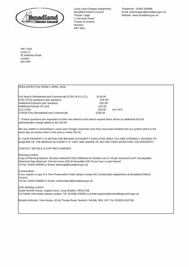
Local Land Charges Department
Broadland District Council
Thorpe Lodge
1 Yarmouth Road
Thorpe St Andrew
Norwich
NR7 0DU
Telephone: 01603 430586
Email: [email protected]
Website: www.broadland.gov.uk
Info Track
Level 11
91 Waterloo Road
London
SE1 8RT
FEES EFFECTIVE FROM 1 APRIL 2018:-
Full Search (Residential and Commercial) (CON 29 & LLC1) £128.00
CON 29 (O) Questions (per question) £20.40*
Additional Enquiries (per question) £20.40*
Additional Parcels Of Land £19.20
LLC1 Only £23.00 (no VAT)
CON29 Only (Residential and Commercial) £105.00
* If these questions are requested on their own without a full search request there will be an additional £24.00
administration charge added to the £20.40.
We are unable to cancel/return Local Land Charges Searches once they have been booked onto our system which is the
same day we receive them in the post or online (NLIS).
IF YOUR PROPERTY IS WITHIN THE BROADS AUTHORITY EXECUTIVE AREA YOU ARE STRONGLY ADVISED TO
ENQUIRE OF THE BROADS AUTHORITY IF THEY ARE AWARE OF ANY MATTERS AFFECTING THE PROPERTY.
CONTACT DETAILS & COPYING CHARGES
Planning Control:
Copy of Planning Notices: Decision Notices/S.52/S.106/Deed of Variation etc £7.00 per document (VAT not payable)
Historical Data Retrieval: First two hours £59.20 thereafter £29.70 per hour or part thereof.
Tel No: 01603 430509 or Email: [email protected]
Conservation:
If you require a copy of a Tree Preservation Order please contact the Conservation department at Broadland District
Council.
Tel No: 01603 430560 or Email: [email protected]
CNC Building Control:
South Norfolk House, Cygnet Court, Long Stratton, NR15 2XE
For further information please contact; Tel: (01508) 535300 or Email:[email protected]
Broads Authority, Yare House, 62-64 Thorpe Road, Norwich, Norfolk, NR1 1RY Tel: (01603) 610734}

REGISTER OF LOCAL LAND CHARGES
OFFICIAL CERTIFICATE OF SEARCH
2018/01778Official Number:
Info Track
Level 11
91 Waterloo Road
London
SE1 8RT
Enquirer:
Dated 22/10/2018
Requisition for Search:An official search is required in the register of local land charges kept by the below-named
registering authority for subsisting registrations against the land described below.
Registering Authority: Broadland District Council
Search Address: Spratts Green Farm
and Land
Spratts Green
Aylsham
Norwich
NR11 6TX
Official Certificate of Search
It is hereby certified that the search requested above reveals the 4 registration(s) described in the Schedule(s) hereto
up to and including the date of this Certificate.
Date: 22/10/2018
Mr P Courtier
Head of Planning

Part 3 - Planning Charges
Town & Country Planning Act 1990 - Area Of Special Advert Control
Special Control Order defining an area of "special control" for the purposes of the Town & Country Planning (Control Of
Advertisements) Regulations 1992
Date Of Registration: 06/04/1992
Originating Authority Place where relevant documents may be inspected
Broadland District Council Broadland District Council (Broadland District
Council,Thorpe Lodge,1 Yarmouth Road,Thorpe St
Andrew,NR7 0DU)
06 April, 1992
Date of Registration
Part 4 - Miscellaneous Charges
Public Health Act 1925 Section 30/104 Order
Continued in force by Paragraph 22 of the 24th Schedule to the Highways Act 1959
Informative: Under the terms of an Order made under Section 30 Public Health Act 1925, an owner can be required, upon
development or redevelopment of an affected property, to surrender land into the public highway. In instances where land has not
been taken it is current policy of Norfolk County Council not to enforce such orders unless the property is also affected by an
approved highway improvement scheme.
Originating Authority Place where relevant documents may be inspected
Norfolk County Council Norfolk County Council (Norfolk County Council,County
Hall,Martineau Lane,Norwich,NR1 2SF)
08 October, 1934
Date of Registration
Dated: 22/10/2018
2018/01778Search Reference: Broadland District Council
Thorpe Lodge
1 Yarmouth Road
Thorpe St Andrew
Norwich NR7 0DU

Part 10 - Listed Building Charges
Listed Buildings & Conservation Areas Act 1990 - Listed Building
Description : Spratts Green Farm House,Spratts Green,Aylsham,
Early C19. Red brick, slate roof. Two storeys. Metal casements with glazing bars. Rubbed brick arches. Plain brick angle
pilasters. Parapetted gables with internal chimney stacks. Wide eaves overhang with plain brackets. Central doorway with
simple doorcase. Catslide extension on north side. One storey and attic brick and pantile wing on east side. Range of brick and
pantile outbuildings and barn on north and west sides.
Grade : Grade II
Reference : DNBB-216
Dated : 01-JUN-84
Date of Registration : 01-JUN-84
Originating Authority Place where relevant documents may be inspected
Broadland District Council Broadland District Council (Broadland District
Council,Thorpe Lodge,1 Yarmouth Road,Thorpe St
Andrew,NR7 0DU)
01 June, 1984
Date of Registration
Listed Buildings & Conservation Areas Act 1990 - Listed Building
Description : Spratts Green Barns,Spratts Green,Aylsham,
Early C19. Red brick, slate roof. Two storeys. Metal casements with glazing bars. Rubbed brick arches. Plain brick angle
pilasters. Parapetted gables with internal chimney stacks. Wide eaves overhang with plain brackets. Central doorway with
simple doorcase. Catslide extension on north side. One storey and attic brick and pantile wing on east side. Range of brick and
pantile outbuildings and barn on north and west sides.
Grade : Grade II
Reference : DNBB-217
Dated : 01-JUN-84
Date of Registration : 01-JUN-84
Originating Authority Place where relevant documents may be inspected
Broadland District Council Broadland District Council (Broadland District
Council,Thorpe Lodge,1 Yarmouth Road,Thorpe St
Andrew,NR7 0DU)
01 June, 1984
Date of Registration
Dated: 22/10/2018
2018/01778Search Reference: Broadland District Council
Thorpe Lodge
1 Yarmouth Road
Thorpe St Andrew
Norwich NR7 0DU

Dated: 22/10/2018
2018/01778Search Reference: Broadland District Council
Thorpe Lodge
1 Yarmouth Road
Thorpe St Andrew
Norwich NR7 0DU
THE FOLLOWING REPLIES TO THE ENQUIRIES PRINTED ON THE FORM CON29(2016)
ARE SUBJECT TO THE NOTES AT THE FOOT OF THE FORM
Law Society CON29 Enquiries of Local Authority (2016)
Spratts Green Farm, and Land, Spratts Green, Aylsham, Norwich, NR11 6TXProperty Address:
Planning permission 1.01(a)
None 1.01(a)
a listed building consent 1.01(b)
None 1.01(b)
a conservation area consent 1.01(c)
None 1.01(c)
a certificate of lawfulness of existing use or development 1.01(d)
None 1.01(d)
a certificate of lawfulness of proposed use or development 1.01(e)
None 1.01(e)
a certificate of lawfulness of proposed works for listed buildings 1.01(f)
None 1.01(f)
a heritage partnership agreement 1.01(g)
None 1.01(g)
a listed building consent order 1.01(h)
None 1.01(h)
a local listed building consent order 1.01(i)
None 1.01(i)
building regulations approval 1.01(j)
None 1.01(j)
a building regulation completion certificate and 1.01(k)
None 1.01(k)
any building regulations certificate or notice issued in respect of work carried out under a competent
person self-certification scheme?
1.01(l)
None 1.01(l)
What designations of land use for the property or the area and what specific proposals for the property
are contained in any existing or proposed development plan?
1.02
Dated: 22/10/2018
2018/01778Search Reference: Broadland District Council
Thorpe Lodge
1 Yarmouth Road
Thorpe St Andrew
Norwich NR7 0DU
The site is within the area of the 'Broadland Local Plan' which includes the:
Joint Core Strategy for Broadland, Norwich and South Norfolk' (JCS) (Adopted) (2011) (2014),
Development Management DPD (Adopted) (2015),
Site Allocations DPD (Adopted) (2016), and
Old Catton, Sprowston, Rackheath, Thorpe St Andrew Growth Triangle AAP Adopted (2016).
Neighbourhood Plans - Some parishes have adopted (or are in the process of adopting) a Neighbourhood
Plan. Once adopted, these form part of the Development Plan for the district.
For more information please check the Council's website on
https://www.broadland.gov.uk/info/200164/neighbourhood_plans/403/areas_with_adopted_neighbourhood
_plans
The policies within these documents that apply to the district as a whole should be considered, however
the policies most likely to be relevant to this locality are:
Joint Core Strategy (DPD) Relevant Policies:
Area Wide Policies 1-8 within the JCS apply across the plan area. These include the provision for
development in the settlement. In addition, Policies 9-17 describe the Settlement Hierarchy for Parishes in
the District.
Development Management (DPD) Policies:
GC2 - OUTSIDE THE SETTLEMENT LIMIT
TS6 - SITE WITHIN AIRPORT SAFEGUARDING BOUNDARY
Adopted Neighbourhood Plan
NO
Site Allocations (DPD) Relevant Policies:
NONE
Growth Triangle Area Action Plan AAP (Adopted) (2016) Policies:
NONE
Other policies throughout the Growth Triangle Area Action Plan may also affect the property. Further
information (if required) can be obtained from the Spatial Planning Team at Broadland District Council.
(Proposed) Greater Norwich Local Plan (GNLP)
The council has started the review of the Local Plan referred to as the Greater Norwich Local Plan which
is being prepared jointly with Norwich City Council, South Norfolk District Council and Norfolk County
Council and which will cover up to 2036.
http://www.greaternorwichlocalplan.org.uk/
Any enquiries on the Local Plan should be addressed to Broadland District Council.
The District Council has produced a Local Development Scheme which sets out the programme for
producing the (emerging) Local Plan.
See also replies from Norfolk County Council on the attached sheet. These relate to, Norfolk Minerals &
Waste Local Plan, or Transport - Local Transport Plan (LTP). Any enquiries on these plans should be
addressed to Norfolk County Council.
1.02
highways maintainable at public expense 2.01(a)
Norfolk County Council is the Highway Authority for the Broadland District Council area.
See replies of Norfolk County Council on attached sheet.
2.01(a)
subject to adoption and supported by a bond or bond waiver 2.01(b)
Dated: 22/10/2018
2018/01778Search Reference: Broadland District Council
Thorpe Lodge
1 Yarmouth Road
Thorpe St Andrew
Norwich NR7 0DU
Norfolk County Council is the Highway Authority for the Broadland District Council area.
See replies of Norfolk County Council on attached sheet.
2.01(b)
to be made up by a local authority who will reclaim the cost from the frontagers 2.01(c)
Norfolk County Council is the Highway Authority for the Broadland District Council area.
See replies of Norfolk County Council on attached sheet.
2.01(c)
to be adopted by a local authority without reclaiming the cost from the frontagers 2.01(d)
Norfolk County Council is the Highway Authority for the Broadland District Council area.
See replies of Norfolk County Council on attached sheet.
2.01(d)
Is any public right of way which abuts on or crosses the property shown in a definitive map or revised
definitive map?
2.02
Norfolk County Council is the Highway Authority for the Broadland District Council area.
See replies of Norfolk County Council on attached sheet.
2.02
Are there any pending applications to record a public right of way that abuts or crosses the property on
a definitive map or revised definitive map?
2.03
Norfolk County Council is the Highway Authority for the Broadland District Council area.
See replies of Norfolk County Council on attached sheet.
2.03
Are there any legal orders to stop up after or create a public right of way which abuts or crosses the
property not yet implemented or shown on a definitive map?
2.04
Norfolk County Council is the Highway Authority for the Broadland District Council area.
See replies of Norfolk County Council on attached sheet.
2.04
If so please attach a plan showing the approximate route. 2.05
Norfolk County Council is the Highway Authority for the Broadland District Council area.
See replies of Norfolk County Council on attached sheet.
2.05
Land required for Public Purposes Is the property included in land required for public purposes? 3.01
Broadland District Council - NONE
See also reply to question 1.2 for any proposals in the development plan.
See also reply from Norfolk County Council on attached sheet.
3.01
Land to be acquired for Road Works Is the property included in land to be acquired for road works? 3.02
Norfolk County Council is the Highway Authority for the Broadland District Council area.
See replies of Norfolk County Council on attached sheet.
3.02
Is the property served by a sustainable urban drainage system (SuDS)? 3.03(a)
The Council does not hold accurate information on SUDS features which may or may not be installed at
the property, some information may be available on the relevant planning submissions for the site (if
applicable).
We recommend that the question is referred back to the property/land owner who may hold further
information.
Planning Decision Notices and associated documentation are available to view on the Broadland District
Council website www.broadland.gov.uk/plans by inserting the planning application number.
3.03(a)
Are there SuDS features within the boundary of the property if yes is the owner responsible for
maintenance?
3.03(b)
Any specific SuDS features located on individual properties may be identified on final construction
drawings produced by the developer and transferred to legal property deeds.
3.03(b)
If the property benefits from a SuDS for which there is a charge who bills the property for the surface
water drainage charge?
3.03(c)
Dated: 22/10/2018
2018/01778Search Reference: Broadland District Council
Thorpe Lodge
1 Yarmouth Road
Thorpe St Andrew
Norwich NR7 0DU
Long term management and any financial arrangements for maintenance of SuDS is the responsibility of
the developer/land owner who may choose to make arrangements for financial contributions towards
SuDS maintenance from property owners
3.03(c)
the centre line of a new trunk road or special road specified in any order draft order or scheme 3.04(a)
Norfolk County Council is the Highway Authority for the Broadland District Council area.
See replies of Norfolk County Council on attached sheet.
3.04(a)
The centre line of a proposed alteration or improvement to an existing road notified to the Council by the
appropriate Secretary of State involving the construction of a subway underpass flyover footbridge
elevated road or dual carriageway (whether or not within existing highway limits) ; or
3.04(b)
Norfolk County Council is the Highway Authority for the Broadland District Council area.
See replies of Norfolk County Council on attached sheet.
3.04(b)
the outer limits of construction works for a proposed alteration or improvement to an existing road
involving (i) construction of a roundabout (other than a mini roundabout); or (ii) widening by construction
of one or more additional traffic lanes;
3.04(c)
Norfolk County Council is the Highway Authority for the Broadland District Council area.
See replies of Norfolk County Council on attached sheet.
3.04(c)
the outer limits of (i) construction of a new road to be built by a local authority; (ii) an approved alteration
or improvement to an existing road involving construction of a subway underpass flyover footbridge
elevated road or dual carriageway; or (iii) construction a roundabout (other than a mini roundabout) or
widening by construction of one or more additional traffic lanes;
3.04(d)
Norfolk County Council is the Highway Authority for the Broadland District Council area.
See replies of Norfolk County Council on attached sheet.
3.04(d)
the centre line of the proposed route of a new road under proposals published for public consultation; or 3.04(e)
Norfolk County Council is the Highway Authority for the Broadland District Council area.
See replies of Norfolk County Council on attached sheet.
3.04(e)
the outer limits of (i) construction of a proposed alteration or improvement to an existing road involving
construction of a subway underpass flyover footbridge elevated road or dual carriageway; (ii)
construction a roundabout (other than a mini roundabout); or (iii) widening by construction of one or
more additional traffic lanes under proposals published for public consultation?
3.04(f)
Norfolk County Council is the Highway Authority for the Broadland District Council area.
See replies of Norfolk County Council on attached sheet.
3.04(f)
Is the property (or will it be) within 200 metres of the centre line of a proposed railway tramway light
railway or monorail?
3.05(a)
Norfolk County Council is the Highway Authority for the Broadland District Council area.
See replies of Norfolk County Council on attached sheet.
3.05(a)
Are there any proposals for a railway tramway light railway or monorail within the Local Authority's
boundary?
3.05(b)
Norfolk County Council is the Highway Authority for the Broadland District Council area.
See replies of Norfolk County Council on attached sheet.
3.05(b)
Permanent stopping up or diversion 3.06(a)
Norfolk County Council is the Highway Authority for the Broadland District Council area.
See replies of Norfolk County Council on attached sheet.
3.06(a)
Waiting or loading restrictions 3.06(b)
Norfolk County Council is the Highway Authority for the Broadland District Council area.
See replies of Norfolk County Council on attached sheet.
3.06(b)
Dated: 22/10/2018
2018/01778Search Reference: Broadland District Council
Thorpe Lodge
1 Yarmouth Road
Thorpe St Andrew
Norwich NR7 0DU
One-way driving 3.06(c)
Norfolk County Council is the Highway Authority for the Broadland District Council area.
See replies of Norfolk County Council on attached sheet.
3.06(c)
Prohibition of driving 3.06(d)
Norfolk County Council is the Highway Authority for the Broadland District Council area.
See replies of Norfolk County Council on attached sheet.
3.06(d)
Pedestrianisation 3.06(e)
Norfolk County Council is the Highway Authority for the Broadland District Council area.
See replies of Norfolk County Council on attached sheet.
3.06(e)
Vehicle width or weight restriction 3.06(f)
Norfolk County Council is the Highway Authority for the Broadland District Council area.
See replies of Norfolk County Council on attached sheet.
3.06(f)
Traffic calming works e.g. road humps 3.06(g)
Norfolk County Council is the Highway Authority for the Broadland District Council area.
See replies of Norfolk County Council on attached sheet.
3.06(g)
Residents parking controls 3.06(h)
Norfolk County Council is the Highway Authority for the Broadland District Council area.
See replies of Norfolk County Council on attached sheet.
3.06(h)
Minor road widening or improvement 3.06(i)
Norfolk County Council is the Highway Authority for the Broadland District Council area.
See replies of Norfolk County Council on attached sheet.
3.06(i)
Pedestrian crossings 3.06(j)
Norfolk County Council is the Highway Authority for the Broadland District Council area.
See replies of Norfolk County Council on attached sheet.
3.06(j)
Cycle tracks 3.06(k)
Norfolk County Council is the Highway Authority for the Broadland District Council area.
See replies of Norfolk County Council on attached sheet.
3.06(k)
Bridge building 3.06(l)
Norfolk County Council is the Highway Authority for the Broadland District Council area.
See replies of Norfolk County Council on attached sheet.
3.06(l)
building works 3.07(a)
None 3.07(a)
environment 3.07(b)
None 3.07(b)
health and safety 3.07(c)
None 3.07(c)
housing 3.07(d)
None 3.07(d)
highways 3.07(e)
Dated: 22/10/2018
2018/01778Search Reference: Broadland District Council
Thorpe Lodge
1 Yarmouth Road
Thorpe St Andrew
Norwich NR7 0DU

Norfolk County Council is the Highway Authority for the Broadland District Council area.
See replies of Norfolk County Council on attached sheet.
3.07(e)
public health 3.07(f)
None 3.07(f)
flood and coastal erosion risk management 3.07(g)
Norfolk County Council is the Lead Local Flood Authority.
See replies of Norfolk County Council on attached sheet.
3.07(g)
Contravention of Building Regulations Has a local authority authorised in relation to the property any
proceedings for the contravention of any provision contained in Building Regulations?
3.08
None 3.08
an Enforcement Notice 3.09(a)
None 3.09(a)
a stop notice 3.09(b)
None 3.09(b)
a listed building enforcement notice 3.09(c)
None 3.09(c)
a breach of condition notice 3.09(d)
None 3.09(d)
a planning contravention notice 3.09(e)
None 3.09(e)
another notice relating to breach of planning control 3.09(f)
None 3.09(f)
a listed building repairs notice 3.09(g)
None 3.09(g)
in the case of a listed building deliberately allowed to fall into disrepair a compulsory purchase order with
a direction for minimum compensation;
3.09(h)
None 3.09(h)
a building preservation notice 3.09(i)
None 3.09(i)
a direction restricting permitted development 3.09(j)
None 3.09(j)
an order revoking or modifying a planning permission or discontinuing an existing planning use 3.09(k)
None 3.09(k)
an order requiring discontinuance of use or alterations or removal of building or works; 3.09(l)
None 3.09(l)
tree preservation order; or 3.09(m)
None 3.09(m)
proceedings to enforce a planning agreement or planning contribution 3.09(n)
None 3.09(n)
Is there a CIL charge schedule? 3.10(a)
Dated: 22/10/2018
2018/01778Search Reference: Broadland District Council
Thorpe Lodge
1 Yarmouth Road
Thorpe St Andrew
Norwich NR7 0DU
Yes - Broadland District Council has a CIL charging schedule which came into effect on the 1st July 2013.
Any development granted planning permission prior to this date is not affected by the Community
Infrastructure Levy - further information if required can be found on our website:
https://www.broadland.gov.uk/info/200153/planning_permission/277/community_infrastructure_levy_cil.
At present the Broads Authority does not have a CIL charging schedule (This only applies to property/land
within the Broads Authority area).
3.10(a)
If yes do any of the following subsist in relation to the property or has a local authority decided to issue
serve make or commence any of the following:- i) a liability notice? ii) a notice of chargeable
development? iii) a demand notice? iv) a default liability notice? v) an assumption notice? (vi) a
commencement notice?
3.10(b)
No 3.10(b)
Has any demand notice been suspended? 3.10(c)
Not Applicable 3.10(c)
Has the local authority received full or part payment of any CIL liability? 3.10(d)
Not Applicable 3.10(d)
Has the local authority received any appeal against any of the above? 3.10(e)
Not Applicable 3.10(e)
Has a decision been taken to apply for a liability order? 3.10(f)
Not Applicable 3.10(f)
Has a liability order been granted? 3.10(g)
Not Applicable 3.10(g)
Have any other enforcement measures been taken? 3.10(h)
Not Applicable 3.10(h)
the making of the area a Conservation Area before 31 August 1974; or 3.11(a)
No 3.11(a)
an unimplemented resolution to designate the area a Conservation Area? 3.11(b)
No 3.11(b)
Compulsory Purchase Has any enforceable order or decision been made to compulsorily purchase or
acquire the property?
3.12
No
See replies from Norfolk County Council on attached sheet.
3.12
a contaminated land notice; 3.13(a)
No 3.13(a)
in relation to a register maintained under section 78R of the Environmental Protection Act 1990:- (i) a
decision to make an entry; or (ii) an entry; or
3.13(b)
No 3.13(b)
consultation with the owner or occupier of the property conducted under section 78G(3) of the
Environmental Protection Act 1990 before the service of a remediation notice?
3.13(c)
No 3.13(c)
Radon Gas Do records indicate that the property is in a "Radon Affected Area" as identified by Public
Heath England or Public Health Wales?
3.14
Dated: 22/10/2018
2018/01778Search Reference: Broadland District Council
Thorpe Lodge
1 Yarmouth Road
Thorpe St Andrew
Norwich NR7 0DU

Broadland is not in an area identified as experiencing significant emissions of radon gas.
You can view the 'Radon Affected Areas' on the Public Health England website:
http://www.ukradon.org/information/ukmaps
3.14
Has the property been nominated as an asset of community value? If so:- (i) Is it listed as an asset of
community value? (ii) Was it excluded and placed on the 'nominated but not listed' list? (iii) Has the listing
expired? (iv) Is the Local Authority reviewing or proposing to review the listing? (v) Are there any
subsisting appeals against the listing?
3.15(a)
No 3.15(a)
If the property is listed: (i) Has the local authority decided to apply to the Land Registry for an entry or
cancellation of a restriction in respect of listed land affecting the property? (ii) Has the Local Authority
received a notice of disposal? (iii) Has any community interest group requested to be treated as a bidder?
3.15(b)
Not Applicable 3.15(b)
Dated: 22/10/2018
2018/01778Search Reference: Broadland District Council
Thorpe Lodge
1 Yarmouth Road
Thorpe St Andrew
Norwich NR7 0DU
THE FOLLOWING REPLIES TO THE ENQUIRIES PRINTED ON THE FORM CON29(2016)
ARE SUBJECT TO THE NOTES AT THE FOOT OF THE FORM
Law Society CON29O Enquiries of Local Authority (2016)
Spratts Green Farm, and Land, Spratts Green, Aylsham, Norwich, NR11 6TXProperty Address:
Extra Information 3.99
None 3.99
Areas of Outstanding Natural Beauty Has any order under s.82 of the Countryside and Rights of Way Act
2000 been made?
7.1
See replies from Norfolk County Council on attached sheet. 7.1
National Parks Is the property within a National Park designated under s.7 of the National Parks and
Access to the Countryside Act 1949?
7.2
See replies from Norfolk County Council on attached sheet. 7.2
Has a map been deposited under s.35 of the Pipelines Act 1962 or Schedule 7 of the Gas Act 1986
showing a pipeline laid through or within 100 feet (30.48 metres) of the property?
8
No 8
Is the area a mineral consultation area or mineral safeguarding area notified by the county planning
authority under Schedule 1 para 7 of the Town and Country Planning Act 1990?
16
No 16
What outstanding statutory or informal notices have been issued by the Council under the Environmental
Protection Act 1990 or the Control of Pollution Act 1974? (This enquiry does not cover notices under Part
IIA or Part III of the EPA to which enquiries 3.12 or 3.07 apply)
18
None
See also replies from Norfolk County Council on attached sheet.
18
Please list any entries in the record maintained under regulation 10 of the Hedgerows Regulations 1997. 20.1
None 20.1
If there are any entries: How can copies of the matters entered be obtained? 20.2(a)
Not Applicable 20.2(a)
Where can the record be inspected? 20.2(b)
Not Applicable 20.2(b)
Is the property or any land which abuts the property registered common land or town or village green
under the Commons Registration Act 1965 or the Commons Act 2006?
22.1
See replies of Norfolk County Council on attached sheet. 22.1
Is there any prescribed information about maps and statements deposited under s.15A of the Commons
Act 2006 in the register maintained under s.15B(1) of the Commons Act 2006 or under s.31A of the
Highways Act 1980?
22.2
As Above 22.2
If there are any entries how can copies of the matters registered be obtained and where can the register
be inspected?
22.3
As Above 22.3
Dated: 22/10/2018
2018/01778Search Reference: Broadland District Council
Thorpe Lodge
1 Yarmouth Road
Thorpe St Andrew
Norwich NR7 0DU

Addendum
Standard Information/Disclaimer
Dated: 22/10/2018
2018/01778Search Reference: Broadland District Council
Thorpe Lodge
1 Yarmouth Road
Thorpe St Andrew
Norwich NR7 0DU
2016 CON29 PART 1 Informatives
Question 1.1(a)-(i)
This reply does not cover other properties in the vicinity of the search property.
The local authority's computerised records of planning applications do not extend back before 1st April 1974 and this reply covers
only the period since that date.
If the property is or has been part of a farm, we recommend that you check that there are no 'Agricultural Occupancy' restrictions
by way of conditions on the original planning. If the planning is pre April 1974 it would not be shown on this search result.
Question 1.1(j) - 1.1(k)
This reply does not cover other properties in the vicinity of the property.
The results of the Building Regulation records only pertain to works that have been completed within the last 15 years or are
projects that have not been actioned as completed. Applications that were issued a completion certificate more than 15 years ago
are not revealed as part of this search. If you require further information on this matter please email
Copies of documents issued by, or held by CNC Building Control, on behalf of Broadland District Council are available on request.
Address: South Norfolk House, Cygnet Court, Long Stratton, NR15 2XE
Tel No: 0808 168 5041
Email: [email protected]
Question 1.1(l)
This reply does not cover other properties in the vicinity of the property.
The local authority may not always be aware of such works and enquiries should also be made of the seller.
Information relating to the Competent Persons Scheme is only available from 1st January 2005. The information shown is an
exact copy of what is supplied to CNC Building Control by the Competent Person Scheme. If you require further information or
clarification please contact the appropriate scheme member.
Question 1.2
No informative required.
Question 2.1
No informative required to this question because all of the highways related questions are answered by Norfolk County Council.
Question 2.2
No informative required to this question because all of the highways related questions are answered by Norfolk County Council.
Question 3
With reference to questions 3.7 to 3.15 matters already entered on the Local Land Charges Register will not be revealed to in
answer to this enquiry.
Question 3.9
No informative required
Question 3.13
A negative reply does not imply that the property or any adjoining or adjacent land is free from contamination, or from the risk of it,
and the reply may not disclose steps taken by another local authority in whose area adjacent or adjoining land is situated.
Question 3.14
Dated: 22/10/2018
2018/01778Search Reference: Broadland District Council
Thorpe Lodge
1 Yarmouth Road
Thorpe St Andrew
Norwich NR7 0DU

No informative required.
Question 3.15
No informative required.
CON29 PART 2 Informatives
Question 8
You are advised to seek further information from http://www.linesearchbeforeudig.co.uk
LinesearchbeforeUdig (LSBUD) is a free to use internet based enquiry service available 24/7. It provides a single point of contact
for all enquiries relating to the apparatus owned and/or operated by the Asset Owners protected by LSBUD, including
underground and overhead transmission/distribution electricity networks, transmission/distribution gas networks, oil pipelines, and
fibre optic networks.
These replies have been given in accordance with the notes appended to CON29 form.
References to the provisions of particular Acts of Parliament or Regulations include any provisions which they have replaced and
also include existing or future amendments or re-enactments.
The replies will be given in the belief that they are in accordance with information presently available to the officers of the replying
local authority, but none of the local authorities or their officers accepts legal responsibility for an incorrect reply, except for
negligence. Any legal responsibility for negligence will be owed to the person who raised the enquiries and the person on whose
behalf they were raised. It will also be owed to any other person who has knowledge (personally or through an agent) of the
replies before the time when he purchases, takes a tenancy of, or lends money on the security of the property or (if earlier) the
time when he becomes contractually bound to do so.
This Form should be read in conjunction with the guidance notes available separately.
Area means any area in which the property is located.
References to the Local Authority include any predecessor Local Authority and also any Local Authority committee, sub-committee
or other body or person exercising powers delegated by the Local Authority and their approval includes their decision to proceed.
The replies given to certain enquiries cover knowledge and actions of both the District Local Authority and County Local Authority.
Where relevant, the source department for copy documents should be provided.
Dated: 22/10/2018
2018/01778Search Reference: Broadland District Council
Thorpe Lodge
1 Yarmouth Road
Thorpe St Andrew
Norwich NR7 0DU
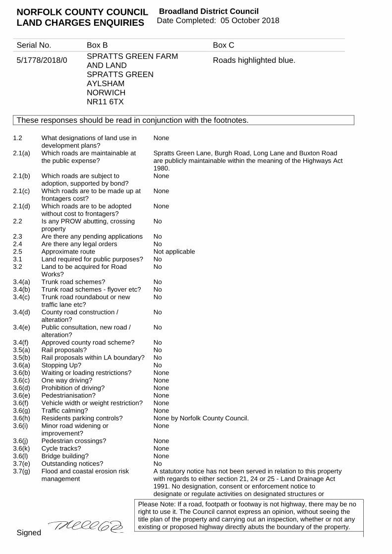
NORFOLK COUNTY COUNCIL LAND CHARGES ENQUIRIES
Broadland District Council Date Completed: 05 October 2018
Serial No. Box B Box C
5/1778/2018/0 SPRATTS GREEN FARM AND LAND SPRATTS GREEN AYLSHAM NORWICH NR11 6TX
Roads highlighted blue.
These responses should be read in conjunction with the footnotes.
Please Note: If a road, footpath or footway is not highway, there may be no right to use it. The Council cannot express an opinion, without seeing the title plan of the property and carrying out an inspection, whether or not any existing or proposed highway directly abuts the boundary of the property.
Signed
1.2 What designations of land use in development plans?
None
2.1(a) Which roads are maintainable at the public expense?
Spratts Green Lane, Burgh Road, Long Lane and Buxton Road are publicly maintainable within the meaning of the Highways Act 1980.
2.1(b) Which roads are subject to adoption, supported by bond?
None
2.1(c) Which roads are to be made up at frontagers cost?
None
2.1(d) Which roads are to be adopted without cost to frontagers?
None
2.2 Is any PROW abutting, crossing property
No
2.3 Are there any pending applications No 2.4 Are there any legal orders No 2.5 Approximate route Not applicable 3.1 Land required for public purposes? No 3.2 Land to be acquired for Road
Works? No
3.4(a) Trunk road schemes? No 3.4(b) Trunk road schemes - flyover etc? No 3.4(c) Trunk road roundabout or new
traffic lane etc? No
3.4(d) County road construction / alteration?
No
3.4(e) Public consultation, new road / alteration?
No
3.4(f) Approved county road scheme? No 3.5(a) Rail proposals? No 3.5(b) Rail proposals within LA boundary? No 3.6(a) Stopping Up? No 3.6(b) Waiting or loading restrictions? None 3.6(c) One way driving? None 3.6(d) Prohibition of driving? None 3.6(e) Pedestrianisation? None 3.6(f) Vehicle width or weight restriction? None 3.6(g) Traffic calming? None 3.6(h) Residents parking controls? None by Norfolk County Council. 3.6(i) Minor road widening or
improvement? None
3.6(j) Pedestrian crossings? None 3.6(k) Cycle tracks? None 3.6(l) Bridge building? None 3.7(e) Outstanding notices? No 3.7(g) Flood and coastal erosion risk
management A statutory notice has not been served in relation to this property with regards to either section 21, 24 or 25 - Land Drainage Act 1991. No designation, consent or enforcement notice to designate or regulate activities on designated structures or

NORFOLK COUNTY COUNCIL LAND CHARGES ENQUIRIES
Broadland District Council Date Completed: 05 October 2018
Serial No. Box B Box C
5/1778/2018/0 SPRATTS GREEN FARM AND LAND SPRATTS GREEN AYLSHAM NORWICH NR11 6TX
Roads highlighted blue.
These responses should be read in conjunction with the footnotes.
Please Note: If a road, footpath or footway is not highway, there may be no right to use it. The Council cannot express an opinion, without seeing the title plan of the property and carrying out an inspection, whether or not any existing or proposed highway directly abuts the boundary of the property.
Signed
features that affect flood risk have been served on this property by Norfolk County Council under Sched. 1 of the Flood and Water Management Act 2010 (FWM Act 2010). Please note: 1) The above information is limited to the data we hold as a Lead Local Flood Authority in pursuance of our duties under the FWM Act 2010 and the Land Drainage Act 1991. 2) This search relates to notices issued by NCC since commencement of this function in April 2012. There may be notices issued by other Risk Management Authorities in relation to this property. These include: 1) Internal Drainage Boards (ordinary watercourses across 20% of Norfolk) 2) District Councils (coastal erosion) 3) Environment Agency (main rivers, coastal flooding & large raised reservoirs)
3.9(g) A listed building repairs notice? No 3.9(h) Acquisition of listed building? No 3.9(i) Building preservation notice? No 3.12 Compulsory purchase order? No 7.1 A.O.N.B. No 7.2 National park? No 16 Mineral area? The property or area searched is within, or partially within, the
safeguarding and consultation areas for a safeguarded mineral resource (sand and gravel), as designated in the adopted Norfolk Minerals and Waste Core Strategy (Policy CS16 – safeguarding) and delineated in the accompanying Policies Map. The safeguarding and consultation areas cover mineral resources identified as of potential economic value. Norfolk Minerals and Waste Core Strategy Policy CS16 contains further information on requirements for consultation on proposed development within this area. (Further details may be obtained from Minerals and Waste Policy, Planning Services, Community and Environmental Services Department, Norfolk County Council DX 135926 Norwich 13, or email [email protected]
18 Environment and pollution? None in respect of section 23 of the Control of Pollution Act 1974. This question is also a matter for the Environment Agency, Anglian Regional Office, Kingfisher House, Goldhay Way, Orton Goldhay, Peterborough, Cambridgeshire PE2 5ZR and should be sent to that Authority. A separate charge may be made.
22.1 Is the property or any land abutting the property registered common land or town or village green?
No
22.2 Entries in the register under s15B of the Commons Act 2006 or s31A of the Highways Act 1980?
The register of maps, statements and declarations may be viewed at the following link https://www.norfolk.gov.uk/out-and-about-in-norfolk/public-rights-of-way/register-of-declarations-and-deposits/about-register-of-declarations-and-deposits
22.3 How can copies of the matters registered be obtained and where can the register be inspected?
The Register is held at the offices of Norfolk County Council, Community and Environmental Department, County Hall, Martineau Lane, Norwich, NR1 2SG Telephone No. 01603 222957 DX 135927 Norwich 13. If you wish to inspect the
NORFOLK COUNTY COUNCIL LAND CHARGES ENQUIRIES
Broadland District Council Date Completed: 05 October 2018
Serial No. Box B Box C
5/1778/2018/0 SPRATTS GREEN FARM AND LAND SPRATTS GREEN AYLSHAM NORWICH NR11 6TX
Roads highlighted blue.
These responses should be read in conjunction with the footnotes.
Please Note: If a road, footpath or footway is not highway, there may be no right to use it. The Council cannot express an opinion, without seeing the title plan of the property and carrying out an inspection, whether or not any existing or proposed highway directly abuts the boundary of the property.
Signed
register we recommend that you telephone in advance for an appointment.
Date Returned: Property type:
Prepared for: Matter: Client address:
Property:
InfoTrack UK Limited, Level 11, 91 Waterloo Road, London, SE1 8RT T: 0207 186 8090 E: [email protected]
ChancelCheck Premium
Search Details
Birketts LLP
Kingfisher House, 1 Gilders Way,Off Barrack Street, Norwich, NR3 1UBER/328585.1
Spratts Green Farm, Spratts Green, Aylsham, Norwich, NR11 6TX
STLLocal Authority:
This search was compiled by the Data Supplier above and provided by InfoTrack Ltd – t: 0207 186 8090, e: [email protected] search is subject to terms and conditions issued by InfoTrack which can be viewed at www.infotrack.co.uk or supplied on request.This search is also subject to terms and conditions issued by the Data Supplier, available on request. InfoTrack and the Data Supplier aboveare registered with the Property Codes Compliance Board (PCCB) as subscribers to the Search Code. The PCCB independently monitors howregistered firms maintain compliance with the Code. Visit www.propertycodes.org.uk for more information.
Agriculture / Large Site26/09/2018

Certificate
© Copyright CLS Property Insight Limited 2016
Visit: www.clspropertyinsight.co.uk Email: [email protected]
Call: 01732 753910
CLS Property Insight Limited (registered in England and Wales; Company Number 06993053) is authorised and regulated by the Financial Conduct Authority
Certificate Details
Certificate Number 7481304
Issue Date 26/09/2018
Client Ref 2717977
Address Spratts Green Farm, Spratts Green, Aylsham, Norwich, Norfolk, NR11 6TX
Property The area(s) of land within the boundaries on the plan attached to this report
Result We hereby certify that no points on or within the boundaries marked on the plan attached to this Certificate are located within the historical boundary of a tithe district within a parish which continues to have a potential chancel repair liability based upon historical parish boundary data and the relevant Inland Revenue indices held by The National Archives.
Notes and Conditions of Issue of this Certificate 1. This service is only available for properties in England and Wales.
2. The data used to identify potential risk are derived from an academic study of historical parish boundaries and the relevant documentation pertaining to potential chancel repair liability held at The National Archives.
3. The statement of certification above means that:
a) No record of risk is held by The National Archives for any point searched against in the subject parish; or a point is within a parish with evidence of risk but that point is situated within a tithe district for which the records described above disclose no risk or; the record held by The National Archives specifies that the total liability is held by the Church Commissioners, cathedrals and/or educational establishments.
b)
c) When purchasing land from any of these parties you should enquire with them directly regarding this liability.
4. ChancelCheck® Premium, searches against the address points formed and enclosed by the boundary marked by you on the plan attached to this Certificate.
5. CLS Property Insight Limited (‘CLS’) will not be liable for any inaccuracy in the plan provided by you.
6. This ChancelCheck® Premium Certificate is provided with the benefit of an insurance policy giving cover for a market value of the Property up to £2,000,000.00 where an adverse matter, not reported on here, which existed at the Issue Date is later discovered. For full details of the insurance provided and all its terms and conditions go to www.clspropertyinsight.co.uk.
7. This Certificate is prepared by CLS and is subject to the following Terms and Conditions:
Business Clients Visit: https://www.clsl.co.uk/Content/PDFs/Website/TermsConditions-B2B.pdf
Reseller Details
STL Group Ltd, Orion Gate, 1st Floor, Guildford Road, Woking, GU22 7NJ.
Call: Fax:
01483 71535501483 221854
Visit:Email:
Visit: www.clspropertyinsight.co.ukEmail: [email protected]
Call: 01732 753910
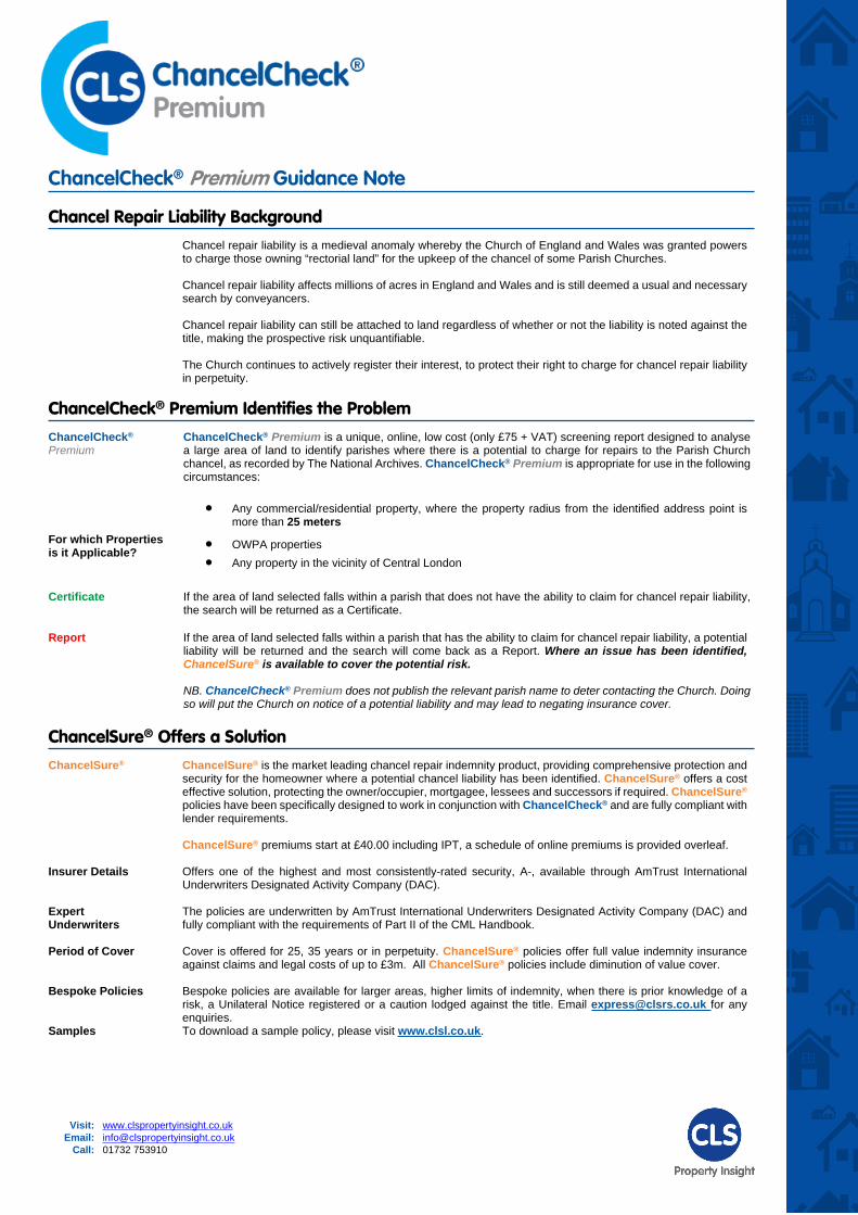
ChancelCheck® Premium Guidance Note
Chancel Repair Liability BackgroundChancel repair liability is a medieval anomaly whereby the Church of England and Wales was granted powers to charge those owning “rectorial land” for the upkeep of the chancel of some Parish Churches.
Chancel repair liability affects millions of acres in England and Wales and is still deemed a usual and necessary search by conveyancers.
Chancel repair liability can still be attached to land regardless of whether or not the liability is noted against the title, making the prospective risk unquantifiable.
The Church continues to actively register their interest, to protect their right to charge for chancel repair liability in perpetuity.
ChancelCheck® Premium Identifies the ProblemChancelCheck®
PremiumChancelCheck® Premium is a unique, online, low cost (only £75 + VAT) screening report designed to analyse a large area of land to identify parishes where there is a potential to charge for repairs to the Parish Church chancel, as recorded by The National Archives. ChancelCheck® Premium is appropriate for use in the following circumstances:
Any commercial/residential property, where the property radius from the identified address point is more than 25 meters
For which Properties is it Applicable? OWPA properties
Any property in the vicinity of Central London
Certificate If the area of land selected falls within a parish that does not have the ability to claim for chancel repair liability, the search will be returned as a Certificate.
Report If the area of land selected falls within a parish that has the ability to claim for chancel repair liability, a potential liability will be returned and the search will come back as a Report. Where an issue has been identified, ChancelSure® is available to cover the potential risk.
NB. ChancelCheck® Premium does not publish the relevant parish name to deter contacting the Church. Doing so will put the Church on notice of a potential liability and may lead to negating insurance cover.
ChancelSure® Offers a SolutionChancelSure® ChancelSure® is the market leading chancel repair indemnity product, providing comprehensive protection and
security for the homeowner where a potential chancel liability has been identified. ChancelSure® offers a cost effective solution, protecting the owner/occupier, mortgagee, lessees and successors if required. ChancelSure® policies have been specifically designed to work in conjunction with ChancelCheck® and are fully compliant with lender requirements.
ChancelSure® premiums start at £40.00 including IPT, a schedule of online premiums is provided overleaf.
Insurer Details Offers one of the highest and most consistently-rated security, A-, available through AmTrust International Underwriters Designated Activity Company (DAC).
Expert Underwriters
The policies are underwritten by AmTrust International Underwriters Designated Activity Company (DAC) and fully compliant with the requirements of Part II of the CML Handbook.
Period of Cover Cover is offered for 25, 35 years or in perpetuity. ChancelSure® policies offer full value indemnity insurance against claims and legal costs of up to £3m. All ChancelSure® policies include diminution of value cover.
Bespoke Policies Bespoke policies are available for larger areas, higher limits of indemnity, when there is prior knowledge of a risk, a Unilateral Notice registered or a caution lodged against the title. Email [email protected] for any enquiries.
Samples To download a sample policy, please visit www.clsl.co.uk.
Visit: www.clspropertyinsight.co.ukEmail: [email protected]
Call: 01732 753910
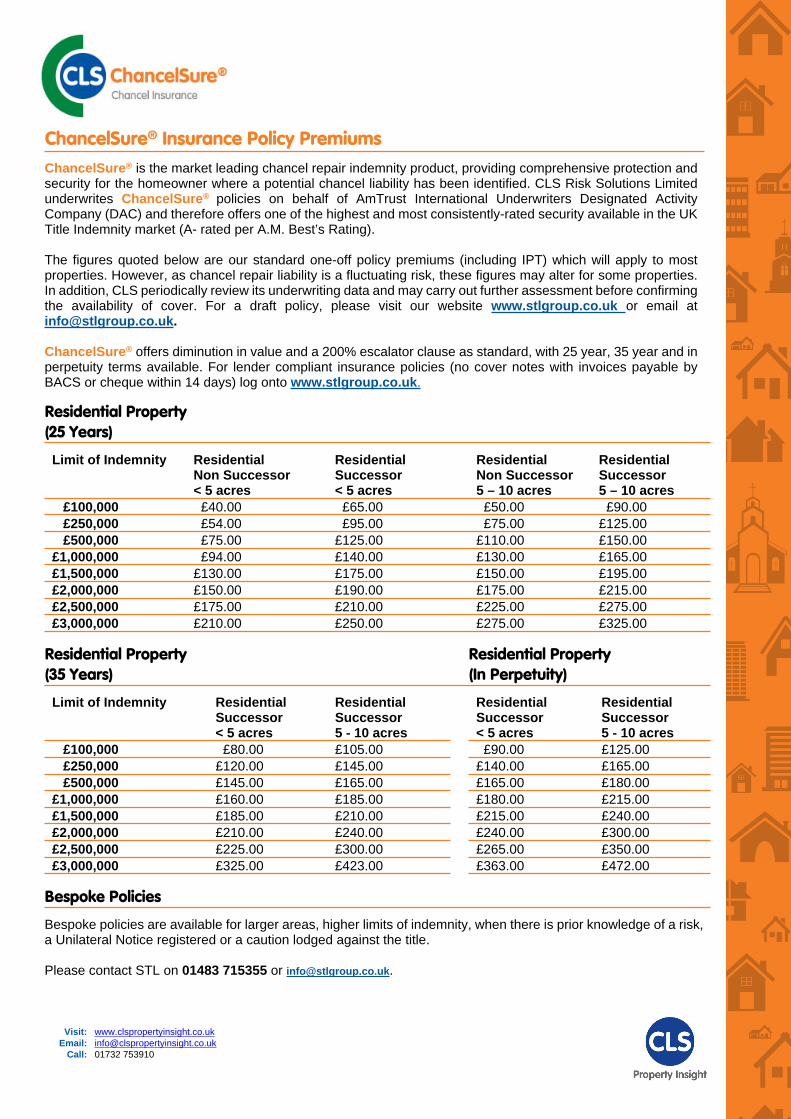
ChancelSure® Insurance Policy PremiumsChancelSure® is the market leading chancel repair indemnity product, providing comprehensive protection and security for the homeowner where a potential chancel liability has been identified. CLS Risk Solutions Limited underwrites ChancelSure® policies on behalf of AmTrust International Underwriters Designated Activity Company (DAC) and therefore offers one of the highest and most consistently-rated security available in the UK Title Indemnity market (A- rated per A.M. Best’s Rating).
The figures quoted below are our standard one-off policy premiums (including IPT) which will apply to most properties. However, as chancel repair liability is a fluctuating risk, these figures may alter for some properties. In addition, CLS periodically review its underwriting data and may carry out further assessment before confirming the availability of cover. For a draft policy, please visit our website www.stlgroup.co.uk or email at [email protected].
ChancelSure® offers diminution in value and a 200% escalator clause as standard, with 25 year, 35 year and in perpetuity terms available. For lender compliant insurance policies (no cover notes with invoices payable by BACS or cheque within 14 days) log onto www.stlgroup.co.uk.
Residential Property (25 Years)
Limit of Indemnity ResidentialNon Successor< 5 acres
ResidentialSuccessor< 5 acres
ResidentialNon Successor5 – 10 acres
ResidentialSuccessor5 – 10 acres
£100,000 £40.00 £65.00 £50.00 £90.00 £250,000 £54.00 £95.00 £75.00 £125.00 £500,000 £75.00 £125.00 £110.00 £150.00£1,000,000 £94.00 £140.00 £130.00 £165.00£1,500,000 £130.00 £175.00 £150.00 £195.00£2,000,000 £150.00 £190.00 £175.00 £215.00£2,500,000 £175.00 £210.00 £225.00 £275.00£3,000,000 £210.00 £250.00 £275.00 £325.00
Residential Property (35 Years)
Residential Property (In Perpetuity)
Limit of Indemnity ResidentialSuccessor< 5 acres
ResidentialSuccessor5 - 10 acres
ResidentialSuccessor< 5 acres
ResidentialSuccessor5 - 10 acres
£100,000 £80.00 £105.00 £90.00 £125.00 £250,000 £120.00 £145.00 £140.00 £165.00 £500,000 £145.00 £165.00 £165.00 £180.00£1,000,000 £160.00 £185.00 £180.00 £215.00£1,500,000 £185.00 £210.00 £215.00 £240.00£2,000,000 £210.00 £240.00 £240.00 £300.00£2,500,000 £225.00 £300.00 £265.00 £350.00£3,000,000 £325.00 £423.00 £363.00 £472.00
Bespoke Policies
Bespoke policies are available for larger areas, higher limits of indemnity, when there is prior knowledge of a risk, a Unilateral Notice registered or a caution lodged against the title.
Please contact STL on 01483 715355 or [email protected].
Visit: www.clspropertyinsight.co.ukEmail: [email protected]
Call: 01732 753910
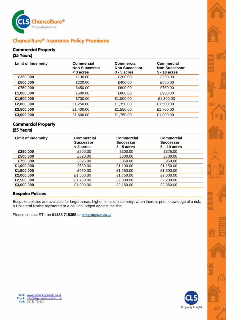
ChancelSure® Insurance Policy Premiums
Commercial Property (25 Years)
Limit of Indemnity CommercialNon Successor< 3 acres
CommercialNon Successor3 - 5 acres
CommercialNon Successor5 - 10 acres
£250,000 £130.00 £200.00 £250.00 £500,000 £220.00 £400.00 £550.00 £750,000 £450.00 £600.00 £750.00£1,000,000 £500.00 £800.00 £900.00£1,500,000 £700.00 £1,000.00 £1,300.00£2,000,000 £1,250.00 £1,350.00 £1,500.00£2,500,000 £1,400.00 £1,550.00 £1,700.00£3,000,000 £1,600.00 £1,750.00 £1,900.00
Commercial Property (25 Years)
Limit of Indemnity Commercial Successor< 3 acres
CommercialSuccessor3 - 5 acres
CommercialSuccessor5 – 10 acres
£250,000 £200.00 £300.00 £375.00 £500,000 £320.00 £600.00 £700.00 £750,000 £625.00 £850.00 £950.00£1,000,000 £680.00 £1,100.00 £1,150.00£1,500,000 £950.00 £1,250.00 £1,500.00£2,000,000 £1,500.00 £1,750.00 £2,000.00£2,500,000 £1,750.00 £2,000.00 £2,200.00£3,000,000 £1,900.00 £2,150.00 £2,350.00
Bespoke Policies
Bespoke policies are available for larger areas, higher limits of indemnity, when there is prior knowledge of a risk, a Unilateral Notice registered or a caution lodged against the title.
Please contact STL on 01483 715355 or [email protected].

Visit: www.clspropertyinsight.co.ukEmail: [email protected]
Call: 01732 753910
PCCB Guidance NoteIMPORTANT CONSUMER PROTECTION INFORMATIONThis search has been produced by CLS Property Insight Limited, 17 Kings Hill Avenue, West Malling, Kent ME19 4UA (Call: 01732 753910, Email:[email protected])CLS Property Insight Limited is registered with the Property Codes Compliance Board (PCCB) as a subscriber to the Search Code. The PCCB independently monitors how registered firms maintain compliance with the Code.
The Search Code provides protection for homebuyers, sellers, estate agents, conveyancers, and mortgage lenders, who rely on the information included in property search reports undertaken by subscribers on residential and commercial property within the United Kingdom.
sets out minimum standards which firms compiling and selling search reports have to meet. promotes the best practice and quality standards within the industry for the benefit of consumers and
property professionals. enables consumers and property professionals to have confidence in firms which subscribe to the code,
their products and services.By giving you this information, the search firm is confirming that they keep to the principles of the Code. This provides important protection for you.
Core Principles Search providers which subscribe to the Code will: display the Code logo prominently on their search reports act with integrity and carry out work with due skill, care and diligence at all times maintain adequate and appropriate insurance to protect consumers conduct business in an honest, fair and professional manner handle complaints speedily and fairly ensure that products and services comply with industry registration rules and standards monitor their compliance with the Code
Complaints If you have a query or complaint about your search, you should raise it directly with the search firm, and if appropriate ask for any complaint to be considered under their formal internal complaints procedure. If you remain dissatisfied with the firm’s final response, after your complaint has been formally considered, or if the firm has exceeded the response timescales, you may refer your complaint for consideration under The Property Ombudsman scheme (TPOs). The Ombudsman can award compensation of up to £5,000 to you if he finds that you have suffered actual loss as a result of your search provider failing to keep to the Code.Please note that all queries or complaints regarding your search should be directed to your search provider in the first instance, not to TPOs or to the PCCB.TPO’s Contact Details:
The Property Ombudsman scheme; Milford House, 43-55 Milford Street Salisbury, Wiltshire, SP1 2BP. (Call: 01722 333 306, Fax: 01722 332 296, Email: [email protected], Website: www.tpos.co.uk).
You can also get more information about the PCCB from www.propertycodes.org.ukPLEASE ASK YOUR SEARCH PROVIDER IF YOU WOULD LIKE A COPY OF THE FULL SEARCH CODE
CLS Complaint Resolution Procedure
If you have a complaint regarding our services or products, please send the details to:CLS Property Insight Limited, 17 Kings Hill Avenue, West Malling, Kent ME19 4UA (Call: 01732 753910 Email: [email protected]).
Your complaint will be acknowledged within 5 working days of receipt and you should receive a written response within 20 working days. Where this is not possible, we will inform you of the reasons why and give an indication of when you should expect a response. If you have not received a response within 40 working days of original receipt of the complaint or you are not happy with the response given you may take one of the following actions: If your complaint is in relation to our search products you may refer your complaint to:
The Property Ombudsman scheme; Milford House, 43-55 Milford Street Salisbury, Wiltshire, SP1 2BP. (Call: 01722 333 306, Fax: 01722 332 296, Email: [email protected], Website: www.tpos.co.uk).
If your complaint is in relation to our insurance products you may refer your complaint to:Financial Ombudsman Service; Exchange Tower, Harbour Exchange Square, London, E14 9SR. (Call: 020 7964 1000, Fax: 020 7964 1001, Email: [email protected]).
For details of the additional protection and benefits provided by commissioning a code compliant search product from an IPSA registered member please visit www.search-code.co.uk
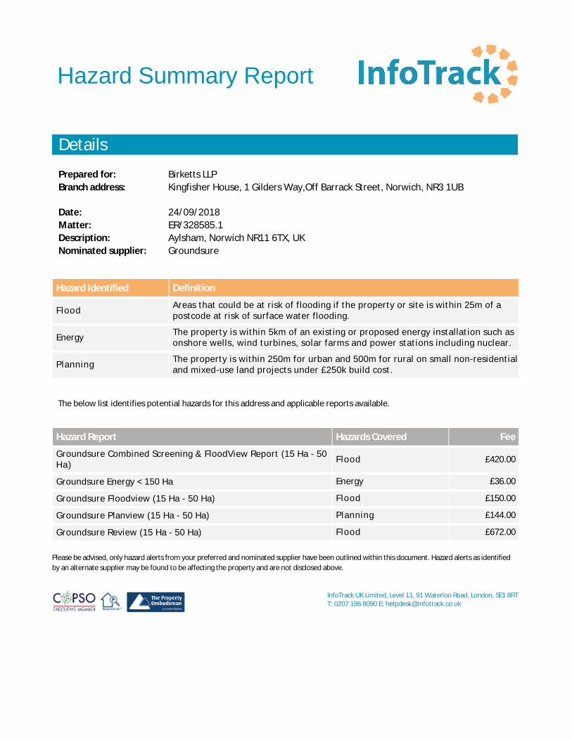
Birketts LLPKingfisher House, 1 Gilders Way,Off Barrack Street, Norwich, NR3 1UB
24/09/2018ER/328585.1Aylsham, Norwich NR11 6TX, UKGroundsure
InfoTrack UK Limited, Level 11, 91 Waterloo Road, London, SE1 8RTT: 0207 186 8090 E: [email protected]
Hazard Summary Report
Details
Prepared for:Branch address:
Date:Matter:Description:Nominated supplier:
Hazard Identified Definition
Flood Areas that could be at risk of flooding if the property or site is within 25m of apostcode at risk of surface water flooding.
Energy The property is within 5km of an existing or proposed energy installation such asonshore wells, wind turbines, solar farms and power stations including nuclear.
Planning The property is within 250m for urban and 500m for rural on small non-residentialand mixed-use land projects under £250k build cost.
The below list identifies potential hazards for this address and applicable reports available.
Hazard Report Hazards Covered Fee
Groundsure Combined Screening & FloodView Report (15 Ha - 50Ha) Flood £420.00
Groundsure Energy < 150 Ha Energy £36.00
Groundsure Floodview (15 Ha - 50 Ha) Flood £150.00
Groundsure Planview (15 Ha - 50 Ha) Planning £144.00
Groundsure Review (15 Ha - 50 Ha) Flood £672.00
Please be advised, only hazard alerts from your preferred and nominated supplier have been outlined within this document. Hazard alerts as identifiedby an alternate supplier may be found to be affecting the property and are not disclosed above.

Date Returned: Property type:
Prepared for: Matter: Client address:
Property:
InfoTrack UK Limited, Level 11, 91 Waterloo Road, London, SE1 8RT T: 0207 186 8090 E: [email protected]
Landmark Estate SolutionsFarm
Search Details
Birketts LLP
Kingfisher House, 1 Gilders Way,Off Barrack Street, Norwich, NR3 1UBER/328585.1
Spratts Green Farm, Spratts Green, Aylsham, Norwich, NR11 6TX
Imperium, Imperial Way, Reading, Berkshire, RG2 0TDLandmarkData Supplier:
This search was compiled by the Data Supplier above and provided by InfoTrack Ltd – t: 0207 186 8090, e: [email protected] search is subject to terms and conditions issued by InfoTrack which can be viewed at www.infotrack.co.uk or supplied on request.This search is also subject to terms and conditions issued by the Data Supplier, available on request. InfoTrack and the Data Supplier aboveare registered with the Property Codes Compliance Board (PCCB) as subscribers to the Search Code. The PCCB independently monitors howregistered firms maintain compliance with the Code. Visit www.propertycodes.org.uk for more information.
Agriculture / Large Site26/09/2018

EstateSolutions Farm
Contaminated Land
PASSEDFlooding
PASSEDArgyll's Overview
Contaminated Land :The property poses an acceptably low contamination risk. No further environmental investigation is recommended.
Flood Risk :Moderate - The Site is susceptible to flooding from one or more sources. A prudent purchaser should ask the vendor whether there has been any historicalflooding and confirm the availability of building and contents insurance. You may also want to carry out further assessment and explore options for managingflood risk (see pages 3 & 4).
Environmental Hazards :No other Environmental Hazards have been identified in the immediate vicinity of the Site.
Report on:
Spratts Green Farm, Spratts Green, Aylsham, Norwic, Norwich, NR11 6TX
Report prepared for:
Infotrack
Client Reference:
jNk1n/A3y/CLgk9u9UUAm7/C4BARTtHJ_ESF
Report Reference:
AEL-0016-LSF-953620
National Grid Reference:
620630,325314
Report date:
25th September 2018
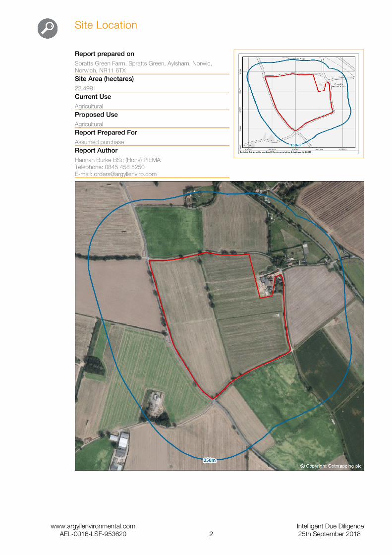
Site Location
Report prepared onSpratts Green Farm, Spratts Green, Aylsham, Norwic, Norwich, NR11 6TXSite Area (hectares)22.4991Current UseAgriculturalProposed UseAgriculturalReport Prepared For Assumed purchaseReport AuthorHannah Burke BSc (Hons) PIEMATelephone: 0845 458 5250E-mail: [email protected]
www.argyllenvironmental.com Intelligent Due DiligenceAEL-0016-LSF-953620 2 25th September 2018
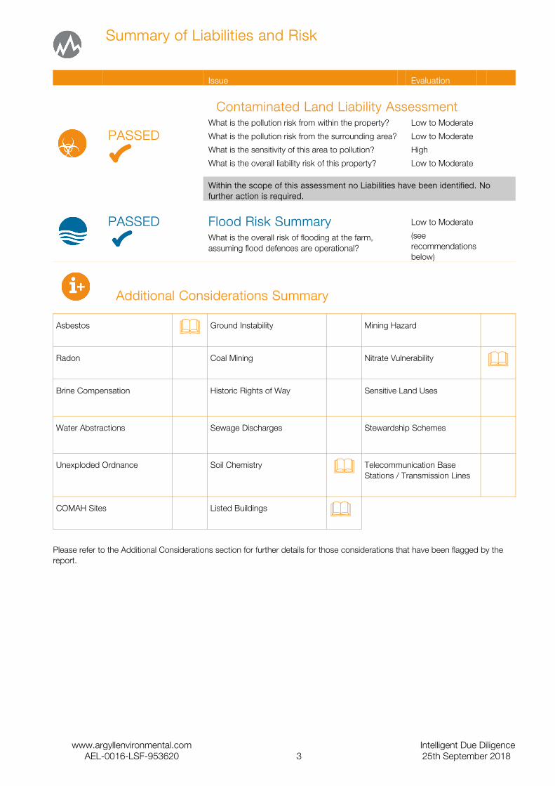
Summary of Liabilities and Risk
Issue Evaluation
Contaminated Land Liability Assessment
PASSEDWhat is the pollution risk from within the property?
What is the pollution risk from the surrounding area?
What is the sensitivity of this area to pollution?
What is the overall liability risk of this property?
Low to Moderate
Low to Moderate
High
Low to Moderate
Within the scope of this assessment no Liabilities have been identified. No further action is required.
PASSED Flood Risk SummaryWhat is the overall risk of flooding at the farm, assuming flood defences are operational?
Low to Moderate
(see recommendations below)
Additional Considerations Summary
Asbestos & Ground Instability Mining Hazard
Radon Coal Mining Nitrate Vulnerability &
Brine Compensation Historic Rights of Way Sensitive Land Uses
Water Abstractions Sewage Discharges Stewardship Schemes
Unexploded Ordnance Soil Chemistry & Telecommunication Base Stations / Transmission Lines
COMAH Sites Listed Buildings &
Please refer to the Additional Considerations section for further details for those considerations that have been flagged by the report.
www.argyllenvironmental.com Intelligent Due DiligenceAEL-0016-LSF-953620 3 25th September 2018
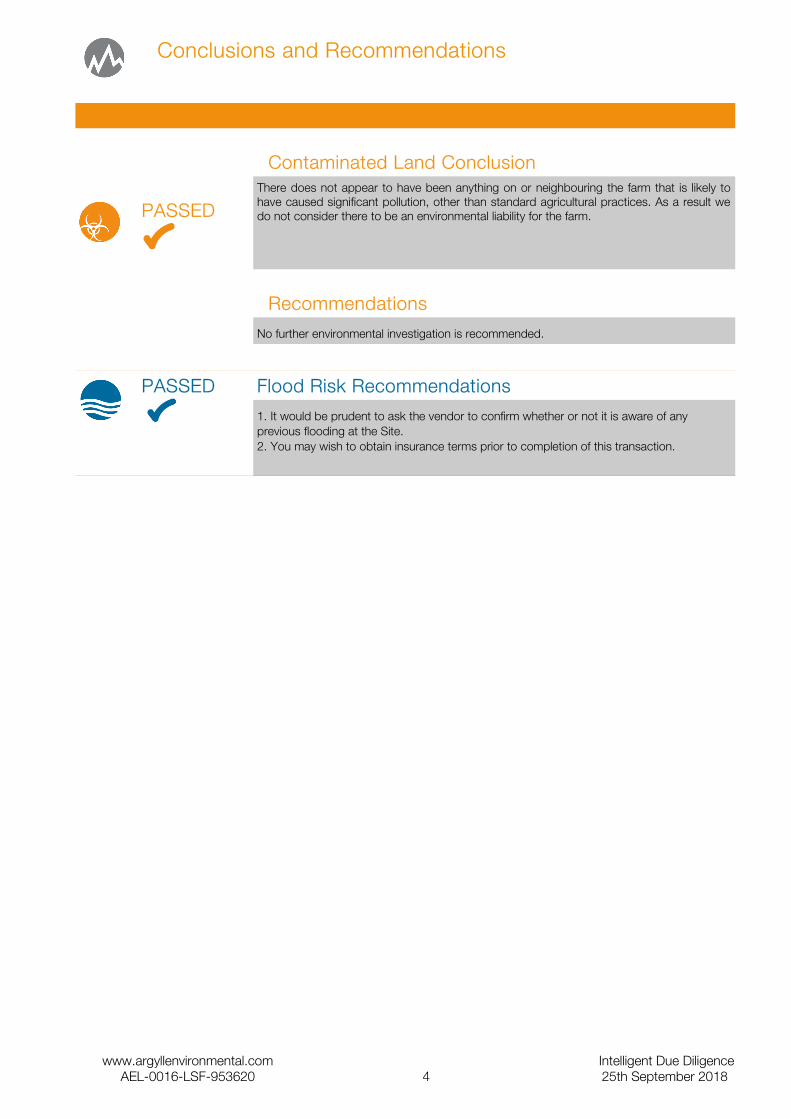
Conclusions and Recommendations
Contaminated Land Conclusion
PASSEDThere does not appear to have been anything on or neighbouring the farm that is likely to have caused significant pollution, other than standard agricultural practices. As a result we do not consider there to be an environmental liability for the farm.
Recommendations
No further environmental investigation is recommended.
PASSED Flood Risk Recommendations
1. It would be prudent to ask the vendor to confirm whether or not it is aware of any previous flooding at the Site.2. You may wish to obtain insurance terms prior to completion of this transaction.
www.argyllenvironmental.com Intelligent Due DiligenceAEL-0016-LSF-953620 4 25th September 2018
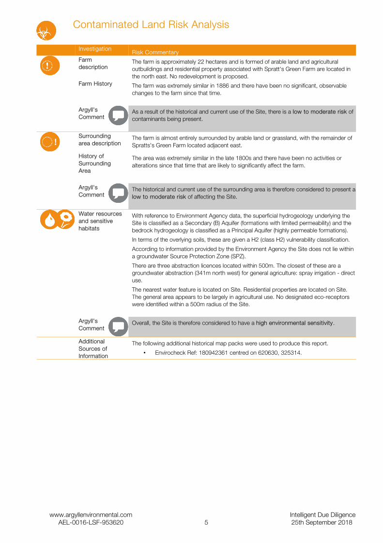
Contaminated Land Risk Analysis
InvestigationRisk Commentary
Farm description
The farm is approximately 22 hectares and is formed of arable land and agricultural outbuildings and residential property associated with Spratt's Green Farm are located in the north east. No redevelopment is proposed.
Farm History The farm was extremely similar in 1886 and there have been no significant, observable changes to the farm since that time.
Argyll's Comment
As a result of the historical and current use of the Site, there is a low to moderate risk of contaminants being present.
Surrounding area description
The farm is almost entirely surrounded by arable land or grassland, with the remainder of Spratts's Green Farm located adjacent east.
History of Surrounding Area
The area was extremely similar in the late 1800s and there have been no activities or alterations since that time that are likely to significantly affect the farm.
Argyll's Comment
The historical and current use of the surrounding area is therefore considered to present a low to moderate risk of affecting the Site.
Water resources and sensitive habitats
With reference to Environment Agency data, the superficial hydrogeology underlying the Site is classified as a Secondary (B) Aquifer (formations with limited permeability) and the bedrock hydrogeology is classified as a Principal Aquifer (highly permeable formations).
In terms of the overlying soils, these are given a H2 (class H2) vulnerability classification.
According to information provided by the Environment Agency the Site does not lie within a groundwater Source Protection Zone (SPZ).
There are three abstraction licences located within 500m. The closest of these are a groundwater abstraction (341m north west) for general agriculture: spray irrigation - direct use.
The nearest water feature is located on Site. Residential properties are located on Site. The general area appears to be largely in agricultural use. No designated eco-receptors were identified within a 500m radius of the Site.
Argyll'sComment
Overall, the Site is therefore considered to have a high environmental sensitivity.
Additional Sources of Information
The following additional historical map packs were used to produce this report.
• Envirocheck Ref: 180942361 centred on 620630, 325314.
www.argyllenvironmental.com Intelligent Due DiligenceAEL-0016-LSF-953620 5 25th September 2018
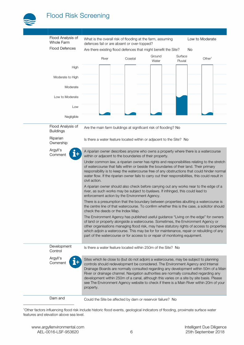
Flood Risk Screening
Flood Analysis of Whole Farm
What is the overall risk of flooding at the farm, assuming defences fail or are absent or over-topped?
Low to Moderate
Flood Defences Are there existing flood defences that might benefit the Site? No
River CoastalGround Water
Surface Pluvial
Other1
High
Moderate to High
Moderate
Low to Moderate
Low
Negligible
Flood Analysis of Buildings
Are the main farm buildings at significant risk of flooding? No
Riparian Ownership
Is there a water feature located within or adjacent to the Site? No
Argyll'sComment
A riparian owner describes anyone who owns a property where there is a watercourse within or adjacent to the boundaries of their property.
Under common law, a riparian owner has rights and responsibilities relating to the stretch of watercourse that falls within or beside the boundaries of their land. Their primary responsibility is to keep the watercourse free of any obstructions that could hinder normal water flow. If the riparian owner fails to carry out their responsibilities, this could result in civil action.
A riparian owner should also check before carrying out any works near to the edge of a river, as such works may be subject to byelaws. If infringed, this could lead to enforcement action by the Environment Agency.
There is a presumption that the boundary between properties abutting a watercourse is the centre line of that watercourse. To confirm whether this is the case, a solicitor should check the deeds or the Index Map.
The Environment Agency has published useful guidance “Living on the edge” for owners of land or property alongside a watercourse. Sometimes, the Environment Agency or other organisations managing flood risk, may have statutory rights of access to properties which adjoin a watercourse. This may be for for maintenance, repair or rebuilding of any part of the watercourse or for access to or repair of monitoring equipment.
Development Control
Is there a water feature located within 250m of the Site? No
Argyll'sComment
Sites which lie close to (but do not adjoin) a watercourse, may be subject to planning controls should redevelopment be considered. The Environment Agency and Internal Drainage Boards are normally consulted regarding any development within 50m of a Main River or drainage channel. Navigation authorities are normally consulted regarding any development within 250m of a canal, although this varies on a site by site basis. Please see The Environment Agency website to check if there is a Main River within 20m of your property.
Dam and Could the Site be affected by dam or reservoir failure? No
1Other factors influencing flood risk include historic flood events, geological indicators of flooding, proximate surface water features and elevation above sea level.
www.argyllenvironmental.com Intelligent Due DiligenceAEL-0016-LSF-953620 6 25th September 2018

Reservoir Failure
Argyll'sComment
The answer is based on detailed models provided by JBA Risk Management. These predict the areas liable to flood around approximately 1700 key dams and reservoirs across England and Wales (if that dam or reservoir were to fail).
Recommendations
1. It would be prudent to ask the vendor to confirm whether or not it is aware of any previous flooding at the Site.2. You may wish to obtain insurance terms prior to completion of this transaction.
www.argyllenvironmental.com Intelligent Due DiligenceAEL-0016-LSF-953620 7 25th September 2018

Additional Considerations
Item Summary Suggested ActionAsbestos (Commercial) If the buildings at the Site were constructed or renovated during
the period between 1950 and 1999, then the fabric of these buildings may contain asbestos in a variety of forms.
Check Asbestos Register and Management Plan
Listed Buildings The following listed buildings have been identified on Site: spratts green farmhouse and barns.
Contact Historic England, Historic Environment Scotland or the Welsh Historic Environment Service (Cadw) or your local Planning Department for further information
Nitrate Vulnerable Zones The farm is located within a Nitrate Vulnerable Zone. Nitrate Vulnerable Zones are designated areas of land draining into waters assessed to be polluted by nitrates. As the farm lies within a designated zone the land owner will need to comply with the requirements of the Nitrates Action Programme regulated by DEFRA and the Environment Agency.
Contact the Environment Agency for further information
Soils BGS soil chemistry data for the Site indicates <15 mg/kg of arsenic, <1.8 mg/kg of cadmium, 40 - 60 mg/kg of chromium, <100 mg/kg of lead, <15 mg/kg of nickel.
None required
Agricultural Land Classifications
The farm is located within a Grade 2 classification (very good). The classification system forms part of the planning system in England and Wales. Agricultural land is classified into five categories according to versatility and suitability for growing crops. The top three grades 1, 2 and 3a are considered the best and most versatile land, 3b – 5 are considered moderate to very poor.
Contact Natural England for further information
Generic Guidance
Item Summary Suggested ActionEnergy Performance Certificate
Under the Energy Performance of Buildings (England and Wales) Regulations 2012 and the Energy Performance of Buildings (Scotland) Regulations 2008, there is a requirement for all buildings to have an Energy Performance Certificate (EPC) upon their construction, sale or lease (and in some cases when the building is modified).
Check EPC or conduct energy assessment
Silage, Slurry, Oil, Storage (Farms)
Under the Control of Pollution (Silage, Slurry and Agricultural Fuel Oil) Regulations 1991, silage, slurry or fuel storage facilities constructed after March 1991 have to be designed and built to minimum standards to prevent the pollution of Controlled Waters.
Compliance Audit
Above and Below Ground Storage
It is common for agricultural premises to store a variety of substances in above ground and underground storage tanks (ASTs and USTs). Most commonly red diesel, heating oil and occasionally petrol on larger estates. There is no reliable database of underground storage tanks nor are all above ground tanks marked on historical maps.
Check all tanks and surrounding land for signs of leaks or spills, such as stained ground or vegetation die-back
www.argyllenvironmental.com Intelligent Due DiligenceAEL-0016-LSF-953620 8 25th September 2018
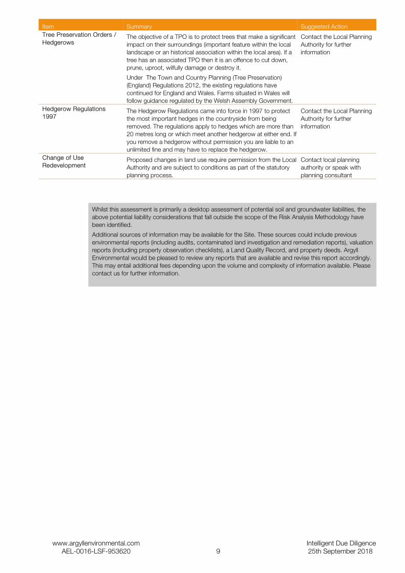
Item Summary Suggested ActionTree Preservation Orders / Hedgerows
The objective of a TPO is to protect trees that make a significant impact on their surroundings (important feature within the local landscape or an historical association within the local area). If a tree has an associated TPO then it is an offence to cut down, prune, uproot, wilfully damage or destroy it.
Under The Town and Country Planning (Tree Preservation) (England) Regulations 2012, the existing regulations have continued for England and Wales. Farms situated in Wales will follow guidance regulated by the Welsh Assembly Government.
Contact the Local Planning Authority for further information
Hedgerow Regulations 1997
The Hedgerow Regulations came into force in 1997 to protect the most important hedges in the countryside from being removed. The regulations apply to hedges which are more than 20 metres long or which meet another hedgerow at either end. If you remove a hedgerow without permission you are liable to an unlimited fine and may have to replace the hedgerow.
Contact the Local Planning Authority for further information
Change of UseRedevelopment
Proposed changes in land use require permission from the Local Authority and are subject to conditions as part of the statutory planning process.
Contact local planning authority or speak with planning consultant
Whilst this assessment is primarily a desktop assessment of potential soil and groundwater liabilities, the above potential liability considerations that fall outside the scope of the Risk Analysis Methodology have been identified.
Additional sources of information may be available for the Site. These sources could include previous environmental reports (including audits, contaminated land investigation and remediation reports), valuation reports (including property observation checklists), a Land Quality Record, and property deeds. Argyll Environmental would be pleased to review any reports that are available and revise this report accordingly. This may entail additional fees depending upon the volume and complexity of information available. Please contact us for further information.
www.argyllenvironmental.com Intelligent Due DiligenceAEL-0016-LSF-953620 9 25th September 2018

Contents of the Data Section
Section DescriptionTabular Summary
This section presents a tabular summary of information found for the Site and surrounding area. The data is presented in three buffer zones for ease of reference: data found at the Site, from 1-250m and from 251-500m.
If a database has been searched the number of records found will be displayed under the relevant search band. If a database is not available or has not been searched, this will be represented by the abbreviation N/A under the relevant search band.
Current Land Use Mapping
This section provides information on current land uses and is divided into three sections, statutory information, waste and current industrial uses. It is preceded by two maps.
Statutory Information
This section presents detailed statutory information for the Site and surrounding area (up to 500m depending upon dataset). The Map ID of each feature is indicated (where applicable) followed by specific information on each feature and its distance and direction from the Site.
If no data is identified then the section will be omitted.
Waste This section presents detailed information on waste and landfill sites for the Site and surrounding area (up to 500m depending upon dataset). The Map ID of each feature is indicated (where applicable) followed by specific information on each feature and its distance and direction from the Site.
If no data is identified then the section will be omitted.
Current Industrial Land Use
This section presents detailed information on current land use for the Site and surrounding area (0-250m). The Map ID of each feature is indicated (where applicable) followed by specific information on each feature and its distance and direction from the Site.
If no data is identified then the section will be omitted.
Historical Land Use Mapping
The Historical Land Use Map presents 1:10,000 scale and selected 1:2,500 scale (tanks and energy facilities) historical land use information within 250m of the Site boundary.
Historical Land Use
This section presents selected information on historical land use for the Site and surrounding area (0-250m). The Map ID of each feature is indicated (where applicable) followed by specific information on each feature and its distance and direction from the Site.
If no data is identified then the section will be omitted.
Aquifer Designations and Geology
This section is preceded by two maps that present information relating to the aquifer designations beneath the Site. The first of these maps indicates the designation of the Superficial geology. The second map presents the aquifer designation of the solid geology.
These maps are followed by detailed information in relation to aquifer designations/groundwater vulnerability and geology at the Site and surrounding area (0-500m).
If no data is identified then the section will be omitted.
Environmental Sensitivity
This section presents detailed information on the environmental sensitivity of the Site and surrounding area (up to 500m depending upon dataset) and is preceded by two maps. The first shows areas with statutory designations, the second shows source protection zones. The Map ID of each feature is indicated (where applicable) followed by specific information on each feature and its distance and direction from the Site.
If no data is identified then the section will be omitted.
Natural and Mining Related Hazards
This section contains information on natural and mining related hazards which may affect the Site. These include subsidence, radon and mining.
If no data is identified then the section will be omitted.
www.argyllenvironmental.com Intelligent Due DiligenceAEL-0016-LSF-953620 10 25th September 2018

Farm Specific Issues
This section firstly presents data relating to designated features and areas that may be present on or in proximity to a farm and could affect or restrict farming operations (e.g. listed buildings, heritage sites etc.).
If no data is identified then the section will be omitted.
Soil Chemistry This section is preceded by five maps that present information relating to the concentrations of Arsenic, Cadmium, Chromium, Lead and Nickel within soils beneath the farm and surrounding area. The maps are immediately followed by the detailed data.
If no data is identified then the section will be omitted.
Flooding Risk Information
This section presents information relating to the four main types of flooding – River flooding, Coastal/tidal flooding, surface water flooding and groundwater flooding. Some of this data will be preceded by an associated map.
© Landmark Information Group Limited 2018. All Rights Reserved. The copyright on the information and data as contained in the Data section of this Report ("Report") is the property of Landmark Information Group Limited ("Landmark") and several other Data Providers, including (but not limited to) Ordnance Survey, British Geological Survey, the Environment Agency and English Nature, and must not be reproduced in whole or in part by photocopying or any other method.
www.argyllenvironmental.com Intelligent Due DiligenceAEL-0016-LSF-953620 11 25th September 2018

Tabular Summary
Statutory Information
Authorisations On-site 1-250m 251-500m
Local Authority Pollution Prevention and Controls 0 0 N/A
Local Authority Integrated Pollution Prevention and Controls 0 0 N/A
Integrated Pollution Controls 0 0 N/A
Integrated Pollution Prevention And Control 0 0 N/A
Registered Radioactive Substances 0 0 N/A
Discharges On-site 1-250m 251-500m
Discharge Consents 0 0 N/A
Water Industry Act Referrals 0 0 N/A
Control of Major Accident Hazards Sites 0 0 0
Explosive Sites 0 0 0
Notification of Installations Handling Hazardous Substances 0 0 0
Planning Hazardous Substance Consents 0 0 0
Contraventions On-site 1-250m 251-500m
Contaminated Land Register Entries and Notices 0 0 N/A
Local Authority Pollution Prevention and Control Enforcements 0 0 N/A
Enforcement and Prohibition Notices 0 0 N/A
Planning Hazardous Substance Enforcements 0 0 0
Substantiated Pollution Incident Register 0 0 0
Prosecutions Relating to Authorised Processes 0 0 N/A
Prosecutions Relating to Controlled Waters 0 0 N/A
Waste
Waste/Landfill Sites On-site 1-250m 251-500m
BGS Recorded Landfill Sites 0 0 0
Integrated Pollution Control Registered Waste Sites 0 0 N/A
Licenced Waste Management Facilities (Landfill Boundaries) 0 0 N/A
Licenced Waste Management Facilities (Locations) 0 0 0
Local Authority Recorded Landfill Sites 0 0 0
Registered Landfill Sites 0 0 0
Registered Waste Transfer Sites 0 0 N/A
Registered Waste Treatment or Disposal Sites 0 0 N/A
Historical Landfill Sites 0 0 0
Current Land Use
Current Potentially Contaminative Uses On-site 1-250m 251-500m
Contemporary Trade Directory Entries 0 0 N/A
Fuel Station Entries 0 0 N/A
Other Features On-site 1-250m 251-500m
Telecommunication Base Stations 0 02 N/A
Overhead Transmission Lines 0 0 N/A
Historical Land Use
Historical Potentially Contaminative Uses On-site 1-250m 251-500m
2Telecommunication base stations are only searched to a radius of 100m from the Site boundary.
www.argyllenvironmental.com Intelligent Due DiligenceAEL-0016-LSF-953620 12 25th September 2018

Historical Land Use
Potentially Contaminative Industrial Uses (Past Land Use) 0 3 N/A
Historical Tanks And Energy Facilities 0 0 N/A
Potentially Infilled Land On-site 1-250m 251-500m
Former Marshes 0 0 N/A
Potentially Infilled Land (Non-Water) 0 1 N/A
Potentially Infilled Land (Water) 0 0 N/A
Groundwater Vulnerability
Hydrogeology On-site 1-250m 251-500m
Superficial Aquifer Designations 2 4 0
Bedrock Aquifer Designations 2 0 0
Groundwater Vulnerability 1 0 N/A
Geology On-site 1-250m 251-500m
Low Permeability Drift Deposits 1 N/A N/A
BGS 1:625,000 Solid Geology 1 N/A N/A
Environmental Sensitivity
Environmental Sensitivity On-site 1-250m 251-500m
Areas of Outstanding Natural Beauty 0 0 N/A
Environmentally Sensitive Areas 0 0 N/A
Forest Parks 0 0 N/A
Local Nature Reserves 0 0 0
Marine Nature Reserves 0 0 0
National Nature Reserves 0 0 0
National Parks 0 0 N/A
National Scenic Areas 0 0 N/A
Nitrate Sensitive Areas 0 N/A N/A
Nitrate Vulnerable Zones 2 N/A N/A
Ramsar Sites 0 0 0
River Quality Biology Sampling Points 0 0 N/A
River Quality Chemistry Sampling Points 0 0 N/A
Nearest Surface Water Feature 1 0 N/A
Sites of Special Scientific Interest 0 0 0
Special Areas of Conservation 0 0 0
Special Protection Areas 0 0 0
Water Abstractions 0 0 3
Source Protection Zones 0 0 N/A
Natural and Mining Related Hazards
Subsidence On-site 1-250m 251-500m
Collapsible Ground Stability Hazards 1 03 N/A
Compressible Ground Stability Hazards 1 0 N/A
Ground Dissolution Stability Hazards 1 0 N/A
Landslide Ground Stability Hazards 1 0 N/A
Running Sand Ground Stability Hazards 1 0 N/A
Shrinking or Swelling Clay Subsidence Hazards 1 1 N/A
3Ground stability hazards are only searched to a radius of 50m from the Site boundary.
www.argyllenvironmental.com Intelligent Due DiligenceAEL-0016-LSF-953620 13 25th September 2018

Natural and Mining Related Hazards
Non-Coal Mining Hazards 0 0 N/A
Radon On-site 1-250m 251-500m
Radon Potential 1 N/A N/A
Radon Protection Measures 1 N/A N/A
Mining On-site 1-250m 251-500m
Brine Compensation Areas 0 N/A N/A
Coal Mining Affected Areas 0 N/A N/A
Natural and Mining Cavities 0 0 N/A
Mining Instability 0 0 N/A
BGS Recorded Mineral Sites 0 1 N/A
Farm Specific Issues
Farm Specific Issues On-site 1-250m 251-500m
Listed Buildings 1 0 2
World Heritage Sites 0 0 0
Scheduled Monuments 0 1 0
Historic Battlefields 0 0 0
Historic Landscapes 0 0 0
Country Parks 0 0 0
Ancient Woodlands 0 0 0
Soils On-site 1-250m 251-500m
BGS Soil Chemistry Arsenic 1 0 0
BGS Soil Chemistry Cadmium 1 0 0
BGS Soil Chemistry Chromium 1 1 0
BGS Soil Chemistry Lead 1 0 0
BGS Soil Chemistry Nickel 1 0 0
Flooding
Current Flood Risk On-site 1-250m 251-500m
Flooding From Rivers or Sea 0 0 1
Flooding From Rivers or Sea (in an Extreme Event) 0 0 1
Areas Benefiting from Flood Defences 0 0 0
Flood Water Storage Areas 0 0 0
Flood Defences 0 0 0
Risk of Flooding from Rivers and Sea 0 0 3
Groundwater Flood Risk 0 2 0
Surface Water Flooding (1:75 year rainfall event) 2 0 0
Surface Water Flooding (1:200 year rainfall event) 2 0 0
Surface Water Flooding (1:1,000 year rainfall event) 2 1 0
Dam or Reservoir Failure 0 0 0
Historical Flooding On-site 1-250m 251-500m
Historical Flood Events 0 0 0
Geological Indicators of Flooding 0 0 2
Other Flood Information On-site 1-250m 251-500m
Surface Water Feature 0 0 0
MasterMap Water Network 0 0 0
www.argyllenvironmental.com Intelligent Due DiligenceAEL-0016-LSF-953620 14 25th September 2018
Tabular Summary Explanation
Argyll has carefully selected a range of datasets which are considered appropriate for the intended use of this report. Each dataset is searched to a set radius from the
Site boundary and the tabular summary is divided into different search bands accordingly. If a database is searched and information is found, then the number of
records available are detailed in the table above. If the database was searched and no data was found, then a zero will be present. If a database was not searched
then the abbreviation N/A will be found, indicating this information was not available at the radius searched.
Landfill Site Information
Registered landfill site boundaries (where available), are shown on the map as a red diagonal hatched polygon and referred to in the map legend as Registered Landfill
Sites. At present no complete national dataset exists for landfill site boundaries, therefore a point grid reference provided by the data supplier is used for some landfill
sites. The point grid references supplied provide only an approximate position, and can vary from the site entrance to the centre of the site. A point cannot properly
define landfill boundaries therefore Landmark constructs a 250 metre or 100 metre "buffer" zone around the point to warn of the possible presence of landfill. The
"buffer" zone is shown on the map as an orange crosshatched area and is referred to in the map legend as Potential Landfill Buffer.
Local Authority landfill data is sourced from individual local authorities that were able to provide information on sites operating prior to the introduction of the Control of
Pollution Act (COPA) in 1974. Appropriate authorities are listed under Local Authority Landfill Coverage with an indication of whether or not they were able to make
landfill data available. Details of any records identified are disclosed. You should be aware that if the local authority had landfill data but passed it to the relevant
Environment Agency office, it does not necessarily mean that local authority landfill data is now included in our other Landfill datasets. In addition if no data has been
made available for all or part of the search area, you should be aware that a negative response under 'Local Authority Recorded Landfill Sites' does not necessarily
confirm that no local authority landfills exist.
Subsidence Hazards
Information on subsidence hazards is provided by the British Geological Survey (BGS). Information present within 250m of the Site is reported under Natural and
Mining Related Hazards. Due to the level of detail of this data and the complexities of the real world, the BGS recommends a precautionary approach when using
this information and advises taking the worst reading noted for each dataset within the vicinity of a property. Therefore, Argyll reports the presence of a ground
stability or non-coal related mining hazard in the Risk Analysis section based on the highest reading found within 50m of the Site boundary.
www.argyllenvironmental.com Intelligent Due DiligenceAEL-0016-LSF-953620 15 25th September 2018

www.argyllenvironmental.com Intelligent Due DiligenceAEL-0016-LSF-953620 16 25th September 2018

www.argyllenvironmental.com Intelligent Due DiligenceAEL-0016-LSF-953620 17 25th September 2018
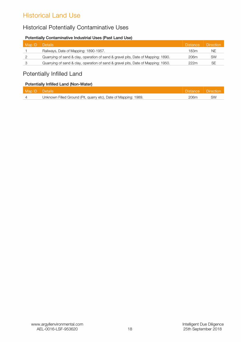
Historical Land Use
Historical Potentially Contaminative Uses
Potentially Contaminative Industrial Uses (Past Land Use)
Map ID Details Distance Direction
1 Railways, Date of Mapping: 1890-1957. 183m NE
2 Quarrying of sand & clay, operation of sand & gravel pits, Date of Mapping: 1890. 206m SW
3 Quarrying of sand & clay, operation of sand & gravel pits, Date of Mapping: 1950. 222m SE
Potentially Infilled Land
Potentially Infilled Land (Non-Water)
Map ID Details Distance Direction
4 Unknown Filled Ground (Pit, quarry etc), Date of Mapping: 1989. 206m SW
www.argyllenvironmental.com Intelligent Due DiligenceAEL-0016-LSF-953620 18 25th September 2018

Aquifer Designation (Superficial)
www.argyllenvironmental.com Intelligent Due DiligenceAEL-0016-LSF-953620 19 25th September 2018

Aquifer Designation (Bedrock)
www.argyllenvironmental.com Intelligent Due DiligenceAEL-0016-LSF-953620 20 25th September 2018

Groundwater Vulnerability
Hydrogeology
Superficial Aquifer Designations
Map ID Details Distance Direction
Secondary Aquifer - B
These aquifers are formed of predominantly lower permeability layers which may store and yield limited amounts of groundwater due to localised features such as fissures, thin permeable layers and weathering.
On Site N
Secondary Aquifer - B
These aquifers are formed of predominantly lower permeability layers which may store and yield limited amounts of groundwater due to localised features such as fissures, thin permeable layers and weathering.
On Site S
Secondary Aquifer - A
These aquifers are formed of moderately permeable layers capable of supporting water supplies at a local scale, and in some cases forming an important source of base flow to rivers.
100m SW
Secondary Aquifer - A
These aquifers are formed of moderately permeable layers capable of supporting water supplies at a local scale, and in some cases forming an important source of base flow to rivers.
101m SW
Secondary Aquifer - A
These aquifers are formed of moderately permeable layers capable of supporting water supplies at a local scale, and in some cases forming an important source of base flow to rivers.
143m E
Secondary Aquifer - B
These aquifers are formed of predominantly lower permeability layers which may store and yield limited amounts of groundwater due to localised features such as fissures, thin permeable layers and weathering.
247m SE
Bedrock Aquifer Designations
Map ID Details Distance Direction
Principal Aquifer
These aquifers are typically formed of layers of rock or drift deposits that have a high permeability and provide a high level of water storage. They may support water supply and/or base river flow on a strategic scale.
On Site S
Principal Aquifer
These aquifers are typically formed of layers of rock or drift deposits that have a high permeability and provide a high level of water storage. They may support water supply and/or base river flow on a strategic scale.
On Site -
Groundwater Vulnerability
Map ID Details Distance Direction
Soil Classification: Soils of High Leaching Potential (H2) - Deep, permeable, coarse textured soils which readily transmit a wide range of pollutants because of their rapid drainage and low attenuation potential, Map Scale: 1:100,000, Map Name: Sheet 26 East Norfolk.
On Site -
Geology
Low Permeability Drift Deposits
Map ID Details Distance Direction
Low permeability drift deposits occuring at the surface and overlying Major and Minor Aquifers are head, clay-with-flints, brickearth, peat, river terrace deposits and marine and estuarine alluvium, Map Sheet: Sheet 26 East Norfolk, Scale: 1:100,000.
On Site -
www.argyllenvironmental.com Intelligent Due DiligenceAEL-0016-LSF-953620 21 25th September 2018

BGS 1:625,000 Solid Geology
Map ID Details Distance Direction
Neogene To Quaternary Rocks (Undifferentiated). On Site -
www.argyllenvironmental.com Intelligent Due DiligenceAEL-0016-LSF-953620 22 25th September 2018

Sensitive Land Uses
www.argyllenvironmental.com Intelligent Due DiligenceAEL-0016-LSF-953620 23 25th September 2018

Source Protection Zones
www.argyllenvironmental.com Intelligent Due DiligenceAEL-0016-LSF-953620 24 25th September 2018
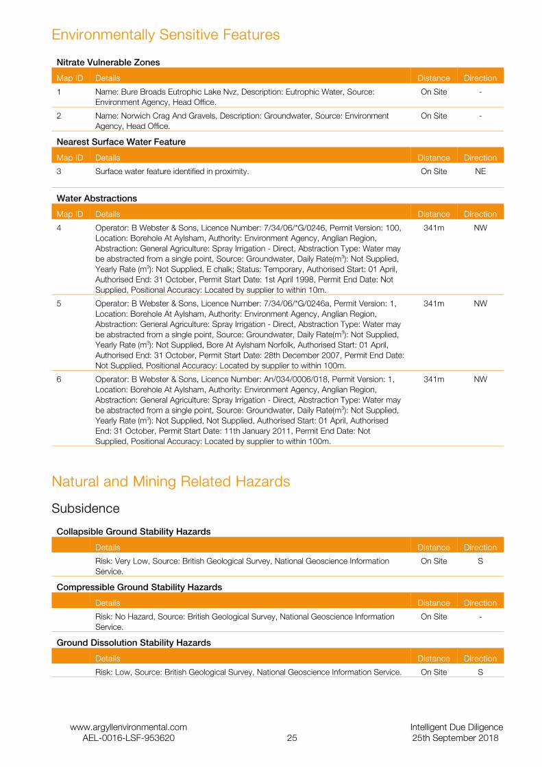
Environmentally Sensitive Features
Nitrate Vulnerable Zones
Map ID Details Distance Direction
1 Name: Bure Broads Eutrophic Lake Nvz, Description: Eutrophic Water, Source: Environment Agency, Head Office.
On Site -
2 Name: Norwich Crag And Gravels, Description: Groundwater, Source: Environment Agency, Head Office.
On Site -
Nearest Surface Water Feature
Map ID Details Distance Direction
3 Surface water feature identified in proximity. On Site NE
Water Abstractions
Map ID Details Distance Direction
4 Operator: B Webster & Sons, Licence Number: 7/34/06/*G/0246, Permit Version: 100, Location: Borehole At Aylsham, Authority: Environment Agency, Anglian Region, Abstraction: General Agriculture: Spray Irrigation - Direct, Abstraction Type: Water may be abstracted from a single point, Source: Groundwater, Daily Rate(m3): Not Supplied, Yearly Rate (m3): Not Supplied, E chalk; Status: Temporary, Authorised Start: 01 April, Authorised End: 31 October, Permit Start Date: 1st April 1998, Permit End Date: Not Supplied, Positional Accuracy: Located by supplier to within 10m.
341m NW
5 Operator: B Webster & Sons, Licence Number: 7/34/06/*G/0246a, Permit Version: 1, Location: Borehole At Aylsham, Authority: Environment Agency, Anglian Region, Abstraction: General Agriculture: Spray Irrigation - Direct, Abstraction Type: Water may be abstracted from a single point, Source: Groundwater, Daily Rate(m3): Not Supplied, Yearly Rate (m3): Not Supplied, Bore At Aylsham Norfolk, Authorised Start: 01 April, Authorised End: 31 October, Permit Start Date: 28th December 2007, Permit End Date: Not Supplied, Positional Accuracy: Located by supplier to within 100m.
341m NW
6 Operator: B Webster & Sons, Licence Number: An/034/0006/018, Permit Version: 1, Location: Borehole At Aylsham, Authority: Environment Agency, Anglian Region, Abstraction: General Agriculture: Spray Irrigation - Direct, Abstraction Type: Water may be abstracted from a single point, Source: Groundwater, Daily Rate(m3): Not Supplied, Yearly Rate (m3): Not Supplied, Not Supplied, Authorised Start: 01 April, Authorised End: 31 October, Permit Start Date: 11th January 2011, Permit End Date: Not Supplied, Positional Accuracy: Located by supplier to within 100m.
341m NW
Natural and Mining Related Hazards
Subsidence
Collapsible Ground Stability Hazards
Details Distance Direction
Risk: Very Low, Source: British Geological Survey, National Geoscience Information Service.
On Site S
Compressible Ground Stability Hazards
Details Distance Direction
Risk: No Hazard, Source: British Geological Survey, National Geoscience Information Service.
On Site -
Ground Dissolution Stability Hazards
Details Distance Direction
Risk: Low, Source: British Geological Survey, National Geoscience Information Service. On Site S
www.argyllenvironmental.com Intelligent Due DiligenceAEL-0016-LSF-953620 25 25th September 2018
Landslide Ground Stability Hazards
Details Distance Direction
Risk: Very Low, Source: British Geological Survey, National Geoscience Information Service.
On Site S
Running Sand Ground Stability Hazards
Details Distance Direction
Risk: Very Low, Source: British Geological Survey, National Geoscience Information Service.
On Site S
Shrinking or Swelling Clay Subsidence Hazards
Details Distance Direction
Risk: Very Low, Source: British Geological Survey, National Geoscience Information Service.
On Site N
Risk: No Hazard, Source: British Geological Survey, National Geoscience Information Service.
18m S
Radon
Radon Potential
Details Distance Direction
The property is in a Lower probability radon area (less than 1% of homes are estimated to be at or above the Action Level)., Source: British Geological Survey, National Geoscience Information Service.
On Site -
Radon Protective Measures
Details Distance Direction
None, Source: British Geological Survey, National Geoscience Information Service. On Site -
Mining
BGS Recorded Mineral Sites
Map ID Details Distance Direction
1 Site Name: Hall Farm Pit, Site Location: Not Supplied, Source: British Geological Survey, National Geoscience Information Service, Reference: 192934, Type: Opencast, Status: Ceased, Operator: Not Supplied, Operator Location: Not Supplied, Periodic Type: Cretaceous, Geology: White Chalk Subgroup, Commodity: Chalk, Positional Accuracy: Located by supplier to within 10m.
223m SE
www.argyllenvironmental.com Intelligent Due DiligenceAEL-0016-LSF-953620 26 25th September 2018
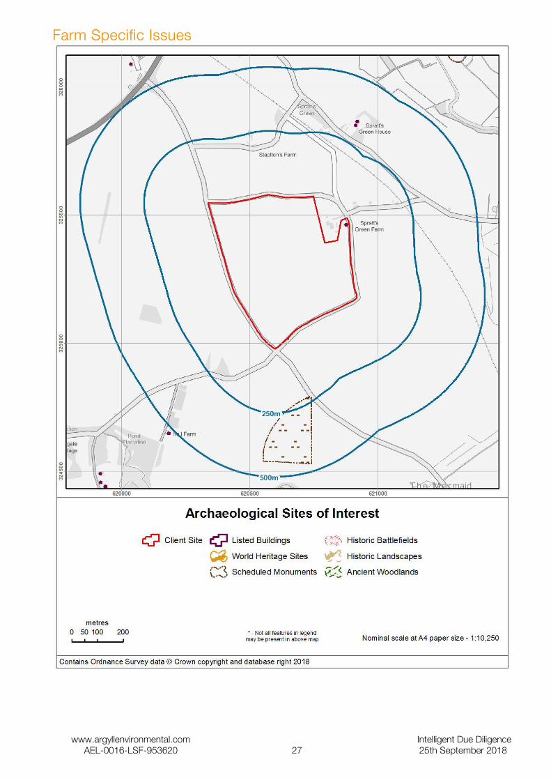
Farm Specific Issues
www.argyllenvironmental.com Intelligent Due DiligenceAEL-0016-LSF-953620 27 25th September 2018

Farm Specific Issues
Listed Buildings
Details Distance Direction
List Entry: 1170412, Name: SPRATTS GREEN FARMHOUSE AND BARNS, Grade: II, List Date: 01/06/1984, Amend Date: , NGR: TG2087725463, Capture Scale: 1:2500, Easting: 620877, Northing: 325463, Area (hectares): 0
On Site -
List Entry: 1051570, Name: SPRATTS GREEN HOUSE, Grade: II, List Date: 01/06/1984, Amend Date: , NGR: TG 20914 25850, Capture Scale: 1:2500, Easting: 620914, Northing: 325850, Area (hectares): 0
320.6m NE
List Entry: 1170438, Name: COTTAGE IMMEDIATELY NORTH OF SPRATTS GREEN HOUSE, Grade: II, List Date: 01/06/1984, Amend Date: , NGR: TG 20920 25865, Capture Scale: 1:2500, Easting: 620920, Northing: 325865, Area (hectares): 0
336.6m NE
Scheduled Monuments
Details Distance Direction
List Entry: 1003952, Name: Bolwick Hall Farm, Roman site, Schedule Date: , Amend Date: , NGR: TG 20647 24637, Capture Scale: 1:10000, Easting: 620663.347823, Northing: 324637.77903, Area (hectares): 3.57
225.9m SE
www.argyllenvironmental.com Intelligent Due DiligenceAEL-0016-LSF-953620 28 25th September 2018

BGS Soil Chemistry – Arsenic
www.argyllenvironmental.com Intelligent Due DiligenceAEL-0016-LSF-953620 29 25th September 2018
BGS Soil Chemistry – Cadmium
www.argyllenvironmental.com Intelligent Due DiligenceAEL-0016-LSF-953620 30 25th September 2018
BGS Soil Chemistry – Chromium
www.argyllenvironmental.com Intelligent Due DiligenceAEL-0016-LSF-953620 31 25th September 2018

BGS Soil Chemistry – Lead
www.argyllenvironmental.com Intelligent Due DiligenceAEL-0016-LSF-953620 32 25th September 2018

BGS Soil Chemistry – Nickel
www.argyllenvironmental.com Intelligent Due DiligenceAEL-0016-LSF-953620 33 25th September 2018

Soil Chemistry
BGS Soil Chemistry Arsenic
Map ID Details Distance Direction
Sample Type: RuralSoil, Proportion: <15 mg/kg On Site -
BGS Soil Chemistry Cadmium
Map ID Details Distance Direction
Sample Type: RuralSoil, Proportion: <1.8 mg/kg On Site -
BGS Soil Chemistry Chromium
Map ID Details Distance Direction
Sample Type: RuralSoil, Proportion: 40 - 60 mg/kg On Site -
Sample Type: RuralSoil, Proportion: 20 - 40 mg/kg 99.6m SW
BGS Soil Chemistry Lead
Map ID Details Distance Direction
Sample Type: RuralSoil, Proportion: <100 mg/kg On Site -
BGS Soil Chemistry Nickel
Map ID Details Distance Direction
Sample Type: RuralSoil, Proportion: <15 mg/kg On Site -
www.argyllenvironmental.com Intelligent Due DiligenceAEL-0016-LSF-953620 34 25th September 2018
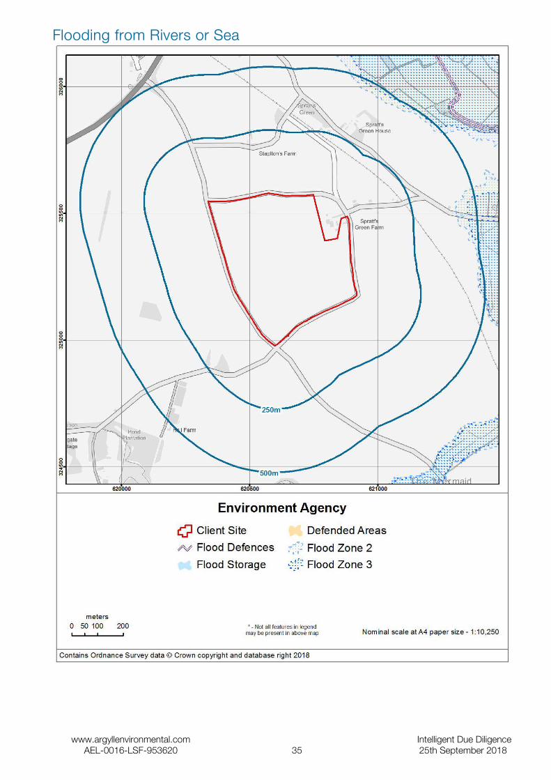
Flooding from Rivers or Sea
www.argyllenvironmental.com Intelligent Due DiligenceAEL-0016-LSF-953620 35 25th September 2018

Flooding from Rivers or Sea
Flooding from River or Sea (Flood Zone 3)
Map ID Details Distance Reply or Direction
Are there any indicative flood plains within 500m? <501m YES
Type: Fluvial Models, Source: Environment Agency, Head Office, Boundary Accuracy: As Supplied.
464.1m E
Flooding from River or Sea in an Extreme Event (Flood Zone 2)
Map ID Details Distance Reply or Direction
Are there any indicative flood plains (extreme events) within 500m? <501m YES
Type: Fluvial Models, Source: Environment Agency, Head Office, Boundary Accuracy: As Supplied.
416.0m E
The Site is at a low risk of flooding from rivers or the sea, as defined by the regulatory body's Flood Map. If the Site area is greater than one hectare, any planning application for development would need to be accompanied by a Flood Risk Assessment in accordance with NPPF.
Areas Benefiting from Flood Defences
Map ID Details Distance Reply or Direction
Does the Site or any areas within 500m benefit from flood defences? <501m NO
The Site is over 500m from an Area Benefiting from a Flood Defence, as defined by the regulatory body. The residual risk that the Site may flood if the protection standard of any flood defences is exceeded, or if the defences fail, is insignificant.
Flood Water Storage Areas
Map ID Details Distance Reply or Direction
Are there any flood water storage areas within 500m? <501m NO
The Site is over 500m from a Flood Storage Area (FSA) as defined by the regulatory body. These areas store flood water during significant flood events. It is unlikely that any FSA presents any associated flood risk to the Site.
Flood Defences
Map ID Details Distance Reply or Direction
Are there any flood defences within 500m? <501m NO
There are no flood defences within 500m of the Site. There may be a small residual risk of flooding from overtopping or failure of defences more distant from the Site. Reference should be made to the assessment of 'Areas Benefiting from Flood Defences' to ascertain whether the Site could potentially be at risk.
www.argyllenvironmental.com Intelligent Due DiligenceAEL-0016-LSF-953620 36 25th September 2018

The Environment Agency Risk of Flooding from Rivers and Sea
www.argyllenvironmental.com Intelligent Due DiligenceAEL-0016-LSF-953620 37 25th September 2018

The Environment Agency Risk of Flooding from Rivers and Sea
Details Distance Reply or Direction
What is the flood likelihood category for the Site? On Site -
Some areas may be classified as having no result. This occurs where there is no output data from the analysis used to produce the regulatory body's risk assessment, but the area falls within the extreme flood outline (with a 0.1% or 1 in 1000 chance of flooding in any year).
The Environment Agency Data
The data in the Risk of Flooding from Rivers and Sea Property Flood Likelihood Database is sourced from The Environment Agency’s National Property Dataset (NPD2). The information provided includes the flood likelihood category low, moderate, or significant according to the flood risk analysis.
www.argyllenvironmental.com Intelligent Due DiligenceAEL-0016-LSF-953620 38 25th September 2018

Groundwater Flooding Risk
Groundwater Flooding Risk
Details Distance Reply or Direction
What is the risk of groundwater flooding at the Site? On Site -
Information from GeoSmart Information Ltd indicates that there is a negligible risk of groundwater flooding in this area and any groundwater flooding incidence will be less frequent than 1 in 100 years return period.No further investigation of risk is deemed necessary unless the proposed site use is unusually sensitive. However, data may be lacking in some areas, so assessment as ‘negligible risk’ on the basis of the map does not rule out local flooding due to features not currently represented in the national datasets used to generate this version of the map.
GeoSmart Information Ltd Data
GeoSmart Information Ltd provides data to Argyll in relation to groundwater flooding. Through research and development, building on their expertise in addressing groundwater flooding issues for the Environment Agency and other clients in the UK, GeoSmart Information Ltd has developed algorithms and calibrated predictions of the risk of groundwater flooding occurring in England and Wales. This differs from other suppliers of data regarding groundwater flooding which only report on the susceptibility of groundwater flooding. Susceptibility merely has to be identified, whereas risk must be quantified. The resulting map is a 5x5m classification of groundwater flooding risk into four categories (Negligible, Low, Moderate and High). GeoSmart Information Ltd’s classifications are based on the level of risk, combining severity and uncertainty that a site will suffer groundwater flooding within a return period of about 100 years.
The map is a general purpose indicative screening tool, and is intended to provide a useful initial view for a wide variety of applications. However, it does not provide an alternative to a site specific assessment, and a detailed risk assessment should be used for any site where the impact of groundwater flooding would have significant adverse consequences.
www.argyllenvironmental.com Intelligent Due DiligenceAEL-0016-LSF-953620 39 25th September 2018

Surface Water Flooding (1:200 year rainfall event)
www.argyllenvironmental.com Intelligent Due DiligenceAEL-0016-LSF-953620 40 25th September 2018

Surface Water Flooding
Surface Water Flooding
Details Distance Reply or Direction
What is the risk of surface water flooding at the Site following a 1 in 75 year rainfall event?
On Site medium
What is the risk of surface water flooding at the Site following a 1 in 200 year rainfall event?
On Site medium
What is the risk of surface water flooding at the Site following a 1 in 1,000 year rainfall event?
On Site medium
JBA Risk Management Data
Surface Water Flooding - Information regarding the risk of natural surface water or pluvial flooding. The risk is classified by JBA into four categories, low (equal to 10cm), low to medium (more than 10cm), medium (more than 30cm) and high (more than 1m) which reflect varying depths of potential surface water flooding during a range of rainfall events including 1:75 year, 1:200 year, and 1:1000 year.
www.argyllenvironmental.com Intelligent Due DiligenceAEL-0016-LSF-953620 41 25th September 2018

Historical Flooding
www.argyllenvironmental.com Intelligent Due DiligenceAEL-0016-LSF-953620 42 25th September 2018
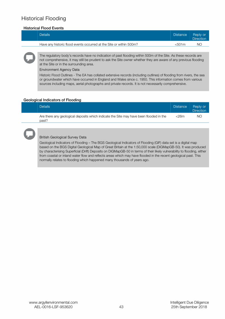
Historical Flooding
Historical Flood Events
Details Distance Reply or Direction
Have any historic flood events occurred at the Site or within 500m? <501m NO
The regulatory body's records have no indication of past flooding within 500m of the Site. As these records are not comprehensive, it may still be prudent to ask the Site owner whether they are aware of any previous flooding at the Site or in the surrounding area.
Environment Agency Data
Historic Flood Outlines - The EA has collated extensive records (including outlines) of flooding from rivers, the sea or groundwater which have occurred in England and Wales since c. 1950. This information comes from various sources including maps, aerial photographs and private records. It is not necessarily comprehensive.
Geological Indicators of Flooding
Details Distance Reply or Direction
Are there any geological deposits which indicate the Site may have been flooded in the past?
<26m NO
British Geological Survey Data
Geological Indicators of Flooding – The BGS Geological Indicators of Flooding (GIF) data set is a digital map based on the BGS Digital Geological Map of Great Britain at the 1:50,000 scale (DiGMapGB-50). It was produced by characterising Superficial (Drift) Deposits on DiGMapGB-50 in terms of their likely vulnerability to flooding, either from coastal or inland water flow and reflects areas which may have flooded in the recent geological past. This normally relates to flooding which happened many thousands of years ago.
www.argyllenvironmental.com Intelligent Due DiligenceAEL-0016-LSF-953620 43 25th September 2018
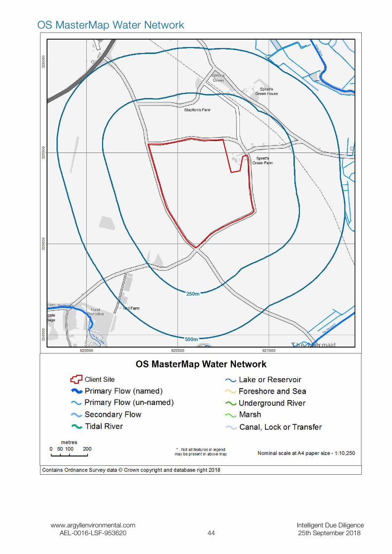
OS MasterMap Water Network
www.argyllenvironmental.com Intelligent Due DiligenceAEL-0016-LSF-953620 44 25th September 2018
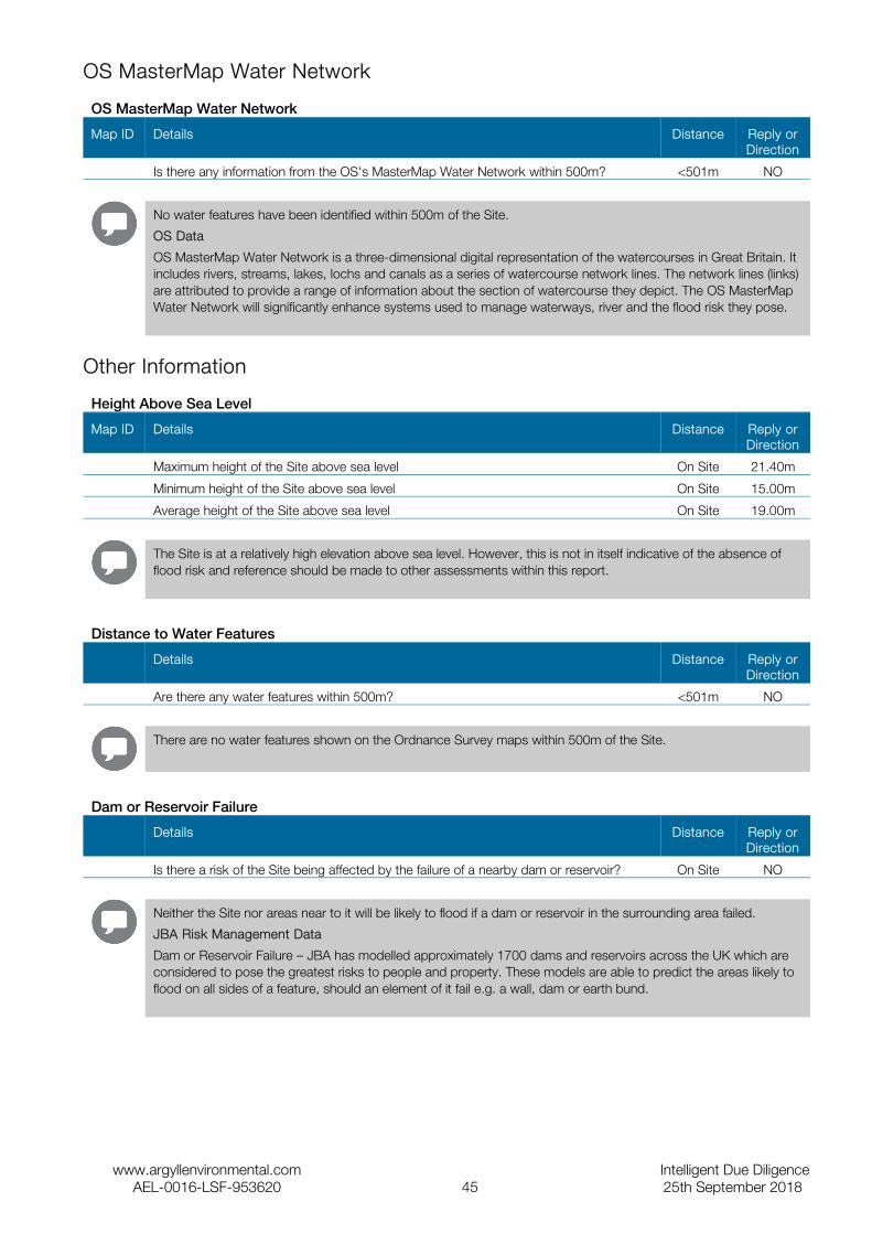
OS MasterMap Water Network
OS MasterMap Water Network
Map ID Details Distance Reply or Direction
Is there any information from the OS's MasterMap Water Network within 500m? <501m NO
No water features have been identified within 500m of the Site.
OS Data
OS MasterMap Water Network is a three-dimensional digital representation of the watercourses in Great Britain. It includes rivers, streams, lakes, lochs and canals as a series of watercourse network lines. The network lines (links) are attributed to provide a range of information about the section of watercourse they depict. The OS MasterMap Water Network will significantly enhance systems used to manage waterways, river and the flood risk they pose.
Other Information
Height Above Sea Level
Map ID Details Distance Reply or Direction
Maximum height of the Site above sea level On Site 21.40m
Minimum height of the Site above sea level On Site 15.00m
Average height of the Site above sea level On Site 19.00m
The Site is at a relatively high elevation above sea level. However, this is not in itself indicative of the absence of flood risk and reference should be made to other assessments within this report.
Distance to Water Features
Details Distance Reply or Direction
Are there any water features within 500m? <501m NO
There are no water features shown on the Ordnance Survey maps within 500m of the Site.
Dam or Reservoir Failure
Details Distance Reply or Direction
Is there a risk of the Site being affected by the failure of a nearby dam or reservoir? On Site NO
Neither the Site nor areas near to it will be likely to flood if a dam or reservoir in the surrounding area failed.
JBA Risk Management Data
Dam or Reservoir Failure – JBA has modelled approximately 1700 dams and reservoirs across the UK which are considered to pose the greatest risks to people and property. These models are able to predict the areas likely to flood on all sides of a feature, should an element of it fail e.g. a wall, dam or earth bund.
www.argyllenvironmental.com Intelligent Due DiligenceAEL-0016-LSF-953620 45 25th September 2018

Useful Contacts
Name and Address Telephone/Fax/Email
Argyll Environmental Limited1st Floor98 – 99 Queens RoadBrightonBN1 3XF
www.argyllenvironmental.com
Telephone 0845 458 5250
Ensura Limited (for Environmental Insurance)1st Floor98 – 99 Queens RoadBrightonBN1 3XF
www.ensura.co.uk
Telephone 0845 652 8585
Fax 0845 652 8686
Norfolk County Council Planning & Transportation - Minerals & WasteCounty Hall
www.norfolk.gov.uk
Telephone 0844 800 8020
Fax: 0844 800 8012
Broadland District CouncilThorpe Lodge
www.broadland.gov.uk
Telephone 01603 431133
Fax: 01603 700339
British Geological Survey Enquiry ServiceBritish Geological Survey
www.bgs.ac.uk
Telephone 0115 936 3143
Fax: 0115 936 3276
Environment Agency National Customer Contact Centre (NCCC)PO Box 544
Telephone 03708 506 506
Environment Agency Head OfficeRio House
Telephone 01454 624400
Fax: 01454 624409
DefraNobel House17 Smith SquareLondonSW1P 3JR
Telephone 08459 335577
ALA (Agricultural Law Association) Telephone 01206 383521
Please note that the Environment Agency / SEPA have a charging policy in place for enquiries. When contacting these agencies please mention that this data has been received from the Landmark database, alternatively Argyll Environmental Limited would be pleased to assist with consultation to the above bodies. Please contact us for a quotation.
www.argyllenvironmental.com Intelligent Due DiligenceAEL-0016-LSF-953620 46 25th September 2018

Contaminated Land Risk Analysis MethodologyThe Estate Solutions reports have been designed to assist in making informed decisions during property transactions. The Report is a desktop assessment of direct liabilities (Liabilities) which could affect the owner /occupier of the Site and arise under Part 2A of the Environmental Protection Act 1990 and/or equivalent requirements under the planning regime and/or the Water Resources Act 19914. (Relevant Legislation). If a risk is identified, then a number of options for finding out more about the risk, managing it or transferring it are proposed.
The assessment of environmental liability under the Relevant Legislation is based upon the principle of determining the presence of a plausible contaminant-pathway-receptor relationship (a contaminant linkage). A ‘contaminant’ is a source of contamination, a ‘pathway’ is a medium through which the contamination can mobilise and ‘a receptor’ is a person or entity that could be detrimentally affected by the contamination. If all three are identified, then a 'plausible contaminant-pathway-receptor relationship' may be present. By definition, this is one which Argyll believes could result in significant harm, a significant possibility of significant harm or significant pollution or the possibility of significant pollution to Controlled Waters.
In our assessment we use the following test to decide if there is a potential liability affecting the Site. For the purpose of this assessment a site where a potential Liability has been identified is defined as follows:
A Site which, from the information assessed by Argyll, is considered to have the potential of being affected by contaminative substances present in or under the Site (but excluding potential sources of contamination on or above the land) such that, on the basis of its current or proposed use, there is a reasonable likelihood of a UK regulatory authority, acting in accordance with Relevant Legislation, requiring that remedial measures are taken in order to remedy or mitigate the contaminative substances that are present in or under the land that forms all or part of the Site.
The term Liabilities is defined within the scope of this assessment to mean, remedial works under Part 2A of the Environmental Protection Act 1990 (or where appropriate, equivalent requirements under the planning regime) and/or the Water Resources Act 1991 which may result in direct liability for the site owner/occupier.
The assessment within the Report has been produced and quality checked by a team of qualified environmental professionals. The assessment is based upon a manual review of the data contained within the Data Section of this Report and of 1:2500 and 1:1250 (where available) scale historical mapping.
Ecological Risk AssessmentThe evaluation of ecological risk is becoming an increasingly important input when making risk management decisions. In the Site Solutions Commercial report, Argyll assesses two different drivers for risks and liabilities driven by ecological receptors;
1.The Contaminated Land Regime; and
2.The Environmental Damage Regulations (EDR) 2009.
The Environment Agency has designed a generic framework for conducting ecological risk assessment (see Assessing Risk to Ecosystems from Land Contamination, R&D Technical Report P299, EA 2002). This recommends a tiered approach in line with best practice for human health and controlled water risk assessment and defines Relevant Ecological Receptors as any of the Relevant Types of Receptor as set out in Table 1 of Defra Statutory Guidance on Contaminated Land dated April 2012.
Argyll assesses Relevant Ecological Receptors as part of its assessment process. To do so it uses the Argyll EcoRisk model which was developed and tested in consultation with leading experts and is based on the Environment Agency framework.
The Environmental Damage (Prevention and Remediation) Regulations 2009 were introduced on 1 March 2009 to implement the provisions of the European Commission's Environmental Liability Directive into law in England 5. The aim of EDR is to prevent and remedy damage to protected species or natural habitats or a site of special scientific interest, surface water, groundwater or to land. 'Environmental damage' has a specific meaning in the Regulations, and covers only the most severe cases. Existing legislation with provisions for environmental liability remains in place. The Regulations apply on land in England and on the seabed around the UK up to the limits set out in the Continental Shelf Act 1964, and to waters in the Renewable Energy Zone, which extends approximately 200 miles out to sea.
Argyll does not consider the standard of current operations, but reports the potential for environmental damage based on the location of EDR Receptors around the Site.
4 Water Environment (Controlled Activities)(Scotland) Regulations 2005 where appropriate.5 Environmental Damage (Prevention and Remediation) (Wales) Regulations 2009 or Environmental Damage (Prevention and Remediation) (Scotland) Regulations where appropriate.

When conducting either assessment, Argyll will primarily assess information provided in the Data section of the Report. However, in some cases Argyll may choose to supplement this with freely available public information such as that provided by Natural England and/or information provided by the Argyll Europa System.
Liability AssessmentIn this section Argyll will report on any potential soil and groundwater liabilities which it considers are associated with the Site. Our assessment of Liability is based upon the proposed and current use of the Site (as supplied by the client) in line with current Government guidance.
There will be one of the following three responses:
Assessment Liability Statement & explanation Defra Category*
PASSED Within the scope of this assessment no Liabilities have been identified. No further action is required.
This statement indicates that within the scope of this assessment, no issues have been identified that are likely to result in significant cost liabilities under Relevant Legislation.
3 or 4
PASSED Within the scope of this assessment no Liabilities have been identified. However, your attention is drawn to the prudent enquiries suggested below.
This statement indicates that within the scope of this assessment, no issues have been identified that are likely to result in significant cost liabilities under Relevant Legislation. However, a client may wish to obtain further information about other issues disclosed in the Report, which could be material.
3 or 4
FURTHER ACTION
Potential Liabilities have been identified under Part 2A of the Environmental Protection Act 1990 (or where appropriate, equivalent requirements under the planning regime) and/or the Water Resources Act 19916. To quantify these you may decide to undertake a more detailed assessment through the recommendation(s) set out below.
This statement indicates that within the scope of this assessment, an issue or a number of issues have been identified that are likely to result in significant cost liabilities under Relevant Legislation. In this event, recommendations are made, in order that additional information is collected so that the liabilities may be more accurately assessed.
Potentially 1 or 2
* According to Defra's updated Statutory Guidance on Contaminated Land, Regulators have a four-stage test to decide when land is and is not contaminated. Category 1 and Category 2 sites would encompass land which is capable of being determined as contaminated land, whereas Category 3 and Category 4 sites would encompass land which is not capable of being determined as contaminated land.
Limitations of the ReportThe Estate Solutions reports have been designed to satisfy standard environmental due-diligence enquiries, as recommended by the Law Society's contaminated land warning card. It is a ‘remote’ investigation and reviews only information provided by the client and from the databases of publicly available information that have been chosen to enable a desk based environmental assessment of the Site. The Report does not include a site investigation, nor does Argyll make specific information requests of the regulatory authorities for any relevant information they may hold. Therefore, Argyll cannot guarantee that all land uses or factors of concern will have been identified by the Report.
The information in the Data Section of the Report is derived from a number of statutory and non-statutory sources. While every effort is made to ensure accuracy, Argyll cannot guarantee the accuracy or completeness of such information or data. Argyll will not accept responsibility for inaccurate data provided by external data providers.
Further information regarding our risk assessment methodology is provided in the Products and Services User Manual which is available free of charge from the client area of our website www.argyllenvironmental.com. For further information regarding the datasets reviewed within our assessment, please contact one of our technical team on 0845 458 5250. This report is provided under The Argyll Environmental Terms and Conditions for Data Reports, a copy of which is available on our website.Flood Risk Screening Methodology
6Water Environment (Controlled Activities)(Scotland) Regulations 2005 where appropriate.

The EstateSolutions Farm includes a desktop flood risk assessment designed to enable property professionals to assess the risk of flooding at agricultural sites. It examines the overall risk of flooding at a site (not taking into account any flood defences that may be present). The report considers current Government guidance including the National Planning Policy Framework (NPPF) and the agreement between the Association of British Insurers and Defra known as the Statement of Principles. The report has been produced and quality-checked by a qualified consultant using the data contained in this report.
Flood Risk RatingArgyll provides an overall flood risk rating based on an assessment of the data provided within this report. It does so by asking one question:
1. What is the overall risk of flooding, assuming flood defence fail or are absent or overtopped?
The answer to this question provides a worst case scenario assuming there are either no defences in the area, that any defences in the area could fail, primarily as a result of river or coastal flooding, or are overtopped by excessive flood volumes.
Questions 1 are answered by one of six standard responses:
Response Meaning
Negligible The overall flood risk rating for the Site is assessed to be 'Negligible'. Existing datasets do not indicate any risk at the Site itself, or any feature within the locality of the Site, which would be expected to pose a threat of flooding. It is not considered that any further investigations are necessary in regard to flood risk.
Low The overall flood risk rating for the Site is assessed to be 'Low'. Although large sites (over 1 ha) would require a Drainage Impact Assessment to accompany any planning application, it is not considered necessary to undertake any other further investigations into the flood risk to the Site.
Low to Moderate The overall flood risk rating for the Site is assessed to be 'Low to Moderate'. The presence of such features as flood defences, flood storage areas and watercourses within the locality of the Site suggests that there may be a risk of flooding to the Site itself. Further investigations could be undertaken to further assess this risk.
Moderate The overall flood risk rating for the Site is assessed to be 'Moderate'. Information from existing datasets suggests that there are certain features which may present a risk to the Site and its occupants. Further assessment would normally be suggested as a prudent measure to clarify the risk of flooding at the Site.
Moderate to High The overall flood risk rating for Site is assessed to be 'Moderate to High'. Information from existing datasets suggests that there are certain features which may present a significant risk to the Site and its occupants. Further assessment is usually recommended in order to clarify the risk of flooding at the Site.
High The overall flood risk rating for Site is assessed to be 'High', with a consequent risk to life and property. This means that existing datasets reveal significant flood risk issues which need to be addressed. Further assessment is usually recommended in order to clarify the risk of flooding at the Site.
Flood AnalysisThe flood risk gauges provide a more detailed analysis of the risk from each of the four main types of flooding – river, coastal, groundwater and surface water. In addition, a fifth gauge provides an analysis of other factors ( i.e. historic flood events, geological deposits which are indicative of past flooding, proximity to surface water features and elevation above sea level) that may affect the overall flood risk. For surface water flooding, only the risk rating generated from the 1:200 year rainfall event data is included in the overall risk assessment. The data on 1:75 year and 1:1,000 year rainfall events is provided for information only. The flood analysis within the report is automated taking into account the percentage of identified flood risk from the individual datasets to assess their significance in the context of the wider farm. This includes an assessment of whether the assumed main buildings within the Site boundary fall within an area of flood risk. For further information on each of these types of flooding, please refer to the Argyll FloodSolutions User Guide.
This analysis takes into account any existing flood defences that are intended to protect the Site and assumes that these work as designed. The analysis also takes into account the other information contained in those data sections of the report

which are relevant to that particular type of flooding. The assessment of the risk as shown in the flood gauge should therefore take priority over the information in the individual data sections of the report.
Limitations of the ReportThe Renaissance Estate Solutions Farm report has been designed to satisfy basic flood-related environmental due-diligence enquiries for farm and large estates. It is a desktop review of information provided by the client and from selected private and public databases. It does not include a site investigation, nor are specific information requests made of the regulatory authorities for any relevant information (other than local water and sewerage providers). Therefore, Argyll cannot guarantee that all issues of concern will be identified by this report, or that the data and information supplied to it by third parties is accurate and complete.
This report includes an assessment of surface water flooding which examines the risk of the general drainage network overflowing during periods of extreme rainfall. This report does not make a detailed site-specific assessment of the suitability of the existing drainage on the Site. If this is required, then a site survey should be considered. The assessment of pluvial flooding does not take into account particular local or temporary factors that may cause surface water flooding such as the blockage or failure of structures on or within watercourses, drains, foul sewers, water mains, canals and other water infrastructure; and any history of drains flooding at the Site or in the locality. Surface water flooding can occur before surface water reaches the general drainage network, for example on hills and inclines.
Environment Agency data does not include flood risk from very small catchments as models of such small scale catchments are not considered to be reliable for UK-wide flood risk assessments. The potential impact of climate change on flood risk to the Site would require further study.
When answering any questions within this report, current applicable legislation is taken into account.
The data used in this report may have inherent limitations and qualifications. Further details are set out in the FloodSolutions User Guide which is available free of charge from our website www.argyllenvironmental.com , or by calling one of our technical team on 0845 458 5250.
This report is provided under The Argyll Environmental Terms and Conditions for Flood Solutions Reports, a copy of which is available on our website, www.argyllenvironmental.com , or by calling one of our technical team on 0845 458 5250
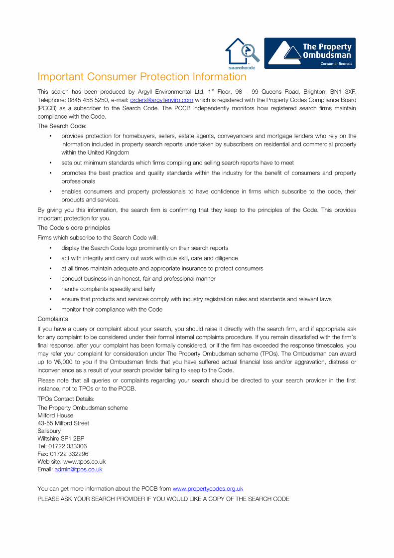
Important Consumer Protection InformationThis search has been produced by Argyll Environmental Ltd, 1st Floor, 98 – 99 Queens Road, Brighton, BN1 3XF. Telephone: 0845 458 5250, e-mail: [email protected] which is registered with the Property Codes Compliance Board (PCCB) as a subscriber to the Search Code. The PCCB independently monitors how registered search firms maintain compliance with the Code.
The Search Code:
• provides protection for homebuyers, sellers, estate agents, conveyancers and mortgage lenders who rely on the information included in property search reports undertaken by subscribers on residential and commercial property within the United Kingdom
• sets out minimum standards which firms compiling and selling search reports have to meet
• promotes the best practice and quality standards within the industry for the benefit of consumers and property professionals
• enables consumers and property professionals to have confidence in firms which subscribe to the code, their products and services.
By giving you this information, the search firm is confirming that they keep to the principles of the Code. This provides important protection for you.
The Code's core principles
Firms which subscribe to the Search Code will:
• display the Search Code logo prominently on their search reports
• act with integrity and carry out work with due skill, care and diligence
• at all times maintain adequate and appropriate insurance to protect consumers
• conduct business in an honest, fair and professional manner
• handle complaints speedily and fairly
• ensure that products and services comply with industry registration rules and standards and relevant laws
• monitor their compliance with the Code
Complaints
If you have a query or complaint about your search, you should raise it directly with the search firm, and if appropriate ask for any complaint to be considered under their formal internal complaints procedure. If you remain dissatisfied with the firm’s final response, after your complaint has been formally considered, or if the firm has exceeded the response timescales, you may refer your complaint for consideration under The Property Ombudsman scheme (TPOs). The Ombudsman can award up to £5,000 to you if the Ombudsman finds that you have suffered actual financial loss and/or aggravation, distress or inconvenience as a result of your search provider failing to keep to the Code.
Please note that all queries or complaints regarding your search should be directed to your search provider in the first instance, not to TPOs or to the PCCB.
TPOs Contact Details:
The Property Ombudsman schemeMilford House43-55 Milford StreetSalisburyWiltshire SP1 2BPTel: 01722 333306Fax: 01722 332296Web site: www.tpos.co.ukEmail: [email protected]
You can get more information about the PCCB from www.propertycodes.org.uk
PLEASE ASK YOUR SEARCH PROVIDER IF YOU WOULD LIKE A COPY OF THE SEARCH CODE

Complaints procedure
If you want to make a complaint, we will:
• Acknowledge it within 5 working days of receipt.
• Normally deal with it fully and provide a final response, in writing, within 20 working days of receipt.
• Keep you informed by letter, telephone or e-mail, as you prefer, if we need more time.
• Provide a final response, in writing, at the latest within 40 working days of receipt.
• Liaise, at your request, with anyone acting formally on your behalf.
Complaints should be sent to:Legal DirectorArgyll Environmental Ltd1st Floor98 – 99 Queens RoadBrightonBN1 3XF
Telephone: 0845 458 5250Email: [email protected]
If you are not satisfied with our final response, or if we exceed the response timescales, you may refer the complaint to The Property Ombudsman scheme (TPOs): Tel: 01722 333306, E-mail: [email protected]
We will co-operate fully with the Ombudsman during an investigation and comply with his final decision.
These are the notes referred to on the following official copy Title Number NK404642 The electronic official copy of the document follows this message. This copy may not be the same size as the original. Please note that the quality of one or more pages may be poor. Unfortunately thisis the best quality image we hold of the document. If you are able to obtain abetter quality copy from another source we would be grateful if you would send itto us so we may update our records. Alternatively if you know who holds or mayhold either a copy or the original please let us know so that we may contact thatperson. Costs or expenses reasonably incurred as a result of the mistake may berecoverable as indemnity under paragraph 3 of Schedule 8, Land Registration Act2002. However the Registrar's consent should normally be obtained before suchcosts are incurred. If you intend to incur costs as a result of any loss arisingfrom the poor quality and to claim for these under the statutory compensationscheme please inform us of the steps you intend to take, what is the estimatedcost and how this has been calculated. Our Practice Guide 39 - Rectification andindemnity contains further information. We appreciate that the payment ofindemnity will be an inferior alternative to a better copy of the document itself. You can view or download copies of the practice guide from our website atwww.gov.uk/land-registry in English or Welsh. Alternatively, you can telephoneCustomer Support on 0300 006 0411 (0300 006 0422 for a Welsh-speaking service). Please note that this is the only official copy we will issue. We will not issue apaper official copy.
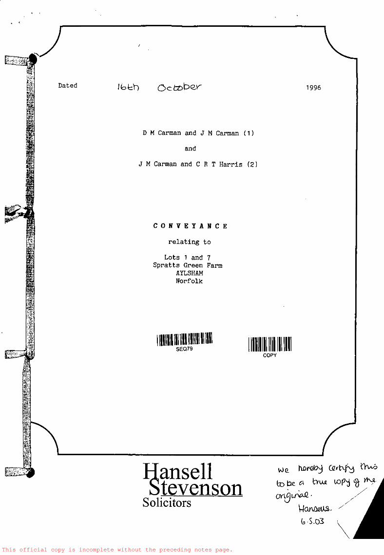
This official copy is incomplete without the preceding notes page.
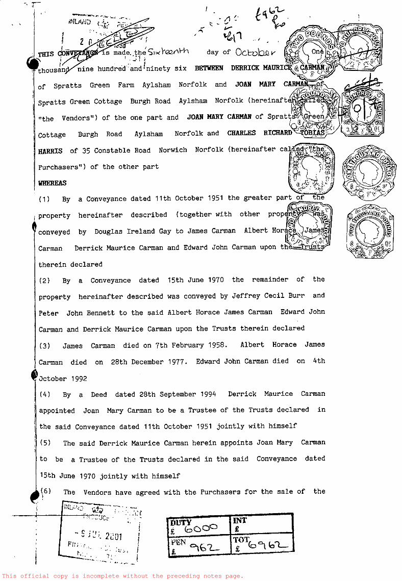
This official copy is incomplete without the preceding notes page.
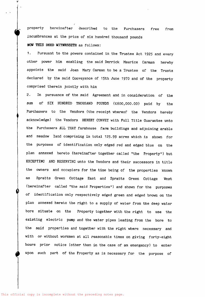
This official copy is incomplete without the preceding notes page.

This official copy is incomplete without the preceding notes page.
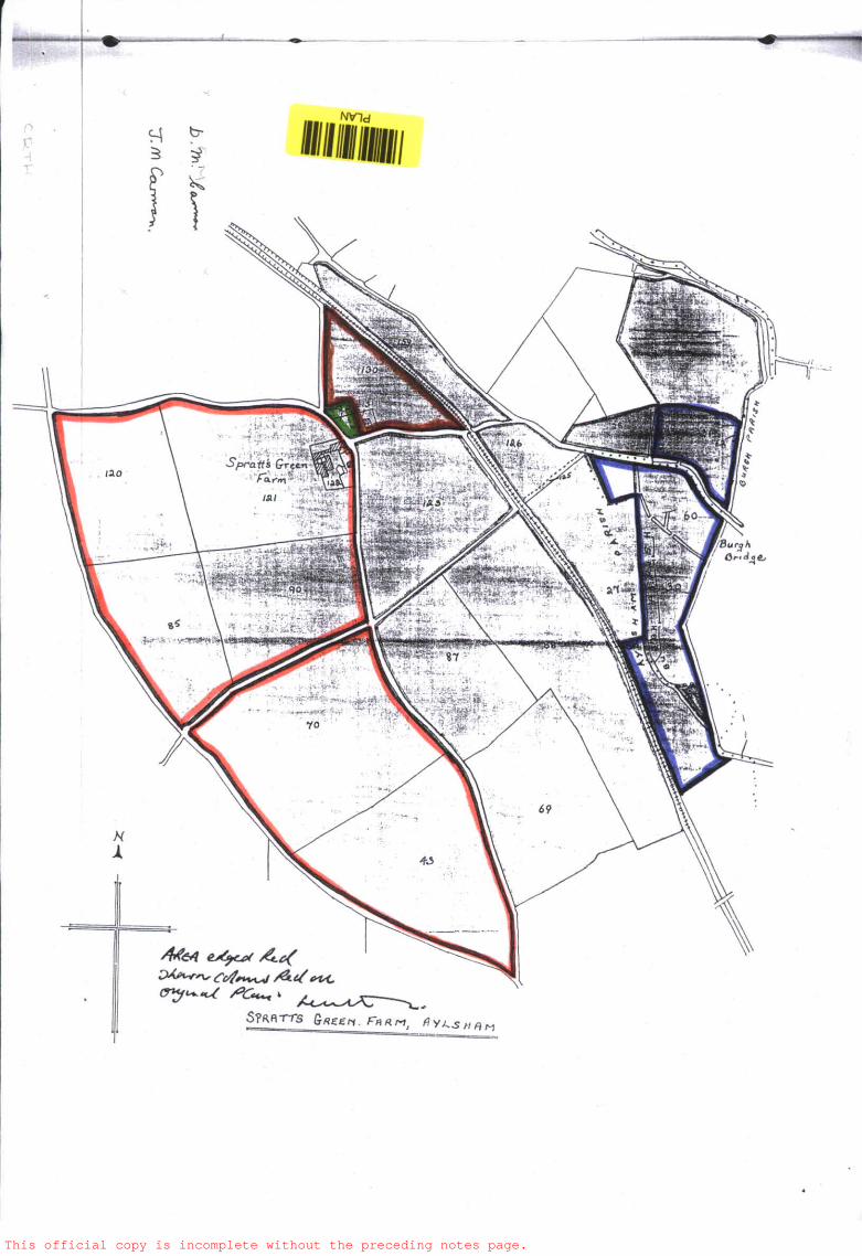
This official copy is incomplete without the preceding notes page.

The electronic official copy of the register follows this message.
Please note that this is the only official copy we will issue. We will not issue apaper official copy.
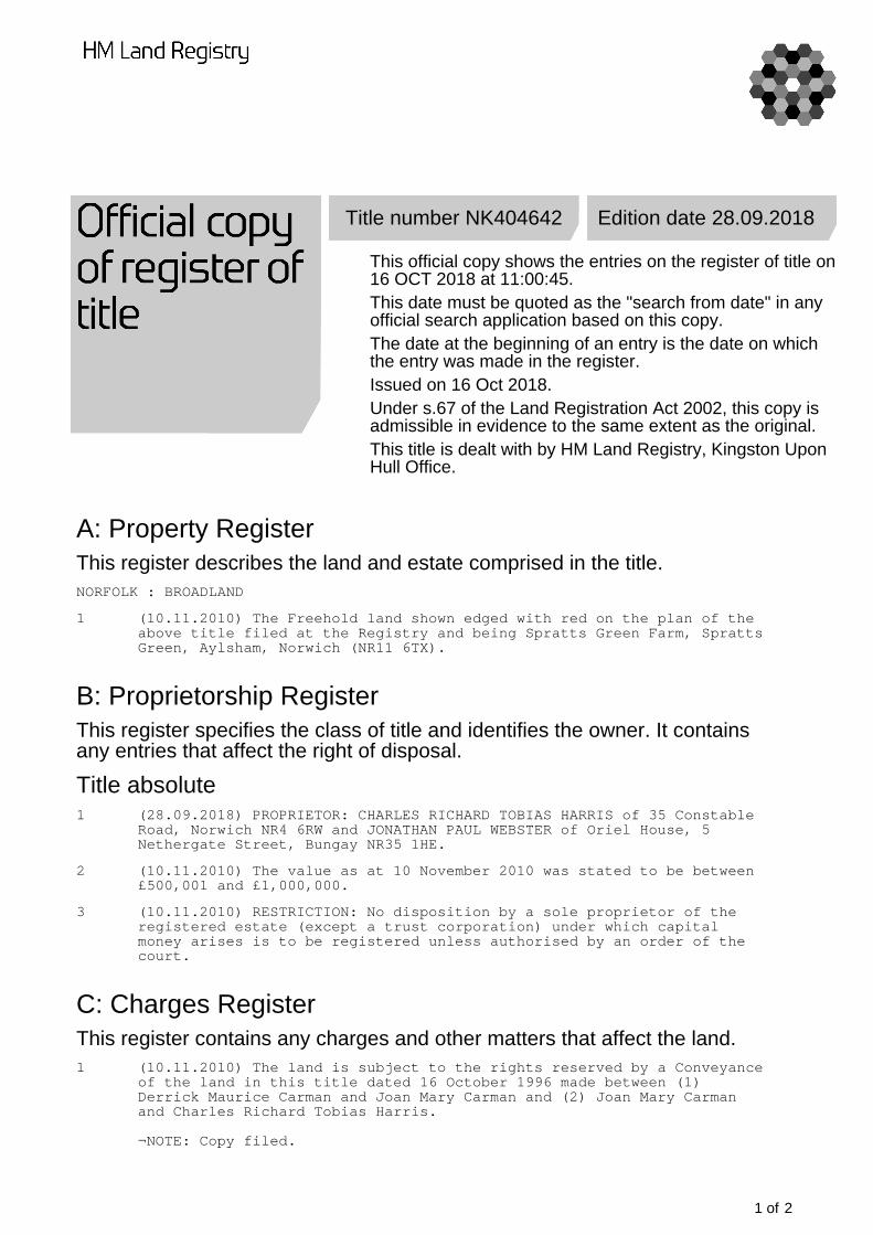
Title number NK404642 Edition date 28.09.2018
This official copy shows the entries on the register of title on16 OCT 2018 at 11:00:45.This date must be quoted as the "search from date" in anyofficial search application based on this copy.The date at the beginning of an entry is the date on whichthe entry was made in the register.Issued on 16 Oct 2018.Under s.67 of the Land Registration Act 2002, this copy isadmissible in evidence to the same extent as the original.This title is dealt with by HM Land Registry, Kingston UponHull Office.
A: Property RegisterThis register describes the land and estate comprised in the title.NORFOLK : BROADLAND
1 (10.11.2010) The Freehold land shown edged with red on the plan of theabove title filed at the Registry and being Spratts Green Farm, SprattsGreen, Aylsham, Norwich (NR11 6TX).
B: Proprietorship RegisterThis register specifies the class of title and identifies the owner. It containsany entries that affect the right of disposal.
Title absolute1 (28.09.2018) PROPRIETOR: CHARLES RICHARD TOBIAS HARRIS of 35 Constable
Road, Norwich NR4 6RW and JONATHAN PAUL WEBSTER of Oriel House, 5Nethergate Street, Bungay NR35 1HE.
2 (10.11.2010) The value as at 10 November 2010 was stated to be between£500,001 and £1,000,000.
3 (10.11.2010) RESTRICTION: No disposition by a sole proprietor of theregistered estate (except a trust corporation) under which capitalmoney arises is to be registered unless authorised by an order of thecourt.
C: Charges RegisterThis register contains any charges and other matters that affect the land.1 (10.11.2010) The land is subject to the rights reserved by a Conveyance
of the land in this title dated 16 October 1996 made between (1)Derrick Maurice Carman and Joan Mary Carman and (2) Joan Mary Carmanand Charles Richard Tobias Harris.
¬NOTE: Copy filed.
1 of 2

End of registerTitle number NK404642
2 of 2