remote infrared audible signage (rias) pilot … · remote infrared audible signage (rias) pilot...
TRANSCRIPT
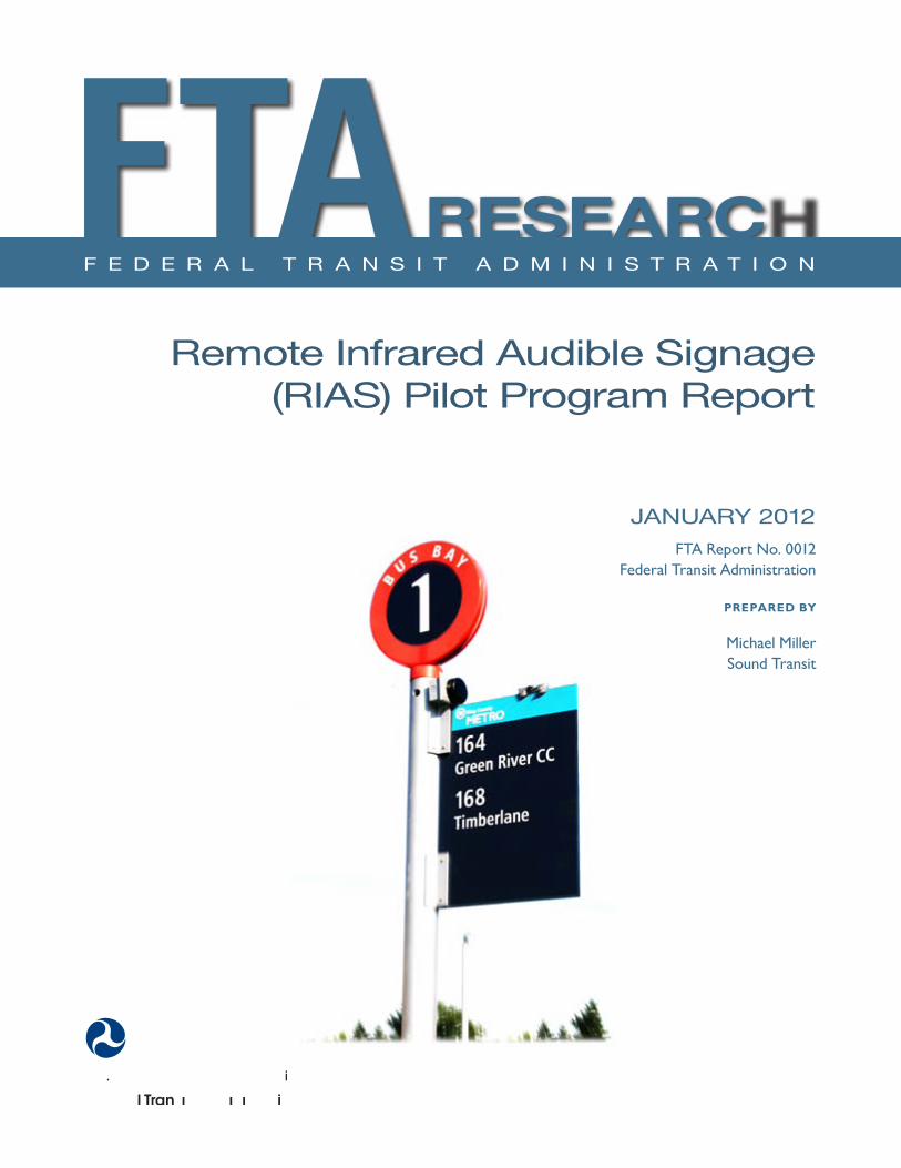
Remote Infrared Audible Signage(RIAS) Pilot Program Report
JANUARY 2012 FTA Report No 0012
Federal Transit Administration
PREPARED BY
Michael Miller Sound Transit
COVER PHOTO Courtesy of Sound Transit Seattle
DISCLAIMER This document is intended as a technical assistance product It is disseminated under the sponsorship of the US Department of Transportation in the interest of information exchange The United States Government assumes no liability for its contents or use thereof The United States Government does not endorse products of manufacturers Trade or manufacturersrsquo names appear herein solely because they are considered essential to the objective of this report
Trademarks or manufacturersrsquo names appear in the document only because they are essential to the objective of the document and do not constitute an official endorsement either expressed or implied by Sound Transit FTA or LM Telecommunications
Remote Infrared Audible Signage(RIAS) Pilot ProgramReport
JANUARY 2012 FTA Report No 0012
PREPARED BY
Michael Miller Sound Transit 401 S Jackson St Seattle WA 98126
SPONSORED BY
Federal Transit Administration Office of Research Demonstration and Innovation US Department of Transportation 1200 New Jersey Avenue SE Washington DC 20590
AVAILABLE ONLINE
httpwwwftadotgovresearch
Metric Conversion Table
FEDERAL TRANSIT ADMINISTRATION ii
Metric Conversion Table
SYMBOL WHEN YOU KNOW
in inches
ft feet
yd yards
mi miles
MULTIPLY BY
LENGTH
254
0305
0914
161
VOLUME
TO FIND
millimeters
meters
meters
kilometers
SYMBOL
mm
m
m
km
fl oz fluid ounces 2957 milliliters mL
gal gallons 3785 liters L
3ft3 cubic feet 0028 cubic meters m
yd3 cubic yards 0765 cubic meters m 3
NOTE volumes greater than 1000 L shall be shown in m3
MASS
oz ounces 2835 grams g
lb pounds 0454 kilograms kg
megagrams T short tons (2000 lb) 0907 Mg (or t)
(or metric ton)
TEMPERATURE (exact degrees)
5 (F-32)9 oF Fahrenheit Celsius oCor (F-32)18
FEDERAL TRANSIT ADMINISTRATION ii
REPORT DOCUMENTATION PAGE Form Approved OMB No 0704-0188
Public reporting burden for this collection of information is estimated to average 1 hour per response including the time for reviewing instrucshytions searching existing data sources gathering and maintaining the data needed and completing and reviewing the collection of information Send comments regarding this burden estimate or any other aspect of this collection of information including suggestions for reducing this burden to Washington Headquarters Services Directorate for Information Operations and Reports 1215 Jefferson Davis Highway Suite 1204 Arlington VA 22202-4302 and to the Office of Management and Budget Paperwork Reduction Project (0704-0188) Washington DC 20503
1 AGENCY USE ONLY 2 REPORT DATE July 2011
3 REPORT TYPE AND DATES COVERED August 2006 - October 2009
4 TITLE AND SUBTITLE Remote Infrared Audible Signage Pilot Program
5 FUNDING NUMBERS WA-26-7010
6 AUTHOR(S) Michael Miller
7 PERFORMING ORGANIZATION NAME(S) AND ADDRESSE(ES) Sound Transit 401 S Jackson St Seattle WA 98126
8 PERFORMING ORGANIZATION REPORT NUMBER
FTA Report No 0012
9 SPONSORINGMONITORING AGENCY NAME(S) AND ADDRESS(ES) US Department of Transportation Federal Transit Administration East Building 1200 New Jersey Avenue SE Washington DC 20590
10 SPONSORINGMONITORING AGENCY REPORT NUMBER
FTA Report No 0012
11 SUPPLEMENTARY NOTES Available Online [httpwwwftadotgovresearch]
12A DISTRIBUTIONAVAILABILITY STATEMENT Available From National Technical Information Service (NTIS) 5285 Port Royal Road Springfield VA 22161 NTIS Sales Desk 1-800-553-6847 or (703) 605-6000 fax (703) 605-6900 TDD (703) 487-4639 Email [infontisgov]
12B DISTRIBUTION CODE
TRI-30
13 ABSTRACT The Remote Infrared Audible Sign Model Accessibility Program (RIAS MAP) is a program funded by the Federal Transit Administration (FTA) to evaluate the effectiveness of remote infrared audible sign systems in enabling persons with visual and cognitive disabilities to travel independently The subject for this report is the continuation of this evaluation through using a more comprehensive multi-modal public transportation environment for measuring effectiveness The wayfinding product evaluated is the RIAS technology with the registered trade name Talking Signs (Talking Signs Inc) There are two main goals for this project 1) Measure the effectiveness of the Sound Transit RIAS system by using persons with visual or cognitive disabilities to test the installed system and provide feedback as well as by observing the testersrsquo ability to use the system during structured testing and 2) Measure cost implications for future expansion of the RIAS system for both Sound Transit and other regional public transit agencies
14 SUBJECT TERMS Remote Infrared Audible Signage RIAS wayfinding blind partially sighted visushyally impaired talking signs
15 NUMBER OF PAGES 52
16 PRICE CODE
17 SECURITY CLASSIFICATION OF REPORT Unclassified
18 SECURITY CLASSIFICATION OF THIS PAGE
Unclassified
19 SECURITY CLASSIFICATION OF ABSTRACT
Unclassified
20 LIMITATION OF ABSTRACT
FEDERAL TRANSIT ADMINISTRATION iii
TABLE OF CONTENTS
1 Executive Summary
6 Section 1 Introduction
8 Section 2 RIAS System Description
12 Section 3 Human Factors Testing amp Evaluation (HFTE) Procedures
13 Participant Training 14 ObservationalInteractive Research 14 Extended-User Research (Post-Trial Interviews)
15 Section 4 Human Factors Testing amp Evaluation (HFTE) Results 15 ObservationalInteractive Research Results Summary 16 Extended User Research Summary 16 Issues and Lessons Learned 17 Analysis by Others
18 Section 5 Existing Wayfinding Technology Review
18 Infrared (IR) and Light Emitting Signs 18 Talking Signs 19 Talking Lights 19 Radio Frequency (RF) Signs 19 Step-Hear 20 Bar-Coded Signs 20 University of California and Smith-Kettlewell Eye Research Institute
Color Marker and bar Code System 20 GPS-Based Systems 20 Loadstone GPS 21 Wayfinder Access 21 Trekker 21 BrailleNote GPS 21 Mobile GEO 22 Research Projects 22 University of South Florida Travel Assistance Device (TAD) 22 Trinetra 22 NOPPA 23 Brunel University Navigation System 23 Drishti 23 Transit Location and ScheduleData 24 Current Trends for Wayfinding Technology 25 Summary of Wayfinding Technology Review
28 Section 6 Cost Benefit Analysis 28 Introduction 29 Evaluation of Potential Wayfinding System Users in the Puget Sound
FEDERAL TRANSIT ADMINISTRATION iv
29 Potential Cost Savings for Paratransit Services 30 Wayfinding System Costs 30 Talking Signs Costs 31 Step-Hear Costs 31 Talking Lights Costs 31 GPS-Based System Costs 32 Wayfinding Systems Cost Comparison Summary 32 Talking Signs and Step-Hear Cost Comparison 34 Wayfinding Systems Implementation Risks 36 RIAS Installation Evaluation for Remainder of Sound Transit Facilities 37 RIAS Installation Evaluation at Other Regional Public Transportation Facilities 38 Results of the Analysis
40 Section 7 Recommendations
41 References
42 Appendix Diagram of Typical Installation
FEDERAL TRANSIT ADMINISTRATION v
LIST OF FIGURES
9 Figure 2-1 Transmitter located at paratransit stop at Everett Station
9 Figure 2-2 Transmitter installed to identify ticket vending machine at Everett Station
10 Figure 2-3 RIAS receiver with a neck strap
10 Figure 2-4 Talking Signs transmitter for Bus Bay 6 at Federal Way Transit Center
10 Figure 2-5 RIAS transmitters in this area of Kent Station identify and locate the elevator to the pedestrian bridge and stairs down to the street crossing that leads to a shopping center
11 Figure 2-6 Controllers for low-voltage Talking Sign transmitters installed in basement of Everett Transit Center
11 Figure 2-7 Transmitters at Bellevue Transit Center
LIST OF TABLES
13 Table 3-1 RIAS Testing Task Groups
29 Table 6-1 Statistics on Persons with Visual Impairment and Cognitive Disabilities in Puget Sound
30 Table 6-2 Paratransit Costs and Potential Savings
30 Table 6-3 Talking Signs System History of Costs
31 Table 6-4 Talking Signs Material Costs
31 Table 6-5 Step-Hear Material Costs
32 Table 6-6 GPS-Based System Costs
32 Table 6-7 Sound Transit Wayfinding System Installation Cost Comparison
33 Table 6-8 Caltrain San Jose Diridon Station Wayfinding System Installation Cost Comparison
33 Table 6-9 Sound Transit Wayfinding System Installation Cost Comparison
37 Table 6-10 Sound Transit RIAS Costs for Remaining Facilities and Vehicles
38 Table 6-11 Estimated RIAS Costs for Regional Facilities
FEDERAL TRANSIT ADMINISTRATION vi
FOREWORD
In 2007 Sound Transit the Central Puget Sound Regional Transit Authority received a Research and Technology Grant from the Federal Transit Administration to conduct a model program to install and evaluate Remote Infrared Audible Signage (RIAS) Sound Transit installed the technology at nine multi-modal facilities in the Central Puget Sound Region This report describes the design installation and user testing of technology
ABSTRACT
The Remote Infrared Audible Sign Model Accessibility Program (RIAS MAP) is a program funded by the Federal Transit Administration (FTA) to evaluate the effectiveness of remote infrared audible sign systems in enabling persons with visual and cognitive disabilities to travel independently The subject for this report is the continuation of this evaluation through using a more comprehensive multi-modal public transportation environment for measuring effectiveness The wayfinding product evaluated is the RIAS technology with the registered trade name Talking Signs (Talking Signs Inc) There are two main goals for this project 1) measure the effectiveness of the Sound Transit RIAS system by using persons with visual or cognitive disabilities to test the installed system and provide feedback as well as by observing the testersrsquo ability to use the system during structured testing and 2) measure cost implications for future expansion of the RIAS system for both Sound Transit and other regional public transit agencies
FEDERAL TRANSIT ADMINISTRATION vii
EXECUTIVE SUMMARY
EXECUTIVE Purpose SUMMARY The Remote Infrared Audible Sign Model Accessibility Program (RIAS MAP) is
a program funded by the Federal Transit Administration (FTA) to evaluate the effectiveness of remote infrared audible sign systems in enabling persons with visual and cognitive disabilities to travel independently The subject for this report is the continuation of this evaluation through using a more comprehensive multi-modal public transportation environment for measuring effectiveness The wayfinding product evaluated is the RIAS technology with the registered trade name Talking Signs (Talking Signs Inc) There are two main goals for this project
1 Measure the effectiveness of the Sound Transit RIAS system by using persons with visual or cognitive disabilities to test the installed system and provide feedback as well as by observing the testersrsquo ability to use the system during structured testing
2 Measure cost implications for future expansion of the RIAS system for both Sound Transit and other regional public transit agencies
Based upon these two main purposes from the RIAS MAP this report contains the following
bull Summary of the Sound Transit RIAS system
bull Summary of the test results from the human factors testing and evaluation (HFTE)
bullWayfinding technology review and comparison
bullCost benefit analysis for RIAS including evaluation of costs for future RIAS system expansion and comparison of costs with other wayfinding systems
bullRecommendations on future wayfinding systems upgrades for Sound Transit as well as future regional public transportation installations in the Puget Sound area
Human factors tests were conducted using participants with visual impairments or disabilities Although recruiting of persons with cognitive disabilities was completed none participated in the study Those who participated were observed during multiple pre-established tasks that they were asked to complete and their success in accomplishing these tasks was recorded At the end of each task each participant was interviewed to determine hisher response to the RIAS system A more detailed analysis of these tests based upon the results of the participant tests will be completed by Hidalgo amp De Vries (HD) In addition each participant will use the RIAS system for several weeks which is described in this report as the end-user testing of the Sound Transit RIAS system An analysis of the extended end-user tests will be completed by the Volpe National Transportation Systems Center (Volpe) A final report will be prepared by Volpe based upon all the evaluations and reports completed for this project This final report will be submitted to FTA and the US Congress for their review
FEDERAL TRANSIT ADMINISTRATION 1
Using the information gathered about available technologies for wayfinding systems the associated benefits to persons with visual or cognitive disabilities the cost implications for future funding of wayfinding systems and recommendations contained in this report FTA and Sound Transit are able to make informed decisions in determining future implementation of RIAS or other potential wayfinding systems for public transportation
RIAS System Description The RIAS system tested for this project was the Sound Transit RIAS system which has been installed at several transit facilities The RIAS system uses infrared transmitters that provide directional information to a mobile receiver that then decodes the information and provides it in an audible form to the user
The Sound Transit RIAS system consists of 303 transmitters located at or near six stations or transit centers and placed to provide location and feature identification of different amenities of the station For example ticket vending machines and bus bays are provided with a transmitter nearby to provide directional information to the user about that item or location Some transmitters were already placed at the King Street station for the initial pilot installation
Five transmitters were placed at bus stopsshelters outside the stationtransit transmitters which were to provide item identification of these locations In addition 8 more transmitters were placed at crosswalks adjacent to two of the transit centers and provide information to the traveler regarding when to cross the street by integrating the RIAS system with the existing crosswalk signaling system As-built drawings for sign locations at each facility for Sound Transit are in Appendix A
Human Factors Testing amp Evaluation (HFTE) Procedures Detailed subject qualification interviews and testing procedures were developed then reviewed by the Washington State Institutional Review Board (IRB) and followed for three test task groups to obtain information about how effective the RIAS system performs Participants were recruited from advocacy organizations in the Puget Sound area for persons who are blind or have visual impairments or disabilities and by using intercept recruitment at two of the transit centers Recruitment of participants with cognitive disabilities was unsuccessful Training was given to each participant prior to the tests to provide a more accurate model of actual RIAS system performance
Human Factors Testing amp Evaluation (HFTE) Results This report focuses on providing a summary of the test results from observers and associated participant interviews More analysis on the results of these tests has been completed by Hidalgo amp De Vries and additional end-user testing will
FEDERAL TRANSIT ADMINISTRATION 2
be evaluated by the Volpe National Transportation System Center The human factors tests were grouped into three main areas as described below
Observer Research Observers accompanied the participants during the tests and evaluated their successes and failures in accomplishing the different navigation tasks using the RIAS system The results were documented and a summary of this evaluation is contained in this report In navigating their environment using the RIAS system overall the participants were successful in accomplishing the majority of the tasks given without assistance Some issues existed because of reflections of the RIAS signal power loss to some of the audible signs and some areas that did not have enough audible signs for some participants to find their destination without assistance
Participant Interview Results Interviews with participants were conducted after they completed several navigation tasks Overall the participants were pleased with the usability of the RIAS system Some participants expressed the need to install additional signs around the transit centers such as at the crosswalks and some areas around the transit center Some areas that had limited signal strength or limited ability to mount audible signs were found to be more difficult for the participants to navigate
Extended-User Research Post-trial interviews were conducted after each participant had evaluated the RIAS system for several weeks and the following summarizes their feedback on the system
bullOverall the participants were very satisfied with the RIAS system and their role in the study and on a 10-point scale (with 10 as the best experience) the average rating was 682
bull An increased number of participants stated they would use the RIAS system if they did not have to pay out-of-pocket for the RIAS receivers
bull Further implementation of the RIAS system region-wide was also a factor for increasing the number of participants that stated they would use the system
More qualitative analysis on extended end-user results will be completed and evaluated by Volpe Once this evaluation is completed a final report will be prepared by Volpe and submitted to FTA and the US Congress
Wayfinding Technology Review
A detailed review of existing wayfinding technology was conducted to provide a basis for recommendations on future installation of Talking Signs on transit
FEDERAL TRANSIT ADMINISTRATION 3
vehicles and transportation facilities Many technologies are currently under evaluation and development however many of these are not viable options for implementation at this time The following are the types of systems considered in this report
bull Infrared (IR) and light emitting signs
bull Radio frequency (RF) or Wi-Fi signs
bull Bar-coded signs
bull GPS-based systems
bull Research projects
The technologies that were considered the most viable options were Talking Signs Talking Lights (Talking Lights LLC) Step-Hear (Step-Hear Ltd Israel) for indoor navigation and on-board buses and using GPS-based integrated solutions for outdoor navigation Technology for wayfinding appears to be headed towards more integrated technologies with GPS-assisted solutions with higher location accuracy Because of this some integration with a GPS-based system is the more promising option for implementing a wayfinding system in a public transportation environment from a long-term viewpoint GPS technologies provide a coarser granularity of user placement which must be combined with mapping technologies to provide effective wayfinding directions while RIAS provides a finer granularity and specific direction to facility amenities and specific directions to places of interest
Cost Benefit Analysis A cost benefit analysis was completed to provide a basis for recommendations for installing Talking SignsRIAS systems in the future A comparison of the costs for several main technologies currently available was considered as part of this analysis These other technologies included Talking Lights Step-Hear and some integrated GPS-based solutions The risks and benefits of each type of system were evaluated and it was determined that using either Talking Signs Talking Lights or Step-Hear for indoor installations in combination with a GPS-based solution that uses an accessible database for transit points of interest would have the greatest overall long-term benefit for the cost however more cost information and analysis of the performance of each system is necessary The analysis included evaluating the potential number of users of the RIAS or other wayfinding systems in the Puget Sound area on public transportation systems and determining the cost savings in reducing paratransit service costs
A wayfinding system that enables people with visual or cognitive disabilities to travel independently within a public transit system environment provides some obvious benefits to these groups of people Because of this the focus of the cost benefit analysis was to evaluate other systems that could provide a similar benefit to these same groups of people in the Puget Sound for the least amount of cost
FEDERAL TRANSIT ADMINISTRATION 4
and provide a system that will be easily upgradeable in the future as technology advances
Other parts of this analysis included evaluating the potential costs for installing RIAS on the remainder of Sound Transitrsquos facilities and for regional public transportation installation Other Puget Sound area transportation agencies were contacted and given these costs to determine their interest and overall feasibility in implementing a RIAS system for the entire public transportation system in the Puget Sound area Overall the ability to fund the RIAS system was low
The results of this analysis show there is justification for consideration of other wayfinding technologies that could provide a similar system to RIAS at a lower cost Additional analysis of costs and overall effectiveness of these other technologies is needed prior to deciding which technology to implement Currently the RIAS system is the only wayfinding system that has been proven to be successful in navigating persons with visual impairments or disabilities however with current trends in technology in mind integration with GPS technologies will be likely for the long term
Recommendations for Future Upgrades Based upon the HFTE the wayfinding technology review and the cost benefit analysis recommendations are provided to assist Sound Transit and FTA in deciding on future wayfinding systemsrsquo implementation for public transportation The following are the main recommendations
bull Begin the next phase of the RIAS MAP to continue expansion of the system and to further evaluate the RIAS system and include funding for further evaluation of other wayfinding systems
bull Further evaluate Step-Hear and Talking Lights existing installations as well as other similar systems that were installed at the time of the evaluation Conduct additional research on these systems
bull Further evaluate the effectiveness and costs in using a GPS-based solution for outdoor navigation in combination with Talking Signs Talking Lights or Step-Hear for indoor and bus applications
bullExpand the wayfinding system once evaluations are complete and funding is in place
FEDERAL TRANSIT ADMINISTRATION 5
SECTION
1SECTION Introduction 1
Remote Infrared Audible Signs (RIAS) has emerged as a method for providing wayfinding information for persons with visual or cognitive disabilities Typically this technology has been used for transit purposes in assisting these persons in their travel needs
In 2003 and 2004 Sound Transit completed a demonstration project of the RIAS system at two of its facilities using Talking Signs technology The audible signs were placed at the King Street Station the International District Station the Weller Street pedestrian bridge and the International District Plaza Forty transmitters were installed and end-user testing was conducted for this initial system The results which were in the form of feedback given by the end-users were very positive In addition input was received as the result of joint workshops and public outreach efforts conducted by Sound Transit
Based upon the success of the demonstration project and the feedback from the public Sound Transit decided to apply for a federal grant to conduct the RIAS Model Accessibility Program (MAP) Funding was provided by the Federal Transit Administration (FTA) through Congressional legislation as part of the Safe Accountable Flexible and Efficient Transportation Equity ActmdashA Legacy for Users (SAFETEA-LU) Congress authorized the RIAS MAP to evaluate the impact of RIAS technology on the overall quality of life for people who are blind or who have visual or cognitive disabilities
This report includes the results from the tests of persons with visual or cognitive disabilities who used the extended RIAS Sound Transit system The RIAS system was expanded at the following Sound Transit facilities and crosswalks to provide a system that could be tested and evaluated in a multi-modal public transportation environment
bull Everett Station
bull King Street Station
bull Kent Station
bull Tacoma Dome Station
bull Bellevue Transit Center
bull Federal Way Transit Center
bull King Street Amtrak Platform
bull Downtown Seattle bus stops
bull Crosswalk installations at King Street and Everett stations
FEDERAL TRANSIT ADMINISTRATION 6
SECTION 1 INTRODUCTION
Originally installations at SEATAC Airport Overlake Transit Center Lynnwood Transit Center and Auburn Station and audible signs on buses were to be completed however budget constraints based upon the original cost proposal from Talking Signs did not allow installation at these facilities or on buses
The purpose of this project was to evaluate the benefits ease of use and overall effectiveness of RIAS technology in a multimodal application Qualitative Human Factors Testing amp Evaluation (HFTE) was used as the primary research methodology Separate participant groups in the study took part in one-day trials during which they navigated their way through different transit stations and facilities Previous quantitative testing of the RIAS technology has been conducted
There are two main goals that are a part of the evaluation of the RIAS system extension for Sound Transit The first goal was to measure the ability of participants with visual or cognitive disabilities and their ability to effectively use the system and to obtain participant response regarding their satisfaction with the system This was accomplished by having observers determine the ridersrsquo ability to use the system based upon whether successful completion of navigation tasks was accomplished with minimal use of any other assistance besides the use of the RIAS system Detectionobservation of other features and amenities of the sites that were encountered during the navigation test were also noted during the test Interviews with the persons who participated in the tests were conducted to record their responses regarding the effectiveness of the RIAS system This report provides a summary of the results from these tests and determines whether they indicate that the project was successful and if further installation for Sound Transit and other regional transit facilities is recommended
Extended analysis of the results of the tests will be conducted by Hidalgo amp De Vries and the Volpe National Transportation Systems Center after which Volpe will prepare a final report that will be submitted to FTA and the US Congress The extended analysis will include analyzing the effect of RIAS in improving the quality of life for persons with visual impairments or disabilities and with developmental or cognitive disabilities
The second goal of this evaluation was to determine the cost implications for future expansion of the RIAS system for the remaining Sound Transit commuter rail express bus and new light rail facilities as well as for other regional transit agencies such as the Port of Seattlersquos SEATAC Airport the Washington State Ferry system King County Transit Community Transit and Pierce Transit A review of costs and benefits of the RIAS system and a comparison with other technologies was completed to provide the basis for the recommendations included in this report
FEDERAL TRANSIT ADMINISTRATION 7
SECTION
2SECTION
2 RIAS System Description
RIAS is a system provided by Talking Signs Inc and includes infrared transmitters and associated hand-held receivers that help people with visual or cognitive disabilities to navigate through their environment The transmitters are installed within a given environment on or near specific features such as elevators train boarding platforms ticket vending machines drinking fountains etc Mobile receivers are then used to guide users through the environment Dynamic Talking Signs which change their announcements have been integrated into Variable Message Boards (VMB) and have been installed at other transit agencies
The Talking Signs RIAS technology requires that an Orientation and Mobility (OampM) specialist survey the sites to direct the location of the signs with attention given to several aspects of the site installation including
bull Wayfinding including direction instructions and identification of dangers
bull Location of amenities and features
bull Identification of amenities and features
The Sound Transit RIAS system was installed at six transit centers and included a total of 316 transmitters at these locations including installation at nearby bus stops and crosswalks The installation required placement of conduit as well as cabling for powerdata to the transmitters and mounting hardware for the transmitters The transmitters are manufactured in two different types One type called the stand-alone type has the message built-in and requires only 120 VAC power cabling for operation The second type or control-type uses low-voltage data cabling for power and transmitting of the programmed message Each programmed message for this type is contained in a separate device within a central cabinet This central cabinet houses multiple messages that connect to multiple control-type transmitters There were also 60 hand-held receivers provided as part of this Sound Transit RIAS system These receivers have several operating features A button positioned on the top of the receiver is pressed down and held while scanning for transmitters Speakers which are located on the top of the receiver as well provide the audible messages from the transmitters A control switch on one side of the receiver turns the receiver on and off adjusts the volume levels of the audible message On the opposite side of the receiver is an audio jack for connecting earphones if the user does not want the messages transmitted through the speakers on the top The front of the receiver has infrared sensors that are used to pick up the messages from the transmitters
FEDERAL TRANSIT ADMINISTRATION 8
SECTION 2 RIAS SYSTEM DESCRIPTION
Following are photographs that show some of the transmitter installations at Sound Transit facilities and of a typical receiver Drawings that show the final locations of each transmitter by transit stationfacility are shown in Appendix A
Figure 2-1 Transmitter located
at paratransit stop at Everett Station
Figure 2-2 Transmitter installed
to identify ticket vending machine at
Everett Station
FEDERAL TRANSIT ADMINISTRATION 9
Figure 2-3 RIAS receiver with a
neck strap
Figure 2-4 Talking Signs
transmitter for Bus Bay 6 at Federal Way
Transit Center
Figure 2-5 RIAS transmitters
in this area of Kent Station identify and
locate elevator to pedestrian bridge and stairs down to street crossing that leads to
shopping center
SECTION 2 RIAS SYSTEM DESCRIPTION
FEDERAL TRANSIT ADMINISTRATION 10
Figure 2-6 Controllers for
low-voltage Talking Sign transmitters
installed in basement of Everett Transit
Center Existing communications
conduit was used to run low-voltage
wiring to transmitter locations on bus
bay platforms each central controller runs
12 transmitters
SECTION 2 RIAS SYSTEM DESCRIPTION
Figure 2-7 Transmitters at Bellevue Transit
Center Transmitter on right identifies Bus
Bay 6 while other transmitter provides
direction towards other bus bays and
facilities for this transit center
FEDERAL TRANSIT ADMINISTRATION 11
SECTION
3SECTION
3 Human Factors Testing amp Evaluation (HFTE)Procedures
The testing procedures used were developed in accordance with best practices and then approved by the Washington State Institution Review Board to meet requirements established for tests where human subjects are involved These tests on the RIAS system were conducted with staff from Sound Transit LM Telecommunications and Hidalgo amp De Vries Each person assisting with the testing of the system was trained and certified to perform the tests with human subjects by both the National Institutes of Health (NIH) and the Collaborative Institutional Training Initiative (CITI)
The sample frames considered with these tests consisted of 19 persons who are blind or have visual impairments or disabilities This report focuses on the human factors testing and evaluation with respect to the RIAS installation Volpe will conduct the extended end-user research for this installation The method used in evaluating the results of the observer research and post-trial interviews is based upon an approach known as SITE (Charlton 1991) The SITE method supports the design of human factors testing and the interpretation of test results by defining human factors test issues within the four following attributes
1 Situation this defines what the relevant elements are in the environment stimuli setting events system functions or goals
2 Individual this defines who is using the equipment including information about their skills training and cognitive state
3 Task this defines how the equipment is used and what behaviors are associated with the use of the equipment in relative termsmdashfor example how hard how fast how much
4 Effect this describes the success or failure and satisfaction or disappointment associated with the test
The goal of the tests was to provide a method of determining the effectiveness of the RIAS system in providing guidance to the test subjects There were three task groups of tests considered for the observationinteractive research phase of the testing as shown in Table 3-1 Each subtask was created to simulate tasks that would be required by the RIAS user in a multi-modal transportation environment For example each task assumed that the user had arrived at a particular transit facility by train bus on foot or was dropped off by private vehicle at the transit facility
FEDERAL TRANSIT ADMINISTRATION 12
- -
- -
- -
SECTION 3 HUMAN FACTORS TESTING amp EVALUATION (HFTE) PROCEDURES
Table 3-1 Task Group 1 RIAS Testing Task
Groups Task
Station Transit Facility
Sub task Sub task Description
1 King
Street Station
1-1 1-2 1-3
bull From Sounder ADA platform find South TVM bull From TVM locate 4th Ave crosswalk bull Locate stairs leading to Bus Bay C south and Bus Bay D East I-90
Transport participant to Bellevue Transit Center
2 Bellevue Transit Center
2-1 2-2
bull From northwest end of platform find customer service window bull From customer service window find Bus Bay 7
Task Group 2
Task
Station Transit Facility
Sub task Sub task Description
1 Kent Station
1-1
1-2
bull From West Park amp Ride cross pedestrian bridge and locate Track 2 Sounder SeattleEverett bull From TVM find second boarding sign on Track 2 Sounder SeattleEverett
Transport participant to King Street Station
2 King
Street Station
2-1
2-2
bull From Northbound Sounder ADA platform locate stairs up to South Jackson
bull At top of stairs walk to Jackson Street crosswalk
Task Group 3
Task
Station Transit Facility
Sub task Sub task Description
1 Tacoma Dome Station
1-1
1-2 1-3
bull Walk from LINK light rail stop to unisex bathroom located in Information Center bull From Information Center locate 25th St crosswalk bull Proceed across 25th St and locate Sound TVM
Transport participant to Federal Way Transit Center
2
Federal Way
Transit Center
2-1
2-2
bull From Park amp Ride parking area locate sign for uncontrolled crosswalk to bus platforms
bull From center of bus platform locate Bus Bay 6
Participant Training Prior to conducting the tests each participant was trained in the use of the RIAS receiver Each training session consisted of a training facilitator an OampM specialist and at least two training assistants To increase the amount of ldquohands-onrdquo interaction no more than eight participants were used in each training session The Talking Signs Guide for Trainers was followed as the training manual for participant training This training manual is considered the most
FEDERAL TRANSIT ADMINISTRATION 13
SECTION 3 HUMAN FACTORS TESTING amp EVALUATION (HFTE) PROCEDURES
comprehensive reference for use by people who teach others to use the RIAS technology and Talking Signs According to a 1995 study (Crandall et al) ldquothose who receive direct instruction for 15 to 2 hours are more proficient in their use of the [RIAS] systemrdquo Each participant was trained until heshe could successfully use the RIAS system It does not take much time to learn how to use the Talking Sign system and this training assisted in providing a simulation of persons navigating their way that are familiar with the use of the system which is a better simulation of what will be experienced in real life by the frequent user of the system
ObservationalInteractive Research The staff conducting the tests evaluated how well each user was able to navigate through hisher trip and filled out information about the results on prepared forms for groups 1ndash3 In each location the participants were asked to locate specific features of the transit facility Each participant was asked to complete a series of tasks based upon the task group described above For each task the observer recorded the number of transmitters located and the number of requests for assistance from the participant This was the most important part of the research process since it involves the participantrsquos actual success or failure with the RIAS system in a real-world application
The observer accompanied the participant as each task was performed The primary responsibility of the observer was to ensure the safety of the participant during the test The observer also recorded the participantrsquos performance comments and questions which were used to determine the level of success of the RIAS system The test subjects were also asked a series of questions related to their evaluation of the system after the testing was completed and the answers were recorded by the observer
Extended-User Research (Post-Trial Interviews) Once the test subjects had completed the observationalinteractive group tests they were asked to use the system for several weeks At the end of this extended use each participant assisted in filling out forms with questions related to their evaluation of the system These questions were used to assess the participantsrsquo extended experience with the RIAS system and to determine their interest in using the system in the future The answers to these questions were used in analyzing the overall success of the system
FEDERAL TRANSIT ADMINISTRATION 14
SECTION
4SECTION
4 Human Factors Testing amp Evaluation (HFTE) Results
The majority of the test results showed a positive indication that the RIAS system works well in providing people who are blind or who have visual impairments or disabilities with more independence in their travel The results are summarized into two areasmdashthe observationalinteractive research and the participant post-trial interviewmdashas described in the previous section of this report This report provides a summary of the results from these tests as well as some of the issues and lessons learned with the system Detailed HFTE test results and analyses are contained in a report completed by Hidalgo amp De Vries Overall the results of all the tests were fairly positive The participants felt pleased with the effectiveness of the RIAS system and comments suggested there is room for improvement in some areas
ObservationalInteractive ResearchResults Summary For Group 1 the participants were able to locate the majority of the audible signs at the King Street Station and all of the audible signs at the Bellevue Transit Center with no problems One audible sign at King Street Station that identifies the stairs leading down to the International District Bus Tunnel was not located by the participants Overall the participants were pleased with the usability of the RIAS system at these two transit centers however some expressed the need for additional signs around the transit centers At the time of the tests audible signs had not been installed for the crosswalks These signs were not installed for the King Street Station for this project and would help in addressing this need
For Group 2 the test results showed for the King Street Station that the RIAS system was effective and the participants were able to locate all of the signs without assistance The results were different for the Kent Station The participants had more difficulty locating the audible signs at this station and two of the six participants in this group found the RIAS system to be ldquonot very usefulrdquo or ldquonot at all usefulrdquo in the post-trial interviews It should be noted that one of the audible signs at the Kent Station was not transmitting the audible message
Finally in Group 3 all four participants were able to locate the audible signs at the Tacoma Dome Station and three of the four participants were able to locate all the signs at the Federal Way Transit Center without assistance One participant required assistance from the observer to locate one of the audible
FEDERAL TRANSIT ADMINISTRATION 15
SECTION 4 HUMAN FACTORS TESTING amp EVALUATION (HFTE) RESULTS
signs A power outage in part of the Federal Way Transit Center caused one of the signs used in the tests to not be operational Three of the four were able to locate the destination for the subtask using another nearby audible sign
Extended User Research Summary Of the 19 HFTE participants 11 completed post-trial interviews to provide their feedback on the extended use of the RIAS system The participants rated their overall satisfaction with the RIAS system on a 10-point scale with 10 as the best experience and 1 as the worst experience The average rating was 682 with a high rating by one participant of 10 and a low rating of 3 The following are the most significant items from the participant interviews
bull Overall the participants were very satisfied with the RIAS system and their role in the study
bull The majority of participants would not use the RIAS system if they had to pay out-of-pocket for a RIAS receiver
bullThe majority of participants would use the RIAS system if the RIAS receiver was provided free of charge
bull If the RIAS system was available at the rest of Sound Transitrsquos facilities more participants would use the RIAS system
Issues and Lessons Learned There were several issues that were encountered during the HFTE tests At two stations there were problems with some of the audible signs not being operational Most of these seemed to be related more to maintenance issues from temporary power outages while maintenance was repairing nearby lighting damage This would likely be a continuing issue as maintenance at each station is needed and power to the audible signs would need to be temporarily disconnected For their safety travelers who are blind or who have visual impairments or disabilities would need to be notified in some way when these conditions occur
Another issue that occurred was that there were reflections of the RIAS signals in some instances which create a potential hazard to the traveler One instance in particular occurred when a RIAS signal reflected off a person wearing a reflective jacket who was standing in front of the participant during testing This caused the signal to transmit to the participantrsquos receiver coming from the opposite direction intended by the RIAS system which caused the participant to become confused about the direction needed to walk to reach the destination Reflections off articles of clothing are likely to occur every now and then particularly when walking through crowded areas which is common at the Sound Transit multimodal facilities Reflections of the RIAS signals also seem to occur when the signal reaches metallic objects Items at transit facilities that would
FEDERAL TRANSIT ADMINISTRATION 16
SECTION 4 HUMAN FACTORS TESTING amp EVALUATION (HFTE) RESULTS
reflect the RIAS signal include elevator doors support columnsbeams and roofs and certain parts of ticket vending machines In some instances reflections are used as an installation method such as pointing transmitters at elevator doors to guide persons to elevators where the transmitter cannot be located above the doors Any highly-polished surface can reflect the IR transmissions
Issues were found with some of the RIAS signals being blocked by objects At the King Street Station there were temporary vinyl banners that had been placed in the bridgewalkway leading down to the platforms which prevented the receiver from picking up the audible message Other objects that blocked RIAS signals included concrete structures wallsbuildings shelters and structural supports
Overall it seems that placement and setting the direction and adjusting the strength of the audible signs signal is the key to reducing these reflections and avoiding objects that may block the signal There are problems however in some transit facility locations where it becomes difficult to place the audible signs in a way that they can effectively function In addition future placement of objects at each facility should not be completed without some consideration regarding the effects these objects will have on RIAS system performance
The RIAS signals also seemed to be affected to some degree by sunlight In one instance the signal strength of one sign appeared to be stronger during cloud cover than it was with more sunlight or a brighter sky behind the transmitter location One issue that was mentioned by some of the participants was that there were not enough audible signs in some locations It was a great to provide audible signs at all locations in the Tacoma Dome Station in particular because of large open walking areas with nothing that could be used for mounting the sign In addition there were budget constraints that limited the number of audible signs installed
Analysis by Others The Volpe Institute will be determining the practical operation of the RIAS technology and its benefits In addition Hidalgo amp De Vries has conducted a more detailed review of the human factors tests This project requires a report to the US Congress by the Secretary of Transportation which will be finalized by Volpe with this report and Hidalgorsquos report provided as input to the final Volpe report The following are the evaluation points Volpe will be considering
bull The effect on multimodal accessibility in public transportation with regard to persons with visual cognitive and learning disabilities
bullThe effect on making public transportation accessible to persons with visual cognitive and learning disabilities who use public transit and paratransit
bull The effect on education community integration work life and general quality of life of the targeted populations
FEDERAL TRANSIT ADMINISTRATION 17
SECTION
5SECTION
5 Existing WayfindingTechnology Review
As part of an evaluation in recommending further investment into RIAS technology it is important to consider the existing technology that is available or under development for wayfinding systems for people who are blind or who have visual or cognitive disabilities These systems can be divided into several categories
bull Infrared (IR) and light emitting signs
bull Radio frequency (RF) or Wi-Fi signs
bull Bar-coded signs
bull Gps-based systems
bull Research projects
This review has considered only wayfinding technologies that would have a benefit similar to that provided by Talking Signs In other words the focus of this review has been on technology for orientation and navigation with a particular focus on systems that provide orientation and navigation for public transportation facilities
Infrared (IR) and Light EmittingSigns One technology that has developed with great promise is audible signs that transmit infrared or light signals that can be decoded by a receiver The transmitted information is converted to an audible message that is played on a receiver to the person with visual impairments or disabilities Two types of these systems that are currently in operation have been reviewed for this report Talking Signs and Talking Lights (Talking Lights LLC)
Talking Signs Talking Signs has emerged as a promising technology that can provide localized directional information and item identification to persons with visual impairments or disabilities There have been many studies and tests with human subjects to determine the effectiveness and value associated with using this system This system has developed to the greatest degree in the marketplace and in the number of system implementations which gives it an advantage over other similar competing technologies
FEDERAL TRANSIT ADMINISTRATION 18
SECTION 5 EXISTING WAYFINDING TECHNOLOGY REVIEW
The Talking Signs system has been used in many transit environments and has the capability to provide easily-updated message information such as changes in bus numbers or routes for a particular bus The system has also been embedded in visual message signs to match the messages displayed Many studies have been completed for this system and it has been shown to be of benefit to travelers with visual impairments or disabilities The main drawback to using this system is that it is costly Talking Signs has established relationships with other companies to continue to develop the system to make sure it continues to transition to a more open architecture environment to be used with other transit systems in the future More detailed information about this system including a description of the Sound Transit Talking Sign system is provided in Section 3
Talking Lights Talking Lights is a system developed by a team at MIT that uses ordinary lights and embeds a signal that can be decoded by a receiver The system is a high-resolution tracking system that uses PDAs with audio direction software The advantage of this technology is that there are no wires needed to install facilities can use their existing lighting infrastructure and the light bulbs do not consume any additional energy to perform their function
While this appears to be promising technology that could be more easily implemented by modifying existing lights within a facility it is still new This system has had success for patients at the Spaulding Rehabilitation Hospital in Boston and there is currently a study going on at the Decatur Hospital in Georgia Other plans include developing a system for museums In addition this system seems to be used only for indoor applications although Talking Lights has teamed with the Sendoro Group to provide an outdoor navigation system
Radio Frequency (RF) Signs Step-Hear Step-Hear is a new product that debuted in August 2008 at the World Blind Union 7th Assembly in Geneva Switzerland This product is similar to Talking Signs in that it uses a base transmitter to send directional information to a hand held receiver The system uses radio frequency signals transmitted by the base transmitter provided in a directional nature to transmit information about the location of the transmitter
This system also seems to have a few more features than Talking Signs The receiver vibrates when it is within range (about 12 ft) of a base transmitter and for bus installations a red light is activated to notify the bus driver that a person needing help entering the bus is within range of the transmitter In addition the base unit can be integrated with the bus GPS and speaker systems Changing
FEDERAL TRANSIT ADMINISTRATION 19
SECTION 5 EXISTING WAYFINDING TECHNOLOGY REVIEW
the messages appears to be quite simple using a built-in switch and button that when used together will allow modification of the message
One drawback to this technology is that it has not yet been fully deployed and has yet to be proven as a viable option in the marketplace There is currently an installation ongoing for a bus system which is reportedly showing success A full report on this project was promised to be provided once the project was completely installed tested and operating on the system Information about this system was limited at the time of this report and further review of the installation on the bus system should be completed when available
Bar-Coded Signs University of California and Smith-Kettlewell EyeResearch Institute Color Marker and Bar Code System
This system is still in the research stage of development and cannot be considered as a viable alternative at this point However the system does show some promise in the future for providing a beneficial cost-effective wayfinding system The system is based on a cell phone that detects color markers placed throughout the environment These markers are detected by the cell phone at a distance of several meters away The purpose of the color marker is not to give any information about the location of the marker but to help a person with visual impairments or disabilities to detect the marker A bar code is then placed near the marker and the cell phone can decode and receive information about the location This typically requires the user to move closer to the marker to process the information and determine location-based information
GPS-Based Systems There are many GPS-based systems that travelers with visual impairments or disabilities can use to assist in guidance to a destination There are a few that are commercially available and many others still being developed All systems are for outdoor use only with very limited capability indoors due to lack of GPS satellite signal These systems continue to advance with greater accuracy including WAAS corrections which can provide 2ndash3 meter accuracy Common GPS for the consumer market has been tested to have a location accuracy of within 30 meters as a comparison
Loadstone GPS Loadstone GPS is open source software using satellite navigation for persons with visual impairments or disabilities The benefit to this system is that the software is free and will run on many different Nokia cell phone devices It requires a GPS receiver that connects to the cell phone by Bluetooth In
FEDERAL TRANSIT ADMINISTRATION 20
SECTION 5 EXISTING WAYFINDING TECHNOLOGY REVIEW
addition a screen reader program must be running on the cell phone such as Talks or Mobile Speak to give the user instructions
Wayfinder Access This GPS solution is similar to Loadstone however it offers more features to the traveler with visual impairments or disabilities It is a software application that uses Symbian phones to work with screen readers Other features are customized for persons who are blind or who have visual impairments or disabilities to provide them with information about surroundings including feedback on points of interest and Braille support
Trekker Trekker was developed as a personal digital assistant (PDA) application operating on a Microsoft Pocket PC operating system and was adapted to be used by persons who are blind or have visual impairments or disabilities with talking menus talking maps and GPS information Features include determination of position creating routes and receiving information about navigating to a destination A search function for points of interest is also available This application has the ability to expand to accommodate new hardware platforms and more detailed location and geographic information
BrailleNote GPS BrailleNote GPS was developed by Sendero Group and the idea behind it combines a PDA with direction software that returns audible directions to the user It uses GPS to pinpoint a personrsquos position and nearby points of interest and is about the size of a small cell phone Points of interest can be input into the system and directions to these locations can be accessed This is similar to the GPS-based direction systems for automotive use
Mobile Geo Mobile Geo works with Windows Mobile-based smartphones Pocket PC phones and other PDAs The GPS and mapping technology built into this system is from the Sendero Group It is the first solution that works with a wide range of mainstream mobile devices and it can be used with more than 20 different Braille devices for input and output It works with Mobile Speak screen reader software which is a Code Factory product It is compatible with more than 300 PDAs as well as mobile phones that operate on GSM CDMA and WCDMA networks Like other GPS-based solutions Mobile Geo pinpoints the travelerrsquos location and provides information about points of interest The benefit to this product is that it has built-in map data
FEDERAL TRANSIT ADMINISTRATION 21
SECTION 5 EXISTING WAYFINDING TECHNOLOGY REVIEW
Research Projects A number of projects are currently under development and a few of these are mentioned below The trend for wayfinding systems and technology for persons with visual impairments or disabilities is to use a combination of GPS infrared RF and other methods to provide a more complete solution for travelers with visual impairments or disabilities The systems described below are provided in this report to show this trend as well as to provide a basis for recommendations on pursuing an integrated solution using GPS and smartphone technologies with Internet capability
University of South Florida Travel Assistance Device(TAD) The University of South Florida (USF) Center for Urban Transportation Research is developing software that uses GPS technology inside cell phones to assist persons with cognitive disabilities to navigate public transportation Users can access a website that is similar to the Google Map interface where they can select their route location stop and travel times Trips are planned using this website and then downloaded to the cell phone The software developed by USF is installed on the phone and can give the rider alerts while riding the bus to prepare himher to exit the bus at the planned destination The system was tested last year with student with developmental disabilities and was quite successful
Trinetra The Trinetra project aims to create a smartphone solution that will benefit persons with visual impairments or disabilities The goals are to develop a cost-effective system This project is one to reconsider in the future since the plans are to develop a system that will assist the needs of persons with visual impairments or disabilities who uses public transportation by providing them with real-time information The concept of the system uses a combination of GPS receivers and infrared sensors that relay information to a centralized fleet management server using a cell phone The person with visual impairments or disabilities can then use a cell phone with text-to-speech capability to determine estimated time of arrival location and current bus capacity using a web browser Other research for this project is considering the use of universal product codes (UPCs) and radio-frequency identification (RFID) for indoor navigation in a shopping setting
NOPPA The NOPPA project was a three-year project (2002ndash2004) in Finland as part of the Ministry of Transport and Communications Finlandrsquos HEILI Passenger Information Program which was a pilot program to develop a system for
FEDERAL TRANSIT ADMINISTRATION 22
SECTION 5 EXISTING WAYFINDING TECHNOLOGY REVIEW
navigation and guidance for persons with visual impairments or disabilities who use public transportation It is similar in goals to the Trinetra project and uses GPS technology combined with Wi-Fi smartphone for Internet access and text-to-speech capability optional RFID reader and a database of route information to provide directional information to the user Like Trinetra it is based on a central information server concept While the pilot program was successful there are still drawbacks to this system which includes wireless and GPS not always being available in areas without line of sight or in urban canyons issues associated with having outdated information in the central database and availability of this system in the United States
Brunel University Navigation System Brunel University is developing a system that is based on the combination of several state-of-the-art current technologies including GPS and GIS The system provides automated guidance using the information from daily updated digital map datasets The difficulties with this system include the availability of up-to-date information and what information to offer with the navigation procedure Different levels of functionality have been created with this system to be able to customize the information to the user
Drishti Drishti is a wireless pedestrian navigation system developed by the University of Florida The system integrates technologies including wearable computers voice recognition and synthesis wireless networks GIS and GPS It also provides contextual information to the person with visual impairments or disabilities and computed optimized routes based on user preference traffic congestion and obstacles such as road work The system guides the user to navigate based on both available static and dynamic data This requires a spatial database that provides environmental conditions and landmark information along the travelerrsquos route The system also has the capability for the user to add information to the database
Transit Location and Schedule Data Several technologies are being developed that assist travelers in navigating a transit system Google Transit is a popular system that has developed since 2005 and now includes 70 transit agencies in 10 countries It is a web-based application that uses a database of information from each transit agency along with Google Maps to determine the best bus route or routes and times for transporting passengers to and from locations that are input online by the traveler King County Metro is already part of the Google Transit system
Sound Transit already has existing databases built for a regional Trip Planner system which uses Trapeze software for their bus routes King County Metro
FEDERAL TRANSIT ADMINISTRATION 23
SECTION 5 EXISTING WAYFINDING TECHNOLOGY REVIEW
Community Transit and Pierce Transit are also already part of this system It will not be added to the Sounder rail line until the commuter rail line is completely built out For some agencies real-time feeds are also provided for locating certain buses on routes of interest however at this time Sound Transit does not have the ability to provide these real-time feeds These systems will continue to improve in providing wayfinding information for travelers
Current Trends for WayfindingTechnology Technology today is rapidly changing It is estimated that every 18 months another set of advancements in technology will occur The wayfinding system technology is no different and this market should be frequently analyzed in order to be aware of innovative cost-effective solutions that become available to travelers with visual impairments or disabilities
Computer chips and small embedded devices are already being placed in many environmental aspects of our lives such as ldquosmartrdquo surroundings These have the ability to monitor and report conditions continually and computer chips are increasingly being found in signage They can be placed in walls poles sidewalks etc and provide information to the traveler As computer chips continue to expand in application technologies will advance to the point of providing benefit in wayfinding for persons with visual impairments
The current trend for wayfinding technology as can be seen from the GPS-based systems and research projects evaluated is to further develop and use smartphones and PDAs with Internet and GPS applications and blend several technologies to provide a complete solution for navigation The focus is on developing software applications that will run on many of the devices people carry with them already such as smart phonesPDAs The integration of Bluetooth GPS and radioWi-Fi functions in a handset provides many benefits and is the current trend The benefits include improved system performance improved cost structure power consumption savings and other savings from shared system use including ease of assembly because of shared packaging
Many applications are available for pedestrians drivers and public transportation users that continue to improve the efficiency of traveling Some of these applications can in conjunction with other technologies provide wayfinding for both travelers who are blind or who have visual impairments or disabilities as well as all travelers These types of technologies could potentially increase funding as they help a greater number of public transportation users
The GPS-based systems are continuing to be improved and other technologies are being combined with GPS to provide more accurate wayfinding information
FEDERAL TRANSIT ADMINISTRATION 24
SECTION 5 EXISTING WAYFINDING TECHNOLOGY REVIEW
Some systems use Wi-Fi to assist location determination while others use inertial sensors and cameras in areas where GPS signals may be limited It seems clear that GPS systems combined with smartphones with Internet access are the future of wayfinding systems as there are many new developments occurring to continue to increase the effectiveness of these systems For those who are blind or have visual impairments or disabilities stable low-cost technologies are important
Summary of WayfindingTechnology Review Based upon the technology review of this report there are three current options available to use for localized directional information Talking Signs Talking Lights and Step-Hear systems Other GPS-based or GPS-assisted systems using smartphones or PDA technologies using a database of points of interest seem to have the capability to provide outdoor wayfinding at a continually increasing accuracy Current accuracy taking into account WAAS corrections for reasonably-priced GPS units is about 2ndash3 meters Based upon the evaluation of RIAS technology using GPS systems would be similar to the accuracy provided by RIAS for persons with visual impairments or disabilities in determining the actual position of a particular point if WAAS corrections are taken into account Since the current trend is for ldquosmartrdquo devices the GPS-based technologies should be considered an option for providing wayfinding outdoors while using other systems for indoor navigation
The Talking Signs system still has the market advantage when compared to other localized directional information systems and is the most proven system at this time with many installations currently in place throughout the world One drawback to this system as with some other systems considered in this report is that the current trend for wayfinding technology is to integrate a number of technologies together Cell phonesPDAs are integrating with technologies including webe-mail access interactive voice response and text-to-speech technology GPS wayfinding systems digital cameras for recognition purposes palm computing and CPUs and smart-sensing environments The enhanced cell phone is becoming a handy remote device for finding information about the environment As technology continues to advance these smartphones will become smaller and less expensive with more features Modifications to the cell phone will continue to adapt to be a cost-effective and universal solution for wayfinding Another drawback for this system is that it is mainly used for item identification Information on routespaths to take are given within the messages of some of the signs however the user is not given a travel route based on his her destination information
FEDERAL TRANSIT ADMINISTRATION 25
SECTION 5 EXISTING WAYFINDING TECHNOLOGY REVIEW
The Talking Lights system is already working with Sendoro Group which provides GPS wayfinding products to integrate the two technologies This system also has the capability to integrate with a local Wi-Fi mesh network Talking Lights seems to be a cost-effective solution based upon costs that were obtained and are provided in the next section This system at this time is limited to indoorbuilding applications which makes this technology a good fit for integration with a GPS-based technology There are plans to expand the system to outdoor environments and an application of this system has already been introduced on headlights for military vehicles Some concerns for outdoors would be problems that could occur during the daylight versus at night and other light interference sources that could reduce the performance of the system however if this system is integrated with other technologies such as GPS-based technology from Sendoro Group it could prove to be a useful navigation aid for both indoor and outdoor environments An advantage that this system has over the Talking Signs system is that it acts in a similar manner to GPS-based wayfinding technologies In other words it uses more than just item identification and delivers pathroute information to the user via a central database The two main drawbacks are that the system does not have the same market presence as Talking Signs so long-term viability is a concern and the system has not been tested in a transit environment for people who have visual impairments or disabilities or cognitively disabilities
The Step-Hear system is fairly new technology that shows promise in comparison to the Talking Signs system Unlike the disadvantage Talking Lights has in outdoor applications the Step-Hear system can operate in both outdoor and indoor environments This system appears to have a few more functions than Talking Signs however it is also not fully proven in the market Once the initial installation is complete for this system another evaluation should be completed to determine its effectiveness This system also seems to be a cost-effective product like Talking Lights A comparison of costs for these three systems is provided in the next section
In summary a blending of technologies seems to be the best solution for providing people who have visual impairments or disabilities and cognitive disabilities with a wayfinding system that can be used for public transportation Smartphones or PDAs with speech-to-text capability can access via the Internet databases of information for points of interest particularly GPS coordinates and determine step-by-step instructions to the user based upon hisher GPS-determined position Google using its Google Transit database and TimeTablePublisher software for schedules and locations has already begun integrating transit points of interest just as the regional Trip Planner for the Puget Sound bus systems does and now gives users step-by-step instructions for using public transportation based upon the starting and ending points of the traveler Creating a database of transit points of interest that would aid a traveler
FEDERAL TRANSIT ADMINISTRATION 26
SECTION 5 EXISTING WAYFINDING TECHNOLOGY REVIEW
with visual impairments or disabilities would seem to be an effective solution that could be used by technologies integrated with GPS systems for wayfinding from a long-term perspective For buses however the localized item identification systems would have an advantage for those that are easily updateable with bus information although current trends with GPSAVL systems on buses are to publish bus locations online that could then be accessed via a smartphone PDA or other ldquosmartrdquo device
FEDERAL TRANSIT ADMINISTRATION 27
SECTION
6SECTION Cost Benefit Analysis 6
Introduction In completing a cost benefit analysis for something that provides social equality to a group of people a typical cost versus benefit analysis is not possible The basic benefits for a person with visual or cognitive disabilities from a wayfinding system are
bullAbility to travel with confidence and enable them to become more independent
bullOverall positive effect on quality of life
Detailed analysis on the benefits of Talking Signs as well as costs for the system have already been completed in numerous other studies including those done by the University of California Santa Barbara and the Smith-Kettlewell Eye Research Institute The results from the human factors testing at Sound Transit also show that the RIAS system was received positively by the evaluation participants as summarized in Section 5 and as detailed by the report completed by Hidalgo amp De Vries
Because of the social benefits of this type of system this cost benefit analysis will focus primarily on how well each technology performs as a wayfinding system for persons with visual impairments or disabilities and the cost implications for each of the technologies The purpose of this analysis was to evaluate these cost implications for RIAS as well as other technologies and to determine whether proceeding with expansion of a RIAS system would be the best solution to provide these benefits to persons with visual or cognitive disabilities in the Puget Sound area The cost benefit analysis provided in this report focuses on the following
bullBased on the number of people who have visual and cognitively disabilities in the Puget Sound area as well as those which use public transportation determine how many people could potentially benefit from a wayfinding technology system
bullBased on the number of people who have visual and cognitively disabilities in the Puget Sound area analyze paratransit costs for Sound Transit to determine the potential cost savings in reducing the number of persons using this service
bullBased upon the technology review compare four main products or solutions for costs and benefits and the risks with the use of each system Talking Signs Talking Lights Step-Hear and a combination of one of these three to use for just indoors and on buses with a GPS-based system for outdoor navigation
FEDERAL TRANSIT ADMINISTRATION 28
SECTION 6 COST BENEFIT ANALYSIS
Table 6-1 Statistics on
Persons with Visual Impairment and
Cognitive Disabilities in Puget Sound
Evaluation of Potential WayfindingSystem Users in the Puget Sound Information about the number of persons with visual and cognitively disabilities is summarized in Table 6-1 The number of persons with developmental disabilities for each county was obtained from Sound Transit and the statistics for the number of persons who are blind or have visual disabilities is based on percentages from the US Census Bureau on people with sensory disabilities for the tri-county area from a 2006 American Community Survey Other national percentages are from the US Cernsus Bureau 2005 measures of disability Based upon these available statistics estimated upper bounds of 4 percent of the population were used in Table 6-1 Population estimates were based upon information from the US Census Bureau
Puget Sound Region County
Total Persons with Cognitive Disabilities
Total Persons with Visual Disabilities or Blind
King 10399 74371
Pierce 4712 30927
Snohomish 3469 27076
Total 18580 132374
From these numbers it appears that there are many people who could potentially benefit from a wayfinding system in the Puget Sound region Also from the post-trial interviews the participants were likely to use the RIAS system for a range of trip purposes such as work shopping social events recreation and education
Potential Cost Savings for Paratransit Services There are cost savings that could be seen from persons who are blind or who have visual disabilities becoming more independent in their travel These costs would be related to paratransit services for these persons As more persons who are blind or who have visual disabilities become more independent they will likely use paratransit services less or not at all Information about the operating expense per revenue mile for demand response vehicles was obtained from the 2007 National Transit Database Based upon the information available from Sound Transit it is estimated that approximately 4 percent of the passenger miles represents passengers who are blind or who have visual disabilities From this estimate the total cost savings was calculated for 2007 and is shown in Table 6-2
FEDERAL TRANSIT ADMINISTRATION 29
SECTION 6 COST BENEFIT ANALYSIS
Table 6-2 Paratransit Costs
and Potential Savings (based on 2007 cost
data for demand response vehicle operating costs)
Table 6-3 Talking Signs System
History of Costs
Demand Response Transit Agency Cost per Passenger Mile 4 of Cost per
Passenger Mile Potential 2007 Cost Savings
King County Metro $424 $017 $1920000
Pierce Transit $455 $018 $630000
Community Transit $353 $014 $320000
Total $2870000
From this analysis there are significant potential annual savings in providing a wayfinding system for persons who are blind or who have visual disabilities which would decrease paratransit use and thereby reduce the operating costs for paratransit services
Wayfinding System Costs Costs for the different types of wayfinding systems available were obtained from each of the vendors One of the problems with the comparison of costs is that only material costs were obtained from Step-Hear and only installation costs for buildings were obtained from Talking Lights By far Talking Signs has the most cost information available for this analysis because it has been installed in more locations Because of this the analysis focuses on comparing material costs between Talking Signs and Step-Hear and building system costs between Talking Signs and Talking Lights
Talking Signs Costs Information about the costs for Talking Signs was obtained from previous installations as well as from the bid provided by Talking Signs Services Inc for the Sound Transit RIAS project Table 6-3 shows installation costs (in cost per transmitter) for some Talking Signs projects
Installation Location Number of Transmitters Cost per Transmitter
Sound Transit 370 $7005
TriMet 30 $2655
San Francisco Muni 30 $3200
Colorado Springs 10 $3760
Phoenix Public Transit 10 $4630
Port of San Francisco 30 $4635
Caltrain 40 $3000
It should be noted that installation costs for the Sound Transit RIAS project are much higher because the other installation costs did not include installation of the system infrastructure such as conduit cable etc In other words Talking Signs has typically installed the system in locations where all that is required is to install the transmitter and test and operate the system the other costs for conduit and system infrastructure were provided through separate contracts In
FEDERAL TRANSIT ADMINISTRATION 30
-
SECTION 6 COST BENEFIT ANALYSIS
Table 6-4 Talking Signs Material
Costs
addition the costs given above were the costs at the time of the installation The Sound Transit project is the most recent one given
Table 6-4 shows the material costs per transmitter and receiver There are two different types of transmitters provided so an average transmitter cost is given
Talking Signs Equipment Unit Cost
Average material cost per transmitter $1600
Material cost per receiver $265
Step-Hear Costs As mentioned only material costs were obtained from Step-Hear Additional cost information will be provided once the first project for this system is completed Below is a table which shows the cost per transmitter and per receiver for this system
Table 6-5 Step-Hear Material
Costs
Step Hear Equipment Unit Cost
Average material cost per transmitter $100
Material cost per receiver $22
Talking Lights Costs The cost to install Talking Lights was obtained only for indoor applications Depending on the type of facility and complexity the cost to install Talking Lights ranges from $050ndash2 per square foot A comparison of this cost with Talking Signs based upon the historical costs at the San Francisco Caltrain station is given in the next section
GPS-Based System Costs It is difficult to determine the actual cost for a GPS-based solution that could be used by the person with visual or cognitive disabilities for wayfinding There are several smartphone systems such as Loadstone GPS which runs on Nokia phones and interfaces to a GPS receiver Costs were calculated from some of the systems evaluated in this report and are included in Table 6-6 In addition to the costs for these systems some costs would be necessary to develop a database for Sound Transit specific points of interest and other points required for wayfinding as well as monthly costs for the phone service In downtown areas where it is difficult to gain connectivity with GPS signals from satellites additional WAAS or other fixed location signal sources may need to be installed to provide accurate locations
FEDERAL TRANSIT ADMINISTRATION 31
SECTION 6 COST BENEFIT ANALYSIS
Table 6-6 GPS-Based System
Costs
Table 6-7 Sound Transit
Wayfinding System Installation Cost
Comparison
System Type Unit Cost Avg Monthly Service Cost
Loadstone GPS (includes smartphone software GPS receiver screen reader)
$700 $60
Wayfinder Access (includes smartphone software GPS receiver screen reader)
$1200 $60
BrailleNote GPS V 3 (Includes maps receiver pouch cable 1 GB CF card)
$1599 NA
Trekker GPS System $1695 NA
Mobile Geo (includes smartphone software GPS receiver screen reader)
$1745 $60
Wayfinding SystemsCost Comparison Summary Talking Signs and Step-Hear Cost Comparison In comparing material costs shown between Talking Signs and Step-Hear it is clear that Step-Hear has a very large cost advantage from a material unit per unit basis Talking Sign transmitters are 18 times the cost of a similar Step-Hear transmitter and receiver costs are more than 10 times more expensive for material only Table 7-7 shows a comparison of the total RIAS Sound Transit installation costs based upon the complete bid from Talking Signs with equivalent costs for Step-Hear The cost shown for the Step-Hear system was calculated by substituting material costs for Step-Hear transmitters and receivers for the Talking Sign transmitter and receiver bid prices This comparison assumes that conduit and power cabling needs and installation costs for mounting the transmitters are the same
System Type Cost
Talking Signs System (actual installation cost in todayrsquos dollars) $2199765
Step-Hear System (estimated cost based upon Step-Hear material costs) $1665495
One major factor that is not considered in the above comparison is the number of Step-Hear transmitters that would be necessary to replicate the same system coverage for Talking Signs Information obtained from Step-Hear indicated the range for the transmitter was about 65 feet which is somewhat shorter than the maximum range for the Talking Signs transmitter of around 100 feet Also it does not seem the Step-Hear transmitter has similar capabilities in adjusting the strength of the signal Another problem with this comparison is the assumption that installation costs would be similar including testing training and maintenance The main result of this analysis is that it would appear that Step-Hear would have a cost advantage for installation on buses since transmitter coverage areas would be similar for both and it would take the same number of Talking Signs transmitters on a bus as it would for the Step-Hear system
FEDERAL TRANSIT ADMINISTRATION 32
SECTION 6 COST BENEFIT ANALYSIS
Table 6-8 Caltrain San Jose
Diridon Station Wayfinding System
Installation Cost Comparison
Table 6-9 Sound Transit
Wayfinding System Installation Cost
Comparison
Talking Signs and Talking Lights Cost Comparison For the Talking Lights system it is difficult to compare on a cost-to-cost basis with Talking Signs The method used for the purpose of this report was to consider the historical cost (converted to todayrsquos dollars) to install the Talking Signs system at the San Jose Diridon Caltrain station with a Talking Lights system cost for this station of $2 per square foot The area in square feet was calculated for the coverage area provided by Talking Signs at this station This included areas outside on train platforms as well as indoor areas This installation was only for mounting installation and testing of the RIAS system and did not include conduit and wiring costs which were completed under a separate contract Table 6-8 shows a simplified comparison of the costs between these systems using this method
System Type Cost
Talking Signs System (actual installation cost in todayrsquos dollars) $215000
Talking Lights System (est cost based on $2sf) $32000
Based upon this comparison there seems to be a large cost advantage for the Talking Lights system However this comparison does not consider the issues that could be encountered for the outside train platform areas of the San Jose Diridon Caltrain station if Talking Lights were used This does indicate that further investigation of the costs and effectiveness of the Talking Lights system for at least indoor transit facility areas should be completed
Talking Signs and GPS-Based System Cost Comparison In comparing the Talking Signs system to an outdoor GPS-based system there are a number of factors to consider Table 6-9 shows the actual cost for the RIAS system for Sound Transit compared with the estimated cost for implementing a region-wide database of points that are web-accessible The costs assume that receivers (GPS-based or Talking Signs receivers) will be purchased by the user Based upon the results of the participant interviews purchasing these receivers is a critical factor for determining whether persons will actually use the system
System Type Cost
Talking Signs System (actual installation cost in todayrsquos dollars) $2199765
GPS-based system (est cost to create point database interface and web access)
$150000
An integration of these technologies would seem to be more feasible As mentioned the costs above do not include the purchase of the individual GPS systems for each user which would likely be an issue for the user to purchase The cost to create this database is small since many of the bus routes for Sound Transit and King County Metro are already created using the Transit Trip Planner system Budget is already in place to update the database several
FEDERAL TRANSIT ADMINISTRATION 33
SECTION 6 COST BENEFIT ANALYSIS
times per year to make sure the bus route information is current The cost to create this database includes creating points for the entire regional transit system which would cover a larger area than the initial RIAS system at the six Sound Transit facilities It should be noted that the cost for the GPS system does not include review and testing of the system or a review from an OampM specialist From a per-person cost perspective for the entire regional transit system if the funding is to include purchasing a $700 personal GPS system and $250 for the RIAS receiver for each user the RIAS system has a cost advantage based upon the number of people in the Puget Sound area who have visual or cognitive disabilities However further comparison of costs of this system should be considered as GPS systems advance and costs for these systems continue to decrease
Wayfinding SystemsImplementation Risks Since RIAS technology has already been demonstrated in the Puget Sound area and in many other locations risks in proceeding with further system implementation are minimal There have also been many studies that have shown the system to be very successful and it has been tested more extensively by transit users who are blind or who have visual disabilities than any other system
There are several risks associated with installing a different system other than Talking Signs The main risks are
bullAnother custom device would be needed by the user
bullOther technologies do not have transit system studies completed using persons who are blind or have visual disabilities
bull Newer technology may not last long term
There are problems created when a user is required to have two different receivers to have the ability to travel independently For instance if a different technology other than RIAS is used for installation on the remaining Sound Transit facilities this would create the need for travelers who are blind or have visual disabilities to carry two different receivers and have the knowledge about which receiver to use at each facility This would make it more difficult for the user to travel effectively and could increase the cost if two receivers are needed to be purchased This would be simplified if one receiverunit was used indoors and a GPS-based unit was used outdoors By adding a cardmodule to the GPS-based unit to pick up either IR or RF signals from the item identifying transmitter these two units would have the potential to be integrated into one future unit
The Talking Signs RIAS technology is still the only technology that has been proven beneficial for use by persons who are blind or have visual disabilities in
FEDERAL TRANSIT ADMINISTRATION 34
SECTION 6 COST BENEFIT ANALYSIS
a transit environment There have been many studies and tests of the system on many transit systems All of these studies and tests including this most recent test with Sound Transit have been successful and have shown great benefits to the user Talking Lights has only been tested and used in an indoor hospital environment and has not been tested for use by persons who are blind although those who have had brain or eye surgery would have navigation needs similar to those who are blind or have visual disabilities impairments The Step-Hear system has only been completed on one bus system installation and the effectiveness of this system when compared to Talking Signs has yet to be determined
In addition both Talking Lights and Step-Hear are new technologies that have not been on the market very long The probability of these systems surviving in the market long term is less than for Talking Signs which has been in the market for many years There would naturally be increased risk in supporting technologies that are new and not proven
One issue in using Talking Signs and Step-Hear systems is that they are based upon item identification which has less focus on step-by-step guidance In other words a person could become lost or find it necessary to backtrack if the item was not identified and the person continued past the transmitter Also the transmitters are somewhat limited in placement because of mounting issues in the field which may not always be the best for guiding a visual impairments or disabilities traveler One issue noted during the installation and tests with the Sound Transit RIAS system was the ability for signals to reflect off of other objects particularly metallic objects This can sometimes create a message that gives the traveler incorrect information about which direction to go Reflection of RF signals from Step-Hear could also occur as well as issues associate with interference from other RF sources
GPS-based GPS-based systems are a good solution to provide directional information outdoors These systems are the trend for wayfinding technology so future integration and implementation of more advanced wayfinding systems would likely be easier when compared to the other wayfinding systems evaluated Because of this there is less risk in implementing GPS-based technology that is proven to be effective in guiding persons with visual impairments or disabilities There are many existing systems now that use GPS for the persons with visual impairments or disabilities and all that is necessary is to continue building a database of transit points of interest for travel path calculation purposes Satellite signals are sometimes blocked in areas such as around large high-rise buildings however applications are being developed that use last-known-positioning to calculate position within these types of dead zones Building footprints are also being placed into GPS databases in an effort to guide persons around the city areas In addition the iPhone offers assisted GPS through the use of Wi-Fi
FEDERAL TRANSIT ADMINISTRATION 35
SECTION 6 COST BENEFIT ANALYSIS
positioning which could also be used in urban areas for guidance One concern with the GPS-based systems as with other new technologies is the time it takes for people to become comfortable using the technology yet already there are persons with visual impairments or disabilities or who are blind using these systems for navigation
RIAS Installation Evaluation for Remainder of Sound Transit Facilities Another purpose of this project was to evaluate the cost implications for completing installation of the RIAS system on the remaining Sound Transit facilities and future facilities and on vehiclesbuses The following are the remaining facilities at Sound Transit that do not have a RIAS system installed
bull Edmonds Station
bull Mukilteo Station
bull Tukwila Station
bull Auburn Station
bull Sumner Station
bull Puyallup Station
bull Ash Way Park amp Rid
bullOverlake Transit Center
bull South Tacoma (open for bus opened for commuter rail in 2010)
bullLakewood Station (open for bus opened for commuter rail in 2010)
bull Lynwood Transit Center
bull Light Rail System (existing Tacoma line and new line opened for airport in 2009)
The Sound Transit RIAS project cost was $22 million to install at 6 facilities including some crosswalks and bus stops Operations and maintenance of the system and system support has already been budgeted within the Mobility Initiative Program and is not considered in the costs provided here Table 6-10 shows the budgetary costs per facility including buses commuter rail and light rail trains to install the RIAS system at the remainder of the Sound Transit facilities
FEDERAL TRANSIT ADMINISTRATION 36
SECTION 6 COST BENEFIT ANALYSIS
Table 6-10 Sound Transit RIAS
Costs for Remaining Facilities and Vehicles
Sound Transit Facilities Including Buses and Trains Cost
Edmonds Station (for future Edmonds Crossing) $375000
Mukilteo Station $430000
Tukwila Station $520000
Auburn Station $415000
Sumner Station $290000
Puyallup Station $375000
South Tacoma $250000
Overlake Transit Center $270000
Lakewood Station $600000
Lynnwood Transit Center $645000
Ash Way Park amp Ride $290000
Commuter Rail Vehicles (assumes 69 vehicles) $175000
Light Rail System (all lines installedplanned through 2009 19 stations) $2750000
Light Rail Vehicles (assumes 38 vehicles) $95000
Buses (assumes 239 vehicles) $600000
Total Estimated $8080000
RIAS Installation Evaluation at Other Regional PublicTransportation Facilities One of the purposes of this project was to evaluate the cost implications for regional transit facilities that could participate in implementation of a RIAS system All costs contained herein are for budgeting purposes only The following are the other regional transit agencies that should be considered for this system These are the other major transportation agencies that provide public transportation to the Puget Sound area
bull Community Transit
bull King County Metro
bull Pierce Transit
bull SeaTac Airport
The costs were based upon the bids received from Talking Signs for the subject project Average costs for facilities in which RIAS was installed were used in calculating the costs for each agency Costs for bus stop installation were estimated to be $4000 per bus stop since solar panels will likely need to be installed at each of these locations for power to operate the audible signs Table 6-11 shows a breakdown of costs by transit agency which includes material installation and testing costs
FEDERAL TRANSIT ADMINISTRATION 37
SECTION 6 COST BENEFIT ANALYSIS
Table 6-11 Estimated RIAS Costs for Regional Facilities
Other Regional Facility RIAS Costs Including Buses and Bus Stops Cost
Community Transit Buses (assumes 290 vehicles) $870000
King County Metro Buses (assumes 966 vehicles) $2900000
Pierce Transit Buses (assumes 158 vehicles) $475000
Bus Stops (assumes 16930 bus stops) $67720000
Other transit facilities (park-and-ride etc) $3500000
SeaTac Airport (main concourse only) $350000
Total $75815000
The level of interest found from the agencies contacted was low The only transit agency that was interested in installing a RIAS system was Everett Transit a small local transit system The main reason for the lack of interest seems to be a combination of both the cost benefit of the system and current budget issues because of recent economic downturns Another factor is that all three of these transit systems are currently involved in the replacement of Computer Aided DispatchAutomatic Vehicle Location (CADAVL) and Radio systems which are very large investments that also occupy the agency staffs during the installations and immediately after during the preliminary operation period
The RIAS technology was also introduced to the other regional transit agencies who were asked about their ability to fund the implementation of this technology Based upon the cost information and the regional agenciesrsquo level of interest and ability to fund the RIAS system the feasibility of regional implementation is low at this time It is likely more funds will be available in the near future as more government funding becomes available however the cost benefit will be a factor for these transit agencies in determining implementation as well
Results of the Analysis This trend is expected to continue and grow over the years Both GPS-based solutions and Talking Lights appear to be following this trend for their systems while Talking Signs and Step-Hear are more focused on item identification rather than locating the traveler and providing directions based upon the travelerrsquos location Regardless of which wayfinding system is used there appears to be some cost savings in operation of an agencyrsquos paratransit system
There are many benefits that travelers who are blind or who have visual or cognitive disabilities will experience in using a wayfinding system integrated into a public transportation environment The Talking Signs or RIAS system has been shown to be a system that provides many of these benefits Based upon the analysis completed however there are two main drawbacks in implementing the Talking Signs system The first is that it appears to be more costly when compared with other wayfinding system costs obtained This may change as more installations begin to occur however another way for this to change is for competition to drive market prices The second is that the current development
FEDERAL TRANSIT ADMINISTRATION 38
SECTION 6 COST BENEFIT ANALYSIS
trend for wayfinding systems is not in developing systems for item identification which is the focus of a Talking Signs system This current trend is towards systems that determine the position of the traveler and then access pre-defined locations in a database to calculate step-by-step paths
At this time there is not another system on the market that is at the same proven level of effectiveness for persons who are blind or who have visual impairments or disabilities as Talking Signs although with further evaluation of the Talking Lights and Step-Hear systems along with GPS-based solutions these other solutions could be brought into the picture There is enough information obtained from this analysis to justify the consideration of using other systems at least integrated with Talking Signs from both a cost and current technology trend perspective
GPS-based systems have been tested in the past in downtown areas with ineffective outcomes alongside Talking Signs because of the systemrsquos early dependence on satellites only Current GPS technologies are more accurate in these same areas and deserve structured tests to gain a better idea of the possibilities of the integration of these technologies
From this analysis it appears that the best least-cost option for a wayfinding solution outdoors would be to use a GPS-based solution integrated with a database containing transit points of interest that can be accessed either remotely or stored locally on a smartphone or other receiver combined with a Talking Lights system for indoor navigation One of the keys to this solution is that it would be of benefit to every traveler including those with visual and cognitive disabilities
Funding for this type of system could potentially be greater since it would directly benefit all riders and could increase overall ridership For indoor applications Talking Signs Talking Lights and Step-Hear are good solutions with Talking Lights and Step-Hear appearing to have the cost advantage over Talking Signs For bus applications either Talking Signs or Step-Hear would be good solutions with Step-Hear having the cost advantage Overall more cost information and analysis of GPS-based Talking Lights and Step-Hear systems is necessary to determine which system has the clear cost and performance advantage and provides an effective system that helps minimize future implementation risks A considerable amount of funding will be necessary to build out the RIAS system and steps should be taken to ensure that a cost-effective system that will provide a good long-term solution is implemented These steps would include further evaluation and comparison of other technologies through analysis of system costs and performance
FEDERAL TRANSIT ADMINISTRATION 39
SECTION
7SECTION
7 Recommendations
The following are the recommendations for Sound Transit regarding expanding the RIAS system further The main goal for these recommendations is to provide Sound Transit with the next steps that should be taken to implement a fully-functioning wayfinding system throughout its transit network Another goal of these recommendations is to preserve the investment Sound Transit has made in hardware as well as Sound Transit staff and consultant time
bull Begin the next phase of the RIAS MAP to continue build-out of the system and to further evaluate the RIAS system
bull Include funding for evaluation of the RIAS system along with other wayfinding systems
bull Invite other wayfinding systems that are available for people with visual or cognitive disabilities to participate in system demonstrations and in providing bids for implementation of their system for Sound Transit
bull Further evaluate Step-Hear and Talking Lights existing installations as well as other similar systems that are installed at the time of the evaluation Conduct additional research on these systems
bull Further evaluate the effectiveness and costs in using a GPS-based solution for outdoor navigation in combination with Talking Signs Talking Lights or Step-Hear for indoor and bus applications
bull Use the efforts King County Metro has made to create a data extraction process for its schedule and bus stop locations using Google Transit or the regional Trip Planner system
bull Consider use of the Google Time Table Publisher open interface and database for the Google Transit Planner
bull Further determine overall public interest in using a wayfinding system to assist in determining potential funds for expanding the system
bull Expand the wayfinding system once evaluations are complete and funding is in place
FEDERAL TRANSIT ADMINISTRATION 40
References
REFERENCES
Bentzen B L Crandall W and Myers L 1997 ldquoUse of Remote Infrared Signage in a Complex Transit Station by Persons with Developmental Delays or Dyslexiardquo Journal of Visual Impairment and Blindness 91 407ndash410
Bentzen B and Mitchell P 1995 ldquoAudible Signage as a Wayfinding Aid Comparison of Verbal Landmarks and Talking Signsrdquo Journal of Visual Impairment and Blindness
Brabyn J A and Brabyn L A 1982 ldquoSpeech intelligibility of the Talking Signsrdquo Journal of Visual Impairment and Blindness 76 77ndash-78
Brabyn J A and Brabyn L A ldquoAn Evaluation of lsquoTalking Signsrsquo for the Blindrdquo Human Factors 25(1) 49ndash53
Crandall W Bentzen B Myers L and Steed D 1995 ldquoTalking Signs Remote Infrared Signage A Guide for Transit System Managersrdquo Project ACTION of the National Easter Seal Society
Crandall W Bentzen B Myers L and Mitchell P 1995 ldquoTalking Signs Remote Infrared Signage A Guide for Transit System Managersrdquo Project ACTION of the National Easter Seal Society
Crandall W Bentzen B L Myers L and Mitchell P 1995 ldquoTransit Accessibility Improvement through Talking Signsreg Remote Infrared Signage A Demonstration and Evaluationrdquo Federal Transit Administration and Project ACTION of the National Easter Seal Society
Crandall W Bentzen B Rosen S and Mitchell P 1994 ldquoInfrared Remote Signage for the Blind and Print Handicapped An Orientation and Mobility Studyrdquo Final Report National Easter Seal Research Program
Hidalgo amp De Vries 2009 ldquoFederal Transit Administration Remote Infrared Audible Signage (RIAS) Model Accessibility Program (MAP) Human Factors Testing amp Evaluation Final Reportrdquo Federal Transit Administration Report Number FTA-MI-26-7909
Loomis J M Golledge R G Klatzky R L and Marston J R 2007 ldquoAssisting Wayfinding in Visually Impaired Travelersrdquo In G L Allen (Ed) Applied Spatial Cognition From Research to Cognitive Technology Mahwah NJ Lawrence Erlbaum Associates
Marston J R 2002 ldquoTowards And Accessible City Empirical Measurement and Modeling of Access to Urban Opportunities for Those with Vision Impairments Using Remote Infrared Audible Signagerdquo Doctoral dissertation University of California Santa Barbara
Marston J R and Golledge R G 2000 ldquoTowards an Accessible City Removing Functional Barriers to Independent Travel for Blind and Vision-Impaired A Case for Auditory Signsrdquo Final Report UCTC 65V430 University of California Berkley University of California Transportation Center
National Transit Database 2007 Transit Agency Profiles httpwwwntdprogramgovntdprogrampubsprofiles2007agency_ profiles
Step-Hear 2008 Request for Information e-mail communication
Talking Lights 2008 Request for Information e-mail and phone communication
Talking_Lights_LLC 2009 Talking Lights httpwwwtalking-lightscom
Talking_Signs_Inc (2009) Talking Signs httpwwwtalkingsignscom
United States Census Bureau 2006 American Community Survey httpfactfindercensusgov
United States Census bureau 2008 Population Estimates by County httpwwwcensusgovpopestcounties
FEDERAL TRANSIT ADMINISTRATION 41
APPENDIX Diagram of Typical Installation
FEDERAL TRANSIT ADMINISTRATION 42
FEDERAL TRANSIT ADMINISTRATION 128
US Department of TransportationFederal Transit AdministrationEast Building1200 New Jersey Avenue SEWashington DC 20590httpwwwftadotgovresearch
US Department of Transportation Federal Transit Administration East Building 1200 New Jersey Avenue SE Washington DC 20590 httpwwwftadotgovresearch
- Button1
- Button2
- Button3
- Button4
- Button5
- Button6
- Button7
- Button8
- Button9
- Button10
- Button13
- Button14
- Button15
- Button16
- Button17
- Button18
- Button19
- Button20
- Button21
- Button22
- Button23
- Button24
- Button25
- Button26
- Button27
- Button28
- Button29
- Button30
- Button31
- Button32
- Button33
- Button34
- Button35
- Button36
- Button37
- Button38
- Button39
- Button40
- Button41
- Button42
- Button43
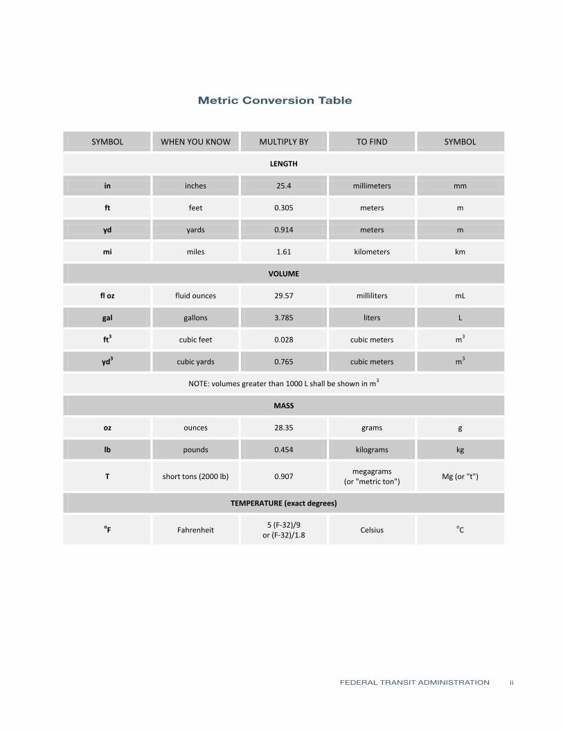
Metric Conversion Table
FEDERAL TRANSIT ADMINISTRATION ii
Metric Conversion Table
SYMBOL WHEN YOU KNOW
in inches
ft feet
yd yards
mi miles
MULTIPLY BY
LENGTH
254
0305
0914
161
VOLUME
TO FIND
millimeters
meters
meters
kilometers
SYMBOL
mm
m
m
km
fl oz fluid ounces 2957 milliliters mL
gal gallons 3785 liters L
3ft3 cubic feet 0028 cubic meters m
yd3 cubic yards 0765 cubic meters m 3
NOTE volumes greater than 1000 L shall be shown in m3
MASS
oz ounces 2835 grams g
lb pounds 0454 kilograms kg
megagrams T short tons (2000 lb) 0907 Mg (or t)
(or metric ton)
TEMPERATURE (exact degrees)
5 (F-32)9 oF Fahrenheit Celsius oCor (F-32)18
FEDERAL TRANSIT ADMINISTRATION ii
REPORT DOCUMENTATION PAGE Form Approved OMB No 0704-0188
Public reporting burden for this collection of information is estimated to average 1 hour per response including the time for reviewing instrucshytions searching existing data sources gathering and maintaining the data needed and completing and reviewing the collection of information Send comments regarding this burden estimate or any other aspect of this collection of information including suggestions for reducing this burden to Washington Headquarters Services Directorate for Information Operations and Reports 1215 Jefferson Davis Highway Suite 1204 Arlington VA 22202-4302 and to the Office of Management and Budget Paperwork Reduction Project (0704-0188) Washington DC 20503
1 AGENCY USE ONLY 2 REPORT DATE July 2011
3 REPORT TYPE AND DATES COVERED August 2006 - October 2009
4 TITLE AND SUBTITLE Remote Infrared Audible Signage Pilot Program
5 FUNDING NUMBERS WA-26-7010
6 AUTHOR(S) Michael Miller
7 PERFORMING ORGANIZATION NAME(S) AND ADDRESSE(ES) Sound Transit 401 S Jackson St Seattle WA 98126
8 PERFORMING ORGANIZATION REPORT NUMBER
FTA Report No 0012
9 SPONSORINGMONITORING AGENCY NAME(S) AND ADDRESS(ES) US Department of Transportation Federal Transit Administration East Building 1200 New Jersey Avenue SE Washington DC 20590
10 SPONSORINGMONITORING AGENCY REPORT NUMBER
FTA Report No 0012
11 SUPPLEMENTARY NOTES Available Online [httpwwwftadotgovresearch]
12A DISTRIBUTIONAVAILABILITY STATEMENT Available From National Technical Information Service (NTIS) 5285 Port Royal Road Springfield VA 22161 NTIS Sales Desk 1-800-553-6847 or (703) 605-6000 fax (703) 605-6900 TDD (703) 487-4639 Email [infontisgov]
12B DISTRIBUTION CODE
TRI-30
13 ABSTRACT The Remote Infrared Audible Sign Model Accessibility Program (RIAS MAP) is a program funded by the Federal Transit Administration (FTA) to evaluate the effectiveness of remote infrared audible sign systems in enabling persons with visual and cognitive disabilities to travel independently The subject for this report is the continuation of this evaluation through using a more comprehensive multi-modal public transportation environment for measuring effectiveness The wayfinding product evaluated is the RIAS technology with the registered trade name Talking Signs (Talking Signs Inc) There are two main goals for this project 1) Measure the effectiveness of the Sound Transit RIAS system by using persons with visual or cognitive disabilities to test the installed system and provide feedback as well as by observing the testersrsquo ability to use the system during structured testing and 2) Measure cost implications for future expansion of the RIAS system for both Sound Transit and other regional public transit agencies
14 SUBJECT TERMS Remote Infrared Audible Signage RIAS wayfinding blind partially sighted visushyally impaired talking signs
15 NUMBER OF PAGES 52
16 PRICE CODE
17 SECURITY CLASSIFICATION OF REPORT Unclassified
18 SECURITY CLASSIFICATION OF THIS PAGE
Unclassified
19 SECURITY CLASSIFICATION OF ABSTRACT
Unclassified
20 LIMITATION OF ABSTRACT
FEDERAL TRANSIT ADMINISTRATION iii
TABLE OF CONTENTS
1 Executive Summary
6 Section 1 Introduction
8 Section 2 RIAS System Description
12 Section 3 Human Factors Testing amp Evaluation (HFTE) Procedures
13 Participant Training 14 ObservationalInteractive Research 14 Extended-User Research (Post-Trial Interviews)
15 Section 4 Human Factors Testing amp Evaluation (HFTE) Results 15 ObservationalInteractive Research Results Summary 16 Extended User Research Summary 16 Issues and Lessons Learned 17 Analysis by Others
18 Section 5 Existing Wayfinding Technology Review
18 Infrared (IR) and Light Emitting Signs 18 Talking Signs 19 Talking Lights 19 Radio Frequency (RF) Signs 19 Step-Hear 20 Bar-Coded Signs 20 University of California and Smith-Kettlewell Eye Research Institute
Color Marker and bar Code System 20 GPS-Based Systems 20 Loadstone GPS 21 Wayfinder Access 21 Trekker 21 BrailleNote GPS 21 Mobile GEO 22 Research Projects 22 University of South Florida Travel Assistance Device (TAD) 22 Trinetra 22 NOPPA 23 Brunel University Navigation System 23 Drishti 23 Transit Location and ScheduleData 24 Current Trends for Wayfinding Technology 25 Summary of Wayfinding Technology Review
28 Section 6 Cost Benefit Analysis 28 Introduction 29 Evaluation of Potential Wayfinding System Users in the Puget Sound
FEDERAL TRANSIT ADMINISTRATION iv
29 Potential Cost Savings for Paratransit Services 30 Wayfinding System Costs 30 Talking Signs Costs 31 Step-Hear Costs 31 Talking Lights Costs 31 GPS-Based System Costs 32 Wayfinding Systems Cost Comparison Summary 32 Talking Signs and Step-Hear Cost Comparison 34 Wayfinding Systems Implementation Risks 36 RIAS Installation Evaluation for Remainder of Sound Transit Facilities 37 RIAS Installation Evaluation at Other Regional Public Transportation Facilities 38 Results of the Analysis
40 Section 7 Recommendations
41 References
42 Appendix Diagram of Typical Installation
FEDERAL TRANSIT ADMINISTRATION v
LIST OF FIGURES
9 Figure 2-1 Transmitter located at paratransit stop at Everett Station
9 Figure 2-2 Transmitter installed to identify ticket vending machine at Everett Station
10 Figure 2-3 RIAS receiver with a neck strap
10 Figure 2-4 Talking Signs transmitter for Bus Bay 6 at Federal Way Transit Center
10 Figure 2-5 RIAS transmitters in this area of Kent Station identify and locate the elevator to the pedestrian bridge and stairs down to the street crossing that leads to a shopping center
11 Figure 2-6 Controllers for low-voltage Talking Sign transmitters installed in basement of Everett Transit Center
11 Figure 2-7 Transmitters at Bellevue Transit Center
LIST OF TABLES
13 Table 3-1 RIAS Testing Task Groups
29 Table 6-1 Statistics on Persons with Visual Impairment and Cognitive Disabilities in Puget Sound
30 Table 6-2 Paratransit Costs and Potential Savings
30 Table 6-3 Talking Signs System History of Costs
31 Table 6-4 Talking Signs Material Costs
31 Table 6-5 Step-Hear Material Costs
32 Table 6-6 GPS-Based System Costs
32 Table 6-7 Sound Transit Wayfinding System Installation Cost Comparison
33 Table 6-8 Caltrain San Jose Diridon Station Wayfinding System Installation Cost Comparison
33 Table 6-9 Sound Transit Wayfinding System Installation Cost Comparison
37 Table 6-10 Sound Transit RIAS Costs for Remaining Facilities and Vehicles
38 Table 6-11 Estimated RIAS Costs for Regional Facilities
FEDERAL TRANSIT ADMINISTRATION vi
FOREWORD
In 2007 Sound Transit the Central Puget Sound Regional Transit Authority received a Research and Technology Grant from the Federal Transit Administration to conduct a model program to install and evaluate Remote Infrared Audible Signage (RIAS) Sound Transit installed the technology at nine multi-modal facilities in the Central Puget Sound Region This report describes the design installation and user testing of technology
ABSTRACT
The Remote Infrared Audible Sign Model Accessibility Program (RIAS MAP) is a program funded by the Federal Transit Administration (FTA) to evaluate the effectiveness of remote infrared audible sign systems in enabling persons with visual and cognitive disabilities to travel independently The subject for this report is the continuation of this evaluation through using a more comprehensive multi-modal public transportation environment for measuring effectiveness The wayfinding product evaluated is the RIAS technology with the registered trade name Talking Signs (Talking Signs Inc) There are two main goals for this project 1) measure the effectiveness of the Sound Transit RIAS system by using persons with visual or cognitive disabilities to test the installed system and provide feedback as well as by observing the testersrsquo ability to use the system during structured testing and 2) measure cost implications for future expansion of the RIAS system for both Sound Transit and other regional public transit agencies
FEDERAL TRANSIT ADMINISTRATION vii
EXECUTIVE SUMMARY
EXECUTIVE Purpose SUMMARY The Remote Infrared Audible Sign Model Accessibility Program (RIAS MAP) is
a program funded by the Federal Transit Administration (FTA) to evaluate the effectiveness of remote infrared audible sign systems in enabling persons with visual and cognitive disabilities to travel independently The subject for this report is the continuation of this evaluation through using a more comprehensive multi-modal public transportation environment for measuring effectiveness The wayfinding product evaluated is the RIAS technology with the registered trade name Talking Signs (Talking Signs Inc) There are two main goals for this project
1 Measure the effectiveness of the Sound Transit RIAS system by using persons with visual or cognitive disabilities to test the installed system and provide feedback as well as by observing the testersrsquo ability to use the system during structured testing
2 Measure cost implications for future expansion of the RIAS system for both Sound Transit and other regional public transit agencies
Based upon these two main purposes from the RIAS MAP this report contains the following
bull Summary of the Sound Transit RIAS system
bull Summary of the test results from the human factors testing and evaluation (HFTE)
bullWayfinding technology review and comparison
bullCost benefit analysis for RIAS including evaluation of costs for future RIAS system expansion and comparison of costs with other wayfinding systems
bullRecommendations on future wayfinding systems upgrades for Sound Transit as well as future regional public transportation installations in the Puget Sound area
Human factors tests were conducted using participants with visual impairments or disabilities Although recruiting of persons with cognitive disabilities was completed none participated in the study Those who participated were observed during multiple pre-established tasks that they were asked to complete and their success in accomplishing these tasks was recorded At the end of each task each participant was interviewed to determine hisher response to the RIAS system A more detailed analysis of these tests based upon the results of the participant tests will be completed by Hidalgo amp De Vries (HD) In addition each participant will use the RIAS system for several weeks which is described in this report as the end-user testing of the Sound Transit RIAS system An analysis of the extended end-user tests will be completed by the Volpe National Transportation Systems Center (Volpe) A final report will be prepared by Volpe based upon all the evaluations and reports completed for this project This final report will be submitted to FTA and the US Congress for their review
FEDERAL TRANSIT ADMINISTRATION 1
Using the information gathered about available technologies for wayfinding systems the associated benefits to persons with visual or cognitive disabilities the cost implications for future funding of wayfinding systems and recommendations contained in this report FTA and Sound Transit are able to make informed decisions in determining future implementation of RIAS or other potential wayfinding systems for public transportation
RIAS System Description The RIAS system tested for this project was the Sound Transit RIAS system which has been installed at several transit facilities The RIAS system uses infrared transmitters that provide directional information to a mobile receiver that then decodes the information and provides it in an audible form to the user
The Sound Transit RIAS system consists of 303 transmitters located at or near six stations or transit centers and placed to provide location and feature identification of different amenities of the station For example ticket vending machines and bus bays are provided with a transmitter nearby to provide directional information to the user about that item or location Some transmitters were already placed at the King Street station for the initial pilot installation
Five transmitters were placed at bus stopsshelters outside the stationtransit transmitters which were to provide item identification of these locations In addition 8 more transmitters were placed at crosswalks adjacent to two of the transit centers and provide information to the traveler regarding when to cross the street by integrating the RIAS system with the existing crosswalk signaling system As-built drawings for sign locations at each facility for Sound Transit are in Appendix A
Human Factors Testing amp Evaluation (HFTE) Procedures Detailed subject qualification interviews and testing procedures were developed then reviewed by the Washington State Institutional Review Board (IRB) and followed for three test task groups to obtain information about how effective the RIAS system performs Participants were recruited from advocacy organizations in the Puget Sound area for persons who are blind or have visual impairments or disabilities and by using intercept recruitment at two of the transit centers Recruitment of participants with cognitive disabilities was unsuccessful Training was given to each participant prior to the tests to provide a more accurate model of actual RIAS system performance
Human Factors Testing amp Evaluation (HFTE) Results This report focuses on providing a summary of the test results from observers and associated participant interviews More analysis on the results of these tests has been completed by Hidalgo amp De Vries and additional end-user testing will
FEDERAL TRANSIT ADMINISTRATION 2
be evaluated by the Volpe National Transportation System Center The human factors tests were grouped into three main areas as described below
Observer Research Observers accompanied the participants during the tests and evaluated their successes and failures in accomplishing the different navigation tasks using the RIAS system The results were documented and a summary of this evaluation is contained in this report In navigating their environment using the RIAS system overall the participants were successful in accomplishing the majority of the tasks given without assistance Some issues existed because of reflections of the RIAS signal power loss to some of the audible signs and some areas that did not have enough audible signs for some participants to find their destination without assistance
Participant Interview Results Interviews with participants were conducted after they completed several navigation tasks Overall the participants were pleased with the usability of the RIAS system Some participants expressed the need to install additional signs around the transit centers such as at the crosswalks and some areas around the transit center Some areas that had limited signal strength or limited ability to mount audible signs were found to be more difficult for the participants to navigate
Extended-User Research Post-trial interviews were conducted after each participant had evaluated the RIAS system for several weeks and the following summarizes their feedback on the system
bullOverall the participants were very satisfied with the RIAS system and their role in the study and on a 10-point scale (with 10 as the best experience) the average rating was 682
bull An increased number of participants stated they would use the RIAS system if they did not have to pay out-of-pocket for the RIAS receivers
bull Further implementation of the RIAS system region-wide was also a factor for increasing the number of participants that stated they would use the system
More qualitative analysis on extended end-user results will be completed and evaluated by Volpe Once this evaluation is completed a final report will be prepared by Volpe and submitted to FTA and the US Congress
Wayfinding Technology Review
A detailed review of existing wayfinding technology was conducted to provide a basis for recommendations on future installation of Talking Signs on transit
FEDERAL TRANSIT ADMINISTRATION 3
vehicles and transportation facilities Many technologies are currently under evaluation and development however many of these are not viable options for implementation at this time The following are the types of systems considered in this report
bull Infrared (IR) and light emitting signs
bull Radio frequency (RF) or Wi-Fi signs
bull Bar-coded signs
bull GPS-based systems
bull Research projects
The technologies that were considered the most viable options were Talking Signs Talking Lights (Talking Lights LLC) Step-Hear (Step-Hear Ltd Israel) for indoor navigation and on-board buses and using GPS-based integrated solutions for outdoor navigation Technology for wayfinding appears to be headed towards more integrated technologies with GPS-assisted solutions with higher location accuracy Because of this some integration with a GPS-based system is the more promising option for implementing a wayfinding system in a public transportation environment from a long-term viewpoint GPS technologies provide a coarser granularity of user placement which must be combined with mapping technologies to provide effective wayfinding directions while RIAS provides a finer granularity and specific direction to facility amenities and specific directions to places of interest
Cost Benefit Analysis A cost benefit analysis was completed to provide a basis for recommendations for installing Talking SignsRIAS systems in the future A comparison of the costs for several main technologies currently available was considered as part of this analysis These other technologies included Talking Lights Step-Hear and some integrated GPS-based solutions The risks and benefits of each type of system were evaluated and it was determined that using either Talking Signs Talking Lights or Step-Hear for indoor installations in combination with a GPS-based solution that uses an accessible database for transit points of interest would have the greatest overall long-term benefit for the cost however more cost information and analysis of the performance of each system is necessary The analysis included evaluating the potential number of users of the RIAS or other wayfinding systems in the Puget Sound area on public transportation systems and determining the cost savings in reducing paratransit service costs
A wayfinding system that enables people with visual or cognitive disabilities to travel independently within a public transit system environment provides some obvious benefits to these groups of people Because of this the focus of the cost benefit analysis was to evaluate other systems that could provide a similar benefit to these same groups of people in the Puget Sound for the least amount of cost
FEDERAL TRANSIT ADMINISTRATION 4
and provide a system that will be easily upgradeable in the future as technology advances
Other parts of this analysis included evaluating the potential costs for installing RIAS on the remainder of Sound Transitrsquos facilities and for regional public transportation installation Other Puget Sound area transportation agencies were contacted and given these costs to determine their interest and overall feasibility in implementing a RIAS system for the entire public transportation system in the Puget Sound area Overall the ability to fund the RIAS system was low
The results of this analysis show there is justification for consideration of other wayfinding technologies that could provide a similar system to RIAS at a lower cost Additional analysis of costs and overall effectiveness of these other technologies is needed prior to deciding which technology to implement Currently the RIAS system is the only wayfinding system that has been proven to be successful in navigating persons with visual impairments or disabilities however with current trends in technology in mind integration with GPS technologies will be likely for the long term
Recommendations for Future Upgrades Based upon the HFTE the wayfinding technology review and the cost benefit analysis recommendations are provided to assist Sound Transit and FTA in deciding on future wayfinding systemsrsquo implementation for public transportation The following are the main recommendations
bull Begin the next phase of the RIAS MAP to continue expansion of the system and to further evaluate the RIAS system and include funding for further evaluation of other wayfinding systems
bull Further evaluate Step-Hear and Talking Lights existing installations as well as other similar systems that were installed at the time of the evaluation Conduct additional research on these systems
bull Further evaluate the effectiveness and costs in using a GPS-based solution for outdoor navigation in combination with Talking Signs Talking Lights or Step-Hear for indoor and bus applications
bullExpand the wayfinding system once evaluations are complete and funding is in place
FEDERAL TRANSIT ADMINISTRATION 5
SECTION
1SECTION Introduction 1
Remote Infrared Audible Signs (RIAS) has emerged as a method for providing wayfinding information for persons with visual or cognitive disabilities Typically this technology has been used for transit purposes in assisting these persons in their travel needs
In 2003 and 2004 Sound Transit completed a demonstration project of the RIAS system at two of its facilities using Talking Signs technology The audible signs were placed at the King Street Station the International District Station the Weller Street pedestrian bridge and the International District Plaza Forty transmitters were installed and end-user testing was conducted for this initial system The results which were in the form of feedback given by the end-users were very positive In addition input was received as the result of joint workshops and public outreach efforts conducted by Sound Transit
Based upon the success of the demonstration project and the feedback from the public Sound Transit decided to apply for a federal grant to conduct the RIAS Model Accessibility Program (MAP) Funding was provided by the Federal Transit Administration (FTA) through Congressional legislation as part of the Safe Accountable Flexible and Efficient Transportation Equity ActmdashA Legacy for Users (SAFETEA-LU) Congress authorized the RIAS MAP to evaluate the impact of RIAS technology on the overall quality of life for people who are blind or who have visual or cognitive disabilities
This report includes the results from the tests of persons with visual or cognitive disabilities who used the extended RIAS Sound Transit system The RIAS system was expanded at the following Sound Transit facilities and crosswalks to provide a system that could be tested and evaluated in a multi-modal public transportation environment
bull Everett Station
bull King Street Station
bull Kent Station
bull Tacoma Dome Station
bull Bellevue Transit Center
bull Federal Way Transit Center
bull King Street Amtrak Platform
bull Downtown Seattle bus stops
bull Crosswalk installations at King Street and Everett stations
FEDERAL TRANSIT ADMINISTRATION 6
SECTION 1 INTRODUCTION
Originally installations at SEATAC Airport Overlake Transit Center Lynnwood Transit Center and Auburn Station and audible signs on buses were to be completed however budget constraints based upon the original cost proposal from Talking Signs did not allow installation at these facilities or on buses
The purpose of this project was to evaluate the benefits ease of use and overall effectiveness of RIAS technology in a multimodal application Qualitative Human Factors Testing amp Evaluation (HFTE) was used as the primary research methodology Separate participant groups in the study took part in one-day trials during which they navigated their way through different transit stations and facilities Previous quantitative testing of the RIAS technology has been conducted
There are two main goals that are a part of the evaluation of the RIAS system extension for Sound Transit The first goal was to measure the ability of participants with visual or cognitive disabilities and their ability to effectively use the system and to obtain participant response regarding their satisfaction with the system This was accomplished by having observers determine the ridersrsquo ability to use the system based upon whether successful completion of navigation tasks was accomplished with minimal use of any other assistance besides the use of the RIAS system Detectionobservation of other features and amenities of the sites that were encountered during the navigation test were also noted during the test Interviews with the persons who participated in the tests were conducted to record their responses regarding the effectiveness of the RIAS system This report provides a summary of the results from these tests and determines whether they indicate that the project was successful and if further installation for Sound Transit and other regional transit facilities is recommended
Extended analysis of the results of the tests will be conducted by Hidalgo amp De Vries and the Volpe National Transportation Systems Center after which Volpe will prepare a final report that will be submitted to FTA and the US Congress The extended analysis will include analyzing the effect of RIAS in improving the quality of life for persons with visual impairments or disabilities and with developmental or cognitive disabilities
The second goal of this evaluation was to determine the cost implications for future expansion of the RIAS system for the remaining Sound Transit commuter rail express bus and new light rail facilities as well as for other regional transit agencies such as the Port of Seattlersquos SEATAC Airport the Washington State Ferry system King County Transit Community Transit and Pierce Transit A review of costs and benefits of the RIAS system and a comparison with other technologies was completed to provide the basis for the recommendations included in this report
FEDERAL TRANSIT ADMINISTRATION 7
SECTION
2SECTION
2 RIAS System Description
RIAS is a system provided by Talking Signs Inc and includes infrared transmitters and associated hand-held receivers that help people with visual or cognitive disabilities to navigate through their environment The transmitters are installed within a given environment on or near specific features such as elevators train boarding platforms ticket vending machines drinking fountains etc Mobile receivers are then used to guide users through the environment Dynamic Talking Signs which change their announcements have been integrated into Variable Message Boards (VMB) and have been installed at other transit agencies
The Talking Signs RIAS technology requires that an Orientation and Mobility (OampM) specialist survey the sites to direct the location of the signs with attention given to several aspects of the site installation including
bull Wayfinding including direction instructions and identification of dangers
bull Location of amenities and features
bull Identification of amenities and features
The Sound Transit RIAS system was installed at six transit centers and included a total of 316 transmitters at these locations including installation at nearby bus stops and crosswalks The installation required placement of conduit as well as cabling for powerdata to the transmitters and mounting hardware for the transmitters The transmitters are manufactured in two different types One type called the stand-alone type has the message built-in and requires only 120 VAC power cabling for operation The second type or control-type uses low-voltage data cabling for power and transmitting of the programmed message Each programmed message for this type is contained in a separate device within a central cabinet This central cabinet houses multiple messages that connect to multiple control-type transmitters There were also 60 hand-held receivers provided as part of this Sound Transit RIAS system These receivers have several operating features A button positioned on the top of the receiver is pressed down and held while scanning for transmitters Speakers which are located on the top of the receiver as well provide the audible messages from the transmitters A control switch on one side of the receiver turns the receiver on and off adjusts the volume levels of the audible message On the opposite side of the receiver is an audio jack for connecting earphones if the user does not want the messages transmitted through the speakers on the top The front of the receiver has infrared sensors that are used to pick up the messages from the transmitters
FEDERAL TRANSIT ADMINISTRATION 8
SECTION 2 RIAS SYSTEM DESCRIPTION
Following are photographs that show some of the transmitter installations at Sound Transit facilities and of a typical receiver Drawings that show the final locations of each transmitter by transit stationfacility are shown in Appendix A
Figure 2-1 Transmitter located
at paratransit stop at Everett Station
Figure 2-2 Transmitter installed
to identify ticket vending machine at
Everett Station
FEDERAL TRANSIT ADMINISTRATION 9
Figure 2-3 RIAS receiver with a
neck strap
Figure 2-4 Talking Signs
transmitter for Bus Bay 6 at Federal Way
Transit Center
Figure 2-5 RIAS transmitters
in this area of Kent Station identify and
locate elevator to pedestrian bridge and stairs down to street crossing that leads to
shopping center
SECTION 2 RIAS SYSTEM DESCRIPTION
FEDERAL TRANSIT ADMINISTRATION 10
Figure 2-6 Controllers for
low-voltage Talking Sign transmitters
installed in basement of Everett Transit
Center Existing communications
conduit was used to run low-voltage
wiring to transmitter locations on bus
bay platforms each central controller runs
12 transmitters
SECTION 2 RIAS SYSTEM DESCRIPTION
Figure 2-7 Transmitters at Bellevue Transit
Center Transmitter on right identifies Bus
Bay 6 while other transmitter provides
direction towards other bus bays and
facilities for this transit center
FEDERAL TRANSIT ADMINISTRATION 11
SECTION
3SECTION
3 Human Factors Testing amp Evaluation (HFTE)Procedures
The testing procedures used were developed in accordance with best practices and then approved by the Washington State Institution Review Board to meet requirements established for tests where human subjects are involved These tests on the RIAS system were conducted with staff from Sound Transit LM Telecommunications and Hidalgo amp De Vries Each person assisting with the testing of the system was trained and certified to perform the tests with human subjects by both the National Institutes of Health (NIH) and the Collaborative Institutional Training Initiative (CITI)
The sample frames considered with these tests consisted of 19 persons who are blind or have visual impairments or disabilities This report focuses on the human factors testing and evaluation with respect to the RIAS installation Volpe will conduct the extended end-user research for this installation The method used in evaluating the results of the observer research and post-trial interviews is based upon an approach known as SITE (Charlton 1991) The SITE method supports the design of human factors testing and the interpretation of test results by defining human factors test issues within the four following attributes
1 Situation this defines what the relevant elements are in the environment stimuli setting events system functions or goals
2 Individual this defines who is using the equipment including information about their skills training and cognitive state
3 Task this defines how the equipment is used and what behaviors are associated with the use of the equipment in relative termsmdashfor example how hard how fast how much
4 Effect this describes the success or failure and satisfaction or disappointment associated with the test
The goal of the tests was to provide a method of determining the effectiveness of the RIAS system in providing guidance to the test subjects There were three task groups of tests considered for the observationinteractive research phase of the testing as shown in Table 3-1 Each subtask was created to simulate tasks that would be required by the RIAS user in a multi-modal transportation environment For example each task assumed that the user had arrived at a particular transit facility by train bus on foot or was dropped off by private vehicle at the transit facility
FEDERAL TRANSIT ADMINISTRATION 12
- -
- -
- -
SECTION 3 HUMAN FACTORS TESTING amp EVALUATION (HFTE) PROCEDURES
Table 3-1 Task Group 1 RIAS Testing Task
Groups Task
Station Transit Facility
Sub task Sub task Description
1 King
Street Station
1-1 1-2 1-3
bull From Sounder ADA platform find South TVM bull From TVM locate 4th Ave crosswalk bull Locate stairs leading to Bus Bay C south and Bus Bay D East I-90
Transport participant to Bellevue Transit Center
2 Bellevue Transit Center
2-1 2-2
bull From northwest end of platform find customer service window bull From customer service window find Bus Bay 7
Task Group 2
Task
Station Transit Facility
Sub task Sub task Description
1 Kent Station
1-1
1-2
bull From West Park amp Ride cross pedestrian bridge and locate Track 2 Sounder SeattleEverett bull From TVM find second boarding sign on Track 2 Sounder SeattleEverett
Transport participant to King Street Station
2 King
Street Station
2-1
2-2
bull From Northbound Sounder ADA platform locate stairs up to South Jackson
bull At top of stairs walk to Jackson Street crosswalk
Task Group 3
Task
Station Transit Facility
Sub task Sub task Description
1 Tacoma Dome Station
1-1
1-2 1-3
bull Walk from LINK light rail stop to unisex bathroom located in Information Center bull From Information Center locate 25th St crosswalk bull Proceed across 25th St and locate Sound TVM
Transport participant to Federal Way Transit Center
2
Federal Way
Transit Center
2-1
2-2
bull From Park amp Ride parking area locate sign for uncontrolled crosswalk to bus platforms
bull From center of bus platform locate Bus Bay 6
Participant Training Prior to conducting the tests each participant was trained in the use of the RIAS receiver Each training session consisted of a training facilitator an OampM specialist and at least two training assistants To increase the amount of ldquohands-onrdquo interaction no more than eight participants were used in each training session The Talking Signs Guide for Trainers was followed as the training manual for participant training This training manual is considered the most
FEDERAL TRANSIT ADMINISTRATION 13
SECTION 3 HUMAN FACTORS TESTING amp EVALUATION (HFTE) PROCEDURES
comprehensive reference for use by people who teach others to use the RIAS technology and Talking Signs According to a 1995 study (Crandall et al) ldquothose who receive direct instruction for 15 to 2 hours are more proficient in their use of the [RIAS] systemrdquo Each participant was trained until heshe could successfully use the RIAS system It does not take much time to learn how to use the Talking Sign system and this training assisted in providing a simulation of persons navigating their way that are familiar with the use of the system which is a better simulation of what will be experienced in real life by the frequent user of the system
ObservationalInteractive Research The staff conducting the tests evaluated how well each user was able to navigate through hisher trip and filled out information about the results on prepared forms for groups 1ndash3 In each location the participants were asked to locate specific features of the transit facility Each participant was asked to complete a series of tasks based upon the task group described above For each task the observer recorded the number of transmitters located and the number of requests for assistance from the participant This was the most important part of the research process since it involves the participantrsquos actual success or failure with the RIAS system in a real-world application
The observer accompanied the participant as each task was performed The primary responsibility of the observer was to ensure the safety of the participant during the test The observer also recorded the participantrsquos performance comments and questions which were used to determine the level of success of the RIAS system The test subjects were also asked a series of questions related to their evaluation of the system after the testing was completed and the answers were recorded by the observer
Extended-User Research (Post-Trial Interviews) Once the test subjects had completed the observationalinteractive group tests they were asked to use the system for several weeks At the end of this extended use each participant assisted in filling out forms with questions related to their evaluation of the system These questions were used to assess the participantsrsquo extended experience with the RIAS system and to determine their interest in using the system in the future The answers to these questions were used in analyzing the overall success of the system
FEDERAL TRANSIT ADMINISTRATION 14
SECTION
4SECTION
4 Human Factors Testing amp Evaluation (HFTE) Results
The majority of the test results showed a positive indication that the RIAS system works well in providing people who are blind or who have visual impairments or disabilities with more independence in their travel The results are summarized into two areasmdashthe observationalinteractive research and the participant post-trial interviewmdashas described in the previous section of this report This report provides a summary of the results from these tests as well as some of the issues and lessons learned with the system Detailed HFTE test results and analyses are contained in a report completed by Hidalgo amp De Vries Overall the results of all the tests were fairly positive The participants felt pleased with the effectiveness of the RIAS system and comments suggested there is room for improvement in some areas
ObservationalInteractive ResearchResults Summary For Group 1 the participants were able to locate the majority of the audible signs at the King Street Station and all of the audible signs at the Bellevue Transit Center with no problems One audible sign at King Street Station that identifies the stairs leading down to the International District Bus Tunnel was not located by the participants Overall the participants were pleased with the usability of the RIAS system at these two transit centers however some expressed the need for additional signs around the transit centers At the time of the tests audible signs had not been installed for the crosswalks These signs were not installed for the King Street Station for this project and would help in addressing this need
For Group 2 the test results showed for the King Street Station that the RIAS system was effective and the participants were able to locate all of the signs without assistance The results were different for the Kent Station The participants had more difficulty locating the audible signs at this station and two of the six participants in this group found the RIAS system to be ldquonot very usefulrdquo or ldquonot at all usefulrdquo in the post-trial interviews It should be noted that one of the audible signs at the Kent Station was not transmitting the audible message
Finally in Group 3 all four participants were able to locate the audible signs at the Tacoma Dome Station and three of the four participants were able to locate all the signs at the Federal Way Transit Center without assistance One participant required assistance from the observer to locate one of the audible
FEDERAL TRANSIT ADMINISTRATION 15
SECTION 4 HUMAN FACTORS TESTING amp EVALUATION (HFTE) RESULTS
signs A power outage in part of the Federal Way Transit Center caused one of the signs used in the tests to not be operational Three of the four were able to locate the destination for the subtask using another nearby audible sign
Extended User Research Summary Of the 19 HFTE participants 11 completed post-trial interviews to provide their feedback on the extended use of the RIAS system The participants rated their overall satisfaction with the RIAS system on a 10-point scale with 10 as the best experience and 1 as the worst experience The average rating was 682 with a high rating by one participant of 10 and a low rating of 3 The following are the most significant items from the participant interviews
bull Overall the participants were very satisfied with the RIAS system and their role in the study
bull The majority of participants would not use the RIAS system if they had to pay out-of-pocket for a RIAS receiver
bullThe majority of participants would use the RIAS system if the RIAS receiver was provided free of charge
bull If the RIAS system was available at the rest of Sound Transitrsquos facilities more participants would use the RIAS system
Issues and Lessons Learned There were several issues that were encountered during the HFTE tests At two stations there were problems with some of the audible signs not being operational Most of these seemed to be related more to maintenance issues from temporary power outages while maintenance was repairing nearby lighting damage This would likely be a continuing issue as maintenance at each station is needed and power to the audible signs would need to be temporarily disconnected For their safety travelers who are blind or who have visual impairments or disabilities would need to be notified in some way when these conditions occur
Another issue that occurred was that there were reflections of the RIAS signals in some instances which create a potential hazard to the traveler One instance in particular occurred when a RIAS signal reflected off a person wearing a reflective jacket who was standing in front of the participant during testing This caused the signal to transmit to the participantrsquos receiver coming from the opposite direction intended by the RIAS system which caused the participant to become confused about the direction needed to walk to reach the destination Reflections off articles of clothing are likely to occur every now and then particularly when walking through crowded areas which is common at the Sound Transit multimodal facilities Reflections of the RIAS signals also seem to occur when the signal reaches metallic objects Items at transit facilities that would
FEDERAL TRANSIT ADMINISTRATION 16
SECTION 4 HUMAN FACTORS TESTING amp EVALUATION (HFTE) RESULTS
reflect the RIAS signal include elevator doors support columnsbeams and roofs and certain parts of ticket vending machines In some instances reflections are used as an installation method such as pointing transmitters at elevator doors to guide persons to elevators where the transmitter cannot be located above the doors Any highly-polished surface can reflect the IR transmissions
Issues were found with some of the RIAS signals being blocked by objects At the King Street Station there were temporary vinyl banners that had been placed in the bridgewalkway leading down to the platforms which prevented the receiver from picking up the audible message Other objects that blocked RIAS signals included concrete structures wallsbuildings shelters and structural supports
Overall it seems that placement and setting the direction and adjusting the strength of the audible signs signal is the key to reducing these reflections and avoiding objects that may block the signal There are problems however in some transit facility locations where it becomes difficult to place the audible signs in a way that they can effectively function In addition future placement of objects at each facility should not be completed without some consideration regarding the effects these objects will have on RIAS system performance
The RIAS signals also seemed to be affected to some degree by sunlight In one instance the signal strength of one sign appeared to be stronger during cloud cover than it was with more sunlight or a brighter sky behind the transmitter location One issue that was mentioned by some of the participants was that there were not enough audible signs in some locations It was a great to provide audible signs at all locations in the Tacoma Dome Station in particular because of large open walking areas with nothing that could be used for mounting the sign In addition there were budget constraints that limited the number of audible signs installed
Analysis by Others The Volpe Institute will be determining the practical operation of the RIAS technology and its benefits In addition Hidalgo amp De Vries has conducted a more detailed review of the human factors tests This project requires a report to the US Congress by the Secretary of Transportation which will be finalized by Volpe with this report and Hidalgorsquos report provided as input to the final Volpe report The following are the evaluation points Volpe will be considering
bull The effect on multimodal accessibility in public transportation with regard to persons with visual cognitive and learning disabilities
bullThe effect on making public transportation accessible to persons with visual cognitive and learning disabilities who use public transit and paratransit
bull The effect on education community integration work life and general quality of life of the targeted populations
FEDERAL TRANSIT ADMINISTRATION 17
SECTION
5SECTION
5 Existing WayfindingTechnology Review
As part of an evaluation in recommending further investment into RIAS technology it is important to consider the existing technology that is available or under development for wayfinding systems for people who are blind or who have visual or cognitive disabilities These systems can be divided into several categories
bull Infrared (IR) and light emitting signs
bull Radio frequency (RF) or Wi-Fi signs
bull Bar-coded signs
bull Gps-based systems
bull Research projects
This review has considered only wayfinding technologies that would have a benefit similar to that provided by Talking Signs In other words the focus of this review has been on technology for orientation and navigation with a particular focus on systems that provide orientation and navigation for public transportation facilities
Infrared (IR) and Light EmittingSigns One technology that has developed with great promise is audible signs that transmit infrared or light signals that can be decoded by a receiver The transmitted information is converted to an audible message that is played on a receiver to the person with visual impairments or disabilities Two types of these systems that are currently in operation have been reviewed for this report Talking Signs and Talking Lights (Talking Lights LLC)
Talking Signs Talking Signs has emerged as a promising technology that can provide localized directional information and item identification to persons with visual impairments or disabilities There have been many studies and tests with human subjects to determine the effectiveness and value associated with using this system This system has developed to the greatest degree in the marketplace and in the number of system implementations which gives it an advantage over other similar competing technologies
FEDERAL TRANSIT ADMINISTRATION 18
SECTION 5 EXISTING WAYFINDING TECHNOLOGY REVIEW
The Talking Signs system has been used in many transit environments and has the capability to provide easily-updated message information such as changes in bus numbers or routes for a particular bus The system has also been embedded in visual message signs to match the messages displayed Many studies have been completed for this system and it has been shown to be of benefit to travelers with visual impairments or disabilities The main drawback to using this system is that it is costly Talking Signs has established relationships with other companies to continue to develop the system to make sure it continues to transition to a more open architecture environment to be used with other transit systems in the future More detailed information about this system including a description of the Sound Transit Talking Sign system is provided in Section 3
Talking Lights Talking Lights is a system developed by a team at MIT that uses ordinary lights and embeds a signal that can be decoded by a receiver The system is a high-resolution tracking system that uses PDAs with audio direction software The advantage of this technology is that there are no wires needed to install facilities can use their existing lighting infrastructure and the light bulbs do not consume any additional energy to perform their function
While this appears to be promising technology that could be more easily implemented by modifying existing lights within a facility it is still new This system has had success for patients at the Spaulding Rehabilitation Hospital in Boston and there is currently a study going on at the Decatur Hospital in Georgia Other plans include developing a system for museums In addition this system seems to be used only for indoor applications although Talking Lights has teamed with the Sendoro Group to provide an outdoor navigation system
Radio Frequency (RF) Signs Step-Hear Step-Hear is a new product that debuted in August 2008 at the World Blind Union 7th Assembly in Geneva Switzerland This product is similar to Talking Signs in that it uses a base transmitter to send directional information to a hand held receiver The system uses radio frequency signals transmitted by the base transmitter provided in a directional nature to transmit information about the location of the transmitter
This system also seems to have a few more features than Talking Signs The receiver vibrates when it is within range (about 12 ft) of a base transmitter and for bus installations a red light is activated to notify the bus driver that a person needing help entering the bus is within range of the transmitter In addition the base unit can be integrated with the bus GPS and speaker systems Changing
FEDERAL TRANSIT ADMINISTRATION 19
SECTION 5 EXISTING WAYFINDING TECHNOLOGY REVIEW
the messages appears to be quite simple using a built-in switch and button that when used together will allow modification of the message
One drawback to this technology is that it has not yet been fully deployed and has yet to be proven as a viable option in the marketplace There is currently an installation ongoing for a bus system which is reportedly showing success A full report on this project was promised to be provided once the project was completely installed tested and operating on the system Information about this system was limited at the time of this report and further review of the installation on the bus system should be completed when available
Bar-Coded Signs University of California and Smith-Kettlewell EyeResearch Institute Color Marker and Bar Code System
This system is still in the research stage of development and cannot be considered as a viable alternative at this point However the system does show some promise in the future for providing a beneficial cost-effective wayfinding system The system is based on a cell phone that detects color markers placed throughout the environment These markers are detected by the cell phone at a distance of several meters away The purpose of the color marker is not to give any information about the location of the marker but to help a person with visual impairments or disabilities to detect the marker A bar code is then placed near the marker and the cell phone can decode and receive information about the location This typically requires the user to move closer to the marker to process the information and determine location-based information
GPS-Based Systems There are many GPS-based systems that travelers with visual impairments or disabilities can use to assist in guidance to a destination There are a few that are commercially available and many others still being developed All systems are for outdoor use only with very limited capability indoors due to lack of GPS satellite signal These systems continue to advance with greater accuracy including WAAS corrections which can provide 2ndash3 meter accuracy Common GPS for the consumer market has been tested to have a location accuracy of within 30 meters as a comparison
Loadstone GPS Loadstone GPS is open source software using satellite navigation for persons with visual impairments or disabilities The benefit to this system is that the software is free and will run on many different Nokia cell phone devices It requires a GPS receiver that connects to the cell phone by Bluetooth In
FEDERAL TRANSIT ADMINISTRATION 20
SECTION 5 EXISTING WAYFINDING TECHNOLOGY REVIEW
addition a screen reader program must be running on the cell phone such as Talks or Mobile Speak to give the user instructions
Wayfinder Access This GPS solution is similar to Loadstone however it offers more features to the traveler with visual impairments or disabilities It is a software application that uses Symbian phones to work with screen readers Other features are customized for persons who are blind or who have visual impairments or disabilities to provide them with information about surroundings including feedback on points of interest and Braille support
Trekker Trekker was developed as a personal digital assistant (PDA) application operating on a Microsoft Pocket PC operating system and was adapted to be used by persons who are blind or have visual impairments or disabilities with talking menus talking maps and GPS information Features include determination of position creating routes and receiving information about navigating to a destination A search function for points of interest is also available This application has the ability to expand to accommodate new hardware platforms and more detailed location and geographic information
BrailleNote GPS BrailleNote GPS was developed by Sendero Group and the idea behind it combines a PDA with direction software that returns audible directions to the user It uses GPS to pinpoint a personrsquos position and nearby points of interest and is about the size of a small cell phone Points of interest can be input into the system and directions to these locations can be accessed This is similar to the GPS-based direction systems for automotive use
Mobile Geo Mobile Geo works with Windows Mobile-based smartphones Pocket PC phones and other PDAs The GPS and mapping technology built into this system is from the Sendero Group It is the first solution that works with a wide range of mainstream mobile devices and it can be used with more than 20 different Braille devices for input and output It works with Mobile Speak screen reader software which is a Code Factory product It is compatible with more than 300 PDAs as well as mobile phones that operate on GSM CDMA and WCDMA networks Like other GPS-based solutions Mobile Geo pinpoints the travelerrsquos location and provides information about points of interest The benefit to this product is that it has built-in map data
FEDERAL TRANSIT ADMINISTRATION 21
SECTION 5 EXISTING WAYFINDING TECHNOLOGY REVIEW
Research Projects A number of projects are currently under development and a few of these are mentioned below The trend for wayfinding systems and technology for persons with visual impairments or disabilities is to use a combination of GPS infrared RF and other methods to provide a more complete solution for travelers with visual impairments or disabilities The systems described below are provided in this report to show this trend as well as to provide a basis for recommendations on pursuing an integrated solution using GPS and smartphone technologies with Internet capability
University of South Florida Travel Assistance Device(TAD) The University of South Florida (USF) Center for Urban Transportation Research is developing software that uses GPS technology inside cell phones to assist persons with cognitive disabilities to navigate public transportation Users can access a website that is similar to the Google Map interface where they can select their route location stop and travel times Trips are planned using this website and then downloaded to the cell phone The software developed by USF is installed on the phone and can give the rider alerts while riding the bus to prepare himher to exit the bus at the planned destination The system was tested last year with student with developmental disabilities and was quite successful
Trinetra The Trinetra project aims to create a smartphone solution that will benefit persons with visual impairments or disabilities The goals are to develop a cost-effective system This project is one to reconsider in the future since the plans are to develop a system that will assist the needs of persons with visual impairments or disabilities who uses public transportation by providing them with real-time information The concept of the system uses a combination of GPS receivers and infrared sensors that relay information to a centralized fleet management server using a cell phone The person with visual impairments or disabilities can then use a cell phone with text-to-speech capability to determine estimated time of arrival location and current bus capacity using a web browser Other research for this project is considering the use of universal product codes (UPCs) and radio-frequency identification (RFID) for indoor navigation in a shopping setting
NOPPA The NOPPA project was a three-year project (2002ndash2004) in Finland as part of the Ministry of Transport and Communications Finlandrsquos HEILI Passenger Information Program which was a pilot program to develop a system for
FEDERAL TRANSIT ADMINISTRATION 22
SECTION 5 EXISTING WAYFINDING TECHNOLOGY REVIEW
navigation and guidance for persons with visual impairments or disabilities who use public transportation It is similar in goals to the Trinetra project and uses GPS technology combined with Wi-Fi smartphone for Internet access and text-to-speech capability optional RFID reader and a database of route information to provide directional information to the user Like Trinetra it is based on a central information server concept While the pilot program was successful there are still drawbacks to this system which includes wireless and GPS not always being available in areas without line of sight or in urban canyons issues associated with having outdated information in the central database and availability of this system in the United States
Brunel University Navigation System Brunel University is developing a system that is based on the combination of several state-of-the-art current technologies including GPS and GIS The system provides automated guidance using the information from daily updated digital map datasets The difficulties with this system include the availability of up-to-date information and what information to offer with the navigation procedure Different levels of functionality have been created with this system to be able to customize the information to the user
Drishti Drishti is a wireless pedestrian navigation system developed by the University of Florida The system integrates technologies including wearable computers voice recognition and synthesis wireless networks GIS and GPS It also provides contextual information to the person with visual impairments or disabilities and computed optimized routes based on user preference traffic congestion and obstacles such as road work The system guides the user to navigate based on both available static and dynamic data This requires a spatial database that provides environmental conditions and landmark information along the travelerrsquos route The system also has the capability for the user to add information to the database
Transit Location and Schedule Data Several technologies are being developed that assist travelers in navigating a transit system Google Transit is a popular system that has developed since 2005 and now includes 70 transit agencies in 10 countries It is a web-based application that uses a database of information from each transit agency along with Google Maps to determine the best bus route or routes and times for transporting passengers to and from locations that are input online by the traveler King County Metro is already part of the Google Transit system
Sound Transit already has existing databases built for a regional Trip Planner system which uses Trapeze software for their bus routes King County Metro
FEDERAL TRANSIT ADMINISTRATION 23
SECTION 5 EXISTING WAYFINDING TECHNOLOGY REVIEW
Community Transit and Pierce Transit are also already part of this system It will not be added to the Sounder rail line until the commuter rail line is completely built out For some agencies real-time feeds are also provided for locating certain buses on routes of interest however at this time Sound Transit does not have the ability to provide these real-time feeds These systems will continue to improve in providing wayfinding information for travelers
Current Trends for WayfindingTechnology Technology today is rapidly changing It is estimated that every 18 months another set of advancements in technology will occur The wayfinding system technology is no different and this market should be frequently analyzed in order to be aware of innovative cost-effective solutions that become available to travelers with visual impairments or disabilities
Computer chips and small embedded devices are already being placed in many environmental aspects of our lives such as ldquosmartrdquo surroundings These have the ability to monitor and report conditions continually and computer chips are increasingly being found in signage They can be placed in walls poles sidewalks etc and provide information to the traveler As computer chips continue to expand in application technologies will advance to the point of providing benefit in wayfinding for persons with visual impairments
The current trend for wayfinding technology as can be seen from the GPS-based systems and research projects evaluated is to further develop and use smartphones and PDAs with Internet and GPS applications and blend several technologies to provide a complete solution for navigation The focus is on developing software applications that will run on many of the devices people carry with them already such as smart phonesPDAs The integration of Bluetooth GPS and radioWi-Fi functions in a handset provides many benefits and is the current trend The benefits include improved system performance improved cost structure power consumption savings and other savings from shared system use including ease of assembly because of shared packaging
Many applications are available for pedestrians drivers and public transportation users that continue to improve the efficiency of traveling Some of these applications can in conjunction with other technologies provide wayfinding for both travelers who are blind or who have visual impairments or disabilities as well as all travelers These types of technologies could potentially increase funding as they help a greater number of public transportation users
The GPS-based systems are continuing to be improved and other technologies are being combined with GPS to provide more accurate wayfinding information
FEDERAL TRANSIT ADMINISTRATION 24
SECTION 5 EXISTING WAYFINDING TECHNOLOGY REVIEW
Some systems use Wi-Fi to assist location determination while others use inertial sensors and cameras in areas where GPS signals may be limited It seems clear that GPS systems combined with smartphones with Internet access are the future of wayfinding systems as there are many new developments occurring to continue to increase the effectiveness of these systems For those who are blind or have visual impairments or disabilities stable low-cost technologies are important
Summary of WayfindingTechnology Review Based upon the technology review of this report there are three current options available to use for localized directional information Talking Signs Talking Lights and Step-Hear systems Other GPS-based or GPS-assisted systems using smartphones or PDA technologies using a database of points of interest seem to have the capability to provide outdoor wayfinding at a continually increasing accuracy Current accuracy taking into account WAAS corrections for reasonably-priced GPS units is about 2ndash3 meters Based upon the evaluation of RIAS technology using GPS systems would be similar to the accuracy provided by RIAS for persons with visual impairments or disabilities in determining the actual position of a particular point if WAAS corrections are taken into account Since the current trend is for ldquosmartrdquo devices the GPS-based technologies should be considered an option for providing wayfinding outdoors while using other systems for indoor navigation
The Talking Signs system still has the market advantage when compared to other localized directional information systems and is the most proven system at this time with many installations currently in place throughout the world One drawback to this system as with some other systems considered in this report is that the current trend for wayfinding technology is to integrate a number of technologies together Cell phonesPDAs are integrating with technologies including webe-mail access interactive voice response and text-to-speech technology GPS wayfinding systems digital cameras for recognition purposes palm computing and CPUs and smart-sensing environments The enhanced cell phone is becoming a handy remote device for finding information about the environment As technology continues to advance these smartphones will become smaller and less expensive with more features Modifications to the cell phone will continue to adapt to be a cost-effective and universal solution for wayfinding Another drawback for this system is that it is mainly used for item identification Information on routespaths to take are given within the messages of some of the signs however the user is not given a travel route based on his her destination information
FEDERAL TRANSIT ADMINISTRATION 25
SECTION 5 EXISTING WAYFINDING TECHNOLOGY REVIEW
The Talking Lights system is already working with Sendoro Group which provides GPS wayfinding products to integrate the two technologies This system also has the capability to integrate with a local Wi-Fi mesh network Talking Lights seems to be a cost-effective solution based upon costs that were obtained and are provided in the next section This system at this time is limited to indoorbuilding applications which makes this technology a good fit for integration with a GPS-based technology There are plans to expand the system to outdoor environments and an application of this system has already been introduced on headlights for military vehicles Some concerns for outdoors would be problems that could occur during the daylight versus at night and other light interference sources that could reduce the performance of the system however if this system is integrated with other technologies such as GPS-based technology from Sendoro Group it could prove to be a useful navigation aid for both indoor and outdoor environments An advantage that this system has over the Talking Signs system is that it acts in a similar manner to GPS-based wayfinding technologies In other words it uses more than just item identification and delivers pathroute information to the user via a central database The two main drawbacks are that the system does not have the same market presence as Talking Signs so long-term viability is a concern and the system has not been tested in a transit environment for people who have visual impairments or disabilities or cognitively disabilities
The Step-Hear system is fairly new technology that shows promise in comparison to the Talking Signs system Unlike the disadvantage Talking Lights has in outdoor applications the Step-Hear system can operate in both outdoor and indoor environments This system appears to have a few more functions than Talking Signs however it is also not fully proven in the market Once the initial installation is complete for this system another evaluation should be completed to determine its effectiveness This system also seems to be a cost-effective product like Talking Lights A comparison of costs for these three systems is provided in the next section
In summary a blending of technologies seems to be the best solution for providing people who have visual impairments or disabilities and cognitive disabilities with a wayfinding system that can be used for public transportation Smartphones or PDAs with speech-to-text capability can access via the Internet databases of information for points of interest particularly GPS coordinates and determine step-by-step instructions to the user based upon hisher GPS-determined position Google using its Google Transit database and TimeTablePublisher software for schedules and locations has already begun integrating transit points of interest just as the regional Trip Planner for the Puget Sound bus systems does and now gives users step-by-step instructions for using public transportation based upon the starting and ending points of the traveler Creating a database of transit points of interest that would aid a traveler
FEDERAL TRANSIT ADMINISTRATION 26
SECTION 5 EXISTING WAYFINDING TECHNOLOGY REVIEW
with visual impairments or disabilities would seem to be an effective solution that could be used by technologies integrated with GPS systems for wayfinding from a long-term perspective For buses however the localized item identification systems would have an advantage for those that are easily updateable with bus information although current trends with GPSAVL systems on buses are to publish bus locations online that could then be accessed via a smartphone PDA or other ldquosmartrdquo device
FEDERAL TRANSIT ADMINISTRATION 27
SECTION
6SECTION Cost Benefit Analysis 6
Introduction In completing a cost benefit analysis for something that provides social equality to a group of people a typical cost versus benefit analysis is not possible The basic benefits for a person with visual or cognitive disabilities from a wayfinding system are
bullAbility to travel with confidence and enable them to become more independent
bullOverall positive effect on quality of life
Detailed analysis on the benefits of Talking Signs as well as costs for the system have already been completed in numerous other studies including those done by the University of California Santa Barbara and the Smith-Kettlewell Eye Research Institute The results from the human factors testing at Sound Transit also show that the RIAS system was received positively by the evaluation participants as summarized in Section 5 and as detailed by the report completed by Hidalgo amp De Vries
Because of the social benefits of this type of system this cost benefit analysis will focus primarily on how well each technology performs as a wayfinding system for persons with visual impairments or disabilities and the cost implications for each of the technologies The purpose of this analysis was to evaluate these cost implications for RIAS as well as other technologies and to determine whether proceeding with expansion of a RIAS system would be the best solution to provide these benefits to persons with visual or cognitive disabilities in the Puget Sound area The cost benefit analysis provided in this report focuses on the following
bullBased on the number of people who have visual and cognitively disabilities in the Puget Sound area as well as those which use public transportation determine how many people could potentially benefit from a wayfinding technology system
bullBased on the number of people who have visual and cognitively disabilities in the Puget Sound area analyze paratransit costs for Sound Transit to determine the potential cost savings in reducing the number of persons using this service
bullBased upon the technology review compare four main products or solutions for costs and benefits and the risks with the use of each system Talking Signs Talking Lights Step-Hear and a combination of one of these three to use for just indoors and on buses with a GPS-based system for outdoor navigation
FEDERAL TRANSIT ADMINISTRATION 28
SECTION 6 COST BENEFIT ANALYSIS
Table 6-1 Statistics on
Persons with Visual Impairment and
Cognitive Disabilities in Puget Sound
Evaluation of Potential WayfindingSystem Users in the Puget Sound Information about the number of persons with visual and cognitively disabilities is summarized in Table 6-1 The number of persons with developmental disabilities for each county was obtained from Sound Transit and the statistics for the number of persons who are blind or have visual disabilities is based on percentages from the US Census Bureau on people with sensory disabilities for the tri-county area from a 2006 American Community Survey Other national percentages are from the US Cernsus Bureau 2005 measures of disability Based upon these available statistics estimated upper bounds of 4 percent of the population were used in Table 6-1 Population estimates were based upon information from the US Census Bureau
Puget Sound Region County
Total Persons with Cognitive Disabilities
Total Persons with Visual Disabilities or Blind
King 10399 74371
Pierce 4712 30927
Snohomish 3469 27076
Total 18580 132374
From these numbers it appears that there are many people who could potentially benefit from a wayfinding system in the Puget Sound region Also from the post-trial interviews the participants were likely to use the RIAS system for a range of trip purposes such as work shopping social events recreation and education
Potential Cost Savings for Paratransit Services There are cost savings that could be seen from persons who are blind or who have visual disabilities becoming more independent in their travel These costs would be related to paratransit services for these persons As more persons who are blind or who have visual disabilities become more independent they will likely use paratransit services less or not at all Information about the operating expense per revenue mile for demand response vehicles was obtained from the 2007 National Transit Database Based upon the information available from Sound Transit it is estimated that approximately 4 percent of the passenger miles represents passengers who are blind or who have visual disabilities From this estimate the total cost savings was calculated for 2007 and is shown in Table 6-2
FEDERAL TRANSIT ADMINISTRATION 29
SECTION 6 COST BENEFIT ANALYSIS
Table 6-2 Paratransit Costs
and Potential Savings (based on 2007 cost
data for demand response vehicle operating costs)
Table 6-3 Talking Signs System
History of Costs
Demand Response Transit Agency Cost per Passenger Mile 4 of Cost per
Passenger Mile Potential 2007 Cost Savings
King County Metro $424 $017 $1920000
Pierce Transit $455 $018 $630000
Community Transit $353 $014 $320000
Total $2870000
From this analysis there are significant potential annual savings in providing a wayfinding system for persons who are blind or who have visual disabilities which would decrease paratransit use and thereby reduce the operating costs for paratransit services
Wayfinding System Costs Costs for the different types of wayfinding systems available were obtained from each of the vendors One of the problems with the comparison of costs is that only material costs were obtained from Step-Hear and only installation costs for buildings were obtained from Talking Lights By far Talking Signs has the most cost information available for this analysis because it has been installed in more locations Because of this the analysis focuses on comparing material costs between Talking Signs and Step-Hear and building system costs between Talking Signs and Talking Lights
Talking Signs Costs Information about the costs for Talking Signs was obtained from previous installations as well as from the bid provided by Talking Signs Services Inc for the Sound Transit RIAS project Table 6-3 shows installation costs (in cost per transmitter) for some Talking Signs projects
Installation Location Number of Transmitters Cost per Transmitter
Sound Transit 370 $7005
TriMet 30 $2655
San Francisco Muni 30 $3200
Colorado Springs 10 $3760
Phoenix Public Transit 10 $4630
Port of San Francisco 30 $4635
Caltrain 40 $3000
It should be noted that installation costs for the Sound Transit RIAS project are much higher because the other installation costs did not include installation of the system infrastructure such as conduit cable etc In other words Talking Signs has typically installed the system in locations where all that is required is to install the transmitter and test and operate the system the other costs for conduit and system infrastructure were provided through separate contracts In
FEDERAL TRANSIT ADMINISTRATION 30
-
SECTION 6 COST BENEFIT ANALYSIS
Table 6-4 Talking Signs Material
Costs
addition the costs given above were the costs at the time of the installation The Sound Transit project is the most recent one given
Table 6-4 shows the material costs per transmitter and receiver There are two different types of transmitters provided so an average transmitter cost is given
Talking Signs Equipment Unit Cost
Average material cost per transmitter $1600
Material cost per receiver $265
Step-Hear Costs As mentioned only material costs were obtained from Step-Hear Additional cost information will be provided once the first project for this system is completed Below is a table which shows the cost per transmitter and per receiver for this system
Table 6-5 Step-Hear Material
Costs
Step Hear Equipment Unit Cost
Average material cost per transmitter $100
Material cost per receiver $22
Talking Lights Costs The cost to install Talking Lights was obtained only for indoor applications Depending on the type of facility and complexity the cost to install Talking Lights ranges from $050ndash2 per square foot A comparison of this cost with Talking Signs based upon the historical costs at the San Francisco Caltrain station is given in the next section
GPS-Based System Costs It is difficult to determine the actual cost for a GPS-based solution that could be used by the person with visual or cognitive disabilities for wayfinding There are several smartphone systems such as Loadstone GPS which runs on Nokia phones and interfaces to a GPS receiver Costs were calculated from some of the systems evaluated in this report and are included in Table 6-6 In addition to the costs for these systems some costs would be necessary to develop a database for Sound Transit specific points of interest and other points required for wayfinding as well as monthly costs for the phone service In downtown areas where it is difficult to gain connectivity with GPS signals from satellites additional WAAS or other fixed location signal sources may need to be installed to provide accurate locations
FEDERAL TRANSIT ADMINISTRATION 31
SECTION 6 COST BENEFIT ANALYSIS
Table 6-6 GPS-Based System
Costs
Table 6-7 Sound Transit
Wayfinding System Installation Cost
Comparison
System Type Unit Cost Avg Monthly Service Cost
Loadstone GPS (includes smartphone software GPS receiver screen reader)
$700 $60
Wayfinder Access (includes smartphone software GPS receiver screen reader)
$1200 $60
BrailleNote GPS V 3 (Includes maps receiver pouch cable 1 GB CF card)
$1599 NA
Trekker GPS System $1695 NA
Mobile Geo (includes smartphone software GPS receiver screen reader)
$1745 $60
Wayfinding SystemsCost Comparison Summary Talking Signs and Step-Hear Cost Comparison In comparing material costs shown between Talking Signs and Step-Hear it is clear that Step-Hear has a very large cost advantage from a material unit per unit basis Talking Sign transmitters are 18 times the cost of a similar Step-Hear transmitter and receiver costs are more than 10 times more expensive for material only Table 7-7 shows a comparison of the total RIAS Sound Transit installation costs based upon the complete bid from Talking Signs with equivalent costs for Step-Hear The cost shown for the Step-Hear system was calculated by substituting material costs for Step-Hear transmitters and receivers for the Talking Sign transmitter and receiver bid prices This comparison assumes that conduit and power cabling needs and installation costs for mounting the transmitters are the same
System Type Cost
Talking Signs System (actual installation cost in todayrsquos dollars) $2199765
Step-Hear System (estimated cost based upon Step-Hear material costs) $1665495
One major factor that is not considered in the above comparison is the number of Step-Hear transmitters that would be necessary to replicate the same system coverage for Talking Signs Information obtained from Step-Hear indicated the range for the transmitter was about 65 feet which is somewhat shorter than the maximum range for the Talking Signs transmitter of around 100 feet Also it does not seem the Step-Hear transmitter has similar capabilities in adjusting the strength of the signal Another problem with this comparison is the assumption that installation costs would be similar including testing training and maintenance The main result of this analysis is that it would appear that Step-Hear would have a cost advantage for installation on buses since transmitter coverage areas would be similar for both and it would take the same number of Talking Signs transmitters on a bus as it would for the Step-Hear system
FEDERAL TRANSIT ADMINISTRATION 32
SECTION 6 COST BENEFIT ANALYSIS
Table 6-8 Caltrain San Jose
Diridon Station Wayfinding System
Installation Cost Comparison
Table 6-9 Sound Transit
Wayfinding System Installation Cost
Comparison
Talking Signs and Talking Lights Cost Comparison For the Talking Lights system it is difficult to compare on a cost-to-cost basis with Talking Signs The method used for the purpose of this report was to consider the historical cost (converted to todayrsquos dollars) to install the Talking Signs system at the San Jose Diridon Caltrain station with a Talking Lights system cost for this station of $2 per square foot The area in square feet was calculated for the coverage area provided by Talking Signs at this station This included areas outside on train platforms as well as indoor areas This installation was only for mounting installation and testing of the RIAS system and did not include conduit and wiring costs which were completed under a separate contract Table 6-8 shows a simplified comparison of the costs between these systems using this method
System Type Cost
Talking Signs System (actual installation cost in todayrsquos dollars) $215000
Talking Lights System (est cost based on $2sf) $32000
Based upon this comparison there seems to be a large cost advantage for the Talking Lights system However this comparison does not consider the issues that could be encountered for the outside train platform areas of the San Jose Diridon Caltrain station if Talking Lights were used This does indicate that further investigation of the costs and effectiveness of the Talking Lights system for at least indoor transit facility areas should be completed
Talking Signs and GPS-Based System Cost Comparison In comparing the Talking Signs system to an outdoor GPS-based system there are a number of factors to consider Table 6-9 shows the actual cost for the RIAS system for Sound Transit compared with the estimated cost for implementing a region-wide database of points that are web-accessible The costs assume that receivers (GPS-based or Talking Signs receivers) will be purchased by the user Based upon the results of the participant interviews purchasing these receivers is a critical factor for determining whether persons will actually use the system
System Type Cost
Talking Signs System (actual installation cost in todayrsquos dollars) $2199765
GPS-based system (est cost to create point database interface and web access)
$150000
An integration of these technologies would seem to be more feasible As mentioned the costs above do not include the purchase of the individual GPS systems for each user which would likely be an issue for the user to purchase The cost to create this database is small since many of the bus routes for Sound Transit and King County Metro are already created using the Transit Trip Planner system Budget is already in place to update the database several
FEDERAL TRANSIT ADMINISTRATION 33
SECTION 6 COST BENEFIT ANALYSIS
times per year to make sure the bus route information is current The cost to create this database includes creating points for the entire regional transit system which would cover a larger area than the initial RIAS system at the six Sound Transit facilities It should be noted that the cost for the GPS system does not include review and testing of the system or a review from an OampM specialist From a per-person cost perspective for the entire regional transit system if the funding is to include purchasing a $700 personal GPS system and $250 for the RIAS receiver for each user the RIAS system has a cost advantage based upon the number of people in the Puget Sound area who have visual or cognitive disabilities However further comparison of costs of this system should be considered as GPS systems advance and costs for these systems continue to decrease
Wayfinding SystemsImplementation Risks Since RIAS technology has already been demonstrated in the Puget Sound area and in many other locations risks in proceeding with further system implementation are minimal There have also been many studies that have shown the system to be very successful and it has been tested more extensively by transit users who are blind or who have visual disabilities than any other system
There are several risks associated with installing a different system other than Talking Signs The main risks are
bullAnother custom device would be needed by the user
bullOther technologies do not have transit system studies completed using persons who are blind or have visual disabilities
bull Newer technology may not last long term
There are problems created when a user is required to have two different receivers to have the ability to travel independently For instance if a different technology other than RIAS is used for installation on the remaining Sound Transit facilities this would create the need for travelers who are blind or have visual disabilities to carry two different receivers and have the knowledge about which receiver to use at each facility This would make it more difficult for the user to travel effectively and could increase the cost if two receivers are needed to be purchased This would be simplified if one receiverunit was used indoors and a GPS-based unit was used outdoors By adding a cardmodule to the GPS-based unit to pick up either IR or RF signals from the item identifying transmitter these two units would have the potential to be integrated into one future unit
The Talking Signs RIAS technology is still the only technology that has been proven beneficial for use by persons who are blind or have visual disabilities in
FEDERAL TRANSIT ADMINISTRATION 34
SECTION 6 COST BENEFIT ANALYSIS
a transit environment There have been many studies and tests of the system on many transit systems All of these studies and tests including this most recent test with Sound Transit have been successful and have shown great benefits to the user Talking Lights has only been tested and used in an indoor hospital environment and has not been tested for use by persons who are blind although those who have had brain or eye surgery would have navigation needs similar to those who are blind or have visual disabilities impairments The Step-Hear system has only been completed on one bus system installation and the effectiveness of this system when compared to Talking Signs has yet to be determined
In addition both Talking Lights and Step-Hear are new technologies that have not been on the market very long The probability of these systems surviving in the market long term is less than for Talking Signs which has been in the market for many years There would naturally be increased risk in supporting technologies that are new and not proven
One issue in using Talking Signs and Step-Hear systems is that they are based upon item identification which has less focus on step-by-step guidance In other words a person could become lost or find it necessary to backtrack if the item was not identified and the person continued past the transmitter Also the transmitters are somewhat limited in placement because of mounting issues in the field which may not always be the best for guiding a visual impairments or disabilities traveler One issue noted during the installation and tests with the Sound Transit RIAS system was the ability for signals to reflect off of other objects particularly metallic objects This can sometimes create a message that gives the traveler incorrect information about which direction to go Reflection of RF signals from Step-Hear could also occur as well as issues associate with interference from other RF sources
GPS-based GPS-based systems are a good solution to provide directional information outdoors These systems are the trend for wayfinding technology so future integration and implementation of more advanced wayfinding systems would likely be easier when compared to the other wayfinding systems evaluated Because of this there is less risk in implementing GPS-based technology that is proven to be effective in guiding persons with visual impairments or disabilities There are many existing systems now that use GPS for the persons with visual impairments or disabilities and all that is necessary is to continue building a database of transit points of interest for travel path calculation purposes Satellite signals are sometimes blocked in areas such as around large high-rise buildings however applications are being developed that use last-known-positioning to calculate position within these types of dead zones Building footprints are also being placed into GPS databases in an effort to guide persons around the city areas In addition the iPhone offers assisted GPS through the use of Wi-Fi
FEDERAL TRANSIT ADMINISTRATION 35
SECTION 6 COST BENEFIT ANALYSIS
positioning which could also be used in urban areas for guidance One concern with the GPS-based systems as with other new technologies is the time it takes for people to become comfortable using the technology yet already there are persons with visual impairments or disabilities or who are blind using these systems for navigation
RIAS Installation Evaluation for Remainder of Sound Transit Facilities Another purpose of this project was to evaluate the cost implications for completing installation of the RIAS system on the remaining Sound Transit facilities and future facilities and on vehiclesbuses The following are the remaining facilities at Sound Transit that do not have a RIAS system installed
bull Edmonds Station
bull Mukilteo Station
bull Tukwila Station
bull Auburn Station
bull Sumner Station
bull Puyallup Station
bull Ash Way Park amp Rid
bullOverlake Transit Center
bull South Tacoma (open for bus opened for commuter rail in 2010)
bullLakewood Station (open for bus opened for commuter rail in 2010)
bull Lynwood Transit Center
bull Light Rail System (existing Tacoma line and new line opened for airport in 2009)
The Sound Transit RIAS project cost was $22 million to install at 6 facilities including some crosswalks and bus stops Operations and maintenance of the system and system support has already been budgeted within the Mobility Initiative Program and is not considered in the costs provided here Table 6-10 shows the budgetary costs per facility including buses commuter rail and light rail trains to install the RIAS system at the remainder of the Sound Transit facilities
FEDERAL TRANSIT ADMINISTRATION 36
SECTION 6 COST BENEFIT ANALYSIS
Table 6-10 Sound Transit RIAS
Costs for Remaining Facilities and Vehicles
Sound Transit Facilities Including Buses and Trains Cost
Edmonds Station (for future Edmonds Crossing) $375000
Mukilteo Station $430000
Tukwila Station $520000
Auburn Station $415000
Sumner Station $290000
Puyallup Station $375000
South Tacoma $250000
Overlake Transit Center $270000
Lakewood Station $600000
Lynnwood Transit Center $645000
Ash Way Park amp Ride $290000
Commuter Rail Vehicles (assumes 69 vehicles) $175000
Light Rail System (all lines installedplanned through 2009 19 stations) $2750000
Light Rail Vehicles (assumes 38 vehicles) $95000
Buses (assumes 239 vehicles) $600000
Total Estimated $8080000
RIAS Installation Evaluation at Other Regional PublicTransportation Facilities One of the purposes of this project was to evaluate the cost implications for regional transit facilities that could participate in implementation of a RIAS system All costs contained herein are for budgeting purposes only The following are the other regional transit agencies that should be considered for this system These are the other major transportation agencies that provide public transportation to the Puget Sound area
bull Community Transit
bull King County Metro
bull Pierce Transit
bull SeaTac Airport
The costs were based upon the bids received from Talking Signs for the subject project Average costs for facilities in which RIAS was installed were used in calculating the costs for each agency Costs for bus stop installation were estimated to be $4000 per bus stop since solar panels will likely need to be installed at each of these locations for power to operate the audible signs Table 6-11 shows a breakdown of costs by transit agency which includes material installation and testing costs
FEDERAL TRANSIT ADMINISTRATION 37
SECTION 6 COST BENEFIT ANALYSIS
Table 6-11 Estimated RIAS Costs for Regional Facilities
Other Regional Facility RIAS Costs Including Buses and Bus Stops Cost
Community Transit Buses (assumes 290 vehicles) $870000
King County Metro Buses (assumes 966 vehicles) $2900000
Pierce Transit Buses (assumes 158 vehicles) $475000
Bus Stops (assumes 16930 bus stops) $67720000
Other transit facilities (park-and-ride etc) $3500000
SeaTac Airport (main concourse only) $350000
Total $75815000
The level of interest found from the agencies contacted was low The only transit agency that was interested in installing a RIAS system was Everett Transit a small local transit system The main reason for the lack of interest seems to be a combination of both the cost benefit of the system and current budget issues because of recent economic downturns Another factor is that all three of these transit systems are currently involved in the replacement of Computer Aided DispatchAutomatic Vehicle Location (CADAVL) and Radio systems which are very large investments that also occupy the agency staffs during the installations and immediately after during the preliminary operation period
The RIAS technology was also introduced to the other regional transit agencies who were asked about their ability to fund the implementation of this technology Based upon the cost information and the regional agenciesrsquo level of interest and ability to fund the RIAS system the feasibility of regional implementation is low at this time It is likely more funds will be available in the near future as more government funding becomes available however the cost benefit will be a factor for these transit agencies in determining implementation as well
Results of the Analysis This trend is expected to continue and grow over the years Both GPS-based solutions and Talking Lights appear to be following this trend for their systems while Talking Signs and Step-Hear are more focused on item identification rather than locating the traveler and providing directions based upon the travelerrsquos location Regardless of which wayfinding system is used there appears to be some cost savings in operation of an agencyrsquos paratransit system
There are many benefits that travelers who are blind or who have visual or cognitive disabilities will experience in using a wayfinding system integrated into a public transportation environment The Talking Signs or RIAS system has been shown to be a system that provides many of these benefits Based upon the analysis completed however there are two main drawbacks in implementing the Talking Signs system The first is that it appears to be more costly when compared with other wayfinding system costs obtained This may change as more installations begin to occur however another way for this to change is for competition to drive market prices The second is that the current development
FEDERAL TRANSIT ADMINISTRATION 38
SECTION 6 COST BENEFIT ANALYSIS
trend for wayfinding systems is not in developing systems for item identification which is the focus of a Talking Signs system This current trend is towards systems that determine the position of the traveler and then access pre-defined locations in a database to calculate step-by-step paths
At this time there is not another system on the market that is at the same proven level of effectiveness for persons who are blind or who have visual impairments or disabilities as Talking Signs although with further evaluation of the Talking Lights and Step-Hear systems along with GPS-based solutions these other solutions could be brought into the picture There is enough information obtained from this analysis to justify the consideration of using other systems at least integrated with Talking Signs from both a cost and current technology trend perspective
GPS-based systems have been tested in the past in downtown areas with ineffective outcomes alongside Talking Signs because of the systemrsquos early dependence on satellites only Current GPS technologies are more accurate in these same areas and deserve structured tests to gain a better idea of the possibilities of the integration of these technologies
From this analysis it appears that the best least-cost option for a wayfinding solution outdoors would be to use a GPS-based solution integrated with a database containing transit points of interest that can be accessed either remotely or stored locally on a smartphone or other receiver combined with a Talking Lights system for indoor navigation One of the keys to this solution is that it would be of benefit to every traveler including those with visual and cognitive disabilities
Funding for this type of system could potentially be greater since it would directly benefit all riders and could increase overall ridership For indoor applications Talking Signs Talking Lights and Step-Hear are good solutions with Talking Lights and Step-Hear appearing to have the cost advantage over Talking Signs For bus applications either Talking Signs or Step-Hear would be good solutions with Step-Hear having the cost advantage Overall more cost information and analysis of GPS-based Talking Lights and Step-Hear systems is necessary to determine which system has the clear cost and performance advantage and provides an effective system that helps minimize future implementation risks A considerable amount of funding will be necessary to build out the RIAS system and steps should be taken to ensure that a cost-effective system that will provide a good long-term solution is implemented These steps would include further evaluation and comparison of other technologies through analysis of system costs and performance
FEDERAL TRANSIT ADMINISTRATION 39
SECTION
7SECTION
7 Recommendations
The following are the recommendations for Sound Transit regarding expanding the RIAS system further The main goal for these recommendations is to provide Sound Transit with the next steps that should be taken to implement a fully-functioning wayfinding system throughout its transit network Another goal of these recommendations is to preserve the investment Sound Transit has made in hardware as well as Sound Transit staff and consultant time
bull Begin the next phase of the RIAS MAP to continue build-out of the system and to further evaluate the RIAS system
bull Include funding for evaluation of the RIAS system along with other wayfinding systems
bull Invite other wayfinding systems that are available for people with visual or cognitive disabilities to participate in system demonstrations and in providing bids for implementation of their system for Sound Transit
bull Further evaluate Step-Hear and Talking Lights existing installations as well as other similar systems that are installed at the time of the evaluation Conduct additional research on these systems
bull Further evaluate the effectiveness and costs in using a GPS-based solution for outdoor navigation in combination with Talking Signs Talking Lights or Step-Hear for indoor and bus applications
bull Use the efforts King County Metro has made to create a data extraction process for its schedule and bus stop locations using Google Transit or the regional Trip Planner system
bull Consider use of the Google Time Table Publisher open interface and database for the Google Transit Planner
bull Further determine overall public interest in using a wayfinding system to assist in determining potential funds for expanding the system
bull Expand the wayfinding system once evaluations are complete and funding is in place
FEDERAL TRANSIT ADMINISTRATION 40
References
REFERENCES
Bentzen B L Crandall W and Myers L 1997 ldquoUse of Remote Infrared Signage in a Complex Transit Station by Persons with Developmental Delays or Dyslexiardquo Journal of Visual Impairment and Blindness 91 407ndash410
Bentzen B and Mitchell P 1995 ldquoAudible Signage as a Wayfinding Aid Comparison of Verbal Landmarks and Talking Signsrdquo Journal of Visual Impairment and Blindness
Brabyn J A and Brabyn L A 1982 ldquoSpeech intelligibility of the Talking Signsrdquo Journal of Visual Impairment and Blindness 76 77ndash-78
Brabyn J A and Brabyn L A ldquoAn Evaluation of lsquoTalking Signsrsquo for the Blindrdquo Human Factors 25(1) 49ndash53
Crandall W Bentzen B Myers L and Steed D 1995 ldquoTalking Signs Remote Infrared Signage A Guide for Transit System Managersrdquo Project ACTION of the National Easter Seal Society
Crandall W Bentzen B Myers L and Mitchell P 1995 ldquoTalking Signs Remote Infrared Signage A Guide for Transit System Managersrdquo Project ACTION of the National Easter Seal Society
Crandall W Bentzen B L Myers L and Mitchell P 1995 ldquoTransit Accessibility Improvement through Talking Signsreg Remote Infrared Signage A Demonstration and Evaluationrdquo Federal Transit Administration and Project ACTION of the National Easter Seal Society
Crandall W Bentzen B Rosen S and Mitchell P 1994 ldquoInfrared Remote Signage for the Blind and Print Handicapped An Orientation and Mobility Studyrdquo Final Report National Easter Seal Research Program
Hidalgo amp De Vries 2009 ldquoFederal Transit Administration Remote Infrared Audible Signage (RIAS) Model Accessibility Program (MAP) Human Factors Testing amp Evaluation Final Reportrdquo Federal Transit Administration Report Number FTA-MI-26-7909
Loomis J M Golledge R G Klatzky R L and Marston J R 2007 ldquoAssisting Wayfinding in Visually Impaired Travelersrdquo In G L Allen (Ed) Applied Spatial Cognition From Research to Cognitive Technology Mahwah NJ Lawrence Erlbaum Associates
Marston J R 2002 ldquoTowards And Accessible City Empirical Measurement and Modeling of Access to Urban Opportunities for Those with Vision Impairments Using Remote Infrared Audible Signagerdquo Doctoral dissertation University of California Santa Barbara
Marston J R and Golledge R G 2000 ldquoTowards an Accessible City Removing Functional Barriers to Independent Travel for Blind and Vision-Impaired A Case for Auditory Signsrdquo Final Report UCTC 65V430 University of California Berkley University of California Transportation Center
National Transit Database 2007 Transit Agency Profiles httpwwwntdprogramgovntdprogrampubsprofiles2007agency_ profiles
Step-Hear 2008 Request for Information e-mail communication
Talking Lights 2008 Request for Information e-mail and phone communication
Talking_Lights_LLC 2009 Talking Lights httpwwwtalking-lightscom
Talking_Signs_Inc (2009) Talking Signs httpwwwtalkingsignscom
United States Census Bureau 2006 American Community Survey httpfactfindercensusgov
United States Census bureau 2008 Population Estimates by County httpwwwcensusgovpopestcounties
FEDERAL TRANSIT ADMINISTRATION 41
APPENDIX Diagram of Typical Installation
FEDERAL TRANSIT ADMINISTRATION 42
FEDERAL TRANSIT ADMINISTRATION 128
US Department of TransportationFederal Transit AdministrationEast Building1200 New Jersey Avenue SEWashington DC 20590httpwwwftadotgovresearch
US Department of Transportation Federal Transit Administration East Building 1200 New Jersey Avenue SE Washington DC 20590 httpwwwftadotgovresearch
- Button1
- Button2
- Button3
- Button4
- Button5
- Button6
- Button7
- Button8
- Button9
- Button10
- Button13
- Button14
- Button15
- Button16
- Button17
- Button18
- Button19
- Button20
- Button21
- Button22
- Button23
- Button24
- Button25
- Button26
- Button27
- Button28
- Button29
- Button30
- Button31
- Button32
- Button33
- Button34
- Button35
- Button36
- Button37
- Button38
- Button39
- Button40
- Button41
- Button42
- Button43
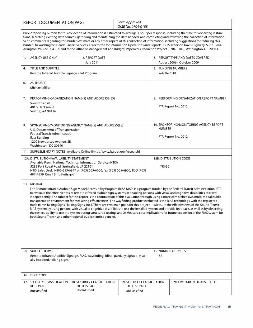
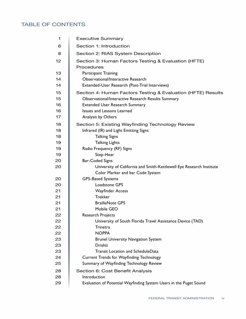
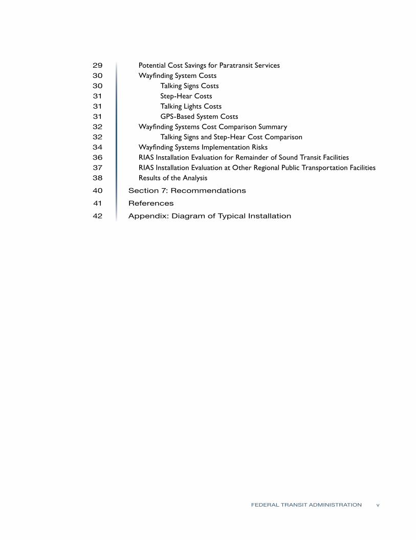
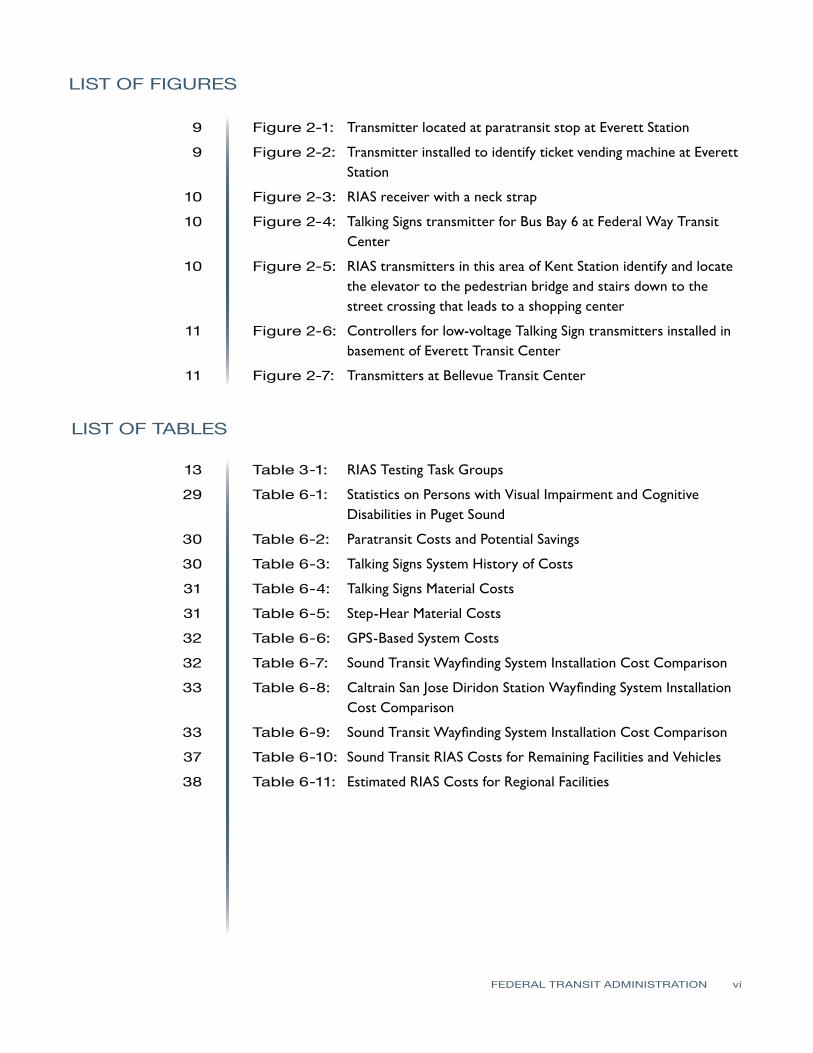
SECTION
1SECTION Introduction 1
Remote Infrared Audible Signs (RIAS) has emerged as a method for providing wayfinding information for persons with visual or cognitive disabilities Typically this technology has been used for transit purposes in assisting these persons in their travel needs
In 2003 and 2004 Sound Transit completed a demonstration project of the RIAS system at two of its facilities using Talking Signs technology The audible signs were placed at the King Street Station the International District Station the Weller Street pedestrian bridge and the International District Plaza Forty transmitters were installed and end-user testing was conducted for this initial system The results which were in the form of feedback given by the end-users were very positive In addition input was received as the result of joint workshops and public outreach efforts conducted by Sound Transit
Based upon the success of the demonstration project and the feedback from the public Sound Transit decided to apply for a federal grant to conduct the RIAS Model Accessibility Program (MAP) Funding was provided by the Federal Transit Administration (FTA) through Congressional legislation as part of the Safe Accountable Flexible and Efficient Transportation Equity ActmdashA Legacy for Users (SAFETEA-LU) Congress authorized the RIAS MAP to evaluate the impact of RIAS technology on the overall quality of life for people who are blind or who have visual or cognitive disabilities
This report includes the results from the tests of persons with visual or cognitive disabilities who used the extended RIAS Sound Transit system The RIAS system was expanded at the following Sound Transit facilities and crosswalks to provide a system that could be tested and evaluated in a multi-modal public transportation environment
bull Everett Station
bull King Street Station
bull Kent Station
bull Tacoma Dome Station
bull Bellevue Transit Center
bull Federal Way Transit Center
bull King Street Amtrak Platform
bull Downtown Seattle bus stops
bull Crosswalk installations at King Street and Everett stations
FEDERAL TRANSIT ADMINISTRATION 6
SECTION 1 INTRODUCTION
Originally installations at SEATAC Airport Overlake Transit Center Lynnwood Transit Center and Auburn Station and audible signs on buses were to be completed however budget constraints based upon the original cost proposal from Talking Signs did not allow installation at these facilities or on buses
The purpose of this project was to evaluate the benefits ease of use and overall effectiveness of RIAS technology in a multimodal application Qualitative Human Factors Testing amp Evaluation (HFTE) was used as the primary research methodology Separate participant groups in the study took part in one-day trials during which they navigated their way through different transit stations and facilities Previous quantitative testing of the RIAS technology has been conducted
There are two main goals that are a part of the evaluation of the RIAS system extension for Sound Transit The first goal was to measure the ability of participants with visual or cognitive disabilities and their ability to effectively use the system and to obtain participant response regarding their satisfaction with the system This was accomplished by having observers determine the ridersrsquo ability to use the system based upon whether successful completion of navigation tasks was accomplished with minimal use of any other assistance besides the use of the RIAS system Detectionobservation of other features and amenities of the sites that were encountered during the navigation test were also noted during the test Interviews with the persons who participated in the tests were conducted to record their responses regarding the effectiveness of the RIAS system This report provides a summary of the results from these tests and determines whether they indicate that the project was successful and if further installation for Sound Transit and other regional transit facilities is recommended
Extended analysis of the results of the tests will be conducted by Hidalgo amp De Vries and the Volpe National Transportation Systems Center after which Volpe will prepare a final report that will be submitted to FTA and the US Congress The extended analysis will include analyzing the effect of RIAS in improving the quality of life for persons with visual impairments or disabilities and with developmental or cognitive disabilities
The second goal of this evaluation was to determine the cost implications for future expansion of the RIAS system for the remaining Sound Transit commuter rail express bus and new light rail facilities as well as for other regional transit agencies such as the Port of Seattlersquos SEATAC Airport the Washington State Ferry system King County Transit Community Transit and Pierce Transit A review of costs and benefits of the RIAS system and a comparison with other technologies was completed to provide the basis for the recommendations included in this report
FEDERAL TRANSIT ADMINISTRATION 7
SECTION
2SECTION
2 RIAS System Description
RIAS is a system provided by Talking Signs Inc and includes infrared transmitters and associated hand-held receivers that help people with visual or cognitive disabilities to navigate through their environment The transmitters are installed within a given environment on or near specific features such as elevators train boarding platforms ticket vending machines drinking fountains etc Mobile receivers are then used to guide users through the environment Dynamic Talking Signs which change their announcements have been integrated into Variable Message Boards (VMB) and have been installed at other transit agencies
The Talking Signs RIAS technology requires that an Orientation and Mobility (OampM) specialist survey the sites to direct the location of the signs with attention given to several aspects of the site installation including
bull Wayfinding including direction instructions and identification of dangers
bull Location of amenities and features
bull Identification of amenities and features
The Sound Transit RIAS system was installed at six transit centers and included a total of 316 transmitters at these locations including installation at nearby bus stops and crosswalks The installation required placement of conduit as well as cabling for powerdata to the transmitters and mounting hardware for the transmitters The transmitters are manufactured in two different types One type called the stand-alone type has the message built-in and requires only 120 VAC power cabling for operation The second type or control-type uses low-voltage data cabling for power and transmitting of the programmed message Each programmed message for this type is contained in a separate device within a central cabinet This central cabinet houses multiple messages that connect to multiple control-type transmitters There were also 60 hand-held receivers provided as part of this Sound Transit RIAS system These receivers have several operating features A button positioned on the top of the receiver is pressed down and held while scanning for transmitters Speakers which are located on the top of the receiver as well provide the audible messages from the transmitters A control switch on one side of the receiver turns the receiver on and off adjusts the volume levels of the audible message On the opposite side of the receiver is an audio jack for connecting earphones if the user does not want the messages transmitted through the speakers on the top The front of the receiver has infrared sensors that are used to pick up the messages from the transmitters
FEDERAL TRANSIT ADMINISTRATION 8
SECTION 2 RIAS SYSTEM DESCRIPTION
Following are photographs that show some of the transmitter installations at Sound Transit facilities and of a typical receiver Drawings that show the final locations of each transmitter by transit stationfacility are shown in Appendix A
Figure 2-1 Transmitter located
at paratransit stop at Everett Station
Figure 2-2 Transmitter installed
to identify ticket vending machine at
Everett Station
FEDERAL TRANSIT ADMINISTRATION 9
Figure 2-3 RIAS receiver with a
neck strap
Figure 2-4 Talking Signs
transmitter for Bus Bay 6 at Federal Way
Transit Center
Figure 2-5 RIAS transmitters
in this area of Kent Station identify and
locate elevator to pedestrian bridge and stairs down to street crossing that leads to
shopping center
SECTION 2 RIAS SYSTEM DESCRIPTION
FEDERAL TRANSIT ADMINISTRATION 10
Figure 2-6 Controllers for
low-voltage Talking Sign transmitters
installed in basement of Everett Transit
Center Existing communications
conduit was used to run low-voltage
wiring to transmitter locations on bus
bay platforms each central controller runs
12 transmitters
SECTION 2 RIAS SYSTEM DESCRIPTION
Figure 2-7 Transmitters at Bellevue Transit
Center Transmitter on right identifies Bus
Bay 6 while other transmitter provides
direction towards other bus bays and
facilities for this transit center
FEDERAL TRANSIT ADMINISTRATION 11
SECTION
3SECTION
3 Human Factors Testing amp Evaluation (HFTE)Procedures
The testing procedures used were developed in accordance with best practices and then approved by the Washington State Institution Review Board to meet requirements established for tests where human subjects are involved These tests on the RIAS system were conducted with staff from Sound Transit LM Telecommunications and Hidalgo amp De Vries Each person assisting with the testing of the system was trained and certified to perform the tests with human subjects by both the National Institutes of Health (NIH) and the Collaborative Institutional Training Initiative (CITI)
The sample frames considered with these tests consisted of 19 persons who are blind or have visual impairments or disabilities This report focuses on the human factors testing and evaluation with respect to the RIAS installation Volpe will conduct the extended end-user research for this installation The method used in evaluating the results of the observer research and post-trial interviews is based upon an approach known as SITE (Charlton 1991) The SITE method supports the design of human factors testing and the interpretation of test results by defining human factors test issues within the four following attributes
1 Situation this defines what the relevant elements are in the environment stimuli setting events system functions or goals
2 Individual this defines who is using the equipment including information about their skills training and cognitive state
3 Task this defines how the equipment is used and what behaviors are associated with the use of the equipment in relative termsmdashfor example how hard how fast how much
4 Effect this describes the success or failure and satisfaction or disappointment associated with the test
The goal of the tests was to provide a method of determining the effectiveness of the RIAS system in providing guidance to the test subjects There were three task groups of tests considered for the observationinteractive research phase of the testing as shown in Table 3-1 Each subtask was created to simulate tasks that would be required by the RIAS user in a multi-modal transportation environment For example each task assumed that the user had arrived at a particular transit facility by train bus on foot or was dropped off by private vehicle at the transit facility
FEDERAL TRANSIT ADMINISTRATION 12
- -
- -
- -
SECTION 3 HUMAN FACTORS TESTING amp EVALUATION (HFTE) PROCEDURES
Table 3-1 Task Group 1 RIAS Testing Task
Groups Task
Station Transit Facility
Sub task Sub task Description
1 King
Street Station
1-1 1-2 1-3
bull From Sounder ADA platform find South TVM bull From TVM locate 4th Ave crosswalk bull Locate stairs leading to Bus Bay C south and Bus Bay D East I-90
Transport participant to Bellevue Transit Center
2 Bellevue Transit Center
2-1 2-2
bull From northwest end of platform find customer service window bull From customer service window find Bus Bay 7
Task Group 2
Task
Station Transit Facility
Sub task Sub task Description
1 Kent Station
1-1
1-2
bull From West Park amp Ride cross pedestrian bridge and locate Track 2 Sounder SeattleEverett bull From TVM find second boarding sign on Track 2 Sounder SeattleEverett
Transport participant to King Street Station
2 King
Street Station
2-1
2-2
bull From Northbound Sounder ADA platform locate stairs up to South Jackson
bull At top of stairs walk to Jackson Street crosswalk
Task Group 3
Task
Station Transit Facility
Sub task Sub task Description
1 Tacoma Dome Station
1-1
1-2 1-3
bull Walk from LINK light rail stop to unisex bathroom located in Information Center bull From Information Center locate 25th St crosswalk bull Proceed across 25th St and locate Sound TVM
Transport participant to Federal Way Transit Center
2
Federal Way
Transit Center
2-1
2-2
bull From Park amp Ride parking area locate sign for uncontrolled crosswalk to bus platforms
bull From center of bus platform locate Bus Bay 6
Participant Training Prior to conducting the tests each participant was trained in the use of the RIAS receiver Each training session consisted of a training facilitator an OampM specialist and at least two training assistants To increase the amount of ldquohands-onrdquo interaction no more than eight participants were used in each training session The Talking Signs Guide for Trainers was followed as the training manual for participant training This training manual is considered the most
FEDERAL TRANSIT ADMINISTRATION 13
SECTION 3 HUMAN FACTORS TESTING amp EVALUATION (HFTE) PROCEDURES
comprehensive reference for use by people who teach others to use the RIAS technology and Talking Signs According to a 1995 study (Crandall et al) ldquothose who receive direct instruction for 15 to 2 hours are more proficient in their use of the [RIAS] systemrdquo Each participant was trained until heshe could successfully use the RIAS system It does not take much time to learn how to use the Talking Sign system and this training assisted in providing a simulation of persons navigating their way that are familiar with the use of the system which is a better simulation of what will be experienced in real life by the frequent user of the system
ObservationalInteractive Research The staff conducting the tests evaluated how well each user was able to navigate through hisher trip and filled out information about the results on prepared forms for groups 1ndash3 In each location the participants were asked to locate specific features of the transit facility Each participant was asked to complete a series of tasks based upon the task group described above For each task the observer recorded the number of transmitters located and the number of requests for assistance from the participant This was the most important part of the research process since it involves the participantrsquos actual success or failure with the RIAS system in a real-world application
The observer accompanied the participant as each task was performed The primary responsibility of the observer was to ensure the safety of the participant during the test The observer also recorded the participantrsquos performance comments and questions which were used to determine the level of success of the RIAS system The test subjects were also asked a series of questions related to their evaluation of the system after the testing was completed and the answers were recorded by the observer
Extended-User Research (Post-Trial Interviews) Once the test subjects had completed the observationalinteractive group tests they were asked to use the system for several weeks At the end of this extended use each participant assisted in filling out forms with questions related to their evaluation of the system These questions were used to assess the participantsrsquo extended experience with the RIAS system and to determine their interest in using the system in the future The answers to these questions were used in analyzing the overall success of the system
FEDERAL TRANSIT ADMINISTRATION 14
SECTION
4SECTION
4 Human Factors Testing amp Evaluation (HFTE) Results
The majority of the test results showed a positive indication that the RIAS system works well in providing people who are blind or who have visual impairments or disabilities with more independence in their travel The results are summarized into two areasmdashthe observationalinteractive research and the participant post-trial interviewmdashas described in the previous section of this report This report provides a summary of the results from these tests as well as some of the issues and lessons learned with the system Detailed HFTE test results and analyses are contained in a report completed by Hidalgo amp De Vries Overall the results of all the tests were fairly positive The participants felt pleased with the effectiveness of the RIAS system and comments suggested there is room for improvement in some areas
ObservationalInteractive ResearchResults Summary For Group 1 the participants were able to locate the majority of the audible signs at the King Street Station and all of the audible signs at the Bellevue Transit Center with no problems One audible sign at King Street Station that identifies the stairs leading down to the International District Bus Tunnel was not located by the participants Overall the participants were pleased with the usability of the RIAS system at these two transit centers however some expressed the need for additional signs around the transit centers At the time of the tests audible signs had not been installed for the crosswalks These signs were not installed for the King Street Station for this project and would help in addressing this need
For Group 2 the test results showed for the King Street Station that the RIAS system was effective and the participants were able to locate all of the signs without assistance The results were different for the Kent Station The participants had more difficulty locating the audible signs at this station and two of the six participants in this group found the RIAS system to be ldquonot very usefulrdquo or ldquonot at all usefulrdquo in the post-trial interviews It should be noted that one of the audible signs at the Kent Station was not transmitting the audible message
Finally in Group 3 all four participants were able to locate the audible signs at the Tacoma Dome Station and three of the four participants were able to locate all the signs at the Federal Way Transit Center without assistance One participant required assistance from the observer to locate one of the audible
FEDERAL TRANSIT ADMINISTRATION 15
SECTION 4 HUMAN FACTORS TESTING amp EVALUATION (HFTE) RESULTS
signs A power outage in part of the Federal Way Transit Center caused one of the signs used in the tests to not be operational Three of the four were able to locate the destination for the subtask using another nearby audible sign
Extended User Research Summary Of the 19 HFTE participants 11 completed post-trial interviews to provide their feedback on the extended use of the RIAS system The participants rated their overall satisfaction with the RIAS system on a 10-point scale with 10 as the best experience and 1 as the worst experience The average rating was 682 with a high rating by one participant of 10 and a low rating of 3 The following are the most significant items from the participant interviews
bull Overall the participants were very satisfied with the RIAS system and their role in the study
bull The majority of participants would not use the RIAS system if they had to pay out-of-pocket for a RIAS receiver
bullThe majority of participants would use the RIAS system if the RIAS receiver was provided free of charge
bull If the RIAS system was available at the rest of Sound Transitrsquos facilities more participants would use the RIAS system
Issues and Lessons Learned There were several issues that were encountered during the HFTE tests At two stations there were problems with some of the audible signs not being operational Most of these seemed to be related more to maintenance issues from temporary power outages while maintenance was repairing nearby lighting damage This would likely be a continuing issue as maintenance at each station is needed and power to the audible signs would need to be temporarily disconnected For their safety travelers who are blind or who have visual impairments or disabilities would need to be notified in some way when these conditions occur
Another issue that occurred was that there were reflections of the RIAS signals in some instances which create a potential hazard to the traveler One instance in particular occurred when a RIAS signal reflected off a person wearing a reflective jacket who was standing in front of the participant during testing This caused the signal to transmit to the participantrsquos receiver coming from the opposite direction intended by the RIAS system which caused the participant to become confused about the direction needed to walk to reach the destination Reflections off articles of clothing are likely to occur every now and then particularly when walking through crowded areas which is common at the Sound Transit multimodal facilities Reflections of the RIAS signals also seem to occur when the signal reaches metallic objects Items at transit facilities that would
FEDERAL TRANSIT ADMINISTRATION 16
SECTION 4 HUMAN FACTORS TESTING amp EVALUATION (HFTE) RESULTS
reflect the RIAS signal include elevator doors support columnsbeams and roofs and certain parts of ticket vending machines In some instances reflections are used as an installation method such as pointing transmitters at elevator doors to guide persons to elevators where the transmitter cannot be located above the doors Any highly-polished surface can reflect the IR transmissions
Issues were found with some of the RIAS signals being blocked by objects At the King Street Station there were temporary vinyl banners that had been placed in the bridgewalkway leading down to the platforms which prevented the receiver from picking up the audible message Other objects that blocked RIAS signals included concrete structures wallsbuildings shelters and structural supports
Overall it seems that placement and setting the direction and adjusting the strength of the audible signs signal is the key to reducing these reflections and avoiding objects that may block the signal There are problems however in some transit facility locations where it becomes difficult to place the audible signs in a way that they can effectively function In addition future placement of objects at each facility should not be completed without some consideration regarding the effects these objects will have on RIAS system performance
The RIAS signals also seemed to be affected to some degree by sunlight In one instance the signal strength of one sign appeared to be stronger during cloud cover than it was with more sunlight or a brighter sky behind the transmitter location One issue that was mentioned by some of the participants was that there were not enough audible signs in some locations It was a great to provide audible signs at all locations in the Tacoma Dome Station in particular because of large open walking areas with nothing that could be used for mounting the sign In addition there were budget constraints that limited the number of audible signs installed
Analysis by Others The Volpe Institute will be determining the practical operation of the RIAS technology and its benefits In addition Hidalgo amp De Vries has conducted a more detailed review of the human factors tests This project requires a report to the US Congress by the Secretary of Transportation which will be finalized by Volpe with this report and Hidalgorsquos report provided as input to the final Volpe report The following are the evaluation points Volpe will be considering
bull The effect on multimodal accessibility in public transportation with regard to persons with visual cognitive and learning disabilities
bullThe effect on making public transportation accessible to persons with visual cognitive and learning disabilities who use public transit and paratransit
bull The effect on education community integration work life and general quality of life of the targeted populations
FEDERAL TRANSIT ADMINISTRATION 17
SECTION
5SECTION
5 Existing WayfindingTechnology Review
As part of an evaluation in recommending further investment into RIAS technology it is important to consider the existing technology that is available or under development for wayfinding systems for people who are blind or who have visual or cognitive disabilities These systems can be divided into several categories
bull Infrared (IR) and light emitting signs
bull Radio frequency (RF) or Wi-Fi signs
bull Bar-coded signs
bull Gps-based systems
bull Research projects
This review has considered only wayfinding technologies that would have a benefit similar to that provided by Talking Signs In other words the focus of this review has been on technology for orientation and navigation with a particular focus on systems that provide orientation and navigation for public transportation facilities
Infrared (IR) and Light EmittingSigns One technology that has developed with great promise is audible signs that transmit infrared or light signals that can be decoded by a receiver The transmitted information is converted to an audible message that is played on a receiver to the person with visual impairments or disabilities Two types of these systems that are currently in operation have been reviewed for this report Talking Signs and Talking Lights (Talking Lights LLC)
Talking Signs Talking Signs has emerged as a promising technology that can provide localized directional information and item identification to persons with visual impairments or disabilities There have been many studies and tests with human subjects to determine the effectiveness and value associated with using this system This system has developed to the greatest degree in the marketplace and in the number of system implementations which gives it an advantage over other similar competing technologies
FEDERAL TRANSIT ADMINISTRATION 18
SECTION 5 EXISTING WAYFINDING TECHNOLOGY REVIEW
The Talking Signs system has been used in many transit environments and has the capability to provide easily-updated message information such as changes in bus numbers or routes for a particular bus The system has also been embedded in visual message signs to match the messages displayed Many studies have been completed for this system and it has been shown to be of benefit to travelers with visual impairments or disabilities The main drawback to using this system is that it is costly Talking Signs has established relationships with other companies to continue to develop the system to make sure it continues to transition to a more open architecture environment to be used with other transit systems in the future More detailed information about this system including a description of the Sound Transit Talking Sign system is provided in Section 3
Talking Lights Talking Lights is a system developed by a team at MIT that uses ordinary lights and embeds a signal that can be decoded by a receiver The system is a high-resolution tracking system that uses PDAs with audio direction software The advantage of this technology is that there are no wires needed to install facilities can use their existing lighting infrastructure and the light bulbs do not consume any additional energy to perform their function
While this appears to be promising technology that could be more easily implemented by modifying existing lights within a facility it is still new This system has had success for patients at the Spaulding Rehabilitation Hospital in Boston and there is currently a study going on at the Decatur Hospital in Georgia Other plans include developing a system for museums In addition this system seems to be used only for indoor applications although Talking Lights has teamed with the Sendoro Group to provide an outdoor navigation system
Radio Frequency (RF) Signs Step-Hear Step-Hear is a new product that debuted in August 2008 at the World Blind Union 7th Assembly in Geneva Switzerland This product is similar to Talking Signs in that it uses a base transmitter to send directional information to a hand held receiver The system uses radio frequency signals transmitted by the base transmitter provided in a directional nature to transmit information about the location of the transmitter
This system also seems to have a few more features than Talking Signs The receiver vibrates when it is within range (about 12 ft) of a base transmitter and for bus installations a red light is activated to notify the bus driver that a person needing help entering the bus is within range of the transmitter In addition the base unit can be integrated with the bus GPS and speaker systems Changing
FEDERAL TRANSIT ADMINISTRATION 19
SECTION 5 EXISTING WAYFINDING TECHNOLOGY REVIEW
the messages appears to be quite simple using a built-in switch and button that when used together will allow modification of the message
One drawback to this technology is that it has not yet been fully deployed and has yet to be proven as a viable option in the marketplace There is currently an installation ongoing for a bus system which is reportedly showing success A full report on this project was promised to be provided once the project was completely installed tested and operating on the system Information about this system was limited at the time of this report and further review of the installation on the bus system should be completed when available
Bar-Coded Signs University of California and Smith-Kettlewell EyeResearch Institute Color Marker and Bar Code System
This system is still in the research stage of development and cannot be considered as a viable alternative at this point However the system does show some promise in the future for providing a beneficial cost-effective wayfinding system The system is based on a cell phone that detects color markers placed throughout the environment These markers are detected by the cell phone at a distance of several meters away The purpose of the color marker is not to give any information about the location of the marker but to help a person with visual impairments or disabilities to detect the marker A bar code is then placed near the marker and the cell phone can decode and receive information about the location This typically requires the user to move closer to the marker to process the information and determine location-based information
GPS-Based Systems There are many GPS-based systems that travelers with visual impairments or disabilities can use to assist in guidance to a destination There are a few that are commercially available and many others still being developed All systems are for outdoor use only with very limited capability indoors due to lack of GPS satellite signal These systems continue to advance with greater accuracy including WAAS corrections which can provide 2ndash3 meter accuracy Common GPS for the consumer market has been tested to have a location accuracy of within 30 meters as a comparison
Loadstone GPS Loadstone GPS is open source software using satellite navigation for persons with visual impairments or disabilities The benefit to this system is that the software is free and will run on many different Nokia cell phone devices It requires a GPS receiver that connects to the cell phone by Bluetooth In
FEDERAL TRANSIT ADMINISTRATION 20
SECTION 5 EXISTING WAYFINDING TECHNOLOGY REVIEW
addition a screen reader program must be running on the cell phone such as Talks or Mobile Speak to give the user instructions
Wayfinder Access This GPS solution is similar to Loadstone however it offers more features to the traveler with visual impairments or disabilities It is a software application that uses Symbian phones to work with screen readers Other features are customized for persons who are blind or who have visual impairments or disabilities to provide them with information about surroundings including feedback on points of interest and Braille support
Trekker Trekker was developed as a personal digital assistant (PDA) application operating on a Microsoft Pocket PC operating system and was adapted to be used by persons who are blind or have visual impairments or disabilities with talking menus talking maps and GPS information Features include determination of position creating routes and receiving information about navigating to a destination A search function for points of interest is also available This application has the ability to expand to accommodate new hardware platforms and more detailed location and geographic information
BrailleNote GPS BrailleNote GPS was developed by Sendero Group and the idea behind it combines a PDA with direction software that returns audible directions to the user It uses GPS to pinpoint a personrsquos position and nearby points of interest and is about the size of a small cell phone Points of interest can be input into the system and directions to these locations can be accessed This is similar to the GPS-based direction systems for automotive use
Mobile Geo Mobile Geo works with Windows Mobile-based smartphones Pocket PC phones and other PDAs The GPS and mapping technology built into this system is from the Sendero Group It is the first solution that works with a wide range of mainstream mobile devices and it can be used with more than 20 different Braille devices for input and output It works with Mobile Speak screen reader software which is a Code Factory product It is compatible with more than 300 PDAs as well as mobile phones that operate on GSM CDMA and WCDMA networks Like other GPS-based solutions Mobile Geo pinpoints the travelerrsquos location and provides information about points of interest The benefit to this product is that it has built-in map data
FEDERAL TRANSIT ADMINISTRATION 21
SECTION 5 EXISTING WAYFINDING TECHNOLOGY REVIEW
Research Projects A number of projects are currently under development and a few of these are mentioned below The trend for wayfinding systems and technology for persons with visual impairments or disabilities is to use a combination of GPS infrared RF and other methods to provide a more complete solution for travelers with visual impairments or disabilities The systems described below are provided in this report to show this trend as well as to provide a basis for recommendations on pursuing an integrated solution using GPS and smartphone technologies with Internet capability
University of South Florida Travel Assistance Device(TAD) The University of South Florida (USF) Center for Urban Transportation Research is developing software that uses GPS technology inside cell phones to assist persons with cognitive disabilities to navigate public transportation Users can access a website that is similar to the Google Map interface where they can select their route location stop and travel times Trips are planned using this website and then downloaded to the cell phone The software developed by USF is installed on the phone and can give the rider alerts while riding the bus to prepare himher to exit the bus at the planned destination The system was tested last year with student with developmental disabilities and was quite successful
Trinetra The Trinetra project aims to create a smartphone solution that will benefit persons with visual impairments or disabilities The goals are to develop a cost-effective system This project is one to reconsider in the future since the plans are to develop a system that will assist the needs of persons with visual impairments or disabilities who uses public transportation by providing them with real-time information The concept of the system uses a combination of GPS receivers and infrared sensors that relay information to a centralized fleet management server using a cell phone The person with visual impairments or disabilities can then use a cell phone with text-to-speech capability to determine estimated time of arrival location and current bus capacity using a web browser Other research for this project is considering the use of universal product codes (UPCs) and radio-frequency identification (RFID) for indoor navigation in a shopping setting
NOPPA The NOPPA project was a three-year project (2002ndash2004) in Finland as part of the Ministry of Transport and Communications Finlandrsquos HEILI Passenger Information Program which was a pilot program to develop a system for
FEDERAL TRANSIT ADMINISTRATION 22
SECTION 5 EXISTING WAYFINDING TECHNOLOGY REVIEW
navigation and guidance for persons with visual impairments or disabilities who use public transportation It is similar in goals to the Trinetra project and uses GPS technology combined with Wi-Fi smartphone for Internet access and text-to-speech capability optional RFID reader and a database of route information to provide directional information to the user Like Trinetra it is based on a central information server concept While the pilot program was successful there are still drawbacks to this system which includes wireless and GPS not always being available in areas without line of sight or in urban canyons issues associated with having outdated information in the central database and availability of this system in the United States
Brunel University Navigation System Brunel University is developing a system that is based on the combination of several state-of-the-art current technologies including GPS and GIS The system provides automated guidance using the information from daily updated digital map datasets The difficulties with this system include the availability of up-to-date information and what information to offer with the navigation procedure Different levels of functionality have been created with this system to be able to customize the information to the user
Drishti Drishti is a wireless pedestrian navigation system developed by the University of Florida The system integrates technologies including wearable computers voice recognition and synthesis wireless networks GIS and GPS It also provides contextual information to the person with visual impairments or disabilities and computed optimized routes based on user preference traffic congestion and obstacles such as road work The system guides the user to navigate based on both available static and dynamic data This requires a spatial database that provides environmental conditions and landmark information along the travelerrsquos route The system also has the capability for the user to add information to the database
Transit Location and Schedule Data Several technologies are being developed that assist travelers in navigating a transit system Google Transit is a popular system that has developed since 2005 and now includes 70 transit agencies in 10 countries It is a web-based application that uses a database of information from each transit agency along with Google Maps to determine the best bus route or routes and times for transporting passengers to and from locations that are input online by the traveler King County Metro is already part of the Google Transit system
Sound Transit already has existing databases built for a regional Trip Planner system which uses Trapeze software for their bus routes King County Metro
FEDERAL TRANSIT ADMINISTRATION 23
SECTION 5 EXISTING WAYFINDING TECHNOLOGY REVIEW
Community Transit and Pierce Transit are also already part of this system It will not be added to the Sounder rail line until the commuter rail line is completely built out For some agencies real-time feeds are also provided for locating certain buses on routes of interest however at this time Sound Transit does not have the ability to provide these real-time feeds These systems will continue to improve in providing wayfinding information for travelers
Current Trends for WayfindingTechnology Technology today is rapidly changing It is estimated that every 18 months another set of advancements in technology will occur The wayfinding system technology is no different and this market should be frequently analyzed in order to be aware of innovative cost-effective solutions that become available to travelers with visual impairments or disabilities
Computer chips and small embedded devices are already being placed in many environmental aspects of our lives such as ldquosmartrdquo surroundings These have the ability to monitor and report conditions continually and computer chips are increasingly being found in signage They can be placed in walls poles sidewalks etc and provide information to the traveler As computer chips continue to expand in application technologies will advance to the point of providing benefit in wayfinding for persons with visual impairments
The current trend for wayfinding technology as can be seen from the GPS-based systems and research projects evaluated is to further develop and use smartphones and PDAs with Internet and GPS applications and blend several technologies to provide a complete solution for navigation The focus is on developing software applications that will run on many of the devices people carry with them already such as smart phonesPDAs The integration of Bluetooth GPS and radioWi-Fi functions in a handset provides many benefits and is the current trend The benefits include improved system performance improved cost structure power consumption savings and other savings from shared system use including ease of assembly because of shared packaging
Many applications are available for pedestrians drivers and public transportation users that continue to improve the efficiency of traveling Some of these applications can in conjunction with other technologies provide wayfinding for both travelers who are blind or who have visual impairments or disabilities as well as all travelers These types of technologies could potentially increase funding as they help a greater number of public transportation users
The GPS-based systems are continuing to be improved and other technologies are being combined with GPS to provide more accurate wayfinding information
FEDERAL TRANSIT ADMINISTRATION 24
SECTION 5 EXISTING WAYFINDING TECHNOLOGY REVIEW
Some systems use Wi-Fi to assist location determination while others use inertial sensors and cameras in areas where GPS signals may be limited It seems clear that GPS systems combined with smartphones with Internet access are the future of wayfinding systems as there are many new developments occurring to continue to increase the effectiveness of these systems For those who are blind or have visual impairments or disabilities stable low-cost technologies are important
Summary of WayfindingTechnology Review Based upon the technology review of this report there are three current options available to use for localized directional information Talking Signs Talking Lights and Step-Hear systems Other GPS-based or GPS-assisted systems using smartphones or PDA technologies using a database of points of interest seem to have the capability to provide outdoor wayfinding at a continually increasing accuracy Current accuracy taking into account WAAS corrections for reasonably-priced GPS units is about 2ndash3 meters Based upon the evaluation of RIAS technology using GPS systems would be similar to the accuracy provided by RIAS for persons with visual impairments or disabilities in determining the actual position of a particular point if WAAS corrections are taken into account Since the current trend is for ldquosmartrdquo devices the GPS-based technologies should be considered an option for providing wayfinding outdoors while using other systems for indoor navigation
The Talking Signs system still has the market advantage when compared to other localized directional information systems and is the most proven system at this time with many installations currently in place throughout the world One drawback to this system as with some other systems considered in this report is that the current trend for wayfinding technology is to integrate a number of technologies together Cell phonesPDAs are integrating with technologies including webe-mail access interactive voice response and text-to-speech technology GPS wayfinding systems digital cameras for recognition purposes palm computing and CPUs and smart-sensing environments The enhanced cell phone is becoming a handy remote device for finding information about the environment As technology continues to advance these smartphones will become smaller and less expensive with more features Modifications to the cell phone will continue to adapt to be a cost-effective and universal solution for wayfinding Another drawback for this system is that it is mainly used for item identification Information on routespaths to take are given within the messages of some of the signs however the user is not given a travel route based on his her destination information
FEDERAL TRANSIT ADMINISTRATION 25
SECTION 5 EXISTING WAYFINDING TECHNOLOGY REVIEW
The Talking Lights system is already working with Sendoro Group which provides GPS wayfinding products to integrate the two technologies This system also has the capability to integrate with a local Wi-Fi mesh network Talking Lights seems to be a cost-effective solution based upon costs that were obtained and are provided in the next section This system at this time is limited to indoorbuilding applications which makes this technology a good fit for integration with a GPS-based technology There are plans to expand the system to outdoor environments and an application of this system has already been introduced on headlights for military vehicles Some concerns for outdoors would be problems that could occur during the daylight versus at night and other light interference sources that could reduce the performance of the system however if this system is integrated with other technologies such as GPS-based technology from Sendoro Group it could prove to be a useful navigation aid for both indoor and outdoor environments An advantage that this system has over the Talking Signs system is that it acts in a similar manner to GPS-based wayfinding technologies In other words it uses more than just item identification and delivers pathroute information to the user via a central database The two main drawbacks are that the system does not have the same market presence as Talking Signs so long-term viability is a concern and the system has not been tested in a transit environment for people who have visual impairments or disabilities or cognitively disabilities
The Step-Hear system is fairly new technology that shows promise in comparison to the Talking Signs system Unlike the disadvantage Talking Lights has in outdoor applications the Step-Hear system can operate in both outdoor and indoor environments This system appears to have a few more functions than Talking Signs however it is also not fully proven in the market Once the initial installation is complete for this system another evaluation should be completed to determine its effectiveness This system also seems to be a cost-effective product like Talking Lights A comparison of costs for these three systems is provided in the next section
In summary a blending of technologies seems to be the best solution for providing people who have visual impairments or disabilities and cognitive disabilities with a wayfinding system that can be used for public transportation Smartphones or PDAs with speech-to-text capability can access via the Internet databases of information for points of interest particularly GPS coordinates and determine step-by-step instructions to the user based upon hisher GPS-determined position Google using its Google Transit database and TimeTablePublisher software for schedules and locations has already begun integrating transit points of interest just as the regional Trip Planner for the Puget Sound bus systems does and now gives users step-by-step instructions for using public transportation based upon the starting and ending points of the traveler Creating a database of transit points of interest that would aid a traveler
FEDERAL TRANSIT ADMINISTRATION 26
SECTION 5 EXISTING WAYFINDING TECHNOLOGY REVIEW
with visual impairments or disabilities would seem to be an effective solution that could be used by technologies integrated with GPS systems for wayfinding from a long-term perspective For buses however the localized item identification systems would have an advantage for those that are easily updateable with bus information although current trends with GPSAVL systems on buses are to publish bus locations online that could then be accessed via a smartphone PDA or other ldquosmartrdquo device
FEDERAL TRANSIT ADMINISTRATION 27
SECTION
6SECTION Cost Benefit Analysis 6
Introduction In completing a cost benefit analysis for something that provides social equality to a group of people a typical cost versus benefit analysis is not possible The basic benefits for a person with visual or cognitive disabilities from a wayfinding system are
bullAbility to travel with confidence and enable them to become more independent
bullOverall positive effect on quality of life
Detailed analysis on the benefits of Talking Signs as well as costs for the system have already been completed in numerous other studies including those done by the University of California Santa Barbara and the Smith-Kettlewell Eye Research Institute The results from the human factors testing at Sound Transit also show that the RIAS system was received positively by the evaluation participants as summarized in Section 5 and as detailed by the report completed by Hidalgo amp De Vries
Because of the social benefits of this type of system this cost benefit analysis will focus primarily on how well each technology performs as a wayfinding system for persons with visual impairments or disabilities and the cost implications for each of the technologies The purpose of this analysis was to evaluate these cost implications for RIAS as well as other technologies and to determine whether proceeding with expansion of a RIAS system would be the best solution to provide these benefits to persons with visual or cognitive disabilities in the Puget Sound area The cost benefit analysis provided in this report focuses on the following
bullBased on the number of people who have visual and cognitively disabilities in the Puget Sound area as well as those which use public transportation determine how many people could potentially benefit from a wayfinding technology system
bullBased on the number of people who have visual and cognitively disabilities in the Puget Sound area analyze paratransit costs for Sound Transit to determine the potential cost savings in reducing the number of persons using this service
bullBased upon the technology review compare four main products or solutions for costs and benefits and the risks with the use of each system Talking Signs Talking Lights Step-Hear and a combination of one of these three to use for just indoors and on buses with a GPS-based system for outdoor navigation
FEDERAL TRANSIT ADMINISTRATION 28
SECTION 6 COST BENEFIT ANALYSIS
Table 6-1 Statistics on
Persons with Visual Impairment and
Cognitive Disabilities in Puget Sound
Evaluation of Potential WayfindingSystem Users in the Puget Sound Information about the number of persons with visual and cognitively disabilities is summarized in Table 6-1 The number of persons with developmental disabilities for each county was obtained from Sound Transit and the statistics for the number of persons who are blind or have visual disabilities is based on percentages from the US Census Bureau on people with sensory disabilities for the tri-county area from a 2006 American Community Survey Other national percentages are from the US Cernsus Bureau 2005 measures of disability Based upon these available statistics estimated upper bounds of 4 percent of the population were used in Table 6-1 Population estimates were based upon information from the US Census Bureau
Puget Sound Region County
Total Persons with Cognitive Disabilities
Total Persons with Visual Disabilities or Blind
King 10399 74371
Pierce 4712 30927
Snohomish 3469 27076
Total 18580 132374
From these numbers it appears that there are many people who could potentially benefit from a wayfinding system in the Puget Sound region Also from the post-trial interviews the participants were likely to use the RIAS system for a range of trip purposes such as work shopping social events recreation and education
Potential Cost Savings for Paratransit Services There are cost savings that could be seen from persons who are blind or who have visual disabilities becoming more independent in their travel These costs would be related to paratransit services for these persons As more persons who are blind or who have visual disabilities become more independent they will likely use paratransit services less or not at all Information about the operating expense per revenue mile for demand response vehicles was obtained from the 2007 National Transit Database Based upon the information available from Sound Transit it is estimated that approximately 4 percent of the passenger miles represents passengers who are blind or who have visual disabilities From this estimate the total cost savings was calculated for 2007 and is shown in Table 6-2
FEDERAL TRANSIT ADMINISTRATION 29
SECTION 6 COST BENEFIT ANALYSIS
Table 6-2 Paratransit Costs
and Potential Savings (based on 2007 cost
data for demand response vehicle operating costs)
Table 6-3 Talking Signs System
History of Costs
Demand Response Transit Agency Cost per Passenger Mile 4 of Cost per
Passenger Mile Potential 2007 Cost Savings
King County Metro $424 $017 $1920000
Pierce Transit $455 $018 $630000
Community Transit $353 $014 $320000
Total $2870000
From this analysis there are significant potential annual savings in providing a wayfinding system for persons who are blind or who have visual disabilities which would decrease paratransit use and thereby reduce the operating costs for paratransit services
Wayfinding System Costs Costs for the different types of wayfinding systems available were obtained from each of the vendors One of the problems with the comparison of costs is that only material costs were obtained from Step-Hear and only installation costs for buildings were obtained from Talking Lights By far Talking Signs has the most cost information available for this analysis because it has been installed in more locations Because of this the analysis focuses on comparing material costs between Talking Signs and Step-Hear and building system costs between Talking Signs and Talking Lights
Talking Signs Costs Information about the costs for Talking Signs was obtained from previous installations as well as from the bid provided by Talking Signs Services Inc for the Sound Transit RIAS project Table 6-3 shows installation costs (in cost per transmitter) for some Talking Signs projects
Installation Location Number of Transmitters Cost per Transmitter
Sound Transit 370 $7005
TriMet 30 $2655
San Francisco Muni 30 $3200
Colorado Springs 10 $3760
Phoenix Public Transit 10 $4630
Port of San Francisco 30 $4635
Caltrain 40 $3000
It should be noted that installation costs for the Sound Transit RIAS project are much higher because the other installation costs did not include installation of the system infrastructure such as conduit cable etc In other words Talking Signs has typically installed the system in locations where all that is required is to install the transmitter and test and operate the system the other costs for conduit and system infrastructure were provided through separate contracts In
FEDERAL TRANSIT ADMINISTRATION 30
-
SECTION 6 COST BENEFIT ANALYSIS
Table 6-4 Talking Signs Material
Costs
addition the costs given above were the costs at the time of the installation The Sound Transit project is the most recent one given
Table 6-4 shows the material costs per transmitter and receiver There are two different types of transmitters provided so an average transmitter cost is given
Talking Signs Equipment Unit Cost
Average material cost per transmitter $1600
Material cost per receiver $265
Step-Hear Costs As mentioned only material costs were obtained from Step-Hear Additional cost information will be provided once the first project for this system is completed Below is a table which shows the cost per transmitter and per receiver for this system
Table 6-5 Step-Hear Material
Costs
Step Hear Equipment Unit Cost
Average material cost per transmitter $100
Material cost per receiver $22
Talking Lights Costs The cost to install Talking Lights was obtained only for indoor applications Depending on the type of facility and complexity the cost to install Talking Lights ranges from $050ndash2 per square foot A comparison of this cost with Talking Signs based upon the historical costs at the San Francisco Caltrain station is given in the next section
GPS-Based System Costs It is difficult to determine the actual cost for a GPS-based solution that could be used by the person with visual or cognitive disabilities for wayfinding There are several smartphone systems such as Loadstone GPS which runs on Nokia phones and interfaces to a GPS receiver Costs were calculated from some of the systems evaluated in this report and are included in Table 6-6 In addition to the costs for these systems some costs would be necessary to develop a database for Sound Transit specific points of interest and other points required for wayfinding as well as monthly costs for the phone service In downtown areas where it is difficult to gain connectivity with GPS signals from satellites additional WAAS or other fixed location signal sources may need to be installed to provide accurate locations
FEDERAL TRANSIT ADMINISTRATION 31
SECTION 6 COST BENEFIT ANALYSIS
Table 6-6 GPS-Based System
Costs
Table 6-7 Sound Transit
Wayfinding System Installation Cost
Comparison
System Type Unit Cost Avg Monthly Service Cost
Loadstone GPS (includes smartphone software GPS receiver screen reader)
$700 $60
Wayfinder Access (includes smartphone software GPS receiver screen reader)
$1200 $60
BrailleNote GPS V 3 (Includes maps receiver pouch cable 1 GB CF card)
$1599 NA
Trekker GPS System $1695 NA
Mobile Geo (includes smartphone software GPS receiver screen reader)
$1745 $60
Wayfinding SystemsCost Comparison Summary Talking Signs and Step-Hear Cost Comparison In comparing material costs shown between Talking Signs and Step-Hear it is clear that Step-Hear has a very large cost advantage from a material unit per unit basis Talking Sign transmitters are 18 times the cost of a similar Step-Hear transmitter and receiver costs are more than 10 times more expensive for material only Table 7-7 shows a comparison of the total RIAS Sound Transit installation costs based upon the complete bid from Talking Signs with equivalent costs for Step-Hear The cost shown for the Step-Hear system was calculated by substituting material costs for Step-Hear transmitters and receivers for the Talking Sign transmitter and receiver bid prices This comparison assumes that conduit and power cabling needs and installation costs for mounting the transmitters are the same
System Type Cost
Talking Signs System (actual installation cost in todayrsquos dollars) $2199765
Step-Hear System (estimated cost based upon Step-Hear material costs) $1665495
One major factor that is not considered in the above comparison is the number of Step-Hear transmitters that would be necessary to replicate the same system coverage for Talking Signs Information obtained from Step-Hear indicated the range for the transmitter was about 65 feet which is somewhat shorter than the maximum range for the Talking Signs transmitter of around 100 feet Also it does not seem the Step-Hear transmitter has similar capabilities in adjusting the strength of the signal Another problem with this comparison is the assumption that installation costs would be similar including testing training and maintenance The main result of this analysis is that it would appear that Step-Hear would have a cost advantage for installation on buses since transmitter coverage areas would be similar for both and it would take the same number of Talking Signs transmitters on a bus as it would for the Step-Hear system
FEDERAL TRANSIT ADMINISTRATION 32
SECTION 6 COST BENEFIT ANALYSIS
Table 6-8 Caltrain San Jose
Diridon Station Wayfinding System
Installation Cost Comparison
Table 6-9 Sound Transit
Wayfinding System Installation Cost
Comparison
Talking Signs and Talking Lights Cost Comparison For the Talking Lights system it is difficult to compare on a cost-to-cost basis with Talking Signs The method used for the purpose of this report was to consider the historical cost (converted to todayrsquos dollars) to install the Talking Signs system at the San Jose Diridon Caltrain station with a Talking Lights system cost for this station of $2 per square foot The area in square feet was calculated for the coverage area provided by Talking Signs at this station This included areas outside on train platforms as well as indoor areas This installation was only for mounting installation and testing of the RIAS system and did not include conduit and wiring costs which were completed under a separate contract Table 6-8 shows a simplified comparison of the costs between these systems using this method
System Type Cost
Talking Signs System (actual installation cost in todayrsquos dollars) $215000
Talking Lights System (est cost based on $2sf) $32000
Based upon this comparison there seems to be a large cost advantage for the Talking Lights system However this comparison does not consider the issues that could be encountered for the outside train platform areas of the San Jose Diridon Caltrain station if Talking Lights were used This does indicate that further investigation of the costs and effectiveness of the Talking Lights system for at least indoor transit facility areas should be completed
Talking Signs and GPS-Based System Cost Comparison In comparing the Talking Signs system to an outdoor GPS-based system there are a number of factors to consider Table 6-9 shows the actual cost for the RIAS system for Sound Transit compared with the estimated cost for implementing a region-wide database of points that are web-accessible The costs assume that receivers (GPS-based or Talking Signs receivers) will be purchased by the user Based upon the results of the participant interviews purchasing these receivers is a critical factor for determining whether persons will actually use the system
System Type Cost
Talking Signs System (actual installation cost in todayrsquos dollars) $2199765
GPS-based system (est cost to create point database interface and web access)
$150000
An integration of these technologies would seem to be more feasible As mentioned the costs above do not include the purchase of the individual GPS systems for each user which would likely be an issue for the user to purchase The cost to create this database is small since many of the bus routes for Sound Transit and King County Metro are already created using the Transit Trip Planner system Budget is already in place to update the database several
FEDERAL TRANSIT ADMINISTRATION 33
SECTION 6 COST BENEFIT ANALYSIS
times per year to make sure the bus route information is current The cost to create this database includes creating points for the entire regional transit system which would cover a larger area than the initial RIAS system at the six Sound Transit facilities It should be noted that the cost for the GPS system does not include review and testing of the system or a review from an OampM specialist From a per-person cost perspective for the entire regional transit system if the funding is to include purchasing a $700 personal GPS system and $250 for the RIAS receiver for each user the RIAS system has a cost advantage based upon the number of people in the Puget Sound area who have visual or cognitive disabilities However further comparison of costs of this system should be considered as GPS systems advance and costs for these systems continue to decrease
Wayfinding SystemsImplementation Risks Since RIAS technology has already been demonstrated in the Puget Sound area and in many other locations risks in proceeding with further system implementation are minimal There have also been many studies that have shown the system to be very successful and it has been tested more extensively by transit users who are blind or who have visual disabilities than any other system
There are several risks associated with installing a different system other than Talking Signs The main risks are
bullAnother custom device would be needed by the user
bullOther technologies do not have transit system studies completed using persons who are blind or have visual disabilities
bull Newer technology may not last long term
There are problems created when a user is required to have two different receivers to have the ability to travel independently For instance if a different technology other than RIAS is used for installation on the remaining Sound Transit facilities this would create the need for travelers who are blind or have visual disabilities to carry two different receivers and have the knowledge about which receiver to use at each facility This would make it more difficult for the user to travel effectively and could increase the cost if two receivers are needed to be purchased This would be simplified if one receiverunit was used indoors and a GPS-based unit was used outdoors By adding a cardmodule to the GPS-based unit to pick up either IR or RF signals from the item identifying transmitter these two units would have the potential to be integrated into one future unit
The Talking Signs RIAS technology is still the only technology that has been proven beneficial for use by persons who are blind or have visual disabilities in
FEDERAL TRANSIT ADMINISTRATION 34
SECTION 6 COST BENEFIT ANALYSIS
a transit environment There have been many studies and tests of the system on many transit systems All of these studies and tests including this most recent test with Sound Transit have been successful and have shown great benefits to the user Talking Lights has only been tested and used in an indoor hospital environment and has not been tested for use by persons who are blind although those who have had brain or eye surgery would have navigation needs similar to those who are blind or have visual disabilities impairments The Step-Hear system has only been completed on one bus system installation and the effectiveness of this system when compared to Talking Signs has yet to be determined
In addition both Talking Lights and Step-Hear are new technologies that have not been on the market very long The probability of these systems surviving in the market long term is less than for Talking Signs which has been in the market for many years There would naturally be increased risk in supporting technologies that are new and not proven
One issue in using Talking Signs and Step-Hear systems is that they are based upon item identification which has less focus on step-by-step guidance In other words a person could become lost or find it necessary to backtrack if the item was not identified and the person continued past the transmitter Also the transmitters are somewhat limited in placement because of mounting issues in the field which may not always be the best for guiding a visual impairments or disabilities traveler One issue noted during the installation and tests with the Sound Transit RIAS system was the ability for signals to reflect off of other objects particularly metallic objects This can sometimes create a message that gives the traveler incorrect information about which direction to go Reflection of RF signals from Step-Hear could also occur as well as issues associate with interference from other RF sources
GPS-based GPS-based systems are a good solution to provide directional information outdoors These systems are the trend for wayfinding technology so future integration and implementation of more advanced wayfinding systems would likely be easier when compared to the other wayfinding systems evaluated Because of this there is less risk in implementing GPS-based technology that is proven to be effective in guiding persons with visual impairments or disabilities There are many existing systems now that use GPS for the persons with visual impairments or disabilities and all that is necessary is to continue building a database of transit points of interest for travel path calculation purposes Satellite signals are sometimes blocked in areas such as around large high-rise buildings however applications are being developed that use last-known-positioning to calculate position within these types of dead zones Building footprints are also being placed into GPS databases in an effort to guide persons around the city areas In addition the iPhone offers assisted GPS through the use of Wi-Fi
FEDERAL TRANSIT ADMINISTRATION 35
SECTION 6 COST BENEFIT ANALYSIS
positioning which could also be used in urban areas for guidance One concern with the GPS-based systems as with other new technologies is the time it takes for people to become comfortable using the technology yet already there are persons with visual impairments or disabilities or who are blind using these systems for navigation
RIAS Installation Evaluation for Remainder of Sound Transit Facilities Another purpose of this project was to evaluate the cost implications for completing installation of the RIAS system on the remaining Sound Transit facilities and future facilities and on vehiclesbuses The following are the remaining facilities at Sound Transit that do not have a RIAS system installed
bull Edmonds Station
bull Mukilteo Station
bull Tukwila Station
bull Auburn Station
bull Sumner Station
bull Puyallup Station
bull Ash Way Park amp Rid
bullOverlake Transit Center
bull South Tacoma (open for bus opened for commuter rail in 2010)
bullLakewood Station (open for bus opened for commuter rail in 2010)
bull Lynwood Transit Center
bull Light Rail System (existing Tacoma line and new line opened for airport in 2009)
The Sound Transit RIAS project cost was $22 million to install at 6 facilities including some crosswalks and bus stops Operations and maintenance of the system and system support has already been budgeted within the Mobility Initiative Program and is not considered in the costs provided here Table 6-10 shows the budgetary costs per facility including buses commuter rail and light rail trains to install the RIAS system at the remainder of the Sound Transit facilities
FEDERAL TRANSIT ADMINISTRATION 36
SECTION 6 COST BENEFIT ANALYSIS
Table 6-10 Sound Transit RIAS
Costs for Remaining Facilities and Vehicles
Sound Transit Facilities Including Buses and Trains Cost
Edmonds Station (for future Edmonds Crossing) $375000
Mukilteo Station $430000
Tukwila Station $520000
Auburn Station $415000
Sumner Station $290000
Puyallup Station $375000
South Tacoma $250000
Overlake Transit Center $270000
Lakewood Station $600000
Lynnwood Transit Center $645000
Ash Way Park amp Ride $290000
Commuter Rail Vehicles (assumes 69 vehicles) $175000
Light Rail System (all lines installedplanned through 2009 19 stations) $2750000
Light Rail Vehicles (assumes 38 vehicles) $95000
Buses (assumes 239 vehicles) $600000
Total Estimated $8080000
RIAS Installation Evaluation at Other Regional PublicTransportation Facilities One of the purposes of this project was to evaluate the cost implications for regional transit facilities that could participate in implementation of a RIAS system All costs contained herein are for budgeting purposes only The following are the other regional transit agencies that should be considered for this system These are the other major transportation agencies that provide public transportation to the Puget Sound area
bull Community Transit
bull King County Metro
bull Pierce Transit
bull SeaTac Airport
The costs were based upon the bids received from Talking Signs for the subject project Average costs for facilities in which RIAS was installed were used in calculating the costs for each agency Costs for bus stop installation were estimated to be $4000 per bus stop since solar panels will likely need to be installed at each of these locations for power to operate the audible signs Table 6-11 shows a breakdown of costs by transit agency which includes material installation and testing costs
FEDERAL TRANSIT ADMINISTRATION 37
SECTION 6 COST BENEFIT ANALYSIS
Table 6-11 Estimated RIAS Costs for Regional Facilities
Other Regional Facility RIAS Costs Including Buses and Bus Stops Cost
Community Transit Buses (assumes 290 vehicles) $870000
King County Metro Buses (assumes 966 vehicles) $2900000
Pierce Transit Buses (assumes 158 vehicles) $475000
Bus Stops (assumes 16930 bus stops) $67720000
Other transit facilities (park-and-ride etc) $3500000
SeaTac Airport (main concourse only) $350000
Total $75815000
The level of interest found from the agencies contacted was low The only transit agency that was interested in installing a RIAS system was Everett Transit a small local transit system The main reason for the lack of interest seems to be a combination of both the cost benefit of the system and current budget issues because of recent economic downturns Another factor is that all three of these transit systems are currently involved in the replacement of Computer Aided DispatchAutomatic Vehicle Location (CADAVL) and Radio systems which are very large investments that also occupy the agency staffs during the installations and immediately after during the preliminary operation period
The RIAS technology was also introduced to the other regional transit agencies who were asked about their ability to fund the implementation of this technology Based upon the cost information and the regional agenciesrsquo level of interest and ability to fund the RIAS system the feasibility of regional implementation is low at this time It is likely more funds will be available in the near future as more government funding becomes available however the cost benefit will be a factor for these transit agencies in determining implementation as well
Results of the Analysis This trend is expected to continue and grow over the years Both GPS-based solutions and Talking Lights appear to be following this trend for their systems while Talking Signs and Step-Hear are more focused on item identification rather than locating the traveler and providing directions based upon the travelerrsquos location Regardless of which wayfinding system is used there appears to be some cost savings in operation of an agencyrsquos paratransit system
There are many benefits that travelers who are blind or who have visual or cognitive disabilities will experience in using a wayfinding system integrated into a public transportation environment The Talking Signs or RIAS system has been shown to be a system that provides many of these benefits Based upon the analysis completed however there are two main drawbacks in implementing the Talking Signs system The first is that it appears to be more costly when compared with other wayfinding system costs obtained This may change as more installations begin to occur however another way for this to change is for competition to drive market prices The second is that the current development
FEDERAL TRANSIT ADMINISTRATION 38
SECTION 6 COST BENEFIT ANALYSIS
trend for wayfinding systems is not in developing systems for item identification which is the focus of a Talking Signs system This current trend is towards systems that determine the position of the traveler and then access pre-defined locations in a database to calculate step-by-step paths
At this time there is not another system on the market that is at the same proven level of effectiveness for persons who are blind or who have visual impairments or disabilities as Talking Signs although with further evaluation of the Talking Lights and Step-Hear systems along with GPS-based solutions these other solutions could be brought into the picture There is enough information obtained from this analysis to justify the consideration of using other systems at least integrated with Talking Signs from both a cost and current technology trend perspective
GPS-based systems have been tested in the past in downtown areas with ineffective outcomes alongside Talking Signs because of the systemrsquos early dependence on satellites only Current GPS technologies are more accurate in these same areas and deserve structured tests to gain a better idea of the possibilities of the integration of these technologies
From this analysis it appears that the best least-cost option for a wayfinding solution outdoors would be to use a GPS-based solution integrated with a database containing transit points of interest that can be accessed either remotely or stored locally on a smartphone or other receiver combined with a Talking Lights system for indoor navigation One of the keys to this solution is that it would be of benefit to every traveler including those with visual and cognitive disabilities
Funding for this type of system could potentially be greater since it would directly benefit all riders and could increase overall ridership For indoor applications Talking Signs Talking Lights and Step-Hear are good solutions with Talking Lights and Step-Hear appearing to have the cost advantage over Talking Signs For bus applications either Talking Signs or Step-Hear would be good solutions with Step-Hear having the cost advantage Overall more cost information and analysis of GPS-based Talking Lights and Step-Hear systems is necessary to determine which system has the clear cost and performance advantage and provides an effective system that helps minimize future implementation risks A considerable amount of funding will be necessary to build out the RIAS system and steps should be taken to ensure that a cost-effective system that will provide a good long-term solution is implemented These steps would include further evaluation and comparison of other technologies through analysis of system costs and performance
FEDERAL TRANSIT ADMINISTRATION 39
SECTION
7SECTION
7 Recommendations
The following are the recommendations for Sound Transit regarding expanding the RIAS system further The main goal for these recommendations is to provide Sound Transit with the next steps that should be taken to implement a fully-functioning wayfinding system throughout its transit network Another goal of these recommendations is to preserve the investment Sound Transit has made in hardware as well as Sound Transit staff and consultant time
bull Begin the next phase of the RIAS MAP to continue build-out of the system and to further evaluate the RIAS system
bull Include funding for evaluation of the RIAS system along with other wayfinding systems
bull Invite other wayfinding systems that are available for people with visual or cognitive disabilities to participate in system demonstrations and in providing bids for implementation of their system for Sound Transit
bull Further evaluate Step-Hear and Talking Lights existing installations as well as other similar systems that are installed at the time of the evaluation Conduct additional research on these systems
bull Further evaluate the effectiveness and costs in using a GPS-based solution for outdoor navigation in combination with Talking Signs Talking Lights or Step-Hear for indoor and bus applications
bull Use the efforts King County Metro has made to create a data extraction process for its schedule and bus stop locations using Google Transit or the regional Trip Planner system
bull Consider use of the Google Time Table Publisher open interface and database for the Google Transit Planner
bull Further determine overall public interest in using a wayfinding system to assist in determining potential funds for expanding the system
bull Expand the wayfinding system once evaluations are complete and funding is in place
FEDERAL TRANSIT ADMINISTRATION 40
References
REFERENCES
Bentzen B L Crandall W and Myers L 1997 ldquoUse of Remote Infrared Signage in a Complex Transit Station by Persons with Developmental Delays or Dyslexiardquo Journal of Visual Impairment and Blindness 91 407ndash410
Bentzen B and Mitchell P 1995 ldquoAudible Signage as a Wayfinding Aid Comparison of Verbal Landmarks and Talking Signsrdquo Journal of Visual Impairment and Blindness
Brabyn J A and Brabyn L A 1982 ldquoSpeech intelligibility of the Talking Signsrdquo Journal of Visual Impairment and Blindness 76 77ndash-78
Brabyn J A and Brabyn L A ldquoAn Evaluation of lsquoTalking Signsrsquo for the Blindrdquo Human Factors 25(1) 49ndash53
Crandall W Bentzen B Myers L and Steed D 1995 ldquoTalking Signs Remote Infrared Signage A Guide for Transit System Managersrdquo Project ACTION of the National Easter Seal Society
Crandall W Bentzen B Myers L and Mitchell P 1995 ldquoTalking Signs Remote Infrared Signage A Guide for Transit System Managersrdquo Project ACTION of the National Easter Seal Society
Crandall W Bentzen B L Myers L and Mitchell P 1995 ldquoTransit Accessibility Improvement through Talking Signsreg Remote Infrared Signage A Demonstration and Evaluationrdquo Federal Transit Administration and Project ACTION of the National Easter Seal Society
Crandall W Bentzen B Rosen S and Mitchell P 1994 ldquoInfrared Remote Signage for the Blind and Print Handicapped An Orientation and Mobility Studyrdquo Final Report National Easter Seal Research Program
Hidalgo amp De Vries 2009 ldquoFederal Transit Administration Remote Infrared Audible Signage (RIAS) Model Accessibility Program (MAP) Human Factors Testing amp Evaluation Final Reportrdquo Federal Transit Administration Report Number FTA-MI-26-7909
Loomis J M Golledge R G Klatzky R L and Marston J R 2007 ldquoAssisting Wayfinding in Visually Impaired Travelersrdquo In G L Allen (Ed) Applied Spatial Cognition From Research to Cognitive Technology Mahwah NJ Lawrence Erlbaum Associates
Marston J R 2002 ldquoTowards And Accessible City Empirical Measurement and Modeling of Access to Urban Opportunities for Those with Vision Impairments Using Remote Infrared Audible Signagerdquo Doctoral dissertation University of California Santa Barbara
Marston J R and Golledge R G 2000 ldquoTowards an Accessible City Removing Functional Barriers to Independent Travel for Blind and Vision-Impaired A Case for Auditory Signsrdquo Final Report UCTC 65V430 University of California Berkley University of California Transportation Center
National Transit Database 2007 Transit Agency Profiles httpwwwntdprogramgovntdprogrampubsprofiles2007agency_ profiles
Step-Hear 2008 Request for Information e-mail communication
Talking Lights 2008 Request for Information e-mail and phone communication
Talking_Lights_LLC 2009 Talking Lights httpwwwtalking-lightscom
Talking_Signs_Inc (2009) Talking Signs httpwwwtalkingsignscom
United States Census Bureau 2006 American Community Survey httpfactfindercensusgov
United States Census bureau 2008 Population Estimates by County httpwwwcensusgovpopestcounties
FEDERAL TRANSIT ADMINISTRATION 41
APPENDIX Diagram of Typical Installation
FEDERAL TRANSIT ADMINISTRATION 42
FEDERAL TRANSIT ADMINISTRATION 128
US Department of TransportationFederal Transit AdministrationEast Building1200 New Jersey Avenue SEWashington DC 20590httpwwwftadotgovresearch
US Department of Transportation Federal Transit Administration East Building 1200 New Jersey Avenue SE Washington DC 20590 httpwwwftadotgovresearch
- Button1
- Button2
- Button3
- Button4
- Button5
- Button6
- Button7
- Button8
- Button9
- Button10
- Button13
- Button14
- Button15
- Button16
- Button17
- Button18
- Button19
- Button20
- Button21
- Button22
- Button23
- Button24
- Button25
- Button26
- Button27
- Button28
- Button29
- Button30
- Button31
- Button32
- Button33
- Button34
- Button35
- Button36
- Button37
- Button38
- Button39
- Button40
- Button41
- Button42
- Button43
SECTION
2SECTION
2 RIAS System Description
RIAS is a system provided by Talking Signs Inc and includes infrared transmitters and associated hand-held receivers that help people with visual or cognitive disabilities to navigate through their environment The transmitters are installed within a given environment on or near specific features such as elevators train boarding platforms ticket vending machines drinking fountains etc Mobile receivers are then used to guide users through the environment Dynamic Talking Signs which change their announcements have been integrated into Variable Message Boards (VMB) and have been installed at other transit agencies
The Talking Signs RIAS technology requires that an Orientation and Mobility (OampM) specialist survey the sites to direct the location of the signs with attention given to several aspects of the site installation including
bull Wayfinding including direction instructions and identification of dangers
bull Location of amenities and features
bull Identification of amenities and features
The Sound Transit RIAS system was installed at six transit centers and included a total of 316 transmitters at these locations including installation at nearby bus stops and crosswalks The installation required placement of conduit as well as cabling for powerdata to the transmitters and mounting hardware for the transmitters The transmitters are manufactured in two different types One type called the stand-alone type has the message built-in and requires only 120 VAC power cabling for operation The second type or control-type uses low-voltage data cabling for power and transmitting of the programmed message Each programmed message for this type is contained in a separate device within a central cabinet This central cabinet houses multiple messages that connect to multiple control-type transmitters There were also 60 hand-held receivers provided as part of this Sound Transit RIAS system These receivers have several operating features A button positioned on the top of the receiver is pressed down and held while scanning for transmitters Speakers which are located on the top of the receiver as well provide the audible messages from the transmitters A control switch on one side of the receiver turns the receiver on and off adjusts the volume levels of the audible message On the opposite side of the receiver is an audio jack for connecting earphones if the user does not want the messages transmitted through the speakers on the top The front of the receiver has infrared sensors that are used to pick up the messages from the transmitters
FEDERAL TRANSIT ADMINISTRATION 8
SECTION 2 RIAS SYSTEM DESCRIPTION
Following are photographs that show some of the transmitter installations at Sound Transit facilities and of a typical receiver Drawings that show the final locations of each transmitter by transit stationfacility are shown in Appendix A
Figure 2-1 Transmitter located
at paratransit stop at Everett Station
Figure 2-2 Transmitter installed
to identify ticket vending machine at
Everett Station
FEDERAL TRANSIT ADMINISTRATION 9
Figure 2-3 RIAS receiver with a
neck strap
Figure 2-4 Talking Signs
transmitter for Bus Bay 6 at Federal Way
Transit Center
Figure 2-5 RIAS transmitters
in this area of Kent Station identify and
locate elevator to pedestrian bridge and stairs down to street crossing that leads to
shopping center
SECTION 2 RIAS SYSTEM DESCRIPTION
FEDERAL TRANSIT ADMINISTRATION 10
Figure 2-6 Controllers for
low-voltage Talking Sign transmitters
installed in basement of Everett Transit
Center Existing communications
conduit was used to run low-voltage
wiring to transmitter locations on bus
bay platforms each central controller runs
12 transmitters
SECTION 2 RIAS SYSTEM DESCRIPTION
Figure 2-7 Transmitters at Bellevue Transit
Center Transmitter on right identifies Bus
Bay 6 while other transmitter provides
direction towards other bus bays and
facilities for this transit center
FEDERAL TRANSIT ADMINISTRATION 11
SECTION
3SECTION
3 Human Factors Testing amp Evaluation (HFTE)Procedures
The testing procedures used were developed in accordance with best practices and then approved by the Washington State Institution Review Board to meet requirements established for tests where human subjects are involved These tests on the RIAS system were conducted with staff from Sound Transit LM Telecommunications and Hidalgo amp De Vries Each person assisting with the testing of the system was trained and certified to perform the tests with human subjects by both the National Institutes of Health (NIH) and the Collaborative Institutional Training Initiative (CITI)
The sample frames considered with these tests consisted of 19 persons who are blind or have visual impairments or disabilities This report focuses on the human factors testing and evaluation with respect to the RIAS installation Volpe will conduct the extended end-user research for this installation The method used in evaluating the results of the observer research and post-trial interviews is based upon an approach known as SITE (Charlton 1991) The SITE method supports the design of human factors testing and the interpretation of test results by defining human factors test issues within the four following attributes
1 Situation this defines what the relevant elements are in the environment stimuli setting events system functions or goals
2 Individual this defines who is using the equipment including information about their skills training and cognitive state
3 Task this defines how the equipment is used and what behaviors are associated with the use of the equipment in relative termsmdashfor example how hard how fast how much
4 Effect this describes the success or failure and satisfaction or disappointment associated with the test
The goal of the tests was to provide a method of determining the effectiveness of the RIAS system in providing guidance to the test subjects There were three task groups of tests considered for the observationinteractive research phase of the testing as shown in Table 3-1 Each subtask was created to simulate tasks that would be required by the RIAS user in a multi-modal transportation environment For example each task assumed that the user had arrived at a particular transit facility by train bus on foot or was dropped off by private vehicle at the transit facility
FEDERAL TRANSIT ADMINISTRATION 12
- -
- -
- -
SECTION 3 HUMAN FACTORS TESTING amp EVALUATION (HFTE) PROCEDURES
Table 3-1 Task Group 1 RIAS Testing Task
Groups Task
Station Transit Facility
Sub task Sub task Description
1 King
Street Station
1-1 1-2 1-3
bull From Sounder ADA platform find South TVM bull From TVM locate 4th Ave crosswalk bull Locate stairs leading to Bus Bay C south and Bus Bay D East I-90
Transport participant to Bellevue Transit Center
2 Bellevue Transit Center
2-1 2-2
bull From northwest end of platform find customer service window bull From customer service window find Bus Bay 7
Task Group 2
Task
Station Transit Facility
Sub task Sub task Description
1 Kent Station
1-1
1-2
bull From West Park amp Ride cross pedestrian bridge and locate Track 2 Sounder SeattleEverett bull From TVM find second boarding sign on Track 2 Sounder SeattleEverett
Transport participant to King Street Station
2 King
Street Station
2-1
2-2
bull From Northbound Sounder ADA platform locate stairs up to South Jackson
bull At top of stairs walk to Jackson Street crosswalk
Task Group 3
Task
Station Transit Facility
Sub task Sub task Description
1 Tacoma Dome Station
1-1
1-2 1-3
bull Walk from LINK light rail stop to unisex bathroom located in Information Center bull From Information Center locate 25th St crosswalk bull Proceed across 25th St and locate Sound TVM
Transport participant to Federal Way Transit Center
2
Federal Way
Transit Center
2-1
2-2
bull From Park amp Ride parking area locate sign for uncontrolled crosswalk to bus platforms
bull From center of bus platform locate Bus Bay 6
Participant Training Prior to conducting the tests each participant was trained in the use of the RIAS receiver Each training session consisted of a training facilitator an OampM specialist and at least two training assistants To increase the amount of ldquohands-onrdquo interaction no more than eight participants were used in each training session The Talking Signs Guide for Trainers was followed as the training manual for participant training This training manual is considered the most
FEDERAL TRANSIT ADMINISTRATION 13
SECTION 3 HUMAN FACTORS TESTING amp EVALUATION (HFTE) PROCEDURES
comprehensive reference for use by people who teach others to use the RIAS technology and Talking Signs According to a 1995 study (Crandall et al) ldquothose who receive direct instruction for 15 to 2 hours are more proficient in their use of the [RIAS] systemrdquo Each participant was trained until heshe could successfully use the RIAS system It does not take much time to learn how to use the Talking Sign system and this training assisted in providing a simulation of persons navigating their way that are familiar with the use of the system which is a better simulation of what will be experienced in real life by the frequent user of the system
ObservationalInteractive Research The staff conducting the tests evaluated how well each user was able to navigate through hisher trip and filled out information about the results on prepared forms for groups 1ndash3 In each location the participants were asked to locate specific features of the transit facility Each participant was asked to complete a series of tasks based upon the task group described above For each task the observer recorded the number of transmitters located and the number of requests for assistance from the participant This was the most important part of the research process since it involves the participantrsquos actual success or failure with the RIAS system in a real-world application
The observer accompanied the participant as each task was performed The primary responsibility of the observer was to ensure the safety of the participant during the test The observer also recorded the participantrsquos performance comments and questions which were used to determine the level of success of the RIAS system The test subjects were also asked a series of questions related to their evaluation of the system after the testing was completed and the answers were recorded by the observer
Extended-User Research (Post-Trial Interviews) Once the test subjects had completed the observationalinteractive group tests they were asked to use the system for several weeks At the end of this extended use each participant assisted in filling out forms with questions related to their evaluation of the system These questions were used to assess the participantsrsquo extended experience with the RIAS system and to determine their interest in using the system in the future The answers to these questions were used in analyzing the overall success of the system
FEDERAL TRANSIT ADMINISTRATION 14
SECTION
4SECTION
4 Human Factors Testing amp Evaluation (HFTE) Results
The majority of the test results showed a positive indication that the RIAS system works well in providing people who are blind or who have visual impairments or disabilities with more independence in their travel The results are summarized into two areasmdashthe observationalinteractive research and the participant post-trial interviewmdashas described in the previous section of this report This report provides a summary of the results from these tests as well as some of the issues and lessons learned with the system Detailed HFTE test results and analyses are contained in a report completed by Hidalgo amp De Vries Overall the results of all the tests were fairly positive The participants felt pleased with the effectiveness of the RIAS system and comments suggested there is room for improvement in some areas
ObservationalInteractive ResearchResults Summary For Group 1 the participants were able to locate the majority of the audible signs at the King Street Station and all of the audible signs at the Bellevue Transit Center with no problems One audible sign at King Street Station that identifies the stairs leading down to the International District Bus Tunnel was not located by the participants Overall the participants were pleased with the usability of the RIAS system at these two transit centers however some expressed the need for additional signs around the transit centers At the time of the tests audible signs had not been installed for the crosswalks These signs were not installed for the King Street Station for this project and would help in addressing this need
For Group 2 the test results showed for the King Street Station that the RIAS system was effective and the participants were able to locate all of the signs without assistance The results were different for the Kent Station The participants had more difficulty locating the audible signs at this station and two of the six participants in this group found the RIAS system to be ldquonot very usefulrdquo or ldquonot at all usefulrdquo in the post-trial interviews It should be noted that one of the audible signs at the Kent Station was not transmitting the audible message
Finally in Group 3 all four participants were able to locate the audible signs at the Tacoma Dome Station and three of the four participants were able to locate all the signs at the Federal Way Transit Center without assistance One participant required assistance from the observer to locate one of the audible
FEDERAL TRANSIT ADMINISTRATION 15
SECTION 4 HUMAN FACTORS TESTING amp EVALUATION (HFTE) RESULTS
signs A power outage in part of the Federal Way Transit Center caused one of the signs used in the tests to not be operational Three of the four were able to locate the destination for the subtask using another nearby audible sign
Extended User Research Summary Of the 19 HFTE participants 11 completed post-trial interviews to provide their feedback on the extended use of the RIAS system The participants rated their overall satisfaction with the RIAS system on a 10-point scale with 10 as the best experience and 1 as the worst experience The average rating was 682 with a high rating by one participant of 10 and a low rating of 3 The following are the most significant items from the participant interviews
bull Overall the participants were very satisfied with the RIAS system and their role in the study
bull The majority of participants would not use the RIAS system if they had to pay out-of-pocket for a RIAS receiver
bullThe majority of participants would use the RIAS system if the RIAS receiver was provided free of charge
bull If the RIAS system was available at the rest of Sound Transitrsquos facilities more participants would use the RIAS system
Issues and Lessons Learned There were several issues that were encountered during the HFTE tests At two stations there were problems with some of the audible signs not being operational Most of these seemed to be related more to maintenance issues from temporary power outages while maintenance was repairing nearby lighting damage This would likely be a continuing issue as maintenance at each station is needed and power to the audible signs would need to be temporarily disconnected For their safety travelers who are blind or who have visual impairments or disabilities would need to be notified in some way when these conditions occur
Another issue that occurred was that there were reflections of the RIAS signals in some instances which create a potential hazard to the traveler One instance in particular occurred when a RIAS signal reflected off a person wearing a reflective jacket who was standing in front of the participant during testing This caused the signal to transmit to the participantrsquos receiver coming from the opposite direction intended by the RIAS system which caused the participant to become confused about the direction needed to walk to reach the destination Reflections off articles of clothing are likely to occur every now and then particularly when walking through crowded areas which is common at the Sound Transit multimodal facilities Reflections of the RIAS signals also seem to occur when the signal reaches metallic objects Items at transit facilities that would
FEDERAL TRANSIT ADMINISTRATION 16
SECTION 4 HUMAN FACTORS TESTING amp EVALUATION (HFTE) RESULTS
reflect the RIAS signal include elevator doors support columnsbeams and roofs and certain parts of ticket vending machines In some instances reflections are used as an installation method such as pointing transmitters at elevator doors to guide persons to elevators where the transmitter cannot be located above the doors Any highly-polished surface can reflect the IR transmissions
Issues were found with some of the RIAS signals being blocked by objects At the King Street Station there were temporary vinyl banners that had been placed in the bridgewalkway leading down to the platforms which prevented the receiver from picking up the audible message Other objects that blocked RIAS signals included concrete structures wallsbuildings shelters and structural supports
Overall it seems that placement and setting the direction and adjusting the strength of the audible signs signal is the key to reducing these reflections and avoiding objects that may block the signal There are problems however in some transit facility locations where it becomes difficult to place the audible signs in a way that they can effectively function In addition future placement of objects at each facility should not be completed without some consideration regarding the effects these objects will have on RIAS system performance
The RIAS signals also seemed to be affected to some degree by sunlight In one instance the signal strength of one sign appeared to be stronger during cloud cover than it was with more sunlight or a brighter sky behind the transmitter location One issue that was mentioned by some of the participants was that there were not enough audible signs in some locations It was a great to provide audible signs at all locations in the Tacoma Dome Station in particular because of large open walking areas with nothing that could be used for mounting the sign In addition there were budget constraints that limited the number of audible signs installed
Analysis by Others The Volpe Institute will be determining the practical operation of the RIAS technology and its benefits In addition Hidalgo amp De Vries has conducted a more detailed review of the human factors tests This project requires a report to the US Congress by the Secretary of Transportation which will be finalized by Volpe with this report and Hidalgorsquos report provided as input to the final Volpe report The following are the evaluation points Volpe will be considering
bull The effect on multimodal accessibility in public transportation with regard to persons with visual cognitive and learning disabilities
bullThe effect on making public transportation accessible to persons with visual cognitive and learning disabilities who use public transit and paratransit
bull The effect on education community integration work life and general quality of life of the targeted populations
FEDERAL TRANSIT ADMINISTRATION 17
SECTION
5SECTION
5 Existing WayfindingTechnology Review
As part of an evaluation in recommending further investment into RIAS technology it is important to consider the existing technology that is available or under development for wayfinding systems for people who are blind or who have visual or cognitive disabilities These systems can be divided into several categories
bull Infrared (IR) and light emitting signs
bull Radio frequency (RF) or Wi-Fi signs
bull Bar-coded signs
bull Gps-based systems
bull Research projects
This review has considered only wayfinding technologies that would have a benefit similar to that provided by Talking Signs In other words the focus of this review has been on technology for orientation and navigation with a particular focus on systems that provide orientation and navigation for public transportation facilities
Infrared (IR) and Light EmittingSigns One technology that has developed with great promise is audible signs that transmit infrared or light signals that can be decoded by a receiver The transmitted information is converted to an audible message that is played on a receiver to the person with visual impairments or disabilities Two types of these systems that are currently in operation have been reviewed for this report Talking Signs and Talking Lights (Talking Lights LLC)
Talking Signs Talking Signs has emerged as a promising technology that can provide localized directional information and item identification to persons with visual impairments or disabilities There have been many studies and tests with human subjects to determine the effectiveness and value associated with using this system This system has developed to the greatest degree in the marketplace and in the number of system implementations which gives it an advantage over other similar competing technologies
FEDERAL TRANSIT ADMINISTRATION 18
SECTION 5 EXISTING WAYFINDING TECHNOLOGY REVIEW
The Talking Signs system has been used in many transit environments and has the capability to provide easily-updated message information such as changes in bus numbers or routes for a particular bus The system has also been embedded in visual message signs to match the messages displayed Many studies have been completed for this system and it has been shown to be of benefit to travelers with visual impairments or disabilities The main drawback to using this system is that it is costly Talking Signs has established relationships with other companies to continue to develop the system to make sure it continues to transition to a more open architecture environment to be used with other transit systems in the future More detailed information about this system including a description of the Sound Transit Talking Sign system is provided in Section 3
Talking Lights Talking Lights is a system developed by a team at MIT that uses ordinary lights and embeds a signal that can be decoded by a receiver The system is a high-resolution tracking system that uses PDAs with audio direction software The advantage of this technology is that there are no wires needed to install facilities can use their existing lighting infrastructure and the light bulbs do not consume any additional energy to perform their function
While this appears to be promising technology that could be more easily implemented by modifying existing lights within a facility it is still new This system has had success for patients at the Spaulding Rehabilitation Hospital in Boston and there is currently a study going on at the Decatur Hospital in Georgia Other plans include developing a system for museums In addition this system seems to be used only for indoor applications although Talking Lights has teamed with the Sendoro Group to provide an outdoor navigation system
Radio Frequency (RF) Signs Step-Hear Step-Hear is a new product that debuted in August 2008 at the World Blind Union 7th Assembly in Geneva Switzerland This product is similar to Talking Signs in that it uses a base transmitter to send directional information to a hand held receiver The system uses radio frequency signals transmitted by the base transmitter provided in a directional nature to transmit information about the location of the transmitter
This system also seems to have a few more features than Talking Signs The receiver vibrates when it is within range (about 12 ft) of a base transmitter and for bus installations a red light is activated to notify the bus driver that a person needing help entering the bus is within range of the transmitter In addition the base unit can be integrated with the bus GPS and speaker systems Changing
FEDERAL TRANSIT ADMINISTRATION 19
SECTION 5 EXISTING WAYFINDING TECHNOLOGY REVIEW
the messages appears to be quite simple using a built-in switch and button that when used together will allow modification of the message
One drawback to this technology is that it has not yet been fully deployed and has yet to be proven as a viable option in the marketplace There is currently an installation ongoing for a bus system which is reportedly showing success A full report on this project was promised to be provided once the project was completely installed tested and operating on the system Information about this system was limited at the time of this report and further review of the installation on the bus system should be completed when available
Bar-Coded Signs University of California and Smith-Kettlewell EyeResearch Institute Color Marker and Bar Code System
This system is still in the research stage of development and cannot be considered as a viable alternative at this point However the system does show some promise in the future for providing a beneficial cost-effective wayfinding system The system is based on a cell phone that detects color markers placed throughout the environment These markers are detected by the cell phone at a distance of several meters away The purpose of the color marker is not to give any information about the location of the marker but to help a person with visual impairments or disabilities to detect the marker A bar code is then placed near the marker and the cell phone can decode and receive information about the location This typically requires the user to move closer to the marker to process the information and determine location-based information
GPS-Based Systems There are many GPS-based systems that travelers with visual impairments or disabilities can use to assist in guidance to a destination There are a few that are commercially available and many others still being developed All systems are for outdoor use only with very limited capability indoors due to lack of GPS satellite signal These systems continue to advance with greater accuracy including WAAS corrections which can provide 2ndash3 meter accuracy Common GPS for the consumer market has been tested to have a location accuracy of within 30 meters as a comparison
Loadstone GPS Loadstone GPS is open source software using satellite navigation for persons with visual impairments or disabilities The benefit to this system is that the software is free and will run on many different Nokia cell phone devices It requires a GPS receiver that connects to the cell phone by Bluetooth In
FEDERAL TRANSIT ADMINISTRATION 20
SECTION 5 EXISTING WAYFINDING TECHNOLOGY REVIEW
addition a screen reader program must be running on the cell phone such as Talks or Mobile Speak to give the user instructions
Wayfinder Access This GPS solution is similar to Loadstone however it offers more features to the traveler with visual impairments or disabilities It is a software application that uses Symbian phones to work with screen readers Other features are customized for persons who are blind or who have visual impairments or disabilities to provide them with information about surroundings including feedback on points of interest and Braille support
Trekker Trekker was developed as a personal digital assistant (PDA) application operating on a Microsoft Pocket PC operating system and was adapted to be used by persons who are blind or have visual impairments or disabilities with talking menus talking maps and GPS information Features include determination of position creating routes and receiving information about navigating to a destination A search function for points of interest is also available This application has the ability to expand to accommodate new hardware platforms and more detailed location and geographic information
BrailleNote GPS BrailleNote GPS was developed by Sendero Group and the idea behind it combines a PDA with direction software that returns audible directions to the user It uses GPS to pinpoint a personrsquos position and nearby points of interest and is about the size of a small cell phone Points of interest can be input into the system and directions to these locations can be accessed This is similar to the GPS-based direction systems for automotive use
Mobile Geo Mobile Geo works with Windows Mobile-based smartphones Pocket PC phones and other PDAs The GPS and mapping technology built into this system is from the Sendero Group It is the first solution that works with a wide range of mainstream mobile devices and it can be used with more than 20 different Braille devices for input and output It works with Mobile Speak screen reader software which is a Code Factory product It is compatible with more than 300 PDAs as well as mobile phones that operate on GSM CDMA and WCDMA networks Like other GPS-based solutions Mobile Geo pinpoints the travelerrsquos location and provides information about points of interest The benefit to this product is that it has built-in map data
FEDERAL TRANSIT ADMINISTRATION 21
SECTION 5 EXISTING WAYFINDING TECHNOLOGY REVIEW
Research Projects A number of projects are currently under development and a few of these are mentioned below The trend for wayfinding systems and technology for persons with visual impairments or disabilities is to use a combination of GPS infrared RF and other methods to provide a more complete solution for travelers with visual impairments or disabilities The systems described below are provided in this report to show this trend as well as to provide a basis for recommendations on pursuing an integrated solution using GPS and smartphone technologies with Internet capability
University of South Florida Travel Assistance Device(TAD) The University of South Florida (USF) Center for Urban Transportation Research is developing software that uses GPS technology inside cell phones to assist persons with cognitive disabilities to navigate public transportation Users can access a website that is similar to the Google Map interface where they can select their route location stop and travel times Trips are planned using this website and then downloaded to the cell phone The software developed by USF is installed on the phone and can give the rider alerts while riding the bus to prepare himher to exit the bus at the planned destination The system was tested last year with student with developmental disabilities and was quite successful
Trinetra The Trinetra project aims to create a smartphone solution that will benefit persons with visual impairments or disabilities The goals are to develop a cost-effective system This project is one to reconsider in the future since the plans are to develop a system that will assist the needs of persons with visual impairments or disabilities who uses public transportation by providing them with real-time information The concept of the system uses a combination of GPS receivers and infrared sensors that relay information to a centralized fleet management server using a cell phone The person with visual impairments or disabilities can then use a cell phone with text-to-speech capability to determine estimated time of arrival location and current bus capacity using a web browser Other research for this project is considering the use of universal product codes (UPCs) and radio-frequency identification (RFID) for indoor navigation in a shopping setting
NOPPA The NOPPA project was a three-year project (2002ndash2004) in Finland as part of the Ministry of Transport and Communications Finlandrsquos HEILI Passenger Information Program which was a pilot program to develop a system for
FEDERAL TRANSIT ADMINISTRATION 22
SECTION 5 EXISTING WAYFINDING TECHNOLOGY REVIEW
navigation and guidance for persons with visual impairments or disabilities who use public transportation It is similar in goals to the Trinetra project and uses GPS technology combined with Wi-Fi smartphone for Internet access and text-to-speech capability optional RFID reader and a database of route information to provide directional information to the user Like Trinetra it is based on a central information server concept While the pilot program was successful there are still drawbacks to this system which includes wireless and GPS not always being available in areas without line of sight or in urban canyons issues associated with having outdated information in the central database and availability of this system in the United States
Brunel University Navigation System Brunel University is developing a system that is based on the combination of several state-of-the-art current technologies including GPS and GIS The system provides automated guidance using the information from daily updated digital map datasets The difficulties with this system include the availability of up-to-date information and what information to offer with the navigation procedure Different levels of functionality have been created with this system to be able to customize the information to the user
Drishti Drishti is a wireless pedestrian navigation system developed by the University of Florida The system integrates technologies including wearable computers voice recognition and synthesis wireless networks GIS and GPS It also provides contextual information to the person with visual impairments or disabilities and computed optimized routes based on user preference traffic congestion and obstacles such as road work The system guides the user to navigate based on both available static and dynamic data This requires a spatial database that provides environmental conditions and landmark information along the travelerrsquos route The system also has the capability for the user to add information to the database
Transit Location and Schedule Data Several technologies are being developed that assist travelers in navigating a transit system Google Transit is a popular system that has developed since 2005 and now includes 70 transit agencies in 10 countries It is a web-based application that uses a database of information from each transit agency along with Google Maps to determine the best bus route or routes and times for transporting passengers to and from locations that are input online by the traveler King County Metro is already part of the Google Transit system
Sound Transit already has existing databases built for a regional Trip Planner system which uses Trapeze software for their bus routes King County Metro
FEDERAL TRANSIT ADMINISTRATION 23
SECTION 5 EXISTING WAYFINDING TECHNOLOGY REVIEW
Community Transit and Pierce Transit are also already part of this system It will not be added to the Sounder rail line until the commuter rail line is completely built out For some agencies real-time feeds are also provided for locating certain buses on routes of interest however at this time Sound Transit does not have the ability to provide these real-time feeds These systems will continue to improve in providing wayfinding information for travelers
Current Trends for WayfindingTechnology Technology today is rapidly changing It is estimated that every 18 months another set of advancements in technology will occur The wayfinding system technology is no different and this market should be frequently analyzed in order to be aware of innovative cost-effective solutions that become available to travelers with visual impairments or disabilities
Computer chips and small embedded devices are already being placed in many environmental aspects of our lives such as ldquosmartrdquo surroundings These have the ability to monitor and report conditions continually and computer chips are increasingly being found in signage They can be placed in walls poles sidewalks etc and provide information to the traveler As computer chips continue to expand in application technologies will advance to the point of providing benefit in wayfinding for persons with visual impairments
The current trend for wayfinding technology as can be seen from the GPS-based systems and research projects evaluated is to further develop and use smartphones and PDAs with Internet and GPS applications and blend several technologies to provide a complete solution for navigation The focus is on developing software applications that will run on many of the devices people carry with them already such as smart phonesPDAs The integration of Bluetooth GPS and radioWi-Fi functions in a handset provides many benefits and is the current trend The benefits include improved system performance improved cost structure power consumption savings and other savings from shared system use including ease of assembly because of shared packaging
Many applications are available for pedestrians drivers and public transportation users that continue to improve the efficiency of traveling Some of these applications can in conjunction with other technologies provide wayfinding for both travelers who are blind or who have visual impairments or disabilities as well as all travelers These types of technologies could potentially increase funding as they help a greater number of public transportation users
The GPS-based systems are continuing to be improved and other technologies are being combined with GPS to provide more accurate wayfinding information
FEDERAL TRANSIT ADMINISTRATION 24
SECTION 5 EXISTING WAYFINDING TECHNOLOGY REVIEW
Some systems use Wi-Fi to assist location determination while others use inertial sensors and cameras in areas where GPS signals may be limited It seems clear that GPS systems combined with smartphones with Internet access are the future of wayfinding systems as there are many new developments occurring to continue to increase the effectiveness of these systems For those who are blind or have visual impairments or disabilities stable low-cost technologies are important
Summary of WayfindingTechnology Review Based upon the technology review of this report there are three current options available to use for localized directional information Talking Signs Talking Lights and Step-Hear systems Other GPS-based or GPS-assisted systems using smartphones or PDA technologies using a database of points of interest seem to have the capability to provide outdoor wayfinding at a continually increasing accuracy Current accuracy taking into account WAAS corrections for reasonably-priced GPS units is about 2ndash3 meters Based upon the evaluation of RIAS technology using GPS systems would be similar to the accuracy provided by RIAS for persons with visual impairments or disabilities in determining the actual position of a particular point if WAAS corrections are taken into account Since the current trend is for ldquosmartrdquo devices the GPS-based technologies should be considered an option for providing wayfinding outdoors while using other systems for indoor navigation
The Talking Signs system still has the market advantage when compared to other localized directional information systems and is the most proven system at this time with many installations currently in place throughout the world One drawback to this system as with some other systems considered in this report is that the current trend for wayfinding technology is to integrate a number of technologies together Cell phonesPDAs are integrating with technologies including webe-mail access interactive voice response and text-to-speech technology GPS wayfinding systems digital cameras for recognition purposes palm computing and CPUs and smart-sensing environments The enhanced cell phone is becoming a handy remote device for finding information about the environment As technology continues to advance these smartphones will become smaller and less expensive with more features Modifications to the cell phone will continue to adapt to be a cost-effective and universal solution for wayfinding Another drawback for this system is that it is mainly used for item identification Information on routespaths to take are given within the messages of some of the signs however the user is not given a travel route based on his her destination information
FEDERAL TRANSIT ADMINISTRATION 25
SECTION 5 EXISTING WAYFINDING TECHNOLOGY REVIEW
The Talking Lights system is already working with Sendoro Group which provides GPS wayfinding products to integrate the two technologies This system also has the capability to integrate with a local Wi-Fi mesh network Talking Lights seems to be a cost-effective solution based upon costs that were obtained and are provided in the next section This system at this time is limited to indoorbuilding applications which makes this technology a good fit for integration with a GPS-based technology There are plans to expand the system to outdoor environments and an application of this system has already been introduced on headlights for military vehicles Some concerns for outdoors would be problems that could occur during the daylight versus at night and other light interference sources that could reduce the performance of the system however if this system is integrated with other technologies such as GPS-based technology from Sendoro Group it could prove to be a useful navigation aid for both indoor and outdoor environments An advantage that this system has over the Talking Signs system is that it acts in a similar manner to GPS-based wayfinding technologies In other words it uses more than just item identification and delivers pathroute information to the user via a central database The two main drawbacks are that the system does not have the same market presence as Talking Signs so long-term viability is a concern and the system has not been tested in a transit environment for people who have visual impairments or disabilities or cognitively disabilities
The Step-Hear system is fairly new technology that shows promise in comparison to the Talking Signs system Unlike the disadvantage Talking Lights has in outdoor applications the Step-Hear system can operate in both outdoor and indoor environments This system appears to have a few more functions than Talking Signs however it is also not fully proven in the market Once the initial installation is complete for this system another evaluation should be completed to determine its effectiveness This system also seems to be a cost-effective product like Talking Lights A comparison of costs for these three systems is provided in the next section
In summary a blending of technologies seems to be the best solution for providing people who have visual impairments or disabilities and cognitive disabilities with a wayfinding system that can be used for public transportation Smartphones or PDAs with speech-to-text capability can access via the Internet databases of information for points of interest particularly GPS coordinates and determine step-by-step instructions to the user based upon hisher GPS-determined position Google using its Google Transit database and TimeTablePublisher software for schedules and locations has already begun integrating transit points of interest just as the regional Trip Planner for the Puget Sound bus systems does and now gives users step-by-step instructions for using public transportation based upon the starting and ending points of the traveler Creating a database of transit points of interest that would aid a traveler
FEDERAL TRANSIT ADMINISTRATION 26
SECTION 5 EXISTING WAYFINDING TECHNOLOGY REVIEW
with visual impairments or disabilities would seem to be an effective solution that could be used by technologies integrated with GPS systems for wayfinding from a long-term perspective For buses however the localized item identification systems would have an advantage for those that are easily updateable with bus information although current trends with GPSAVL systems on buses are to publish bus locations online that could then be accessed via a smartphone PDA or other ldquosmartrdquo device
FEDERAL TRANSIT ADMINISTRATION 27
SECTION
6SECTION Cost Benefit Analysis 6
Introduction In completing a cost benefit analysis for something that provides social equality to a group of people a typical cost versus benefit analysis is not possible The basic benefits for a person with visual or cognitive disabilities from a wayfinding system are
bullAbility to travel with confidence and enable them to become more independent
bullOverall positive effect on quality of life
Detailed analysis on the benefits of Talking Signs as well as costs for the system have already been completed in numerous other studies including those done by the University of California Santa Barbara and the Smith-Kettlewell Eye Research Institute The results from the human factors testing at Sound Transit also show that the RIAS system was received positively by the evaluation participants as summarized in Section 5 and as detailed by the report completed by Hidalgo amp De Vries
Because of the social benefits of this type of system this cost benefit analysis will focus primarily on how well each technology performs as a wayfinding system for persons with visual impairments or disabilities and the cost implications for each of the technologies The purpose of this analysis was to evaluate these cost implications for RIAS as well as other technologies and to determine whether proceeding with expansion of a RIAS system would be the best solution to provide these benefits to persons with visual or cognitive disabilities in the Puget Sound area The cost benefit analysis provided in this report focuses on the following
bullBased on the number of people who have visual and cognitively disabilities in the Puget Sound area as well as those which use public transportation determine how many people could potentially benefit from a wayfinding technology system
bullBased on the number of people who have visual and cognitively disabilities in the Puget Sound area analyze paratransit costs for Sound Transit to determine the potential cost savings in reducing the number of persons using this service
bullBased upon the technology review compare four main products or solutions for costs and benefits and the risks with the use of each system Talking Signs Talking Lights Step-Hear and a combination of one of these three to use for just indoors and on buses with a GPS-based system for outdoor navigation
FEDERAL TRANSIT ADMINISTRATION 28
SECTION 6 COST BENEFIT ANALYSIS
Table 6-1 Statistics on
Persons with Visual Impairment and
Cognitive Disabilities in Puget Sound
Evaluation of Potential WayfindingSystem Users in the Puget Sound Information about the number of persons with visual and cognitively disabilities is summarized in Table 6-1 The number of persons with developmental disabilities for each county was obtained from Sound Transit and the statistics for the number of persons who are blind or have visual disabilities is based on percentages from the US Census Bureau on people with sensory disabilities for the tri-county area from a 2006 American Community Survey Other national percentages are from the US Cernsus Bureau 2005 measures of disability Based upon these available statistics estimated upper bounds of 4 percent of the population were used in Table 6-1 Population estimates were based upon information from the US Census Bureau
Puget Sound Region County
Total Persons with Cognitive Disabilities
Total Persons with Visual Disabilities or Blind
King 10399 74371
Pierce 4712 30927
Snohomish 3469 27076
Total 18580 132374
From these numbers it appears that there are many people who could potentially benefit from a wayfinding system in the Puget Sound region Also from the post-trial interviews the participants were likely to use the RIAS system for a range of trip purposes such as work shopping social events recreation and education
Potential Cost Savings for Paratransit Services There are cost savings that could be seen from persons who are blind or who have visual disabilities becoming more independent in their travel These costs would be related to paratransit services for these persons As more persons who are blind or who have visual disabilities become more independent they will likely use paratransit services less or not at all Information about the operating expense per revenue mile for demand response vehicles was obtained from the 2007 National Transit Database Based upon the information available from Sound Transit it is estimated that approximately 4 percent of the passenger miles represents passengers who are blind or who have visual disabilities From this estimate the total cost savings was calculated for 2007 and is shown in Table 6-2
FEDERAL TRANSIT ADMINISTRATION 29
SECTION 6 COST BENEFIT ANALYSIS
Table 6-2 Paratransit Costs
and Potential Savings (based on 2007 cost
data for demand response vehicle operating costs)
Table 6-3 Talking Signs System
History of Costs
Demand Response Transit Agency Cost per Passenger Mile 4 of Cost per
Passenger Mile Potential 2007 Cost Savings
King County Metro $424 $017 $1920000
Pierce Transit $455 $018 $630000
Community Transit $353 $014 $320000
Total $2870000
From this analysis there are significant potential annual savings in providing a wayfinding system for persons who are blind or who have visual disabilities which would decrease paratransit use and thereby reduce the operating costs for paratransit services
Wayfinding System Costs Costs for the different types of wayfinding systems available were obtained from each of the vendors One of the problems with the comparison of costs is that only material costs were obtained from Step-Hear and only installation costs for buildings were obtained from Talking Lights By far Talking Signs has the most cost information available for this analysis because it has been installed in more locations Because of this the analysis focuses on comparing material costs between Talking Signs and Step-Hear and building system costs between Talking Signs and Talking Lights
Talking Signs Costs Information about the costs for Talking Signs was obtained from previous installations as well as from the bid provided by Talking Signs Services Inc for the Sound Transit RIAS project Table 6-3 shows installation costs (in cost per transmitter) for some Talking Signs projects
Installation Location Number of Transmitters Cost per Transmitter
Sound Transit 370 $7005
TriMet 30 $2655
San Francisco Muni 30 $3200
Colorado Springs 10 $3760
Phoenix Public Transit 10 $4630
Port of San Francisco 30 $4635
Caltrain 40 $3000
It should be noted that installation costs for the Sound Transit RIAS project are much higher because the other installation costs did not include installation of the system infrastructure such as conduit cable etc In other words Talking Signs has typically installed the system in locations where all that is required is to install the transmitter and test and operate the system the other costs for conduit and system infrastructure were provided through separate contracts In
FEDERAL TRANSIT ADMINISTRATION 30
-
SECTION 6 COST BENEFIT ANALYSIS
Table 6-4 Talking Signs Material
Costs
addition the costs given above were the costs at the time of the installation The Sound Transit project is the most recent one given
Table 6-4 shows the material costs per transmitter and receiver There are two different types of transmitters provided so an average transmitter cost is given
Talking Signs Equipment Unit Cost
Average material cost per transmitter $1600
Material cost per receiver $265
Step-Hear Costs As mentioned only material costs were obtained from Step-Hear Additional cost information will be provided once the first project for this system is completed Below is a table which shows the cost per transmitter and per receiver for this system
Table 6-5 Step-Hear Material
Costs
Step Hear Equipment Unit Cost
Average material cost per transmitter $100
Material cost per receiver $22
Talking Lights Costs The cost to install Talking Lights was obtained only for indoor applications Depending on the type of facility and complexity the cost to install Talking Lights ranges from $050ndash2 per square foot A comparison of this cost with Talking Signs based upon the historical costs at the San Francisco Caltrain station is given in the next section
GPS-Based System Costs It is difficult to determine the actual cost for a GPS-based solution that could be used by the person with visual or cognitive disabilities for wayfinding There are several smartphone systems such as Loadstone GPS which runs on Nokia phones and interfaces to a GPS receiver Costs were calculated from some of the systems evaluated in this report and are included in Table 6-6 In addition to the costs for these systems some costs would be necessary to develop a database for Sound Transit specific points of interest and other points required for wayfinding as well as monthly costs for the phone service In downtown areas where it is difficult to gain connectivity with GPS signals from satellites additional WAAS or other fixed location signal sources may need to be installed to provide accurate locations
FEDERAL TRANSIT ADMINISTRATION 31
SECTION 6 COST BENEFIT ANALYSIS
Table 6-6 GPS-Based System
Costs
Table 6-7 Sound Transit
Wayfinding System Installation Cost
Comparison
System Type Unit Cost Avg Monthly Service Cost
Loadstone GPS (includes smartphone software GPS receiver screen reader)
$700 $60
Wayfinder Access (includes smartphone software GPS receiver screen reader)
$1200 $60
BrailleNote GPS V 3 (Includes maps receiver pouch cable 1 GB CF card)
$1599 NA
Trekker GPS System $1695 NA
Mobile Geo (includes smartphone software GPS receiver screen reader)
$1745 $60
Wayfinding SystemsCost Comparison Summary Talking Signs and Step-Hear Cost Comparison In comparing material costs shown between Talking Signs and Step-Hear it is clear that Step-Hear has a very large cost advantage from a material unit per unit basis Talking Sign transmitters are 18 times the cost of a similar Step-Hear transmitter and receiver costs are more than 10 times more expensive for material only Table 7-7 shows a comparison of the total RIAS Sound Transit installation costs based upon the complete bid from Talking Signs with equivalent costs for Step-Hear The cost shown for the Step-Hear system was calculated by substituting material costs for Step-Hear transmitters and receivers for the Talking Sign transmitter and receiver bid prices This comparison assumes that conduit and power cabling needs and installation costs for mounting the transmitters are the same
System Type Cost
Talking Signs System (actual installation cost in todayrsquos dollars) $2199765
Step-Hear System (estimated cost based upon Step-Hear material costs) $1665495
One major factor that is not considered in the above comparison is the number of Step-Hear transmitters that would be necessary to replicate the same system coverage for Talking Signs Information obtained from Step-Hear indicated the range for the transmitter was about 65 feet which is somewhat shorter than the maximum range for the Talking Signs transmitter of around 100 feet Also it does not seem the Step-Hear transmitter has similar capabilities in adjusting the strength of the signal Another problem with this comparison is the assumption that installation costs would be similar including testing training and maintenance The main result of this analysis is that it would appear that Step-Hear would have a cost advantage for installation on buses since transmitter coverage areas would be similar for both and it would take the same number of Talking Signs transmitters on a bus as it would for the Step-Hear system
FEDERAL TRANSIT ADMINISTRATION 32
SECTION 6 COST BENEFIT ANALYSIS
Table 6-8 Caltrain San Jose
Diridon Station Wayfinding System
Installation Cost Comparison
Table 6-9 Sound Transit
Wayfinding System Installation Cost
Comparison
Talking Signs and Talking Lights Cost Comparison For the Talking Lights system it is difficult to compare on a cost-to-cost basis with Talking Signs The method used for the purpose of this report was to consider the historical cost (converted to todayrsquos dollars) to install the Talking Signs system at the San Jose Diridon Caltrain station with a Talking Lights system cost for this station of $2 per square foot The area in square feet was calculated for the coverage area provided by Talking Signs at this station This included areas outside on train platforms as well as indoor areas This installation was only for mounting installation and testing of the RIAS system and did not include conduit and wiring costs which were completed under a separate contract Table 6-8 shows a simplified comparison of the costs between these systems using this method
System Type Cost
Talking Signs System (actual installation cost in todayrsquos dollars) $215000
Talking Lights System (est cost based on $2sf) $32000
Based upon this comparison there seems to be a large cost advantage for the Talking Lights system However this comparison does not consider the issues that could be encountered for the outside train platform areas of the San Jose Diridon Caltrain station if Talking Lights were used This does indicate that further investigation of the costs and effectiveness of the Talking Lights system for at least indoor transit facility areas should be completed
Talking Signs and GPS-Based System Cost Comparison In comparing the Talking Signs system to an outdoor GPS-based system there are a number of factors to consider Table 6-9 shows the actual cost for the RIAS system for Sound Transit compared with the estimated cost for implementing a region-wide database of points that are web-accessible The costs assume that receivers (GPS-based or Talking Signs receivers) will be purchased by the user Based upon the results of the participant interviews purchasing these receivers is a critical factor for determining whether persons will actually use the system
System Type Cost
Talking Signs System (actual installation cost in todayrsquos dollars) $2199765
GPS-based system (est cost to create point database interface and web access)
$150000
An integration of these technologies would seem to be more feasible As mentioned the costs above do not include the purchase of the individual GPS systems for each user which would likely be an issue for the user to purchase The cost to create this database is small since many of the bus routes for Sound Transit and King County Metro are already created using the Transit Trip Planner system Budget is already in place to update the database several
FEDERAL TRANSIT ADMINISTRATION 33
SECTION 6 COST BENEFIT ANALYSIS
times per year to make sure the bus route information is current The cost to create this database includes creating points for the entire regional transit system which would cover a larger area than the initial RIAS system at the six Sound Transit facilities It should be noted that the cost for the GPS system does not include review and testing of the system or a review from an OampM specialist From a per-person cost perspective for the entire regional transit system if the funding is to include purchasing a $700 personal GPS system and $250 for the RIAS receiver for each user the RIAS system has a cost advantage based upon the number of people in the Puget Sound area who have visual or cognitive disabilities However further comparison of costs of this system should be considered as GPS systems advance and costs for these systems continue to decrease
Wayfinding SystemsImplementation Risks Since RIAS technology has already been demonstrated in the Puget Sound area and in many other locations risks in proceeding with further system implementation are minimal There have also been many studies that have shown the system to be very successful and it has been tested more extensively by transit users who are blind or who have visual disabilities than any other system
There are several risks associated with installing a different system other than Talking Signs The main risks are
bullAnother custom device would be needed by the user
bullOther technologies do not have transit system studies completed using persons who are blind or have visual disabilities
bull Newer technology may not last long term
There are problems created when a user is required to have two different receivers to have the ability to travel independently For instance if a different technology other than RIAS is used for installation on the remaining Sound Transit facilities this would create the need for travelers who are blind or have visual disabilities to carry two different receivers and have the knowledge about which receiver to use at each facility This would make it more difficult for the user to travel effectively and could increase the cost if two receivers are needed to be purchased This would be simplified if one receiverunit was used indoors and a GPS-based unit was used outdoors By adding a cardmodule to the GPS-based unit to pick up either IR or RF signals from the item identifying transmitter these two units would have the potential to be integrated into one future unit
The Talking Signs RIAS technology is still the only technology that has been proven beneficial for use by persons who are blind or have visual disabilities in
FEDERAL TRANSIT ADMINISTRATION 34
SECTION 6 COST BENEFIT ANALYSIS
a transit environment There have been many studies and tests of the system on many transit systems All of these studies and tests including this most recent test with Sound Transit have been successful and have shown great benefits to the user Talking Lights has only been tested and used in an indoor hospital environment and has not been tested for use by persons who are blind although those who have had brain or eye surgery would have navigation needs similar to those who are blind or have visual disabilities impairments The Step-Hear system has only been completed on one bus system installation and the effectiveness of this system when compared to Talking Signs has yet to be determined
In addition both Talking Lights and Step-Hear are new technologies that have not been on the market very long The probability of these systems surviving in the market long term is less than for Talking Signs which has been in the market for many years There would naturally be increased risk in supporting technologies that are new and not proven
One issue in using Talking Signs and Step-Hear systems is that they are based upon item identification which has less focus on step-by-step guidance In other words a person could become lost or find it necessary to backtrack if the item was not identified and the person continued past the transmitter Also the transmitters are somewhat limited in placement because of mounting issues in the field which may not always be the best for guiding a visual impairments or disabilities traveler One issue noted during the installation and tests with the Sound Transit RIAS system was the ability for signals to reflect off of other objects particularly metallic objects This can sometimes create a message that gives the traveler incorrect information about which direction to go Reflection of RF signals from Step-Hear could also occur as well as issues associate with interference from other RF sources
GPS-based GPS-based systems are a good solution to provide directional information outdoors These systems are the trend for wayfinding technology so future integration and implementation of more advanced wayfinding systems would likely be easier when compared to the other wayfinding systems evaluated Because of this there is less risk in implementing GPS-based technology that is proven to be effective in guiding persons with visual impairments or disabilities There are many existing systems now that use GPS for the persons with visual impairments or disabilities and all that is necessary is to continue building a database of transit points of interest for travel path calculation purposes Satellite signals are sometimes blocked in areas such as around large high-rise buildings however applications are being developed that use last-known-positioning to calculate position within these types of dead zones Building footprints are also being placed into GPS databases in an effort to guide persons around the city areas In addition the iPhone offers assisted GPS through the use of Wi-Fi
FEDERAL TRANSIT ADMINISTRATION 35
SECTION 6 COST BENEFIT ANALYSIS
positioning which could also be used in urban areas for guidance One concern with the GPS-based systems as with other new technologies is the time it takes for people to become comfortable using the technology yet already there are persons with visual impairments or disabilities or who are blind using these systems for navigation
RIAS Installation Evaluation for Remainder of Sound Transit Facilities Another purpose of this project was to evaluate the cost implications for completing installation of the RIAS system on the remaining Sound Transit facilities and future facilities and on vehiclesbuses The following are the remaining facilities at Sound Transit that do not have a RIAS system installed
bull Edmonds Station
bull Mukilteo Station
bull Tukwila Station
bull Auburn Station
bull Sumner Station
bull Puyallup Station
bull Ash Way Park amp Rid
bullOverlake Transit Center
bull South Tacoma (open for bus opened for commuter rail in 2010)
bullLakewood Station (open for bus opened for commuter rail in 2010)
bull Lynwood Transit Center
bull Light Rail System (existing Tacoma line and new line opened for airport in 2009)
The Sound Transit RIAS project cost was $22 million to install at 6 facilities including some crosswalks and bus stops Operations and maintenance of the system and system support has already been budgeted within the Mobility Initiative Program and is not considered in the costs provided here Table 6-10 shows the budgetary costs per facility including buses commuter rail and light rail trains to install the RIAS system at the remainder of the Sound Transit facilities
FEDERAL TRANSIT ADMINISTRATION 36
SECTION 6 COST BENEFIT ANALYSIS
Table 6-10 Sound Transit RIAS
Costs for Remaining Facilities and Vehicles
Sound Transit Facilities Including Buses and Trains Cost
Edmonds Station (for future Edmonds Crossing) $375000
Mukilteo Station $430000
Tukwila Station $520000
Auburn Station $415000
Sumner Station $290000
Puyallup Station $375000
South Tacoma $250000
Overlake Transit Center $270000
Lakewood Station $600000
Lynnwood Transit Center $645000
Ash Way Park amp Ride $290000
Commuter Rail Vehicles (assumes 69 vehicles) $175000
Light Rail System (all lines installedplanned through 2009 19 stations) $2750000
Light Rail Vehicles (assumes 38 vehicles) $95000
Buses (assumes 239 vehicles) $600000
Total Estimated $8080000
RIAS Installation Evaluation at Other Regional PublicTransportation Facilities One of the purposes of this project was to evaluate the cost implications for regional transit facilities that could participate in implementation of a RIAS system All costs contained herein are for budgeting purposes only The following are the other regional transit agencies that should be considered for this system These are the other major transportation agencies that provide public transportation to the Puget Sound area
bull Community Transit
bull King County Metro
bull Pierce Transit
bull SeaTac Airport
The costs were based upon the bids received from Talking Signs for the subject project Average costs for facilities in which RIAS was installed were used in calculating the costs for each agency Costs for bus stop installation were estimated to be $4000 per bus stop since solar panels will likely need to be installed at each of these locations for power to operate the audible signs Table 6-11 shows a breakdown of costs by transit agency which includes material installation and testing costs
FEDERAL TRANSIT ADMINISTRATION 37
SECTION 6 COST BENEFIT ANALYSIS
Table 6-11 Estimated RIAS Costs for Regional Facilities
Other Regional Facility RIAS Costs Including Buses and Bus Stops Cost
Community Transit Buses (assumes 290 vehicles) $870000
King County Metro Buses (assumes 966 vehicles) $2900000
Pierce Transit Buses (assumes 158 vehicles) $475000
Bus Stops (assumes 16930 bus stops) $67720000
Other transit facilities (park-and-ride etc) $3500000
SeaTac Airport (main concourse only) $350000
Total $75815000
The level of interest found from the agencies contacted was low The only transit agency that was interested in installing a RIAS system was Everett Transit a small local transit system The main reason for the lack of interest seems to be a combination of both the cost benefit of the system and current budget issues because of recent economic downturns Another factor is that all three of these transit systems are currently involved in the replacement of Computer Aided DispatchAutomatic Vehicle Location (CADAVL) and Radio systems which are very large investments that also occupy the agency staffs during the installations and immediately after during the preliminary operation period
The RIAS technology was also introduced to the other regional transit agencies who were asked about their ability to fund the implementation of this technology Based upon the cost information and the regional agenciesrsquo level of interest and ability to fund the RIAS system the feasibility of regional implementation is low at this time It is likely more funds will be available in the near future as more government funding becomes available however the cost benefit will be a factor for these transit agencies in determining implementation as well
Results of the Analysis This trend is expected to continue and grow over the years Both GPS-based solutions and Talking Lights appear to be following this trend for their systems while Talking Signs and Step-Hear are more focused on item identification rather than locating the traveler and providing directions based upon the travelerrsquos location Regardless of which wayfinding system is used there appears to be some cost savings in operation of an agencyrsquos paratransit system
There are many benefits that travelers who are blind or who have visual or cognitive disabilities will experience in using a wayfinding system integrated into a public transportation environment The Talking Signs or RIAS system has been shown to be a system that provides many of these benefits Based upon the analysis completed however there are two main drawbacks in implementing the Talking Signs system The first is that it appears to be more costly when compared with other wayfinding system costs obtained This may change as more installations begin to occur however another way for this to change is for competition to drive market prices The second is that the current development
FEDERAL TRANSIT ADMINISTRATION 38
SECTION 6 COST BENEFIT ANALYSIS
trend for wayfinding systems is not in developing systems for item identification which is the focus of a Talking Signs system This current trend is towards systems that determine the position of the traveler and then access pre-defined locations in a database to calculate step-by-step paths
At this time there is not another system on the market that is at the same proven level of effectiveness for persons who are blind or who have visual impairments or disabilities as Talking Signs although with further evaluation of the Talking Lights and Step-Hear systems along with GPS-based solutions these other solutions could be brought into the picture There is enough information obtained from this analysis to justify the consideration of using other systems at least integrated with Talking Signs from both a cost and current technology trend perspective
GPS-based systems have been tested in the past in downtown areas with ineffective outcomes alongside Talking Signs because of the systemrsquos early dependence on satellites only Current GPS technologies are more accurate in these same areas and deserve structured tests to gain a better idea of the possibilities of the integration of these technologies
From this analysis it appears that the best least-cost option for a wayfinding solution outdoors would be to use a GPS-based solution integrated with a database containing transit points of interest that can be accessed either remotely or stored locally on a smartphone or other receiver combined with a Talking Lights system for indoor navigation One of the keys to this solution is that it would be of benefit to every traveler including those with visual and cognitive disabilities
Funding for this type of system could potentially be greater since it would directly benefit all riders and could increase overall ridership For indoor applications Talking Signs Talking Lights and Step-Hear are good solutions with Talking Lights and Step-Hear appearing to have the cost advantage over Talking Signs For bus applications either Talking Signs or Step-Hear would be good solutions with Step-Hear having the cost advantage Overall more cost information and analysis of GPS-based Talking Lights and Step-Hear systems is necessary to determine which system has the clear cost and performance advantage and provides an effective system that helps minimize future implementation risks A considerable amount of funding will be necessary to build out the RIAS system and steps should be taken to ensure that a cost-effective system that will provide a good long-term solution is implemented These steps would include further evaluation and comparison of other technologies through analysis of system costs and performance
FEDERAL TRANSIT ADMINISTRATION 39
SECTION
7SECTION
7 Recommendations
The following are the recommendations for Sound Transit regarding expanding the RIAS system further The main goal for these recommendations is to provide Sound Transit with the next steps that should be taken to implement a fully-functioning wayfinding system throughout its transit network Another goal of these recommendations is to preserve the investment Sound Transit has made in hardware as well as Sound Transit staff and consultant time
bull Begin the next phase of the RIAS MAP to continue build-out of the system and to further evaluate the RIAS system
bull Include funding for evaluation of the RIAS system along with other wayfinding systems
bull Invite other wayfinding systems that are available for people with visual or cognitive disabilities to participate in system demonstrations and in providing bids for implementation of their system for Sound Transit
bull Further evaluate Step-Hear and Talking Lights existing installations as well as other similar systems that are installed at the time of the evaluation Conduct additional research on these systems
bull Further evaluate the effectiveness and costs in using a GPS-based solution for outdoor navigation in combination with Talking Signs Talking Lights or Step-Hear for indoor and bus applications
bull Use the efforts King County Metro has made to create a data extraction process for its schedule and bus stop locations using Google Transit or the regional Trip Planner system
bull Consider use of the Google Time Table Publisher open interface and database for the Google Transit Planner
bull Further determine overall public interest in using a wayfinding system to assist in determining potential funds for expanding the system
bull Expand the wayfinding system once evaluations are complete and funding is in place
FEDERAL TRANSIT ADMINISTRATION 40
References
REFERENCES
Bentzen B L Crandall W and Myers L 1997 ldquoUse of Remote Infrared Signage in a Complex Transit Station by Persons with Developmental Delays or Dyslexiardquo Journal of Visual Impairment and Blindness 91 407ndash410
Bentzen B and Mitchell P 1995 ldquoAudible Signage as a Wayfinding Aid Comparison of Verbal Landmarks and Talking Signsrdquo Journal of Visual Impairment and Blindness
Brabyn J A and Brabyn L A 1982 ldquoSpeech intelligibility of the Talking Signsrdquo Journal of Visual Impairment and Blindness 76 77ndash-78
Brabyn J A and Brabyn L A ldquoAn Evaluation of lsquoTalking Signsrsquo for the Blindrdquo Human Factors 25(1) 49ndash53
Crandall W Bentzen B Myers L and Steed D 1995 ldquoTalking Signs Remote Infrared Signage A Guide for Transit System Managersrdquo Project ACTION of the National Easter Seal Society
Crandall W Bentzen B Myers L and Mitchell P 1995 ldquoTalking Signs Remote Infrared Signage A Guide for Transit System Managersrdquo Project ACTION of the National Easter Seal Society
Crandall W Bentzen B L Myers L and Mitchell P 1995 ldquoTransit Accessibility Improvement through Talking Signsreg Remote Infrared Signage A Demonstration and Evaluationrdquo Federal Transit Administration and Project ACTION of the National Easter Seal Society
Crandall W Bentzen B Rosen S and Mitchell P 1994 ldquoInfrared Remote Signage for the Blind and Print Handicapped An Orientation and Mobility Studyrdquo Final Report National Easter Seal Research Program
Hidalgo amp De Vries 2009 ldquoFederal Transit Administration Remote Infrared Audible Signage (RIAS) Model Accessibility Program (MAP) Human Factors Testing amp Evaluation Final Reportrdquo Federal Transit Administration Report Number FTA-MI-26-7909
Loomis J M Golledge R G Klatzky R L and Marston J R 2007 ldquoAssisting Wayfinding in Visually Impaired Travelersrdquo In G L Allen (Ed) Applied Spatial Cognition From Research to Cognitive Technology Mahwah NJ Lawrence Erlbaum Associates
Marston J R 2002 ldquoTowards And Accessible City Empirical Measurement and Modeling of Access to Urban Opportunities for Those with Vision Impairments Using Remote Infrared Audible Signagerdquo Doctoral dissertation University of California Santa Barbara
Marston J R and Golledge R G 2000 ldquoTowards an Accessible City Removing Functional Barriers to Independent Travel for Blind and Vision-Impaired A Case for Auditory Signsrdquo Final Report UCTC 65V430 University of California Berkley University of California Transportation Center
National Transit Database 2007 Transit Agency Profiles httpwwwntdprogramgovntdprogrampubsprofiles2007agency_ profiles
Step-Hear 2008 Request for Information e-mail communication
Talking Lights 2008 Request for Information e-mail and phone communication
Talking_Lights_LLC 2009 Talking Lights httpwwwtalking-lightscom
Talking_Signs_Inc (2009) Talking Signs httpwwwtalkingsignscom
United States Census Bureau 2006 American Community Survey httpfactfindercensusgov
United States Census bureau 2008 Population Estimates by County httpwwwcensusgovpopestcounties
FEDERAL TRANSIT ADMINISTRATION 41
APPENDIX Diagram of Typical Installation
FEDERAL TRANSIT ADMINISTRATION 42
FEDERAL TRANSIT ADMINISTRATION 128
US Department of TransportationFederal Transit AdministrationEast Building1200 New Jersey Avenue SEWashington DC 20590httpwwwftadotgovresearch
US Department of Transportation Federal Transit Administration East Building 1200 New Jersey Avenue SE Washington DC 20590 httpwwwftadotgovresearch
- Button1
- Button2
- Button3
- Button4
- Button5
- Button6
- Button7
- Button8
- Button9
- Button10
- Button13
- Button14
- Button15
- Button16
- Button17
- Button18
- Button19
- Button20
- Button21
- Button22
- Button23
- Button24
- Button25
- Button26
- Button27
- Button28
- Button29
- Button30
- Button31
- Button32
- Button33
- Button34
- Button35
- Button36
- Button37
- Button38
- Button39
- Button40
- Button41
- Button42
- Button43
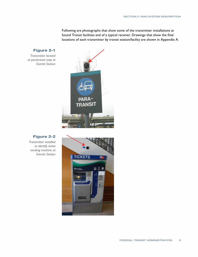
SECTION 2 RIAS SYSTEM DESCRIPTION
Following are photographs that show some of the transmitter installations at Sound Transit facilities and of a typical receiver Drawings that show the final locations of each transmitter by transit stationfacility are shown in Appendix A
Figure 2-1 Transmitter located
at paratransit stop at Everett Station
Figure 2-2 Transmitter installed
to identify ticket vending machine at
Everett Station
FEDERAL TRANSIT ADMINISTRATION 9
Figure 2-3 RIAS receiver with a
neck strap
Figure 2-4 Talking Signs
transmitter for Bus Bay 6 at Federal Way
Transit Center
Figure 2-5 RIAS transmitters
in this area of Kent Station identify and
locate elevator to pedestrian bridge and stairs down to street crossing that leads to
shopping center
SECTION 2 RIAS SYSTEM DESCRIPTION
FEDERAL TRANSIT ADMINISTRATION 10
Figure 2-6 Controllers for
low-voltage Talking Sign transmitters
installed in basement of Everett Transit
Center Existing communications
conduit was used to run low-voltage
wiring to transmitter locations on bus
bay platforms each central controller runs
12 transmitters
SECTION 2 RIAS SYSTEM DESCRIPTION
Figure 2-7 Transmitters at Bellevue Transit
Center Transmitter on right identifies Bus
Bay 6 while other transmitter provides
direction towards other bus bays and
facilities for this transit center
FEDERAL TRANSIT ADMINISTRATION 11
SECTION
3SECTION
3 Human Factors Testing amp Evaluation (HFTE)Procedures
The testing procedures used were developed in accordance with best practices and then approved by the Washington State Institution Review Board to meet requirements established for tests where human subjects are involved These tests on the RIAS system were conducted with staff from Sound Transit LM Telecommunications and Hidalgo amp De Vries Each person assisting with the testing of the system was trained and certified to perform the tests with human subjects by both the National Institutes of Health (NIH) and the Collaborative Institutional Training Initiative (CITI)
The sample frames considered with these tests consisted of 19 persons who are blind or have visual impairments or disabilities This report focuses on the human factors testing and evaluation with respect to the RIAS installation Volpe will conduct the extended end-user research for this installation The method used in evaluating the results of the observer research and post-trial interviews is based upon an approach known as SITE (Charlton 1991) The SITE method supports the design of human factors testing and the interpretation of test results by defining human factors test issues within the four following attributes
1 Situation this defines what the relevant elements are in the environment stimuli setting events system functions or goals
2 Individual this defines who is using the equipment including information about their skills training and cognitive state
3 Task this defines how the equipment is used and what behaviors are associated with the use of the equipment in relative termsmdashfor example how hard how fast how much
4 Effect this describes the success or failure and satisfaction or disappointment associated with the test
The goal of the tests was to provide a method of determining the effectiveness of the RIAS system in providing guidance to the test subjects There were three task groups of tests considered for the observationinteractive research phase of the testing as shown in Table 3-1 Each subtask was created to simulate tasks that would be required by the RIAS user in a multi-modal transportation environment For example each task assumed that the user had arrived at a particular transit facility by train bus on foot or was dropped off by private vehicle at the transit facility
FEDERAL TRANSIT ADMINISTRATION 12
- -
- -
- -
SECTION 3 HUMAN FACTORS TESTING amp EVALUATION (HFTE) PROCEDURES
Table 3-1 Task Group 1 RIAS Testing Task
Groups Task
Station Transit Facility
Sub task Sub task Description
1 King
Street Station
1-1 1-2 1-3
bull From Sounder ADA platform find South TVM bull From TVM locate 4th Ave crosswalk bull Locate stairs leading to Bus Bay C south and Bus Bay D East I-90
Transport participant to Bellevue Transit Center
2 Bellevue Transit Center
2-1 2-2
bull From northwest end of platform find customer service window bull From customer service window find Bus Bay 7
Task Group 2
Task
Station Transit Facility
Sub task Sub task Description
1 Kent Station
1-1
1-2
bull From West Park amp Ride cross pedestrian bridge and locate Track 2 Sounder SeattleEverett bull From TVM find second boarding sign on Track 2 Sounder SeattleEverett
Transport participant to King Street Station
2 King
Street Station
2-1
2-2
bull From Northbound Sounder ADA platform locate stairs up to South Jackson
bull At top of stairs walk to Jackson Street crosswalk
Task Group 3
Task
Station Transit Facility
Sub task Sub task Description
1 Tacoma Dome Station
1-1
1-2 1-3
bull Walk from LINK light rail stop to unisex bathroom located in Information Center bull From Information Center locate 25th St crosswalk bull Proceed across 25th St and locate Sound TVM
Transport participant to Federal Way Transit Center
2
Federal Way
Transit Center
2-1
2-2
bull From Park amp Ride parking area locate sign for uncontrolled crosswalk to bus platforms
bull From center of bus platform locate Bus Bay 6
Participant Training Prior to conducting the tests each participant was trained in the use of the RIAS receiver Each training session consisted of a training facilitator an OampM specialist and at least two training assistants To increase the amount of ldquohands-onrdquo interaction no more than eight participants were used in each training session The Talking Signs Guide for Trainers was followed as the training manual for participant training This training manual is considered the most
FEDERAL TRANSIT ADMINISTRATION 13
SECTION 3 HUMAN FACTORS TESTING amp EVALUATION (HFTE) PROCEDURES
comprehensive reference for use by people who teach others to use the RIAS technology and Talking Signs According to a 1995 study (Crandall et al) ldquothose who receive direct instruction for 15 to 2 hours are more proficient in their use of the [RIAS] systemrdquo Each participant was trained until heshe could successfully use the RIAS system It does not take much time to learn how to use the Talking Sign system and this training assisted in providing a simulation of persons navigating their way that are familiar with the use of the system which is a better simulation of what will be experienced in real life by the frequent user of the system
ObservationalInteractive Research The staff conducting the tests evaluated how well each user was able to navigate through hisher trip and filled out information about the results on prepared forms for groups 1ndash3 In each location the participants were asked to locate specific features of the transit facility Each participant was asked to complete a series of tasks based upon the task group described above For each task the observer recorded the number of transmitters located and the number of requests for assistance from the participant This was the most important part of the research process since it involves the participantrsquos actual success or failure with the RIAS system in a real-world application
The observer accompanied the participant as each task was performed The primary responsibility of the observer was to ensure the safety of the participant during the test The observer also recorded the participantrsquos performance comments and questions which were used to determine the level of success of the RIAS system The test subjects were also asked a series of questions related to their evaluation of the system after the testing was completed and the answers were recorded by the observer
Extended-User Research (Post-Trial Interviews) Once the test subjects had completed the observationalinteractive group tests they were asked to use the system for several weeks At the end of this extended use each participant assisted in filling out forms with questions related to their evaluation of the system These questions were used to assess the participantsrsquo extended experience with the RIAS system and to determine their interest in using the system in the future The answers to these questions were used in analyzing the overall success of the system
FEDERAL TRANSIT ADMINISTRATION 14
SECTION
4SECTION
4 Human Factors Testing amp Evaluation (HFTE) Results
The majority of the test results showed a positive indication that the RIAS system works well in providing people who are blind or who have visual impairments or disabilities with more independence in their travel The results are summarized into two areasmdashthe observationalinteractive research and the participant post-trial interviewmdashas described in the previous section of this report This report provides a summary of the results from these tests as well as some of the issues and lessons learned with the system Detailed HFTE test results and analyses are contained in a report completed by Hidalgo amp De Vries Overall the results of all the tests were fairly positive The participants felt pleased with the effectiveness of the RIAS system and comments suggested there is room for improvement in some areas
ObservationalInteractive ResearchResults Summary For Group 1 the participants were able to locate the majority of the audible signs at the King Street Station and all of the audible signs at the Bellevue Transit Center with no problems One audible sign at King Street Station that identifies the stairs leading down to the International District Bus Tunnel was not located by the participants Overall the participants were pleased with the usability of the RIAS system at these two transit centers however some expressed the need for additional signs around the transit centers At the time of the tests audible signs had not been installed for the crosswalks These signs were not installed for the King Street Station for this project and would help in addressing this need
For Group 2 the test results showed for the King Street Station that the RIAS system was effective and the participants were able to locate all of the signs without assistance The results were different for the Kent Station The participants had more difficulty locating the audible signs at this station and two of the six participants in this group found the RIAS system to be ldquonot very usefulrdquo or ldquonot at all usefulrdquo in the post-trial interviews It should be noted that one of the audible signs at the Kent Station was not transmitting the audible message
Finally in Group 3 all four participants were able to locate the audible signs at the Tacoma Dome Station and three of the four participants were able to locate all the signs at the Federal Way Transit Center without assistance One participant required assistance from the observer to locate one of the audible
FEDERAL TRANSIT ADMINISTRATION 15
SECTION 4 HUMAN FACTORS TESTING amp EVALUATION (HFTE) RESULTS
signs A power outage in part of the Federal Way Transit Center caused one of the signs used in the tests to not be operational Three of the four were able to locate the destination for the subtask using another nearby audible sign
Extended User Research Summary Of the 19 HFTE participants 11 completed post-trial interviews to provide their feedback on the extended use of the RIAS system The participants rated their overall satisfaction with the RIAS system on a 10-point scale with 10 as the best experience and 1 as the worst experience The average rating was 682 with a high rating by one participant of 10 and a low rating of 3 The following are the most significant items from the participant interviews
bull Overall the participants were very satisfied with the RIAS system and their role in the study
bull The majority of participants would not use the RIAS system if they had to pay out-of-pocket for a RIAS receiver
bullThe majority of participants would use the RIAS system if the RIAS receiver was provided free of charge
bull If the RIAS system was available at the rest of Sound Transitrsquos facilities more participants would use the RIAS system
Issues and Lessons Learned There were several issues that were encountered during the HFTE tests At two stations there were problems with some of the audible signs not being operational Most of these seemed to be related more to maintenance issues from temporary power outages while maintenance was repairing nearby lighting damage This would likely be a continuing issue as maintenance at each station is needed and power to the audible signs would need to be temporarily disconnected For their safety travelers who are blind or who have visual impairments or disabilities would need to be notified in some way when these conditions occur
Another issue that occurred was that there were reflections of the RIAS signals in some instances which create a potential hazard to the traveler One instance in particular occurred when a RIAS signal reflected off a person wearing a reflective jacket who was standing in front of the participant during testing This caused the signal to transmit to the participantrsquos receiver coming from the opposite direction intended by the RIAS system which caused the participant to become confused about the direction needed to walk to reach the destination Reflections off articles of clothing are likely to occur every now and then particularly when walking through crowded areas which is common at the Sound Transit multimodal facilities Reflections of the RIAS signals also seem to occur when the signal reaches metallic objects Items at transit facilities that would
FEDERAL TRANSIT ADMINISTRATION 16
SECTION 4 HUMAN FACTORS TESTING amp EVALUATION (HFTE) RESULTS
reflect the RIAS signal include elevator doors support columnsbeams and roofs and certain parts of ticket vending machines In some instances reflections are used as an installation method such as pointing transmitters at elevator doors to guide persons to elevators where the transmitter cannot be located above the doors Any highly-polished surface can reflect the IR transmissions
Issues were found with some of the RIAS signals being blocked by objects At the King Street Station there were temporary vinyl banners that had been placed in the bridgewalkway leading down to the platforms which prevented the receiver from picking up the audible message Other objects that blocked RIAS signals included concrete structures wallsbuildings shelters and structural supports
Overall it seems that placement and setting the direction and adjusting the strength of the audible signs signal is the key to reducing these reflections and avoiding objects that may block the signal There are problems however in some transit facility locations where it becomes difficult to place the audible signs in a way that they can effectively function In addition future placement of objects at each facility should not be completed without some consideration regarding the effects these objects will have on RIAS system performance
The RIAS signals also seemed to be affected to some degree by sunlight In one instance the signal strength of one sign appeared to be stronger during cloud cover than it was with more sunlight or a brighter sky behind the transmitter location One issue that was mentioned by some of the participants was that there were not enough audible signs in some locations It was a great to provide audible signs at all locations in the Tacoma Dome Station in particular because of large open walking areas with nothing that could be used for mounting the sign In addition there were budget constraints that limited the number of audible signs installed
Analysis by Others The Volpe Institute will be determining the practical operation of the RIAS technology and its benefits In addition Hidalgo amp De Vries has conducted a more detailed review of the human factors tests This project requires a report to the US Congress by the Secretary of Transportation which will be finalized by Volpe with this report and Hidalgorsquos report provided as input to the final Volpe report The following are the evaluation points Volpe will be considering
bull The effect on multimodal accessibility in public transportation with regard to persons with visual cognitive and learning disabilities
bullThe effect on making public transportation accessible to persons with visual cognitive and learning disabilities who use public transit and paratransit
bull The effect on education community integration work life and general quality of life of the targeted populations
FEDERAL TRANSIT ADMINISTRATION 17
SECTION
5SECTION
5 Existing WayfindingTechnology Review
As part of an evaluation in recommending further investment into RIAS technology it is important to consider the existing technology that is available or under development for wayfinding systems for people who are blind or who have visual or cognitive disabilities These systems can be divided into several categories
bull Infrared (IR) and light emitting signs
bull Radio frequency (RF) or Wi-Fi signs
bull Bar-coded signs
bull Gps-based systems
bull Research projects
This review has considered only wayfinding technologies that would have a benefit similar to that provided by Talking Signs In other words the focus of this review has been on technology for orientation and navigation with a particular focus on systems that provide orientation and navigation for public transportation facilities
Infrared (IR) and Light EmittingSigns One technology that has developed with great promise is audible signs that transmit infrared or light signals that can be decoded by a receiver The transmitted information is converted to an audible message that is played on a receiver to the person with visual impairments or disabilities Two types of these systems that are currently in operation have been reviewed for this report Talking Signs and Talking Lights (Talking Lights LLC)
Talking Signs Talking Signs has emerged as a promising technology that can provide localized directional information and item identification to persons with visual impairments or disabilities There have been many studies and tests with human subjects to determine the effectiveness and value associated with using this system This system has developed to the greatest degree in the marketplace and in the number of system implementations which gives it an advantage over other similar competing technologies
FEDERAL TRANSIT ADMINISTRATION 18
SECTION 5 EXISTING WAYFINDING TECHNOLOGY REVIEW
The Talking Signs system has been used in many transit environments and has the capability to provide easily-updated message information such as changes in bus numbers or routes for a particular bus The system has also been embedded in visual message signs to match the messages displayed Many studies have been completed for this system and it has been shown to be of benefit to travelers with visual impairments or disabilities The main drawback to using this system is that it is costly Talking Signs has established relationships with other companies to continue to develop the system to make sure it continues to transition to a more open architecture environment to be used with other transit systems in the future More detailed information about this system including a description of the Sound Transit Talking Sign system is provided in Section 3
Talking Lights Talking Lights is a system developed by a team at MIT that uses ordinary lights and embeds a signal that can be decoded by a receiver The system is a high-resolution tracking system that uses PDAs with audio direction software The advantage of this technology is that there are no wires needed to install facilities can use their existing lighting infrastructure and the light bulbs do not consume any additional energy to perform their function
While this appears to be promising technology that could be more easily implemented by modifying existing lights within a facility it is still new This system has had success for patients at the Spaulding Rehabilitation Hospital in Boston and there is currently a study going on at the Decatur Hospital in Georgia Other plans include developing a system for museums In addition this system seems to be used only for indoor applications although Talking Lights has teamed with the Sendoro Group to provide an outdoor navigation system
Radio Frequency (RF) Signs Step-Hear Step-Hear is a new product that debuted in August 2008 at the World Blind Union 7th Assembly in Geneva Switzerland This product is similar to Talking Signs in that it uses a base transmitter to send directional information to a hand held receiver The system uses radio frequency signals transmitted by the base transmitter provided in a directional nature to transmit information about the location of the transmitter
This system also seems to have a few more features than Talking Signs The receiver vibrates when it is within range (about 12 ft) of a base transmitter and for bus installations a red light is activated to notify the bus driver that a person needing help entering the bus is within range of the transmitter In addition the base unit can be integrated with the bus GPS and speaker systems Changing
FEDERAL TRANSIT ADMINISTRATION 19
SECTION 5 EXISTING WAYFINDING TECHNOLOGY REVIEW
the messages appears to be quite simple using a built-in switch and button that when used together will allow modification of the message
One drawback to this technology is that it has not yet been fully deployed and has yet to be proven as a viable option in the marketplace There is currently an installation ongoing for a bus system which is reportedly showing success A full report on this project was promised to be provided once the project was completely installed tested and operating on the system Information about this system was limited at the time of this report and further review of the installation on the bus system should be completed when available
Bar-Coded Signs University of California and Smith-Kettlewell EyeResearch Institute Color Marker and Bar Code System
This system is still in the research stage of development and cannot be considered as a viable alternative at this point However the system does show some promise in the future for providing a beneficial cost-effective wayfinding system The system is based on a cell phone that detects color markers placed throughout the environment These markers are detected by the cell phone at a distance of several meters away The purpose of the color marker is not to give any information about the location of the marker but to help a person with visual impairments or disabilities to detect the marker A bar code is then placed near the marker and the cell phone can decode and receive information about the location This typically requires the user to move closer to the marker to process the information and determine location-based information
GPS-Based Systems There are many GPS-based systems that travelers with visual impairments or disabilities can use to assist in guidance to a destination There are a few that are commercially available and many others still being developed All systems are for outdoor use only with very limited capability indoors due to lack of GPS satellite signal These systems continue to advance with greater accuracy including WAAS corrections which can provide 2ndash3 meter accuracy Common GPS for the consumer market has been tested to have a location accuracy of within 30 meters as a comparison
Loadstone GPS Loadstone GPS is open source software using satellite navigation for persons with visual impairments or disabilities The benefit to this system is that the software is free and will run on many different Nokia cell phone devices It requires a GPS receiver that connects to the cell phone by Bluetooth In
FEDERAL TRANSIT ADMINISTRATION 20
SECTION 5 EXISTING WAYFINDING TECHNOLOGY REVIEW
addition a screen reader program must be running on the cell phone such as Talks or Mobile Speak to give the user instructions
Wayfinder Access This GPS solution is similar to Loadstone however it offers more features to the traveler with visual impairments or disabilities It is a software application that uses Symbian phones to work with screen readers Other features are customized for persons who are blind or who have visual impairments or disabilities to provide them with information about surroundings including feedback on points of interest and Braille support
Trekker Trekker was developed as a personal digital assistant (PDA) application operating on a Microsoft Pocket PC operating system and was adapted to be used by persons who are blind or have visual impairments or disabilities with talking menus talking maps and GPS information Features include determination of position creating routes and receiving information about navigating to a destination A search function for points of interest is also available This application has the ability to expand to accommodate new hardware platforms and more detailed location and geographic information
BrailleNote GPS BrailleNote GPS was developed by Sendero Group and the idea behind it combines a PDA with direction software that returns audible directions to the user It uses GPS to pinpoint a personrsquos position and nearby points of interest and is about the size of a small cell phone Points of interest can be input into the system and directions to these locations can be accessed This is similar to the GPS-based direction systems for automotive use
Mobile Geo Mobile Geo works with Windows Mobile-based smartphones Pocket PC phones and other PDAs The GPS and mapping technology built into this system is from the Sendero Group It is the first solution that works with a wide range of mainstream mobile devices and it can be used with more than 20 different Braille devices for input and output It works with Mobile Speak screen reader software which is a Code Factory product It is compatible with more than 300 PDAs as well as mobile phones that operate on GSM CDMA and WCDMA networks Like other GPS-based solutions Mobile Geo pinpoints the travelerrsquos location and provides information about points of interest The benefit to this product is that it has built-in map data
FEDERAL TRANSIT ADMINISTRATION 21
SECTION 5 EXISTING WAYFINDING TECHNOLOGY REVIEW
Research Projects A number of projects are currently under development and a few of these are mentioned below The trend for wayfinding systems and technology for persons with visual impairments or disabilities is to use a combination of GPS infrared RF and other methods to provide a more complete solution for travelers with visual impairments or disabilities The systems described below are provided in this report to show this trend as well as to provide a basis for recommendations on pursuing an integrated solution using GPS and smartphone technologies with Internet capability
University of South Florida Travel Assistance Device(TAD) The University of South Florida (USF) Center for Urban Transportation Research is developing software that uses GPS technology inside cell phones to assist persons with cognitive disabilities to navigate public transportation Users can access a website that is similar to the Google Map interface where they can select their route location stop and travel times Trips are planned using this website and then downloaded to the cell phone The software developed by USF is installed on the phone and can give the rider alerts while riding the bus to prepare himher to exit the bus at the planned destination The system was tested last year with student with developmental disabilities and was quite successful
Trinetra The Trinetra project aims to create a smartphone solution that will benefit persons with visual impairments or disabilities The goals are to develop a cost-effective system This project is one to reconsider in the future since the plans are to develop a system that will assist the needs of persons with visual impairments or disabilities who uses public transportation by providing them with real-time information The concept of the system uses a combination of GPS receivers and infrared sensors that relay information to a centralized fleet management server using a cell phone The person with visual impairments or disabilities can then use a cell phone with text-to-speech capability to determine estimated time of arrival location and current bus capacity using a web browser Other research for this project is considering the use of universal product codes (UPCs) and radio-frequency identification (RFID) for indoor navigation in a shopping setting
NOPPA The NOPPA project was a three-year project (2002ndash2004) in Finland as part of the Ministry of Transport and Communications Finlandrsquos HEILI Passenger Information Program which was a pilot program to develop a system for
FEDERAL TRANSIT ADMINISTRATION 22
SECTION 5 EXISTING WAYFINDING TECHNOLOGY REVIEW
navigation and guidance for persons with visual impairments or disabilities who use public transportation It is similar in goals to the Trinetra project and uses GPS technology combined with Wi-Fi smartphone for Internet access and text-to-speech capability optional RFID reader and a database of route information to provide directional information to the user Like Trinetra it is based on a central information server concept While the pilot program was successful there are still drawbacks to this system which includes wireless and GPS not always being available in areas without line of sight or in urban canyons issues associated with having outdated information in the central database and availability of this system in the United States
Brunel University Navigation System Brunel University is developing a system that is based on the combination of several state-of-the-art current technologies including GPS and GIS The system provides automated guidance using the information from daily updated digital map datasets The difficulties with this system include the availability of up-to-date information and what information to offer with the navigation procedure Different levels of functionality have been created with this system to be able to customize the information to the user
Drishti Drishti is a wireless pedestrian navigation system developed by the University of Florida The system integrates technologies including wearable computers voice recognition and synthesis wireless networks GIS and GPS It also provides contextual information to the person with visual impairments or disabilities and computed optimized routes based on user preference traffic congestion and obstacles such as road work The system guides the user to navigate based on both available static and dynamic data This requires a spatial database that provides environmental conditions and landmark information along the travelerrsquos route The system also has the capability for the user to add information to the database
Transit Location and Schedule Data Several technologies are being developed that assist travelers in navigating a transit system Google Transit is a popular system that has developed since 2005 and now includes 70 transit agencies in 10 countries It is a web-based application that uses a database of information from each transit agency along with Google Maps to determine the best bus route or routes and times for transporting passengers to and from locations that are input online by the traveler King County Metro is already part of the Google Transit system
Sound Transit already has existing databases built for a regional Trip Planner system which uses Trapeze software for their bus routes King County Metro
FEDERAL TRANSIT ADMINISTRATION 23
SECTION 5 EXISTING WAYFINDING TECHNOLOGY REVIEW
Community Transit and Pierce Transit are also already part of this system It will not be added to the Sounder rail line until the commuter rail line is completely built out For some agencies real-time feeds are also provided for locating certain buses on routes of interest however at this time Sound Transit does not have the ability to provide these real-time feeds These systems will continue to improve in providing wayfinding information for travelers
Current Trends for WayfindingTechnology Technology today is rapidly changing It is estimated that every 18 months another set of advancements in technology will occur The wayfinding system technology is no different and this market should be frequently analyzed in order to be aware of innovative cost-effective solutions that become available to travelers with visual impairments or disabilities
Computer chips and small embedded devices are already being placed in many environmental aspects of our lives such as ldquosmartrdquo surroundings These have the ability to monitor and report conditions continually and computer chips are increasingly being found in signage They can be placed in walls poles sidewalks etc and provide information to the traveler As computer chips continue to expand in application technologies will advance to the point of providing benefit in wayfinding for persons with visual impairments
The current trend for wayfinding technology as can be seen from the GPS-based systems and research projects evaluated is to further develop and use smartphones and PDAs with Internet and GPS applications and blend several technologies to provide a complete solution for navigation The focus is on developing software applications that will run on many of the devices people carry with them already such as smart phonesPDAs The integration of Bluetooth GPS and radioWi-Fi functions in a handset provides many benefits and is the current trend The benefits include improved system performance improved cost structure power consumption savings and other savings from shared system use including ease of assembly because of shared packaging
Many applications are available for pedestrians drivers and public transportation users that continue to improve the efficiency of traveling Some of these applications can in conjunction with other technologies provide wayfinding for both travelers who are blind or who have visual impairments or disabilities as well as all travelers These types of technologies could potentially increase funding as they help a greater number of public transportation users
The GPS-based systems are continuing to be improved and other technologies are being combined with GPS to provide more accurate wayfinding information
FEDERAL TRANSIT ADMINISTRATION 24
SECTION 5 EXISTING WAYFINDING TECHNOLOGY REVIEW
Some systems use Wi-Fi to assist location determination while others use inertial sensors and cameras in areas where GPS signals may be limited It seems clear that GPS systems combined with smartphones with Internet access are the future of wayfinding systems as there are many new developments occurring to continue to increase the effectiveness of these systems For those who are blind or have visual impairments or disabilities stable low-cost technologies are important
Summary of WayfindingTechnology Review Based upon the technology review of this report there are three current options available to use for localized directional information Talking Signs Talking Lights and Step-Hear systems Other GPS-based or GPS-assisted systems using smartphones or PDA technologies using a database of points of interest seem to have the capability to provide outdoor wayfinding at a continually increasing accuracy Current accuracy taking into account WAAS corrections for reasonably-priced GPS units is about 2ndash3 meters Based upon the evaluation of RIAS technology using GPS systems would be similar to the accuracy provided by RIAS for persons with visual impairments or disabilities in determining the actual position of a particular point if WAAS corrections are taken into account Since the current trend is for ldquosmartrdquo devices the GPS-based technologies should be considered an option for providing wayfinding outdoors while using other systems for indoor navigation
The Talking Signs system still has the market advantage when compared to other localized directional information systems and is the most proven system at this time with many installations currently in place throughout the world One drawback to this system as with some other systems considered in this report is that the current trend for wayfinding technology is to integrate a number of technologies together Cell phonesPDAs are integrating with technologies including webe-mail access interactive voice response and text-to-speech technology GPS wayfinding systems digital cameras for recognition purposes palm computing and CPUs and smart-sensing environments The enhanced cell phone is becoming a handy remote device for finding information about the environment As technology continues to advance these smartphones will become smaller and less expensive with more features Modifications to the cell phone will continue to adapt to be a cost-effective and universal solution for wayfinding Another drawback for this system is that it is mainly used for item identification Information on routespaths to take are given within the messages of some of the signs however the user is not given a travel route based on his her destination information
FEDERAL TRANSIT ADMINISTRATION 25
SECTION 5 EXISTING WAYFINDING TECHNOLOGY REVIEW
The Talking Lights system is already working with Sendoro Group which provides GPS wayfinding products to integrate the two technologies This system also has the capability to integrate with a local Wi-Fi mesh network Talking Lights seems to be a cost-effective solution based upon costs that were obtained and are provided in the next section This system at this time is limited to indoorbuilding applications which makes this technology a good fit for integration with a GPS-based technology There are plans to expand the system to outdoor environments and an application of this system has already been introduced on headlights for military vehicles Some concerns for outdoors would be problems that could occur during the daylight versus at night and other light interference sources that could reduce the performance of the system however if this system is integrated with other technologies such as GPS-based technology from Sendoro Group it could prove to be a useful navigation aid for both indoor and outdoor environments An advantage that this system has over the Talking Signs system is that it acts in a similar manner to GPS-based wayfinding technologies In other words it uses more than just item identification and delivers pathroute information to the user via a central database The two main drawbacks are that the system does not have the same market presence as Talking Signs so long-term viability is a concern and the system has not been tested in a transit environment for people who have visual impairments or disabilities or cognitively disabilities
The Step-Hear system is fairly new technology that shows promise in comparison to the Talking Signs system Unlike the disadvantage Talking Lights has in outdoor applications the Step-Hear system can operate in both outdoor and indoor environments This system appears to have a few more functions than Talking Signs however it is also not fully proven in the market Once the initial installation is complete for this system another evaluation should be completed to determine its effectiveness This system also seems to be a cost-effective product like Talking Lights A comparison of costs for these three systems is provided in the next section
In summary a blending of technologies seems to be the best solution for providing people who have visual impairments or disabilities and cognitive disabilities with a wayfinding system that can be used for public transportation Smartphones or PDAs with speech-to-text capability can access via the Internet databases of information for points of interest particularly GPS coordinates and determine step-by-step instructions to the user based upon hisher GPS-determined position Google using its Google Transit database and TimeTablePublisher software for schedules and locations has already begun integrating transit points of interest just as the regional Trip Planner for the Puget Sound bus systems does and now gives users step-by-step instructions for using public transportation based upon the starting and ending points of the traveler Creating a database of transit points of interest that would aid a traveler
FEDERAL TRANSIT ADMINISTRATION 26
SECTION 5 EXISTING WAYFINDING TECHNOLOGY REVIEW
with visual impairments or disabilities would seem to be an effective solution that could be used by technologies integrated with GPS systems for wayfinding from a long-term perspective For buses however the localized item identification systems would have an advantage for those that are easily updateable with bus information although current trends with GPSAVL systems on buses are to publish bus locations online that could then be accessed via a smartphone PDA or other ldquosmartrdquo device
FEDERAL TRANSIT ADMINISTRATION 27
SECTION
6SECTION Cost Benefit Analysis 6
Introduction In completing a cost benefit analysis for something that provides social equality to a group of people a typical cost versus benefit analysis is not possible The basic benefits for a person with visual or cognitive disabilities from a wayfinding system are
bullAbility to travel with confidence and enable them to become more independent
bullOverall positive effect on quality of life
Detailed analysis on the benefits of Talking Signs as well as costs for the system have already been completed in numerous other studies including those done by the University of California Santa Barbara and the Smith-Kettlewell Eye Research Institute The results from the human factors testing at Sound Transit also show that the RIAS system was received positively by the evaluation participants as summarized in Section 5 and as detailed by the report completed by Hidalgo amp De Vries
Because of the social benefits of this type of system this cost benefit analysis will focus primarily on how well each technology performs as a wayfinding system for persons with visual impairments or disabilities and the cost implications for each of the technologies The purpose of this analysis was to evaluate these cost implications for RIAS as well as other technologies and to determine whether proceeding with expansion of a RIAS system would be the best solution to provide these benefits to persons with visual or cognitive disabilities in the Puget Sound area The cost benefit analysis provided in this report focuses on the following
bullBased on the number of people who have visual and cognitively disabilities in the Puget Sound area as well as those which use public transportation determine how many people could potentially benefit from a wayfinding technology system
bullBased on the number of people who have visual and cognitively disabilities in the Puget Sound area analyze paratransit costs for Sound Transit to determine the potential cost savings in reducing the number of persons using this service
bullBased upon the technology review compare four main products or solutions for costs and benefits and the risks with the use of each system Talking Signs Talking Lights Step-Hear and a combination of one of these three to use for just indoors and on buses with a GPS-based system for outdoor navigation
FEDERAL TRANSIT ADMINISTRATION 28
SECTION 6 COST BENEFIT ANALYSIS
Table 6-1 Statistics on
Persons with Visual Impairment and
Cognitive Disabilities in Puget Sound
Evaluation of Potential WayfindingSystem Users in the Puget Sound Information about the number of persons with visual and cognitively disabilities is summarized in Table 6-1 The number of persons with developmental disabilities for each county was obtained from Sound Transit and the statistics for the number of persons who are blind or have visual disabilities is based on percentages from the US Census Bureau on people with sensory disabilities for the tri-county area from a 2006 American Community Survey Other national percentages are from the US Cernsus Bureau 2005 measures of disability Based upon these available statistics estimated upper bounds of 4 percent of the population were used in Table 6-1 Population estimates were based upon information from the US Census Bureau
Puget Sound Region County
Total Persons with Cognitive Disabilities
Total Persons with Visual Disabilities or Blind
King 10399 74371
Pierce 4712 30927
Snohomish 3469 27076
Total 18580 132374
From these numbers it appears that there are many people who could potentially benefit from a wayfinding system in the Puget Sound region Also from the post-trial interviews the participants were likely to use the RIAS system for a range of trip purposes such as work shopping social events recreation and education
Potential Cost Savings for Paratransit Services There are cost savings that could be seen from persons who are blind or who have visual disabilities becoming more independent in their travel These costs would be related to paratransit services for these persons As more persons who are blind or who have visual disabilities become more independent they will likely use paratransit services less or not at all Information about the operating expense per revenue mile for demand response vehicles was obtained from the 2007 National Transit Database Based upon the information available from Sound Transit it is estimated that approximately 4 percent of the passenger miles represents passengers who are blind or who have visual disabilities From this estimate the total cost savings was calculated for 2007 and is shown in Table 6-2
FEDERAL TRANSIT ADMINISTRATION 29
SECTION 6 COST BENEFIT ANALYSIS
Table 6-2 Paratransit Costs
and Potential Savings (based on 2007 cost
data for demand response vehicle operating costs)
Table 6-3 Talking Signs System
History of Costs
Demand Response Transit Agency Cost per Passenger Mile 4 of Cost per
Passenger Mile Potential 2007 Cost Savings
King County Metro $424 $017 $1920000
Pierce Transit $455 $018 $630000
Community Transit $353 $014 $320000
Total $2870000
From this analysis there are significant potential annual savings in providing a wayfinding system for persons who are blind or who have visual disabilities which would decrease paratransit use and thereby reduce the operating costs for paratransit services
Wayfinding System Costs Costs for the different types of wayfinding systems available were obtained from each of the vendors One of the problems with the comparison of costs is that only material costs were obtained from Step-Hear and only installation costs for buildings were obtained from Talking Lights By far Talking Signs has the most cost information available for this analysis because it has been installed in more locations Because of this the analysis focuses on comparing material costs between Talking Signs and Step-Hear and building system costs between Talking Signs and Talking Lights
Talking Signs Costs Information about the costs for Talking Signs was obtained from previous installations as well as from the bid provided by Talking Signs Services Inc for the Sound Transit RIAS project Table 6-3 shows installation costs (in cost per transmitter) for some Talking Signs projects
Installation Location Number of Transmitters Cost per Transmitter
Sound Transit 370 $7005
TriMet 30 $2655
San Francisco Muni 30 $3200
Colorado Springs 10 $3760
Phoenix Public Transit 10 $4630
Port of San Francisco 30 $4635
Caltrain 40 $3000
It should be noted that installation costs for the Sound Transit RIAS project are much higher because the other installation costs did not include installation of the system infrastructure such as conduit cable etc In other words Talking Signs has typically installed the system in locations where all that is required is to install the transmitter and test and operate the system the other costs for conduit and system infrastructure were provided through separate contracts In
FEDERAL TRANSIT ADMINISTRATION 30
-
SECTION 6 COST BENEFIT ANALYSIS
Table 6-4 Talking Signs Material
Costs
addition the costs given above were the costs at the time of the installation The Sound Transit project is the most recent one given
Table 6-4 shows the material costs per transmitter and receiver There are two different types of transmitters provided so an average transmitter cost is given
Talking Signs Equipment Unit Cost
Average material cost per transmitter $1600
Material cost per receiver $265
Step-Hear Costs As mentioned only material costs were obtained from Step-Hear Additional cost information will be provided once the first project for this system is completed Below is a table which shows the cost per transmitter and per receiver for this system
Table 6-5 Step-Hear Material
Costs
Step Hear Equipment Unit Cost
Average material cost per transmitter $100
Material cost per receiver $22
Talking Lights Costs The cost to install Talking Lights was obtained only for indoor applications Depending on the type of facility and complexity the cost to install Talking Lights ranges from $050ndash2 per square foot A comparison of this cost with Talking Signs based upon the historical costs at the San Francisco Caltrain station is given in the next section
GPS-Based System Costs It is difficult to determine the actual cost for a GPS-based solution that could be used by the person with visual or cognitive disabilities for wayfinding There are several smartphone systems such as Loadstone GPS which runs on Nokia phones and interfaces to a GPS receiver Costs were calculated from some of the systems evaluated in this report and are included in Table 6-6 In addition to the costs for these systems some costs would be necessary to develop a database for Sound Transit specific points of interest and other points required for wayfinding as well as monthly costs for the phone service In downtown areas where it is difficult to gain connectivity with GPS signals from satellites additional WAAS or other fixed location signal sources may need to be installed to provide accurate locations
FEDERAL TRANSIT ADMINISTRATION 31
SECTION 6 COST BENEFIT ANALYSIS
Table 6-6 GPS-Based System
Costs
Table 6-7 Sound Transit
Wayfinding System Installation Cost
Comparison
System Type Unit Cost Avg Monthly Service Cost
Loadstone GPS (includes smartphone software GPS receiver screen reader)
$700 $60
Wayfinder Access (includes smartphone software GPS receiver screen reader)
$1200 $60
BrailleNote GPS V 3 (Includes maps receiver pouch cable 1 GB CF card)
$1599 NA
Trekker GPS System $1695 NA
Mobile Geo (includes smartphone software GPS receiver screen reader)
$1745 $60
Wayfinding SystemsCost Comparison Summary Talking Signs and Step-Hear Cost Comparison In comparing material costs shown between Talking Signs and Step-Hear it is clear that Step-Hear has a very large cost advantage from a material unit per unit basis Talking Sign transmitters are 18 times the cost of a similar Step-Hear transmitter and receiver costs are more than 10 times more expensive for material only Table 7-7 shows a comparison of the total RIAS Sound Transit installation costs based upon the complete bid from Talking Signs with equivalent costs for Step-Hear The cost shown for the Step-Hear system was calculated by substituting material costs for Step-Hear transmitters and receivers for the Talking Sign transmitter and receiver bid prices This comparison assumes that conduit and power cabling needs and installation costs for mounting the transmitters are the same
System Type Cost
Talking Signs System (actual installation cost in todayrsquos dollars) $2199765
Step-Hear System (estimated cost based upon Step-Hear material costs) $1665495
One major factor that is not considered in the above comparison is the number of Step-Hear transmitters that would be necessary to replicate the same system coverage for Talking Signs Information obtained from Step-Hear indicated the range for the transmitter was about 65 feet which is somewhat shorter than the maximum range for the Talking Signs transmitter of around 100 feet Also it does not seem the Step-Hear transmitter has similar capabilities in adjusting the strength of the signal Another problem with this comparison is the assumption that installation costs would be similar including testing training and maintenance The main result of this analysis is that it would appear that Step-Hear would have a cost advantage for installation on buses since transmitter coverage areas would be similar for both and it would take the same number of Talking Signs transmitters on a bus as it would for the Step-Hear system
FEDERAL TRANSIT ADMINISTRATION 32
SECTION 6 COST BENEFIT ANALYSIS
Table 6-8 Caltrain San Jose
Diridon Station Wayfinding System
Installation Cost Comparison
Table 6-9 Sound Transit
Wayfinding System Installation Cost
Comparison
Talking Signs and Talking Lights Cost Comparison For the Talking Lights system it is difficult to compare on a cost-to-cost basis with Talking Signs The method used for the purpose of this report was to consider the historical cost (converted to todayrsquos dollars) to install the Talking Signs system at the San Jose Diridon Caltrain station with a Talking Lights system cost for this station of $2 per square foot The area in square feet was calculated for the coverage area provided by Talking Signs at this station This included areas outside on train platforms as well as indoor areas This installation was only for mounting installation and testing of the RIAS system and did not include conduit and wiring costs which were completed under a separate contract Table 6-8 shows a simplified comparison of the costs between these systems using this method
System Type Cost
Talking Signs System (actual installation cost in todayrsquos dollars) $215000
Talking Lights System (est cost based on $2sf) $32000
Based upon this comparison there seems to be a large cost advantage for the Talking Lights system However this comparison does not consider the issues that could be encountered for the outside train platform areas of the San Jose Diridon Caltrain station if Talking Lights were used This does indicate that further investigation of the costs and effectiveness of the Talking Lights system for at least indoor transit facility areas should be completed
Talking Signs and GPS-Based System Cost Comparison In comparing the Talking Signs system to an outdoor GPS-based system there are a number of factors to consider Table 6-9 shows the actual cost for the RIAS system for Sound Transit compared with the estimated cost for implementing a region-wide database of points that are web-accessible The costs assume that receivers (GPS-based or Talking Signs receivers) will be purchased by the user Based upon the results of the participant interviews purchasing these receivers is a critical factor for determining whether persons will actually use the system
System Type Cost
Talking Signs System (actual installation cost in todayrsquos dollars) $2199765
GPS-based system (est cost to create point database interface and web access)
$150000
An integration of these technologies would seem to be more feasible As mentioned the costs above do not include the purchase of the individual GPS systems for each user which would likely be an issue for the user to purchase The cost to create this database is small since many of the bus routes for Sound Transit and King County Metro are already created using the Transit Trip Planner system Budget is already in place to update the database several
FEDERAL TRANSIT ADMINISTRATION 33
SECTION 6 COST BENEFIT ANALYSIS
times per year to make sure the bus route information is current The cost to create this database includes creating points for the entire regional transit system which would cover a larger area than the initial RIAS system at the six Sound Transit facilities It should be noted that the cost for the GPS system does not include review and testing of the system or a review from an OampM specialist From a per-person cost perspective for the entire regional transit system if the funding is to include purchasing a $700 personal GPS system and $250 for the RIAS receiver for each user the RIAS system has a cost advantage based upon the number of people in the Puget Sound area who have visual or cognitive disabilities However further comparison of costs of this system should be considered as GPS systems advance and costs for these systems continue to decrease
Wayfinding SystemsImplementation Risks Since RIAS technology has already been demonstrated in the Puget Sound area and in many other locations risks in proceeding with further system implementation are minimal There have also been many studies that have shown the system to be very successful and it has been tested more extensively by transit users who are blind or who have visual disabilities than any other system
There are several risks associated with installing a different system other than Talking Signs The main risks are
bullAnother custom device would be needed by the user
bullOther technologies do not have transit system studies completed using persons who are blind or have visual disabilities
bull Newer technology may not last long term
There are problems created when a user is required to have two different receivers to have the ability to travel independently For instance if a different technology other than RIAS is used for installation on the remaining Sound Transit facilities this would create the need for travelers who are blind or have visual disabilities to carry two different receivers and have the knowledge about which receiver to use at each facility This would make it more difficult for the user to travel effectively and could increase the cost if two receivers are needed to be purchased This would be simplified if one receiverunit was used indoors and a GPS-based unit was used outdoors By adding a cardmodule to the GPS-based unit to pick up either IR or RF signals from the item identifying transmitter these two units would have the potential to be integrated into one future unit
The Talking Signs RIAS technology is still the only technology that has been proven beneficial for use by persons who are blind or have visual disabilities in
FEDERAL TRANSIT ADMINISTRATION 34
SECTION 6 COST BENEFIT ANALYSIS
a transit environment There have been many studies and tests of the system on many transit systems All of these studies and tests including this most recent test with Sound Transit have been successful and have shown great benefits to the user Talking Lights has only been tested and used in an indoor hospital environment and has not been tested for use by persons who are blind although those who have had brain or eye surgery would have navigation needs similar to those who are blind or have visual disabilities impairments The Step-Hear system has only been completed on one bus system installation and the effectiveness of this system when compared to Talking Signs has yet to be determined
In addition both Talking Lights and Step-Hear are new technologies that have not been on the market very long The probability of these systems surviving in the market long term is less than for Talking Signs which has been in the market for many years There would naturally be increased risk in supporting technologies that are new and not proven
One issue in using Talking Signs and Step-Hear systems is that they are based upon item identification which has less focus on step-by-step guidance In other words a person could become lost or find it necessary to backtrack if the item was not identified and the person continued past the transmitter Also the transmitters are somewhat limited in placement because of mounting issues in the field which may not always be the best for guiding a visual impairments or disabilities traveler One issue noted during the installation and tests with the Sound Transit RIAS system was the ability for signals to reflect off of other objects particularly metallic objects This can sometimes create a message that gives the traveler incorrect information about which direction to go Reflection of RF signals from Step-Hear could also occur as well as issues associate with interference from other RF sources
GPS-based GPS-based systems are a good solution to provide directional information outdoors These systems are the trend for wayfinding technology so future integration and implementation of more advanced wayfinding systems would likely be easier when compared to the other wayfinding systems evaluated Because of this there is less risk in implementing GPS-based technology that is proven to be effective in guiding persons with visual impairments or disabilities There are many existing systems now that use GPS for the persons with visual impairments or disabilities and all that is necessary is to continue building a database of transit points of interest for travel path calculation purposes Satellite signals are sometimes blocked in areas such as around large high-rise buildings however applications are being developed that use last-known-positioning to calculate position within these types of dead zones Building footprints are also being placed into GPS databases in an effort to guide persons around the city areas In addition the iPhone offers assisted GPS through the use of Wi-Fi
FEDERAL TRANSIT ADMINISTRATION 35
SECTION 6 COST BENEFIT ANALYSIS
positioning which could also be used in urban areas for guidance One concern with the GPS-based systems as with other new technologies is the time it takes for people to become comfortable using the technology yet already there are persons with visual impairments or disabilities or who are blind using these systems for navigation
RIAS Installation Evaluation for Remainder of Sound Transit Facilities Another purpose of this project was to evaluate the cost implications for completing installation of the RIAS system on the remaining Sound Transit facilities and future facilities and on vehiclesbuses The following are the remaining facilities at Sound Transit that do not have a RIAS system installed
bull Edmonds Station
bull Mukilteo Station
bull Tukwila Station
bull Auburn Station
bull Sumner Station
bull Puyallup Station
bull Ash Way Park amp Rid
bullOverlake Transit Center
bull South Tacoma (open for bus opened for commuter rail in 2010)
bullLakewood Station (open for bus opened for commuter rail in 2010)
bull Lynwood Transit Center
bull Light Rail System (existing Tacoma line and new line opened for airport in 2009)
The Sound Transit RIAS project cost was $22 million to install at 6 facilities including some crosswalks and bus stops Operations and maintenance of the system and system support has already been budgeted within the Mobility Initiative Program and is not considered in the costs provided here Table 6-10 shows the budgetary costs per facility including buses commuter rail and light rail trains to install the RIAS system at the remainder of the Sound Transit facilities
FEDERAL TRANSIT ADMINISTRATION 36
SECTION 6 COST BENEFIT ANALYSIS
Table 6-10 Sound Transit RIAS
Costs for Remaining Facilities and Vehicles
Sound Transit Facilities Including Buses and Trains Cost
Edmonds Station (for future Edmonds Crossing) $375000
Mukilteo Station $430000
Tukwila Station $520000
Auburn Station $415000
Sumner Station $290000
Puyallup Station $375000
South Tacoma $250000
Overlake Transit Center $270000
Lakewood Station $600000
Lynnwood Transit Center $645000
Ash Way Park amp Ride $290000
Commuter Rail Vehicles (assumes 69 vehicles) $175000
Light Rail System (all lines installedplanned through 2009 19 stations) $2750000
Light Rail Vehicles (assumes 38 vehicles) $95000
Buses (assumes 239 vehicles) $600000
Total Estimated $8080000
RIAS Installation Evaluation at Other Regional PublicTransportation Facilities One of the purposes of this project was to evaluate the cost implications for regional transit facilities that could participate in implementation of a RIAS system All costs contained herein are for budgeting purposes only The following are the other regional transit agencies that should be considered for this system These are the other major transportation agencies that provide public transportation to the Puget Sound area
bull Community Transit
bull King County Metro
bull Pierce Transit
bull SeaTac Airport
The costs were based upon the bids received from Talking Signs for the subject project Average costs for facilities in which RIAS was installed were used in calculating the costs for each agency Costs for bus stop installation were estimated to be $4000 per bus stop since solar panels will likely need to be installed at each of these locations for power to operate the audible signs Table 6-11 shows a breakdown of costs by transit agency which includes material installation and testing costs
FEDERAL TRANSIT ADMINISTRATION 37
SECTION 6 COST BENEFIT ANALYSIS
Table 6-11 Estimated RIAS Costs for Regional Facilities
Other Regional Facility RIAS Costs Including Buses and Bus Stops Cost
Community Transit Buses (assumes 290 vehicles) $870000
King County Metro Buses (assumes 966 vehicles) $2900000
Pierce Transit Buses (assumes 158 vehicles) $475000
Bus Stops (assumes 16930 bus stops) $67720000
Other transit facilities (park-and-ride etc) $3500000
SeaTac Airport (main concourse only) $350000
Total $75815000
The level of interest found from the agencies contacted was low The only transit agency that was interested in installing a RIAS system was Everett Transit a small local transit system The main reason for the lack of interest seems to be a combination of both the cost benefit of the system and current budget issues because of recent economic downturns Another factor is that all three of these transit systems are currently involved in the replacement of Computer Aided DispatchAutomatic Vehicle Location (CADAVL) and Radio systems which are very large investments that also occupy the agency staffs during the installations and immediately after during the preliminary operation period
The RIAS technology was also introduced to the other regional transit agencies who were asked about their ability to fund the implementation of this technology Based upon the cost information and the regional agenciesrsquo level of interest and ability to fund the RIAS system the feasibility of regional implementation is low at this time It is likely more funds will be available in the near future as more government funding becomes available however the cost benefit will be a factor for these transit agencies in determining implementation as well
Results of the Analysis This trend is expected to continue and grow over the years Both GPS-based solutions and Talking Lights appear to be following this trend for their systems while Talking Signs and Step-Hear are more focused on item identification rather than locating the traveler and providing directions based upon the travelerrsquos location Regardless of which wayfinding system is used there appears to be some cost savings in operation of an agencyrsquos paratransit system
There are many benefits that travelers who are blind or who have visual or cognitive disabilities will experience in using a wayfinding system integrated into a public transportation environment The Talking Signs or RIAS system has been shown to be a system that provides many of these benefits Based upon the analysis completed however there are two main drawbacks in implementing the Talking Signs system The first is that it appears to be more costly when compared with other wayfinding system costs obtained This may change as more installations begin to occur however another way for this to change is for competition to drive market prices The second is that the current development
FEDERAL TRANSIT ADMINISTRATION 38
SECTION 6 COST BENEFIT ANALYSIS
trend for wayfinding systems is not in developing systems for item identification which is the focus of a Talking Signs system This current trend is towards systems that determine the position of the traveler and then access pre-defined locations in a database to calculate step-by-step paths
At this time there is not another system on the market that is at the same proven level of effectiveness for persons who are blind or who have visual impairments or disabilities as Talking Signs although with further evaluation of the Talking Lights and Step-Hear systems along with GPS-based solutions these other solutions could be brought into the picture There is enough information obtained from this analysis to justify the consideration of using other systems at least integrated with Talking Signs from both a cost and current technology trend perspective
GPS-based systems have been tested in the past in downtown areas with ineffective outcomes alongside Talking Signs because of the systemrsquos early dependence on satellites only Current GPS technologies are more accurate in these same areas and deserve structured tests to gain a better idea of the possibilities of the integration of these technologies
From this analysis it appears that the best least-cost option for a wayfinding solution outdoors would be to use a GPS-based solution integrated with a database containing transit points of interest that can be accessed either remotely or stored locally on a smartphone or other receiver combined with a Talking Lights system for indoor navigation One of the keys to this solution is that it would be of benefit to every traveler including those with visual and cognitive disabilities
Funding for this type of system could potentially be greater since it would directly benefit all riders and could increase overall ridership For indoor applications Talking Signs Talking Lights and Step-Hear are good solutions with Talking Lights and Step-Hear appearing to have the cost advantage over Talking Signs For bus applications either Talking Signs or Step-Hear would be good solutions with Step-Hear having the cost advantage Overall more cost information and analysis of GPS-based Talking Lights and Step-Hear systems is necessary to determine which system has the clear cost and performance advantage and provides an effective system that helps minimize future implementation risks A considerable amount of funding will be necessary to build out the RIAS system and steps should be taken to ensure that a cost-effective system that will provide a good long-term solution is implemented These steps would include further evaluation and comparison of other technologies through analysis of system costs and performance
FEDERAL TRANSIT ADMINISTRATION 39
SECTION
7SECTION
7 Recommendations
The following are the recommendations for Sound Transit regarding expanding the RIAS system further The main goal for these recommendations is to provide Sound Transit with the next steps that should be taken to implement a fully-functioning wayfinding system throughout its transit network Another goal of these recommendations is to preserve the investment Sound Transit has made in hardware as well as Sound Transit staff and consultant time
bull Begin the next phase of the RIAS MAP to continue build-out of the system and to further evaluate the RIAS system
bull Include funding for evaluation of the RIAS system along with other wayfinding systems
bull Invite other wayfinding systems that are available for people with visual or cognitive disabilities to participate in system demonstrations and in providing bids for implementation of their system for Sound Transit
bull Further evaluate Step-Hear and Talking Lights existing installations as well as other similar systems that are installed at the time of the evaluation Conduct additional research on these systems
bull Further evaluate the effectiveness and costs in using a GPS-based solution for outdoor navigation in combination with Talking Signs Talking Lights or Step-Hear for indoor and bus applications
bull Use the efforts King County Metro has made to create a data extraction process for its schedule and bus stop locations using Google Transit or the regional Trip Planner system
bull Consider use of the Google Time Table Publisher open interface and database for the Google Transit Planner
bull Further determine overall public interest in using a wayfinding system to assist in determining potential funds for expanding the system
bull Expand the wayfinding system once evaluations are complete and funding is in place
FEDERAL TRANSIT ADMINISTRATION 40
References
REFERENCES
Bentzen B L Crandall W and Myers L 1997 ldquoUse of Remote Infrared Signage in a Complex Transit Station by Persons with Developmental Delays or Dyslexiardquo Journal of Visual Impairment and Blindness 91 407ndash410
Bentzen B and Mitchell P 1995 ldquoAudible Signage as a Wayfinding Aid Comparison of Verbal Landmarks and Talking Signsrdquo Journal of Visual Impairment and Blindness
Brabyn J A and Brabyn L A 1982 ldquoSpeech intelligibility of the Talking Signsrdquo Journal of Visual Impairment and Blindness 76 77ndash-78
Brabyn J A and Brabyn L A ldquoAn Evaluation of lsquoTalking Signsrsquo for the Blindrdquo Human Factors 25(1) 49ndash53
Crandall W Bentzen B Myers L and Steed D 1995 ldquoTalking Signs Remote Infrared Signage A Guide for Transit System Managersrdquo Project ACTION of the National Easter Seal Society
Crandall W Bentzen B Myers L and Mitchell P 1995 ldquoTalking Signs Remote Infrared Signage A Guide for Transit System Managersrdquo Project ACTION of the National Easter Seal Society
Crandall W Bentzen B L Myers L and Mitchell P 1995 ldquoTransit Accessibility Improvement through Talking Signsreg Remote Infrared Signage A Demonstration and Evaluationrdquo Federal Transit Administration and Project ACTION of the National Easter Seal Society
Crandall W Bentzen B Rosen S and Mitchell P 1994 ldquoInfrared Remote Signage for the Blind and Print Handicapped An Orientation and Mobility Studyrdquo Final Report National Easter Seal Research Program
Hidalgo amp De Vries 2009 ldquoFederal Transit Administration Remote Infrared Audible Signage (RIAS) Model Accessibility Program (MAP) Human Factors Testing amp Evaluation Final Reportrdquo Federal Transit Administration Report Number FTA-MI-26-7909
Loomis J M Golledge R G Klatzky R L and Marston J R 2007 ldquoAssisting Wayfinding in Visually Impaired Travelersrdquo In G L Allen (Ed) Applied Spatial Cognition From Research to Cognitive Technology Mahwah NJ Lawrence Erlbaum Associates
Marston J R 2002 ldquoTowards And Accessible City Empirical Measurement and Modeling of Access to Urban Opportunities for Those with Vision Impairments Using Remote Infrared Audible Signagerdquo Doctoral dissertation University of California Santa Barbara
Marston J R and Golledge R G 2000 ldquoTowards an Accessible City Removing Functional Barriers to Independent Travel for Blind and Vision-Impaired A Case for Auditory Signsrdquo Final Report UCTC 65V430 University of California Berkley University of California Transportation Center
National Transit Database 2007 Transit Agency Profiles httpwwwntdprogramgovntdprogrampubsprofiles2007agency_ profiles
Step-Hear 2008 Request for Information e-mail communication
Talking Lights 2008 Request for Information e-mail and phone communication
Talking_Lights_LLC 2009 Talking Lights httpwwwtalking-lightscom
Talking_Signs_Inc (2009) Talking Signs httpwwwtalkingsignscom
United States Census Bureau 2006 American Community Survey httpfactfindercensusgov
United States Census bureau 2008 Population Estimates by County httpwwwcensusgovpopestcounties
FEDERAL TRANSIT ADMINISTRATION 41
APPENDIX Diagram of Typical Installation
FEDERAL TRANSIT ADMINISTRATION 42
FEDERAL TRANSIT ADMINISTRATION 128
US Department of TransportationFederal Transit AdministrationEast Building1200 New Jersey Avenue SEWashington DC 20590httpwwwftadotgovresearch
US Department of Transportation Federal Transit Administration East Building 1200 New Jersey Avenue SE Washington DC 20590 httpwwwftadotgovresearch
- Button1
- Button2
- Button3
- Button4
- Button5
- Button6
- Button7
- Button8
- Button9
- Button10
- Button13
- Button14
- Button15
- Button16
- Button17
- Button18
- Button19
- Button20
- Button21
- Button22
- Button23
- Button24
- Button25
- Button26
- Button27
- Button28
- Button29
- Button30
- Button31
- Button32
- Button33
- Button34
- Button35
- Button36
- Button37
- Button38
- Button39
- Button40
- Button41
- Button42
- Button43
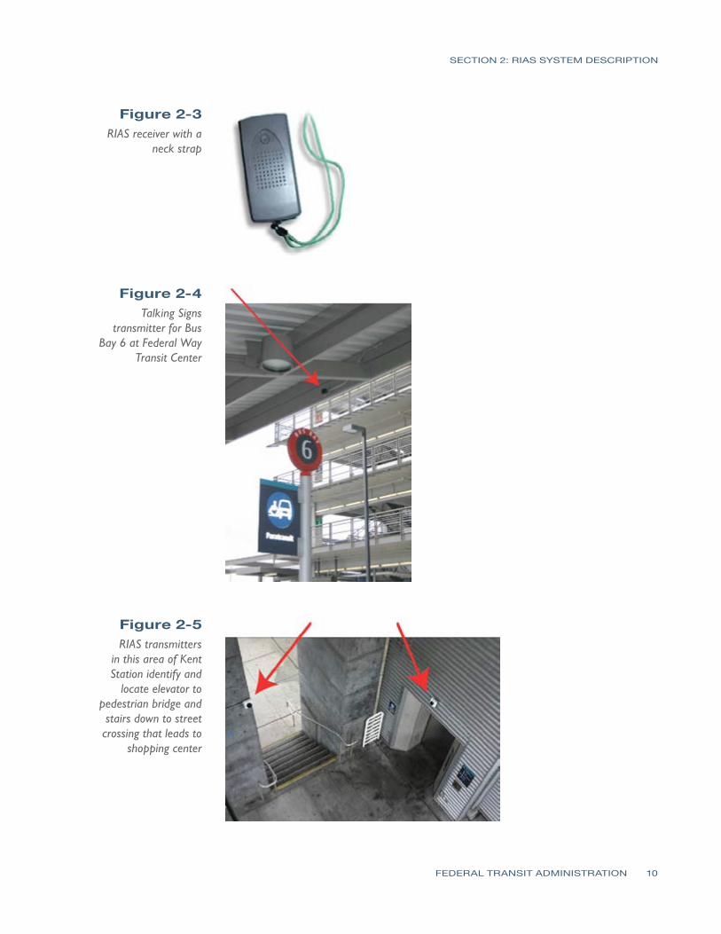
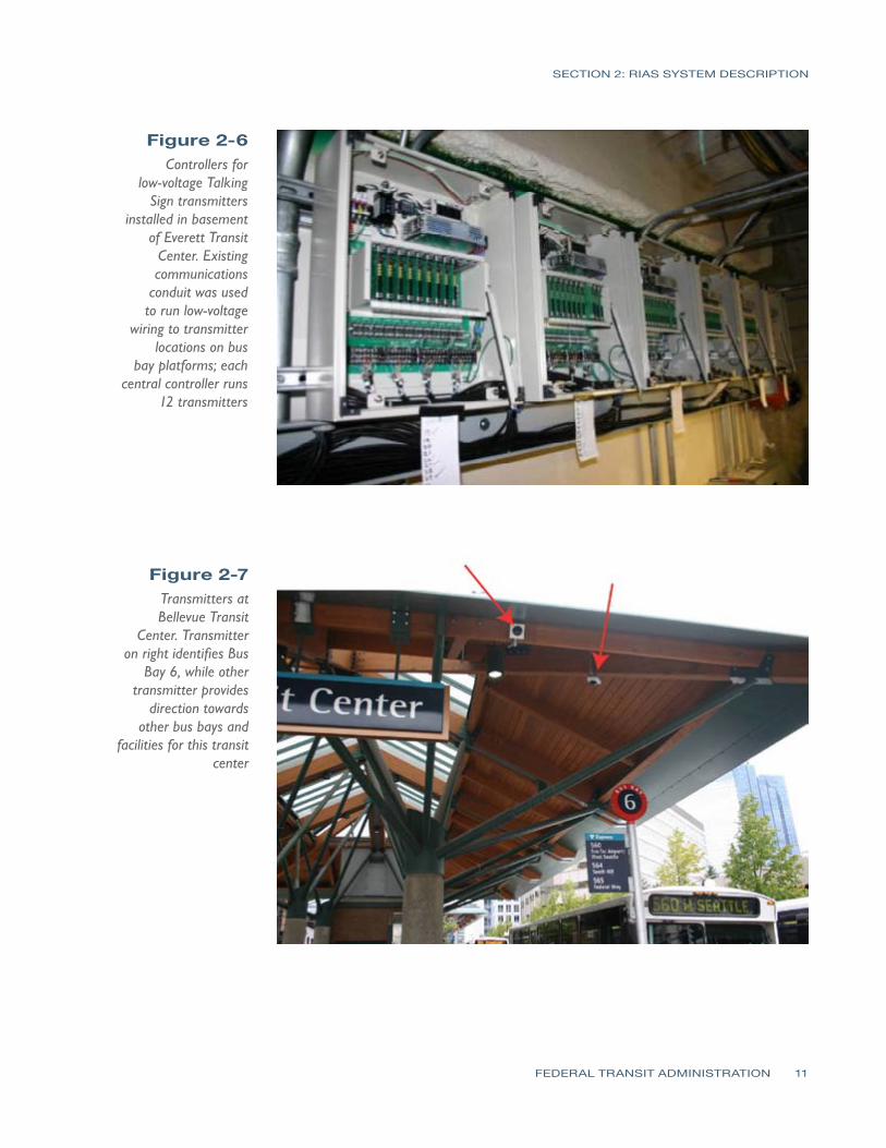
SECTION
3SECTION
3 Human Factors Testing amp Evaluation (HFTE)Procedures
The testing procedures used were developed in accordance with best practices and then approved by the Washington State Institution Review Board to meet requirements established for tests where human subjects are involved These tests on the RIAS system were conducted with staff from Sound Transit LM Telecommunications and Hidalgo amp De Vries Each person assisting with the testing of the system was trained and certified to perform the tests with human subjects by both the National Institutes of Health (NIH) and the Collaborative Institutional Training Initiative (CITI)
The sample frames considered with these tests consisted of 19 persons who are blind or have visual impairments or disabilities This report focuses on the human factors testing and evaluation with respect to the RIAS installation Volpe will conduct the extended end-user research for this installation The method used in evaluating the results of the observer research and post-trial interviews is based upon an approach known as SITE (Charlton 1991) The SITE method supports the design of human factors testing and the interpretation of test results by defining human factors test issues within the four following attributes
1 Situation this defines what the relevant elements are in the environment stimuli setting events system functions or goals
2 Individual this defines who is using the equipment including information about their skills training and cognitive state
3 Task this defines how the equipment is used and what behaviors are associated with the use of the equipment in relative termsmdashfor example how hard how fast how much
4 Effect this describes the success or failure and satisfaction or disappointment associated with the test
The goal of the tests was to provide a method of determining the effectiveness of the RIAS system in providing guidance to the test subjects There were three task groups of tests considered for the observationinteractive research phase of the testing as shown in Table 3-1 Each subtask was created to simulate tasks that would be required by the RIAS user in a multi-modal transportation environment For example each task assumed that the user had arrived at a particular transit facility by train bus on foot or was dropped off by private vehicle at the transit facility
FEDERAL TRANSIT ADMINISTRATION 12
- -
- -
- -
SECTION 3 HUMAN FACTORS TESTING amp EVALUATION (HFTE) PROCEDURES
Table 3-1 Task Group 1 RIAS Testing Task
Groups Task
Station Transit Facility
Sub task Sub task Description
1 King
Street Station
1-1 1-2 1-3
bull From Sounder ADA platform find South TVM bull From TVM locate 4th Ave crosswalk bull Locate stairs leading to Bus Bay C south and Bus Bay D East I-90
Transport participant to Bellevue Transit Center
2 Bellevue Transit Center
2-1 2-2
bull From northwest end of platform find customer service window bull From customer service window find Bus Bay 7
Task Group 2
Task
Station Transit Facility
Sub task Sub task Description
1 Kent Station
1-1
1-2
bull From West Park amp Ride cross pedestrian bridge and locate Track 2 Sounder SeattleEverett bull From TVM find second boarding sign on Track 2 Sounder SeattleEverett
Transport participant to King Street Station
2 King
Street Station
2-1
2-2
bull From Northbound Sounder ADA platform locate stairs up to South Jackson
bull At top of stairs walk to Jackson Street crosswalk
Task Group 3
Task
Station Transit Facility
Sub task Sub task Description
1 Tacoma Dome Station
1-1
1-2 1-3
bull Walk from LINK light rail stop to unisex bathroom located in Information Center bull From Information Center locate 25th St crosswalk bull Proceed across 25th St and locate Sound TVM
Transport participant to Federal Way Transit Center
2
Federal Way
Transit Center
2-1
2-2
bull From Park amp Ride parking area locate sign for uncontrolled crosswalk to bus platforms
bull From center of bus platform locate Bus Bay 6
Participant Training Prior to conducting the tests each participant was trained in the use of the RIAS receiver Each training session consisted of a training facilitator an OampM specialist and at least two training assistants To increase the amount of ldquohands-onrdquo interaction no more than eight participants were used in each training session The Talking Signs Guide for Trainers was followed as the training manual for participant training This training manual is considered the most
FEDERAL TRANSIT ADMINISTRATION 13
SECTION 3 HUMAN FACTORS TESTING amp EVALUATION (HFTE) PROCEDURES
comprehensive reference for use by people who teach others to use the RIAS technology and Talking Signs According to a 1995 study (Crandall et al) ldquothose who receive direct instruction for 15 to 2 hours are more proficient in their use of the [RIAS] systemrdquo Each participant was trained until heshe could successfully use the RIAS system It does not take much time to learn how to use the Talking Sign system and this training assisted in providing a simulation of persons navigating their way that are familiar with the use of the system which is a better simulation of what will be experienced in real life by the frequent user of the system
ObservationalInteractive Research The staff conducting the tests evaluated how well each user was able to navigate through hisher trip and filled out information about the results on prepared forms for groups 1ndash3 In each location the participants were asked to locate specific features of the transit facility Each participant was asked to complete a series of tasks based upon the task group described above For each task the observer recorded the number of transmitters located and the number of requests for assistance from the participant This was the most important part of the research process since it involves the participantrsquos actual success or failure with the RIAS system in a real-world application
The observer accompanied the participant as each task was performed The primary responsibility of the observer was to ensure the safety of the participant during the test The observer also recorded the participantrsquos performance comments and questions which were used to determine the level of success of the RIAS system The test subjects were also asked a series of questions related to their evaluation of the system after the testing was completed and the answers were recorded by the observer
Extended-User Research (Post-Trial Interviews) Once the test subjects had completed the observationalinteractive group tests they were asked to use the system for several weeks At the end of this extended use each participant assisted in filling out forms with questions related to their evaluation of the system These questions were used to assess the participantsrsquo extended experience with the RIAS system and to determine their interest in using the system in the future The answers to these questions were used in analyzing the overall success of the system
FEDERAL TRANSIT ADMINISTRATION 14
SECTION
4SECTION
4 Human Factors Testing amp Evaluation (HFTE) Results
The majority of the test results showed a positive indication that the RIAS system works well in providing people who are blind or who have visual impairments or disabilities with more independence in their travel The results are summarized into two areasmdashthe observationalinteractive research and the participant post-trial interviewmdashas described in the previous section of this report This report provides a summary of the results from these tests as well as some of the issues and lessons learned with the system Detailed HFTE test results and analyses are contained in a report completed by Hidalgo amp De Vries Overall the results of all the tests were fairly positive The participants felt pleased with the effectiveness of the RIAS system and comments suggested there is room for improvement in some areas
ObservationalInteractive ResearchResults Summary For Group 1 the participants were able to locate the majority of the audible signs at the King Street Station and all of the audible signs at the Bellevue Transit Center with no problems One audible sign at King Street Station that identifies the stairs leading down to the International District Bus Tunnel was not located by the participants Overall the participants were pleased with the usability of the RIAS system at these two transit centers however some expressed the need for additional signs around the transit centers At the time of the tests audible signs had not been installed for the crosswalks These signs were not installed for the King Street Station for this project and would help in addressing this need
For Group 2 the test results showed for the King Street Station that the RIAS system was effective and the participants were able to locate all of the signs without assistance The results were different for the Kent Station The participants had more difficulty locating the audible signs at this station and two of the six participants in this group found the RIAS system to be ldquonot very usefulrdquo or ldquonot at all usefulrdquo in the post-trial interviews It should be noted that one of the audible signs at the Kent Station was not transmitting the audible message
Finally in Group 3 all four participants were able to locate the audible signs at the Tacoma Dome Station and three of the four participants were able to locate all the signs at the Federal Way Transit Center without assistance One participant required assistance from the observer to locate one of the audible
FEDERAL TRANSIT ADMINISTRATION 15
SECTION 4 HUMAN FACTORS TESTING amp EVALUATION (HFTE) RESULTS
signs A power outage in part of the Federal Way Transit Center caused one of the signs used in the tests to not be operational Three of the four were able to locate the destination for the subtask using another nearby audible sign
Extended User Research Summary Of the 19 HFTE participants 11 completed post-trial interviews to provide their feedback on the extended use of the RIAS system The participants rated their overall satisfaction with the RIAS system on a 10-point scale with 10 as the best experience and 1 as the worst experience The average rating was 682 with a high rating by one participant of 10 and a low rating of 3 The following are the most significant items from the participant interviews
bull Overall the participants were very satisfied with the RIAS system and their role in the study
bull The majority of participants would not use the RIAS system if they had to pay out-of-pocket for a RIAS receiver
bullThe majority of participants would use the RIAS system if the RIAS receiver was provided free of charge
bull If the RIAS system was available at the rest of Sound Transitrsquos facilities more participants would use the RIAS system
Issues and Lessons Learned There were several issues that were encountered during the HFTE tests At two stations there were problems with some of the audible signs not being operational Most of these seemed to be related more to maintenance issues from temporary power outages while maintenance was repairing nearby lighting damage This would likely be a continuing issue as maintenance at each station is needed and power to the audible signs would need to be temporarily disconnected For their safety travelers who are blind or who have visual impairments or disabilities would need to be notified in some way when these conditions occur
Another issue that occurred was that there were reflections of the RIAS signals in some instances which create a potential hazard to the traveler One instance in particular occurred when a RIAS signal reflected off a person wearing a reflective jacket who was standing in front of the participant during testing This caused the signal to transmit to the participantrsquos receiver coming from the opposite direction intended by the RIAS system which caused the participant to become confused about the direction needed to walk to reach the destination Reflections off articles of clothing are likely to occur every now and then particularly when walking through crowded areas which is common at the Sound Transit multimodal facilities Reflections of the RIAS signals also seem to occur when the signal reaches metallic objects Items at transit facilities that would
FEDERAL TRANSIT ADMINISTRATION 16
SECTION 4 HUMAN FACTORS TESTING amp EVALUATION (HFTE) RESULTS
reflect the RIAS signal include elevator doors support columnsbeams and roofs and certain parts of ticket vending machines In some instances reflections are used as an installation method such as pointing transmitters at elevator doors to guide persons to elevators where the transmitter cannot be located above the doors Any highly-polished surface can reflect the IR transmissions
Issues were found with some of the RIAS signals being blocked by objects At the King Street Station there were temporary vinyl banners that had been placed in the bridgewalkway leading down to the platforms which prevented the receiver from picking up the audible message Other objects that blocked RIAS signals included concrete structures wallsbuildings shelters and structural supports
Overall it seems that placement and setting the direction and adjusting the strength of the audible signs signal is the key to reducing these reflections and avoiding objects that may block the signal There are problems however in some transit facility locations where it becomes difficult to place the audible signs in a way that they can effectively function In addition future placement of objects at each facility should not be completed without some consideration regarding the effects these objects will have on RIAS system performance
The RIAS signals also seemed to be affected to some degree by sunlight In one instance the signal strength of one sign appeared to be stronger during cloud cover than it was with more sunlight or a brighter sky behind the transmitter location One issue that was mentioned by some of the participants was that there were not enough audible signs in some locations It was a great to provide audible signs at all locations in the Tacoma Dome Station in particular because of large open walking areas with nothing that could be used for mounting the sign In addition there were budget constraints that limited the number of audible signs installed
Analysis by Others The Volpe Institute will be determining the practical operation of the RIAS technology and its benefits In addition Hidalgo amp De Vries has conducted a more detailed review of the human factors tests This project requires a report to the US Congress by the Secretary of Transportation which will be finalized by Volpe with this report and Hidalgorsquos report provided as input to the final Volpe report The following are the evaluation points Volpe will be considering
bull The effect on multimodal accessibility in public transportation with regard to persons with visual cognitive and learning disabilities
bullThe effect on making public transportation accessible to persons with visual cognitive and learning disabilities who use public transit and paratransit
bull The effect on education community integration work life and general quality of life of the targeted populations
FEDERAL TRANSIT ADMINISTRATION 17
SECTION
5SECTION
5 Existing WayfindingTechnology Review
As part of an evaluation in recommending further investment into RIAS technology it is important to consider the existing technology that is available or under development for wayfinding systems for people who are blind or who have visual or cognitive disabilities These systems can be divided into several categories
bull Infrared (IR) and light emitting signs
bull Radio frequency (RF) or Wi-Fi signs
bull Bar-coded signs
bull Gps-based systems
bull Research projects
This review has considered only wayfinding technologies that would have a benefit similar to that provided by Talking Signs In other words the focus of this review has been on technology for orientation and navigation with a particular focus on systems that provide orientation and navigation for public transportation facilities
Infrared (IR) and Light EmittingSigns One technology that has developed with great promise is audible signs that transmit infrared or light signals that can be decoded by a receiver The transmitted information is converted to an audible message that is played on a receiver to the person with visual impairments or disabilities Two types of these systems that are currently in operation have been reviewed for this report Talking Signs and Talking Lights (Talking Lights LLC)
Talking Signs Talking Signs has emerged as a promising technology that can provide localized directional information and item identification to persons with visual impairments or disabilities There have been many studies and tests with human subjects to determine the effectiveness and value associated with using this system This system has developed to the greatest degree in the marketplace and in the number of system implementations which gives it an advantage over other similar competing technologies
FEDERAL TRANSIT ADMINISTRATION 18
SECTION 5 EXISTING WAYFINDING TECHNOLOGY REVIEW
The Talking Signs system has been used in many transit environments and has the capability to provide easily-updated message information such as changes in bus numbers or routes for a particular bus The system has also been embedded in visual message signs to match the messages displayed Many studies have been completed for this system and it has been shown to be of benefit to travelers with visual impairments or disabilities The main drawback to using this system is that it is costly Talking Signs has established relationships with other companies to continue to develop the system to make sure it continues to transition to a more open architecture environment to be used with other transit systems in the future More detailed information about this system including a description of the Sound Transit Talking Sign system is provided in Section 3
Talking Lights Talking Lights is a system developed by a team at MIT that uses ordinary lights and embeds a signal that can be decoded by a receiver The system is a high-resolution tracking system that uses PDAs with audio direction software The advantage of this technology is that there are no wires needed to install facilities can use their existing lighting infrastructure and the light bulbs do not consume any additional energy to perform their function
While this appears to be promising technology that could be more easily implemented by modifying existing lights within a facility it is still new This system has had success for patients at the Spaulding Rehabilitation Hospital in Boston and there is currently a study going on at the Decatur Hospital in Georgia Other plans include developing a system for museums In addition this system seems to be used only for indoor applications although Talking Lights has teamed with the Sendoro Group to provide an outdoor navigation system
Radio Frequency (RF) Signs Step-Hear Step-Hear is a new product that debuted in August 2008 at the World Blind Union 7th Assembly in Geneva Switzerland This product is similar to Talking Signs in that it uses a base transmitter to send directional information to a hand held receiver The system uses radio frequency signals transmitted by the base transmitter provided in a directional nature to transmit information about the location of the transmitter
This system also seems to have a few more features than Talking Signs The receiver vibrates when it is within range (about 12 ft) of a base transmitter and for bus installations a red light is activated to notify the bus driver that a person needing help entering the bus is within range of the transmitter In addition the base unit can be integrated with the bus GPS and speaker systems Changing
FEDERAL TRANSIT ADMINISTRATION 19
SECTION 5 EXISTING WAYFINDING TECHNOLOGY REVIEW
the messages appears to be quite simple using a built-in switch and button that when used together will allow modification of the message
One drawback to this technology is that it has not yet been fully deployed and has yet to be proven as a viable option in the marketplace There is currently an installation ongoing for a bus system which is reportedly showing success A full report on this project was promised to be provided once the project was completely installed tested and operating on the system Information about this system was limited at the time of this report and further review of the installation on the bus system should be completed when available
Bar-Coded Signs University of California and Smith-Kettlewell EyeResearch Institute Color Marker and Bar Code System
This system is still in the research stage of development and cannot be considered as a viable alternative at this point However the system does show some promise in the future for providing a beneficial cost-effective wayfinding system The system is based on a cell phone that detects color markers placed throughout the environment These markers are detected by the cell phone at a distance of several meters away The purpose of the color marker is not to give any information about the location of the marker but to help a person with visual impairments or disabilities to detect the marker A bar code is then placed near the marker and the cell phone can decode and receive information about the location This typically requires the user to move closer to the marker to process the information and determine location-based information
GPS-Based Systems There are many GPS-based systems that travelers with visual impairments or disabilities can use to assist in guidance to a destination There are a few that are commercially available and many others still being developed All systems are for outdoor use only with very limited capability indoors due to lack of GPS satellite signal These systems continue to advance with greater accuracy including WAAS corrections which can provide 2ndash3 meter accuracy Common GPS for the consumer market has been tested to have a location accuracy of within 30 meters as a comparison
Loadstone GPS Loadstone GPS is open source software using satellite navigation for persons with visual impairments or disabilities The benefit to this system is that the software is free and will run on many different Nokia cell phone devices It requires a GPS receiver that connects to the cell phone by Bluetooth In
FEDERAL TRANSIT ADMINISTRATION 20
SECTION 5 EXISTING WAYFINDING TECHNOLOGY REVIEW
addition a screen reader program must be running on the cell phone such as Talks or Mobile Speak to give the user instructions
Wayfinder Access This GPS solution is similar to Loadstone however it offers more features to the traveler with visual impairments or disabilities It is a software application that uses Symbian phones to work with screen readers Other features are customized for persons who are blind or who have visual impairments or disabilities to provide them with information about surroundings including feedback on points of interest and Braille support
Trekker Trekker was developed as a personal digital assistant (PDA) application operating on a Microsoft Pocket PC operating system and was adapted to be used by persons who are blind or have visual impairments or disabilities with talking menus talking maps and GPS information Features include determination of position creating routes and receiving information about navigating to a destination A search function for points of interest is also available This application has the ability to expand to accommodate new hardware platforms and more detailed location and geographic information
BrailleNote GPS BrailleNote GPS was developed by Sendero Group and the idea behind it combines a PDA with direction software that returns audible directions to the user It uses GPS to pinpoint a personrsquos position and nearby points of interest and is about the size of a small cell phone Points of interest can be input into the system and directions to these locations can be accessed This is similar to the GPS-based direction systems for automotive use
Mobile Geo Mobile Geo works with Windows Mobile-based smartphones Pocket PC phones and other PDAs The GPS and mapping technology built into this system is from the Sendero Group It is the first solution that works with a wide range of mainstream mobile devices and it can be used with more than 20 different Braille devices for input and output It works with Mobile Speak screen reader software which is a Code Factory product It is compatible with more than 300 PDAs as well as mobile phones that operate on GSM CDMA and WCDMA networks Like other GPS-based solutions Mobile Geo pinpoints the travelerrsquos location and provides information about points of interest The benefit to this product is that it has built-in map data
FEDERAL TRANSIT ADMINISTRATION 21
SECTION 5 EXISTING WAYFINDING TECHNOLOGY REVIEW
Research Projects A number of projects are currently under development and a few of these are mentioned below The trend for wayfinding systems and technology for persons with visual impairments or disabilities is to use a combination of GPS infrared RF and other methods to provide a more complete solution for travelers with visual impairments or disabilities The systems described below are provided in this report to show this trend as well as to provide a basis for recommendations on pursuing an integrated solution using GPS and smartphone technologies with Internet capability
University of South Florida Travel Assistance Device(TAD) The University of South Florida (USF) Center for Urban Transportation Research is developing software that uses GPS technology inside cell phones to assist persons with cognitive disabilities to navigate public transportation Users can access a website that is similar to the Google Map interface where they can select their route location stop and travel times Trips are planned using this website and then downloaded to the cell phone The software developed by USF is installed on the phone and can give the rider alerts while riding the bus to prepare himher to exit the bus at the planned destination The system was tested last year with student with developmental disabilities and was quite successful
Trinetra The Trinetra project aims to create a smartphone solution that will benefit persons with visual impairments or disabilities The goals are to develop a cost-effective system This project is one to reconsider in the future since the plans are to develop a system that will assist the needs of persons with visual impairments or disabilities who uses public transportation by providing them with real-time information The concept of the system uses a combination of GPS receivers and infrared sensors that relay information to a centralized fleet management server using a cell phone The person with visual impairments or disabilities can then use a cell phone with text-to-speech capability to determine estimated time of arrival location and current bus capacity using a web browser Other research for this project is considering the use of universal product codes (UPCs) and radio-frequency identification (RFID) for indoor navigation in a shopping setting
NOPPA The NOPPA project was a three-year project (2002ndash2004) in Finland as part of the Ministry of Transport and Communications Finlandrsquos HEILI Passenger Information Program which was a pilot program to develop a system for
FEDERAL TRANSIT ADMINISTRATION 22
SECTION 5 EXISTING WAYFINDING TECHNOLOGY REVIEW
navigation and guidance for persons with visual impairments or disabilities who use public transportation It is similar in goals to the Trinetra project and uses GPS technology combined with Wi-Fi smartphone for Internet access and text-to-speech capability optional RFID reader and a database of route information to provide directional information to the user Like Trinetra it is based on a central information server concept While the pilot program was successful there are still drawbacks to this system which includes wireless and GPS not always being available in areas without line of sight or in urban canyons issues associated with having outdated information in the central database and availability of this system in the United States
Brunel University Navigation System Brunel University is developing a system that is based on the combination of several state-of-the-art current technologies including GPS and GIS The system provides automated guidance using the information from daily updated digital map datasets The difficulties with this system include the availability of up-to-date information and what information to offer with the navigation procedure Different levels of functionality have been created with this system to be able to customize the information to the user
Drishti Drishti is a wireless pedestrian navigation system developed by the University of Florida The system integrates technologies including wearable computers voice recognition and synthesis wireless networks GIS and GPS It also provides contextual information to the person with visual impairments or disabilities and computed optimized routes based on user preference traffic congestion and obstacles such as road work The system guides the user to navigate based on both available static and dynamic data This requires a spatial database that provides environmental conditions and landmark information along the travelerrsquos route The system also has the capability for the user to add information to the database
Transit Location and Schedule Data Several technologies are being developed that assist travelers in navigating a transit system Google Transit is a popular system that has developed since 2005 and now includes 70 transit agencies in 10 countries It is a web-based application that uses a database of information from each transit agency along with Google Maps to determine the best bus route or routes and times for transporting passengers to and from locations that are input online by the traveler King County Metro is already part of the Google Transit system
Sound Transit already has existing databases built for a regional Trip Planner system which uses Trapeze software for their bus routes King County Metro
FEDERAL TRANSIT ADMINISTRATION 23
SECTION 5 EXISTING WAYFINDING TECHNOLOGY REVIEW
Community Transit and Pierce Transit are also already part of this system It will not be added to the Sounder rail line until the commuter rail line is completely built out For some agencies real-time feeds are also provided for locating certain buses on routes of interest however at this time Sound Transit does not have the ability to provide these real-time feeds These systems will continue to improve in providing wayfinding information for travelers
Current Trends for WayfindingTechnology Technology today is rapidly changing It is estimated that every 18 months another set of advancements in technology will occur The wayfinding system technology is no different and this market should be frequently analyzed in order to be aware of innovative cost-effective solutions that become available to travelers with visual impairments or disabilities
Computer chips and small embedded devices are already being placed in many environmental aspects of our lives such as ldquosmartrdquo surroundings These have the ability to monitor and report conditions continually and computer chips are increasingly being found in signage They can be placed in walls poles sidewalks etc and provide information to the traveler As computer chips continue to expand in application technologies will advance to the point of providing benefit in wayfinding for persons with visual impairments
The current trend for wayfinding technology as can be seen from the GPS-based systems and research projects evaluated is to further develop and use smartphones and PDAs with Internet and GPS applications and blend several technologies to provide a complete solution for navigation The focus is on developing software applications that will run on many of the devices people carry with them already such as smart phonesPDAs The integration of Bluetooth GPS and radioWi-Fi functions in a handset provides many benefits and is the current trend The benefits include improved system performance improved cost structure power consumption savings and other savings from shared system use including ease of assembly because of shared packaging
Many applications are available for pedestrians drivers and public transportation users that continue to improve the efficiency of traveling Some of these applications can in conjunction with other technologies provide wayfinding for both travelers who are blind or who have visual impairments or disabilities as well as all travelers These types of technologies could potentially increase funding as they help a greater number of public transportation users
The GPS-based systems are continuing to be improved and other technologies are being combined with GPS to provide more accurate wayfinding information
FEDERAL TRANSIT ADMINISTRATION 24
SECTION 5 EXISTING WAYFINDING TECHNOLOGY REVIEW
Some systems use Wi-Fi to assist location determination while others use inertial sensors and cameras in areas where GPS signals may be limited It seems clear that GPS systems combined with smartphones with Internet access are the future of wayfinding systems as there are many new developments occurring to continue to increase the effectiveness of these systems For those who are blind or have visual impairments or disabilities stable low-cost technologies are important
Summary of WayfindingTechnology Review Based upon the technology review of this report there are three current options available to use for localized directional information Talking Signs Talking Lights and Step-Hear systems Other GPS-based or GPS-assisted systems using smartphones or PDA technologies using a database of points of interest seem to have the capability to provide outdoor wayfinding at a continually increasing accuracy Current accuracy taking into account WAAS corrections for reasonably-priced GPS units is about 2ndash3 meters Based upon the evaluation of RIAS technology using GPS systems would be similar to the accuracy provided by RIAS for persons with visual impairments or disabilities in determining the actual position of a particular point if WAAS corrections are taken into account Since the current trend is for ldquosmartrdquo devices the GPS-based technologies should be considered an option for providing wayfinding outdoors while using other systems for indoor navigation
The Talking Signs system still has the market advantage when compared to other localized directional information systems and is the most proven system at this time with many installations currently in place throughout the world One drawback to this system as with some other systems considered in this report is that the current trend for wayfinding technology is to integrate a number of technologies together Cell phonesPDAs are integrating with technologies including webe-mail access interactive voice response and text-to-speech technology GPS wayfinding systems digital cameras for recognition purposes palm computing and CPUs and smart-sensing environments The enhanced cell phone is becoming a handy remote device for finding information about the environment As technology continues to advance these smartphones will become smaller and less expensive with more features Modifications to the cell phone will continue to adapt to be a cost-effective and universal solution for wayfinding Another drawback for this system is that it is mainly used for item identification Information on routespaths to take are given within the messages of some of the signs however the user is not given a travel route based on his her destination information
FEDERAL TRANSIT ADMINISTRATION 25
SECTION 5 EXISTING WAYFINDING TECHNOLOGY REVIEW
The Talking Lights system is already working with Sendoro Group which provides GPS wayfinding products to integrate the two technologies This system also has the capability to integrate with a local Wi-Fi mesh network Talking Lights seems to be a cost-effective solution based upon costs that were obtained and are provided in the next section This system at this time is limited to indoorbuilding applications which makes this technology a good fit for integration with a GPS-based technology There are plans to expand the system to outdoor environments and an application of this system has already been introduced on headlights for military vehicles Some concerns for outdoors would be problems that could occur during the daylight versus at night and other light interference sources that could reduce the performance of the system however if this system is integrated with other technologies such as GPS-based technology from Sendoro Group it could prove to be a useful navigation aid for both indoor and outdoor environments An advantage that this system has over the Talking Signs system is that it acts in a similar manner to GPS-based wayfinding technologies In other words it uses more than just item identification and delivers pathroute information to the user via a central database The two main drawbacks are that the system does not have the same market presence as Talking Signs so long-term viability is a concern and the system has not been tested in a transit environment for people who have visual impairments or disabilities or cognitively disabilities
The Step-Hear system is fairly new technology that shows promise in comparison to the Talking Signs system Unlike the disadvantage Talking Lights has in outdoor applications the Step-Hear system can operate in both outdoor and indoor environments This system appears to have a few more functions than Talking Signs however it is also not fully proven in the market Once the initial installation is complete for this system another evaluation should be completed to determine its effectiveness This system also seems to be a cost-effective product like Talking Lights A comparison of costs for these three systems is provided in the next section
In summary a blending of technologies seems to be the best solution for providing people who have visual impairments or disabilities and cognitive disabilities with a wayfinding system that can be used for public transportation Smartphones or PDAs with speech-to-text capability can access via the Internet databases of information for points of interest particularly GPS coordinates and determine step-by-step instructions to the user based upon hisher GPS-determined position Google using its Google Transit database and TimeTablePublisher software for schedules and locations has already begun integrating transit points of interest just as the regional Trip Planner for the Puget Sound bus systems does and now gives users step-by-step instructions for using public transportation based upon the starting and ending points of the traveler Creating a database of transit points of interest that would aid a traveler
FEDERAL TRANSIT ADMINISTRATION 26
SECTION 5 EXISTING WAYFINDING TECHNOLOGY REVIEW
with visual impairments or disabilities would seem to be an effective solution that could be used by technologies integrated with GPS systems for wayfinding from a long-term perspective For buses however the localized item identification systems would have an advantage for those that are easily updateable with bus information although current trends with GPSAVL systems on buses are to publish bus locations online that could then be accessed via a smartphone PDA or other ldquosmartrdquo device
FEDERAL TRANSIT ADMINISTRATION 27
SECTION
6SECTION Cost Benefit Analysis 6
Introduction In completing a cost benefit analysis for something that provides social equality to a group of people a typical cost versus benefit analysis is not possible The basic benefits for a person with visual or cognitive disabilities from a wayfinding system are
bullAbility to travel with confidence and enable them to become more independent
bullOverall positive effect on quality of life
Detailed analysis on the benefits of Talking Signs as well as costs for the system have already been completed in numerous other studies including those done by the University of California Santa Barbara and the Smith-Kettlewell Eye Research Institute The results from the human factors testing at Sound Transit also show that the RIAS system was received positively by the evaluation participants as summarized in Section 5 and as detailed by the report completed by Hidalgo amp De Vries
Because of the social benefits of this type of system this cost benefit analysis will focus primarily on how well each technology performs as a wayfinding system for persons with visual impairments or disabilities and the cost implications for each of the technologies The purpose of this analysis was to evaluate these cost implications for RIAS as well as other technologies and to determine whether proceeding with expansion of a RIAS system would be the best solution to provide these benefits to persons with visual or cognitive disabilities in the Puget Sound area The cost benefit analysis provided in this report focuses on the following
bullBased on the number of people who have visual and cognitively disabilities in the Puget Sound area as well as those which use public transportation determine how many people could potentially benefit from a wayfinding technology system
bullBased on the number of people who have visual and cognitively disabilities in the Puget Sound area analyze paratransit costs for Sound Transit to determine the potential cost savings in reducing the number of persons using this service
bullBased upon the technology review compare four main products or solutions for costs and benefits and the risks with the use of each system Talking Signs Talking Lights Step-Hear and a combination of one of these three to use for just indoors and on buses with a GPS-based system for outdoor navigation
FEDERAL TRANSIT ADMINISTRATION 28
SECTION 6 COST BENEFIT ANALYSIS
Table 6-1 Statistics on
Persons with Visual Impairment and
Cognitive Disabilities in Puget Sound
Evaluation of Potential WayfindingSystem Users in the Puget Sound Information about the number of persons with visual and cognitively disabilities is summarized in Table 6-1 The number of persons with developmental disabilities for each county was obtained from Sound Transit and the statistics for the number of persons who are blind or have visual disabilities is based on percentages from the US Census Bureau on people with sensory disabilities for the tri-county area from a 2006 American Community Survey Other national percentages are from the US Cernsus Bureau 2005 measures of disability Based upon these available statistics estimated upper bounds of 4 percent of the population were used in Table 6-1 Population estimates were based upon information from the US Census Bureau
Puget Sound Region County
Total Persons with Cognitive Disabilities
Total Persons with Visual Disabilities or Blind
King 10399 74371
Pierce 4712 30927
Snohomish 3469 27076
Total 18580 132374
From these numbers it appears that there are many people who could potentially benefit from a wayfinding system in the Puget Sound region Also from the post-trial interviews the participants were likely to use the RIAS system for a range of trip purposes such as work shopping social events recreation and education
Potential Cost Savings for Paratransit Services There are cost savings that could be seen from persons who are blind or who have visual disabilities becoming more independent in their travel These costs would be related to paratransit services for these persons As more persons who are blind or who have visual disabilities become more independent they will likely use paratransit services less or not at all Information about the operating expense per revenue mile for demand response vehicles was obtained from the 2007 National Transit Database Based upon the information available from Sound Transit it is estimated that approximately 4 percent of the passenger miles represents passengers who are blind or who have visual disabilities From this estimate the total cost savings was calculated for 2007 and is shown in Table 6-2
FEDERAL TRANSIT ADMINISTRATION 29
SECTION 6 COST BENEFIT ANALYSIS
Table 6-2 Paratransit Costs
and Potential Savings (based on 2007 cost
data for demand response vehicle operating costs)
Table 6-3 Talking Signs System
History of Costs
Demand Response Transit Agency Cost per Passenger Mile 4 of Cost per
Passenger Mile Potential 2007 Cost Savings
King County Metro $424 $017 $1920000
Pierce Transit $455 $018 $630000
Community Transit $353 $014 $320000
Total $2870000
From this analysis there are significant potential annual savings in providing a wayfinding system for persons who are blind or who have visual disabilities which would decrease paratransit use and thereby reduce the operating costs for paratransit services
Wayfinding System Costs Costs for the different types of wayfinding systems available were obtained from each of the vendors One of the problems with the comparison of costs is that only material costs were obtained from Step-Hear and only installation costs for buildings were obtained from Talking Lights By far Talking Signs has the most cost information available for this analysis because it has been installed in more locations Because of this the analysis focuses on comparing material costs between Talking Signs and Step-Hear and building system costs between Talking Signs and Talking Lights
Talking Signs Costs Information about the costs for Talking Signs was obtained from previous installations as well as from the bid provided by Talking Signs Services Inc for the Sound Transit RIAS project Table 6-3 shows installation costs (in cost per transmitter) for some Talking Signs projects
Installation Location Number of Transmitters Cost per Transmitter
Sound Transit 370 $7005
TriMet 30 $2655
San Francisco Muni 30 $3200
Colorado Springs 10 $3760
Phoenix Public Transit 10 $4630
Port of San Francisco 30 $4635
Caltrain 40 $3000
It should be noted that installation costs for the Sound Transit RIAS project are much higher because the other installation costs did not include installation of the system infrastructure such as conduit cable etc In other words Talking Signs has typically installed the system in locations where all that is required is to install the transmitter and test and operate the system the other costs for conduit and system infrastructure were provided through separate contracts In
FEDERAL TRANSIT ADMINISTRATION 30
-
SECTION 6 COST BENEFIT ANALYSIS
Table 6-4 Talking Signs Material
Costs
addition the costs given above were the costs at the time of the installation The Sound Transit project is the most recent one given
Table 6-4 shows the material costs per transmitter and receiver There are two different types of transmitters provided so an average transmitter cost is given
Talking Signs Equipment Unit Cost
Average material cost per transmitter $1600
Material cost per receiver $265
Step-Hear Costs As mentioned only material costs were obtained from Step-Hear Additional cost information will be provided once the first project for this system is completed Below is a table which shows the cost per transmitter and per receiver for this system
Table 6-5 Step-Hear Material
Costs
Step Hear Equipment Unit Cost
Average material cost per transmitter $100
Material cost per receiver $22
Talking Lights Costs The cost to install Talking Lights was obtained only for indoor applications Depending on the type of facility and complexity the cost to install Talking Lights ranges from $050ndash2 per square foot A comparison of this cost with Talking Signs based upon the historical costs at the San Francisco Caltrain station is given in the next section
GPS-Based System Costs It is difficult to determine the actual cost for a GPS-based solution that could be used by the person with visual or cognitive disabilities for wayfinding There are several smartphone systems such as Loadstone GPS which runs on Nokia phones and interfaces to a GPS receiver Costs were calculated from some of the systems evaluated in this report and are included in Table 6-6 In addition to the costs for these systems some costs would be necessary to develop a database for Sound Transit specific points of interest and other points required for wayfinding as well as monthly costs for the phone service In downtown areas where it is difficult to gain connectivity with GPS signals from satellites additional WAAS or other fixed location signal sources may need to be installed to provide accurate locations
FEDERAL TRANSIT ADMINISTRATION 31
SECTION 6 COST BENEFIT ANALYSIS
Table 6-6 GPS-Based System
Costs
Table 6-7 Sound Transit
Wayfinding System Installation Cost
Comparison
System Type Unit Cost Avg Monthly Service Cost
Loadstone GPS (includes smartphone software GPS receiver screen reader)
$700 $60
Wayfinder Access (includes smartphone software GPS receiver screen reader)
$1200 $60
BrailleNote GPS V 3 (Includes maps receiver pouch cable 1 GB CF card)
$1599 NA
Trekker GPS System $1695 NA
Mobile Geo (includes smartphone software GPS receiver screen reader)
$1745 $60
Wayfinding SystemsCost Comparison Summary Talking Signs and Step-Hear Cost Comparison In comparing material costs shown between Talking Signs and Step-Hear it is clear that Step-Hear has a very large cost advantage from a material unit per unit basis Talking Sign transmitters are 18 times the cost of a similar Step-Hear transmitter and receiver costs are more than 10 times more expensive for material only Table 7-7 shows a comparison of the total RIAS Sound Transit installation costs based upon the complete bid from Talking Signs with equivalent costs for Step-Hear The cost shown for the Step-Hear system was calculated by substituting material costs for Step-Hear transmitters and receivers for the Talking Sign transmitter and receiver bid prices This comparison assumes that conduit and power cabling needs and installation costs for mounting the transmitters are the same
System Type Cost
Talking Signs System (actual installation cost in todayrsquos dollars) $2199765
Step-Hear System (estimated cost based upon Step-Hear material costs) $1665495
One major factor that is not considered in the above comparison is the number of Step-Hear transmitters that would be necessary to replicate the same system coverage for Talking Signs Information obtained from Step-Hear indicated the range for the transmitter was about 65 feet which is somewhat shorter than the maximum range for the Talking Signs transmitter of around 100 feet Also it does not seem the Step-Hear transmitter has similar capabilities in adjusting the strength of the signal Another problem with this comparison is the assumption that installation costs would be similar including testing training and maintenance The main result of this analysis is that it would appear that Step-Hear would have a cost advantage for installation on buses since transmitter coverage areas would be similar for both and it would take the same number of Talking Signs transmitters on a bus as it would for the Step-Hear system
FEDERAL TRANSIT ADMINISTRATION 32
SECTION 6 COST BENEFIT ANALYSIS
Table 6-8 Caltrain San Jose
Diridon Station Wayfinding System
Installation Cost Comparison
Table 6-9 Sound Transit
Wayfinding System Installation Cost
Comparison
Talking Signs and Talking Lights Cost Comparison For the Talking Lights system it is difficult to compare on a cost-to-cost basis with Talking Signs The method used for the purpose of this report was to consider the historical cost (converted to todayrsquos dollars) to install the Talking Signs system at the San Jose Diridon Caltrain station with a Talking Lights system cost for this station of $2 per square foot The area in square feet was calculated for the coverage area provided by Talking Signs at this station This included areas outside on train platforms as well as indoor areas This installation was only for mounting installation and testing of the RIAS system and did not include conduit and wiring costs which were completed under a separate contract Table 6-8 shows a simplified comparison of the costs between these systems using this method
System Type Cost
Talking Signs System (actual installation cost in todayrsquos dollars) $215000
Talking Lights System (est cost based on $2sf) $32000
Based upon this comparison there seems to be a large cost advantage for the Talking Lights system However this comparison does not consider the issues that could be encountered for the outside train platform areas of the San Jose Diridon Caltrain station if Talking Lights were used This does indicate that further investigation of the costs and effectiveness of the Talking Lights system for at least indoor transit facility areas should be completed
Talking Signs and GPS-Based System Cost Comparison In comparing the Talking Signs system to an outdoor GPS-based system there are a number of factors to consider Table 6-9 shows the actual cost for the RIAS system for Sound Transit compared with the estimated cost for implementing a region-wide database of points that are web-accessible The costs assume that receivers (GPS-based or Talking Signs receivers) will be purchased by the user Based upon the results of the participant interviews purchasing these receivers is a critical factor for determining whether persons will actually use the system
System Type Cost
Talking Signs System (actual installation cost in todayrsquos dollars) $2199765
GPS-based system (est cost to create point database interface and web access)
$150000
An integration of these technologies would seem to be more feasible As mentioned the costs above do not include the purchase of the individual GPS systems for each user which would likely be an issue for the user to purchase The cost to create this database is small since many of the bus routes for Sound Transit and King County Metro are already created using the Transit Trip Planner system Budget is already in place to update the database several
FEDERAL TRANSIT ADMINISTRATION 33
SECTION 6 COST BENEFIT ANALYSIS
times per year to make sure the bus route information is current The cost to create this database includes creating points for the entire regional transit system which would cover a larger area than the initial RIAS system at the six Sound Transit facilities It should be noted that the cost for the GPS system does not include review and testing of the system or a review from an OampM specialist From a per-person cost perspective for the entire regional transit system if the funding is to include purchasing a $700 personal GPS system and $250 for the RIAS receiver for each user the RIAS system has a cost advantage based upon the number of people in the Puget Sound area who have visual or cognitive disabilities However further comparison of costs of this system should be considered as GPS systems advance and costs for these systems continue to decrease
Wayfinding SystemsImplementation Risks Since RIAS technology has already been demonstrated in the Puget Sound area and in many other locations risks in proceeding with further system implementation are minimal There have also been many studies that have shown the system to be very successful and it has been tested more extensively by transit users who are blind or who have visual disabilities than any other system
There are several risks associated with installing a different system other than Talking Signs The main risks are
bullAnother custom device would be needed by the user
bullOther technologies do not have transit system studies completed using persons who are blind or have visual disabilities
bull Newer technology may not last long term
There are problems created when a user is required to have two different receivers to have the ability to travel independently For instance if a different technology other than RIAS is used for installation on the remaining Sound Transit facilities this would create the need for travelers who are blind or have visual disabilities to carry two different receivers and have the knowledge about which receiver to use at each facility This would make it more difficult for the user to travel effectively and could increase the cost if two receivers are needed to be purchased This would be simplified if one receiverunit was used indoors and a GPS-based unit was used outdoors By adding a cardmodule to the GPS-based unit to pick up either IR or RF signals from the item identifying transmitter these two units would have the potential to be integrated into one future unit
The Talking Signs RIAS technology is still the only technology that has been proven beneficial for use by persons who are blind or have visual disabilities in
FEDERAL TRANSIT ADMINISTRATION 34
SECTION 6 COST BENEFIT ANALYSIS
a transit environment There have been many studies and tests of the system on many transit systems All of these studies and tests including this most recent test with Sound Transit have been successful and have shown great benefits to the user Talking Lights has only been tested and used in an indoor hospital environment and has not been tested for use by persons who are blind although those who have had brain or eye surgery would have navigation needs similar to those who are blind or have visual disabilities impairments The Step-Hear system has only been completed on one bus system installation and the effectiveness of this system when compared to Talking Signs has yet to be determined
In addition both Talking Lights and Step-Hear are new technologies that have not been on the market very long The probability of these systems surviving in the market long term is less than for Talking Signs which has been in the market for many years There would naturally be increased risk in supporting technologies that are new and not proven
One issue in using Talking Signs and Step-Hear systems is that they are based upon item identification which has less focus on step-by-step guidance In other words a person could become lost or find it necessary to backtrack if the item was not identified and the person continued past the transmitter Also the transmitters are somewhat limited in placement because of mounting issues in the field which may not always be the best for guiding a visual impairments or disabilities traveler One issue noted during the installation and tests with the Sound Transit RIAS system was the ability for signals to reflect off of other objects particularly metallic objects This can sometimes create a message that gives the traveler incorrect information about which direction to go Reflection of RF signals from Step-Hear could also occur as well as issues associate with interference from other RF sources
GPS-based GPS-based systems are a good solution to provide directional information outdoors These systems are the trend for wayfinding technology so future integration and implementation of more advanced wayfinding systems would likely be easier when compared to the other wayfinding systems evaluated Because of this there is less risk in implementing GPS-based technology that is proven to be effective in guiding persons with visual impairments or disabilities There are many existing systems now that use GPS for the persons with visual impairments or disabilities and all that is necessary is to continue building a database of transit points of interest for travel path calculation purposes Satellite signals are sometimes blocked in areas such as around large high-rise buildings however applications are being developed that use last-known-positioning to calculate position within these types of dead zones Building footprints are also being placed into GPS databases in an effort to guide persons around the city areas In addition the iPhone offers assisted GPS through the use of Wi-Fi
FEDERAL TRANSIT ADMINISTRATION 35
SECTION 6 COST BENEFIT ANALYSIS
positioning which could also be used in urban areas for guidance One concern with the GPS-based systems as with other new technologies is the time it takes for people to become comfortable using the technology yet already there are persons with visual impairments or disabilities or who are blind using these systems for navigation
RIAS Installation Evaluation for Remainder of Sound Transit Facilities Another purpose of this project was to evaluate the cost implications for completing installation of the RIAS system on the remaining Sound Transit facilities and future facilities and on vehiclesbuses The following are the remaining facilities at Sound Transit that do not have a RIAS system installed
bull Edmonds Station
bull Mukilteo Station
bull Tukwila Station
bull Auburn Station
bull Sumner Station
bull Puyallup Station
bull Ash Way Park amp Rid
bullOverlake Transit Center
bull South Tacoma (open for bus opened for commuter rail in 2010)
bullLakewood Station (open for bus opened for commuter rail in 2010)
bull Lynwood Transit Center
bull Light Rail System (existing Tacoma line and new line opened for airport in 2009)
The Sound Transit RIAS project cost was $22 million to install at 6 facilities including some crosswalks and bus stops Operations and maintenance of the system and system support has already been budgeted within the Mobility Initiative Program and is not considered in the costs provided here Table 6-10 shows the budgetary costs per facility including buses commuter rail and light rail trains to install the RIAS system at the remainder of the Sound Transit facilities
FEDERAL TRANSIT ADMINISTRATION 36
SECTION 6 COST BENEFIT ANALYSIS
Table 6-10 Sound Transit RIAS
Costs for Remaining Facilities and Vehicles
Sound Transit Facilities Including Buses and Trains Cost
Edmonds Station (for future Edmonds Crossing) $375000
Mukilteo Station $430000
Tukwila Station $520000
Auburn Station $415000
Sumner Station $290000
Puyallup Station $375000
South Tacoma $250000
Overlake Transit Center $270000
Lakewood Station $600000
Lynnwood Transit Center $645000
Ash Way Park amp Ride $290000
Commuter Rail Vehicles (assumes 69 vehicles) $175000
Light Rail System (all lines installedplanned through 2009 19 stations) $2750000
Light Rail Vehicles (assumes 38 vehicles) $95000
Buses (assumes 239 vehicles) $600000
Total Estimated $8080000
RIAS Installation Evaluation at Other Regional PublicTransportation Facilities One of the purposes of this project was to evaluate the cost implications for regional transit facilities that could participate in implementation of a RIAS system All costs contained herein are for budgeting purposes only The following are the other regional transit agencies that should be considered for this system These are the other major transportation agencies that provide public transportation to the Puget Sound area
bull Community Transit
bull King County Metro
bull Pierce Transit
bull SeaTac Airport
The costs were based upon the bids received from Talking Signs for the subject project Average costs for facilities in which RIAS was installed were used in calculating the costs for each agency Costs for bus stop installation were estimated to be $4000 per bus stop since solar panels will likely need to be installed at each of these locations for power to operate the audible signs Table 6-11 shows a breakdown of costs by transit agency which includes material installation and testing costs
FEDERAL TRANSIT ADMINISTRATION 37
SECTION 6 COST BENEFIT ANALYSIS
Table 6-11 Estimated RIAS Costs for Regional Facilities
Other Regional Facility RIAS Costs Including Buses and Bus Stops Cost
Community Transit Buses (assumes 290 vehicles) $870000
King County Metro Buses (assumes 966 vehicles) $2900000
Pierce Transit Buses (assumes 158 vehicles) $475000
Bus Stops (assumes 16930 bus stops) $67720000
Other transit facilities (park-and-ride etc) $3500000
SeaTac Airport (main concourse only) $350000
Total $75815000
The level of interest found from the agencies contacted was low The only transit agency that was interested in installing a RIAS system was Everett Transit a small local transit system The main reason for the lack of interest seems to be a combination of both the cost benefit of the system and current budget issues because of recent economic downturns Another factor is that all three of these transit systems are currently involved in the replacement of Computer Aided DispatchAutomatic Vehicle Location (CADAVL) and Radio systems which are very large investments that also occupy the agency staffs during the installations and immediately after during the preliminary operation period
The RIAS technology was also introduced to the other regional transit agencies who were asked about their ability to fund the implementation of this technology Based upon the cost information and the regional agenciesrsquo level of interest and ability to fund the RIAS system the feasibility of regional implementation is low at this time It is likely more funds will be available in the near future as more government funding becomes available however the cost benefit will be a factor for these transit agencies in determining implementation as well
Results of the Analysis This trend is expected to continue and grow over the years Both GPS-based solutions and Talking Lights appear to be following this trend for their systems while Talking Signs and Step-Hear are more focused on item identification rather than locating the traveler and providing directions based upon the travelerrsquos location Regardless of which wayfinding system is used there appears to be some cost savings in operation of an agencyrsquos paratransit system
There are many benefits that travelers who are blind or who have visual or cognitive disabilities will experience in using a wayfinding system integrated into a public transportation environment The Talking Signs or RIAS system has been shown to be a system that provides many of these benefits Based upon the analysis completed however there are two main drawbacks in implementing the Talking Signs system The first is that it appears to be more costly when compared with other wayfinding system costs obtained This may change as more installations begin to occur however another way for this to change is for competition to drive market prices The second is that the current development
FEDERAL TRANSIT ADMINISTRATION 38
SECTION 6 COST BENEFIT ANALYSIS
trend for wayfinding systems is not in developing systems for item identification which is the focus of a Talking Signs system This current trend is towards systems that determine the position of the traveler and then access pre-defined locations in a database to calculate step-by-step paths
At this time there is not another system on the market that is at the same proven level of effectiveness for persons who are blind or who have visual impairments or disabilities as Talking Signs although with further evaluation of the Talking Lights and Step-Hear systems along with GPS-based solutions these other solutions could be brought into the picture There is enough information obtained from this analysis to justify the consideration of using other systems at least integrated with Talking Signs from both a cost and current technology trend perspective
GPS-based systems have been tested in the past in downtown areas with ineffective outcomes alongside Talking Signs because of the systemrsquos early dependence on satellites only Current GPS technologies are more accurate in these same areas and deserve structured tests to gain a better idea of the possibilities of the integration of these technologies
From this analysis it appears that the best least-cost option for a wayfinding solution outdoors would be to use a GPS-based solution integrated with a database containing transit points of interest that can be accessed either remotely or stored locally on a smartphone or other receiver combined with a Talking Lights system for indoor navigation One of the keys to this solution is that it would be of benefit to every traveler including those with visual and cognitive disabilities
Funding for this type of system could potentially be greater since it would directly benefit all riders and could increase overall ridership For indoor applications Talking Signs Talking Lights and Step-Hear are good solutions with Talking Lights and Step-Hear appearing to have the cost advantage over Talking Signs For bus applications either Talking Signs or Step-Hear would be good solutions with Step-Hear having the cost advantage Overall more cost information and analysis of GPS-based Talking Lights and Step-Hear systems is necessary to determine which system has the clear cost and performance advantage and provides an effective system that helps minimize future implementation risks A considerable amount of funding will be necessary to build out the RIAS system and steps should be taken to ensure that a cost-effective system that will provide a good long-term solution is implemented These steps would include further evaluation and comparison of other technologies through analysis of system costs and performance
FEDERAL TRANSIT ADMINISTRATION 39
SECTION
7SECTION
7 Recommendations
The following are the recommendations for Sound Transit regarding expanding the RIAS system further The main goal for these recommendations is to provide Sound Transit with the next steps that should be taken to implement a fully-functioning wayfinding system throughout its transit network Another goal of these recommendations is to preserve the investment Sound Transit has made in hardware as well as Sound Transit staff and consultant time
bull Begin the next phase of the RIAS MAP to continue build-out of the system and to further evaluate the RIAS system
bull Include funding for evaluation of the RIAS system along with other wayfinding systems
bull Invite other wayfinding systems that are available for people with visual or cognitive disabilities to participate in system demonstrations and in providing bids for implementation of their system for Sound Transit
bull Further evaluate Step-Hear and Talking Lights existing installations as well as other similar systems that are installed at the time of the evaluation Conduct additional research on these systems
bull Further evaluate the effectiveness and costs in using a GPS-based solution for outdoor navigation in combination with Talking Signs Talking Lights or Step-Hear for indoor and bus applications
bull Use the efforts King County Metro has made to create a data extraction process for its schedule and bus stop locations using Google Transit or the regional Trip Planner system
bull Consider use of the Google Time Table Publisher open interface and database for the Google Transit Planner
bull Further determine overall public interest in using a wayfinding system to assist in determining potential funds for expanding the system
bull Expand the wayfinding system once evaluations are complete and funding is in place
FEDERAL TRANSIT ADMINISTRATION 40
References
REFERENCES
Bentzen B L Crandall W and Myers L 1997 ldquoUse of Remote Infrared Signage in a Complex Transit Station by Persons with Developmental Delays or Dyslexiardquo Journal of Visual Impairment and Blindness 91 407ndash410
Bentzen B and Mitchell P 1995 ldquoAudible Signage as a Wayfinding Aid Comparison of Verbal Landmarks and Talking Signsrdquo Journal of Visual Impairment and Blindness
Brabyn J A and Brabyn L A 1982 ldquoSpeech intelligibility of the Talking Signsrdquo Journal of Visual Impairment and Blindness 76 77ndash-78
Brabyn J A and Brabyn L A ldquoAn Evaluation of lsquoTalking Signsrsquo for the Blindrdquo Human Factors 25(1) 49ndash53
Crandall W Bentzen B Myers L and Steed D 1995 ldquoTalking Signs Remote Infrared Signage A Guide for Transit System Managersrdquo Project ACTION of the National Easter Seal Society
Crandall W Bentzen B Myers L and Mitchell P 1995 ldquoTalking Signs Remote Infrared Signage A Guide for Transit System Managersrdquo Project ACTION of the National Easter Seal Society
Crandall W Bentzen B L Myers L and Mitchell P 1995 ldquoTransit Accessibility Improvement through Talking Signsreg Remote Infrared Signage A Demonstration and Evaluationrdquo Federal Transit Administration and Project ACTION of the National Easter Seal Society
Crandall W Bentzen B Rosen S and Mitchell P 1994 ldquoInfrared Remote Signage for the Blind and Print Handicapped An Orientation and Mobility Studyrdquo Final Report National Easter Seal Research Program
Hidalgo amp De Vries 2009 ldquoFederal Transit Administration Remote Infrared Audible Signage (RIAS) Model Accessibility Program (MAP) Human Factors Testing amp Evaluation Final Reportrdquo Federal Transit Administration Report Number FTA-MI-26-7909
Loomis J M Golledge R G Klatzky R L and Marston J R 2007 ldquoAssisting Wayfinding in Visually Impaired Travelersrdquo In G L Allen (Ed) Applied Spatial Cognition From Research to Cognitive Technology Mahwah NJ Lawrence Erlbaum Associates
Marston J R 2002 ldquoTowards And Accessible City Empirical Measurement and Modeling of Access to Urban Opportunities for Those with Vision Impairments Using Remote Infrared Audible Signagerdquo Doctoral dissertation University of California Santa Barbara
Marston J R and Golledge R G 2000 ldquoTowards an Accessible City Removing Functional Barriers to Independent Travel for Blind and Vision-Impaired A Case for Auditory Signsrdquo Final Report UCTC 65V430 University of California Berkley University of California Transportation Center
National Transit Database 2007 Transit Agency Profiles httpwwwntdprogramgovntdprogrampubsprofiles2007agency_ profiles
Step-Hear 2008 Request for Information e-mail communication
Talking Lights 2008 Request for Information e-mail and phone communication
Talking_Lights_LLC 2009 Talking Lights httpwwwtalking-lightscom
Talking_Signs_Inc (2009) Talking Signs httpwwwtalkingsignscom
United States Census Bureau 2006 American Community Survey httpfactfindercensusgov
United States Census bureau 2008 Population Estimates by County httpwwwcensusgovpopestcounties
FEDERAL TRANSIT ADMINISTRATION 41
APPENDIX Diagram of Typical Installation
FEDERAL TRANSIT ADMINISTRATION 42
FEDERAL TRANSIT ADMINISTRATION 128
US Department of TransportationFederal Transit AdministrationEast Building1200 New Jersey Avenue SEWashington DC 20590httpwwwftadotgovresearch
US Department of Transportation Federal Transit Administration East Building 1200 New Jersey Avenue SE Washington DC 20590 httpwwwftadotgovresearch
- Button1
- Button2
- Button3
- Button4
- Button5
- Button6
- Button7
- Button8
- Button9
- Button10
- Button13
- Button14
- Button15
- Button16
- Button17
- Button18
- Button19
- Button20
- Button21
- Button22
- Button23
- Button24
- Button25
- Button26
- Button27
- Button28
- Button29
- Button30
- Button31
- Button32
- Button33
- Button34
- Button35
- Button36
- Button37
- Button38
- Button39
- Button40
- Button41
- Button42
- Button43
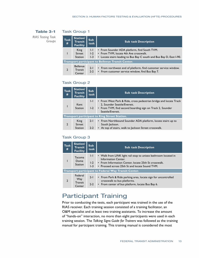
- -
- -
- -
SECTION 3 HUMAN FACTORS TESTING amp EVALUATION (HFTE) PROCEDURES
Table 3-1 Task Group 1 RIAS Testing Task
Groups Task
Station Transit Facility
Sub task Sub task Description
1 King
Street Station
1-1 1-2 1-3
bull From Sounder ADA platform find South TVM bull From TVM locate 4th Ave crosswalk bull Locate stairs leading to Bus Bay C south and Bus Bay D East I-90
Transport participant to Bellevue Transit Center
2 Bellevue Transit Center
2-1 2-2
bull From northwest end of platform find customer service window bull From customer service window find Bus Bay 7
Task Group 2
Task
Station Transit Facility
Sub task Sub task Description
1 Kent Station
1-1
1-2
bull From West Park amp Ride cross pedestrian bridge and locate Track 2 Sounder SeattleEverett bull From TVM find second boarding sign on Track 2 Sounder SeattleEverett
Transport participant to King Street Station
2 King
Street Station
2-1
2-2
bull From Northbound Sounder ADA platform locate stairs up to South Jackson
bull At top of stairs walk to Jackson Street crosswalk
Task Group 3
Task
Station Transit Facility
Sub task Sub task Description
1 Tacoma Dome Station
1-1
1-2 1-3
bull Walk from LINK light rail stop to unisex bathroom located in Information Center bull From Information Center locate 25th St crosswalk bull Proceed across 25th St and locate Sound TVM
Transport participant to Federal Way Transit Center
2
Federal Way
Transit Center
2-1
2-2
bull From Park amp Ride parking area locate sign for uncontrolled crosswalk to bus platforms
bull From center of bus platform locate Bus Bay 6
Participant Training Prior to conducting the tests each participant was trained in the use of the RIAS receiver Each training session consisted of a training facilitator an OampM specialist and at least two training assistants To increase the amount of ldquohands-onrdquo interaction no more than eight participants were used in each training session The Talking Signs Guide for Trainers was followed as the training manual for participant training This training manual is considered the most
FEDERAL TRANSIT ADMINISTRATION 13
SECTION 3 HUMAN FACTORS TESTING amp EVALUATION (HFTE) PROCEDURES
comprehensive reference for use by people who teach others to use the RIAS technology and Talking Signs According to a 1995 study (Crandall et al) ldquothose who receive direct instruction for 15 to 2 hours are more proficient in their use of the [RIAS] systemrdquo Each participant was trained until heshe could successfully use the RIAS system It does not take much time to learn how to use the Talking Sign system and this training assisted in providing a simulation of persons navigating their way that are familiar with the use of the system which is a better simulation of what will be experienced in real life by the frequent user of the system
ObservationalInteractive Research The staff conducting the tests evaluated how well each user was able to navigate through hisher trip and filled out information about the results on prepared forms for groups 1ndash3 In each location the participants were asked to locate specific features of the transit facility Each participant was asked to complete a series of tasks based upon the task group described above For each task the observer recorded the number of transmitters located and the number of requests for assistance from the participant This was the most important part of the research process since it involves the participantrsquos actual success or failure with the RIAS system in a real-world application
The observer accompanied the participant as each task was performed The primary responsibility of the observer was to ensure the safety of the participant during the test The observer also recorded the participantrsquos performance comments and questions which were used to determine the level of success of the RIAS system The test subjects were also asked a series of questions related to their evaluation of the system after the testing was completed and the answers were recorded by the observer
Extended-User Research (Post-Trial Interviews) Once the test subjects had completed the observationalinteractive group tests they were asked to use the system for several weeks At the end of this extended use each participant assisted in filling out forms with questions related to their evaluation of the system These questions were used to assess the participantsrsquo extended experience with the RIAS system and to determine their interest in using the system in the future The answers to these questions were used in analyzing the overall success of the system
FEDERAL TRANSIT ADMINISTRATION 14
SECTION
4SECTION
4 Human Factors Testing amp Evaluation (HFTE) Results
The majority of the test results showed a positive indication that the RIAS system works well in providing people who are blind or who have visual impairments or disabilities with more independence in their travel The results are summarized into two areasmdashthe observationalinteractive research and the participant post-trial interviewmdashas described in the previous section of this report This report provides a summary of the results from these tests as well as some of the issues and lessons learned with the system Detailed HFTE test results and analyses are contained in a report completed by Hidalgo amp De Vries Overall the results of all the tests were fairly positive The participants felt pleased with the effectiveness of the RIAS system and comments suggested there is room for improvement in some areas
ObservationalInteractive ResearchResults Summary For Group 1 the participants were able to locate the majority of the audible signs at the King Street Station and all of the audible signs at the Bellevue Transit Center with no problems One audible sign at King Street Station that identifies the stairs leading down to the International District Bus Tunnel was not located by the participants Overall the participants were pleased with the usability of the RIAS system at these two transit centers however some expressed the need for additional signs around the transit centers At the time of the tests audible signs had not been installed for the crosswalks These signs were not installed for the King Street Station for this project and would help in addressing this need
For Group 2 the test results showed for the King Street Station that the RIAS system was effective and the participants were able to locate all of the signs without assistance The results were different for the Kent Station The participants had more difficulty locating the audible signs at this station and two of the six participants in this group found the RIAS system to be ldquonot very usefulrdquo or ldquonot at all usefulrdquo in the post-trial interviews It should be noted that one of the audible signs at the Kent Station was not transmitting the audible message
Finally in Group 3 all four participants were able to locate the audible signs at the Tacoma Dome Station and three of the four participants were able to locate all the signs at the Federal Way Transit Center without assistance One participant required assistance from the observer to locate one of the audible
FEDERAL TRANSIT ADMINISTRATION 15
SECTION 4 HUMAN FACTORS TESTING amp EVALUATION (HFTE) RESULTS
signs A power outage in part of the Federal Way Transit Center caused one of the signs used in the tests to not be operational Three of the four were able to locate the destination for the subtask using another nearby audible sign
Extended User Research Summary Of the 19 HFTE participants 11 completed post-trial interviews to provide their feedback on the extended use of the RIAS system The participants rated their overall satisfaction with the RIAS system on a 10-point scale with 10 as the best experience and 1 as the worst experience The average rating was 682 with a high rating by one participant of 10 and a low rating of 3 The following are the most significant items from the participant interviews
bull Overall the participants were very satisfied with the RIAS system and their role in the study
bull The majority of participants would not use the RIAS system if they had to pay out-of-pocket for a RIAS receiver
bullThe majority of participants would use the RIAS system if the RIAS receiver was provided free of charge
bull If the RIAS system was available at the rest of Sound Transitrsquos facilities more participants would use the RIAS system
Issues and Lessons Learned There were several issues that were encountered during the HFTE tests At two stations there were problems with some of the audible signs not being operational Most of these seemed to be related more to maintenance issues from temporary power outages while maintenance was repairing nearby lighting damage This would likely be a continuing issue as maintenance at each station is needed and power to the audible signs would need to be temporarily disconnected For their safety travelers who are blind or who have visual impairments or disabilities would need to be notified in some way when these conditions occur
Another issue that occurred was that there were reflections of the RIAS signals in some instances which create a potential hazard to the traveler One instance in particular occurred when a RIAS signal reflected off a person wearing a reflective jacket who was standing in front of the participant during testing This caused the signal to transmit to the participantrsquos receiver coming from the opposite direction intended by the RIAS system which caused the participant to become confused about the direction needed to walk to reach the destination Reflections off articles of clothing are likely to occur every now and then particularly when walking through crowded areas which is common at the Sound Transit multimodal facilities Reflections of the RIAS signals also seem to occur when the signal reaches metallic objects Items at transit facilities that would
FEDERAL TRANSIT ADMINISTRATION 16
SECTION 4 HUMAN FACTORS TESTING amp EVALUATION (HFTE) RESULTS
reflect the RIAS signal include elevator doors support columnsbeams and roofs and certain parts of ticket vending machines In some instances reflections are used as an installation method such as pointing transmitters at elevator doors to guide persons to elevators where the transmitter cannot be located above the doors Any highly-polished surface can reflect the IR transmissions
Issues were found with some of the RIAS signals being blocked by objects At the King Street Station there were temporary vinyl banners that had been placed in the bridgewalkway leading down to the platforms which prevented the receiver from picking up the audible message Other objects that blocked RIAS signals included concrete structures wallsbuildings shelters and structural supports
Overall it seems that placement and setting the direction and adjusting the strength of the audible signs signal is the key to reducing these reflections and avoiding objects that may block the signal There are problems however in some transit facility locations where it becomes difficult to place the audible signs in a way that they can effectively function In addition future placement of objects at each facility should not be completed without some consideration regarding the effects these objects will have on RIAS system performance
The RIAS signals also seemed to be affected to some degree by sunlight In one instance the signal strength of one sign appeared to be stronger during cloud cover than it was with more sunlight or a brighter sky behind the transmitter location One issue that was mentioned by some of the participants was that there were not enough audible signs in some locations It was a great to provide audible signs at all locations in the Tacoma Dome Station in particular because of large open walking areas with nothing that could be used for mounting the sign In addition there were budget constraints that limited the number of audible signs installed
Analysis by Others The Volpe Institute will be determining the practical operation of the RIAS technology and its benefits In addition Hidalgo amp De Vries has conducted a more detailed review of the human factors tests This project requires a report to the US Congress by the Secretary of Transportation which will be finalized by Volpe with this report and Hidalgorsquos report provided as input to the final Volpe report The following are the evaluation points Volpe will be considering
bull The effect on multimodal accessibility in public transportation with regard to persons with visual cognitive and learning disabilities
bullThe effect on making public transportation accessible to persons with visual cognitive and learning disabilities who use public transit and paratransit
bull The effect on education community integration work life and general quality of life of the targeted populations
FEDERAL TRANSIT ADMINISTRATION 17
SECTION
5SECTION
5 Existing WayfindingTechnology Review
As part of an evaluation in recommending further investment into RIAS technology it is important to consider the existing technology that is available or under development for wayfinding systems for people who are blind or who have visual or cognitive disabilities These systems can be divided into several categories
bull Infrared (IR) and light emitting signs
bull Radio frequency (RF) or Wi-Fi signs
bull Bar-coded signs
bull Gps-based systems
bull Research projects
This review has considered only wayfinding technologies that would have a benefit similar to that provided by Talking Signs In other words the focus of this review has been on technology for orientation and navigation with a particular focus on systems that provide orientation and navigation for public transportation facilities
Infrared (IR) and Light EmittingSigns One technology that has developed with great promise is audible signs that transmit infrared or light signals that can be decoded by a receiver The transmitted information is converted to an audible message that is played on a receiver to the person with visual impairments or disabilities Two types of these systems that are currently in operation have been reviewed for this report Talking Signs and Talking Lights (Talking Lights LLC)
Talking Signs Talking Signs has emerged as a promising technology that can provide localized directional information and item identification to persons with visual impairments or disabilities There have been many studies and tests with human subjects to determine the effectiveness and value associated with using this system This system has developed to the greatest degree in the marketplace and in the number of system implementations which gives it an advantage over other similar competing technologies
FEDERAL TRANSIT ADMINISTRATION 18
SECTION 5 EXISTING WAYFINDING TECHNOLOGY REVIEW
The Talking Signs system has been used in many transit environments and has the capability to provide easily-updated message information such as changes in bus numbers or routes for a particular bus The system has also been embedded in visual message signs to match the messages displayed Many studies have been completed for this system and it has been shown to be of benefit to travelers with visual impairments or disabilities The main drawback to using this system is that it is costly Talking Signs has established relationships with other companies to continue to develop the system to make sure it continues to transition to a more open architecture environment to be used with other transit systems in the future More detailed information about this system including a description of the Sound Transit Talking Sign system is provided in Section 3
Talking Lights Talking Lights is a system developed by a team at MIT that uses ordinary lights and embeds a signal that can be decoded by a receiver The system is a high-resolution tracking system that uses PDAs with audio direction software The advantage of this technology is that there are no wires needed to install facilities can use their existing lighting infrastructure and the light bulbs do not consume any additional energy to perform their function
While this appears to be promising technology that could be more easily implemented by modifying existing lights within a facility it is still new This system has had success for patients at the Spaulding Rehabilitation Hospital in Boston and there is currently a study going on at the Decatur Hospital in Georgia Other plans include developing a system for museums In addition this system seems to be used only for indoor applications although Talking Lights has teamed with the Sendoro Group to provide an outdoor navigation system
Radio Frequency (RF) Signs Step-Hear Step-Hear is a new product that debuted in August 2008 at the World Blind Union 7th Assembly in Geneva Switzerland This product is similar to Talking Signs in that it uses a base transmitter to send directional information to a hand held receiver The system uses radio frequency signals transmitted by the base transmitter provided in a directional nature to transmit information about the location of the transmitter
This system also seems to have a few more features than Talking Signs The receiver vibrates when it is within range (about 12 ft) of a base transmitter and for bus installations a red light is activated to notify the bus driver that a person needing help entering the bus is within range of the transmitter In addition the base unit can be integrated with the bus GPS and speaker systems Changing
FEDERAL TRANSIT ADMINISTRATION 19
SECTION 5 EXISTING WAYFINDING TECHNOLOGY REVIEW
the messages appears to be quite simple using a built-in switch and button that when used together will allow modification of the message
One drawback to this technology is that it has not yet been fully deployed and has yet to be proven as a viable option in the marketplace There is currently an installation ongoing for a bus system which is reportedly showing success A full report on this project was promised to be provided once the project was completely installed tested and operating on the system Information about this system was limited at the time of this report and further review of the installation on the bus system should be completed when available
Bar-Coded Signs University of California and Smith-Kettlewell EyeResearch Institute Color Marker and Bar Code System
This system is still in the research stage of development and cannot be considered as a viable alternative at this point However the system does show some promise in the future for providing a beneficial cost-effective wayfinding system The system is based on a cell phone that detects color markers placed throughout the environment These markers are detected by the cell phone at a distance of several meters away The purpose of the color marker is not to give any information about the location of the marker but to help a person with visual impairments or disabilities to detect the marker A bar code is then placed near the marker and the cell phone can decode and receive information about the location This typically requires the user to move closer to the marker to process the information and determine location-based information
GPS-Based Systems There are many GPS-based systems that travelers with visual impairments or disabilities can use to assist in guidance to a destination There are a few that are commercially available and many others still being developed All systems are for outdoor use only with very limited capability indoors due to lack of GPS satellite signal These systems continue to advance with greater accuracy including WAAS corrections which can provide 2ndash3 meter accuracy Common GPS for the consumer market has been tested to have a location accuracy of within 30 meters as a comparison
Loadstone GPS Loadstone GPS is open source software using satellite navigation for persons with visual impairments or disabilities The benefit to this system is that the software is free and will run on many different Nokia cell phone devices It requires a GPS receiver that connects to the cell phone by Bluetooth In
FEDERAL TRANSIT ADMINISTRATION 20
SECTION 5 EXISTING WAYFINDING TECHNOLOGY REVIEW
addition a screen reader program must be running on the cell phone such as Talks or Mobile Speak to give the user instructions
Wayfinder Access This GPS solution is similar to Loadstone however it offers more features to the traveler with visual impairments or disabilities It is a software application that uses Symbian phones to work with screen readers Other features are customized for persons who are blind or who have visual impairments or disabilities to provide them with information about surroundings including feedback on points of interest and Braille support
Trekker Trekker was developed as a personal digital assistant (PDA) application operating on a Microsoft Pocket PC operating system and was adapted to be used by persons who are blind or have visual impairments or disabilities with talking menus talking maps and GPS information Features include determination of position creating routes and receiving information about navigating to a destination A search function for points of interest is also available This application has the ability to expand to accommodate new hardware platforms and more detailed location and geographic information
BrailleNote GPS BrailleNote GPS was developed by Sendero Group and the idea behind it combines a PDA with direction software that returns audible directions to the user It uses GPS to pinpoint a personrsquos position and nearby points of interest and is about the size of a small cell phone Points of interest can be input into the system and directions to these locations can be accessed This is similar to the GPS-based direction systems for automotive use
Mobile Geo Mobile Geo works with Windows Mobile-based smartphones Pocket PC phones and other PDAs The GPS and mapping technology built into this system is from the Sendero Group It is the first solution that works with a wide range of mainstream mobile devices and it can be used with more than 20 different Braille devices for input and output It works with Mobile Speak screen reader software which is a Code Factory product It is compatible with more than 300 PDAs as well as mobile phones that operate on GSM CDMA and WCDMA networks Like other GPS-based solutions Mobile Geo pinpoints the travelerrsquos location and provides information about points of interest The benefit to this product is that it has built-in map data
FEDERAL TRANSIT ADMINISTRATION 21
SECTION 5 EXISTING WAYFINDING TECHNOLOGY REVIEW
Research Projects A number of projects are currently under development and a few of these are mentioned below The trend for wayfinding systems and technology for persons with visual impairments or disabilities is to use a combination of GPS infrared RF and other methods to provide a more complete solution for travelers with visual impairments or disabilities The systems described below are provided in this report to show this trend as well as to provide a basis for recommendations on pursuing an integrated solution using GPS and smartphone technologies with Internet capability
University of South Florida Travel Assistance Device(TAD) The University of South Florida (USF) Center for Urban Transportation Research is developing software that uses GPS technology inside cell phones to assist persons with cognitive disabilities to navigate public transportation Users can access a website that is similar to the Google Map interface where they can select their route location stop and travel times Trips are planned using this website and then downloaded to the cell phone The software developed by USF is installed on the phone and can give the rider alerts while riding the bus to prepare himher to exit the bus at the planned destination The system was tested last year with student with developmental disabilities and was quite successful
Trinetra The Trinetra project aims to create a smartphone solution that will benefit persons with visual impairments or disabilities The goals are to develop a cost-effective system This project is one to reconsider in the future since the plans are to develop a system that will assist the needs of persons with visual impairments or disabilities who uses public transportation by providing them with real-time information The concept of the system uses a combination of GPS receivers and infrared sensors that relay information to a centralized fleet management server using a cell phone The person with visual impairments or disabilities can then use a cell phone with text-to-speech capability to determine estimated time of arrival location and current bus capacity using a web browser Other research for this project is considering the use of universal product codes (UPCs) and radio-frequency identification (RFID) for indoor navigation in a shopping setting
NOPPA The NOPPA project was a three-year project (2002ndash2004) in Finland as part of the Ministry of Transport and Communications Finlandrsquos HEILI Passenger Information Program which was a pilot program to develop a system for
FEDERAL TRANSIT ADMINISTRATION 22
SECTION 5 EXISTING WAYFINDING TECHNOLOGY REVIEW
navigation and guidance for persons with visual impairments or disabilities who use public transportation It is similar in goals to the Trinetra project and uses GPS technology combined with Wi-Fi smartphone for Internet access and text-to-speech capability optional RFID reader and a database of route information to provide directional information to the user Like Trinetra it is based on a central information server concept While the pilot program was successful there are still drawbacks to this system which includes wireless and GPS not always being available in areas without line of sight or in urban canyons issues associated with having outdated information in the central database and availability of this system in the United States
Brunel University Navigation System Brunel University is developing a system that is based on the combination of several state-of-the-art current technologies including GPS and GIS The system provides automated guidance using the information from daily updated digital map datasets The difficulties with this system include the availability of up-to-date information and what information to offer with the navigation procedure Different levels of functionality have been created with this system to be able to customize the information to the user
Drishti Drishti is a wireless pedestrian navigation system developed by the University of Florida The system integrates technologies including wearable computers voice recognition and synthesis wireless networks GIS and GPS It also provides contextual information to the person with visual impairments or disabilities and computed optimized routes based on user preference traffic congestion and obstacles such as road work The system guides the user to navigate based on both available static and dynamic data This requires a spatial database that provides environmental conditions and landmark information along the travelerrsquos route The system also has the capability for the user to add information to the database
Transit Location and Schedule Data Several technologies are being developed that assist travelers in navigating a transit system Google Transit is a popular system that has developed since 2005 and now includes 70 transit agencies in 10 countries It is a web-based application that uses a database of information from each transit agency along with Google Maps to determine the best bus route or routes and times for transporting passengers to and from locations that are input online by the traveler King County Metro is already part of the Google Transit system
Sound Transit already has existing databases built for a regional Trip Planner system which uses Trapeze software for their bus routes King County Metro
FEDERAL TRANSIT ADMINISTRATION 23
SECTION 5 EXISTING WAYFINDING TECHNOLOGY REVIEW
Community Transit and Pierce Transit are also already part of this system It will not be added to the Sounder rail line until the commuter rail line is completely built out For some agencies real-time feeds are also provided for locating certain buses on routes of interest however at this time Sound Transit does not have the ability to provide these real-time feeds These systems will continue to improve in providing wayfinding information for travelers
Current Trends for WayfindingTechnology Technology today is rapidly changing It is estimated that every 18 months another set of advancements in technology will occur The wayfinding system technology is no different and this market should be frequently analyzed in order to be aware of innovative cost-effective solutions that become available to travelers with visual impairments or disabilities
Computer chips and small embedded devices are already being placed in many environmental aspects of our lives such as ldquosmartrdquo surroundings These have the ability to monitor and report conditions continually and computer chips are increasingly being found in signage They can be placed in walls poles sidewalks etc and provide information to the traveler As computer chips continue to expand in application technologies will advance to the point of providing benefit in wayfinding for persons with visual impairments
The current trend for wayfinding technology as can be seen from the GPS-based systems and research projects evaluated is to further develop and use smartphones and PDAs with Internet and GPS applications and blend several technologies to provide a complete solution for navigation The focus is on developing software applications that will run on many of the devices people carry with them already such as smart phonesPDAs The integration of Bluetooth GPS and radioWi-Fi functions in a handset provides many benefits and is the current trend The benefits include improved system performance improved cost structure power consumption savings and other savings from shared system use including ease of assembly because of shared packaging
Many applications are available for pedestrians drivers and public transportation users that continue to improve the efficiency of traveling Some of these applications can in conjunction with other technologies provide wayfinding for both travelers who are blind or who have visual impairments or disabilities as well as all travelers These types of technologies could potentially increase funding as they help a greater number of public transportation users
The GPS-based systems are continuing to be improved and other technologies are being combined with GPS to provide more accurate wayfinding information
FEDERAL TRANSIT ADMINISTRATION 24
SECTION 5 EXISTING WAYFINDING TECHNOLOGY REVIEW
Some systems use Wi-Fi to assist location determination while others use inertial sensors and cameras in areas where GPS signals may be limited It seems clear that GPS systems combined with smartphones with Internet access are the future of wayfinding systems as there are many new developments occurring to continue to increase the effectiveness of these systems For those who are blind or have visual impairments or disabilities stable low-cost technologies are important
Summary of WayfindingTechnology Review Based upon the technology review of this report there are three current options available to use for localized directional information Talking Signs Talking Lights and Step-Hear systems Other GPS-based or GPS-assisted systems using smartphones or PDA technologies using a database of points of interest seem to have the capability to provide outdoor wayfinding at a continually increasing accuracy Current accuracy taking into account WAAS corrections for reasonably-priced GPS units is about 2ndash3 meters Based upon the evaluation of RIAS technology using GPS systems would be similar to the accuracy provided by RIAS for persons with visual impairments or disabilities in determining the actual position of a particular point if WAAS corrections are taken into account Since the current trend is for ldquosmartrdquo devices the GPS-based technologies should be considered an option for providing wayfinding outdoors while using other systems for indoor navigation
The Talking Signs system still has the market advantage when compared to other localized directional information systems and is the most proven system at this time with many installations currently in place throughout the world One drawback to this system as with some other systems considered in this report is that the current trend for wayfinding technology is to integrate a number of technologies together Cell phonesPDAs are integrating with technologies including webe-mail access interactive voice response and text-to-speech technology GPS wayfinding systems digital cameras for recognition purposes palm computing and CPUs and smart-sensing environments The enhanced cell phone is becoming a handy remote device for finding information about the environment As technology continues to advance these smartphones will become smaller and less expensive with more features Modifications to the cell phone will continue to adapt to be a cost-effective and universal solution for wayfinding Another drawback for this system is that it is mainly used for item identification Information on routespaths to take are given within the messages of some of the signs however the user is not given a travel route based on his her destination information
FEDERAL TRANSIT ADMINISTRATION 25
SECTION 5 EXISTING WAYFINDING TECHNOLOGY REVIEW
The Talking Lights system is already working with Sendoro Group which provides GPS wayfinding products to integrate the two technologies This system also has the capability to integrate with a local Wi-Fi mesh network Talking Lights seems to be a cost-effective solution based upon costs that were obtained and are provided in the next section This system at this time is limited to indoorbuilding applications which makes this technology a good fit for integration with a GPS-based technology There are plans to expand the system to outdoor environments and an application of this system has already been introduced on headlights for military vehicles Some concerns for outdoors would be problems that could occur during the daylight versus at night and other light interference sources that could reduce the performance of the system however if this system is integrated with other technologies such as GPS-based technology from Sendoro Group it could prove to be a useful navigation aid for both indoor and outdoor environments An advantage that this system has over the Talking Signs system is that it acts in a similar manner to GPS-based wayfinding technologies In other words it uses more than just item identification and delivers pathroute information to the user via a central database The two main drawbacks are that the system does not have the same market presence as Talking Signs so long-term viability is a concern and the system has not been tested in a transit environment for people who have visual impairments or disabilities or cognitively disabilities
The Step-Hear system is fairly new technology that shows promise in comparison to the Talking Signs system Unlike the disadvantage Talking Lights has in outdoor applications the Step-Hear system can operate in both outdoor and indoor environments This system appears to have a few more functions than Talking Signs however it is also not fully proven in the market Once the initial installation is complete for this system another evaluation should be completed to determine its effectiveness This system also seems to be a cost-effective product like Talking Lights A comparison of costs for these three systems is provided in the next section
In summary a blending of technologies seems to be the best solution for providing people who have visual impairments or disabilities and cognitive disabilities with a wayfinding system that can be used for public transportation Smartphones or PDAs with speech-to-text capability can access via the Internet databases of information for points of interest particularly GPS coordinates and determine step-by-step instructions to the user based upon hisher GPS-determined position Google using its Google Transit database and TimeTablePublisher software for schedules and locations has already begun integrating transit points of interest just as the regional Trip Planner for the Puget Sound bus systems does and now gives users step-by-step instructions for using public transportation based upon the starting and ending points of the traveler Creating a database of transit points of interest that would aid a traveler
FEDERAL TRANSIT ADMINISTRATION 26
SECTION 5 EXISTING WAYFINDING TECHNOLOGY REVIEW
with visual impairments or disabilities would seem to be an effective solution that could be used by technologies integrated with GPS systems for wayfinding from a long-term perspective For buses however the localized item identification systems would have an advantage for those that are easily updateable with bus information although current trends with GPSAVL systems on buses are to publish bus locations online that could then be accessed via a smartphone PDA or other ldquosmartrdquo device
FEDERAL TRANSIT ADMINISTRATION 27
SECTION
6SECTION Cost Benefit Analysis 6
Introduction In completing a cost benefit analysis for something that provides social equality to a group of people a typical cost versus benefit analysis is not possible The basic benefits for a person with visual or cognitive disabilities from a wayfinding system are
bullAbility to travel with confidence and enable them to become more independent
bullOverall positive effect on quality of life
Detailed analysis on the benefits of Talking Signs as well as costs for the system have already been completed in numerous other studies including those done by the University of California Santa Barbara and the Smith-Kettlewell Eye Research Institute The results from the human factors testing at Sound Transit also show that the RIAS system was received positively by the evaluation participants as summarized in Section 5 and as detailed by the report completed by Hidalgo amp De Vries
Because of the social benefits of this type of system this cost benefit analysis will focus primarily on how well each technology performs as a wayfinding system for persons with visual impairments or disabilities and the cost implications for each of the technologies The purpose of this analysis was to evaluate these cost implications for RIAS as well as other technologies and to determine whether proceeding with expansion of a RIAS system would be the best solution to provide these benefits to persons with visual or cognitive disabilities in the Puget Sound area The cost benefit analysis provided in this report focuses on the following
bullBased on the number of people who have visual and cognitively disabilities in the Puget Sound area as well as those which use public transportation determine how many people could potentially benefit from a wayfinding technology system
bullBased on the number of people who have visual and cognitively disabilities in the Puget Sound area analyze paratransit costs for Sound Transit to determine the potential cost savings in reducing the number of persons using this service
bullBased upon the technology review compare four main products or solutions for costs and benefits and the risks with the use of each system Talking Signs Talking Lights Step-Hear and a combination of one of these three to use for just indoors and on buses with a GPS-based system for outdoor navigation
FEDERAL TRANSIT ADMINISTRATION 28
SECTION 6 COST BENEFIT ANALYSIS
Table 6-1 Statistics on
Persons with Visual Impairment and
Cognitive Disabilities in Puget Sound
Evaluation of Potential WayfindingSystem Users in the Puget Sound Information about the number of persons with visual and cognitively disabilities is summarized in Table 6-1 The number of persons with developmental disabilities for each county was obtained from Sound Transit and the statistics for the number of persons who are blind or have visual disabilities is based on percentages from the US Census Bureau on people with sensory disabilities for the tri-county area from a 2006 American Community Survey Other national percentages are from the US Cernsus Bureau 2005 measures of disability Based upon these available statistics estimated upper bounds of 4 percent of the population were used in Table 6-1 Population estimates were based upon information from the US Census Bureau
Puget Sound Region County
Total Persons with Cognitive Disabilities
Total Persons with Visual Disabilities or Blind
King 10399 74371
Pierce 4712 30927
Snohomish 3469 27076
Total 18580 132374
From these numbers it appears that there are many people who could potentially benefit from a wayfinding system in the Puget Sound region Also from the post-trial interviews the participants were likely to use the RIAS system for a range of trip purposes such as work shopping social events recreation and education
Potential Cost Savings for Paratransit Services There are cost savings that could be seen from persons who are blind or who have visual disabilities becoming more independent in their travel These costs would be related to paratransit services for these persons As more persons who are blind or who have visual disabilities become more independent they will likely use paratransit services less or not at all Information about the operating expense per revenue mile for demand response vehicles was obtained from the 2007 National Transit Database Based upon the information available from Sound Transit it is estimated that approximately 4 percent of the passenger miles represents passengers who are blind or who have visual disabilities From this estimate the total cost savings was calculated for 2007 and is shown in Table 6-2
FEDERAL TRANSIT ADMINISTRATION 29
SECTION 6 COST BENEFIT ANALYSIS
Table 6-2 Paratransit Costs
and Potential Savings (based on 2007 cost
data for demand response vehicle operating costs)
Table 6-3 Talking Signs System
History of Costs
Demand Response Transit Agency Cost per Passenger Mile 4 of Cost per
Passenger Mile Potential 2007 Cost Savings
King County Metro $424 $017 $1920000
Pierce Transit $455 $018 $630000
Community Transit $353 $014 $320000
Total $2870000
From this analysis there are significant potential annual savings in providing a wayfinding system for persons who are blind or who have visual disabilities which would decrease paratransit use and thereby reduce the operating costs for paratransit services
Wayfinding System Costs Costs for the different types of wayfinding systems available were obtained from each of the vendors One of the problems with the comparison of costs is that only material costs were obtained from Step-Hear and only installation costs for buildings were obtained from Talking Lights By far Talking Signs has the most cost information available for this analysis because it has been installed in more locations Because of this the analysis focuses on comparing material costs between Talking Signs and Step-Hear and building system costs between Talking Signs and Talking Lights
Talking Signs Costs Information about the costs for Talking Signs was obtained from previous installations as well as from the bid provided by Talking Signs Services Inc for the Sound Transit RIAS project Table 6-3 shows installation costs (in cost per transmitter) for some Talking Signs projects
Installation Location Number of Transmitters Cost per Transmitter
Sound Transit 370 $7005
TriMet 30 $2655
San Francisco Muni 30 $3200
Colorado Springs 10 $3760
Phoenix Public Transit 10 $4630
Port of San Francisco 30 $4635
Caltrain 40 $3000
It should be noted that installation costs for the Sound Transit RIAS project are much higher because the other installation costs did not include installation of the system infrastructure such as conduit cable etc In other words Talking Signs has typically installed the system in locations where all that is required is to install the transmitter and test and operate the system the other costs for conduit and system infrastructure were provided through separate contracts In
FEDERAL TRANSIT ADMINISTRATION 30
-
SECTION 6 COST BENEFIT ANALYSIS
Table 6-4 Talking Signs Material
Costs
addition the costs given above were the costs at the time of the installation The Sound Transit project is the most recent one given
Table 6-4 shows the material costs per transmitter and receiver There are two different types of transmitters provided so an average transmitter cost is given
Talking Signs Equipment Unit Cost
Average material cost per transmitter $1600
Material cost per receiver $265
Step-Hear Costs As mentioned only material costs were obtained from Step-Hear Additional cost information will be provided once the first project for this system is completed Below is a table which shows the cost per transmitter and per receiver for this system
Table 6-5 Step-Hear Material
Costs
Step Hear Equipment Unit Cost
Average material cost per transmitter $100
Material cost per receiver $22
Talking Lights Costs The cost to install Talking Lights was obtained only for indoor applications Depending on the type of facility and complexity the cost to install Talking Lights ranges from $050ndash2 per square foot A comparison of this cost with Talking Signs based upon the historical costs at the San Francisco Caltrain station is given in the next section
GPS-Based System Costs It is difficult to determine the actual cost for a GPS-based solution that could be used by the person with visual or cognitive disabilities for wayfinding There are several smartphone systems such as Loadstone GPS which runs on Nokia phones and interfaces to a GPS receiver Costs were calculated from some of the systems evaluated in this report and are included in Table 6-6 In addition to the costs for these systems some costs would be necessary to develop a database for Sound Transit specific points of interest and other points required for wayfinding as well as monthly costs for the phone service In downtown areas where it is difficult to gain connectivity with GPS signals from satellites additional WAAS or other fixed location signal sources may need to be installed to provide accurate locations
FEDERAL TRANSIT ADMINISTRATION 31
SECTION 6 COST BENEFIT ANALYSIS
Table 6-6 GPS-Based System
Costs
Table 6-7 Sound Transit
Wayfinding System Installation Cost
Comparison
System Type Unit Cost Avg Monthly Service Cost
Loadstone GPS (includes smartphone software GPS receiver screen reader)
$700 $60
Wayfinder Access (includes smartphone software GPS receiver screen reader)
$1200 $60
BrailleNote GPS V 3 (Includes maps receiver pouch cable 1 GB CF card)
$1599 NA
Trekker GPS System $1695 NA
Mobile Geo (includes smartphone software GPS receiver screen reader)
$1745 $60
Wayfinding SystemsCost Comparison Summary Talking Signs and Step-Hear Cost Comparison In comparing material costs shown between Talking Signs and Step-Hear it is clear that Step-Hear has a very large cost advantage from a material unit per unit basis Talking Sign transmitters are 18 times the cost of a similar Step-Hear transmitter and receiver costs are more than 10 times more expensive for material only Table 7-7 shows a comparison of the total RIAS Sound Transit installation costs based upon the complete bid from Talking Signs with equivalent costs for Step-Hear The cost shown for the Step-Hear system was calculated by substituting material costs for Step-Hear transmitters and receivers for the Talking Sign transmitter and receiver bid prices This comparison assumes that conduit and power cabling needs and installation costs for mounting the transmitters are the same
System Type Cost
Talking Signs System (actual installation cost in todayrsquos dollars) $2199765
Step-Hear System (estimated cost based upon Step-Hear material costs) $1665495
One major factor that is not considered in the above comparison is the number of Step-Hear transmitters that would be necessary to replicate the same system coverage for Talking Signs Information obtained from Step-Hear indicated the range for the transmitter was about 65 feet which is somewhat shorter than the maximum range for the Talking Signs transmitter of around 100 feet Also it does not seem the Step-Hear transmitter has similar capabilities in adjusting the strength of the signal Another problem with this comparison is the assumption that installation costs would be similar including testing training and maintenance The main result of this analysis is that it would appear that Step-Hear would have a cost advantage for installation on buses since transmitter coverage areas would be similar for both and it would take the same number of Talking Signs transmitters on a bus as it would for the Step-Hear system
FEDERAL TRANSIT ADMINISTRATION 32
SECTION 6 COST BENEFIT ANALYSIS
Table 6-8 Caltrain San Jose
Diridon Station Wayfinding System
Installation Cost Comparison
Table 6-9 Sound Transit
Wayfinding System Installation Cost
Comparison
Talking Signs and Talking Lights Cost Comparison For the Talking Lights system it is difficult to compare on a cost-to-cost basis with Talking Signs The method used for the purpose of this report was to consider the historical cost (converted to todayrsquos dollars) to install the Talking Signs system at the San Jose Diridon Caltrain station with a Talking Lights system cost for this station of $2 per square foot The area in square feet was calculated for the coverage area provided by Talking Signs at this station This included areas outside on train platforms as well as indoor areas This installation was only for mounting installation and testing of the RIAS system and did not include conduit and wiring costs which were completed under a separate contract Table 6-8 shows a simplified comparison of the costs between these systems using this method
System Type Cost
Talking Signs System (actual installation cost in todayrsquos dollars) $215000
Talking Lights System (est cost based on $2sf) $32000
Based upon this comparison there seems to be a large cost advantage for the Talking Lights system However this comparison does not consider the issues that could be encountered for the outside train platform areas of the San Jose Diridon Caltrain station if Talking Lights were used This does indicate that further investigation of the costs and effectiveness of the Talking Lights system for at least indoor transit facility areas should be completed
Talking Signs and GPS-Based System Cost Comparison In comparing the Talking Signs system to an outdoor GPS-based system there are a number of factors to consider Table 6-9 shows the actual cost for the RIAS system for Sound Transit compared with the estimated cost for implementing a region-wide database of points that are web-accessible The costs assume that receivers (GPS-based or Talking Signs receivers) will be purchased by the user Based upon the results of the participant interviews purchasing these receivers is a critical factor for determining whether persons will actually use the system
System Type Cost
Talking Signs System (actual installation cost in todayrsquos dollars) $2199765
GPS-based system (est cost to create point database interface and web access)
$150000
An integration of these technologies would seem to be more feasible As mentioned the costs above do not include the purchase of the individual GPS systems for each user which would likely be an issue for the user to purchase The cost to create this database is small since many of the bus routes for Sound Transit and King County Metro are already created using the Transit Trip Planner system Budget is already in place to update the database several
FEDERAL TRANSIT ADMINISTRATION 33
SECTION 6 COST BENEFIT ANALYSIS
times per year to make sure the bus route information is current The cost to create this database includes creating points for the entire regional transit system which would cover a larger area than the initial RIAS system at the six Sound Transit facilities It should be noted that the cost for the GPS system does not include review and testing of the system or a review from an OampM specialist From a per-person cost perspective for the entire regional transit system if the funding is to include purchasing a $700 personal GPS system and $250 for the RIAS receiver for each user the RIAS system has a cost advantage based upon the number of people in the Puget Sound area who have visual or cognitive disabilities However further comparison of costs of this system should be considered as GPS systems advance and costs for these systems continue to decrease
Wayfinding SystemsImplementation Risks Since RIAS technology has already been demonstrated in the Puget Sound area and in many other locations risks in proceeding with further system implementation are minimal There have also been many studies that have shown the system to be very successful and it has been tested more extensively by transit users who are blind or who have visual disabilities than any other system
There are several risks associated with installing a different system other than Talking Signs The main risks are
bullAnother custom device would be needed by the user
bullOther technologies do not have transit system studies completed using persons who are blind or have visual disabilities
bull Newer technology may not last long term
There are problems created when a user is required to have two different receivers to have the ability to travel independently For instance if a different technology other than RIAS is used for installation on the remaining Sound Transit facilities this would create the need for travelers who are blind or have visual disabilities to carry two different receivers and have the knowledge about which receiver to use at each facility This would make it more difficult for the user to travel effectively and could increase the cost if two receivers are needed to be purchased This would be simplified if one receiverunit was used indoors and a GPS-based unit was used outdoors By adding a cardmodule to the GPS-based unit to pick up either IR or RF signals from the item identifying transmitter these two units would have the potential to be integrated into one future unit
The Talking Signs RIAS technology is still the only technology that has been proven beneficial for use by persons who are blind or have visual disabilities in
FEDERAL TRANSIT ADMINISTRATION 34
SECTION 6 COST BENEFIT ANALYSIS
a transit environment There have been many studies and tests of the system on many transit systems All of these studies and tests including this most recent test with Sound Transit have been successful and have shown great benefits to the user Talking Lights has only been tested and used in an indoor hospital environment and has not been tested for use by persons who are blind although those who have had brain or eye surgery would have navigation needs similar to those who are blind or have visual disabilities impairments The Step-Hear system has only been completed on one bus system installation and the effectiveness of this system when compared to Talking Signs has yet to be determined
In addition both Talking Lights and Step-Hear are new technologies that have not been on the market very long The probability of these systems surviving in the market long term is less than for Talking Signs which has been in the market for many years There would naturally be increased risk in supporting technologies that are new and not proven
One issue in using Talking Signs and Step-Hear systems is that they are based upon item identification which has less focus on step-by-step guidance In other words a person could become lost or find it necessary to backtrack if the item was not identified and the person continued past the transmitter Also the transmitters are somewhat limited in placement because of mounting issues in the field which may not always be the best for guiding a visual impairments or disabilities traveler One issue noted during the installation and tests with the Sound Transit RIAS system was the ability for signals to reflect off of other objects particularly metallic objects This can sometimes create a message that gives the traveler incorrect information about which direction to go Reflection of RF signals from Step-Hear could also occur as well as issues associate with interference from other RF sources
GPS-based GPS-based systems are a good solution to provide directional information outdoors These systems are the trend for wayfinding technology so future integration and implementation of more advanced wayfinding systems would likely be easier when compared to the other wayfinding systems evaluated Because of this there is less risk in implementing GPS-based technology that is proven to be effective in guiding persons with visual impairments or disabilities There are many existing systems now that use GPS for the persons with visual impairments or disabilities and all that is necessary is to continue building a database of transit points of interest for travel path calculation purposes Satellite signals are sometimes blocked in areas such as around large high-rise buildings however applications are being developed that use last-known-positioning to calculate position within these types of dead zones Building footprints are also being placed into GPS databases in an effort to guide persons around the city areas In addition the iPhone offers assisted GPS through the use of Wi-Fi
FEDERAL TRANSIT ADMINISTRATION 35
SECTION 6 COST BENEFIT ANALYSIS
positioning which could also be used in urban areas for guidance One concern with the GPS-based systems as with other new technologies is the time it takes for people to become comfortable using the technology yet already there are persons with visual impairments or disabilities or who are blind using these systems for navigation
RIAS Installation Evaluation for Remainder of Sound Transit Facilities Another purpose of this project was to evaluate the cost implications for completing installation of the RIAS system on the remaining Sound Transit facilities and future facilities and on vehiclesbuses The following are the remaining facilities at Sound Transit that do not have a RIAS system installed
bull Edmonds Station
bull Mukilteo Station
bull Tukwila Station
bull Auburn Station
bull Sumner Station
bull Puyallup Station
bull Ash Way Park amp Rid
bullOverlake Transit Center
bull South Tacoma (open for bus opened for commuter rail in 2010)
bullLakewood Station (open for bus opened for commuter rail in 2010)
bull Lynwood Transit Center
bull Light Rail System (existing Tacoma line and new line opened for airport in 2009)
The Sound Transit RIAS project cost was $22 million to install at 6 facilities including some crosswalks and bus stops Operations and maintenance of the system and system support has already been budgeted within the Mobility Initiative Program and is not considered in the costs provided here Table 6-10 shows the budgetary costs per facility including buses commuter rail and light rail trains to install the RIAS system at the remainder of the Sound Transit facilities
FEDERAL TRANSIT ADMINISTRATION 36
SECTION 6 COST BENEFIT ANALYSIS
Table 6-10 Sound Transit RIAS
Costs for Remaining Facilities and Vehicles
Sound Transit Facilities Including Buses and Trains Cost
Edmonds Station (for future Edmonds Crossing) $375000
Mukilteo Station $430000
Tukwila Station $520000
Auburn Station $415000
Sumner Station $290000
Puyallup Station $375000
South Tacoma $250000
Overlake Transit Center $270000
Lakewood Station $600000
Lynnwood Transit Center $645000
Ash Way Park amp Ride $290000
Commuter Rail Vehicles (assumes 69 vehicles) $175000
Light Rail System (all lines installedplanned through 2009 19 stations) $2750000
Light Rail Vehicles (assumes 38 vehicles) $95000
Buses (assumes 239 vehicles) $600000
Total Estimated $8080000
RIAS Installation Evaluation at Other Regional PublicTransportation Facilities One of the purposes of this project was to evaluate the cost implications for regional transit facilities that could participate in implementation of a RIAS system All costs contained herein are for budgeting purposes only The following are the other regional transit agencies that should be considered for this system These are the other major transportation agencies that provide public transportation to the Puget Sound area
bull Community Transit
bull King County Metro
bull Pierce Transit
bull SeaTac Airport
The costs were based upon the bids received from Talking Signs for the subject project Average costs for facilities in which RIAS was installed were used in calculating the costs for each agency Costs for bus stop installation were estimated to be $4000 per bus stop since solar panels will likely need to be installed at each of these locations for power to operate the audible signs Table 6-11 shows a breakdown of costs by transit agency which includes material installation and testing costs
FEDERAL TRANSIT ADMINISTRATION 37
SECTION 6 COST BENEFIT ANALYSIS
Table 6-11 Estimated RIAS Costs for Regional Facilities
Other Regional Facility RIAS Costs Including Buses and Bus Stops Cost
Community Transit Buses (assumes 290 vehicles) $870000
King County Metro Buses (assumes 966 vehicles) $2900000
Pierce Transit Buses (assumes 158 vehicles) $475000
Bus Stops (assumes 16930 bus stops) $67720000
Other transit facilities (park-and-ride etc) $3500000
SeaTac Airport (main concourse only) $350000
Total $75815000
The level of interest found from the agencies contacted was low The only transit agency that was interested in installing a RIAS system was Everett Transit a small local transit system The main reason for the lack of interest seems to be a combination of both the cost benefit of the system and current budget issues because of recent economic downturns Another factor is that all three of these transit systems are currently involved in the replacement of Computer Aided DispatchAutomatic Vehicle Location (CADAVL) and Radio systems which are very large investments that also occupy the agency staffs during the installations and immediately after during the preliminary operation period
The RIAS technology was also introduced to the other regional transit agencies who were asked about their ability to fund the implementation of this technology Based upon the cost information and the regional agenciesrsquo level of interest and ability to fund the RIAS system the feasibility of regional implementation is low at this time It is likely more funds will be available in the near future as more government funding becomes available however the cost benefit will be a factor for these transit agencies in determining implementation as well
Results of the Analysis This trend is expected to continue and grow over the years Both GPS-based solutions and Talking Lights appear to be following this trend for their systems while Talking Signs and Step-Hear are more focused on item identification rather than locating the traveler and providing directions based upon the travelerrsquos location Regardless of which wayfinding system is used there appears to be some cost savings in operation of an agencyrsquos paratransit system
There are many benefits that travelers who are blind or who have visual or cognitive disabilities will experience in using a wayfinding system integrated into a public transportation environment The Talking Signs or RIAS system has been shown to be a system that provides many of these benefits Based upon the analysis completed however there are two main drawbacks in implementing the Talking Signs system The first is that it appears to be more costly when compared with other wayfinding system costs obtained This may change as more installations begin to occur however another way for this to change is for competition to drive market prices The second is that the current development
FEDERAL TRANSIT ADMINISTRATION 38
SECTION 6 COST BENEFIT ANALYSIS
trend for wayfinding systems is not in developing systems for item identification which is the focus of a Talking Signs system This current trend is towards systems that determine the position of the traveler and then access pre-defined locations in a database to calculate step-by-step paths
At this time there is not another system on the market that is at the same proven level of effectiveness for persons who are blind or who have visual impairments or disabilities as Talking Signs although with further evaluation of the Talking Lights and Step-Hear systems along with GPS-based solutions these other solutions could be brought into the picture There is enough information obtained from this analysis to justify the consideration of using other systems at least integrated with Talking Signs from both a cost and current technology trend perspective
GPS-based systems have been tested in the past in downtown areas with ineffective outcomes alongside Talking Signs because of the systemrsquos early dependence on satellites only Current GPS technologies are more accurate in these same areas and deserve structured tests to gain a better idea of the possibilities of the integration of these technologies
From this analysis it appears that the best least-cost option for a wayfinding solution outdoors would be to use a GPS-based solution integrated with a database containing transit points of interest that can be accessed either remotely or stored locally on a smartphone or other receiver combined with a Talking Lights system for indoor navigation One of the keys to this solution is that it would be of benefit to every traveler including those with visual and cognitive disabilities
Funding for this type of system could potentially be greater since it would directly benefit all riders and could increase overall ridership For indoor applications Talking Signs Talking Lights and Step-Hear are good solutions with Talking Lights and Step-Hear appearing to have the cost advantage over Talking Signs For bus applications either Talking Signs or Step-Hear would be good solutions with Step-Hear having the cost advantage Overall more cost information and analysis of GPS-based Talking Lights and Step-Hear systems is necessary to determine which system has the clear cost and performance advantage and provides an effective system that helps minimize future implementation risks A considerable amount of funding will be necessary to build out the RIAS system and steps should be taken to ensure that a cost-effective system that will provide a good long-term solution is implemented These steps would include further evaluation and comparison of other technologies through analysis of system costs and performance
FEDERAL TRANSIT ADMINISTRATION 39
SECTION
7SECTION
7 Recommendations
The following are the recommendations for Sound Transit regarding expanding the RIAS system further The main goal for these recommendations is to provide Sound Transit with the next steps that should be taken to implement a fully-functioning wayfinding system throughout its transit network Another goal of these recommendations is to preserve the investment Sound Transit has made in hardware as well as Sound Transit staff and consultant time
bull Begin the next phase of the RIAS MAP to continue build-out of the system and to further evaluate the RIAS system
bull Include funding for evaluation of the RIAS system along with other wayfinding systems
bull Invite other wayfinding systems that are available for people with visual or cognitive disabilities to participate in system demonstrations and in providing bids for implementation of their system for Sound Transit
bull Further evaluate Step-Hear and Talking Lights existing installations as well as other similar systems that are installed at the time of the evaluation Conduct additional research on these systems
bull Further evaluate the effectiveness and costs in using a GPS-based solution for outdoor navigation in combination with Talking Signs Talking Lights or Step-Hear for indoor and bus applications
bull Use the efforts King County Metro has made to create a data extraction process for its schedule and bus stop locations using Google Transit or the regional Trip Planner system
bull Consider use of the Google Time Table Publisher open interface and database for the Google Transit Planner
bull Further determine overall public interest in using a wayfinding system to assist in determining potential funds for expanding the system
bull Expand the wayfinding system once evaluations are complete and funding is in place
FEDERAL TRANSIT ADMINISTRATION 40
References
REFERENCES
Bentzen B L Crandall W and Myers L 1997 ldquoUse of Remote Infrared Signage in a Complex Transit Station by Persons with Developmental Delays or Dyslexiardquo Journal of Visual Impairment and Blindness 91 407ndash410
Bentzen B and Mitchell P 1995 ldquoAudible Signage as a Wayfinding Aid Comparison of Verbal Landmarks and Talking Signsrdquo Journal of Visual Impairment and Blindness
Brabyn J A and Brabyn L A 1982 ldquoSpeech intelligibility of the Talking Signsrdquo Journal of Visual Impairment and Blindness 76 77ndash-78
Brabyn J A and Brabyn L A ldquoAn Evaluation of lsquoTalking Signsrsquo for the Blindrdquo Human Factors 25(1) 49ndash53
Crandall W Bentzen B Myers L and Steed D 1995 ldquoTalking Signs Remote Infrared Signage A Guide for Transit System Managersrdquo Project ACTION of the National Easter Seal Society
Crandall W Bentzen B Myers L and Mitchell P 1995 ldquoTalking Signs Remote Infrared Signage A Guide for Transit System Managersrdquo Project ACTION of the National Easter Seal Society
Crandall W Bentzen B L Myers L and Mitchell P 1995 ldquoTransit Accessibility Improvement through Talking Signsreg Remote Infrared Signage A Demonstration and Evaluationrdquo Federal Transit Administration and Project ACTION of the National Easter Seal Society
Crandall W Bentzen B Rosen S and Mitchell P 1994 ldquoInfrared Remote Signage for the Blind and Print Handicapped An Orientation and Mobility Studyrdquo Final Report National Easter Seal Research Program
Hidalgo amp De Vries 2009 ldquoFederal Transit Administration Remote Infrared Audible Signage (RIAS) Model Accessibility Program (MAP) Human Factors Testing amp Evaluation Final Reportrdquo Federal Transit Administration Report Number FTA-MI-26-7909
Loomis J M Golledge R G Klatzky R L and Marston J R 2007 ldquoAssisting Wayfinding in Visually Impaired Travelersrdquo In G L Allen (Ed) Applied Spatial Cognition From Research to Cognitive Technology Mahwah NJ Lawrence Erlbaum Associates
Marston J R 2002 ldquoTowards And Accessible City Empirical Measurement and Modeling of Access to Urban Opportunities for Those with Vision Impairments Using Remote Infrared Audible Signagerdquo Doctoral dissertation University of California Santa Barbara
Marston J R and Golledge R G 2000 ldquoTowards an Accessible City Removing Functional Barriers to Independent Travel for Blind and Vision-Impaired A Case for Auditory Signsrdquo Final Report UCTC 65V430 University of California Berkley University of California Transportation Center
National Transit Database 2007 Transit Agency Profiles httpwwwntdprogramgovntdprogrampubsprofiles2007agency_ profiles
Step-Hear 2008 Request for Information e-mail communication
Talking Lights 2008 Request for Information e-mail and phone communication
Talking_Lights_LLC 2009 Talking Lights httpwwwtalking-lightscom
Talking_Signs_Inc (2009) Talking Signs httpwwwtalkingsignscom
United States Census Bureau 2006 American Community Survey httpfactfindercensusgov
United States Census bureau 2008 Population Estimates by County httpwwwcensusgovpopestcounties
FEDERAL TRANSIT ADMINISTRATION 41
APPENDIX Diagram of Typical Installation
FEDERAL TRANSIT ADMINISTRATION 42
FEDERAL TRANSIT ADMINISTRATION 128
US Department of TransportationFederal Transit AdministrationEast Building1200 New Jersey Avenue SEWashington DC 20590httpwwwftadotgovresearch
US Department of Transportation Federal Transit Administration East Building 1200 New Jersey Avenue SE Washington DC 20590 httpwwwftadotgovresearch
- Button1
- Button2
- Button3
- Button4
- Button5
- Button6
- Button7
- Button8
- Button9
- Button10
- Button13
- Button14
- Button15
- Button16
- Button17
- Button18
- Button19
- Button20
- Button21
- Button22
- Button23
- Button24
- Button25
- Button26
- Button27
- Button28
- Button29
- Button30
- Button31
- Button32
- Button33
- Button34
- Button35
- Button36
- Button37
- Button38
- Button39
- Button40
- Button41
- Button42
- Button43
SECTION
4SECTION
4 Human Factors Testing amp Evaluation (HFTE) Results
The majority of the test results showed a positive indication that the RIAS system works well in providing people who are blind or who have visual impairments or disabilities with more independence in their travel The results are summarized into two areasmdashthe observationalinteractive research and the participant post-trial interviewmdashas described in the previous section of this report This report provides a summary of the results from these tests as well as some of the issues and lessons learned with the system Detailed HFTE test results and analyses are contained in a report completed by Hidalgo amp De Vries Overall the results of all the tests were fairly positive The participants felt pleased with the effectiveness of the RIAS system and comments suggested there is room for improvement in some areas
ObservationalInteractive ResearchResults Summary For Group 1 the participants were able to locate the majority of the audible signs at the King Street Station and all of the audible signs at the Bellevue Transit Center with no problems One audible sign at King Street Station that identifies the stairs leading down to the International District Bus Tunnel was not located by the participants Overall the participants were pleased with the usability of the RIAS system at these two transit centers however some expressed the need for additional signs around the transit centers At the time of the tests audible signs had not been installed for the crosswalks These signs were not installed for the King Street Station for this project and would help in addressing this need
For Group 2 the test results showed for the King Street Station that the RIAS system was effective and the participants were able to locate all of the signs without assistance The results were different for the Kent Station The participants had more difficulty locating the audible signs at this station and two of the six participants in this group found the RIAS system to be ldquonot very usefulrdquo or ldquonot at all usefulrdquo in the post-trial interviews It should be noted that one of the audible signs at the Kent Station was not transmitting the audible message
Finally in Group 3 all four participants were able to locate the audible signs at the Tacoma Dome Station and three of the four participants were able to locate all the signs at the Federal Way Transit Center without assistance One participant required assistance from the observer to locate one of the audible
FEDERAL TRANSIT ADMINISTRATION 15
SECTION 4 HUMAN FACTORS TESTING amp EVALUATION (HFTE) RESULTS
signs A power outage in part of the Federal Way Transit Center caused one of the signs used in the tests to not be operational Three of the four were able to locate the destination for the subtask using another nearby audible sign
Extended User Research Summary Of the 19 HFTE participants 11 completed post-trial interviews to provide their feedback on the extended use of the RIAS system The participants rated their overall satisfaction with the RIAS system on a 10-point scale with 10 as the best experience and 1 as the worst experience The average rating was 682 with a high rating by one participant of 10 and a low rating of 3 The following are the most significant items from the participant interviews
bull Overall the participants were very satisfied with the RIAS system and their role in the study
bull The majority of participants would not use the RIAS system if they had to pay out-of-pocket for a RIAS receiver
bullThe majority of participants would use the RIAS system if the RIAS receiver was provided free of charge
bull If the RIAS system was available at the rest of Sound Transitrsquos facilities more participants would use the RIAS system
Issues and Lessons Learned There were several issues that were encountered during the HFTE tests At two stations there were problems with some of the audible signs not being operational Most of these seemed to be related more to maintenance issues from temporary power outages while maintenance was repairing nearby lighting damage This would likely be a continuing issue as maintenance at each station is needed and power to the audible signs would need to be temporarily disconnected For their safety travelers who are blind or who have visual impairments or disabilities would need to be notified in some way when these conditions occur
Another issue that occurred was that there were reflections of the RIAS signals in some instances which create a potential hazard to the traveler One instance in particular occurred when a RIAS signal reflected off a person wearing a reflective jacket who was standing in front of the participant during testing This caused the signal to transmit to the participantrsquos receiver coming from the opposite direction intended by the RIAS system which caused the participant to become confused about the direction needed to walk to reach the destination Reflections off articles of clothing are likely to occur every now and then particularly when walking through crowded areas which is common at the Sound Transit multimodal facilities Reflections of the RIAS signals also seem to occur when the signal reaches metallic objects Items at transit facilities that would
FEDERAL TRANSIT ADMINISTRATION 16
SECTION 4 HUMAN FACTORS TESTING amp EVALUATION (HFTE) RESULTS
reflect the RIAS signal include elevator doors support columnsbeams and roofs and certain parts of ticket vending machines In some instances reflections are used as an installation method such as pointing transmitters at elevator doors to guide persons to elevators where the transmitter cannot be located above the doors Any highly-polished surface can reflect the IR transmissions
Issues were found with some of the RIAS signals being blocked by objects At the King Street Station there were temporary vinyl banners that had been placed in the bridgewalkway leading down to the platforms which prevented the receiver from picking up the audible message Other objects that blocked RIAS signals included concrete structures wallsbuildings shelters and structural supports
Overall it seems that placement and setting the direction and adjusting the strength of the audible signs signal is the key to reducing these reflections and avoiding objects that may block the signal There are problems however in some transit facility locations where it becomes difficult to place the audible signs in a way that they can effectively function In addition future placement of objects at each facility should not be completed without some consideration regarding the effects these objects will have on RIAS system performance
The RIAS signals also seemed to be affected to some degree by sunlight In one instance the signal strength of one sign appeared to be stronger during cloud cover than it was with more sunlight or a brighter sky behind the transmitter location One issue that was mentioned by some of the participants was that there were not enough audible signs in some locations It was a great to provide audible signs at all locations in the Tacoma Dome Station in particular because of large open walking areas with nothing that could be used for mounting the sign In addition there were budget constraints that limited the number of audible signs installed
Analysis by Others The Volpe Institute will be determining the practical operation of the RIAS technology and its benefits In addition Hidalgo amp De Vries has conducted a more detailed review of the human factors tests This project requires a report to the US Congress by the Secretary of Transportation which will be finalized by Volpe with this report and Hidalgorsquos report provided as input to the final Volpe report The following are the evaluation points Volpe will be considering
bull The effect on multimodal accessibility in public transportation with regard to persons with visual cognitive and learning disabilities
bullThe effect on making public transportation accessible to persons with visual cognitive and learning disabilities who use public transit and paratransit
bull The effect on education community integration work life and general quality of life of the targeted populations
FEDERAL TRANSIT ADMINISTRATION 17
SECTION
5SECTION
5 Existing WayfindingTechnology Review
As part of an evaluation in recommending further investment into RIAS technology it is important to consider the existing technology that is available or under development for wayfinding systems for people who are blind or who have visual or cognitive disabilities These systems can be divided into several categories
bull Infrared (IR) and light emitting signs
bull Radio frequency (RF) or Wi-Fi signs
bull Bar-coded signs
bull Gps-based systems
bull Research projects
This review has considered only wayfinding technologies that would have a benefit similar to that provided by Talking Signs In other words the focus of this review has been on technology for orientation and navigation with a particular focus on systems that provide orientation and navigation for public transportation facilities
Infrared (IR) and Light EmittingSigns One technology that has developed with great promise is audible signs that transmit infrared or light signals that can be decoded by a receiver The transmitted information is converted to an audible message that is played on a receiver to the person with visual impairments or disabilities Two types of these systems that are currently in operation have been reviewed for this report Talking Signs and Talking Lights (Talking Lights LLC)
Talking Signs Talking Signs has emerged as a promising technology that can provide localized directional information and item identification to persons with visual impairments or disabilities There have been many studies and tests with human subjects to determine the effectiveness and value associated with using this system This system has developed to the greatest degree in the marketplace and in the number of system implementations which gives it an advantage over other similar competing technologies
FEDERAL TRANSIT ADMINISTRATION 18
SECTION 5 EXISTING WAYFINDING TECHNOLOGY REVIEW
The Talking Signs system has been used in many transit environments and has the capability to provide easily-updated message information such as changes in bus numbers or routes for a particular bus The system has also been embedded in visual message signs to match the messages displayed Many studies have been completed for this system and it has been shown to be of benefit to travelers with visual impairments or disabilities The main drawback to using this system is that it is costly Talking Signs has established relationships with other companies to continue to develop the system to make sure it continues to transition to a more open architecture environment to be used with other transit systems in the future More detailed information about this system including a description of the Sound Transit Talking Sign system is provided in Section 3
Talking Lights Talking Lights is a system developed by a team at MIT that uses ordinary lights and embeds a signal that can be decoded by a receiver The system is a high-resolution tracking system that uses PDAs with audio direction software The advantage of this technology is that there are no wires needed to install facilities can use their existing lighting infrastructure and the light bulbs do not consume any additional energy to perform their function
While this appears to be promising technology that could be more easily implemented by modifying existing lights within a facility it is still new This system has had success for patients at the Spaulding Rehabilitation Hospital in Boston and there is currently a study going on at the Decatur Hospital in Georgia Other plans include developing a system for museums In addition this system seems to be used only for indoor applications although Talking Lights has teamed with the Sendoro Group to provide an outdoor navigation system
Radio Frequency (RF) Signs Step-Hear Step-Hear is a new product that debuted in August 2008 at the World Blind Union 7th Assembly in Geneva Switzerland This product is similar to Talking Signs in that it uses a base transmitter to send directional information to a hand held receiver The system uses radio frequency signals transmitted by the base transmitter provided in a directional nature to transmit information about the location of the transmitter
This system also seems to have a few more features than Talking Signs The receiver vibrates when it is within range (about 12 ft) of a base transmitter and for bus installations a red light is activated to notify the bus driver that a person needing help entering the bus is within range of the transmitter In addition the base unit can be integrated with the bus GPS and speaker systems Changing
FEDERAL TRANSIT ADMINISTRATION 19
SECTION 5 EXISTING WAYFINDING TECHNOLOGY REVIEW
the messages appears to be quite simple using a built-in switch and button that when used together will allow modification of the message
One drawback to this technology is that it has not yet been fully deployed and has yet to be proven as a viable option in the marketplace There is currently an installation ongoing for a bus system which is reportedly showing success A full report on this project was promised to be provided once the project was completely installed tested and operating on the system Information about this system was limited at the time of this report and further review of the installation on the bus system should be completed when available
Bar-Coded Signs University of California and Smith-Kettlewell EyeResearch Institute Color Marker and Bar Code System
This system is still in the research stage of development and cannot be considered as a viable alternative at this point However the system does show some promise in the future for providing a beneficial cost-effective wayfinding system The system is based on a cell phone that detects color markers placed throughout the environment These markers are detected by the cell phone at a distance of several meters away The purpose of the color marker is not to give any information about the location of the marker but to help a person with visual impairments or disabilities to detect the marker A bar code is then placed near the marker and the cell phone can decode and receive information about the location This typically requires the user to move closer to the marker to process the information and determine location-based information
GPS-Based Systems There are many GPS-based systems that travelers with visual impairments or disabilities can use to assist in guidance to a destination There are a few that are commercially available and many others still being developed All systems are for outdoor use only with very limited capability indoors due to lack of GPS satellite signal These systems continue to advance with greater accuracy including WAAS corrections which can provide 2ndash3 meter accuracy Common GPS for the consumer market has been tested to have a location accuracy of within 30 meters as a comparison
Loadstone GPS Loadstone GPS is open source software using satellite navigation for persons with visual impairments or disabilities The benefit to this system is that the software is free and will run on many different Nokia cell phone devices It requires a GPS receiver that connects to the cell phone by Bluetooth In
FEDERAL TRANSIT ADMINISTRATION 20
SECTION 5 EXISTING WAYFINDING TECHNOLOGY REVIEW
addition a screen reader program must be running on the cell phone such as Talks or Mobile Speak to give the user instructions
Wayfinder Access This GPS solution is similar to Loadstone however it offers more features to the traveler with visual impairments or disabilities It is a software application that uses Symbian phones to work with screen readers Other features are customized for persons who are blind or who have visual impairments or disabilities to provide them with information about surroundings including feedback on points of interest and Braille support
Trekker Trekker was developed as a personal digital assistant (PDA) application operating on a Microsoft Pocket PC operating system and was adapted to be used by persons who are blind or have visual impairments or disabilities with talking menus talking maps and GPS information Features include determination of position creating routes and receiving information about navigating to a destination A search function for points of interest is also available This application has the ability to expand to accommodate new hardware platforms and more detailed location and geographic information
BrailleNote GPS BrailleNote GPS was developed by Sendero Group and the idea behind it combines a PDA with direction software that returns audible directions to the user It uses GPS to pinpoint a personrsquos position and nearby points of interest and is about the size of a small cell phone Points of interest can be input into the system and directions to these locations can be accessed This is similar to the GPS-based direction systems for automotive use
Mobile Geo Mobile Geo works with Windows Mobile-based smartphones Pocket PC phones and other PDAs The GPS and mapping technology built into this system is from the Sendero Group It is the first solution that works with a wide range of mainstream mobile devices and it can be used with more than 20 different Braille devices for input and output It works with Mobile Speak screen reader software which is a Code Factory product It is compatible with more than 300 PDAs as well as mobile phones that operate on GSM CDMA and WCDMA networks Like other GPS-based solutions Mobile Geo pinpoints the travelerrsquos location and provides information about points of interest The benefit to this product is that it has built-in map data
FEDERAL TRANSIT ADMINISTRATION 21
SECTION 5 EXISTING WAYFINDING TECHNOLOGY REVIEW
Research Projects A number of projects are currently under development and a few of these are mentioned below The trend for wayfinding systems and technology for persons with visual impairments or disabilities is to use a combination of GPS infrared RF and other methods to provide a more complete solution for travelers with visual impairments or disabilities The systems described below are provided in this report to show this trend as well as to provide a basis for recommendations on pursuing an integrated solution using GPS and smartphone technologies with Internet capability
University of South Florida Travel Assistance Device(TAD) The University of South Florida (USF) Center for Urban Transportation Research is developing software that uses GPS technology inside cell phones to assist persons with cognitive disabilities to navigate public transportation Users can access a website that is similar to the Google Map interface where they can select their route location stop and travel times Trips are planned using this website and then downloaded to the cell phone The software developed by USF is installed on the phone and can give the rider alerts while riding the bus to prepare himher to exit the bus at the planned destination The system was tested last year with student with developmental disabilities and was quite successful
Trinetra The Trinetra project aims to create a smartphone solution that will benefit persons with visual impairments or disabilities The goals are to develop a cost-effective system This project is one to reconsider in the future since the plans are to develop a system that will assist the needs of persons with visual impairments or disabilities who uses public transportation by providing them with real-time information The concept of the system uses a combination of GPS receivers and infrared sensors that relay information to a centralized fleet management server using a cell phone The person with visual impairments or disabilities can then use a cell phone with text-to-speech capability to determine estimated time of arrival location and current bus capacity using a web browser Other research for this project is considering the use of universal product codes (UPCs) and radio-frequency identification (RFID) for indoor navigation in a shopping setting
NOPPA The NOPPA project was a three-year project (2002ndash2004) in Finland as part of the Ministry of Transport and Communications Finlandrsquos HEILI Passenger Information Program which was a pilot program to develop a system for
FEDERAL TRANSIT ADMINISTRATION 22
SECTION 5 EXISTING WAYFINDING TECHNOLOGY REVIEW
navigation and guidance for persons with visual impairments or disabilities who use public transportation It is similar in goals to the Trinetra project and uses GPS technology combined with Wi-Fi smartphone for Internet access and text-to-speech capability optional RFID reader and a database of route information to provide directional information to the user Like Trinetra it is based on a central information server concept While the pilot program was successful there are still drawbacks to this system which includes wireless and GPS not always being available in areas without line of sight or in urban canyons issues associated with having outdated information in the central database and availability of this system in the United States
Brunel University Navigation System Brunel University is developing a system that is based on the combination of several state-of-the-art current technologies including GPS and GIS The system provides automated guidance using the information from daily updated digital map datasets The difficulties with this system include the availability of up-to-date information and what information to offer with the navigation procedure Different levels of functionality have been created with this system to be able to customize the information to the user
Drishti Drishti is a wireless pedestrian navigation system developed by the University of Florida The system integrates technologies including wearable computers voice recognition and synthesis wireless networks GIS and GPS It also provides contextual information to the person with visual impairments or disabilities and computed optimized routes based on user preference traffic congestion and obstacles such as road work The system guides the user to navigate based on both available static and dynamic data This requires a spatial database that provides environmental conditions and landmark information along the travelerrsquos route The system also has the capability for the user to add information to the database
Transit Location and Schedule Data Several technologies are being developed that assist travelers in navigating a transit system Google Transit is a popular system that has developed since 2005 and now includes 70 transit agencies in 10 countries It is a web-based application that uses a database of information from each transit agency along with Google Maps to determine the best bus route or routes and times for transporting passengers to and from locations that are input online by the traveler King County Metro is already part of the Google Transit system
Sound Transit already has existing databases built for a regional Trip Planner system which uses Trapeze software for their bus routes King County Metro
FEDERAL TRANSIT ADMINISTRATION 23
SECTION 5 EXISTING WAYFINDING TECHNOLOGY REVIEW
Community Transit and Pierce Transit are also already part of this system It will not be added to the Sounder rail line until the commuter rail line is completely built out For some agencies real-time feeds are also provided for locating certain buses on routes of interest however at this time Sound Transit does not have the ability to provide these real-time feeds These systems will continue to improve in providing wayfinding information for travelers
Current Trends for WayfindingTechnology Technology today is rapidly changing It is estimated that every 18 months another set of advancements in technology will occur The wayfinding system technology is no different and this market should be frequently analyzed in order to be aware of innovative cost-effective solutions that become available to travelers with visual impairments or disabilities
Computer chips and small embedded devices are already being placed in many environmental aspects of our lives such as ldquosmartrdquo surroundings These have the ability to monitor and report conditions continually and computer chips are increasingly being found in signage They can be placed in walls poles sidewalks etc and provide information to the traveler As computer chips continue to expand in application technologies will advance to the point of providing benefit in wayfinding for persons with visual impairments
The current trend for wayfinding technology as can be seen from the GPS-based systems and research projects evaluated is to further develop and use smartphones and PDAs with Internet and GPS applications and blend several technologies to provide a complete solution for navigation The focus is on developing software applications that will run on many of the devices people carry with them already such as smart phonesPDAs The integration of Bluetooth GPS and radioWi-Fi functions in a handset provides many benefits and is the current trend The benefits include improved system performance improved cost structure power consumption savings and other savings from shared system use including ease of assembly because of shared packaging
Many applications are available for pedestrians drivers and public transportation users that continue to improve the efficiency of traveling Some of these applications can in conjunction with other technologies provide wayfinding for both travelers who are blind or who have visual impairments or disabilities as well as all travelers These types of technologies could potentially increase funding as they help a greater number of public transportation users
The GPS-based systems are continuing to be improved and other technologies are being combined with GPS to provide more accurate wayfinding information
FEDERAL TRANSIT ADMINISTRATION 24
SECTION 5 EXISTING WAYFINDING TECHNOLOGY REVIEW
Some systems use Wi-Fi to assist location determination while others use inertial sensors and cameras in areas where GPS signals may be limited It seems clear that GPS systems combined with smartphones with Internet access are the future of wayfinding systems as there are many new developments occurring to continue to increase the effectiveness of these systems For those who are blind or have visual impairments or disabilities stable low-cost technologies are important
Summary of WayfindingTechnology Review Based upon the technology review of this report there are three current options available to use for localized directional information Talking Signs Talking Lights and Step-Hear systems Other GPS-based or GPS-assisted systems using smartphones or PDA technologies using a database of points of interest seem to have the capability to provide outdoor wayfinding at a continually increasing accuracy Current accuracy taking into account WAAS corrections for reasonably-priced GPS units is about 2ndash3 meters Based upon the evaluation of RIAS technology using GPS systems would be similar to the accuracy provided by RIAS for persons with visual impairments or disabilities in determining the actual position of a particular point if WAAS corrections are taken into account Since the current trend is for ldquosmartrdquo devices the GPS-based technologies should be considered an option for providing wayfinding outdoors while using other systems for indoor navigation
The Talking Signs system still has the market advantage when compared to other localized directional information systems and is the most proven system at this time with many installations currently in place throughout the world One drawback to this system as with some other systems considered in this report is that the current trend for wayfinding technology is to integrate a number of technologies together Cell phonesPDAs are integrating with technologies including webe-mail access interactive voice response and text-to-speech technology GPS wayfinding systems digital cameras for recognition purposes palm computing and CPUs and smart-sensing environments The enhanced cell phone is becoming a handy remote device for finding information about the environment As technology continues to advance these smartphones will become smaller and less expensive with more features Modifications to the cell phone will continue to adapt to be a cost-effective and universal solution for wayfinding Another drawback for this system is that it is mainly used for item identification Information on routespaths to take are given within the messages of some of the signs however the user is not given a travel route based on his her destination information
FEDERAL TRANSIT ADMINISTRATION 25
SECTION 5 EXISTING WAYFINDING TECHNOLOGY REVIEW
The Talking Lights system is already working with Sendoro Group which provides GPS wayfinding products to integrate the two technologies This system also has the capability to integrate with a local Wi-Fi mesh network Talking Lights seems to be a cost-effective solution based upon costs that were obtained and are provided in the next section This system at this time is limited to indoorbuilding applications which makes this technology a good fit for integration with a GPS-based technology There are plans to expand the system to outdoor environments and an application of this system has already been introduced on headlights for military vehicles Some concerns for outdoors would be problems that could occur during the daylight versus at night and other light interference sources that could reduce the performance of the system however if this system is integrated with other technologies such as GPS-based technology from Sendoro Group it could prove to be a useful navigation aid for both indoor and outdoor environments An advantage that this system has over the Talking Signs system is that it acts in a similar manner to GPS-based wayfinding technologies In other words it uses more than just item identification and delivers pathroute information to the user via a central database The two main drawbacks are that the system does not have the same market presence as Talking Signs so long-term viability is a concern and the system has not been tested in a transit environment for people who have visual impairments or disabilities or cognitively disabilities
The Step-Hear system is fairly new technology that shows promise in comparison to the Talking Signs system Unlike the disadvantage Talking Lights has in outdoor applications the Step-Hear system can operate in both outdoor and indoor environments This system appears to have a few more functions than Talking Signs however it is also not fully proven in the market Once the initial installation is complete for this system another evaluation should be completed to determine its effectiveness This system also seems to be a cost-effective product like Talking Lights A comparison of costs for these three systems is provided in the next section
In summary a blending of technologies seems to be the best solution for providing people who have visual impairments or disabilities and cognitive disabilities with a wayfinding system that can be used for public transportation Smartphones or PDAs with speech-to-text capability can access via the Internet databases of information for points of interest particularly GPS coordinates and determine step-by-step instructions to the user based upon hisher GPS-determined position Google using its Google Transit database and TimeTablePublisher software for schedules and locations has already begun integrating transit points of interest just as the regional Trip Planner for the Puget Sound bus systems does and now gives users step-by-step instructions for using public transportation based upon the starting and ending points of the traveler Creating a database of transit points of interest that would aid a traveler
FEDERAL TRANSIT ADMINISTRATION 26
SECTION 5 EXISTING WAYFINDING TECHNOLOGY REVIEW
with visual impairments or disabilities would seem to be an effective solution that could be used by technologies integrated with GPS systems for wayfinding from a long-term perspective For buses however the localized item identification systems would have an advantage for those that are easily updateable with bus information although current trends with GPSAVL systems on buses are to publish bus locations online that could then be accessed via a smartphone PDA or other ldquosmartrdquo device
FEDERAL TRANSIT ADMINISTRATION 27
SECTION
6SECTION Cost Benefit Analysis 6
Introduction In completing a cost benefit analysis for something that provides social equality to a group of people a typical cost versus benefit analysis is not possible The basic benefits for a person with visual or cognitive disabilities from a wayfinding system are
bullAbility to travel with confidence and enable them to become more independent
bullOverall positive effect on quality of life
Detailed analysis on the benefits of Talking Signs as well as costs for the system have already been completed in numerous other studies including those done by the University of California Santa Barbara and the Smith-Kettlewell Eye Research Institute The results from the human factors testing at Sound Transit also show that the RIAS system was received positively by the evaluation participants as summarized in Section 5 and as detailed by the report completed by Hidalgo amp De Vries
Because of the social benefits of this type of system this cost benefit analysis will focus primarily on how well each technology performs as a wayfinding system for persons with visual impairments or disabilities and the cost implications for each of the technologies The purpose of this analysis was to evaluate these cost implications for RIAS as well as other technologies and to determine whether proceeding with expansion of a RIAS system would be the best solution to provide these benefits to persons with visual or cognitive disabilities in the Puget Sound area The cost benefit analysis provided in this report focuses on the following
bullBased on the number of people who have visual and cognitively disabilities in the Puget Sound area as well as those which use public transportation determine how many people could potentially benefit from a wayfinding technology system
bullBased on the number of people who have visual and cognitively disabilities in the Puget Sound area analyze paratransit costs for Sound Transit to determine the potential cost savings in reducing the number of persons using this service
bullBased upon the technology review compare four main products or solutions for costs and benefits and the risks with the use of each system Talking Signs Talking Lights Step-Hear and a combination of one of these three to use for just indoors and on buses with a GPS-based system for outdoor navigation
FEDERAL TRANSIT ADMINISTRATION 28
SECTION 6 COST BENEFIT ANALYSIS
Table 6-1 Statistics on
Persons with Visual Impairment and
Cognitive Disabilities in Puget Sound
Evaluation of Potential WayfindingSystem Users in the Puget Sound Information about the number of persons with visual and cognitively disabilities is summarized in Table 6-1 The number of persons with developmental disabilities for each county was obtained from Sound Transit and the statistics for the number of persons who are blind or have visual disabilities is based on percentages from the US Census Bureau on people with sensory disabilities for the tri-county area from a 2006 American Community Survey Other national percentages are from the US Cernsus Bureau 2005 measures of disability Based upon these available statistics estimated upper bounds of 4 percent of the population were used in Table 6-1 Population estimates were based upon information from the US Census Bureau
Puget Sound Region County
Total Persons with Cognitive Disabilities
Total Persons with Visual Disabilities or Blind
King 10399 74371
Pierce 4712 30927
Snohomish 3469 27076
Total 18580 132374
From these numbers it appears that there are many people who could potentially benefit from a wayfinding system in the Puget Sound region Also from the post-trial interviews the participants were likely to use the RIAS system for a range of trip purposes such as work shopping social events recreation and education
Potential Cost Savings for Paratransit Services There are cost savings that could be seen from persons who are blind or who have visual disabilities becoming more independent in their travel These costs would be related to paratransit services for these persons As more persons who are blind or who have visual disabilities become more independent they will likely use paratransit services less or not at all Information about the operating expense per revenue mile for demand response vehicles was obtained from the 2007 National Transit Database Based upon the information available from Sound Transit it is estimated that approximately 4 percent of the passenger miles represents passengers who are blind or who have visual disabilities From this estimate the total cost savings was calculated for 2007 and is shown in Table 6-2
FEDERAL TRANSIT ADMINISTRATION 29
SECTION 6 COST BENEFIT ANALYSIS
Table 6-2 Paratransit Costs
and Potential Savings (based on 2007 cost
data for demand response vehicle operating costs)
Table 6-3 Talking Signs System
History of Costs
Demand Response Transit Agency Cost per Passenger Mile 4 of Cost per
Passenger Mile Potential 2007 Cost Savings
King County Metro $424 $017 $1920000
Pierce Transit $455 $018 $630000
Community Transit $353 $014 $320000
Total $2870000
From this analysis there are significant potential annual savings in providing a wayfinding system for persons who are blind or who have visual disabilities which would decrease paratransit use and thereby reduce the operating costs for paratransit services
Wayfinding System Costs Costs for the different types of wayfinding systems available were obtained from each of the vendors One of the problems with the comparison of costs is that only material costs were obtained from Step-Hear and only installation costs for buildings were obtained from Talking Lights By far Talking Signs has the most cost information available for this analysis because it has been installed in more locations Because of this the analysis focuses on comparing material costs between Talking Signs and Step-Hear and building system costs between Talking Signs and Talking Lights
Talking Signs Costs Information about the costs for Talking Signs was obtained from previous installations as well as from the bid provided by Talking Signs Services Inc for the Sound Transit RIAS project Table 6-3 shows installation costs (in cost per transmitter) for some Talking Signs projects
Installation Location Number of Transmitters Cost per Transmitter
Sound Transit 370 $7005
TriMet 30 $2655
San Francisco Muni 30 $3200
Colorado Springs 10 $3760
Phoenix Public Transit 10 $4630
Port of San Francisco 30 $4635
Caltrain 40 $3000
It should be noted that installation costs for the Sound Transit RIAS project are much higher because the other installation costs did not include installation of the system infrastructure such as conduit cable etc In other words Talking Signs has typically installed the system in locations where all that is required is to install the transmitter and test and operate the system the other costs for conduit and system infrastructure were provided through separate contracts In
FEDERAL TRANSIT ADMINISTRATION 30
-
SECTION 6 COST BENEFIT ANALYSIS
Table 6-4 Talking Signs Material
Costs
addition the costs given above were the costs at the time of the installation The Sound Transit project is the most recent one given
Table 6-4 shows the material costs per transmitter and receiver There are two different types of transmitters provided so an average transmitter cost is given
Talking Signs Equipment Unit Cost
Average material cost per transmitter $1600
Material cost per receiver $265
Step-Hear Costs As mentioned only material costs were obtained from Step-Hear Additional cost information will be provided once the first project for this system is completed Below is a table which shows the cost per transmitter and per receiver for this system
Table 6-5 Step-Hear Material
Costs
Step Hear Equipment Unit Cost
Average material cost per transmitter $100
Material cost per receiver $22
Talking Lights Costs The cost to install Talking Lights was obtained only for indoor applications Depending on the type of facility and complexity the cost to install Talking Lights ranges from $050ndash2 per square foot A comparison of this cost with Talking Signs based upon the historical costs at the San Francisco Caltrain station is given in the next section
GPS-Based System Costs It is difficult to determine the actual cost for a GPS-based solution that could be used by the person with visual or cognitive disabilities for wayfinding There are several smartphone systems such as Loadstone GPS which runs on Nokia phones and interfaces to a GPS receiver Costs were calculated from some of the systems evaluated in this report and are included in Table 6-6 In addition to the costs for these systems some costs would be necessary to develop a database for Sound Transit specific points of interest and other points required for wayfinding as well as monthly costs for the phone service In downtown areas where it is difficult to gain connectivity with GPS signals from satellites additional WAAS or other fixed location signal sources may need to be installed to provide accurate locations
FEDERAL TRANSIT ADMINISTRATION 31
SECTION 6 COST BENEFIT ANALYSIS
Table 6-6 GPS-Based System
Costs
Table 6-7 Sound Transit
Wayfinding System Installation Cost
Comparison
System Type Unit Cost Avg Monthly Service Cost
Loadstone GPS (includes smartphone software GPS receiver screen reader)
$700 $60
Wayfinder Access (includes smartphone software GPS receiver screen reader)
$1200 $60
BrailleNote GPS V 3 (Includes maps receiver pouch cable 1 GB CF card)
$1599 NA
Trekker GPS System $1695 NA
Mobile Geo (includes smartphone software GPS receiver screen reader)
$1745 $60
Wayfinding SystemsCost Comparison Summary Talking Signs and Step-Hear Cost Comparison In comparing material costs shown between Talking Signs and Step-Hear it is clear that Step-Hear has a very large cost advantage from a material unit per unit basis Talking Sign transmitters are 18 times the cost of a similar Step-Hear transmitter and receiver costs are more than 10 times more expensive for material only Table 7-7 shows a comparison of the total RIAS Sound Transit installation costs based upon the complete bid from Talking Signs with equivalent costs for Step-Hear The cost shown for the Step-Hear system was calculated by substituting material costs for Step-Hear transmitters and receivers for the Talking Sign transmitter and receiver bid prices This comparison assumes that conduit and power cabling needs and installation costs for mounting the transmitters are the same
System Type Cost
Talking Signs System (actual installation cost in todayrsquos dollars) $2199765
Step-Hear System (estimated cost based upon Step-Hear material costs) $1665495
One major factor that is not considered in the above comparison is the number of Step-Hear transmitters that would be necessary to replicate the same system coverage for Talking Signs Information obtained from Step-Hear indicated the range for the transmitter was about 65 feet which is somewhat shorter than the maximum range for the Talking Signs transmitter of around 100 feet Also it does not seem the Step-Hear transmitter has similar capabilities in adjusting the strength of the signal Another problem with this comparison is the assumption that installation costs would be similar including testing training and maintenance The main result of this analysis is that it would appear that Step-Hear would have a cost advantage for installation on buses since transmitter coverage areas would be similar for both and it would take the same number of Talking Signs transmitters on a bus as it would for the Step-Hear system
FEDERAL TRANSIT ADMINISTRATION 32
SECTION 6 COST BENEFIT ANALYSIS
Table 6-8 Caltrain San Jose
Diridon Station Wayfinding System
Installation Cost Comparison
Table 6-9 Sound Transit
Wayfinding System Installation Cost
Comparison
Talking Signs and Talking Lights Cost Comparison For the Talking Lights system it is difficult to compare on a cost-to-cost basis with Talking Signs The method used for the purpose of this report was to consider the historical cost (converted to todayrsquos dollars) to install the Talking Signs system at the San Jose Diridon Caltrain station with a Talking Lights system cost for this station of $2 per square foot The area in square feet was calculated for the coverage area provided by Talking Signs at this station This included areas outside on train platforms as well as indoor areas This installation was only for mounting installation and testing of the RIAS system and did not include conduit and wiring costs which were completed under a separate contract Table 6-8 shows a simplified comparison of the costs between these systems using this method
System Type Cost
Talking Signs System (actual installation cost in todayrsquos dollars) $215000
Talking Lights System (est cost based on $2sf) $32000
Based upon this comparison there seems to be a large cost advantage for the Talking Lights system However this comparison does not consider the issues that could be encountered for the outside train platform areas of the San Jose Diridon Caltrain station if Talking Lights were used This does indicate that further investigation of the costs and effectiveness of the Talking Lights system for at least indoor transit facility areas should be completed
Talking Signs and GPS-Based System Cost Comparison In comparing the Talking Signs system to an outdoor GPS-based system there are a number of factors to consider Table 6-9 shows the actual cost for the RIAS system for Sound Transit compared with the estimated cost for implementing a region-wide database of points that are web-accessible The costs assume that receivers (GPS-based or Talking Signs receivers) will be purchased by the user Based upon the results of the participant interviews purchasing these receivers is a critical factor for determining whether persons will actually use the system
System Type Cost
Talking Signs System (actual installation cost in todayrsquos dollars) $2199765
GPS-based system (est cost to create point database interface and web access)
$150000
An integration of these technologies would seem to be more feasible As mentioned the costs above do not include the purchase of the individual GPS systems for each user which would likely be an issue for the user to purchase The cost to create this database is small since many of the bus routes for Sound Transit and King County Metro are already created using the Transit Trip Planner system Budget is already in place to update the database several
FEDERAL TRANSIT ADMINISTRATION 33
SECTION 6 COST BENEFIT ANALYSIS
times per year to make sure the bus route information is current The cost to create this database includes creating points for the entire regional transit system which would cover a larger area than the initial RIAS system at the six Sound Transit facilities It should be noted that the cost for the GPS system does not include review and testing of the system or a review from an OampM specialist From a per-person cost perspective for the entire regional transit system if the funding is to include purchasing a $700 personal GPS system and $250 for the RIAS receiver for each user the RIAS system has a cost advantage based upon the number of people in the Puget Sound area who have visual or cognitive disabilities However further comparison of costs of this system should be considered as GPS systems advance and costs for these systems continue to decrease
Wayfinding SystemsImplementation Risks Since RIAS technology has already been demonstrated in the Puget Sound area and in many other locations risks in proceeding with further system implementation are minimal There have also been many studies that have shown the system to be very successful and it has been tested more extensively by transit users who are blind or who have visual disabilities than any other system
There are several risks associated with installing a different system other than Talking Signs The main risks are
bullAnother custom device would be needed by the user
bullOther technologies do not have transit system studies completed using persons who are blind or have visual disabilities
bull Newer technology may not last long term
There are problems created when a user is required to have two different receivers to have the ability to travel independently For instance if a different technology other than RIAS is used for installation on the remaining Sound Transit facilities this would create the need for travelers who are blind or have visual disabilities to carry two different receivers and have the knowledge about which receiver to use at each facility This would make it more difficult for the user to travel effectively and could increase the cost if two receivers are needed to be purchased This would be simplified if one receiverunit was used indoors and a GPS-based unit was used outdoors By adding a cardmodule to the GPS-based unit to pick up either IR or RF signals from the item identifying transmitter these two units would have the potential to be integrated into one future unit
The Talking Signs RIAS technology is still the only technology that has been proven beneficial for use by persons who are blind or have visual disabilities in
FEDERAL TRANSIT ADMINISTRATION 34
SECTION 6 COST BENEFIT ANALYSIS
a transit environment There have been many studies and tests of the system on many transit systems All of these studies and tests including this most recent test with Sound Transit have been successful and have shown great benefits to the user Talking Lights has only been tested and used in an indoor hospital environment and has not been tested for use by persons who are blind although those who have had brain or eye surgery would have navigation needs similar to those who are blind or have visual disabilities impairments The Step-Hear system has only been completed on one bus system installation and the effectiveness of this system when compared to Talking Signs has yet to be determined
In addition both Talking Lights and Step-Hear are new technologies that have not been on the market very long The probability of these systems surviving in the market long term is less than for Talking Signs which has been in the market for many years There would naturally be increased risk in supporting technologies that are new and not proven
One issue in using Talking Signs and Step-Hear systems is that they are based upon item identification which has less focus on step-by-step guidance In other words a person could become lost or find it necessary to backtrack if the item was not identified and the person continued past the transmitter Also the transmitters are somewhat limited in placement because of mounting issues in the field which may not always be the best for guiding a visual impairments or disabilities traveler One issue noted during the installation and tests with the Sound Transit RIAS system was the ability for signals to reflect off of other objects particularly metallic objects This can sometimes create a message that gives the traveler incorrect information about which direction to go Reflection of RF signals from Step-Hear could also occur as well as issues associate with interference from other RF sources
GPS-based GPS-based systems are a good solution to provide directional information outdoors These systems are the trend for wayfinding technology so future integration and implementation of more advanced wayfinding systems would likely be easier when compared to the other wayfinding systems evaluated Because of this there is less risk in implementing GPS-based technology that is proven to be effective in guiding persons with visual impairments or disabilities There are many existing systems now that use GPS for the persons with visual impairments or disabilities and all that is necessary is to continue building a database of transit points of interest for travel path calculation purposes Satellite signals are sometimes blocked in areas such as around large high-rise buildings however applications are being developed that use last-known-positioning to calculate position within these types of dead zones Building footprints are also being placed into GPS databases in an effort to guide persons around the city areas In addition the iPhone offers assisted GPS through the use of Wi-Fi
FEDERAL TRANSIT ADMINISTRATION 35
SECTION 6 COST BENEFIT ANALYSIS
positioning which could also be used in urban areas for guidance One concern with the GPS-based systems as with other new technologies is the time it takes for people to become comfortable using the technology yet already there are persons with visual impairments or disabilities or who are blind using these systems for navigation
RIAS Installation Evaluation for Remainder of Sound Transit Facilities Another purpose of this project was to evaluate the cost implications for completing installation of the RIAS system on the remaining Sound Transit facilities and future facilities and on vehiclesbuses The following are the remaining facilities at Sound Transit that do not have a RIAS system installed
bull Edmonds Station
bull Mukilteo Station
bull Tukwila Station
bull Auburn Station
bull Sumner Station
bull Puyallup Station
bull Ash Way Park amp Rid
bullOverlake Transit Center
bull South Tacoma (open for bus opened for commuter rail in 2010)
bullLakewood Station (open for bus opened for commuter rail in 2010)
bull Lynwood Transit Center
bull Light Rail System (existing Tacoma line and new line opened for airport in 2009)
The Sound Transit RIAS project cost was $22 million to install at 6 facilities including some crosswalks and bus stops Operations and maintenance of the system and system support has already been budgeted within the Mobility Initiative Program and is not considered in the costs provided here Table 6-10 shows the budgetary costs per facility including buses commuter rail and light rail trains to install the RIAS system at the remainder of the Sound Transit facilities
FEDERAL TRANSIT ADMINISTRATION 36
SECTION 6 COST BENEFIT ANALYSIS
Table 6-10 Sound Transit RIAS
Costs for Remaining Facilities and Vehicles
Sound Transit Facilities Including Buses and Trains Cost
Edmonds Station (for future Edmonds Crossing) $375000
Mukilteo Station $430000
Tukwila Station $520000
Auburn Station $415000
Sumner Station $290000
Puyallup Station $375000
South Tacoma $250000
Overlake Transit Center $270000
Lakewood Station $600000
Lynnwood Transit Center $645000
Ash Way Park amp Ride $290000
Commuter Rail Vehicles (assumes 69 vehicles) $175000
Light Rail System (all lines installedplanned through 2009 19 stations) $2750000
Light Rail Vehicles (assumes 38 vehicles) $95000
Buses (assumes 239 vehicles) $600000
Total Estimated $8080000
RIAS Installation Evaluation at Other Regional PublicTransportation Facilities One of the purposes of this project was to evaluate the cost implications for regional transit facilities that could participate in implementation of a RIAS system All costs contained herein are for budgeting purposes only The following are the other regional transit agencies that should be considered for this system These are the other major transportation agencies that provide public transportation to the Puget Sound area
bull Community Transit
bull King County Metro
bull Pierce Transit
bull SeaTac Airport
The costs were based upon the bids received from Talking Signs for the subject project Average costs for facilities in which RIAS was installed were used in calculating the costs for each agency Costs for bus stop installation were estimated to be $4000 per bus stop since solar panels will likely need to be installed at each of these locations for power to operate the audible signs Table 6-11 shows a breakdown of costs by transit agency which includes material installation and testing costs
FEDERAL TRANSIT ADMINISTRATION 37
SECTION 6 COST BENEFIT ANALYSIS
Table 6-11 Estimated RIAS Costs for Regional Facilities
Other Regional Facility RIAS Costs Including Buses and Bus Stops Cost
Community Transit Buses (assumes 290 vehicles) $870000
King County Metro Buses (assumes 966 vehicles) $2900000
Pierce Transit Buses (assumes 158 vehicles) $475000
Bus Stops (assumes 16930 bus stops) $67720000
Other transit facilities (park-and-ride etc) $3500000
SeaTac Airport (main concourse only) $350000
Total $75815000
The level of interest found from the agencies contacted was low The only transit agency that was interested in installing a RIAS system was Everett Transit a small local transit system The main reason for the lack of interest seems to be a combination of both the cost benefit of the system and current budget issues because of recent economic downturns Another factor is that all three of these transit systems are currently involved in the replacement of Computer Aided DispatchAutomatic Vehicle Location (CADAVL) and Radio systems which are very large investments that also occupy the agency staffs during the installations and immediately after during the preliminary operation period
The RIAS technology was also introduced to the other regional transit agencies who were asked about their ability to fund the implementation of this technology Based upon the cost information and the regional agenciesrsquo level of interest and ability to fund the RIAS system the feasibility of regional implementation is low at this time It is likely more funds will be available in the near future as more government funding becomes available however the cost benefit will be a factor for these transit agencies in determining implementation as well
Results of the Analysis This trend is expected to continue and grow over the years Both GPS-based solutions and Talking Lights appear to be following this trend for their systems while Talking Signs and Step-Hear are more focused on item identification rather than locating the traveler and providing directions based upon the travelerrsquos location Regardless of which wayfinding system is used there appears to be some cost savings in operation of an agencyrsquos paratransit system
There are many benefits that travelers who are blind or who have visual or cognitive disabilities will experience in using a wayfinding system integrated into a public transportation environment The Talking Signs or RIAS system has been shown to be a system that provides many of these benefits Based upon the analysis completed however there are two main drawbacks in implementing the Talking Signs system The first is that it appears to be more costly when compared with other wayfinding system costs obtained This may change as more installations begin to occur however another way for this to change is for competition to drive market prices The second is that the current development
FEDERAL TRANSIT ADMINISTRATION 38
SECTION 6 COST BENEFIT ANALYSIS
trend for wayfinding systems is not in developing systems for item identification which is the focus of a Talking Signs system This current trend is towards systems that determine the position of the traveler and then access pre-defined locations in a database to calculate step-by-step paths
At this time there is not another system on the market that is at the same proven level of effectiveness for persons who are blind or who have visual impairments or disabilities as Talking Signs although with further evaluation of the Talking Lights and Step-Hear systems along with GPS-based solutions these other solutions could be brought into the picture There is enough information obtained from this analysis to justify the consideration of using other systems at least integrated with Talking Signs from both a cost and current technology trend perspective
GPS-based systems have been tested in the past in downtown areas with ineffective outcomes alongside Talking Signs because of the systemrsquos early dependence on satellites only Current GPS technologies are more accurate in these same areas and deserve structured tests to gain a better idea of the possibilities of the integration of these technologies
From this analysis it appears that the best least-cost option for a wayfinding solution outdoors would be to use a GPS-based solution integrated with a database containing transit points of interest that can be accessed either remotely or stored locally on a smartphone or other receiver combined with a Talking Lights system for indoor navigation One of the keys to this solution is that it would be of benefit to every traveler including those with visual and cognitive disabilities
Funding for this type of system could potentially be greater since it would directly benefit all riders and could increase overall ridership For indoor applications Talking Signs Talking Lights and Step-Hear are good solutions with Talking Lights and Step-Hear appearing to have the cost advantage over Talking Signs For bus applications either Talking Signs or Step-Hear would be good solutions with Step-Hear having the cost advantage Overall more cost information and analysis of GPS-based Talking Lights and Step-Hear systems is necessary to determine which system has the clear cost and performance advantage and provides an effective system that helps minimize future implementation risks A considerable amount of funding will be necessary to build out the RIAS system and steps should be taken to ensure that a cost-effective system that will provide a good long-term solution is implemented These steps would include further evaluation and comparison of other technologies through analysis of system costs and performance
FEDERAL TRANSIT ADMINISTRATION 39
SECTION
7SECTION
7 Recommendations
The following are the recommendations for Sound Transit regarding expanding the RIAS system further The main goal for these recommendations is to provide Sound Transit with the next steps that should be taken to implement a fully-functioning wayfinding system throughout its transit network Another goal of these recommendations is to preserve the investment Sound Transit has made in hardware as well as Sound Transit staff and consultant time
bull Begin the next phase of the RIAS MAP to continue build-out of the system and to further evaluate the RIAS system
bull Include funding for evaluation of the RIAS system along with other wayfinding systems
bull Invite other wayfinding systems that are available for people with visual or cognitive disabilities to participate in system demonstrations and in providing bids for implementation of their system for Sound Transit
bull Further evaluate Step-Hear and Talking Lights existing installations as well as other similar systems that are installed at the time of the evaluation Conduct additional research on these systems
bull Further evaluate the effectiveness and costs in using a GPS-based solution for outdoor navigation in combination with Talking Signs Talking Lights or Step-Hear for indoor and bus applications
bull Use the efforts King County Metro has made to create a data extraction process for its schedule and bus stop locations using Google Transit or the regional Trip Planner system
bull Consider use of the Google Time Table Publisher open interface and database for the Google Transit Planner
bull Further determine overall public interest in using a wayfinding system to assist in determining potential funds for expanding the system
bull Expand the wayfinding system once evaluations are complete and funding is in place
FEDERAL TRANSIT ADMINISTRATION 40
References
REFERENCES
Bentzen B L Crandall W and Myers L 1997 ldquoUse of Remote Infrared Signage in a Complex Transit Station by Persons with Developmental Delays or Dyslexiardquo Journal of Visual Impairment and Blindness 91 407ndash410
Bentzen B and Mitchell P 1995 ldquoAudible Signage as a Wayfinding Aid Comparison of Verbal Landmarks and Talking Signsrdquo Journal of Visual Impairment and Blindness
Brabyn J A and Brabyn L A 1982 ldquoSpeech intelligibility of the Talking Signsrdquo Journal of Visual Impairment and Blindness 76 77ndash-78
Brabyn J A and Brabyn L A ldquoAn Evaluation of lsquoTalking Signsrsquo for the Blindrdquo Human Factors 25(1) 49ndash53
Crandall W Bentzen B Myers L and Steed D 1995 ldquoTalking Signs Remote Infrared Signage A Guide for Transit System Managersrdquo Project ACTION of the National Easter Seal Society
Crandall W Bentzen B Myers L and Mitchell P 1995 ldquoTalking Signs Remote Infrared Signage A Guide for Transit System Managersrdquo Project ACTION of the National Easter Seal Society
Crandall W Bentzen B L Myers L and Mitchell P 1995 ldquoTransit Accessibility Improvement through Talking Signsreg Remote Infrared Signage A Demonstration and Evaluationrdquo Federal Transit Administration and Project ACTION of the National Easter Seal Society
Crandall W Bentzen B Rosen S and Mitchell P 1994 ldquoInfrared Remote Signage for the Blind and Print Handicapped An Orientation and Mobility Studyrdquo Final Report National Easter Seal Research Program
Hidalgo amp De Vries 2009 ldquoFederal Transit Administration Remote Infrared Audible Signage (RIAS) Model Accessibility Program (MAP) Human Factors Testing amp Evaluation Final Reportrdquo Federal Transit Administration Report Number FTA-MI-26-7909
Loomis J M Golledge R G Klatzky R L and Marston J R 2007 ldquoAssisting Wayfinding in Visually Impaired Travelersrdquo In G L Allen (Ed) Applied Spatial Cognition From Research to Cognitive Technology Mahwah NJ Lawrence Erlbaum Associates
Marston J R 2002 ldquoTowards And Accessible City Empirical Measurement and Modeling of Access to Urban Opportunities for Those with Vision Impairments Using Remote Infrared Audible Signagerdquo Doctoral dissertation University of California Santa Barbara
Marston J R and Golledge R G 2000 ldquoTowards an Accessible City Removing Functional Barriers to Independent Travel for Blind and Vision-Impaired A Case for Auditory Signsrdquo Final Report UCTC 65V430 University of California Berkley University of California Transportation Center
National Transit Database 2007 Transit Agency Profiles httpwwwntdprogramgovntdprogrampubsprofiles2007agency_ profiles
Step-Hear 2008 Request for Information e-mail communication
Talking Lights 2008 Request for Information e-mail and phone communication
Talking_Lights_LLC 2009 Talking Lights httpwwwtalking-lightscom
Talking_Signs_Inc (2009) Talking Signs httpwwwtalkingsignscom
United States Census Bureau 2006 American Community Survey httpfactfindercensusgov
United States Census bureau 2008 Population Estimates by County httpwwwcensusgovpopestcounties
FEDERAL TRANSIT ADMINISTRATION 41
APPENDIX Diagram of Typical Installation
FEDERAL TRANSIT ADMINISTRATION 42
FEDERAL TRANSIT ADMINISTRATION 128
US Department of TransportationFederal Transit AdministrationEast Building1200 New Jersey Avenue SEWashington DC 20590httpwwwftadotgovresearch
US Department of Transportation Federal Transit Administration East Building 1200 New Jersey Avenue SE Washington DC 20590 httpwwwftadotgovresearch
- Button1
- Button2
- Button3
- Button4
- Button5
- Button6
- Button7
- Button8
- Button9
- Button10
- Button13
- Button14
- Button15
- Button16
- Button17
- Button18
- Button19
- Button20
- Button21
- Button22
- Button23
- Button24
- Button25
- Button26
- Button27
- Button28
- Button29
- Button30
- Button31
- Button32
- Button33
- Button34
- Button35
- Button36
- Button37
- Button38
- Button39
- Button40
- Button41
- Button42
- Button43
SECTION 4 HUMAN FACTORS TESTING amp EVALUATION (HFTE) RESULTS
reflect the RIAS signal include elevator doors support columnsbeams and roofs and certain parts of ticket vending machines In some instances reflections are used as an installation method such as pointing transmitters at elevator doors to guide persons to elevators where the transmitter cannot be located above the doors Any highly-polished surface can reflect the IR transmissions
Issues were found with some of the RIAS signals being blocked by objects At the King Street Station there were temporary vinyl banners that had been placed in the bridgewalkway leading down to the platforms which prevented the receiver from picking up the audible message Other objects that blocked RIAS signals included concrete structures wallsbuildings shelters and structural supports
Overall it seems that placement and setting the direction and adjusting the strength of the audible signs signal is the key to reducing these reflections and avoiding objects that may block the signal There are problems however in some transit facility locations where it becomes difficult to place the audible signs in a way that they can effectively function In addition future placement of objects at each facility should not be completed without some consideration regarding the effects these objects will have on RIAS system performance
The RIAS signals also seemed to be affected to some degree by sunlight In one instance the signal strength of one sign appeared to be stronger during cloud cover than it was with more sunlight or a brighter sky behind the transmitter location One issue that was mentioned by some of the participants was that there were not enough audible signs in some locations It was a great to provide audible signs at all locations in the Tacoma Dome Station in particular because of large open walking areas with nothing that could be used for mounting the sign In addition there were budget constraints that limited the number of audible signs installed
Analysis by Others The Volpe Institute will be determining the practical operation of the RIAS technology and its benefits In addition Hidalgo amp De Vries has conducted a more detailed review of the human factors tests This project requires a report to the US Congress by the Secretary of Transportation which will be finalized by Volpe with this report and Hidalgorsquos report provided as input to the final Volpe report The following are the evaluation points Volpe will be considering
bull The effect on multimodal accessibility in public transportation with regard to persons with visual cognitive and learning disabilities
bullThe effect on making public transportation accessible to persons with visual cognitive and learning disabilities who use public transit and paratransit
bull The effect on education community integration work life and general quality of life of the targeted populations
FEDERAL TRANSIT ADMINISTRATION 17
SECTION
5SECTION
5 Existing WayfindingTechnology Review
As part of an evaluation in recommending further investment into RIAS technology it is important to consider the existing technology that is available or under development for wayfinding systems for people who are blind or who have visual or cognitive disabilities These systems can be divided into several categories
bull Infrared (IR) and light emitting signs
bull Radio frequency (RF) or Wi-Fi signs
bull Bar-coded signs
bull Gps-based systems
bull Research projects
This review has considered only wayfinding technologies that would have a benefit similar to that provided by Talking Signs In other words the focus of this review has been on technology for orientation and navigation with a particular focus on systems that provide orientation and navigation for public transportation facilities
Infrared (IR) and Light EmittingSigns One technology that has developed with great promise is audible signs that transmit infrared or light signals that can be decoded by a receiver The transmitted information is converted to an audible message that is played on a receiver to the person with visual impairments or disabilities Two types of these systems that are currently in operation have been reviewed for this report Talking Signs and Talking Lights (Talking Lights LLC)
Talking Signs Talking Signs has emerged as a promising technology that can provide localized directional information and item identification to persons with visual impairments or disabilities There have been many studies and tests with human subjects to determine the effectiveness and value associated with using this system This system has developed to the greatest degree in the marketplace and in the number of system implementations which gives it an advantage over other similar competing technologies
FEDERAL TRANSIT ADMINISTRATION 18
SECTION 5 EXISTING WAYFINDING TECHNOLOGY REVIEW
The Talking Signs system has been used in many transit environments and has the capability to provide easily-updated message information such as changes in bus numbers or routes for a particular bus The system has also been embedded in visual message signs to match the messages displayed Many studies have been completed for this system and it has been shown to be of benefit to travelers with visual impairments or disabilities The main drawback to using this system is that it is costly Talking Signs has established relationships with other companies to continue to develop the system to make sure it continues to transition to a more open architecture environment to be used with other transit systems in the future More detailed information about this system including a description of the Sound Transit Talking Sign system is provided in Section 3
Talking Lights Talking Lights is a system developed by a team at MIT that uses ordinary lights and embeds a signal that can be decoded by a receiver The system is a high-resolution tracking system that uses PDAs with audio direction software The advantage of this technology is that there are no wires needed to install facilities can use their existing lighting infrastructure and the light bulbs do not consume any additional energy to perform their function
While this appears to be promising technology that could be more easily implemented by modifying existing lights within a facility it is still new This system has had success for patients at the Spaulding Rehabilitation Hospital in Boston and there is currently a study going on at the Decatur Hospital in Georgia Other plans include developing a system for museums In addition this system seems to be used only for indoor applications although Talking Lights has teamed with the Sendoro Group to provide an outdoor navigation system
Radio Frequency (RF) Signs Step-Hear Step-Hear is a new product that debuted in August 2008 at the World Blind Union 7th Assembly in Geneva Switzerland This product is similar to Talking Signs in that it uses a base transmitter to send directional information to a hand held receiver The system uses radio frequency signals transmitted by the base transmitter provided in a directional nature to transmit information about the location of the transmitter
This system also seems to have a few more features than Talking Signs The receiver vibrates when it is within range (about 12 ft) of a base transmitter and for bus installations a red light is activated to notify the bus driver that a person needing help entering the bus is within range of the transmitter In addition the base unit can be integrated with the bus GPS and speaker systems Changing
FEDERAL TRANSIT ADMINISTRATION 19
SECTION 5 EXISTING WAYFINDING TECHNOLOGY REVIEW
the messages appears to be quite simple using a built-in switch and button that when used together will allow modification of the message
One drawback to this technology is that it has not yet been fully deployed and has yet to be proven as a viable option in the marketplace There is currently an installation ongoing for a bus system which is reportedly showing success A full report on this project was promised to be provided once the project was completely installed tested and operating on the system Information about this system was limited at the time of this report and further review of the installation on the bus system should be completed when available
Bar-Coded Signs University of California and Smith-Kettlewell EyeResearch Institute Color Marker and Bar Code System
This system is still in the research stage of development and cannot be considered as a viable alternative at this point However the system does show some promise in the future for providing a beneficial cost-effective wayfinding system The system is based on a cell phone that detects color markers placed throughout the environment These markers are detected by the cell phone at a distance of several meters away The purpose of the color marker is not to give any information about the location of the marker but to help a person with visual impairments or disabilities to detect the marker A bar code is then placed near the marker and the cell phone can decode and receive information about the location This typically requires the user to move closer to the marker to process the information and determine location-based information
GPS-Based Systems There are many GPS-based systems that travelers with visual impairments or disabilities can use to assist in guidance to a destination There are a few that are commercially available and many others still being developed All systems are for outdoor use only with very limited capability indoors due to lack of GPS satellite signal These systems continue to advance with greater accuracy including WAAS corrections which can provide 2ndash3 meter accuracy Common GPS for the consumer market has been tested to have a location accuracy of within 30 meters as a comparison
Loadstone GPS Loadstone GPS is open source software using satellite navigation for persons with visual impairments or disabilities The benefit to this system is that the software is free and will run on many different Nokia cell phone devices It requires a GPS receiver that connects to the cell phone by Bluetooth In
FEDERAL TRANSIT ADMINISTRATION 20
SECTION 5 EXISTING WAYFINDING TECHNOLOGY REVIEW
addition a screen reader program must be running on the cell phone such as Talks or Mobile Speak to give the user instructions
Wayfinder Access This GPS solution is similar to Loadstone however it offers more features to the traveler with visual impairments or disabilities It is a software application that uses Symbian phones to work with screen readers Other features are customized for persons who are blind or who have visual impairments or disabilities to provide them with information about surroundings including feedback on points of interest and Braille support
Trekker Trekker was developed as a personal digital assistant (PDA) application operating on a Microsoft Pocket PC operating system and was adapted to be used by persons who are blind or have visual impairments or disabilities with talking menus talking maps and GPS information Features include determination of position creating routes and receiving information about navigating to a destination A search function for points of interest is also available This application has the ability to expand to accommodate new hardware platforms and more detailed location and geographic information
BrailleNote GPS BrailleNote GPS was developed by Sendero Group and the idea behind it combines a PDA with direction software that returns audible directions to the user It uses GPS to pinpoint a personrsquos position and nearby points of interest and is about the size of a small cell phone Points of interest can be input into the system and directions to these locations can be accessed This is similar to the GPS-based direction systems for automotive use
Mobile Geo Mobile Geo works with Windows Mobile-based smartphones Pocket PC phones and other PDAs The GPS and mapping technology built into this system is from the Sendero Group It is the first solution that works with a wide range of mainstream mobile devices and it can be used with more than 20 different Braille devices for input and output It works with Mobile Speak screen reader software which is a Code Factory product It is compatible with more than 300 PDAs as well as mobile phones that operate on GSM CDMA and WCDMA networks Like other GPS-based solutions Mobile Geo pinpoints the travelerrsquos location and provides information about points of interest The benefit to this product is that it has built-in map data
FEDERAL TRANSIT ADMINISTRATION 21
SECTION 5 EXISTING WAYFINDING TECHNOLOGY REVIEW
Research Projects A number of projects are currently under development and a few of these are mentioned below The trend for wayfinding systems and technology for persons with visual impairments or disabilities is to use a combination of GPS infrared RF and other methods to provide a more complete solution for travelers with visual impairments or disabilities The systems described below are provided in this report to show this trend as well as to provide a basis for recommendations on pursuing an integrated solution using GPS and smartphone technologies with Internet capability
University of South Florida Travel Assistance Device(TAD) The University of South Florida (USF) Center for Urban Transportation Research is developing software that uses GPS technology inside cell phones to assist persons with cognitive disabilities to navigate public transportation Users can access a website that is similar to the Google Map interface where they can select their route location stop and travel times Trips are planned using this website and then downloaded to the cell phone The software developed by USF is installed on the phone and can give the rider alerts while riding the bus to prepare himher to exit the bus at the planned destination The system was tested last year with student with developmental disabilities and was quite successful
Trinetra The Trinetra project aims to create a smartphone solution that will benefit persons with visual impairments or disabilities The goals are to develop a cost-effective system This project is one to reconsider in the future since the plans are to develop a system that will assist the needs of persons with visual impairments or disabilities who uses public transportation by providing them with real-time information The concept of the system uses a combination of GPS receivers and infrared sensors that relay information to a centralized fleet management server using a cell phone The person with visual impairments or disabilities can then use a cell phone with text-to-speech capability to determine estimated time of arrival location and current bus capacity using a web browser Other research for this project is considering the use of universal product codes (UPCs) and radio-frequency identification (RFID) for indoor navigation in a shopping setting
NOPPA The NOPPA project was a three-year project (2002ndash2004) in Finland as part of the Ministry of Transport and Communications Finlandrsquos HEILI Passenger Information Program which was a pilot program to develop a system for
FEDERAL TRANSIT ADMINISTRATION 22
SECTION 5 EXISTING WAYFINDING TECHNOLOGY REVIEW
navigation and guidance for persons with visual impairments or disabilities who use public transportation It is similar in goals to the Trinetra project and uses GPS technology combined with Wi-Fi smartphone for Internet access and text-to-speech capability optional RFID reader and a database of route information to provide directional information to the user Like Trinetra it is based on a central information server concept While the pilot program was successful there are still drawbacks to this system which includes wireless and GPS not always being available in areas without line of sight or in urban canyons issues associated with having outdated information in the central database and availability of this system in the United States
Brunel University Navigation System Brunel University is developing a system that is based on the combination of several state-of-the-art current technologies including GPS and GIS The system provides automated guidance using the information from daily updated digital map datasets The difficulties with this system include the availability of up-to-date information and what information to offer with the navigation procedure Different levels of functionality have been created with this system to be able to customize the information to the user
Drishti Drishti is a wireless pedestrian navigation system developed by the University of Florida The system integrates technologies including wearable computers voice recognition and synthesis wireless networks GIS and GPS It also provides contextual information to the person with visual impairments or disabilities and computed optimized routes based on user preference traffic congestion and obstacles such as road work The system guides the user to navigate based on both available static and dynamic data This requires a spatial database that provides environmental conditions and landmark information along the travelerrsquos route The system also has the capability for the user to add information to the database
Transit Location and Schedule Data Several technologies are being developed that assist travelers in navigating a transit system Google Transit is a popular system that has developed since 2005 and now includes 70 transit agencies in 10 countries It is a web-based application that uses a database of information from each transit agency along with Google Maps to determine the best bus route or routes and times for transporting passengers to and from locations that are input online by the traveler King County Metro is already part of the Google Transit system
Sound Transit already has existing databases built for a regional Trip Planner system which uses Trapeze software for their bus routes King County Metro
FEDERAL TRANSIT ADMINISTRATION 23
SECTION 5 EXISTING WAYFINDING TECHNOLOGY REVIEW
Community Transit and Pierce Transit are also already part of this system It will not be added to the Sounder rail line until the commuter rail line is completely built out For some agencies real-time feeds are also provided for locating certain buses on routes of interest however at this time Sound Transit does not have the ability to provide these real-time feeds These systems will continue to improve in providing wayfinding information for travelers
Current Trends for WayfindingTechnology Technology today is rapidly changing It is estimated that every 18 months another set of advancements in technology will occur The wayfinding system technology is no different and this market should be frequently analyzed in order to be aware of innovative cost-effective solutions that become available to travelers with visual impairments or disabilities
Computer chips and small embedded devices are already being placed in many environmental aspects of our lives such as ldquosmartrdquo surroundings These have the ability to monitor and report conditions continually and computer chips are increasingly being found in signage They can be placed in walls poles sidewalks etc and provide information to the traveler As computer chips continue to expand in application technologies will advance to the point of providing benefit in wayfinding for persons with visual impairments
The current trend for wayfinding technology as can be seen from the GPS-based systems and research projects evaluated is to further develop and use smartphones and PDAs with Internet and GPS applications and blend several technologies to provide a complete solution for navigation The focus is on developing software applications that will run on many of the devices people carry with them already such as smart phonesPDAs The integration of Bluetooth GPS and radioWi-Fi functions in a handset provides many benefits and is the current trend The benefits include improved system performance improved cost structure power consumption savings and other savings from shared system use including ease of assembly because of shared packaging
Many applications are available for pedestrians drivers and public transportation users that continue to improve the efficiency of traveling Some of these applications can in conjunction with other technologies provide wayfinding for both travelers who are blind or who have visual impairments or disabilities as well as all travelers These types of technologies could potentially increase funding as they help a greater number of public transportation users
The GPS-based systems are continuing to be improved and other technologies are being combined with GPS to provide more accurate wayfinding information
FEDERAL TRANSIT ADMINISTRATION 24
SECTION 5 EXISTING WAYFINDING TECHNOLOGY REVIEW
Some systems use Wi-Fi to assist location determination while others use inertial sensors and cameras in areas where GPS signals may be limited It seems clear that GPS systems combined with smartphones with Internet access are the future of wayfinding systems as there are many new developments occurring to continue to increase the effectiveness of these systems For those who are blind or have visual impairments or disabilities stable low-cost technologies are important
Summary of WayfindingTechnology Review Based upon the technology review of this report there are three current options available to use for localized directional information Talking Signs Talking Lights and Step-Hear systems Other GPS-based or GPS-assisted systems using smartphones or PDA technologies using a database of points of interest seem to have the capability to provide outdoor wayfinding at a continually increasing accuracy Current accuracy taking into account WAAS corrections for reasonably-priced GPS units is about 2ndash3 meters Based upon the evaluation of RIAS technology using GPS systems would be similar to the accuracy provided by RIAS for persons with visual impairments or disabilities in determining the actual position of a particular point if WAAS corrections are taken into account Since the current trend is for ldquosmartrdquo devices the GPS-based technologies should be considered an option for providing wayfinding outdoors while using other systems for indoor navigation
The Talking Signs system still has the market advantage when compared to other localized directional information systems and is the most proven system at this time with many installations currently in place throughout the world One drawback to this system as with some other systems considered in this report is that the current trend for wayfinding technology is to integrate a number of technologies together Cell phonesPDAs are integrating with technologies including webe-mail access interactive voice response and text-to-speech technology GPS wayfinding systems digital cameras for recognition purposes palm computing and CPUs and smart-sensing environments The enhanced cell phone is becoming a handy remote device for finding information about the environment As technology continues to advance these smartphones will become smaller and less expensive with more features Modifications to the cell phone will continue to adapt to be a cost-effective and universal solution for wayfinding Another drawback for this system is that it is mainly used for item identification Information on routespaths to take are given within the messages of some of the signs however the user is not given a travel route based on his her destination information
FEDERAL TRANSIT ADMINISTRATION 25
SECTION 5 EXISTING WAYFINDING TECHNOLOGY REVIEW
The Talking Lights system is already working with Sendoro Group which provides GPS wayfinding products to integrate the two technologies This system also has the capability to integrate with a local Wi-Fi mesh network Talking Lights seems to be a cost-effective solution based upon costs that were obtained and are provided in the next section This system at this time is limited to indoorbuilding applications which makes this technology a good fit for integration with a GPS-based technology There are plans to expand the system to outdoor environments and an application of this system has already been introduced on headlights for military vehicles Some concerns for outdoors would be problems that could occur during the daylight versus at night and other light interference sources that could reduce the performance of the system however if this system is integrated with other technologies such as GPS-based technology from Sendoro Group it could prove to be a useful navigation aid for both indoor and outdoor environments An advantage that this system has over the Talking Signs system is that it acts in a similar manner to GPS-based wayfinding technologies In other words it uses more than just item identification and delivers pathroute information to the user via a central database The two main drawbacks are that the system does not have the same market presence as Talking Signs so long-term viability is a concern and the system has not been tested in a transit environment for people who have visual impairments or disabilities or cognitively disabilities
The Step-Hear system is fairly new technology that shows promise in comparison to the Talking Signs system Unlike the disadvantage Talking Lights has in outdoor applications the Step-Hear system can operate in both outdoor and indoor environments This system appears to have a few more functions than Talking Signs however it is also not fully proven in the market Once the initial installation is complete for this system another evaluation should be completed to determine its effectiveness This system also seems to be a cost-effective product like Talking Lights A comparison of costs for these three systems is provided in the next section
In summary a blending of technologies seems to be the best solution for providing people who have visual impairments or disabilities and cognitive disabilities with a wayfinding system that can be used for public transportation Smartphones or PDAs with speech-to-text capability can access via the Internet databases of information for points of interest particularly GPS coordinates and determine step-by-step instructions to the user based upon hisher GPS-determined position Google using its Google Transit database and TimeTablePublisher software for schedules and locations has already begun integrating transit points of interest just as the regional Trip Planner for the Puget Sound bus systems does and now gives users step-by-step instructions for using public transportation based upon the starting and ending points of the traveler Creating a database of transit points of interest that would aid a traveler
FEDERAL TRANSIT ADMINISTRATION 26
SECTION 5 EXISTING WAYFINDING TECHNOLOGY REVIEW
with visual impairments or disabilities would seem to be an effective solution that could be used by technologies integrated with GPS systems for wayfinding from a long-term perspective For buses however the localized item identification systems would have an advantage for those that are easily updateable with bus information although current trends with GPSAVL systems on buses are to publish bus locations online that could then be accessed via a smartphone PDA or other ldquosmartrdquo device
FEDERAL TRANSIT ADMINISTRATION 27
SECTION
6SECTION Cost Benefit Analysis 6
Introduction In completing a cost benefit analysis for something that provides social equality to a group of people a typical cost versus benefit analysis is not possible The basic benefits for a person with visual or cognitive disabilities from a wayfinding system are
bullAbility to travel with confidence and enable them to become more independent
bullOverall positive effect on quality of life
Detailed analysis on the benefits of Talking Signs as well as costs for the system have already been completed in numerous other studies including those done by the University of California Santa Barbara and the Smith-Kettlewell Eye Research Institute The results from the human factors testing at Sound Transit also show that the RIAS system was received positively by the evaluation participants as summarized in Section 5 and as detailed by the report completed by Hidalgo amp De Vries
Because of the social benefits of this type of system this cost benefit analysis will focus primarily on how well each technology performs as a wayfinding system for persons with visual impairments or disabilities and the cost implications for each of the technologies The purpose of this analysis was to evaluate these cost implications for RIAS as well as other technologies and to determine whether proceeding with expansion of a RIAS system would be the best solution to provide these benefits to persons with visual or cognitive disabilities in the Puget Sound area The cost benefit analysis provided in this report focuses on the following
bullBased on the number of people who have visual and cognitively disabilities in the Puget Sound area as well as those which use public transportation determine how many people could potentially benefit from a wayfinding technology system
bullBased on the number of people who have visual and cognitively disabilities in the Puget Sound area analyze paratransit costs for Sound Transit to determine the potential cost savings in reducing the number of persons using this service
bullBased upon the technology review compare four main products or solutions for costs and benefits and the risks with the use of each system Talking Signs Talking Lights Step-Hear and a combination of one of these three to use for just indoors and on buses with a GPS-based system for outdoor navigation
FEDERAL TRANSIT ADMINISTRATION 28
SECTION 6 COST BENEFIT ANALYSIS
Table 6-1 Statistics on
Persons with Visual Impairment and
Cognitive Disabilities in Puget Sound
Evaluation of Potential WayfindingSystem Users in the Puget Sound Information about the number of persons with visual and cognitively disabilities is summarized in Table 6-1 The number of persons with developmental disabilities for each county was obtained from Sound Transit and the statistics for the number of persons who are blind or have visual disabilities is based on percentages from the US Census Bureau on people with sensory disabilities for the tri-county area from a 2006 American Community Survey Other national percentages are from the US Cernsus Bureau 2005 measures of disability Based upon these available statistics estimated upper bounds of 4 percent of the population were used in Table 6-1 Population estimates were based upon information from the US Census Bureau
Puget Sound Region County
Total Persons with Cognitive Disabilities
Total Persons with Visual Disabilities or Blind
King 10399 74371
Pierce 4712 30927
Snohomish 3469 27076
Total 18580 132374
From these numbers it appears that there are many people who could potentially benefit from a wayfinding system in the Puget Sound region Also from the post-trial interviews the participants were likely to use the RIAS system for a range of trip purposes such as work shopping social events recreation and education
Potential Cost Savings for Paratransit Services There are cost savings that could be seen from persons who are blind or who have visual disabilities becoming more independent in their travel These costs would be related to paratransit services for these persons As more persons who are blind or who have visual disabilities become more independent they will likely use paratransit services less or not at all Information about the operating expense per revenue mile for demand response vehicles was obtained from the 2007 National Transit Database Based upon the information available from Sound Transit it is estimated that approximately 4 percent of the passenger miles represents passengers who are blind or who have visual disabilities From this estimate the total cost savings was calculated for 2007 and is shown in Table 6-2
FEDERAL TRANSIT ADMINISTRATION 29
SECTION 6 COST BENEFIT ANALYSIS
Table 6-2 Paratransit Costs
and Potential Savings (based on 2007 cost
data for demand response vehicle operating costs)
Table 6-3 Talking Signs System
History of Costs
Demand Response Transit Agency Cost per Passenger Mile 4 of Cost per
Passenger Mile Potential 2007 Cost Savings
King County Metro $424 $017 $1920000
Pierce Transit $455 $018 $630000
Community Transit $353 $014 $320000
Total $2870000
From this analysis there are significant potential annual savings in providing a wayfinding system for persons who are blind or who have visual disabilities which would decrease paratransit use and thereby reduce the operating costs for paratransit services
Wayfinding System Costs Costs for the different types of wayfinding systems available were obtained from each of the vendors One of the problems with the comparison of costs is that only material costs were obtained from Step-Hear and only installation costs for buildings were obtained from Talking Lights By far Talking Signs has the most cost information available for this analysis because it has been installed in more locations Because of this the analysis focuses on comparing material costs between Talking Signs and Step-Hear and building system costs between Talking Signs and Talking Lights
Talking Signs Costs Information about the costs for Talking Signs was obtained from previous installations as well as from the bid provided by Talking Signs Services Inc for the Sound Transit RIAS project Table 6-3 shows installation costs (in cost per transmitter) for some Talking Signs projects
Installation Location Number of Transmitters Cost per Transmitter
Sound Transit 370 $7005
TriMet 30 $2655
San Francisco Muni 30 $3200
Colorado Springs 10 $3760
Phoenix Public Transit 10 $4630
Port of San Francisco 30 $4635
Caltrain 40 $3000
It should be noted that installation costs for the Sound Transit RIAS project are much higher because the other installation costs did not include installation of the system infrastructure such as conduit cable etc In other words Talking Signs has typically installed the system in locations where all that is required is to install the transmitter and test and operate the system the other costs for conduit and system infrastructure were provided through separate contracts In
FEDERAL TRANSIT ADMINISTRATION 30
-
SECTION 6 COST BENEFIT ANALYSIS
Table 6-4 Talking Signs Material
Costs
addition the costs given above were the costs at the time of the installation The Sound Transit project is the most recent one given
Table 6-4 shows the material costs per transmitter and receiver There are two different types of transmitters provided so an average transmitter cost is given
Talking Signs Equipment Unit Cost
Average material cost per transmitter $1600
Material cost per receiver $265
Step-Hear Costs As mentioned only material costs were obtained from Step-Hear Additional cost information will be provided once the first project for this system is completed Below is a table which shows the cost per transmitter and per receiver for this system
Table 6-5 Step-Hear Material
Costs
Step Hear Equipment Unit Cost
Average material cost per transmitter $100
Material cost per receiver $22
Talking Lights Costs The cost to install Talking Lights was obtained only for indoor applications Depending on the type of facility and complexity the cost to install Talking Lights ranges from $050ndash2 per square foot A comparison of this cost with Talking Signs based upon the historical costs at the San Francisco Caltrain station is given in the next section
GPS-Based System Costs It is difficult to determine the actual cost for a GPS-based solution that could be used by the person with visual or cognitive disabilities for wayfinding There are several smartphone systems such as Loadstone GPS which runs on Nokia phones and interfaces to a GPS receiver Costs were calculated from some of the systems evaluated in this report and are included in Table 6-6 In addition to the costs for these systems some costs would be necessary to develop a database for Sound Transit specific points of interest and other points required for wayfinding as well as monthly costs for the phone service In downtown areas where it is difficult to gain connectivity with GPS signals from satellites additional WAAS or other fixed location signal sources may need to be installed to provide accurate locations
FEDERAL TRANSIT ADMINISTRATION 31
SECTION 6 COST BENEFIT ANALYSIS
Table 6-6 GPS-Based System
Costs
Table 6-7 Sound Transit
Wayfinding System Installation Cost
Comparison
System Type Unit Cost Avg Monthly Service Cost
Loadstone GPS (includes smartphone software GPS receiver screen reader)
$700 $60
Wayfinder Access (includes smartphone software GPS receiver screen reader)
$1200 $60
BrailleNote GPS V 3 (Includes maps receiver pouch cable 1 GB CF card)
$1599 NA
Trekker GPS System $1695 NA
Mobile Geo (includes smartphone software GPS receiver screen reader)
$1745 $60
Wayfinding SystemsCost Comparison Summary Talking Signs and Step-Hear Cost Comparison In comparing material costs shown between Talking Signs and Step-Hear it is clear that Step-Hear has a very large cost advantage from a material unit per unit basis Talking Sign transmitters are 18 times the cost of a similar Step-Hear transmitter and receiver costs are more than 10 times more expensive for material only Table 7-7 shows a comparison of the total RIAS Sound Transit installation costs based upon the complete bid from Talking Signs with equivalent costs for Step-Hear The cost shown for the Step-Hear system was calculated by substituting material costs for Step-Hear transmitters and receivers for the Talking Sign transmitter and receiver bid prices This comparison assumes that conduit and power cabling needs and installation costs for mounting the transmitters are the same
System Type Cost
Talking Signs System (actual installation cost in todayrsquos dollars) $2199765
Step-Hear System (estimated cost based upon Step-Hear material costs) $1665495
One major factor that is not considered in the above comparison is the number of Step-Hear transmitters that would be necessary to replicate the same system coverage for Talking Signs Information obtained from Step-Hear indicated the range for the transmitter was about 65 feet which is somewhat shorter than the maximum range for the Talking Signs transmitter of around 100 feet Also it does not seem the Step-Hear transmitter has similar capabilities in adjusting the strength of the signal Another problem with this comparison is the assumption that installation costs would be similar including testing training and maintenance The main result of this analysis is that it would appear that Step-Hear would have a cost advantage for installation on buses since transmitter coverage areas would be similar for both and it would take the same number of Talking Signs transmitters on a bus as it would for the Step-Hear system
FEDERAL TRANSIT ADMINISTRATION 32
SECTION 6 COST BENEFIT ANALYSIS
Table 6-8 Caltrain San Jose
Diridon Station Wayfinding System
Installation Cost Comparison
Table 6-9 Sound Transit
Wayfinding System Installation Cost
Comparison
Talking Signs and Talking Lights Cost Comparison For the Talking Lights system it is difficult to compare on a cost-to-cost basis with Talking Signs The method used for the purpose of this report was to consider the historical cost (converted to todayrsquos dollars) to install the Talking Signs system at the San Jose Diridon Caltrain station with a Talking Lights system cost for this station of $2 per square foot The area in square feet was calculated for the coverage area provided by Talking Signs at this station This included areas outside on train platforms as well as indoor areas This installation was only for mounting installation and testing of the RIAS system and did not include conduit and wiring costs which were completed under a separate contract Table 6-8 shows a simplified comparison of the costs between these systems using this method
System Type Cost
Talking Signs System (actual installation cost in todayrsquos dollars) $215000
Talking Lights System (est cost based on $2sf) $32000
Based upon this comparison there seems to be a large cost advantage for the Talking Lights system However this comparison does not consider the issues that could be encountered for the outside train platform areas of the San Jose Diridon Caltrain station if Talking Lights were used This does indicate that further investigation of the costs and effectiveness of the Talking Lights system for at least indoor transit facility areas should be completed
Talking Signs and GPS-Based System Cost Comparison In comparing the Talking Signs system to an outdoor GPS-based system there are a number of factors to consider Table 6-9 shows the actual cost for the RIAS system for Sound Transit compared with the estimated cost for implementing a region-wide database of points that are web-accessible The costs assume that receivers (GPS-based or Talking Signs receivers) will be purchased by the user Based upon the results of the participant interviews purchasing these receivers is a critical factor for determining whether persons will actually use the system
System Type Cost
Talking Signs System (actual installation cost in todayrsquos dollars) $2199765
GPS-based system (est cost to create point database interface and web access)
$150000
An integration of these technologies would seem to be more feasible As mentioned the costs above do not include the purchase of the individual GPS systems for each user which would likely be an issue for the user to purchase The cost to create this database is small since many of the bus routes for Sound Transit and King County Metro are already created using the Transit Trip Planner system Budget is already in place to update the database several
FEDERAL TRANSIT ADMINISTRATION 33
SECTION 6 COST BENEFIT ANALYSIS
times per year to make sure the bus route information is current The cost to create this database includes creating points for the entire regional transit system which would cover a larger area than the initial RIAS system at the six Sound Transit facilities It should be noted that the cost for the GPS system does not include review and testing of the system or a review from an OampM specialist From a per-person cost perspective for the entire regional transit system if the funding is to include purchasing a $700 personal GPS system and $250 for the RIAS receiver for each user the RIAS system has a cost advantage based upon the number of people in the Puget Sound area who have visual or cognitive disabilities However further comparison of costs of this system should be considered as GPS systems advance and costs for these systems continue to decrease
Wayfinding SystemsImplementation Risks Since RIAS technology has already been demonstrated in the Puget Sound area and in many other locations risks in proceeding with further system implementation are minimal There have also been many studies that have shown the system to be very successful and it has been tested more extensively by transit users who are blind or who have visual disabilities than any other system
There are several risks associated with installing a different system other than Talking Signs The main risks are
bullAnother custom device would be needed by the user
bullOther technologies do not have transit system studies completed using persons who are blind or have visual disabilities
bull Newer technology may not last long term
There are problems created when a user is required to have two different receivers to have the ability to travel independently For instance if a different technology other than RIAS is used for installation on the remaining Sound Transit facilities this would create the need for travelers who are blind or have visual disabilities to carry two different receivers and have the knowledge about which receiver to use at each facility This would make it more difficult for the user to travel effectively and could increase the cost if two receivers are needed to be purchased This would be simplified if one receiverunit was used indoors and a GPS-based unit was used outdoors By adding a cardmodule to the GPS-based unit to pick up either IR or RF signals from the item identifying transmitter these two units would have the potential to be integrated into one future unit
The Talking Signs RIAS technology is still the only technology that has been proven beneficial for use by persons who are blind or have visual disabilities in
FEDERAL TRANSIT ADMINISTRATION 34
SECTION 6 COST BENEFIT ANALYSIS
a transit environment There have been many studies and tests of the system on many transit systems All of these studies and tests including this most recent test with Sound Transit have been successful and have shown great benefits to the user Talking Lights has only been tested and used in an indoor hospital environment and has not been tested for use by persons who are blind although those who have had brain or eye surgery would have navigation needs similar to those who are blind or have visual disabilities impairments The Step-Hear system has only been completed on one bus system installation and the effectiveness of this system when compared to Talking Signs has yet to be determined
In addition both Talking Lights and Step-Hear are new technologies that have not been on the market very long The probability of these systems surviving in the market long term is less than for Talking Signs which has been in the market for many years There would naturally be increased risk in supporting technologies that are new and not proven
One issue in using Talking Signs and Step-Hear systems is that they are based upon item identification which has less focus on step-by-step guidance In other words a person could become lost or find it necessary to backtrack if the item was not identified and the person continued past the transmitter Also the transmitters are somewhat limited in placement because of mounting issues in the field which may not always be the best for guiding a visual impairments or disabilities traveler One issue noted during the installation and tests with the Sound Transit RIAS system was the ability for signals to reflect off of other objects particularly metallic objects This can sometimes create a message that gives the traveler incorrect information about which direction to go Reflection of RF signals from Step-Hear could also occur as well as issues associate with interference from other RF sources
GPS-based GPS-based systems are a good solution to provide directional information outdoors These systems are the trend for wayfinding technology so future integration and implementation of more advanced wayfinding systems would likely be easier when compared to the other wayfinding systems evaluated Because of this there is less risk in implementing GPS-based technology that is proven to be effective in guiding persons with visual impairments or disabilities There are many existing systems now that use GPS for the persons with visual impairments or disabilities and all that is necessary is to continue building a database of transit points of interest for travel path calculation purposes Satellite signals are sometimes blocked in areas such as around large high-rise buildings however applications are being developed that use last-known-positioning to calculate position within these types of dead zones Building footprints are also being placed into GPS databases in an effort to guide persons around the city areas In addition the iPhone offers assisted GPS through the use of Wi-Fi
FEDERAL TRANSIT ADMINISTRATION 35
SECTION 6 COST BENEFIT ANALYSIS
positioning which could also be used in urban areas for guidance One concern with the GPS-based systems as with other new technologies is the time it takes for people to become comfortable using the technology yet already there are persons with visual impairments or disabilities or who are blind using these systems for navigation
RIAS Installation Evaluation for Remainder of Sound Transit Facilities Another purpose of this project was to evaluate the cost implications for completing installation of the RIAS system on the remaining Sound Transit facilities and future facilities and on vehiclesbuses The following are the remaining facilities at Sound Transit that do not have a RIAS system installed
bull Edmonds Station
bull Mukilteo Station
bull Tukwila Station
bull Auburn Station
bull Sumner Station
bull Puyallup Station
bull Ash Way Park amp Rid
bullOverlake Transit Center
bull South Tacoma (open for bus opened for commuter rail in 2010)
bullLakewood Station (open for bus opened for commuter rail in 2010)
bull Lynwood Transit Center
bull Light Rail System (existing Tacoma line and new line opened for airport in 2009)
The Sound Transit RIAS project cost was $22 million to install at 6 facilities including some crosswalks and bus stops Operations and maintenance of the system and system support has already been budgeted within the Mobility Initiative Program and is not considered in the costs provided here Table 6-10 shows the budgetary costs per facility including buses commuter rail and light rail trains to install the RIAS system at the remainder of the Sound Transit facilities
FEDERAL TRANSIT ADMINISTRATION 36
SECTION 6 COST BENEFIT ANALYSIS
Table 6-10 Sound Transit RIAS
Costs for Remaining Facilities and Vehicles
Sound Transit Facilities Including Buses and Trains Cost
Edmonds Station (for future Edmonds Crossing) $375000
Mukilteo Station $430000
Tukwila Station $520000
Auburn Station $415000
Sumner Station $290000
Puyallup Station $375000
South Tacoma $250000
Overlake Transit Center $270000
Lakewood Station $600000
Lynnwood Transit Center $645000
Ash Way Park amp Ride $290000
Commuter Rail Vehicles (assumes 69 vehicles) $175000
Light Rail System (all lines installedplanned through 2009 19 stations) $2750000
Light Rail Vehicles (assumes 38 vehicles) $95000
Buses (assumes 239 vehicles) $600000
Total Estimated $8080000
RIAS Installation Evaluation at Other Regional PublicTransportation Facilities One of the purposes of this project was to evaluate the cost implications for regional transit facilities that could participate in implementation of a RIAS system All costs contained herein are for budgeting purposes only The following are the other regional transit agencies that should be considered for this system These are the other major transportation agencies that provide public transportation to the Puget Sound area
bull Community Transit
bull King County Metro
bull Pierce Transit
bull SeaTac Airport
The costs were based upon the bids received from Talking Signs for the subject project Average costs for facilities in which RIAS was installed were used in calculating the costs for each agency Costs for bus stop installation were estimated to be $4000 per bus stop since solar panels will likely need to be installed at each of these locations for power to operate the audible signs Table 6-11 shows a breakdown of costs by transit agency which includes material installation and testing costs
FEDERAL TRANSIT ADMINISTRATION 37
SECTION 6 COST BENEFIT ANALYSIS
Table 6-11 Estimated RIAS Costs for Regional Facilities
Other Regional Facility RIAS Costs Including Buses and Bus Stops Cost
Community Transit Buses (assumes 290 vehicles) $870000
King County Metro Buses (assumes 966 vehicles) $2900000
Pierce Transit Buses (assumes 158 vehicles) $475000
Bus Stops (assumes 16930 bus stops) $67720000
Other transit facilities (park-and-ride etc) $3500000
SeaTac Airport (main concourse only) $350000
Total $75815000
The level of interest found from the agencies contacted was low The only transit agency that was interested in installing a RIAS system was Everett Transit a small local transit system The main reason for the lack of interest seems to be a combination of both the cost benefit of the system and current budget issues because of recent economic downturns Another factor is that all three of these transit systems are currently involved in the replacement of Computer Aided DispatchAutomatic Vehicle Location (CADAVL) and Radio systems which are very large investments that also occupy the agency staffs during the installations and immediately after during the preliminary operation period
The RIAS technology was also introduced to the other regional transit agencies who were asked about their ability to fund the implementation of this technology Based upon the cost information and the regional agenciesrsquo level of interest and ability to fund the RIAS system the feasibility of regional implementation is low at this time It is likely more funds will be available in the near future as more government funding becomes available however the cost benefit will be a factor for these transit agencies in determining implementation as well
Results of the Analysis This trend is expected to continue and grow over the years Both GPS-based solutions and Talking Lights appear to be following this trend for their systems while Talking Signs and Step-Hear are more focused on item identification rather than locating the traveler and providing directions based upon the travelerrsquos location Regardless of which wayfinding system is used there appears to be some cost savings in operation of an agencyrsquos paratransit system
There are many benefits that travelers who are blind or who have visual or cognitive disabilities will experience in using a wayfinding system integrated into a public transportation environment The Talking Signs or RIAS system has been shown to be a system that provides many of these benefits Based upon the analysis completed however there are two main drawbacks in implementing the Talking Signs system The first is that it appears to be more costly when compared with other wayfinding system costs obtained This may change as more installations begin to occur however another way for this to change is for competition to drive market prices The second is that the current development
FEDERAL TRANSIT ADMINISTRATION 38
SECTION 6 COST BENEFIT ANALYSIS
trend for wayfinding systems is not in developing systems for item identification which is the focus of a Talking Signs system This current trend is towards systems that determine the position of the traveler and then access pre-defined locations in a database to calculate step-by-step paths
At this time there is not another system on the market that is at the same proven level of effectiveness for persons who are blind or who have visual impairments or disabilities as Talking Signs although with further evaluation of the Talking Lights and Step-Hear systems along with GPS-based solutions these other solutions could be brought into the picture There is enough information obtained from this analysis to justify the consideration of using other systems at least integrated with Talking Signs from both a cost and current technology trend perspective
GPS-based systems have been tested in the past in downtown areas with ineffective outcomes alongside Talking Signs because of the systemrsquos early dependence on satellites only Current GPS technologies are more accurate in these same areas and deserve structured tests to gain a better idea of the possibilities of the integration of these technologies
From this analysis it appears that the best least-cost option for a wayfinding solution outdoors would be to use a GPS-based solution integrated with a database containing transit points of interest that can be accessed either remotely or stored locally on a smartphone or other receiver combined with a Talking Lights system for indoor navigation One of the keys to this solution is that it would be of benefit to every traveler including those with visual and cognitive disabilities
Funding for this type of system could potentially be greater since it would directly benefit all riders and could increase overall ridership For indoor applications Talking Signs Talking Lights and Step-Hear are good solutions with Talking Lights and Step-Hear appearing to have the cost advantage over Talking Signs For bus applications either Talking Signs or Step-Hear would be good solutions with Step-Hear having the cost advantage Overall more cost information and analysis of GPS-based Talking Lights and Step-Hear systems is necessary to determine which system has the clear cost and performance advantage and provides an effective system that helps minimize future implementation risks A considerable amount of funding will be necessary to build out the RIAS system and steps should be taken to ensure that a cost-effective system that will provide a good long-term solution is implemented These steps would include further evaluation and comparison of other technologies through analysis of system costs and performance
FEDERAL TRANSIT ADMINISTRATION 39
SECTION
7SECTION
7 Recommendations
The following are the recommendations for Sound Transit regarding expanding the RIAS system further The main goal for these recommendations is to provide Sound Transit with the next steps that should be taken to implement a fully-functioning wayfinding system throughout its transit network Another goal of these recommendations is to preserve the investment Sound Transit has made in hardware as well as Sound Transit staff and consultant time
bull Begin the next phase of the RIAS MAP to continue build-out of the system and to further evaluate the RIAS system
bull Include funding for evaluation of the RIAS system along with other wayfinding systems
bull Invite other wayfinding systems that are available for people with visual or cognitive disabilities to participate in system demonstrations and in providing bids for implementation of their system for Sound Transit
bull Further evaluate Step-Hear and Talking Lights existing installations as well as other similar systems that are installed at the time of the evaluation Conduct additional research on these systems
bull Further evaluate the effectiveness and costs in using a GPS-based solution for outdoor navigation in combination with Talking Signs Talking Lights or Step-Hear for indoor and bus applications
bull Use the efforts King County Metro has made to create a data extraction process for its schedule and bus stop locations using Google Transit or the regional Trip Planner system
bull Consider use of the Google Time Table Publisher open interface and database for the Google Transit Planner
bull Further determine overall public interest in using a wayfinding system to assist in determining potential funds for expanding the system
bull Expand the wayfinding system once evaluations are complete and funding is in place
FEDERAL TRANSIT ADMINISTRATION 40
References
REFERENCES
Bentzen B L Crandall W and Myers L 1997 ldquoUse of Remote Infrared Signage in a Complex Transit Station by Persons with Developmental Delays or Dyslexiardquo Journal of Visual Impairment and Blindness 91 407ndash410
Bentzen B and Mitchell P 1995 ldquoAudible Signage as a Wayfinding Aid Comparison of Verbal Landmarks and Talking Signsrdquo Journal of Visual Impairment and Blindness
Brabyn J A and Brabyn L A 1982 ldquoSpeech intelligibility of the Talking Signsrdquo Journal of Visual Impairment and Blindness 76 77ndash-78
Brabyn J A and Brabyn L A ldquoAn Evaluation of lsquoTalking Signsrsquo for the Blindrdquo Human Factors 25(1) 49ndash53
Crandall W Bentzen B Myers L and Steed D 1995 ldquoTalking Signs Remote Infrared Signage A Guide for Transit System Managersrdquo Project ACTION of the National Easter Seal Society
Crandall W Bentzen B Myers L and Mitchell P 1995 ldquoTalking Signs Remote Infrared Signage A Guide for Transit System Managersrdquo Project ACTION of the National Easter Seal Society
Crandall W Bentzen B L Myers L and Mitchell P 1995 ldquoTransit Accessibility Improvement through Talking Signsreg Remote Infrared Signage A Demonstration and Evaluationrdquo Federal Transit Administration and Project ACTION of the National Easter Seal Society
Crandall W Bentzen B Rosen S and Mitchell P 1994 ldquoInfrared Remote Signage for the Blind and Print Handicapped An Orientation and Mobility Studyrdquo Final Report National Easter Seal Research Program
Hidalgo amp De Vries 2009 ldquoFederal Transit Administration Remote Infrared Audible Signage (RIAS) Model Accessibility Program (MAP) Human Factors Testing amp Evaluation Final Reportrdquo Federal Transit Administration Report Number FTA-MI-26-7909
Loomis J M Golledge R G Klatzky R L and Marston J R 2007 ldquoAssisting Wayfinding in Visually Impaired Travelersrdquo In G L Allen (Ed) Applied Spatial Cognition From Research to Cognitive Technology Mahwah NJ Lawrence Erlbaum Associates
Marston J R 2002 ldquoTowards And Accessible City Empirical Measurement and Modeling of Access to Urban Opportunities for Those with Vision Impairments Using Remote Infrared Audible Signagerdquo Doctoral dissertation University of California Santa Barbara
Marston J R and Golledge R G 2000 ldquoTowards an Accessible City Removing Functional Barriers to Independent Travel for Blind and Vision-Impaired A Case for Auditory Signsrdquo Final Report UCTC 65V430 University of California Berkley University of California Transportation Center
National Transit Database 2007 Transit Agency Profiles httpwwwntdprogramgovntdprogrampubsprofiles2007agency_ profiles
Step-Hear 2008 Request for Information e-mail communication
Talking Lights 2008 Request for Information e-mail and phone communication
Talking_Lights_LLC 2009 Talking Lights httpwwwtalking-lightscom
Talking_Signs_Inc (2009) Talking Signs httpwwwtalkingsignscom
United States Census Bureau 2006 American Community Survey httpfactfindercensusgov
United States Census bureau 2008 Population Estimates by County httpwwwcensusgovpopestcounties
FEDERAL TRANSIT ADMINISTRATION 41
APPENDIX Diagram of Typical Installation
FEDERAL TRANSIT ADMINISTRATION 42
FEDERAL TRANSIT ADMINISTRATION 128
US Department of TransportationFederal Transit AdministrationEast Building1200 New Jersey Avenue SEWashington DC 20590httpwwwftadotgovresearch
US Department of Transportation Federal Transit Administration East Building 1200 New Jersey Avenue SE Washington DC 20590 httpwwwftadotgovresearch
- Button1
- Button2
- Button3
- Button4
- Button5
- Button6
- Button7
- Button8
- Button9
- Button10
- Button13
- Button14
- Button15
- Button16
- Button17
- Button18
- Button19
- Button20
- Button21
- Button22
- Button23
- Button24
- Button25
- Button26
- Button27
- Button28
- Button29
- Button30
- Button31
- Button32
- Button33
- Button34
- Button35
- Button36
- Button37
- Button38
- Button39
- Button40
- Button41
- Button42
- Button43
SECTION
5SECTION
5 Existing WayfindingTechnology Review
As part of an evaluation in recommending further investment into RIAS technology it is important to consider the existing technology that is available or under development for wayfinding systems for people who are blind or who have visual or cognitive disabilities These systems can be divided into several categories
bull Infrared (IR) and light emitting signs
bull Radio frequency (RF) or Wi-Fi signs
bull Bar-coded signs
bull Gps-based systems
bull Research projects
This review has considered only wayfinding technologies that would have a benefit similar to that provided by Talking Signs In other words the focus of this review has been on technology for orientation and navigation with a particular focus on systems that provide orientation and navigation for public transportation facilities
Infrared (IR) and Light EmittingSigns One technology that has developed with great promise is audible signs that transmit infrared or light signals that can be decoded by a receiver The transmitted information is converted to an audible message that is played on a receiver to the person with visual impairments or disabilities Two types of these systems that are currently in operation have been reviewed for this report Talking Signs and Talking Lights (Talking Lights LLC)
Talking Signs Talking Signs has emerged as a promising technology that can provide localized directional information and item identification to persons with visual impairments or disabilities There have been many studies and tests with human subjects to determine the effectiveness and value associated with using this system This system has developed to the greatest degree in the marketplace and in the number of system implementations which gives it an advantage over other similar competing technologies
FEDERAL TRANSIT ADMINISTRATION 18
SECTION 5 EXISTING WAYFINDING TECHNOLOGY REVIEW
The Talking Signs system has been used in many transit environments and has the capability to provide easily-updated message information such as changes in bus numbers or routes for a particular bus The system has also been embedded in visual message signs to match the messages displayed Many studies have been completed for this system and it has been shown to be of benefit to travelers with visual impairments or disabilities The main drawback to using this system is that it is costly Talking Signs has established relationships with other companies to continue to develop the system to make sure it continues to transition to a more open architecture environment to be used with other transit systems in the future More detailed information about this system including a description of the Sound Transit Talking Sign system is provided in Section 3
Talking Lights Talking Lights is a system developed by a team at MIT that uses ordinary lights and embeds a signal that can be decoded by a receiver The system is a high-resolution tracking system that uses PDAs with audio direction software The advantage of this technology is that there are no wires needed to install facilities can use their existing lighting infrastructure and the light bulbs do not consume any additional energy to perform their function
While this appears to be promising technology that could be more easily implemented by modifying existing lights within a facility it is still new This system has had success for patients at the Spaulding Rehabilitation Hospital in Boston and there is currently a study going on at the Decatur Hospital in Georgia Other plans include developing a system for museums In addition this system seems to be used only for indoor applications although Talking Lights has teamed with the Sendoro Group to provide an outdoor navigation system
Radio Frequency (RF) Signs Step-Hear Step-Hear is a new product that debuted in August 2008 at the World Blind Union 7th Assembly in Geneva Switzerland This product is similar to Talking Signs in that it uses a base transmitter to send directional information to a hand held receiver The system uses radio frequency signals transmitted by the base transmitter provided in a directional nature to transmit information about the location of the transmitter
This system also seems to have a few more features than Talking Signs The receiver vibrates when it is within range (about 12 ft) of a base transmitter and for bus installations a red light is activated to notify the bus driver that a person needing help entering the bus is within range of the transmitter In addition the base unit can be integrated with the bus GPS and speaker systems Changing
FEDERAL TRANSIT ADMINISTRATION 19
SECTION 5 EXISTING WAYFINDING TECHNOLOGY REVIEW
the messages appears to be quite simple using a built-in switch and button that when used together will allow modification of the message
One drawback to this technology is that it has not yet been fully deployed and has yet to be proven as a viable option in the marketplace There is currently an installation ongoing for a bus system which is reportedly showing success A full report on this project was promised to be provided once the project was completely installed tested and operating on the system Information about this system was limited at the time of this report and further review of the installation on the bus system should be completed when available
Bar-Coded Signs University of California and Smith-Kettlewell EyeResearch Institute Color Marker and Bar Code System
This system is still in the research stage of development and cannot be considered as a viable alternative at this point However the system does show some promise in the future for providing a beneficial cost-effective wayfinding system The system is based on a cell phone that detects color markers placed throughout the environment These markers are detected by the cell phone at a distance of several meters away The purpose of the color marker is not to give any information about the location of the marker but to help a person with visual impairments or disabilities to detect the marker A bar code is then placed near the marker and the cell phone can decode and receive information about the location This typically requires the user to move closer to the marker to process the information and determine location-based information
GPS-Based Systems There are many GPS-based systems that travelers with visual impairments or disabilities can use to assist in guidance to a destination There are a few that are commercially available and many others still being developed All systems are for outdoor use only with very limited capability indoors due to lack of GPS satellite signal These systems continue to advance with greater accuracy including WAAS corrections which can provide 2ndash3 meter accuracy Common GPS for the consumer market has been tested to have a location accuracy of within 30 meters as a comparison
Loadstone GPS Loadstone GPS is open source software using satellite navigation for persons with visual impairments or disabilities The benefit to this system is that the software is free and will run on many different Nokia cell phone devices It requires a GPS receiver that connects to the cell phone by Bluetooth In
FEDERAL TRANSIT ADMINISTRATION 20
SECTION 5 EXISTING WAYFINDING TECHNOLOGY REVIEW
addition a screen reader program must be running on the cell phone such as Talks or Mobile Speak to give the user instructions
Wayfinder Access This GPS solution is similar to Loadstone however it offers more features to the traveler with visual impairments or disabilities It is a software application that uses Symbian phones to work with screen readers Other features are customized for persons who are blind or who have visual impairments or disabilities to provide them with information about surroundings including feedback on points of interest and Braille support
Trekker Trekker was developed as a personal digital assistant (PDA) application operating on a Microsoft Pocket PC operating system and was adapted to be used by persons who are blind or have visual impairments or disabilities with talking menus talking maps and GPS information Features include determination of position creating routes and receiving information about navigating to a destination A search function for points of interest is also available This application has the ability to expand to accommodate new hardware platforms and more detailed location and geographic information
BrailleNote GPS BrailleNote GPS was developed by Sendero Group and the idea behind it combines a PDA with direction software that returns audible directions to the user It uses GPS to pinpoint a personrsquos position and nearby points of interest and is about the size of a small cell phone Points of interest can be input into the system and directions to these locations can be accessed This is similar to the GPS-based direction systems for automotive use
Mobile Geo Mobile Geo works with Windows Mobile-based smartphones Pocket PC phones and other PDAs The GPS and mapping technology built into this system is from the Sendero Group It is the first solution that works with a wide range of mainstream mobile devices and it can be used with more than 20 different Braille devices for input and output It works with Mobile Speak screen reader software which is a Code Factory product It is compatible with more than 300 PDAs as well as mobile phones that operate on GSM CDMA and WCDMA networks Like other GPS-based solutions Mobile Geo pinpoints the travelerrsquos location and provides information about points of interest The benefit to this product is that it has built-in map data
FEDERAL TRANSIT ADMINISTRATION 21
SECTION 5 EXISTING WAYFINDING TECHNOLOGY REVIEW
Research Projects A number of projects are currently under development and a few of these are mentioned below The trend for wayfinding systems and technology for persons with visual impairments or disabilities is to use a combination of GPS infrared RF and other methods to provide a more complete solution for travelers with visual impairments or disabilities The systems described below are provided in this report to show this trend as well as to provide a basis for recommendations on pursuing an integrated solution using GPS and smartphone technologies with Internet capability
University of South Florida Travel Assistance Device(TAD) The University of South Florida (USF) Center for Urban Transportation Research is developing software that uses GPS technology inside cell phones to assist persons with cognitive disabilities to navigate public transportation Users can access a website that is similar to the Google Map interface where they can select their route location stop and travel times Trips are planned using this website and then downloaded to the cell phone The software developed by USF is installed on the phone and can give the rider alerts while riding the bus to prepare himher to exit the bus at the planned destination The system was tested last year with student with developmental disabilities and was quite successful
Trinetra The Trinetra project aims to create a smartphone solution that will benefit persons with visual impairments or disabilities The goals are to develop a cost-effective system This project is one to reconsider in the future since the plans are to develop a system that will assist the needs of persons with visual impairments or disabilities who uses public transportation by providing them with real-time information The concept of the system uses a combination of GPS receivers and infrared sensors that relay information to a centralized fleet management server using a cell phone The person with visual impairments or disabilities can then use a cell phone with text-to-speech capability to determine estimated time of arrival location and current bus capacity using a web browser Other research for this project is considering the use of universal product codes (UPCs) and radio-frequency identification (RFID) for indoor navigation in a shopping setting
NOPPA The NOPPA project was a three-year project (2002ndash2004) in Finland as part of the Ministry of Transport and Communications Finlandrsquos HEILI Passenger Information Program which was a pilot program to develop a system for
FEDERAL TRANSIT ADMINISTRATION 22
SECTION 5 EXISTING WAYFINDING TECHNOLOGY REVIEW
navigation and guidance for persons with visual impairments or disabilities who use public transportation It is similar in goals to the Trinetra project and uses GPS technology combined with Wi-Fi smartphone for Internet access and text-to-speech capability optional RFID reader and a database of route information to provide directional information to the user Like Trinetra it is based on a central information server concept While the pilot program was successful there are still drawbacks to this system which includes wireless and GPS not always being available in areas without line of sight or in urban canyons issues associated with having outdated information in the central database and availability of this system in the United States
Brunel University Navigation System Brunel University is developing a system that is based on the combination of several state-of-the-art current technologies including GPS and GIS The system provides automated guidance using the information from daily updated digital map datasets The difficulties with this system include the availability of up-to-date information and what information to offer with the navigation procedure Different levels of functionality have been created with this system to be able to customize the information to the user
Drishti Drishti is a wireless pedestrian navigation system developed by the University of Florida The system integrates technologies including wearable computers voice recognition and synthesis wireless networks GIS and GPS It also provides contextual information to the person with visual impairments or disabilities and computed optimized routes based on user preference traffic congestion and obstacles such as road work The system guides the user to navigate based on both available static and dynamic data This requires a spatial database that provides environmental conditions and landmark information along the travelerrsquos route The system also has the capability for the user to add information to the database
Transit Location and Schedule Data Several technologies are being developed that assist travelers in navigating a transit system Google Transit is a popular system that has developed since 2005 and now includes 70 transit agencies in 10 countries It is a web-based application that uses a database of information from each transit agency along with Google Maps to determine the best bus route or routes and times for transporting passengers to and from locations that are input online by the traveler King County Metro is already part of the Google Transit system
Sound Transit already has existing databases built for a regional Trip Planner system which uses Trapeze software for their bus routes King County Metro
FEDERAL TRANSIT ADMINISTRATION 23
SECTION 5 EXISTING WAYFINDING TECHNOLOGY REVIEW
Community Transit and Pierce Transit are also already part of this system It will not be added to the Sounder rail line until the commuter rail line is completely built out For some agencies real-time feeds are also provided for locating certain buses on routes of interest however at this time Sound Transit does not have the ability to provide these real-time feeds These systems will continue to improve in providing wayfinding information for travelers
Current Trends for WayfindingTechnology Technology today is rapidly changing It is estimated that every 18 months another set of advancements in technology will occur The wayfinding system technology is no different and this market should be frequently analyzed in order to be aware of innovative cost-effective solutions that become available to travelers with visual impairments or disabilities
Computer chips and small embedded devices are already being placed in many environmental aspects of our lives such as ldquosmartrdquo surroundings These have the ability to monitor and report conditions continually and computer chips are increasingly being found in signage They can be placed in walls poles sidewalks etc and provide information to the traveler As computer chips continue to expand in application technologies will advance to the point of providing benefit in wayfinding for persons with visual impairments
The current trend for wayfinding technology as can be seen from the GPS-based systems and research projects evaluated is to further develop and use smartphones and PDAs with Internet and GPS applications and blend several technologies to provide a complete solution for navigation The focus is on developing software applications that will run on many of the devices people carry with them already such as smart phonesPDAs The integration of Bluetooth GPS and radioWi-Fi functions in a handset provides many benefits and is the current trend The benefits include improved system performance improved cost structure power consumption savings and other savings from shared system use including ease of assembly because of shared packaging
Many applications are available for pedestrians drivers and public transportation users that continue to improve the efficiency of traveling Some of these applications can in conjunction with other technologies provide wayfinding for both travelers who are blind or who have visual impairments or disabilities as well as all travelers These types of technologies could potentially increase funding as they help a greater number of public transportation users
The GPS-based systems are continuing to be improved and other technologies are being combined with GPS to provide more accurate wayfinding information
FEDERAL TRANSIT ADMINISTRATION 24
SECTION 5 EXISTING WAYFINDING TECHNOLOGY REVIEW
Some systems use Wi-Fi to assist location determination while others use inertial sensors and cameras in areas where GPS signals may be limited It seems clear that GPS systems combined with smartphones with Internet access are the future of wayfinding systems as there are many new developments occurring to continue to increase the effectiveness of these systems For those who are blind or have visual impairments or disabilities stable low-cost technologies are important
Summary of WayfindingTechnology Review Based upon the technology review of this report there are three current options available to use for localized directional information Talking Signs Talking Lights and Step-Hear systems Other GPS-based or GPS-assisted systems using smartphones or PDA technologies using a database of points of interest seem to have the capability to provide outdoor wayfinding at a continually increasing accuracy Current accuracy taking into account WAAS corrections for reasonably-priced GPS units is about 2ndash3 meters Based upon the evaluation of RIAS technology using GPS systems would be similar to the accuracy provided by RIAS for persons with visual impairments or disabilities in determining the actual position of a particular point if WAAS corrections are taken into account Since the current trend is for ldquosmartrdquo devices the GPS-based technologies should be considered an option for providing wayfinding outdoors while using other systems for indoor navigation
The Talking Signs system still has the market advantage when compared to other localized directional information systems and is the most proven system at this time with many installations currently in place throughout the world One drawback to this system as with some other systems considered in this report is that the current trend for wayfinding technology is to integrate a number of technologies together Cell phonesPDAs are integrating with technologies including webe-mail access interactive voice response and text-to-speech technology GPS wayfinding systems digital cameras for recognition purposes palm computing and CPUs and smart-sensing environments The enhanced cell phone is becoming a handy remote device for finding information about the environment As technology continues to advance these smartphones will become smaller and less expensive with more features Modifications to the cell phone will continue to adapt to be a cost-effective and universal solution for wayfinding Another drawback for this system is that it is mainly used for item identification Information on routespaths to take are given within the messages of some of the signs however the user is not given a travel route based on his her destination information
FEDERAL TRANSIT ADMINISTRATION 25
SECTION 5 EXISTING WAYFINDING TECHNOLOGY REVIEW
The Talking Lights system is already working with Sendoro Group which provides GPS wayfinding products to integrate the two technologies This system also has the capability to integrate with a local Wi-Fi mesh network Talking Lights seems to be a cost-effective solution based upon costs that were obtained and are provided in the next section This system at this time is limited to indoorbuilding applications which makes this technology a good fit for integration with a GPS-based technology There are plans to expand the system to outdoor environments and an application of this system has already been introduced on headlights for military vehicles Some concerns for outdoors would be problems that could occur during the daylight versus at night and other light interference sources that could reduce the performance of the system however if this system is integrated with other technologies such as GPS-based technology from Sendoro Group it could prove to be a useful navigation aid for both indoor and outdoor environments An advantage that this system has over the Talking Signs system is that it acts in a similar manner to GPS-based wayfinding technologies In other words it uses more than just item identification and delivers pathroute information to the user via a central database The two main drawbacks are that the system does not have the same market presence as Talking Signs so long-term viability is a concern and the system has not been tested in a transit environment for people who have visual impairments or disabilities or cognitively disabilities
The Step-Hear system is fairly new technology that shows promise in comparison to the Talking Signs system Unlike the disadvantage Talking Lights has in outdoor applications the Step-Hear system can operate in both outdoor and indoor environments This system appears to have a few more functions than Talking Signs however it is also not fully proven in the market Once the initial installation is complete for this system another evaluation should be completed to determine its effectiveness This system also seems to be a cost-effective product like Talking Lights A comparison of costs for these three systems is provided in the next section
In summary a blending of technologies seems to be the best solution for providing people who have visual impairments or disabilities and cognitive disabilities with a wayfinding system that can be used for public transportation Smartphones or PDAs with speech-to-text capability can access via the Internet databases of information for points of interest particularly GPS coordinates and determine step-by-step instructions to the user based upon hisher GPS-determined position Google using its Google Transit database and TimeTablePublisher software for schedules and locations has already begun integrating transit points of interest just as the regional Trip Planner for the Puget Sound bus systems does and now gives users step-by-step instructions for using public transportation based upon the starting and ending points of the traveler Creating a database of transit points of interest that would aid a traveler
FEDERAL TRANSIT ADMINISTRATION 26
SECTION 5 EXISTING WAYFINDING TECHNOLOGY REVIEW
with visual impairments or disabilities would seem to be an effective solution that could be used by technologies integrated with GPS systems for wayfinding from a long-term perspective For buses however the localized item identification systems would have an advantage for those that are easily updateable with bus information although current trends with GPSAVL systems on buses are to publish bus locations online that could then be accessed via a smartphone PDA or other ldquosmartrdquo device
FEDERAL TRANSIT ADMINISTRATION 27
SECTION
6SECTION Cost Benefit Analysis 6
Introduction In completing a cost benefit analysis for something that provides social equality to a group of people a typical cost versus benefit analysis is not possible The basic benefits for a person with visual or cognitive disabilities from a wayfinding system are
bullAbility to travel with confidence and enable them to become more independent
bullOverall positive effect on quality of life
Detailed analysis on the benefits of Talking Signs as well as costs for the system have already been completed in numerous other studies including those done by the University of California Santa Barbara and the Smith-Kettlewell Eye Research Institute The results from the human factors testing at Sound Transit also show that the RIAS system was received positively by the evaluation participants as summarized in Section 5 and as detailed by the report completed by Hidalgo amp De Vries
Because of the social benefits of this type of system this cost benefit analysis will focus primarily on how well each technology performs as a wayfinding system for persons with visual impairments or disabilities and the cost implications for each of the technologies The purpose of this analysis was to evaluate these cost implications for RIAS as well as other technologies and to determine whether proceeding with expansion of a RIAS system would be the best solution to provide these benefits to persons with visual or cognitive disabilities in the Puget Sound area The cost benefit analysis provided in this report focuses on the following
bullBased on the number of people who have visual and cognitively disabilities in the Puget Sound area as well as those which use public transportation determine how many people could potentially benefit from a wayfinding technology system
bullBased on the number of people who have visual and cognitively disabilities in the Puget Sound area analyze paratransit costs for Sound Transit to determine the potential cost savings in reducing the number of persons using this service
bullBased upon the technology review compare four main products or solutions for costs and benefits and the risks with the use of each system Talking Signs Talking Lights Step-Hear and a combination of one of these three to use for just indoors and on buses with a GPS-based system for outdoor navigation
FEDERAL TRANSIT ADMINISTRATION 28
SECTION 6 COST BENEFIT ANALYSIS
Table 6-1 Statistics on
Persons with Visual Impairment and
Cognitive Disabilities in Puget Sound
Evaluation of Potential WayfindingSystem Users in the Puget Sound Information about the number of persons with visual and cognitively disabilities is summarized in Table 6-1 The number of persons with developmental disabilities for each county was obtained from Sound Transit and the statistics for the number of persons who are blind or have visual disabilities is based on percentages from the US Census Bureau on people with sensory disabilities for the tri-county area from a 2006 American Community Survey Other national percentages are from the US Cernsus Bureau 2005 measures of disability Based upon these available statistics estimated upper bounds of 4 percent of the population were used in Table 6-1 Population estimates were based upon information from the US Census Bureau
Puget Sound Region County
Total Persons with Cognitive Disabilities
Total Persons with Visual Disabilities or Blind
King 10399 74371
Pierce 4712 30927
Snohomish 3469 27076
Total 18580 132374
From these numbers it appears that there are many people who could potentially benefit from a wayfinding system in the Puget Sound region Also from the post-trial interviews the participants were likely to use the RIAS system for a range of trip purposes such as work shopping social events recreation and education
Potential Cost Savings for Paratransit Services There are cost savings that could be seen from persons who are blind or who have visual disabilities becoming more independent in their travel These costs would be related to paratransit services for these persons As more persons who are blind or who have visual disabilities become more independent they will likely use paratransit services less or not at all Information about the operating expense per revenue mile for demand response vehicles was obtained from the 2007 National Transit Database Based upon the information available from Sound Transit it is estimated that approximately 4 percent of the passenger miles represents passengers who are blind or who have visual disabilities From this estimate the total cost savings was calculated for 2007 and is shown in Table 6-2
FEDERAL TRANSIT ADMINISTRATION 29
SECTION 6 COST BENEFIT ANALYSIS
Table 6-2 Paratransit Costs
and Potential Savings (based on 2007 cost
data for demand response vehicle operating costs)
Table 6-3 Talking Signs System
History of Costs
Demand Response Transit Agency Cost per Passenger Mile 4 of Cost per
Passenger Mile Potential 2007 Cost Savings
King County Metro $424 $017 $1920000
Pierce Transit $455 $018 $630000
Community Transit $353 $014 $320000
Total $2870000
From this analysis there are significant potential annual savings in providing a wayfinding system for persons who are blind or who have visual disabilities which would decrease paratransit use and thereby reduce the operating costs for paratransit services
Wayfinding System Costs Costs for the different types of wayfinding systems available were obtained from each of the vendors One of the problems with the comparison of costs is that only material costs were obtained from Step-Hear and only installation costs for buildings were obtained from Talking Lights By far Talking Signs has the most cost information available for this analysis because it has been installed in more locations Because of this the analysis focuses on comparing material costs between Talking Signs and Step-Hear and building system costs between Talking Signs and Talking Lights
Talking Signs Costs Information about the costs for Talking Signs was obtained from previous installations as well as from the bid provided by Talking Signs Services Inc for the Sound Transit RIAS project Table 6-3 shows installation costs (in cost per transmitter) for some Talking Signs projects
Installation Location Number of Transmitters Cost per Transmitter
Sound Transit 370 $7005
TriMet 30 $2655
San Francisco Muni 30 $3200
Colorado Springs 10 $3760
Phoenix Public Transit 10 $4630
Port of San Francisco 30 $4635
Caltrain 40 $3000
It should be noted that installation costs for the Sound Transit RIAS project are much higher because the other installation costs did not include installation of the system infrastructure such as conduit cable etc In other words Talking Signs has typically installed the system in locations where all that is required is to install the transmitter and test and operate the system the other costs for conduit and system infrastructure were provided through separate contracts In
FEDERAL TRANSIT ADMINISTRATION 30
-
SECTION 6 COST BENEFIT ANALYSIS
Table 6-4 Talking Signs Material
Costs
addition the costs given above were the costs at the time of the installation The Sound Transit project is the most recent one given
Table 6-4 shows the material costs per transmitter and receiver There are two different types of transmitters provided so an average transmitter cost is given
Talking Signs Equipment Unit Cost
Average material cost per transmitter $1600
Material cost per receiver $265
Step-Hear Costs As mentioned only material costs were obtained from Step-Hear Additional cost information will be provided once the first project for this system is completed Below is a table which shows the cost per transmitter and per receiver for this system
Table 6-5 Step-Hear Material
Costs
Step Hear Equipment Unit Cost
Average material cost per transmitter $100
Material cost per receiver $22
Talking Lights Costs The cost to install Talking Lights was obtained only for indoor applications Depending on the type of facility and complexity the cost to install Talking Lights ranges from $050ndash2 per square foot A comparison of this cost with Talking Signs based upon the historical costs at the San Francisco Caltrain station is given in the next section
GPS-Based System Costs It is difficult to determine the actual cost for a GPS-based solution that could be used by the person with visual or cognitive disabilities for wayfinding There are several smartphone systems such as Loadstone GPS which runs on Nokia phones and interfaces to a GPS receiver Costs were calculated from some of the systems evaluated in this report and are included in Table 6-6 In addition to the costs for these systems some costs would be necessary to develop a database for Sound Transit specific points of interest and other points required for wayfinding as well as monthly costs for the phone service In downtown areas where it is difficult to gain connectivity with GPS signals from satellites additional WAAS or other fixed location signal sources may need to be installed to provide accurate locations
FEDERAL TRANSIT ADMINISTRATION 31
SECTION 6 COST BENEFIT ANALYSIS
Table 6-6 GPS-Based System
Costs
Table 6-7 Sound Transit
Wayfinding System Installation Cost
Comparison
System Type Unit Cost Avg Monthly Service Cost
Loadstone GPS (includes smartphone software GPS receiver screen reader)
$700 $60
Wayfinder Access (includes smartphone software GPS receiver screen reader)
$1200 $60
BrailleNote GPS V 3 (Includes maps receiver pouch cable 1 GB CF card)
$1599 NA
Trekker GPS System $1695 NA
Mobile Geo (includes smartphone software GPS receiver screen reader)
$1745 $60
Wayfinding SystemsCost Comparison Summary Talking Signs and Step-Hear Cost Comparison In comparing material costs shown between Talking Signs and Step-Hear it is clear that Step-Hear has a very large cost advantage from a material unit per unit basis Talking Sign transmitters are 18 times the cost of a similar Step-Hear transmitter and receiver costs are more than 10 times more expensive for material only Table 7-7 shows a comparison of the total RIAS Sound Transit installation costs based upon the complete bid from Talking Signs with equivalent costs for Step-Hear The cost shown for the Step-Hear system was calculated by substituting material costs for Step-Hear transmitters and receivers for the Talking Sign transmitter and receiver bid prices This comparison assumes that conduit and power cabling needs and installation costs for mounting the transmitters are the same
System Type Cost
Talking Signs System (actual installation cost in todayrsquos dollars) $2199765
Step-Hear System (estimated cost based upon Step-Hear material costs) $1665495
One major factor that is not considered in the above comparison is the number of Step-Hear transmitters that would be necessary to replicate the same system coverage for Talking Signs Information obtained from Step-Hear indicated the range for the transmitter was about 65 feet which is somewhat shorter than the maximum range for the Talking Signs transmitter of around 100 feet Also it does not seem the Step-Hear transmitter has similar capabilities in adjusting the strength of the signal Another problem with this comparison is the assumption that installation costs would be similar including testing training and maintenance The main result of this analysis is that it would appear that Step-Hear would have a cost advantage for installation on buses since transmitter coverage areas would be similar for both and it would take the same number of Talking Signs transmitters on a bus as it would for the Step-Hear system
FEDERAL TRANSIT ADMINISTRATION 32
SECTION 6 COST BENEFIT ANALYSIS
Table 6-8 Caltrain San Jose
Diridon Station Wayfinding System
Installation Cost Comparison
Table 6-9 Sound Transit
Wayfinding System Installation Cost
Comparison
Talking Signs and Talking Lights Cost Comparison For the Talking Lights system it is difficult to compare on a cost-to-cost basis with Talking Signs The method used for the purpose of this report was to consider the historical cost (converted to todayrsquos dollars) to install the Talking Signs system at the San Jose Diridon Caltrain station with a Talking Lights system cost for this station of $2 per square foot The area in square feet was calculated for the coverage area provided by Talking Signs at this station This included areas outside on train platforms as well as indoor areas This installation was only for mounting installation and testing of the RIAS system and did not include conduit and wiring costs which were completed under a separate contract Table 6-8 shows a simplified comparison of the costs between these systems using this method
System Type Cost
Talking Signs System (actual installation cost in todayrsquos dollars) $215000
Talking Lights System (est cost based on $2sf) $32000
Based upon this comparison there seems to be a large cost advantage for the Talking Lights system However this comparison does not consider the issues that could be encountered for the outside train platform areas of the San Jose Diridon Caltrain station if Talking Lights were used This does indicate that further investigation of the costs and effectiveness of the Talking Lights system for at least indoor transit facility areas should be completed
Talking Signs and GPS-Based System Cost Comparison In comparing the Talking Signs system to an outdoor GPS-based system there are a number of factors to consider Table 6-9 shows the actual cost for the RIAS system for Sound Transit compared with the estimated cost for implementing a region-wide database of points that are web-accessible The costs assume that receivers (GPS-based or Talking Signs receivers) will be purchased by the user Based upon the results of the participant interviews purchasing these receivers is a critical factor for determining whether persons will actually use the system
System Type Cost
Talking Signs System (actual installation cost in todayrsquos dollars) $2199765
GPS-based system (est cost to create point database interface and web access)
$150000
An integration of these technologies would seem to be more feasible As mentioned the costs above do not include the purchase of the individual GPS systems for each user which would likely be an issue for the user to purchase The cost to create this database is small since many of the bus routes for Sound Transit and King County Metro are already created using the Transit Trip Planner system Budget is already in place to update the database several
FEDERAL TRANSIT ADMINISTRATION 33
SECTION 6 COST BENEFIT ANALYSIS
times per year to make sure the bus route information is current The cost to create this database includes creating points for the entire regional transit system which would cover a larger area than the initial RIAS system at the six Sound Transit facilities It should be noted that the cost for the GPS system does not include review and testing of the system or a review from an OampM specialist From a per-person cost perspective for the entire regional transit system if the funding is to include purchasing a $700 personal GPS system and $250 for the RIAS receiver for each user the RIAS system has a cost advantage based upon the number of people in the Puget Sound area who have visual or cognitive disabilities However further comparison of costs of this system should be considered as GPS systems advance and costs for these systems continue to decrease
Wayfinding SystemsImplementation Risks Since RIAS technology has already been demonstrated in the Puget Sound area and in many other locations risks in proceeding with further system implementation are minimal There have also been many studies that have shown the system to be very successful and it has been tested more extensively by transit users who are blind or who have visual disabilities than any other system
There are several risks associated with installing a different system other than Talking Signs The main risks are
bullAnother custom device would be needed by the user
bullOther technologies do not have transit system studies completed using persons who are blind or have visual disabilities
bull Newer technology may not last long term
There are problems created when a user is required to have two different receivers to have the ability to travel independently For instance if a different technology other than RIAS is used for installation on the remaining Sound Transit facilities this would create the need for travelers who are blind or have visual disabilities to carry two different receivers and have the knowledge about which receiver to use at each facility This would make it more difficult for the user to travel effectively and could increase the cost if two receivers are needed to be purchased This would be simplified if one receiverunit was used indoors and a GPS-based unit was used outdoors By adding a cardmodule to the GPS-based unit to pick up either IR or RF signals from the item identifying transmitter these two units would have the potential to be integrated into one future unit
The Talking Signs RIAS technology is still the only technology that has been proven beneficial for use by persons who are blind or have visual disabilities in
FEDERAL TRANSIT ADMINISTRATION 34
SECTION 6 COST BENEFIT ANALYSIS
a transit environment There have been many studies and tests of the system on many transit systems All of these studies and tests including this most recent test with Sound Transit have been successful and have shown great benefits to the user Talking Lights has only been tested and used in an indoor hospital environment and has not been tested for use by persons who are blind although those who have had brain or eye surgery would have navigation needs similar to those who are blind or have visual disabilities impairments The Step-Hear system has only been completed on one bus system installation and the effectiveness of this system when compared to Talking Signs has yet to be determined
In addition both Talking Lights and Step-Hear are new technologies that have not been on the market very long The probability of these systems surviving in the market long term is less than for Talking Signs which has been in the market for many years There would naturally be increased risk in supporting technologies that are new and not proven
One issue in using Talking Signs and Step-Hear systems is that they are based upon item identification which has less focus on step-by-step guidance In other words a person could become lost or find it necessary to backtrack if the item was not identified and the person continued past the transmitter Also the transmitters are somewhat limited in placement because of mounting issues in the field which may not always be the best for guiding a visual impairments or disabilities traveler One issue noted during the installation and tests with the Sound Transit RIAS system was the ability for signals to reflect off of other objects particularly metallic objects This can sometimes create a message that gives the traveler incorrect information about which direction to go Reflection of RF signals from Step-Hear could also occur as well as issues associate with interference from other RF sources
GPS-based GPS-based systems are a good solution to provide directional information outdoors These systems are the trend for wayfinding technology so future integration and implementation of more advanced wayfinding systems would likely be easier when compared to the other wayfinding systems evaluated Because of this there is less risk in implementing GPS-based technology that is proven to be effective in guiding persons with visual impairments or disabilities There are many existing systems now that use GPS for the persons with visual impairments or disabilities and all that is necessary is to continue building a database of transit points of interest for travel path calculation purposes Satellite signals are sometimes blocked in areas such as around large high-rise buildings however applications are being developed that use last-known-positioning to calculate position within these types of dead zones Building footprints are also being placed into GPS databases in an effort to guide persons around the city areas In addition the iPhone offers assisted GPS through the use of Wi-Fi
FEDERAL TRANSIT ADMINISTRATION 35
SECTION 6 COST BENEFIT ANALYSIS
positioning which could also be used in urban areas for guidance One concern with the GPS-based systems as with other new technologies is the time it takes for people to become comfortable using the technology yet already there are persons with visual impairments or disabilities or who are blind using these systems for navigation
RIAS Installation Evaluation for Remainder of Sound Transit Facilities Another purpose of this project was to evaluate the cost implications for completing installation of the RIAS system on the remaining Sound Transit facilities and future facilities and on vehiclesbuses The following are the remaining facilities at Sound Transit that do not have a RIAS system installed
bull Edmonds Station
bull Mukilteo Station
bull Tukwila Station
bull Auburn Station
bull Sumner Station
bull Puyallup Station
bull Ash Way Park amp Rid
bullOverlake Transit Center
bull South Tacoma (open for bus opened for commuter rail in 2010)
bullLakewood Station (open for bus opened for commuter rail in 2010)
bull Lynwood Transit Center
bull Light Rail System (existing Tacoma line and new line opened for airport in 2009)
The Sound Transit RIAS project cost was $22 million to install at 6 facilities including some crosswalks and bus stops Operations and maintenance of the system and system support has already been budgeted within the Mobility Initiative Program and is not considered in the costs provided here Table 6-10 shows the budgetary costs per facility including buses commuter rail and light rail trains to install the RIAS system at the remainder of the Sound Transit facilities
FEDERAL TRANSIT ADMINISTRATION 36
SECTION 6 COST BENEFIT ANALYSIS
Table 6-10 Sound Transit RIAS
Costs for Remaining Facilities and Vehicles
Sound Transit Facilities Including Buses and Trains Cost
Edmonds Station (for future Edmonds Crossing) $375000
Mukilteo Station $430000
Tukwila Station $520000
Auburn Station $415000
Sumner Station $290000
Puyallup Station $375000
South Tacoma $250000
Overlake Transit Center $270000
Lakewood Station $600000
Lynnwood Transit Center $645000
Ash Way Park amp Ride $290000
Commuter Rail Vehicles (assumes 69 vehicles) $175000
Light Rail System (all lines installedplanned through 2009 19 stations) $2750000
Light Rail Vehicles (assumes 38 vehicles) $95000
Buses (assumes 239 vehicles) $600000
Total Estimated $8080000
RIAS Installation Evaluation at Other Regional PublicTransportation Facilities One of the purposes of this project was to evaluate the cost implications for regional transit facilities that could participate in implementation of a RIAS system All costs contained herein are for budgeting purposes only The following are the other regional transit agencies that should be considered for this system These are the other major transportation agencies that provide public transportation to the Puget Sound area
bull Community Transit
bull King County Metro
bull Pierce Transit
bull SeaTac Airport
The costs were based upon the bids received from Talking Signs for the subject project Average costs for facilities in which RIAS was installed were used in calculating the costs for each agency Costs for bus stop installation were estimated to be $4000 per bus stop since solar panels will likely need to be installed at each of these locations for power to operate the audible signs Table 6-11 shows a breakdown of costs by transit agency which includes material installation and testing costs
FEDERAL TRANSIT ADMINISTRATION 37
SECTION 6 COST BENEFIT ANALYSIS
Table 6-11 Estimated RIAS Costs for Regional Facilities
Other Regional Facility RIAS Costs Including Buses and Bus Stops Cost
Community Transit Buses (assumes 290 vehicles) $870000
King County Metro Buses (assumes 966 vehicles) $2900000
Pierce Transit Buses (assumes 158 vehicles) $475000
Bus Stops (assumes 16930 bus stops) $67720000
Other transit facilities (park-and-ride etc) $3500000
SeaTac Airport (main concourse only) $350000
Total $75815000
The level of interest found from the agencies contacted was low The only transit agency that was interested in installing a RIAS system was Everett Transit a small local transit system The main reason for the lack of interest seems to be a combination of both the cost benefit of the system and current budget issues because of recent economic downturns Another factor is that all three of these transit systems are currently involved in the replacement of Computer Aided DispatchAutomatic Vehicle Location (CADAVL) and Radio systems which are very large investments that also occupy the agency staffs during the installations and immediately after during the preliminary operation period
The RIAS technology was also introduced to the other regional transit agencies who were asked about their ability to fund the implementation of this technology Based upon the cost information and the regional agenciesrsquo level of interest and ability to fund the RIAS system the feasibility of regional implementation is low at this time It is likely more funds will be available in the near future as more government funding becomes available however the cost benefit will be a factor for these transit agencies in determining implementation as well
Results of the Analysis This trend is expected to continue and grow over the years Both GPS-based solutions and Talking Lights appear to be following this trend for their systems while Talking Signs and Step-Hear are more focused on item identification rather than locating the traveler and providing directions based upon the travelerrsquos location Regardless of which wayfinding system is used there appears to be some cost savings in operation of an agencyrsquos paratransit system
There are many benefits that travelers who are blind or who have visual or cognitive disabilities will experience in using a wayfinding system integrated into a public transportation environment The Talking Signs or RIAS system has been shown to be a system that provides many of these benefits Based upon the analysis completed however there are two main drawbacks in implementing the Talking Signs system The first is that it appears to be more costly when compared with other wayfinding system costs obtained This may change as more installations begin to occur however another way for this to change is for competition to drive market prices The second is that the current development
FEDERAL TRANSIT ADMINISTRATION 38
SECTION 6 COST BENEFIT ANALYSIS
trend for wayfinding systems is not in developing systems for item identification which is the focus of a Talking Signs system This current trend is towards systems that determine the position of the traveler and then access pre-defined locations in a database to calculate step-by-step paths
At this time there is not another system on the market that is at the same proven level of effectiveness for persons who are blind or who have visual impairments or disabilities as Talking Signs although with further evaluation of the Talking Lights and Step-Hear systems along with GPS-based solutions these other solutions could be brought into the picture There is enough information obtained from this analysis to justify the consideration of using other systems at least integrated with Talking Signs from both a cost and current technology trend perspective
GPS-based systems have been tested in the past in downtown areas with ineffective outcomes alongside Talking Signs because of the systemrsquos early dependence on satellites only Current GPS technologies are more accurate in these same areas and deserve structured tests to gain a better idea of the possibilities of the integration of these technologies
From this analysis it appears that the best least-cost option for a wayfinding solution outdoors would be to use a GPS-based solution integrated with a database containing transit points of interest that can be accessed either remotely or stored locally on a smartphone or other receiver combined with a Talking Lights system for indoor navigation One of the keys to this solution is that it would be of benefit to every traveler including those with visual and cognitive disabilities
Funding for this type of system could potentially be greater since it would directly benefit all riders and could increase overall ridership For indoor applications Talking Signs Talking Lights and Step-Hear are good solutions with Talking Lights and Step-Hear appearing to have the cost advantage over Talking Signs For bus applications either Talking Signs or Step-Hear would be good solutions with Step-Hear having the cost advantage Overall more cost information and analysis of GPS-based Talking Lights and Step-Hear systems is necessary to determine which system has the clear cost and performance advantage and provides an effective system that helps minimize future implementation risks A considerable amount of funding will be necessary to build out the RIAS system and steps should be taken to ensure that a cost-effective system that will provide a good long-term solution is implemented These steps would include further evaluation and comparison of other technologies through analysis of system costs and performance
FEDERAL TRANSIT ADMINISTRATION 39
SECTION
7SECTION
7 Recommendations
The following are the recommendations for Sound Transit regarding expanding the RIAS system further The main goal for these recommendations is to provide Sound Transit with the next steps that should be taken to implement a fully-functioning wayfinding system throughout its transit network Another goal of these recommendations is to preserve the investment Sound Transit has made in hardware as well as Sound Transit staff and consultant time
bull Begin the next phase of the RIAS MAP to continue build-out of the system and to further evaluate the RIAS system
bull Include funding for evaluation of the RIAS system along with other wayfinding systems
bull Invite other wayfinding systems that are available for people with visual or cognitive disabilities to participate in system demonstrations and in providing bids for implementation of their system for Sound Transit
bull Further evaluate Step-Hear and Talking Lights existing installations as well as other similar systems that are installed at the time of the evaluation Conduct additional research on these systems
bull Further evaluate the effectiveness and costs in using a GPS-based solution for outdoor navigation in combination with Talking Signs Talking Lights or Step-Hear for indoor and bus applications
bull Use the efforts King County Metro has made to create a data extraction process for its schedule and bus stop locations using Google Transit or the regional Trip Planner system
bull Consider use of the Google Time Table Publisher open interface and database for the Google Transit Planner
bull Further determine overall public interest in using a wayfinding system to assist in determining potential funds for expanding the system
bull Expand the wayfinding system once evaluations are complete and funding is in place
FEDERAL TRANSIT ADMINISTRATION 40
References
REFERENCES
Bentzen B L Crandall W and Myers L 1997 ldquoUse of Remote Infrared Signage in a Complex Transit Station by Persons with Developmental Delays or Dyslexiardquo Journal of Visual Impairment and Blindness 91 407ndash410
Bentzen B and Mitchell P 1995 ldquoAudible Signage as a Wayfinding Aid Comparison of Verbal Landmarks and Talking Signsrdquo Journal of Visual Impairment and Blindness
Brabyn J A and Brabyn L A 1982 ldquoSpeech intelligibility of the Talking Signsrdquo Journal of Visual Impairment and Blindness 76 77ndash-78
Brabyn J A and Brabyn L A ldquoAn Evaluation of lsquoTalking Signsrsquo for the Blindrdquo Human Factors 25(1) 49ndash53
Crandall W Bentzen B Myers L and Steed D 1995 ldquoTalking Signs Remote Infrared Signage A Guide for Transit System Managersrdquo Project ACTION of the National Easter Seal Society
Crandall W Bentzen B Myers L and Mitchell P 1995 ldquoTalking Signs Remote Infrared Signage A Guide for Transit System Managersrdquo Project ACTION of the National Easter Seal Society
Crandall W Bentzen B L Myers L and Mitchell P 1995 ldquoTransit Accessibility Improvement through Talking Signsreg Remote Infrared Signage A Demonstration and Evaluationrdquo Federal Transit Administration and Project ACTION of the National Easter Seal Society
Crandall W Bentzen B Rosen S and Mitchell P 1994 ldquoInfrared Remote Signage for the Blind and Print Handicapped An Orientation and Mobility Studyrdquo Final Report National Easter Seal Research Program
Hidalgo amp De Vries 2009 ldquoFederal Transit Administration Remote Infrared Audible Signage (RIAS) Model Accessibility Program (MAP) Human Factors Testing amp Evaluation Final Reportrdquo Federal Transit Administration Report Number FTA-MI-26-7909
Loomis J M Golledge R G Klatzky R L and Marston J R 2007 ldquoAssisting Wayfinding in Visually Impaired Travelersrdquo In G L Allen (Ed) Applied Spatial Cognition From Research to Cognitive Technology Mahwah NJ Lawrence Erlbaum Associates
Marston J R 2002 ldquoTowards And Accessible City Empirical Measurement and Modeling of Access to Urban Opportunities for Those with Vision Impairments Using Remote Infrared Audible Signagerdquo Doctoral dissertation University of California Santa Barbara
Marston J R and Golledge R G 2000 ldquoTowards an Accessible City Removing Functional Barriers to Independent Travel for Blind and Vision-Impaired A Case for Auditory Signsrdquo Final Report UCTC 65V430 University of California Berkley University of California Transportation Center
National Transit Database 2007 Transit Agency Profiles httpwwwntdprogramgovntdprogrampubsprofiles2007agency_ profiles
Step-Hear 2008 Request for Information e-mail communication
Talking Lights 2008 Request for Information e-mail and phone communication
Talking_Lights_LLC 2009 Talking Lights httpwwwtalking-lightscom
Talking_Signs_Inc (2009) Talking Signs httpwwwtalkingsignscom
United States Census Bureau 2006 American Community Survey httpfactfindercensusgov
United States Census bureau 2008 Population Estimates by County httpwwwcensusgovpopestcounties
FEDERAL TRANSIT ADMINISTRATION 41
APPENDIX Diagram of Typical Installation
FEDERAL TRANSIT ADMINISTRATION 42
FEDERAL TRANSIT ADMINISTRATION 128
US Department of TransportationFederal Transit AdministrationEast Building1200 New Jersey Avenue SEWashington DC 20590httpwwwftadotgovresearch
US Department of Transportation Federal Transit Administration East Building 1200 New Jersey Avenue SE Washington DC 20590 httpwwwftadotgovresearch
- Button1
- Button2
- Button3
- Button4
- Button5
- Button6
- Button7
- Button8
- Button9
- Button10
- Button13
- Button14
- Button15
- Button16
- Button17
- Button18
- Button19
- Button20
- Button21
- Button22
- Button23
- Button24
- Button25
- Button26
- Button27
- Button28
- Button29
- Button30
- Button31
- Button32
- Button33
- Button34
- Button35
- Button36
- Button37
- Button38
- Button39
- Button40
- Button41
- Button42
- Button43
SECTION 5 EXISTING WAYFINDING TECHNOLOGY REVIEW
with visual impairments or disabilities would seem to be an effective solution that could be used by technologies integrated with GPS systems for wayfinding from a long-term perspective For buses however the localized item identification systems would have an advantage for those that are easily updateable with bus information although current trends with GPSAVL systems on buses are to publish bus locations online that could then be accessed via a smartphone PDA or other ldquosmartrdquo device
FEDERAL TRANSIT ADMINISTRATION 27
SECTION
6SECTION Cost Benefit Analysis 6
Introduction In completing a cost benefit analysis for something that provides social equality to a group of people a typical cost versus benefit analysis is not possible The basic benefits for a person with visual or cognitive disabilities from a wayfinding system are
bullAbility to travel with confidence and enable them to become more independent
bullOverall positive effect on quality of life
Detailed analysis on the benefits of Talking Signs as well as costs for the system have already been completed in numerous other studies including those done by the University of California Santa Barbara and the Smith-Kettlewell Eye Research Institute The results from the human factors testing at Sound Transit also show that the RIAS system was received positively by the evaluation participants as summarized in Section 5 and as detailed by the report completed by Hidalgo amp De Vries
Because of the social benefits of this type of system this cost benefit analysis will focus primarily on how well each technology performs as a wayfinding system for persons with visual impairments or disabilities and the cost implications for each of the technologies The purpose of this analysis was to evaluate these cost implications for RIAS as well as other technologies and to determine whether proceeding with expansion of a RIAS system would be the best solution to provide these benefits to persons with visual or cognitive disabilities in the Puget Sound area The cost benefit analysis provided in this report focuses on the following
bullBased on the number of people who have visual and cognitively disabilities in the Puget Sound area as well as those which use public transportation determine how many people could potentially benefit from a wayfinding technology system
bullBased on the number of people who have visual and cognitively disabilities in the Puget Sound area analyze paratransit costs for Sound Transit to determine the potential cost savings in reducing the number of persons using this service
bullBased upon the technology review compare four main products or solutions for costs and benefits and the risks with the use of each system Talking Signs Talking Lights Step-Hear and a combination of one of these three to use for just indoors and on buses with a GPS-based system for outdoor navigation
FEDERAL TRANSIT ADMINISTRATION 28
SECTION 6 COST BENEFIT ANALYSIS
Table 6-1 Statistics on
Persons with Visual Impairment and
Cognitive Disabilities in Puget Sound
Evaluation of Potential WayfindingSystem Users in the Puget Sound Information about the number of persons with visual and cognitively disabilities is summarized in Table 6-1 The number of persons with developmental disabilities for each county was obtained from Sound Transit and the statistics for the number of persons who are blind or have visual disabilities is based on percentages from the US Census Bureau on people with sensory disabilities for the tri-county area from a 2006 American Community Survey Other national percentages are from the US Cernsus Bureau 2005 measures of disability Based upon these available statistics estimated upper bounds of 4 percent of the population were used in Table 6-1 Population estimates were based upon information from the US Census Bureau
Puget Sound Region County
Total Persons with Cognitive Disabilities
Total Persons with Visual Disabilities or Blind
King 10399 74371
Pierce 4712 30927
Snohomish 3469 27076
Total 18580 132374
From these numbers it appears that there are many people who could potentially benefit from a wayfinding system in the Puget Sound region Also from the post-trial interviews the participants were likely to use the RIAS system for a range of trip purposes such as work shopping social events recreation and education
Potential Cost Savings for Paratransit Services There are cost savings that could be seen from persons who are blind or who have visual disabilities becoming more independent in their travel These costs would be related to paratransit services for these persons As more persons who are blind or who have visual disabilities become more independent they will likely use paratransit services less or not at all Information about the operating expense per revenue mile for demand response vehicles was obtained from the 2007 National Transit Database Based upon the information available from Sound Transit it is estimated that approximately 4 percent of the passenger miles represents passengers who are blind or who have visual disabilities From this estimate the total cost savings was calculated for 2007 and is shown in Table 6-2
FEDERAL TRANSIT ADMINISTRATION 29
SECTION 6 COST BENEFIT ANALYSIS
Table 6-2 Paratransit Costs
and Potential Savings (based on 2007 cost
data for demand response vehicle operating costs)
Table 6-3 Talking Signs System
History of Costs
Demand Response Transit Agency Cost per Passenger Mile 4 of Cost per
Passenger Mile Potential 2007 Cost Savings
King County Metro $424 $017 $1920000
Pierce Transit $455 $018 $630000
Community Transit $353 $014 $320000
Total $2870000
From this analysis there are significant potential annual savings in providing a wayfinding system for persons who are blind or who have visual disabilities which would decrease paratransit use and thereby reduce the operating costs for paratransit services
Wayfinding System Costs Costs for the different types of wayfinding systems available were obtained from each of the vendors One of the problems with the comparison of costs is that only material costs were obtained from Step-Hear and only installation costs for buildings were obtained from Talking Lights By far Talking Signs has the most cost information available for this analysis because it has been installed in more locations Because of this the analysis focuses on comparing material costs between Talking Signs and Step-Hear and building system costs between Talking Signs and Talking Lights
Talking Signs Costs Information about the costs for Talking Signs was obtained from previous installations as well as from the bid provided by Talking Signs Services Inc for the Sound Transit RIAS project Table 6-3 shows installation costs (in cost per transmitter) for some Talking Signs projects
Installation Location Number of Transmitters Cost per Transmitter
Sound Transit 370 $7005
TriMet 30 $2655
San Francisco Muni 30 $3200
Colorado Springs 10 $3760
Phoenix Public Transit 10 $4630
Port of San Francisco 30 $4635
Caltrain 40 $3000
It should be noted that installation costs for the Sound Transit RIAS project are much higher because the other installation costs did not include installation of the system infrastructure such as conduit cable etc In other words Talking Signs has typically installed the system in locations where all that is required is to install the transmitter and test and operate the system the other costs for conduit and system infrastructure were provided through separate contracts In
FEDERAL TRANSIT ADMINISTRATION 30
-
SECTION 6 COST BENEFIT ANALYSIS
Table 6-4 Talking Signs Material
Costs
addition the costs given above were the costs at the time of the installation The Sound Transit project is the most recent one given
Table 6-4 shows the material costs per transmitter and receiver There are two different types of transmitters provided so an average transmitter cost is given
Talking Signs Equipment Unit Cost
Average material cost per transmitter $1600
Material cost per receiver $265
Step-Hear Costs As mentioned only material costs were obtained from Step-Hear Additional cost information will be provided once the first project for this system is completed Below is a table which shows the cost per transmitter and per receiver for this system
Table 6-5 Step-Hear Material
Costs
Step Hear Equipment Unit Cost
Average material cost per transmitter $100
Material cost per receiver $22
Talking Lights Costs The cost to install Talking Lights was obtained only for indoor applications Depending on the type of facility and complexity the cost to install Talking Lights ranges from $050ndash2 per square foot A comparison of this cost with Talking Signs based upon the historical costs at the San Francisco Caltrain station is given in the next section
GPS-Based System Costs It is difficult to determine the actual cost for a GPS-based solution that could be used by the person with visual or cognitive disabilities for wayfinding There are several smartphone systems such as Loadstone GPS which runs on Nokia phones and interfaces to a GPS receiver Costs were calculated from some of the systems evaluated in this report and are included in Table 6-6 In addition to the costs for these systems some costs would be necessary to develop a database for Sound Transit specific points of interest and other points required for wayfinding as well as monthly costs for the phone service In downtown areas where it is difficult to gain connectivity with GPS signals from satellites additional WAAS or other fixed location signal sources may need to be installed to provide accurate locations
FEDERAL TRANSIT ADMINISTRATION 31
SECTION 6 COST BENEFIT ANALYSIS
Table 6-6 GPS-Based System
Costs
Table 6-7 Sound Transit
Wayfinding System Installation Cost
Comparison
System Type Unit Cost Avg Monthly Service Cost
Loadstone GPS (includes smartphone software GPS receiver screen reader)
$700 $60
Wayfinder Access (includes smartphone software GPS receiver screen reader)
$1200 $60
BrailleNote GPS V 3 (Includes maps receiver pouch cable 1 GB CF card)
$1599 NA
Trekker GPS System $1695 NA
Mobile Geo (includes smartphone software GPS receiver screen reader)
$1745 $60
Wayfinding SystemsCost Comparison Summary Talking Signs and Step-Hear Cost Comparison In comparing material costs shown between Talking Signs and Step-Hear it is clear that Step-Hear has a very large cost advantage from a material unit per unit basis Talking Sign transmitters are 18 times the cost of a similar Step-Hear transmitter and receiver costs are more than 10 times more expensive for material only Table 7-7 shows a comparison of the total RIAS Sound Transit installation costs based upon the complete bid from Talking Signs with equivalent costs for Step-Hear The cost shown for the Step-Hear system was calculated by substituting material costs for Step-Hear transmitters and receivers for the Talking Sign transmitter and receiver bid prices This comparison assumes that conduit and power cabling needs and installation costs for mounting the transmitters are the same
System Type Cost
Talking Signs System (actual installation cost in todayrsquos dollars) $2199765
Step-Hear System (estimated cost based upon Step-Hear material costs) $1665495
One major factor that is not considered in the above comparison is the number of Step-Hear transmitters that would be necessary to replicate the same system coverage for Talking Signs Information obtained from Step-Hear indicated the range for the transmitter was about 65 feet which is somewhat shorter than the maximum range for the Talking Signs transmitter of around 100 feet Also it does not seem the Step-Hear transmitter has similar capabilities in adjusting the strength of the signal Another problem with this comparison is the assumption that installation costs would be similar including testing training and maintenance The main result of this analysis is that it would appear that Step-Hear would have a cost advantage for installation on buses since transmitter coverage areas would be similar for both and it would take the same number of Talking Signs transmitters on a bus as it would for the Step-Hear system
FEDERAL TRANSIT ADMINISTRATION 32
SECTION 6 COST BENEFIT ANALYSIS
Table 6-8 Caltrain San Jose
Diridon Station Wayfinding System
Installation Cost Comparison
Table 6-9 Sound Transit
Wayfinding System Installation Cost
Comparison
Talking Signs and Talking Lights Cost Comparison For the Talking Lights system it is difficult to compare on a cost-to-cost basis with Talking Signs The method used for the purpose of this report was to consider the historical cost (converted to todayrsquos dollars) to install the Talking Signs system at the San Jose Diridon Caltrain station with a Talking Lights system cost for this station of $2 per square foot The area in square feet was calculated for the coverage area provided by Talking Signs at this station This included areas outside on train platforms as well as indoor areas This installation was only for mounting installation and testing of the RIAS system and did not include conduit and wiring costs which were completed under a separate contract Table 6-8 shows a simplified comparison of the costs between these systems using this method
System Type Cost
Talking Signs System (actual installation cost in todayrsquos dollars) $215000
Talking Lights System (est cost based on $2sf) $32000
Based upon this comparison there seems to be a large cost advantage for the Talking Lights system However this comparison does not consider the issues that could be encountered for the outside train platform areas of the San Jose Diridon Caltrain station if Talking Lights were used This does indicate that further investigation of the costs and effectiveness of the Talking Lights system for at least indoor transit facility areas should be completed
Talking Signs and GPS-Based System Cost Comparison In comparing the Talking Signs system to an outdoor GPS-based system there are a number of factors to consider Table 6-9 shows the actual cost for the RIAS system for Sound Transit compared with the estimated cost for implementing a region-wide database of points that are web-accessible The costs assume that receivers (GPS-based or Talking Signs receivers) will be purchased by the user Based upon the results of the participant interviews purchasing these receivers is a critical factor for determining whether persons will actually use the system
System Type Cost
Talking Signs System (actual installation cost in todayrsquos dollars) $2199765
GPS-based system (est cost to create point database interface and web access)
$150000
An integration of these technologies would seem to be more feasible As mentioned the costs above do not include the purchase of the individual GPS systems for each user which would likely be an issue for the user to purchase The cost to create this database is small since many of the bus routes for Sound Transit and King County Metro are already created using the Transit Trip Planner system Budget is already in place to update the database several
FEDERAL TRANSIT ADMINISTRATION 33
SECTION 6 COST BENEFIT ANALYSIS
times per year to make sure the bus route information is current The cost to create this database includes creating points for the entire regional transit system which would cover a larger area than the initial RIAS system at the six Sound Transit facilities It should be noted that the cost for the GPS system does not include review and testing of the system or a review from an OampM specialist From a per-person cost perspective for the entire regional transit system if the funding is to include purchasing a $700 personal GPS system and $250 for the RIAS receiver for each user the RIAS system has a cost advantage based upon the number of people in the Puget Sound area who have visual or cognitive disabilities However further comparison of costs of this system should be considered as GPS systems advance and costs for these systems continue to decrease
Wayfinding SystemsImplementation Risks Since RIAS technology has already been demonstrated in the Puget Sound area and in many other locations risks in proceeding with further system implementation are minimal There have also been many studies that have shown the system to be very successful and it has been tested more extensively by transit users who are blind or who have visual disabilities than any other system
There are several risks associated with installing a different system other than Talking Signs The main risks are
bullAnother custom device would be needed by the user
bullOther technologies do not have transit system studies completed using persons who are blind or have visual disabilities
bull Newer technology may not last long term
There are problems created when a user is required to have two different receivers to have the ability to travel independently For instance if a different technology other than RIAS is used for installation on the remaining Sound Transit facilities this would create the need for travelers who are blind or have visual disabilities to carry two different receivers and have the knowledge about which receiver to use at each facility This would make it more difficult for the user to travel effectively and could increase the cost if two receivers are needed to be purchased This would be simplified if one receiverunit was used indoors and a GPS-based unit was used outdoors By adding a cardmodule to the GPS-based unit to pick up either IR or RF signals from the item identifying transmitter these two units would have the potential to be integrated into one future unit
The Talking Signs RIAS technology is still the only technology that has been proven beneficial for use by persons who are blind or have visual disabilities in
FEDERAL TRANSIT ADMINISTRATION 34
SECTION 6 COST BENEFIT ANALYSIS
a transit environment There have been many studies and tests of the system on many transit systems All of these studies and tests including this most recent test with Sound Transit have been successful and have shown great benefits to the user Talking Lights has only been tested and used in an indoor hospital environment and has not been tested for use by persons who are blind although those who have had brain or eye surgery would have navigation needs similar to those who are blind or have visual disabilities impairments The Step-Hear system has only been completed on one bus system installation and the effectiveness of this system when compared to Talking Signs has yet to be determined
In addition both Talking Lights and Step-Hear are new technologies that have not been on the market very long The probability of these systems surviving in the market long term is less than for Talking Signs which has been in the market for many years There would naturally be increased risk in supporting technologies that are new and not proven
One issue in using Talking Signs and Step-Hear systems is that they are based upon item identification which has less focus on step-by-step guidance In other words a person could become lost or find it necessary to backtrack if the item was not identified and the person continued past the transmitter Also the transmitters are somewhat limited in placement because of mounting issues in the field which may not always be the best for guiding a visual impairments or disabilities traveler One issue noted during the installation and tests with the Sound Transit RIAS system was the ability for signals to reflect off of other objects particularly metallic objects This can sometimes create a message that gives the traveler incorrect information about which direction to go Reflection of RF signals from Step-Hear could also occur as well as issues associate with interference from other RF sources
GPS-based GPS-based systems are a good solution to provide directional information outdoors These systems are the trend for wayfinding technology so future integration and implementation of more advanced wayfinding systems would likely be easier when compared to the other wayfinding systems evaluated Because of this there is less risk in implementing GPS-based technology that is proven to be effective in guiding persons with visual impairments or disabilities There are many existing systems now that use GPS for the persons with visual impairments or disabilities and all that is necessary is to continue building a database of transit points of interest for travel path calculation purposes Satellite signals are sometimes blocked in areas such as around large high-rise buildings however applications are being developed that use last-known-positioning to calculate position within these types of dead zones Building footprints are also being placed into GPS databases in an effort to guide persons around the city areas In addition the iPhone offers assisted GPS through the use of Wi-Fi
FEDERAL TRANSIT ADMINISTRATION 35
SECTION 6 COST BENEFIT ANALYSIS
positioning which could also be used in urban areas for guidance One concern with the GPS-based systems as with other new technologies is the time it takes for people to become comfortable using the technology yet already there are persons with visual impairments or disabilities or who are blind using these systems for navigation
RIAS Installation Evaluation for Remainder of Sound Transit Facilities Another purpose of this project was to evaluate the cost implications for completing installation of the RIAS system on the remaining Sound Transit facilities and future facilities and on vehiclesbuses The following are the remaining facilities at Sound Transit that do not have a RIAS system installed
bull Edmonds Station
bull Mukilteo Station
bull Tukwila Station
bull Auburn Station
bull Sumner Station
bull Puyallup Station
bull Ash Way Park amp Rid
bullOverlake Transit Center
bull South Tacoma (open for bus opened for commuter rail in 2010)
bullLakewood Station (open for bus opened for commuter rail in 2010)
bull Lynwood Transit Center
bull Light Rail System (existing Tacoma line and new line opened for airport in 2009)
The Sound Transit RIAS project cost was $22 million to install at 6 facilities including some crosswalks and bus stops Operations and maintenance of the system and system support has already been budgeted within the Mobility Initiative Program and is not considered in the costs provided here Table 6-10 shows the budgetary costs per facility including buses commuter rail and light rail trains to install the RIAS system at the remainder of the Sound Transit facilities
FEDERAL TRANSIT ADMINISTRATION 36
SECTION 6 COST BENEFIT ANALYSIS
Table 6-10 Sound Transit RIAS
Costs for Remaining Facilities and Vehicles
Sound Transit Facilities Including Buses and Trains Cost
Edmonds Station (for future Edmonds Crossing) $375000
Mukilteo Station $430000
Tukwila Station $520000
Auburn Station $415000
Sumner Station $290000
Puyallup Station $375000
South Tacoma $250000
Overlake Transit Center $270000
Lakewood Station $600000
Lynnwood Transit Center $645000
Ash Way Park amp Ride $290000
Commuter Rail Vehicles (assumes 69 vehicles) $175000
Light Rail System (all lines installedplanned through 2009 19 stations) $2750000
Light Rail Vehicles (assumes 38 vehicles) $95000
Buses (assumes 239 vehicles) $600000
Total Estimated $8080000
RIAS Installation Evaluation at Other Regional PublicTransportation Facilities One of the purposes of this project was to evaluate the cost implications for regional transit facilities that could participate in implementation of a RIAS system All costs contained herein are for budgeting purposes only The following are the other regional transit agencies that should be considered for this system These are the other major transportation agencies that provide public transportation to the Puget Sound area
bull Community Transit
bull King County Metro
bull Pierce Transit
bull SeaTac Airport
The costs were based upon the bids received from Talking Signs for the subject project Average costs for facilities in which RIAS was installed were used in calculating the costs for each agency Costs for bus stop installation were estimated to be $4000 per bus stop since solar panels will likely need to be installed at each of these locations for power to operate the audible signs Table 6-11 shows a breakdown of costs by transit agency which includes material installation and testing costs
FEDERAL TRANSIT ADMINISTRATION 37
SECTION 6 COST BENEFIT ANALYSIS
Table 6-11 Estimated RIAS Costs for Regional Facilities
Other Regional Facility RIAS Costs Including Buses and Bus Stops Cost
Community Transit Buses (assumes 290 vehicles) $870000
King County Metro Buses (assumes 966 vehicles) $2900000
Pierce Transit Buses (assumes 158 vehicles) $475000
Bus Stops (assumes 16930 bus stops) $67720000
Other transit facilities (park-and-ride etc) $3500000
SeaTac Airport (main concourse only) $350000
Total $75815000
The level of interest found from the agencies contacted was low The only transit agency that was interested in installing a RIAS system was Everett Transit a small local transit system The main reason for the lack of interest seems to be a combination of both the cost benefit of the system and current budget issues because of recent economic downturns Another factor is that all three of these transit systems are currently involved in the replacement of Computer Aided DispatchAutomatic Vehicle Location (CADAVL) and Radio systems which are very large investments that also occupy the agency staffs during the installations and immediately after during the preliminary operation period
The RIAS technology was also introduced to the other regional transit agencies who were asked about their ability to fund the implementation of this technology Based upon the cost information and the regional agenciesrsquo level of interest and ability to fund the RIAS system the feasibility of regional implementation is low at this time It is likely more funds will be available in the near future as more government funding becomes available however the cost benefit will be a factor for these transit agencies in determining implementation as well
Results of the Analysis This trend is expected to continue and grow over the years Both GPS-based solutions and Talking Lights appear to be following this trend for their systems while Talking Signs and Step-Hear are more focused on item identification rather than locating the traveler and providing directions based upon the travelerrsquos location Regardless of which wayfinding system is used there appears to be some cost savings in operation of an agencyrsquos paratransit system
There are many benefits that travelers who are blind or who have visual or cognitive disabilities will experience in using a wayfinding system integrated into a public transportation environment The Talking Signs or RIAS system has been shown to be a system that provides many of these benefits Based upon the analysis completed however there are two main drawbacks in implementing the Talking Signs system The first is that it appears to be more costly when compared with other wayfinding system costs obtained This may change as more installations begin to occur however another way for this to change is for competition to drive market prices The second is that the current development
FEDERAL TRANSIT ADMINISTRATION 38
SECTION 6 COST BENEFIT ANALYSIS
trend for wayfinding systems is not in developing systems for item identification which is the focus of a Talking Signs system This current trend is towards systems that determine the position of the traveler and then access pre-defined locations in a database to calculate step-by-step paths
At this time there is not another system on the market that is at the same proven level of effectiveness for persons who are blind or who have visual impairments or disabilities as Talking Signs although with further evaluation of the Talking Lights and Step-Hear systems along with GPS-based solutions these other solutions could be brought into the picture There is enough information obtained from this analysis to justify the consideration of using other systems at least integrated with Talking Signs from both a cost and current technology trend perspective
GPS-based systems have been tested in the past in downtown areas with ineffective outcomes alongside Talking Signs because of the systemrsquos early dependence on satellites only Current GPS technologies are more accurate in these same areas and deserve structured tests to gain a better idea of the possibilities of the integration of these technologies
From this analysis it appears that the best least-cost option for a wayfinding solution outdoors would be to use a GPS-based solution integrated with a database containing transit points of interest that can be accessed either remotely or stored locally on a smartphone or other receiver combined with a Talking Lights system for indoor navigation One of the keys to this solution is that it would be of benefit to every traveler including those with visual and cognitive disabilities
Funding for this type of system could potentially be greater since it would directly benefit all riders and could increase overall ridership For indoor applications Talking Signs Talking Lights and Step-Hear are good solutions with Talking Lights and Step-Hear appearing to have the cost advantage over Talking Signs For bus applications either Talking Signs or Step-Hear would be good solutions with Step-Hear having the cost advantage Overall more cost information and analysis of GPS-based Talking Lights and Step-Hear systems is necessary to determine which system has the clear cost and performance advantage and provides an effective system that helps minimize future implementation risks A considerable amount of funding will be necessary to build out the RIAS system and steps should be taken to ensure that a cost-effective system that will provide a good long-term solution is implemented These steps would include further evaluation and comparison of other technologies through analysis of system costs and performance
FEDERAL TRANSIT ADMINISTRATION 39
SECTION
7SECTION
7 Recommendations
The following are the recommendations for Sound Transit regarding expanding the RIAS system further The main goal for these recommendations is to provide Sound Transit with the next steps that should be taken to implement a fully-functioning wayfinding system throughout its transit network Another goal of these recommendations is to preserve the investment Sound Transit has made in hardware as well as Sound Transit staff and consultant time
bull Begin the next phase of the RIAS MAP to continue build-out of the system and to further evaluate the RIAS system
bull Include funding for evaluation of the RIAS system along with other wayfinding systems
bull Invite other wayfinding systems that are available for people with visual or cognitive disabilities to participate in system demonstrations and in providing bids for implementation of their system for Sound Transit
bull Further evaluate Step-Hear and Talking Lights existing installations as well as other similar systems that are installed at the time of the evaluation Conduct additional research on these systems
bull Further evaluate the effectiveness and costs in using a GPS-based solution for outdoor navigation in combination with Talking Signs Talking Lights or Step-Hear for indoor and bus applications
bull Use the efforts King County Metro has made to create a data extraction process for its schedule and bus stop locations using Google Transit or the regional Trip Planner system
bull Consider use of the Google Time Table Publisher open interface and database for the Google Transit Planner
bull Further determine overall public interest in using a wayfinding system to assist in determining potential funds for expanding the system
bull Expand the wayfinding system once evaluations are complete and funding is in place
FEDERAL TRANSIT ADMINISTRATION 40
References
REFERENCES
Bentzen B L Crandall W and Myers L 1997 ldquoUse of Remote Infrared Signage in a Complex Transit Station by Persons with Developmental Delays or Dyslexiardquo Journal of Visual Impairment and Blindness 91 407ndash410
Bentzen B and Mitchell P 1995 ldquoAudible Signage as a Wayfinding Aid Comparison of Verbal Landmarks and Talking Signsrdquo Journal of Visual Impairment and Blindness
Brabyn J A and Brabyn L A 1982 ldquoSpeech intelligibility of the Talking Signsrdquo Journal of Visual Impairment and Blindness 76 77ndash-78
Brabyn J A and Brabyn L A ldquoAn Evaluation of lsquoTalking Signsrsquo for the Blindrdquo Human Factors 25(1) 49ndash53
Crandall W Bentzen B Myers L and Steed D 1995 ldquoTalking Signs Remote Infrared Signage A Guide for Transit System Managersrdquo Project ACTION of the National Easter Seal Society
Crandall W Bentzen B Myers L and Mitchell P 1995 ldquoTalking Signs Remote Infrared Signage A Guide for Transit System Managersrdquo Project ACTION of the National Easter Seal Society
Crandall W Bentzen B L Myers L and Mitchell P 1995 ldquoTransit Accessibility Improvement through Talking Signsreg Remote Infrared Signage A Demonstration and Evaluationrdquo Federal Transit Administration and Project ACTION of the National Easter Seal Society
Crandall W Bentzen B Rosen S and Mitchell P 1994 ldquoInfrared Remote Signage for the Blind and Print Handicapped An Orientation and Mobility Studyrdquo Final Report National Easter Seal Research Program
Hidalgo amp De Vries 2009 ldquoFederal Transit Administration Remote Infrared Audible Signage (RIAS) Model Accessibility Program (MAP) Human Factors Testing amp Evaluation Final Reportrdquo Federal Transit Administration Report Number FTA-MI-26-7909
Loomis J M Golledge R G Klatzky R L and Marston J R 2007 ldquoAssisting Wayfinding in Visually Impaired Travelersrdquo In G L Allen (Ed) Applied Spatial Cognition From Research to Cognitive Technology Mahwah NJ Lawrence Erlbaum Associates
Marston J R 2002 ldquoTowards And Accessible City Empirical Measurement and Modeling of Access to Urban Opportunities for Those with Vision Impairments Using Remote Infrared Audible Signagerdquo Doctoral dissertation University of California Santa Barbara
Marston J R and Golledge R G 2000 ldquoTowards an Accessible City Removing Functional Barriers to Independent Travel for Blind and Vision-Impaired A Case for Auditory Signsrdquo Final Report UCTC 65V430 University of California Berkley University of California Transportation Center
National Transit Database 2007 Transit Agency Profiles httpwwwntdprogramgovntdprogrampubsprofiles2007agency_ profiles
Step-Hear 2008 Request for Information e-mail communication
Talking Lights 2008 Request for Information e-mail and phone communication
Talking_Lights_LLC 2009 Talking Lights httpwwwtalking-lightscom
Talking_Signs_Inc (2009) Talking Signs httpwwwtalkingsignscom
United States Census Bureau 2006 American Community Survey httpfactfindercensusgov
United States Census bureau 2008 Population Estimates by County httpwwwcensusgovpopestcounties
FEDERAL TRANSIT ADMINISTRATION 41
APPENDIX Diagram of Typical Installation
FEDERAL TRANSIT ADMINISTRATION 42
FEDERAL TRANSIT ADMINISTRATION 128
US Department of TransportationFederal Transit AdministrationEast Building1200 New Jersey Avenue SEWashington DC 20590httpwwwftadotgovresearch
US Department of Transportation Federal Transit Administration East Building 1200 New Jersey Avenue SE Washington DC 20590 httpwwwftadotgovresearch
- Button1
- Button2
- Button3
- Button4
- Button5
- Button6
- Button7
- Button8
- Button9
- Button10
- Button13
- Button14
- Button15
- Button16
- Button17
- Button18
- Button19
- Button20
- Button21
- Button22
- Button23
- Button24
- Button25
- Button26
- Button27
- Button28
- Button29
- Button30
- Button31
- Button32
- Button33
- Button34
- Button35
- Button36
- Button37
- Button38
- Button39
- Button40
- Button41
- Button42
- Button43
SECTION
6SECTION Cost Benefit Analysis 6
Introduction In completing a cost benefit analysis for something that provides social equality to a group of people a typical cost versus benefit analysis is not possible The basic benefits for a person with visual or cognitive disabilities from a wayfinding system are
bullAbility to travel with confidence and enable them to become more independent
bullOverall positive effect on quality of life
Detailed analysis on the benefits of Talking Signs as well as costs for the system have already been completed in numerous other studies including those done by the University of California Santa Barbara and the Smith-Kettlewell Eye Research Institute The results from the human factors testing at Sound Transit also show that the RIAS system was received positively by the evaluation participants as summarized in Section 5 and as detailed by the report completed by Hidalgo amp De Vries
Because of the social benefits of this type of system this cost benefit analysis will focus primarily on how well each technology performs as a wayfinding system for persons with visual impairments or disabilities and the cost implications for each of the technologies The purpose of this analysis was to evaluate these cost implications for RIAS as well as other technologies and to determine whether proceeding with expansion of a RIAS system would be the best solution to provide these benefits to persons with visual or cognitive disabilities in the Puget Sound area The cost benefit analysis provided in this report focuses on the following
bullBased on the number of people who have visual and cognitively disabilities in the Puget Sound area as well as those which use public transportation determine how many people could potentially benefit from a wayfinding technology system
bullBased on the number of people who have visual and cognitively disabilities in the Puget Sound area analyze paratransit costs for Sound Transit to determine the potential cost savings in reducing the number of persons using this service
bullBased upon the technology review compare four main products or solutions for costs and benefits and the risks with the use of each system Talking Signs Talking Lights Step-Hear and a combination of one of these three to use for just indoors and on buses with a GPS-based system for outdoor navigation
FEDERAL TRANSIT ADMINISTRATION 28
SECTION 6 COST BENEFIT ANALYSIS
Table 6-1 Statistics on
Persons with Visual Impairment and
Cognitive Disabilities in Puget Sound
Evaluation of Potential WayfindingSystem Users in the Puget Sound Information about the number of persons with visual and cognitively disabilities is summarized in Table 6-1 The number of persons with developmental disabilities for each county was obtained from Sound Transit and the statistics for the number of persons who are blind or have visual disabilities is based on percentages from the US Census Bureau on people with sensory disabilities for the tri-county area from a 2006 American Community Survey Other national percentages are from the US Cernsus Bureau 2005 measures of disability Based upon these available statistics estimated upper bounds of 4 percent of the population were used in Table 6-1 Population estimates were based upon information from the US Census Bureau
Puget Sound Region County
Total Persons with Cognitive Disabilities
Total Persons with Visual Disabilities or Blind
King 10399 74371
Pierce 4712 30927
Snohomish 3469 27076
Total 18580 132374
From these numbers it appears that there are many people who could potentially benefit from a wayfinding system in the Puget Sound region Also from the post-trial interviews the participants were likely to use the RIAS system for a range of trip purposes such as work shopping social events recreation and education
Potential Cost Savings for Paratransit Services There are cost savings that could be seen from persons who are blind or who have visual disabilities becoming more independent in their travel These costs would be related to paratransit services for these persons As more persons who are blind or who have visual disabilities become more independent they will likely use paratransit services less or not at all Information about the operating expense per revenue mile for demand response vehicles was obtained from the 2007 National Transit Database Based upon the information available from Sound Transit it is estimated that approximately 4 percent of the passenger miles represents passengers who are blind or who have visual disabilities From this estimate the total cost savings was calculated for 2007 and is shown in Table 6-2
FEDERAL TRANSIT ADMINISTRATION 29
SECTION 6 COST BENEFIT ANALYSIS
Table 6-2 Paratransit Costs
and Potential Savings (based on 2007 cost
data for demand response vehicle operating costs)
Table 6-3 Talking Signs System
History of Costs
Demand Response Transit Agency Cost per Passenger Mile 4 of Cost per
Passenger Mile Potential 2007 Cost Savings
King County Metro $424 $017 $1920000
Pierce Transit $455 $018 $630000
Community Transit $353 $014 $320000
Total $2870000
From this analysis there are significant potential annual savings in providing a wayfinding system for persons who are blind or who have visual disabilities which would decrease paratransit use and thereby reduce the operating costs for paratransit services
Wayfinding System Costs Costs for the different types of wayfinding systems available were obtained from each of the vendors One of the problems with the comparison of costs is that only material costs were obtained from Step-Hear and only installation costs for buildings were obtained from Talking Lights By far Talking Signs has the most cost information available for this analysis because it has been installed in more locations Because of this the analysis focuses on comparing material costs between Talking Signs and Step-Hear and building system costs between Talking Signs and Talking Lights
Talking Signs Costs Information about the costs for Talking Signs was obtained from previous installations as well as from the bid provided by Talking Signs Services Inc for the Sound Transit RIAS project Table 6-3 shows installation costs (in cost per transmitter) for some Talking Signs projects
Installation Location Number of Transmitters Cost per Transmitter
Sound Transit 370 $7005
TriMet 30 $2655
San Francisco Muni 30 $3200
Colorado Springs 10 $3760
Phoenix Public Transit 10 $4630
Port of San Francisco 30 $4635
Caltrain 40 $3000
It should be noted that installation costs for the Sound Transit RIAS project are much higher because the other installation costs did not include installation of the system infrastructure such as conduit cable etc In other words Talking Signs has typically installed the system in locations where all that is required is to install the transmitter and test and operate the system the other costs for conduit and system infrastructure were provided through separate contracts In
FEDERAL TRANSIT ADMINISTRATION 30
-
SECTION 6 COST BENEFIT ANALYSIS
Table 6-4 Talking Signs Material
Costs
addition the costs given above were the costs at the time of the installation The Sound Transit project is the most recent one given
Table 6-4 shows the material costs per transmitter and receiver There are two different types of transmitters provided so an average transmitter cost is given
Talking Signs Equipment Unit Cost
Average material cost per transmitter $1600
Material cost per receiver $265
Step-Hear Costs As mentioned only material costs were obtained from Step-Hear Additional cost information will be provided once the first project for this system is completed Below is a table which shows the cost per transmitter and per receiver for this system
Table 6-5 Step-Hear Material
Costs
Step Hear Equipment Unit Cost
Average material cost per transmitter $100
Material cost per receiver $22
Talking Lights Costs The cost to install Talking Lights was obtained only for indoor applications Depending on the type of facility and complexity the cost to install Talking Lights ranges from $050ndash2 per square foot A comparison of this cost with Talking Signs based upon the historical costs at the San Francisco Caltrain station is given in the next section
GPS-Based System Costs It is difficult to determine the actual cost for a GPS-based solution that could be used by the person with visual or cognitive disabilities for wayfinding There are several smartphone systems such as Loadstone GPS which runs on Nokia phones and interfaces to a GPS receiver Costs were calculated from some of the systems evaluated in this report and are included in Table 6-6 In addition to the costs for these systems some costs would be necessary to develop a database for Sound Transit specific points of interest and other points required for wayfinding as well as monthly costs for the phone service In downtown areas where it is difficult to gain connectivity with GPS signals from satellites additional WAAS or other fixed location signal sources may need to be installed to provide accurate locations
FEDERAL TRANSIT ADMINISTRATION 31
SECTION 6 COST BENEFIT ANALYSIS
Table 6-6 GPS-Based System
Costs
Table 6-7 Sound Transit
Wayfinding System Installation Cost
Comparison
System Type Unit Cost Avg Monthly Service Cost
Loadstone GPS (includes smartphone software GPS receiver screen reader)
$700 $60
Wayfinder Access (includes smartphone software GPS receiver screen reader)
$1200 $60
BrailleNote GPS V 3 (Includes maps receiver pouch cable 1 GB CF card)
$1599 NA
Trekker GPS System $1695 NA
Mobile Geo (includes smartphone software GPS receiver screen reader)
$1745 $60
Wayfinding SystemsCost Comparison Summary Talking Signs and Step-Hear Cost Comparison In comparing material costs shown between Talking Signs and Step-Hear it is clear that Step-Hear has a very large cost advantage from a material unit per unit basis Talking Sign transmitters are 18 times the cost of a similar Step-Hear transmitter and receiver costs are more than 10 times more expensive for material only Table 7-7 shows a comparison of the total RIAS Sound Transit installation costs based upon the complete bid from Talking Signs with equivalent costs for Step-Hear The cost shown for the Step-Hear system was calculated by substituting material costs for Step-Hear transmitters and receivers for the Talking Sign transmitter and receiver bid prices This comparison assumes that conduit and power cabling needs and installation costs for mounting the transmitters are the same
System Type Cost
Talking Signs System (actual installation cost in todayrsquos dollars) $2199765
Step-Hear System (estimated cost based upon Step-Hear material costs) $1665495
One major factor that is not considered in the above comparison is the number of Step-Hear transmitters that would be necessary to replicate the same system coverage for Talking Signs Information obtained from Step-Hear indicated the range for the transmitter was about 65 feet which is somewhat shorter than the maximum range for the Talking Signs transmitter of around 100 feet Also it does not seem the Step-Hear transmitter has similar capabilities in adjusting the strength of the signal Another problem with this comparison is the assumption that installation costs would be similar including testing training and maintenance The main result of this analysis is that it would appear that Step-Hear would have a cost advantage for installation on buses since transmitter coverage areas would be similar for both and it would take the same number of Talking Signs transmitters on a bus as it would for the Step-Hear system
FEDERAL TRANSIT ADMINISTRATION 32
SECTION 6 COST BENEFIT ANALYSIS
Table 6-8 Caltrain San Jose
Diridon Station Wayfinding System
Installation Cost Comparison
Table 6-9 Sound Transit
Wayfinding System Installation Cost
Comparison
Talking Signs and Talking Lights Cost Comparison For the Talking Lights system it is difficult to compare on a cost-to-cost basis with Talking Signs The method used for the purpose of this report was to consider the historical cost (converted to todayrsquos dollars) to install the Talking Signs system at the San Jose Diridon Caltrain station with a Talking Lights system cost for this station of $2 per square foot The area in square feet was calculated for the coverage area provided by Talking Signs at this station This included areas outside on train platforms as well as indoor areas This installation was only for mounting installation and testing of the RIAS system and did not include conduit and wiring costs which were completed under a separate contract Table 6-8 shows a simplified comparison of the costs between these systems using this method
System Type Cost
Talking Signs System (actual installation cost in todayrsquos dollars) $215000
Talking Lights System (est cost based on $2sf) $32000
Based upon this comparison there seems to be a large cost advantage for the Talking Lights system However this comparison does not consider the issues that could be encountered for the outside train platform areas of the San Jose Diridon Caltrain station if Talking Lights were used This does indicate that further investigation of the costs and effectiveness of the Talking Lights system for at least indoor transit facility areas should be completed
Talking Signs and GPS-Based System Cost Comparison In comparing the Talking Signs system to an outdoor GPS-based system there are a number of factors to consider Table 6-9 shows the actual cost for the RIAS system for Sound Transit compared with the estimated cost for implementing a region-wide database of points that are web-accessible The costs assume that receivers (GPS-based or Talking Signs receivers) will be purchased by the user Based upon the results of the participant interviews purchasing these receivers is a critical factor for determining whether persons will actually use the system
System Type Cost
Talking Signs System (actual installation cost in todayrsquos dollars) $2199765
GPS-based system (est cost to create point database interface and web access)
$150000
An integration of these technologies would seem to be more feasible As mentioned the costs above do not include the purchase of the individual GPS systems for each user which would likely be an issue for the user to purchase The cost to create this database is small since many of the bus routes for Sound Transit and King County Metro are already created using the Transit Trip Planner system Budget is already in place to update the database several
FEDERAL TRANSIT ADMINISTRATION 33
SECTION 6 COST BENEFIT ANALYSIS
times per year to make sure the bus route information is current The cost to create this database includes creating points for the entire regional transit system which would cover a larger area than the initial RIAS system at the six Sound Transit facilities It should be noted that the cost for the GPS system does not include review and testing of the system or a review from an OampM specialist From a per-person cost perspective for the entire regional transit system if the funding is to include purchasing a $700 personal GPS system and $250 for the RIAS receiver for each user the RIAS system has a cost advantage based upon the number of people in the Puget Sound area who have visual or cognitive disabilities However further comparison of costs of this system should be considered as GPS systems advance and costs for these systems continue to decrease
Wayfinding SystemsImplementation Risks Since RIAS technology has already been demonstrated in the Puget Sound area and in many other locations risks in proceeding with further system implementation are minimal There have also been many studies that have shown the system to be very successful and it has been tested more extensively by transit users who are blind or who have visual disabilities than any other system
There are several risks associated with installing a different system other than Talking Signs The main risks are
bullAnother custom device would be needed by the user
bullOther technologies do not have transit system studies completed using persons who are blind or have visual disabilities
bull Newer technology may not last long term
There are problems created when a user is required to have two different receivers to have the ability to travel independently For instance if a different technology other than RIAS is used for installation on the remaining Sound Transit facilities this would create the need for travelers who are blind or have visual disabilities to carry two different receivers and have the knowledge about which receiver to use at each facility This would make it more difficult for the user to travel effectively and could increase the cost if two receivers are needed to be purchased This would be simplified if one receiverunit was used indoors and a GPS-based unit was used outdoors By adding a cardmodule to the GPS-based unit to pick up either IR or RF signals from the item identifying transmitter these two units would have the potential to be integrated into one future unit
The Talking Signs RIAS technology is still the only technology that has been proven beneficial for use by persons who are blind or have visual disabilities in
FEDERAL TRANSIT ADMINISTRATION 34
SECTION 6 COST BENEFIT ANALYSIS
a transit environment There have been many studies and tests of the system on many transit systems All of these studies and tests including this most recent test with Sound Transit have been successful and have shown great benefits to the user Talking Lights has only been tested and used in an indoor hospital environment and has not been tested for use by persons who are blind although those who have had brain or eye surgery would have navigation needs similar to those who are blind or have visual disabilities impairments The Step-Hear system has only been completed on one bus system installation and the effectiveness of this system when compared to Talking Signs has yet to be determined
In addition both Talking Lights and Step-Hear are new technologies that have not been on the market very long The probability of these systems surviving in the market long term is less than for Talking Signs which has been in the market for many years There would naturally be increased risk in supporting technologies that are new and not proven
One issue in using Talking Signs and Step-Hear systems is that they are based upon item identification which has less focus on step-by-step guidance In other words a person could become lost or find it necessary to backtrack if the item was not identified and the person continued past the transmitter Also the transmitters are somewhat limited in placement because of mounting issues in the field which may not always be the best for guiding a visual impairments or disabilities traveler One issue noted during the installation and tests with the Sound Transit RIAS system was the ability for signals to reflect off of other objects particularly metallic objects This can sometimes create a message that gives the traveler incorrect information about which direction to go Reflection of RF signals from Step-Hear could also occur as well as issues associate with interference from other RF sources
GPS-based GPS-based systems are a good solution to provide directional information outdoors These systems are the trend for wayfinding technology so future integration and implementation of more advanced wayfinding systems would likely be easier when compared to the other wayfinding systems evaluated Because of this there is less risk in implementing GPS-based technology that is proven to be effective in guiding persons with visual impairments or disabilities There are many existing systems now that use GPS for the persons with visual impairments or disabilities and all that is necessary is to continue building a database of transit points of interest for travel path calculation purposes Satellite signals are sometimes blocked in areas such as around large high-rise buildings however applications are being developed that use last-known-positioning to calculate position within these types of dead zones Building footprints are also being placed into GPS databases in an effort to guide persons around the city areas In addition the iPhone offers assisted GPS through the use of Wi-Fi
FEDERAL TRANSIT ADMINISTRATION 35
SECTION 6 COST BENEFIT ANALYSIS
positioning which could also be used in urban areas for guidance One concern with the GPS-based systems as with other new technologies is the time it takes for people to become comfortable using the technology yet already there are persons with visual impairments or disabilities or who are blind using these systems for navigation
RIAS Installation Evaluation for Remainder of Sound Transit Facilities Another purpose of this project was to evaluate the cost implications for completing installation of the RIAS system on the remaining Sound Transit facilities and future facilities and on vehiclesbuses The following are the remaining facilities at Sound Transit that do not have a RIAS system installed
bull Edmonds Station
bull Mukilteo Station
bull Tukwila Station
bull Auburn Station
bull Sumner Station
bull Puyallup Station
bull Ash Way Park amp Rid
bullOverlake Transit Center
bull South Tacoma (open for bus opened for commuter rail in 2010)
bullLakewood Station (open for bus opened for commuter rail in 2010)
bull Lynwood Transit Center
bull Light Rail System (existing Tacoma line and new line opened for airport in 2009)
The Sound Transit RIAS project cost was $22 million to install at 6 facilities including some crosswalks and bus stops Operations and maintenance of the system and system support has already been budgeted within the Mobility Initiative Program and is not considered in the costs provided here Table 6-10 shows the budgetary costs per facility including buses commuter rail and light rail trains to install the RIAS system at the remainder of the Sound Transit facilities
FEDERAL TRANSIT ADMINISTRATION 36
SECTION 6 COST BENEFIT ANALYSIS
Table 6-10 Sound Transit RIAS
Costs for Remaining Facilities and Vehicles
Sound Transit Facilities Including Buses and Trains Cost
Edmonds Station (for future Edmonds Crossing) $375000
Mukilteo Station $430000
Tukwila Station $520000
Auburn Station $415000
Sumner Station $290000
Puyallup Station $375000
South Tacoma $250000
Overlake Transit Center $270000
Lakewood Station $600000
Lynnwood Transit Center $645000
Ash Way Park amp Ride $290000
Commuter Rail Vehicles (assumes 69 vehicles) $175000
Light Rail System (all lines installedplanned through 2009 19 stations) $2750000
Light Rail Vehicles (assumes 38 vehicles) $95000
Buses (assumes 239 vehicles) $600000
Total Estimated $8080000
RIAS Installation Evaluation at Other Regional PublicTransportation Facilities One of the purposes of this project was to evaluate the cost implications for regional transit facilities that could participate in implementation of a RIAS system All costs contained herein are for budgeting purposes only The following are the other regional transit agencies that should be considered for this system These are the other major transportation agencies that provide public transportation to the Puget Sound area
bull Community Transit
bull King County Metro
bull Pierce Transit
bull SeaTac Airport
The costs were based upon the bids received from Talking Signs for the subject project Average costs for facilities in which RIAS was installed were used in calculating the costs for each agency Costs for bus stop installation were estimated to be $4000 per bus stop since solar panels will likely need to be installed at each of these locations for power to operate the audible signs Table 6-11 shows a breakdown of costs by transit agency which includes material installation and testing costs
FEDERAL TRANSIT ADMINISTRATION 37
SECTION 6 COST BENEFIT ANALYSIS
Table 6-11 Estimated RIAS Costs for Regional Facilities
Other Regional Facility RIAS Costs Including Buses and Bus Stops Cost
Community Transit Buses (assumes 290 vehicles) $870000
King County Metro Buses (assumes 966 vehicles) $2900000
Pierce Transit Buses (assumes 158 vehicles) $475000
Bus Stops (assumes 16930 bus stops) $67720000
Other transit facilities (park-and-ride etc) $3500000
SeaTac Airport (main concourse only) $350000
Total $75815000
The level of interest found from the agencies contacted was low The only transit agency that was interested in installing a RIAS system was Everett Transit a small local transit system The main reason for the lack of interest seems to be a combination of both the cost benefit of the system and current budget issues because of recent economic downturns Another factor is that all three of these transit systems are currently involved in the replacement of Computer Aided DispatchAutomatic Vehicle Location (CADAVL) and Radio systems which are very large investments that also occupy the agency staffs during the installations and immediately after during the preliminary operation period
The RIAS technology was also introduced to the other regional transit agencies who were asked about their ability to fund the implementation of this technology Based upon the cost information and the regional agenciesrsquo level of interest and ability to fund the RIAS system the feasibility of regional implementation is low at this time It is likely more funds will be available in the near future as more government funding becomes available however the cost benefit will be a factor for these transit agencies in determining implementation as well
Results of the Analysis This trend is expected to continue and grow over the years Both GPS-based solutions and Talking Lights appear to be following this trend for their systems while Talking Signs and Step-Hear are more focused on item identification rather than locating the traveler and providing directions based upon the travelerrsquos location Regardless of which wayfinding system is used there appears to be some cost savings in operation of an agencyrsquos paratransit system
There are many benefits that travelers who are blind or who have visual or cognitive disabilities will experience in using a wayfinding system integrated into a public transportation environment The Talking Signs or RIAS system has been shown to be a system that provides many of these benefits Based upon the analysis completed however there are two main drawbacks in implementing the Talking Signs system The first is that it appears to be more costly when compared with other wayfinding system costs obtained This may change as more installations begin to occur however another way for this to change is for competition to drive market prices The second is that the current development
FEDERAL TRANSIT ADMINISTRATION 38
SECTION 6 COST BENEFIT ANALYSIS
trend for wayfinding systems is not in developing systems for item identification which is the focus of a Talking Signs system This current trend is towards systems that determine the position of the traveler and then access pre-defined locations in a database to calculate step-by-step paths
At this time there is not another system on the market that is at the same proven level of effectiveness for persons who are blind or who have visual impairments or disabilities as Talking Signs although with further evaluation of the Talking Lights and Step-Hear systems along with GPS-based solutions these other solutions could be brought into the picture There is enough information obtained from this analysis to justify the consideration of using other systems at least integrated with Talking Signs from both a cost and current technology trend perspective
GPS-based systems have been tested in the past in downtown areas with ineffective outcomes alongside Talking Signs because of the systemrsquos early dependence on satellites only Current GPS technologies are more accurate in these same areas and deserve structured tests to gain a better idea of the possibilities of the integration of these technologies
From this analysis it appears that the best least-cost option for a wayfinding solution outdoors would be to use a GPS-based solution integrated with a database containing transit points of interest that can be accessed either remotely or stored locally on a smartphone or other receiver combined with a Talking Lights system for indoor navigation One of the keys to this solution is that it would be of benefit to every traveler including those with visual and cognitive disabilities
Funding for this type of system could potentially be greater since it would directly benefit all riders and could increase overall ridership For indoor applications Talking Signs Talking Lights and Step-Hear are good solutions with Talking Lights and Step-Hear appearing to have the cost advantage over Talking Signs For bus applications either Talking Signs or Step-Hear would be good solutions with Step-Hear having the cost advantage Overall more cost information and analysis of GPS-based Talking Lights and Step-Hear systems is necessary to determine which system has the clear cost and performance advantage and provides an effective system that helps minimize future implementation risks A considerable amount of funding will be necessary to build out the RIAS system and steps should be taken to ensure that a cost-effective system that will provide a good long-term solution is implemented These steps would include further evaluation and comparison of other technologies through analysis of system costs and performance
FEDERAL TRANSIT ADMINISTRATION 39
SECTION
7SECTION
7 Recommendations
The following are the recommendations for Sound Transit regarding expanding the RIAS system further The main goal for these recommendations is to provide Sound Transit with the next steps that should be taken to implement a fully-functioning wayfinding system throughout its transit network Another goal of these recommendations is to preserve the investment Sound Transit has made in hardware as well as Sound Transit staff and consultant time
bull Begin the next phase of the RIAS MAP to continue build-out of the system and to further evaluate the RIAS system
bull Include funding for evaluation of the RIAS system along with other wayfinding systems
bull Invite other wayfinding systems that are available for people with visual or cognitive disabilities to participate in system demonstrations and in providing bids for implementation of their system for Sound Transit
bull Further evaluate Step-Hear and Talking Lights existing installations as well as other similar systems that are installed at the time of the evaluation Conduct additional research on these systems
bull Further evaluate the effectiveness and costs in using a GPS-based solution for outdoor navigation in combination with Talking Signs Talking Lights or Step-Hear for indoor and bus applications
bull Use the efforts King County Metro has made to create a data extraction process for its schedule and bus stop locations using Google Transit or the regional Trip Planner system
bull Consider use of the Google Time Table Publisher open interface and database for the Google Transit Planner
bull Further determine overall public interest in using a wayfinding system to assist in determining potential funds for expanding the system
bull Expand the wayfinding system once evaluations are complete and funding is in place
FEDERAL TRANSIT ADMINISTRATION 40
References
REFERENCES
Bentzen B L Crandall W and Myers L 1997 ldquoUse of Remote Infrared Signage in a Complex Transit Station by Persons with Developmental Delays or Dyslexiardquo Journal of Visual Impairment and Blindness 91 407ndash410
Bentzen B and Mitchell P 1995 ldquoAudible Signage as a Wayfinding Aid Comparison of Verbal Landmarks and Talking Signsrdquo Journal of Visual Impairment and Blindness
Brabyn J A and Brabyn L A 1982 ldquoSpeech intelligibility of the Talking Signsrdquo Journal of Visual Impairment and Blindness 76 77ndash-78
Brabyn J A and Brabyn L A ldquoAn Evaluation of lsquoTalking Signsrsquo for the Blindrdquo Human Factors 25(1) 49ndash53
Crandall W Bentzen B Myers L and Steed D 1995 ldquoTalking Signs Remote Infrared Signage A Guide for Transit System Managersrdquo Project ACTION of the National Easter Seal Society
Crandall W Bentzen B Myers L and Mitchell P 1995 ldquoTalking Signs Remote Infrared Signage A Guide for Transit System Managersrdquo Project ACTION of the National Easter Seal Society
Crandall W Bentzen B L Myers L and Mitchell P 1995 ldquoTransit Accessibility Improvement through Talking Signsreg Remote Infrared Signage A Demonstration and Evaluationrdquo Federal Transit Administration and Project ACTION of the National Easter Seal Society
Crandall W Bentzen B Rosen S and Mitchell P 1994 ldquoInfrared Remote Signage for the Blind and Print Handicapped An Orientation and Mobility Studyrdquo Final Report National Easter Seal Research Program
Hidalgo amp De Vries 2009 ldquoFederal Transit Administration Remote Infrared Audible Signage (RIAS) Model Accessibility Program (MAP) Human Factors Testing amp Evaluation Final Reportrdquo Federal Transit Administration Report Number FTA-MI-26-7909
Loomis J M Golledge R G Klatzky R L and Marston J R 2007 ldquoAssisting Wayfinding in Visually Impaired Travelersrdquo In G L Allen (Ed) Applied Spatial Cognition From Research to Cognitive Technology Mahwah NJ Lawrence Erlbaum Associates
Marston J R 2002 ldquoTowards And Accessible City Empirical Measurement and Modeling of Access to Urban Opportunities for Those with Vision Impairments Using Remote Infrared Audible Signagerdquo Doctoral dissertation University of California Santa Barbara
Marston J R and Golledge R G 2000 ldquoTowards an Accessible City Removing Functional Barriers to Independent Travel for Blind and Vision-Impaired A Case for Auditory Signsrdquo Final Report UCTC 65V430 University of California Berkley University of California Transportation Center
National Transit Database 2007 Transit Agency Profiles httpwwwntdprogramgovntdprogrampubsprofiles2007agency_ profiles
Step-Hear 2008 Request for Information e-mail communication
Talking Lights 2008 Request for Information e-mail and phone communication
Talking_Lights_LLC 2009 Talking Lights httpwwwtalking-lightscom
Talking_Signs_Inc (2009) Talking Signs httpwwwtalkingsignscom
United States Census Bureau 2006 American Community Survey httpfactfindercensusgov
United States Census bureau 2008 Population Estimates by County httpwwwcensusgovpopestcounties
FEDERAL TRANSIT ADMINISTRATION 41
APPENDIX Diagram of Typical Installation
FEDERAL TRANSIT ADMINISTRATION 42
FEDERAL TRANSIT ADMINISTRATION 128
US Department of TransportationFederal Transit AdministrationEast Building1200 New Jersey Avenue SEWashington DC 20590httpwwwftadotgovresearch
US Department of Transportation Federal Transit Administration East Building 1200 New Jersey Avenue SE Washington DC 20590 httpwwwftadotgovresearch
- Button1
- Button2
- Button3
- Button4
- Button5
- Button6
- Button7
- Button8
- Button9
- Button10
- Button13
- Button14
- Button15
- Button16
- Button17
- Button18
- Button19
- Button20
- Button21
- Button22
- Button23
- Button24
- Button25
- Button26
- Button27
- Button28
- Button29
- Button30
- Button31
- Button32
- Button33
- Button34
- Button35
- Button36
- Button37
- Button38
- Button39
- Button40
- Button41
- Button42
- Button43
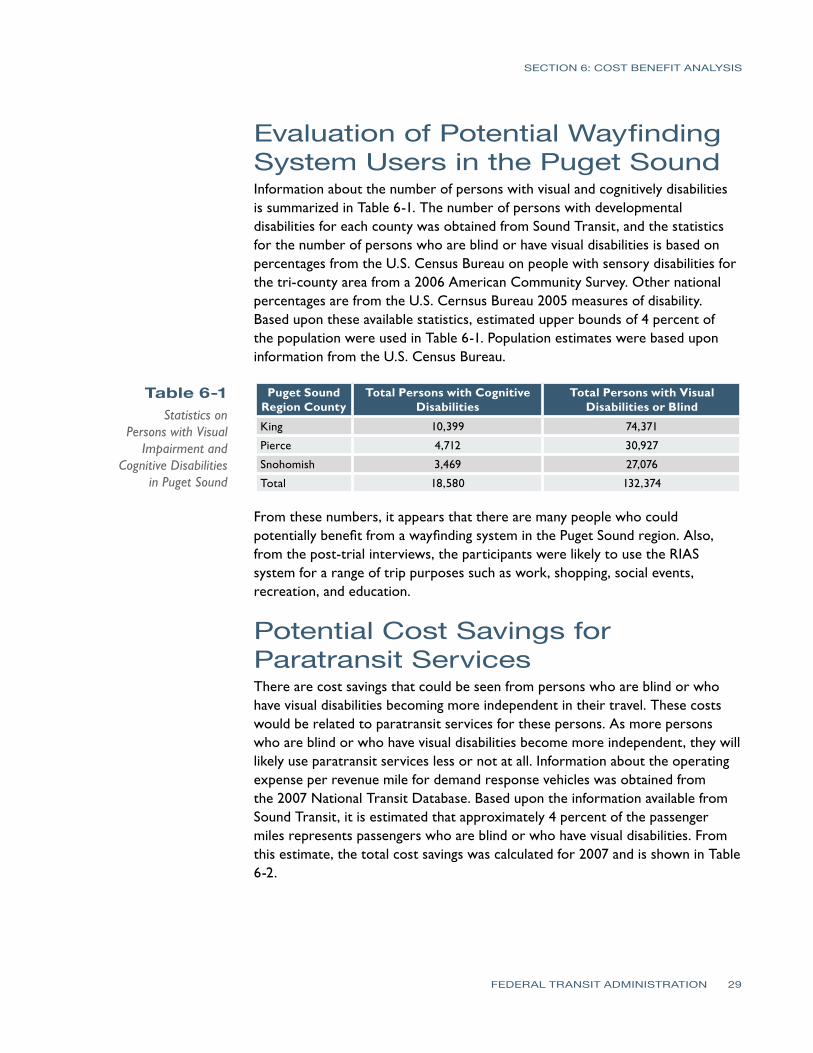
SECTION 6 COST BENEFIT ANALYSIS
Table 6-1 Statistics on
Persons with Visual Impairment and
Cognitive Disabilities in Puget Sound
Evaluation of Potential WayfindingSystem Users in the Puget Sound Information about the number of persons with visual and cognitively disabilities is summarized in Table 6-1 The number of persons with developmental disabilities for each county was obtained from Sound Transit and the statistics for the number of persons who are blind or have visual disabilities is based on percentages from the US Census Bureau on people with sensory disabilities for the tri-county area from a 2006 American Community Survey Other national percentages are from the US Cernsus Bureau 2005 measures of disability Based upon these available statistics estimated upper bounds of 4 percent of the population were used in Table 6-1 Population estimates were based upon information from the US Census Bureau
Puget Sound Region County
Total Persons with Cognitive Disabilities
Total Persons with Visual Disabilities or Blind
King 10399 74371
Pierce 4712 30927
Snohomish 3469 27076
Total 18580 132374
From these numbers it appears that there are many people who could potentially benefit from a wayfinding system in the Puget Sound region Also from the post-trial interviews the participants were likely to use the RIAS system for a range of trip purposes such as work shopping social events recreation and education
Potential Cost Savings for Paratransit Services There are cost savings that could be seen from persons who are blind or who have visual disabilities becoming more independent in their travel These costs would be related to paratransit services for these persons As more persons who are blind or who have visual disabilities become more independent they will likely use paratransit services less or not at all Information about the operating expense per revenue mile for demand response vehicles was obtained from the 2007 National Transit Database Based upon the information available from Sound Transit it is estimated that approximately 4 percent of the passenger miles represents passengers who are blind or who have visual disabilities From this estimate the total cost savings was calculated for 2007 and is shown in Table 6-2
FEDERAL TRANSIT ADMINISTRATION 29
SECTION 6 COST BENEFIT ANALYSIS
Table 6-2 Paratransit Costs
and Potential Savings (based on 2007 cost
data for demand response vehicle operating costs)
Table 6-3 Talking Signs System
History of Costs
Demand Response Transit Agency Cost per Passenger Mile 4 of Cost per
Passenger Mile Potential 2007 Cost Savings
King County Metro $424 $017 $1920000
Pierce Transit $455 $018 $630000
Community Transit $353 $014 $320000
Total $2870000
From this analysis there are significant potential annual savings in providing a wayfinding system for persons who are blind or who have visual disabilities which would decrease paratransit use and thereby reduce the operating costs for paratransit services
Wayfinding System Costs Costs for the different types of wayfinding systems available were obtained from each of the vendors One of the problems with the comparison of costs is that only material costs were obtained from Step-Hear and only installation costs for buildings were obtained from Talking Lights By far Talking Signs has the most cost information available for this analysis because it has been installed in more locations Because of this the analysis focuses on comparing material costs between Talking Signs and Step-Hear and building system costs between Talking Signs and Talking Lights
Talking Signs Costs Information about the costs for Talking Signs was obtained from previous installations as well as from the bid provided by Talking Signs Services Inc for the Sound Transit RIAS project Table 6-3 shows installation costs (in cost per transmitter) for some Talking Signs projects
Installation Location Number of Transmitters Cost per Transmitter
Sound Transit 370 $7005
TriMet 30 $2655
San Francisco Muni 30 $3200
Colorado Springs 10 $3760
Phoenix Public Transit 10 $4630
Port of San Francisco 30 $4635
Caltrain 40 $3000
It should be noted that installation costs for the Sound Transit RIAS project are much higher because the other installation costs did not include installation of the system infrastructure such as conduit cable etc In other words Talking Signs has typically installed the system in locations where all that is required is to install the transmitter and test and operate the system the other costs for conduit and system infrastructure were provided through separate contracts In
FEDERAL TRANSIT ADMINISTRATION 30
-
SECTION 6 COST BENEFIT ANALYSIS
Table 6-4 Talking Signs Material
Costs
addition the costs given above were the costs at the time of the installation The Sound Transit project is the most recent one given
Table 6-4 shows the material costs per transmitter and receiver There are two different types of transmitters provided so an average transmitter cost is given
Talking Signs Equipment Unit Cost
Average material cost per transmitter $1600
Material cost per receiver $265
Step-Hear Costs As mentioned only material costs were obtained from Step-Hear Additional cost information will be provided once the first project for this system is completed Below is a table which shows the cost per transmitter and per receiver for this system
Table 6-5 Step-Hear Material
Costs
Step Hear Equipment Unit Cost
Average material cost per transmitter $100
Material cost per receiver $22
Talking Lights Costs The cost to install Talking Lights was obtained only for indoor applications Depending on the type of facility and complexity the cost to install Talking Lights ranges from $050ndash2 per square foot A comparison of this cost with Talking Signs based upon the historical costs at the San Francisco Caltrain station is given in the next section
GPS-Based System Costs It is difficult to determine the actual cost for a GPS-based solution that could be used by the person with visual or cognitive disabilities for wayfinding There are several smartphone systems such as Loadstone GPS which runs on Nokia phones and interfaces to a GPS receiver Costs were calculated from some of the systems evaluated in this report and are included in Table 6-6 In addition to the costs for these systems some costs would be necessary to develop a database for Sound Transit specific points of interest and other points required for wayfinding as well as monthly costs for the phone service In downtown areas where it is difficult to gain connectivity with GPS signals from satellites additional WAAS or other fixed location signal sources may need to be installed to provide accurate locations
FEDERAL TRANSIT ADMINISTRATION 31
SECTION 6 COST BENEFIT ANALYSIS
Table 6-6 GPS-Based System
Costs
Table 6-7 Sound Transit
Wayfinding System Installation Cost
Comparison
System Type Unit Cost Avg Monthly Service Cost
Loadstone GPS (includes smartphone software GPS receiver screen reader)
$700 $60
Wayfinder Access (includes smartphone software GPS receiver screen reader)
$1200 $60
BrailleNote GPS V 3 (Includes maps receiver pouch cable 1 GB CF card)
$1599 NA
Trekker GPS System $1695 NA
Mobile Geo (includes smartphone software GPS receiver screen reader)
$1745 $60
Wayfinding SystemsCost Comparison Summary Talking Signs and Step-Hear Cost Comparison In comparing material costs shown between Talking Signs and Step-Hear it is clear that Step-Hear has a very large cost advantage from a material unit per unit basis Talking Sign transmitters are 18 times the cost of a similar Step-Hear transmitter and receiver costs are more than 10 times more expensive for material only Table 7-7 shows a comparison of the total RIAS Sound Transit installation costs based upon the complete bid from Talking Signs with equivalent costs for Step-Hear The cost shown for the Step-Hear system was calculated by substituting material costs for Step-Hear transmitters and receivers for the Talking Sign transmitter and receiver bid prices This comparison assumes that conduit and power cabling needs and installation costs for mounting the transmitters are the same
System Type Cost
Talking Signs System (actual installation cost in todayrsquos dollars) $2199765
Step-Hear System (estimated cost based upon Step-Hear material costs) $1665495
One major factor that is not considered in the above comparison is the number of Step-Hear transmitters that would be necessary to replicate the same system coverage for Talking Signs Information obtained from Step-Hear indicated the range for the transmitter was about 65 feet which is somewhat shorter than the maximum range for the Talking Signs transmitter of around 100 feet Also it does not seem the Step-Hear transmitter has similar capabilities in adjusting the strength of the signal Another problem with this comparison is the assumption that installation costs would be similar including testing training and maintenance The main result of this analysis is that it would appear that Step-Hear would have a cost advantage for installation on buses since transmitter coverage areas would be similar for both and it would take the same number of Talking Signs transmitters on a bus as it would for the Step-Hear system
FEDERAL TRANSIT ADMINISTRATION 32
SECTION 6 COST BENEFIT ANALYSIS
Table 6-8 Caltrain San Jose
Diridon Station Wayfinding System
Installation Cost Comparison
Table 6-9 Sound Transit
Wayfinding System Installation Cost
Comparison
Talking Signs and Talking Lights Cost Comparison For the Talking Lights system it is difficult to compare on a cost-to-cost basis with Talking Signs The method used for the purpose of this report was to consider the historical cost (converted to todayrsquos dollars) to install the Talking Signs system at the San Jose Diridon Caltrain station with a Talking Lights system cost for this station of $2 per square foot The area in square feet was calculated for the coverage area provided by Talking Signs at this station This included areas outside on train platforms as well as indoor areas This installation was only for mounting installation and testing of the RIAS system and did not include conduit and wiring costs which were completed under a separate contract Table 6-8 shows a simplified comparison of the costs between these systems using this method
System Type Cost
Talking Signs System (actual installation cost in todayrsquos dollars) $215000
Talking Lights System (est cost based on $2sf) $32000
Based upon this comparison there seems to be a large cost advantage for the Talking Lights system However this comparison does not consider the issues that could be encountered for the outside train platform areas of the San Jose Diridon Caltrain station if Talking Lights were used This does indicate that further investigation of the costs and effectiveness of the Talking Lights system for at least indoor transit facility areas should be completed
Talking Signs and GPS-Based System Cost Comparison In comparing the Talking Signs system to an outdoor GPS-based system there are a number of factors to consider Table 6-9 shows the actual cost for the RIAS system for Sound Transit compared with the estimated cost for implementing a region-wide database of points that are web-accessible The costs assume that receivers (GPS-based or Talking Signs receivers) will be purchased by the user Based upon the results of the participant interviews purchasing these receivers is a critical factor for determining whether persons will actually use the system
System Type Cost
Talking Signs System (actual installation cost in todayrsquos dollars) $2199765
GPS-based system (est cost to create point database interface and web access)
$150000
An integration of these technologies would seem to be more feasible As mentioned the costs above do not include the purchase of the individual GPS systems for each user which would likely be an issue for the user to purchase The cost to create this database is small since many of the bus routes for Sound Transit and King County Metro are already created using the Transit Trip Planner system Budget is already in place to update the database several
FEDERAL TRANSIT ADMINISTRATION 33
SECTION 6 COST BENEFIT ANALYSIS
times per year to make sure the bus route information is current The cost to create this database includes creating points for the entire regional transit system which would cover a larger area than the initial RIAS system at the six Sound Transit facilities It should be noted that the cost for the GPS system does not include review and testing of the system or a review from an OampM specialist From a per-person cost perspective for the entire regional transit system if the funding is to include purchasing a $700 personal GPS system and $250 for the RIAS receiver for each user the RIAS system has a cost advantage based upon the number of people in the Puget Sound area who have visual or cognitive disabilities However further comparison of costs of this system should be considered as GPS systems advance and costs for these systems continue to decrease
Wayfinding SystemsImplementation Risks Since RIAS technology has already been demonstrated in the Puget Sound area and in many other locations risks in proceeding with further system implementation are minimal There have also been many studies that have shown the system to be very successful and it has been tested more extensively by transit users who are blind or who have visual disabilities than any other system
There are several risks associated with installing a different system other than Talking Signs The main risks are
bullAnother custom device would be needed by the user
bullOther technologies do not have transit system studies completed using persons who are blind or have visual disabilities
bull Newer technology may not last long term
There are problems created when a user is required to have two different receivers to have the ability to travel independently For instance if a different technology other than RIAS is used for installation on the remaining Sound Transit facilities this would create the need for travelers who are blind or have visual disabilities to carry two different receivers and have the knowledge about which receiver to use at each facility This would make it more difficult for the user to travel effectively and could increase the cost if two receivers are needed to be purchased This would be simplified if one receiverunit was used indoors and a GPS-based unit was used outdoors By adding a cardmodule to the GPS-based unit to pick up either IR or RF signals from the item identifying transmitter these two units would have the potential to be integrated into one future unit
The Talking Signs RIAS technology is still the only technology that has been proven beneficial for use by persons who are blind or have visual disabilities in
FEDERAL TRANSIT ADMINISTRATION 34
SECTION 6 COST BENEFIT ANALYSIS
a transit environment There have been many studies and tests of the system on many transit systems All of these studies and tests including this most recent test with Sound Transit have been successful and have shown great benefits to the user Talking Lights has only been tested and used in an indoor hospital environment and has not been tested for use by persons who are blind although those who have had brain or eye surgery would have navigation needs similar to those who are blind or have visual disabilities impairments The Step-Hear system has only been completed on one bus system installation and the effectiveness of this system when compared to Talking Signs has yet to be determined
In addition both Talking Lights and Step-Hear are new technologies that have not been on the market very long The probability of these systems surviving in the market long term is less than for Talking Signs which has been in the market for many years There would naturally be increased risk in supporting technologies that are new and not proven
One issue in using Talking Signs and Step-Hear systems is that they are based upon item identification which has less focus on step-by-step guidance In other words a person could become lost or find it necessary to backtrack if the item was not identified and the person continued past the transmitter Also the transmitters are somewhat limited in placement because of mounting issues in the field which may not always be the best for guiding a visual impairments or disabilities traveler One issue noted during the installation and tests with the Sound Transit RIAS system was the ability for signals to reflect off of other objects particularly metallic objects This can sometimes create a message that gives the traveler incorrect information about which direction to go Reflection of RF signals from Step-Hear could also occur as well as issues associate with interference from other RF sources
GPS-based GPS-based systems are a good solution to provide directional information outdoors These systems are the trend for wayfinding technology so future integration and implementation of more advanced wayfinding systems would likely be easier when compared to the other wayfinding systems evaluated Because of this there is less risk in implementing GPS-based technology that is proven to be effective in guiding persons with visual impairments or disabilities There are many existing systems now that use GPS for the persons with visual impairments or disabilities and all that is necessary is to continue building a database of transit points of interest for travel path calculation purposes Satellite signals are sometimes blocked in areas such as around large high-rise buildings however applications are being developed that use last-known-positioning to calculate position within these types of dead zones Building footprints are also being placed into GPS databases in an effort to guide persons around the city areas In addition the iPhone offers assisted GPS through the use of Wi-Fi
FEDERAL TRANSIT ADMINISTRATION 35
SECTION 6 COST BENEFIT ANALYSIS
positioning which could also be used in urban areas for guidance One concern with the GPS-based systems as with other new technologies is the time it takes for people to become comfortable using the technology yet already there are persons with visual impairments or disabilities or who are blind using these systems for navigation
RIAS Installation Evaluation for Remainder of Sound Transit Facilities Another purpose of this project was to evaluate the cost implications for completing installation of the RIAS system on the remaining Sound Transit facilities and future facilities and on vehiclesbuses The following are the remaining facilities at Sound Transit that do not have a RIAS system installed
bull Edmonds Station
bull Mukilteo Station
bull Tukwila Station
bull Auburn Station
bull Sumner Station
bull Puyallup Station
bull Ash Way Park amp Rid
bullOverlake Transit Center
bull South Tacoma (open for bus opened for commuter rail in 2010)
bullLakewood Station (open for bus opened for commuter rail in 2010)
bull Lynwood Transit Center
bull Light Rail System (existing Tacoma line and new line opened for airport in 2009)
The Sound Transit RIAS project cost was $22 million to install at 6 facilities including some crosswalks and bus stops Operations and maintenance of the system and system support has already been budgeted within the Mobility Initiative Program and is not considered in the costs provided here Table 6-10 shows the budgetary costs per facility including buses commuter rail and light rail trains to install the RIAS system at the remainder of the Sound Transit facilities
FEDERAL TRANSIT ADMINISTRATION 36
SECTION 6 COST BENEFIT ANALYSIS
Table 6-10 Sound Transit RIAS
Costs for Remaining Facilities and Vehicles
Sound Transit Facilities Including Buses and Trains Cost
Edmonds Station (for future Edmonds Crossing) $375000
Mukilteo Station $430000
Tukwila Station $520000
Auburn Station $415000
Sumner Station $290000
Puyallup Station $375000
South Tacoma $250000
Overlake Transit Center $270000
Lakewood Station $600000
Lynnwood Transit Center $645000
Ash Way Park amp Ride $290000
Commuter Rail Vehicles (assumes 69 vehicles) $175000
Light Rail System (all lines installedplanned through 2009 19 stations) $2750000
Light Rail Vehicles (assumes 38 vehicles) $95000
Buses (assumes 239 vehicles) $600000
Total Estimated $8080000
RIAS Installation Evaluation at Other Regional PublicTransportation Facilities One of the purposes of this project was to evaluate the cost implications for regional transit facilities that could participate in implementation of a RIAS system All costs contained herein are for budgeting purposes only The following are the other regional transit agencies that should be considered for this system These are the other major transportation agencies that provide public transportation to the Puget Sound area
bull Community Transit
bull King County Metro
bull Pierce Transit
bull SeaTac Airport
The costs were based upon the bids received from Talking Signs for the subject project Average costs for facilities in which RIAS was installed were used in calculating the costs for each agency Costs for bus stop installation were estimated to be $4000 per bus stop since solar panels will likely need to be installed at each of these locations for power to operate the audible signs Table 6-11 shows a breakdown of costs by transit agency which includes material installation and testing costs
FEDERAL TRANSIT ADMINISTRATION 37
SECTION 6 COST BENEFIT ANALYSIS
Table 6-11 Estimated RIAS Costs for Regional Facilities
Other Regional Facility RIAS Costs Including Buses and Bus Stops Cost
Community Transit Buses (assumes 290 vehicles) $870000
King County Metro Buses (assumes 966 vehicles) $2900000
Pierce Transit Buses (assumes 158 vehicles) $475000
Bus Stops (assumes 16930 bus stops) $67720000
Other transit facilities (park-and-ride etc) $3500000
SeaTac Airport (main concourse only) $350000
Total $75815000
The level of interest found from the agencies contacted was low The only transit agency that was interested in installing a RIAS system was Everett Transit a small local transit system The main reason for the lack of interest seems to be a combination of both the cost benefit of the system and current budget issues because of recent economic downturns Another factor is that all three of these transit systems are currently involved in the replacement of Computer Aided DispatchAutomatic Vehicle Location (CADAVL) and Radio systems which are very large investments that also occupy the agency staffs during the installations and immediately after during the preliminary operation period
The RIAS technology was also introduced to the other regional transit agencies who were asked about their ability to fund the implementation of this technology Based upon the cost information and the regional agenciesrsquo level of interest and ability to fund the RIAS system the feasibility of regional implementation is low at this time It is likely more funds will be available in the near future as more government funding becomes available however the cost benefit will be a factor for these transit agencies in determining implementation as well
Results of the Analysis This trend is expected to continue and grow over the years Both GPS-based solutions and Talking Lights appear to be following this trend for their systems while Talking Signs and Step-Hear are more focused on item identification rather than locating the traveler and providing directions based upon the travelerrsquos location Regardless of which wayfinding system is used there appears to be some cost savings in operation of an agencyrsquos paratransit system
There are many benefits that travelers who are blind or who have visual or cognitive disabilities will experience in using a wayfinding system integrated into a public transportation environment The Talking Signs or RIAS system has been shown to be a system that provides many of these benefits Based upon the analysis completed however there are two main drawbacks in implementing the Talking Signs system The first is that it appears to be more costly when compared with other wayfinding system costs obtained This may change as more installations begin to occur however another way for this to change is for competition to drive market prices The second is that the current development
FEDERAL TRANSIT ADMINISTRATION 38
SECTION 6 COST BENEFIT ANALYSIS
trend for wayfinding systems is not in developing systems for item identification which is the focus of a Talking Signs system This current trend is towards systems that determine the position of the traveler and then access pre-defined locations in a database to calculate step-by-step paths
At this time there is not another system on the market that is at the same proven level of effectiveness for persons who are blind or who have visual impairments or disabilities as Talking Signs although with further evaluation of the Talking Lights and Step-Hear systems along with GPS-based solutions these other solutions could be brought into the picture There is enough information obtained from this analysis to justify the consideration of using other systems at least integrated with Talking Signs from both a cost and current technology trend perspective
GPS-based systems have been tested in the past in downtown areas with ineffective outcomes alongside Talking Signs because of the systemrsquos early dependence on satellites only Current GPS technologies are more accurate in these same areas and deserve structured tests to gain a better idea of the possibilities of the integration of these technologies
From this analysis it appears that the best least-cost option for a wayfinding solution outdoors would be to use a GPS-based solution integrated with a database containing transit points of interest that can be accessed either remotely or stored locally on a smartphone or other receiver combined with a Talking Lights system for indoor navigation One of the keys to this solution is that it would be of benefit to every traveler including those with visual and cognitive disabilities
Funding for this type of system could potentially be greater since it would directly benefit all riders and could increase overall ridership For indoor applications Talking Signs Talking Lights and Step-Hear are good solutions with Talking Lights and Step-Hear appearing to have the cost advantage over Talking Signs For bus applications either Talking Signs or Step-Hear would be good solutions with Step-Hear having the cost advantage Overall more cost information and analysis of GPS-based Talking Lights and Step-Hear systems is necessary to determine which system has the clear cost and performance advantage and provides an effective system that helps minimize future implementation risks A considerable amount of funding will be necessary to build out the RIAS system and steps should be taken to ensure that a cost-effective system that will provide a good long-term solution is implemented These steps would include further evaluation and comparison of other technologies through analysis of system costs and performance
FEDERAL TRANSIT ADMINISTRATION 39
SECTION
7SECTION
7 Recommendations
The following are the recommendations for Sound Transit regarding expanding the RIAS system further The main goal for these recommendations is to provide Sound Transit with the next steps that should be taken to implement a fully-functioning wayfinding system throughout its transit network Another goal of these recommendations is to preserve the investment Sound Transit has made in hardware as well as Sound Transit staff and consultant time
bull Begin the next phase of the RIAS MAP to continue build-out of the system and to further evaluate the RIAS system
bull Include funding for evaluation of the RIAS system along with other wayfinding systems
bull Invite other wayfinding systems that are available for people with visual or cognitive disabilities to participate in system demonstrations and in providing bids for implementation of their system for Sound Transit
bull Further evaluate Step-Hear and Talking Lights existing installations as well as other similar systems that are installed at the time of the evaluation Conduct additional research on these systems
bull Further evaluate the effectiveness and costs in using a GPS-based solution for outdoor navigation in combination with Talking Signs Talking Lights or Step-Hear for indoor and bus applications
bull Use the efforts King County Metro has made to create a data extraction process for its schedule and bus stop locations using Google Transit or the regional Trip Planner system
bull Consider use of the Google Time Table Publisher open interface and database for the Google Transit Planner
bull Further determine overall public interest in using a wayfinding system to assist in determining potential funds for expanding the system
bull Expand the wayfinding system once evaluations are complete and funding is in place
FEDERAL TRANSIT ADMINISTRATION 40
References
REFERENCES
Bentzen B L Crandall W and Myers L 1997 ldquoUse of Remote Infrared Signage in a Complex Transit Station by Persons with Developmental Delays or Dyslexiardquo Journal of Visual Impairment and Blindness 91 407ndash410
Bentzen B and Mitchell P 1995 ldquoAudible Signage as a Wayfinding Aid Comparison of Verbal Landmarks and Talking Signsrdquo Journal of Visual Impairment and Blindness
Brabyn J A and Brabyn L A 1982 ldquoSpeech intelligibility of the Talking Signsrdquo Journal of Visual Impairment and Blindness 76 77ndash-78
Brabyn J A and Brabyn L A ldquoAn Evaluation of lsquoTalking Signsrsquo for the Blindrdquo Human Factors 25(1) 49ndash53
Crandall W Bentzen B Myers L and Steed D 1995 ldquoTalking Signs Remote Infrared Signage A Guide for Transit System Managersrdquo Project ACTION of the National Easter Seal Society
Crandall W Bentzen B Myers L and Mitchell P 1995 ldquoTalking Signs Remote Infrared Signage A Guide for Transit System Managersrdquo Project ACTION of the National Easter Seal Society
Crandall W Bentzen B L Myers L and Mitchell P 1995 ldquoTransit Accessibility Improvement through Talking Signsreg Remote Infrared Signage A Demonstration and Evaluationrdquo Federal Transit Administration and Project ACTION of the National Easter Seal Society
Crandall W Bentzen B Rosen S and Mitchell P 1994 ldquoInfrared Remote Signage for the Blind and Print Handicapped An Orientation and Mobility Studyrdquo Final Report National Easter Seal Research Program
Hidalgo amp De Vries 2009 ldquoFederal Transit Administration Remote Infrared Audible Signage (RIAS) Model Accessibility Program (MAP) Human Factors Testing amp Evaluation Final Reportrdquo Federal Transit Administration Report Number FTA-MI-26-7909
Loomis J M Golledge R G Klatzky R L and Marston J R 2007 ldquoAssisting Wayfinding in Visually Impaired Travelersrdquo In G L Allen (Ed) Applied Spatial Cognition From Research to Cognitive Technology Mahwah NJ Lawrence Erlbaum Associates
Marston J R 2002 ldquoTowards And Accessible City Empirical Measurement and Modeling of Access to Urban Opportunities for Those with Vision Impairments Using Remote Infrared Audible Signagerdquo Doctoral dissertation University of California Santa Barbara
Marston J R and Golledge R G 2000 ldquoTowards an Accessible City Removing Functional Barriers to Independent Travel for Blind and Vision-Impaired A Case for Auditory Signsrdquo Final Report UCTC 65V430 University of California Berkley University of California Transportation Center
National Transit Database 2007 Transit Agency Profiles httpwwwntdprogramgovntdprogrampubsprofiles2007agency_ profiles
Step-Hear 2008 Request for Information e-mail communication
Talking Lights 2008 Request for Information e-mail and phone communication
Talking_Lights_LLC 2009 Talking Lights httpwwwtalking-lightscom
Talking_Signs_Inc (2009) Talking Signs httpwwwtalkingsignscom
United States Census Bureau 2006 American Community Survey httpfactfindercensusgov
United States Census bureau 2008 Population Estimates by County httpwwwcensusgovpopestcounties
FEDERAL TRANSIT ADMINISTRATION 41
APPENDIX Diagram of Typical Installation
FEDERAL TRANSIT ADMINISTRATION 42
FEDERAL TRANSIT ADMINISTRATION 128
US Department of TransportationFederal Transit AdministrationEast Building1200 New Jersey Avenue SEWashington DC 20590httpwwwftadotgovresearch
US Department of Transportation Federal Transit Administration East Building 1200 New Jersey Avenue SE Washington DC 20590 httpwwwftadotgovresearch
- Button1
- Button2
- Button3
- Button4
- Button5
- Button6
- Button7
- Button8
- Button9
- Button10
- Button13
- Button14
- Button15
- Button16
- Button17
- Button18
- Button19
- Button20
- Button21
- Button22
- Button23
- Button24
- Button25
- Button26
- Button27
- Button28
- Button29
- Button30
- Button31
- Button32
- Button33
- Button34
- Button35
- Button36
- Button37
- Button38
- Button39
- Button40
- Button41
- Button42
- Button43
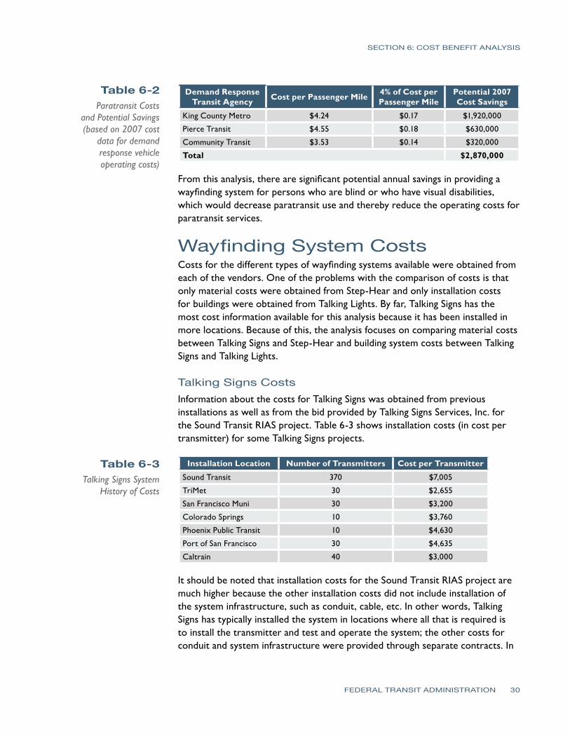
SECTION 6 COST BENEFIT ANALYSIS
Table 6-2 Paratransit Costs
and Potential Savings (based on 2007 cost
data for demand response vehicle operating costs)
Table 6-3 Talking Signs System
History of Costs
Demand Response Transit Agency Cost per Passenger Mile 4 of Cost per
Passenger Mile Potential 2007 Cost Savings
King County Metro $424 $017 $1920000
Pierce Transit $455 $018 $630000
Community Transit $353 $014 $320000
Total $2870000
From this analysis there are significant potential annual savings in providing a wayfinding system for persons who are blind or who have visual disabilities which would decrease paratransit use and thereby reduce the operating costs for paratransit services
Wayfinding System Costs Costs for the different types of wayfinding systems available were obtained from each of the vendors One of the problems with the comparison of costs is that only material costs were obtained from Step-Hear and only installation costs for buildings were obtained from Talking Lights By far Talking Signs has the most cost information available for this analysis because it has been installed in more locations Because of this the analysis focuses on comparing material costs between Talking Signs and Step-Hear and building system costs between Talking Signs and Talking Lights
Talking Signs Costs Information about the costs for Talking Signs was obtained from previous installations as well as from the bid provided by Talking Signs Services Inc for the Sound Transit RIAS project Table 6-3 shows installation costs (in cost per transmitter) for some Talking Signs projects
Installation Location Number of Transmitters Cost per Transmitter
Sound Transit 370 $7005
TriMet 30 $2655
San Francisco Muni 30 $3200
Colorado Springs 10 $3760
Phoenix Public Transit 10 $4630
Port of San Francisco 30 $4635
Caltrain 40 $3000
It should be noted that installation costs for the Sound Transit RIAS project are much higher because the other installation costs did not include installation of the system infrastructure such as conduit cable etc In other words Talking Signs has typically installed the system in locations where all that is required is to install the transmitter and test and operate the system the other costs for conduit and system infrastructure were provided through separate contracts In
FEDERAL TRANSIT ADMINISTRATION 30
-
SECTION 6 COST BENEFIT ANALYSIS
Table 6-4 Talking Signs Material
Costs
addition the costs given above were the costs at the time of the installation The Sound Transit project is the most recent one given
Table 6-4 shows the material costs per transmitter and receiver There are two different types of transmitters provided so an average transmitter cost is given
Talking Signs Equipment Unit Cost
Average material cost per transmitter $1600
Material cost per receiver $265
Step-Hear Costs As mentioned only material costs were obtained from Step-Hear Additional cost information will be provided once the first project for this system is completed Below is a table which shows the cost per transmitter and per receiver for this system
Table 6-5 Step-Hear Material
Costs
Step Hear Equipment Unit Cost
Average material cost per transmitter $100
Material cost per receiver $22
Talking Lights Costs The cost to install Talking Lights was obtained only for indoor applications Depending on the type of facility and complexity the cost to install Talking Lights ranges from $050ndash2 per square foot A comparison of this cost with Talking Signs based upon the historical costs at the San Francisco Caltrain station is given in the next section
GPS-Based System Costs It is difficult to determine the actual cost for a GPS-based solution that could be used by the person with visual or cognitive disabilities for wayfinding There are several smartphone systems such as Loadstone GPS which runs on Nokia phones and interfaces to a GPS receiver Costs were calculated from some of the systems evaluated in this report and are included in Table 6-6 In addition to the costs for these systems some costs would be necessary to develop a database for Sound Transit specific points of interest and other points required for wayfinding as well as monthly costs for the phone service In downtown areas where it is difficult to gain connectivity with GPS signals from satellites additional WAAS or other fixed location signal sources may need to be installed to provide accurate locations
FEDERAL TRANSIT ADMINISTRATION 31
SECTION 6 COST BENEFIT ANALYSIS
Table 6-6 GPS-Based System
Costs
Table 6-7 Sound Transit
Wayfinding System Installation Cost
Comparison
System Type Unit Cost Avg Monthly Service Cost
Loadstone GPS (includes smartphone software GPS receiver screen reader)
$700 $60
Wayfinder Access (includes smartphone software GPS receiver screen reader)
$1200 $60
BrailleNote GPS V 3 (Includes maps receiver pouch cable 1 GB CF card)
$1599 NA
Trekker GPS System $1695 NA
Mobile Geo (includes smartphone software GPS receiver screen reader)
$1745 $60
Wayfinding SystemsCost Comparison Summary Talking Signs and Step-Hear Cost Comparison In comparing material costs shown between Talking Signs and Step-Hear it is clear that Step-Hear has a very large cost advantage from a material unit per unit basis Talking Sign transmitters are 18 times the cost of a similar Step-Hear transmitter and receiver costs are more than 10 times more expensive for material only Table 7-7 shows a comparison of the total RIAS Sound Transit installation costs based upon the complete bid from Talking Signs with equivalent costs for Step-Hear The cost shown for the Step-Hear system was calculated by substituting material costs for Step-Hear transmitters and receivers for the Talking Sign transmitter and receiver bid prices This comparison assumes that conduit and power cabling needs and installation costs for mounting the transmitters are the same
System Type Cost
Talking Signs System (actual installation cost in todayrsquos dollars) $2199765
Step-Hear System (estimated cost based upon Step-Hear material costs) $1665495
One major factor that is not considered in the above comparison is the number of Step-Hear transmitters that would be necessary to replicate the same system coverage for Talking Signs Information obtained from Step-Hear indicated the range for the transmitter was about 65 feet which is somewhat shorter than the maximum range for the Talking Signs transmitter of around 100 feet Also it does not seem the Step-Hear transmitter has similar capabilities in adjusting the strength of the signal Another problem with this comparison is the assumption that installation costs would be similar including testing training and maintenance The main result of this analysis is that it would appear that Step-Hear would have a cost advantage for installation on buses since transmitter coverage areas would be similar for both and it would take the same number of Talking Signs transmitters on a bus as it would for the Step-Hear system
FEDERAL TRANSIT ADMINISTRATION 32
SECTION 6 COST BENEFIT ANALYSIS
Table 6-8 Caltrain San Jose
Diridon Station Wayfinding System
Installation Cost Comparison
Table 6-9 Sound Transit
Wayfinding System Installation Cost
Comparison
Talking Signs and Talking Lights Cost Comparison For the Talking Lights system it is difficult to compare on a cost-to-cost basis with Talking Signs The method used for the purpose of this report was to consider the historical cost (converted to todayrsquos dollars) to install the Talking Signs system at the San Jose Diridon Caltrain station with a Talking Lights system cost for this station of $2 per square foot The area in square feet was calculated for the coverage area provided by Talking Signs at this station This included areas outside on train platforms as well as indoor areas This installation was only for mounting installation and testing of the RIAS system and did not include conduit and wiring costs which were completed under a separate contract Table 6-8 shows a simplified comparison of the costs between these systems using this method
System Type Cost
Talking Signs System (actual installation cost in todayrsquos dollars) $215000
Talking Lights System (est cost based on $2sf) $32000
Based upon this comparison there seems to be a large cost advantage for the Talking Lights system However this comparison does not consider the issues that could be encountered for the outside train platform areas of the San Jose Diridon Caltrain station if Talking Lights were used This does indicate that further investigation of the costs and effectiveness of the Talking Lights system for at least indoor transit facility areas should be completed
Talking Signs and GPS-Based System Cost Comparison In comparing the Talking Signs system to an outdoor GPS-based system there are a number of factors to consider Table 6-9 shows the actual cost for the RIAS system for Sound Transit compared with the estimated cost for implementing a region-wide database of points that are web-accessible The costs assume that receivers (GPS-based or Talking Signs receivers) will be purchased by the user Based upon the results of the participant interviews purchasing these receivers is a critical factor for determining whether persons will actually use the system
System Type Cost
Talking Signs System (actual installation cost in todayrsquos dollars) $2199765
GPS-based system (est cost to create point database interface and web access)
$150000
An integration of these technologies would seem to be more feasible As mentioned the costs above do not include the purchase of the individual GPS systems for each user which would likely be an issue for the user to purchase The cost to create this database is small since many of the bus routes for Sound Transit and King County Metro are already created using the Transit Trip Planner system Budget is already in place to update the database several
FEDERAL TRANSIT ADMINISTRATION 33
SECTION 6 COST BENEFIT ANALYSIS
times per year to make sure the bus route information is current The cost to create this database includes creating points for the entire regional transit system which would cover a larger area than the initial RIAS system at the six Sound Transit facilities It should be noted that the cost for the GPS system does not include review and testing of the system or a review from an OampM specialist From a per-person cost perspective for the entire regional transit system if the funding is to include purchasing a $700 personal GPS system and $250 for the RIAS receiver for each user the RIAS system has a cost advantage based upon the number of people in the Puget Sound area who have visual or cognitive disabilities However further comparison of costs of this system should be considered as GPS systems advance and costs for these systems continue to decrease
Wayfinding SystemsImplementation Risks Since RIAS technology has already been demonstrated in the Puget Sound area and in many other locations risks in proceeding with further system implementation are minimal There have also been many studies that have shown the system to be very successful and it has been tested more extensively by transit users who are blind or who have visual disabilities than any other system
There are several risks associated with installing a different system other than Talking Signs The main risks are
bullAnother custom device would be needed by the user
bullOther technologies do not have transit system studies completed using persons who are blind or have visual disabilities
bull Newer technology may not last long term
There are problems created when a user is required to have two different receivers to have the ability to travel independently For instance if a different technology other than RIAS is used for installation on the remaining Sound Transit facilities this would create the need for travelers who are blind or have visual disabilities to carry two different receivers and have the knowledge about which receiver to use at each facility This would make it more difficult for the user to travel effectively and could increase the cost if two receivers are needed to be purchased This would be simplified if one receiverunit was used indoors and a GPS-based unit was used outdoors By adding a cardmodule to the GPS-based unit to pick up either IR or RF signals from the item identifying transmitter these two units would have the potential to be integrated into one future unit
The Talking Signs RIAS technology is still the only technology that has been proven beneficial for use by persons who are blind or have visual disabilities in
FEDERAL TRANSIT ADMINISTRATION 34
SECTION 6 COST BENEFIT ANALYSIS
a transit environment There have been many studies and tests of the system on many transit systems All of these studies and tests including this most recent test with Sound Transit have been successful and have shown great benefits to the user Talking Lights has only been tested and used in an indoor hospital environment and has not been tested for use by persons who are blind although those who have had brain or eye surgery would have navigation needs similar to those who are blind or have visual disabilities impairments The Step-Hear system has only been completed on one bus system installation and the effectiveness of this system when compared to Talking Signs has yet to be determined
In addition both Talking Lights and Step-Hear are new technologies that have not been on the market very long The probability of these systems surviving in the market long term is less than for Talking Signs which has been in the market for many years There would naturally be increased risk in supporting technologies that are new and not proven
One issue in using Talking Signs and Step-Hear systems is that they are based upon item identification which has less focus on step-by-step guidance In other words a person could become lost or find it necessary to backtrack if the item was not identified and the person continued past the transmitter Also the transmitters are somewhat limited in placement because of mounting issues in the field which may not always be the best for guiding a visual impairments or disabilities traveler One issue noted during the installation and tests with the Sound Transit RIAS system was the ability for signals to reflect off of other objects particularly metallic objects This can sometimes create a message that gives the traveler incorrect information about which direction to go Reflection of RF signals from Step-Hear could also occur as well as issues associate with interference from other RF sources
GPS-based GPS-based systems are a good solution to provide directional information outdoors These systems are the trend for wayfinding technology so future integration and implementation of more advanced wayfinding systems would likely be easier when compared to the other wayfinding systems evaluated Because of this there is less risk in implementing GPS-based technology that is proven to be effective in guiding persons with visual impairments or disabilities There are many existing systems now that use GPS for the persons with visual impairments or disabilities and all that is necessary is to continue building a database of transit points of interest for travel path calculation purposes Satellite signals are sometimes blocked in areas such as around large high-rise buildings however applications are being developed that use last-known-positioning to calculate position within these types of dead zones Building footprints are also being placed into GPS databases in an effort to guide persons around the city areas In addition the iPhone offers assisted GPS through the use of Wi-Fi
FEDERAL TRANSIT ADMINISTRATION 35
SECTION 6 COST BENEFIT ANALYSIS
positioning which could also be used in urban areas for guidance One concern with the GPS-based systems as with other new technologies is the time it takes for people to become comfortable using the technology yet already there are persons with visual impairments or disabilities or who are blind using these systems for navigation
RIAS Installation Evaluation for Remainder of Sound Transit Facilities Another purpose of this project was to evaluate the cost implications for completing installation of the RIAS system on the remaining Sound Transit facilities and future facilities and on vehiclesbuses The following are the remaining facilities at Sound Transit that do not have a RIAS system installed
bull Edmonds Station
bull Mukilteo Station
bull Tukwila Station
bull Auburn Station
bull Sumner Station
bull Puyallup Station
bull Ash Way Park amp Rid
bullOverlake Transit Center
bull South Tacoma (open for bus opened for commuter rail in 2010)
bullLakewood Station (open for bus opened for commuter rail in 2010)
bull Lynwood Transit Center
bull Light Rail System (existing Tacoma line and new line opened for airport in 2009)
The Sound Transit RIAS project cost was $22 million to install at 6 facilities including some crosswalks and bus stops Operations and maintenance of the system and system support has already been budgeted within the Mobility Initiative Program and is not considered in the costs provided here Table 6-10 shows the budgetary costs per facility including buses commuter rail and light rail trains to install the RIAS system at the remainder of the Sound Transit facilities
FEDERAL TRANSIT ADMINISTRATION 36
SECTION 6 COST BENEFIT ANALYSIS
Table 6-10 Sound Transit RIAS
Costs for Remaining Facilities and Vehicles
Sound Transit Facilities Including Buses and Trains Cost
Edmonds Station (for future Edmonds Crossing) $375000
Mukilteo Station $430000
Tukwila Station $520000
Auburn Station $415000
Sumner Station $290000
Puyallup Station $375000
South Tacoma $250000
Overlake Transit Center $270000
Lakewood Station $600000
Lynnwood Transit Center $645000
Ash Way Park amp Ride $290000
Commuter Rail Vehicles (assumes 69 vehicles) $175000
Light Rail System (all lines installedplanned through 2009 19 stations) $2750000
Light Rail Vehicles (assumes 38 vehicles) $95000
Buses (assumes 239 vehicles) $600000
Total Estimated $8080000
RIAS Installation Evaluation at Other Regional PublicTransportation Facilities One of the purposes of this project was to evaluate the cost implications for regional transit facilities that could participate in implementation of a RIAS system All costs contained herein are for budgeting purposes only The following are the other regional transit agencies that should be considered for this system These are the other major transportation agencies that provide public transportation to the Puget Sound area
bull Community Transit
bull King County Metro
bull Pierce Transit
bull SeaTac Airport
The costs were based upon the bids received from Talking Signs for the subject project Average costs for facilities in which RIAS was installed were used in calculating the costs for each agency Costs for bus stop installation were estimated to be $4000 per bus stop since solar panels will likely need to be installed at each of these locations for power to operate the audible signs Table 6-11 shows a breakdown of costs by transit agency which includes material installation and testing costs
FEDERAL TRANSIT ADMINISTRATION 37
SECTION 6 COST BENEFIT ANALYSIS
Table 6-11 Estimated RIAS Costs for Regional Facilities
Other Regional Facility RIAS Costs Including Buses and Bus Stops Cost
Community Transit Buses (assumes 290 vehicles) $870000
King County Metro Buses (assumes 966 vehicles) $2900000
Pierce Transit Buses (assumes 158 vehicles) $475000
Bus Stops (assumes 16930 bus stops) $67720000
Other transit facilities (park-and-ride etc) $3500000
SeaTac Airport (main concourse only) $350000
Total $75815000
The level of interest found from the agencies contacted was low The only transit agency that was interested in installing a RIAS system was Everett Transit a small local transit system The main reason for the lack of interest seems to be a combination of both the cost benefit of the system and current budget issues because of recent economic downturns Another factor is that all three of these transit systems are currently involved in the replacement of Computer Aided DispatchAutomatic Vehicle Location (CADAVL) and Radio systems which are very large investments that also occupy the agency staffs during the installations and immediately after during the preliminary operation period
The RIAS technology was also introduced to the other regional transit agencies who were asked about their ability to fund the implementation of this technology Based upon the cost information and the regional agenciesrsquo level of interest and ability to fund the RIAS system the feasibility of regional implementation is low at this time It is likely more funds will be available in the near future as more government funding becomes available however the cost benefit will be a factor for these transit agencies in determining implementation as well
Results of the Analysis This trend is expected to continue and grow over the years Both GPS-based solutions and Talking Lights appear to be following this trend for their systems while Talking Signs and Step-Hear are more focused on item identification rather than locating the traveler and providing directions based upon the travelerrsquos location Regardless of which wayfinding system is used there appears to be some cost savings in operation of an agencyrsquos paratransit system
There are many benefits that travelers who are blind or who have visual or cognitive disabilities will experience in using a wayfinding system integrated into a public transportation environment The Talking Signs or RIAS system has been shown to be a system that provides many of these benefits Based upon the analysis completed however there are two main drawbacks in implementing the Talking Signs system The first is that it appears to be more costly when compared with other wayfinding system costs obtained This may change as more installations begin to occur however another way for this to change is for competition to drive market prices The second is that the current development
FEDERAL TRANSIT ADMINISTRATION 38
SECTION 6 COST BENEFIT ANALYSIS
trend for wayfinding systems is not in developing systems for item identification which is the focus of a Talking Signs system This current trend is towards systems that determine the position of the traveler and then access pre-defined locations in a database to calculate step-by-step paths
At this time there is not another system on the market that is at the same proven level of effectiveness for persons who are blind or who have visual impairments or disabilities as Talking Signs although with further evaluation of the Talking Lights and Step-Hear systems along with GPS-based solutions these other solutions could be brought into the picture There is enough information obtained from this analysis to justify the consideration of using other systems at least integrated with Talking Signs from both a cost and current technology trend perspective
GPS-based systems have been tested in the past in downtown areas with ineffective outcomes alongside Talking Signs because of the systemrsquos early dependence on satellites only Current GPS technologies are more accurate in these same areas and deserve structured tests to gain a better idea of the possibilities of the integration of these technologies
From this analysis it appears that the best least-cost option for a wayfinding solution outdoors would be to use a GPS-based solution integrated with a database containing transit points of interest that can be accessed either remotely or stored locally on a smartphone or other receiver combined with a Talking Lights system for indoor navigation One of the keys to this solution is that it would be of benefit to every traveler including those with visual and cognitive disabilities
Funding for this type of system could potentially be greater since it would directly benefit all riders and could increase overall ridership For indoor applications Talking Signs Talking Lights and Step-Hear are good solutions with Talking Lights and Step-Hear appearing to have the cost advantage over Talking Signs For bus applications either Talking Signs or Step-Hear would be good solutions with Step-Hear having the cost advantage Overall more cost information and analysis of GPS-based Talking Lights and Step-Hear systems is necessary to determine which system has the clear cost and performance advantage and provides an effective system that helps minimize future implementation risks A considerable amount of funding will be necessary to build out the RIAS system and steps should be taken to ensure that a cost-effective system that will provide a good long-term solution is implemented These steps would include further evaluation and comparison of other technologies through analysis of system costs and performance
FEDERAL TRANSIT ADMINISTRATION 39
SECTION
7SECTION
7 Recommendations
The following are the recommendations for Sound Transit regarding expanding the RIAS system further The main goal for these recommendations is to provide Sound Transit with the next steps that should be taken to implement a fully-functioning wayfinding system throughout its transit network Another goal of these recommendations is to preserve the investment Sound Transit has made in hardware as well as Sound Transit staff and consultant time
bull Begin the next phase of the RIAS MAP to continue build-out of the system and to further evaluate the RIAS system
bull Include funding for evaluation of the RIAS system along with other wayfinding systems
bull Invite other wayfinding systems that are available for people with visual or cognitive disabilities to participate in system demonstrations and in providing bids for implementation of their system for Sound Transit
bull Further evaluate Step-Hear and Talking Lights existing installations as well as other similar systems that are installed at the time of the evaluation Conduct additional research on these systems
bull Further evaluate the effectiveness and costs in using a GPS-based solution for outdoor navigation in combination with Talking Signs Talking Lights or Step-Hear for indoor and bus applications
bull Use the efforts King County Metro has made to create a data extraction process for its schedule and bus stop locations using Google Transit or the regional Trip Planner system
bull Consider use of the Google Time Table Publisher open interface and database for the Google Transit Planner
bull Further determine overall public interest in using a wayfinding system to assist in determining potential funds for expanding the system
bull Expand the wayfinding system once evaluations are complete and funding is in place
FEDERAL TRANSIT ADMINISTRATION 40
References
REFERENCES
Bentzen B L Crandall W and Myers L 1997 ldquoUse of Remote Infrared Signage in a Complex Transit Station by Persons with Developmental Delays or Dyslexiardquo Journal of Visual Impairment and Blindness 91 407ndash410
Bentzen B and Mitchell P 1995 ldquoAudible Signage as a Wayfinding Aid Comparison of Verbal Landmarks and Talking Signsrdquo Journal of Visual Impairment and Blindness
Brabyn J A and Brabyn L A 1982 ldquoSpeech intelligibility of the Talking Signsrdquo Journal of Visual Impairment and Blindness 76 77ndash-78
Brabyn J A and Brabyn L A ldquoAn Evaluation of lsquoTalking Signsrsquo for the Blindrdquo Human Factors 25(1) 49ndash53
Crandall W Bentzen B Myers L and Steed D 1995 ldquoTalking Signs Remote Infrared Signage A Guide for Transit System Managersrdquo Project ACTION of the National Easter Seal Society
Crandall W Bentzen B Myers L and Mitchell P 1995 ldquoTalking Signs Remote Infrared Signage A Guide for Transit System Managersrdquo Project ACTION of the National Easter Seal Society
Crandall W Bentzen B L Myers L and Mitchell P 1995 ldquoTransit Accessibility Improvement through Talking Signsreg Remote Infrared Signage A Demonstration and Evaluationrdquo Federal Transit Administration and Project ACTION of the National Easter Seal Society
Crandall W Bentzen B Rosen S and Mitchell P 1994 ldquoInfrared Remote Signage for the Blind and Print Handicapped An Orientation and Mobility Studyrdquo Final Report National Easter Seal Research Program
Hidalgo amp De Vries 2009 ldquoFederal Transit Administration Remote Infrared Audible Signage (RIAS) Model Accessibility Program (MAP) Human Factors Testing amp Evaluation Final Reportrdquo Federal Transit Administration Report Number FTA-MI-26-7909
Loomis J M Golledge R G Klatzky R L and Marston J R 2007 ldquoAssisting Wayfinding in Visually Impaired Travelersrdquo In G L Allen (Ed) Applied Spatial Cognition From Research to Cognitive Technology Mahwah NJ Lawrence Erlbaum Associates
Marston J R 2002 ldquoTowards And Accessible City Empirical Measurement and Modeling of Access to Urban Opportunities for Those with Vision Impairments Using Remote Infrared Audible Signagerdquo Doctoral dissertation University of California Santa Barbara
Marston J R and Golledge R G 2000 ldquoTowards an Accessible City Removing Functional Barriers to Independent Travel for Blind and Vision-Impaired A Case for Auditory Signsrdquo Final Report UCTC 65V430 University of California Berkley University of California Transportation Center
National Transit Database 2007 Transit Agency Profiles httpwwwntdprogramgovntdprogrampubsprofiles2007agency_ profiles
Step-Hear 2008 Request for Information e-mail communication
Talking Lights 2008 Request for Information e-mail and phone communication
Talking_Lights_LLC 2009 Talking Lights httpwwwtalking-lightscom
Talking_Signs_Inc (2009) Talking Signs httpwwwtalkingsignscom
United States Census Bureau 2006 American Community Survey httpfactfindercensusgov
United States Census bureau 2008 Population Estimates by County httpwwwcensusgovpopestcounties
FEDERAL TRANSIT ADMINISTRATION 41
APPENDIX Diagram of Typical Installation
FEDERAL TRANSIT ADMINISTRATION 42
FEDERAL TRANSIT ADMINISTRATION 128
US Department of TransportationFederal Transit AdministrationEast Building1200 New Jersey Avenue SEWashington DC 20590httpwwwftadotgovresearch
US Department of Transportation Federal Transit Administration East Building 1200 New Jersey Avenue SE Washington DC 20590 httpwwwftadotgovresearch
- Button1
- Button2
- Button3
- Button4
- Button5
- Button6
- Button7
- Button8
- Button9
- Button10
- Button13
- Button14
- Button15
- Button16
- Button17
- Button18
- Button19
- Button20
- Button21
- Button22
- Button23
- Button24
- Button25
- Button26
- Button27
- Button28
- Button29
- Button30
- Button31
- Button32
- Button33
- Button34
- Button35
- Button36
- Button37
- Button38
- Button39
- Button40
- Button41
- Button42
- Button43
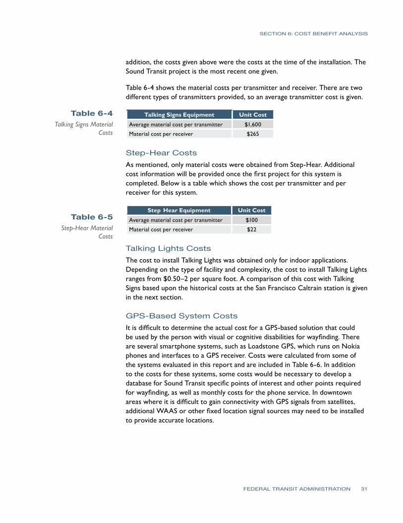
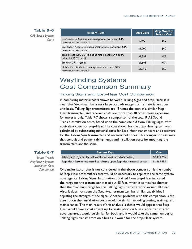
SECTION 6 COST BENEFIT ANALYSIS
Table 6-6 GPS-Based System
Costs
Table 6-7 Sound Transit
Wayfinding System Installation Cost
Comparison
System Type Unit Cost Avg Monthly Service Cost
Loadstone GPS (includes smartphone software GPS receiver screen reader)
$700 $60
Wayfinder Access (includes smartphone software GPS receiver screen reader)
$1200 $60
BrailleNote GPS V 3 (Includes maps receiver pouch cable 1 GB CF card)
$1599 NA
Trekker GPS System $1695 NA
Mobile Geo (includes smartphone software GPS receiver screen reader)
$1745 $60
Wayfinding SystemsCost Comparison Summary Talking Signs and Step-Hear Cost Comparison In comparing material costs shown between Talking Signs and Step-Hear it is clear that Step-Hear has a very large cost advantage from a material unit per unit basis Talking Sign transmitters are 18 times the cost of a similar Step-Hear transmitter and receiver costs are more than 10 times more expensive for material only Table 7-7 shows a comparison of the total RIAS Sound Transit installation costs based upon the complete bid from Talking Signs with equivalent costs for Step-Hear The cost shown for the Step-Hear system was calculated by substituting material costs for Step-Hear transmitters and receivers for the Talking Sign transmitter and receiver bid prices This comparison assumes that conduit and power cabling needs and installation costs for mounting the transmitters are the same
System Type Cost
Talking Signs System (actual installation cost in todayrsquos dollars) $2199765
Step-Hear System (estimated cost based upon Step-Hear material costs) $1665495
One major factor that is not considered in the above comparison is the number of Step-Hear transmitters that would be necessary to replicate the same system coverage for Talking Signs Information obtained from Step-Hear indicated the range for the transmitter was about 65 feet which is somewhat shorter than the maximum range for the Talking Signs transmitter of around 100 feet Also it does not seem the Step-Hear transmitter has similar capabilities in adjusting the strength of the signal Another problem with this comparison is the assumption that installation costs would be similar including testing training and maintenance The main result of this analysis is that it would appear that Step-Hear would have a cost advantage for installation on buses since transmitter coverage areas would be similar for both and it would take the same number of Talking Signs transmitters on a bus as it would for the Step-Hear system
FEDERAL TRANSIT ADMINISTRATION 32
SECTION 6 COST BENEFIT ANALYSIS
Table 6-8 Caltrain San Jose
Diridon Station Wayfinding System
Installation Cost Comparison
Table 6-9 Sound Transit
Wayfinding System Installation Cost
Comparison
Talking Signs and Talking Lights Cost Comparison For the Talking Lights system it is difficult to compare on a cost-to-cost basis with Talking Signs The method used for the purpose of this report was to consider the historical cost (converted to todayrsquos dollars) to install the Talking Signs system at the San Jose Diridon Caltrain station with a Talking Lights system cost for this station of $2 per square foot The area in square feet was calculated for the coverage area provided by Talking Signs at this station This included areas outside on train platforms as well as indoor areas This installation was only for mounting installation and testing of the RIAS system and did not include conduit and wiring costs which were completed under a separate contract Table 6-8 shows a simplified comparison of the costs between these systems using this method
System Type Cost
Talking Signs System (actual installation cost in todayrsquos dollars) $215000
Talking Lights System (est cost based on $2sf) $32000
Based upon this comparison there seems to be a large cost advantage for the Talking Lights system However this comparison does not consider the issues that could be encountered for the outside train platform areas of the San Jose Diridon Caltrain station if Talking Lights were used This does indicate that further investigation of the costs and effectiveness of the Talking Lights system for at least indoor transit facility areas should be completed
Talking Signs and GPS-Based System Cost Comparison In comparing the Talking Signs system to an outdoor GPS-based system there are a number of factors to consider Table 6-9 shows the actual cost for the RIAS system for Sound Transit compared with the estimated cost for implementing a region-wide database of points that are web-accessible The costs assume that receivers (GPS-based or Talking Signs receivers) will be purchased by the user Based upon the results of the participant interviews purchasing these receivers is a critical factor for determining whether persons will actually use the system
System Type Cost
Talking Signs System (actual installation cost in todayrsquos dollars) $2199765
GPS-based system (est cost to create point database interface and web access)
$150000
An integration of these technologies would seem to be more feasible As mentioned the costs above do not include the purchase of the individual GPS systems for each user which would likely be an issue for the user to purchase The cost to create this database is small since many of the bus routes for Sound Transit and King County Metro are already created using the Transit Trip Planner system Budget is already in place to update the database several
FEDERAL TRANSIT ADMINISTRATION 33
SECTION 6 COST BENEFIT ANALYSIS
times per year to make sure the bus route information is current The cost to create this database includes creating points for the entire regional transit system which would cover a larger area than the initial RIAS system at the six Sound Transit facilities It should be noted that the cost for the GPS system does not include review and testing of the system or a review from an OampM specialist From a per-person cost perspective for the entire regional transit system if the funding is to include purchasing a $700 personal GPS system and $250 for the RIAS receiver for each user the RIAS system has a cost advantage based upon the number of people in the Puget Sound area who have visual or cognitive disabilities However further comparison of costs of this system should be considered as GPS systems advance and costs for these systems continue to decrease
Wayfinding SystemsImplementation Risks Since RIAS technology has already been demonstrated in the Puget Sound area and in many other locations risks in proceeding with further system implementation are minimal There have also been many studies that have shown the system to be very successful and it has been tested more extensively by transit users who are blind or who have visual disabilities than any other system
There are several risks associated with installing a different system other than Talking Signs The main risks are
bullAnother custom device would be needed by the user
bullOther technologies do not have transit system studies completed using persons who are blind or have visual disabilities
bull Newer technology may not last long term
There are problems created when a user is required to have two different receivers to have the ability to travel independently For instance if a different technology other than RIAS is used for installation on the remaining Sound Transit facilities this would create the need for travelers who are blind or have visual disabilities to carry two different receivers and have the knowledge about which receiver to use at each facility This would make it more difficult for the user to travel effectively and could increase the cost if two receivers are needed to be purchased This would be simplified if one receiverunit was used indoors and a GPS-based unit was used outdoors By adding a cardmodule to the GPS-based unit to pick up either IR or RF signals from the item identifying transmitter these two units would have the potential to be integrated into one future unit
The Talking Signs RIAS technology is still the only technology that has been proven beneficial for use by persons who are blind or have visual disabilities in
FEDERAL TRANSIT ADMINISTRATION 34
SECTION 6 COST BENEFIT ANALYSIS
a transit environment There have been many studies and tests of the system on many transit systems All of these studies and tests including this most recent test with Sound Transit have been successful and have shown great benefits to the user Talking Lights has only been tested and used in an indoor hospital environment and has not been tested for use by persons who are blind although those who have had brain or eye surgery would have navigation needs similar to those who are blind or have visual disabilities impairments The Step-Hear system has only been completed on one bus system installation and the effectiveness of this system when compared to Talking Signs has yet to be determined
In addition both Talking Lights and Step-Hear are new technologies that have not been on the market very long The probability of these systems surviving in the market long term is less than for Talking Signs which has been in the market for many years There would naturally be increased risk in supporting technologies that are new and not proven
One issue in using Talking Signs and Step-Hear systems is that they are based upon item identification which has less focus on step-by-step guidance In other words a person could become lost or find it necessary to backtrack if the item was not identified and the person continued past the transmitter Also the transmitters are somewhat limited in placement because of mounting issues in the field which may not always be the best for guiding a visual impairments or disabilities traveler One issue noted during the installation and tests with the Sound Transit RIAS system was the ability for signals to reflect off of other objects particularly metallic objects This can sometimes create a message that gives the traveler incorrect information about which direction to go Reflection of RF signals from Step-Hear could also occur as well as issues associate with interference from other RF sources
GPS-based GPS-based systems are a good solution to provide directional information outdoors These systems are the trend for wayfinding technology so future integration and implementation of more advanced wayfinding systems would likely be easier when compared to the other wayfinding systems evaluated Because of this there is less risk in implementing GPS-based technology that is proven to be effective in guiding persons with visual impairments or disabilities There are many existing systems now that use GPS for the persons with visual impairments or disabilities and all that is necessary is to continue building a database of transit points of interest for travel path calculation purposes Satellite signals are sometimes blocked in areas such as around large high-rise buildings however applications are being developed that use last-known-positioning to calculate position within these types of dead zones Building footprints are also being placed into GPS databases in an effort to guide persons around the city areas In addition the iPhone offers assisted GPS through the use of Wi-Fi
FEDERAL TRANSIT ADMINISTRATION 35
SECTION 6 COST BENEFIT ANALYSIS
positioning which could also be used in urban areas for guidance One concern with the GPS-based systems as with other new technologies is the time it takes for people to become comfortable using the technology yet already there are persons with visual impairments or disabilities or who are blind using these systems for navigation
RIAS Installation Evaluation for Remainder of Sound Transit Facilities Another purpose of this project was to evaluate the cost implications for completing installation of the RIAS system on the remaining Sound Transit facilities and future facilities and on vehiclesbuses The following are the remaining facilities at Sound Transit that do not have a RIAS system installed
bull Edmonds Station
bull Mukilteo Station
bull Tukwila Station
bull Auburn Station
bull Sumner Station
bull Puyallup Station
bull Ash Way Park amp Rid
bullOverlake Transit Center
bull South Tacoma (open for bus opened for commuter rail in 2010)
bullLakewood Station (open for bus opened for commuter rail in 2010)
bull Lynwood Transit Center
bull Light Rail System (existing Tacoma line and new line opened for airport in 2009)
The Sound Transit RIAS project cost was $22 million to install at 6 facilities including some crosswalks and bus stops Operations and maintenance of the system and system support has already been budgeted within the Mobility Initiative Program and is not considered in the costs provided here Table 6-10 shows the budgetary costs per facility including buses commuter rail and light rail trains to install the RIAS system at the remainder of the Sound Transit facilities
FEDERAL TRANSIT ADMINISTRATION 36
SECTION 6 COST BENEFIT ANALYSIS
Table 6-10 Sound Transit RIAS
Costs for Remaining Facilities and Vehicles
Sound Transit Facilities Including Buses and Trains Cost
Edmonds Station (for future Edmonds Crossing) $375000
Mukilteo Station $430000
Tukwila Station $520000
Auburn Station $415000
Sumner Station $290000
Puyallup Station $375000
South Tacoma $250000
Overlake Transit Center $270000
Lakewood Station $600000
Lynnwood Transit Center $645000
Ash Way Park amp Ride $290000
Commuter Rail Vehicles (assumes 69 vehicles) $175000
Light Rail System (all lines installedplanned through 2009 19 stations) $2750000
Light Rail Vehicles (assumes 38 vehicles) $95000
Buses (assumes 239 vehicles) $600000
Total Estimated $8080000
RIAS Installation Evaluation at Other Regional PublicTransportation Facilities One of the purposes of this project was to evaluate the cost implications for regional transit facilities that could participate in implementation of a RIAS system All costs contained herein are for budgeting purposes only The following are the other regional transit agencies that should be considered for this system These are the other major transportation agencies that provide public transportation to the Puget Sound area
bull Community Transit
bull King County Metro
bull Pierce Transit
bull SeaTac Airport
The costs were based upon the bids received from Talking Signs for the subject project Average costs for facilities in which RIAS was installed were used in calculating the costs for each agency Costs for bus stop installation were estimated to be $4000 per bus stop since solar panels will likely need to be installed at each of these locations for power to operate the audible signs Table 6-11 shows a breakdown of costs by transit agency which includes material installation and testing costs
FEDERAL TRANSIT ADMINISTRATION 37
SECTION 6 COST BENEFIT ANALYSIS
Table 6-11 Estimated RIAS Costs for Regional Facilities
Other Regional Facility RIAS Costs Including Buses and Bus Stops Cost
Community Transit Buses (assumes 290 vehicles) $870000
King County Metro Buses (assumes 966 vehicles) $2900000
Pierce Transit Buses (assumes 158 vehicles) $475000
Bus Stops (assumes 16930 bus stops) $67720000
Other transit facilities (park-and-ride etc) $3500000
SeaTac Airport (main concourse only) $350000
Total $75815000
The level of interest found from the agencies contacted was low The only transit agency that was interested in installing a RIAS system was Everett Transit a small local transit system The main reason for the lack of interest seems to be a combination of both the cost benefit of the system and current budget issues because of recent economic downturns Another factor is that all three of these transit systems are currently involved in the replacement of Computer Aided DispatchAutomatic Vehicle Location (CADAVL) and Radio systems which are very large investments that also occupy the agency staffs during the installations and immediately after during the preliminary operation period
The RIAS technology was also introduced to the other regional transit agencies who were asked about their ability to fund the implementation of this technology Based upon the cost information and the regional agenciesrsquo level of interest and ability to fund the RIAS system the feasibility of regional implementation is low at this time It is likely more funds will be available in the near future as more government funding becomes available however the cost benefit will be a factor for these transit agencies in determining implementation as well
Results of the Analysis This trend is expected to continue and grow over the years Both GPS-based solutions and Talking Lights appear to be following this trend for their systems while Talking Signs and Step-Hear are more focused on item identification rather than locating the traveler and providing directions based upon the travelerrsquos location Regardless of which wayfinding system is used there appears to be some cost savings in operation of an agencyrsquos paratransit system
There are many benefits that travelers who are blind or who have visual or cognitive disabilities will experience in using a wayfinding system integrated into a public transportation environment The Talking Signs or RIAS system has been shown to be a system that provides many of these benefits Based upon the analysis completed however there are two main drawbacks in implementing the Talking Signs system The first is that it appears to be more costly when compared with other wayfinding system costs obtained This may change as more installations begin to occur however another way for this to change is for competition to drive market prices The second is that the current development
FEDERAL TRANSIT ADMINISTRATION 38
SECTION 6 COST BENEFIT ANALYSIS
trend for wayfinding systems is not in developing systems for item identification which is the focus of a Talking Signs system This current trend is towards systems that determine the position of the traveler and then access pre-defined locations in a database to calculate step-by-step paths
At this time there is not another system on the market that is at the same proven level of effectiveness for persons who are blind or who have visual impairments or disabilities as Talking Signs although with further evaluation of the Talking Lights and Step-Hear systems along with GPS-based solutions these other solutions could be brought into the picture There is enough information obtained from this analysis to justify the consideration of using other systems at least integrated with Talking Signs from both a cost and current technology trend perspective
GPS-based systems have been tested in the past in downtown areas with ineffective outcomes alongside Talking Signs because of the systemrsquos early dependence on satellites only Current GPS technologies are more accurate in these same areas and deserve structured tests to gain a better idea of the possibilities of the integration of these technologies
From this analysis it appears that the best least-cost option for a wayfinding solution outdoors would be to use a GPS-based solution integrated with a database containing transit points of interest that can be accessed either remotely or stored locally on a smartphone or other receiver combined with a Talking Lights system for indoor navigation One of the keys to this solution is that it would be of benefit to every traveler including those with visual and cognitive disabilities
Funding for this type of system could potentially be greater since it would directly benefit all riders and could increase overall ridership For indoor applications Talking Signs Talking Lights and Step-Hear are good solutions with Talking Lights and Step-Hear appearing to have the cost advantage over Talking Signs For bus applications either Talking Signs or Step-Hear would be good solutions with Step-Hear having the cost advantage Overall more cost information and analysis of GPS-based Talking Lights and Step-Hear systems is necessary to determine which system has the clear cost and performance advantage and provides an effective system that helps minimize future implementation risks A considerable amount of funding will be necessary to build out the RIAS system and steps should be taken to ensure that a cost-effective system that will provide a good long-term solution is implemented These steps would include further evaluation and comparison of other technologies through analysis of system costs and performance
FEDERAL TRANSIT ADMINISTRATION 39
SECTION
7SECTION
7 Recommendations
The following are the recommendations for Sound Transit regarding expanding the RIAS system further The main goal for these recommendations is to provide Sound Transit with the next steps that should be taken to implement a fully-functioning wayfinding system throughout its transit network Another goal of these recommendations is to preserve the investment Sound Transit has made in hardware as well as Sound Transit staff and consultant time
bull Begin the next phase of the RIAS MAP to continue build-out of the system and to further evaluate the RIAS system
bull Include funding for evaluation of the RIAS system along with other wayfinding systems
bull Invite other wayfinding systems that are available for people with visual or cognitive disabilities to participate in system demonstrations and in providing bids for implementation of their system for Sound Transit
bull Further evaluate Step-Hear and Talking Lights existing installations as well as other similar systems that are installed at the time of the evaluation Conduct additional research on these systems
bull Further evaluate the effectiveness and costs in using a GPS-based solution for outdoor navigation in combination with Talking Signs Talking Lights or Step-Hear for indoor and bus applications
bull Use the efforts King County Metro has made to create a data extraction process for its schedule and bus stop locations using Google Transit or the regional Trip Planner system
bull Consider use of the Google Time Table Publisher open interface and database for the Google Transit Planner
bull Further determine overall public interest in using a wayfinding system to assist in determining potential funds for expanding the system
bull Expand the wayfinding system once evaluations are complete and funding is in place
FEDERAL TRANSIT ADMINISTRATION 40
References
REFERENCES
Bentzen B L Crandall W and Myers L 1997 ldquoUse of Remote Infrared Signage in a Complex Transit Station by Persons with Developmental Delays or Dyslexiardquo Journal of Visual Impairment and Blindness 91 407ndash410
Bentzen B and Mitchell P 1995 ldquoAudible Signage as a Wayfinding Aid Comparison of Verbal Landmarks and Talking Signsrdquo Journal of Visual Impairment and Blindness
Brabyn J A and Brabyn L A 1982 ldquoSpeech intelligibility of the Talking Signsrdquo Journal of Visual Impairment and Blindness 76 77ndash-78
Brabyn J A and Brabyn L A ldquoAn Evaluation of lsquoTalking Signsrsquo for the Blindrdquo Human Factors 25(1) 49ndash53
Crandall W Bentzen B Myers L and Steed D 1995 ldquoTalking Signs Remote Infrared Signage A Guide for Transit System Managersrdquo Project ACTION of the National Easter Seal Society
Crandall W Bentzen B Myers L and Mitchell P 1995 ldquoTalking Signs Remote Infrared Signage A Guide for Transit System Managersrdquo Project ACTION of the National Easter Seal Society
Crandall W Bentzen B L Myers L and Mitchell P 1995 ldquoTransit Accessibility Improvement through Talking Signsreg Remote Infrared Signage A Demonstration and Evaluationrdquo Federal Transit Administration and Project ACTION of the National Easter Seal Society
Crandall W Bentzen B Rosen S and Mitchell P 1994 ldquoInfrared Remote Signage for the Blind and Print Handicapped An Orientation and Mobility Studyrdquo Final Report National Easter Seal Research Program
Hidalgo amp De Vries 2009 ldquoFederal Transit Administration Remote Infrared Audible Signage (RIAS) Model Accessibility Program (MAP) Human Factors Testing amp Evaluation Final Reportrdquo Federal Transit Administration Report Number FTA-MI-26-7909
Loomis J M Golledge R G Klatzky R L and Marston J R 2007 ldquoAssisting Wayfinding in Visually Impaired Travelersrdquo In G L Allen (Ed) Applied Spatial Cognition From Research to Cognitive Technology Mahwah NJ Lawrence Erlbaum Associates
Marston J R 2002 ldquoTowards And Accessible City Empirical Measurement and Modeling of Access to Urban Opportunities for Those with Vision Impairments Using Remote Infrared Audible Signagerdquo Doctoral dissertation University of California Santa Barbara
Marston J R and Golledge R G 2000 ldquoTowards an Accessible City Removing Functional Barriers to Independent Travel for Blind and Vision-Impaired A Case for Auditory Signsrdquo Final Report UCTC 65V430 University of California Berkley University of California Transportation Center
National Transit Database 2007 Transit Agency Profiles httpwwwntdprogramgovntdprogrampubsprofiles2007agency_ profiles
Step-Hear 2008 Request for Information e-mail communication
Talking Lights 2008 Request for Information e-mail and phone communication
Talking_Lights_LLC 2009 Talking Lights httpwwwtalking-lightscom
Talking_Signs_Inc (2009) Talking Signs httpwwwtalkingsignscom
United States Census Bureau 2006 American Community Survey httpfactfindercensusgov
United States Census bureau 2008 Population Estimates by County httpwwwcensusgovpopestcounties
FEDERAL TRANSIT ADMINISTRATION 41
APPENDIX Diagram of Typical Installation
FEDERAL TRANSIT ADMINISTRATION 42
FEDERAL TRANSIT ADMINISTRATION 128
US Department of TransportationFederal Transit AdministrationEast Building1200 New Jersey Avenue SEWashington DC 20590httpwwwftadotgovresearch
US Department of Transportation Federal Transit Administration East Building 1200 New Jersey Avenue SE Washington DC 20590 httpwwwftadotgovresearch
- Button1
- Button2
- Button3
- Button4
- Button5
- Button6
- Button7
- Button8
- Button9
- Button10
- Button13
- Button14
- Button15
- Button16
- Button17
- Button18
- Button19
- Button20
- Button21
- Button22
- Button23
- Button24
- Button25
- Button26
- Button27
- Button28
- Button29
- Button30
- Button31
- Button32
- Button33
- Button34
- Button35
- Button36
- Button37
- Button38
- Button39
- Button40
- Button41
- Button42
- Button43
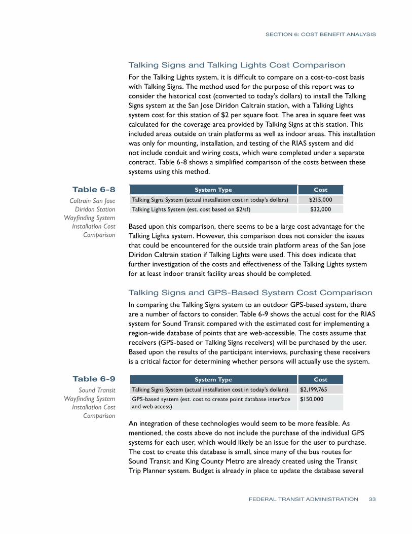
SECTION 6 COST BENEFIT ANALYSIS
Table 6-8 Caltrain San Jose
Diridon Station Wayfinding System
Installation Cost Comparison
Table 6-9 Sound Transit
Wayfinding System Installation Cost
Comparison
Talking Signs and Talking Lights Cost Comparison For the Talking Lights system it is difficult to compare on a cost-to-cost basis with Talking Signs The method used for the purpose of this report was to consider the historical cost (converted to todayrsquos dollars) to install the Talking Signs system at the San Jose Diridon Caltrain station with a Talking Lights system cost for this station of $2 per square foot The area in square feet was calculated for the coverage area provided by Talking Signs at this station This included areas outside on train platforms as well as indoor areas This installation was only for mounting installation and testing of the RIAS system and did not include conduit and wiring costs which were completed under a separate contract Table 6-8 shows a simplified comparison of the costs between these systems using this method
System Type Cost
Talking Signs System (actual installation cost in todayrsquos dollars) $215000
Talking Lights System (est cost based on $2sf) $32000
Based upon this comparison there seems to be a large cost advantage for the Talking Lights system However this comparison does not consider the issues that could be encountered for the outside train platform areas of the San Jose Diridon Caltrain station if Talking Lights were used This does indicate that further investigation of the costs and effectiveness of the Talking Lights system for at least indoor transit facility areas should be completed
Talking Signs and GPS-Based System Cost Comparison In comparing the Talking Signs system to an outdoor GPS-based system there are a number of factors to consider Table 6-9 shows the actual cost for the RIAS system for Sound Transit compared with the estimated cost for implementing a region-wide database of points that are web-accessible The costs assume that receivers (GPS-based or Talking Signs receivers) will be purchased by the user Based upon the results of the participant interviews purchasing these receivers is a critical factor for determining whether persons will actually use the system
System Type Cost
Talking Signs System (actual installation cost in todayrsquos dollars) $2199765
GPS-based system (est cost to create point database interface and web access)
$150000
An integration of these technologies would seem to be more feasible As mentioned the costs above do not include the purchase of the individual GPS systems for each user which would likely be an issue for the user to purchase The cost to create this database is small since many of the bus routes for Sound Transit and King County Metro are already created using the Transit Trip Planner system Budget is already in place to update the database several
FEDERAL TRANSIT ADMINISTRATION 33
SECTION 6 COST BENEFIT ANALYSIS
times per year to make sure the bus route information is current The cost to create this database includes creating points for the entire regional transit system which would cover a larger area than the initial RIAS system at the six Sound Transit facilities It should be noted that the cost for the GPS system does not include review and testing of the system or a review from an OampM specialist From a per-person cost perspective for the entire regional transit system if the funding is to include purchasing a $700 personal GPS system and $250 for the RIAS receiver for each user the RIAS system has a cost advantage based upon the number of people in the Puget Sound area who have visual or cognitive disabilities However further comparison of costs of this system should be considered as GPS systems advance and costs for these systems continue to decrease
Wayfinding SystemsImplementation Risks Since RIAS technology has already been demonstrated in the Puget Sound area and in many other locations risks in proceeding with further system implementation are minimal There have also been many studies that have shown the system to be very successful and it has been tested more extensively by transit users who are blind or who have visual disabilities than any other system
There are several risks associated with installing a different system other than Talking Signs The main risks are
bullAnother custom device would be needed by the user
bullOther technologies do not have transit system studies completed using persons who are blind or have visual disabilities
bull Newer technology may not last long term
There are problems created when a user is required to have two different receivers to have the ability to travel independently For instance if a different technology other than RIAS is used for installation on the remaining Sound Transit facilities this would create the need for travelers who are blind or have visual disabilities to carry two different receivers and have the knowledge about which receiver to use at each facility This would make it more difficult for the user to travel effectively and could increase the cost if two receivers are needed to be purchased This would be simplified if one receiverunit was used indoors and a GPS-based unit was used outdoors By adding a cardmodule to the GPS-based unit to pick up either IR or RF signals from the item identifying transmitter these two units would have the potential to be integrated into one future unit
The Talking Signs RIAS technology is still the only technology that has been proven beneficial for use by persons who are blind or have visual disabilities in
FEDERAL TRANSIT ADMINISTRATION 34
SECTION 6 COST BENEFIT ANALYSIS
a transit environment There have been many studies and tests of the system on many transit systems All of these studies and tests including this most recent test with Sound Transit have been successful and have shown great benefits to the user Talking Lights has only been tested and used in an indoor hospital environment and has not been tested for use by persons who are blind although those who have had brain or eye surgery would have navigation needs similar to those who are blind or have visual disabilities impairments The Step-Hear system has only been completed on one bus system installation and the effectiveness of this system when compared to Talking Signs has yet to be determined
In addition both Talking Lights and Step-Hear are new technologies that have not been on the market very long The probability of these systems surviving in the market long term is less than for Talking Signs which has been in the market for many years There would naturally be increased risk in supporting technologies that are new and not proven
One issue in using Talking Signs and Step-Hear systems is that they are based upon item identification which has less focus on step-by-step guidance In other words a person could become lost or find it necessary to backtrack if the item was not identified and the person continued past the transmitter Also the transmitters are somewhat limited in placement because of mounting issues in the field which may not always be the best for guiding a visual impairments or disabilities traveler One issue noted during the installation and tests with the Sound Transit RIAS system was the ability for signals to reflect off of other objects particularly metallic objects This can sometimes create a message that gives the traveler incorrect information about which direction to go Reflection of RF signals from Step-Hear could also occur as well as issues associate with interference from other RF sources
GPS-based GPS-based systems are a good solution to provide directional information outdoors These systems are the trend for wayfinding technology so future integration and implementation of more advanced wayfinding systems would likely be easier when compared to the other wayfinding systems evaluated Because of this there is less risk in implementing GPS-based technology that is proven to be effective in guiding persons with visual impairments or disabilities There are many existing systems now that use GPS for the persons with visual impairments or disabilities and all that is necessary is to continue building a database of transit points of interest for travel path calculation purposes Satellite signals are sometimes blocked in areas such as around large high-rise buildings however applications are being developed that use last-known-positioning to calculate position within these types of dead zones Building footprints are also being placed into GPS databases in an effort to guide persons around the city areas In addition the iPhone offers assisted GPS through the use of Wi-Fi
FEDERAL TRANSIT ADMINISTRATION 35
SECTION 6 COST BENEFIT ANALYSIS
positioning which could also be used in urban areas for guidance One concern with the GPS-based systems as with other new technologies is the time it takes for people to become comfortable using the technology yet already there are persons with visual impairments or disabilities or who are blind using these systems for navigation
RIAS Installation Evaluation for Remainder of Sound Transit Facilities Another purpose of this project was to evaluate the cost implications for completing installation of the RIAS system on the remaining Sound Transit facilities and future facilities and on vehiclesbuses The following are the remaining facilities at Sound Transit that do not have a RIAS system installed
bull Edmonds Station
bull Mukilteo Station
bull Tukwila Station
bull Auburn Station
bull Sumner Station
bull Puyallup Station
bull Ash Way Park amp Rid
bullOverlake Transit Center
bull South Tacoma (open for bus opened for commuter rail in 2010)
bullLakewood Station (open for bus opened for commuter rail in 2010)
bull Lynwood Transit Center
bull Light Rail System (existing Tacoma line and new line opened for airport in 2009)
The Sound Transit RIAS project cost was $22 million to install at 6 facilities including some crosswalks and bus stops Operations and maintenance of the system and system support has already been budgeted within the Mobility Initiative Program and is not considered in the costs provided here Table 6-10 shows the budgetary costs per facility including buses commuter rail and light rail trains to install the RIAS system at the remainder of the Sound Transit facilities
FEDERAL TRANSIT ADMINISTRATION 36
SECTION 6 COST BENEFIT ANALYSIS
Table 6-10 Sound Transit RIAS
Costs for Remaining Facilities and Vehicles
Sound Transit Facilities Including Buses and Trains Cost
Edmonds Station (for future Edmonds Crossing) $375000
Mukilteo Station $430000
Tukwila Station $520000
Auburn Station $415000
Sumner Station $290000
Puyallup Station $375000
South Tacoma $250000
Overlake Transit Center $270000
Lakewood Station $600000
Lynnwood Transit Center $645000
Ash Way Park amp Ride $290000
Commuter Rail Vehicles (assumes 69 vehicles) $175000
Light Rail System (all lines installedplanned through 2009 19 stations) $2750000
Light Rail Vehicles (assumes 38 vehicles) $95000
Buses (assumes 239 vehicles) $600000
Total Estimated $8080000
RIAS Installation Evaluation at Other Regional PublicTransportation Facilities One of the purposes of this project was to evaluate the cost implications for regional transit facilities that could participate in implementation of a RIAS system All costs contained herein are for budgeting purposes only The following are the other regional transit agencies that should be considered for this system These are the other major transportation agencies that provide public transportation to the Puget Sound area
bull Community Transit
bull King County Metro
bull Pierce Transit
bull SeaTac Airport
The costs were based upon the bids received from Talking Signs for the subject project Average costs for facilities in which RIAS was installed were used in calculating the costs for each agency Costs for bus stop installation were estimated to be $4000 per bus stop since solar panels will likely need to be installed at each of these locations for power to operate the audible signs Table 6-11 shows a breakdown of costs by transit agency which includes material installation and testing costs
FEDERAL TRANSIT ADMINISTRATION 37
SECTION 6 COST BENEFIT ANALYSIS
Table 6-11 Estimated RIAS Costs for Regional Facilities
Other Regional Facility RIAS Costs Including Buses and Bus Stops Cost
Community Transit Buses (assumes 290 vehicles) $870000
King County Metro Buses (assumes 966 vehicles) $2900000
Pierce Transit Buses (assumes 158 vehicles) $475000
Bus Stops (assumes 16930 bus stops) $67720000
Other transit facilities (park-and-ride etc) $3500000
SeaTac Airport (main concourse only) $350000
Total $75815000
The level of interest found from the agencies contacted was low The only transit agency that was interested in installing a RIAS system was Everett Transit a small local transit system The main reason for the lack of interest seems to be a combination of both the cost benefit of the system and current budget issues because of recent economic downturns Another factor is that all three of these transit systems are currently involved in the replacement of Computer Aided DispatchAutomatic Vehicle Location (CADAVL) and Radio systems which are very large investments that also occupy the agency staffs during the installations and immediately after during the preliminary operation period
The RIAS technology was also introduced to the other regional transit agencies who were asked about their ability to fund the implementation of this technology Based upon the cost information and the regional agenciesrsquo level of interest and ability to fund the RIAS system the feasibility of regional implementation is low at this time It is likely more funds will be available in the near future as more government funding becomes available however the cost benefit will be a factor for these transit agencies in determining implementation as well
Results of the Analysis This trend is expected to continue and grow over the years Both GPS-based solutions and Talking Lights appear to be following this trend for their systems while Talking Signs and Step-Hear are more focused on item identification rather than locating the traveler and providing directions based upon the travelerrsquos location Regardless of which wayfinding system is used there appears to be some cost savings in operation of an agencyrsquos paratransit system
There are many benefits that travelers who are blind or who have visual or cognitive disabilities will experience in using a wayfinding system integrated into a public transportation environment The Talking Signs or RIAS system has been shown to be a system that provides many of these benefits Based upon the analysis completed however there are two main drawbacks in implementing the Talking Signs system The first is that it appears to be more costly when compared with other wayfinding system costs obtained This may change as more installations begin to occur however another way for this to change is for competition to drive market prices The second is that the current development
FEDERAL TRANSIT ADMINISTRATION 38
SECTION 6 COST BENEFIT ANALYSIS
trend for wayfinding systems is not in developing systems for item identification which is the focus of a Talking Signs system This current trend is towards systems that determine the position of the traveler and then access pre-defined locations in a database to calculate step-by-step paths
At this time there is not another system on the market that is at the same proven level of effectiveness for persons who are blind or who have visual impairments or disabilities as Talking Signs although with further evaluation of the Talking Lights and Step-Hear systems along with GPS-based solutions these other solutions could be brought into the picture There is enough information obtained from this analysis to justify the consideration of using other systems at least integrated with Talking Signs from both a cost and current technology trend perspective
GPS-based systems have been tested in the past in downtown areas with ineffective outcomes alongside Talking Signs because of the systemrsquos early dependence on satellites only Current GPS technologies are more accurate in these same areas and deserve structured tests to gain a better idea of the possibilities of the integration of these technologies
From this analysis it appears that the best least-cost option for a wayfinding solution outdoors would be to use a GPS-based solution integrated with a database containing transit points of interest that can be accessed either remotely or stored locally on a smartphone or other receiver combined with a Talking Lights system for indoor navigation One of the keys to this solution is that it would be of benefit to every traveler including those with visual and cognitive disabilities
Funding for this type of system could potentially be greater since it would directly benefit all riders and could increase overall ridership For indoor applications Talking Signs Talking Lights and Step-Hear are good solutions with Talking Lights and Step-Hear appearing to have the cost advantage over Talking Signs For bus applications either Talking Signs or Step-Hear would be good solutions with Step-Hear having the cost advantage Overall more cost information and analysis of GPS-based Talking Lights and Step-Hear systems is necessary to determine which system has the clear cost and performance advantage and provides an effective system that helps minimize future implementation risks A considerable amount of funding will be necessary to build out the RIAS system and steps should be taken to ensure that a cost-effective system that will provide a good long-term solution is implemented These steps would include further evaluation and comparison of other technologies through analysis of system costs and performance
FEDERAL TRANSIT ADMINISTRATION 39
SECTION
7SECTION
7 Recommendations
The following are the recommendations for Sound Transit regarding expanding the RIAS system further The main goal for these recommendations is to provide Sound Transit with the next steps that should be taken to implement a fully-functioning wayfinding system throughout its transit network Another goal of these recommendations is to preserve the investment Sound Transit has made in hardware as well as Sound Transit staff and consultant time
bull Begin the next phase of the RIAS MAP to continue build-out of the system and to further evaluate the RIAS system
bull Include funding for evaluation of the RIAS system along with other wayfinding systems
bull Invite other wayfinding systems that are available for people with visual or cognitive disabilities to participate in system demonstrations and in providing bids for implementation of their system for Sound Transit
bull Further evaluate Step-Hear and Talking Lights existing installations as well as other similar systems that are installed at the time of the evaluation Conduct additional research on these systems
bull Further evaluate the effectiveness and costs in using a GPS-based solution for outdoor navigation in combination with Talking Signs Talking Lights or Step-Hear for indoor and bus applications
bull Use the efforts King County Metro has made to create a data extraction process for its schedule and bus stop locations using Google Transit or the regional Trip Planner system
bull Consider use of the Google Time Table Publisher open interface and database for the Google Transit Planner
bull Further determine overall public interest in using a wayfinding system to assist in determining potential funds for expanding the system
bull Expand the wayfinding system once evaluations are complete and funding is in place
FEDERAL TRANSIT ADMINISTRATION 40
References
REFERENCES
Bentzen B L Crandall W and Myers L 1997 ldquoUse of Remote Infrared Signage in a Complex Transit Station by Persons with Developmental Delays or Dyslexiardquo Journal of Visual Impairment and Blindness 91 407ndash410
Bentzen B and Mitchell P 1995 ldquoAudible Signage as a Wayfinding Aid Comparison of Verbal Landmarks and Talking Signsrdquo Journal of Visual Impairment and Blindness
Brabyn J A and Brabyn L A 1982 ldquoSpeech intelligibility of the Talking Signsrdquo Journal of Visual Impairment and Blindness 76 77ndash-78
Brabyn J A and Brabyn L A ldquoAn Evaluation of lsquoTalking Signsrsquo for the Blindrdquo Human Factors 25(1) 49ndash53
Crandall W Bentzen B Myers L and Steed D 1995 ldquoTalking Signs Remote Infrared Signage A Guide for Transit System Managersrdquo Project ACTION of the National Easter Seal Society
Crandall W Bentzen B Myers L and Mitchell P 1995 ldquoTalking Signs Remote Infrared Signage A Guide for Transit System Managersrdquo Project ACTION of the National Easter Seal Society
Crandall W Bentzen B L Myers L and Mitchell P 1995 ldquoTransit Accessibility Improvement through Talking Signsreg Remote Infrared Signage A Demonstration and Evaluationrdquo Federal Transit Administration and Project ACTION of the National Easter Seal Society
Crandall W Bentzen B Rosen S and Mitchell P 1994 ldquoInfrared Remote Signage for the Blind and Print Handicapped An Orientation and Mobility Studyrdquo Final Report National Easter Seal Research Program
Hidalgo amp De Vries 2009 ldquoFederal Transit Administration Remote Infrared Audible Signage (RIAS) Model Accessibility Program (MAP) Human Factors Testing amp Evaluation Final Reportrdquo Federal Transit Administration Report Number FTA-MI-26-7909
Loomis J M Golledge R G Klatzky R L and Marston J R 2007 ldquoAssisting Wayfinding in Visually Impaired Travelersrdquo In G L Allen (Ed) Applied Spatial Cognition From Research to Cognitive Technology Mahwah NJ Lawrence Erlbaum Associates
Marston J R 2002 ldquoTowards And Accessible City Empirical Measurement and Modeling of Access to Urban Opportunities for Those with Vision Impairments Using Remote Infrared Audible Signagerdquo Doctoral dissertation University of California Santa Barbara
Marston J R and Golledge R G 2000 ldquoTowards an Accessible City Removing Functional Barriers to Independent Travel for Blind and Vision-Impaired A Case for Auditory Signsrdquo Final Report UCTC 65V430 University of California Berkley University of California Transportation Center
National Transit Database 2007 Transit Agency Profiles httpwwwntdprogramgovntdprogrampubsprofiles2007agency_ profiles
Step-Hear 2008 Request for Information e-mail communication
Talking Lights 2008 Request for Information e-mail and phone communication
Talking_Lights_LLC 2009 Talking Lights httpwwwtalking-lightscom
Talking_Signs_Inc (2009) Talking Signs httpwwwtalkingsignscom
United States Census Bureau 2006 American Community Survey httpfactfindercensusgov
United States Census bureau 2008 Population Estimates by County httpwwwcensusgovpopestcounties
FEDERAL TRANSIT ADMINISTRATION 41
APPENDIX Diagram of Typical Installation
FEDERAL TRANSIT ADMINISTRATION 42
FEDERAL TRANSIT ADMINISTRATION 128
US Department of TransportationFederal Transit AdministrationEast Building1200 New Jersey Avenue SEWashington DC 20590httpwwwftadotgovresearch
US Department of Transportation Federal Transit Administration East Building 1200 New Jersey Avenue SE Washington DC 20590 httpwwwftadotgovresearch
- Button1
- Button2
- Button3
- Button4
- Button5
- Button6
- Button7
- Button8
- Button9
- Button10
- Button13
- Button14
- Button15
- Button16
- Button17
- Button18
- Button19
- Button20
- Button21
- Button22
- Button23
- Button24
- Button25
- Button26
- Button27
- Button28
- Button29
- Button30
- Button31
- Button32
- Button33
- Button34
- Button35
- Button36
- Button37
- Button38
- Button39
- Button40
- Button41
- Button42
- Button43
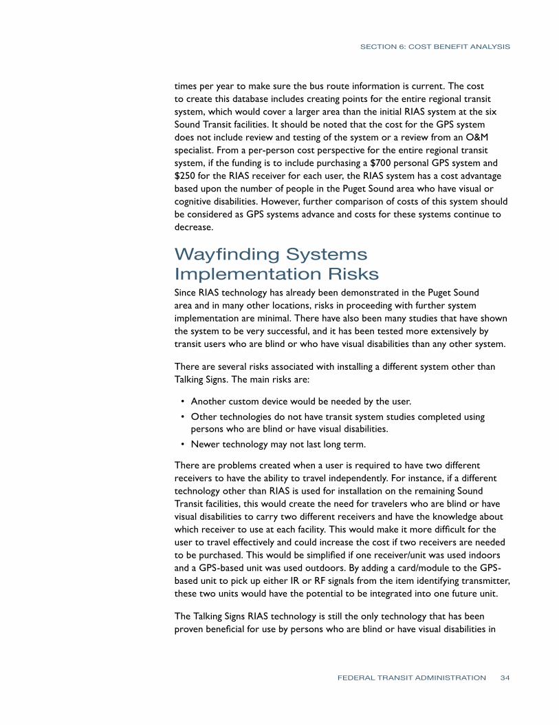
SECTION 6 COST BENEFIT ANALYSIS
times per year to make sure the bus route information is current The cost to create this database includes creating points for the entire regional transit system which would cover a larger area than the initial RIAS system at the six Sound Transit facilities It should be noted that the cost for the GPS system does not include review and testing of the system or a review from an OampM specialist From a per-person cost perspective for the entire regional transit system if the funding is to include purchasing a $700 personal GPS system and $250 for the RIAS receiver for each user the RIAS system has a cost advantage based upon the number of people in the Puget Sound area who have visual or cognitive disabilities However further comparison of costs of this system should be considered as GPS systems advance and costs for these systems continue to decrease
Wayfinding SystemsImplementation Risks Since RIAS technology has already been demonstrated in the Puget Sound area and in many other locations risks in proceeding with further system implementation are minimal There have also been many studies that have shown the system to be very successful and it has been tested more extensively by transit users who are blind or who have visual disabilities than any other system
There are several risks associated with installing a different system other than Talking Signs The main risks are
bullAnother custom device would be needed by the user
bullOther technologies do not have transit system studies completed using persons who are blind or have visual disabilities
bull Newer technology may not last long term
There are problems created when a user is required to have two different receivers to have the ability to travel independently For instance if a different technology other than RIAS is used for installation on the remaining Sound Transit facilities this would create the need for travelers who are blind or have visual disabilities to carry two different receivers and have the knowledge about which receiver to use at each facility This would make it more difficult for the user to travel effectively and could increase the cost if two receivers are needed to be purchased This would be simplified if one receiverunit was used indoors and a GPS-based unit was used outdoors By adding a cardmodule to the GPS-based unit to pick up either IR or RF signals from the item identifying transmitter these two units would have the potential to be integrated into one future unit
The Talking Signs RIAS technology is still the only technology that has been proven beneficial for use by persons who are blind or have visual disabilities in
FEDERAL TRANSIT ADMINISTRATION 34
SECTION 6 COST BENEFIT ANALYSIS
a transit environment There have been many studies and tests of the system on many transit systems All of these studies and tests including this most recent test with Sound Transit have been successful and have shown great benefits to the user Talking Lights has only been tested and used in an indoor hospital environment and has not been tested for use by persons who are blind although those who have had brain or eye surgery would have navigation needs similar to those who are blind or have visual disabilities impairments The Step-Hear system has only been completed on one bus system installation and the effectiveness of this system when compared to Talking Signs has yet to be determined
In addition both Talking Lights and Step-Hear are new technologies that have not been on the market very long The probability of these systems surviving in the market long term is less than for Talking Signs which has been in the market for many years There would naturally be increased risk in supporting technologies that are new and not proven
One issue in using Talking Signs and Step-Hear systems is that they are based upon item identification which has less focus on step-by-step guidance In other words a person could become lost or find it necessary to backtrack if the item was not identified and the person continued past the transmitter Also the transmitters are somewhat limited in placement because of mounting issues in the field which may not always be the best for guiding a visual impairments or disabilities traveler One issue noted during the installation and tests with the Sound Transit RIAS system was the ability for signals to reflect off of other objects particularly metallic objects This can sometimes create a message that gives the traveler incorrect information about which direction to go Reflection of RF signals from Step-Hear could also occur as well as issues associate with interference from other RF sources
GPS-based GPS-based systems are a good solution to provide directional information outdoors These systems are the trend for wayfinding technology so future integration and implementation of more advanced wayfinding systems would likely be easier when compared to the other wayfinding systems evaluated Because of this there is less risk in implementing GPS-based technology that is proven to be effective in guiding persons with visual impairments or disabilities There are many existing systems now that use GPS for the persons with visual impairments or disabilities and all that is necessary is to continue building a database of transit points of interest for travel path calculation purposes Satellite signals are sometimes blocked in areas such as around large high-rise buildings however applications are being developed that use last-known-positioning to calculate position within these types of dead zones Building footprints are also being placed into GPS databases in an effort to guide persons around the city areas In addition the iPhone offers assisted GPS through the use of Wi-Fi
FEDERAL TRANSIT ADMINISTRATION 35
SECTION 6 COST BENEFIT ANALYSIS
positioning which could also be used in urban areas for guidance One concern with the GPS-based systems as with other new technologies is the time it takes for people to become comfortable using the technology yet already there are persons with visual impairments or disabilities or who are blind using these systems for navigation
RIAS Installation Evaluation for Remainder of Sound Transit Facilities Another purpose of this project was to evaluate the cost implications for completing installation of the RIAS system on the remaining Sound Transit facilities and future facilities and on vehiclesbuses The following are the remaining facilities at Sound Transit that do not have a RIAS system installed
bull Edmonds Station
bull Mukilteo Station
bull Tukwila Station
bull Auburn Station
bull Sumner Station
bull Puyallup Station
bull Ash Way Park amp Rid
bullOverlake Transit Center
bull South Tacoma (open for bus opened for commuter rail in 2010)
bullLakewood Station (open for bus opened for commuter rail in 2010)
bull Lynwood Transit Center
bull Light Rail System (existing Tacoma line and new line opened for airport in 2009)
The Sound Transit RIAS project cost was $22 million to install at 6 facilities including some crosswalks and bus stops Operations and maintenance of the system and system support has already been budgeted within the Mobility Initiative Program and is not considered in the costs provided here Table 6-10 shows the budgetary costs per facility including buses commuter rail and light rail trains to install the RIAS system at the remainder of the Sound Transit facilities
FEDERAL TRANSIT ADMINISTRATION 36
SECTION 6 COST BENEFIT ANALYSIS
Table 6-10 Sound Transit RIAS
Costs for Remaining Facilities and Vehicles
Sound Transit Facilities Including Buses and Trains Cost
Edmonds Station (for future Edmonds Crossing) $375000
Mukilteo Station $430000
Tukwila Station $520000
Auburn Station $415000
Sumner Station $290000
Puyallup Station $375000
South Tacoma $250000
Overlake Transit Center $270000
Lakewood Station $600000
Lynnwood Transit Center $645000
Ash Way Park amp Ride $290000
Commuter Rail Vehicles (assumes 69 vehicles) $175000
Light Rail System (all lines installedplanned through 2009 19 stations) $2750000
Light Rail Vehicles (assumes 38 vehicles) $95000
Buses (assumes 239 vehicles) $600000
Total Estimated $8080000
RIAS Installation Evaluation at Other Regional PublicTransportation Facilities One of the purposes of this project was to evaluate the cost implications for regional transit facilities that could participate in implementation of a RIAS system All costs contained herein are for budgeting purposes only The following are the other regional transit agencies that should be considered for this system These are the other major transportation agencies that provide public transportation to the Puget Sound area
bull Community Transit
bull King County Metro
bull Pierce Transit
bull SeaTac Airport
The costs were based upon the bids received from Talking Signs for the subject project Average costs for facilities in which RIAS was installed were used in calculating the costs for each agency Costs for bus stop installation were estimated to be $4000 per bus stop since solar panels will likely need to be installed at each of these locations for power to operate the audible signs Table 6-11 shows a breakdown of costs by transit agency which includes material installation and testing costs
FEDERAL TRANSIT ADMINISTRATION 37
SECTION 6 COST BENEFIT ANALYSIS
Table 6-11 Estimated RIAS Costs for Regional Facilities
Other Regional Facility RIAS Costs Including Buses and Bus Stops Cost
Community Transit Buses (assumes 290 vehicles) $870000
King County Metro Buses (assumes 966 vehicles) $2900000
Pierce Transit Buses (assumes 158 vehicles) $475000
Bus Stops (assumes 16930 bus stops) $67720000
Other transit facilities (park-and-ride etc) $3500000
SeaTac Airport (main concourse only) $350000
Total $75815000
The level of interest found from the agencies contacted was low The only transit agency that was interested in installing a RIAS system was Everett Transit a small local transit system The main reason for the lack of interest seems to be a combination of both the cost benefit of the system and current budget issues because of recent economic downturns Another factor is that all three of these transit systems are currently involved in the replacement of Computer Aided DispatchAutomatic Vehicle Location (CADAVL) and Radio systems which are very large investments that also occupy the agency staffs during the installations and immediately after during the preliminary operation period
The RIAS technology was also introduced to the other regional transit agencies who were asked about their ability to fund the implementation of this technology Based upon the cost information and the regional agenciesrsquo level of interest and ability to fund the RIAS system the feasibility of regional implementation is low at this time It is likely more funds will be available in the near future as more government funding becomes available however the cost benefit will be a factor for these transit agencies in determining implementation as well
Results of the Analysis This trend is expected to continue and grow over the years Both GPS-based solutions and Talking Lights appear to be following this trend for their systems while Talking Signs and Step-Hear are more focused on item identification rather than locating the traveler and providing directions based upon the travelerrsquos location Regardless of which wayfinding system is used there appears to be some cost savings in operation of an agencyrsquos paratransit system
There are many benefits that travelers who are blind or who have visual or cognitive disabilities will experience in using a wayfinding system integrated into a public transportation environment The Talking Signs or RIAS system has been shown to be a system that provides many of these benefits Based upon the analysis completed however there are two main drawbacks in implementing the Talking Signs system The first is that it appears to be more costly when compared with other wayfinding system costs obtained This may change as more installations begin to occur however another way for this to change is for competition to drive market prices The second is that the current development
FEDERAL TRANSIT ADMINISTRATION 38
SECTION 6 COST BENEFIT ANALYSIS
trend for wayfinding systems is not in developing systems for item identification which is the focus of a Talking Signs system This current trend is towards systems that determine the position of the traveler and then access pre-defined locations in a database to calculate step-by-step paths
At this time there is not another system on the market that is at the same proven level of effectiveness for persons who are blind or who have visual impairments or disabilities as Talking Signs although with further evaluation of the Talking Lights and Step-Hear systems along with GPS-based solutions these other solutions could be brought into the picture There is enough information obtained from this analysis to justify the consideration of using other systems at least integrated with Talking Signs from both a cost and current technology trend perspective
GPS-based systems have been tested in the past in downtown areas with ineffective outcomes alongside Talking Signs because of the systemrsquos early dependence on satellites only Current GPS technologies are more accurate in these same areas and deserve structured tests to gain a better idea of the possibilities of the integration of these technologies
From this analysis it appears that the best least-cost option for a wayfinding solution outdoors would be to use a GPS-based solution integrated with a database containing transit points of interest that can be accessed either remotely or stored locally on a smartphone or other receiver combined with a Talking Lights system for indoor navigation One of the keys to this solution is that it would be of benefit to every traveler including those with visual and cognitive disabilities
Funding for this type of system could potentially be greater since it would directly benefit all riders and could increase overall ridership For indoor applications Talking Signs Talking Lights and Step-Hear are good solutions with Talking Lights and Step-Hear appearing to have the cost advantage over Talking Signs For bus applications either Talking Signs or Step-Hear would be good solutions with Step-Hear having the cost advantage Overall more cost information and analysis of GPS-based Talking Lights and Step-Hear systems is necessary to determine which system has the clear cost and performance advantage and provides an effective system that helps minimize future implementation risks A considerable amount of funding will be necessary to build out the RIAS system and steps should be taken to ensure that a cost-effective system that will provide a good long-term solution is implemented These steps would include further evaluation and comparison of other technologies through analysis of system costs and performance
FEDERAL TRANSIT ADMINISTRATION 39
SECTION
7SECTION
7 Recommendations
The following are the recommendations for Sound Transit regarding expanding the RIAS system further The main goal for these recommendations is to provide Sound Transit with the next steps that should be taken to implement a fully-functioning wayfinding system throughout its transit network Another goal of these recommendations is to preserve the investment Sound Transit has made in hardware as well as Sound Transit staff and consultant time
bull Begin the next phase of the RIAS MAP to continue build-out of the system and to further evaluate the RIAS system
bull Include funding for evaluation of the RIAS system along with other wayfinding systems
bull Invite other wayfinding systems that are available for people with visual or cognitive disabilities to participate in system demonstrations and in providing bids for implementation of their system for Sound Transit
bull Further evaluate Step-Hear and Talking Lights existing installations as well as other similar systems that are installed at the time of the evaluation Conduct additional research on these systems
bull Further evaluate the effectiveness and costs in using a GPS-based solution for outdoor navigation in combination with Talking Signs Talking Lights or Step-Hear for indoor and bus applications
bull Use the efforts King County Metro has made to create a data extraction process for its schedule and bus stop locations using Google Transit or the regional Trip Planner system
bull Consider use of the Google Time Table Publisher open interface and database for the Google Transit Planner
bull Further determine overall public interest in using a wayfinding system to assist in determining potential funds for expanding the system
bull Expand the wayfinding system once evaluations are complete and funding is in place
FEDERAL TRANSIT ADMINISTRATION 40
References
REFERENCES
Bentzen B L Crandall W and Myers L 1997 ldquoUse of Remote Infrared Signage in a Complex Transit Station by Persons with Developmental Delays or Dyslexiardquo Journal of Visual Impairment and Blindness 91 407ndash410
Bentzen B and Mitchell P 1995 ldquoAudible Signage as a Wayfinding Aid Comparison of Verbal Landmarks and Talking Signsrdquo Journal of Visual Impairment and Blindness
Brabyn J A and Brabyn L A 1982 ldquoSpeech intelligibility of the Talking Signsrdquo Journal of Visual Impairment and Blindness 76 77ndash-78
Brabyn J A and Brabyn L A ldquoAn Evaluation of lsquoTalking Signsrsquo for the Blindrdquo Human Factors 25(1) 49ndash53
Crandall W Bentzen B Myers L and Steed D 1995 ldquoTalking Signs Remote Infrared Signage A Guide for Transit System Managersrdquo Project ACTION of the National Easter Seal Society
Crandall W Bentzen B Myers L and Mitchell P 1995 ldquoTalking Signs Remote Infrared Signage A Guide for Transit System Managersrdquo Project ACTION of the National Easter Seal Society
Crandall W Bentzen B L Myers L and Mitchell P 1995 ldquoTransit Accessibility Improvement through Talking Signsreg Remote Infrared Signage A Demonstration and Evaluationrdquo Federal Transit Administration and Project ACTION of the National Easter Seal Society
Crandall W Bentzen B Rosen S and Mitchell P 1994 ldquoInfrared Remote Signage for the Blind and Print Handicapped An Orientation and Mobility Studyrdquo Final Report National Easter Seal Research Program
Hidalgo amp De Vries 2009 ldquoFederal Transit Administration Remote Infrared Audible Signage (RIAS) Model Accessibility Program (MAP) Human Factors Testing amp Evaluation Final Reportrdquo Federal Transit Administration Report Number FTA-MI-26-7909
Loomis J M Golledge R G Klatzky R L and Marston J R 2007 ldquoAssisting Wayfinding in Visually Impaired Travelersrdquo In G L Allen (Ed) Applied Spatial Cognition From Research to Cognitive Technology Mahwah NJ Lawrence Erlbaum Associates
Marston J R 2002 ldquoTowards And Accessible City Empirical Measurement and Modeling of Access to Urban Opportunities for Those with Vision Impairments Using Remote Infrared Audible Signagerdquo Doctoral dissertation University of California Santa Barbara
Marston J R and Golledge R G 2000 ldquoTowards an Accessible City Removing Functional Barriers to Independent Travel for Blind and Vision-Impaired A Case for Auditory Signsrdquo Final Report UCTC 65V430 University of California Berkley University of California Transportation Center
National Transit Database 2007 Transit Agency Profiles httpwwwntdprogramgovntdprogrampubsprofiles2007agency_ profiles
Step-Hear 2008 Request for Information e-mail communication
Talking Lights 2008 Request for Information e-mail and phone communication
Talking_Lights_LLC 2009 Talking Lights httpwwwtalking-lightscom
Talking_Signs_Inc (2009) Talking Signs httpwwwtalkingsignscom
United States Census Bureau 2006 American Community Survey httpfactfindercensusgov
United States Census bureau 2008 Population Estimates by County httpwwwcensusgovpopestcounties
FEDERAL TRANSIT ADMINISTRATION 41
APPENDIX Diagram of Typical Installation
FEDERAL TRANSIT ADMINISTRATION 42
FEDERAL TRANSIT ADMINISTRATION 128
US Department of TransportationFederal Transit AdministrationEast Building1200 New Jersey Avenue SEWashington DC 20590httpwwwftadotgovresearch
US Department of Transportation Federal Transit Administration East Building 1200 New Jersey Avenue SE Washington DC 20590 httpwwwftadotgovresearch
- Button1
- Button2
- Button3
- Button4
- Button5
- Button6
- Button7
- Button8
- Button9
- Button10
- Button13
- Button14
- Button15
- Button16
- Button17
- Button18
- Button19
- Button20
- Button21
- Button22
- Button23
- Button24
- Button25
- Button26
- Button27
- Button28
- Button29
- Button30
- Button31
- Button32
- Button33
- Button34
- Button35
- Button36
- Button37
- Button38
- Button39
- Button40
- Button41
- Button42
- Button43
SECTION 6 COST BENEFIT ANALYSIS
positioning which could also be used in urban areas for guidance One concern with the GPS-based systems as with other new technologies is the time it takes for people to become comfortable using the technology yet already there are persons with visual impairments or disabilities or who are blind using these systems for navigation
RIAS Installation Evaluation for Remainder of Sound Transit Facilities Another purpose of this project was to evaluate the cost implications for completing installation of the RIAS system on the remaining Sound Transit facilities and future facilities and on vehiclesbuses The following are the remaining facilities at Sound Transit that do not have a RIAS system installed
bull Edmonds Station
bull Mukilteo Station
bull Tukwila Station
bull Auburn Station
bull Sumner Station
bull Puyallup Station
bull Ash Way Park amp Rid
bullOverlake Transit Center
bull South Tacoma (open for bus opened for commuter rail in 2010)
bullLakewood Station (open for bus opened for commuter rail in 2010)
bull Lynwood Transit Center
bull Light Rail System (existing Tacoma line and new line opened for airport in 2009)
The Sound Transit RIAS project cost was $22 million to install at 6 facilities including some crosswalks and bus stops Operations and maintenance of the system and system support has already been budgeted within the Mobility Initiative Program and is not considered in the costs provided here Table 6-10 shows the budgetary costs per facility including buses commuter rail and light rail trains to install the RIAS system at the remainder of the Sound Transit facilities
FEDERAL TRANSIT ADMINISTRATION 36
SECTION 6 COST BENEFIT ANALYSIS
Table 6-10 Sound Transit RIAS
Costs for Remaining Facilities and Vehicles
Sound Transit Facilities Including Buses and Trains Cost
Edmonds Station (for future Edmonds Crossing) $375000
Mukilteo Station $430000
Tukwila Station $520000
Auburn Station $415000
Sumner Station $290000
Puyallup Station $375000
South Tacoma $250000
Overlake Transit Center $270000
Lakewood Station $600000
Lynnwood Transit Center $645000
Ash Way Park amp Ride $290000
Commuter Rail Vehicles (assumes 69 vehicles) $175000
Light Rail System (all lines installedplanned through 2009 19 stations) $2750000
Light Rail Vehicles (assumes 38 vehicles) $95000
Buses (assumes 239 vehicles) $600000
Total Estimated $8080000
RIAS Installation Evaluation at Other Regional PublicTransportation Facilities One of the purposes of this project was to evaluate the cost implications for regional transit facilities that could participate in implementation of a RIAS system All costs contained herein are for budgeting purposes only The following are the other regional transit agencies that should be considered for this system These are the other major transportation agencies that provide public transportation to the Puget Sound area
bull Community Transit
bull King County Metro
bull Pierce Transit
bull SeaTac Airport
The costs were based upon the bids received from Talking Signs for the subject project Average costs for facilities in which RIAS was installed were used in calculating the costs for each agency Costs for bus stop installation were estimated to be $4000 per bus stop since solar panels will likely need to be installed at each of these locations for power to operate the audible signs Table 6-11 shows a breakdown of costs by transit agency which includes material installation and testing costs
FEDERAL TRANSIT ADMINISTRATION 37
SECTION 6 COST BENEFIT ANALYSIS
Table 6-11 Estimated RIAS Costs for Regional Facilities
Other Regional Facility RIAS Costs Including Buses and Bus Stops Cost
Community Transit Buses (assumes 290 vehicles) $870000
King County Metro Buses (assumes 966 vehicles) $2900000
Pierce Transit Buses (assumes 158 vehicles) $475000
Bus Stops (assumes 16930 bus stops) $67720000
Other transit facilities (park-and-ride etc) $3500000
SeaTac Airport (main concourse only) $350000
Total $75815000
The level of interest found from the agencies contacted was low The only transit agency that was interested in installing a RIAS system was Everett Transit a small local transit system The main reason for the lack of interest seems to be a combination of both the cost benefit of the system and current budget issues because of recent economic downturns Another factor is that all three of these transit systems are currently involved in the replacement of Computer Aided DispatchAutomatic Vehicle Location (CADAVL) and Radio systems which are very large investments that also occupy the agency staffs during the installations and immediately after during the preliminary operation period
The RIAS technology was also introduced to the other regional transit agencies who were asked about their ability to fund the implementation of this technology Based upon the cost information and the regional agenciesrsquo level of interest and ability to fund the RIAS system the feasibility of regional implementation is low at this time It is likely more funds will be available in the near future as more government funding becomes available however the cost benefit will be a factor for these transit agencies in determining implementation as well
Results of the Analysis This trend is expected to continue and grow over the years Both GPS-based solutions and Talking Lights appear to be following this trend for their systems while Talking Signs and Step-Hear are more focused on item identification rather than locating the traveler and providing directions based upon the travelerrsquos location Regardless of which wayfinding system is used there appears to be some cost savings in operation of an agencyrsquos paratransit system
There are many benefits that travelers who are blind or who have visual or cognitive disabilities will experience in using a wayfinding system integrated into a public transportation environment The Talking Signs or RIAS system has been shown to be a system that provides many of these benefits Based upon the analysis completed however there are two main drawbacks in implementing the Talking Signs system The first is that it appears to be more costly when compared with other wayfinding system costs obtained This may change as more installations begin to occur however another way for this to change is for competition to drive market prices The second is that the current development
FEDERAL TRANSIT ADMINISTRATION 38
SECTION 6 COST BENEFIT ANALYSIS
trend for wayfinding systems is not in developing systems for item identification which is the focus of a Talking Signs system This current trend is towards systems that determine the position of the traveler and then access pre-defined locations in a database to calculate step-by-step paths
At this time there is not another system on the market that is at the same proven level of effectiveness for persons who are blind or who have visual impairments or disabilities as Talking Signs although with further evaluation of the Talking Lights and Step-Hear systems along with GPS-based solutions these other solutions could be brought into the picture There is enough information obtained from this analysis to justify the consideration of using other systems at least integrated with Talking Signs from both a cost and current technology trend perspective
GPS-based systems have been tested in the past in downtown areas with ineffective outcomes alongside Talking Signs because of the systemrsquos early dependence on satellites only Current GPS technologies are more accurate in these same areas and deserve structured tests to gain a better idea of the possibilities of the integration of these technologies
From this analysis it appears that the best least-cost option for a wayfinding solution outdoors would be to use a GPS-based solution integrated with a database containing transit points of interest that can be accessed either remotely or stored locally on a smartphone or other receiver combined with a Talking Lights system for indoor navigation One of the keys to this solution is that it would be of benefit to every traveler including those with visual and cognitive disabilities
Funding for this type of system could potentially be greater since it would directly benefit all riders and could increase overall ridership For indoor applications Talking Signs Talking Lights and Step-Hear are good solutions with Talking Lights and Step-Hear appearing to have the cost advantage over Talking Signs For bus applications either Talking Signs or Step-Hear would be good solutions with Step-Hear having the cost advantage Overall more cost information and analysis of GPS-based Talking Lights and Step-Hear systems is necessary to determine which system has the clear cost and performance advantage and provides an effective system that helps minimize future implementation risks A considerable amount of funding will be necessary to build out the RIAS system and steps should be taken to ensure that a cost-effective system that will provide a good long-term solution is implemented These steps would include further evaluation and comparison of other technologies through analysis of system costs and performance
FEDERAL TRANSIT ADMINISTRATION 39
SECTION
7SECTION
7 Recommendations
The following are the recommendations for Sound Transit regarding expanding the RIAS system further The main goal for these recommendations is to provide Sound Transit with the next steps that should be taken to implement a fully-functioning wayfinding system throughout its transit network Another goal of these recommendations is to preserve the investment Sound Transit has made in hardware as well as Sound Transit staff and consultant time
bull Begin the next phase of the RIAS MAP to continue build-out of the system and to further evaluate the RIAS system
bull Include funding for evaluation of the RIAS system along with other wayfinding systems
bull Invite other wayfinding systems that are available for people with visual or cognitive disabilities to participate in system demonstrations and in providing bids for implementation of their system for Sound Transit
bull Further evaluate Step-Hear and Talking Lights existing installations as well as other similar systems that are installed at the time of the evaluation Conduct additional research on these systems
bull Further evaluate the effectiveness and costs in using a GPS-based solution for outdoor navigation in combination with Talking Signs Talking Lights or Step-Hear for indoor and bus applications
bull Use the efforts King County Metro has made to create a data extraction process for its schedule and bus stop locations using Google Transit or the regional Trip Planner system
bull Consider use of the Google Time Table Publisher open interface and database for the Google Transit Planner
bull Further determine overall public interest in using a wayfinding system to assist in determining potential funds for expanding the system
bull Expand the wayfinding system once evaluations are complete and funding is in place
FEDERAL TRANSIT ADMINISTRATION 40
References
REFERENCES
Bentzen B L Crandall W and Myers L 1997 ldquoUse of Remote Infrared Signage in a Complex Transit Station by Persons with Developmental Delays or Dyslexiardquo Journal of Visual Impairment and Blindness 91 407ndash410
Bentzen B and Mitchell P 1995 ldquoAudible Signage as a Wayfinding Aid Comparison of Verbal Landmarks and Talking Signsrdquo Journal of Visual Impairment and Blindness
Brabyn J A and Brabyn L A 1982 ldquoSpeech intelligibility of the Talking Signsrdquo Journal of Visual Impairment and Blindness 76 77ndash-78
Brabyn J A and Brabyn L A ldquoAn Evaluation of lsquoTalking Signsrsquo for the Blindrdquo Human Factors 25(1) 49ndash53
Crandall W Bentzen B Myers L and Steed D 1995 ldquoTalking Signs Remote Infrared Signage A Guide for Transit System Managersrdquo Project ACTION of the National Easter Seal Society
Crandall W Bentzen B Myers L and Mitchell P 1995 ldquoTalking Signs Remote Infrared Signage A Guide for Transit System Managersrdquo Project ACTION of the National Easter Seal Society
Crandall W Bentzen B L Myers L and Mitchell P 1995 ldquoTransit Accessibility Improvement through Talking Signsreg Remote Infrared Signage A Demonstration and Evaluationrdquo Federal Transit Administration and Project ACTION of the National Easter Seal Society
Crandall W Bentzen B Rosen S and Mitchell P 1994 ldquoInfrared Remote Signage for the Blind and Print Handicapped An Orientation and Mobility Studyrdquo Final Report National Easter Seal Research Program
Hidalgo amp De Vries 2009 ldquoFederal Transit Administration Remote Infrared Audible Signage (RIAS) Model Accessibility Program (MAP) Human Factors Testing amp Evaluation Final Reportrdquo Federal Transit Administration Report Number FTA-MI-26-7909
Loomis J M Golledge R G Klatzky R L and Marston J R 2007 ldquoAssisting Wayfinding in Visually Impaired Travelersrdquo In G L Allen (Ed) Applied Spatial Cognition From Research to Cognitive Technology Mahwah NJ Lawrence Erlbaum Associates
Marston J R 2002 ldquoTowards And Accessible City Empirical Measurement and Modeling of Access to Urban Opportunities for Those with Vision Impairments Using Remote Infrared Audible Signagerdquo Doctoral dissertation University of California Santa Barbara
Marston J R and Golledge R G 2000 ldquoTowards an Accessible City Removing Functional Barriers to Independent Travel for Blind and Vision-Impaired A Case for Auditory Signsrdquo Final Report UCTC 65V430 University of California Berkley University of California Transportation Center
National Transit Database 2007 Transit Agency Profiles httpwwwntdprogramgovntdprogrampubsprofiles2007agency_ profiles
Step-Hear 2008 Request for Information e-mail communication
Talking Lights 2008 Request for Information e-mail and phone communication
Talking_Lights_LLC 2009 Talking Lights httpwwwtalking-lightscom
Talking_Signs_Inc (2009) Talking Signs httpwwwtalkingsignscom
United States Census Bureau 2006 American Community Survey httpfactfindercensusgov
United States Census bureau 2008 Population Estimates by County httpwwwcensusgovpopestcounties
FEDERAL TRANSIT ADMINISTRATION 41
APPENDIX Diagram of Typical Installation
FEDERAL TRANSIT ADMINISTRATION 42
FEDERAL TRANSIT ADMINISTRATION 128
US Department of TransportationFederal Transit AdministrationEast Building1200 New Jersey Avenue SEWashington DC 20590httpwwwftadotgovresearch
US Department of Transportation Federal Transit Administration East Building 1200 New Jersey Avenue SE Washington DC 20590 httpwwwftadotgovresearch
- Button1
- Button2
- Button3
- Button4
- Button5
- Button6
- Button7
- Button8
- Button9
- Button10
- Button13
- Button14
- Button15
- Button16
- Button17
- Button18
- Button19
- Button20
- Button21
- Button22
- Button23
- Button24
- Button25
- Button26
- Button27
- Button28
- Button29
- Button30
- Button31
- Button32
- Button33
- Button34
- Button35
- Button36
- Button37
- Button38
- Button39
- Button40
- Button41
- Button42
- Button43
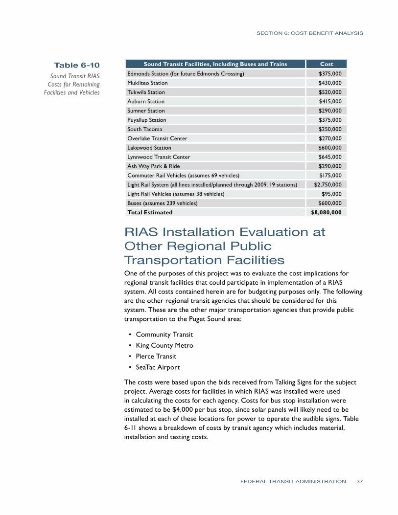
SECTION 6 COST BENEFIT ANALYSIS
Table 6-10 Sound Transit RIAS
Costs for Remaining Facilities and Vehicles
Sound Transit Facilities Including Buses and Trains Cost
Edmonds Station (for future Edmonds Crossing) $375000
Mukilteo Station $430000
Tukwila Station $520000
Auburn Station $415000
Sumner Station $290000
Puyallup Station $375000
South Tacoma $250000
Overlake Transit Center $270000
Lakewood Station $600000
Lynnwood Transit Center $645000
Ash Way Park amp Ride $290000
Commuter Rail Vehicles (assumes 69 vehicles) $175000
Light Rail System (all lines installedplanned through 2009 19 stations) $2750000
Light Rail Vehicles (assumes 38 vehicles) $95000
Buses (assumes 239 vehicles) $600000
Total Estimated $8080000
RIAS Installation Evaluation at Other Regional PublicTransportation Facilities One of the purposes of this project was to evaluate the cost implications for regional transit facilities that could participate in implementation of a RIAS system All costs contained herein are for budgeting purposes only The following are the other regional transit agencies that should be considered for this system These are the other major transportation agencies that provide public transportation to the Puget Sound area
bull Community Transit
bull King County Metro
bull Pierce Transit
bull SeaTac Airport
The costs were based upon the bids received from Talking Signs for the subject project Average costs for facilities in which RIAS was installed were used in calculating the costs for each agency Costs for bus stop installation were estimated to be $4000 per bus stop since solar panels will likely need to be installed at each of these locations for power to operate the audible signs Table 6-11 shows a breakdown of costs by transit agency which includes material installation and testing costs
FEDERAL TRANSIT ADMINISTRATION 37
SECTION 6 COST BENEFIT ANALYSIS
Table 6-11 Estimated RIAS Costs for Regional Facilities
Other Regional Facility RIAS Costs Including Buses and Bus Stops Cost
Community Transit Buses (assumes 290 vehicles) $870000
King County Metro Buses (assumes 966 vehicles) $2900000
Pierce Transit Buses (assumes 158 vehicles) $475000
Bus Stops (assumes 16930 bus stops) $67720000
Other transit facilities (park-and-ride etc) $3500000
SeaTac Airport (main concourse only) $350000
Total $75815000
The level of interest found from the agencies contacted was low The only transit agency that was interested in installing a RIAS system was Everett Transit a small local transit system The main reason for the lack of interest seems to be a combination of both the cost benefit of the system and current budget issues because of recent economic downturns Another factor is that all three of these transit systems are currently involved in the replacement of Computer Aided DispatchAutomatic Vehicle Location (CADAVL) and Radio systems which are very large investments that also occupy the agency staffs during the installations and immediately after during the preliminary operation period
The RIAS technology was also introduced to the other regional transit agencies who were asked about their ability to fund the implementation of this technology Based upon the cost information and the regional agenciesrsquo level of interest and ability to fund the RIAS system the feasibility of regional implementation is low at this time It is likely more funds will be available in the near future as more government funding becomes available however the cost benefit will be a factor for these transit agencies in determining implementation as well
Results of the Analysis This trend is expected to continue and grow over the years Both GPS-based solutions and Talking Lights appear to be following this trend for their systems while Talking Signs and Step-Hear are more focused on item identification rather than locating the traveler and providing directions based upon the travelerrsquos location Regardless of which wayfinding system is used there appears to be some cost savings in operation of an agencyrsquos paratransit system
There are many benefits that travelers who are blind or who have visual or cognitive disabilities will experience in using a wayfinding system integrated into a public transportation environment The Talking Signs or RIAS system has been shown to be a system that provides many of these benefits Based upon the analysis completed however there are two main drawbacks in implementing the Talking Signs system The first is that it appears to be more costly when compared with other wayfinding system costs obtained This may change as more installations begin to occur however another way for this to change is for competition to drive market prices The second is that the current development
FEDERAL TRANSIT ADMINISTRATION 38
SECTION 6 COST BENEFIT ANALYSIS
trend for wayfinding systems is not in developing systems for item identification which is the focus of a Talking Signs system This current trend is towards systems that determine the position of the traveler and then access pre-defined locations in a database to calculate step-by-step paths
At this time there is not another system on the market that is at the same proven level of effectiveness for persons who are blind or who have visual impairments or disabilities as Talking Signs although with further evaluation of the Talking Lights and Step-Hear systems along with GPS-based solutions these other solutions could be brought into the picture There is enough information obtained from this analysis to justify the consideration of using other systems at least integrated with Talking Signs from both a cost and current technology trend perspective
GPS-based systems have been tested in the past in downtown areas with ineffective outcomes alongside Talking Signs because of the systemrsquos early dependence on satellites only Current GPS technologies are more accurate in these same areas and deserve structured tests to gain a better idea of the possibilities of the integration of these technologies
From this analysis it appears that the best least-cost option for a wayfinding solution outdoors would be to use a GPS-based solution integrated with a database containing transit points of interest that can be accessed either remotely or stored locally on a smartphone or other receiver combined with a Talking Lights system for indoor navigation One of the keys to this solution is that it would be of benefit to every traveler including those with visual and cognitive disabilities
Funding for this type of system could potentially be greater since it would directly benefit all riders and could increase overall ridership For indoor applications Talking Signs Talking Lights and Step-Hear are good solutions with Talking Lights and Step-Hear appearing to have the cost advantage over Talking Signs For bus applications either Talking Signs or Step-Hear would be good solutions with Step-Hear having the cost advantage Overall more cost information and analysis of GPS-based Talking Lights and Step-Hear systems is necessary to determine which system has the clear cost and performance advantage and provides an effective system that helps minimize future implementation risks A considerable amount of funding will be necessary to build out the RIAS system and steps should be taken to ensure that a cost-effective system that will provide a good long-term solution is implemented These steps would include further evaluation and comparison of other technologies through analysis of system costs and performance
FEDERAL TRANSIT ADMINISTRATION 39
SECTION
7SECTION
7 Recommendations
The following are the recommendations for Sound Transit regarding expanding the RIAS system further The main goal for these recommendations is to provide Sound Transit with the next steps that should be taken to implement a fully-functioning wayfinding system throughout its transit network Another goal of these recommendations is to preserve the investment Sound Transit has made in hardware as well as Sound Transit staff and consultant time
bull Begin the next phase of the RIAS MAP to continue build-out of the system and to further evaluate the RIAS system
bull Include funding for evaluation of the RIAS system along with other wayfinding systems
bull Invite other wayfinding systems that are available for people with visual or cognitive disabilities to participate in system demonstrations and in providing bids for implementation of their system for Sound Transit
bull Further evaluate Step-Hear and Talking Lights existing installations as well as other similar systems that are installed at the time of the evaluation Conduct additional research on these systems
bull Further evaluate the effectiveness and costs in using a GPS-based solution for outdoor navigation in combination with Talking Signs Talking Lights or Step-Hear for indoor and bus applications
bull Use the efforts King County Metro has made to create a data extraction process for its schedule and bus stop locations using Google Transit or the regional Trip Planner system
bull Consider use of the Google Time Table Publisher open interface and database for the Google Transit Planner
bull Further determine overall public interest in using a wayfinding system to assist in determining potential funds for expanding the system
bull Expand the wayfinding system once evaluations are complete and funding is in place
FEDERAL TRANSIT ADMINISTRATION 40
References
REFERENCES
Bentzen B L Crandall W and Myers L 1997 ldquoUse of Remote Infrared Signage in a Complex Transit Station by Persons with Developmental Delays or Dyslexiardquo Journal of Visual Impairment and Blindness 91 407ndash410
Bentzen B and Mitchell P 1995 ldquoAudible Signage as a Wayfinding Aid Comparison of Verbal Landmarks and Talking Signsrdquo Journal of Visual Impairment and Blindness
Brabyn J A and Brabyn L A 1982 ldquoSpeech intelligibility of the Talking Signsrdquo Journal of Visual Impairment and Blindness 76 77ndash-78
Brabyn J A and Brabyn L A ldquoAn Evaluation of lsquoTalking Signsrsquo for the Blindrdquo Human Factors 25(1) 49ndash53
Crandall W Bentzen B Myers L and Steed D 1995 ldquoTalking Signs Remote Infrared Signage A Guide for Transit System Managersrdquo Project ACTION of the National Easter Seal Society
Crandall W Bentzen B Myers L and Mitchell P 1995 ldquoTalking Signs Remote Infrared Signage A Guide for Transit System Managersrdquo Project ACTION of the National Easter Seal Society
Crandall W Bentzen B L Myers L and Mitchell P 1995 ldquoTransit Accessibility Improvement through Talking Signsreg Remote Infrared Signage A Demonstration and Evaluationrdquo Federal Transit Administration and Project ACTION of the National Easter Seal Society
Crandall W Bentzen B Rosen S and Mitchell P 1994 ldquoInfrared Remote Signage for the Blind and Print Handicapped An Orientation and Mobility Studyrdquo Final Report National Easter Seal Research Program
Hidalgo amp De Vries 2009 ldquoFederal Transit Administration Remote Infrared Audible Signage (RIAS) Model Accessibility Program (MAP) Human Factors Testing amp Evaluation Final Reportrdquo Federal Transit Administration Report Number FTA-MI-26-7909
Loomis J M Golledge R G Klatzky R L and Marston J R 2007 ldquoAssisting Wayfinding in Visually Impaired Travelersrdquo In G L Allen (Ed) Applied Spatial Cognition From Research to Cognitive Technology Mahwah NJ Lawrence Erlbaum Associates
Marston J R 2002 ldquoTowards And Accessible City Empirical Measurement and Modeling of Access to Urban Opportunities for Those with Vision Impairments Using Remote Infrared Audible Signagerdquo Doctoral dissertation University of California Santa Barbara
Marston J R and Golledge R G 2000 ldquoTowards an Accessible City Removing Functional Barriers to Independent Travel for Blind and Vision-Impaired A Case for Auditory Signsrdquo Final Report UCTC 65V430 University of California Berkley University of California Transportation Center
National Transit Database 2007 Transit Agency Profiles httpwwwntdprogramgovntdprogrampubsprofiles2007agency_ profiles
Step-Hear 2008 Request for Information e-mail communication
Talking Lights 2008 Request for Information e-mail and phone communication
Talking_Lights_LLC 2009 Talking Lights httpwwwtalking-lightscom
Talking_Signs_Inc (2009) Talking Signs httpwwwtalkingsignscom
United States Census Bureau 2006 American Community Survey httpfactfindercensusgov
United States Census bureau 2008 Population Estimates by County httpwwwcensusgovpopestcounties
FEDERAL TRANSIT ADMINISTRATION 41
APPENDIX Diagram of Typical Installation
FEDERAL TRANSIT ADMINISTRATION 42
FEDERAL TRANSIT ADMINISTRATION 128
US Department of TransportationFederal Transit AdministrationEast Building1200 New Jersey Avenue SEWashington DC 20590httpwwwftadotgovresearch
US Department of Transportation Federal Transit Administration East Building 1200 New Jersey Avenue SE Washington DC 20590 httpwwwftadotgovresearch
- Button1
- Button2
- Button3
- Button4
- Button5
- Button6
- Button7
- Button8
- Button9
- Button10
- Button13
- Button14
- Button15
- Button16
- Button17
- Button18
- Button19
- Button20
- Button21
- Button22
- Button23
- Button24
- Button25
- Button26
- Button27
- Button28
- Button29
- Button30
- Button31
- Button32
- Button33
- Button34
- Button35
- Button36
- Button37
- Button38
- Button39
- Button40
- Button41
- Button42
- Button43
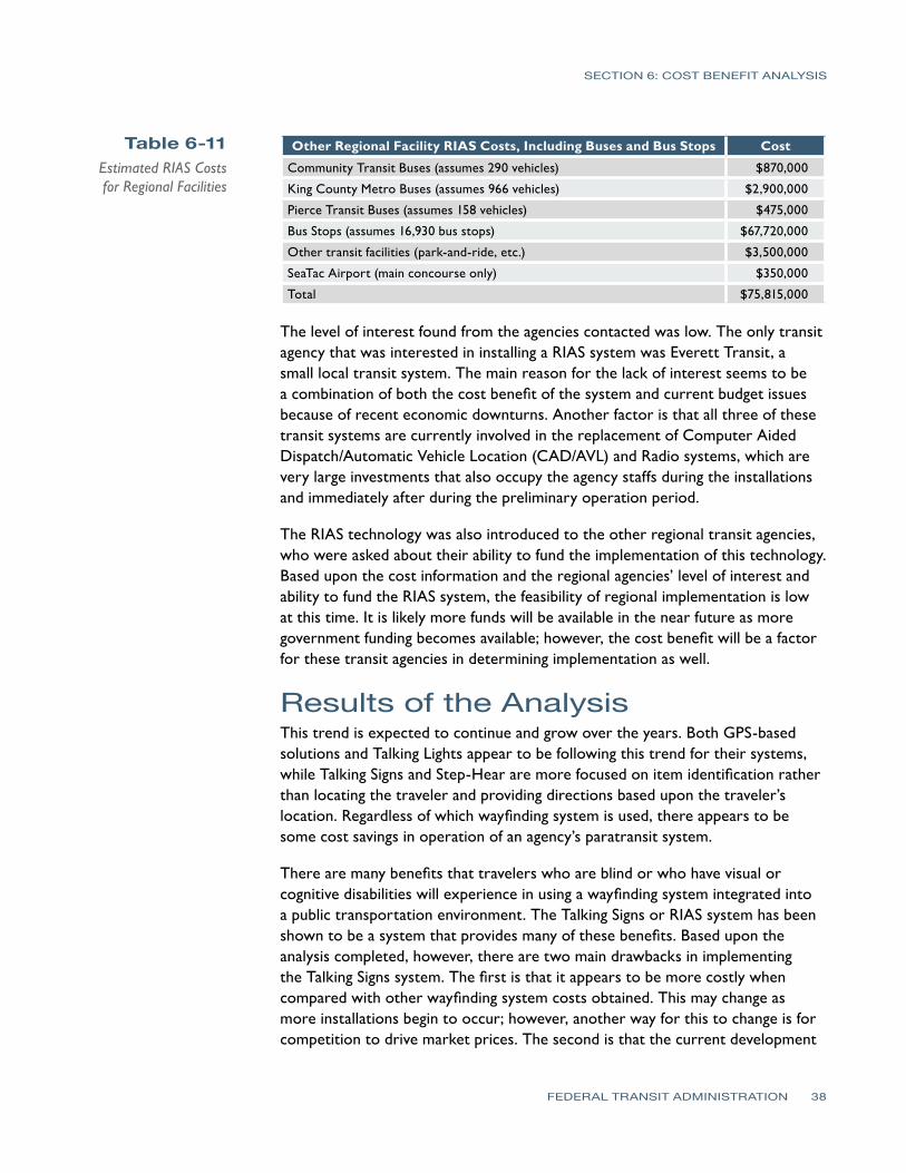
SECTION 6 COST BENEFIT ANALYSIS
Table 6-11 Estimated RIAS Costs for Regional Facilities
Other Regional Facility RIAS Costs Including Buses and Bus Stops Cost
Community Transit Buses (assumes 290 vehicles) $870000
King County Metro Buses (assumes 966 vehicles) $2900000
Pierce Transit Buses (assumes 158 vehicles) $475000
Bus Stops (assumes 16930 bus stops) $67720000
Other transit facilities (park-and-ride etc) $3500000
SeaTac Airport (main concourse only) $350000
Total $75815000
The level of interest found from the agencies contacted was low The only transit agency that was interested in installing a RIAS system was Everett Transit a small local transit system The main reason for the lack of interest seems to be a combination of both the cost benefit of the system and current budget issues because of recent economic downturns Another factor is that all three of these transit systems are currently involved in the replacement of Computer Aided DispatchAutomatic Vehicle Location (CADAVL) and Radio systems which are very large investments that also occupy the agency staffs during the installations and immediately after during the preliminary operation period
The RIAS technology was also introduced to the other regional transit agencies who were asked about their ability to fund the implementation of this technology Based upon the cost information and the regional agenciesrsquo level of interest and ability to fund the RIAS system the feasibility of regional implementation is low at this time It is likely more funds will be available in the near future as more government funding becomes available however the cost benefit will be a factor for these transit agencies in determining implementation as well
Results of the Analysis This trend is expected to continue and grow over the years Both GPS-based solutions and Talking Lights appear to be following this trend for their systems while Talking Signs and Step-Hear are more focused on item identification rather than locating the traveler and providing directions based upon the travelerrsquos location Regardless of which wayfinding system is used there appears to be some cost savings in operation of an agencyrsquos paratransit system
There are many benefits that travelers who are blind or who have visual or cognitive disabilities will experience in using a wayfinding system integrated into a public transportation environment The Talking Signs or RIAS system has been shown to be a system that provides many of these benefits Based upon the analysis completed however there are two main drawbacks in implementing the Talking Signs system The first is that it appears to be more costly when compared with other wayfinding system costs obtained This may change as more installations begin to occur however another way for this to change is for competition to drive market prices The second is that the current development
FEDERAL TRANSIT ADMINISTRATION 38
SECTION 6 COST BENEFIT ANALYSIS
trend for wayfinding systems is not in developing systems for item identification which is the focus of a Talking Signs system This current trend is towards systems that determine the position of the traveler and then access pre-defined locations in a database to calculate step-by-step paths
At this time there is not another system on the market that is at the same proven level of effectiveness for persons who are blind or who have visual impairments or disabilities as Talking Signs although with further evaluation of the Talking Lights and Step-Hear systems along with GPS-based solutions these other solutions could be brought into the picture There is enough information obtained from this analysis to justify the consideration of using other systems at least integrated with Talking Signs from both a cost and current technology trend perspective
GPS-based systems have been tested in the past in downtown areas with ineffective outcomes alongside Talking Signs because of the systemrsquos early dependence on satellites only Current GPS technologies are more accurate in these same areas and deserve structured tests to gain a better idea of the possibilities of the integration of these technologies
From this analysis it appears that the best least-cost option for a wayfinding solution outdoors would be to use a GPS-based solution integrated with a database containing transit points of interest that can be accessed either remotely or stored locally on a smartphone or other receiver combined with a Talking Lights system for indoor navigation One of the keys to this solution is that it would be of benefit to every traveler including those with visual and cognitive disabilities
Funding for this type of system could potentially be greater since it would directly benefit all riders and could increase overall ridership For indoor applications Talking Signs Talking Lights and Step-Hear are good solutions with Talking Lights and Step-Hear appearing to have the cost advantage over Talking Signs For bus applications either Talking Signs or Step-Hear would be good solutions with Step-Hear having the cost advantage Overall more cost information and analysis of GPS-based Talking Lights and Step-Hear systems is necessary to determine which system has the clear cost and performance advantage and provides an effective system that helps minimize future implementation risks A considerable amount of funding will be necessary to build out the RIAS system and steps should be taken to ensure that a cost-effective system that will provide a good long-term solution is implemented These steps would include further evaluation and comparison of other technologies through analysis of system costs and performance
FEDERAL TRANSIT ADMINISTRATION 39
SECTION
7SECTION
7 Recommendations
The following are the recommendations for Sound Transit regarding expanding the RIAS system further The main goal for these recommendations is to provide Sound Transit with the next steps that should be taken to implement a fully-functioning wayfinding system throughout its transit network Another goal of these recommendations is to preserve the investment Sound Transit has made in hardware as well as Sound Transit staff and consultant time
bull Begin the next phase of the RIAS MAP to continue build-out of the system and to further evaluate the RIAS system
bull Include funding for evaluation of the RIAS system along with other wayfinding systems
bull Invite other wayfinding systems that are available for people with visual or cognitive disabilities to participate in system demonstrations and in providing bids for implementation of their system for Sound Transit
bull Further evaluate Step-Hear and Talking Lights existing installations as well as other similar systems that are installed at the time of the evaluation Conduct additional research on these systems
bull Further evaluate the effectiveness and costs in using a GPS-based solution for outdoor navigation in combination with Talking Signs Talking Lights or Step-Hear for indoor and bus applications
bull Use the efforts King County Metro has made to create a data extraction process for its schedule and bus stop locations using Google Transit or the regional Trip Planner system
bull Consider use of the Google Time Table Publisher open interface and database for the Google Transit Planner
bull Further determine overall public interest in using a wayfinding system to assist in determining potential funds for expanding the system
bull Expand the wayfinding system once evaluations are complete and funding is in place
FEDERAL TRANSIT ADMINISTRATION 40
References
REFERENCES
Bentzen B L Crandall W and Myers L 1997 ldquoUse of Remote Infrared Signage in a Complex Transit Station by Persons with Developmental Delays or Dyslexiardquo Journal of Visual Impairment and Blindness 91 407ndash410
Bentzen B and Mitchell P 1995 ldquoAudible Signage as a Wayfinding Aid Comparison of Verbal Landmarks and Talking Signsrdquo Journal of Visual Impairment and Blindness
Brabyn J A and Brabyn L A 1982 ldquoSpeech intelligibility of the Talking Signsrdquo Journal of Visual Impairment and Blindness 76 77ndash-78
Brabyn J A and Brabyn L A ldquoAn Evaluation of lsquoTalking Signsrsquo for the Blindrdquo Human Factors 25(1) 49ndash53
Crandall W Bentzen B Myers L and Steed D 1995 ldquoTalking Signs Remote Infrared Signage A Guide for Transit System Managersrdquo Project ACTION of the National Easter Seal Society
Crandall W Bentzen B Myers L and Mitchell P 1995 ldquoTalking Signs Remote Infrared Signage A Guide for Transit System Managersrdquo Project ACTION of the National Easter Seal Society
Crandall W Bentzen B L Myers L and Mitchell P 1995 ldquoTransit Accessibility Improvement through Talking Signsreg Remote Infrared Signage A Demonstration and Evaluationrdquo Federal Transit Administration and Project ACTION of the National Easter Seal Society
Crandall W Bentzen B Rosen S and Mitchell P 1994 ldquoInfrared Remote Signage for the Blind and Print Handicapped An Orientation and Mobility Studyrdquo Final Report National Easter Seal Research Program
Hidalgo amp De Vries 2009 ldquoFederal Transit Administration Remote Infrared Audible Signage (RIAS) Model Accessibility Program (MAP) Human Factors Testing amp Evaluation Final Reportrdquo Federal Transit Administration Report Number FTA-MI-26-7909
Loomis J M Golledge R G Klatzky R L and Marston J R 2007 ldquoAssisting Wayfinding in Visually Impaired Travelersrdquo In G L Allen (Ed) Applied Spatial Cognition From Research to Cognitive Technology Mahwah NJ Lawrence Erlbaum Associates
Marston J R 2002 ldquoTowards And Accessible City Empirical Measurement and Modeling of Access to Urban Opportunities for Those with Vision Impairments Using Remote Infrared Audible Signagerdquo Doctoral dissertation University of California Santa Barbara
Marston J R and Golledge R G 2000 ldquoTowards an Accessible City Removing Functional Barriers to Independent Travel for Blind and Vision-Impaired A Case for Auditory Signsrdquo Final Report UCTC 65V430 University of California Berkley University of California Transportation Center
National Transit Database 2007 Transit Agency Profiles httpwwwntdprogramgovntdprogrampubsprofiles2007agency_ profiles
Step-Hear 2008 Request for Information e-mail communication
Talking Lights 2008 Request for Information e-mail and phone communication
Talking_Lights_LLC 2009 Talking Lights httpwwwtalking-lightscom
Talking_Signs_Inc (2009) Talking Signs httpwwwtalkingsignscom
United States Census Bureau 2006 American Community Survey httpfactfindercensusgov
United States Census bureau 2008 Population Estimates by County httpwwwcensusgovpopestcounties
FEDERAL TRANSIT ADMINISTRATION 41
APPENDIX Diagram of Typical Installation
FEDERAL TRANSIT ADMINISTRATION 42
FEDERAL TRANSIT ADMINISTRATION 128
US Department of TransportationFederal Transit AdministrationEast Building1200 New Jersey Avenue SEWashington DC 20590httpwwwftadotgovresearch
US Department of Transportation Federal Transit Administration East Building 1200 New Jersey Avenue SE Washington DC 20590 httpwwwftadotgovresearch
- Button1
- Button2
- Button3
- Button4
- Button5
- Button6
- Button7
- Button8
- Button9
- Button10
- Button13
- Button14
- Button15
- Button16
- Button17
- Button18
- Button19
- Button20
- Button21
- Button22
- Button23
- Button24
- Button25
- Button26
- Button27
- Button28
- Button29
- Button30
- Button31
- Button32
- Button33
- Button34
- Button35
- Button36
- Button37
- Button38
- Button39
- Button40
- Button41
- Button42
- Button43
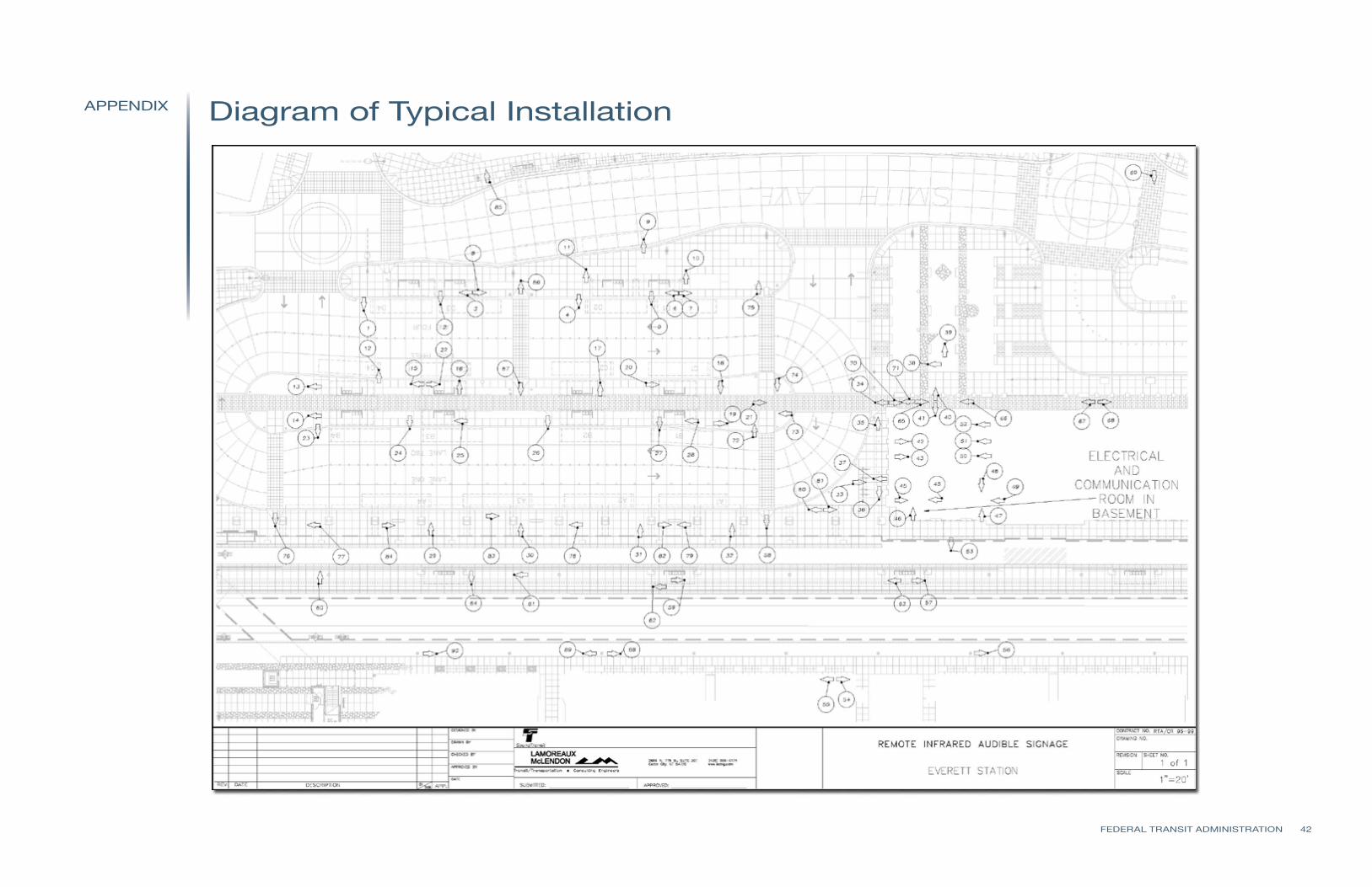