renewable energy - loch lomond and the trossachs … · contents planning guidance eneae ene 5 1....
TRANSCRIPT

Renewable Energy
Planning Guidance

Contents Planning Guidance | Renewable Energy 2
Contents
1 Introduction ...................................................................................................................................................................... 5
2 Summary - Renewable Energy Development in Loch Lomond & The Trossachs National Park ........ 8
Special qualities.................................................................................................................................................................. 8
Planning considerations – hydro, wind and biomass ................................................................................................ 8
Cultural and Historic Environment ..............................................................................................................................10
Recreation and Access ..................................................................................................................................................15
Summary of renewable energy potential .................................................................................................................15
3 Planning Application Process ...................................................................................................................................16
Pre-application discussions, Environmental Impact Assessment (EIA) screening and scoping ...............16
Planning application and the decision-making process ........................................................................................16
Other consenting regimes ...........................................................................................................................................20 n Controlled Activity Regulations (CAR) licensing ............................................................................................20 n Scottish Natural Heritage licensing ...................................................................................................................21 n Forestry Commission licensing ..........................................................................................................................21 n Waste Management licensing ............................................................................................................................21 n Marine Scotland .....................................................................................................................................................21 n Abnormal Load Routing .......................................................................................................................................21 n Grid connection .....................................................................................................................................................21
4 Hydro ..............................................................................................................................................................................23
Technical feasibility and scope ....................................................................................................................................23
Locational guidance .......................................................................................................................................................26
Planning considerations – Introduction .....................................................................................................................29
Natural heritage considerations ..................................................................................................................................29
Landscape and visual impact considerations ..........................................................................................................31
Assessing cumulative impacts ...................................................................................................................................32
Hydro topic advice...........................................................................................................................................................33
5 Wind ..............................................................................................................................................................................34
Technical feasibility and scope ....................................................................................................................................34
Locational guidance .......................................................................................................................................................34
Wind energy development outside the National Park ...........................................................................................35
Wind planning considerations – Introduction ..........................................................................................................35
Landscape & visual impact considerations ..............................................................................................................36 n Landscape and visual impact assessment .....................................................................................................36 n Landscape character assessment ...................................................................................................................36 n Siting considerations, sensitivities and examples .........................................................................................36 n Landscape scenario – Development potential illustrations .......................................................................39 n Assessing the cumulative impacts ...................................................................................................................43
Natural heritage considerations ..................................................................................................................................44
Wind topic advice ............................................................................................................................................................46

Contents Planning Guidance | Renewable Energy 3
6 Biomass.............................................................................................................................................................................48
Technical feasibility and scope ....................................................................................................................................48
Locational guidance .......................................................................................................................................................49
Biomass planning considerations - Introduction ....................................................................................................49
Natural heritage considerations ..................................................................................................................................50
n Woodland management ......................................................................................................................................50
Landscape and visual impact considerations ..........................................................................................................50
Assessing cumulative impacts ....................................................................................................................................51
Biomass topic advice ......................................................................................................................................................51
Appendices
1 Glossary .............................................................................................................................................................................54
2 Abbreviations ...................................................................................................................................................................55
3 National Park natural heritage designations ............................................................................................................56
4 References and websites ..............................................................................................................................................57
5 Hydro power assessment methodology ..................................................................................................................62
6 Contacts ...........................................................................................................................................................................64
7 Wind developments outwith the National Park .......................................................................................................67
8 Best practice & mitigation measures for renewables in LLTNPA .......................................................................72

Contents Planning Guidance | Renewable Energy 4
List of maps, tables and figures
MAPs Page
1 Relative wildness ...................................................................................................................................................................9
2 Natural heritage designations ........................................................................................................................................ 11
3 Cultural and built heritage designations ....................................................................................................................... 13
4 Designed Landscapes ...................................................................................................................................................... 14
5 Electricity grid network ..................................................................................................................................................... 22
6 Approved and completed hydro schemes (January 2013) ..................................................................................... 24
7 Technical assessment of potential run-of-river hydro power schemes with installed capacity between 15kw and 2MW ........................................................................................................ 27
8 Technical assessment of potential run-of-river hydro power schemes with installed capacity of greater than 50kw ............................................................................................................... 28
tABLes
1 Main permissions and licenses required for renewable energy developments ....................................................6
2 Renewable energy pre-application process ............................................................................................................... 18
3 Renewable energy planning application and decision-making process .............................................................. 20
4 A list of species which should be considered in relation to run-of-river hydro developments in the National Park ............................................................................................................................... 30
5 A list of species which should be considered in relation to wind developments in the National Park .......................................................................................................................................................... 45
6 Biomass cumulative Impacts .......................................................................................................................................... 51
FIGURes
1.1 Pre-applicationandplanningapplicationprocess:Summaryflowchart ............................................................. 17
2.1 Main components of a run-of-river hydro scheme under construction ............................................................. 25
2.2 Main components of an operational run-of-river hydro scheme .......................................................................... 26
3.1 Wind turbine related to existing development ........................................................................................................... 37
3.2 Wind turbine related to existing farm steading .......................................................................................................... 37
3.3 Wind turbine related to existing development ........................................................................................................... 37
3.4 Wind turbine not related to existing development .................................................................................................... 37
3.5 Wind turbines on loch shore ............................................................................................................................................ 37
3.6 Wind turbines on prominent hill ...................................................................................................................................... 38
3.7 Wind turbines on prominent ridge ................................................................................................................................. 38
3.8 Positive scenario inland loch shore................................................................................................................................ 39
3.9 Negative scenario inland loch shore ............................................................................................................................. 40
3.10 Positive scenario coastal sea loch shore ..................................................................................................................... 40
3.11 Negative scenario coastal sea loch shore ................................................................................................................... 41
3.12 Positive scenario edge of settlement ........................................................................................................................... 42
3.13 Negative scenario edge of settlement ........................................................................................................................ 42
3.14 Positive cumulative example ........................................................................................................................................... 43
3.15 Negative cumulative impact ........................................................................................................................................... 43

Contents Planning Guidance | Renewable Energy 5
1. Introduction
1.1 The Local Development Plan’s renewable energy policies set out criteria for wind, hydro energy projects and biomass and biogas energy (heat and power) within the National Park. This planning guidance is an updated version of previously adopted supplementary guidance originally adopted in June 2013. It focuses on three main technologies – hydro, wind and biomass – and provides:
i. A spatial framework including guidance on appropriate locations, types and scales of development within the National Park.
ii. Specificconsiderationsandgoodpracticethatshouldbetakenintoaccountwhenpreparingaproposal; and
iii. The recommended procedure for submitting a planning application.
1.2 This planning guidance seeks to provide detailed guidance and information upfront to ensure that applicants are clear on our requirements throughout the planning application process. It sets out a summary of typical key considerations then includes a section on each technology. Best practice advice, including mitigation measures, are included as an appendix.
1.3 Compliance with this guidance and the Local Development Plan’s renewable energy policies, does not remove the need to comply with policies in other sections of the Local Development Plan. This guidance should be read in conjunction with the Plan. It is a material planning consideration in determining planning applications.
1.4 The approach of this guidance is to focus on providing additional information that will assist applicants in progressing an application for a renewable energy development in the National Park. It does not seek to repeat information, policies or guidance available in other National Park, Scottish Government or Government Agency (Scottish Environmental Protection Agency (SEPA), Scottish Natural Heritage (SNH), Historic Environment Scotland) documents, however will reference or signpost to them. It is written for an audience with at least a basic knowledge of the three technologies. A glossary can be found in Appendix 1.
Local Development Plan
n Planning & Development In the national Parkn Development strategyn enabling & Management Policies
Planning Guidance
n Key sensitivities, standardsn technical Feasibility & scopen Locational Guidancen natural & Built Heritage Considerationsn Process Advice – links to other regulatory regimes
Best Practice & Mitigation Measures (Appendix 8)
n Hydro n Wind n Biomass

Contents Planning Guidance | Renewable Energy 6
1.5 The regulation of renewable energy is undertaken by a number of organisations 1 . The main consenting organisations are Local Planning Authorities such as NPA, Scottish Environmental Protection Agency (SEPA), and the Scottish Government. As a local planning authority the NPA determines hydro, wind and biomass energy proposals up to 50MW and all heat-only biomass proposals. Above this threshold the NPA is a statutory consultee and the Scottish Government determines the application.
1.6 A summary of the main regulatory regimes is outlined below in Table 1 and further information can be found below in paragraphs 3.8 to 3.14. Where there is a key link between these regimes, within a particular stage in the planning process, it is highlighted in the table.
Table 1 Main permissions and licenses required for renewable energy developments
Technology Planning Authority
Scottish Government s.36 electricity Act 1989
SEPA Controlled Activity Regulations (CAR) and Pollution Prevention & Control (PPC)
SNH Forestry Commission
Local Authorities (e.g. West Dunbartonshire Council)
Determination
Hydro <50 MW generating capacity
> 50MW generating capacity
Water abstraction and river engineering works (CAR)
Waste management
Licenses for protected species
Felling licenses and associated environmental impact assessments
Wind <50MW generating capacity
> 50MW generating capacity
Any associated river engineering works (CAR)
Licenses for protected species
Felling licenses and associated environmental impact assessments
Biomass Heat only and < 50MW generating capacity
> 50MW generating capacity
Any associated river engineering works (CAR) and PPC for biomass boiler and CHP plant
Licenses for protected species
Felling licenses and associated environmental impact assessments
smoke Control exemptions – Balloch only (Clean Air Act)
1 see Appendix 6: Contacts for other consenting bodies

Contents Planning Guidance | Renewable Energy 7
1.7 support or advice for communities within the National Park area who are seeking to develop a renewable energyschemecanbefoundacrossanumberofdifferentagencies.Alistofusefulorganisations,contacts and websites can be found in Appendix 6 of this guidance.
1.8 Scottish Government published the 2020 Road Map for Renewable energy in 2011, which was updated in October 2012. This document provides a target of up to 100% of electricity and 11% of all heat in Scotland to be generated through renewable energy sources by 2020.
1.9 The National Park’s Partnership Plan, setsouttheapproachtomanagingtheNationalPark,reflectingthe special qualities, challenges and opportunities. The principles set out in this and Cairngorm National Park’sPartnershipPlanrecognisesthesignificantroletheParkshaveinmitigatingandadaptingtoclimatechange, including appropriate and sensitive renewable energy development.
1.10 The policies in the Partnership Plan are also a material consideration in determining applications or responding to consultations.
1.11 Wind, hydro and biomass are presently the technologies from which there is most demand within the National Park and it is envisaged there will be an increase in demand for these types of development over the immediate future. This is therefore the focus for this guidance. other technologies could provide renewable energy generation (heat and power) within the National Park to support households, communities and businesses energy needs, potentially assisting in contributing to the Scottish Government’s renewable energy targets and the transition towards a low carbon economy. Further guidance will be prepared on micro renewable energy as part of sustainability supplementary planning guidance. This Planning Guidance will be monitored and reviewed or updated as required. Information, as well as examples of best practice will be placed in our Local Development Plan pages on the National Park website. This will include updates on consented and operational schemes.

Contents Planning Guidance | Renewable Energy 8
2. Summary Renewable Energy Development in the National Park
Special qualities
2.1 The National Park has been designated on account of its unique natural and built heritage. These are known as special qualities. Safeguarding and enhancing the special qualities of the National Park is central to implementing the Local Development Plan and the Park Partnership Plan. Further, they are central to the visitor experience of the National Park, key in supporting tourism based economic activity and are incorporated within the Park’s statutory aims to promote understanding and enjoyment of them, including enjoyment in the form of recreation.
2.2 Below is a summary of key planning considerations in relation to renewable energy development in the NationalPark,althoughindividualproposalsmayraiseothersignificantconsiderationsdependingonthescale and location. A full outline of relevant considerations is outlined within the individual sections on each technology (sections 4 to 6), however those matters applicable to all are summarised below, including landscape character, wild land, biodiversity, cultural and historic environment and recreation and access.
Planning considerations – Hydro, wind and biomass
2.3 The landscape character of the National Park is sensitive to new development and typically forms the most important consideration in assessing development proposals both within, and visible from the Park. Landscape values were one of the founding reasons for establishing the National Park designation. All proposals will require as a minimum a landscape appraisal, the extent of which can be discussed with the NationalParkplanningandspecialiststaff.Alandscapeclerkofworksmayberequiredforvariousstagesduring and after construction.
2.4 Wild land characteristics are an important special quality within the National Park with many visitors seeking to experience these characteristics. A Relative Wildness study of the National Park (LLTNPA & SNH), undertaken in 2011 describes the attributes of wild land including: perceived naturalness of land cover, absence of modern human artefacts, rugged and challenging nature of terrain, and remoteness. ThestudyidentifiesandmapsthegeographicalextentandintensityofwildnesswithintheNationalPark.Generally the wilder areas (“Core Wildness”) are located within the less accessible areas of the mountain core and associated glens and corries as shown in Map 1 on 9. The National Park Partnership Plan states that priority will be given to protecting these core areas of wild land character. These areas will therefore be safeguarded from development which may detract from their relative wildness. Relative wildness is differentfromwildlandasdefinedbyScottishNaturalHeritage2014wildlandareas,shownonMap1alongside areas of relative wildness. SNH have published guidance on assessing impacts on wild land areas which can be found on their website.

Contents Planning Guidance | Renewable Energy 9
Map 1 Relative wildness and SNH Wild Land

Contents Planning Guidance | Renewable Energy 10
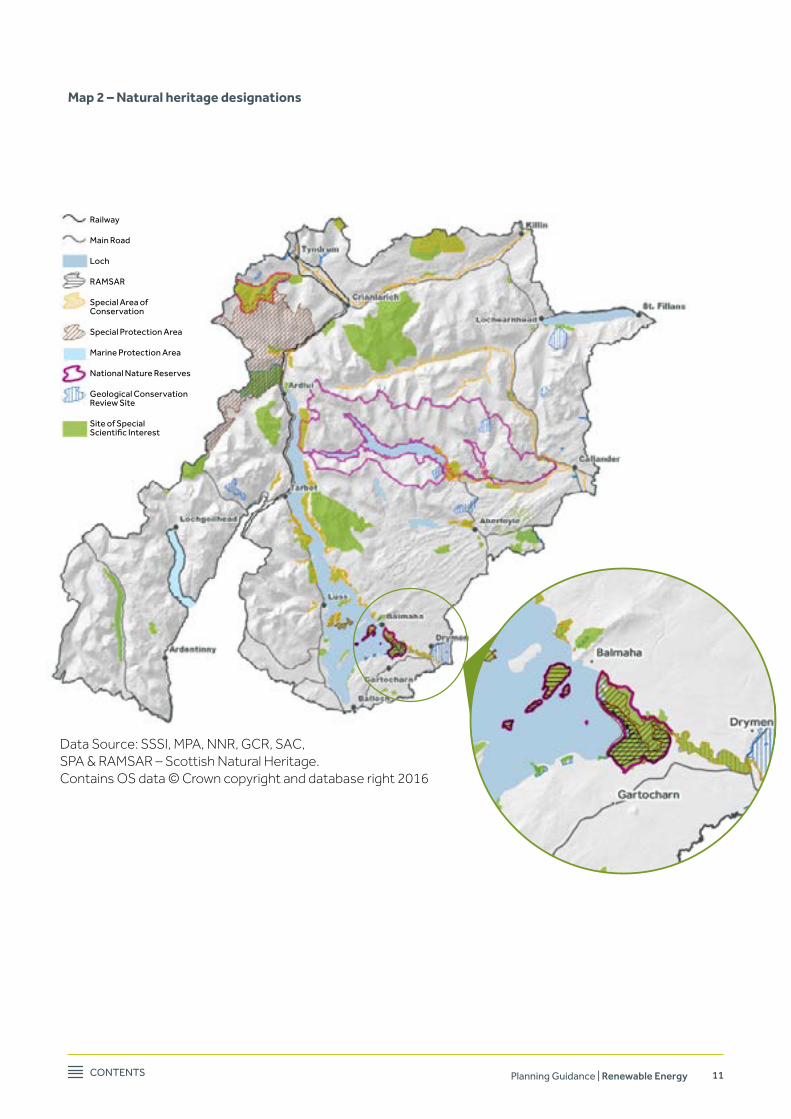
2.5 The National Park has a rich and varied wildlife, biodiversity is a major component of the Park’s natural heritage. The National Park is host to numerous habitats and species protected under European and domestic legislation (see Appendix 3). european Protected Habitats and species are given the highest level of protection under the Conservation (Natural Habitats etc) Regulations, which implements the Habitats Directive. These sites include Special Areas of Conservation (SAC) and Special Protection Areas (SPA), such as the Rivers Teith, Tay and Endrick Mouth which, along with their tributaries, cover a large areaoftheNationalPark.These,alongwithotherdesignatedsitessuchasSitesofSpecialScientificInterest (SSSI), are shown in Map 2.
2.6 Anyproposalwillneedtoensurethatitdoesnotresultinasignificantadverseeffectonprotectedspecies (e.g. bats and otters) or habitats (e.g. western acidic oak woodland). It is likely that most proposals will need to be accompanied by an initial ecological survey and an Ecological Clerk of Works (ECoW) may be required during the construction. Where a proposal is located within an SAC or SPA, or has the potential to negatively impact on the qualifying interests of one of these designated sites, a Habitats Regulation Appraisal (HRA) will be undertaken by the NPA and SEPA where required, to ensure there will be no negative impact on the integrity of the site. Information for the assessment should be provided by the developer.
Information on designated sites and their qualifying features can be found on SNH’s sitelink website.
Cultural and historic environment
2.7 The National Park has a rich cultural and historic environment2 (see Map 3 “Cultural and built heritage designations” and Map 4“DesignedLandscapes”).Thesespecialcharacteristicscontributesignificantlyto the special sense of place within the Park. The assets include historic and listed buildings, conservation areas, scheduled ancient monuments, archaeological remains, historic gardens and designed landscapes. Furthermore, underneath the ground there is a wealth of archaeological remains waiting to be explored.
2.8 Renewable energy schemes may impact on the cultural and historic environment depending on their locationandsize.Itmaybeappropriatetoaltersitelocation,orincludebufferareas.Impactsonthecultural and historic environment, can be both direct and indirect:
n Direct – construction works in an area of archaeological sensitivity can cause irreversible damage to valuable irreplaceable assets;
n Indirect –thedevelopmentofrenewableenergyinfrastructurecanhaveasignificantimpactonthesetting of important historic features within the landscape. This includes views from and towards the feature of interest.
2 See Appendix 1 - Glossary
Contents Planning Guidance | Renewable Energy 11
Map 2 – Natural heritage designations
Data Source: SSSI, MPA, NNR, GCR, SAC, SPA & RAMSAR – Scottish Natural Heritage. Contains OS data © Crown copyright and database right 2016
Railway
Main Road
Loch
RAMsAR
special Area of Conservation
special Protection Area
Marine Protection Area
national nature Reserves
Geological Conservation Review site
site of special Scientific Interest

Contents Planning Guidance | Renewable Energy 12
2.9 Where development is proposed that might impact on the cultural and historic environment, the developer will need to:
n Identifytheculturalandhistoricassetsthatmightbeaffected: • by searching the national Park’s sites and Monuments Record and national Monuments Record to
locate known archaeological sites, monuments and buildings; West of Scotland Archaeology Service (WoSAS) have an on-line search facility;
• information on designed landscapes can be found in the Historic Environment Scotland’s Inventory of Gardens and Designed Landscapes; The Inventory of Gardens and Designed Landscapes and Regionally Important Landscapes are shown on Map 4.
• for conservation areas (on the National Park’s website); n Definethesetting of each cultural and historic asset - the location of structures and buildings of a
schememayaffectthearchaeological,builtorculturalresourceincludingthroughitssetting; n Assesshowtheproposalislikelytoimpactonthisassetanditssetting,forexampletheeffectsof
direct impacts on sites due to land-take by tracks and ancillary structures; and n Consider the potential for previously unknown cultural heritage assetsbeingaffectedbythe
proposals, either through early discussion with WoSAS (the National Park’s Archaeology Service – see contact details in Appendix 6), or by engaging independent archaeological advice.
n WhereproposalarelikelytoaffecthistoricassetswithinthestatutoryremitofHistoricEnvironmentScotland (scheduled monuments and their setting, category A listed buildings and their setting and gardens and designed landscapes in the Inventory of the Gardens and Designed Landscapes) developers should seek early engagement with Historic Environment Scotland.
2.10 Historic Environment Scotland’s website provides guidance on managing change in the historic environment which can help minimise the impact development can have on the fabric and setting of historic assets:
Of particular relevance is the guidance note on “Managing Change In the Historic Environment: Setting”:
2.11 Also WoSAS, as the National Park’s Archaeology service, have archaeological advice and procedural guidance for developers on their website. Developers should engage with WoSAS (see contact details in Appendix 6) at the pre-application stage in order to identify and agree which key cultural heritage assets mightbeaffectedbytheproposals.
2.12 For impacts on listed buildings and conservation areas, built heritage advice can be sought from the National Park’s Built Environment Adviser (see contact details in Appendix 6).

Contents Planning Guidance | Renewable Energy 13
Map 3 Cultural and built heritage designations

Contents Planning Guidance | Renewable Energy 14
Map 4 Designed Landscape

Contents Planning Guidance | Renewable Energy 15
Recreation and access
2.13 The right of responsible access for the public is upheld by the NPA as a statutory duty along with a responsibility to safeguard resources which support it. This includes ensuring that the right of responsible access to land and open water can be exercised freely and is not avoidably impinged upon. The National Park aims also include reference to promotion of ‘enjoyment in the form of recreation’ and as with the exercisingofaccessrights,asignificantproportionofthistakesplacewithinthesameopencountryside,forests, rivers and lochs which form the resource base for renewable generation. There is therefore a careful balance to be attained between development (during all phases), protection of opportunities for outdoor recreation, and enjoyment of the National Park. Key issues for developers will include:
n Theeffectofdevelopmentonaccessibleopencountryside,pathsandtracks; n Theeffectoflandscapeandvisualeffectsonvisitorexperience(includingrecreational); n Theeffectofchangesinwaterlevelsonactivitiessuchasfishingandcanoeing;and n The potential for enhancement of recreational opportunities through additional access routes,
infrastructure and facilities.
2.14 SEPA also has a duty to consider impacts on recreation and amenity. If a proposal has the potential to impact upon recreational use additional information may be requested, for instance, on how well used a river is for canoeing, or how often a waterfall is visited. See SEPA’s website for further details.
2.15 Planning authorities are required to protect Core Paths and other important routes. New developments should therefore seek to protect existing access opportunities and where possible incorporate additional and/or enhanced access provision which links with the wider access network.
2.16 The right of access to open land should not be obstructed and where development does take place, care must be taken to place appropriate signage, install diversions (to cater for pre-existing paths and routes) and implement necessary safety measures which allow public access and recreation to continue unhindered. Further information on the National Park’s Core Path network can be found on Loch Lomond & The Trossachs National Park website.
Summary of renewable energy potential
2.17 The Local Development Plan provides support for small scale renewable energy development with a focus supporting the National Park’s communities and businesses. The aim is not to solely provide energy for ‘export’, rather sustaining communities through less expensive electricity or heat and the opportunity forraisingfundsfortheirdevelopment.‘Smallscale’canbedefinedfurtherasadevelopmentwhichhasalow impact on the landscape, natural or built heritage, rather than its generation capacity.
2.18 Intermsofwindenergy,thePartnershipPlandefineslargescalecommercialwindturbinesas“morethan1 turbine and over 30m in height”. In terms of this guidance we are interpreting this to mean small scale as likely to be (a) no more than 1 turbine and (b) any single turbine less than 30m in height (to blade tip). Above this threshold is considered large scale and is not normally supported.
2.19 NeithertheLocalDevelopmentPlannorthePartnershipPlandefine‘smallscale’forhydroorbiomassenergy developments. In terms of hydro, run of the river schemes up to 2MW are likely to provide the greatest opportunity whilst still considered to be small scale. Each application will be assessed against its impacts and these will include cumulative impacts in combination or in sequence with other developments.

Contents Planning Guidance | Renewable Energy 16
3. Planning Application Process
Pre-application discussions, EIA screening and scoping
3.1 Pre-applicationdiscussionsandliaisonwithNPAplanningofficersareencouragedinordertohelpprogress the planning application process. It can identify unsuitable proposals at an early stage and lead to better quality submissions which can be dealt with faster. At the pre-application stage a screening opinion will normally also be undertaken. A screening opinion is the process whereby the planning authority determines whether an Environmental Impact Assessment (EIA) is required.
3.2 The Environmental Impact Assessment (Scotland) Regulations 2017 specify when an EIA is required. TheNationalParkisidentifiedinSchedule2oftheregulationsasa‘sensitivearea’whichmeansthatthethreshold/criteria in the second column of Schedule 2 do not apply. This means that all renewable energy developments need to be screened to determine whether an EIA is required. An Environmental Impact Assessmentwillberequiredwherethedevelopmentisscreenedasbeinglikelytohavesignificanteffectson the environment.
3.3 IneachcaseitwillbenecessaryfortheNPAtojudgewhetherthelikelyeffectsontheenvironment,byaparticulardevelopment,withinaparticularlocationarelikelytobesignificant.IftheNPAconcludesthat an EIA is required then it is the responsibility of the applicant to prepare the EIA Report (EIA). There is no obligation for an applicant to consult with the NPA on the content of the EIA however it is highly recommended that an applicant does so by requesting a “scoping opinion”. A scoping opinion is where an applicant asks the planning authority for its formal opinion on the information to be supplied in the EIA Report. The NPA has specialised information relating to the area and can identify relevant environmental issues, constraints or concerns at the scoping stage.
3.4 Links to EIA legislation, guidance and advice, including Circular 1/2017: The Town and Country Planning (Environmental Impact Assessment) (Scotland) Regulations 2017 can be found on the Scottish Government website. Even for cases where an eIA is not required it may be useful to look at this guidance as similar information will be needed for the NPA to determine the impacts of a proposed development and this supplementary information should be submitted along with the application.
3.5 As explained in paragraph 2.6, a Habitats Regulation Appraisal (HRA) is also required where a proposal is located within an SAC or SPA, or has the potential to negatively impact on the qualifying interests of one of these designated sites.
Planning application and the decision-making process
3.6 Once the pre-application stage has been completed and any additional survey work carried out the planning application can be submitted together with the EIA Report, where required. The planning application will not necessarily be made invalid if the EIA Report does not fully comply with the scoping opinion. Notwithstanding this, during the course of considering the application further information may be requested.
3.7 A summary of the recommended process is outlined in Figure 1.1 below, with more detailed advice for the pre-application and planning application stages in Tables 2 and 3.

Contents Planning Guidance | Renewable Energy 17
APPLICANT: DEvELoP PRoPoSAL
Aim: to create understanding of types of scheme capable of securing consent and consider potential
locations
APPLICANT/ NATIoNAL PARk AuTHoRITy: PRE-APPLICATIoN DISCuSSIoNS
Aim: to secure initial view from national Park Authority on proposed development
APPLICANT: CoNSIDERATIoN of INDIvIDuAL SCHEME
AND CuMuLATIvE EffECTS
Aim: to ensure that all necessary information supporting the application has been gathered
and analysed
APPLICANT: SuBMISSIoN of PLANNING APPLICATIoN
Aim: to ensure all information required for validation of the planning application is
submitted to the national Park Authority
NATIoNAL PARk AuTHoRITy: DETERMINATIoN of PLANNING APPLICATIoN
Aim: to allow the nPA to provide a clear determination decision in accordance with
the statutory procedures
APPLICANT/ NATIoNAL PARk AuTHoRITy: DISCHARGE of CoNDITIoNS
Aim: to provide required information in order to ensure development is constructed and
operated according to conditions as set out in planning permission
APPLICANT:
Additional Licenses: Discussions with other regulatory
bodies (and other organisations as
appropriate)
twin-tracking with other
regulatory regimes (e.g. CAR licence)
Figure 1.1: Pre-application and planning application process: Summary flowchart
screening, scoping and
preparation of environmental
Report or supporting information
submit environmental
Report or supporting information
NATIoNAL PARk AuTHoRITy:
Undertake Habitats Regulation Appraisal
Preparation of information to
inform Habitats Regulation
Appraisal (HRA)
submit information to
inform Habitats Regulation Appraisal

Contents Planning Guidance | Renewable Energy 18
Table 2 – Renewable energy pre-application processIt is recommended that this table is read in conjunction with Appendix 8 ‘Best Practice & Mitigation Measures for Renewables in LLTNPA’.
APPLICANT: DEvELoP PRoPoSAL
1. Identify purpose of scheme and who will be involved.2. Undertake a desk study and understand the potential relationship and interaction of the scheme to the national Park’s special qualities, taking particular note of the special landscape qualities.3. Identify the likely form and capacity of the scheme, including the technology proposed, infrastructure required and grid connection.4. Identify the potential to modify the concept design to avoid adverse impact on the surrounding area. 5. Identify the potential for mitigation measures to reduce or avoid adverse impacts of proposals.6. start process of early engagement with key consultation agencies, including sePA, snH and Historic environment scotland (where applicable).
APPLICANT/ NATIoNAL PARk AuTHoRITy: PRE-APPLICATIoN DISCuSSIoNS
1. the pre-application procedure is set out on the NPA website, including an enquiry form that can be used:
the pre-application enquiry should include the following information: • summary of the proposal, development description, location plan, development footprint and design details.
- Location and size of access tracks and whether permanent or temporary; - Any road, junction, bridge improvements likely to be needed for delivery of materials and construction; - Proposed grid connection and distribution requirements (new and existing).
• the likely spatial area for the scheme including the location and extent of the project, all related enabling works and a list of the potential environmental effects;
• For hydro - number and form of intakes, form and route of penstocks, location of turbine houses, location and form of weir, details of tailraces;
• For wind – Number and size of turbines, specifications and details of any preliminary assessment on wind conditions.
• For biomass – Location of plant, height of proposed building and height of proposed flue, details of likely site area;
2. submit additional information showing rationale behind site selection.
3. the nPA will usually meet with the applicant in order to provide an initial response to the scheme and to discuss key areas and issues of concern. this meeting might include a site visit which it can be helpful to have jointly with sePA.
4. the nPA will provide written pre-application advice. this will outline the relevant policies, the considerations specific to the site and the information that will be required to be submitted with the application.
APPLICANT: SuBMIT REquEST To NPA foR EIA SCREENING oPINIoN
1. The determination on whether or not an EIA is required (EIA Screening) can take place at a number of different stages however the nPA recommends that it takes place as early in the process as possible. the request should include the following:
• A plan indicating the proposed location of the development • A brief description of the development • Details of the likely environmental effects
2. on receipt of the eIA screening request the nPA will consider whether the development is likely to have an environmental impact by virtue of factors such as its nature, size or location.
3. the nPA will adopt its screening opinion within three weeks (unless an extension of time is agreed) and state the full reasons for its conclusion, clearly and precisely.

Contents Planning Guidance | Renewable Energy 19
APPLICANT: SuBMIT A SCoPING REquEST To THE NATIoNAL PARk AuTHoRITy
1. Where the nPA has concluded that an eIA will be required, the applicant should request a scoping opinion. the applicant may also wish to submit a draft outline of the eIA Report (known as a “scoping report”). this would give an indication of their consideration of the main environmental issues. It is recommended that the information provided at the scoping stage includes:
• A list of works which may cause environmental effects, together with initial estimates of their likelihood and their potential magnitude, including temporary works (such as access tracks);
• A list of environmental receptors that are likely to be affected by the different stages or activities of the project including the following:
1. Landscape – the extent of the area of Zone of theoretical Visibility (ZtV).
2. Biodiversity – protected habitats and species, surveys proposed with methods and timescales.
3. Cultural and historic associations – known extent and form of targeted field survey proposed.
4. People – noise and disturbance from operation or construction. Recreation and access routes.
5. (for hydro schemes) Hydrology – watercourse characteristics, including flow, habitats and species and quality.
• Details of the methodology of conducting the above environmental assessment, including details of methods to be used and resources required.
2. on receipt of the scoping report the nPA must consult a number of consultation bodies including snH, sePA, Scottish Water and Scottish Ministers. NPA planning staff and specialist advisors will normally undertake a site visit during the scoping stage.
3. The NPA will adopt its scoping opinion within five weeks of receipt (unless an extension of time is agreed) and set out the methodology and specifications for the EIA Report to be submitted with the application.
4. Where it is concluded that an EIA is not required, the scoping opinion will offer guidance on information that will still be needed to be submitted as part of the application.
APPLICANT: SuBMIT INfoRMATIoN To INfoRM HABITATS REGuLATIoN APPRAISAL (HRA)
1. Where a proposal is located within an sAC or sPA, or has the potential to negatively impact on the qualifying interests of one of these designated sites a HRA must be carried out by the nPA. the applicant should prepare sufficient information to inform an HRA. This detail is likely to be covered within the EIA Report, but where an EIA is not required the applicant should collate and submit the required information.
DISCuSSIoNS WITH oTHER REGuLAToRy BoDIES: ADDITIoNAL LICENSES
1. Although the nPA will consult with a number of external agencies, both at the scoping and application stage, it is strongly recommended that the applicant contact these agencies directly to discuss the requirement for additional licenses. see paragraphs 3.8 to 3.14 below.
APPLICANT: CoNSIDERATIoN of INDIvIDuAL SCHEME
1. The applicant may be required to undertake additional surveying, investigations or modifications to the proposed development in preparation for the final EIA Report and application.
Contents Planning Guidance | Renewable Energy 20
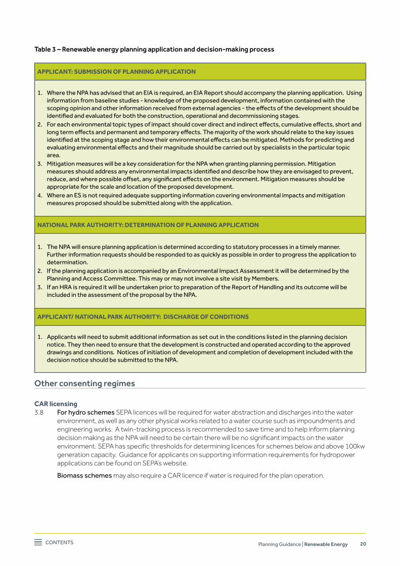
Table 3 – Renewable energy planning application and decision-making process
APPLICANT: SuBMISSIoN of PLANNING APPLICATIoN
1. Where the nPA has advised that an eIA is required, an eIA Report should accompany the planning application. Using information from baseline studies - knowledge of the proposed development, information contained with the scoping opinion and other information received from external agencies - the effects of the development should be identified and evaluated for both the construction, operational and decommissioning stages.
2. For each environmental topic types of impact should cover direct and indirect effects, cumulative effects, short and long term effects and permanent and temporary effects. The majority of the work should relate to the key issues identified at the scoping stage and how their environmental effects can be mitigated. Methods for predicting and evaluating environmental effects and their magnitude should be carried out by specialists in the particular topic area.
3. Mitigation measures will be a key consideration for the nPA when granting planning permission. Mitigation measures should address any environmental impacts identified and describe how they are envisaged to prevent, reduce, and where possible offset, any significant effects on the environment. Mitigation measures should be appropriate for the scale and location of the proposed development.
4. Where an es is not required adequate supporting information covering environmental impacts and mitigation measures proposed should be submitted along with the application.
NATIoNAL PARk AuTHoRITy: DETERMINATIoN of PLANNING APPLICATIoN
1. the nPA will ensure planning application is determined according to statutory processes in a timely manner. Further information requests should be responded to as quickly as possible in order to progress the application to determination.
2. If the planning application is accompanied by an environmental Impact Assessment it will be determined by the Planning and Access Committee. this may or may not involve a site visit by Members.
3. If an HRA is required it will be undertaken prior to preparation of the Report of Handling and its outcome will be included in the assessment of the proposal by the nPA.
APPLICANT/ NATIoNAL PARk AuTHoRITy: DISCHARGE of CoNDITIoNS
1. Applicants will need to submit additional information as set out in the conditions listed in the planning decision notice. they then need to ensure that the development is constructed and operated according to the approved drawings and conditions. notices of initiation of development and completion of development included with the decision notice should be submitted to the nPA.
Other consenting regimes
CAR licensing3.8 For hydro schemes SEPA licences will be required for water abstraction and discharges into the water
environment, as well as any other physical works related to a water course such as impoundments and engineering works. A twin-tracking process is recommended to save time and to help inform planning decisionmakingastheNPAwillneedtobecertaintherewillbenosignificantimpactsonthewaterenvironment.SEPAhasspecificthresholdsfordetermininglicencesforschemesbelowandabove100kwgeneration capacity. Guidance for applicants on supporting information requirements for hydropower applications can be found on SEPA’s website.
Biomass schemes may also require a CAR licence if water is required for the plan operation.

Contents Planning Guidance | Renewable Energy 21
SNH licensing3.9 For all renewable schemes, licenses may be required from SNH for activities with a potential impact on
protected species, for example European Protected Species (EPS) such as otters and bats. Mitigation for species submitted as part of a planning application can be used for licence applications to SNH. It is not possible to apply for a European Protected Species licence without having obtained planning consent.
forestry commission licensing3.10 Licenses may also be required from the Forestry Commission for felling and the restructure of
woodlands. These may also require a separate Environmental Impact Assessment.
Waste management licensing3.11 Peatlands hold large stocks of carbon and excavation of peat will result in carbon losses from excavated
peat. Developments on peat should seek to minimise peat excavation and disturbance to prevent the unnecessary production of waste soils and peat. Excavated peat is not always suitable for re-use within a development and may be regarded as waste in law. Further information on dealing with surplus peat can be found on the SEPA website.
3.12 Under certain circumstances waste legislation can also apply to materials arising from forestry operations. Windfarm and hydroscheme proposals can involve felling of timber with the potential to producewaste.Largescalefellingcanresultinapeakreleaseofnutrientswhichcanaffectlocalwaterquality. Any felling operations should be undertaken with a view to preventing and reducing waste arisings: see SEPA guidance on the Management of Forestry Waste.
Marine Scotland3.13 Hydro schemes may also need to comply with the Salmon (Fish Passes and Screens) (Scotland)
Regulations1994.Regulatoryguidancenotesonappropriatedesignsoffishpassesandscreensthatwillhelp to ensure the regulations are complied with are available from Marine Scotland.
Abnormal Load Routing3.14 Transport Scotland co-ordinates the movement of abnormal loads throughout Scotland’s trunk and
non-trunk road network, ensuring that the requirements of industry are met, whilst minimising the risk to road safety and delays to other road users, and also safeguarding bridges from damage by overweight or over height vehicles. The primary function of Transport Scotland’s Abnormal Routing Section is to investigate on behalf of the Highways Agency, the suitability of proposed wide, high and heavy load movements within Scotland that require VR1 or Special Order authorisation under Section 44 of the Road TrafficAct.
Further information is available on the Transport Scotland website.
Grid connection3.15 Renewable energy projects connecting to the National Grid will require an additional consent process.
The grid connection, should it require overhead elements, requires consent under 37 of the Electricity Act 1989, and deemed planning consent under section 57(2) of the Town and Country Planning (Scotland) Act 1997. Many projects will be directly connected to their local distribution network, operated by the Distribution Network Operator (DNO). Mapping can be used to calculate the distance from the proposed project site to each main type of connection in the area (see Map 5). However in order to establishifthereissufficientcapacitytoconnecttothegridinthislocation,agridconnectionfeasibilitystudy by the DNO would be required. Whilst planning permission is sought by the applicant or developer, the grid connection consent will be sought by the relevant owner of the local distribution or transmission network. The applicant or developer should therefore contact their local DNO - contact details can be found in Appendix 6.

Contents Planning Guidance | Renewable Energy 22
Map 5 - Electricity grid network

Contents Planning Guidance | Renewable Energy 23
4. Hydro Energy
Technical feasibility and scope
4.1 Local Development Plan Renewable Energy Policy 1 applies to all types and scales of hydro developments. Hydro power generation involves the extraction of energy from moving water. The amount of energy generateddependsonthevolumeandflowofwaterandwaterpressure.Therearethreemaintypesofhydro power generation:
n Diversion (run-of-river) – where a proportion of water is diverted via a weir or lade into a penstock (pipe) to a turbine (which generates electricity) before returning the water to the river downstream;
n Low Head – run-of-river scheme that operates with a head of 20 meters or less; n Impoundment-whereadamorseriesofdamsholdwaterbackinfloodedvalleysystems,creatinga
hydraulic head from which electricity is generated; and n Pumped storage – which uses similar principles to large scale impoundment but where a second
reservoirisalsousedtopumpwaterbackintothefirstreservoirduringoff-peakhours.Thisprovidesalarger volume of water that can be used to generate electricity during periods of peak electricity usage.
4.2 Small scale run-of-river technology is considered to be the most compatible to the National Park’s geography and special qualities. There are a number of these schemes operating in the National Park, with more currently seeking planning permission (see Map 6 ‘Approved and completed hydro schemes (January 2017)’). The geography of the National Park, with an intricate stream network and range in elevation, is estimated to have the capability to support a range of capacities up to 2MW (see Map 7), subject to ensuring that all environmental considerations are taken into account through the planning and CAR licensing processes (see paragraph 3.8). Any proposal would need to demonstrate that there would benoadverseenvironmental(includingnolikelysignificanteffectsonaEuropeanProtectedHabitatorSpecies) or landscape impacts.
4.3 This section of the guidance therefore focuses on small run-of-river schemes as it is considered that thisisthescaleofdevelopmentwhichoffersthemostopportunitywithintheNationalParkandforwhichthere is most demand. A small run-of-river scheme typically comprises the following main elements:
n Weir/dam –theintakepointwhichusuallycreatesasmallheadpondtoallowwatertofilltheintakeofthepenstockpipebutalsoforaproportionofthewatertocontinuetoflowdownthestreambed.Thisproportionofflowisastatutoryrequirementandisknownaseithercompensationflowor“hands-off”flow;
n Penstock – a pipe that carries the water, using gravity, from the head pond to the turbines at a lower elevation.Thepipecaneitherbeflexibleorrigiddependingontheamountofwaterbeingtransportedand the anticipated pressure of the water based on the head of the scheme. Penstocks are usually underground in order to minimise landscape impact;
n Powerhouse–abuildingcontainingtheturbine(s)thatgenerateelectricityfromtheflowofwater;
n tailrace – a pipe or channel through which water is returned to the watercourse at a point downstream of the powerhouse. This can be incorporated into the powerhouse or separated by some distance;
n Access to the powerhouse - the access to the powerhouse is likely to be a permanent route and may already exist but possibly need upgraded.
n Access to the intake - the access track to the intake should, wherever possible, be a temporary construction to facilitate the construction of the weir and laying of the pipe and will require complete restoration following construction. If it is proposed that the access track to the intake is to be retained permanentlyformaintenancepurposes,itwillberequiredtoberestoredfromthespecificationrequired for construction vehicles to a minor track, suitable for four wheel drive or all-terrain vehicles. This will involve reducing the width to a minimum and re-vegetation;
n enclosed substation/transformer – this sits close to the powerhouse to connect the turbines to electricity transmission lines; and
n transmission line – which links the power to the national grid, local network or brings the power to adjacent buildings. In sensitive locations undergrounding of this line will be preferred.
Contents Planning Guidance | Renewable Energy 24
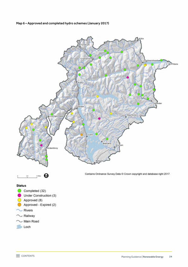
Map 6 – Approved and completed hydro schemes (January 2017)
update this map

Contents Planning Guidance | Renewable Energy 25
4.4 The accompanying best practice appendix (see Appendix 8) provides further guidance on each of these elements and highlights key issues that should be considered when developing a hydro scheme; for example the use of stone facing to wingwalls, careful placement of boulders, mitigating planting, and means of slope retention.
Figure 2.1: Main components of a run-of-river hydro scheme under construction

Contents Planning Guidance | Renewable Energy 26
Figure 2.2: Main components of an operational run-of-river hydro scheme
Locational guidance
4.5 In order to identify where there may be opportunities for hydro development, a strategic assessment of the National Park’s capacity for small scale run-of-river schemes ranging in size from between 15kw and 2MW has been completed and illustrated in Map 7 and Map 8below.2MWisdefinedforthepurposesof this guidance to be the upper limit for small scale hydro development. The purpose of the maps is to provide a strategic indication of where there may be potential technical capacity for small scale schemes, howeveritdoesnotreplacetheneedforfurthersite-specificassessmentsandcompliancewithLocalDevelopment Plan’s policies and this guidance. It may be that further assessment may conclude that development will not be possible. Cumulatively the National Park may have the technical potential to generate approximately 73MW from small scale run-of-river schemes. The main area of commercial potential appears to be for schemes with an installed capacity of greater than 500kw. Map 7 also shows that there are a large number of water courses that potentially might be capable of generating under 500kw, and therefore more suitable for on-site use. Map 8 shows potential areas for schemes between 50kw and 2MW. 50kw was chosen as the lower threshold as it is generally considered to be the lower limit for schemes that are commercially viable.

Contents Planning Guidance | Renewable Energy 27
Map 7: Technical assessment of potential run-of-river hydro power schemes with installed capacity between 15kw and 2MW

Contents Planning Guidance | Renewable Energy 28
Map 8: Technical assessment of potential run-of-river hydro power schemes with installed capacity of greater than 50kw
Contents Planning Guidance | Renewable Energy 29
4.6 DevelopingthemapsinvolvedassessingtheflowandtopographyoftheNationalPark’swaterresources.Further information about the methodology used to generate Maps 7 and 8 is contained in Appendix 5.
4.7 Whileflowandgeographyareessentialelementsfordeterminingthecapacityofariversystemtosupport a hydro scheme, further information and assessments will be required by SEPA for granting consent under the Water Environment (Controlled Activities) Regulations 2011 (CAR) (see paragraph 3.8). Permission under CAR requires the ecological condition of water bodies to be taken into account, as well as the cumulative impacts on the hydrology and water quality from other schemes on or related to the same water course. This will also need to recognise that there are a number of European Sites (SACs and SPAs) within the Park (refer to paragraph 2.6).
Developers should consult SEPA’s screening guidance, included in their Guidance for developers of run-of-river hydropower schemes before consulting SEPA.
Planning considerations – Introduction
4.8 The next sections will give an overview of issues that need to be considered before a planning application for a hydro energy development within the National Park is submitted. These focus on impacts on the water environment, both hydrology and water quality, considering that this is likely to be the issue that requires greatest consideration. The following sections also cover landscape and ecology. Impacts on the designated areas of the National Park which protect natural and landscape features will be a key consideration for all hydro scheme proposals. Advice on Cultural and Historic Environment considerations can be found in section 2 (paragraphs 2.7 to 2.12). Issues such as noise and design of powerhouse are covered in paragraphs 4.25 to 4.28 ‘Topic Advice’. As outlined in section 3 hydro proposals will be screened under EIA regulations and an EIA Report (ES) may be required to be submitted with a planning application.
Natural heritage considerations
Ecology – key issues and information sources4.9 Many of the ecological impacts associated with hydro developments will also be considered under other
licensing processes required by SEPA, SNH and the Forestry Commission. See section 3 about the steps that need to be undertaken in tandem with the planning process.
4.10 All hydro schemes could potentially have an adverse impact on freshwater and terrestrial habitats and species. The natural heritage of the National Park incorporates a wide range of habitats and species whose existence and interactions combine with geological, soils and climatic variation to create a unique and highly bio-diverse area.
4.11 Theecologicalimpactsfromhydroschemeswilloftenbesitespecificalthoughimpactsmaybewider,for example downstream of the site. The applicant will need to carry out surveys to help determine the extent of impacts. SNH’s Guidance on Hydroelectric Schemes and the Natural Heritage includes informationonpotentialimpactsonhabitatsandspeciesfromspecificaspectsofaschemeincludingweirs, dams and intakes, impoundments, penstocks, turbine buildings, access tracks, and construction and support infrastructure.
4.12 The range of ecological features which may be impacted upon include:
n terrestrial habitats4 - potential impacts on land which has high biodiversity value at a European (SAC, SPA, RAMSAR sites) and national (SSSI) level.
n River habitats – potential impacts on rivers which have high biodiversity value (see designations above, e.g.RiverTaySACandRiverTeithSAC);informationonthesuitabilityoftheriverhabitatsforfish,freshwater pearl mussels, otters (European Protected Species (EPS)), water voles and other protected species.
n Blanket bog and deep peat – the potential impacts on peatland habitats and peat greater than 0.5m in depth.
4See Appendix 1 - Glossary

Contents Planning Guidance | Renewable Energy 30
n trees and woodlands – consider their conservation value as they could be protected woodlands, included in the Ancient Woodland Inventory, valued as semi-natural woodland, and/or listed as veteran trees.
n trees and bat roosts - consider whether any felling of mature trees with potential for bat roosts is required. Bats are European Protected Species, they and their roosts are protected by law.
n species – impacts on species or their habitats which have a high biodiversity value at a European level, a national level or regional and local level – see Table 4 for a full list. * Please note that in order to comply with the Habitats Directive all European Protected Species (EPS) must be surveyed for prior to determination of any planning application.
n Fish-potentialimpactsonfishspeciesthroughpollutionofthewatercourses,changestohabitat,riverflowsorcreatingbarrierstomovement.Itisimportantthatspawningsalmoncanascendtheriver/stream between the outfall and the intake in order to access habitat further upstream. The impact of newhydrodevelopmentsonothervulnerablefishspecies,suchasEuropeaneelandtrout,willalsobeconsidered. These species are important components of a healthy aquatic ecosystem.
n Fresh water pearl mussels –impactsonthisspecieswhichisvulnerabletodirectorindirecteffectsifitis present in the water course.
n Bryophytes - incised river valleys and rocky or wooded ravines which are suitable for hydro schemes are also habitats for a range of bryophytes (mosses and liverworts) and lichens that thrive and depend onshelteredandhumidconditions.Anyreductioninflowcouldhaveanegativeimpactonthesespecies. SNH has surveyed many river courses for mosses and liverworts to assist with hydroelectric assessments and possible impact on rare species – see Oceanic bryophyte planning tool – Scottish Natural Heritage.
n Invasive species – schemes must aim to prevent the spread of invasive species and to actively control invasive species within the area of proposal.
n natural heritage designations - protecting the National Park’s national and international natural heritage designations, as illustrated on Map 2 for protected sites, is a statutory requirement. See also the SNH SiteLink website.
Table 4: A list of species which should be considered in relation to run-of-river hydro developments in the National Park (the list will vary depending on the habitats present and may include other protected species not listed here)
Mammals Birds fish
Bats*
european otter*
Red squirrel
Water vole
Badgers
Wild cat
Pine Marten
All breeding birds
Birds listed on schedule 1 of the Wildlife and Countryside Act as amended and those listed on Annex 1 ofthe eU Birds Directive.
Black grouse lek sites
salmon
Lampreys
Brown trout
Arctic charr
eel
Molluscs Invertebrates Bryophytes, vascular plants
Freshwater pearl mussel Red data book species e.g. dragonflies
Red data book species e.g. scottish dock
Invasive Plant Species Non-native invertebrates
Giant hogweed
Japanese knotweed
Rhododendron
skunk cabbage
elodea species
American signal crayfish
* Please note that in order to comply with the Habitats Directive all European Protected Species (EPS) must be surveyed prior to determination of any planning application.

Contents Planning Guidance | Renewable Energy 31
Water environment – key issues and information sources4.13 The NPA has an obligation to prevent any deterioration of the Park’s high quality water resources under
theWaterFrameworkDirective.Wealsohaveadutytoconsiderimpactsofchangestowaterflowontheimportant salmon rivers in the National Park which are European Designated Sites. Impacts to consider on water quality and quantity from hydro schemes include:
n Reduction of water velocity from dams and reservoirs and change in patterns of natural erosion of water courses.
n Reductioninwaterdepthandflowandeffectsontheavailabilityanddistributionoffishspawningandholding habitats.
n Impacts on the ability of streams to host invertebrate species such as freshwater pearl mussel. n Impacts on groundwater dependent ecosystems. n Impacts on water chemistry and ecology from the potential transfer of water between catchments. n Impacts on abstractions and private water supplies within the catchment. n Surfacewaterrun-offintowatercoursesfromaccesstracks. n Damage to streams and river banks from vehicles during construction. n Potential for fuel, chemical spills and sediment pollution during construction. n Impacts on the water quality, hydrology and ecology are considered by SEPA through the Water
Environment (Controlled Activities) Regulations 2011 (CAR) authorisation process. It is recommended that this is pursued in tandem with the planning application process in order for us to take account of their advice. SEPA has extensive guidance on applying for CAR authorisations for run-of-river hydro schemes which can be found on their website.
4.14 Good practice guides are available on bank protection, river crossings, sediment management, intakes and outfalls, construction methods and riparian vegetation management.
4.15 SEPA will also assess the impacts of hydro developments on the ecological status of water bodies.
4.16 SNHhaveproducedspecificguidance for developerswhenconsideringnewprojectswhichcouldaffectthe River Tay Special Area of Conservation. This guidance is also relevant to other salmon rivers in the NationalPark.Itincludesachecklisttoassesswhethertherewouldbelikelysignificantenvironmentaleffectsonthisimportantriversystemanditsspecies.
Landscape and visual impact considerations
Landscape – key issues and information sources4.17 The location and setting of a hydro scheme proposal is key to determining the range of landscape and
visual impacts. This is due to the timescales for restoration of vegetation. In upland locations vegetation takes longer to re-establish. Identifying landscape impacts at an early stage of a project’s inception can helpinfluencethesitinganddesignofaproject.
A landscape appraisal may need to take consideration of:
n The scheme as a whole and its visibility in the wider and local landscape; n Thecumulativeimpactofthescheme’sdifferentcomponentsaswellasmorethanonedevelopment
in or close to a particular location; n The impact of permanent and temporary structures; supporting infrastructure such as powerhouses,
penstocks (buried or overground), and intakes; associated infrastructure such as access tracks, borrowpits and temporary construction areas;
n The design of the structures including scale, materials and colour; n Theeffectsonlocallandscapecharacteranditsscenicqualityintermsofthecompositionof
landscape elements (for example walls, fanks, ruins, outcrops, burns and the river course) and how it is experienced;
n Reducedflowsinriversandburnsandeffectsonthelocallandscapecharacteroftheriver,itsscenicquality and the visual amenity of its morphology (for example waterfalls, rock outcrops, individual boulders,gravelbedandpools),andtheeffectsonthecharacterofaglenasaresultofreducedriverflow;and
n Impacts on wildness.

Contents Planning Guidance | Renewable Energy 32
4.18 As the potential landscape and visual impact of the disturbed pipe route (penstock) and construction track are a major concern in open upland hydro schemes we would require detailed Construction Method statement(s) to be submitted with the application. This should include turve management.
Further guidance on identifying landscape impacts from hydro schemes can be found in SNH’s Guidance on Hydroelectric Schemes and the Natural Heritage.
4.19 Mitigation and enhancement measures for minimising landscape impacts from hydro schemes are outlined in the accompanying best practice guidance (see Appendix 8 Best Practice & Mitigation Measures). The level and detail of analysis should be proportionate to the scale of the proposal and the sensitivity of the site.
Wildness – key issues and information sources4.20 Wild land can best be described as those areas where wildness characteristics are best expressed. These
characteristics can include perceived naturalness of land cover, absence of modern human artefacts, rugged and challenging terrain and remoteness. Development of hydro generation schemes may have an impact on the wild land qualities of an area. For example built structures, visual intrusion and an increase in activity and noise may diminish the qualities found and valued in wild places.
4.21 The development of small scale hydro, although of a lesser scale, could potentially contribute to the erosion of certain wild land qualities. Care will be required to ensure infrastructure such as access tracks, penstocks, borrow pits, fencing, power lines, intake structures and powerhouses do not have a negative impact (see Map 1).
Further guidance on assessing impacts on wildness can be found above in paragraph 2.4 and SNH’s Guidance on Hydroelectric Schemes and the Natural Heritage.
Assessing cumulative impacts
4.22 Multiple small scale hydro developments in an area could result in cumulative impacts on landscape, ecology, water quality and quantity, and recreation and access. Cumulative impacts could include visual effectsthatchangethecharacterofviewsandthevisualamenityofanarea;lossofspawninghabitatorimpedancetofishpassage,andgeneralreductioninoverallvalueoftheaquatichabitat.SEPA,throughits CAR regime, considers cumulative water environment impacts. The following issues should be considered by the developer:
n Hydrology–impactonflowsduringandafterconstructionanduseofthewaterresourceupanddownstream of the intake.
n Fish and aquatic values-impactsonfishandaquaticenvironments,forexamplelossofspawninghabitat or impedance to passage and general reduction in overall quality of the aquatic habitat.
n ecology – potential for loss in habitat connectivity which can result in disruption to migratory and feeding areas for species within a catchment area and subsequent impacts on the feeding areas of terrestrial species.
n Morphology – increased sediment and river bed and bank erosion. n Landscape impacts–physicalchangestothelandscape,effectsonlandscapecharacterandhow
people perceive and experience the landscape, impacts on cultural heritage assets, visual impacts during and after construction, and site recovery time.
n Historic environment – direct and indirect impacts on the cultural and historic environment. n Access and recreation – potential disruption to recreation activities during and after construction.

Contents Planning Guidance | Renewable Energy 33
4.23 Map 6 shows the existing schemes within the National Park boundary that have received planning permission by either the NPA, local authorities (prior to the Park’s establishment) or Scottish Government (for schemes above 1MW generation capacity before 2012). This map will be located on the National Park website and updated with new schemes.
4.24 There are some areas of the National Park, such as Glen Dochart and Glen Falloch where there are a number of developed and proposed hydro schemes (see Map 6). In instances where there may be more than one scheme in a catchment consideration will be given by the NPA, SEPA and other organisations to the potential cumulative impacts before permissions will be granted. With more applications received for hydro schemes, and other projects and proposals, throughout the National Park the need to consider cumulative impacts will become increasingly necessary.
Hydro topic advice
flooding 4.25 Developmentsites,particularlyforthesitingofapowerhouse,shouldbeassessedforfloodriskand
a Flood Risk Assessment (FRA) may be required. It should be demonstrated that the scheme will not createafloodriskforpropertiesinthevicinityorfurtherdownstream.Furtherguidanceonfloodrisk and the preparation of Flood Risk Assessments can be found on the SEPA website.
Transport4.26 Hydro developments may have an impact on the road network during the construction phase.
Development proposals will require to be accompanied by a transport statement5 . This should include a description of the site access, location of proposed laydown areas and anticipated length of operations. It should also identify anticipated vehicle movements to and from the site, the frequency and size of deliveries along with peak periods of activity throughout the day and the types of vehicles to be used. The statement should also provide an assessment of suitability of the road network and existing structures (bridges and culverts) to accommodate anticipated heavy loads during construction. Statutory consultees for transport include Transport Scotland, where the trunk road network would beaffected,andlocalauthorityroadsdepartments.
Noise4.27 There are two main sources of noise likely with a hydro scheme – (a) noise, from the turbine within the
powerhouse and substation, over the operational lifetime of the scheme and (b) construction noise from vehicles etc. Noise receptors will include local residents and also visitors to the area, for example hillwalkers. A noise assessment examining the current baseline levels in the area and the predicted levels may be required to be submitted in order to assess whether any mitigation measures are necessary to ensurethatnoisewillnotcauseasignificantimpact.TherelevantlocalauthorityEnvironmentalHealthdepartment will be consulted as part of the planning assessment process.
4.28 Noisecanalsobeconsideredintermsoftheaffectonthetranquilqualitiesofanarea.TheWorldHealthOrganisation Guidelines for Community Noise seeks to preserve existing levels of quiet in outdoor areas and this should be considered particularly in relation to the length of the construction period and long term residual impacts.
other useful advice:
Appendix 4.2 contains a list of references on hydropower
Appendix 8 includes hydropower best practice and mitigation measures
5 See glossary Appendix 1.

Contents Planning Guidance | Renewable Energy 34
5. Wind Energy
Technical feasibility and scope
5.1 Renewable Energy Policy 1 and 2 of the Local Development Plan are the two policies that cover wind energy. Renewable Energy Policy 1 states that large-scale commercial wind turbines are incompatible with the special qualities of the National Park and are not considered to be appropriate within the National ParkorwhereoutsidetheNationalParktheyaffectitslandscapesetting.Howeverthereissupportforsingleturbineswithaheighttobladetipoflessthan30metresthatmeetthespecificcriteriainthepolicy. Renewable Energy Policy 2 covers renewable energy development adjacent to the National Park and there is a criteria listed in the policy that must be met or otherwise the authority would object to the proposals (Appendix 7).
5.2 In general, wind energy proposals should provide information on the wind turbine(s) and all necessary associated infrastructure, including access tracks, underground cabling, powerhouses and borrow pits etc. The impact and scale of the additional infrastructure will be dependent on the size of the proposal.
5.3 The landscape character of the National Park is varied comprising farmed lowland, steep sided glens both afforestedandopen,lochs,riversandcoastandexpansiveopenupland.Withinthisvariedlandscapeitisdifficulttodefinitivelymapwheresmallscale,singleturbinesmaybeacceptableinlandscapeterms.EvenwithinasingleLandscapeCharacterType(LCT)thecapacityfordevelopmentcanvarysignificantlyas a result of the prominence of the site, existing development and surrounding views and viewpoints. Consequently this SPG’s approach is to provide guidance and examples on what is likely to be acceptable in common scenarios within the some of the LCTs of the park.
5.4 It is considered that there are some opportunities to locate single wind turbines up to 15m high in the National Park. These structures will have a similar size to modest mature trees or large farm or industrial buildings. As such, if carefully sited, they may be accommodated within the landscape without harming the special qualities. Information on Permitted Development rights for wind turbines within the curtilage of a dwellinghouse can be found on the Scottish Government website.
5.5 There are also limited opportunities to site single wind turbines up to 30m high in the landscape. They would typically be higher than the majority of manmade structure in the National Park, both in the more settled areas and in isolated rural locations. As a result, they are likely to become a prominent feature in the landscape and can potentially detract from the National Parks’ special landscape qualities.
Locational guidance
5.6 It is not considered appropriate to map areas with potential for wind energy proposals, considering the limited opportunities. However, there are a number of Landscape Character Types (LCTs) within the National Park which may have the potential to accommodate individual turbines and these are central to the locational guidance. Further information on LCTs in the National Park can be found in the publication “Landscape Character Assessment” (SNH & LLTNPA). In this guidance we have chosen to illustrate how single wind turbines of up to 30m high might be accommodated in the following LCTs:
i. Inland shore fringe (17)6 ii. Coastal sea loch shore (20) iii. Edgeofsettlement–rollingfarmland(33)andfarmedstrathfloor(14)
5.7 These LCTs were selected as they best demonstrate the principles involved and are likely to be where the majority of proposals are generated. However, they do not represent the only areas where proposals may be acceptable, nor do they represent how any single view or receptor will view a particular scenario, and eachapplicationwillbeassessedonitssitespecificimpacts.
6 Numbering relates to SNH Landscape Character Type

Contents Planning Guidance | Renewable Energy 35
5.8 There are a number of factors to be considered in assessing any proposed scheme to ensure that the specialqualitiesoftheNationalParkwillnotbeadverselyaffected:
i. scale: The overall height of the turbine should be 30 metres or less to accord with Local Development Plan Renewable Energy Policy 1.
ii. Landscape and Visual: Careful siting and design within the landscape to ensure the turbine is not intrusive (see paragraphs 5.15 to 5.29).
iii. Cumulative Impact: Consideration of other turbines and development proposals within the area (see paragraphs 5.20 to 5.35).
iv. safety:Sufficientdistancesfrommainroadsandexistingtelecommunicationslinkstoachievesafety. v. Wild Land: No tracks or turbines are to be located within core wild land (see Map 2). vi. Protection of residential amenity:theamenityofnearbyresidentsshouldnotbeadverselyaffected
bynoise,visualdominance,shadowflickeretc. vii. Impact on cultural and historic environment: Statutory historic environment heritage designations
such as Listed Buildings, Conservation Areas, Scheduled Ancient Monuments, Inventory Gardens and Designed Landscapes and their settings should be avoided. See section 2.
viii. ecology/Biodiversity: Statutory nature conservation designations such as Special Areas of Conservation (SAC) and Special Protection Areas (SPAs) should be avoided. Steps should be taken to minimise impact on the natural environment (see paragraphs 5.36 to 5.45).
Wind farm development outside the National Park boundary
5.9 The NPA can be consulted on planning applications for wind energy development in the neighbouring local authorities. The NPA will take a generally positive approach to development of renewable energy projects,includingwindenergy.SNHandScottishGovernmentdonotaffordadditionalprotectiontothelandsurroundingtheNationalParkthroughbufferareas,howeveritisimportantthatindividualproposalsare considered within the context impact on setting, and approach to the Park. Local Development Plan Renewable Energy Policy 2 states that the National Park Authority will object to renewable energy development outwith the Park where the criteria within the policy has not been met.
5.10 Local Development Plan Renewable Energy Policy 2 outlines the criteria when considering a consultation. Critical to this is the visibility of the development from the National Park, and its impact on the setting of the Park due to visual intrusion and its enjoyment by residents and visitors. Early contact is encouraged to ensure that any proposal includes the relevant viewpoints and operational or proposed development in the cumulative assessment.
Further information on wind farm development outwith the National Park can be found in Appendix 7.
Wind planning considerations – introduction
5.11 The following sections will give an overview of issues that need to be considered before a planning application for a wind energy development within the National Park Boundary is submitted. They focus on landscape and visual impacts as these are likely to be the issues that require the greatest consideration. However they also contain information on ecological and other environmental considerations. Advice on Cultural and Historic Environment considerations can be found in section 2 (paragraphs 2.7 to 2.12). It should be noted that, as with hydro electric proposals, wind proposals will be screened under EIA regulations and an EIA Report may be required to be submitted with a planning application.

Contents Planning Guidance | Renewable Energy 36
Landscape and visual impact considerations
Landscape and visual Impact Assessment 5.12 All applications to the NPA for wind energy developments will need to be accompanied by a Landscape
and Visual Impact Assessment (LVIA). The extent of the LVIA will be agreed as part of the pre-application discussions through the production of a Zone of Theoretical Visibility (ZTV) mapping the potential extent ofthevisibilityoftheproposalandidentifyinganykeyviewpoints,includingwheretheturbineisfirstsighted on the trunk road network.
The LVIA will consist of two distinct sections:
n Landscape Impact Assessment – This considers the potential changes to the character of the physical landscape as a result of the proposed development.
n Visual Impact Assessment – This considers the potential changes to views and appreciation of a landscape and how people are likely to respond to these changes.
5.13 The level and extent of the LVIA will depend on the complexity and scale of the proposal and sensitivity of location. However, the assessment should still be based on the general principles, techniques and methodology set out by the Landscape Institute in ‘Guidelines for Landscape and Visual Impact Assessment (3rd edition)’. A full list of relevant guidance from SNH is included in the reference list in Appendix 4.
Landscape Character Assessment5.14 As part of the LVIA, the applicant will be expected to consider impacts on the existing landscape
character, and make an informed judgment on the impact of the proposal on the landscape. SNH, in association with the NPA, has produced a Landscape Character Assessment for the National Park. This document provides a detailed assessment of the existing landscape character of Loch Lomond & The Trossachs National Park, and considers the likely pressures and opportunities for change in the landscape as well as assessing the sensitivity of the landscape to change. This document should be used along with SNH commissioned ‘The Special Landscape Qualities of Loch Lomond & The Trossachs National Park’ as a basis to identify key landscape characteristics in the immediate area of the proposal, but also in the surrounding area where the proposal can be seen from. In certain cases a proposal can impact on more than one landscape character type and impacts can be direct and/or indirect. The impact of the proposal onalllandscapecharactertypesaffectedshouldalwaysbeassessed.
Siting considerations, sensitivities and examples5.15 The information from the above reports should inform the siting and design of the proposal. Careful
designcaninfluencenotjusthowvisibleadevelopmentis,butalsohowintrusiveitwillbe.Thesize,shapeand colour of the turbine and the siting of the turbine in relation to existing buildings or infrastructure, and the setting of the development within the wider landscape, will all play their part in determining whether the development appears to integrate with, or stand out from the landscape.
In general, sites can be sensitive in terms of landscape or visual impact due to:
n their prominence within the overall landscape, due to the scale of topography and shape of the landform;
n the sensitivity of the locations from which they are visible, i.e. iconic or key viewpoints, gateways and approaches to the National Park (such as visibility of the turbine from roads, core paths, the West Highland railway line or ferry routes);
n theirscenic,historic,culturalorrecreationalsignificance; n locations on prominent horizons, ridges and loch shores; and n locationsthatformasignificantfocusofviewfromsettlementsandvisitorattractions.
Developers should aim to integrate their proposals with the grain and pattern of the landscape.
5.16 Figures 3.1 to 3.9 on the following pages illustrate the points discussed above and some general principles ofhowthepositionofwindturbineswithinasitecaninfluencetheirfitwithinthelandscape,irrespectiveof landscape character type. The Figures deliberately exaggerate the scale and number of turbines in order to graphically illustrate the general principles.

Contents Planning Guidance | Renewable Energy 37
figure 3.1: Wind turbine related to figure 3.2: Wind turbine related to existing development existing farm steading
InFigures3.1and3.2thelocationandsizeoftheindividualturbinesfitinwellwiththeexistingdevelopmentand landscape characteristics on and surrounding the site. Their size and scale are well related to the size of the buildings and the surrounding vegetation. Furthermore, the turbines do not appear disproportionally largeinrelationtothehillsinthebackground.Theturbinesaresufficientlyfarremovedfromthehillstonotreducetheirperceivedscaleandmagnificence.Theturbinesarefullybackclothedandwillbeevidentinthelandscape. However overall the turbines can be integrated in the existing landscape without detracting from the characteristics that make these landscapes scenic and unique.
figure 3.3: Wind turbine related to existing development
Figures 3.3 and 3.4 demonstrate the importance of the location and size of the turbine within the same landscape. In Figure 3.3 a small scale turbine is positioned as part of the existing group of buildings in thelandscape.Thescaleoftheturbinefitswellwiththe size of the existing buildings and trees nearby. It presents a coherent picture where the turbine is clearly related to the overall development in the landscape.
figure 3.4: Wind turbine not related to existing development
Infigure3.4,alargerturbineislocatedawayfromthe building. Due to its size, the turbine dwarves the existing buildings and trees and dominates the picture. Furthermore, it has an isolated position in the surrounding area, and does not relate to any characteristicswithinthelandscapesuchasfieldboundaries, building cluster or existing tracks. As a result, it becomes the focal point within the landscape. The turbine is therefore too dominant and is an example of poor siting and design.

Contents Planning Guidance | Renewable Energy 38
figure 3.5: Wind turbines on loch shore
Infigure3.5,thesmallscaleturbinesarebackclothedagainstthehillsinthe background. They are of an appropriate size and scale in relation to the nearby buildings and trees. Their positioning relates to the row of houses in the foreground and the edge of the forest in the background. They do not detract from the height of the hills or the scenic views beyond. They are not back clothed by the forestry which would maximise the colour contrast with the turbine.
figure 3.6: Wind turbines on prominent hill figure 3.7: Wind turbines on prominent ridge
Whilstsomeskylinedturbinescanblendintoaviewascolourcontrastisminimisedthesefigures3.6and3.7illustrate poorly sited turbines within the landscape. They are positioned on the hilltops and ridges. The turbines become the prominent feature on the slope and can alter the viewer’s perception of vertical scale, making the hills appear smaller or diminished. Furthermore, as the blades intersect with the hill top, they present a confusing picture when rotating. Rather than being part of a developed area within the landscape, they introduce a completely new feature which immediately draws the eye and forms a focal point. This feature is out of character with the other elements within the landscape, distorting its natural feel. As a result, the turbines detract from, and dominate the scenic landscape composition.

Contents Planning Guidance | Renewable Energy 39
Landscape scenarios – development potential illustrations
5.17 The following presents three scenarios of landscape settings within the National Park where small turbines might be acceptable. Development in other landscape character types may be acceptable but these demonstrate key principles.
Inland Loch Shore fringe5.18 Thefollowingtwofigurespresenttwodifferentscenariosofwindturbinedevelopmentwithinthesame
landscape character type – the Inland Loch Shore Fringe.
5.19 LochShoreFringeshavesignificantnaturalandculturalvalues.Whenviewedtogetherwithaloch,theycan present an exceptionally scenic contribution to the landscape. They are well spread throughout the National Park and can be seen in a variety of landscapes. They can form part of a transition in a layered approach and frame views between the loch and the higher grounds, including upland hills. This can result inexceptionalreflectionsandaddtothetranquillityandpeacefullandscapeexperienceofmanylochshores. The loch shore fringes are critical to the setting of the lochs in the wider and local landscapes and can enhance their scenic qualities. Loch shore fringes are very sensitive to landscape change. Some general rules for wind turbine development on the loch shore fringe include:
n Maintaintheopenqualitiesofsmallisolatedfields,lochshoredeltasandmeadows,reedbedsandparklands;
n Conserve and enhance the natural shoreline of lochs and the integrity of topographic features; n Site development well back from prominent loch shore locations and in clear association with existing
settlement and built infrastructure. n Avoid insensitive road upgrading that would impact on natural loch shore fringes.
Figure 3.8: Positive scenario inland loch shore
5.20 ThisfirstscenarioinFigure3.8showstwowellproportionedturbineswellsitedbackfromtheprominentloch shore. The turbine on the left relates well to the building on the shore. The turbine on the right is sited in relation to the hills in the background and in the line of the existing settlement. The turbine is significantlylowerthanthehillsanddoesnotdetractfromtheirheight.Furthermore,itisnotthemainelement in views from and towards the main body of the loch. As such, it can be considered that both turbines show a good example of positioning of wind turbines within this landscape character type.

Contents Planning Guidance | Renewable Energy 40
Figure 3.9: Negative scenario inland loch shore
5.21 In Figure 3.9, three turbines are shown immediately on the shore of the main body of the loch. The turbines are in a prominent position on the loch shore and detract from the scenic qualities of the loch and its hinterland. They become the focal point in views from and towards the loch and are not related to its setting. Furthermore, the turbines are located in an undeveloped part of the loch shore fringe, and they introduce a new man-made element to the landscape.
The quality of tranquillity and the overall landscape experience would be adversely impacted upon by movementandlargescalefeaturessoclosetothewaterandinreflections.Evenasingleturbineinthislocation would be unacceptable.
Coastal Sea Loch Shore5.22 The coastal sea loch shores are an important landscape character type, especially in the Cowal peninsula
as they provide the outlook to the Clyde seaways. They comprise the area from the waters’ edge and includetheoftensteepslopesbeyondthewaterfront.Theymakeasignificantsceniccontributiontothelandscape and coastal environments in this part of the National Park.
Some general rules for wind turbine development on the coastal sea loch shores include: n Development should be sited well back from prominent loch shore locations; n The natural shore line and integrity of topographic features should be conserved and enhanced; n Avoid insensitive road upgrading; and n Maintaintheopenqualitiesofsmallisolatedfields,sealochshoreriverdeltasandparkland.
Figure 3.10: Positive scenario coastal sea loch shore

Contents Planning Guidance | Renewable Energy 41
5.23 ThewindturbinesinFigure3.10arewellsetbackfromtheshoreline.Duetotheirmodestsize,theyfitinwell with the existing development in the area. The wind turbines are well related to existing development, landscape character in terms of landscape pattern and natural features on the site, and are not in an isolated location. They merge into the background and do not become the focal points within the view or the landscape. They are fully back clothed but avoid back clothing by forestry which would maximise colour contrast and increase visibility.
Figure 3.11: Negative scenario coastal sea loch shore
5.24 InFigure3.11thewindturbineonthelefthandsideistootalltofitinwiththecharacteristicsmall-scalelevel of development on the loch shore. Furthermore, the turbine is placed in a very prominent position on the loch shore, dominating the view from the water. The turbines on the right hand side are located in a prominent position midway up the steep slope. The group of three turbines do not relate to the built development below on the loch shore. In their isolated position they become a new focal point for views from the water and do not integrate well with the surrounding environment. Even a single turbine set above the settlement would be unacceptable in this scenario.
Edge of settlement – Rolling farmland and farmed Strath floor5.25 These landscape character types occur throughout the highland and lowland areas of the National
Park. They include the areas surrounding some of the main settlements, including Callander and Drymen. Even though this section covers two distinct landscape character types – Rolling Farmland (Lowland) and Farmed Strath Floor (Highland), they comprise many of the same characteristics despite their topographic distinctiveness. In general, these are the areas within the National Park that are most influencedbyhumandevelopment.Theycompriseopenmanagedfarmlandwithvarioustypesandsizesoffieldsandenclosures.
5.26 Wind turbine proposals should complement the existing pattern of land-use and development. They shouldreflecttheexistingpatternandscaleofdevelopmentandtakeintoaccountthatmanyofthesettlements are designated as Conservation Areas or include individual buildings of historic importance. Furthermore, applicants should ensure that development on the edge of settlements and upgrading of roads leading towards the settlements do not detract from the rural character of the area.

Contents Planning Guidance | Renewable Energy 42
Figure 3.12: Positive scenario edge of settlement
5.27 In Figure 3.12 two small wind turbines are well sited within the landscape. The wind turbine in the foreground relates well to the farm steading it serves. It is positioned close to the existing buildings on the site to form one clear built up cluster. The size of the turbine respects the scale of the farm buildings and the surrounding mature trees.
5.28 The second turbine in the background is slightly removed from the settlement. However, its location near another farm steading and its proximity to the settlement ensures a clear link with the existing built environment in the area. Furthermore, the turbine is sensitively positioned in a non prominent location. It does not dominate in further views towards the hill side or the forests to the right.
Figure 3.13: Negative scenario edge of settlement
5.29 The three large turbines in Figure 3.13 represent poor siting and design of wind turbines in this landscape character. The turbines are too large and dwarf the farm steading in the foreground. Furthermore, the turbinesdonotrelatetotheexistingfieldpatternsintheareaanddominateviewstowardsthewoodedarea to the right and the hills in the background. Any single one of the turbines would be unacceptable as a result of scale and location. Back clothing against the woodland would increase colour contrast and visual impact.
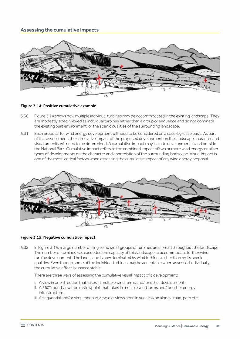
Contents Planning Guidance | Renewable Energy 43
Assessing the cumulative impacts
Figure 3.14: Positive cumulative example
5.30 Figure 3.14 shows how multiple individual turbines may be accommodated in the existing landscape. They are modestly sized, viewed as individual turbines rather than a group or sequence and do not dominate the existing built environment, or the scenic qualities of the surrounding landscape.
5.31 Each proposal for wind energy development will need to be considered on a case-by-case basis. As part of this assessment, the cumulative impact of the proposed development on the landscape character and visual amenity will need to be determined. A cumulative impact may include development in and outside the National Park. Cumulative impact refers to the combined impact of two or more wind energy or other types of developments on the character and appreciation of the surrounding landscape. Visual impact is one of the most critical factors when assessing the cumulative impact of any wind energy proposal.
Figure 3.15: Negative cumulative impact
5.32 In Figure 3.15, a large number of single and small groups of turbines are spread throughout the landscape. The number of turbines has exceeded the capacity of this landscape to accommodate further wind turbine development. The landscape is now dominated by wind turbines rather than by its scenic qualities. Even though some of the individual turbines may be acceptable when assessed individually, thecumulativeeffectisunacceptable.
There are three ways of assessing the cumulative visual impact of a development:
i. A view in one direction that takes in multiple wind farms and/ or other development; ii. A 360° round view from a viewpoint that takes in multiple wind farms and/ or other energy
infrastructure. iii. A sequential and/or simultaneous view, e.g. views seen in succession along a road, path etc.
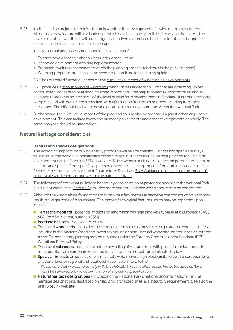
Contents Planning Guidance | Renewable Energy 44
5.33 In all cases, the major determining factor is whether the development of a wind energy development will create a new feature within a landscape which has the capacity for it (i.e. it can visually ‘absorb’ the development),orwhetheritwillhaveasignificantadverseeffectonthecharacterofalandscape,i.e.become a dominant feature of the landscape.
Ideally, a cumulative assessment should take account of:
i. Existing development, either built or under construction ii. Approved development awaiting implementation iii. Proposals awaiting determination within the planning process (and thus in the public domain) iv. Where appropriate, pre-application schemes submitted for a scoping opinion.
SNH has prepared further guidance on the cumulative impact of wind turbine developments.
5.34 SNH produces a map showing all wind farms with turbines larger than 50m that are operating, under construction, consented or at scoping stage in Scotland. This map is generally updated on an annual basis and represents an indication of the level of wind farm development in Scotland. It is not necessarily complete, and will require cross checking with information from other sources including from local authorities. The NPA will be able to provide details on small developments within the National Park.
5.35 Furthermore, the cumulative impact of the proposal should also be assessed against other large-scale development. This can include hydro and biomass power plants and other developments generally. The same analyses should be undertaken.
Natural heritage considerations
Habitat and species designations5.36 Theecologicalimpactsfromwindenergyproposalswillbesitespecific.Habitatandspeciessurveys
will establish the ecological sensitivities of the site and further guidance on best practice for wind farm development can be found on SEPA’s website. SNH’s website includes guidance on potential impacts on habitatsandspeciesfromspecificaspectsofaschemeincludingimpactsfromturbines,accesstracks,fencing, construction and support infrastructure. See also: “SNH Guidance on assessing the impact of small-scale wind energy proposals on the natural heritage”.
5.37 ThefollowingreflectswhatislikelytobethekeyconsiderationofprotectedspeciesintheNationalPark,but it is not exhaustive. Section 2 provides more general guidance which should also be considered.
5.38 Although the wind turbine foundations may only be a few metres in diameter the construction work may result in a larger zone of disturbance. The range of ecological features which may be impacted upon include:
n terrestrial habitats - potential impacts on land which has high biodiversity value at a European (SAC, SPA, RAMSAR, sites), national (SSSI).
n Peatland habitats – see section below. n trees and woodlands – consider their conservation value as they could be protected woodland sites,
included in the Ancient Woodland Inventory, valued as semi-natural woodland, and/or listed as veteran trees. Compensatory planting may be required under the Forestry Commission for Scotland (FCS) Woodland Removal Policy.
n trees and bat roosts - consider whether any felling of mature trees with potential for bat roosts is required. Bats are European Protected Species and their roosts are protected by law.
n species – impacts on species or their habitats which have a high biodiversity value at a European level, a national level or regional and local level – see Table 5 for a full list. * Please note that in order to comply with the Habitats Directive all European Protected Species (EPS) must be surveyed prior to determination of any planning application.
n natural heritage designations - protecting the National Park’s national and international natural heritage designations, illustrated on Map 2 for protected sites, is a statutory requirement. See also the SNH SiteLink website.

Contents Planning Guidance | Renewable Energy 45
Table 5: A list of species which should be considered in relation to wind developments in the National Park (the list will vary depending on the scale of the proposals and habitats present, and may include other protected species not listed here)
Mammals BirdsBats*
otters*
Red squirrel
Badgers
Wild cat
Water vole
All breeding birds
Birds listed on schedule 1 of the Wildlife and Countryside Act as amended and those listed on Annex 1 of the eU birds directive
Black grouse lek sites
* Please note that in order to comply with the Habitats Directive all european Protected species (ePs) must be surveyed prior to determination of any planning application.
Bats5.39 Recent evidence shows that wind turbines can result in a high mortality rate of bats. Research is still being
undertaken as to the causes of these high mortality rates, although it is thought this is caused by the occurrence of ‘barotrauma’. This is caused by rapid air pressure reduction near the edge of the turbine blade as it moves through the air. Impacts on bats will depend on the scale of the development. Natural England has prepared a guidance note for the installation of commercial wind turbines that deals with this issue. SNH provides additional guidance for the installation of micro-turbines in the publication ‘Micro-renewables and the natural heritage’. The SNH website also provides advice on bats.
Birds5.40 Windenergydevelopmentsmightresultinpotentialconflictswithbirds.Thereareacknowledgedtobe
three main areas of potential risk to birds:
n displacement through indirect loss of habitat; n death through collision or interaction with turbine blades; n direct habitat loss through construction.
Anassessmentofapotentialwindfarm’seffectonthebirdinterestofasiteshouldthoroughlyconsidereach of these three potential risks for each bird species which uses the site. SNH have produced information on windfarm impacts on birds.
5.41 Not all bird species are equally susceptible. Impacts will also be proportional to the scale of the development proposed. RSPB and SNH have produced a map of bird sensitivities which can assist in selecting suitable locations for wind energy development. This map is based on the distribution of 16 bird species of conservation priority. More information about this project and the map can be found on the RSPB website.
5.42 Another issue to be considered is the potential for connectivity with Special Protection Areas. SNH have produced guidance on this providing information on dispersal and foraging distances for a range of bird species which can be qualifying interests of SPAs.
Impact on water5.43 Once operational, wind turbines tend to have little impact on water quality or water resources. However,
throughout construction, careful monitoring and supervision should ensure that no pollution of water courses takes place and that adverse impacts on ground water and the ecological status of water bodies are avoided. Where necessary a statement will need to be submitted as part of the planning application setting out protective/ preventative measures. Further advice regarding water quality, including whether any construction works will require a CAR Licence can be found on the SEPA website.

Contents Planning Guidance | Renewable Energy 46
Developments on peat5.44 Within the National Park there are some large peat areas. The main concentrations of peat are in
the Trossachs to the north west of Callander, along the south eastern boundary of the Park between Gartmore and Drymen and south of Gartocharn. The most northern peat areas are located within the more remote and wilder areas of the National Park. Any development should be avoided on areas of deep peat more than 0.5m deep.
5.45 Peat bogs can contain a large quantity of carbon. When the peat bog gets disturbed, this carbon gets released as carbon dioxide, a greenhouse gas. When wind energy developments are proposed on peat bogs, it is necessary to keep disturbance to a minimum to safeguard the role of the peat bog as a carbon sink. SNH, SEPA, Scottish Renewables and Forestry Commission Scotland have produced a good practice guide on the construction of wind energy developments, where more information on this issue can be found.
Information on how to calculate carbon emission savings associated with wind farm developments on Scottish peatlands can be found on the Scottish Government website.
Advice on how to deal with surplus peat can be found on SEPA’s website.
Wind topic advice
Location and micro-siting5.46 In some cases developers need to alter the precise location of the turbines following planning approval
due to unforeseen constraints. This relocation or ‘micro-siting’ of wind turbines should be avoided, as for smaller schemes the impact of a relatively minor alteration to the location of a turbine can have large consequences for the way the turbine impacts on the landscape and relates to the surrounding area and it may also impact on habitats or species. It is therefore recommended that developers carry out a full site investigations study prior to submission for planning permission.
5.47 If a micro-siting condition is required, then the distances will be kept to a minimum, proportionate to the height of the turbine. This should ensure that the best overall design is retained.
Turbine design and colour5.48 There are various designs and types of wind turbines available. All have their own characteristics in terms
of size, proportions and rotation speeds. For example, a three blade turbine is generally considered more restful on the eye than a two blade turbine.
5.49 The colour of a turbine can also be a contributing factor in how noticeable a development will appear. It is important to choose a colour that will relate positively to the immediate backdrop (e.g. heather, moorland, etc.) against which the turbine will be viewed. As the National Park is host to a wide variety of landscapes, the best type and colour of turbine is dependent on local circumstances and needs to be considered on a case-by-case basis.
visual impact and roads5.50 Wind turbines should not be positioned such that they appear abruptly at a location where drivers are
required to manoeuvre, react or make decisions (e.g. junctions, bends etc.). Therefore, it is important to identifythepointatwhichthewindturbine(s)firstcomeintothedriver’sviewsoitcanbedemonstratedthat they can be clearly seen in advance of such a location.
Residential amenity5.51 All proposals will be assessed in relation to their impact on residential amenity. In general, but not
excludinganyothers,issuestobeconsideredarenoise,shadowflickerandpotentialoverbearingimpactof turbine development on residential properties.

Contents Planning Guidance | Renewable Energy 47
‘Community’ turbines5.52 The same tests of acceptability would apply for a community project as it would to a commercial proposal.
However, where a community wishes to erect a turbine solely as a community venture, or takes a share inalargerproject,orsupportsaproposalbyalocalbusiness,whereitistheonlycommunitysignificantlyimpacted by the proposal this will be regarded as a material consideration7 .
Noise 5.53 In general, one of the most common complaints related to wind turbines is an increase in noise levels in
the surrounding area. Noise is produced from wind turbine developments in three ways:
n During the construction and decommissioning stages (temporary, often transport related) n Aerodynamic noise, caused by the blades moving through the air n Mechanical noise in relation to the generator and gear boxes inside the wind turbine.
5.54 It is noted that noise will be dictated by the scale of a proposal. The NPA will require any wind turbine development to be accompanied by at least the manufacturers’ noise information data.
Shadow flicker5.55 Shadowflickeriscausedbyalowsunbehindtherotatingbladesofawindturbine.Thisshadowiscreated
by rotating blades and can cause alternating light and dark shadows to be cast on roads or nearby buildings. This can be a source of distraction and annoyance to occupants. The extent of this impact will be dictated by scale of the proposal.
Developers will need to ensure that location, scale, layout and design of proposals will not lead to unacceptableimpactsonresidentialproperties,roadusersandwalkersasaresultofshadowflicker.
Decommissioning5.56 Wind turbines have a design ‘life’ and are generally granted consent for a period of 25 years. Turbines may
also cease generating power for other reasons. It seems likely that a site for wind energy development, once approved, will remain suitable for that purpose and that, if the technology is still viable at the end of the approval period, turbines will be replaced.
Planning applications require to be accompanied by information on these matters, with a scheme of decommissioning,equipmentremoval,siterestorationandaftercare,andfinancialarrangementssufficienttoensurethatthenecessaryworkscanbecarriedout.
If the turbine ceases to operate before the consent expires, with no prospect of restarting, there will be provisions in consents (or planning agreements) to bring forward the decommissioning scheme.
Repowering5.57 “Repowering”referstopowerplantsingeneralandincludesmeasureswhichimprovetheefficiencyand
capacitybymeansofretrofittingwiththelatesttechnology.Possiblemodificationsonwindturbinesarelimited, particularly for single small turbines. If the operator wishes to replace the turbine either at the end of the 25 years or earlier, they will need to submit a new planning application.
5.58 Iftheoperatorwantstousethesiteforadifferentturbine,thentheywillneedtore-designthesite.Forexample, if the developer wishes to increase the height of the turbine, they will need to re-assess its impact on the landscape setting. The changes to the scheme might mean that a proposed development is less or more likely to gain planning permission. The operator will be required to complete the changeover in as short a period as possible.
other useful advice:
Appendix 4.3 contains a list of references for wind energy
Appendix 8 includes Renewable Wind Energy best practice and mitigation measures
7 Anybenefit,suchasacommunitytrustfund,“shouldnotbetreatedasamaterialconsiderationunless it meets the tests set out in Circular 1/2010 Planning Agreements.” (SPP 2010)

Contents Planning Guidance | Renewable Energy 48
6. Biomass
Technical feasibility and scope
6.1 Renewable Energy Policy 1 of the Local Development Plan states that biomass and biogas (heat and power) proposals will be supported where they are located in close proximity to the source of demand for generated heat and power and use a sustainable source of fuel. Biomass power involves producing electricity and/or heat from wood products (including wood fuel, by-products or felling waste), agricultural by-productsorwaste.Ofthesedifferenttypesoffuel,woodisexpectedtobethemainsourceandopportunity in the National Park.
There are four main types of biomass energy installations:
n Biomass providing electricity – Whilst this has potential for commercial exploitation within the National Park, assuming that a generation plant can be appropriately sited near a fuel source and where there is a demand for electricity and/or a grid connection, the Scottish Government’s Draft Electricity Generation Policy Statement8 states that biomass should preferably be used in small heat orCombinedHeatandPowerinareasoffthegasgridtomakeefficientuseofalimitedresourceandthis will be a material consideration in the determination of planning applications.
n Biomass providing heating only - This technology is particularly suitable to support the development of small and medium scale biomass heating systems associated with new housing developments or withretro-fitforheatingofpublicandcommunitybuildings.Thisislikelytohavelimitedpotentialwithinthe National Park but should be a consideration in all new development.
n Biomass Combined Heat and Power (CHP) – Combining the above two types, most potential for CHPs are likely to be smaller scale installations using available wood resource for needs within the same site.
n Anaerobic digestion – This typically involves generating methane-rich biogas from biodegradable waste. The potential is limited as there are no substantial concentrations of livestock enterprises, no foodprocessingplantsorotherproductionfacilitieslikelytogeneratesignificantvolumesoforganicwaste matter.
6.2 Typicalplanningissueswillconcernvisualimpactofthebuildings,stack/flue,plume,compoundareaand boundary treatment (fencing), access roads and any increases in vehicle movements in relation to bringing in fuel material.
Biomass installations come in a variety of sizes, ranging from a small wood burning stove in an individual property to large scale power stations:
6.3 Installation with a capacity of up to 50kW will provide enough heat and hot water for individual dwellings and small commercial properties. Often these schemes will not require planning permission as they are containedwithinthedesignofalargerbuilding.However,certainelementssuchastheflue,anexternalstorage facility or new access for fuel deliveries might require planning permission9 . In the case of listed buildings, Listed Building Consent will be needed for any external and possibly internal alterations to the fabric of the building. For more information contact the NPA planning service using the contact details in this document (see Appendix 6). Building Control Regulations apply and should be checked with the relevant Local Authority.
6.4 Installations with a capacity of up to 2MW will be big enough to provide power for large commercial buildings and some district heating systems. Again, planning issues are fairly limited depending on the size of the installation and the infrastructure required. These installations tend to be more suitable for residential, commercial and industrial schemes and, in the case of a new development, any buildings required can be designed in the overall scheme. The most controversial elements of this type of developmentarelikelytobetheimpactoftheflueandplume,thedesignofthestorageareaforthefuel,a potential new access and additional pressure on the road network for fuel deliveries. In residential areas there is also the potential for some increase in noise disturbance for larger schemes, caused by additional transport movements and unloading of fuel.
8 See ‘Thermal Generation – Bioenergy’, sections 51-54 on the Scottish Government website. 9 See Scottish Government website for details of householder Permitted Development Rights (PDR) for biomass installations.
Contents Planning Guidance | Renewable Energy 49
6.5 In terms of larger district heating systems or commercial biomass power stations, the location of the installation is more likely to be determined by accessibility and proximity to fuel rather than the destination of the power. This is because a larger installation requires a much larger amount of fuel. These installations are not necessarily located within an urban environment. In addition, the size and scaleofbuildings,fluesandancillaryinfrastructureismuchbigger.Theyarethereforemuchmorelikely to have an impact on the natural and built environment.
Even though the information contained in this guidance applies to all types and sizes of installations, it will be most applicable to smaller commercial electricity and/or heating installations.
Locational guidance
6.6 Biomass energy installations are either located adjacent to the fuel source (generally outside settlements) or adjacent to the heat demand location (generally within settlements). The following section summarises the opportunities in the National Park and key planning issues.
Adjacent to the fuel source: outside settlements6.7 The only substantial fuel resource available within the National Park is that of commercial forestry, which
is used in the case of the approved Combined Heat and Power plant near Killin. The main issues for consideration in relation to these locations are:
a) Potential for adverse impacts on special qualities, landscape character, designed landscapes and visual amenity;
b) Management and disproportionate harvesting of the wood resource; and c) Proximity of valuable habitats and protected species.
With such systems being based close to fuel sources, the main locational restrictions are in landscape and ecological terms and associated with the plant itself; fuel storage and processing requirements; and ancillary infrastructure such as access and grid infrastructure.
Adjacent to heat demand: Within settlements6.8 The main heat demand potential comes from settlement areas. Larger settlements, particularly those
with civic or public buildings and commercial/ industrial areas are locations where there could be sufficientdemandtomeritthedevelopmentofbiomassenergyschemes,suchascommunitydistrictheating schemes or small scale CHP. As such there may be more scope for CHP schemes in the larger settlementssuchasCallanderandBalloch.Newdevelopmentsinthesettlementsalsoofferpotentialforthe integration of CHP systems. The main issues for consideration in relation to these locations are:
a) Impact on the built environment, including conservation areas and listed buildings, historic gardens and designed landscapes;
b) Impactonroadinfrastructure,increasedtrafficandaffectingcommunities; c) Impact on residential amenity; and d) Management and disproportionate harvesting of the wood resource.
Biomass planning considerations – Introduction
6.9 This section will give a short overview of issues that need to be considered before a planning application for a biomass development within the National Park boundaries is submitted. The main focus of this section is medium/large-scale commercial biomass operations located close to the fuel source as these aremostlikelytohaveasignificantimpactontheimmediatelandscapesetting.Italsocoverswoodlandmanagement and cumulative impacts. Impacts on the designated areas of the National Park which protect natural and landscape features will be a key consideration for all biomass scheme proposals. Other planning considerations such as noise and design are considered under the heading ‘Biomass topic advice’ from paragraph 6.20 onwards. Advice on Cultural and Historic Environment considerations can be found in section 2 (paragraphs 2.7 to 2.12). It should be noted that, as with hydro electric and wind proposals, biomass proposals will be screened under EIA regulations and an EIA Report may be required to be submitted with a planning application.
Contents Planning Guidance | Renewable Energy 50
Natural heritage considerations
Ecology – key issues and information sources6.10 The ecological impacts of biomass plants will depend on the amount of land needed and also the level
of water abstraction (if required). Potential direct impacts on habitats and species may result from the construction of buildings, the compound area and any new or upgraded access roads. The range of ecological features will be similar to those found in the hydro section (see paragraphs 4.9 to 4.12) and habitat and species surveys may be required to be submitted. Indirect impacts may result from the extraction of fuel, for example the removal of trees and their transportation to the plant.
Woodland management 6.11 The impact of biomass installations on the Park’s woodlands is twofold. Firstly, depending on the location,
there is the direct impact of the development on the woodland site and surrounding landscape. Secondly, there is the impact of the use of the woodlands as an energy source.
6.12 As such, any proposal will need to be accompanied by a statement setting out where the fuel for the installation is sourced. If this is from within woodlands in the National Park, then this will need to be accompanied by a Woodland Management Strategy. This strategy will need to address the following issues:
n Thinning and felling of trees n Woodland habitat management n Restructuring and restocking of existing and new woodlands and its ecological and landscape impact. n Potential impacts on the historic environment. n Transport of felled trees and impacts on the road network and nearby residents.
6.13 In general terms, felling of large coupes will not be acceptable. The forest plan should incorporate a continuous rotating cycle of felling, thinning and restructuring with some element of permanent coverandspecimentreesforlongtermlandscapebenefit.Theconstructionofadditionaltracksinthe woodland should be avoided. Where necessary, horses should be used to extract trees from the woodland. Suitable species should be used for restocking the felled coupes.
Landscape and visual impact considerations
6.14 A key focus for designating the National Park is its wide variety in landscapes and settings. As such, it is notpossibletoprovidedefinitiveadviceonwheredevelopmentmightbepossible,asallproposalswillneed to be determined on a case-by-case basis.
6.15 Some of the main issues determining the suitability of a proposal within the landscape are general, and will always need to be considered. These issues are related to the impact of the proposal on the Park’s special qualitiesanditswiderlandscapesetting.Thesizeoftheproposalwilldeterminethesignificanceofissuesand the level of assessment required.
6.16 Prior to determining the potential suitability of a site, an appropriate level of Landscape and Visual Impact Assessment(LVIA)shouldbeundertakenbyasuitablyqualifiedlandscapearchitect.TheextentoftheLVIA will be agreed as part of the pre-application discussions and the production of a Zone of Theoretical Visibility (ZTV) mapping the potential extent of proposal and identifying any key viewpoints.
The LVIA will consist of two distinct sections:
n Landscape Impact Assessment – This considers the potential changes to the character of the physical landscape as a result of the proposed development.
n Visual Impact Assessment – This considers the potential changes to views and appreciation of a landscape and how people are likely to respond to these changes.
The assessment should be based on the general principles, techniques and methodology set out by the Landscape Institute in ‘Guidelines for Landscape and Visual Impact Assessment (3rd edition)’. A full list of relevant guidance from SNH is included in the reference list in Appendix 4.
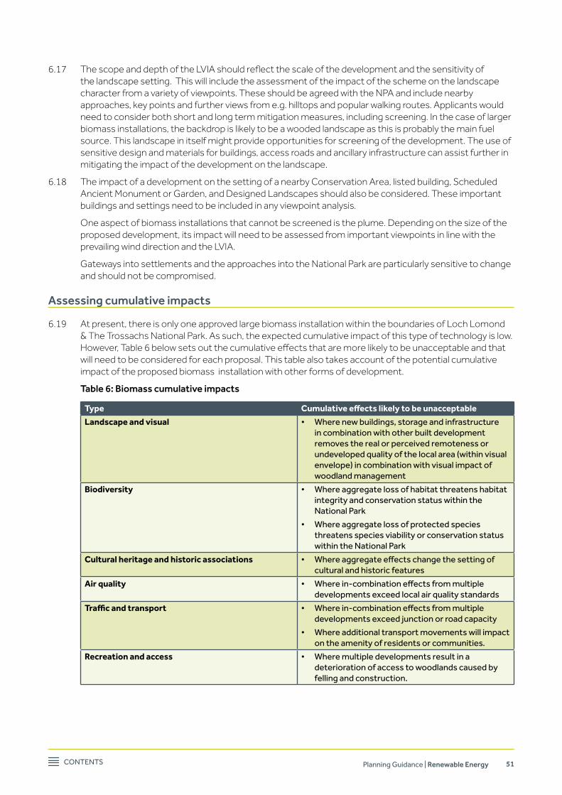
Contents Planning Guidance | Renewable Energy 51
6.17 ThescopeanddepthoftheLVIAshouldreflectthescaleofthedevelopmentandthesensitivityofthe landscape setting. This will include the assessment of the impact of the scheme on the landscape character from a variety of viewpoints. These should be agreed with the NPA and include nearby approaches, key points and further views from e.g. hilltops and popular walking routes. Applicants would need to consider both short and long term mitigation measures, including screening. In the case of larger biomass installations, the backdrop is likely to be a wooded landscape as this is probably the main fuel source. This landscape in itself might provide opportunities for screening of the development. The use of sensitive design and materials for buildings, access roads and ancillary infrastructure can assist further in mitigating the impact of the development on the landscape.
6.18 The impact of a development on the setting of a nearby Conservation Area, listed building, Scheduled Ancient Monument or Garden, and Designed Landscapes should also be considered. These important buildings and settings need to be included in any viewpoint analysis.
One aspect of biomass installations that cannot be screened is the plume. Depending on the size of the proposed development, its impact will need to be assessed from important viewpoints in line with the prevailing wind direction and the LVIA.
Gateways into settlements and the approaches into the National Park are particularly sensitive to change and should not be compromised.
Assessing cumulative impacts
6.19 At present, there is only one approved large biomass installation within the boundaries of Loch Lomond & The Trossachs National Park. As such, the expected cumulative impact of this type of technology is low. However,Table6belowsetsoutthecumulativeeffectsthataremorelikelytobeunacceptableandthatwill need to be considered for each proposal. This table also takes account of the potential cumulative impact of the proposed biomass installation with other forms of development.
Table 6: Biomass cumulative impacts
Type Cumulative effects likely to be unacceptable
Landscape and visual • Where new buildings, storage and infrastructure in combination with other built development removes the real or perceived remoteness or undeveloped quality of the local area (within visual envelope) in combination with visual impact of woodland management
Biodiversity • Where aggregate loss of habitat threatens habitat integrity and conservation status within the national Park
• Where aggregate loss of protected species threatens species viability or conservation status within the national Park
Cultural heritage and historic associations • Where aggregate effects change the setting of cultural and historic features
Air quality • Where in-combination effects from multiple developments exceed local air quality standards
Traffic and transport • Where in-combination effects from multiple developments exceed junction or road capacity
• Where additional transport movements will impact on the amenity of residents or communities.
Recreation and access • Where multiple developments result in a deterioration of access to woodlands caused by felling and construction.

Contents Planning Guidance | Renewable Energy 52
Biomass topic advice
Residential amenity6.20 Residential amenity will be a material consideration in the consideration of biomass proposals. The main
considerations will be noise from the plant itself and disturbance from deliveries of fuel.
Noise6.21 There are two main sources of noise likely with a biomass scheme – (a) noise from the operation of the
plant over the operational lifetime of the scheme, including the boiler and movement of timber within the site and (b) noise from vehicles entering and leaving the site with fuel deliveries. Noise receptors will include local residents and also visitors to the area, for example hillwalkers. A noise assessment examining the current baseline levels in the area and the predicted levels may be required to be submitted in order to assess whether any mitigation measures are necessary to ensure that noise will not cause a significantimpact.TherelevantlocalauthorityEnvironmentalHealthdepartmentwillbeconsultedaspart of the planning assessment process.
Transport and deliveries6.22 Depending on the scale of the plant and the amount of fuel required, some biomass developments
may have an impact on the road network and planning applications may require to be accompanied by a transport statement10 . This should include a description of the site access, anticipated vehicle movements to and from the site, the frequency and size of deliveries along with peak periods of activity throughout the day and the types of vehicles to be used. The statement should also provide an assessment of suitability of the road network and existing structures (bridges and culverts) to accommodate anticipated heavy loads. Statutory consultees for transport include Transport Scotland wherethetrunkroadnetworkwouldbeaffected,andlocalauthorityroadsdepartments.
Additional consents for biomass6.23 Once the application is submitted, the NPA will need to be assured by the applicant that the necessary
operational licenses are capable of being secured in principle. Where the fuel comes from waste, the plant must comply with the requirements of the Waste Incineration Directive (WID) or Local Air Pollution Control,dependingontheclassificationofthefuel.Inbothcases,biomassboilersandCHPplantmustcomply with all relevant pollution prevention and control legislation. More information can be found on the Scottish Government website.
MoreinformationonefficientlyusingwastetorecoverenergycanalsobefoundintheSEPApublicationThermal Treatment of Waste Guidelines (2014).
6.24 Biomass boilers and CHP Plant must comply with the Clean Air Act in Smoke Control Areas. At present, BallochisidentifiedbyWestDunbartonshireCouncilasaSmokeControlArea.Thismeansthatasmokecontrol exemption is required for any installation. The boiler must be on an approved list of systems held by the relevant local authority. More information can be found on the Department for Environment Food andRuralAffairs(DEFRA)website.
other useful advice:
Appendix 4.4 contains a list of references for biomass energy
Appendix 8 includes biomass best practice and mitigation measures
10 See Appendix 1 - Glossary

Contents Planning Guidance | Renewable Energy 53
Appendices
Appendix 1 Glossary ........................................................................................................................................... 56
Appendix 2 Abbreviations ................................................................................................................................. 57
Appendix 3 National Park natural heritage designations .......................................................................... 58
Appendix 4 References...................................................................................................................................... 59
Appendix 5 Hydro power assessment methodology ................................................................................ 64
Appendix 6 Contacts for other consenting bodies ................................................................................... 66
Appendix 7 Wind developments outwith the National Park ..................................................................... 69
Appendix 8 Best practice and mitigation measures for renewables in LLTNPA ................................. 74
Contents Planning Guidance | Renewable Energy 54
Appendix 1 Glossary
Batters the constructed earth slopes that connect the track or road surface to the contour of the surrounding land.
Cofferdama watertight structure that encloses an area under water, pumped dry to enable construction work to be carried out.
Cultural Heritage historical, artistic, literary, linguistic, and scenic associations of places and landscapes.
Historic environment includes ancient monuments (scheduled and unscheduled), archaeological sites and landscapes, historic buildings (listed, unlisted and those within Conservation Areas), historic gardens and designed landscapes (both on the Inventory of Gardens and Designed Landscapes, and those not included on the inventory), and their context and setting.
Landscape Character a distinct, recognisable and consistent pattern of elements, be it natural (soil, landform) and/or human (for examplesettlementanddevelopment)inthelandscapethatmakesonelandscapedifferentfromanother,ratherthan better or worse.
Landscape Character Assessment (LCA) a standard system for identifying, describing, classifying and mapping this variety of landscape: it helps explain whatmakeslandscapesdifferentfromeachother.
Micro-renewables /Microgeneration the generation, from low or zero carbon sources, of electricity of up to 50kW capacity and heat of up to 45kW capacity, as set by the Electricity Act 2004.
Permitted Development (PD) planning permission granted for certain classes of development by the Town and Country Planning (General Permitted Development) (Scotland) Order 1992, as amended. Also known as Permitted Development Rights (PDR).
RAMsAR wetlands of international importance designated under the Ramsar Convention.
terrestrial habitats ground based environments where a plant or animal naturally or normally lives and grows.
transport statement (trunk Roads) normallyconsistsofadocumentdetailingthetrafficgeneratedbythedevelopment,ananalysisofajunctionontothetrunkroadtoensurethatitoperatesefficientlyandanaccidentanalysis.Thisisnotnecessarilyanexhaustive list and applicants are advised to contact Transport Scotland to ensure that all the necessary analysis is completed.

Contents Planning Guidance | Renewable Energy 55
Appendix 2 Abbreviations
eCoW Ecological Clerk of Works
eIA Environmental Impact Assessment
FC Forestry Commission
FCs Forestry Commission Scotland
GWDte GroundWater Dependent Terrestrial Ecosystems
HRA Habitats Regulations Appraisal
LCA Landscape Character Assessment
LCt Landscape Character Type
LLtnPA Loch Lomond & The Trossachs National Park Authority
nnR National Nature Reserve
nPBAP National Park Biodiversity Action Plan
nsA National Scenic Area
nsR Noise Sensitive Receptor
RCAHMs Royal Commission on the Ancient and Historical Monuments of Scotland
sAC Special Area of Conservation
sAM Scheduled Ancient Monument
sePA Scottish Environment Protection Agency
sMR Sites and Monument Record
snH Scottish Natural Heritage
sPA Special Protection Area
sssI SiteofSpecialScientificInterest
UKBAP United Kingdom Biodiversity Action Plan
WHo World Health Organisation
ZtV Zone of Theoretical Visibility

Contents Planning Guidance | Renewable Energy 56
Appendix 3 National Park natural heritage designations
Designation Designation description special Areas of Conservation (sAC)
special Protection Areas (sPA’s)
RAMsAR sites
There are eight SAC’s and two SPA’s within the National Park. These are internationally designated sites where the purpose is to restore and maintain the abundance and distribution of endangered or vulnerable habitats or species. One of the SPA sites is also a RAMSAR site and SSSI (south east area of Loch Lomond).
See Local Development Plan Natural Environment Policy 1 & 2.
Sites of Special Scientific Interest (SSSI’s)
national nature Reserves (nnR)
UKBAP Priority Habitats
SSSI’s are areas which are considered to be of special interest onaccountoftheirnaturalfeaturesincludingflora,fauna,geological or geomorphological features. There are 57 SSSI sites located wholly or partly within the National Park. Two of these are also designated as National Nature Reserves.
See Local Development Plan Natural Environment Policy 2.
Ancient woodland
Ancient woodland has statutory protection where it is designated as a SSSI, SAC or SPA. Loch Lomond oakwoods are one of the largest areas of semi-natural woodlands in Britain and are designated as a SAC.
See Local Development Plan Natural Environment Policy 1, 2 & 8.

Contents Planning Guidance | Renewable Energy 57
Appendix 4 References and Websites
4.1 References – General
forestry Commission Scotland
Felling licenses: http://www.forestry.gov.uk/website/forestry.nsf/byunique/infd-5zgksj
Historic Environment Scotland
Inventory of Gardens and Designed Landscapes: http://www.historic-scotland.gov.uk/index/heritage/gardens.htm
Managing Change in the Historic environment Guidance notes: http://www.historic-scotland.gov.uk/index/heritage/policy/managingchange.html
Managing Change in the Historic environment: setting (october 2010): http://www.historic-scotland.gov.uk/setting-2.pdf
Landscape Institute
Guidelines for Landscape and Visual Impact Assessment. (3rd edition): http://www.landscapeinstitute.org/knowledge/GLVIA.php
Loch Lomond & The Trossachs National Park Authority
Local Development Plan 2017 - 2021: http://www.lochlomond-trossachs.org/planning/planning-guidance/local-development-plan/
Conservation Areas: http://www.lochlomond-trossachs.org/planning/planning-applications/make-an-application/listed-buildings-conservation-areas/
Core Paths network: http://www.lochlomond-trossachs.org/park-authority/publications/core-paths-plan/
Loch Lomond & the trossachs national Park Landscape Character Assessment: http://www.snh.org.uk/pdfs/publications/review/140.pdf
national Park Biodiversity Action Plan: http://www.lochlomond-trossachs.org/park-authority/what-we-do/conservation/wild-park-2020-nature-conservation-action-plan/
national Park Partnership Plan: http://www.lochlomond-trossachs.org/park-authority/publications/national-park-partnership-plans/
Pre-application advice: http://www.lochlomond-trossachs.org/planning/planning-applications/make-an-application/pre-planning-application-advice/
Wildness study in the Loch Lomond & the trossachs national Park: http://www.lochlomond-trossachs.org/park-authority/publications/wildness-study/

Contents Planning Guidance | Renewable Energy 58
Scottish Environmental Protection Agency (SEPA)
Developments on peatland: Guidance on the assessment of peat volumes, reuse of excavated peat and the minimisation of waste, A joint publication by Scottish Renewables and the Scottish Environment Protection Agency, Version 1, January 2012;
Developments on Peatland: Site Surveys and Best Practice;
SEPA Guidance Management of Forestry Waste; SEPA Regulatory Position Statement – Developments on Peat;
the documents above can be found on the following web page: http://www.sepa.org.uk/planning/energy.aspx
Advice regarding water quality, including CARs Licences: http://www.sepa.org.uk/water/water_regulation.aspx
Information on Recreational Use: http://www.sepa.org.uk/water/hydropower/supporting_information/other_information.aspx#recreationaluse
Scottish Government
eIA legislation guidance and advice: https://beta.gov.scot/policies/planning-architecture/development-management/
national Planning Framework 3: https://beta.gov.scot/publications/national-planning-framework-3
Permitted Development rights within the curtilage of a dwellinghouse: http://www.gov.scot/Resource/0038/00388268.pdf
scottish Government’s online renewables planning advice includes information on hydro schemes, woody biomass, and wind farms, the guidance can be found on the following web page: http://www.gov.scot/Topics/Business-Industry/Energy/Energy-sources/1918
scottish Planning Policy: https://beta.gov.scot/publications/scottish-planning-policy
Scottish Natural Heritage (SNH)
Constructed tracks in the scottish Uplands: http://www.snh.org.uk/pdfs/publications/heritagemanagement/constructedtracks.pdf
Handbook on environmental impact assessment: Guidance for Competent Authorities, Consultees and others involved in the environmental Impact Assessment Process in scotland: http://www.snh.org.uk/pdfs/publications/heritagemanagement/eia.pdf
Landscape Character Assessment for Loch Lomond and trossachs national Park (in association with LLtnP): http://www.snh.org.uk/pdfs/publications/review/140.pdf
scottish natural Heritage’s Information service http://www.snh.org.uk/snhi
sitelink website: http://gateway.snh.gov.uk/sitelink/index.jsp
special Landscape Qualities of LLt national Park snH commissioned Report no 376: http://www.snh.gov.uk/publications-data-and-research/publications/search-the-catalogue/publication-detail/?id=1521
species Licence: http://www.snh.gov.uk/protecting-scotlands-nature/
Assessing impacts on Wild Land Areas - technical Guidance http://www.snh.gov.uk/protecting-scotlands-nature/looking-after-landscapes/landscape-policy-and-guidance/wild-land

Contents Planning Guidance | Renewable Energy 59
West of Scotland Archaeology Service (WoSAS)
on-line search facility: http://www.wosas.net/search.php
Guidance for developers: http://www.wosas.net/information.html
other
CAnMAP allows you to search CAnMoRe, the nMRs database, and to search for archaeological sites, monuments, buildings and maritime sites using a map: http://jura.rcahms.gov.uk/PASTMAP/Map
4.2 References - Hydro
SEPA
Flood Risk Advice: http://www.sepa.org.uk/planning/flood_risk/developers.aspx
Guidance for developers of run-of-river hydropower schemes: http://www.sepa.org.uk/water/idoc.ashx?docid=25e5f167-ab8c-4820-9350-677482889231&version=-1
sePA’s Guidance to Hydropower Construction Best Practice: http://www.sepa.org.uk/water/hydropower.aspx
Water environment (Controlled Activities) Regulations 2011 (CAR): http://www.sepa.org.uk/water/hydropower/supporting_information.aspx
Scottish Natural Heritage (SNH)
Bryological assessment for hydroelectric schemes in the West Highlands: http://www.snh.org.uk/pdfs/publications/commissioned_reports/449b.pdf
Comprehensive guidance on information requirements is available from snH at: http://www.snh.gov.uk/planning-and-development/renewable-energy/hydro/
River tay special Area of Conservation (sAC): Advice to developers when considering new projects which could affect the River Tay Special Area of Conservation: http://www.snh.org.uk/pdfs/publications/designatedareas/River%20Tay%20SAC.pdf
snH’s Guidance on Hydro electric schemes and the natural Heritage: http://www.snh.gov.uk/planning-and-development/renewable-energy/hydro/
4.3 References – Wind
Natural England
Bats and onshore Wind turbines (Interim Guidance tIn051): http://publications.naturalengland.org.uk/publication/35010?category=31008
Royal Society for Protection of Birds (RSPB)
Bird sensitivity map to provide locational guidance for onshore wind farms in scotland (in association with snH): http://www.rspb.org.uk/ourwork/projects/details/197790-bird-sensitivity-map-to-provide-locational-guidance-for-onshore-wind-farms-in-scotland#downloads

Contents Planning Guidance | Renewable Energy 60
Scottish Government:
Wind Farms and Carbon: http://www.gov.scot/Topics/Business-Industry/Energy/Energy-sources/19185/17852-1/CSavings
Scottish Natural Heritage (SNH)
Advice on Bats: http://www.snh.gov.uk/about-scotlands-nature/wildlife-and-you/bats/advice/
Assessing the Cumulative Impact of onshore Wind energy Developments: http://www.snh.gov.uk/docs/A675503.pdf
Assessing the impact of small-scale wind energy proposals on the natural heritage (February 2012): http://www.snh.gov.uk/docs/A669283.pdf
Assessing impacts on Wild Land Areas - technical Guidance http://www.snh.gov.uk/protecting-scotlands-nature/looking-after-landscapes/landscape-policy-and-guidance/wild-land
Full suite of documents related to wind energy developments: http://www.snh.gov.uk/planning-and-development/renewable-energy/onshore-wind/
Good Practice During Windfarm Construction (in association with sePA, scottish Renewables and the Forestry Commission scotland): http://www.snh.org.uk/pdfs/strategy/renewables/Good%20practice%20during%20windfarm%20construction.pdf
Micro-renewables and the natural heritage: http://www.snh.gov.uk/docs/A301202.pdf
siting and Design of small scale Wind turbines of between 15 and 50 metres in height: http://www.snh.gov.uk/docs/A675507.pdf
strategic Locational Guidance for onshore Wind Farms in respect of the natural Heritage: http://www.snh.gov.uk/docs/A247182.pdf
Windfarm Footprint Maps: http://www.snh.gov.uk/planning-and-development/renewable-energy/research-data-and-trends/trendsandstats/windfarm-footprint-maps/
Windfarm impacts on birds guidance: http://www.snh.gov.uk/planning-and-development/renewable-energy/onshore-wind/windfarm-impacts-on-birds-guidance/
stirling Council (in association with snH and LLtnPA): stirling landscape sensitivity and capacity study for wind energy development: http://www.stirling.gov.uk/services/planning-and-the-environment/planning-and-building-standards/local-and-statutory-development-plans/supplementary-planning-guidance/wind-farms

Contents Planning Guidance | Renewable Energy 61
4.4 References – Biomass
DEfRA
UK smoke Control Areas: http://smokecontrol.defra.gov.uk/
Scottish Government
scottish Government electricity Generation Policy statement: http://scotland.gov.uk/Resource/0038/00389294.pdf
SNH
Bioenergy and the natural Heritage : http://www.snh.org.uk/pdfs/strategy/renewable/B410085.pdf
4.5 Reference sources
BS4142:1997MethodforRatingIndustrialNoiseAffectingMixedResidentialandIndustrialAreas.Forestsand Water Guidelines, 4th edition (Forestry Commission)
Guidelines for Baseline Ecological Assessment (Institute of Environmental Assessment, 1995)
Guidelines for Ecological Impact Assessment in the UK (Institute of Ecology and Environmental Management, 2006)
GuidelinesfortheEnvironmentalAssessmentofRoadTraffic(InstituteofEnvironmentalAssessment,1993)
Guidelines on Landscape and Visual Impact Assessment (GLVIA) Third Edition, (Landscape Institute and Institute of Environmental Management and Assessment, 2013)
IPPC H1 Horizontal Guidance Note – Environmental Appraisal and Assessment of BAT (SEPA et al., 2003)
Landscape Character Assessment: Guidance for England and Scotland (Countryside Agency and SNH publicationproducedbytheUniversityofSheffieldandLandUseConsultants,2002)
Pollution Prevention Guidance Notes (Scottish Environment Protection Agency (SEPA))
Standards and Guidance for Archaeological Desk-Based Assessments (Institute of Field Archaeologists, 2001)
Contents Planning Guidance | Renewable Energy 62
Appendix 5 Hydro power assessment methodology
1 To assess the hydro power potential in a watercourse or system of watercourses an assessment needs to be carried out appraising the physical characteristics and the hydrology to determine the most realistic maximum turbine type and size (in kilowatts generating capacity) that could be installed at the site. This turbinesizeisthemaximumhydropotentialforthegivenconfiguration.Theestimatedyearlyoutputfromthissizeofturbinecanthenbecalculatedbyapplyingestimatedfiguresforotherfactorssuchasflowavailability,operationalefficiencies,compensationflowetc.Theseconsiderationsaredescribedinmoredetail in the following sections.
Assessment of site topography
2 Toassessthehydropowerpotentialforasitethefirststepistoconsidertheriverforpotentialintakepositions, pipeline routes and turbine housing sites. This assessment is guided by several factors, which can include; utilising the steepest parts of the watercourse, maximising the catchment area above the intake, minimising penstock length and curvature, ease of construction and access, environmental and visual impact, grid connection, and existing infrastructure land ownership.
3 Unless more detailed data is available or a site visit has been undertaken, this information is taken from OrdnanceSurvey1:25,000mapping.Onceoneormorepossibleintakeandturbineconfigurationshavebeen found, a theoretical penstock routing is established for each variation. At this stage the location of all infrastructure is purely theoretical. Land surveying and involvement of design engineers and contractorswouldberequiredtoensurethebuildabilityandcosteffectivenessofthescheme.
Catchment characteristics
4 To carry out a hydropower potential assessment it is necessary to research the hydrological characteristicsfortheareaingeneralandforthespecificcatchmentunderstudy.StandardvariablesaremeasuredandquantifiedacrosstheUKformostwatercourseswithacatchmentof>2km2.Thisinformation is taken from the FEH (Flood Estimation Handbook) CD-ROM created by the Institute of Hydrology.
5 InsomecasestheremaybesignificantmodificationstothesystemnotdescribedintheFEHCR-ROM,therefore thorough interrogation of the maps is an essential part of the process. This should help to identifyanymodifications,whichmayaffecttheestimation.Thesecouldincludeexistingabstractionpoints;intercatchmentaqueductsforexistinghydroschemesorotherartificialflowroutes.
Flow data
6 Toassessthepotentialhydropoweravailableanestimationofflowmustbemadeunlessthereisexistingflowdataforthewatercourseinquestion.Timeseriesflowdataaregenerallyusedtocreateaflowdurationcurve(FDC),whichisanindustrystandardwayofunderstandingtheflowdynamicsofawatercourse. Estimations can be provided from Low Flows software or in some cases by comparing a suitabledonorcatchmenttoindividualflowgaugings.Forincreasedaccuracygaugedandmeasuredflowdata can be used from a monitoring station installed at or near the proposed intake position.
7 ForhydropowerestimationFlowdurationcurves(FDC)foragivenconfigurationarenormallycalculatedusingLowFlows,atoolforestimatingriverflowsatungaugedsites.ThisisthestandardsoftwaresystemusedbySEPAandtheEnvironmentAgencyforprovidingestimatesofriverflowsinFDCformatacrosstheUK.TheFDCisestimatedusinggaugedflow durationstatisticsfromsimilarcatchments,combinedwith the rainfall statistics and catchment area of the ungauged site (from the FEH – CD ROM).
8 Formanyschemesitislikelythatthecompetentauthority(SEPA)willrequirecontinuouslyloggedflowdataforoneyearpriortodevelopmentinordertoassesscompensationflowsandCARlicenceannualabstraction subsistence costs. Low Flows FDC data are normally presented as a table and graph for each intake location.

Contents Planning Guidance | Renewable Energy 63
Assessment of hydropower potential
9 In order to choose an appropriate turbine size and type for further assessment the following factors need to be considered:
10 Headfromintaketoturbine,flowdurationcurve(s,)operationalregime(domesticuse,gridconnection,mixed),availabilityofdesignflow&minimumflowrequiredforgeneration,easeofconstructionversuspower output.
11 The term load factor is commonly used to describe the operational regime of a hydro turbine. This is the ratio between the predicted annual output of a selected turbine size and the maximum possible output (i.e.ifthatturbineranatmaximumoutputforawholeyear).Efficientcommercialschemestypicallyrangebetweenaloadfactorof40and60%.Iftheenergyuseislocal(i.e.offgrid)thentheusermaypreferasmallerturbinewithahighloadfactormeaningthattheturbinewillrunatmaximumefficiencymuchmoreof the time, however overall it may generate less power. On-grid generators may prefer a larger turbine with a lower load factor as this can mean that wear and tear on the turbine will be reduced and total outputs may be higher.
Estimation of yearly output
12 The estimation of the yearly output (usually quoted as MWH/Year or GWH/Year) of the site is carried out taking the following factors into account:
13 Flowavailableacrosstheflowdurationcurveandhenceovertheyear,multipleflowestimates,ifavailable,compensationflowrequired,flowavailableforgeneration,typeofturbinespecified,turbineefficiencyfromminimumgenerationtofullpower,intaketotransmissionefficiency.
14 Low Flows estimates are commonly lower than measured data for upland Scottish watercourses thereforethemodifiedLowFlowsestimateprovidesanindicationofthelikelydifferenceinoutputifthispredictionholdstruefortheconfigurationinquestion.
Reliability of results
15 The results provided are only as reliable as the data they have been derived from, and several factors couldcauseaschemeconfigurationdescribedinthedocumenttodifferfromwhattheschemeinstalledon site could produce.
Estimatedorshorttermflowdatamaydifferineitherdirectionfromflowsavailableonsiteoncetheschemeisinstalled,sinceseasonalandannualvariationsinflowcouldbesubstantial.Flowsmayalsobeaffectedbyclimatechangeorlandusechangesinthecatchmentarea.Systemefficiencycanbeaffectedby many aspects of design and construction and will vary from scheme to scheme, with yearly output beingaffectedaccordingly.Noaccounthasbeenmadefordowntimeduetomaintenanceorbreakdown.Other issues which may make a particular site unviable in the future which may not have been considered include:
o availability of grid connection, o costlyorinsurmountableconstructiondifficulties, o environmental impact issues, o planning, and o abstraction licensing.

Contents Planning Guidance | Renewable Energy 64
Argyll & Bute CouncilArgyll and Bute Council seek to ensure that maximum benefitisachievedforthecommunitiesoftheareafrom future renewable energy developments. A range of advice and guidance is available on their website.
Audrey MartinProjects and Renewables Manager Development and Infrastructure Services Argyll and Bute Council Email: [email protected]: 01546 604180Email: [email protected]: http://www.argyll-bute.gov.uk/planning-and-environment/renewable-energy
Biomass Energy CentreWebsite is a source of information and guidance on: differenttypesofbiomass,installingbiomassheatingsystems, woodland management and fuel supply, policy and regulations, events etc.
Web: www.biomassenergycentre.org.uk
British Hydro AssociationWebsite includes an introduction to hydro schemes as well as more detailed information and events.
Web: www.british-hydro.org
Community Energy ScotlandA national charity and social enterprise whose remit is to support community organisations doing renewable energy projects. Contact the local Development Officeraboutyourprojectandtofindoutabouttheassistance available to take it forward.
ArgyllDevelopmentOfficer:IonaMcDonaldEmail: [email protected]: www.communityenergyscotland.org.uk
This free support and guidance to communities interested in renewable energy is available via the Scottish Government’s Communities and Renewable Energy Scheme (CARES):
Web: http://www.gov.scot/Topics/Business-Industry/
Energy Saving Trust and their local Energy Saving Scotland advice centres (ESSac)Provideadviceandsupportrelatingtoenergyefficiencyand renewable energy projects to businesses and householders.
Tel: 0800 512 012Web: http://www.energysavingtrust.org.uk/scotland
forestry Commission Scotland (fCS) FCS is working to develop the wind and hydro power potential of the land and forests that they manage for Scottish ministers, also known as the National Forest Estate. For more details contact Forest Renewables.
email: [email protected]: 01786 435603 or 01698 222211Web: www.forestry.gov.uk/forestry/infd-6b2jgq
Forestry Commission Scotland is working with a number of energy developers to build wind and hydro projects on national forest land.
Part of this programme ensures that communities can benefitfromwindorhydrodevelopments.
Forestry Commission Scotland (FCS) has divided the national forest estate into geographical areas called Lots. There are six wind energy Lots covering Scotland and 3 hydro Lots. Energy companies have been allocated particular Lots to work in and develop renewable energy projects with Forestry Commission Scotland.
There are three options for communities to get involved in renewables on the National Forest Estate (NFE)
option A Community organisations might simply want to receive theconventionalcommunitybenefitpaymentwhichis a guaranteed annual sum based upon the installed capacity of the development. (This is simply paid to the registered Community Organisation, or shared out if there is more than one, on an annual basis.)
option B If they wished, the community could take this annual lump sum and then enter into more detailed discussions with the energy company to explore:
a.equitystake-usingthecommunitybenefitpaymentand turning it into a community stake in the scheme; and
b. invested equity - the community may be able to use its own money to add to its shareholding so that it gets a greater stake in the scheme. (Up to an agreed maximum and within certain timescale limits.)
Investment is only permitted by one eligible and properly constituted community organisation per development.
option C
National Forest Land Scheme: this option is now closed. Under the National Forest Land Scheme (NFLS), communities could apply to purchase or lease land to develop renewable energy projects if a site was not committed to a FCS development partner. For more detail go to: www.forestry.gov.uk/nfls
Appendix 6 Contacts

Contents Planning Guidance | Renewable Energy 65
Loch Lomond & The Trossachs National ParkPlanning & Rural Development service:PlanningSupportOfficer-forDevelopmentManagement advice. Forward Planning Team - for queries regarding the content of this guidance.
Tel: 01389 722024 Email: [email protected]: www.lochlomond-trossachs.org/planning
Built environment Adviser Tel: 01389 722600 Web: www.lochlomond-trossachs.org/planning/planning-applications/make-an-application/listed-buildings-conservation-areas/
Archaeological AdviserTel: 0141 287 8333Email: [email protected]: www.wosas.net
Scottish GovernmentThe Scottish Government’s Community Renewable Energy Toolkit aims to encourage and help communities who are considering how they can benefitfromrenewableenergyprojects,whetherledby communities themselves or through partnerships with others. It contains information, advice, details of possible funding sources and suggestions of where to go next to get help.
Web: www.gov.scot/Topics/Business-Industry/Energy/Energy-sources/19185/
Trunk Road Authority: Development Management Advicetrunk Road and Bus operations Directorate: Development ManagementBuchanan House58 Port Dundas RoadGlasgowG4 0HF tel: 0141 272 7387 email: [email protected]
Woodfuel forumsThese are operating across Scotland and there are at least two that coincide with the National Park:
Argyll Woodfuel forumPhone: Lynda Mitchell 01631 720658 Email: [email protected]
Central scotland Woodfuel forum Email: [email protected]: http://www.usewoodfuel.co.uk/news,-events-woodfuel-forums/woodfuel-forums.aspxContacts for other consenting bodies
scottish Government energy Consents UnitEnergy Consents Unit5 Atlantic Quay 150 Broomielaw Glasgow G2 8LU
Email: [email protected]: http://www.gov.scot/Topics/Business-Industry/Energy/Infrastructure/Energy-Consents
SEPALocal Offices:
Balloch OfficeCarrochanCarrochan RoadBallochG83 8EGTel: 01389 727770Fax: 01389 755387
Stirling officeBremner HouseThe Castle Business ParkSTIRLINGFK9 4TFTel: 01786 452595Fax: 01786 461425
email: [email protected]: http://www.sepa.org.uk/water/hydropower/applying_for_a_licence.aspx
Local sePA Planning team:SEPA East Kilbride5 Redwood Crescent, Peel ParkEast Kilbride G74 5PP
email: [email protected]: http://www.sepa.org.uk/planning.aspx

Contents Planning Guidance | Renewable Energy 66
SNHLicensing enquiries:Email: [email protected]: http://www.snh.gov.uk/protecting-scotlands-nature/species-licensing
Planning & Renewables Unit:http://www.snh.gov.uk/planning-and-development/contacts
Local Area Office:Email: [email protected]
forestry CommissionPerth and Argyll ConservancyAlgo Business CentreGlenearn RoadPerthPH2 0NJ
Tel: 01738 442830Fax: 01738 441787Email: [email protected]
Marine Scotland1st Floor Victoria Quay Edinburgh EH6 6QQ
Email: [email protected]: http://www.gov.scot/Topics/marine/contact
Abnormal Load Routingtrunk Road and Bus operations Directorate: Network Administration (Abnormal Load Routing)Buchanan House58 Port Dundas RoadGlasgowG4 0HF
Telephone: 0141 272 7339 Email: [email protected]
District Network operators (Grid Connection)
scottish and southern energy Power Distribution
Contacts for generators 50kW or less:
scottish Hydro electric Power Distribution Microgeneration Connections North Inveralmond House 200 Dunkeld Road Perth PH1 3AQ
Tel: 0845 072 4318 Email: [email protected]
Contacts for generators greater than 50kW:Major Connections Contracts Scottish and Southern Energy Power Distribution Inveralmond House 200 Dunkeld Road Perth PH1 3AQ
Tel: 0845 072 4319 Email: [email protected]: http://www.ssepd.co.uk/Connections/Generation/
sP energy networks
Customer Connections55 Fullarton DriveCambuslangGlasgowG32 8FA
Tel: 0845 270 0785Web: http://www.spenergynetworks.com/connecting_to_our_network/default.asp

Contents Planning Guidance | Renewable Energy 67
Appendix 7 Advice for wind farm developers proposing wind farm developments outwith the National Park
Contents
1 Statutory consultation
2 Pre application consultation
3 Statutory aims of the National Park and policy context
4 Landscape impact - national guidance
5 Landscape impact - National Park requirements
6 Landscape impact - SNH requirements
7 Cumulative impact
8 National Park: Sources of information
9 Neighbouring authorities: Sources of information, guidance and studies.
Contents Planning Guidance | Renewable Energy 68
1. Statutory consultation
Where a proposal for a wind farm is outwith the National Park boundary but is considered to have a potential impact on the National Park, the regulatory authority (i.e. the neighbouring planning authority or Scottish Government) will seek the NPA’s formal response as a statutory consultee. Section 14 of the National Parks (Scotland) Act 2000 requires public bodies to have regard to the National Park Plan whenexercisingtheirfunctionssofarasaffectingtheNationalParkandassuchthereisarequirementindetermining the proposal to take the NPA’s views on impacts into account.
When formal consultation is undertaken by the regulatory authority, having reviewed the information provided by the applicant, a report will be prepared and a formal view on the proposal will then be decided by the NPA’s Planning and Access Committee.
2. Pre-Application consultation
Prior to lodging a planning application, developers are encouraged to seek pre-application advice from theNPA,astheywould,ifthedevelopmentwasintheNationalPark.ThefirstapproachtotheNationalPark by the developer would normally be at the pre-application and preliminary Environmental Impact Assessment (EIA) scoping stage.
Each application is considered on its own merits, on the basis of the potential impacts on the National Park and particularly the special qualities that have contributed to its designation and that encourage people travel from across the world to enjoy. To date most responses to wind farm developments outwith theNationalParkhavefocusedonlandscapeandvisualimpactandthisisreflectedintheguidancebelow.
Inthefirstinstance,theapplicantshouldprovideappropriateinformationtoallowofficerstoundertaketheir initial assessment. Information should include the options tested for the development, including basicsiteplans,wireframesandzonesoftheoreticalvisibility.Officerswillbeinapositiontoadviseiftheinformation allows an initial understanding of the potential impacts. In some cases additional information will be required. Section 5 below sets out detailed advice on the range of information and considerations takenintoaccount.Thisisnotexhaustiveanddevelopersshouldclarifywithofficerstherequirementsforspecificproposals.
Whilsttherewillbedetailedissuesspecifictoanyproposal,thefollowingareashighlightcommonpolicyand guidance that developers should take into consideration for all wind farm developments being submitted to the National Park as a statutory consultee.
Contents Planning Guidance | Renewable Energy 69
3. Policy context
Statutory aims of the National Park As a designated National Park, consideration needs to be given to the four statutory aims as set out by
Section 1 of the National Parks (Scotland) Act 2000:
n to conserve and enhance the natural and cultural heritage of the area; n to promote sustainable use of the natural resources of the area; n to promote understanding and enjoyment (including enjoyment in the form of recreation) of the
special qualities of the area by the public; and n to promote sustainable economic and social development of the area’s communities.
Theseaimsaretobepursuedcollectivelyandwherethereisconflictbetweentheaims,greaterweightwillbegiventothefirstaim.Anyproposalshouldtakeintotheconsiderationthefollowing:
i. The National Park Partnership Plan: n Conservation Policy 3: Landscapes on page 16, aims to protect the outstanding landscapes and
special qualities of the National Park. Priority is given to protecting the relative wildness of the Park specificallythecoreareasofwildlandcharacter.Thepolicydirectsthatthebenefitoftheselandscapesfor the economy of the National Park should be understood.
n Rural Development Policy 5: Renewable energy on page 45, notes that large scale commercial wind turbines are incompatible with the special qualities of the National Park and are not considered to be appropriatewithintheNationalParkorwhereoutsidetheParktheyaffectitslandscapesetting.
The National Park Partnership Plan can be found at: http://www.lochlomond-trossachs.org/nationalparkplan/
ii. Loch Lomond & The Trossachs National Park Local Development Plan The adopted Loch Lomond & The Trossachs National Park Local Development Plan sets the policy
framework for development within the National Park and particularly relevant is:
n Renewable energy Policy 2 - Renewable energy Development adjacent to the National Park boundary sets out the criteria which development proposals should be assessed against. Individual impacts on landscape, protected habitats and species, and amenity will be carefully considered. Objections will be raised by the NPA where it is concluded that these criteria have not been complied with.
The Loch Lomond & The Trossachs National Park Local Development Plan can be found at: http://www.lochlomond-trossachs.org/planning/planning-guidance/local-development-plan
4. Landscape impact - national guidance
National Scenic Areas (NSAs) If the development is close to one of the three National Scenic Areas within the Park, developers should
refertotheScottishNaturalHeritage’sstrategicguidancewhichrecommendsabufferzoneof10kmforNSA’sasthespeciallandscapequalitiesandthelandscapeexperiencewithintheNSAmaybeaffectedbythe wind farm development.
The SNH guidance for windfarm proposals can be found at http://www.snh.gov.uk/planning-and-development/renewable-energy/onshore-wind/
Further information including data sets on NSA’s can be found at: http://www.snh.gov.uk/protecting-scotlands-nature/protected-areas/national-designations/nsa/

Contents Planning Guidance | Renewable Energy 70
5. Landscape impact – National Park requirements
Applicants should take into account the following advice in regard to assessing impacts on the National Park:
n Considerdifferentsites,layouts,sizesandnumberofturbinesandproducesimplewireframesforthese options. Consult on these at an early stage. This will help to identify areas of concern before the project is developed and expense incurred.
n Provide a clear methodology to indicate how a) options were explored in order to arrive at your preferred proposal and b)demonstratewhereadvicegivenbytheNationalParkorSNHhasresultedinmodificationstothe
proposal or c) where proposals have remained unaltered and why
n Identify where the threshold for economic viability lies so it is clear where you can consider alternatives and where you can not
n Identify any and all proposed mitigation which may decrease the impacts of your proposal. n In preparing a Landscape and Visual Impact Assessment (LVIA) the National Park should be consulted
on the choice of viewpoints once the Zones of Theoretical Visibility (ZTVs) are prepared. Viewpoints selected should cover the following:
n Core wild areas, high summits, core paths, loch users, visitor and tourist destinations, popular local paths, drivers approaching or driving through the park, walkers on the West Highland Way, cyclists on key cycle routes, people using the West Highland Line and access through inland or sea lochs.
n Views and viewpoints should consider sightlines within and across the National Park, but also views looking out of the Park and views approaching the Park.
n Impact analysis should take into account the expectation of visitors both approaching and within the National Park who would not normally expect to see turbines dominant in the landscape. It should be stressed that as views cut across administrative boundaries, the analysis should not be restricted to the geographical extent of a singular authority and should take into account the full extent of visibility.
n Particular consideration should be paid to sequential views i.e. along a road, cycleway or rail lines. Cumulative impacts of other developments should be taken into account as part of the assessment of sequential impacts.
6. Landscape impact – Scottish Natural Heritage requirements
Developers should consider the following advice in preparing wind farm proposals.
Follow the guidelines on the snH website at: http://www.snh.gov.uk/planning-and-development/renewable-energy/onshore-wind/
snH guidance on siting and designing windfarms in the landscape can be found at: http://www.snh.gov.uk/docs/A337202.pdf
The EIA Report should include a Landscape and Visual Impact Assessment and this should conform to the GLVIA published 3rd edition.
Further information can be found at: https://www.landscapeinstitute.org/technical/glvia3-panel
Contents Planning Guidance | Renewable Energy 71
7. Cumulative impact
It is expected that the developer will take into account other large scale developments including but not exclusively wind farms within a 60km radius. This is a typical distance for large scale developments. The NPA can provide information on developments that have been determined or are at scoping stage within the National Park but the developer should also consult SNH.
Further information can be found at: http://www.snh.gov.uk/planning-and-development/renewable-energy/research-data-and-trends/trendsandstats/windfarm-footprint-maps/
As well as consulting SNH, advice from neighbouring authorities should also be obtained the most up to date information on proposed development within their area. In general proposals with planning permission will require to be considered but also other developments at the pre-application/scoping stage will require to be considered in order to provide the National Park with a comprehensive view of cumulative impacts.
Cumulative impact should consider direct and indirect impacts in combination with other developments. This should include sequential impacts for example for cyclists on a cycleway or walkers on the West Highland Way.
8. National Park - information and studies
The National Park Partnership Plan sets out the importance of the most relatively wild parts of the Park and our commitment to maintaining them. This includes indirect impacts on them from the development of wind turbines in neighbouring authorities. Views and the dominance of turbines within a view will need to be assessed from these ‘core’ wild areas of the Park.
The full report: Wildness Study in Loch Lomond & The Trossachs National Park (2011) can be viewed at: http://www.lochlomond-trossachs.org/park-authority/publications/wildness-study
The direct and indirect impacts on the Landscape Character Types within the Park should be assessed. The SNH commissioned Landscape Character Assessment for Loch Lomond & The Trossachs National Park can be viewed at: http://www.snh.org.uk/pdfs/publications/review/140.pdf
The direct and indirect impacts on the Special Qualities of the Park should be assessed. The SNH Special Landscape Qualities of Loch Lomond & The Trossachs National Park can be viewed at: http://www.snh.org.uk/pdfs/publications/commissioned_reports/376.pdf
9. Neighbouring Authorities – Information, Guidance and Studies
Argyll and Bute Landscape Capacity Study http://www.argyll-bute.gov.uk/node/30769
Stirling Council Proposed Supplementary Guidance SG33 Wind Farms and Wind Turbines (Sept 2012)http://www.stirling.gov.uk/__documents/temporary-uploads/economy,-planning-_and_-regulation/supp-guidance-sept-2012/sg33-wind-farms-12_10_12.pdf
Perth and Kinross Council Supplementary Planning Guidance http://www.pkc.gov.uk/article/2692/Wind-energy
Ayrshire and Clyde Valley wind farm landscape capacity study http://www.snh.org.uk/pdfs/publications/commissioned_reports/F01AA309c.pdf

Contents Planning Guidance | Renewable Energy 72
Appendix 8
Best Practice and Mitigation Measures for Renewable Energy Developments
This ‘best practice’ guide forms an integral part of the Planning Guidance on renewable energy and aims to deliver appropriate development on the ground. From the outset, renewable energy proposals should be supported by a range of information including specialist technical reports required by the NPA and other statutory bodies. The level of detail required at planning stage will be proportional to the scale and complexityoftheproposal.ItwillalsoreflectthesensitivityofthesiteandshouldbediscussedwiththeNPA at the pre-application stage.
During the design phase the developer should consider the potential impacts and mitigation measures set out below as relevant for their development. If the information required is provided at the pre application stage and the detailed issues raised during pre-application discussions are factored in to the designofthedevelopment,thentherewillbepotentialbenefitstothedeveloperandplanningauthorityinregard to:
n Timescales for processing the planning application and nSaving on the potential costs of re-designing proposals later in the planning process.
Following a decision on the proposal, conditions may be applied to secure additional protection or enhancement measures and /or information prior to commencement of works on site. This may include the appointment of an Ecological and /or Landscape Clerks of Work and detailed Construction Method Statements and species and/or habitat protection plans. We have given an overview of these below.
Where existing guidance is referred to this document does not aim to duplicate it but provides web links to electronic versions of documents.
It should be stressed that this Appendix 8: Best practice and mitigation measures for renewable energy developments, should be read in association with the main planning guidance.

Contents Planning Guidance | Renewable Energy 73
Contents
Page
1) Best practice – elements common to all renewable energy developments ............................. 76
1.1 Landscape Assessment .................................................................................................................. 76
1.2 Landscape Clerk of Works ............................................................................................................... 78
1.3 Species and Habitats......................................................................................................................... 79
1.4 Ecological Clerk of Works ................................................................................................................. 82
1.5 Water quality ........................................................................................................................................ 82
1.6 Historic Environment ........................................................................................................................ 83
1.7 Recreation and Access ..................................................................................................................... 83
2) Common construction elements ................................................................................................ 84
2.1 Tracks and working corridors ........................................................................................................... 84
2.2 Buildings ................................................................................................................................................ 87
2.3 Construction compounds, material and plant storage and laydown areas ........................ 88
2.4 Construction method statements ................................................................................................ 89
2.5 Electricity – connection to the grid ................................................................................................ 89
3) Specific elements to hydro schemes .......................................................................................... 90
3.1 Weir and Intake ................................................................................................................................... 90
3.2 Tailrace .................................................................................................................................................. 92
3.3 Penstock ............................................................................................................................................... 92
4) Specific elements to wind turbine schemes ............................................................................... 93
4.1 Turbines ................................................................................................................................................ 93
5) Specific elements to biomass schemes ...................................................................................... 94
5.1 Chimneys and plumes ....................................................................................................................... 94

Contents Planning Guidance | Renewable Energy 74
1) Best practice - elements common to all renewable energy developments, proportionate to scale of proposal
1.1 Landscape assessment
All proposals must be accompanied by an appropriate Landscape and Visual Impact Assessment. This shouldconsideranumberoflocationaloptionsinordertoassesswhetherthebestlandscapefitforthe scheme has been achieved. The following sections will help the developer to assess the existing landscape and its capacity to accommodate the proposal.
Guidelines for Landscape and Visual Impact Assessment 3rd edition is available from the landscape institute website.
Designated landscapes Considerations:Pleasecheckthemapsandconfirmwhetheranyelementsoftheproposalfallwithin:
nA National Scenic Area nA nationally important designed landscape nA regionally/locally important landscape (refer to Map 5 in the main document).
Where the scheme does fall within one of these areas early discussion with the NPA is advisable. The proposal should seek to minimise any and all impacts on the immediate, local and wider landscape. It will be important that wherever possible tracks set out for construction purposes, are temporary and proposals include detailed restoration and mitigation plans.
Wild Land Considerations:Pleasecheckthewildnessandwildlandareamap(Map2)toconfirmwhetherany
elements of your proposal will be within or partly within a core area of wild land character or in a wild land area.
It should be noted that wind turbines are not appropriate within the core areas. Permanent tracks are also unacceptable within the core areas. Where the proposal includes a temporary track, intake or penstock within the core area, particular attention should be paid to restoration plans, working corridors and method statements. It is important that the qualities of wildness are retained after reinstatement. For hydro schemes micro-siting and design of the intake to minimise visual impact will be important.
Where the proposal does not have any built elements within the wild land core area but has built elements which are clearly visible from the core area, the applicant will need to consider indirect landscape impacts on the core area and how these can be minimised. This is particularly important for permanent tracks or single turbines.
Land form Consider the existing landform. Where possible the scheme should be designed so that it complements
the landform, retains existing features and uses them to help to screen key parts of the development. Cuttingandfillingtocreatelevelplatformsshouldbeminimised.Onaverylocalscaleretainingnaturalareas of exposed rock or stream bed etc and working with this feature can help the scheme to ‘bed in’ and minimise landscape and visual impact.

Contents Planning Guidance | Renewable Energy 75
Landscape pattern and scale Consider the existing land use and the patterns and scale of the landscape. In simple terms, is it large and
openlandscape,suchasanuplandmoorlandareaoristhereapatternofsettlementandfieldenclosurewithhedgesordykes?Theschemeshouldbedesignedsuchthatitfitswiththispattern,i.e.tracksshouldfollow existing linear features such as walls or hedges rather than cut across them, turbines should be located in association with a recognisable settlement pattern etc.
Wherethereisaspecificscaletothelandscape,forexamplewoodland,thedevelopmentofabuildingwithin this landscape should be relative to this height, and be designed to be screened by the woodland ratherthandominateit.Considerthecolourswithinyourlandscapeatdifferenttimesofyearandwherever possible choose materials that will blend in with this.
focal features Identify any existing focal features in or around the site. These may be large in scale such as a loch, or
more localised such as a particular veteran tree or rock formation. Identify any key viewpoints which affordviewsofthesiteorelementsofyourproposal.Designtheschemesothatitdoesnotintroducea new or ‘competing’ focal feature which detracts from the existing features. Consider views into, out of and across the site. Explore options to reduce the visual impact of the proposal.
Perspective Consider your existing perspective. The introduction of a new man-made structure (particularly wind
turbinesorbiomassinstallations)canaffectperspectiveastheyintroduceanearverticalelementintothelandscape.Ifthisverticalelementissignificantlytallerthananything(naturalorman-made)withinthe existing landscape or is prominent because it is on a ridge line or has a plume associated with it, it can affecttheperspective.Inparticularitcandiminishthescaleofexistingverticalelementsandmakehillsappear smaller, closer etc.
Relationship with settlements Consider the existing settlement pattern. In the National Park, many settlements are linear following a
strathfloororalochside.Theyarefrequentlycontainedbywatercoursesandlochsand/orrisingslopes.Itisimportantthatanynewproposal‘fits’thispatternanddoesnotintroduceanewstructureonanundeveloped shore line or extend the development onto a slope or ridge. In a more open agricultural landscape buildings are often clustered, and any new development should be sited in association with an existingclusterandbeofasimilarshape,formandscalethatreflectstheexistingpattern.
Consider key views within and from settlements, including those from road or rail or paths, to ensure that your proposal does not have a negative impact on the settlement as viewed by people living in the area or travelling through it.
A number of settlements within the National Park have had landscape capacity studies undertaken. Further studies are planned as part of the development of the new Local Development Plan. Planning officerscanbecontactedforuptodateinformation(seeContacts-Appendix 6).
Landscape character and special landscape qualities Considerations:
Refer to the Loch Lomond and the Trossachs Landscape Character Assessment (LCA) to establish the key landscape characteristics of the site.
The LCA gives a broad overview of the existing characteristics and their capacity to accommodate development. Features, form, scale, complexity, patterns etc as outlined above as well as any particular local characteristics will need to be considered, in conjunction with the LCA.
Direct impacts on the immediate Landscape Character Type and any indirect impacts from adjacent LCTs which will be viewed in conjunction with the development should be considered. Where a development is surrounded by upland areas with elevated viewpoints the potential for indirect impacts can be extensive and this needs to be considered when designing the scheme. Impacts on these LCTs should be minimised by careful micro-siting and screening wherever possible.

Contents Planning Guidance | Renewable Energy 76
Landscape character and special landscape qualities (continued)
Refer to the Special Landscape Qualities of Loch Lomond & The Trossachs National Park.
The Special Qualities are the key landscape elements that make the National Park a national asset and attract visitors from across the world. The NPA has a duty to conserve and enhance these special qualities. It is therefore important that any impacts of your development on these special qualities are assessed and minimised as part of the design process. Depending on the scale and nature of your proposal it will be important to identify where the proposed development could be seen from, and which arethemostvisuallysensitivelocallandscapecharacterareasandlandscapeelements,significantviews to the site, exposed open slopes, viewpoints, transport corridors, core paths, and long distance cycling and walking routes. The LVIA should consider the impacts of the individual components of the development e.g. the walls, fences, buildings etc. and how they relate to the local landscape character and sensitivities. The impact on sensitive landscapes and visual receptors should be considered cumulatively with other development proposals.
1.2 Landscape Clerk of Works
Considerations:
n If the proposal is of a scale or in a location where there is the potential for landscape and/or visual impact, a Landscape Clerk of Works should be appointed prior to commencement of the development – this may also be a condition of planning consent.
n Planning conditions may also require that a document containing the scope of works, to be overseen by the LCoW, should be submitted to the Planning Authority for approval.
The LCoW should:
n Be appointed for the duration of the site layout, construction and restoration. n Attend a pre-start meeting between the planning authority and the project manager, which should
includeasitewalkovertohighlightthekeyissues,exclusionzonesandeffectivesettingout. n Give a landscape tool box talk to contractors to highlight landscape sensitivities. n Have a watching brief over key stages within the construction schedule of the development and assist
with the micrositing of each element of the scheme to minimise landscape and visual impact, and to work with the ECoW to ensure that best practice is adopted.
n Submit regular follow up reports, including a photographic record, to the planning authority, with the frequency of reports aligning with the schedule of key stages.

Contents Planning Guidance | Renewable Energy 77
1.3 Species and habitats
Considerations:
n An ecological survey should be undertaken to identify any protected habitats or species that may be present. Refer to Map 2 in the main Planning Guidance document.
n Site plans should show any designated areas such as a SSSI, NNR, SAC, SPA and protected habitats such as UKBAP priority habitats. Details on particular sites can be obtained via SNH’s sitelink.
n Where there is the potential for any direct or indirect impacts on a European site (SAC or SPA) the developer will be required to provide information to inform a Habitats Regulation Assessment which the planning authority must undertake. Further information on the HRA process can be found on the SNH website.
n If there are any protected species present on the site, details of these should be included in the ecological report. A good start for collecting ecological data is the NBN gateway. However, many datasets are incomplete and lack of data should not be interpreted as species not being present on site, it is more likely to be a result of lack of surveying and therefore an ecological site survey will usually be required to be carried out on behalf of the developer.
n The developer should provide an ecological survey at the pre application stage having fully discussed the site’s ecological status with the NPA and SNH.
n If any trees are required to be felled they should be assessed for their potential as bat roosts at the time of applying for planning consent. Bats are European Protected Species and any disturbance or destruction of their roost is illegal without a licence.
n Any mitigation measures required in relation to protected species and habitats should be clearly stated in the ecological report.
n MoreinformationonspecificlicencesrequiredforprotectedspeciescanbeobtainedfromSNH: http://www.snh.gov.uk/protecting-scotlands-nature/species-licensing/species-licensing-az
n Scheduling of works should take into consideration key ecological timings, e.g. bird breeding season, salmon spawning etc.
n The scheme should include any measures to improve the potential for protected species and habitats on or near the site, wherever possible biodiversity enhancements should be included as part of the design.
n Built into the Construction Method Statements should be any critical points highlighting the ecological risks and mitigation based on the risk assessments i.e. if a protected species returns to a breeding site early, or if there are heavy rainfall events or periods of drought which could impact on habitats.
Trees and Woodland Considerations:
n Identify the existing resource - its extent, condition and type of woodland and / or veteran trees etc, and both its landscape and ecological value.
n The National Park will wish to see ecological integrity retained and where possible enhanced, for example tracks and pipelines should avoid fragmentation of woodland.
n Woodland, where it exists, should be used to screen developments where this can be achieved without damage to the woodland. It may be appropriate to consider expanding woodland or planting more individual trees to provide additional screening, particularly in situations where trees have been lost to accommodate the development.
n Individual trees can have high landscape value and where possible should be retained and protected. n As part of the Construction Method Statement it should be demonstrated how woodland and individual
trees will be protected. This will include the marking out (often fencing) of exclusion/ protection areas within which no works will be allowed, including storage of materials, passage of vehicles etc. areas to avoid compaction to roots and the deposition of material against trees or on roots.
n All proposals should be designed to minimise the removal of trees but where there is a need to fell trees, these should be retained on site as dead wood habitat wherever possible, and areas of compensatory plantingidentified.
n All trees to be removed should be surveyed for bats, birds, red squirrels, and any other protected species. Bats are a European Protected Species and a Licence will be required to remove a tree with a bat roost.

Contents Planning Guidance | Renewable Energy 78
Peat It is important to know the depth of peat within the site and to design the development to avoid damage
to areas of deep peat i.e. greater than 50cm deep. Peat ‘locks in’ carbon and as such deep peat plays a role in climate change mitigation. Deep peat areas have habitats that are valuable for biodiversity. They are also easily, and often irreversibly, damaged and should be protected.
Where possible areas of deep peat should be avoided. Where it is not possible to avoid deep areas through micrositing, and as it is virtually impossible to restore this habitat to its previous condition, an area of degraded peat-land habitats could be restored as compensation for the loss of functioning blanket bog,aspartofadevelopment.Thecompensatoryareashouldbesignificantlybigger,inordertodeliverthesamefunctionalvalueasthatwhichisbeinglostoraffectedbytheproposal.Seesection14oftheSNH Good Practice During Windfarm Construction.
Where development is on peat, the scheme should be designed in such a way that peat is retained and reused on site. Peat should be stored appropriately in large sections to avoid drying out and bunded to prevent erosion. Materials should be stored for the minimum time possible and stored separately from other types of soils and turves.
Soils To identify the soils resource on site – soils maps are available from:
http://www.macaulayscientific.com/products_maps_list.php
Good practice in soil management requires layers to be excavated and stored separately (e.g. subsoil, topsoil, growing layers / turf) so that they can also be replaced sequentially. For peat and soil storage the following is general good practice and it should be referred to within an EIA Report and detailed within Construction Method Statements:
n Definethelocation,heightandshapeofstorageheaps. n Manage such that storage heaps are kept weed free. n Prevent storage heaps from being damaged by vehicles. n Require that heaps are marked with signs showing the soil type and depth. n Ensurecontrolandtreatmentofsurfacewaterrun-offfromareasofsoilstoragetopreventpollution
of adjacent water bodies. n Detail stop points, particularly weather related, when damage to soils and risk of pollution to water
courses would be unacceptable.
When soils are well managed during excavation, storage and reinstatement, restoration is more successful and the landscape and ecological impacts of the scheme are minimised. Further information on good practice relating to soil and peat management can be found in PAN 64 Section 4 Restoration Considerations.
Turf management For many upland areas of the National Park, turves will have a combination of grass and dwarf shrub heath
communities present. Good turf management will improve restoration and minimise the landscape and ecological impacts. In general the following is good practice and should be referred to within an EIA Report and detailed within Construction Method Statements:
n Minimise the storage period for turves, cut and replacement is preferable. n Where turves have to be stored, store in pre-prepared level areas where they can be protected from
erosion by wind and rain or drying out. Store in as large a piece as practical as this helps to retain integrity.Bundtoavoidrunoff.
n Store turves separately from soils and peat.
Refer to SNH advisory note 44 Heather Re-establishment on mechanically –disturbed areas for more detailed advice.
The use of existing turves to restore vegetation is preferred to hydro seeding, however if areas need to be hydro-seeded, careful selection of species to match the surrounding vegetation is essential to avoid thegreenstripeeffectofre-growth.

Contents Planning Guidance | Renewable Energy 79
Groundwater Dependent Terrestrial Ecosystems (GWDTEs) GroundwaterDependentTerrestrialEcosystems(GWDTEs),whicharetypesofwetland,arespecifically
protectedundertheWaterFrameworkDirective.ThesecanbeidentifiedfromtheNationalVegetationClassification(NVC)surveyandAppendix2ofSEPA’s Planning Guidance on windfarm developments.
Infrastructure should be sited where possible to avoid any unnecessary impacts on known GWDTEs. If any GWDTEs are located within a radius of (i) 100 m from roads, tracks and trenches or (ii) 250 m from borrow pits and foundations, the likely impact of these features will require further assessment. Further guidance can be found in SEPA’s Planning Guidance on windfarm developments.
If the areas of highly groundwater dependent communities cannot be completely avoided by siting then construction techniques should be used, for example including the use of clay bunds across the drainage along pipeline routes, and conduit pipes placed beneath tracks to maintain the connectivity between the dissectedwetlandandtomaintaingroundwaterflows.
Invasive plants As part of the ecological survey for the site identify what if any invasive plants are present on site. If
invasive plants such as Japanese Knotweed are found to be present the ecological report will be required to detail how best practice will be followed to avoid the intentional or unintentional spread of these species. This may involve physically eradicating the species from within the site (where this is possible and /or practical) and careful management of soils and water to ensure that soils on wheels etc. are not movedfromcontaminatedareas.Itisworthnotingthatitisanoffencetocausethespreadofcertainnon-native species. The Scottish Government’s Code of Practice on Invasive Species provides further information on both the law and links to detailed best practice guides.
Biosecurity Inadditiontoinvasiveplantsthereareanumberofinvasivespecies,suchassignalcrayfishandpestsand
diseasessuchasashdiebackandphytophthorathatarespecifictocertainplantsandtrees,aswellasdiseaseswhichaffectlivestockandzoonoses-diseaseswhichcantransferfromanimalstohumans.Itisimportant that all construction method statements identify potential risks and demonstrate how these willbemanagedonsite.Simpleguidancedesignedforpublicsectorstaffbutrelevanttoallcanbefoundin the Sears Biodiversity Brochure.
Where development proposals include the introduction of plant material from nursery stock etc, consideration should be given to species and its vulnerability to disease i.e. a monoculture has an associated greater risk than a mixed planting plan. In developing a planting plan and sourcing material you should refer to the NPA for general advice and to the Forestry Commission for more detailed plant health guidance.

Contents Planning Guidance | Renewable Energy 80
1.4 Ecological Clerk of Works
Considerations:
n If there are sensitive habitats on the site and the potential for protected species to be present, an Ecological Clerk of Works should be appointed prior to commencement of the development – this may be a condition of planning consent.
n Planning conditions may also require that a document containing the scope of works to be overseen by the ECoW should be submitted to the Planning Authority for approval.
n A sample role description for an ECoW can be found at: http://www.highland.gov.uk/NR/rdonlyres/485C70FB-98A7-4F77-8D6B-ED5ACC7409C0/0/construction_environmental_management_22122010.pdf
The ECoW should:
n Be appointed for the duration of the site layout, construction and restoration. n Attend a pre-start meeting between the planning authority and the project manager which should
includeasitewalkovertohighlightthekeyissuestobeprotected,exclusionzonesandeffectivesetting out.
nGiveecologicaltoolboxtalksandemergencyprocedurestofollowifprotectedspeciesareidentifiedwithin or close to the construction areas.
n Have a watching brief over key stages within the construction schedule of the development. n Submit regular follow up reports, including a photographic record, to the planning authority, with the
frequency of reports aligning with the schedule of key stages.
1.5 Water quality - pollution prevention
SEPA is the regulatory authority responsible for water quality and preventing pollution. Detailed guidance is available at http://www.sepa.org.uk/planning/construction_and_pollution.aspx
In general all development proposals which have the potential to impact on water, soil or air quality should take into account the following:
n Monitoring proposals, contingency measures and emergency plans, including an environmental checklist to monitor, to avoid construction of roads, dewatering of pits and other potentially polluting activities during periods of high rainfall. This should cover:
1. Daily visual inspections and the recording of required environmental actions (e.g .in relation to silt management);
2. Proposals for planning activities in relation to heavy rain (up to three day forecast); 3. Identificationofallconstructionelementsandtheirlocationinrelationtosensitivereceptors,
including any water bodies, water supplies, and water-dependent species;
n Protection of development in relation to unstable land including peat landslides or landslip. The risk of this occurring should form part of any peat stability report.
n surface water management plan-thesitespecificmethodsofhowdrainagewillbecontrolled. n Particulate or chemical contamination of water bodies due to, for example, track or cable crossings or
dewatering of excavations. Any proposed discharges should be set out and dilution data provided. Any destabilisation works, excavations, ground disturbance or stripping of vegetation and/or topsoil should be carried out so as to avoid pollution of the water environment.
n sediment – resulting from operations including stockpile storage, storage of weather sensitive materials at lay-down areas, haul routes, access roads, earthworks, drainage channels, vehicle access over watercourses, construction of watercourse crossings and digging of excavations. Permanent and temporary drainage arrangements for access tracks, turbines and substation should be based on sustainable drainage principles.
n Dust Management - proposals for dust management including dust sprays. Excavation works, particularly through drilling and blasting, may cause nuisance to adjacent land users due to the generationofdustandnoise.CommentsfromLocalAuthorityEnvironmentalHealthOfficersshould be sought on the potential nuisance to adjacent land users during the construction and decommissioning phases of the project.

Contents Planning Guidance | Renewable Energy 81
n Concrete production/use – environmental impacts resulting from concrete batching plant operations, use of blinding cement on roadways, wash-out during construction, poor integrity of shuttering. Discharge to waterbodies and pH impact on peatland (where relevant) should be avoided.
n Mineral oils, fuel transport and storage – environmental impacts resulting from spillages, refuelling and burst cables. Contingency plans for large oil spills that cannot be dealt with at a local level, details of designated bunded fuel stores and mobile bunded stores. The preferred option is for a site compound to avoid fuel and other chemicals being stored at numerous locations around the site. Maintenance of vehicles and plant should be carried out only on impermeable areas where any oil spillages can be contained.
n Pollution risks and impacts on other environmental sensitivities as a result of the timing of operations. For example, construction of roads, dewatering of pits and other potentially polluting activitiesshouldbeavoidedduringperiodsofhighrainfall,oratparticulartimesoftheyeare.g.fishspawning. The proposal should demonstrate which periods of the year would be best practice for construction at the site to avoid pollution risks and other environmental sensitivities.
n Welfare arrangements - details of waste water drainage from temporary and permanent facilities for workers on site should be provided. The preference would be for waste water and solid waste to be transported away from the site and disposed of using standard waste handling facilities during the construction period.
n site restoration - it is good practice for large scale developments to be subject to conditions requiring the submission of a restoration and aftercare scheme. The restoration principles should be set out within the submission. It should also outline the proposals for phased working and progressive restoration.Considerationshouldbegiventotheeffectthatanyrestorationwillhaveonthewaterenvironment including groundwater quality and quantity, and should include an assessment of the effectthatanybackfillingbelowthewatertablewillhaveongroundwaterflow.
n environmental accident management procedures - this should include toolbox talks relating to pollution prevention.
n site environmental management - arrangements for the appointment of an appropriately qualifiedandexperiencedenvironmentalmanagertosuperviseoperationsonsiteduringthewholeconstruction period, and with the authority to stop work and implement remedial work with immediate effect.
n site Waste Management Plan (sWMP) whichidentifiesallwastestreamsandproposalsfortheirmanagement, including peat, soils and other materials.
1.6 Cultural and Historic Environment
Paragraphs 2.7 to 2.12 of the main document set out the key considerations of renewable energy developmentsonculturalandhistoricassetsandtheirsettingsincludinghowtofinddesignatedbuildingsand areas.
1.7 Recreation and Access
Key Considerations:
n Theeffectofdevelopmentonaccessibleopencountrysideincludingpathsandtracks(particularlycorepaths) should be considered. Information on the National Parks’ Core Path network can be found at: http://www.lochlomond-trossachs.org/looking-after/core-paths-plan/menu-id-394.html; OS maps may indicate other path and track routes. Advice on the use of tracks can be sought from the LLTNPA AccessOfficers(seecontacts).
n Theeffectoflandscapeandvisualeffectsonvisitorexperience(includingrecreational);commonrecreational pursuits within the area and the impacts of the proposed development on the user groups (e.g. kayaking or cycling) considered.
n Theeffectofchangesinwaterlevelsonactivitiessuchasfishingandcanoeing. n The potential for enhancement of recreational opportunities through additional access routes,
infrastructure and facilities. For example the restoration of temporary access tracks may provide an opportunity for an improved access path, and erection of signage adjacent to installation may be beneficial.

Contents Planning Guidance | Renewable Energy 82
2 Common construction elements
2.1 Tracks and working corridors
Biomass, wind and hydro developments may require the creation of new temporary and /or permanent tracks or the upgrading of existing ones, the creation of borrow pits (often in association with the tracks) and storage or lay-down areas for materials. Best practice guidance exists for the restoration of these areas and the success of restoration depends on the techniques and construction methods used.
Where possible, existing tracks should be used. If new permanent tracks are needed, then care should be takentoreflectlocalcharactersuchasfollowingfieldboundariesandusingappropriatesurfacematerials,keeping width to a minimum. Where tracks are to be retained, especially in locations which are sensitive intermsoflandscapeimpact,theyshouldberestoredfromthespecificationrequiredforconstructionvehicles and be reduced in width to the minimum required for ongoing quad bike (or similar) access. It will be important to demonstrate how materials will be stored and managed in order to undertake this restoration.
n Guidance on track development can be found in SNH’s Constructed tracks in the Scottish Uplands. n See also SNH and FCS guidance on Floating roads on peat.
General Considerations:
n Use existing access routes where possible, rather than create new tracks. n Specify alterations to existing tracks which may be required. For example exits onto public highways
may need enlarged visual splays. n New tracks should avoid valued areas of native woodland and deep peat. n Avoid felling or damage to trees, and where possible leave felled trees in-situ to supplement the local
deadwood habitat. n On soft ground, consider techniques
suchastemporaryfloatingorraftedtracks to avoid habitat destruction, erosionandflooding.
n Minimise the width of any access tracks and working corridors in particular on the most visually exposed sections.
n It is expected that any new access tracks required for the construction will be fully restored unless there is overwhelming reason why they should be retained for the operational phase of the development.
n It is expected that where possible, the type of vehicles which require access after restoration of the tracks will be light low pressure vehicles such as quad-bike or similar.
n If access tracks are to be retained for the use of light low pressure vehicles, the visual impact of these tracks should be minimised through downsizing the width, green track reinstatement methods and localised landscape mitigation such as planting and rock / boulder placement.
n The surface material on tracks should be with an aggregate of similartone, colour and texture to the surroundinglandscape,andthedesignshouldfitwiththelandscapecharacter,complementingthepattern of existing tracks or other linear features.
n Where possible use existing natural features, such as forestry, scrub or landform, to provide screening to minimise the landscape impact.
Figure 1:Use existing tracks, where possible, like this four wheel drive track

Contents Planning Guidance | Renewable Energy 83
n Avoid steep gradients where possible tominimisetheneedforcutandfilloperations and to avoid erosion.
n Avoid cutting across watercourses. If the track will cross watercourses, route it at right angles to the direction of flowtopreventerosionandburialofvegetation by erosion debris. Culvert and bridge, design and location must minimise impacts on water courses, the riparian habitats, groundwater systems and avoid pollution through siltation etc associated with construction or run-off.
n Incorporate appropriate use of silt traps orsettlingpondstomanagerun-off,including fuel and other chemicals during periods of high rainfall.
n Planforstand-offperiodsforconstruction activity which are deemed of high risk of causing siltation impacts during high rainfall events.
n Construction methods should detail reinstatement of vegetation including the length of time topsoil will be exposed, separation of topsoil from subsoil and turves, replacement of turves in order to limit the need to hydro seed, the extent of excavation required, and ongoing management of the restored site.
n Consider the current public use of the site, whether there are public rights of way and other public foot and cycle paths running near or through the site andwhetherthesewillbeaffectedby the proposed development at any stage.
n Consider scope for linking access tracks to existing paths to provide enhanced recreation opportunities.
Figure 2: Silt trap below culvert
Figure 4 Track reduced in width post construction and strip created in centre added to speed up restoration

Contents Planning Guidance | Renewable Energy 84
Minimisation of Track batters Batters are the constructed earth slopes
that connect the track or road surface to the contour of the surrounding land (see figure5).Atrackrunningacrossaslopewill often have a cut batter on the upslope andafillbatteronthedownslope.Oncethe track is constructed the batters are bare earth surfaces that can scar the landscape, so in order to reduce their visual impact batters must be graded in order that re-vegetation can occur. Developers should follow best practice techniques:
n Minimise the length of the batter slope by avoiding steep hillsides.
n Ensure that the slope of the batter is shallow enough for vegetation to grow.
n Complete batters at the time of road construction, not retrospectively.
n Preferably cut and put aside turves during construction of the road and then place these on the batters; or leave a prepared (cultivated) batter surface to assist re-vegetation.
n Assist re-vegetation using appropriate techniques (for example the use of heather brash or native grass seed).
n Protect the batter from water erosion.
Working corridors and exclusion areas It is important, in order to minimise
long term biodiversity and landscape impacts to a site to minimise vehicular access and tracking across sites. As such developers will be asked as part of their CMS and habitat / species protection plans to identify all vehicle access points and all working corridors and state what methods will be used to minimise these and maintain them on site. The rationale behind these will also need to be expressedandspecificexclusionzonesto prevent damage to sensitive habitats, trees, water courses and visually sensitive slopes may also be required. These will need to be marked out on site and specificallyidentifiedtoallcontractors.
Figure 5 Diagram of cut and fill batters
hillside
road surface
fill batter
cut battervolumeof cut
volumeof fill
Figure 8: Penstock Route: note working corridor is limited and exclusion area marked on ground with temporary fencing
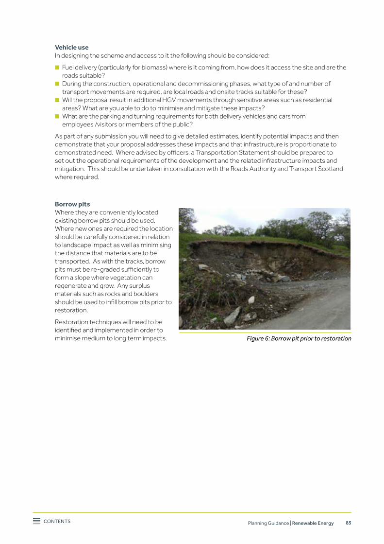
Contents Planning Guidance | Renewable Energy 85
vehicle use In designing the scheme and access to it the following should be considered:
n Fuel delivery (particularly for biomass) where is it coming from, how does it access the site and are the roads suitable?
n During the construction, operational and decommissioning phases, what type of and number of transport movements are required, are local roads and onsite tracks suitable for these?
n Will the proposal result in additional HGV movements through sensitive areas such as residential areas? What are you able to do to minimise and mitigate these impacts?
n What are the parking and turning requirements for both delivery vehicles and cars from employees /visitors or members of the public?
As part of any submission you will need to give detailed estimates, identify potential impacts and then demonstrate that your proposal addresses these impacts and that infrastructure is proportionate to demonstratedneed.Whereadvisedbyofficers,aTransportationStatementshouldbepreparedtoset out the operational requirements of the development and the related infrastructure impacts and mitigation. This should be undertaken in consultation with the Roads Authority and Transport Scotland where required.
Borrow pits Where they are conveniently located
existing borrow pits should be used. Where new ones are required the location should be carefully considered in relation to landscape impact as well as minimising the distance that materials are to be transported. As with the tracks, borrow pitsmustbere-gradedsufficientlytoform a slope where vegetation can regenerate and grow. Any surplus materials such as rocks and boulders shouldbeusedtoinfillborrowpitspriortorestoration.
Restoration techniques will need to be identifiedandimplementedinordertominimise medium to long term impacts. Figure 6: Borrow pit prior to restoration
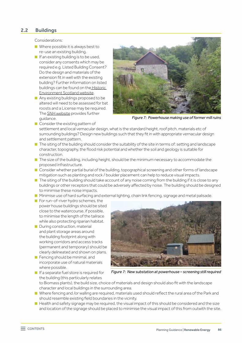
Contents Planning Guidance | Renewable Energy 86
2.2 Buildings
Considerations:
n Where possible it is always best to re-use an existing building.
n If an existing building is to be used, consider any consents which may be required e.g. Listed Building Consent? Do the design and materials of the extensionfitinwellwiththeexistingbuilding? Further information on listed buildings can be found on the Historic Environment Scotland website.
n Any existing buildings proposed to be altered will need to be assessed for bat roosts and a License may be required. The SNH website provides further guidance.
n Consider the existing pattern of settlement and local vernacular design, what is the standard height, roof pitch, materials etc of surroundingbuildings?Designnewbuildingssuchthattheyfitinwithappropriatevernaculardesignand settlement pattern.
n The siting of the building should consider the suitability of the site in terms of: setting and landscape character,topography,thefloodriskpotentialandwhetherthesoilandgeologyissuitableforconstruction.
n The size of the building, including height, should be the minimum necessary to accommodate the proposed infrastructure.
n Consider whether partial burial of the building, topographical screening and other forms of landscape mitigation such as planting and rock / boulder placement can help to reduce visual impacts.
n The siting of the building should take account of any noise coming from the building if it is close to any buildingsorotherreceptorsthatcouldbeadverselyaffectedbynoise.Thebuildingshouldbedesignedto minimise these noise impacts.
n Minimise use of hard surfacing and external lighting, chain link fencing, signage and metal palisade. n For run-of-river hydro schemes, the
power house buildings should be sited close to the watercourse, if possible, to minimise the length of the tailrace while also protecting riparian habitat.
n During construction, material and plant storage areas around the building footprint along with working corridors and access tracks (permanent and temporary) should be clearly delineated and shown on plans.
n Fencing should be minimal, and incorporate use of natural materials where possible.
n If a separate fuel store is required for the building (this particularly relates toBiomassplants),thebuildsize,choiceofmaterialsanddesignshouldalsofitwiththelandscapecharacter and local buildings in the surrounding area.
n Wherefencingand/orwallingarerequired,materialsusedshouldreflecttheruralareaoftheParkandshouldresembleexistingfieldboundariesinthevicinity.
n Health and safety signage may be required, the visual impact of this should be considered and the size and location of the signage should be placed to minimise the visual impact of this from outwith the site.
Figure 7: Powerhouse making use of former mill ruins
Figure 7: New substation at powerhouse – screening still required

Contents Planning Guidance | Renewable Energy 87
2.3 Construction compounds, material and plant storage and laydown areas
Considerations:
n Using an existing construction yard, compound area or areas linked to an existing farm or other building should be considered in preference to creating new compounds.
n Areaswhichareeffectivelyscreenedby existing trees, vegetation or landform should be chosen to minimise the landscape impact.
n Soft ground which can be damaged through compaction should be avoidedandpotentiallyidentifiedasanexclusion area.
n Compounds, material and plant storage areas and temporary laydown areas should be chosen carefully to minimise impacts on valuable habitats and soils, such as deep peat areas.
n All areas should be shown on plans andindicatedonsiteforthebenefitofcontractors.
2.4 Construction method statements
Construction Method Statements (CMS) are produced in order to enable contractors on site to understand responsibilities, lines of communication, how they are to work on site, to identify risks and to put in place control measures. Depending upon the scale of the proposal these may be simple or integrated into a more holistic Construction Environmental Management Plan.
There are various samples and templates for CMS available online. CMS are likely to be a condition of planning consent however drafts may be required as part of the submission to demonstrate that key risks havebeenidentifiedandmethodswillbeinplacetomanageandminimisethoserisks.
2.5 Electricity connection to the Grid
The majority of power generation schemes will require a new connection to the Grid. In designing a renewable scheme, the following should be considered:
n The location of the electricity connection route to the Grid should be based on minimising the impact to valuable habitats or features and using existing power lines or substations where possible.
n DetailofthenearestGridconnectionpointorsubstationshouldbeidentified,thelocationofexistingabove ground power lines, and whether a connection will require only a transformer on a pole or a new substation.
n The location of any new connections should minimise the visual impacts on landscape through appropriate route and design, including wherever possible undergrounding the powerlines.
n Consider the impacts positive and negative of undergrounding powerlines, for example it may minimise bird strike but may disrupt water courses. Where installations involve placing lines under small rivers orstreamstheconstructionmethodsshouldminimiseimpactsonwaterquality,modificationofwaterflowandimpactsonfreshwaterspeciessuchassalmonidsorfreshwaterpearlmussels.
Figure 9 Laydown area
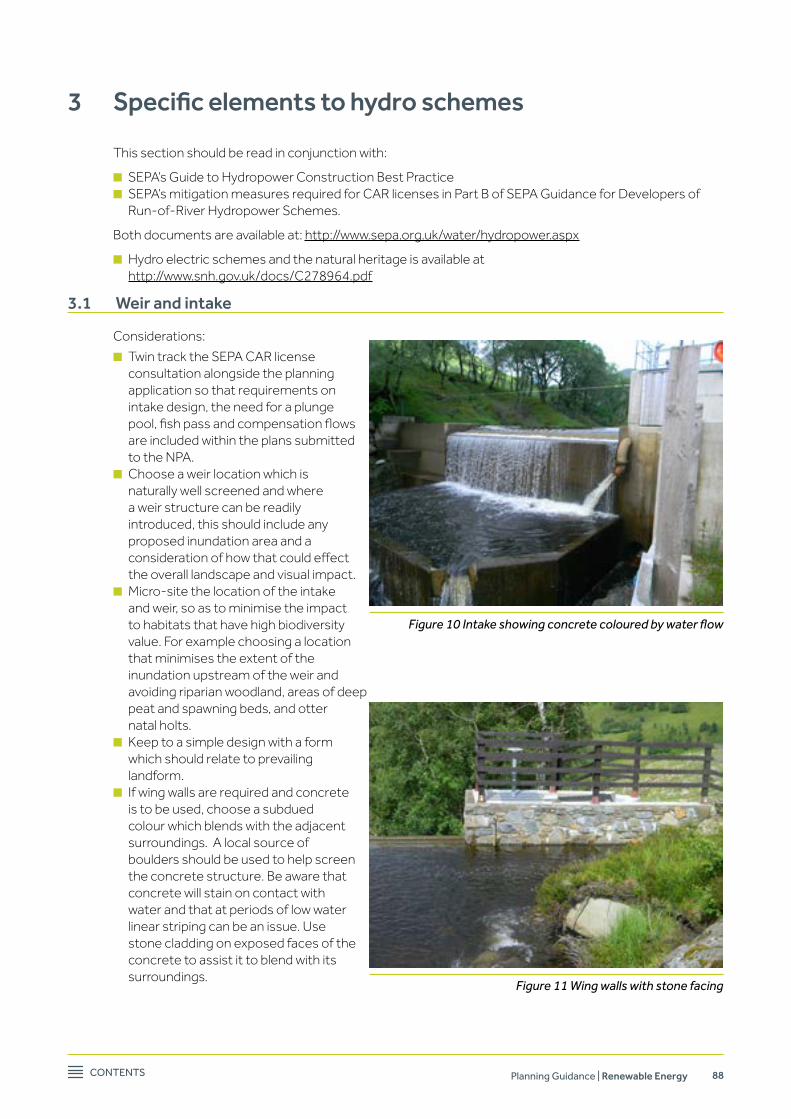
Contents Planning Guidance | Renewable Energy 88
3 Specific elements to hydro schemes
This section should be read in conjunction with:
n SEPA’s Guide to Hydropower Construction Best Practice n SEPA’s mitigation measures required for CAR licenses in Part B of SEPA Guidance for Developers of
Run-of-River Hydropower Schemes.
Both documents are available at: http://www.sepa.org.uk/water/hydropower.aspx
n Hydro electric schemes and the natural heritage is available at http://www.snh.gov.uk/docs/C278964.pdf
3.1 Weir and intake
Considerations:
n Twin track the SEPA CAR license consultation alongside the planning application so that requirements on intake design, the need for a plunge pool,fishpassandcompensationflowsare included within the plans submitted to the NPA.
n Choose a weir location which is naturally well screened and where a weir structure can be readily introduced, this should include any proposed inundation area and a considerationofhowthatcouldeffectthe overall landscape and visual impact.
n Micro-site the location of the intake and weir, so as to minimise the impact to habitats that have high biodiversity value. For example choosing a location that minimises the extent of the inundation upstream of the weir and avoiding riparian woodland, areas of deep peat and spawning beds, and otter natal holts.
n Keep to a simple design with a form which should relate to prevailing landform.
n If wing walls are required and concrete is to be used, choose a subdued colour which blends with the adjacent surroundings. A local source of boulders should be used to help screen the concrete structure. Be aware that concrete will stain on contact with water and that at periods of low water linear striping can be an issue. Use stone cladding on exposed faces of the concrete to assist it to blend with its surroundings.
Figure 10 Intake showing concrete coloured by water flow
Figure 11 Wing walls with stone facing

Contents Planning Guidance | Renewable Energy 89
n If rip-rap retention is required in the vicinity of the inundation area or the river bank immediately adjacent to the weir, consideration should be given to the detail and use of local rocks and boulders to minimise visual impact. If geotextile retention is required, in order to aid re-vegetation as well as successful landscape and visual integration, attention should be paidtothedetailandspecificationofthematerial applied and its ongoing monitoring and maintenance.
n If safety rails are required, link these to existing fence structures where these exist (i.e. if the standard fence in the area is a 3 bar timber fence, use it around the intake). Introduce asfewdifferentmaterialsandcoloursaspossible.Amutegalvanisedfinishinamutegrey / green colour will blend in with most upland environments.
n Keep measuring devices and gauges low in profile.Useamutegalvanisedfinishratherthanahighlyreflectiveorcolouredfinishwhichwillreflectlightanddrawattentiontothestructure.
n If health and safety signage or life buoys are required site these appropriately to minimise visual impact.
nAttentiontodetail,andqualityoffinishmakeahugedifferencetolandscapeandvisualimpact and time taken to get this right is a good investment.
n Check whether the intake would impact upon upstream or downstream passage of migratory fish,anddesigntheintaketoanagreedspecificationthatwillminimiseimpactsonthespecies present.
n Ensuretheschemehasacompensationflowin the water course to allow continual movement of freshwater through waterfalls, boulder areas and pools, and provide for seasonal variationsinflowinlinewithSEPA’sCARlicenserequirements.
n Construction methods should ensure that there are no sedimentation impacts downstream of the in-stream works and that the design of the weir does not result in an accumulation of sediment upstream. Both could impact on fishandfishhabitat.IncludedetailswithintheConstruction Method Statement on sediment pollution and incident management.
n Schedule in stream works to avoid the salmon spawning season.
n Consider recreational users of the area, whether the structure will create a barrier to water recreation or whether provision can be made for enhanced access where possible.
Figure 12: Use of Geo-textile to stabilise and help colonise bank.
Figure 13: Fencing to match existing
Figure 14 Brightly coloured health and safety equipment
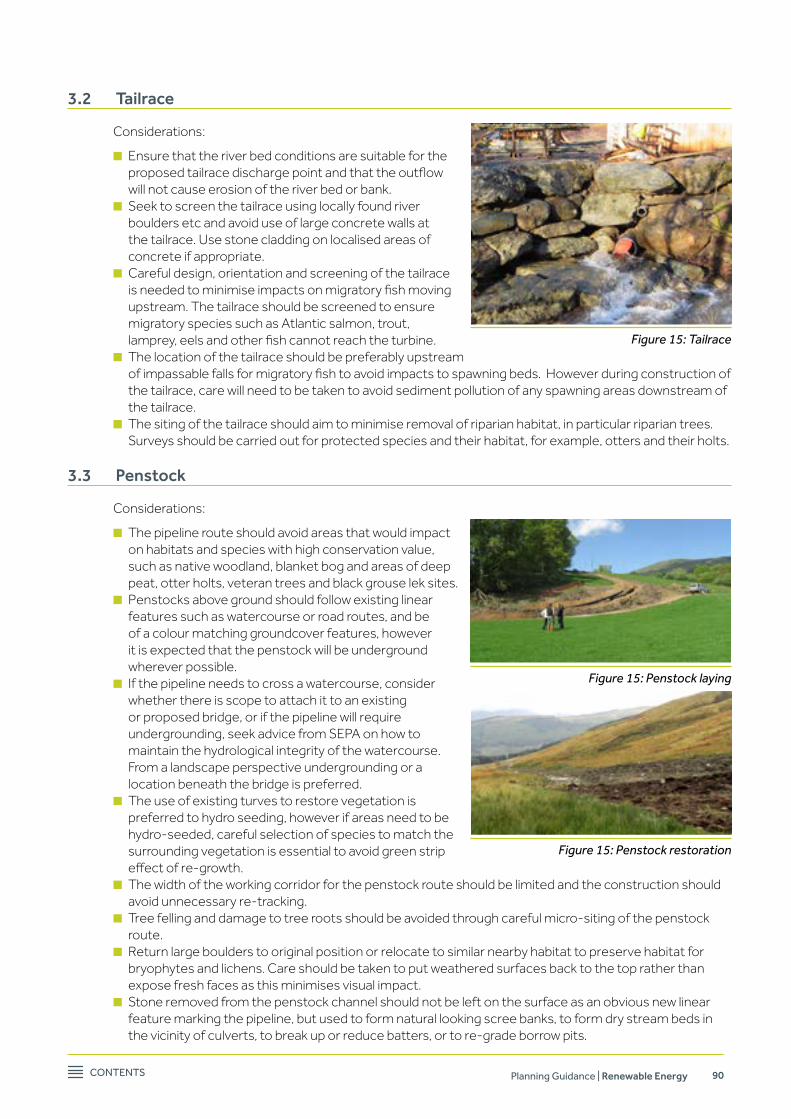
Contents Planning Guidance | Renewable Energy 90
3.2 Tailrace
Considerations:
n Ensure that the river bed conditions are suitable for the proposedtailracedischargepointandthattheoutflowwill not cause erosion of the river bed or bank.
n Seek to screen the tailrace using locally found river boulders etc and avoid use of large concrete walls at the tailrace. Use stone cladding on localised areas of concrete if appropriate.
n Careful design, orientation and screening of the tailrace isneededtominimiseimpactsonmigratoryfishmovingupstream. The tailrace should be screened to ensure migratory species such as Atlantic salmon, trout, lamprey,eelsandotherfishcannotreachtheturbine.
n The location of the tailrace should be preferably upstream ofimpassablefallsformigratoryfishtoavoidimpactstospawningbeds.Howeverduringconstructionofthe tailrace, care will need to be taken to avoid sediment pollution of any spawning areas downstream of the tailrace.
n The siting of the tailrace should aim to minimise removal of riparian habitat, in particular riparian trees. Surveys should be carried out for protected species and their habitat, for example, otters and their holts.
3.3 Penstock
Considerations:
n The pipeline route should avoid areas that would impact on habitats and species with high conservation value, such as native woodland, blanket bog and areas of deep peat, otter holts, veteran trees and black grouse lek sites.
n Penstocks above ground should follow existing linear features such as watercourse or road routes, and be of a colour matching groundcover features, however it is expected that the penstock will be underground wherever possible.
n If the pipeline needs to cross a watercourse, consider whether there is scope to attach it to an existing or proposed bridge, or if the pipeline will require undergrounding, seek advice from SEPA on how to maintain the hydrological integrity of the watercourse. From a landscape perspective undergrounding or a location beneath the bridge is preferred.
n The use of existing turves to restore vegetation is preferred to hydro seeding, however if areas need to be hydro-seeded, careful selection of species to match the surrounding vegetation is essential to avoid green strip effectofre-growth.
n The width of the working corridor for the penstock route should be limited and the construction should avoid unnecessary re-tracking.
n Tree felling and damage to tree roots should be avoided through careful micro-siting of the penstock route.
n Return large boulders to original position or relocate to similar nearby habitat to preserve habitat for bryophytes and lichens. Care should be taken to put weathered surfaces back to the top rather than expose fresh faces as this minimises visual impact.
n Stone removed from the penstock channel should not be left on the surface as an obvious new linear feature marking the pipeline, but used to form natural looking scree banks, to form dry stream beds in the vicinity of culverts, to break up or reduce batters, or to re-grade borrow pits.
Figure 15: Tailrace
Figure 15: Penstock laying
Figure 15: Penstock restoration
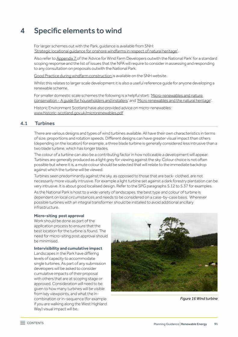
Contents Planning Guidance | Renewable Energy 91
4 Specific elements to wind
For larger schemes out with the Park, guidance is available from SNH: ‘Strategic locational guidance for onshore windfarms in respect of natural heritage’.
Also refer to Appendix 7 of the ‘Advice for Wind Farm Developers outwith the National Park’ for a standard scoping response and the list of issues that the NPA will require to consider in assessing and responding to any consultation on proposals outwith the National Park.
Good Practice during windfarm construction is available on the SNH website.
Whilst this relates to larger scale development it is also a useful reference guide for anyone developing a renewable scheme.
For smaller domestic scale schemes the following is a helpful start: ‘Micro-renewables and nature conservation - A guide for householders and installers’ and ‘Micro renewables and the natural heritage’.
Historic Environment Scotland have also provided advice on micro-renewables: www.historic-scotland.gov.uk/microrenewables.pdf
4.1 Turbines
There are various designs and types of wind turbines available. All have their own characteristics in terms ofsize,proportionsandrotationspeeds.Differentdesignscanhavegreatervisualimpactthanothers(depending on the location) for example, a three blade turbine is generally considered less intrusive than a two blade turbine, which has longer blades.
The colour of a turbine can also be a contributing factor in how noticeable a development will appear. Turbines are generally produced as a light grey for viewing against the sky. Colour choice is not often possible but where it is, a mute colour should be selected that will relate to the immediate backdrop against which the turbine will be viewed.
Turbines seen predominantly against the sky, as opposed to those that are back- clothed, are not necessarily more visually intrusive. For example a light turbine set against a dark forestry plantation can be very intrusive. It is about good localised design. Refer to the SPG paragraphs 5.12 to 5.37 for examples.
As the National Park is host to a wide variety of landscapes, the best type and colour of turbine is dependent on local circumstances and needs to be considered on a case-by-case basis. Wherever possible turbines with an integral transformer should be installed to avoid additional ancillary infrastructure.
Micro-siting post approval Work should be done as part of the
application process to ensure that the best location for the turbine is found. The need for micro-siting post approval should be minimised.
Intervisibility and cumulative impact LandscapesintheParkhavediffering
levels of capacity to accommodate single turbines. As part of any submission developers will be asked to consider cumulative impacts of their proposal with others that are at scoping stage or approved. Consideration will need to be given to how many turbines will be visible from key viewpoints, and what the in-combination or in-sequence (for example if you are walking along the West Highland Way) visual impact will be.
Figure 16 Wind turbine

Contents Planning Guidance | Renewable Energy 92
5 Specific elements to biomass
Around 29% of the National Park is covered by woodland and forestry and this presents an opportunity for biomass heat and/or power generation. This resource should be managed sustainably and any proposal to utilise this resource should be accompanied by a Woodland Management strategy which should include sections on landscape and biodiversity. If you are planning a biomass scheme the following guidance may be of assistance:
“Biomass heating – a practical guide for potential users” – produced by the Carbon Trust
In general the NPA would prefer to see schemes which combine both heat and power, which are located close to the fuel source and limit timber transport miles and are close to the heat demand.
Given that these types of development are likely to be within or adjacent to settlements it will be important to consider the following:
n Is it within a Smoke Control Area? n Is it within a Conservation Area, see n DoesitaffectaListed Building or its setting? n How much fuel will be required, where will it be stored and how will it be delivered – are the roads
suitable for this?
Anyproposalshouldaddresstheseelementsandseektominimiseandmitigateidentifiedimpacts.
5.1 Chimneys and plumes
Biomass schemes will require a chimney which will produce a plume. Depending on the scale of the proposal the chimney maybenohigherorsignificantthananyexisting chimneys. However any proposal must consider how visible the plume (in the prevailing wind) and chimney will be. The visual impact of this should be assessed from key viewpoints (within and out with settlements), transport corridors, core paths, elevated viewpoints and long distance cycling and walking routes.
The plume adds a visual marker to the development so you may also be asked to undertake a cumulative assessment and look at how the plume will appear in key conditions, and what this may then draw the eye to. For example there may be an existing single turbine which is unobtrusive in its landscape setting until the plume draws the viewer’s eye towards it.
Figure 17: Biomass facility in outbuilding

Contents Planning Guidance | Renewable Energy 93

Loch Lomond & The Trossachs National Park Carrochan, Carrochan Road, Balloch G83 8EG.
t: 01389 722600
w: lochlomond-trossachs.org
Adopted June 2013
Revised and re-published June 2017