reo ra - wisconsin dnr
TRANSCRIPT

REGION 5 RAC2R E M E D I A L A C T I O N C O N T R A C T F O R
Remedial, Enforcement Oversight, and Non-Time Critical Removal Activities at Sites of Release or Threatened Release of Hazardous Substances in Region 5
Final ConstruCtion Completion report Lincoln Park/Milwaukee River Channel Sediments Site Phase I Remedial Action Milwaukee, WI
WA No. 122-RARA-2508/Contract No. EP-S5-06-01
June 2013
PREPARED FOR
U.S. Environmental Protection Agency
PREPARED BY
CH2m Hill Ecology and Environment, Inc. Environmental Design International, Inc. Teska Associates, Inc. Critigen, LLC FOR OFFICIAL USE ONLY

F i na l Cons t ruc t i on Comp le t i on Repo r t
Lincoln Park/Milwaukee River Channel Sediments Site
Phase I Remedial Action WA No. 122-RARA-2508/Contract No. EP-S5-06-01
Prepared for
June 2013
Executive Summary This Construction Completion Report (CCR) summarizes the Great Lakes Legacy Act Phase I remediation of the Lincoln Park/Milwaukee River Channel Sediments Site (Lincoln Park/Milwaukee River Site). The Lincoln Park/Milwaukee River Site is part of the Milwaukee Estuary Area of Concern (AOC), in Milwaukee, Wisconsin.
Figure 1 shows the boundaries of the Lincoln Park/ Milwaukee River Site, which is between Lincoln Creek downstream of Green Bay Road, the western oxbow of the Milwaukee River, and the Milwaukee River downstream of the confluence with Lincoln Creek to the Estabrook Park Dam.
The remedial action (Phase I) focused on Zones 1, 2, and the northwestern part of Zone 3. Zones 2 and 3 are divided into subzones 2a, 2b, and 3a for the remedial action.
A 1997, polychlorinated biphenyl (PCB) mass balance study of the site estimated that the Lincoln Park/ Milwaukee River sediments held over 100,000 cubic yards of sediment contaminated with an estimated 5,200 kilograms (11,500 pounds) of PCBs such as Aroclor-1242 (Baird and Associates 1997). The mass balance study determined the Lincoln Park/Milwaukee River Site contributed the greatest mass loading of PCBs to the Milwaukee River and Harbor, and that remediation of contaminated sediment within the area was expected to result in a long-term reduction in PCB mass transport in the Milwaukee River of up to 70 percent.
The following 11 Beneficial Use Impairments (BUIs) occur within the Milwaukee Estuary AOC:
• Restrictions on fish and wildlife consumption • Degradation of fish and wildlife populations • Fish tumors or other deformities • Bird or animal deformities or reproduction problems • Degradation of benthos • Restrictions on dredging activities • Eutrophication or undesirable algae • Beach closings/recreational restrictions • Degraded aesthetics • Degradation of phytoplankton and zooplankton populations • Loss of fish and wildlife habitat
Based on previous evaluations of the site conditions, feasible alternatives, potential costs, and input from federal, state, and local stakeholders, an excavation and offsite disposal remedy was the proposed alternative for remediation at the Lincoln Park/Milwaukee River Site and is documented in the Feasibility Study Report, Lincoln Park/Milwaukee River Channel Sediments Site, Milwaukee Estuary Area of Concern (CH2M HILL 2009). The remedial Design is documented in the Basis of Design Report (CH2M HILL 2011a). The design was completed based on the selected remedial alternative, which addressed the following remedial action objectives:
• Support removal of BUIs within the Milwaukee Estuary AOC: − Fish and wildlife consumption advisories − Degradation of benthos − Restrictions on dredging − Degradation of fish and wildlife habitat
• Minimize potential human health and environmental risks associated with remedial activities, to the extent practical. • Upon completion of remedial activities, improve habitat of the site through restoration efforts.
The general scope of items for construction activities included the following:
• Mechanical excavation and dewatering/solidifying of sediment • Water treatment
ES120512163055MKE III
CONSTRUCTION COMPLETION REPORT: LINCOLN PARK/MILWAUKEE RIVER CHANNEL SEDIMENTS SITE, PHASE I REMEDIAL ACTION
• Offsite disposal • Habitat restoration
A remedial action level of 1 milligram per kilogram (mg/kg) or part per million PCB in sediment was developed for the Lincoln Park/ Milwaukee River Site. The level is consistent with other reaches within the Milwaukee Estuary AOC (Blatz Pavilion Site [Natural Resource Technology 2007]) and is considered to be protective of human health and the environment.
During the sediment removal phase of the remedial action, it was determined that there was a significant volume of polynuclear aromatic hydrocarbon (PAH) material within the Lincoln Park/Milwaukee River Site that was not previously found in investigations of the site (Appendix E). A remedial action level of 20 mg/kg total PAH surface weighted average or 40 mg/kg total PAH maximum concentration in sediment was established by the U.S. Environmental Protection Agency (USEPA) and the Wisconsin Department of Natural Resources for Zones 2B and 3A. A remedial action level of 20 mg/kg total PAH concentration in sediment was established by USEPA and the Wisconsin Department of Natural Resources for Zone 2A.
A summary of the volumes of sediment removed and the related contaminant mass are provided below in Table ES-1.
TABLE ES-1 Mass Removal Summary Lincoln Creek/Milwaukee River Channel Sediments Site Construction Completion Report
Year 2011 2012 Total
Sediment Volume Removed (yd3) 93,483 25,556 119,039
Sediment Volume Removed (tons) 156,549 44,440 200,989
Non-TSCA PCBs (pounds) 2,777 510 3,287
TSCA PCBs (pounds) 1,741 0 1,741
PAHs (pounds) 2,787 1,248 4,035
PAH NAPL (pounds) 359,249* 0 359,249
Total PCBs (pounds) 4,518 510 5,028
*PAH NAPL mass estimated based on 2,000 yd3 at an average concentration of 75,000 mg/kg. yd3 = cubic yards TSCA = Toxic Substances Control Act NAPL = nonaqueous phase liquid
The Phase I remediation of the Lincoln Park/Milwaukee River Site was performed under the Great Lakes Legacy Act and was funded by the USEPA Remedial Action Contract Program and the Wisconsin Department of Natural Resources.
This CCR summarizes a description of the project, site preparation and setup, excavation operations and disposal, environmental monitoring, confirmation sampling and analysis, project results, demobilization and restoration, and project milestones. Restoration included regrading the creek bed and the slopes and placement of riprap and plantings. Maintenance of the restoration is ongoing and will be addressed in a separate restoration completion report.
IV ES120512163055MKE

Contents
Executive Summary ......................................................................................................................................... iii
Acronyms and Abbreviations .......................................................................................................................... vii
1. Project Description ............................................................................................................................ 1-1 1.1 General Site Description ................................................................................................................... 1-1
1.1.1 Beneficial Use Impairments ................................................................................................ 1-2 1.2 Regulatory Framework ..................................................................................................................... 1-2 1.3 Project Objectives ............................................................................................................................ 1-2 1.4 Project Scope .................................................................................................................................... 1-3 1.5 Project Organization and Management ........................................................................................... 1-6
1.5.1 Stakeholders ........................................................................................................................ 1-6 1.5.2 CH2M HILL ........................................................................................................................... 1-7
1.6 Review of Specifications and Drawings ............................................................................................ 1-7 1.7 Work Plan Development .................................................................................................................. 1-7 1.8 Permits ............................................................................................................................................. 1-7
1.8.1 Federal ................................................................................................................................. 1-8 1.8.2 State and Local .................................................................................................................... 1-9
1.9 Project Quality Assurance and Quality Control ................................................................................ 1-9 1.10 Project Management and Reporting .............................................................................................. 1-10 1.11 Safety .............................................................................................................................................. 1-10
1.11.1 Trainings and Certifications ............................................................................................... 1-10 1.11.2 Health and Safety Plan ...................................................................................................... 1-11 1.11.3 Site-specific Training ......................................................................................................... 1-11 1.11.4 Accident Prevention .......................................................................................................... 1-11
2. Site Preparation and Setup ................................................................................................................ 2-1 2.1 Site Preparation ................................................................................................................................ 2-1
2.1.1 Mobilization, Staging, and Temporary Facilities ................................................................. 2-1 2.1.2 Pre-Excavation Sediment Delineation ................................................................................. 2-1 2.1.3 Water Bypass Systems ........................................................................................................ 2-2
3. Excavation Operations and Disposal of Dredging Material ................................................................. 3-1 3.1 Excavation ........................................................................................................................................ 3-1
3.1.1 Sediment Dewatering .......................................................................................................... 3-1 3.1.2 Excavation Sequencing ........................................................................................................ 3-1 3.1.3 Excavation Production Rate ................................................................................................ 3-3
3.2 Sediment Staging/Decontamination ................................................................................................ 3-3 3.3 Offsite Disposal................................................................................................................................. 3-3
4. Environmental Monitoring of Remediation Activity Impacts .............................................................. 4-1 4.1 Wastewater Monitoring and Treatment .......................................................................................... 4-1
5. Sediment Confirmation Sampling and Analysis ................................................................................... 5-1 5.1 Analytical Program ........................................................................................................................... 5-1
5.1.1 Contaminants of Concern ................................................................................................... 5-1 5.1.2 Analytical Laboratories ........................................................................................................ 5-1
5.2 Sediment Sampling ........................................................................................................................... 5-2
ES120512163055MKE V

CONSTRUCTION COMPLETION REPORT: LINCOLN PARK/MILWAUKEE RIVER CHANNEL SEDIMENTS SITE, PHASE I REMEDIAL ACTION
6. Project Results................................................................................................................................... 6-1 6.1 Post-Excavation Sediment Characterization .................................................................................... 6-1 6.2 Post-Excavation Survey .................................................................................................................... 6-1 6.3 Mass Removal .................................................................................................................................. 6-1 6.4 Health, Safety, and Accident Prevention ......................................................................................... 6-2
7. Demobilization and Restoration ......................................................................................................... 7-1 7.1 Demobilization ................................................................................................................................. 7-1 7.2 Site Restoration and Environmental Enhancements ....................................................................... 7-1
7.2.1 Site Restoration ................................................................................................................... 7-1
8. Project Milestones ............................................................................................................................. 8-1
9. Costs ................................................................................................................................................. 9-1
10. References ...................................................................................................................................... 10-1
Appendixes
A Record Drawings B Field Order and Change Order Summary C WPDES Sampling D Pre-Excavation TSCA Technical Memorandum E Remedial Action Characterization Technical Memorandum F Confirmation Sampling Results G Photographs H Waste Tracking Logs I Submittal Register J Permits K Request for Information Log
Tables
ES-1 Mass Removal Summary ................................................................................................................................. iv 1 Project Stakeholders ..................................................................................................................................... 1-6 2 Weights for Offsite Disposal .......................................................................................................................... 3-4 3 Mass Removal Summary ............................................................................................................................... 6-1 4 Project Milestones ......................................................................................................................................... 8-1
Figures
1 Site Location Map 2a Stage 2 Temporary Cut-off 2b Stage 2 Temporary Cut-off 3 Decision Logic for PAH Remediation of Zones 2B and 3A 4 Wastewater Treatment During Remedial Action
VI ES120512163055MKE

Acronyms and Abbreviations AOC Area of Concern BBLPS behavior-based loss prevention system BUI beneficial use impairment CCR Construction Completion Report CFR Code of Federal Regulations CLP Contract Laboratory Program CQAP construction quality assurance plan yd3 cubic yards FEMA Federal Emergency Management Agency GLLA Great Lakes Legacy Act GLNPO Great Lakes National Program Office HASP health and safety plan mg/kg milligram per kilogram mg/L milligrams per liter NAPL nonaqueous phase liquid NCR nonconformance report NRT Natural Resource Technology, Inc. OSHA Occupational Safety and Health Administration PAH polynuclear aromatic hydrocarbon PCB polychlorinated biphenyl ppm parts per million QA quality assurance QAPP quality assurance project plan QC quality control RA remedial action RFI request for information SVOC semivolatile organic compound TCLP toxicity characteristic leaching procedure TSCA Toxic Substances Control Act TSS total suspended solids USEPA U.S. Environmental Protection Agency USFWS U.S. Fish and Wildlife Service VOC volatile organic compound WDNR Wisconsin Department of Natural Resources WPDES Wisconsin Pollutant Discharge Elimination System
ES120512163055MKE VII
SECTION 1
Project Description Section 1 describes the project.
1.1 General Site Description This report describes the Great Lakes Legacy Act (GLLA) remediation of the Lincoln Park/Milwaukee River Site. Figure 1 shows the boundaries of the Lincoln Park/Milwaukee River Channel Sediments Site (Lincoln Park/ Milwaukee River Site), which is within the Milwaukee Estuary Area of Concern (AOC) between Lincoln Creek downstream of Green Bay Road, the western oxbow of the Milwaukee River, and the Milwaukee River downstream of the confluence with Lincoln Creek to the Estabrook Park Dam. The Lincoln Park/Milwaukee River Site was divided into the following five zones during the Estabrook Impoundment sediment remediation predesign study (Wisconsin Department of Natural Resources [WDNR] 2005):
• Zone 1: Lincoln Creek from Green Bay Road to the confluence with the Milwaukee River • Zone 2: Entire western oxbow in the Milwaukee River, which contains the main sediment deposit • Zones 3, 4, and 5: Milwaukee River from the confluence of the western oxbow downstream to Estabrook Park Dam
The remedial design (Phase 1) focused on Zones 1, 2, and the northwestern part of Zone 3. Zones 2 and 3 are divided into subzones 2a, 2b, and 3a as shown in the record drawings (Appendix A). Zones 4 and 5 and the remaining portion of Zone 3 will be addressed at another time. The Estabrook Park Dam forms the downstream boundary of the Lincoln Park/Milwaukee River Site, and backs up water approximately 2.5 miles to a point 0.3 mile upstream of Silver Spring Road on the Milwaukee River, creating a 103-acre impoundment. The Estabrook Park Dam also has an impact on Lincoln Creek to a point about 0.5 mile upstream of the confluence with the Milwaukee River. The Estabrook Park Dam was built on a limestone outcrop in the river channel in 1936, and has a hydraulic height of 8 feet and maximum storage of 700 acre-feet. The Estabrook Park Dam, which is owned and operated by Milwaukee County, was historically kept open during the winter and closed in the summer. The water pool behind the Estabrook Park Dam also has historically been lowered in anticipation of high flows. The bottom draw design of the Estabrook Park Dam and periodic opening and closing of the dam has caused some contaminated sediment to be released downstream, and some compaction of the remaining sediment upstream within the impoundment due to dewatering/wetting cycles.
Inspections by WDNR have identified the need for significant repair work on the Estabrook Park Dam. WDNR issued a Repair or Abandon Order to Milwaukee County on July 28, 2009. The order establishes deadlines for Milwaukee County to meet related to outstanding maintenance and repair requirements. The order also gives Milwaukee County the option to decide whether to abandon the dam. The decision for repair or abandonment is the responsibility of Milwaukee County, the owner of the dam. The order requires that the dam remain open until it is repaired or abandoned.
A 1997 PCB mass balance study of the site estimated that the Lincoln Park/ Milwaukee River sediments held over 100,000 cubic yards (yd3) of sediment contaminated with an estimated 5,200 kilograms (11,500 pounds) of PCBs such as Aroclor-1242 (Baird and Associates 1997). The mass balance study determined the Lincoln Park/Milwaukee River Site contributes the greatest mass loading of PCBs to the Milwaukee River and Harbor, and that remediation of contaminated sediment within the area is expected to result in a long-term reduction in PCB mass transport in the Milwaukee River of up to 70 percent. Beneficial use impairments (BUIs) specifically associated with the Lincoln Park/Milwaukee River Site include restrictions on fish and wildlife consumption, degradation of fish and wildlife populations, degradation of benthos, and restrictions on dredging activities.
From March 2008 through August 2008, through funding from WDNR, approximately 4,700 yd3 of contaminated sediment/soil were removed from the area immediately adjacent to the Blatz Pavilion Lagoon (Zone 3) and backfilled. The Blatz Pavilion Lagoon area is isolated from the other contaminated areas in Zones 1 through 5 and has easy public access. WDNR selected the Blatz Pavilion Lagoon site to be the first area remediated (NRT 2009).
ES120512163055MKE 1-1
CONSTRUCTION COMPLETION REPORT: LINCOLN PARK/MILWAUKEE RIVER CHANNEL SEDIMENTS SITE, PHASE I REMEDIAL ACTION
1.1.1 Beneficial Use Impairments Contaminated sediment is a major contributor to use impairments within the Milwaukee Estuary AOC (WDNR 1994). The following BUIs occur within the AOC:
• Restrictions on fish and wildlife consumption • Degradation of fish and wildlife populations • Fish tumors or other deformities • Bird or animal deformities or reproduction problems • Degradation of benthos • Restrictions on dredging activities • Eutrophication or undesirable algae • Beach closings/recreational restrictions • Degraded aesthetics • Degradation of phytoplankton and zooplankton populations • Loss of fish and wildlife habitat
Fish consumption advisories are in place, such as those in effect from Grafton to the mouth of the Milwaukee River, because of PCB contamination.
1.2 Regulatory Framework The Phase I remediation of the Lincoln Park/Milwaukee River Site was performed under the GLLA and funded by GLLA and WDNR.
1.3 Project Objectives Based on previous evaluations of the site conditions, feasible alternatives, potential costs, and input from federal, state, and local stakeholders, an excavation and offsite disposal remedy was the proposed alternative for remediation at the Lincoln Park/Milwaukee River Site and was documented in the Feasibility Study Report, Lincoln Park/Milwaukee River Channel Sediments Site, Milwaukee Estuary Area of Concern (CH2M HILL 2009). The remedial Design is documented in the Basis of Design Report (CH2M HILL 2011a). The design was completed based on the selected remedial alternative, which addressed the following remedial action (RA) objectives:
• Support removal of BUIs within the Milwaukee Estuary AOC: − Fish and wildlife consumption advisories − Degradation of benthos − Restrictions on dredging − Degradation of fish and wildlife habitat
• Minimize potential human health and environmental risks associated with remedial activities, to the extent practical. • Upon completion of remedial activities, improve habitat of the site through restoration efforts.
An RA level of 1 milligram per kilogram (mg/kg) or part per million PCB in sediment was determined for the Lincoln Park/ Milwaukee River Site. The level is consistent with what was established previously at other reaches within the Milwaukee Estuary AOC Blatz Pavilion Site (Natural Resource Technology, Inc. [NRT] 2007) and is considered to be protective of human health and the environment.
During the sediment removal phase of the RA, it was determined that there was a significant volume (that is, greater than 15,000 yd3) of polynuclear aromatic hydrocarbon (PAH) material within the Lincoln Park/Milwaukee River Site that was not previously found in investigations of the site. A remedial action level of 20 mg/kg total PAH surface-weighted average or 40 mg/kg total PAH point concentration in sediment was established by the U.S. Environmental Protection Agency (USEPA) and WDNR for Zones 2B and 3A. An RA level of 20 mg/kg total maximum PAH concentration in sediment was established by USEPA and WDNR for Zone 2A.
1-2 ES120512163055MKE
1—PROJECT DESCRIPTION
1.4 Project Scope The scope of the project was to implement the approved project design for the Phase 1 area (CH2M HILL 2011a). This design (in general) included excavating and disposing of PCB-contaminated sediments to meet the objectives detailed in Section 1.3. To accomplish this, excavation was to be performed mechanically and in dry conditions. Each Zone that was to be excavated would be hydraulically isolated to minimize treatment of water and the potential migration of contaminants during the excavation. Isolating each cell was performed by installing sheetpile cutoff walls. Once isolated, the zones were dewatered, the sediment removed, and restoration was performed.
Mobilization to the site occurred during the week of August 1, 2011, with clearing and grubbing, implementation of temporary erosion control measures, construction of access points, construction of temporary access roads, and trailer setup. The water treatment plant was also mobilized and constructed. Construction of the sheet pile walls in Zone 1 (Lincoln Creek) began on August 17, 2011. Excavation of contaminated sediment on the west side of Zone 1 (Zone 1W) began on September 15, 2011.
After the initial excavation of Zone 1W was complete, confirmatory sampling was performed that indicated an area of Lincoln Creek and the creek bank in Zone 1W remained contaminated with concentrations of PCBs greater than 50 parts per million (ppm) (the concentration at which disposal is required at a Toxic Substances Control Act (TSCA)-approved landfill). Additional excavation was performed, and an additional investigation led to the discovery of an upland source of PCB contamination. Since it was determined by the project stakeholders that upland remediation could not be performed as part of this project, the project elected to install an Organoclay reactive core mat on the bank as a barrier in this area (see Section 3.1.2), to absorb oily PCB contamination before it enters into and potentially recontaminates Lincoln Creek.
As a result of the additional work to investigate and address the PCB source area and TSCA-level sediments encountered in Zone 1, means were implemented to compress the schedule for remaining work. With direction from the USEPA and other stakeholders, the water treatment system flow rate capacity was doubled, which allowed for excavation in Zone 1 and Zone 2 simultaneously, in lieu of a single zone.
As excavation of Zone 2A was initiated after isolation and dewatering, an oily-based material (nonaqueous phase liquid [NAPL]) was found, mixed with the sediments, near the confluence of Lincoln Creek. During excavation, a pool of NAPL was encountered at the northeast end of Zone 2A (at the north bridge of the Milwaukee River Parkway), as well as smaller areas of PAH contamination throughout Zone 2A. As a result of the PAH contamination in the sediment, PAHs were added to the laboratory analysis of the confirmation samples (in addition to PCBs). The removal criteria for total PAHs was established at 20 mg/kg for Zone 2A based on direction from USEPA and WDNR. An RA level of 20 mg/kg total PAH surface-weighted average or 40 mg/kg total PAH maximum concentration in sediment was established by USEPA and WDNR for Zones 2B and 3A.
Based on the additional contamination encountered in Zone 1W and Zone 2A, a pre-excavation sampling program was initiated in areas yet to be excavated to better define the excavations required to meet both the PCB and PAH cleanup criteria. The post-excavation sampling program also added sediment sampling at depth to refine the target depth and reduce the number of re-excavations. Once determined, the new excavation depths were provided to the subcontractor for implementation.
After excavation and partial restoration (riprap installation) was completed in Zones 1W and 2A, the temporary sheet piling isolating the zones was moved to direct water from Lincoln Creek to flow through Zones 1W and 2A, so that Zones 1E, 2B, and 3A could be dewatered and excavated to the revised excavation depths.
The quantity variations led to an additional excavation of 64,783 tons of sediment and a total delay in completing the project of 55 days. At the completion of excavation on January 13, 2012, the riprap in Zone 3A was installed to complete the restoration of the bank up to future pool elevation (EL 617.4 feet) so that the sheetpile isolating Zone 3A could be removed during the interim winter shutdown period. The sheetpiling that isolated Zone 2B was left in place during the interim winter shutdown period, so that in spring 2012, the zone could be dewatered and restoration completed.
Restoration included stream bank stabilization and grading to shape the post-excavation surface in some locations. Stream bank stabilization included plantings to support re-establishment of vegetation and long-term slope stability.
ES120512163055MKE 1-3

CONSTRUCTION COMPLETION REPORT: LINCOLN PARK/MILWAUKEE RIVER CHANNEL SEDIMENTS SITE, PHASE I REMEDIAL ACTION
Existing outfalls were protected and maintained and, in some cases, additional rock aprons were constructed to minimize erosion. The restoration was modified during construction with the reduction of “hard” landscaped river bank, and the increase of “soft” landscape. Following the assumption that the Estabrook Dam would be repaired and put into service at the completion of this project, much of the design included restoration with riprap for those areas that would be near water or underwater once the dam was put into service. As this project progressed, it became evident that the timing of the dam repair was in question, and the impoundment could be at a lower water level for an extended period. To provide for a more natural setting, as well as public access to the water, gentler slopes along much of the oxbow were constructed, and natural vegetation substituted for riprap.
The original schedule for the restoration was delayed as a result of the additional volumes of excavation that were required, which pushed much of the restoration from fall 2011 into spring and summer 2012. The drought conditions that persisted through this period led to stressed vegetation as it was attempting to be established throughout many areas of the site. Demobilization was performed starting August 8, 2012.
The scope of items for construction activities included the following:
• Mobilization—CH2M HILL and subcontractor Lee & Ryan mobilized to the site during the week of August 1, 2011, and completed clearing and grubbing vegetation, implementation of temporary erosion control measures in the areas disturbed, installation of temporary fencing, identification of excavation areas, construction of creek and oxbow access points, construction of temporary access roads, trailer setup, and utility connections. The water treatment plant was also mobilized and constructed. Kraemer (Lee & Ryan subcontractor) began constructing the sheet pile walls in Zone 1 on August 17, 2011, for the first stages of sediment excavation in the dry. Excavation of contaminated sediment began on September 15, 2011. Section 2 contains additional information regarding site preparation and setup. Installation of sheetpile in other zones was installed concurrent with other site activities.
• Mechanical Excavation and Dewatering/Solidifying of Sediment—Sediment contaminated with PCBs (and/or PAHs once found at the site) at concentrations exceeding criteria were excavated from Zones 1, 2, and 3A (Figure 1) using mechanical methods. Excavation areas were isolated to prevent the downstream migration of contaminated sediment during excavation by installing temporary sheet pile and dewatering prior to excavation. To facilitate sediment dewatering in these areas, channels and sumps were excavated into the sediment to actually allow the sediment to gravity-drain in place. This (along with a reduced estimated volume of TSCA-level sediments) allowed the construction of the TSCA sediment dewatering pad to be removed from the scope, at a cost savings to the project. Once excavated, sediments were allowed to dewater in load out piles through gravity drainage for an additional period of time (less than 24 hours), dry bank soils and/or Calciment was added as needed (see Section 3.1) to meet landfill disposal criteria, and the sediments were then disposed of offsite.
Changes to the original scope of the excavation include additional quantities that were removed due to the observed TSCA-level PCB contamination and source area found in Zone 1W (Appendix E), and the PAH contamination found in Zones 2A, 2B, and 3A. After the initial excavation was complete, confirmatory sampling was performed that indicated an area of Lincoln Creek and the creek bank in Zone 1W remained contaminated with concentrations of PCBs greater than 50 ppm (the concentration at which disposal is required at a TSCA-approved landfill). This was a change in conditions since no TSCA-level PCB contamination had been detected in Lincoln Creek in previous investigations. With the concurrence of USEPA, additional excavation was performed, and an additional investigation led to the discovery of an upland source of PCB contamination. Figure E-5 presents the results of the upland soil investigation immediately adjacent to location B014. Based on the results, TSCA-level sediments with PCB concentrations as high as 990 mg/kg, were found within the bank extending from location B014E+25 (25 feet upstream of B014) to B014E-75 (75 feet downstream of B014).
A total of 95 soil samples (not including quality assurance/quality control samples) from 9 locations were collected and analyzed for PCB Aroclors and PAHs within the upland area of B014. There was visual evidence of contaminant staining in location GP10 and a medium to strong odor from location GP01. Eight locations (GP01 through GP08 and GP10) exhibited a maximum total PAH concentration greater than 20 mg/kg within the soil boring, with the highest being 760 mg/kg. Since it was determined by the project stakeholders that upland remediation could not be performed as part of this project, the project elected to install an Organoclay reactive
1-4 ES120512163055MKE
1—PROJECT DESCRIPTION
core mat on the bank as a barrier in this area (see Section 3.1.2), to absorb oily PCB contamination before it enters into and potentially recontaminates Lincoln Creek.
Additional sediment quantities were also removed as a result of the PAH contamination. An oily material (NAPL) was found mixed with the sediments being excavated in Zone 2A near the confluence of Lincoln Creek. During excavation, a pool of NAPL was encountered at the northeast end of Zone 2A (at the north bridge of the Milwaukee River Parkway), as well as smaller areas of PAH contamination throughout Zone 2A (see Section 3.1.2). As a result of the PAH contamination in the sediment, PAHs were added to the laboratory analysis of the confirmation samples (in addition to PCBs). USEPA and WDNR approved additional excavation and offsite disposal of sediment visually stained with NAPL, if design elevations were attained but visually contaminated material was observed at the surface. The removal criteria for total PAHs was established at 20 mg/kg for Zone 2A based on direction from USEPA and WDNR. Confirmation samples were analyzed for PAHs in Zones 1E, 2A, 2B, and 3A. The confirmation sampling and re-excavation approach for PAH-contaminated material in Zones 2B and 3A followed the decision logic shown in Figure 3. An RA level of 20 mg/kg total PAH surface-weighted average or 40 mg/kg total PAH maximum concentration in sediment was established by USEPA and WDNR for Zones 2B and 3A.
These quantity variations are detailed in Section 3.1.2 and led to additional excavation of 64,783 tons of sediment and a total delay in completing the project of 55 days.
Confirmatory sampling was performed (Section 5) to demonstrate that the RA-level targets were met, and, if not, additional sediment was removed in those areas. Surveys were conducted periodically during the work to verify the target excavation depths were being attained and at the completion of work to document the final condition.
• Water Treatment—Water encountered during the RA was managed in three different ways. Water that was diverted before entering the limits of work, or water that was gravity-drained from undisturbed areas within the limits of work, was discharged without treatment to the Milwaukee River with energy dissipation (geotextile bags) at the outfall. Water (surface water, precipitation, or groundwater) that entered disturbed areas within the work area was treated to remove total suspended solids (TSS), or TSS and PCBs, depending on conditions outlined in Figure 4, and discharged to the Milwaukee River with energy dissipation at the outfall under the Chapter 30 permit or individual WPDES Wastewater Discharge permit. Wastewater generated during decontamination of trucks and equipment, or from the dewatering process on the staging pad, or precipitation that fell on the staging pad was treated for TSS and PCBs and discharged to the Milwaukee River with energy dissipation at the outfall under the individual WPDES wastewater discharge permit (see Section 4.1).
Changes to the original scope of the water treatment include doubling the design capacity of the system, which allowed for excavation in Zone 1 and Zone 2 simultaneously, in lieu of a single zone. USEPA agreed that this was a necessary measure in order to compress the schedule for remaining work, once a PCB source area and TSCA-level sediments were encountered in Zone 1.
The treatment system for TSS and PCB removal included bag filters, gravity settling in multiple frac tanks, a weir tank to skim off water after settling, sand filters to further remove TSS, additional bag filters, granular activated carbon to adsorb PCBs and PAHs, and running the water through geotextile filter bags. The treatment system for TSS removal discharged to the Milwaukee River with energy dissipation after the second set of bag filters. All treated water was discharged to the Milwaukee River through geotextile filter bags for energy dissipation. In the spring of 2012, after removal of contaminated sediment was confirmed and the wastewater treatment system demobilized from the site, wastewater treatment for TSS included geotextile bags to remove suspended solids.
• Offsite Disposal—Sediments with in situ PCB concentrations less than 50 mg/kg were disposed of in an RCRA Subtitle D landfill. The Subtitle D landfill was Waste Management, Inc., Orchard Ridge Landfill, N96W13503 County Line Road, Menomonee Falls, Wisconsin. Sediment with in situ PCB concentrations equal to or greater than 50 mg/kg were disposed of at an RCRA Subtitle C landfill owned and operated by Heritage Environmental Services, Roachdale Landfill, 4370 West County Road, 1275N Roachdale, Indiana (see Section 3.3).
Changes to the original scope of the disposal included increased quantities of sediment as a result of the encounter of PAH containing sediments, but also the disposal of PAH NAPL that was encountered in the northeast area of Zone
ES120512163055MKE 1-5

CONSTRUCTION COMPLETION REPORT: LINCOLN PARK/MILWAUKEE RIVER CHANNEL SEDIMENTS SITE, PHASE I REMEDIAL ACTION
2A. It should also be noted that a key assumption in calculating tonnage of sediment, the ratio of tons per cubic yard, was measurably higher in the execution of this work (1.68 tons per cubic yard) versus that observed during the execution of the nearby Blatz Pavilion Project (1.4 tons per cubic yard; National Resource Technology 2009). The impacts led to a total tonnage of disposed sediment of 200,989 tons versus a plan of 136,206 tons.
• Habitat Restoration—Restoration included stream bank stabilization and grading to shape the post-excavation surface in some locations. Stream bank stabilization included plantings to support re-establishment of vegetation and long-term slope stability. Existing outfalls were protected and maintained and, in some cases, additional rock aprons were constructed to minimize erosion. This Construction Completion Report documents the installation of the restoration and a separate report will be completed to document the long-term maintenance and establishment of the restoration once it is completed. Changes to the original scope of the restoration included the reduction of “hard” landscaped river bank, and the increase of “soft” landscape. Following the assumption that the Estabrook Dam would be repaired and put into service at the completion of this project, much of the design included restoration with riprap for those areas that would be near water or underwater once the dam was put into service. As this project progressed, it became evident that the timing of the dam repair was in question, and the impoundment could be at a lower water level for an extended period. To provide for a more natural setting, as well as public access to the water, gentler slopes along much of the oxbow were constructed and natural vegetation was substituted for riprap. The original schedule for the restoration was delayed as a result of the additional volumes of excavation that were required. This pushed much of the restoration from fall 2011 into spring and summer 2012. The drought conditions that persisted through this period led to stressed vegetation as it was attempting to be established throughout many areas of the site.
• Demobilization—Demobilization at the completion of excavation activities was performed starting August 8, 2012. The maintenance phase continued after demobilization. Demobilization included removing temporary access roads and restoring the road areas. All temporary access roads were removed during site restoration, except a portion of the temporary gravel access road on the south side of 2A and east side of 2B, which was left in place to provide a walking path and water access path. In addition, portions of the bike path were rerouted or repaired and re-paved with asphalt. Reference Section 7 for additional information on demobilization activities.
1.5 Project Organization and Management The project team was composed of stakeholders and the contractor responsible for implementation of the remedy. The project team and roles and responsibilities are described in the following subsections.
1.5.1 Stakeholders Table 1 shows the project stakeholders.
TABLE 1 Project Stakeholders Lincoln Park/Milwaukee River Channel Sediments Site Construction Completion Report
Entity Role/Responsibility
Federal
USEPA–GLNPO Lead federal agency
State
Wisconsin Department of Natural Resources Lead nonfederal sponsor
Local
Milwaukee County Property owner
1-6 ES120512163055MKE

1—PROJECT DESCRIPTION
1.5.1.1 USEPA USEPA had ultimate responsibility for the Lincoln Park/Milwaukee River Site portion of the Milwaukee Estuary AOC project and had the authority to accept or reject drawings and specifications, quality assurance (QA) plans, reports, and recommendations of CH2M HILL. USEPA also served as the main community outreach point of contact.
1.5.1.2 Wisconsin Department of Natural Resources WDNR coordinated the remedial investigations for the AOC. WDNR functioned in a review and permitting capacity and provided comments to USEPA.
1.5.1.3 Milwaukee County Milwaukee County is the land owner for the lands surrounding the Phase 1 project and it owns the Estabrook Park Dam, which controls water levels within the project site. In addition, Milwaukee County provided site access, allowed for long-term park and road closures (facilitating project implementation), and functioned in a review and permitting capacity, providing comments to USEPA.
1.5.2 CH2M HILL CH2M HILL served as general contractor for USEPA. In this role, CH2M HILL provided overall implementation of the project, including project management, construction subcontracting, monitoring, and cleanup confirmation. Subcontractors to CH2M HILL included Lee & Ryan and ECCS Laboratories. Lower-tier subcontractors to Lee & Ryan included Schneider Excavating, Kraemer, Applied Ecological Services, Waste Management, and Heritage.
1.6 Review of Specifications and Drawings Under contract with USEPA, CH2M HILL prepared a detailed design for mechanical excavation and dewatering/solidifying of sediment, water treatment, offsite disposal, and habitat restoration (CH2M HILL 2011a). The work was completed under Work Assignment No. 065-RDRD-2508, Contract No. EP-S5-06-01.
1.7 Work Plan Development A work plan was prepared under work assignment No. 122-RARA-2508, Contract No. EP-S5-06-01, for the Lincoln Park/Milwaukee River Channel Sediment Site Remedial Action (CH2M HILL 2011b). The work plan was later revised in the Work Plan Revision Request dated May 4, 2011, and again revised under Work Plan Revision Request No.2, dated April 10, 2012.
The RA work plan included a comprehensive description of project tasks, procedures for accomplishing the tasks, project documentation, estimated budget, and a project schedule. Development of the work plan consisted of the following tasks:
• Identification of the project team
• Development of a project delivery strategy
• Development of an RA schedule that meets USEPA’s target start date and included information regarding timing, initiation, and completion of critical-path milestones for each activity and deliverable and review time expected of USEPA
• Development of a scope of work and associated budget
• A conflict of interest disclosure
1.8 Permits The basis of design report (CH2M HILL 2011) identified the applicable federal, state, and local regulations. The regulations that affect the implementation of the RA at the Lincoln Park/Milwaukee River Site are related to specific
ES120512163055MKE 1-7

CONSTRUCTION COMPLETION REPORT: LINCOLN PARK/MILWAUKEE RIVER CHANNEL SEDIMENTS SITE, PHASE I REMEDIAL ACTION
components of the project and are discussed in the following subsections. The applicable permits and approvals are included in Appendix J.
1.8.1 Federal • Resource Conservation and Recovery Act. Requirements for hazardous waste and hazardous waste facilities
under 40 Code of Federal Regulations (CFR), Parts 260 through 264, did not need to be met and were not requirements for the dredged sediment because the sediments are not characteristic waste nor was there documentation of a release of listed waste to the sediments. In addition, land disposal restrictions did not apply because the sediments are not hazardous. .
• Toxic Substance Control Act. Application for risk-based disposal approval and a risk-based evaluation was prepared by CH2M HILL for USEPA. TSCA-regulated sediment was removed under the authority of an approval for a risk-based cleanup and disposal from the Land and Chemicals Division of USEPA (Appendix J). A TSCA Notification and Certification was prepared separately in consultation with USEPA Region 5 Land and Chemicals Division and Great Lakes National Program Office (GLNPO) risk assessment personnel. The sediment removed from the Lincoln Park/Milwaukee River Site with PCBs at in situ concentrations of 50 mg/kg or greater was disposed of according to the TSCA requirements.
• Clean Air Act. Based on discussions with the WDNR and the permits previously required for the Blatz Pavilion RA, no state or federal air quality permits were required for this project. It was WDNR’s recommendation that air construction/operation permits for compliance with NR 406, 407, and 445 are inapplicable because no active treatment was performed on the sediments that could have resulted in air emissions. Best available dust suppression practices, such as spraying with clean water and covering sediment and soil stockpiles, were used to control potential particulate emissions.
• Clean Water Act. The applicable permits include the Section 404 and 401 permits authorized by the United States Army Corps of Engineers and are included as part of the Chapter 30 joint permit. Based on the WPDES permit criteria, WPDES limits for TSS in water were set at 10 (Outfall 003) or 40 (Outfall 001/002) milligrams per liter (mg/L) daily max, depending on the outfall. The TSS limit for Outfalls 001 and 002 were established based on Chapter 30 permit requirements incorporated into the WPDES wastewater permit. The TSS limit for Outfall 003 is based on the WPDES wastewater permit. WPDES limits for PCBs in water were set at 0.8 micrograms per liter, monthly average, for outfall 003.
• Fish and Wildlife Coordination Act. Consultations with the U.S. Fish and Wildlife Service (USFWS) and WDNR regarding the impacts on fish and wildlife resources and the measures to mitigate the impacts are documented in the Wisconsin Chapter 30 permit application.
• Endangered Species Act. Per the USFWS technical assistance Web site for federally listed threatened and endangered species, no federally listed threatened or, endangered, or candidate species are known to occur in Milwaukee County.
• Natural Heritage Inventory. WDNR initiated a Natural Heritage Inventory search for known state-listed threatened or endangered species and habitats within the Lincoln Park/Milwaukee River Site. WDNR identified two species, Butler’s gartersnake (Thamnophis butleri) and greater redhorse (Moxostoma valenciennesi), as potentially occurring within the Milwaukee River near the project vicinity. Management of Butler’s gartersnake occurred through implementation of Tier 1 Voluntary Actions (WDNR 2005) for protecting Butler’s gartersnake habitat during the RA, as well as a WDNR-granted incidental take authorization. Although the Natural Heritage Inventory review revealed the presence of the greater redhorse within the vicinity of the Milwaukee River, the habitat within the immediate project area was determined by the WDNR to be not suitable for the greater redhorse, and, therefore, no mitigation was required for this species.
• National Historic Preservation Act. A Phase I archaeological reconnaissance survey was performed in spring 2011. The survey resulted in no archeological materials or deposits being located. A Wisconsin Public Lands Field Archaeological Permit application was prepared, and approval was received by the Wisconsin State Historical
1-8 ES120512163055MKE
1—PROJECT DESCRIPTION
Preservation Office as part of the Chapter 30 permit package for removal of sediment areas that have the potential for cultural resources.
1.8.2 State and Local • Wisconsin Chapter 30 Permit. The project obtained a WDNR general permit for dredging operations as part of
the Chapter 30 permit application. The Chapter 30 permit application package included a narrative description and series of construction drawings to describe the following:
− Project description − Methods of sediment removal and disposal − Schedule and sequence of work − Hydraulic modeling to demonstrate the project would not adversely affect flooding (see Section 2.1.3) − Erosion and stormwater control measures − Wetland and cultural resources potential impacts − Site restoration plan − Emergency action plan
The Wisconsin Chapter 30 Permit remains in effect until soils are stabilized by 80 percent vegetative cover.
• WPDES Stormwater Discharge Permit. A WPDES Stormwater Discharge Permit was prepared and approval received by the WDNR. Stormwater and erosion control plans were prepared under the WPDES stormwater discharge permit and were submitted to the City of Milwaukee and Glendale for individual city stormwater discharge permits.
• WPDES Wastewater Discharge Individual Permit. A WPDES Wastewater Discharge Permit was prepared and approval received by WDNR for the discharge of effluent waters from the water treatment plant to the waters of the Milwaukee Estuary.
1.9 Project Quality Assurance and Quality Control QA refers to activities designed to provide adequate documentation and confidence that materials and workmanship substantially meet the requirements of the project objectives and are consistent with the design. The construction quality assurance plan (CQAP) summarizes the QA processes and procedures for the RA activities implemented at the Lincoln Park/Milwaukee River Site. CH2M HILL was responsible for QA.
Quality control (QC) refers to actions taken by the construction subcontractor to confirm that materials and workmanship meet the requirements of the contract and the applicable drawings and specifications. The subcontractor’s quality control plan summarizes the quality control processes and procedures for the RA. CH2M HILL was ultimately responsible for project QC, and Lee & Ryan was responsible for QC of the excavation and restoration tasks. CH2M HILL performed independent components of QC, which included confirmation sampling.
QC components included inspections, testing, submittals, requests for information (RFIs), and nonconformance reports (NCRs).
QA/QC activities were divided into excavation and site restoration. The objectives of the excavation monitoring activities included the following:
• Confirming that the work being performed meets the design, and the modifications to the design • Quantify PCB and PAH concentrations in the water discharged from the onsite water treatment plant • Quantify the TSS and turbidity in the water discharged from the onsite water treatment plant • Monitoring for erosion • Performing confirmation sampling of PCBs, and in some areas PAHs, to confirm that cleanup objectives were met • Maintaining tracking logs for all measured unit price quantities in the schedule of values • Conducting a survey following the excavation to estimate the volume of sediment removed
ES120512163055MKE 1-9

CONSTRUCTION COMPLETION REPORT: LINCOLN PARK/MILWAUKEE RIVER CHANNEL SEDIMENTS SITE, PHASE I REMEDIAL ACTION
In addition, QC activities during the site restoration activities included the following:
• Confirming that the work being performed meets the design and the modifications to the design • Inspection of materials arriving to the site for conformance to the specifications • Inspection that the proper materials and the proper quantity of materials were being installed
Daily reports include the results of inspections. The results of other QA activities are included in the appendixes as follows or, for the restoration, in a future report. Appendix A contains record drawings, which show the post-excavation topography and site restoration features. Appendix B contains the field order log and change order summary, which summarize the modifications during the work. Appendix C summarizes the results of the WPDES sampling, which is discussed further in Section 4. Appendix F summarizes the sediment confirmation sampling results, which are discussed in Section 5. Appendix H contains the waste tracking logs. Appendix I contains the submittal register. Appendix K contains the RFI log. Maintenance of restoration will be documented in a future report.
The following is a list of documents that are maintained in the project files:
• Requests for Information • Change Orders/Change Request • Request for Costs • Field Orders • Submittals • Contractor and Subcontractor Daily Reports • Photograph Log • Monthly Progress Report • Transportation and Disposal Log • Disposal Weight Tickets • Subcontractor Weekly QA Reports
1.10 Project Management and Reporting During project implementation, CH2M HILL, under contract with USEPA, provided daily, weekly, and monthly progress reports, including the following:
• Quality aspects of the project that are being performed by the subcontractor • Site safety or environmental concerns • Inspections • Tests performed and their results • Personnel and equipment onsite • Work accomplished and work scheduled • Project schedule • Problems encountered and resolutions, and associated schedule and budget impacts • Construction budget: basic contract, and approved and denied change orders
1.11 Safety The following subsections describe safety precautions taken at the site.
1.11.1 Trainings and Certifications All personnel engaged in field activities completed the Occupational Safety and Health Administration (OSHA) 40-hour health and safety training that meets the requirements of 29 CFR 1910.120. All subcontracted project personnel were required to read the project-specific health and safety plan (HASP), and documentation was maintained to demonstrate that all requirements of the plan were followed.
1-10 ES120512163055MKE

1—PROJECT DESCRIPTION
1.11.2 Health and Safety Plan CH2M HILL prepared a site-specific HASP for use during the RA activities. It specifies employee training, protective equipment, medical surveillance requirements, standard operating procedures, and a contingency plan in accordance with 40 CFR 300.150 of the National Oil and Hazardous Substances Contingency Plan and 29 CFR 1910.120 1(1) and (1)(2). The HASP incorporated behavior-based loss prevention system (BBLPS) practices pertinent to construction sites.
1.11.3 Site-specific Training Throughout excavation activities on site, health and safety measures were adapted to the changing conditions. When new contaminants of concern were identified, work was stopped, the health and safety and work plans were adjusted and implemented. The HASP was revised during excavation of Zone 2A to include procedures for PAHs.
1.11.4 Accident Prevention A BBLPS was implemented. BBLPS is a system to prevent or reduce losses using behavior-based tools and proven management techniques to focus on behaviors or acts that could lead to losses.
The following are the four basic loss prevention tools that were used to implement the BBLPS on this project:
• Activity Hazard Analysis • Pre-Task Safety Plans • Safe Work Observations • Loss and Near Loss Investigations
The results of BBLPS implementation are discussed in Section 6.
ES120512163055MKE 1-11

SECTION 2
Site Preparation and Setup
2.1 Site Preparation Site preparation included mobilization of equipment, setup of trailers, staging areas, and other temporary facilities, delineation activities, and water bypass system construction. The Milwaukee River Parkway was closed between Hampton Avenue (South) and Lawn Avenue (North) to automobile traffic during the entire construction schedule.
2.1.1 Mobilization, Staging, and Temporary Facilities CH2M HILL and subcontractor Lee & Ryan mobilized to the site during the week of August 1, 2011, and completed the following tasks:
• Cleared and grubbed vegetation, and implemented temporary erosion control measures in the areas disturbed. Temporary erosion control measures remained in place until permanent measures were installed as part of the site restoration. Additional stabilization measures were temporarily implemented during the winter shutdown period. Additional measures included placement of anionic poly acrylamide over disturbed areas of the embankments as documented in the Addendum to Erosion Control Plan, Interim Shutdown Period Stabilization, dated January 27, 2012.
• Installed temporary fencing.
• Identified excavation areas.
• Constructed creek and oxbow access points.
• Constructed temporary access roads. During the RA, Lee & Ryan requested extending the planned access roads to include the perimeter adjacent to all work areas in Zones 1, 2, and 3A.
• Completed trailer setup, utility connections, and temporary fencing.
• Mobilized and constructed the water treatment plant. The size of the water treatment plant capacity for treatment of PCBs and TSS was increased from 500 gallons per minute to 1,000 gallons per minute to provide the capacity to manage wastewater treatment from two zones of work. This change was documented in Change Order 2.
• Kraemer (Lee & Ryan subcontractor) began constructing the sheet pile walls on August 17, 2011, for the first stages of sediment excavation in the dry. Excavation of contaminated sediment began on September 15, 2011.
2.1.2 Pre-Excavation Sediment Delineation Based on pre-excavation sediment delineation, the estimated volume of sediment with PCB concentrations greater than 1 mg/kg, but less than 50 mg/kg (non-TSCA sediment), was approximately 95,480 yd3. The volume of sediment with PCB concentrations equal to or greater than 50 mg/kg (TSCA) was estimated to be 1,120 yd3. Results of the pre-excavation sediment delineation activities were summarized in the Technical Memorandum: TSCA Delineation Sampling Summary, Lincoln Park/Milwaukee River Channel Sediments Site, Phase 1 Remedial Action, June 29, 2012 (Appendix D).
During the delineation activities, samples were also analyzed to characterize the waste for transportation and disposal. The pre-excavation delineation and waste characterization activities were included in the field sampling plan, HASP, and quality assurance project plan (QAPP). Results of the delineation activities are included in Appendix D.
Due to the unforeseen variability in confirmation sample PCB concentrations for Zones 1 West and 2a when compared to the remedial investigation data (Sullivan International/T N & Associates, Inc., Joint Venture Team 2009) and the discovery of NAPL, additional pre-excavation activities were conducted at several locations. The following
ES120512163055MKE 1-1

CONSTRUCTION COMPLETION REPORT: LINCOLN PARK/MILWAUKEE RIVER CHANNEL SEDIMENTS SITE, PHASE I REMEDIAL ACTION
subsections summarize the additional investigations conducted during RA activities. Appendix E includes additional information, including figures of sampling locations, and results.
2.1.2.1 Zone 1 East, 2b, and 3a Pre-Excavation Sediment Delineation Pre-excavation delineation was completed in the remaining Zones, including Zone 1 East, 2b, and 3a, which led to more accurate excavation volumes and a quicker completion time for the zone. Multiple re-excavations did not need to occur in Zone 1 East, unlike Zone 1 West. The pre-excavation delineation was conducted for PCBs in each of the zones, as well as PAHs within Zones 2b and 3a due to NAPL discovered in Zone 2a.
2.1.2.2 Milwaukee River Parkway North Bridge PAH Delineation During excavation activities immediately adjacent to the Zone 2a, near sheet pile serving as the upstream project extent for the Milwaukee River, NAPL was discovered in the sediment. In order to delineate the extent of the affected sediments upstream of the project, additional delineation was conducted.
2.1.2.3 Zone 1 West—Upland Soil Delineation During pre-construction access road sampling conducted to characterize background conditions, a PCB sample from location AR1-2 exceeded the removal criteria. Additionally, during sediment excavation activities along the west bank immediately adjacent to location bank sample location B014, a series of sample results exceeded the TSCA removal criteria, thereby triggering further upland investigation to delineate a potential upland source area. A total of 19 sediment bank samples were collected from the 6 locations upstream and downstream of B014, as depicted in Figure E-5. Results reported within Figure E-5 represent the preliminary results used for project decision making for the placement of the reactive core mat and conducting the upland soil investigation immediately adjacent to location B014. Based on the results, TSCA-level sediments with PCB concentrations as high as 990 mg/kg, were found within the bank, extending from location B014E+25 (25 feet upstream of B014) to B014E-75 (75 feet downstream of B014).
A total of 95 soil samples (not including quality assurance/quality control samples) from 9 locations were collected and analyzed for PCB Aroclors and PAHs within the upland area of B014. There was visual evidence of contaminant staining in location GP10 and a medium to strong odor from location GP01. Eight locations (GP01 through GP08 and GP10) exhibited a maximum total PAH concentration greater than 20 mg/kg within the soil boring, with the highest being 760 mg/kg. Locations GP09 and GP10 exhibited a total PCB concentration greater than 1 mg/kg; however, no TSCA-level concentrations were encountered within the upland soils. Analytical results are located in Table E-5 and are shown in Figure E-5.
2.1.2.4 Access Road and Decontamination Pad Sampling Support areas, including access roads, laydown areas, stockpiles, and the site of the water treatment plant were sampled during mobilization, and again during demobilization to demonstrate that there were no impacts to upland areas from the implementation of the RA. If detectable concentrations of a site contaminant were observed in the post-construction samples for a given area, additional soil was removed, and the area was resampled to demonstrate that there were no impacts.
2.1.3 Water Bypass Systems To prepare for excavation activities, the targeted excavation areas were isolated by installing a temporary system to bypass Lincoln Creek water around the excavation areas in Lincoln Creek and the Western Oxbow. The system, as designed, included temporary berms and bypass piping for Lincoln Creek. During the subcontract procurement, an alternate approach was provided, which included sheet pile installation down the centerline of the creek, so that the creek could be divided, isolating the western portion from the eastern portion. CH2M HILL worked with USEPA and the stakeholders to gain acceptance for the change, which include a modification to the permit. The modifications, as accepted, are detailed in the following subsections.
1-2 ES120512163055MKE

2—SITE PREPARATION AND SETUP
2.1.3.1 Lincoln Creek and North Oxbow The first bypass system was installed for Lincoln Creek and Zone 2A of the Western Oxbow. The isolation system included temporary sheet piling dividing Lincoln Creek into a west portion (Zone 1W) and an east portion (Zone 1E). Temporary stop logs were constructed at the south end of the creek to be removed during a major storm event. Sheet piling was also constructed at the confluence of Lincoln Creek and the Western Oxbow to isolate Zone 2A from Zone 2B. During excavation activities in Zone 1W and in Zone 2A, water flowed through the Zone 1E and Zone 2B. During excavation activities in Zone 1E, water flowed through Zone 1W and Zone 2B (Figures 2a and 2B).
2.1.3.2 Western and Southern Oxbow After construction was complete on Lincoln Creek and Zone 2A of the Western Oxbow, the temporary sheet piling at the northeast end of Zone 2A and at the junction of Zones 1, 2A, and 2B (the confluence of Lincoln Creek and the Western Oxbow) was adjusted to direct flow from Lincoln Creek to the northeast through Zone 2A. Temporary sheet piling was installed between Zones 2B and 3A, and at the east end of Zone 3A to complete the isolation of Zones 2B and 3A (Figures 2a and 2b) separately. The temporary sheet piling between Zones 2B and 3A was installed east of the Milwaukee River Parkway south bridge and extended across the width of the river to isolate Zone 3A from Zone 2B. Isolation of these zones allowed dewatering, dry excavation, confirmation sampling, and restoration activities to be completed independently, thus accelerating completion of Zone 3A.
2.1.3.3 Bypass Modeling The temporary sheet pile cutoff structures used during the remedial action were modeled during the remedial design. The assumptions used in the model and the results of the modeling are included in the memorandum Lincoln Park Sediment Removal: Temporary Earthen and Sheetpile Cutoff Modeling (CH2M HILL 2010a). Updated Hydrologic Engineering Centers River Analysis System (HEC-RAS) hydraulic models of the Milwaukee River and Lincoln Creek were used to simulate the effect of the sheet pile cutoff structures on the river systems. The following were the goals of the analysis: (1) determine the top elevation of the sheet pile cutoff structures to provide a dry excavation, and (2) minimize the potential water level increases if a major storm event were to occur during construction. The height of the sheet piling was balanced by the need to keep the construction area dry to maintain a short construction period, while minimizing impacts from major storm events.
The flows used in this analysis were obtained from the Federal Emergency Management Agency (FEMA) Flood Insurance Study (FEMA 2008) and were not adjusted except for calculation of the 2-year flows. The flows were used to compare water levels in Lincoln Creek and the western oxbow with and without the sheet pile cutoffs in place. Average flow rates for Lincoln Creek and the Milwaukee River were reviewed to compare how monthly average flow rates vary throughout the year. The months of July through February historically experience the lowest monthly average flows, while the months of March through June historically experience the highest monthly average flows; however, flood flows could occur during any month.
The HEC-RAS models received from the WDNR were updated with 2010 June and October survey data and are referred to as the pre-project models. Details of the 2010 model updates can be found in the memorandum Lincoln Park Sediment Remediation Pre-Project Lincoln Creek and Milwaukee River HEC-RAS Models (CH2M HILL 2010b).
The pre-excavation surveyed cross section of Lincoln Creek upstream of Green Bay Road had a low-point elevation of 610.91 feet, and the surveyed cross section at the confluence with the Milwaukee River had a low-point elevation of 609.71 feet. Therefore, the recommended maximum cutoff elevation was approximately 6 to 10 feet above the bed of the creek or river. The maximum cutoff elevation of the temporary sheet pile cutoffs adhered to the recommendations from the modeling.
ES120512163055MKE 1-3
SECTION 3
Excavation Operations and Disposal of Dredging Material
3.1 Excavation The following subsections summarize the excavation operations.
3.1.1 Sediment Dewatering Prior to excavation, each Zone was isolated using sheet pile cutoff structures, as described in Section 2.1.3. Additionally, the Estabrook Dam remained open during construction activities, which assisted in lowering water levels overall prior to construction, and also reduced potential leakage through the sheetpile walls during construction. Once an excavation area was isolated from the creek or river, natural dewatering was encouraged for a short period of time. Additional dewatering was implemented by creating trenches and channeling water to installed sump(s) to collect water. The wastewater was managed according to the wastewater management flow chart (Appendix C, Figure C-1) to meet requirements before being discharged to the Milwaukee River. The dewatering effort minimized the amount of drying agent (Calciment) added to the sediment in order to meet the landfill requirements. The sediment was mechanically mixed in place with Calciment, as necessary (or dry creek/river bank material when available), until it passed the paint filter test. Dust control measures were provided by the subcontractor, when necessary.
After dewatering, the non-TSCA sediment was directly loaded into trucks for offsite disposal at an RCRA Subtitle D landfill (Waste Management, Inc., Orchard Ridge Landfill, N96W13503 County Line Road, Menomonee Falls, Wisconsin). TSCA sediment was also directly loaded into trucks for offsite disposal. The facility accepting the TSCA-level sediment was Heritage Environmental Services Roachdale Subtitle C Landfill, 4370 West County Road, 1275N Roachdale, Indiana.
3.1.2 Excavation Sequencing Excavation was conducted to elevations as shown on the record drawings (Appendix A). Confirmation sampling (Appendix F), supported by visual characterization, was used to evaluate the extent of sediment to be excavated. Excavation began at the upstream end of Lincoln Creek, on the west half of Zone 1W, Figure F-1). After the initial excavation was complete (removing sediment to the designed cut elevation), confirmatory sampling was performed that indicated an area of the creek and the creek bank remained contaminated with concentrations of PCBs greater than 50 ppm (the concentration at which disposal is required at a TSCA-approved landfill). This was a change in conditions since no TSCA-level PCB contamination had been detected in Lincoln Creek in previous investigations. Additional excavation was performed, including handling and disposing of the material as a TSCA waste, followed by additional confirmatory sampling of both the creek bank and the creek bottom. Additional investigation led to the discovery of an upland source of PCB contamination, between station 20+20 and station 22+20 on the west bank of Lincoln Creek. A total of 19 sediment bank samples were collected from the 6 locations upstream and downstream of B014 as depicted in Figure E-5. Results reported within Figure E-5 represent the preliminary results used for project decision making for the placement of the reactive core mat and conducting the upland soil investigation immediately adjacent to location B014. Based on the results, TSCA-level sediments with PCB concentrations as high as 990 mg/kg, were found within the bank extending from location B014E+25 (25 feet upstream of B014) to B014E-75 (75 feet downstream of B014). Visual contamination was also observed along the bank in this area, between elevations of 612 feet and 610 feet.
A total of 95 soil samples (not including quality assurance/quality control samples) from 9 locations were collected and analyzed for PCB Aroclors and PAHs within the upland area of B014. There was visual evidence of contaminant staining in location GP10 and a medium to strong odor from location GP01. Eight locations (GP01 through GP08 and GP10) exhibited a maximum total PAH concentration greater than 20 mg/kg within the soil boring, with the highest
ES120512163055MKE 2-1
CONSTRUCTION COMPLETION REPORT: LINCOLN PARK/MILWAUKEE RIVER CHANNEL SEDIMENTS SITE, PHASE I REMEDIAL ACTION
being 760 mg/kg. Locations GP09 and GP10 exhibited a total PCB concentration greater than 1 mg/kg; however, no TSCA-level concentrations were encountered within the upland soils. Analytical results are located in Table E-5 and are shown in Figure E-5. Since it was determined by the project stakeholders that upland remediation could not performed as part of this project, the project elected to install an Organoclay reactive core mat on the bank in this area. The mat is intended to absorb oily PCB contamination before it enters into and potentially recontaminates the creek. The mat extends vertically along the bank from elevation 617.5 down to elevation 607 (see Appendix A, drawing C-301, detail 2A), and laterally from station 20+2 to station 22+20 (see Appendix A, drawing C-210). The impact of this discovery delayed the completion of Zone 1W by 42 days. At the completion of Zone 1A, a total of 7,714 tons of sediment had been removed, versus a planned removal of 4,200 tons of sediment.
Sampling for PCBs was conducted according to the confirmation sampling plan to determine that the target criterion had been met. The excavation/confirmation testing process was repeated, as necessary, until the criterion of 1 mg/kg had been achieved. Once the criterion had been achieved, restoration followed as described in Section 7. In efforts to minimize the schedule impact described above, additional water treatment plant capacity was mobilized to the site (so that water in multiple zones could be managed concurrently). Once additional water treatment plant capacity was established, Zone 2A was dewatered, and excavation was initiated. TSCA areas in Zone 2A, refined during pre-excavation sampling, were excavated as quickly as possible to minimize the possibility of sediment relocation during a storm event. On October 5, 2011, an oily-based material (NAPL) was found mixed with the sediments being excavated in Zone 2A near the confluence of Lincoln Creek. The immediate area was evacuated until chemical analysis could be performed on the material and the HASP updated based on the analytical results and air monitoring. A sample of the NAPL was taken on October 5, 2011. A significant portion of the NAPL was found to be PAHs. The results of the analysis are presented in Section 6.
As excavation of Zone 2A proceeded, a pool of NAPL was encountered at the northeast end of Zone 2A (at the north bridge of the Milwaukee River Parkway), as well as smaller areas of PAH contamination throughout Zone 2A. The pool of NAPL was pumped into tanker trucks as liquid waste, and the NAPL-saturated soils surrounding it were over-excavated and disposed of offsite. All NAPL-associated waste was disposed of at the RCRA Subtitle D facility. Once the contamination was removed, a confirmation sample was obtained, and the area was backfilled to grade with imported clay fill.
As the activities in Zone 2A were ongoing, and in an effort to minimize future changed conditions, a pre-excavation sampling effort was initiated for several zones. The effort focused on sediment sampling in areas that had not been excavated yet (Zones 1E, 2B, and 3A) to redefine the dredge cut, as needed, based on both PCBs and PAHs as contaminants. This information is presented in Appendix E.
As a result of the PAH contamination, the confirmation samples for sediment were analyzed for PAHs in addition to PCBs. USEPA and WDNR approved additional excavation and offsite disposal of sediment visually stained with NAPL, if design elevations were attained but visually contaminated material was observed at the surface. The removal criteria for total PAHs was established at 20 mg/kg for Zone 2A based on direction from USEPA and WDNR. Confirmation samples were analyzed for PAHs in Zones 1E, 2A, 2B, and 3A. The confirmation sampling and re-excavation approach for PAH-contaminated material in Zones 2B and 3A followed the decision logic shown in Figure 3. An RA level of 20 mg/kg total PAH surface-weighted average or 40 mg/kg total PAH maximum concentration in sediment was established by USEPA and WDNR for Zones 2B and 3A.
The resulting impact of the NAPL contamination in Zone 2A was an additional 19,631 tons of sediment removed (65,586 tons removed versus a planned removal of 45,955 tons), an estimated 359,249 pounds of NAPL removed, and an approximate delay of 30 days.
Since the NAPL was observed extending out of Zone 2A (and thus outside the project boundary) and not knowing the extent, the stakeholders opted to install a barrier at the upstream end of Zone 2A so that any NAPL outside the zone could not migrate back into Zone 2A. This was accomplished by leaving the sheetpile wall used to isolate the zone in place and cutting it to a level just below the bottom of the river bed so that water could pass through. Any additional remove of NAPL outside of Zone 2A would be completed under a separate project.
2-2 ES120512163055MKE

3—EXCAVATION OPERATIONS AND DISPOSAL OF DREDGING MATERIAL
After excavation and partial restoration (riprap installation) was completed in Zones 1W and 2A, the temporary sheet piling was moved to allow water from Lincoln Creek to flow through Zones 1W and 2A so that Zones 1E, 2B, and 3A could be dewatered and excavated. In addition, sheetpile was installed between Zones 2B and 3A so that each zone could be isolated and dewatered separately (see Section 2.1.3.2). The excavation in Zones 1E, 2B, and 3A followed the same procedures as the previous zones, with the added analysis of total PAHs during confirmation sampling. In total, 16,282 tons of sediment was removed from Zone 1E versus an original plan of 8,810 tons, and 107,006 tons of sediment was removed from Zones 2B and 3A, versus an original plan of 82,810 tons. Total delay in excavation due to the changed conditions observed was 55 days, with 64,783 additional tons of sediment removed.
At the completion of excavation on January 13, 2012, the riprap associated with the restoration of Zone 3A was installed to complete the restoration of the bank up to the future pool elevation (EL 617.4 feet) so that the sheetpile isolating Zone 3A could be removed during the interim winter shutdown period. The sheetpiling that isolated Zone 2B was left in place so that the zone could be dewatered and restoration completed in spring 2012.
Elevations were confirmed in the field during excavation using a global positioning system with an accuracy of ± 0.1 foot. Post-excavation surveying was conducted on the final excavation limits with an accuracy of ± 0.1 foot by a licensed land surveyor. Post-restoration surveying is discussed in the following subsections.
3.1.3 Excavation Production Rate The average excavation production rate was 2,337 tons per day (1,384 yd3/day) based on 86 days of production. Approximately 198 tandem-axle dump trucks (12-yard soil capacity) hauled a total of 9,024 loads. A total of 119,039 yds3 (200,989 tons) of TSCA and non-TSCA sediment was excavated from the site. See Section 3.3 for a breakdown of waste disposed offsite. Appendix H includes the waste tracking logs.
3.2 Sediment Staging/Decontamination Temporary access roads were built along the creek bank to access Lincoln Creek sediments (Zone 1), and on the river bed to access sediments in Zones 2A, 2B, and 3A. They were constructed to provide access for the trucks and prevent trucks and equipment from driving directly on the sediment. Temporary access roads were built using portable mats or gravel. Details of the temporary access road construction materials and layout were proposed by the subcontractor in a submittal dated August 25, 2011 (site management plan, Submittal 15a), and approved by CH2M HILL and the project stakeholders. All temporary access roads were removed during site restoration, except a portion of the temporary gravel access road on the south side of 2A and east side of 2B. The portion was left in place to provide a walking path and water access path. The path is depicted in the record drawings (Appendix A). The sediment was mixed with calciment and loaded into trucks for offsite disposal using the temporary roads for access. The mix ratio of calciment varied up to 10 percent based on the location of the work, soil type, and precipitation, but the overall average was 2.5 percent. The total amount of calciment used was 4,961 tons. After the truck was loaded and before it left the site, the outside of the truck, undercarriage, and tires were brushed off to remove any extraneous dirt on a truck decontamination staging pad. Trucks were covered with tarps for transport to the disposal facilities. Trucks transporting sediments saturated with PAH NAPL were lined to reduce the need for decontamination efforts (truck beds then did not need to be decontaminated). In addition, trucks were occasionally lined during sub-freezing periods to keep the sediments from sticking to the truck beds.
3.3 Offsite Disposal Table 2 summarizes the weights for offsite disposal. The waste tracking logs are included in Appendix H. Personal protective equipment and construction debris was disposed of with the non-TSCA sediment. Sand and granular activated carbon from the water treatment plant was disposed of offsite at the non-TSCA facility, Waste Management Orchard Ridge Landfill. During excavation of sediment contaminated with PAH NAPL in Zone 2A, 617.66 tons of liquid waste was disposed of offsite at Waste Management Orchard Ridge Landfill (Change Order 4).
ES120512163055MKE 2-3

CONSTRUCTION COMPLETION REPORT: LINCOLN PARK/MILWAUKEE RIVER CHANNEL SEDIMENTS SITE, PHASE I REMEDIAL ACTION
TABLE 2 Weights for Offsite Disposal Lincoln Park/Milwaukee River Channel Sediments Site Construction Completion Report
Month Density
(tons per yd3) Non-TSCA Disposal Weight
(tons) TSCA Disposal Weight
(tons)
September 1.688 6,670.92 271.81 October 1.688 55,095.72 1,048.20
November 1.688 18,918.57 988.54 December 1.688 66,569.41 6,985.7
January 1.688 43,389.51 25.35 February 1.688 1,025.44 0
Total 191,669.57 9,319.60
2-4 ES120512163055MKE

SECTION 4
Environmental Monitoring of Remediation Activity Impacts
4.1 Wastewater Monitoring and Treatment Water encountered during the RA was managed in three different ways. Water that was diverted before entering the limits of work or water that was gravity-drained from undisturbed areas within the limits of work was discharged to the Milwaukee River with energy dissipation at the outfall. Water (surface water, precipitation, or groundwater) that entered disturbed areas within the work area was treated to remove TSS, or TSS and PCBs, depending on circumstances of the work, and discharged to the Milwaukee River with energy dissipation at the outfall under the Chapter 30 permit or individual Wisconsin Pollutant Discharge Elimination System (WPDES) Wastewater Discharge permit. The flow chart in Appendix C determined the criteria under which the wastewater was treated. In general, if the water was not in direct contact with disturbed soil containing PCBs greater than 1 ppm, it was treated for TSS only. Wastewater generated during decontamination of trucks and equipment was treated for TSS and PCBs and discharged to the Milwaukee River with energy dissipation at the outfall under the individual WPDES wastewater discharge permit.
Effluent requirements were provided in the WPDES permit. The water treatment system for TSS removal was sized for 2,000 gallons per minute, and the water treatment system for TSS and PCB removal was sized for 1,000 gallons per minute. The design specified a treatment capacity for TSS and PCB removal sized for 500 gallons per minute, but the capacity was increased to 1,000 gallons per minute to support dewatering in two zones at one time and to more quickly dewater after storm events. The treatment system for TSS and PCBs included an influent weir tank, followed by 50-micron bag filters. After the 50-micron bag filters, three fractional (frac) tanks were installed in parallel to provide additional storage capacity and time for settling of suspended solids. The effluent from the frac tanks was pumped through sand filters, followed by 10-micron bag filters. The treatment system for TSS removal discharged to the Milwaukee River with energy dissipation after the 10-micron bag filters. The treatment system for TSS and PCBs proceeded through granular activated carbon and 1-micron bag filters before discharging to the Milwaukee River with energy dissipation. Granular activated carbon included a total of 4 vessels, installed in pairs in parallel lines so that the flow was divided between two legs that housed a lead carbon and lag carbon for primary and breakthrough treatment. An inline polymer treatment system was installed after the sand filters, but polymer treatment was not used (Figure 4). In the spring of 2012, after removal of contaminated sediment was confirmed and the wastewater treatment system demobilized from the site, wastewater treatment for TSS included geotextile bags to remove suspended solids.
It should be noted that analytical testing for PAHs was also performed once they became a contaminant of concern; however, no permit limit was established under the WPDES permit for the project.
Sample ports were installed throughout the system for WPDES monitoring. During operation, three discharge samples per week were taken to verify that the requirements for discharge were met. Figure C-2 shows the locations of the discharge points throughout the project, and Table C-1 contains the discharge sample results. Wastewater samples collected from outfall discharge locations to be analyzed for PCBs and TSS were submitted to the onsite mobile laboratory, ECCS Laboratories. Turbidity measurements were made real-time using a water quality meter and did not require laboratory analysis. There were no wastewater criteria exceedances of PCBs during the RA. Exceedances of TSS criteria occurred in September and October 2011, as shown on the Table C-1. The exceedances were reported to the WDNR with plans for corrective actions. During this period, modifications were made to the wastewater treatment process, including adding frac tanks and bag filters, increasing changeout time for bag filters, reducing the micron size of bag filters, and adjusting flow rate. One additional TSS exceedance occurred January 17, 2012. The exceedance was attributed to issues during startup for TSS-only treatment and was resolved before further discharge occurred. The estimated volume of water treated and dates of operation are shown in Table C-1, Appendix C.
ES120512163055MKE 3-1
CONSTRUCTION COMPLETION REPORT: LINCOLN PARK/MILWAUKEE RIVER CHANNEL SEDIMENTS SITE, PHASE I REMEDIAL ACTION
Wastewater treatment and monitoring sampling and analyses were performed in accordance with the approved field sampling plan dated June 2011 and QAPP, dated August 26, 2011, and subsequent addendums to the QAPP. Addendum 1 is dated September 30, 2011. Addendum 2 is dated October 17, 2011.The equipment was cleaned and demobilized.
As a result of delays experienced with the excavations, it became necessary to “winterize” the treatment system to prevent freezing and allow the project to continue treating wastewater during December and January. The winterization of the plant included erecting tents around the main components of the treatment train, heaters to maintain non-freezing temperatures within the tents, and heat tracing along piping.
3-2 ES120512163055MKE
SECTION 5
Sediment Confirmation Sampling and Analysis Characterization of post-excavation surface conditions was completed by conducting confirmation sampling after excavation was performed.
5.1 Analytical Program The chemical analytical program for the Phase I remedial design was developed based on the project objectives and the following elements:
• The list of target compounds that were identified by the previous investigations and the list of target compounds added during the RA
• The appropriate and acceptable analytical methodology that will meet the data quality objectives discussed in the QAPP, including site-specific applicable or relevant and appropriate requirements
• The appropriate QA/QC requirements such that the site sampling location and sampling frequency is optimized
5.1.1 Contaminants of Concern For this project, contaminants of concern were defined as those chemicals most likely to contribute a risk as a result of exposure. Based on the results of the previous investigations performed by USEPA and WDNR, the primary contaminant of concern for the remedial design and RA within the Lincoln Park Phase I project site was PCBs. An RA level of 1 mg/kg or part per million PCB in sediment was developed for the Lincoln Park/ Milwaukee River Site. The level is consistent with other reaches within the Milwaukee Estuary AOC (Blatz Pavilion Site [Natural Resource Technology 2007]) and is considered to be protective of human health and the environment.
PAHs were added as contaminants of concern after they were identified during the RA. An oil-based material (NAPL) was found mixed with the sediments being excavated in Zone 2A near the confluence of Lincoln Creek. The immediate area was evacuated until chemical analysis could be performed on the material and the HASP updated based on the analytical results and air monitoring. A sample of the NAPL indicated a significant portion of the NAPL was found to be PAHs. The results of the analysis are presented in Section 6. A remedial action level of 20 mg/kg total PAH surface weighted average or 40 mg/kg total PAH maximum concentration in sediment was established by USEPA and WDNR for Zones 2B and 3A. An RA level of 20 mg/kg total PAH concentration in sediment was established by USEPA and WDNR for Zone 2A.
5.1.2 Analytical Laboratories Analytical laboratories in USEPA’s Contract Laboratory Program (CLP) were only used to quality check 10 percent of the post-excavation samples. The use of the CLP was dependent on the media to be analyzed, specific analyses, and required turnaround times. The ability of the CLP to meet the specific media objectives was discussed in the QAPP. The CLP laboratory was Mitkem Laboratories.
Post-excavation sediment samples to be analyzed for PCBs were submitted to an onsite mobile laboratory run by ECCS Laboratories.
Pre-excavation sediment delineation samples to be analyzed for PCBs were submitted to the onsite mobile laboratory due to the need for shorter turnaround times. Sediment samples to be analyzed for waste characterization (Protocol B parameters) were submitted to Applied Sciences Laboratory in Corvallis, Oregon.
Pre- and post-excavation sediment delineation samples and waste water samples analyzed for PAHs were submitted to ECCS Laboratories in Madison, Wisconsin.
The specific analyte lists and required reporting limits for the CLP analyses are presented in the QAPP. The analytical methods were selected such that the quantitation limits for each analysis achieves the sampling objectives.
ES120512163055MKE 4-1

CONSTRUCTION COMPLETION REPORT: LINCOLN PARK/MILWAUKEE RIVER CHANNEL SEDIMENTS SITE, PHASE I REMEDIAL ACTION
5.2 Sediment Sampling Post-excavation confirmation sampling activities were conducted to assess whether the remedial action goal of 1 mg/kg PCB and 20 mg/kg PAH had been achieved and to document the post-excavation sediment conditions of the site. Post-excavation sediment sampling was performed on surface sediments represented by a sample depth 0 to 0.5 foot below the sediment surface and sediments at-depth until refusal at 1-foot intervals.
Confirmation samples were collected on a systematic triangular grid with a spacing of 125 feet (Figures F-1 to F-4, Appendix F). The triangular grid spacing was selected based on doubling the median distance between remedial investigation sample locations used to characterize the project area. The grid location and orientation was selected using a random start point and orientated to the general river channel angle and direction.
Surface sediment was sampled using grab sample methods. Grab samples were taken using disposal scoops and homogenized within resealable zip-top bags, which served as the sample container.
Sediment within 0.5 foot of native clay was sampled using coring sample methods. Sediment core samples were collected manually, using Lexan cores. Disposable core catchers were made on site using plastic core caps to retain the sediments. Cores were pushed manually until reaching refusal. Sediment cores were processed at the field trailer. Cores were visually characterized for sediment type, color, moisture content, texture, particle size and shape, consistency, visible evidence of staining, and other observations.
The specified sample interval of each core collected was homogenized using pre-cleaned utensils within aluminum pans. Rocks and other debris were removed, and the sample was thoroughly mixed until uniform texture and color was achieved. Once the sample had been thoroughly homogenized, aliquots were transferred to the appropriate sample containers. If the last core sample interval was less than half the sample interval, it was included in the previous interval. If greater than half the respective interval, it was processed as a separate sample interval. For example, if the proposed sample interval was 1 foot and the as-sampled bottom interval thickness was less than 0.5 foot, it was included within previous interval, if it was greater than 0.5-foot thick, it was treated as a separate sample. Any reusable equipment used during sample processing was decontaminated between samples.
Samples for PCB analysis were submitted to the onsite mobile laboratory for 24-hour turnaround time. Samples for PAH analysis were submitted to the offsite laboratory. Pre- and post-excavation sampling and analyses were performed in accordance with the field sampling plan dated June 2011, the QAPP dated August 26, 2011, and subsequent addendums to the QAPP. QAPP Addendum 1 is dated September 30, 2011. QAPP Addendum 2 is dated October 17, 2011.
4-2 ES120512163055MKE

SECTION 6
Project Results
6.1 Post-Excavation Sediment Characterization After completion of excavation within each zone, sediment samples were collected based on pre-determined locations. The samples were analyzed to determine the post-excavation PCB (Zones 1, 2A, 2B, and 3A) and PAH concentration(Zones 2A, 2B, and 3A) of the excavated surface. The objective of the post-excavation sediment sampling was to confirm that the post-excavation surface met criteria for PCBs and PAHs. Results of the confirmation sampling are presented in Appendix F.
An oily-based material (NAPL) (see section 3.1) was found mixed with the sediments being excavated in Zone 2A near the confluence of Lincoln Creek. The sediment sample with PAH material was analyzed for general chemistry, volatile organic compounds (VOCs), toxicity characteristic leaching procedure (TCLP) VOCs, semivolatile organic compounds (SVOCs), TCLP SVOCs, PCBs, pesticides, TCLP pesticides, herbicides, TCLP herbicides, total petroleum hydrocarbon, metals, and TCLP metals. The results, included in Appendix F, were used for characterizing the contaminant so that the material could be properly managed and disposed of, which also led to an RA level for total PAHs (see Section 5.1.1). For more information, reference the QAPP, dated August 26, 2011, and subsequent addendums to the QAPP. QAPP Addendum 1 is dated September 30, 2011. QAPP Addendum 2 is dated October 17, 2011.
6.2 Post-Excavation Survey The purpose of the post-excavation survey was to establish elevations and contours within the project area following the completion of excavation activities. The post-excavation elevations were compared to the pre-excavation elevations to calculate the total volume of sediment excavated from the project area. As with the pre-excavation survey, the post-excavation survey was performed by RA Smith, a surveyor licensed in the state of Wisconsin.
Comparison of the post-excavation survey to the pre-excavation survey shows that approximately 119,039 yd3 of sediment was removed from the Lincoln Creek/Milwaukee River Site during the RA. Survey data for post-excavation conditions are presented in the record drawings (Appendix A).
6.3 Mass Removal The estimated mass removed in 2011, 2012, and total for the project is listed in Table 3. The estimated mass removed is based on the average concentration of PCBs or PAHs multiplied by the mass of the sediment removed.
TABLE 3 Mass Removal Summary Lincoln Creek/Milwaukee River Channel Sediments Site Construction Completion Report
Year 2011 2012 Total
Sediment Volume Removed (yd3) 93,483 25,556 119,039
Sediment Volume Removed (tons) 156,549 44,440 200,989
Non-TSCA PCBs (pounds) 2,777 510 3,287
TSCA PCBs (pounds) 1,741 0 1,741
PAHs (pounds) 2,787 1,248 4,035
PAH NAPL (pounds) 359,249* 0 359,249
Total PCBs (pounds) 4,518 510 5,028 *PAH NAPL mass estimated based on 2,000 yd3 at an average concentration of 75,000 mg/kg.
ES120512163055MKE 5-1
CONSTRUCTION COMPLETION REPORT: LINCOLN PARK/MILWAUKEE RIVER CHANNEL SEDIMENTS SITE, PHASE I REMEDIAL ACTION
6.4 Health, Safety, and Accident Prevention Site activities required 73,415 labor hours to implement. Successful implementation of the HASP, as well as the behavior-based loss prevention program, resulted in zero OSHA recordable incidents, zero OSHA reportable incidents, and no loss-time incidents during the execution of the project. There were 227 safe behavior observations and 8 near-misses recorded over the course of the project.
The safe behavior observations generally provide opportunity to document safe work practices, but they also help identify unsafe work practices. The observations generally evaluated the use of personal protective equipment, the use of equipment, and the general conformance with the activity hazard analysis developed for work at the site. Observations were performed on multiple activities ranging in hazard from sediment sampling to crane lifts. Information documented in the reports was used to modify activity hazard analyses used in the future, as well as to immediately adjust any unsafe behaviors that were observed.
The documented “near-misses” at the site ranged from minor cuts and skin abrasions (requiring only first-aid), to a near miss with a utility when a fence post was installed close to a buried conduit. The near miss reports are used to adjust behavior so that more significant incidents can be avoided.
5-2 ES120512163055MKE

SECTION 7
Demobilization and Restoration Section 7 summarizes demobilization and restoration activities.
7.1 Demobilization Demobilization at the completion of excavation activities was performed starting August 8, 2012. The maintenance phase continued after demobilization. Demobilization included removing temporary access roads and restoring the road areas. All temporary access roads were removed during site restoration, except a portion of the temporary gravel access road on the south side of 2A and east side of 2B, which was left in place to provide a walking path and water access path. In addition, portions of the bike path were rerouted or repaired and re-paved with asphalt. The paths are depicted in the record drawings (Appendix A).
7.2 Site Restoration and Environmental Enhancements The Lincoln Creek/Milwaukee River Site Phase I project included restoration of habitat consistent with regulations governing habitat mitigation as a result of disruption done during remediation activities. The seeding and planting was performed but has not met acceptance criteria in all areas. A restoration and maintenance plan was submitted to USEPA on October 30, 2012. Once the containerized trees, riparian plantings and buffer plantings have been accepted they are warranted for 2 years. As described in the plan, a restoration completion report will be prepared upon completion of the warranty period.
7.2.1 Site Restoration Areas impacted by sediment excavation were restored. Slope stabilization was completed from the toe of the slope to the ordinary high watermark or to an existing stable portion of the bank, whichever was higher. The stabilization was completed using riprap, soil lifts, live stakes, erosion control blankets, and/or seed. The stabilization was also supportive of future habitat and recreational enhancements that could be completed, but were beyond the scope of the RA. A summary of the restoration is provided below. Compaction testing reports are included in the project records.
The original schedule for the restoration was delayed as a result of the additional volumes of excavation that were required, which pushed much of the restoration from fall 2011 into spring and summer 2012. The drought conditions that persisted through this period led to stressed vegetation as it was attempting to be established throughout many areas of the site.
7.2.1.1 Stormwater Outfalls and Utility Conflicts Existing stormwater outfalls along the Lincoln Park/Milwaukee River Site were preserved. There were five known stormwater outfalls within the site and a sixth outfall was discovered during construction. Flows from these outfalls were managed during the excavation and restoration construction. A detailed evaluation of the flooding and hydraulic impacts of the restored channel on the stormwater pipes and tributary pipes was not conducted because the project maintained the existing outfalls.
Five existing stormwater outfalls were identified and incorporated into the restoration design. Their locations are shown on the record drawings (Appendix A). During excavation and restoration activities, a sixth outfall in Zone 2A was discovered. This outfall was not located on City of Milwaukee plans. In addition, it was damaged and covered by debris prior to the remedial action. During the restoration process, this outfall was repaired.
A bundle of four communications conduits was exposed within Lincoln Creek prior to the remedial action. In coordination with AT&T and Milwaukee County as the land owner, AT&T relocated the communications lines below the maximum elevation of the designed dredge cut prior to mobilization.
ES120512163055MKE 6-1

CONSTRUCTION COMPLETION REPORT: LINCOLN PARK/MILWAUKEE RIVER CHANNEL SEDIMENTS SITE, PHASE I REMEDIAL ACTION
7.2.1.2 Bank Restoration The bank restoration used native vegetation for areas of the site above the backwater water surface elevation. The bank restoration details are shown on the drawings (C-301, C-302; Appendix A). The restoration design accounted for the variations in water levels between low-flow and flood-flow events, by selecting vegetation for the bioengineered bank stabilization that will function across several water level regimes. At the top of the bank, a low maintenance (no-mow) grass seed mixture was used that has been applied in other Milwaukee County parks. The vegetation schedules are shown in the drawings.
Depending on the side slopes and height of the banks impacted by sediment removal, from the toe of slope to the top of the bank, different bioengineering techniques were used. Along Lincoln Creek, when the banks are less than 10 feet high from the toe of slope, a combination of a single soil lift with an erosion control fabric was used. The straw and coir blend erosion fabric will provide temporary stabilization until the vegetation is established.
In areas where the banks are greater than 10 feet (up to a project maximum of 20 feet) from toe of slope, soil lifts are used in 1-foot increments, reinforced by a biaxial geogrid. The geogrid is needed to provide geotechnical stability for the tall and steep banks to prevent slumping and slope failure. Each soil lift was wrapped with a biodegradable woven netting to provide temporary stabilization until the vegetation is established. A straw and coir blend erosion matting was provided between the woven netting and the soil to retain fine-grained sediment in the soil lift until the vegetation is established. Coverage from seeding the soil lifts did not meet acceptance criteria. The soil lifts were re-planted with vegetative plugs and seedlings to improve soil contact. The vegetative plugs and seedlings are being monitored under the Site Restoration and Maintenance Plan for Riparian Zone, Buffer Zone, and Lawns and Grasses and are expected to meet the acceptance criteria during the 2013 growing season.
The restoration techniques are also used in the Western Oxbow; however, the low-flow velocity and shear stresses in some areas of the oxbow do not require highly engineered stabilization techniques like the steeper banks along Lincoln Creek. In areas with shallow side slopes and bank heights less than 10 feet, the banks were sloped and covered with a biodegradable straw and coir blend erosion fabric to provide temporary stabilization until the seeded vegetation is established. Following the assumption that the Estabrook Dam would be repaired and put into service at the completion of this project, much of the design included restoration with riprap for the areas that would be near water or underwater once the dam was put into service. As this project progressed, it became evident that the timing of the dam repair was in question, and the impoundment could be at a lower water level for an extended period. To provide for a more natural setting, as well as public access to the water, gentler slopes along much of the oxbow were constructed, and natural vegetation was substituted for riprap.
Soil for the bank stabilization and topsoil for site restoration was native soil from the site or, as needed, imported from four different locations: Brook-Falls Veterinary Hospital in Brookfield, Wisconsin (148th Street and Lisbon Road), Westlawn Housing Project in Milwaukee, Wisconsin (6331 W. Silver Spring), University School of Milwaukee in Milwaukee, Wisconsin (2100 West Fairy Chasm Road), and N109 W13300 Ellsworth Drive in Germantown, Wisconsin. Native soil from the site was observed to contain some rocks and debris (slag and bricks) from historical activities at the site. Topsoil from each imported location was analyzed for PAHs, PCBs, metals, percent moisture, and pH. The results of the analyses were sent to USEPA, WDNR, and Milwaukee County for review and concurrence on approval prior to use at the site. The fourth location was only allowed for use above the top of a slope adjacent to a waterway or outside of the soccer fields.
Rock was used along the perimeter at the backwater water surface elevation and below, in areas that have side slopes 2:1 (horizontal:vertical) or steeper, including the entire length of Lincoln Creek, except along the existing sheet pile. The rock provides a stable foundation to construct the bank restoration, and provides erosion protection from flowing water. Vegetation was planted above the rock. The rock was heavy riprap according to Wisconsin Department of Transportation specifications, inspected according to Procedure 5-45-130, Rip Rap, from the Construction and Materials Manual, Chapter 5, Inspection. The heavy riprap was from Halquist Stone in Lannon, Wisconsin.
6-2 ES120512163055MKE
7— DEMOBILIZATION AND RESTORATION
7.2.1.3 Lincoln Creek Bottom Design The bottom contours of Lincoln Creek are shown in the drawings (C-204 to C-208; Appendix A). The contours were determined by modeling requirements to not increase the flood stage, and to minimize re-grading the areas after sediment removal. Much of Lincoln Creek will be backwater even before the Estabrook Park Dam is closed because the sediment removal lowered Lincoln Creek 1 to 2 feet, which is more than the pre-project water surface elevation difference from the upstream end of Lincoln Creek (Green Bay Avenue) to the downstream extents at the main stem of the Milwaukee River.
7.2.1.4 Western Oxbow Bottom Design The bottom contours of the western oxbow are shown in the record drawings (C-204 to C-208; Appendix A). The contours were determined by modeling requirements to not increase the flood stage and to minimize re-grading the areas after sediment removal. Because sediment removal depths created pools in parts of the western oxbow, the bottom contouring maintains these areas and provides diversity of water depths. Due to the over excavation necessary in some areas to meet Remedial Action Levels, some additional grading was performed to provide gradual transitions between areas where dredge cuts were at or near design elevation, and areas where additional excavation was needed. As the project was executed, it was also advised that the Estabrook Dam would not likely be repaired in the timeframe it was originally proposed (at the completion of the Phase I project). Since the original grading was developed to be reflective of an impounded area for at least a portion of the year (that is, Estabrook Dam closed), grading was adjusted to reflect more of a flow-channel concept within the western oxbow to minimize stagnation of surface water during periods of low-water.
The western oxbow area is a natural depositional area, especially under the historical and anticipated Estabrook Park Dam operations that will provide deep water and slow velocities. The deeper water created after sediment removal naturally fills in over time because of the apparent abundant supply of sediment from upstream sources and because it is a much wider and deeper area than Lincoln Creek or the Milwaukee River. Deposition will likely result in the disappearance of some of the deeper water habitat over time compared to that immediately available after construction.
ES120512163055MKE 6-3
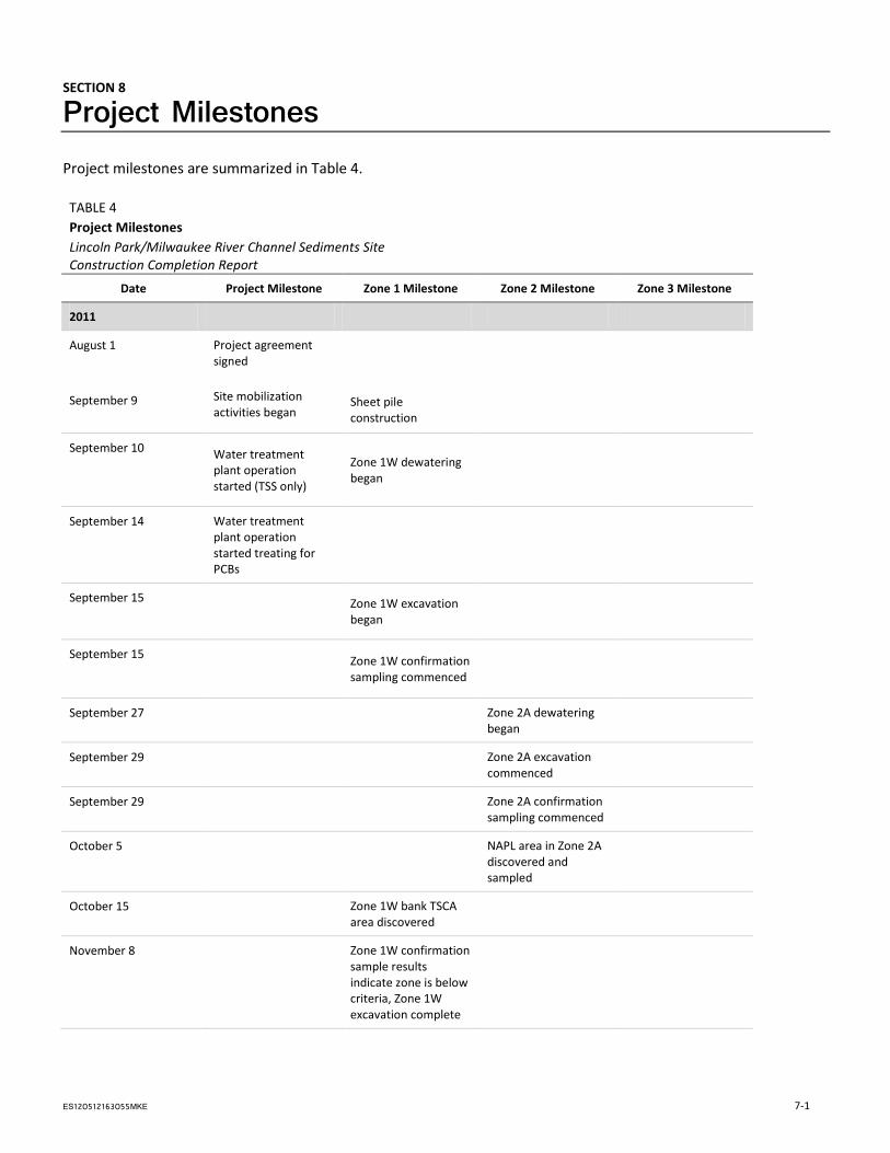
SECTION 8
Project Milestones Project milestones are summarized in Table 4.
TABLE 4 Project Milestones Lincoln Park/Milwaukee River Channel Sediments Site Construction Completion Report
Date Project Milestone Zone 1 Milestone Zone 2 Milestone Zone 3 Milestone
2011
August 1
September 9
Project agreement signed
Sheet pile construction
Site mobilization
activities began
September 10 Water treatment plant operation started (TSS only)
Zone 1W dewatering began
September 14 Water treatment plant operation started treating for PCBs
September 15
Zone 1W excavation began
September 15
Zone 1W confirmation sampling commenced
September 27
Zone 2A dewatering
began
September 29
Zone 2A excavation
commenced
September 29
Zone 2A confirmation
sampling commenced
October 5
NAPL area in Zone 2A discovered and sampled
October 15
Zone 1W bank TSCA area discovered
November 8
Zone 1W confirmation sample results indicate zone is below criteria, Zone 1W excavation complete
ES120512163055MKE 7-1
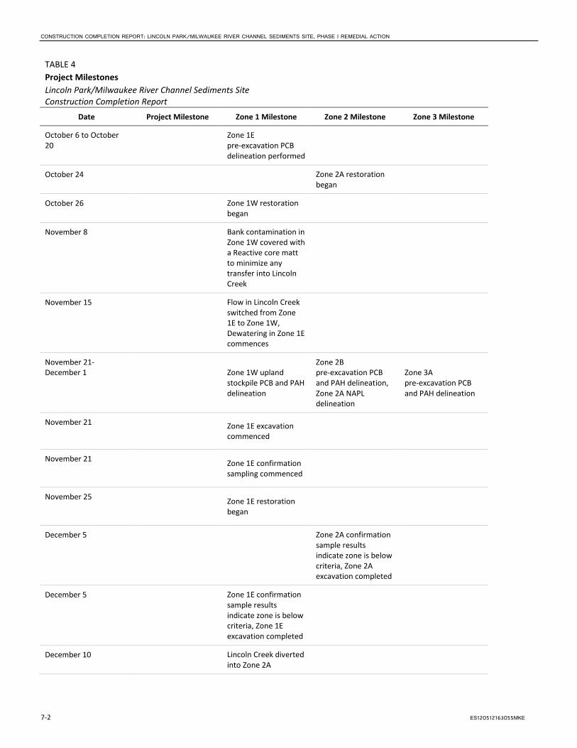
CONSTRUCTION COMPLETION REPORT: LINCOLN PARK/MILWAUKEE RIVER CHANNEL SEDIMENTS SITE, PHASE I REMEDIAL ACTION
TABLE 4 Project Milestones Lincoln Park/Milwaukee River Channel Sediments Site Construction Completion Report
Date Project Milestone Zone 1 Milestone Zone 2 Milestone Zone 3 Milestone
October 6 to October 20
Zone 1E pre-excavation PCB delineation performed
October 24
Zone 2A restoration
began
October 26
Zone 1W restoration began
November 8
Bank contamination in Zone 1W covered with a Reactive core matt to minimize any transfer into Lincoln Creek
November 15
Flow in Lincoln Creek switched from Zone 1E to Zone 1W, Dewatering in Zone 1E commences
November 21-December 1
Zone 1W upland stockpile PCB and PAH delineation
Zone 2B pre-excavation PCB and PAH delineation, Zone 2A NAPL delineation
Zone 3A pre-excavation PCB and PAH delineation
November 21
Zone 1E excavation commenced
November 21
Zone 1E confirmation sampling commenced
November 25
Zone 1E restoration began
December 5
Zone 2A confirmation sample results indicate zone is below criteria, Zone 2A excavation completed
December 5
Zone 1E confirmation sample results indicate zone is below criteria, Zone 1E excavation completed
December 10
Lincoln Creek diverted into Zone 2A
7-2 ES120512163055MKE
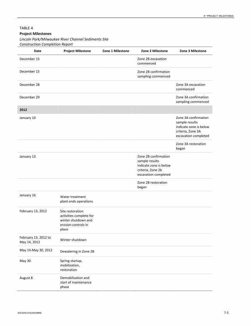
8—PROJECT MILESTONES
TABLE 4 Project Milestones Lincoln Park/Milwaukee River Channel Sediments Site Construction Completion Report
Date Project Milestone Zone 1 Milestone Zone 2 Milestone Zone 3 Milestone
December 15
Zone 2B excavation
commenced
December 15
Zone 2B confirmation
sampling commenced
December 28
Zone 3A excavation
commenced
December 29
Zone 3A confirmation
sampling commenced
2012
January 10
Zone 3A confirmation sample results indicate zone is below criteria, Zone 3A excavation completed
Zone 3A restoration
began
January 13
Zone 2B confirmation sample results indicate zone is below criteria, Zone 2b excavation completed
Zone 2B restoration
began
January 16 Water treatment plant ends operations
February 13, 2012 Site restoration activities complete for winter shutdown and erosion controls in place
February 13, 2012 to May 14, 2012 Winter shutdown
May 14-May 30, 2012 Dewatering in Zone 2B
May 30 Spring startup, mobilization, restoration
August 8 Demobilization and start of maintenance phase
ES120512163055MKE 7-3

SECTION 9
Costs The costs associated with the implementation of this project have not been finalized, and will be provided in an addendum at a later date.
ES120512163055MKE 8-1
SECTION 10
References Baird and Associates. 1997. Milwaukee River PCB Mass Balance Project WI DNR. September.
CH2M HILL. 2009. Feasibility Study Report, Lincoln Park/Milwaukee River Channel Sediments Site, Milwaukee Estuary Area of Concern. December 7.
CH2M HILL. 2010a. Lincoln Park Sediment Removal: Temporary Earthen and Sheetpile Cutoff Modeling, Lincoln Park/Milwaukee River Channel Sediments Site, Milwaukee Estuary Area of Concern. December 8.
CH2M HILL. 2010b. Lincoln Park Sediment Remediation Pre-Project Lincoln Creek and Milwaukee River HEC-RAS Models, Lincoln Park/Milwaukee River Channel Sediments Site, Milwaukee Estuary Area of Concern. November 18.
CH2M HILL. 2010c. Lincoln Creek and Western Oxbow Bank Stabilization Design: Interim Prefinal Design Report Update, Lincoln Park/Milwaukee River Channel Sediments Site, Milwaukee Estuary Area of Concern. December 10.
CH2M HILL. 2011a. Basis of Design Report, Lincoln Park/Milwaukee River Channel Sediments Site, Milwaukee, Wisconsin. March.
CH2M HILL. 2011b. Work Plan—Lincoln Park/Milwaukee River Channel Sediments Site. Milwaukee, WI. Remedial Action. WA No. 122-RARA-2508 / Contract No. EP-S5-06-01. May 4.
Federal Emergency Management Agency. 2008. Flood Insurance Study, Milwaukee County, Wisconsin. September 26.
Natural Resource Technology, Inc. (NRT). 2007. Remedial Investigation/Feasibility Study, Lincoln Park/Blatz Pavilion Site. March.
Natural Resource Technology, Inc. (NRT). 2009. Remedial Construction Documentation Report, PCB-Impacted Sediment Removal, Lincoln Park/Blatz Pavilion Site. January 29.
Sullivan International/T N & Associates, Inc., Joint Venture Team. 2009. Final Focused Remedial Investigation, Lincoln Park/Milwaukee River Channel Sediments. August 10.
Wisconsin Department of Natural Resources (WDNR). 1994. Milwaukee Estuary Remedial Action Plan. Citizen Advisory Committee. July.
Wisconsin Department of Natural Resources (WDNR). 2005. Estabrook Impoundment Sediment Remediation Pre-Design Study. Project Completion Report to USEPA (Great Lakes National Program Office Grant ID GL2000-082). PUBL-WT 826. August.
ES120512163055MKE 9-1

Figures
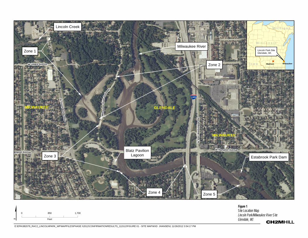
I-43
Lincoln Creek
Milwaukee RiverZone 1Zone 1
Zone 3Zone 3
Zone 2Zone 2
Zone 4Zone 4 Zone 5Zone 5
Estabrook Park Dam
Milw
auke
e R
iver
Par
kway
N. G
reen Bay Avenue
ampton Avenue
W. Villard Avenue
N. P
ort W
ashi
ngto
n R
d.
W. Hampton Avenue
MILWAUKEE GLENDALE
MILWAUKEE
Blatz PavilionLagoon
0 850 1,700
Feet
Figure 1Site Location MapLincoln Park/Milwaukee River SiteGlendale, WI
MilwaukeeMadison
Lincoln Park SiteGlendale, WI.
W i s c o n s i n
I o w a
M i c h i g a n
I l l i n o i s
E:\EPA\382079_RAC2_LINCOLNPARK_WP\MAPFILES\PHASE I\2012\CONFIRMATIONRESULTS_111512\FIGURE 01 - SITE MAP.MXD JHANSEN1 11/26/2012 3:54:17 PM
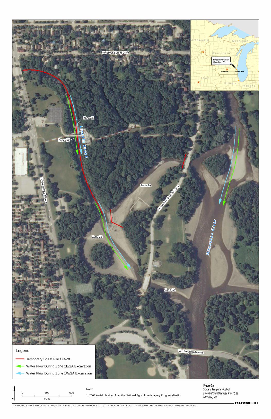
Milwau
kee R
iver P
arkw
ay
N. G
reen Bay Avenue
Li n
co
l n C
r ee
k
re
viR
ee
ku
awli
M
W. Hampton Avenue
W. Silver Spring Drive
Zone 2B
Zone 3A
Zone 2A
Zone 1W
Zone 1E
MilwaukeeMadison
Lincoln Park SiteGlendale, WI.
I o w a
W i s c o n s i n
M i n n e s o t a
I l l i n o i s
M i c h i g a n
I n d i a n a
0 300 600
Feet
E:\EPA\382079_RAC2_LINCOLNPARK_WP\MAPFILES\PHASE I\2012\CONFIRMATIONRESULTS_111512\FIGURE 02A - STAGE 1 TEMPORARY CUT-OFF.MXD JHANSEN1 11/26/2012 5:01:45 PM
Note:
1. 2008 Aerial obtained from the National Agriculture Imagery Program (NAIP)
Figure 2aStage 2 Temporary Cut-offLincoln Park/Milwaukee River SiteGlendale, WI
Legend
Temporary Sheet Pile Cut-off
Water Flow During Zone 1E/2A Excavation
Water Flow During Zone 1W/2A Excavation

Milwau
kee R
iver P
arkw
ay
N. G
reen Bay Avenue
Li n
co
l n C
r ee
k
Mi l
wa
uk
ee
Ri v
er
W. Hampton Avenue
MilwaukeeMadison
Lincoln Park SiteGlendale, WI.
I o w a
W i s c o n s i n
M i n n e s o t a
I l l i n o i s
M i c h i g a n
I n d i a n a
0 250 500
Feet
E:\EPA\382079_RAC2_LINCOLNPARK_WP\MAPFILES\PHASE I\2012\CONFIRMATIONRESULTS_111512\FIGURE 02B - STAGE 2 TEMPORARY CUT-OFF.MXD JHANSEN1 11/26/2012 3:23:09 PM
Note:
1. 2008 Aerial obtained from the National Agriculture Imagery Program (NAIP)
Figure 2bStage 2 Temporary Cut-offLincoln Park/Milwaukee River SiteGlendale, WI
Legend
Water Flow During Zone 2B/3A Excavation
Temporary Sheet Pile Cut-off

Begin Evaluation
Point Concentration
<20 ppm PAH?
Yes. Input Final
Result Into SWAC
Calculation.
Excavation for PAHs
Complete at Point.
No. Evaluate
Further.
Point Concentration
<40 ppm PAH?
No. Re-Excavate
and Re-Sample.
Yes. Input Result
Into SWAC
Calculation.
Is Estimated Post-
Remediation SWAC for
Zone <20 ppm PAH?
Yes. Input Final
Result Into SWAC
Calculation.
No. Evaluate
Further.
Number of
Confirmation Samples
Remaining in Zone
>50% <50%Re-Excavate and
Re-Sample.
Will Area Be Covered
With 2 Feet or More of
Clean Backfill?
Yes. Input fill
sample PAH
Results Into SWAC
Calculation.
No. Evaluate
Further.
Yes. Input Final
Result Into SWAC
Calculation.
Decision Logic for PAH Remediation of Zones 2B and 3A
Lincoln Creek-Milwaukee River Channel Sediment Site
Figure 3
Decision Logic for PAH Remediation of Zones 2B and 3A
Lincoln Creek/Milwaukee River Channel Sediment Site
Glendale, WI

Weir TankBag Filter System
(50 microns)Frac Tank
Frac Tank
Frac Tank
Frac Tank
(Spare)
Frac Tank
(Spare)Frac Tank
Weir Tank
In-Line Polymer
(Installed but not used)
Sand
Filter
System
Bag Filter System
(10 microns)
GAC
GACGAC
GAC
Bag Filter System
(1 micron)
Influent
Effluent to
Energy
Dissipation
Treatment for
TSS and
PCBs
Treatment
for TSS
only
Effluent to
Energy
Dissipation
Wastewater Treatment During Remedial Action
Lincoln Creek-Milwaukee River Channel Sediment Site
Figure 4
Wastewater Treatment During Remedial Action
Lincoln Creek/Milwaukee River Channel Sediment Site
Glendale, WI