report 0*1 the l :tl-:35locn.>fc*« si-fr rr
TRANSCRIPT
i SI
52FI5SEMW 63.4148 BROWRIDGE 010
MAViS LAKE CLA= < ^CUP
REPORT 0*1 ThE
L :Tl-:35LOCN.>fC*« Si-fr rr
Peter J. Vanston13 , i Sc., P.E»:g.
06 April 19*3

PH—.E NO 2O4- 345- 8658
BERNIC LAKE. MANITOBA ROE OGO
010C
TABLE OF CONTENTS
Introduction Page 1
Location and Access Page 1
Claim Group Page 1
Previous Work Page 1
Geology Page 4
Llthogeochemical Survey
Objective Page 5
Methodology Page 5
Results Page 5
Appendix 'A': Claims Surveyed
Appendix 'B 1 : Statement of Expenditures
Appendix 'C': Analytical Methods
Appendix 'D': Nap 'A' Rear Pocket
Nap 'B 1 Rear Pocket

INTRODUCTION
During June 1982, a detailed lithium lithogeochenical survey was completed over a portion of the Mavis Lake claim group in Northwestern Ontario by Tantalum Mining Corporation of Canada Limited.
The purpose of the survey was to locate, by means of a systematic sampling of the bedrock, blind tantalum bearing pegmatites.
LOCATION AND ACCESS
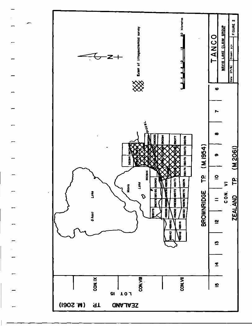
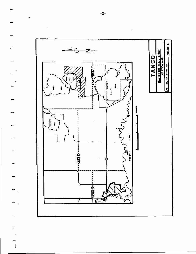
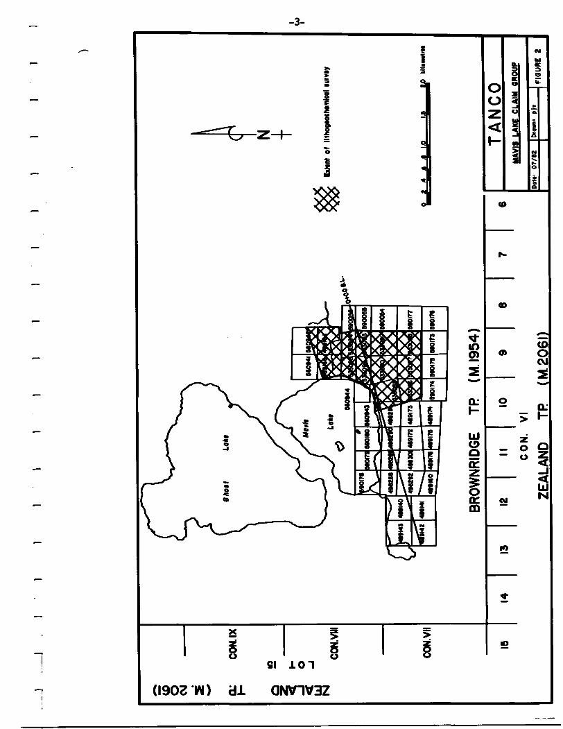
The Mavis Lake claim group is located in Brownridge Township, approximately 14 km. by road from Dryden (Figure 1).
The western portion of the claim group can be easily accessed via the Trans-Canada Highway and the all-weather road to Ghost Lake.
CLAIM GROUP
The Mavis Lake claim group is located within the Kenora Mining Division and at the time of the survey, consisted of 43 contiguous, unpatented claims (Figure 2).
During 1982, the claims were under option to Tantalum Mining Corp oration of Canada Limited from Robert J. Fairservice. The option has since been terminated and all claims returned to R. J. Fairservice.
The names and addresses of the above are:
Tantalum Mining Corporation of Mr. R. J. FairserviceCanada Limited P.O. Box 644
Box 28, Toronto-Dominion Centre Dryden, Ontario Toronto, Ontario P8N 2Z3 N5K 1B8
PREVIOUS WORK
Geologic mapping in the Mavis Lake area was conducted by Bell (1881), Coleman (1894), Parsons (1911), Thomson (1917), PettiJohn (1939) and Satterly (1943).
In 1956, Lun Echo Gold Mines Ltd. drilled the pegmatites immediately south of Mavis Lake. In the same year, Milestone Mines Ltd. completed trenching and very limited diamond drilling on some of the pegmatites immediately east and southeast of Mavis Lake. In 1978, the property was staked by R.J.Fairservice and subsequently optioned to Selco from 1979 to 1981. Work by Selco consisted of limited lithogeochemical surveys, geologic mapping and diamond drilling.
During 1982, and in conjunction with the lithogeochemical survey

1 1
I111)111
1 I
. _ _
JM
HW
MW
T_VA
N H
Om
t TK
J_
__
__
_4
M
lMM
trii
TAN
CO
MAV
IS L
AKE
CLAI
M G
ROUP
LO
CATI
ON M
APDA
TE'
AU
O..I
M2
DRAW
N>
PJV
FIGU
RE
I.
1 1
11
I]
11111)
g CM o:CO
N. ix
o
CON.
VIII
CON.
VII
BRO
WN
RID
GE
IP
(M.I954)
N
Exttn
t of
llt
hogt
oehi
mle
ol t
urvt
y
0 1
.4 t
.6 1
.0_
__
Lfi
__
_IP
1514
1312
II10
98
6
CO
N.
VI
ZEA
LAN
D
TR
(M.2
06I)
TA
NG
OM
AVIS
LAK
E CL
AIM
GR
OUP
Dot.
OT/t
iD
'OM
"FI
GURE
2
-4-
described herein, Tanco completed a program of line-cutting and geophysics (detailed magnetometer) over 30 of the claims.
GEOLOGY
The regional geology is presented in the Ontario Department of Nines report "Geology of the Oryden - Uabigoon Area" by J. Satterly (1943).
The property which is located on the north limb of a westerly plunging syncllne, is underlain by predominantly mafic volcanics and sediments. Inter mediate to f elsic volcanics occur as minor Intercalations within the mafic volcanics. Intruding into these units are an occasional ultramafic dike, occasional, small, alkalic stocks and numerous granitic pegmatites.
The mafic volcanics consist of both pillowed and massive basaltic flows, and amphioolite, with narrow Interbeds of andesitic flows and tuffs.
The intermediate to f elsic volcanics occur as narrow, tuffaceous interbeds within the more mafic volcanics. The majority of these interbeds are dacitic in composition.
The sediments within the claim group are very poorly exposed and consist of greywacke and biotite-quartz schist.
A small, altered ultramafic dike Intrudes the mafic volcanics in the southeast corner of the claim group. This dike is well foliated and has as its components serpentine, talc, possibly tremolite-actlnolite and minor carbonate.
Small stocks and dikes of quartz monzonitic to granitic composition Intrude both the volcanics and the sediments. On the property however, only an occasional, small dike occurs.
Numerous granitic pegmatites ranging from the primary, spodumene bearing variety to the albltlzed, tantalum bearing variety occur on the property. The dikes are generally found within the bands of mafic volcanics.
Structurally, the rocks strike arcuately around the southeast corner of Mavis Lake. Dips are generally steep to the north. Tops, determined from pillowed flows, are to the south, Indicating that the north 11mb of the syncline has been overturned.
Sets of both steep and shallow dipping joints occur throughout the property. In the western portion of the property the pegmatites appear to have an affinity for the steep dipping set, whereas in the eastern portion of the property the pegmatites appear to have an affinity for the shallow dipping set.
-5-
LITHOGEOCHEMICAL SURVEY
OBJECTIVE
The present lithium Hthogeochenical survey was a detailed survey conducted for the purpose of locating blind, tantalum-tin bearing pegmatites in a portion of the claim group known to contain such pegmatites.
METHODOLOGY
The emplacement of granitic pegmatites is accompanied by extensive metasomatism of the country rock by the elements lithium, rubidium and cesium. Of these, lithium is the most mobile and can be expected to migrate the furthest, forming errected halos around granitic pegmatites.
In the present survey, the above premise is used in the search for anomalously high lithium values in the bedrock.
Sample collection for the present survey was carried out at 25 metre Intervals along chained lines 50 metres apart. Half of the survey utilized the cut grid which had a 100 metre line spacing. Intermediate, chained lines were run by compass. In such a survey however, the sample Interval will vary depending on the presence of, or lack of outcrop.
At each sample location, roughly 0.5 kg. (1 Ib) of fresh sample is taken; the sample then being identified by grid coordinates and the rock type recorded. The samples are analyzed for parts per million (p.p.m.) Li20 with the results being plotted on a base map and then contoured.
RESULTS
In the present survey, approximately 37.2 line-kilometres (23.2 line -miles) of sampling were completed with 737 samples being taken. A list of claims surveyed is presented In Appendix 'A'.
However, due to extenuating circumstances, i.e., cutbacks in laboratory personnel at Tanco, and a subsequent. Indefinite mine closure, the samples have yet to be analyzed. It is hoped that these samples will be analyzed in the near future.
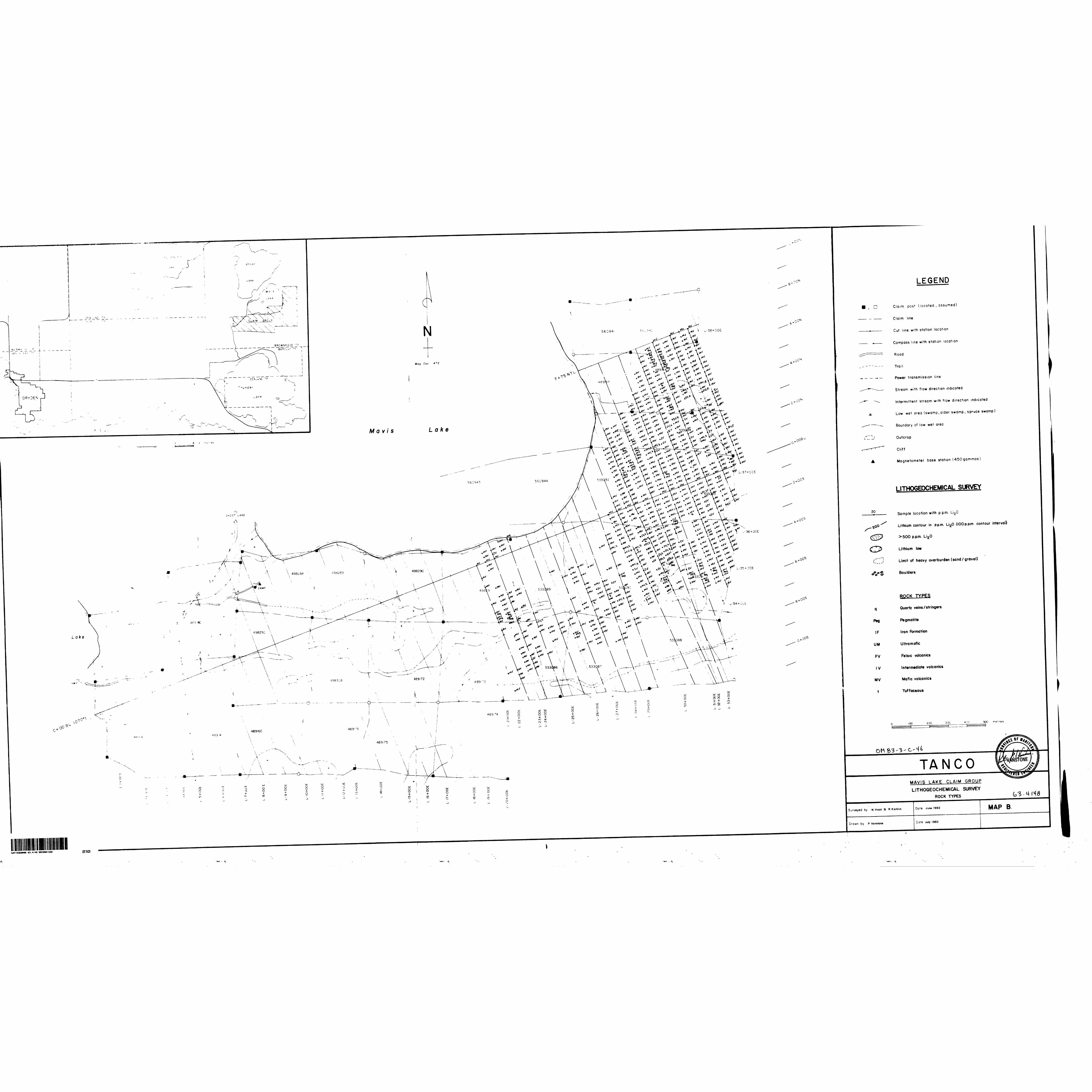
Map 'A* (rear pocket) 1s the base map showing all sample locations. Nap 'B 1 (rear pocket) shows the rock types for the respective samples.
A 11st of expenditures incurred to date Is presented in Appendix 'B 1 .
The analytical procedure to be used in the lithium analyses Is presented In Appendix 'C'.
Peter
I, Peter J. Vanstone, resident of the Village of Lac du Bonnet, Manitoba, did hereby initiate, supervise, or conduct all of the above operations. I am a graduate of Lakehead University with the degree of B.Sc. (Honours), and am a duly registered Professional Engineer in the Province of Manitoba.
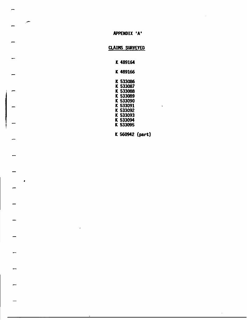
APPENDIX 'A 1
CLAIMS SURVEYED
K 489164
K 489166
K 533086 K 533087 K 533088 K 533089 K 533090 K 533091 K 533092 K 533093 K 533094 K 533095
K 560942 (part)

APPENDIX 'B'
LIST OF EXPENDITURES
Mob/denob $ 183.42
Camp costs $ 384.19
Outboard motor rental $ 139.74
Topofll (chaining string) $ 32.00
Salaries $2,898.00
Report/nap preparation $ 821.10
TOTAL $4,458.45

APPENDIX 'C 1
ANALYTICAL METHODS
DETERMINATION OF LITHIUM. SODIUM, POTASSIUM AND IRON IN ROCKS
Reagents:
- Reagent grade Hydrofluoric Acid - 49% - Nitric Acid - 70% - and Sulfuric Acid - 97%.
- Sodium Chloride - 99-98%.
- Potassium Chloride - 99.9%.
- Lithium Carbonate - 99.5%.
- Iron Wire - 99.9%.
Standard Preparation:
- 1000 ppm stock solution:
Accurately weigh 1.2710 g. of NaCI, 0.9533 gram of KC1. 2.6780 grams of Li2C03. Transfer reagents quantitatively into a 500 ml vol. flask, rinse down with distilled H20 and slowly add diluted HC1 until all is dissolved.
- in a 250 !. beaker dissolve 0.5005 grams of Fe-wire with some 1:1 HC1, transfer the solution to the vol. flask and dilute to mark with distilled H20.
- 100 ppm stock solution:
Dilute an aliquot of 1000 ppm stock solution 1:10.
- Working standards:
- into three separate 100 ml. vol. flasks place 10.0, 5.0 and 2.0 ml. of 100 ml. stock solution and dilute to mark with distilled water.
- into two more 100 ml. vol. flasks place respectively 10 ml. of the 10 and 5 ppm working standard and dilute to mark with distilled water. These solutions represent equivalents of 10.0, 5.0, 2.0, 1.0 and 0.5% of Li, Na, K and Fe in the sample.
Procedure;
- Accurately weigh 0.1 grams of finely ground sample and place into a teflon dish.

- Wet savple with a few drops of water.
- Add 5 •!. of Hydrofluoric Acid - 2 •!. of Nitric Acid - 1 •!. of Sulfuric Acid and place the dish onto a hot plate in a well ventilated fmehood. Heat savple until fines evolve and keep heating until sample is nearly dry. unless sample was totally dissolved, add 5 •!. of HF and 2 •!. of H2SOi, and take to dryness again.
- Now add 2 •!. of HC1 and a few •!. of distilled H20 and dissolve sample (heat if necessary).
- Quantitatively transfer the solution into a 100 •!. vol. flask and dilute to aark with water:
- fro» this solution pipet 10 ml. into a 100 •!. vol. flask and dilute to mark with water.
- Measure this solution versus the standards on the A.A.
CAUTION:
- extreme care mist be taken in regard to cleanliness.
(a) All labware mast be rinsed several tines with distilled water before use.
(b) Fumehood should be kept free of dust.
(c) Never touch anything that Bakes direct contact with solutions.
- Make up a fresh standard as soon as the slightest doubt to its reliability arises.
For low irons (0.01 - 0.05), use first (stock) solution. Use at least a 0.1 ppm standard for setting up the working curve. Also run a blank with samples known to have a low iron content.
Factors;
Li - Li20 « 2.1528
Ha - Na20 - 1.3480
K - K20 • 1.2045
Fe - FeO - 1.2865
- F203 • 1.4297

APPENDIX §D'
MAP 'A 1 : Lithium Values
MAP 'B 1 : Rock Types

X04-34S-46M
•ENMIC LAKE. MANITOBA HOC OGO
ep
020
MAVIS LAKE CLAIM GROUP
REPORT ON THE
LITHOGEOCHENICAL SURVEY
Peter J. Vanstone, B.Sc., P.Eng. 06 April 1983; 04 October 1983

63.4148 BROMRIDGE02OC
TABLE OF CONTENTS
Introduction Page 1 Location and Access Page 1 Claim Group Page 1 Previous Work Page 1 Geology Page 4 Llthogeochemlcal Survey
Objective Page 5 Methodology Page 5 Results Page 5
North Zone Page 6 South Zone Page 7
Conclusions Page 8 Recommendations Page 8 Appendix 'A 1 : Claims Surveyed Appendix 'B 1 : Statement of Expenditures Appendix 'C 1 : Analytical Methods Appendix *D': Oversized Figures Rear Pocket
INTRODUCTION
During June 1982, a detailed lithium lithogeochemlcal survey was completed over a portion of the Mavis Lake claim group in Northwestern Ontario by Tantalum Mining Corporation of Canada Limited.
The purpose of the survey was to locate, by means of a systematic sampling of the bedrock, blind tantalum bearing pegmatites.
LOCATION AND ACCESS
The Mavis Lake claim group is located in Brownridge Township, approximately 14 km. by road from Dryden (Figure 1).
The western portion of the claim group can be easily accessed via the Trans-Canada Highway and the all-weather road to Ghost Lake.
CLAIM GROUP
The Mavis Lake claim group is located within the Kenora Mining Division and at the time of the survey, consisted of 43 contiguous, unpatented claims (Figure 2).
During 1982, the claims were under option to Tantalum Mining Corp oration of Canada Limited from Robert J. Fairservice. The option has since been terminated and all claims returned to R. J. Fairservice.
The names and addresses of the above are:
Tantalum Mining Corporation of Mr. R. J. FairserviceCanada Limited P.O. Box 644
Box 28, Toronto-Dominion Centre Dryden, Ontario Toronto, Ontario P8N 2Z3 N5K IBS
PREVIOUS WORK
Geologic mapping In the Mavis Lake area was conducted by Bell (1881), Colenan (1894), Parsons (1911). Thomson (1917), PettiJohn (1939) and Satterly (1943).
In 1956, Lun Echo Gold Mines Ltd. drilled the pegmatites immediately south of Mavis Lake. In the same year, Milestone Mines Ltd. completed trenching and very limited diamond drilling on some of the pegmatites immediately east and southeast of Mavis Lake. In 1978, the property was staked by R.J.Fairservice and subsequently optioned to Selco from 1979 to 1981. Work by Selco consisted of limited lithogeochemical surveys, geologic mapping and diamond drilling.
During 1982, and in conjunction with the lithogeochemlcal survey
-2-
ZH-III
O O
ouc o
>
o _ O —
O»
CD
2s
to 01
so
PI f>
o
ZEALAND TR (M.206I)
LOT 15
\ I iL
6>i
-e-

-4-
described herein, Tanco completed a program of line-cutting and geophysics (detailed magnetometer) over 30 of the claims.
GEOLOGY
The regional geology is presented in the Ontario Department of Nines report "Geology of the Dryden - Uabigoon Area" by J. Satterly (1943).
The property which is located on the north limb of a westerly plunging syncline, is underlain by predominantly mafic volcanics and sediments. Inter mediate to felsic volcanics occur as minor intercalations within the mafic volcanics. Intruding into these units are an occasional ultramafic dike, occasional, small, alkalic stocks and numerous granitic pegmatites.
The mafic volcanics consist of both pillowed and massive basaltic flows, and amphibolite, with narrow Interbeds of andesitic flows and tuffs.
The intermediate to felsic volcanics occur as narrow, tuffaceous interbeds within the more mafic volcanics. The majority of these interbeds are dacitic in composition.
The sediments within the claim group are very poorly exposed and consist of greywacke and biotite-quartz schist.
A small, altered ultramafic dike intrudes the mafic volcanics in the southeast comer of the claim group. This dike is well foliated and has as its components serpentine, talc, possibly tremolite-actinolite and minor carbonate.
Small stocks and dikes of quartz monzonitic to granitic composition intrude both the volcanics and the sediments. On the property however, only an occasional, small dike occurs.
Numerous granitic pegmatites ranging from the primary,spodumene bearing variety to the albitized, tantalum bearing variety occur on the property. The dikes are generally found within the bands of mafic volcanics.
Structurally, the rocks strike arcuately around the southeast corner of Mavis Lake. Dips are generally steep to the north. Tops, determined from pillowed flows, are to the south, indicating that the north 11mb of the syncline has been overturned.
Sets of both steep and shallow dipping joints occur throughout the property, with the shallow dipping set being the most predominant. In the eastern portion of the property the shallow set dips consistently south at approximately 30 degrees.
-5-ri~~.
LlTHOGEOCHEHICAL SURVEY
OBJECTIVE
The present lithium Hthogeochemlcal survey was a detailed survey conducted for the purpose of locating blind, tantalum/tin bearing pegmatites 1n a portion of the claim group known to contain such pegmatites.
METHODOLOGY
The emplacement of granitic pegmatites is accompanied by extensive metasomatism of the country rocks by the elements lithium, rubidium and cesium. Of these,lithium is the most mobile and can be expected to migrate the furthest, forming erected halos around granitic pegmatites.
In the present survey, the above premise is used in the search for anomalously high lithium values in the bedrock.
Sample collection was carried out at 25 metre intervals along chained lines 50 metres apart. Where possible the the cut grid which had a 100 metre line spacing, was utilized. Intermediate, chained lines were run by compass. In such a survey however, the sample interval will vary depending on the presence of, or lack of outcrop.
At each sample location roughly 0.5 kg. (1 Ib.) of fresh sample is taken; the sample then being identified by grid coordinates and the rock type recorded. The samples are analyzed for parts per million lithia (p,p.m. LigO) with the results being plotted on a base map and then contoured.
RESULTS
In the present survey approximately 37 line-kilometres (23.2 line- miles) of sampling were completed with 733 samples being taken. The area surveyed Is shown in Figure 2, and a list of claims surveyed is presented in Appendix 'A*.
A table of expenditures for the survey is presented In Appendix 'B 1 .
The analytical procedure used 1n the lithia analyses is presented in Appendix 'C 1 .
The contoured results are shown on Hap A (rear pocket) with the corresponding sample rock types shown on Nap B (rear pocket).
During the course of the survey numerous albltized pegmatites were observed. The pegmatites were narrow with widths generally less than three metres and not exceeding five metres. The dikes were for the most part, Irregular and occupied fractures; very few were hosted by joint planes. Where a fracture hosting a pegmatite Intersected a joint plane, the pegmatite formed a lobe in the joint plane.
Within the survey area the attitudes of the pegmatites varied from 020 -180 /moderate to near-vertical southeast in the west portion to

-6-^•^
050*-13(f/shallow southerly in the southeast portion and central portion to 360°-060°/steep north to shallow west in the northern portion.
In addition to the albitized pegmatites an ocassional granite dike was observed. The attitudes of these dikes were generally about 120*/near vertical to vertical.
Tantalum/tin values for all of the pegmatites sampled were too low to be considered as economic. Values rarely exceeded 0.075% Ta205 , with tantalum/ tin ratios approximately 1:1 for the more primary dikes and much greater for the albitized dikes.
The lithia values (Nap A) for the survey ranged from a low of N.D. (none detected) to a high of 8000 p.p.m. with the mean value being 203 p.p.m. As a result of the high mean value, contouring was done at 100 p.p.m. intervals from 200 p.p.m. to 500 p.p.m. inclusive. The 100 p.p.m. contour was not used because it "wandered" and consequently, did not help deliniate anomalies.
A normal statistical approach utilizing the mean plus standard deviations to determine whether or not samples fall within background, possibly anomalous or probably anomalous categories was not used. Such an approach would be invalid for this survey as the survey was conducted over an area known to have a higher than normal lithia background. The mean lithia value (203 p.p.m.) bears this out. The average lithia content for mafic rocks,which was the predominant rock type sampled, is 32 p.p.m.
For the purposes of this survey, anomalies were judged on strength (less than 500 p.p.m. lithia was considered weak) and size, as well as proximity to other anomalies.
As shown on Map A, two anomalous lithia zones were defined by the survey and have been lebelled the "North Zone" and the "South Zone".
North Zone
The North Zone is located in the northeast portion of the survey area. It Is a very intense zone with values in excess of 1000 p.p.m. lithia not
uncommon. The zone Is characterized by broad, extensive anomalies, but also contains a number of small, tight isolated anomalies. The zone Is generally confined to the more magnetic responsive.maflc volcanics.
A majority of the anomalies coincide with known pegmatites, but those which do not are located as follows:
(a bc d e f
I(1 L- (j) L-
L-31+OOE/175N L-31+OOE/225N L-31+50E/350N L-33+OOE/200N L-34+50E/725N L-35+50E/775N L-36+OOE/650N L-36+50E/625N -37+50E/275N 37+50E/500N
-7-^•K
All but three of the sample locations listed above fall within the confines of the large anomalies in the zone. These large anomalies coincide with small swarms of narrow, albitized pegmatites and therefore,It can be assumed that these seven anomalous samples are also due to nearby, narrow pegmatites.
The three remaining anomalous samples ((c), (i) and (j)) all occur along the boundary of the surveyed area. Sample (c) is weak and isolated, forming a one sample anomaly which is deemed insignificant. Samples (1) and (j) are both located along the east boundary of the survey area and are of weak to moderate strength. Sample (1) 1s totally isolated, whereas sample (j) could be loosely associated with the large, dominating anomaly within the zone. Both could be classified as slightly significant due to their relative ly low lithla values and in the case of (1), its isolated position. Prospect- Ing in the vicinity and to the Immediate east of the anomalies might reveal their cause,as well as their extent. Such work however, should be given a low priority.
South Zone
The South Zone consists of a number of small, generally elongated, relatively tight anomalies. Such anomaly configurations are indicative of near vertical to vertical pegmatites. In the eastern portion of the zone however, the anomalies tend to be broader reflecting the change to more shallow dipping pegmatites.
The zone is not as strong as the North Zone, with values rarely exceeding 1000 p.p.m. lithla. As with the North Anomaly, almost all anomalies coincide with observed pegmatites. Those anomalous samples for which coincident pegmatites were not are observed are located as follows:
L-22+50E/0+OOB.L.L-23+OOE/025SL-23+OOE/575SL-27+50E/450SL-28+OOE/475SL-28+50E/350SL-30+50E/500SL-3HOOE/275SL-31+50E/400SL-35+OOE/500S
Samples (a) and (b) form an anomaly which extends off the northwest comer of the survey area. The anomaly is of moderate strength and isolated, and may include sample (c) to the south. The full extent of the anomaly is unknown, necessitating prospecting to determine the cause and possible extent of it.
Samples (d) and (e). form a single, weak, isolated anomaly. The anomaly can be classified as insignificant and does not warrant further work.
Sample (f) forms part of a short, weak, narrow anomaly which is relat ively isolated. During the course of the survey, no pegmatites were found coinciding with the anomaly. However, the size and strength of the anomaly are such that further work is not warranted.
Sample (g) 1s a moderately strong anomaly which may extend Into the overburden to the south. The anomaly is within the confines of a much more extensive anomaly, the east end of which is due to the presence of albitized pegmatites. This anomaly can be classified as significant, based on its strength and proximity to favourable pegmatites, and consequently, warrants further work in the form of prospecting. Should no pegmatites be found which would explain the anomaly, consideration should be given to its location with respect to the cliff. The structural weakness responsible for the cliff may also have acted as a conduit for the lithium metasomatism.
Sample (h) forms a portion of the west end of a larger anomaly. Overall, the large anomaly is weak and contains a few pegmatite stringers in the central portion. A moderately strong lithia peak occurs in close proximity to sample (h), but this peak is very limited in extent. As a con sequence, this anomaly has little significance and does not warrant further work.
Sample (i) is contained within a larger anomaly which coincides with known pegmatites, and can be classified as insignificant.
Sample (j) is part of a rather extensive anomaly known to be due to a number of albitized pegmatites. The pegmatites were shown by previous drill ing (Selco) to lack both the tonnage and grade (Ta/Sn) to be economic. Thus no further work on this anomaly is warranted.
CONCLUSIONS
The contoured lithia results outlined two anomalous zones, the North Zone and the South Zone. Both zones appear to have an affinity for the magnetically more responsive mafic volcanics.
The majority of the anomalies in both zones coincide with pegmatites observed on surface during the course of the survey.
With a few exceptions, the unexplained anomalies for which no coincid ent pegmatites were observed, can be discounted due to insufficient size to be caused by a blind pegmatite of significant volume, or due to weak lithia values, or due to an association with a larger anomaly within which pegma tites were observed. The few exceptions are not strong and are not known to be extensive,with the majority of them occuring along the edges of the sur veyed area or along the margins of areas covered by heavy overburden.
A number of pegmatites sampled during the course of the survey returned tantalum/tin values too low to be considered economic either under present conditions or those of the forseeable future.
RECOMMENDATIONS
In an attempt to explain the following anomalous sample locations, follow-up prospecting In the vicinity of them 1s warranted.
The sample locations involved are:
North Zone: sample locations (1) and (j)South Zone: sample locations (a), (b), (c) and (g)
-9-
This prospecting should require no more than two days work.
Peter J. Vanstone, B.Sc., P.Eng. 04 October 1983
I, Peter J. Vanstone, resident of the Village of Lac du Bonnet, Manitoba, personally conducted or caused to have had conducted the work performed and described in the accompanying report. I am a graduate geologist, holding the degree of B.Sc. (Honours) from Lakehead University, and am a registered Professional Engineer in the Province of Manitoba.
Peter J. Vanstone, B.Sc., P.Eng.

APPENDIX 'A 1
CLAIMS SURVEYED
K 489164
K 489166
K 533086 K 533087 K 533088 K 533089 K 533090 K 533091 K 533092 K 533093 K 533094 K 533095
K 560942 (part)

APPENDIX 'B 1
TABLE OF EXPENDITURES
SAMPLE COLLECTION
Hob/demob $ 183.42
Camp costs $ 384.19
Outboard motor rental $ 139.74
TopofH (chaining string) $ 32,00
Wages $2,898.00
Report/map preparation $ 821.10
SUB-TOTAL———————————————————————— $4,458.45
SAMPLE ANALYSES (733 samples)
Lab reactivation - wages $ 438.00
Sample preparation - wages $1,512.00- consumable materials $ 122.08
Sample analyses - wages $2,016.00 - consumable materials $ 195.27
Supervision $ 120.55
Report/map preparation $ 482.20
SUB-TOTAL ———————————————————————— $4,886.10
TOTAL SURVEY COST ——————————————————————— $9,344.55
1
. ffinatf
APPENDIX 'C'
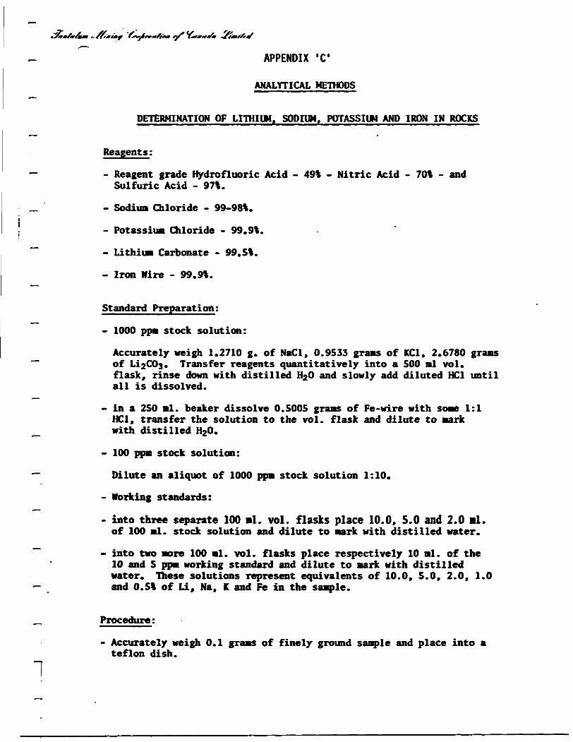
ANALYTICAL METHODS
DETERMINATION OF LITHIUM. SODIUM, POTASSIUM AND IRON IN ROCKS
Reagents:
- Reagent grade Hydrofluoric Acid - 49% - Nitric Acid - 70% - and Sulfuric Acid - 97%.
. Sodium Chloride - 99-98%.
- Potassium Chloride - 99.9%.
- Lithium Carbonate - 99.5%.
- Iron Hire - 99.9%.
Standard Preparation:
- 1000 ppm stock solution:
Accurately weigh 1.2710 g. of NaCl, 0.9533 grans of KC1, 2.6780 grams of Li2003. Transfer reagents quantitatively into a 500 ml vol. flask, rinse down with distilled H20 and slowly add diluted HC1 until all is dissolved.
- in a 250 ml. beaker dissolve 0.5005 grams of Fe-wire with some 1:1 HC1, transfer the solution to the vol. flask and dilute to mark with distilled H20.
- 100 ppm stock solution:
Dilute an aliquot of 1000 ppm stock solution 1:10.
- Working standards:
- into three separate 100 ml. vol. flasks place 10.0, 5.0 and 2.0 •!. of 100 ml. stock solution and dilute to mark with distilled water.
- into two more 100 ml. vol. flasks place respectively 10 ml. of the 10 and 5 ppm working standard and dilute to mark with distilled water. These solutions represent equivalents of 10.0, 5.0, 2.0, 1.0 and 0.5% of Li, Na, K and Fe in the sample.
Procedure:
- Accurately weigh 0.1 grams of finely ground sample and place into a teflon dish.
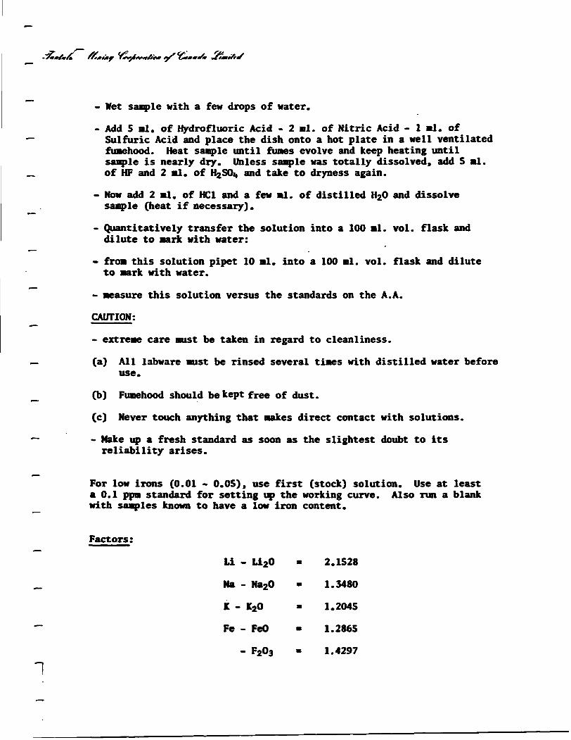
-^M/rA ffmatf
- Wet sample with a few drops of water.
- Add 5 ml. of Hydrofluoric Acid - 2 ml. of Nitric Acid - 1 •!. of Sulfuric Acid and place the dish onto a hot plate in a well ventilated fimehood. Heat sample until fumes evolve and keep heating until sample is nearly dry. Unless sample was totally dissolved, add 5 ml. of HF and 2 ml. of H2SOi» and take to dryness again.
- Now add 2 ml. of HC1 and a few ml. of distilled H20 and dissolve sample (heat if necessary).
- Quantitatively transfer the solution into a 100 ml. vol. flask and dilute to mark with water:
- from this solution pipet 10 ml. into a 100 ml. vol. flask and dilute to mark with water.
> measure this solution versus the standards on the A.A.
CAUTION:
- extreme care must be taken in regard to cleanliness.
(a) All labware must be rinsed several times with distilled water before use.
(b) Fumehood should be kept free of dust.
(c) Never touch anything that makes direct contact with solutions.
- Make up a fresh standard as soon as the slightest doubt to its reliability arises.
For low irons (0.01 - 0.05), use first (stock) solution. Use at least a 0.1 ppm standard for setting up the working curve. Also run a blank with samples known to have a low iron content.
Factors;
Li - Li20 • 2.1528
Na - Na20 • 1.3480
K - K20 - 1.2045
Fe - FeO » 1.2865
- F203 - 1.4297
1
APPENDIX 'D 1
OVERSIZED FIGURES
MAP 'A 1 : Lithium Values
MAP 'B': Rock Types
52F15SEMM 63.4148 BROMtlDGE900
M lTTAL_
OF wrtfc-H
VI
IN S€Ri€s) r

\ --___
^
J-
N20o-
V\\\
\NORTH
ZONE
Maw
" (
- J
o c-t-
Lake.Oo
..C.T i
SOUTH ZONE
O
T
Ld
CM
oLLJ
o-̂r X
UJ'^v
O
63.4148 BROWRIDGE 200
20
q
Peg
IF
UM
FV
IV
MV
t
LEGEND
• _, f^ e 1
ndico'ed
* -
,'f
nase 450
LITHOGEOCHEMICAL SURVEY
Sample location with p.p.m. Li 20
Lithium contour in p.p.m. L^O (lOOp.p.m. contour interval)
> 500 p.p.m. Li20
Lithium low
Limit of heavy overburden (sand /gravel)
Boulders
ROCK TYPES
Quartz veins/stringers
Pegmatite
Iron Formation
Ultra mafic
Felsic volcanic s
Intermediate volcanics
Mafic volcanics
Tuffaceous
TANGOMAVIS LAKE CLAIM GROUP
LITHOGEOCHEMICAL SURVEY LITHIUM VALUES - f If8
> w Hood S R.Korklin June 1982 MAP A.
•• * r » P Vanston* 'f July 1982, S«pt. I983
: - A
LEGEND
Claim post (located , assumed)
Cut line with station location
Compass line with station location
:-$\&Power t ransmission line
Stream with flow direction indicated
Intermittent stream with flow direction indicated
Low wet area (swamp,alder swamp, spruce swamp)v* J? -^ ̂ ^^^-v- ^V *' v^^^^^^V j V ̂ \v •> V ̂ \"t V ̂ \^ XV \^ \ •^ v.* .^ \^ ^ v \^ • Boundary of low wet area
LakeMavis
Magnetometer base station (450gammas)
LITHOGEOCHEMICAL SURVEY
Sample location with p p.m. Li 20
Lithium contour in p.p.m. Li20 (I00p.p.m contour interval)
>500 p.p.m. Li20
Limit of heavy overburden (sand/grdvel)
Quartz veins /stringers•^ r...Pegmatite
Iron Formation
Intermediate volcamcs
TAN COMAVIS LAKE CLAIM GROUP
LITHOGEOCHEMICAL SURVEY ROCK TYPES
MAP BSurveyed by W. H ood a R Karklin
Drawn by P Vanstone
c ^oo^^
52F1SSE«*«8 63.4146 BROWNRIDGE 210