report - home - bodc
TRANSCRIPT

Final Report
Lower George River Investigation
Lower George Riverworks Trust
June 2018

Lower George Riverworks Trust | June 2018 Lower George River Investigation Page 2
5647-0
1 R
01V
01_Low
er_
Georg
e
Document Status
Version Doc type Reviewed by Approved by Date issued
V01 Final Michael Cheetham Julian Martin 15 June 2018
Project Details
Project Name Lower George River Investigation
Client Lower George Riverworks Trust
Client Project Manager Jo Williams
Water Technology Project Manager Michael Cheetham
Water Technology Project Director Julian Martin
Authors Julian Martin, Michael Cheetham
Document Number 5647-01 R01V01_Lower_George
COPYRIGHT
Water Technology Pty Ltd has produced this document in accordance with instructions from Lower George Riverworks
Trust for their use only. The concepts and information contained in this document are the copyright of Water Technology
Pty Ltd. Use or copying of this document in whole or in part without written permission of Water Technology Pty Ltd
constitutes an infringement of copyright.
Water Technology Pty Ltd does not warrant this document is definitive nor free from error and does not accept liability for
any loss caused, or arising from, reliance upon the information provided herein.
First Floor, 40 Rowan Street
Wangaratta VIC 3677
Telephone (03) 5721 2650
ACN 093 377 283
ABN 60 093 377 283

Lower George Riverworks Trust | June 2018 Lower George River Investigation Page 3
5647-0
1 R
01V
01_Low
er_
Georg
e
CONTENTS
1 INTRODUCTION 5
1.1 Project Area 5
1.2 Project Context and Scope 5
2 CATCHMENT CONDITION 7
2.1 Overview 7
2.2 Sediment Sources 7
2.2.1 Historic Mining 7
2.2.2 Fire Impacted Areas 13
2.2.3 Bed and Bank Erosion 14
2.3 The Lower George River 19
2.3.1 Floodplain Mining 21
2.3.2 Bed Aggradation 23
2.3.3 Delta Formation, Channel Movement and Avulsion 23
3 TRAJECTORY AND MANAGEMENT IMPLICATIONS 26
3.1 Trajectory 26
3.2 Management Implications 26
3.2.1 Overview 26
3.2.2 Reducing Sediment Supply 27
3.2.3 Promoting Sediment Storage 27
3.2.4 Accelerating Sediment Transport 27
3.2.5 Sediment Extraction 27
3.2.6 Planning for Avulsion 28
4 EXISTING STRATEGIES AND PLANS 29
4.1 Overview 29
4.2 Rivercare Plan – Lower George River 29
4.3 Lower George River Floodplain Risk Management Plan 30
5 RECOMMENDATIONS AND PRIORITIES 33
5.1 Reduce Sediment Supply 33
5.2 Sediment Extraction 34
6 TECHNICAL ADVICE 35
6.1 Vegetation Establishment 35
6.2 Fencing (Stock Exclusion) 37
6.3 Woody Weed Management 37
6.3.1 Willow Management 38
6.3.2 Other Weeds 38
6.4 Approvals 38

Lower George Riverworks Trust | June 2018 Lower George River Investigation Page 4
5647-0
1 R
01V
01_Low
er_
Georg
e
7 REFERENCES 40
LIST OF FIGURES Figure 1-1 George River Catchment. 5
Figure 1-2 George River Delta 6
Figure 2-1 Google Maps image of the Anchor Mine sand deposits. 8
Figure 2-2 Large sand slug/deposit located at the Anchor mine. 9
Figure 2-3 The extensive sand deposits at the Anchor Mine. 10
Figure 2-4 Looking at the sand deposits immediately adjacent the waterway. 11
Figure 2-5 The Groom River downstream of the Anchor Mine Sand. Note the absence of sand deposits in the channel. 12
Figure 2-6 LiDAR topography showing effect of historic sluice mining and ongoing gullying. 13
Figure 2-7 Fire damage and exposed sand on a hillslope in the Derwent Creek Catchment (a sub-catchment of the Powers Rivulet, itself a tributary of the George River. 14
Figure 2-8 LiDAR topography overlain on aerial imagery showing The Active erosion processes. 16
Figure 2-9 The Avulsion flow path near Priory. 17
Figure 2-10 The avulsion flow path near priory. 18
Figure 2-11 Extensive bank erosion approximately 8m high, over a 400m length. 19
Figure 2-12 The Lower George River, identifying key locations. 20
Figure 2-13 Floodplain mining on the Lower George Floodplain. 22
Figure 2-14 George River channel, immediately upstream of the Binalong Bay Road Bridge, showing dense willow infestation and bed aggradation. 23
Figure 2-15 LiDAR topography showing previous courses of the George River along with potential future courses and breakout points. 25
Figure 4-1 Rehabilitation potentials (Sprod, 2003). 30
Figure 4-2 Lower George River Floodplain Risk Management Plan project extent (Pitt & Sherry 2013). 31
Figure 4-3 Flood hazard rating for a 100 year ARI event under exisitng conditions, where flood hazard is the flood water depth (m) mulitplied by velocity (m/s) (Pitt & Sherry, 2013) 32
Figure 6-1 Concept revegetation arrangement involving a vertical bank profile. 36
Figure 6-2 Concept revegetation arrangement for a sloped bank profile. 37

Lower George Riverworks Trust | June 2018 Lower George River Investigation Page 5
5647-0
1 R
01V
01_Low
er_
Georg
e
1 INTRODUCTION Water Technology was commissioned by the Lower George Riverworks Trust to undertake a waterway
investigation into the sources and potential mitigation measures for excess sediment in the Lower George
River. The Lower George River Works Trust is the statutory body appointed under the Water Management
Act 1999 and is responsible for both river management and landholder representation within the declared
water district. The Trust was successful in receiving Agricultural Land Rehabilitation Scheme (ALRS) funding
to investigate river management options for the system.
1.1 Project Area
The George River is located in the north east of Tasmania and runs from west of Pyengana to St Helens,
where it flows out onto a large delta within Georges Bay (Figure 1-1). This investigation was focused on
managing erosion and excess sediment in the lower George River on the alluvial delta adjacent to the St
Helens township. The entire catchment was therefore also included in the study. Access to the channel was
limited whilst in the field, however, the field assessment was augmented with a thorough desktop assessment
to ascertain potential sediment sources within the catchment.
FIGURE 1-1 GEORGE RIVER CATCHMENT.
1.2 Project Context and Scope
In 2016, Tasmania was subject to widespread flooding. The flooding caused significant damage to many of
Tasmania’s waterways, including the George River system. The George River in north east Tasmania runs
from west of Pyengana to St Helens, where it flows out onto a large delta within Georges Bay.
The George River and the Golden Fleece Rivulet to the south have both contributed to delta progradation
(deposition) during the Holocene and the George River has occupied several courses on the delta over that
time. Currently, the George River occupies a course at the northern boundary of the delta (Figure 1-2);
however, increased sediment accumulation in this section of the channel is causing rapid infill and avulsion to
a new course on the floodplain is becoming imminent.

Lower George Riverworks Trust | June 2018 Lower George River Investigation Page 6
5647-0
1 R
01V
01_Low
er_
Georg
e
Sand slugs are evident in the channel, at the bridge near the mouth of the George River and in the form of a
large delta at the mouth of the river. This project investigates the sources of this sediment and proposes
management options to mitigate the sediment influx and prepare for potential system changes in the future.
The scope of the current investigation is to:
◼ Review the relevant completed studies associated with the George River.
◼ Meet with relevant stakeholders.
◼ Determine the mechanism by which excess sediment is delivered to the Lower George System.
◼ Provide recommendations for management and mitigation of excess sediment in the system, both now
and into the future.
FIGURE 1-2 GEORGE RIVER DELTA

Lower George Riverworks Trust | June 2018 Lower George River Investigation Page 7
5647-0
1 R
01V
01_Low
er_
Georg
e
2 CATCHMENT CONDITION A condition assessment of the George River catchment was conducted both by field inspection (limited by
access) and desktop assessment. The condition assessment was aimed at ascertaining the current and
historic sources of sediment to the system and to determine the processes driving increased sediment loads.
2.1 Overview
The George River catchment drains to the north east coast of Tasmania at St Helens, south of the Bay of
Fires. The catchment is approximately 616 km2 in size, including several major tributaries such as the Ransom
River, Groom River, Powers Creek, Kohls Creek and Factory Creek (Sprod, 2003). In the upper catchment
near Pyengana, the river splits into the North and South George Rivers (Figure 1-1).
The George River and Ransom River consist of alternating sections of open floodplains/terrace and confined
gorge sections. Much of the catchment is very steep. The channel, in many of the floodplain sections, is almost
completely devoid of vegetation and channel erosion both on the bed and banks is evident in almost all these
locations. Willows are present in patches along most of the upstream floodplain channel areas.
Land use on the floodplain areas is predominantly grazing. Logging activities are also evident within the
catchment and most headwater streams and tributaries run through state or forest reserve. The gorge sections
of the Rivers are also usually flanked by state or forest reserve. Fire damage was noted whilst in the field,
which would contribute to increased sediment loads during subsequent heavy rainfall.
2.2 Sediment Sources
The George River catchment is predominantly Devonian granite and is therefore naturally subject to high sandy
sediment loads. However, historic hydraulic mining and land clearing have increased sediment loads
substantially. Bed deepening has been reported since 2003 (Sprod, 2003) and is observable in historic aerial
photography.
2.2.1 Historic Mining
Historic mining in the upper reaches of the George River is well documented, commencing from the 1880’s.
Tin mining on the Ransom and Groom Rivers through bucket dredging, sluicing, open cut and underground
excavations is said to have generated up to 1.6 million cubic metres of sand (Sprod, 2003). The majority of
the sand tailings were added straight to the channel. The Anchor Mine operated continuously between 1885
and 1945, and then intermittently until 1995. All sand tailings from this operation were added straight to the
river system. This mining activity has contributed to large sand slugs moving downstream within the George
River system. Depending on the rate of sediment transport it is possible that sand from the Anchor Mine may
well be present in the current sand slug in the Lower George River.
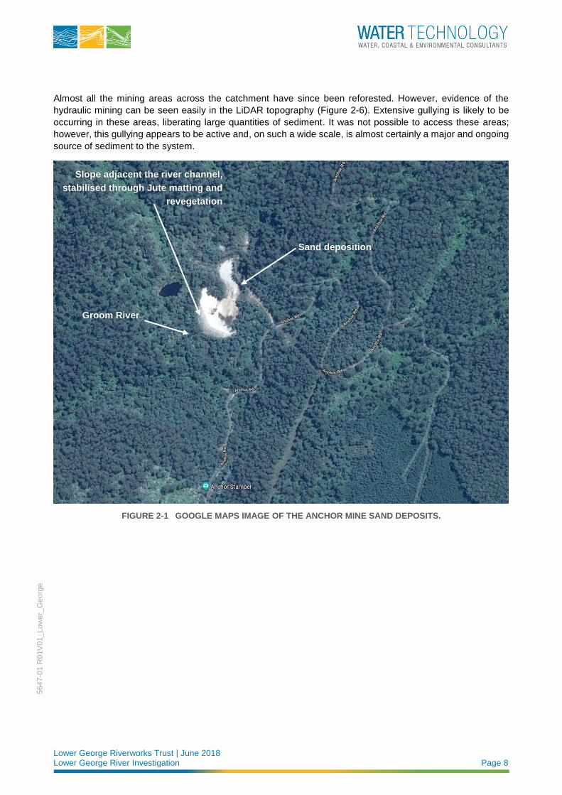
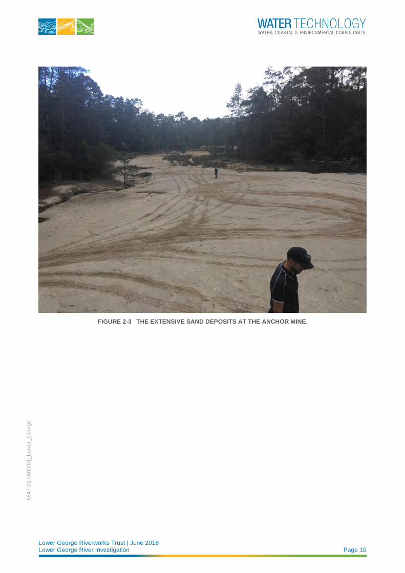
An inspection of a large sand mass at the Anchor Mine (Figure 2-1, Figure 2-2 and Figure 2-3) revealed that
the sediment immediately adjacent the waterway has been stabilised through jute matting and revegetation
works (Figure 2-1 and Figure 2-4). An inspection of the waterway immediately downstream found no indication
that this sediment stockpile at the mine is a current source of sand to the river system (Figure 2-5). However,
failure of these works during a catastrophic event is likely to introduce very large volumes of sand into the
system.
Lower George Riverworks Trust | June 2018 Lower George River Investigation Page 8
5647-0
1 R
01V
01_Low
er_
Georg
e
Almost all the mining areas across the catchment have since been reforested. However, evidence of the
hydraulic mining can be seen easily in the LiDAR topography (Figure 2-6). Extensive gullying is likely to be
occurring in these areas, liberating large quantities of sediment. It was not possible to access these areas;
however, this gullying appears to be active and, on such a wide scale, is almost certainly a major and ongoing
source of sediment to the system.
FIGURE 2-1 GOOGLE MAPS IMAGE OF THE ANCHOR MINE SAND DEPOSITS.
Sand deposition
Groom River
Slope adjacent the river channel,
stabilised through Jute matting and
revegetation

Lower George Riverworks Trust | June 2018 Lower George River Investigation Page 9
5647-0
1 R
01V
01_Low
er_
Georg
e
FIGURE 2-2 LARGE SAND SLUG/DEPOSIT LOCATED AT THE ANCHOR MINE.
Lower George Riverworks Trust | June 2018 Lower George River Investigation Page 10
5647-0
1 R
01V
01_Low
er_
Georg
e
FIGURE 2-3 THE EXTENSIVE SAND DEPOSITS AT THE ANCHOR MINE.

Lower George Riverworks Trust | June 2018 Lower George River Investigation Page 11
5647-0
1 R
01V
01_Low
er_
Georg
e
FIGURE 2-4 LOOKING AT THE SAND DEPOSITS IMMEDIATELY ADJACENT THE WATERWAY.

Lower George Riverworks Trust | June 2018 Lower George River Investigation Page 12
5647-0
1 R
01V
01_Low
er_
Georg
e
FIGURE 2-5 THE GROOM RIVER DOWNSTREAM OF THE ANCHOR MINE SAND. NOTE THE ABSENCE OF SAND DEPOSITS IN THE CHANNEL.

Lower George Riverworks Trust | June 2018 Lower George River Investigation Page 13
5647-0
1 R
01V
01_Low
er_
Georg
e
FIGURE 2-6 LIDAR TOPOGRAPHY SHOWING EFFECT OF HISTORIC SLUICE MINING AND ONGOING GULLYING.
2.2.2 Fire Impacted Areas
Riverine sediment loads in granitic catchments are highly vulnerable to bush fires. The impact to vegetation,
allows for substantially increased hillslope erosion and sediment delivery to the channel, particularly in steeper
sections of the catchment. Fire damage to some areas of the catchment were identified in the aerial imagery
and confirmed in the field (Figure 2-7). Some of the fire damaged areas lie over the areas impacted by mining
and as such are even more prone to erosion.

Lower George Riverworks Trust | June 2018 Lower George River Investigation Page 14
5647-0
1 R
01V
01_Low
er_
Georg
e
FIGURE 2-7 FIRE DAMAGE AND EXPOSED SAND ON A HILLSLOPE IN THE DERWENT CREEK CATCHMENT (A SUB-CATCHMENT OF THE POWERS RIVULET, ITSELF A TRIBUTARY OF THE GEORGE RIVER.
2.2.3 Bed and Bank Erosion
Bank erosion and developing avulsions1 are occurring on a large scale along much of the upstream river
reaches. This is particularly evident at Priory, approximately 16 km upstream of the river mouth where a
secondary flow path (avulsion) along the George River is present (Figure 2-8, Figure 2-9 and Figure 2-10).
Erosion at this scale is extensive and is observable for approximately 6 km along this reach (Figure 2-8).
Whereas bed deepening may have been initially responsible for bank collapse, a majority of the ongoing
erosion can be attributed to a lack of riparian vegetation. The channel is now widening along much of its length
(Figure 2-11).
The George River consists of alternating floodplain and gorge sections. As such, eroded sediment is forced
rapidly through gorge sections and stored temporarily in the valley expansions, either as splays on the
floodplain or sand slugs in the channel. Increased bank erosion due to a lack of vegetation or willow outflanking
is leading to a substantially increased rate of sediment moving to the mouth instead of being stored in these
sections. Land clearing also results in increased sediment making its way rapidly to the channel.
1 An avulsion is defined as a sudden change in river course, which usually occurs during a flood.

Lower George Riverworks Trust | June 2018 Lower George River Investigation Page 15
5647-0
1 R
01V
01_Low
er_
Georg
e
Bed and bank erosion is occurring at many locations along the George River and its tributaries. This erosion
is most often associated with a lack of riparian vegetation and will continue to be a major source of sediment
to the channel.

Lower George Riverworks Trust | June 2018 Lower George River Investigation Page 16
5647-0
1 R
01V
01
_Low
er_
Georg
e
FIGURE 2-8 LIDAR TOPOGRAPHY OVERLAIN ON AERIAL IMAGERY SHOWING THE ACTIVE EROSION PROCESSES.

Lower George Riverworks Trust | June 2018 Lower George River Investigation Page 17
5647-0
1 R
01V
01_Low
er_
Georg
e
FIGURE 2-9 THE AVULSION FLOW PATH NEAR PRIORY.

Lower George Riverworks Trust | June 2018 Lower George River Investigation Page 18
5647-0
1 R
01V
01_Low
er_
Georg
e
FIGURE 2-10 THE AVULSION FLOW PATH NEAR PRIORY.

Lower George Riverworks Trust | June 2018 Lower George River Investigation Page 19
5647-0
1 R
01V
01_Low
er_
Georg
e
FIGURE 2-11 EXTENSIVE BANK EROSION APPROXIMATELY 8M HIGH, OVER A 400M LENGTH.
2.3 The Lower George River
The lower George River is situated immediately downstream of a steep gorge section (Figure 2-12) and runs
through a large Holocene delta complex out to Georges Bay. The channel has clearly occupied various
locations on the delta surface over the past 10,000 years. Currently, the channel runs along the northern
boundary of the delta, flanked by terraces on the left bank and a levee along the right bank.
As can be seen in Figure 2-12, the channel immediately downstream of the gorge section is unvegetated on
the right bank. The channel is then lined with willows for almost its entire length of the reach all the way to its
mouth. Recent and historic flooding has led to large volumes of sand deposited as splays across the floodplain
(Figure 2-12) and as sand slugs within the channel. Aggradation along this reach has led to the channel being
infilled and, due to the levee, the channel bed is now higher than the adjacent floodplain in some locations.

Lower George Riverworks Trust | June 2018 Lower George River Investigation Page 20
5647-0
1 R
01V
01_Low
er_
Georg
e
FIGURE 2-12 THE LOWER GEORGE RIVER, IDENTIFYING KEY LOCATIONS.

Lower George Riverworks Trust | June 2018 Lower George River Investigation Page 21
5647-0
1 R
01V
01_Low
er_
Georg
e
2.3.1 Floodplain Mining
It is understood that an existing mining lease is present on the northern floodplain of the Lower George River,
downstream of the gorge section (Figure 2-13). In its current form, sediment extraction has occurred to a
limited extent; however, it is understood that future expansion of the mining extent is planned.
Being situated on the floodplain, the potential physical risks associated with the pit can be:
◼ Geotechnical instabilities.
◼ Lateral migration (bank erosion).
◼ Flow of water into and through the pit causing pit capture or avulsion.
As can be seen in Figure 2-13, the current pit lies in the path of overbank flood flows and floodplain scour is
already evident between the pit and the George River channel. Avulsion is unlikely at this location due to the
location of the pit relative to channel planform. However, pit capture appears to be real possibility particularly
if future mining expansion brings the pit closer to the channel. Pit capture results in the pit being connected to
the channel through erosion from overbank flow entering the pit and cutting back through the floodplain. This
process is capable of rapidly liberating large volumes of sediment to the system.

Lower George Riverworks Trust | June 2018 Lower George River Investigation Page 22
5647-0
1 R
01V
01_Low
er_
Georg
e
FIGURE 2-13 FLOODPLAIN MINING ON THE LOWER GEORGE FLOODPLAIN.

Lower George Riverworks Trust | June 2018 Lower George River Investigation Page 23
5647-0
1 R
01V
01_Low
er_
Georg
e
2.3.2 Bed Aggradation
Bed aggradation is occurring in the lower reaches of the Lower George River (Figure 2-12). This is no doubt
aided by the dense willow infestation along the entire reach (Figure 2-14) and the levee that runs for
approximately 2km upstream of Binalong Bay Road. As the channel fills, bank full flows are less capable of
moving sediment due to reduced channel capacity. Reduced channel capacity forces flow out of the channel,
depositing sediment on the floodplain/delta. If those overbank flows find a new, more hydraulically efficient,
flow path, a wholesale shift in channel planform (avulsion) will be initiated.
FIGURE 2-14 GEORGE RIVER CHANNEL, IMMEDIATELY UPSTREAM OF THE BINALONG BAY ROAD BRIDGE, SHOWING DENSE WILLOW INFESTATION AND BED AGGRADATION.
2.3.3 Delta Formation, Channel Movement and Avulsion
An assessment of previous flood hazard mapping (Pitt & Sherry, 2013) and floodplain/delta topography adjacent
to the lower George channel was conducted to predict likely breakout points and a future preferred channel
course. The current course of the Lower George is, in planform, the shortest path to George Bay. However,
an inlet to the south (a previous mouth of the George River) is only slightly longer and, as it is not full of sand,
represents a steeper path to the bay. Currently the channel is protected from deepening through knickpoint
migration by a concrete weir structure at the mouth.
Lower George Riverworks Trust | June 2018 Lower George River Investigation Page 24
5647-0
1 R
01V
01_Low
er_
Georg
e
Several potential breach locations (exit points for flood flows) exist along the lower George River, based on
topography and channel planform. However, only three are confirmed by photographic and anecdotal
evidence. Of the three confirmed locations, only one is considered a likely avulsion path due to the
downstream channel length and thus grade increase (Figure 2-15).

Lower George Riverworks Trust | June 2018 Lower George River Investigation Page 25
5647-0
1 R
01V
01_Low
er_
Georg
e
FIGURE 2-15 LIDAR TOPOGRAPHY SHOWING PREVIOUS COURSES OF THE GEORGE RIVER ALONG WITH POTENTIAL FUTURE COURSES AND BREAKOUT POINTS.

Lower George Riverworks Trust | June 2018 Lower George River Investigation Page 26
5647-0
1 R
01V
01_Low
er_
Georg
e
3 TRAJECTORY AND MANAGEMENT IMPLICATIONS
3.1 Trajectory
Bed aggradation within the lower George River is likely to continue for the foreseeable future, with rapid
aggradation during flood events. Excess sediment supply from historic mining impacts, land clearing and
bed/bank erosion is likely to continue with even higher rates of sediment supply during floods or after bush
fires. The following points highlight the key areas of concern over the short-term and long-term.
◼ Ongoing gully erosion: Gully erosion in mining impacted areas is likely to continue for the foreseeable
future. This will continue to add substantial volumes of sediment to the George River system, and
ultimately the lower George River channel. This is a key driver for bed aggradation in the lower George
River and any long-term solution will need to directly address this process.
◼ Ongoing bed and bank erosion: Bed and bank erosion resulting from floodplain and riparian land
clearing is likely to get worse over the short to medium term. This will add substantial volumes of sediment
to the George River system, and ultimately the lower George River channel. This is a key driver for bed
aggradation in the lower George River and any long-term solution will need to directly address this
process.
◼ Avulsion of the lower George River channel: As the channel fills in the lower reaches, overbank flows
will be more frequent and avulsion of the channel to a new location on the floodplain is more and more
likely. Predicting an avulsion path on a delta is difficult and detailed two-dimensional hydraulic modelling
is recommended to reduce uncertainty. However, as discussed in Section 2.3.3, an initial assessment of
floodplain topography suggests a likely breakout point and potential path (Figure 2-15). An avulsion of the
George River channel will have likely implications for the structural integrity of the Binalong Bay Road.
◼ Floodplain mining pit capture: The lower George River floodplain is susceptible to frequent inundation
of fast flowing water and the frequency of inundation is likely to increase in the short to medium term. The
risk of pit capture should be assessed through two-dimensional hydraulic modelling, particularly if the
expansion is to move closer to the channel.
Monitoring of the area over the last 15 years indicates that sedimentation within the lower George River is an
ongoing problem. Like most deltas the lower George delta represents a substantial reduction in grade to that
of its immediately upstream reach. It is therefore an area naturally prone to sediment accumulation and
anthropogenic influences such as mining and tree clearing have accelerated this process. Sediment delivery
to the channel upstream does not appear to be slowing and avulsion is likely in the coming years. As such,
intervention is required to address excess sediment in the channel and it associated impacts.
3.2 Management Implications
3.2.1 Overview
The objective of this project is to reduce sediment within the lower George River with the express intention of:
1. Reducing the likelihood of avulsion in the lower George delta.
2. Reducing the volume of sand deposited on the floodplain during floods.
Lower George Riverworks Trust | June 2018 Lower George River Investigation Page 27
5647-0
1 R
01V
01_Low
er_
Georg
e
Management options for excess sediment (summarised by Sims and Rutherford, 2017) include:
1. Reducing the sediment supply at the source.
2. Promoting sediment storage in the channel.
3. Accelerating sediment transport through the system.
4. Directly extracting sediment from the channel.
Sims and Rutherford (2017) go on to point out that these options are not necessarily mutually exclusive. With
avulsion as the ultimate result in this scenario, a fifth option of planning for a controlled avulsion is added to
the list, particularly as this is a natural and common process in the formation of alluvial deltas.
Each of these management options are discussed in the following sections. The implications associated with
the ‘Do Nothing’ option is summarised in Section 3.1.
3.2.2 Reducing Sediment Supply
Reducing the sediment supply at the source and promoting storage on the floodplain are considered
important actions in the long term. It is likely that these options will require a substantial investment of both
time and money. Revegetating the riparian zone along the eroding areas and re-establishing vegetation on the
floodplain (including likely avulsion paths) will assist in both reducing erosion and increasing storage. However,
the areas requiring treatment are large and considerable time will be required to get funding and buy in from
landholders. It could be decades before the works achieve the desired response at the downstream end of the
catchment. Given the degree to which the channel has infilled in the lower reaches, it is likely that any future
flood will breach and damage the levee and catastrophic flooding, like that seen in 2016, has the potential to
form a new course through the landscape.
3.2.3 Promoting Sediment Storage
Promoting sediment storage in the George River channel is unlikely to be an option due its steep longitudinal
gradient in the reach immediately upstream of the project reach and the degraded (incised) nature of the
channel upstream of that. However, trapping sediment along tributaries affected by mining is an option and
may reduce sediment loads substantially if undertaken on a large scale. This could be achieved in a number
of ways, including revegetation and cross channel log or weir structures.
3.2.4 Accelerating Sediment Transport
Accelerating sediment transport through the affected reach of the George River is not possible due to the
significantly reduced longitudinal slope of the lower George River compared to the reach immediately upstream
and the low energy, deposition zone of the bay downstream. Likewise, the substantially reduced channel
capacity would not allow for the hydraulic conditions required to remove the sediment.
3.2.5 Sediment Extraction
Extracting sediment from the affected reach of the George River is likely to improve stream health in this
location given the current complete lack of geomorphic diversity. The common detrimental effect of channel
sand extraction, incision through knickpoint migration is unlikely to progress far due to bedrock bars in the
upstream gorge reach. As such, extracting sediment from the channel at this location is a potential option to
address the likely avulsion. Sand extraction at this location could be accompanied by the replacement of
willows with native vegetation. This approach would increase channel capacity and allow for enhanced
sediment transport through this reach, particularly if the levee was maintained (not raised). The costs of sand
extraction are ideally offset with the sale of the sand to the construction industry; however, a cursory glance
suggests that the sand may be unsuitable for use in the construction industry.

Lower George Riverworks Trust | June 2018 Lower George River Investigation Page 28
5647-0
1 R
01V
01_Low
er_
Georg
e
3.2.6 Planning for Avulsion
Planning for a controlled avulsion and allowing the river to relocate to the path identified in Section 2.3.3
may be substantially cheaper than extracting sediment from the channel. Analysis of topography and
previously conducted hydraulic modelling (flood hazard results provided in Pitt and Sherry, 2013) provides the
likely and most achievable path for an avulsion when the channel fills past the critical flow conveyance
threshold. The path is slightly longer than the current channel but steeper due to the lack of deposition. The
path also has the additional advantage of an existing bridge on Binalong Bay Road. Currently, the channel is
protected from deepening through knickpoint migration by a concrete weir structure. This structure could be
removed to promote the formation of a new channel and redirection of the George River. This would also
require replacement of willows with native vegetation and revegetation efforts along the new channel. A
controlled avulsion also comes with risks and analysis would be required to assess and mitigate these risks.

Lower George Riverworks Trust | June 2018 Lower George River Investigation Page 29
5647-0
1 R
01V
01_Low
er_
Georg
e
4 EXISTING STRATEGIES AND PLANS
4.1 Overview
Existing strategies and plans can provide supplementary background information, analysis and
recommendations that are useful in the overall management of the Lower George River. When reviewing these
existing plans, it is important to pay attention to the specific aim and scope of the plan, as this will have a heavy
bearing on the final recommendations and priorities. Existing plans can also be leveraged for funding bids
especially if there are consistent recommendations and priorities. Two documents that are of particular
relevance for the management of the lower George River are:
◼ Rivercare Plan – Lower George River.
◼ Lower George River Floodplain Risk Management Plan.
Both of these documents are reviewed below.
4.2 Rivercare Plan – Lower George River
The Lower George River, Rivercare Plan (Sprod 2003) provides a range of management strategies and actions
aimed at protecting and rehabilitating the lower George River and its tributaries (Powers Rivulet, Ransom River
and Groom River). The Rivercare Plan provides details of:
◼ The existing (2003) condition of the lower George River and its tributaries. This includes an assessment
of the geomorphology, flora and fauna, water quality and quantity (hydrology) and vegetation.
◼ A set of management goals. These goals are:
◼ Have water quality standards comply with Australian and New Zealand Guidelines for Fresh and
Marine Water Quality.
◼ Have environmental flow requirements met for the Georges River.
◼ Maintain and extend irrigation rights to the maximum consistent with the above objectives.
◼ Implement works needed to establish Recreation Area 1: Sawdust Road, Recreation Area 1: Smiths
Lane and the Halls Falls network.
◼ Ensure pollution is minimised.
◼ Identify and maintain habitat for threatened riparian species.
◼ Help the river recover its pre-mining geometry and geomorphology.
◼ Maintain and extend the extent of woody cover along the streams.
◼ Maintain and extend the density, diversity and extent of native riparian vegetation.
◼ Reduce the impact of crack willow on stream behaviour and ecology.
◼ Broad strategies to achieve the management goals. The strategies are:
◼ Control stock access.
◼ Control crack willow.
◼ Enhance native vegetation.
◼ Enhance geomorphic recovery.
◼ Define and address point and diffuse sources of pollution.

Lower George Riverworks Trust | June 2018 Lower George River Investigation Page 30
5647-0
1 R
01V
01_Low
er_
Georg
e
◼ A set of priority actions. The Lower George River, Rivercare Plan recommends prioritising works based
on protecting ‘excellent reaches’ first to avoid these reaches becoming degraded. It is then recommended
to prioritise reaches base on their recovery potential (Figure 4-1). This approach has been suggested as
it takes less resources to protect and maintain the good reaches than it does to rehabilitate degraded
reaches with a poor recovery potential. The Rivercare Plan identifies that the ‘delta reach’ of Georges
River (the reach between the Lower Gorge and Georges Bay) as having a low recovery potential, and
therefore being a low priority compared to other reaches (Figure 4-1).
FIGURE 4-1 REHABILITATION POTENTIALS (SPROD, 2003).
4.3 Lower George River Floodplain Risk Management Plan
The Lower George River Floodplain Risk Management Plan (“the Risk Management Plan”) (Pitt & Sherry,
2013) identifies and assesses risks associated with flooding of the lower George River floodplain. The project
extent is limited to the reach of the George River downstream of the gorge to Georges Bay (Figure 4-2).
The principal focus of the Risk Management Plan was to assess and identify mitigation measures to manage
flood risks that have the potential to cause injury, fatality and/or significant economic impacts. In order to
assess the risks, a hydraulic model of the lower George River floodplain was developed. The hydraulic model
was run for various flood event and scenarios to determine the flood hazard ratings (i.e. flood depth (m)
multiplied by flow velocity (m/s) for each of the flood events and scenarios. An example of one of the flood
hazard maps is provided in Figure 4-3. Using the flood hazard rating maps, a risk assessment was undertaken
to identify suitable management actions. Some of the recommended actions include:

Lower George Riverworks Trust | June 2018 Lower George River Investigation Page 31
5647-0
1 R
01V
01_Low
er_
Georg
e
◼ Design and emplace physical barriers to reduce flow velocities.
◼ Obstruction removal.
◼ Review functionality and requirements for armouring.
◼ Review of design and safety of dams.
◼ Dredge the stream channel to make it deeper and wider.
◼ Establish an early flood warning system.
A limitation of this plan is that it does not consider the likely avulsion of the Georges River and the implications
of the avulsion.
FIGURE 4-2 LOWER GEORGE RIVER FLOODPLAIN RISK MANAGEMENT PLAN PROJECT EXTENT (PITT & SHERRY 2013).

Lower George Riverworks Trust | June 2018 Lower George River Investigation Page 32
5647-0
1 R
01V
01_Low
er_
Georg
e
FIGURE 4-3 FLOOD HAZARD RATING FOR A 100 YEAR ARI EVENT UNDER EXISITNG CONDITIONS, WHERE FLOOD HAZARD IS THE FLOOD WATER DEPTH (M) MULITPLIED BY VELOCITY (M/S) (PITT &
SHERRY, 2013)

Lower George Riverworks Trust | June 2018 Lower George River Investigation Page 33
5647-0
1 R
01V
01_Low
er_
Georg
e
5 RECOMMENDATIONS AND PRIORITIES It is recommended that a combined approach is adopted to address the infilling of the lower George River
channel. The following actions should be undertaken together to both address the current issue of bed
aggradation and prevent future infilling. The recommended suite of management actions is listed below.
Further detail is provided in the following sections.
◼ Reduce Sediment Supply:
◼ Address bank erosion in the upper catchment.
◼ Address avulsion risk in the upper catchment.
◼ Address gullying in the upper catchment.
◼ Extract Sediment:
◼ Extract sediment from the affected reach of the channel.
◼ Staged willow management with simultaneous replacement of willows with native woody vegetation
to ensure continued stability.
5.1 Reduce Sediment Supply
Reducing sediment supply in the upper catchment will require substantial funding probably across several
projects. The main tasks in reducing sediment in the upper catchment include:
◼ Bank erosion:
◼ Mitigating acute erosion hotspots is site specific and many of the major erosion sites along the George
River will require specialist assessment and design to properly address the dominant drivers. This
may involve the design and construction of rock armouring or grade control structures to stabilise the
bed and banks whilst vegetation is established.
◼ Mitigating bank instabilities on a wider scale, where erosion is less acute, will require vegetation
establishment, stock management and weed management. Wide scale revegetation and stock
management will increase flood resilience, stabilise banks and slow flood waters (reducing erosive
forces). Technical advice on vegetation establishment, stock management and weed management
with specific reference to locally relevant instructions is provided in Section 6.
◼ Avulsion Management:
◼ Managing active or potential avulsions can require a variety of techniques, usually including hard
engineered rock chutes and/or vegetation establishment. Specialist advise should be sought to
identify and assess active or potential avulsions and design specific management strategies.
◼ Managing avulsion risk will typically involve revegetating the floodplain along the path of the active or
potential avulsion. Revegetation provides a long-term option for managing avulsions, as it increases
stability through the root structure and slows flood water reducing the ability of flood waters to scour
into the floodplain. Technical advice on vegetation establishment, stock management and weed
management with specific reference to locally relevant instructions is provided in Section 6.
◼ Gully erosion:
◼ Gully erosion is notoriously difficult to manage but is likely to be a key source of sediment to the
George River. Like avulsion management, the management of active gullying can require a variety
of techniques, usually including hard engineered structures (rock chutes or weirs) and/or vegetation
establishment. Specialist advise should be sought to assess and design specific mitigation strategies
for managing gully erosion.

Lower George Riverworks Trust | June 2018 Lower George River Investigation Page 34
5647-0
1 R
01V
01_Low
er_
Georg
e
◼ Managing gully erosion will almost always involve revegetating the adjacent floodplain or hillslope.
Revegetation is considered the most cost effective, long-term option for managing gully erosion, as it
increases stability through the root structure and slows flood water reducing the ability of flood waters
to scour into the floodplain. Technical advice on vegetation establishment, stock management and
weed management with specific reference to locally relevant instructions is provided in Section 6.
As previously noted, it could be decades before these works will achieve the desired response at the
downstream end of the catchment.
5.2 Sediment Extraction
Extracting sediment from the lower George River channel will also require substantial funding and must be
conducted following strict limitations and protocols directed by a suitably qualified geomorphologist and an
environmental engineer (most likely two separate people). There are various potential stability issues
associated with instream sediment extraction and care must be taken to avoid initiating erosion or other
detrimental impacts, including increased sediment transport into the bay. Notably, a key reason why this option
presents as a viable management option is that the potential common risk associated with sand extraction
(incision through knickpoint migration) is unlikely to progress far upstream due to the presence of bedrock bars
in the upstream gorge reach.
An associated problem in this reach is that of the willow infestation. The long-term solution to the bed
aggradation issue in the river must involve the removal of the willows and their replacement with native woody
vegetation. However, it is strongly recommended that this occurs after the sediment extraction and after a
period of monitoring.
Expert advice should be sought, and careful consideration should be given to the following aspects of sediment
extraction:
◼ Timing of sediment extraction – sediment extraction should be limited to drier months.
◼ Depth width and depth of extraction – analysis should be conducted to ascertain an appropriate width and
depth of extraction.
◼ Upstream extent of extraction – analysis should be conducted to ascertain an appropriate upstream extent
of extraction.
◼ Channel hydraulics - analysis should be conducted to ensure the proposed extraction does not have
adverse impacts on channel hydraulics.
◼ Access to the channel – if vegetation clearing is required, immediate revegetation activities should be
undertaken.
It may be that analysis indicates that the willows are too encroached to allow for a sufficient extraction width
to be achieved. If this is the case, careful planning will be required for staged extraction to ensure bank stability
is not compromised.

Lower George Riverworks Trust | June 2018 Lower George River Investigation Page 35
5647-0
1 R
01V
01_Low
er_
Georg
e
6 TECHNICAL ADVICE
6.1 Vegetation Establishment
Vegetation establishment is considered the key technique to improve river health within the project area.
The benefits of vegetation include:
◼ Assisting channel stability and reducing rates of channel change.
◼ Improving aquatic and terrestrial ecology values of a waterway.
◼ Improving the social and economic values of a waterway.
◼ In time, revegetation will provide a source of instream logs and branches, which in turn provides complex
habitat that leads to improved aquatic biodiversity.
Revegetation of the riparian zone is the most cost-effective form of erosion control in the long term. A
comprehensive revegetation program should aim to plant native species on the bank face, top of bank and
beyond the top of bank for as wide as can be accommodated. The revegetation offset should extend as wide
as practical, typically a minimum of ten metres beyond top of bank.
Denser plantings are encouraged on the bank face and on outside bends. Revegetation activities must involve
a mixture of indigenous species to assist bank stability. Grasses, reeds, rushes, sedges and shrubs all have a
significant role in assisting bank stability and should be the primary focus of revegetation activities aimed at
assisting bank stability.
Additional revegetation recommendations include:
◼ A vegetation survey in an adjoining or nearby stream system with riparian vegetation will assist
identification of the most appropriate native species. Take note of where particular species occur in
relation to the river channel (e.g. lower bank, mid bank, upper bank or floodplain).
◼ Preferably a range of species should be used, including trees, shrubs and ground covers.
◼ If overstory trees are present, reduce or eliminate the number of trees planted.
◼ Utilise and protect natural recruitment of native species wherever present. These plants will have the
greatest prospect for survival.
◼ Prior to planting seedlings, reduce weed cover as much as possible from the planting area. Ideally one
full year of weed control should occur before planting.
◼ Avoid ripping soils in riparian areas that may be subject to flooding.
◼ Soil preparation, the aim is to create good tilth (loose friable soil) in which to plant your seedlings.
◼ Newly planted seedlings may need protection from browsing or trampling from domestic or native animals.
◼ Gently water new plants with a few litres of water over the first year of their life.
The NRM North website contains further information, including relevant links to determine appropriate species
selection (www.nrmnorth.org.au).
Riparian vegetation widths should be determined on an individual property/works site basis as part of the
appropriate planning process taking into consideration:
◼ The works type proposed for the site.
◼ Ongoing management issues (e.g. weed spraying access).
◼ Interaction of floodplain and channel landforms.

Lower George Riverworks Trust | June 2018 Lower George River Investigation Page 36
5647-0
1 R
01V
01_Low
er_
Georg
e
◼ Property size and layout.
◼ Estimated meander migration direction and rate.
◼ Estimated erosion rate.
◼ Ecological benefits.
◼ Existing infrastructure.
◼ Land planning issues.
◼ Stock access and watering.
◼ Existing remnant vegetation.
◼ Riparian corridor links.
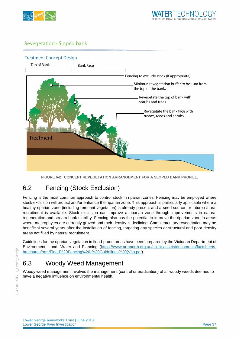
Concept revegetation arrangements for both vertical bank profiles and sloped bank profiles are illustrated in
Figure 6-1 and Figure 6-2 respectively.
FIGURE 6-1 CONCEPT REVEGETATION ARRANGEMENT INVOLVING A VERTICAL BANK PROFILE.
Lower George Riverworks Trust | June 2018 Lower George River Investigation Page 37
5647-0
1 R
01V
01_Low
er_
Georg
e
FIGURE 6-2 CONCEPT REVEGETATION ARRANGEMENT FOR A SLOPED BANK PROFILE.
6.2 Fencing (Stock Exclusion)
Fencing is the most common approach to control stock in riparian zones. Fencing may be employed where
stock exclusion will protect and/or enhance the riparian zone. This approach is particularly applicable where a
healthy riparian zone (including remnant vegetation) is already present and a seed source for future natural
recruitment is available. Stock exclusion can improve a riparian zone through improvements in natural
regeneration and stream bank stability. Fencing also has the potential to improve the riparian zone in areas
where macrophytes are currently grazed and their density is declining. Complementary revegetation may be
beneficial several years after the installation of fencing, targeting any species or structural and poor density
areas not filled by natural recruitment.
Guidelines for the riparian vegetation in flood-prone areas have been prepared by the Victorian Department of
Environment, Land, Water and Planning (https://www.nrmnorth.org.au/client-assets/documents/factsheets-
brochures/nrm/Flood%20Fencing%20-%20Guidelines%20(Vic).pdf).
6.3 Woody Weed Management
Woody weed management involves the management (control or eradication) of all woody weeds deemed to have a negative influence on environmental health.

Lower George Riverworks Trust | June 2018 Lower George River Investigation Page 38
5647-0
1 R
01V
01_Low
er_
Georg
e
6.3.1 Willow Management
Willows are the most prevalent and problematic woody weed species within the project area. Willow
management will primarily involve the phased poisoning of all willow species. The general willow management
rationale shall be as follows:
◼ Where the invasive willow species are assisting channel stability, willow management shall be undertaken
as a staged process involving suitable alternative stabilisation works (e.g. revegetation).
◼ Where invasive willow species are not assisting channel stability they should be eradicated.
Complementary revegetation activities should be undertaken as required to improve the riparian
vegetation condition at the site.
Willow management activities must be undertaken with consideration of site specific issues and the
management of stakeholder expectations. This may necessitate a staged approach to works even where
willows are not assisting channel stability.
Further information regarding willow management is provided on the DPIPWE website
(http://dpipwe.tas.gov.au/invasive-species/weeds/weeds-index/declared-weeds-index/willows/willow-control-
guide).
6.3.2 Other Weeds
Without intervention, invasive weed species, such as Blackberry, will continue to colonise the riparian zone of
Georges River within the project area. Hence a weed management program targeting highly invasive and
noxious weeds is strongly recommended.
6.4 Approvals
River works can improve and protect waterways and adjoining land uses and assets. However, they can also
do significant, extensive and lasting harm to land production, infrastructure, water quality and the streams and
land. For that reason, development and works near streams, wetlands and lakes are subject to regulation and
approvals/permits. The best place to find out what, where and how of legal obligations is: Working near
waterways - Understanding your legal obligations, a Tasmanian guide by the Environment Defenders Office.
For many river works in the Break O’Day Council region, authority and approval from the local Planning
Scheme is likely to be needed. Other approvals may apply as well or instead, including from the land
manager/owner (e.g. Crown Land Services or Parks and Wildlife Service), for dams and levee banks and for
extracting water. It is strongly recommended to contact Council or other authorities involved at an early project
planning stage to make sure you start with the right information about approvals and permits you may or may
not need and the process if you do. Relevant documentation and links are provided in the following points:
◼ Working near waterways - Understanding your legal obligations (www.edotas.org.au/waterways)
◼ Break O’Day Council: 03 6376 7900, [email protected].
◼ Break O’ Day Interim Planning Scheme www.bodc.tas.gov.au/development (see the various Planning
webpages)
◼ Wetlands and Waterways Manual dpipwe.tas.gov.au/conservation/flora-of-tasmania/tasmanias-
wetlands/wetlands-waterways-works-manual)
◼ Soil and water management guidelines www.bodc.tas.gov.au/development/planning/soil-water-
management and epa.tas.gov.au/epa/water/stormwater/soil-and-water-management-on-building-sites
◼ The Australian River Restoration Centre online and river management information resources
arrc.com.au/services/managing-rivers/

Lower George Riverworks Trust | June 2018 Lower George River Investigation Page 39
5647-0
1 R
01V
01_Low
er_
Georg
e
◼ Weed and Disease Planning and Hygiene Guidelines dpipwe.tas.gov.au/invasive-species/weeds/weed-
hygiene/weed-and-disease-planning-and-hygiene-guidelines
◼ Keeping It Clean - A Tasmanian field hygiene manual to prevent the spread of freshwater pests and
pathogens. www.nrmsouth.org.au/wp-content/uploads/2014/10/keeping_it_clean.pdf

Lower George Riverworks Trust | June 2018 Lower George River Investigation Page 40
5647-0
1 R
01V
01_Low
er_
Georg
e
7 REFERENCES Pitt & Sherry. (2013). Lower George River Floodplain Risk Management Plan. Prepared for: Break O’Day
Council. ref: CE12067L001 RskMgPln 31P Rev00.docx/SR/rw
Sims, A. J. & I. D. Rutherfurd (2017). Management responses to pulses of bedload sediment in rivers.
Geomorphology. 294: 70-86.
Sprod, D. (2003) Lower George Rivercare Plan, Lower George Landcare Group, St Helens.

Lower George Riverworks Trust | June 2018 Lower George River Investigation Page 41
5647-0
1 R
01V
01_Low
er_
Georg
e
Melbourne 15 Business Park Drive Notting Hill VIC 3168 Telephone (03) 8526 0800 Fax (03) 9558 9365
Brisbane Level 3, 43 Peel Street South Brisbane QLD 4101 Telephone (07) 3105 1460 Fax (07) 3846 5144
Wangaratta First Floor, 40 Rowan Street Wangaratta VIC 3677 Telephone (03) 5721 2650
Perth PO Box 362 Subiaco WA 6904 Telephone 0407 946 051
Geelong PO Box 436 Geelong VIC 3220 Telephone 0458 015 664
Gippsland 154 Macleod Street Bairnsdale VIC 3875 Telephone (03) 5152 5833
Wimmera PO Box 584 Stawell VIC 3380 Telephone 0438 510 240
www.watertech.com.au