report of examination november 2020
TRANSCRIPT
Penryn Neighbourhood Development Plan
Submission Version 2020 – 2030
Report of Examination November 2020
Undertaken for Cornwall Council with the support of Penryn Town Council on the submission version of the plan.
Independent Examiner:
Liz Beth BA (Hons) MA Dip Design in the Built Environment MRTPI
2
Contents
Summary .............................................................................................................................................. 3
1. Introduction and Background ......................................................................................................... 4
1.1 Neighbourhood Development Plans ......................................................................................... 4
1.2 Independent Examination ......................................................................................................... 4
1.3 Planning Policy Context ............................................................................................................. 6
2. Plan Preparation and Consultation ................................................................................................. 7
2.1 Pre-submission Process and Consultation ................................................................................ 7
2.2 Regulation 16 Consultation Responses ..................................................................................... 8
3. Compliance with the Basic Conditions Part 1 .................................................................................. 9
4. Compliance with the Basic Conditions Part 2: National Policy and the Development Plan ......... 11
5. The Referendum Boundary ........................................................................................................... 21
Abbreviations used in the text of this report:
The Penryn Neighbourhood (Development) Plan is referred to as ‘the Plan’ or ‘PNP’.
Penryn Town Council is referred to as the ‘Town Council’.
Cornwall Council is also referred to as the Local Planning Authority (LPA).
The National Planning Policy Framework (2019) is abbreviated to ‘NPPF’.
The National Planning Practice Guidance is abbreviated to ‘NPPG’.
The Cornwall Local Plan Strategic Policies 2010 - 2030 is abbreviated to ‘CLP’.
The Cornwall Site Allocations Development Plan Document is abbreviated to ‘SADPD’.
Regulations 14 and 16 are abbreviated to ‘Reg14’ and ‘Reg16’ respectively.
Strategic Environmental Assessment = ‘SEA’ and Habitats Regulations Assessment = ‘HRA’
3
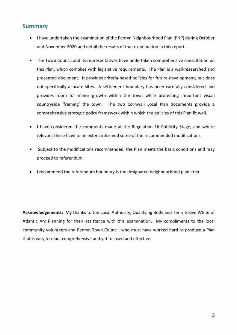
Summary
I have undertaken the examination of the Penryn Neighbourhood Plan (PNP) during October
and November 2020 and detail the results of that examination in this report.
The Town Council and its representatives have undertaken comprehensive consultation on
this Plan, which complies with legislative requirements. The Plan is a well-researched and
presented document. It provides criteria-based policies for future development, but does
not specifically allocate sites. A settlement boundary has been carefully considered and
provides room for minor growth within the town while protecting important visual
countryside ‘framing’ the town. The two Cornwall Local Plan documents provide a
comprehensive strategic policy framework within which the policies of this Plan fit well.
I have considered the comments made at the Regulation 16 Publicity Stage, and where
relevant these have to an extent informed some of the recommended modifications.
Subject to the modifications recommended, the Plan meets the basic conditions and may
proceed to referendum.
I recommend the referendum boundary is the designated neighbourhood plan area.
Acknowledgements: My thanks to the Local Authority, Qualifying Body and Terry Grove White of
Atlantic Arc Planning for their assistance with this examination. My compliments to the local
community volunteers and Penryn Town Council, who must have worked hard to produce a Plan
that is easy to read, comprehensive and yet focused and effective.
4
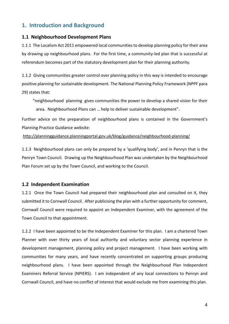
1. Introduction and Background
1.1 Neighbourhood Development Plans
1.1.1 The Localism Act 2011 empowered local communities to develop planning policy for their area
by drawing up neighbourhood plans. For the first time, a community-led plan that is successful at
referendum becomes part of the statutory development plan for their planning authority.
1.1.2 Giving communities greater control over planning policy in this way is intended to encourage
positive planning for sustainable development. The National Planning Policy Framework (NPPF para
29) states that:
“neighbourhood planning gives communities the power to develop a shared vision for their
area. Neighbourhood Plans can … help to deliver sustainable development”.
Further advice on the preparation of neighbourhood plans is contained in the Government’s
Planning Practice Guidance website:
http://planningguidance.planningportal.gov.uk/blog/guidance/neighbourhood-planning/
1.1.3 Neighbourhood plans can only be prepared by a ‘qualifying body’, and in Penryn that is the
Penryn Town Council. Drawing up the Neighbourhood Plan was undertaken by the Neighbourhood
Plan Forum set up by the Town Council, and working to the Council.
1.2 Independent Examination
1.2.1 Once the Town Council had prepared their neighbourhood plan and consulted on it, they
submitted it to Cornwall Council. After publicising the plan with a further opportunity for comment,
Cornwall Council were required to appoint an Independent Examiner, with the agreement of the
Town Council to that appointment.
1.2.2 I have been appointed to be the Independent Examiner for this plan. I am a chartered Town
Planner with over thirty years of local authority and voluntary sector planning experience in
development management, planning policy and project management. I have been working with
communities for many years, and have recently concentrated on supporting groups producing
neighbourhood plans. I have been appointed through the Neighbourhood Plan Independent
Examiners Referral Service (NPIERS). I am independent of any local connections to Penryn and
Cornwall Council, and have no conflict of interest that would exclude me from examining this plan.
5
1.2.3 As the Independent Examiner I am required to produce this report and recommend either:
(a) That the neighbourhood plan is submitted to a referendum without changes; or
(b) That modifications are made and that the modified neighbourhood plan is submitted
to a referendum; or
(c) That the neighbourhood plan does not proceed to a referendum on the basis that it does
not meet the necessary legal requirements.
1.2.4 The legal requirements are firstly that the Plan meets the ‘Basic Conditions’, which I consider
in sections 3 and 4 below. The Plan also needs to meet the following requirements under Paragraph
8(1) of Schedule 4B to the Town and Country Planning Act 1990:
It has been prepared and submitted for examination by a qualifying body;
It has been prepared for an area that has been properly designated by the Local Planning
Authority;
It specifies the period during which it has effect;
It does not include provisions and policies for excluded development;
It does not relate to land outside the designated neighbourhood area.
The Penryn Neighbourhood Plan complies with the requirements of Paragraph 8(1). The
Neighbourhood Area was designated on the 12th October 2016 by Cornwall Council. The Plan does
not relate to land outside the designated Neighbourhood Area. It specifies the period during which
it has effect as 2020 – 2030 and has been submitted and prepared by a qualifying body, Penryn
Town Council, and people working to that qualifying body. It does not include policies about
excluded development; effectively mineral and waste development or strategic infrastructure.
1.2.5 I made an unaccompanied site visit to Penryn to familiarise myself with the area and visit
relevant sites and areas affected by the policies. This examination has been dealt with by written
representations, as I did not consider a hearing necessary.
1.2.6 I am also required to consider whether the referendum boundary should be extended beyond
the designated area, should the Plan proceed to a referendum. I make my recommendation on this
in section 5 at the end of this report.
6
1.3 Planning Policy Context
1.3.1 The Development Plan for Cornwall and Penryn, not including documents relating to excluded
mineral and waste development, are the Cornwall Local Plan (CLP) Strategic Policies adopted in 2016
and the Cornwall Site Allocation Development Plan Document (SADPD) adopted in November 2019.
Both documents are strategic, and all policies in them should be considered as strategic policy for the
purposes of the Basic Conditions. Within the SADPD the section ‘Falmouth and Penryn Spatial
Strategy and Allocations’ is particularly relevant for this examination.
1.3.2 The National Planning Policy Framework 2019 (NPPF) sets out government planning policy for
England, and the National Planning Practice Guidance (NPPG) website offers guidance on how this
policy should be implemented.
1.3.3 During my examination of the PNP I have considered the following documents:
National Planning Policy Framework (NPPF) 2019
National Planning Practice Guidance 2014 and as updated
Town and Country Planning Act 1990 (as amended)
Planning and Compulsory Purchase Act 2004
The Localism Act 2011
The Neighbourhood Planning Regulations 2012 (as amended)
Submission version of the Penryn Neighbourhood Plan (PNP)
The Basic Conditions Statement submitted with the PNP
The Consultation Statement submitted with the PNP
The SEA Environmental Report for the PNP
The HRA Report for the PNP
Neighbourhood Area Designation (map) and Policies Map submitted with the PNP
Cornwall Local Plan Strategic Policies and the Cornwall SADPD
Penryn Conservation Area Appraisal and Management Plan Cornwall Council March 2010
Representations received during the publicity period (reg16 consultation)
7
2. Plan Preparation and Consultation
2.1 Pre-submission Process and Consultation
2.1.1 Penryn is a town in the west of Cornwall, just north of Falmouth, located on the River Penryn
and its estuary. The Plan covers the Parish of Penryn, which includes the town, the upper reaches
of the estuary and some of the surrounding countryside. The Penryn Estuary just beyond the parish
boundary is part of the Fal and Helford Special Area of Conservation (SAC).
2.1.2 A Neighbourhood Plan Forum (the ‘Forum’) was set up to co-ordinate work on the Plan, and
it’s first task was to consult on the issues and options for the Plan in 2017. Five working groups were
set up following this initial work, and site assessment and landowner engagement was undertaken
by the Housing Working Group and AECOM. The SEA process has informed the final choice of
development options for the PNP.
2.1.3 The Consultation Statement describes the nature and form of consultation prior to the formal
regulation 14 (Reg14) six week consultation. A launch event followed by two other engagement
events in 2017 resulted in many comments from the public that have been collated and analysed in
a report that also offered a review of policy areas, the potential evidence base and projects.
2.1.4 As required by Reg14 of the Neighbourhood Planning Regulations 2012, the formal
consultation for six weeks on the Pre-Submission Draft Neighbourhood Plan ran from the 18th
January 2020 to the 4th March 2020. The draft Plan was available in hard copy to view in the town,
and online on the Town Council website, together with a response form. The consultation was
advertised in the press and with a leaflet delivered to all households. A launch event was attended
by over 130 people, and the consultation publicised in schools, local businesses and a rugby match.
2.1.5 Representations were received from 43 respondents during the Reg14 consultation period,
and several amendments have been made to the Plan as a result of constructive suggestions for
changes. I am satisfied that due process has been followed during the consultation undertaken on
the Plan. The Consultation Statement details all consultation activities, and the record of comments
and objections received during the Reg14 consultation shows that these were properly considered,
and where appropriate resulted in amendments to the plan to accommodate points raised.
2.1.6 As required, the amended Plan, together with a Basic Conditions Statement, a Consultation
Statement, The SEA and HRA Reports and a plan showing the neighbourhood area were submitted
to Cornwall Council on the 18th May 2020.

8
2.2 Regulation 16 Consultation Responses
2.2.1 Cornwall Council undertook the Reg16 consultation and publicity on the PNP for 12 weeks,
extended from the usual legal requirement of 6 weeks due to the restrictions on consultation caused
by the Covid 19 pandemic. The consultation therefore ran from the 18th June 2020 to the 10th
September 2020. Ten representations were received during this consultation; four statutory bodies
had no specific comments to make on this Plan but offered general guidance. Several sections of
Cornwall Council offered comments, a local resident commented on a site outside of the
neighbourhood area and two local organisations offered comments that were mostly supportive.
Issues these submissions raise that are pertinent to my consideration of whether the Plan meets
the basic conditions are considered in sections 3 and 4 of this report below.
2.2.2 I am specifically limited by legislation to correcting with recommended modifications any part
of the Plan that does not comply with the Basic Conditions, and other legal requirements of a land-
use plan. When Reg16 comments suggest significant additions, such as new sites or policies, this
examination is not authorised to consider them.

9
3. Compliance with the Basic Conditions Part 1
3.1 General legislative requirements of the 1990 Town and Country Planning Act (TCPA) other than
the Basic Conditions are set out in paragraph 1.2.4 above. The same section of this report considers
that the PNP has complied with these requirements. What this examination must now consider is
whether the Plan complies with the Basic Conditions, which state it must:
Have regard to national policies and advice contained in guidance issued by the Secretary of
State;
Contribute to the achievement of sustainable development;
Be in general conformity with the strategic policies of the development plan for the
area; and
Be compatible with and not breach European Union (EU) obligations and comply with human
rights law.
Not breach the requirements of Chapter 8 of Part 6 of the Conservation of Habitats and
Species Regulations 2017 (prescribed Basic Condition since December 2018).
3.2 The Basic Conditions Statement submitted with the PNP sets out how each policy of the Plan
promotes the social, economic and environmental goals of sustainable development in a table. The
analysis is detailed and thorough, and I accept that the Plan does contribute to sustainable
development in line with the Basic Conditions.
3.3 An Environmental Report and Habitat Regulations Assessment (HRA) Report have been
submitted with the PNP as both Strategic Environmental Assessment (SEA) and HRA were required
for the Plan. Penryn Parish is 300m from the boundary of the Fal and Helford (SAC) and 7 km from
the boundary of the Carrine Common SAC and within the catchment area of both these European-
protected sites. Although the neighbourhood area is also within the 15km catchment of the
Godrevy Head to St Agnes SAC, impact on this has been ruled out for further consideration in the
HRA Report as there are no linking impact pathways with the PNP and its policy implications.
3.4 The Environmental Report, considers the development options explored during initial work on
the PNP, and notes that Option B – not allocating greenfield sites – was chosen as the option for the
draft Reg14 version of the Plan. Assessment of the Reg14 version of the Plan and its policies shows
it to have significant positive effects for several aspects of sustainable development. The Plan was
not significantly altered as a result of comments received at the Reg14 stage, so that the positive
10
effects of the PNP still stand, and EU obligations have been met in regard to environmental impact
and the requirements of SEA.
3.5 The HRA Report has considered the PNP and whether significant effects are likely on the
European protected sites whose catchment areas include the neighbourhood plan area. Again the
option of allocating green field sites was considered in this report, alongside the option finally
chosen of drawing a settlement boundary and promoting development on brownfield sites and
infilling within it. While some potential adverse significant effects were screened out for the PNP,
further Appropriate Assessment was carried out for recreational impact, water quality and
atmospheric pollution, including Appropriate Assessment of potential residential site allocations.
The draft Plan was ruled out for significant likely effects at the Appropriate Assessment stage, but
recommendations were made for additions to policies that would safeguard the Fal and Helford SAC
from recreational pressure. With these changes made, the HRA Report stated at para 5.8 that the
PNP and its policies have ‘no (likely) adverse effect’. This requirement is discussed and modified
slightly to comply with planning policy requirements in para 4.17 and Modification 9 of this report
below.
3.6 The PNP in my view complies with Human Rights Legislation. It has not been challenged with
regard to this, and the Basic Conditions Statement stressed that no policy of the Plan disadvantaged
anyone in the community with protected characteristics.
11
4. Compliance with the Basic Conditions Part 2: National Policy and the Development Plan
4.1 The final and most complex aspect of the Basic Conditions to consider is whether the PNP meets
the requirements as regards national policy and the development plan. This means firstly that the
Plan must have regard to national policy and guidance, which for this neighbourhood plan is the
NPPF 2019 and the NPPG. Secondly the Plan must be in general conformity with the strategic
policies of the development plan. The phrase ‘general conformity’ allows for some flexibility. If I
determine that the Plan as submitted does not comply with the Basic Conditions, I may recommend
modifications that would rectify the non-compliance.
4.2 The Plan and its policies are considered below in terms of whether they comply with the Basic
Conditions as regards national policy and the development plan. If not, then modifications required
to bring the plan into conformity are recommended.
Modifications are boxed in this report, with text to remain in italics, new text highlighted in Bold
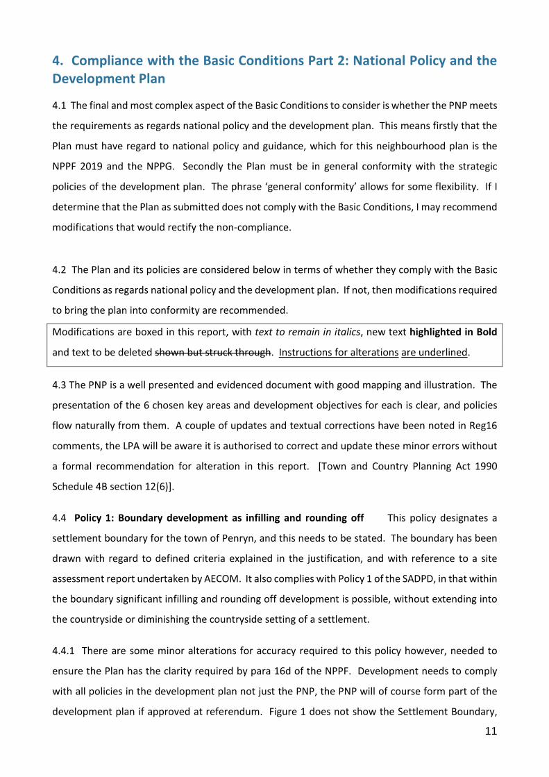
and text to be deleted shown but struck through. Instructions for alterations are underlined.
4.3 The PNP is a well presented and evidenced document with good mapping and illustration. The
presentation of the 6 chosen key areas and development objectives for each is clear, and policies
flow naturally from them. A couple of updates and textual corrections have been noted in Reg16
comments, the LPA will be aware it is authorised to correct and update these minor errors without
a formal recommendation for alteration in this report. [Town and Country Planning Act 1990
Schedule 4B section 12(6)].
4.4 Policy 1: Boundary development as infilling and rounding off This policy designates a
settlement boundary for the town of Penryn, and this needs to be stated. The boundary has been
drawn with regard to defined criteria explained in the justification, and with reference to a site
assessment report undertaken by AECOM. It also complies with Policy 1 of the SADPD, in that within
the boundary significant infilling and rounding off development is possible, without extending into
the countryside or diminishing the countryside setting of a settlement.
4.4.1 There are some minor alterations for accuracy required to this policy however, needed to
ensure the Plan has the clarity required by para 16d of the NPPF. Development needs to comply
with all policies in the development plan not just the PNP, the PNP will of course form part of the
development plan if approved at referendum. Figure 1 does not show the Settlement Boundary,
12
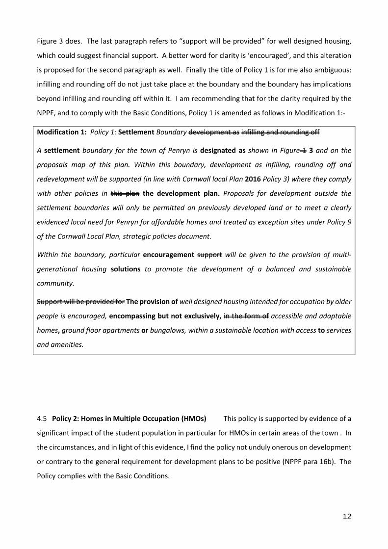
Figure 3 does. The last paragraph refers to “support will be provided” for well designed housing,
which could suggest financial support. A better word for clarity is ‘encouraged’, and this alteration
is proposed for the second paragraph as well. Finally the title of Policy 1 is for me also ambiguous:
infilling and rounding off do not just take place at the boundary and the boundary has implications
beyond infilling and rounding off within it. I am recommending that for the clarity required by the
NPPF, and to comply with the Basic Conditions, Policy 1 is amended as follows in Modification 1:-
Modification 1: Policy 1: Settlement Boundary development as infilling and rounding off
A settlement boundary for the town of Penryn is designated as shown in Figure 1 3 and on the
proposals map of this plan. Within this boundary, development as infilling, rounding off and
redevelopment will be supported (in line with Cornwall local Plan 2016 Policy 3) where they comply
with other policies in this plan the development plan. Proposals for development outside the
settlement boundaries will only be permitted on previously developed land or to meet a clearly
evidenced local need for Penryn for affordable homes and treated as exception sites under Policy 9
of the Cornwall Local Plan, strategic policies document.
Within the boundary, particular encouragement support will be given to the provision of multi-
generational housing solutions to promote the development of a balanced and sustainable
community.
Support will be provided for The provision of well designed housing intended for occupation by older
people is encouraged, encompassing but not exclusively, in the form of accessible and adaptable
homes, ground floor apartments or bungalows, within a sustainable location with access to services
and amenities.
4.5 Policy 2: Homes in Multiple Occupation (HMOs) This policy is supported by evidence of a
significant impact of the student population in particular for HMOs in certain areas of the town . In
the circumstances, and in light of this evidence, I find the policy not unduly onerous on development
or contrary to the general requirement for development plans to be positive (NPPF para 16b). The
Policy complies with the Basic Conditions.

13
4.6 Policy 3: Town centre uses The policy makes reference to a town centre, but this has not
been defined on the proposals map. In order that Policy 3 has the clarity required by the NPPF, an
area needs to be designated to show where the policy will apply. The Qualifying Body have kindly
supplied a designation of the town centre from a previous Local Plan, now superseded, the Carrick
Local Plan. I accept that this is still a relevant boundary for the definition of the town centre, and in
order that the PNP has the clarity required by government policy and thus complies with the Basic
Conditions, I recommend that the Proposals Map is amended as shown in Modification 2:
Modification 2: The Proposals Map to show the boundary of the Town Centre as defined in the
superseded Carrick Local Plan 1998
4.7 Policy 4: Commercial Road and waterfront uses The policy seeks to promote a shift in this
part of the town from a mostly industrial area that happens to be located on a waterway, to a
commercial area that is more attractive to visitors and makes a feature of the potentially attractive
location. Better links between the area and the adjacent town centre are also promoted. I found
some of the wording of the policy lacking in the clarity required by the NPPF, and so in order that
the Policy meets the Basic Conditions, I recommend the amendments shown in Modification 3:
Modification 3: Policy 4 to be altered as follows:
Within the Commercial Road and waterfront area defined in the neighbourhood plan, support will
be provided for improvements to the public realm which create a vibrant commercial quarter and
with links to the waterfront and town centre will be supported.
… … …
Development proposals for residential and other non-commercial uses on upper floors along
Commercial Road and the adjoining waterfront will be supported in principle where they include the
delivery of commercial uses on the ground floor and assist the delivery of the design principles of the
area as set out in this Plan (page TC56), the Penryn Conservation Area Appraisal and other relevant
design advice. Development proposals on the waterfront should also consider their resilience to
future changes to sea levels and flood risk.
… … …
14
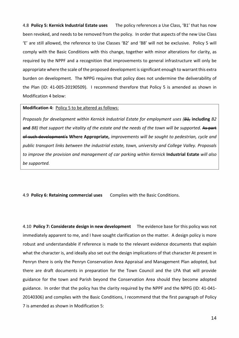
4.8 Policy 5: Kernick Industrial Estate uses The policy references a Use Class, ‘B1’ that has now
been revoked, and needs to be removed from the policy. In order that aspects of the new Use Class
‘E’ are still allowed, the reference to Use Classes ‘B2’ and ‘B8’ will not be exclusive. Policy 5 will
comply with the Basic Conditions with this change, together with minor alterations for clarity, as
required by the NPPF and a recognition that improvements to general infrastructure will only be
appropriate where the scale of the proposed development is significant enough to warrant this extra
burden on development. The NPPG requires that policy does not undermine the deliverability of
the Plan (ID: 41-005-20190509). I recommend therefore that Policy 5 is amended as shown in
Modification 4 below:
Modification 4: Policy 5 to be altered as follows:
Proposals for development within Kernick Industrial Estate for employment uses (B1, including B2
and B8) that support the vitality of the estate and the needs of the town will be supported. As part
of such development’s Where Appropriate, improvements will be sought to pedestrian, cycle and
public transport links between the industrial estate, town, university and College Valley. Proposals
to improve the provision and management of car parking within Kernick Industrial Estate will also
be supported.
4.9 Policy 6: Retaining commercial uses Complies with the Basic Conditions.
4.10 Policy 7: Considerate design in new development The evidence base for this policy was not
immediately apparent to me, and I have sought clarification on the matter. A design policy is more
robust and understandable if reference is made to the relevant evidence documents that explain
what the character is, and ideally also set out the design implications of that character At present in
Penryn there is only the Penryn Conservation Area Appraisal and Management Plan adopted, but
there are draft documents in preparation for the Town Council and the LPA that will provide
guidance for the town and Parish beyond the Conservation Area should they become adopted
guidance. In order that the policy has the clarity required by the NPPF and the NPPG (ID: 41-041-
20140306) and complies with the Basic Conditions, I recommend that the first paragraph of Policy
7 is amended as shown in Modification 5:

15
Modification 5: The first paragraph of Policy 7 to be altered to read as follows:
All new development should demonstrate good quality design and respect the character and
appearance of the surrounding area as demonstrated in relevant design guidance and character
assessment studies. Development that fails to take the opportunities available for enhancing the
local character and quality of the area and the way it functions shall not be permitted.
… … …
4.11 Policy 8: Small scale renewable energy provision Complies with the Basic Conditions.
4.12 Policy 9: Provision of well-designed energy efficient buildings and places Complies with the
Basic Conditions.
4.13 Policy 10: Support and protect community infrastructure Complies with the Basic Conditions.
4.14 Policy 11: Protection of formal open spaces and playing pitches This policy is intended to
apply to the land designated as “Parks and Gardens; Amenity green space; Civic spaces’ and “School
pitches and outdoor sports club facilities (No or limited public access)”. As it reads however the
policy is not clear what designations it applies to. In order that the policy complies with the Basic
Conditions and is clear as required by the NPPF para 16d), I recommend it is amended as shown in
Modification 6.
Modification 6: The first sentence of Policy 11 to be altered as follows:
Land that provides important formal or informal recreational space or sports pitch facilities for the
neighbourhood plan area are shown on the Proposals Map as “Parks and Gardens; Amenity green
space; Civic spaces” or “School pitches and outdoor sports club facilities (No or limited public
access)”. … …
16
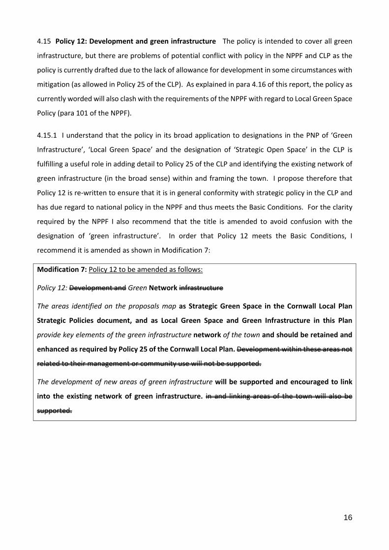
4.15 Policy 12: Development and green infrastructure The policy is intended to cover all green
infrastructure, but there are problems of potential conflict with policy in the NPPF and CLP as the
policy is currently drafted due to the lack of allowance for development in some circumstances with
mitigation (as allowed in Policy 25 of the CLP). As explained in para 4.16 of this report, the policy as
currently worded will also clash with the requirements of the NPPF with regard to Local Green Space
Policy (para 101 of the NPPF).
4.15.1 I understand that the policy in its broad application to designations in the PNP of ‘Green
Infrastructure’, ‘Local Green Space’ and the designation of ‘Strategic Open Space’ in the CLP is
fulfilling a useful role in adding detail to Policy 25 of the CLP and identifying the existing network of
green infrastructure (in the broad sense) within and framing the town. I propose therefore that
Policy 12 is re-written to ensure that it is in general conformity with strategic policy in the CLP and
has due regard to national policy in the NPPF and thus meets the Basic Conditions. For the clarity
required by the NPPF I also recommend that the title is amended to avoid confusion with the
designation of ‘green infrastructure’. In order that Policy 12 meets the Basic Conditions, I
recommend it is amended as shown in Modification 7:
Modification 7: Policy 12 to be amended as follows:
Policy 12: Development and Green Network infrastructure
The areas identified on the proposals map as Strategic Green Space in the Cornwall Local Plan
Strategic Policies document, and as Local Green Space and Green Infrastructure in this Plan
provide key elements of the green infrastructure network of the town and should be retained and
enhanced as required by Policy 25 of the Cornwall Local Plan. Development within these areas not
related to their management or community use will not be supported.
The development of new areas of green infrastructure will be supported and encouraged to link
into the existing network of green infrastructure. in and linking areas of the town will also be
supported.
17
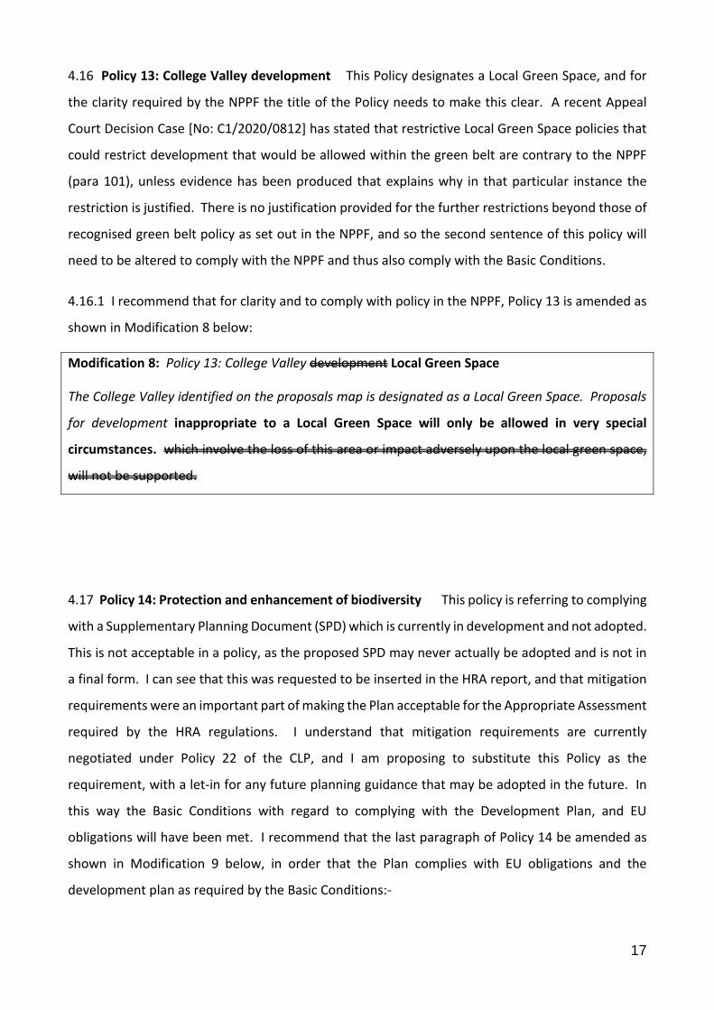
4.16 Policy 13: College Valley development This Policy designates a Local Green Space, and for
the clarity required by the NPPF the title of the Policy needs to make this clear. A recent Appeal
Court Decision Case [No: C1/2020/0812] has stated that restrictive Local Green Space policies that
could restrict development that would be allowed within the green belt are contrary to the NPPF
(para 101), unless evidence has been produced that explains why in that particular instance the
restriction is justified. There is no justification provided for the further restrictions beyond those of
recognised green belt policy as set out in the NPPF, and so the second sentence of this policy will
need to be altered to comply with the NPPF and thus also comply with the Basic Conditions.
4.16.1 I recommend that for clarity and to comply with policy in the NPPF, Policy 13 is amended as
shown in Modification 8 below:
Modification 8: Policy 13: College Valley development Local Green Space
The College Valley identified on the proposals map is designated as a Local Green Space. Proposals
for development inappropriate to a Local Green Space will only be allowed in very special
circumstances. which involve the loss of this area or impact adversely upon the local green space,
will not be supported.
4.17 Policy 14: Protection and enhancement of biodiversity This policy is referring to complying
with a Supplementary Planning Document (SPD) which is currently in development and not adopted.
This is not acceptable in a policy, as the proposed SPD may never actually be adopted and is not in
a final form. I can see that this was requested to be inserted in the HRA report, and that mitigation
requirements were an important part of making the Plan acceptable for the Appropriate Assessment
required by the HRA regulations. I understand that mitigation requirements are currently
negotiated under Policy 22 of the CLP, and I am proposing to substitute this Policy as the
requirement, with a let-in for any future planning guidance that may be adopted in the future. In
this way the Basic Conditions with regard to complying with the Development Plan, and EU
obligations will have been met. I recommend that the last paragraph of Policy 14 be amended as
shown in Modification 9 below, in order that the Plan complies with EU obligations and the
development plan as required by the Basic Conditions:-
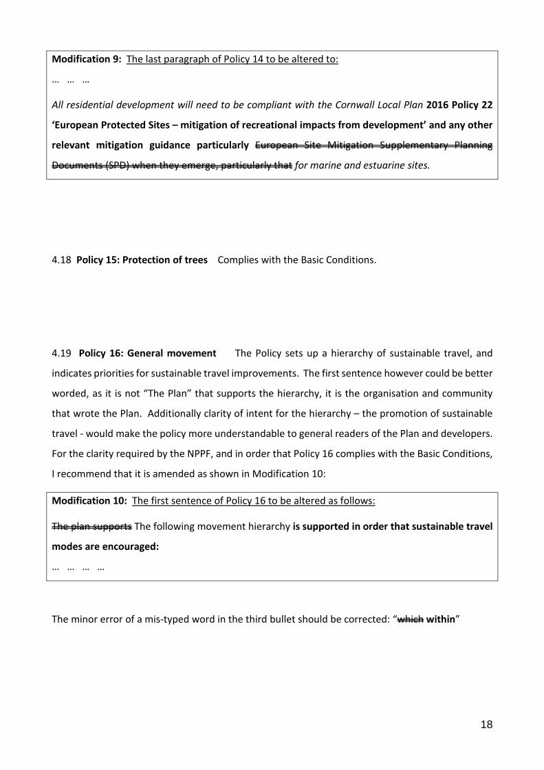
18
Modification 9: The last paragraph of Policy 14 to be altered to:
… … …
All residential development will need to be compliant with the Cornwall Local Plan 2016 Policy 22
‘European Protected Sites – mitigation of recreational impacts from development’ and any other
relevant mitigation guidance particularly European Site Mitigation Supplementary Planning
Documents (SPD) when they emerge, particularly that for marine and estuarine sites.
4.18 Policy 15: Protection of trees Complies with the Basic Conditions.
4.19 Policy 16: General movement The Policy sets up a hierarchy of sustainable travel, and
indicates priorities for sustainable travel improvements. The first sentence however could be better
worded, as it is not “The Plan” that supports the hierarchy, it is the organisation and community
that wrote the Plan. Additionally clarity of intent for the hierarchy – the promotion of sustainable
travel - would make the policy more understandable to general readers of the Plan and developers.
For the clarity required by the NPPF, and in order that Policy 16 complies with the Basic Conditions,
I recommend that it is amended as shown in Modification 10:
Modification 10: The first sentence of Policy 16 to be altered as follows:
The plan supports The following movement hierarchy is supported in order that sustainable travel
modes are encouraged:
… … … …
The minor error of a mis-typed word in the third bullet should be corrected: “which within”
19
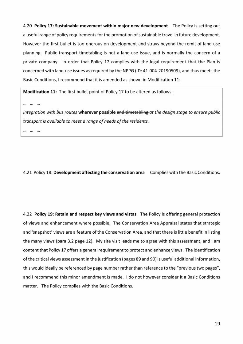
4.20 Policy 17: Sustainable movement within major new development The Policy is setting out
a useful range of policy requirements for the promotion of sustainable travel in future development.
However the first bullet is too onerous on development and strays beyond the remit of land-use
planning. Public transport timetabling is not a land-use issue, and is normally the concern of a
private company. In order that Policy 17 complies with the legal requirement that the Plan is
concerned with land-use issues as required by the NPPG (ID: 41-004-20190509), and thus meets the
Basic Conditions, I recommend that it is amended as shown in Modification 11:
Modification 11: The first bullet point of Policy 17 to be altered as follows:-
… … …
Integration with bus routes wherever possible and timetabling at the design stage to ensure public
transport is available to meet a range of needs of the residents.
… … …
4.21 Policy 18: Development affecting the conservation area Complies with the Basic Conditions.
4.22 Policy 19: Retain and respect key views and vistas The Policy is offering general protection
of views and enhancement where possible. The Conservation Area Appraisal states that strategic
and ‘snapshot’ views are a feature of the Conservation Area, and that there is little benefit in listing
the many views (para 3.2 page 12). My site visit leads me to agree with this assessment, and I am
content that Policy 17 offers a general requirement to protect and enhance views. The identification
of the critical views assessment in the justification (pages 89 and 90) is useful additional information,
this would ideally be referenced by page number rather than reference to the “previous two pages”,
and I recommend this minor amendment is made. I do not however consider it a Basic Conditions
matter. The Policy complies with the Basic Conditions.

20
4.23 Policy 20: Boundary treatment and enclosure in the conservation area Complies with the
Basic Conditions.
4.24 Policy 21: Sustainable energy in the conservation area Complies with the Basic Conditions.
21
5. The Referendum Boundary
5.1 The Penryn Neighbourhood Plan has no policy or proposals that have a significant enough
impact beyond the designated Neighbourhood Plan Boundary that would require the referendum
boundary to extend beyond the Plan boundary. Therefore I recommend that the boundary for the
purposes of any future referendum on the Penryn Neighbourhood Plan 2020 – 2030 shall be the
boundary of the designated Neighbourhood Area for the Plan.