report of exploratory test pits - unf.edu 19-01... · the test pit excavations were performed from...
TRANSCRIPT

Report of Exploratory Test Pits
UNF Transportation Projects
Stockpile Investigation
Osprey Ridge Road Extension
Jacksonville, Florida
CSI Geo Project No.: 71-17-135-20
Arcadis Project No.: JK017002.0001
Prepared by
CSI Geo, Inc.
2394 St. Johns Bluff Road S., Suite 200
Jacksonville, FL 32246
Tel: (904) 641-1993
Fax: (904) 641-0057
Prepared for
Arcadis U.S., Inc.
April 11, 2018


UNF Transportation Projects – Stockpile Investigation Page i of i
TABLE OF CONTENTS
SECTION PAGE NUMBER
1.0 Project Information .............................................................................. 1
1.1 General Project Information
1.2 Existing Site Conditions
2.0 Geotechnical Exploration ..................................................................... 5
2.1 Field Exploration
2.2 Laboratory Testing
3.0 Soil Conditions ...................................................................................... 6
4.0 Geotechnical Engineering Evaluation ................................................. 10
4.1 Basis of Evaluation & Recommendations
4.2 Suitability of Stockpiled Soils for Construction
5.0 Report Limitations ................................................................................ 12
APPENDIX
� Site Location Map
� Field Exploration Plan
� Test Pit Logs
� Summary of Laboratory Test Results
� Key to Soil Classification
� Laboratory Test Procedures

UNF Transportation Projects – Stockpile Investigation Page 1 of 12
1.0 PROJECT INFORMATION
1.1 General Project Information
This geotechnical exploration report was prepared for the existing stockpiled material located
just north of the end of Osprey Ridge Road at the University of North Florida (UNF). The
geotechnical scope of work consisted of performing exploratory test pits to evaluate the
stockpiled soils in order to determine the suitability of the soils for use select material.
This report describes the field and laboratory testing activities and presents the findings. Our
evaluation required the collection of subsurface data and the performance of geotechnical
engineering review of the collected data.
Information about this project has been provided to us by Mr. Erik van Zanden, P.E. of Arcadis,
U.S., Inc. (Arcadis). The following related documents have been furnished to us electronically:
• Overall Concept Roll Plot
Prepared by: Arcadis
Received: 12-13-2017
• Electronic Design Files
Prepared by: Arcadis
Received: 12-19-2017
1.2 Existing Site Conditions
The existing stockpile is within the limits of the roadway corridor of the proposed extension of
Osprey Ridge Road to Varsity Lane. A site location map is included in the Appendix. The
existing site conditions consist of relatively flat wooded grounds with an existing retention pond
to the east of the stockpile. The stockpiled soils are located in two large piles, approximately 13
to 17 feet in height and about 1,000 feet in total length. From visual observation, the stockpile
appeared to consist of granular material with small trees, brush, and vegetation growing on the
surface. Seemingly random scattered construction debris material consisting of broken concrete,

UNF Transportation Projects – Stockpile Investigation Page 2 of 12
brick, PVC pipes, and silt fencing were visible at the surface. The following are photos taken on
December 19th 2017 showing the existing site conditions.
Photo No. 01 –Southern end of stockpile looking north
Photo No. 02 – Stockpile looking north

UNF Transportation Projects – Stockpile Investigation Page 3 of 12
Photo No. 03 – Stockpile looking south
Photo No. 04 – Northern end of stockpile, looking west

UNF Transportation Projects – Stockpile Investigation Page 4 of 12
Photo No. 05 – Stockpile showing surficial debris

UNF Transportation Projects – Stockpile Investigation Page 5 of 12
2.0 GEOTECHNICAL EXPLORATION
2.1 Field Exploration
On February 22, 2018, a total of six test pits (TP-1 through TP-6) were performed by CSI Geo.
The test pit excavations were performed from the side of the stockpiles and samples were
collected from the top to the bottom of the existing stockpile surface. Soil samples obtained
during the field exploration program were visually classified in the field and then reviewed and
reclassified, as needed, by a geotechnical engineer. After completion, each test pit was
photographed by a geotechnical engineer. Care was taken during the field exploration not to
excavate test pits to depths below the existing natural ground surface.
2.2 Laboratory Testing
Quantitative laboratory testing was performed on selected samples of the soils recovered from
the field exploration. The laboratory testing was necessary to better define the physical
composition of the soils encountered. Laboratory tests were performed to determine the fines
content, grain size distribution, organic content, and natural moisture content of the selected soil
samples. The results of the laboratory testing are shown on the Summary of Laboratory Test
Results presented in the Appendix. The laboratory testing procedures used are also briefly
presented in the Laboratory Test Procedures presented in the Appendix.
UNF Transportation Projects – Stockpile Investigation Page 6 of 12
3.0 SOIL CONDITIONS
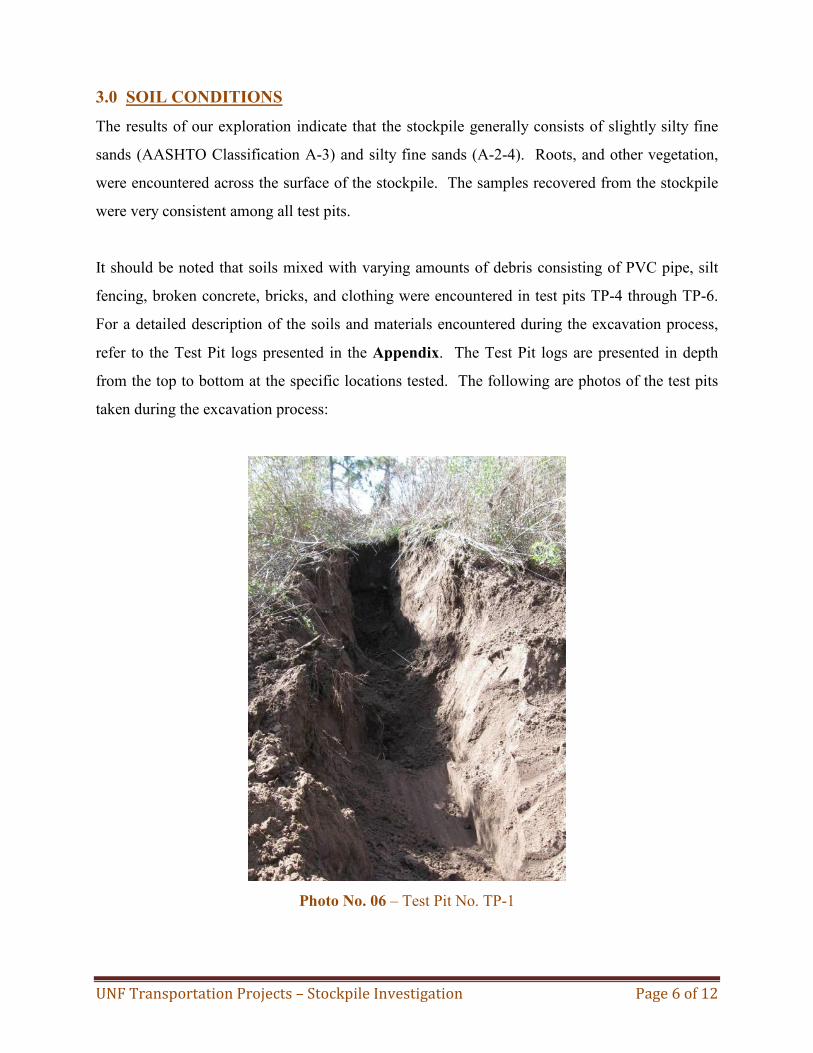
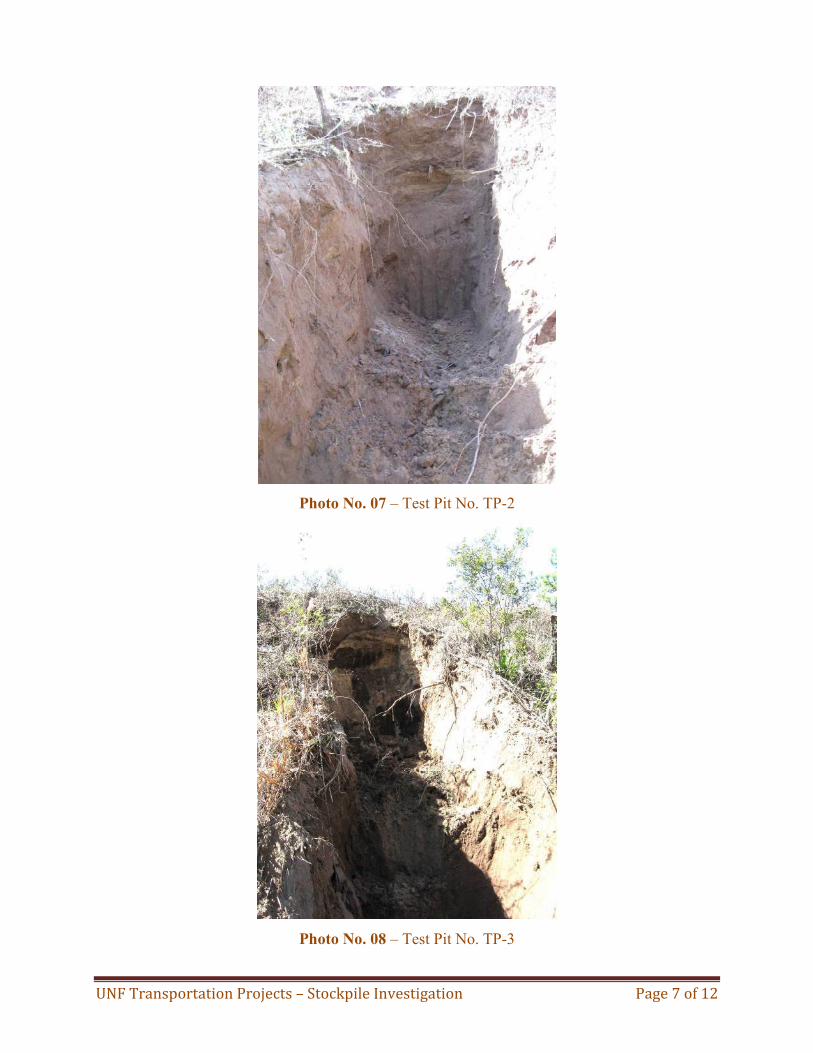
The results of our exploration indicate that the stockpile generally consists of slightly silty fine
sands (AASHTO Classification A-3) and silty fine sands (A-2-4). Roots, and other vegetation,
were encountered across the surface of the stockpile. The samples recovered from the stockpile
were very consistent among all test pits.
It should be noted that soils mixed with varying amounts of debris consisting of PVC pipe, silt
fencing, broken concrete, bricks, and clothing were encountered in test pits TP-4 through TP-6.
For a detailed description of the soils and materials encountered during the excavation process,
refer to the Test Pit logs presented in the Appendix. The Test Pit logs are presented in depth
from the top to bottom at the specific locations tested. The following are photos of the test pits
taken during the excavation process:
Photo No. 06 – Test Pit No. TP-1
UNF Transportation Projects – Stockpile Investigation Page 7 of 12
Photo No. 07 – Test Pit No. TP-2
Photo No. 08 – Test Pit No. TP-3

UNF Transportation Projects – Stockpile Investigation Page 8 of 12
Photo No. 09 – Test Pit No. TP-4
Photo No. 10 – Test Pit No. TP-5

UNF Transportation Projects – Stockpile Investigation Page 9 of 12
Photo No. 11– Test Pit No. TP-6

UNF Transportation Projects – Stockpile Investigation Page 10 of 12
4.0 GEOTECHNICAL ENGINEERING EVALUATION
4.1 Basis of Evaluation and Recommendations
Our geotechnical evaluation and recommendations are based on our visual observations, field
and laboratory test data obtained in the course of this exploration program as well as the project
information described previously in this report. Field and laboratory test data was used to
evaluate the stockpiled soils. It is important that the discovery of any site conditions during
construction that deviates from the findings of this exploration should be reported to us for our
evaluation.
4.2 Suitability of Stockpiled Soils for Construction
Based on our geotechnical findings the majority of the stockpiled soils generally consist of
slightly silty fine sands (A-3) and silty fine sands (A-2-4), with traces of roots. This material can
be considered suitable for use in roadway construction. The slightly silty sands (A-3) are
considered as suitable select material and can be used in roadway construction. The silty fine
sands (A-2-4) can also be treated as select material; however, this stratum may retain excess
moisture and may be difficult to dry and to compact and should be used in the embankment
above the groundwater level at the time of construction.
A certain degree of stripping will be required to remove and separate the surficial vegetation
from the suitable stockpiled soils. Varying amounts of construction debris consisting of PVC
pipe, silt fencing, broken concrete, bricks, and clothing were encountered in test pits TP-4
through TP-6. However, debris was visually observed at the surface in other areas, and therefore
it is cautioned that debris may be present in other areas of the stockpile between test locations.
These surficial soils mixed with construction debris should be regarded as unsuitable for
construction.
Based on our findings and visual observation, we recommend an allowance of approximately
10% to 15% of the estimated volume of stockpiled soils should be made to account for
unsuitable construction debris materials. Therefore, we anticipate that 85% to 90% of the

UNF Transportation Projects – Stockpile Investigation Page 11 of 12
estimated volume of stockpile soils can be regarded as suitable fill for use in roadway
construction.
We recommend that the stockpiled soils should be segregated to separate any debris material
consisting of organic soils, large tree roots and limbs, and other vegetation or organic matter
from otherwise suitable soils. The separated unsuitable soils and construction debris materials
should be disposed of appropriately.

UNF Transportation Projects – Stockpile Investigation Page 12 of 12
5.0 REPORT LIMITATIONS
This exploration program including our evaluation and recommendations was performed in
general accordance of accepted geotechnical engineering principles and standard practices. CSI
Geo is not responsible for any independent conclusions, opinions, or interpretations made by
others based on the data presented in this report.
This report does not reflect any variations that may occur adjacent or between test pits. The
discovery of any conditions during construction that deviates from the findings and data as
presented in this report should be reported to CSI Geo for evaluation.

APPENDIX


BROWN FINE SAND (A-3) WITH TRACE OF ORGANICS
Boring Terminated at 13.0 feet.
DATE STARTED 2/22/18
GROUND WATER LEVELS:
ESHWL ---
GWT ---
EXCAVATION CONTRACTOR CSI Geo, Inc.COMPLETED 2/22/18
GROUND ELEVATION
DE
PT
H(f
t)
0
5
10
DE
PT
H(f
t)
0
5
10
SA
MP
LE T
YP
EN
UM
BE
R
GR
AP
HIC
LOG
MATERIAL DESCRIPTION
PAGE 1 OF 1TEST PIT NO. TP-1
CLIENT Arcadis
PROJECT NUMBER 71-17-135-20
PROJECT NAME UNF Transportation Improvements-Stockpile Investigation
PROJECT LOCATION University of North Florida, Jacksonville, Florida
CSI Geo, Inc.
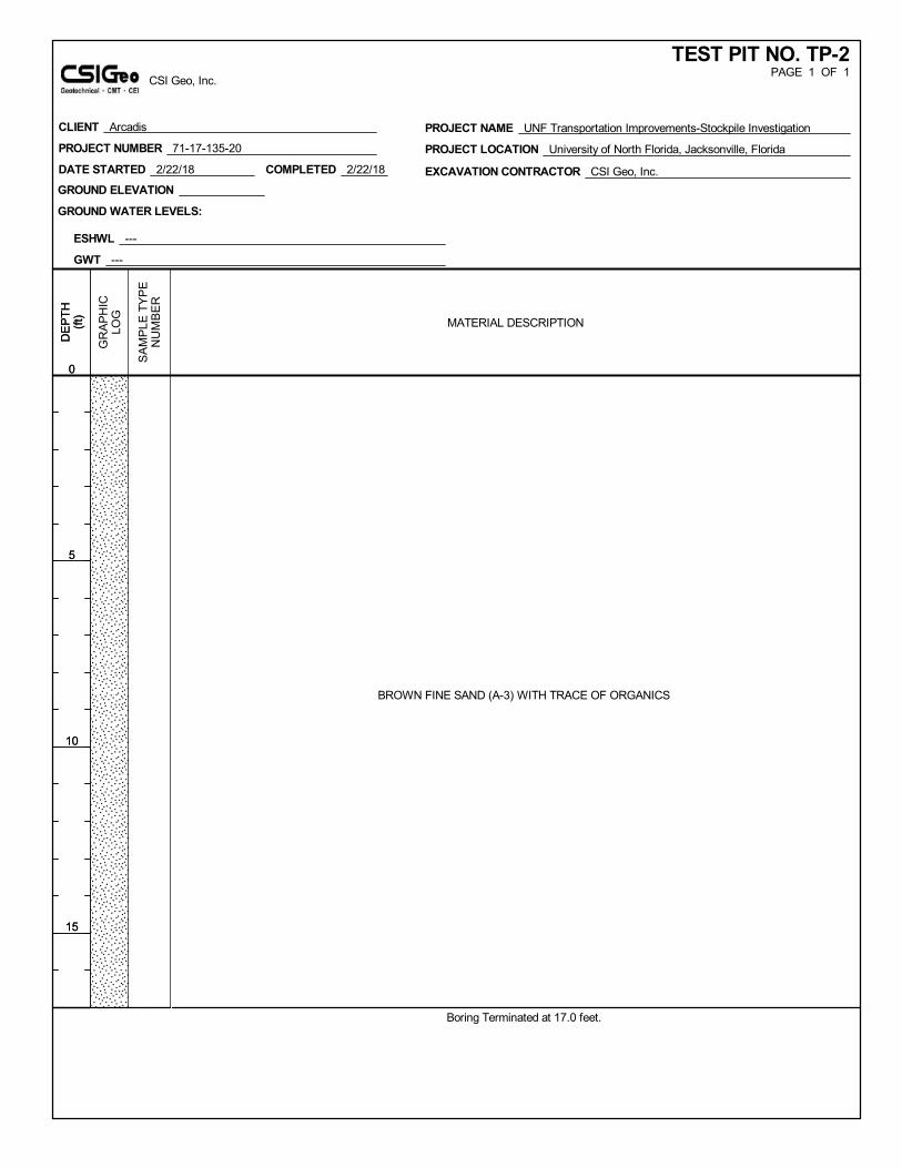
BROWN FINE SAND (A-3) WITH TRACE OF ORGANICS
Boring Terminated at 17.0 feet.
DATE STARTED 2/22/18
GROUND WATER LEVELS:
ESHWL ---
GWT ---
EXCAVATION CONTRACTOR CSI Geo, Inc.COMPLETED 2/22/18
GROUND ELEVATION
DE
PT
H(f
t)
0
5
10
15
DE
PT
H(f
t)
0
5
10
15
SA
MP
LE T
YP
EN
UM
BE
R
GR
AP
HIC
LOG
MATERIAL DESCRIPTION
PAGE 1 OF 1TEST PIT NO. TP-2
CLIENT Arcadis
PROJECT NUMBER 71-17-135-20
PROJECT NAME UNF Transportation Improvements-Stockpile Investigation
PROJECT LOCATION University of North Florida, Jacksonville, Florida
CSI Geo, Inc.

BROWN FINE SAND (A-3) WITH TRACE OF ORGANICS
Boring Terminated at 15.0 feet.
DATE STARTED 2/22/18
GROUND WATER LEVELS:
ESHWL ---
GWT ---
EXCAVATION CONTRACTOR CSI Geo, Inc.COMPLETED 2/22/18
GROUND ELEVATION
DE
PT
H(f
t)
0
5
10
15
DE
PT
H(f
t)
0
5
10
15
SA
MP
LE T
YP
EN
UM
BE
R
GR
AP
HIC
LOG
MATERIAL DESCRIPTION
PAGE 1 OF 1TEST PIT NO. TP-3
CLIENT Arcadis
PROJECT NUMBER 71-17-135-20
PROJECT NAME UNF Transportation Improvements-Stockpile Investigation
PROJECT LOCATION University of North Florida, Jacksonville, Florida
CSI Geo, Inc.

BROWN FINE SAND (A-3)
BROWN FINE SAND (A-3) WITH FEW PIECES OF BROKEN PVC PIPE
BROWN FINE SAND (A-3) WITH TRACE OF ORGANICS
Boring Terminated at 15.0 feet.
DATE STARTED 2/22/18
GROUND WATER LEVELS:
ESHWL ---
GWT ---
EXCAVATION CONTRACTOR CSI Geo, Inc.COMPLETED 2/22/18
GROUND ELEVATION
DE
PT
H(f
t)
0
5
10
15
DE
PT
H(f
t)
0
5
10
15
SA
MP
LE T
YP
EN
UM
BE
R
GR
AP
HIC
LOG
MATERIAL DESCRIPTION
PAGE 1 OF 1TEST PIT NO. TP-4
CLIENT Arcadis
PROJECT NUMBER 71-17-135-20
PROJECT NAME UNF Transportation Improvements-Stockpile Investigation
PROJECT LOCATION University of North Florida, Jacksonville, Florida
CSI Geo, Inc.

BROWN FINE SAND (A-3) WITH TRACE OF ROCKS, CONCRETE, AND ORGANICS
BROWN FINE SAND (A-3) WITH FEW PIECES OF BROKEN PVC PIPE AND CLOTHING
BROWN FINE SAND (A-3) WITH TRACE OF ROCKS, CONCRETE, AND ORGANICS
Boring Terminated at 15.0 feet.
DATE STARTED 2/22/18
GROUND WATER LEVELS:
ESHWL ---
GWT ---
EXCAVATION CONTRACTOR CSI Geo, Inc.COMPLETED 2/22/18
GROUND ELEVATION
DE
PT
H(f
t)
0
5
10
15
DE
PT
H(f
t)
0
5
10
15
SA
MP
LE T
YP
EN
UM
BE
R
GR
AP
HIC
LOG
MATERIAL DESCRIPTION
PAGE 1 OF 1TEST PIT NO. TP-5
CLIENT Arcadis
PROJECT NUMBER 71-17-135-20
PROJECT NAME UNF Transportation Improvements-Stockpile Investigation
PROJECT LOCATION University of North Florida, Jacksonville, Florida
CSI Geo, Inc.

BROWN FINE SAND (A-3) WITH TRACE OF ORGANICS
BROWN FINE SAND (A-3) WITH FEW BROKEN CONCRETE FRAGMENTS
BROWN FINE SAND (A-3)
Boring Terminated at 15.0 feet.
DATE STARTED 2/22/18
GROUND WATER LEVELS:
ESHWL ---
GWT ---
EXCAVATION CONTRACTOR CSI Geo, Inc.COMPLETED 2/22/18
GROUND ELEVATION
DE
PT
H(f
t)
0
5
10
15
DE
PT
H(f
t)
0
5
10
15
SA
MP
LE T
YP
EN
UM
BE
R
GR
AP
HIC
LOG
MATERIAL DESCRIPTION
PAGE 1 OF 1TEST PIT NO. TP-6
CLIENT Arcadis
PROJECT NUMBER 71-17-135-20
PROJECT NAME UNF Transportation Improvements-Stockpile Investigation
PROJECT LOCATION University of North Florida, Jacksonville, Florida
CSI Geo, Inc.

#4 #10 #40 #60 #100 #200 LL Pl
TP-1 1 0.0 - 1.0 5 1 4 A-3
TP-2 2 3.0 - 8.0 5 1 3 A-3
TP-3 1 5.0 - 10.0 6 1 4 A-3
TP-4 1 5.0 - 10.0 6 2 2 A-3
TP-5 2 1.0 - 5.0 5 1 2 A-3
TP-6 6 3.0 - 5.0 5 1 2 A-3
SUMMARY OF LABORATORY TEST RESULTS
UNF Transportation Projects
Jacksonville, Florida
Percent Passing Sieve Size (%) Atterberg LimitsBoring No.
Stockpile Investigation
Sample
No.Approximate Depth (ft)
Natural
Moisture
Content
(%)
Organic
Content
(%)
Soil
Classification
Symbol
G:\Projects\2017\71-GEO\71-17-135-20, UNF Transportation Projects\Lab\Master Labsum - Test Pits.xls

KEY TO SOIL CLASSIFICATION
Correlation of Penetration Resistance with Relative Density and Consistency
Granular Materials Silts and Clays
Relative
Density
Safety Hammer
SPT N-Value
(Blows/foot)
Automatic Hammer
SPT N-Value
(Blows/foot)
Consistency
Safety Hammer
SPT N-Value
(Blows/foot)
Automatic
Hammer SPT N-
Value (Blows/foot)
Very Loose Less than 4 Less than 3 Very Soft Less than 2 Less than 1
Loose 4 – 10 3 – 8 Soft 2 – 4 1 – 3
Medium Dense 10 - 30 8 - 24 Firm 4 - 8 3 - 6
Dense 30 - 50 24 - 40 Stiff 8 - 15 6 - 12
Very Dense Greater than 50 Greater than 40 Very Stiff 15 - 30 12 - 24
Hard Greater than 30 Greater than 24
Particle Size Identification (Unified Soil Classification System)
Boulders: Diameter exceeds 8 inches
Cobbles: 3 to 8 inches diameter
Gravel: Coarse - 3/4 to 3 inches in diameter
Fine - 4.76 mm to 3/4 inch in diameter
Sand: Coarse - 2.0 mm to 4.76 mm in diameter
Medium - 0.42 mm to 2.0 mm in diameter
Fine - 0.074 mm to 0.42 mm in diameter
Modifiers
These modifiers provide our estimate of the amount of fines (silt or clay size particles) in soil samples.
Approximate Fines Content Modifiers
5% Fines 12% Slightly silty or slightly clayey
12% Fines 30% Silty or clayey
30% Fines 50% Very silty or very clayey
These modifiers provide our estimate of shell, rock fragments, or roots in the soil sample.
Approximate Content, By Weight Modifiers
1% to 5% Trace
5% to 12% Few
12% to 30% Some
30% to 50% Many
These modifiers provide our estimate of organic content in the soil sample.
Organic Content Modifiers
1% to 3% Trace
3% to 5% Slightly Organic
5% to 20% Organic
20% to 75% Highly Organic (Muck)
> 75% Peat

LABORATORY TEST PROCEDURES
Percent Fine Content – To determine the percentage of soils finer than No. 200 sieve, the dried
samples were washed over a 200 mesh sieve. The material retained on the sieve was oven dried
and then weighed and compared with the unwashed dry weight in order to determine the weight
of the fines. The percentage of fines in the soil sample was then determined as the percent of
weight of fines in the sample to the weight of the unwashed sample. This test was conducted in
accordance with ASTM D 1140.
Grain Size Distribution - The grain size tests were performed to determine the particle size and
distribution of the samples tested. Each sample was dried, weighed, and washed over a No. 200
mesh sieve. The dried sample was then passed through a standard set of nested sieves to
determine the grain size distribution of the soil particles coarser than the No. 200 sieve. This test
is similar to that described by FM I - T 088.
Natural Moisture Content – The water content is the ratio, expressed as a percentage, of the
weight of water in a given mass of soil to the weight of the solid particles. This test was
conducted in the general accordance with ASTM D2216.
Percent Organic Content
This test is based on the percent of organics by weight of the total sample. This test was
conducted in accordance with ASTM D2974.

SERVICES OFFERED
Geotechnical & Foundations Engineering
Construction Materials Testing (CMT)
Construction Engineering & Inspection (CEI)
2394 St. Johns Bluff Road, Suite 200. • Jacksonville, FL 32246
(904) 641-1993 Phone • (904) 645-0057 Fax
www.csi-geo.com