report on rock sampling and petrographic examination of float … · 2017-03-29 · larder lake...
TRANSCRIPT

Larder Lake N.T.S. 32D/SW
REPORT ON ROCK SAMPLING and
PETROGRAPHIC EXAMINATION OF FLOAT SAMPLES
CLAY PROPERTY
GOLDSTAKE EXPLORATIONS INC. – TRANSPACIFIC RESOURCES INC.
MC’GARRY, MC’VITTIE & OSSIAN TOWNSHIP’S
LARDER LAKE AREA, ONTARIO
July 13, 2015
By: Robert Dillman P.Geo. B.Sc.
8901 Reily Drive
Mount Brydges, Ontario
For: Goldstake Explorations Inc.
W-Suite 1603
2045 Lakeshore Blvd.
Toronto, Ontario M8V 2Z6

- 1 -
Table of Contents
page
Summary 2
Location, Property Ownership, Access 2
Land Status and Topography 3
Regional and Local Geology 3
History of Exploration 8
Survey Dates and Personnel 11
Survey Logistics 11
Survey Results 20
Discussion 20
Conclusions and Recommendations 21
References 23
Certificate of Author 24
Figures
Figure 1. Property Location Map 4
Figure 2. Claim Map 5
Figure 3. Geology Map 6
Figure 4. Rock Sample Location Map 12
Figure 5. Rock Sample Location Map: Instant Pond Zone 14
Figure 6. Rock Sample and Lamprophyre Sample Location Map:
T – Trench, Instant Pond Zone 15
Figure 7. Rock Sample Location Map: L – Trench, Instant Pond Zone 16
Figure 8. Rock Sample Location Map: Mystery Zone 17
Figure 9. Rock Sample Location Map: F Zone, Track Trench 18
Figure 10. Lamprophyre Samples: Goldstake 1a/1b & 2a/2b 19
Tables
Table 1. Rock Sample Descriptions and Summary of Assay Results : CML298 13
Table 2. Budget 22
Appendix
Report on Petrographic Investigation of Two Float Samples from the Goldstake Property,
Northern Ontario.
Assay Certificates

- 2 -
REPORT ON ROCK SAMPLING and PETROGRAPHIC EXAMINATION OF FLOAT SAMPLES
CLAY PROPERTY GOLDSTAKE EXPLORATIONS INC. – TRANSPACIFIC RESOURCES INC.
MC’GARRY, MC’VITTIE & OSSIAN TOWNSHIP’S LARDER LAKE AREA, ONTARIO
Summary
This report describes the results of rock sampling on the Clay Property in 2014. Two programs
of rock sampling were conducted during the year. Samples were collected and assayed for gold
and 52 elements including Rare Earth Elements (REE’s). The object of the rock sampling is to
determine a series of path finder elements related to gold mineralization and use these
elements to find new zones of mineralization.
Location, Property Ownership, Access
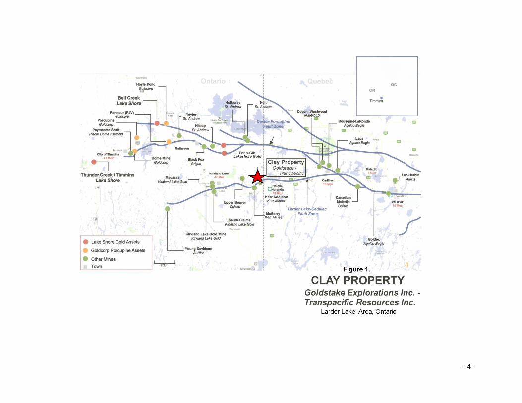
The Clay Property is located in the Virginiatown-Kearns section of Larder Lake Mining Division in
northeastern Ontario (Figure 1). The property is situated in the north region of McGarry
Township and extends west into the east-central and northeast sections of McVittie Township
and north into Ossian Township.
The Clay Property is situated 1 kilometre north of Virginiatown located on Highway 66. The Clay
Property has good seasonal road access via several routes. During dry conditions access can be
made by 4 wheel drive truck to the north section of the property via a forest access road from
the Cheminis Road located 4 kilometres east of the property. The forest access road is partially
washed out by a creek however the creek can be crossed with an ATV.
Access to other regions of the property is possible by ATV or snowmobile via a series of old drill
roads. The property is also accessible by rail and is crossed by the Ontario Northlands Railway.
The property is covered at a scale of 1:100,000 by the Provincial Series Sheet: Larder Lake N.T.S.
32D/SW. Using NAD 83, Zone 17, the property is bounded between UTM coordinates:
600000mE to 610000mE and 5332000mN to 5348200mN.

- 3 -
The Clay Property consists of Mining Lease CLM298 and 30 contiguous unpatented mining
claims covering an approximate area of 2,445 hectares (Figure 2).
Titles to 17 mining claims comprising the Clay Property are recorded in the name of Transpacific
Resources Inc. The remain 13 claims are held by Goldstake Explorations Inc.
Land Status and Topography
Figure 2 depicts the land status of the Clay Property. All 30 of the unpatented mining claims are
situated on Crown Land. The mining lease CLM298 is situated on lands with patented Surface
Rights Only. The bulk of the surface rights are held by the Township of McGarry.
The entire property is forested. The trees consist of: white pine, spruce, balsam, poplar, birch
and alders.
There are several small lakes on the property. They include: Crosby Lake, and Beaver Lake
which are both situated in McVittie Twp., and Glover Lake which is situated in Ossian Twp. Most
of the property drains towards the north via small streams with the exception of the southwest
section which drains towards the south. A northwest orientated ridge situated northeast of
Crosby and Beaver Lake’s separate the drainage flows.
The property is at a mean elevation of 310 to 330 metres above sea level. A near-circular nob of
rock situated in the north-central section of the property towers to an elevation of 400 metres
above sea level.
Regional and Local Geology
The Clay Property is situated on Early Precambrian - Archean mafic volcanic and sedimentary
rocks of the Abitibi Greenstone Belt (Figure 4). The volcanic rocks extend from the
Chibougamau area in Quebec to west of Timmins in Ontario. During the Early Precambrian the
volcanic sequence was intruded by mafic intrusive rocks consisting of gabbro and diorite,
intermediate intrusive rocks and felsic intrusive rocks consisting quartz diorite, granodiorite and
feldspar porphyry dikes. During the Late to Middle Precambrian and into the Proterozoic Era
the entire sequence was intruded by several events of diabase dikes.
- 4 -

- 5 -

- 6 -

- 7 -
The Clay Property is underlain by Archean rocks consisting Fe and Mg rich basalts of the Kinojevis
Assemblage and pillowed basalts of the Blake River Assemblage ranging 2704 to 2696 Ma (OFR 6154).
These units have been intruded by gabbro and all are overlain by sandstones, conglomerate and
pyroclastic rocks of the Timiskaming Assemblage dated 2676 to 2670 Ma. During the late Archean, the
entire sequence was intruded by porphyritic dikes and sills.
Regionally, the Clay Property is located on the south limb of a large east-west trending syncline
structure centred in the Blake River Assemblage approximately 20 km’s north of the property. On the
property, rock units of the Kinojevis, Blake River and Timiskaming Assemblages strike northeast and dip
vertically to steeply southeast or northwest. In the northwest section of the property, pillowed units of
the Blake River assemblage strike northwest and have flows tops dipping towards the northeast.
Structurally, the Clay Property is situated approximately 1 km north of the famous Larder Lake –
Cadillac Fault Zone. The property is crossed by a series of northeast trending conjugate faults and shear
zones associated with the Larder Lake - Cadillac Fault Zone. One such structure, the Ivan-Larder Fault
crosses the south section of the property in the vicinity of the Northland railway track. Rocks
associated with faults on the property are variably deformed, silicified and altered to carbonate,
sericite, fuchsite and chlorite. Faulted units frequently contain sulphides, mineralized quartz veins and
quartz-carbonate stringer stockworks.
At least four prominent zones of mineralization have been discovered on the property:
1.) gold-copper-silver mineralization associated with anastomising stockwork of quartz-calcite-epidote
stringers occurring in a northeast trending corridor ranging approximately 400 metres long by 50 to
155 metres wide. Mineralization has been traced to a vertical depth of 180 metres. The full size of the
Instant Pond Zone has not been established and dimensions are open in all directions. Historic
exploration includes some minor trenching, magnetometer and VLF-EM surveys, I.P. and approximately
7,000 metres of diamond drilling which has resulted in numerous intersections containing gold, copper
and silver. The best hole drilled to date, DDH-05-11, is reported have intersected 29.46 g/t over 9.9 m
starting at a depth of 93.92 m and included intervals assaying 10.54 g/t Au across 5.71m and 100.19 g/t
Au across 2.31m plus a lower interval assaying 4.13 g/t Au across 1.49 m starting at a depth 130.48 m.
Native gold is report in many of the drill holes.
2.) Stump Pond South Area: includes the A to G gold zones. Gold occurs in sheared and altered rock
units situated at the intersection of the Ivan Larder Fault and the northeast trending East Fault. Gold
mineralization occurs in native form with sulphide bearing quartz – carbonate stringer systems of
unknown extent. Historic work reported in the mid 90’s includes: trenching and approximately 9,000
metres of drilling mostly focused on the F Zone. Results outlined a pre-NI-43-101 uncut/ undiluted
inferred resource of 130,000 tons @ 0.10 oz of gold. Three parallel holes in the F Zone spaced 6 m

- 8 -
apart contained native gold and telluride mineralization assaying 5.2 g/t Au across 4.9 metres, 7.9 g/t
across 1.5 metres and 5.7 g/t across 2.4 metres.
3.) McVittie Kirkland Mines Limited: in 1937 a drill hole is reported to have tested vein material in a
shear zone and assayed $7.70 per in gold across 3 feet (0.22 oz/t Au/ 3 feet).
4.) Rose Cu-Zn Prospect: 1 to 3 metre wide volcanogenic massive and semi-massive sulphides
(VMS) consisting mainly of pyrite and pyrrhotite mineralization with stringers of chalcopyrite and
sphalerite assaying up to 0.42% copper and 11% zinc.
History of Exploration
Exploration work has been carried out by a number of companies and individuals over the past 100
years in various areas of the Clay Property. Gold, copper, silver, zinc and diamond have been the main
targets of exploration.
In 1938, McVittie Kirkland Mines Limited drilled nine holes in the vicinity of Beaver Lake. A drill hole in
sheared rock is reported to have intersected $7.70 gold per ton over 3 feet (7.5 g/t Au/ 0.9 m).
In 1941, J. Thompson of the Ontario Department of Mines mapped the geology of McGarry and
McVittie Townships.
In 1942, H. S. Rose discovered zinc and copper mineralization in northwest corner of McGarry
Township. Several pits and shallow shafts were excavated. Later that year, the prospect was tested by
5 short drill holes by Connell Mining and Exploration Company.
Between 1944 and 1949, small tracks of land were explored separately by Ivan Larder Mines, Kerrigan
Gold Mines, Carbonate Larder Mines and Kerromac Mining Co. Work carried out included: prospecting,
trenching and drilling. Carbonate Larder reports gold values of $2.40 gold per ton (2.4 g/t) and $2.80
gold per ton (2.7 g/t).
Between 1960 and 1974, ground VLF electromagnetic and magnetic surveys were reported over small
sections of the property by Union Mining, Emerald Lake Mines and Twentieth Century Mining.
In 1971, Noranda Exploration Company Limited completed ground VLF electromagnetic and magnetic
surveys over the Rose Prospect.

- 9 -
Between 1974 and 1985, parts of the Clay Property were explored by Dr. Albert Lee of Lee Geo-
Indicators Ltd. Early work consisted of heavy mineral prospecting and biochemical (vegetation)
sampling. Dr. Lee’s work lead to the discovery of high-grade gold and copper mineralization in what is
known as the Instant Pond Zone and the discovery of kimberlite indicator minerals in the Stump Pond
area. Follow up work including further heavy mineral prospecting, geological mapping, ground
geophysical surveys, trenching and several phases of drilling. Gold zones A to G, situated in the vicinity
of Stump Pond and the Northlands railway track were discovered as a result.
In 1978, Ram Petroleum completed ground VLF-electromagnetic and magnetic surveys on a small
section of the Clay Property.
In 1978, James Walker reports trenching and drilling work.
In 1980, Noranda Exploration Company Limited completed an additional ground magnetic survey over
the Rose Prospect.
Between 1981 and 1983, Noranda drilled 17 holes totalling 3,690 feet, focusing on the Rose Prospect
and targets situated east and north of the showing. A hole drilled vertically intersected 71.5 feet of
“dalmatianite” rock containing a 1 foot interval assaying 1.78% Zn. Another hole intersected 38.5 feet
of dalmatianite reported to contain a 4.5 foot section assaying 2.78% Zn and 0.1% Cu.
In 1985, Edomar Resources Inc. completed ground VLF-electromagnetic and magnetic surveys,
geological mapping, trenching and drilling. Edomar’s work focused on exploring the gold occurrences
discovered by Lee Geo-Indicators Limited.
In 1992, Noranda drilled two holes east and south of the Rose showing. No mineralization was
reported in the first hole. The second hole, MCG-92-11 is reported to have intersected 0.7 metres of
rhyolite with <1% sphalerite assaying 0.26% Zn and 0.03% Cu and a second interval assaying 0.14% Zn
over 0.3 metres. No more work is reported.
In 1994, trenching and drilling were reported by A. Salo on his claim which is now part of the Clay
Property.
Between 1994 and 1996 Transpacific Resources Inc. explored the property with trenching, drilling,
ground VLF-electromagnetic and magnetic surveys, heavy mineral prospecting and an Induced
Polarization survey over the Instant Pond Zone. Also during this time, mining lease CLM298 was formed
in 1995. Transpacific complete a total of 5,634 metres of drilling in two phases. Numerous gold
intersections including many containing visible gold were reported in drill holes into the Instant Pond
Zone. Some values reported include: 5.5 g/t gold over 4.9 m, 22.9 g/t gold over 2.0 m, 5.5 g/t gold over

- 10 -
5.2 m, 91.0 g/t gold over 0.7 m, 8.9 g/t gold over 2.8 m. A drill hole into the F Zone assayed 12.3 g/t
gold over 1.5 m.
In 2003, Goldstake Exploration Inc. entered into an agreement with Transpacific to acquire 75%
interest in the Clay Property. Goldstake has mostly focused their exploration on the Instant Pond Zone,
the Rose Prospect and further exploration for kimberlite and diamonds.
In 2004, E. Gallo drilled two holes totalling 252 m in the Instant Pond Zone. The holes intersected
numerous intervals containing gold mineralization including native gold. Assays ranged 0.36 to 15.2 g/t
gold over widths of 0.52 to 1.42 metres.
In 2005, E. Gallo drilled eleven holes totalling 1,665.6 m in the Instant Pond Zone and engaged in heavy
mineral prospecting for kimberlite and diamonds. The drilling intersected numerous zones of gold
mineralization along a 300 metre strike length. The best intersection reported was 33.3 g/t gold over
8.76 metres and included intervals of 10.54 g/t over 5.51 m and 100.19 g/t gold over 2.31 m.
In 2006, R.A. MacGregor drilled nine holes totalling 1,552 m in the Instant Pond Zone. Numerous gold
intersections were encountered ranging 0.13 to 37.34 g/t gold over widths of 0.3 to 3.0 m. Goldstake
also excavated three trenches in the Instant Pond Zone.
Between 2007 and 2008, Goldstake engaged in trenching and heavy mineral prospecting for kimberlite
and diamonds in the Stump Pond area. Trenching was also completed on the Rose Prospect.
In 2008, Goldstake drilled 11 holes totalling 2,028.55 metres in the Instant Pond Zone. Drilling was
supervised by the author. Numerous gold intersections were encountered in an area measuring 350
metres long x 200 metres wide and to a vertical depth of 180 metres. Four holes contained visible gold.
In 2009, Goldstake drilled a series of holes in the Instant Pond Zone. Drilling was supervised by A.
Watchman. Numerous gold intersections were report in the vicinity to DDH-05-11 drilled by E. Gallo in
2005.

- 11 -
Survey Dates and Personnel
Rocks samples were collected on the Clay Property between June 22, 2014 to June 24, 2014 and on
September 21, 2014. A total of 4 days were devoted towards sampling.
During the June visit to the property, the author was accompanied by Bernie Sampson of 1250 Chemin
Boissoineault, Rouyn-Noranda, Quebec and Melissa Render, a geologist with Kinross Gold Corp. Three
days were devoted towards sampling during this period.
During the September visit, the author was accompanied by Jim Chard of Cordova Mines, Ontario and
Dr. Jim Renaud of Renaud Geological Consulting Ltd., 21272 Denfield Road, London, Ontario. One day
was devoted rock sampling during this visit.
Survey Logistics
A total of 18 rock samples from outcrop were collected for analysis and 2 rock samples of float were
collected for petrographic analysis. The locations where the rock samples were collect are shown in
Figure 4. Sample locations were recorded using a GPS calibrated on NAD83, Zone 17. All samples were
collected on Mining Lease CLM298.
Twelve rock samples collected in June, 2014 were sent to AGAT Laboratories in Mississauga, Ontario.
All the samples were assayed for gold by standard fire assay method and all were assayed for gold,
platinum, palladium and rhodium by ICP/OES methods. All samples were analyzed using a 48 element
package by standard ICP-MS technique and reanalyzed by ICP-MS technique for Rare Earth Elements
(REE). Assay certificates from AGAT for the precious and REE analyses are appended to this report.
Six rock samples collected in September, 2014 were shipped to SGS Minerals in Lakefield, Ontario. All
six samples were assayed for gold by standard fire assay methods and for 52 elements using an
exploration grade ICP/OES technique involving aqua regia digestion. Assay certificates from SGS
Minerals are appended to this report.
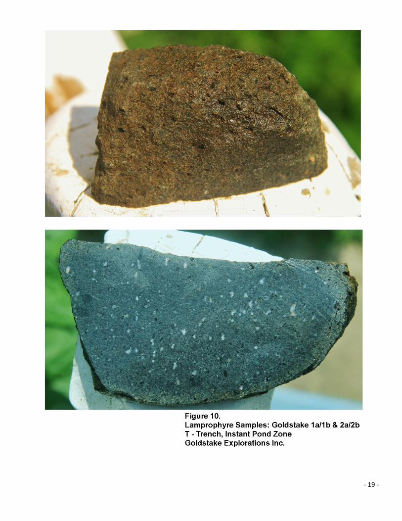
Two rocks were collected from till exposed in the “T” trench at the Instant Pond Zone. Both samples
were sent for petrographic analyses at Renaud Geological Consulting Ltd. and R.L. Barnett Geological
Consulting Inc. in London, Ontario. Their petrographic report is appended to this report.

- 12 -

- 13 -
Table 1.
Rock Sample Descriptions and Summary of Assay Results : CML298
Clay Property, McGarry Twp., Ontario Goldstake Explorations Inc. NAD83, Zone 17
Sample Number
UTM E
UTM N
Lithology Au ppm
Ag ppm
As ppm
Bi ppm
Cu ppm
Cd ppm
Mo ppm
Te ppm
W ppm
Zn ppm
Zone
82832 603795 5335721 Basalt with cpy & epidote
0.30 4.02 1.80 Instant Pond T Trench
82833 603793 5335718 Basalt with cpy & epidote
2.23 1.30 1.62 1260 1.02 0.64 4.10 Instant Pond T Trench
82834 603796 5335717 Diorite Porphyry
3.24 Instant Pond T Trench
82835 603710 5335794 Diorite Porphyry with cpy
2.16 3.15 12.50 1850 2.00 7.58 1.40 Instant Pond Creek Trench
82836 603673 5335600 Basalt & epidote Instant Pond L Trench
82837 603675 5335602 Quartz Diorite with py Instant Pond L Trench
82838 603688 5335618 Diorite 1.61 Instant Pond L Trench
82839 604330 5334596 Metasediment F Zone
82840 604335 5334597 Syenite Porphyry F Zone
82841 604329 5334602 Metasediment F Zone
82842 604353 5334600 Metasediment 2.21 F Zone
82843 604451 5334941 Volcaniclastic 0.59 2.30 Stump Pond
GS-1 603344 5334975 Metasediment 226 Mystery
GS-2 603345 5334970 Metasediment 85 2.22 2.34 Mystery
GS-3 603346 5334968 Metasediment 0.92 116 1.13 Mystery
GS-4 603365 5334985 Syenite Porphyry Mystery
GS-5 603558 5334997 Basalt Float Mystery
GS-6 603783 5335732 Basalt with cpy & epidote
3.38 1.37/ 1.23
2.75/ 3.42
2000/ 1850
1.12/ 1.42
0.60 Instant Pond T Trench
Goldstake 1a/1b Float
603782 5335722 Lamprophyre Oval round, 12x10 cm
Instant Pond T Trench
Goldstake 2a/2b Float
603781 5335734 Lamprophyre Oval round, 14x10 cm
Instant Pond T Trench

- 14 -

- 15 -

- 16 -

- 17 -

- 18 -
- 19 -

- 20 -
Survey Results
Rock samples were collected from variety areas on the property and analyzed for multi-elements in an
attempt to gain a better understanding of the chemical signatures associated with mineralization on the
property. Table 1. summarizes sample locations, rock type and anomalous assay results.
Samples were collected from: Instant Pond Zone, F Zone, Stump Pond and Mystery Zone.
High concentrations of gold were detected only in the samples collected in the Instant Pond Zone. Two
samples, GS-6 and 82833 which tested mineralized basalt exposed in the “T” trench assayed 3.38 g/t gold and
2.23 g/t gold respectively. In addition to gold, these samples also show higher concentrations of
silver, bismuth, copper, molybdenum, tellurium and tungsten.
Elevated arsenic was detected in three samples from Mystery Zone. Although none of the samples returned
gold values, one sample had elevated silver and bismuth and another had elevated cadmium and zinc.
A sample from the Stump Pond area returned elevated tellurium and tungsten. Tellurium has been reported
with gold in the F-Zone however samples collected during this project did not return values for these
elements.
Petrographic examination of the two float samples found in till exposed in the wall of the T Trench of the
Instant Pond Zone were found to be similar in composition and comparable to lamprophyre. Both samples
were essentially composed of hornblende-amphibole phenocrysts and clots of biotite and amphibole in a fine
matrix of plagioclase feldspar. There are some amphibolitized mafic fragments which appear to be carried
with the lamprophyre. Plagioclase feldspar is partially consumed by calcite and white mica and is evidence of
retrograde metamorphism. The rocks are deemed non-kimberlitic and have low diamond potential.
Discussion of Results
The elevated metallic elements (Au, Ag, Bi, Cu, Mo, Te, W) found in samples from the Instant Pond Zone are
distinct compared to metallic elements found in other mineralized zones on the property. The metallic
sequence is somewhat similar to gold ores in the Kirkland Lake area and different to gold ores clustered along
the Larder Lake- Cadillac Fault Zone. The high arsenic values seen in samples from the Mystery Zone are
typical of gold ores along the Larder Lake- Cadillac Fault Zone especially those found in the Kerr Addison Mine.
Alteration found in the Instant Pond Zone includes: carbonate (calcite), epidote, silica, magnetite and hematite
and is indicative of propylitic alteration. This type of alteration and the association with gold-silver-copper are
not typical of ores cluster along the Larder Lake – Cadillac Fault Zone, however similar alteration and ore
minerals are reported in the Upper Beaver Mine in McVittie Twp. and in some of the deposits found In the

- 21 -
Timmins area on the Destor – Porcupine Fault Zone. It’s interesting to note that the Upper Beaver Mine and
Instant Pond Zone are situated in the Blake River Formation and are spatial to syenite and feldspar porphyry.
These deposits most likely represent a separate gold event in comparison to other deposits in the Larder Lake
area.
The lamprophyre float found in the T Trench are non-kimberlitic and most likely have no relationship to the
kimberlite minerals (pyrope, chrome diopside, chromite) found in Instant Pond (Copper) Creek located just
north of the trench.
Conclusions and Recommendations
The metallic signature of the Instant Pond Zone is unique and suggests the Instant Pond Zone represents a
distinct gold event in comparison to other mineralized zones on the property and in the Larder Lake area. The
metallic signature could be used as a model in a multi-element soil survey. Therefore, a Mobile Metal
Ionization (MMI) Survey is recommended with the goal of expanding the Instant Pond Zone and find new
areas of gold mineralization on the property.
An estimate for the cost to explore in the vicinity to the Instant Pond Zone is: $35,000. The cost structure for
the proposed survey is outlined in Table 2.
Respectfully submitted,
Robert Dillman P.Geo, B.Sc.
July 13, 2015

- 22 -
Table 2.
Budget
Proposed MMI Survey: Instant Pond Area
Sample analysis: 500 soil samples x $35/ sample MMI analysis $17,500
Sample collection: 2 men x $500/ day x 7 days $7,000
Hotel & Food $1,500
Transportation $2,000
Reports and Maps $5,000
Contingency $2,000
$35,000

- 23 -
References
Ayer, J.A., Thurston, P.C., Bateman, R., Dube’, B., Gibson, H.L., Hamilton, M.A., Hathway, B., Hocker, S.M., Houle’, M.G., Hudak, G., Ispolatov, V.O., Lafrance, B., Lesher, C.M., MacDonald, P.J., Peloquin, A.S., Piercey, S.J., Reed, L.E. and Thompson, P.H. 2005.
Overview of results from the Greenstone Architecture Project: Discover Abitibi Initiative; Ontario Geological Survey, Open File Report 6154, 146p. File OFR6154.
Dillman, R.J., 2008. Report On Diamond Drill Program Instant Pond Zone, Clay Property,
McGarry, McVittie & Ossian Township’s, Ontario, Canada. Assessment report for Goldstake
Explorations Inc.
Gallo, E.A. 2004. Report on McGarry Project Property of Transpacific Resources Inc. and
Goldstake Explorations Inc. Company Report for Goldstake Explorations Inc. and
Transpacific Resources Inc., Nation Instrument (N.I.) 43-101 Format.
Jackson, S.L. 1995. Precambrian Geology, Larder Lake Area; Ontario Geological Survey, Map 2628, scale
1:50 000.
Renaud, J. and Barnett, R.L. 2015. Petrographic Investigation of Two Float Samples from the Goldstake
Property, Northern Ontario. For: Robert Dillman, Goldstake Explorations Inc.

- 24 -
Robert J. Dillman P.Geo, B.Sc.
ARJADEE PROSPECTING
8901 Reily Drive, Mount Brydges, Ontario, Canada, N0L1W0
Phone/ fax (519) 264-9278
CERIFICATE of AUTHOR
I, Robert J. Dillman, Professional Geologist, do certify that:
1. I am the President and the holder of a Certificate of Authorization for:
ARJADEE PROSPECTING
8901 Reily Drive
Mount Brydges, Ontario, Canada
N0L1W0
2. I graduated in 1991 with a Bachelor of Science Degree in Geology at the
University of Western Ontario.
3. I am an active member of:
Association of Professional Geoscientists of Ontario, APGO
Prospectors and Developers Association of Canada, PDAC
4. I have been a licensed Prospector in Ontario since 1985.
5. I have worked continuously as a Professional Geologist for 24 years.
6. Unless stated otherwise, I am responsible for the preparation of all sections of
the Assessment Report titled:
REPORT ON ROCK SAMPLING and
PETROGRAPHIC EXAMINATION OF FLOAT SAMPLES
CLAY PROPERTY
GOLDSTAKE EXPLORATIONS INC. – TRANSPACIFIC RESOURCES INC.
MCGARRY, MCVITTIE & OSSIAN TOWNSHIP’S, LARDER LAKE AREA, ONTARIO
dated, July 13, 2015
7. I am not aware of any material fact or material change with respect to the subject
matter of the Assessment Report that is not contained in the Assessment Report and
its omission to disclose makes the Assessment Report misleading.
Dated this 13th day of July, 2015
- 25 -

- 26 -

- 27 -

- 28 -

- 29 -

- 30 -

- 31 -