report on the fourth excavation season (2011) of the madâ
TRANSCRIPT

Report on the Fourth Excavation Season (2011)
of the Madâ’in Sâlih Archaeological Project
December 2011
Edited by L. Nehmé
With contributions by
W. Abu-Azizeh, Chr. Benech, G. Charloux, N. Delhopital, C. Durand, Z. T. Fiema, Kh. al-Hâ’itî, S. Marion de Procé, N.-A. Müller, M. al-Mûsa, L. Nehmé, J. Rohmer, I. as-Sabhân, I. Sachet,
J. Studer, D. al-Talhi, Fr. Tourtet
and the drawings of J. Humbert and S. Eliès

Paris, December 2011Page set up Claire Carpentier,
UMR 8167, Orient & Méditerranée27, rue Paul Bert, 94 204 Ivry-sur-Seine cedex, France

Edited by L. Nehmé
With contributions by
W. Abu-Azizeh, Chr. Benech, G. Charloux, N. Delhopital, C. Durand, Z. T. Fiema, Kh. al-Hâ’itî, S. Marion de Procé, N.-A. Müller, M. al-Mûsa, L. Nehmé, J. Rohmer, I. as-Sabhân, I. Sachet,
J. Studer, D. al-Talhi, Fr. Tourtet
and the drawings of J. Humbert and S. Eliès
Report on the Fourth Excavation Season (2011)of the Madâ’in Sâlih Archaeological Project


Table of contents
Introduction p. 7
Appendix by Ibrahim as-Sabhân, p. 15
Area 1Guillaume Charloux p. 27
Area 2Jérôme Rohmer p. 49
Monumental Tombs, Area 5Nathalie Delhopital and Isabelle Sachet p. 77
Area 6 (IGN 132)Laïla Nehmé p. 99
Area 8Solène Marion de Procé p. 145
Area 9Zbigniew T. Fiema p. 165
Study of the cairnsWael Abu-Azizeh p. 223
Geomagnetic SurveyChristophe Benech p. 287
Preliminary study of the animal bones analysed in 2011Jacqueline Studer p. 313
Pottery StudyCaroline Durand p. 325
Appendix by Francelin Tourtet and Nina-Ann Müller, p. 355
Conclusion p. 363


Introduction
7
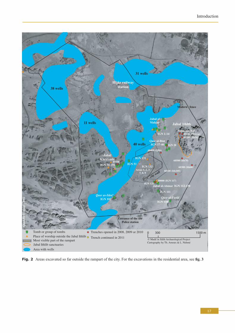
Between the 10th January and the 28th February 2011, the archaeological project at Madâ’in Sâlih carried out its fourth excavation season at the ancient site of Hegra, a medium-sized Nabataean town on the southern border of the Nabataean kingdom and later of the Roman province of Arabia (fig. 1). This season follows the third, on which a complete report was presented to the excavation committee in January 2011.Eight excavation areas were selected in 2011 (fig. 2), one of which only lies outside the residential area (Area 5 / tomb IGN 117) and the others inside it (Areas 1, 2, 3, 8, 9, 6 / IGN 132, for which see fig. 3). They are presented below under the authorship of each area supervisor, and scientific coordination is ensured by the project directors. In 2011, the activities of the Saudi members of the team were devoted to the area excavated in 2003: M. al-Mûsa and Kh. al-Hâ’itî removed some of the baulks left between the squares (see figs 4-7) and took protective measures against the water which runs from the neighbouring hill, IGN 132. Another Saudi member of the team, I. as-Sabhân, devoted all his time to the manufacture of mudbricks, to be used in the restoration of the mudbrick walls which were put to light during the excavations as well as to the building of a small section of the rampart for tourism attraction. The number of mudbricks made in 2011 reached 1,300 units. Each mudbrick measures 40 x 25 cm and weighs 22 kilos. Since a report on these activities has already been published in Arabic,1 they will not be presented at length here (see below, the section on “Restoration”). Apart from the excavations and the restoration, several specialists contributed to our knowledge of the ancient occupation at the site:- Christian Augé completed the study of all the coins which were found since 2008, including those found in 2011 (635 coins);- Jacqueline Studer (see her report in this volume) studied the fauna;- Christophe Benech (see his report in this volume) undertook a geophysical survey in various parts of the site, both in the central part of the city and in the area of the so-called southeastern gate (see fig. 3). After two seasons, the survey covers a surface of 10 ha. The results reflect the environmental conditions and the state of preservation of the archaeological structures. In the areas which resisted to the erosion, the map gives interesting results about the spatial organization of the urban space. It clearly shows the orientation of the streets and buildings but it is difficult to determine their internal organization;- Wael Abu-Azizeh (see his report in this volume) undertook a systematic survey and mapping of the area in which tumuli have been identified, recording hundreds of structures;- In the absence of Yvonne Gerber, who was not able to join the team this year, Caroline Durand continued the study of the pottery by herself (see her report in this volume).
1. D. al-Talhi, I. as-Sabhân, Kh. al-Hâ’iti and M. al-Mûsa, Taqrîr mûzaj ‘an ’a‘mâl al-bi‘tha al-su‘ûdiyya al-faransiyya, madâ’in sâlih, 2011, SCTA, 2011.

8
L. NeHMé
As in the previous reports, the following chapters are a complete report on all the project’s activities. It is presented to the French ministère des Affaires étrangères, as well as to our umbrella organisations, our partners and to a certain number of French and foreign scholars who will thus be able to disseminate the results of the project’s work throughout the academic world. But first and foremost, it is a working document for the team members and their future colleagues on the project and must, therefore, provide detailed and accurate information on the work carried out in the field. The existence of this report is a sine qua non for the success of the final publication.
ACkNowLEDGMENTS
As each year, the directors of the project would like to thank all the institutions and people who helped make this second season a success:
- the Supreme Commission for Tourism and Antiquities in Riyadh (SCTA);- la Division des sciences sociales et de l’archéologie of the ministère des Affaires étrangères in Paris;- l’Ambassade de France in Riyadh and the Consulat général de France in Jeddah;- the Saudi Arabian Embassy in Paris and its Cultural Bureau;- the Archaeological Museum in al-‘Ulâ;- l’UMR 8167 of the CNRS, Orient & Méditerranée, Ivry sur Seine;- l’UMR 7041 of the CNRS, Archéologie et Sciences de l’Antiquité, Nanterre;- the University of Paris 1;- l’Institut français du Proche-Orient (IFPO);- the Simone and Cino del Duca Foundation.Grants from the French Senate, Total and OTV Île de France were obtained in 2008 and are recalled here. They helped in the acquisition of material and the preparation of publications.The project directors would also like to thank the members of the Madâ’in Sâlih team for their professionalism, efficiency and co-operation. We would also like to give particular thanks to Daniel Ollivier and Pierre Vincent of the Service de coopération et d’action culturelle (SCAC) of the Ambassade de France in Riyadh, and to Alain Marquer and Elie Nehmé of the Jedda branch of the SCAC. Finally, we would like to express our warmest thanks to Mutlaq al-Mutlaq, our inspector and good friend, who solved all the daily problems of the project, as well as to Nâyif al-‘Anzi, the director of the al-‘Ulâ museum, who spared no effort in making the new bedrooms available in time for the team.
AFFILIATIoNS, DIRECToRS AND PARTICIPANTS
AffiliationsThe project works under the aegis of the following bodies, to which its directors are affiliated and which evaluate its work:
- la Division des sciences sociales et de l’archéologie of the ministère des Affaires étrangères in Paris;- l’UMR 8167, Orient & Méditerranée, (Ivry sur Seine); UMR 7041, Archéologie et Sciences de
l’Antiquité (Nanterre).- the Supreme Commission for Tourism and Antiquities, Riyadh.
Directors and participantsThe project is directed by Daifallah al-Talhi, professor at the University of Hâ’il, by Laïla Nehmé, researcher at the CNRS in the Orient & Méditerranée section and by François Villeneuve, professor at the University of Paris 1. These three directors took it in turn to be on the site, so that at least one, or
9
Introduction
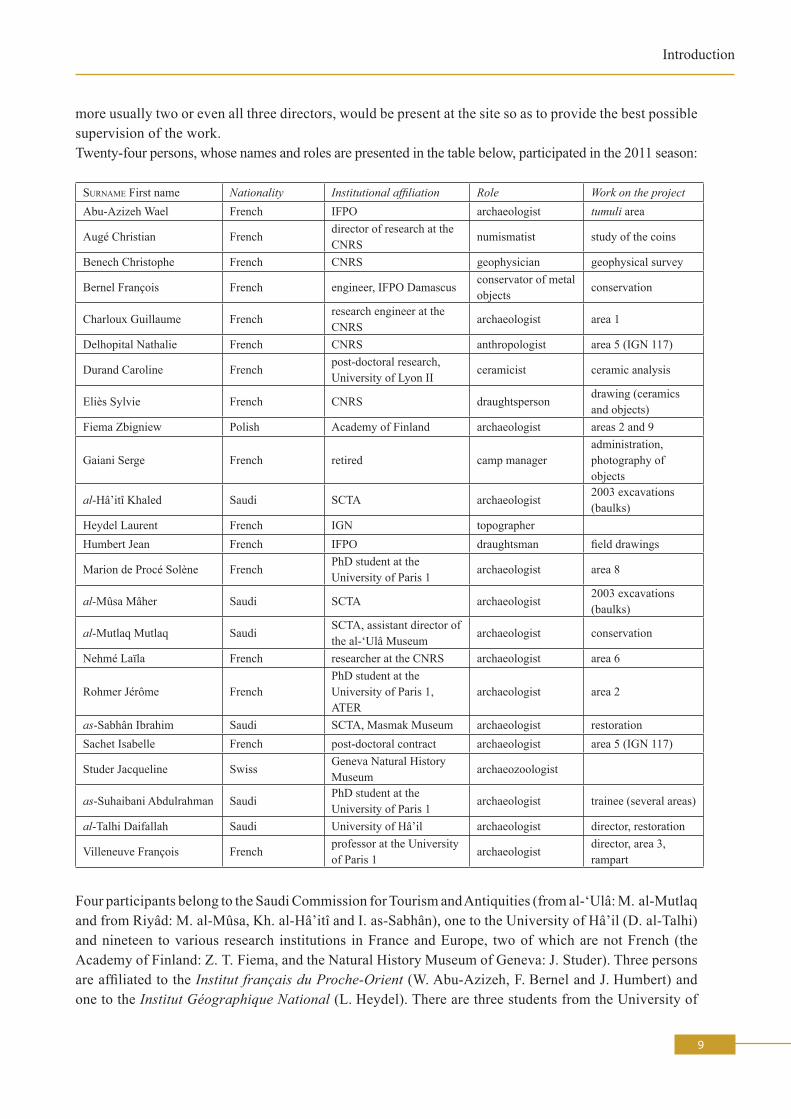
more usually two or even all three directors, would be present at the site so as to provide the best possible supervision of the work.Twenty-four persons, whose names and roles are presented in the table below, participated in the 2011 season:
Surname First name Nationality Institutional affiliation Role Work on the projectAbu-Azizeh Wael French IFPO archaeologist tumuli area
Augé Christian Frenchdirector of research at the CNRS
numismatist study of the coins
Benech Christophe French CNRS geophysician geophysical survey
Bernel François French engineer, IFPO Damascusconservator of metal objects
conservation
Charloux Guillaume Frenchresearch engineer at the CNRS
archaeologist area 1
Delhopital Nathalie French CNRS anthropologist area 5 (IGN 117)
Durand Caroline Frenchpost-doctoral research, University of Lyon II
ceramicist ceramic analysis
eliès Sylvie French CNRS draughtspersondrawing (ceramics and objects)
Fiema Zbigniew Polish Academy of Finland archaeologist areas 2 and 9
Gaiani Serge French retired camp manageradministration, photography of objects
al-Hâ’itî Khaled Saudi SCTA archaeologist2003 excavations (baulks)
Heydel Laurent French IGN topographerHumbert Jean French IFPO draughtsman field drawings
Marion de Procé Solène FrenchPhD student at the University of Paris 1
archaeologist area 8
al-Mûsa Mâher Saudi SCTA archaeologist2003 excavations (baulks)
al-Mutlaq Mutlaq SaudiSCTA, assistant director of the al-‘Ulâ Museum
archaeologist conservation
Nehmé Laïla French researcher at the CNRS archaeologist area 6
Rohmer Jérôme FrenchPhD student at the University of Paris 1, ATeR
archaeologist area 2
as-Sabhân Ibrahim Saudi SCTA, Masmak Museum archaeologist restorationSachet Isabelle French post-doctoral contract archaeologist area 5 (IGN 117)
Studer Jacqueline SwissGeneva Natural History Museum
archaeozoologist
as-Suhaibani Abdulrahman SaudiPhD student at the University of Paris 1
archaeologist trainee (several areas)
al-Talhi Daifallah Saudi University of Hâ’il archaeologist director, restoration
Villeneuve François Frenchprofessor at the University of Paris 1
archaeologistdirector, area 3, rampart
Four participants belong to the Saudi Commission for Tourism and Antiquities (from al-‘Ulâ: M. al-Mutlaq and from Riyâd: M. al-Mûsa, Kh. al-Hâ’itî and I. as-Sabhân), one to the University of Hâ’il (D. al-Talhi) and nineteen to various research institutions in France and Europe, two of which are not French (the Academy of Finland: Z. T. Fiema, and the Natural History Museum of Geneva: J. Studer). Three persons are affiliated to the Institut français du Proche-Orient (W. Abu-Azizeh, F. Bernel and J. Humbert) and one to the Institut Géographique National (L. Heydel). There are three students from the University of
10
L. NeHMé
Paris 1 (S. Marion de Procé, J. Rohmer and A. as-Suhaibani). The CNRS provided three researchers (Chr. Augé, Chr. Benech and L. Nehmé) and two engineers (G. Charloux and S. Eliès) and the University of Paris 1 one professor (F. Villeneuve). Finally, S. Gaiani, a retired teacher, joined the team as steward.
FINANCING AND PARTNERShIPS, 2011 SEASoN
Financing for the project were provided by contributions from both the public and private sectors as follows:
Public Partners- le ministère des Affaires étrangères (government grant);- l’Ambassade de France in Riyadh (government grant);- the Saudi Arabian Embassy in Paris (logistical support, visas);- l’UMR 8167, Orient & Méditerranée and UMR 7041, Archéologie et Sciences de l’Antiquité (individual
missions);- l’Institut français du Proche-Orient (availability of personnel);- the Saudi Commission for Antiquities and Museums (help in kind, publications, lodging, etc.).
Private PartnersFrench firms:For the publication of the monumental tombs: OTV Île de France (Veolia Eau).For the purchase of equipment only (not for fieldwork): 2008 grant from Total.
Prizes2008: the project winned the Grand prize for archaeology of the Simone and Cino del Duca Foundation.In the future, we will still rely heavily on contributions from the ministère des Affaires étrangères, which has long been interested in the excavation project at this major site. This contribution is the only regular one and also provides a source of legitimacy to our work in Saudi Arabia. Equally, the support of the Ambassade de France in Riyadh is essential for our fieldwork to take place.
PRACTICAL ASPECTS
CarsThe project rented four cars in Jedda from a private rental agency (Hanco).
LodgingThe team was once again housed in the flat next to the Museum of al-‘Ulâ. On top of the pre-fabricated building of three rooms with bathrooms which was purchased by the project in 2009, the Saudi Commission for Tourism and Antiquities built several rooms for use by the team (two rooms and a tent at the back of the Museum in 2010 and a new separate building, containing four bedrooms and two bathrooms, entirely furnished, on the side of the museum). We are very grateful to the SCTA for these new rooms, which make the team’s daily life much easier.
SecurityIn 2011, no particular security measures were taken by the Saudi security services: no military escort nor surveillance were given to the team, whose members could get around freely.

11
Introduction
Publications- The 350 page volume (in English) presenting the work of the first season (2008), has been printed in
Riyad and distributed to various libraries in the world as well as to a certain number of scholars. We, again, are very grateful to the SCTA for making this publication possible, especially with such a high printing standard.
- The full reports on the 2009 and 2010 seasons are available online on the “Open pluridisciplinary archive” website of the French National Center for Scientific research (http://hal.archives-ouvertes.fr/):
2009: http://halshs.archives-ouvertes.fr/halshs-00548747/fr/ 2010: http://halshs.archives-ouvertes.fr/halshs-00542793/fr/- A contribution for Atlal on the results of the 2009 and 2010 seasons has been submitted to the
SCTA in January 2011 and is in the press. Another contribution for Atlal will be submitted in January 2012.
- A publication in Arabic was prepared and published by the Saudi members of the 2011 field season: D. al-Talhi, I. as-Sabhân, Kh. al-Hâ’itî and M. al-Mûsa, Taqrîr mûzaj ‘an ’a‘mâl al-bi‘tha al-su‘ûdiyya al-faransiyya, madâ’in sâlih, 2011, SCTA, 2011.
- The preparation of the publication of the volume devoted to the necropolises of the site has been going on in 2011, especially the chapter on the architectural decoration, by Jacqueline Dentzer. Once this chapter is fisnished, the director of the publication, L. Nehmé, will be able to make the necessary modifications in the chapters she is in charge of (“Introduction” and “General presentation of the tombs”). The publisher will normally be the Publications de la Sorbonne, i.e. the publisher of the University of Paris 1 (director Bertrand Hirsch). One problem remains to be solved: the photographs of the tombs which are to be used as illustrations for this volume were taken between 2002 and 2004, that is before the removal of the very unaesthetic metallic ladders which gave access to quite a number of tombs. It is therefore necessary to take new photographs of these tombs, and this will be done during the 2012 study season.
- The project has been associated, in 2010, with the preparation of the exhibition “Routes d’Arabie” which was organized in the Louvre from July to September 2010. A chapter on Madâ’in Sâlih was written by L. Nehmé for the Catalogue of the exhibition who also provided a contribution for the journal Archeothema. This exhibition is due to move, in late 2011, to Berlin. A chapter on the Nabataeans in northwest Arabia was submitted for the German catalogue by L. Nehmé.
- Finally, we would like to draw attention on recent publications, by Ch. Bouchaud, on the archaebotanical remains of Madâ’in Sâlih:
Ch. Bouchaud, “Les pratiques alimentaires en Arabie antique. étude archéobotanique de Madâ’in Sâlih”, Cahier des thèmes transversaux ArScAn 2007-2008 (vol. IX), p. 247-256. Available online at: http://www.mae.u-paris10.fr/Cahiers/FMPro?-db=cahiers.fp5&-format=detailfasc.htm&-lay=cahiers&Theme=orient*&-recid=33298&-find=Ch. Bouchaud, M. Tengberg, P. Dal-Prà: « Cotton cultivation and textile production in the Arabian Peninsula during antiquity; the evidence from Madâ’in Sâlih (Saudi Arabia) and Qal’at al-Bahrain (Bahrain) », in : Vegetation History and Archaeobotany, May 2011. Available online at: http://www.springerlink.com/content/4553148g27587h67/Ch. Bouchaud, I. Sachet and N. Delhopital, “Les bois et les fruits des tombeaux nabatéens de Madâ’in Sâlih/Hégra (Arabie Saoudite): les provenances des végétaux et leur utilisation en contexte funéraire”, Anthropobotanica 2010.1.11. Available online at: http://www.mnhn.fr/museum/foffice/science/science/DocScientifique/publications/presentation/listeParution/ficheParution/ficheContenu.xsp?CONTeNU_ID=4067&PARUTION_ID=2366&PUBLICATION_ID=313&idx=11&nav=listeParution

12
L. NeHMé
LecturesAs usual, L. Nehmé gave a lecture at the French Embassy in Riyadh and at the French consulate in Jedda. The title of these lectures was: “The Nabataean stone cutting techniques in Petra and Hegra”.L. Nehmé also gave a lecture on archaeology at the French school in Riyad to three classes of 15 year old pupils from various origins.
VisitsThe president of the University of Paris 1, Jean-Claude Colliard, visited the site just before the arrival of the team, on the 11th of January. He was guided through the site by D. al-Talhi and F. Villeneuve (fig. 8).On the 28th of February, a group of ten ambassadors and their families visited the site (Austria, Belgium, European Union, France, Germany, Italy, Lebanon, Norway, Spain, United Kingdom). They were given a complete tour by L. Nehmé, ending in front of the Qasr al-Farîd tomb (fig. 9).On the 8th and 9th of February 2011, two members of the Saudi-German Joint Archaeological Project at Taymâ’, Nina-Ann Müller and Francelin Tourtet, visited the team at Madâ’in Sâlih in order to compare the ceramic evidence of these two sites (see their report at the end of the “Pottery study”).
RESToRATIoN
The 2003 excavations (by kh. al-hâ’itî and M. al-Mûsa)During this season, an attempt was made to undertake restorations in the 2003 excavations made by the Department of Antiquities. The purpose of this work was twofold:
1/ remove the baulks which were left between the squares. This will help understanding better the plan of the building unit;
2/ build a barrier to protect the eastern part of the excavation area, which was badly affected by the water running from the nearby outcrop (IGN 132).
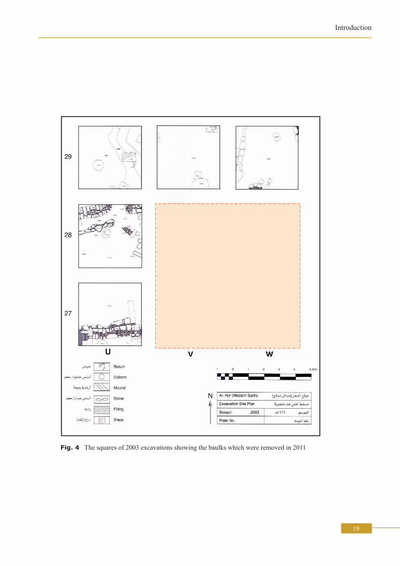
Four baulks were removed (B1, B2, B3 and B4, see fig. 4) and four squares (W27,W28,V27,V8) were thus joined together. Following is a brief description of the structures put to light: there is a door west of square V27 (for location, see fig. 6), with two small buttresses built of five rows of sandstone with mud mortar. The southern buttress is 1.34 x 0.60 and 0.50 m high and the northern one is 1.70 x 0.60 and 0.50 m high. The threshold of the door consists of two long sandstones blocks, 1.25 x 0.22 m each. East of the southern butress, there is an E-W wall (no. 1), with two facings, 3.30 m long and 0.44 m wide. This wall belongs to the second phase of the building (the most recent one). The builder gave it particular attention as he used dressed stones. There are also three steps leading, through a door, to a room paved with white medium size slabs. It is in this area that the Latin inscription mentioning possibly the restoration of the rampart was discovered in 2003.East of the stairs, there is an E-W wall (no. 2), built with large stones (if compared to the other walls in the area. This wall continues east beyond the excavated area and belongs to the first phase (the oldest).Wall no. 3 is parallel to wall no. 2, but it belongs to a different phase (Phase 2, the most recent). It is about 2.89 m long, 0.96 m wide and 0.51 m high. The lowest part of the wall was built of mudbricks while its upper part was built of stone. South of this wall, there is a platform, about 0.66 m long. In the southeast corner of the paved room, there are various cube-shaped stones (47 x 37 x 33 cm) and above them lies another stone, with a more or less circular shape, which may be a column base. Beside it, there is a circular water basin (diameter 72 cm, depth 20 cm).No complete unit appeared in the excavated area, even after the removal of the baulks. If the excavations were to continue, it is recommended that they should expand to the south.

13
Introduction
TRAINING
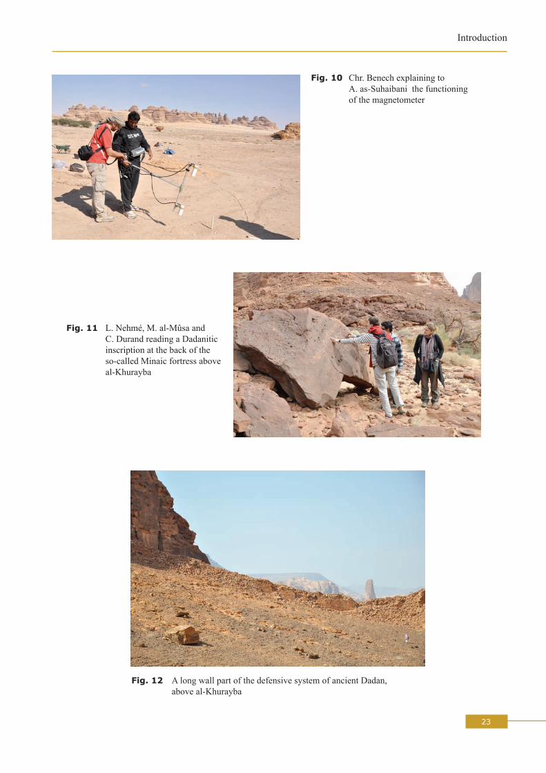
Training of A. as-SuhaibaniApart from the European PhD students (S. Marion de Procé and J. Rohmer), the 2011 team welcomed a Saudi student who is presently preparing a PhD at the University of Paris 1. A complete training programme was prepared for him and he was asked to write a report on his participation, which was corrected and commented by L. Nehmé. He participated actively to the excavations in Area 2 (one week, with J. Rohmer), in Area 35 (one week, with F. Villeneuve) and in tomb IGN 117 (two days, with I. Sachet and N. Delhopital, in order to learn about excavation in funerary contexts). He was also shown the process through which the pottery goes, from washing to analysis (with C. Durand) and drawing (with S. Eliès). He also received a one to one course on numismatics by Chr. Augé and on the archaeozoological remains by J. Studer. Finally, he followed a training in geophysical survey (with Chr. Benech, fig. 10). In the middle of his stay, he participated to a two day survey of three early Islamic dams in the Medina region (with L. Nehmé, J. Schiettecatte and L. Heydel). These dams were described, photographed and mapped using a theodolite (see below, section on “Other activities”). This allowed him to experiment and follow a survey methodology. A. as-Suhaibani is a very promising young scholar who will probably become part of the Saudi academic elite.
Training of students of hâ’il universityIt was agreed with professor D. al-Talhi that the Madâ’in Sâlih project’s topographer, L. Heydel (IGN) would give a three day training in topography applied to archaeology to a group of students of Hâ’il university. L. Heydel’s explained the principles of topography and the operation of the level and the theodolite. His stay in Hâ’il was paid by the university.
ExCAVATIoNS AND SuRVEyS CARRIED ouT IN 2011
In 2010, one excavation area only was located outside the ancient city wall: tomb IGN 117. The others were all within the city wall (see fig. 3). Some of them had been started in 2008 and continued in 2009 (Areas 1, 2), while others were opened in 2009 (Areas 7 and 8), 2010 (Area 9 and 6 / IGN 132) or 2011 (Area 35, which is part of the greater Area 3, which concerns the rampart and its surroundings).Areas 1 and 2 are the two large trenches which brought to light domestic structures dated from the 1st
century BC to the beginning of the 7th century AD, for which see the reports of G. Charloux and J. Rohmer in this volume;Area 3 concerns the rampart and all the structures associated with it. In 2011, several spots along the rampart were explored and one gate of the city, the so-called southeastern gate, was partly excavated;Area 8 covers the remains of structures which belong to several phases which are difficult to date and interpret, one of which reuses monumental building material rather crudely assembled (see the report of S. Marion de Procé in this volume);Area 9 was opened during the second half of the 2010 season and continued in 2011. It was very successful since it yielded the earliest settlement discovered so far at the site (see the report of Z. T. Fiema in this volume, which covers seasons 2010 and 2011);In and around IGN 132, excavations started in 2010. IGN 132 is one of the few rocky outcrops which stand in the middle of the residential area. In 2011, the excavations have put to light, on the summit of the outcrop, the existence of a sanctuary, possibly devoted to the sun god, which is made of a paved platform on which stood a tetrapylon. At the foot of the outcrop, a well was also partly excavated (see the report of L. Nehmé in this volume);
14
L. NeHMé
Area 5 / IGN 117: the funerary chamber of the rock-cut tomb was fully excavated in 2011 and the human bones as well as all the other material uncovered can now be studied (see the report of I. Sachet and N. Delhopital in this volume).The tumuli: quite a lot of effort was put, in 2011, in the systematic survey of the areas, west and south of the site, which contain tumuli (see the report of W. Abu-Azizeh in this volume).
oThER ACTIVITIES
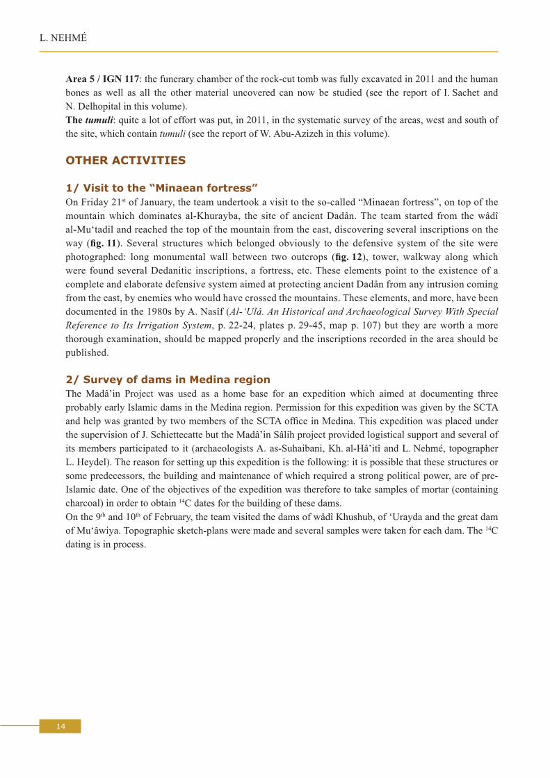
1/ Visit to the “Minaean fortress”On Friday 21st of January, the team undertook a visit to the so-called “Minaean fortress”, on top of the mountain which dominates al-Khurayba, the site of ancient Dadân. The team started from the wâdî al-Mu‘tadil and reached the top of the mountain from the east, discovering several inscriptions on the way (fig. 11). Several structures which belonged obviously to the defensive system of the site were photographed: long monumental wall between two outcrops (fig. 12), tower, walkway along which were found several Dedanitic inscriptions, a fortress, etc. These elements point to the existence of a complete and elaborate defensive system aimed at protecting ancient Dadân from any intrusion coming from the east, by enemies who would have crossed the mountains. These elements, and more, have been documented in the 1980s by A. Nasîf (Al-‘Ulâ. An Historical and Archaeological Survey With Special Reference to Its Irrigation System, p. 22-24, plates p. 29-45, map p. 107) but they are worth a more thorough examination, should be mapped properly and the inscriptions recorded in the area should be published.
2/ Survey of dams in Medina regionThe Madâ’in Project was used as a home base for an expedition which aimed at documenting three probably early Islamic dams in the Medina region. Permission for this expedition was given by the SCTA and help was granted by two members of the SCTA office in Medina. This expedition was placed under the supervision of J. Schiettecatte but the Madâ’in Sâlih project provided logistical support and several of its members participated to it (archaeologists A. as-Suhaibani, Kh. al-Hâ’itî and L. Nehmé, topographer L. Heydel). The reason for setting up this expedition is the following: it is possible that these structures or some predecessors, the building and maintenance of which required a strong political power, are of pre-Islamic date. One of the objectives of the expedition was therefore to take samples of mortar (containing charcoal) in order to obtain 14C dates for the building of these dams.On the 9th and 10th of February, the team visited the dams of wâdî Khushub, of ‘Urayda and the great dam of Mu‘âwiya. Topographic sketch-plans were made and several samples were taken for each dam. The 14C
dating is in process.

15
Introduction
APPENDIx: MANuFACTuRING oF MuDbRICkS
by Ibrahim as-Sabhân
The manufacturing process was established and carefully followed by I. as-Sabhân. The following description is taken directly from the report he published in Arabic (in D. al-Talhi, I. as-Sabhân, Kh. al-Hâ’iti and M. al-Mûsa 2011, see note 1 above, p. 89-133).
Once the material (clayish earth, sand and water) has been collected from appropriate sources of supply, it consists in the following (fig. 13):
1. prepare wooden moulds with handles on the small sides (internal size 40 x 25 x 13 cm): fig. 13.1;2. choose a flat and stoneless area;3. lay down flat 8 x 8 m plastic sheets and fix them on the sides and on the corners with stones or
mudbricks: fig. 13.2;4. in order to prepare 35 mudbricks, put 650 kilos of clay and 400 kilos of sand on the plastic sheet, using
a wheelbarrow (fig. 13.3), and mix them properly with a shovel (fig. 13.4);5. prepare pyramid-shaped mounds and make a bowl-shaped depression (a crater) at the top;6. fill the crater with water and spray the sides of the mound with water so that the earth is not blown by
the wind (fig. 13.5);7. the following morning, bring the earth up, taking it with a shovel from the bottom to the top (fig. 13.6).
If the crater is not completely wet, it is possible to make another one just below the top one (fig. 13.7);8. renew this operation (filling the crater with water, spraying the sides of the mound with water and
bringing the earth from bottom to top) every day for a week;9. trample on each mound until it becomes completely homogeneous. It takes the form of a flat disc
(fig. 13.8);10. spread 600 grams of temper (“Fos Fiber P1” was used instead of straw) uniformly over the disk of
earth (fig. 13.9) and mix it carefully with the earth by trampling on it barefeet (fig. 13.10). It is better to divide the temper into three portions and mix them successively. After mixing each portion, make a pyramid-shaped mound which can be trampled again. Once the temper has been completely mixed with the earth, make a mound (fig. 13.11) and leave it to rest for one day;
11. trample the mound barefeet one last time in order to make it soft and homogeneous;12. clean the ground on which the mudbricks are going to be put to dry;13. plunge the wooden mould into water (fig. 13.12) and spray sand on its internal faces;14. put the mould in the place where you want to make the mudbrick and fill it by hand with the earth
(fig. 13.14). It is easier to use clods of earth prepared in advance (fig. 13.13) pressing it carefully in order to avoid air bubbles. When the mould is completely filled, make its surface smooth with the hands or with a trowel (fig. 13.15);
15. lift the mould using the handles (figs 13.16-17) and spray a little bit of sand on the surface of the mudbrick, in order to help it dry and protect it from the sun;
16. wash the mould and start the same process for a new mudbrick. There should be enough distance (a few centimeters) between the mudbricks for them to dry properly;
17. every two or three days, turn all the mudbricks on their side so that each side dries homogeneously;18. when the mudbricks are completely dry, they can be used as building material.19. In 2011, 1,300 mudbricks were made with 35 earth mounds scattered over 7 plastic sheets, which
makes an average of 37 mudbricks per mound.

16
L. NeHMé
0 50 km 250 km
N
MAJOR CITY
Secondary city: ancient name(or modern name in round brackets)
Isolated sanctuary
Permanent watercourse
Approximate limits of the Nabataean kingdom around 85 BC
PH
OE N
I CI A
S Y R I A
GO
L AN
G A L I L A E A
S Y R I A N S T E P P ET R A C H O N I T I S
A U R A N I T I S
S A M A R I A
J U D A E A
I D U M A E A
A M M A N I T I S
M O A B I T I S
G O B O L I T I S
H A R R A H
W A D I S I R H Â N
N E G E V
BERYTUS
SIDON
TYRE
PTOLEMAIS
Ascalon
GAZA
Rhinocolura
PELUSIUM
Heliopolis
Byblos
(Dmayr)
D A M A S C U S
Pella
GERASA
Scytho-polis
JERUSALEM
Marissa
Massada
ElusaBethomolachon
Sobata
Nessana(Qasrweit)
OBODA
Adraa
Sia
Soada
Namâra
PHILADELPHIA
Madabâ
Tyros
(Qasr Rabbah)
RabbathmôbaBetthôro
(Dhât Râs)(Tannûr)(Dharîh)
PA L M Y R A
Augustopolis
Clysma
R E D
S E A
Myos Hormos?
(Rawâfah)
Leukè Kômè?
Leukos Limèn?
Taymâ
HEGRA
PETRA towards Dûmâ
Dadan
(Dhîbân)
THE NABATAEAN KINGDOMS I N A I
H I J Â Z
Zoara
MAMPSIS
Punon
Gypsaria Auara
IramAyla
Pharan
DEA
D
S
EAEleutheropolis
© E
ditio
ns d
u Se
uil,
1999
CAESAREA
Lac de Tibériade
Jour
dain
B O S R A
(Umm al-Jimâl)
M E D I T E R R A N E A N
S E A
Fig. 1 Location of the site
17
Introduction
40000
Qasr al-Bint
Jabal Ithlib
JabalKhraymãt
Jabal al-Mahjar
Jabal al-Ahmar
Qasr al-FarîdQasr as-Sâni‘
IGN 132
IGN 131
0 300 1500 m
IGN 1-14
IGN 17-46
IGN 112-130
IGN 110IGN 102
IGN 51
IGN 111
IGN 56-101
city wallAreas 1, 2, 3
7, 8, 9
60500 (Ith78)
60300 (Ith68)60200 (Ith105)
50000 (IGN 117)
60400 (QB6)
IGN 20
IGN 125
60000 (Ith23-25)60100 (cistern)60200 (Ith54)
Hijâz railwaystation
Tomb or group of tombsPlace of worship outside the Jabal Ithlib
Trenches opened in 2008, 2009 or 2010
Trench continued in 2011Most visible part of the rampartJabal Ithlib sanctuariesArea with wells
38 wells
11 wells
40 wells
31 wells
Entrance of the sitePolice station
Modern fence
Qui
ckBi
rd im
age
, 200
2
© Madâ’in Sâlih Archaeological ProjectCartography by Th. Arnoux & L. Nehmé
Fig. 2 Areas excavated so far outside the rampart of the city. For the excavations in the residential area, see fig. 3

18
L. NeHMé
Fig. 3 Satellite image showing the ecavations undertaken within the residential area
Area 7
Area 1
Area 3
0 100 m© QuickBird
modern fence
rampart
IGN 131
IGN 132
modern fence
Excavations 1986-1990
Trenches excavated in 2011
Area 8
Area 2
Geophysical survey2010, Chr. BenechGeophysical survey2011, Chr. Benech
Area 9
rampart
rampart
Area 35
19
Introduction
Bau
lk B
3B
aulk
B1
Baulk B4 Baulk B2
Fig. 4 The squares of 2003 excavations showing the baulks which were removed in 2011

20
L. NeHMé
Fig. 5 The 2003 excavation area in 2011 before the removal of the baulks
Fig. 6 The 2003 excavation area in 2011 after the removal of the baulks

21
Introduction
Fig. 7 Final plan of squares V27-28, W27-28
V28 W28
V27 W27
Mudbrick
MortarWall
Excavation limit
CAPTION
Earth mound
MADÂ’IN SÂLIH
Excavat ion 2003Top plan 2011
N
Dessin mis au net au 1/50e
© Mission archéologique de Madâ’in SâlihRelevé J. Humbert 2010, 2011 et mise au net E. Devidal 2011
0 1 2 3 4 5

22
L. NeHMé
Fig. 8 From right to left: D. al-Talhi, F. Villeneuve, Mr. and Mrs Colliard on their visit to Madâ’in Sâlih
Fig. 9 The ambassadors of european Union and other countries (and their photographer!) at the end of their visit to Madâ’in Sâlih
23
Introduction
Chr. Benech explaining to A. as-Suhaibani the functioning of the magnetometer
Fig. 10
L. Nehmé, M. al-Mûsa and C. Durand reading a Dadanitic inscription at the back of the so-called Minaic fortress above al-Khurayba
Fig. 11
A long wall part of the defensive system of ancient Dadan, above al-Khurayba
Fig. 12

24
L. NeHMé
Fig. 13.1 Wooden mould
Fig. 13.2 Plastic sheets
Fig. 13.3 Clay and sand
Fig. 13.4 Mixing of clay and sand with a shovel
Fig. 13.6 Bringing the earth up on following morning
Fig. 13.7 Two-level crater to facilitate the wetting of the earth
Fig. 13.5 Pyramid-shaped mound with central crater filled with water
Manufacturing of mudbricksFig. 13

25
Introduction
Fig. 13.8 Trampling of the mound Fig. 13.9 Temper spread on top of trampled mound
Fig. 13.10 Trampling the earth with the temper
Fig. 13.11 Mound after mixing of earth with temper
Fig. 13.12 Wetting the wooden mouldFig. 13.13 Clods of earth prepared for the filling
of the mould

26
L. NeHMé
Fig. 13.14 Filling of the mould
Fig. 13.15 Smoothing the surface of the earth in the mould
Fig. 13.16 Removal from the mould
Fig. 13.17 Successful operation!