reprocessing of gps and repeated absolute gravity measurements
TRANSCRIPT

Reports on Geodesy no. (93) 2/2012; pages 41 - 40
41
REPROCESSING OF GPS AND REPEATED ABSOLUTE GRAVITY MEASUREMENTS REALIZED IN TATRA MOUNTAIN
Mojzes M., Papco J., Mikolaj M.
Slovak University of Technology in Bratislava Department of Theoretical Geodesy
e-mail: [email protected], [email protected], [email protected]
1. Introduction Present global isostatic adjustment produced horizontal and vertical secular motion of the earth surface (Paulson et al., 2007). This process is frequently monitored by GNSS (Häkli and Koivula, 2010) and repeated absolute gravity measurements (Timmen et al., 2011). Determination of the small rates of the earth surface changes in some areas is still problematic. The accuracy of position determination from no permanent GNSS measurement is 4-7 mm/5 days and permanent GNSS measurement is 2-3 mm/7 days. The accuracy of Absolute Gravity measurements are 1 μGal/16 hours. Integration of GNSS permanent and repeated gravity measurements is one of the ways for detection of vertical movement of the earth surface. This philosophy was applied for detection of movements in the Tatra Mountains.
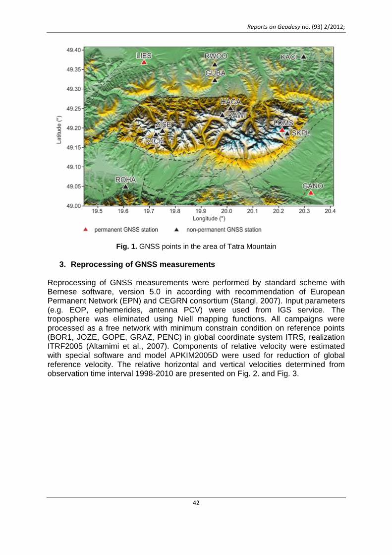
2. GNSS measurements – basic information The non-permanent GPS/GNSS measurements have been performed every year at 12 points (Fig. 1.) with special monument for repeated setup of GPS/GNSS antenna module with 0.5 mm accuracy. The GPS/GNSS campaigns have been organized annually with 4-5 days observation time using only Trimble dual frequency receivers. The non-permanent GPS/GNSS measurements have been connected to the reference permanent GNSS stations: BOR1, JOZE, GOPE, GRAZ, PENC.
Reports on Geodesy no. (93) 2/2012;
42
Fig. 1. GNSS points in the area of Tatra Mountain
3. Reprocessing of GNSS measurements
Reprocessing of GNSS measurements were performed by standard scheme with Bernese software, version 5.0 in according with recommendation of European Permanent Network (EPN) and CEGRN consortium (Stangl, 2007). Input parameters (e.g. EOP, ephemerides, antenna PCV) were used from IGS service. The troposphere was eliminated using Niell mapping functions. All campaigns were processed as a free network with minimum constrain condition on reference points (BOR1, JOZE, GOPE, GRAZ, PENC) in global coordinate system ITRS, realization ITRF2005 (Altamimi et al., 2007). Components of relative velocity were estimated with special software and model APKIM2005D were used for reduction of global reference velocity. The relative horizontal and vertical velocities determined from observation time interval 1998-2010 are presented on Fig. 2. and Fig. 3.

Mojzes M., Papco J., Mikolaj M.: Reprocessing of GPS and repeated absolute gravity measurements ,,,
43
Fig. 2. The relative horizontal velocities determined from GPS/GNSS observations time interval 1998-2010
Fig. 3. The vertical velocities determined from GPS/GNSS observations time interval 1998-2010

Reports on Geodesy no. (93) 2/2012;
44
For better determination of horizontal and vertical movements near the three no permanent GPS/GNSS stations (GANO, LOMS and LIES) the permanent GPS/GNSS stations (GANP, LOMS and LIE1) have been established. The measurements of permanent stations started at GANO in 2003, at LOMS in 2004 and at LIES in 2007 and have been processed in the local analytical centre Slovak University of Technology in Bratislava (SUT) (points GANP, LOMS) and Institute of Geodesy and Cartography in Bratislava (point LIE1) in frame of the EPN and CEGRN. The EPN stations BOR1, BUCU, GOPE, GRAZ, MATE, PENC, SOFI and WTZR have been used as reference permanent GPS/GNSS station in processing of points GANP and LOMS (Hefty et al., 2010) and stations BOR1, GOPE, GRAZ, JOZE, PENC, UZHL in processing of point LIE1 (Droscak, 2012). The comparison between results of no permanent and permanent observations is presented on Fig.4.
Fig. 4. Comparison of no permanent and permanent GPS/GNSS measurements
4. Processing of the absolute gravity measurements The repeated absolute gravity measurements performed with FG5 at tree gravity sites (GANO, SKPL and LIES) have been used for determination of the vertical land uplift/subsidence trend. The one day of absolute gravity measurements (from 12 to 24 hours) have been performed at GANO in 2003, 2005, 2006, 2007 and 2008, at SKPL in 2005, 2006, 2007 and 2008 and at LIES in 2004, 2006, 2007 and 2008. The absolute gravity data have been processed by Micro-g software assuming polar motion, atmospheric and tide corrections. Correction for the fringe value, difference

Mojzes M., Papco J., Mikolaj M.: Reprocessing of GPS and repeated absolute gravity measurements ,,,
45
in reference heights and hydrological effects were added for each measurement separately.
4.1 . Modeling the Hydrological Effect Signal of the vertical movements observed with GPS/GNSS and especially absolute gravimeter can be contaminated with hydrological signal. The aim of the hydrological correction is to eliminate the hydrology from the observed signal of absolute gravimeter. Global hydrological model and local measurements of precipitation and evaporation were used for this purpose. Effect of the hydrological masses for the spherical distance (θ) greater than 0.045° (~5 km) from the point of observation were computed using Green's functions (Farrell, 1972), equation (1), with Love’s coefficients given by (Guo et al., 2004). In this case the hydrological masses were acquired using The Global Land Data Assimilation System NOAH (GLDAS) (Rodell et al., 2004).
0
2 1 cos . (1)n n n
ne
gg n h n k P
m
Local hydrological correction for points up to 4900 m from the point of observation were computed using simple hydrological model based on precipitation (P) and evaporation (E) measured at meteorological sites near to the point of observation. The surface water height (Z) is defined by Z = P – E. This information combined with digital elevation model DMR3 (0.25 m x 0.25 m) served as the input in to the equation for the gravitational effect of prism given by (Sorokin, 1951), equation (2).
ln ln . (2)ZR
g G X Y R Y X R ZarctgXY
5. Velocity trends comparison
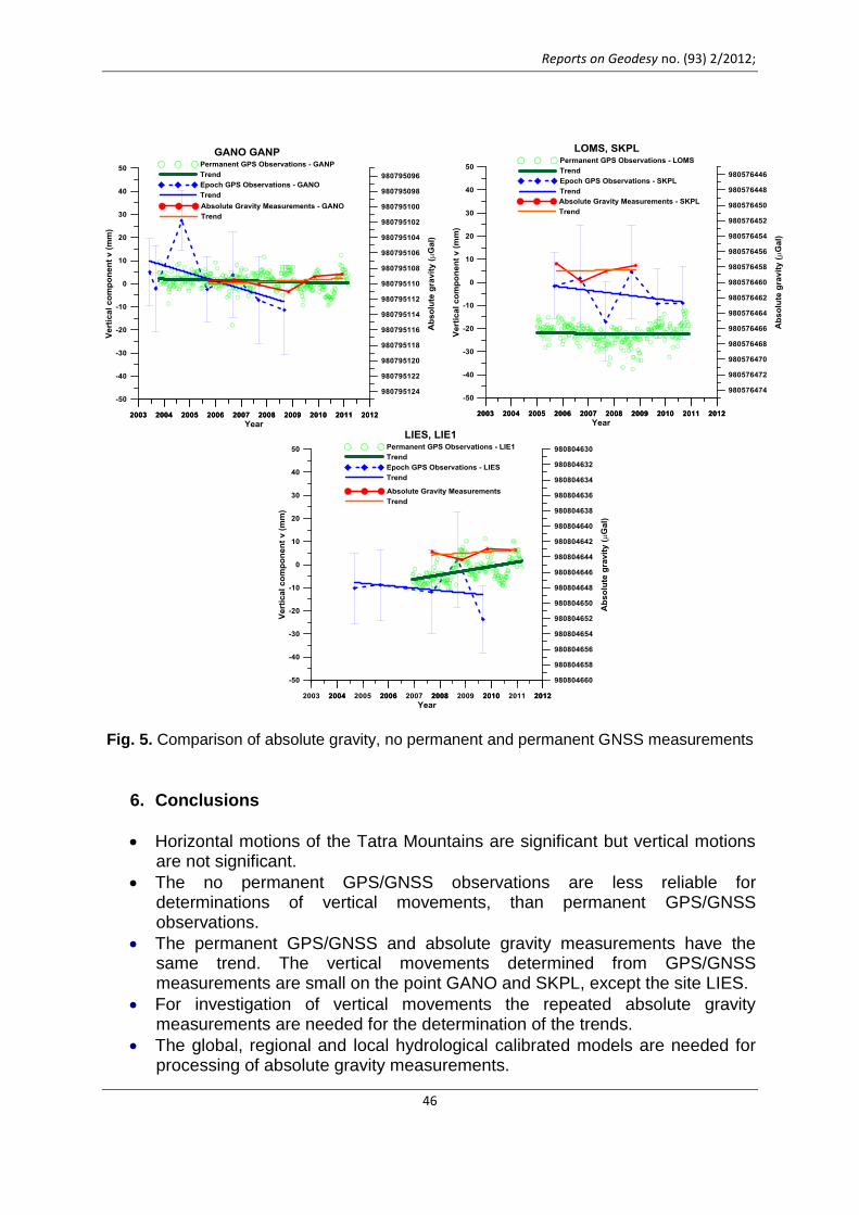
The time series of ellipsoidal heights determined by GPS/GNSS measurements and absolute gravity values on the points GANO, SKPL and LIES are presented on Fig 5. The trends of ellipsoidal changes and the absolute gravity changes, presented in Table 1 and Fig. 5, are very similar at the points GANO and SKPL but they differ slightly at the point LIES.
Table 1. Velocity trends
Point g μGal / yr h mm / yr g / h μGal / mm
No permanent station
GANO 0.48 -3.36 -0.14
SKPL -0.09 -1.38 0.07
LIES -0.18 -1.05 0.17
permanent station
GANP 0.48 -0.26 -1.85
LOMS -0.09 -0.10 0.90
LIE1 -0.18 1,85 -0.10
Reports on Geodesy no. (93) 2/2012;
46
Fig. 5. Comparison of absolute gravity, no permanent and permanent GNSS measurements
6. Conclusions
Horizontal motions of the Tatra Mountains are significant but vertical motions are not significant.
The no permanent GPS/GNSS observations are less reliable for determinations of vertical movements, than permanent GPS/GNSS observations.
The permanent GPS/GNSS and absolute gravity measurements have the same trend. The vertical movements determined from GPS/GNSS measurements are small on the point GANO and SKPL, except the site LIES.
For investigation of vertical movements the repeated absolute gravity measurements are needed for the determination of the trends.
The global, regional and local hydrological calibrated models are needed for processing of absolute gravity measurements.
Mojzes M., Papco J., Mikolaj M.: Reprocessing of GPS and repeated absolute gravity measurements ,,,
47
Better understanding of the Tatra Mountains movements requires denser network of the permanent GNSS and absolute gravity sites.
Acknowledgements: The authors thank the Agency of the Ministry of Education, Science, Research and Sport of the Slovak Republic for the Structural Funds of EU and Slovak University of Technology in Bratislava for financial support of the Project ITMS no.26220220108.
References Altamimi, Z., Collilieux, X., Legrand, J., Garayt, B., Boucher, C., (2007): ITRF2005: New
release of the International Terrestrial Reference Frame based on time series of station positions and Earth Orientation Parameters, Journal of Geophysical Research, vol. 112.
Dorscak (2012): Processing of SKPOS permanent GNSS stations (personal communications).
Farrell W. E. 1972: Deformation of the Earth by Surface Loads. Reviews of Geophysics and Space Physics, 1972, Vol. 10, No. 3, 761-797.
Guo, J. Y.; Li, Y. B.; Huang, Y.; Deng, H. T.; Xu, S. Q.; Ning, J. S. 2004. Green’s function of the deformation of the Earth as a result of atmospheric loading. Geophysical Journal International, 2004, 159, 53-68.
Hefty J., Hipmanová L., Gerhátová Ľ., Igondová M., Droščák B. (2010): Recent Geo-kinematics of Slovakia Based on Homogenized Solutions of Permanent and Epoch GPS Networks. Acta Geodynamica et Geomaterialia. Vol.7,No.3(159), pp. 303-315.
Häkli, Koivula, (2010): Transforming ITRF Coordinates to National ERS89 Realization in the Presence of Postglatial Rebound: An Evaluation of the Nordic Geodynamical Model in Finland. Preccedings of the 2009 IAG Symposium, Buenos Aires, Argentina „Geodesy for Plasnet Earth“, pp.77-86.
Mojzes M., Papco J., Valko M. (2012): Repeated Geodetic Measurements in the Tatra Montain. N. Sneew et al. (eds.), VII Hotine Marussi Symposium on Mathematical Geodesy. IAG Sympopsia 137. Springer-Verlag Berlin Hheidelberg 2012 (in press).
Paulson, A., Zhong, S., and Wahr, J. (2007): Interference of mantle viscosity from GRACE and relative sea level data. Geophys. J. Int. (2007) 171, 497-508.
Rodell M., Houser P. R., Jambor U., Gottschalck J., Mitchell J.K., Meng C.-J., Arsenault K., Cosgrove B., Radakovich J., Bosilovich M., Entin J. K., Walker J. P., Lohmann D., and Toll D. 2004: The Global Land Data Assimilation System. Bulletin of the American Meteorological Society, 2004, vol. 85 (3), 381–394.
Sorokin, L.V. 1951: Gravimetria a gravimetrický prieskum. Moskva Štátne technické nakladateľstvo, [In Russian], 1951.
Stangl, G., (2007): Guidelines for CEGRN Reprocessing version 1.3, available www page: http://cergops2.iwf.oeaw.ac.at
Timmen L., et al. (2011): Observing Gravity Change in the Fennoscandian Uplift Arera with the Hanover Absolute Gravimeter. Pure Appl. Geophys. Springer Based AG.