residential subdivision development code - act … · contents 2 16 residential subdivision...
TRANSCRIPT
NI2008-27 Effective: 2 October 2009
Authorised by the ACT Parliamentary Counsel—also accessible at www.legislation.act.gov.au
Residential Subdivision Development Code

NI2008-27 16 Residential Subdivision Development Code Effective: 2 October 2009
contents 1
Authorised by the ACT Parliamentary Counsel—also accessible at www.legislation.act.gov.au
Contents
Introduction ........................................................................................................................................... 1 Part A – Residential Estate Planning and Design Process............................................................... 2 Part B – Subdivision Development Code ........................................................................................... 5
Part B(1) Estate Development Plans supported by a Precinct Code......................................... 6 Element 1: Neighbourhood Design ............................................................................................ 6 Element 2: Street Works.............................................................................................................. 7
2.1 Functions and Structure ................................................................................... 7 2.2 Corridors and Precincts .................................................................................... 7 2.3 Safety, Access and Convenience..................................................................... 8 2.4 Traffic Impacts and Residential Amenity .......................................................... 8 2.5 Functions and Width......................................................................................... 8 2.6 Site Access and Width.................................................................................... 10 2.7 Geometric Design........................................................................................... 10 2.8 Rear Lanes ..................................................................................................... 11 2.9 Culs-de-sac..................................................................................................... 12 2.10 On-street Parking ........................................................................................... 13 2.11 Water Sensitive Urban Design ....................................................................... 13
Element 3: Pedestrians and Cyclist Facilities......................................................................... 20 3.1 Location and Design....................................................................................... 20 3.2 Safe Crossings ............................................................................................... 21
Element 4: Public Transport ..................................................................................................... 22 4.1 Bus Stop Location and Design ....................................................................... 22
Element 5: Public Open Space and Sporting Facilities ......................................................... 24 5.1 Size and landform........................................................................................... 24 5.2 Accessibility .................................................................................................... 24
Element 6: Block Layout and Building Envelope Plans......................................................... 25 6.1 Section Size.................................................................................................... 25 6.2 Solar Efficient Subdivisions ............................................................................ 25 6.3 Multi-unit Sites ................................................................................................ 26 6.4 Security, Surveillance, Safety, and Amenity................................................... 27 6.5 Compact blocks (defined as blocks having a site area of 250m2 or less) ...... 27
Element 7: Utilities, Waste Management and Sediment and Erosion Control..................... 30 7.1 Viability of Services ........................................................................................ 30 7.2 Utility Services on Leased and Unleased Land.............................................. 30 7.3 Shared Trenching ........................................................................................... 31 7.4 Width of Service Reservations and Service Access Elements ...................... 31 7.5 Width of Service Reservation and Emergency Access to Minor Service
Reticulation..................................................................................................... 32 7.6 Separation of Private and Utility Services ...................................................... 32 7.7 Recording Utility Access Requirements in Leases........................................ 32 7.8 Design and Construction Qualifications ......................................................... 33 7.9 Overland Flow Paths for Sewage and Stormwater Spillage .......................... 33 7.10 Location of Sewage and Stormwater Connections ........................................ 33 7.11 Clearance Between Utility Equipment and Landscape Elements ................. 34 7.12 Noise and odour buffer zones ........................................................................ 34 7.13 Waste management ....................................................................................... 34 7.14 Sediment and Erosion Control Plan ............................................................... 35
contents 2 16 Residential Subdivision Development Code Effective: 2 October 2009
NI2008-27
Authorised by the ACT Parliamentary Counsel—also accessible at www.legislation.act.gov.au
Part B(2) – Additional requirements that apply when an Estate Development Plan is not supported by a Precinct Code...................................................................................................... 40 Element 1: Neighbourhood Design .......................................................................................... 40
1.1 Structure and Composition ............................................................................. 40 1.2 Movement Networks...................................................................................... 41 1.3 Water Sensitive Urban Design ....................................................................... 42 1.4 Bushfire Risk Mitigation .................................................................................. 42 1.5 Traffic Noise.................................................................................................... 43 1.6 Tree Protection ............................................................................................... 43 1.7 Heritage Protection......................................................................................... 43 1.8 Contaminated Sites ........................................................................................ 44
Element 2: Street Networks....................................................................................................... 45 2.1 Traffic Impacts and Residential Amenity ........................................................ 45
Element 3: Pedestrian and Cyclist Facilities........................................................................... 46 3.1 Planning.......................................................................................................... 46
Element 4: Public Transport ..................................................................................................... 46 4.1 Planning.......................................................................................................... 46
Element 5: Public Open Space and Sporting Facilities ......................................................... 47 5.1 Neighbourhood Design Focal Point................................................................ 47 5.2 Identify Management Purpose........................................................................ 47 5.3 Open Space Hierarchy and Recreation Settings............................................ 47 5.4 Distribution...................................................................................................... 48 5.5 Size and landform........................................................................................... 48 5.6 Surveillance and Public Safety ....................................................................... 48 5.7 Existing Vegetation and Natural Features...................................................... 48
Appendix A – Legislation and Other Documents ............................................................................ 52 Appendix B – Services Easement ..................................................................................................... 54 Appendix C – Energy Audits of Subdivisions – Detached Residential Blocks ............................ 55
1 Rationale Behind Energy Audit ................................................................................................. 55 2 Principles of Solar Efficient Subdivision.................................................................................. 55 3 Procedure for Conducting Energy Audits................................................................................ 57 4 Energy Audits Requirements..................................................................................................... 58
NI2008-27 16 Residential Subdivision Development Code Effective: 2 October 2009
page 1
Authorised by the ACT Parliamentary Counsel—also accessible at www.legislation.act.gov.au
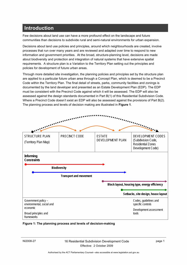
Introduction Few decisions about land use can have a more profound effect on the landscape and future communities than decisions to subdivide rural and semi-natural environments for urban expansion.
Decisions about land use policies and principles, around which neighbourhoods are created, involve processes that run over many years and are reviewed and adapted over time to respond to new information and government priorities. At the broad, structure-planning level, decisions are made about biodiversity and protection and integration of natural systems that have extensive spatial requirements. A structure plan is a Variation to the Territory Plan setting out the principles and policies for development of future urban areas.
Through more detailed site investigation, the planning policies and principles set by the structure plan are applied to a particular future urban area through a Concept Plan, which is deemed to be a Precinct Code within the Territory Plan. The final detail of streets, parks, community facilities and zonings is documented by the land developer and presented as an Estate Development Plan (EDP). The EDP must be consistent with the Precinct Code against which it will be assessed. The EDP will also be assessed against the design standards documented in Part B(1) of this Residential Subdivision Code. Where a Precinct Code doesn’t exist an EDP will also be assessed against the provisions of Part B(2). The planning process and levels of decision making are illustrated in Figure 1.
STRUCTURE PLAN (Territory Plan Map)
PRECINCT CODE
ESTATE DEVELOPMENT PLAN
DEVELOPMENT CODES (Subdivision Code, Residential Zones Development Code)
Informing Constraints Biodiversity Transport and movement Block layout, housing type, energy efficiency Setbacks, site design, house layout
Government policy – environmental, social and economic
Broad principles and frameworks
Codes, guidelines and specific controls
Development assessment tools
Figure 1: The planning process and levels of decision-making
page 2 16 Residential Subdivision Development Code Effective: 2 October 2009
NI2008-27
Authorised by the ACT Parliamentary Counsel—also accessible at www.legislation.act.gov.au
Part A – Residential Estate Planning and Design Process
The three levels of planning that lead to the creation of new neighbourhoods are summarised below.
Structure Plan
The structure plan is prepared by the ACT Planning and Land Authority in consultation with government agencies and external stakeholders. The structure plan is approved by the ACT Government and represents the policies prevailing at the time with regard to protection of natural systems, provision for public and private transport, urban form and spatial planning objectives, retail and employment hierarchies, and other environmental and social policy objectives.
A structure plan gains statutory effect through a Variation to the Territory Plan. Background information that supports changes to the Territory Plan Map and written statement is preserved through the Final Variation for Future Urban Areas that sits within the Territory Plan structure. The planning principles and policies for the broad structure for a defined Future Urban Area reflect the following objectives:
a) to balance provision of sustainable and efficient urban structure with biodiversity protection and enhancement of environmental attributes through design
b) to express the natural landscape character in ways that define neighbourhoods, promote community identity and enhance connectivity of natural systems
c) to provide adequate infrastructure for all modes of transport, and incorporate accessible, efficient and safe public transport that is an attractive alternative to the private car
d) to develop an urban structure of compact, walkable neighbourhoods with relatively intense, mixed-use centres that are capable of supporting appropriate residential, commercial and social opportunities and minimise non-renewable energy use and car dependence
e) to demonstrate that the network capacity of roads, transit ways and utilities infrastructure can be sufficient to cost-effectively maintain the efficient functioning of the city as a whole
f) to ensure that the design of neighbourhoods takes into account environmental constraints including flooding and bushfire risk.
Precinct Codes a) A Concept Plan is prepared by the ACT Planning and Land Authority in consultation with
government agencies and external stakeholders. Under Section 92 of the Planning and Development Act 2007, a concept plan is a precinct code that guides the preparation and assessment of development in future urban areas to which the concept plan relates; and guides assessment of development when the areas cease to be future urban areas.
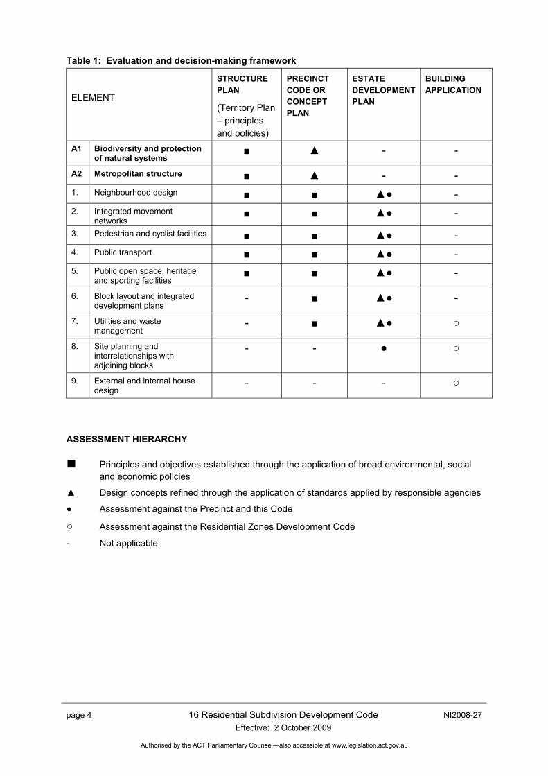
The Precinct Code should follow the structure outlined in Table 1. Commonality in structure between the Precinct Code and the subsequent EDP will ensure that interrelationships between the broad planning principles and detailed site design are synthesised through the development application process.
The Precinct Code specifies notional land uses and dwelling densities, broad infrastructure requirements, higher order road network (collector roads), key landscape features, and boundaries of the suburb. A tree survey is undertaken and in-principle agreement sought from the Conservator regarding the removal, retention and management of Excellent and High Value Trees to ensure that trees are safe for the future urban environment.
NI2008-27 16 Residential Subdivision Development Code Effective: 2 October 2009
page 3
Authorised by the ACT Parliamentary Counsel—also accessible at www.legislation.act.gov.au
The Precinct Code then sits within the structure of the Territory Plan and provides rules and criteria against which the EDP is assessed.
Estate Development Plans
Estate Development Plans (EDPs), together with special design conditions for individual allotments, set out the proposed subdivision pattern and infrastructure works for the neighbourhood. EDPs are development applications approved by the ACT Planning and Land Authority.
Development approval is required before starting the works and before granting leases for the subdivided blocks. The EDP is assessed against the Subdivision Code that is included as Part B of this document. The EDP will also be assessed against the applicable Precinct Code. Where there is no applicable Precinct Code, the EDP will be assessed against Part B(1) and also the supplement to the Subdivision Code, at Part B(2).
Master Planned Communities and Urban Design
The integration and cumulative outcomes of the various elements of this Code is important for achieving a successful master plan for the neighbourhood. This integration is what is often called urban design, which is the composition, in a community context, of movement networks, architectural form, community facilities and open space. The formative elements of a neighbourhood are its streets, buildings, urban landscape and service infrastructure, just as form, structure, and internal space are elements of a building. Master planning a neighbourhood reflects considerations of function, economics, marketing and efficiency, as well as aesthetic and cultural qualities, and involves the creative integration of the disciplines of ecology, engineering, social studies, landscape architecture, and architecture.
Definitions
The following definitions have been used in the document:
Site density
Site density represents the ratio of dwellings to the area of the site they occupy. It can be applied to: o Individual houses on their own block; o Multi-dwelling developments on their development site.
For example, Block Area = 500m², Site Density = 1 dwelling on 0.05 (hectare) = Site density of 20 dwellings per hectare Site density is the preferred definition for density comparisons between projects.
Net residential density
Net residential density is the ratio of the number of dwellings to the area of land they occupy including internal public streets plus half the width of adjoining roads that provide vehicular access to dwellings. (AMCORD, PNP 6, p.2)
Gross or neighbourhood residential density
Gross or neighbourhood residential density is the ratio of the number of dwellings to the area of land they occupy including associated neighbourhood or local facilities. The area includes internal public streets, all areas of public open space, local or neighbourhood shops, primary or secondary schools, local community services, local employment areas and half the width of adjoining arterial roads. (AMCORD, PNP 6, p.2)
page 4 16 Residential Subdivision Development Code Effective: 2 October 2009
NI2008-27
Authorised by the ACT Parliamentary Counsel—also accessible at www.legislation.act.gov.au
Table 1: Evaluation and decision-making framework
ELEMENT
STRUCTURE PLAN
(Territory Plan – principles and policies)
PRECINCT CODE OR CONCEPT PLAN
ESTATE DEVELOPMENT PLAN
BUILDING APPLICATION
A1 Biodiversity and protection of natural systems
■ ▲ - -
A2 Metropolitan structure ■ ▲ - - 1. Neighbourhood design ■ ■ ▲● - 2. Integrated movement
networks ■ ■ ▲● -
3. Pedestrian and cyclist facilities ■ ■ ▲● - 4. Public transport ■ ■ ▲● - 5. Public open space, heritage
and sporting facilities ■ ■ ▲● -
6. Block layout and integrated development plans
- ■ ▲● -
7. Utilities and waste management
- ■ ▲● ○
8. Site planning and interrelationships with adjoining blocks
- - ● ○
9. External and internal house design
- - - ○
ASSESSMENT HIERARCHY
■ Principles and objectives established through the application of broad environmental, social and economic policies
▲ Design concepts refined through the application of standards applied by responsible agencies
● Assessment against the Precinct and this Code
○ Assessment against the Residential Zones Development Code
- Not applicable
NI2008-27 16 Residential Subdivision Development Code Effective: 2 October 2009
page 5
Authorised by the ACT Parliamentary Counsel—also accessible at www.legislation.act.gov.au
Part B – Subdivision Development Code Application of this code This code applies to the design and subdivision of residential areas that are subject to an Estate Development Plan (EDP). An EDP sets out the proposed pattern of subdivision and infrastructure works for an estate. An EDP must be approved before works are started and before leases are granted for the subdivided blocks.
How to use this code
The Subdivision Code is divided into two subsections dealing with the rules and criteria for EDPs:
a) Part B(1): applies to EDP’s that are supported by a Precinct Code
b) Part B(2): in addition to Part B(1) Part B(2) applies to EDP’s that are not supported by a Precinct Code.
The Code’s controls are expressed as either rules, which are generally quantitative, or as qualitative criteria. • Proposals in the code track must comply with all rules relevant to the development. • Proposals in the merit track have the option to comply with the rules or the criteria, unless the
rule is mandatory. Where it is proposed to meet the criteria, the onus is on the applicant to demonstrate, by supporting plans and written documentation, that the proposed development satisfies the criteria and therefore the intent of the element.
• Proposals in the impact track must address the rules or criteria and justify any non-compliances.
Each Part is divided into sections referred to as Elements, although each Part may not include provisions for every Element. The Elements describe the various issues for consideration.1
Each Element consists of Intents and Items under which are Rules and Criteria.
Intent describes the purpose of the development controls
Rules provide the quantitative, or definitive, controls for development
Criteria provide the qualitative controls for development
In some instances, there are rules that are mandatory. For clarity of use, the mandatory rules are emphasized by the following words: “This is a mandatory requirement. There are no applicable criteria”. Non-compliance with these provisions will result in the refusal of a development application. Conversely, the words “There is no rule applicable” is used when controls cannot be quantitative or definitive and only criteria exist.
Any application of a General Code to a development proposal is identified as part of the relevant rule or criteria.
Where more than one type of Code applies to a development, the order of precedence when there is inconsistency of provisions between Codes, as defined by the Act, is Precinct Code, then Development Code, and then General Code.
page 6 16 Residential Subdivision Development Code Effective: 2 October 2009
NI2008-27
Authorised by the ACT Parliamentary Counsel—also accessible at www.legislation.act.gov.au
Part B(1) Estate Development Plans supported by a Precinct Code
Element 1: Neighbourhood Design Intent: a) To provide safe, convenient, accessible and attractive neighbourhoods that meet the diverse and
changing needs of the community. This encompasses offering a wide choice in good quality housing and associated community and commercial facilities, providing for local employment opportunities, encouraging walking cycling and use of public transport, minimising energy and water consumption, and promoting a sense of place through neighbourhood focal points and the creation of a distinctive identity which recognises and, where relevant, preserves the natural environment.
Where a Precinct Code exists, ‘Code Element 1: Neighbourhood Design’ will be evaluated entirely against the Precinct Code.
NI2008-27 16 Residential Subdivision Development Code Effective: 2 October 2009
page 7
Authorised by the ACT Parliamentary Counsel—also accessible at www.legislation.act.gov.au
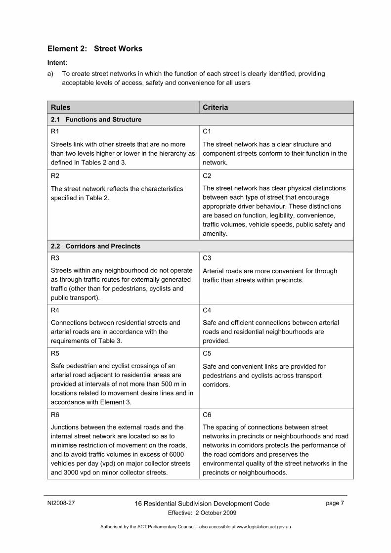
Element 2: Street Works Intent: a) To create street networks in which the function of each street is clearly identified, providing
acceptable levels of access, safety and convenience for all users
Rules Criteria 2.1 Functions and Structure
R1
Streets link with other streets that are no more than two levels higher or lower in the hierarchy as defined in Tables 2 and 3.
C1
The street network has a clear structure and component streets conform to their function in the network.
R2
The street network reflects the characteristics specified in Table 2.
C2
The street network has clear physical distinctions between each type of street that encourage appropriate driver behaviour. These distinctions are based on function, legibility, convenience, traffic volumes, vehicle speeds, public safety and amenity.
2.2 Corridors and Precincts
R3
Streets within any neighbourhood do not operate as through traffic routes for externally generated traffic (other than for pedestrians, cyclists and public transport).
C3
Arterial roads are more convenient for through traffic than streets within precincts.
R4
Connections between residential streets and arterial roads are in accordance with the requirements of Table 3.
C4
Safe and efficient connections between arterial roads and residential neighbourhoods are provided.
R5
Safe pedestrian and cyclist crossings of an arterial road adjacent to residential areas are provided at intervals of not more than 500 m in locations related to movement desire lines and in accordance with Element 3.
C5
Safe and convenient links are provided for pedestrians and cyclists across transport corridors.
R6
Junctions between the external roads and the internal street network are located so as to minimise restriction of movement on the roads, and to avoid traffic volumes in excess of 6000 vehicles per day (vpd) on major collector streets and 3000 vpd on minor collector streets.
C6
The spacing of connections between street networks in precincts or neighbourhoods and road networks in corridors protects the performance of the road corridors and preserves the environmental quality of the street networks in the precincts or neighbourhoods.
page 8 16 Residential Subdivision Development Code Effective: 2 October 2009
NI2008-27
Authorised by the ACT Parliamentary Counsel—also accessible at www.legislation.act.gov.au
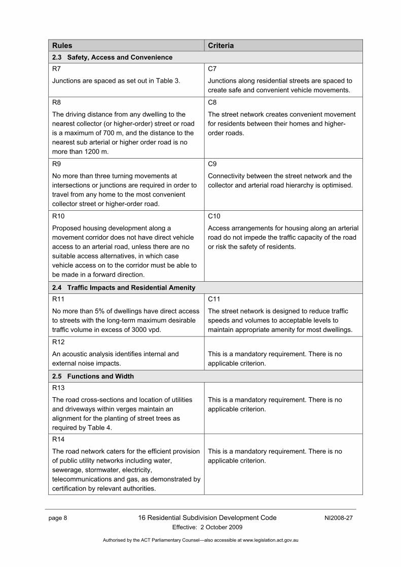
Rules Criteria 2.3 Safety, Access and Convenience R7
Junctions are spaced as set out in Table 3.
C7
Junctions along residential streets are spaced to create safe and convenient vehicle movements.
R8
The driving distance from any dwelling to the nearest collector (or higher-order) street or road is a maximum of 700 m, and the distance to the nearest sub arterial or higher order road is no more than 1200 m.
C8
The street network creates convenient movement for residents between their homes and higher-order roads.
R9
No more than three turning movements at intersections or junctions are required in order to travel from any home to the most convenient collector street or higher-order road.
C9
Connectivity between the street network and the collector and arterial road hierarchy is optimised.
R10
Proposed housing development along a movement corridor does not have direct vehicle access to an arterial road, unless there are no suitable access alternatives, in which case vehicle access on to the corridor must be able to be made in a forward direction.
C10
Access arrangements for housing along an arterial road do not impede the traffic capacity of the road or risk the safety of residents.
2.4 Traffic Impacts and Residential Amenity R11
No more than 5% of dwellings have direct access to streets with the long-term maximum desirable traffic volume in excess of 3000 vpd.
C11
The street network is designed to reduce traffic speeds and volumes to acceptable levels to maintain appropriate amenity for most dwellings.
R12
An acoustic analysis identifies internal and external noise impacts.
This is a mandatory requirement. There is no applicable criterion.
2.5 Functions and Width R13
The road cross-sections and location of utilities and driveways within verges maintain an alignment for the planting of street trees as required by Table 4.
This is a mandatory requirement. There is no applicable criterion.
R14
The road network caters for the efficient provision of public utility networks including water, sewerage, stormwater, electricity, telecommunications and gas, as demonstrated by certification by relevant authorities.
This is a mandatory requirement. There is no applicable criterion.
NI2008-27 16 Residential Subdivision Development Code Effective: 2 October 2009
page 9
Authorised by the ACT Parliamentary Counsel—also accessible at www.legislation.act.gov.au
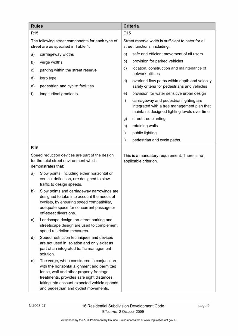
Rules Criteria R15
The following street components for each type of street are as specified in Table 4:
a) carriageway widths
b) verge widths
c) parking within the street reserve
d) kerb type
e) pedestrian and cyclist facilities
f) longitudinal gradients.
C15
Street reserve width is sufficient to cater for all street functions, including:
a) safe and efficient movement of all users
b) provision for parked vehicles
c) location, construction and maintenance of network utilities
d) overland flow paths within depth and velocity safety criteria for pedestrians and vehicles
e) provision for water sensitive urban design
f) carriageway and pedestrian lighting are integrated with a tree management plan that maintains designed lighting levels over time
g) street tree planting
h) retaining walls
i) public lighting
j) pedestrian and cycle paths.
R16
Speed reduction devices are part of the design for the total street environment which demonstrates that:
a) Slow points, including either horizontal or vertical deflection, are designed to slow traffic to design speeds.
b) Slow points and carriageway narrowings are designed to take into account the needs of cyclists, by ensuring speed compatibility, adequate space for concurrent passage or off-street diversions.
c) Landscape design, on-street parking and streetscape design are used to complement speed restriction measures.
d) Speed restriction techniques and devices are not used in isolation and only exist as part of an integrated traffic management solution.
e) The verge, when considered in conjunction with the horizontal alignment and permitted fence, wall and other property frontage treatments, provides safe sight distances, taking into account expected vehicle speeds and pedestrian and cyclist movements.
This is a mandatory requirement. There is no applicable criterion.
page 10 16 Residential Subdivision Development Code Effective: 2 October 2009
NI2008-27
Authorised by the ACT Parliamentary Counsel—also accessible at www.legislation.act.gov.au
Rules Criteria f) Traffic control devices are designed in
accordance with national standards that take into account the access requirements for emergency vehicles.
R17
The impact of measures intended to restrain traffic speeds and traffic volumes take account of the needs of other road users and adjoining dwellings, by avoiding:
a) unacceptable traffic noise to adjoining dwellings
b) devices that reduce convenience or safety levels for cyclists and public transport.
This is a mandatory requirement. There is no applicable criterion.
R18
Shared Use Zones comply with AUSTROADS requirements.
This is a mandatory requirement. There is no applicable criterion.
R19
Sight distances at pedestrian and cyclist crossings and at junctions and intersections are in accordance with Part 5 Guide to Traffic Engineering Practice or its successor.
C19
Safe sight distances, based on the speeds at which vehicles may travel in the street, exist at access points to properties, pedestrian and cyclist crossings and at junctions and intersections.
2.6 Site Access and Width
R20
Motorists are able to enter or reverse from a block or site in a single movement.
C20
The carriageway width, together with the verge width and crossover dimensions, allows for unobstructed and efficient access to individual blocks and sites, even when a car is parked on the opposite side of the street.
R21
Driveways and direct vehicle access to major collector streets and other streets that carry more than 3000 vpd are designed to require forward entry and exit of vehicles from properties.
C21
Driveway egress movements do not create a safety hazard.
2.7 Geometric Design
R22
Longitudinal gradient does not exceed the gradients specified in Table 4, and street pavement cross-fall is between 2.5% and 5%.
C22
Crossfall and horizontal and vertical alignments reflect physical land characteristics and major drainage functions, while satisfying safety criteria.
NI2008-27 16 Residential Subdivision Development Code Effective: 2 October 2009
page 11
Authorised by the ACT Parliamentary Counsel—also accessible at www.legislation.act.gov.au
Rules Criteria R23
Geometric design for intersections, roundabouts and slow points is consistent with the vehicle speed and maximum design vehicle envelop intended for each street and is consistent with AUSTROADS Guidelines and in accordance with the Australian Road Rules.
This is a mandatory requirement. There is no applicable criterion.
R24
At intersections, turning vehicles are accommodated using AUSTROADS Design Vehicles and Turning Templates to enable turns to be made in a single forward movement as follows:
a) For turns between a major collector and a minor collector or access street, the ‘design articulated vehicle’ provides a turning path radius of at least 15 m in accordance with the Australian Road Rules.
b) For turns between a minor collector street and access streets, the ‘design heavy rigid vehicle’ provides a turning path radius of at least 15 m, using any part of the pavement, in accordance with the Australian Road Rules.
c) For turns between access streets, the B99 ‘design car’ provides a turning path radius of at least 7.5 m using the correct side of the pavement only.
This is a mandatory requirement. There is no applicable criterion.
R25
Kerb radii do not exceed desirable kerb returns in Table 4, except when required to accommodate larger vehicle turning movements in accordance with the Australian Road Rules.
This is a mandatory requirement. There is no applicable criterion.
2.8 Rear Lanes
R26
Rear lanes must serve one of the following purposes:
a) Run east–west and provide small-lot rear-parking access to maximise solar access to habitable areas;
b) Access multi-unit housing;
c) Rear access to lots fronting busy streets; or
d) Service retail and commercial areas.
C26
Where a proposal involves rear lanes running north – south a building form capable of acceptable orientation is demonstrated.
page 12 16 Residential Subdivision Development Code Effective: 2 October 2009
NI2008-27
Authorised by the ACT Parliamentary Counsel—also accessible at www.legislation.act.gov.au
Rules Criteria R27
Rear lanes:
a) Are no longer than 100 m;
b) Do not serve as the primary access route for emergency vehicles;
c) Do not create a more direct through route alternative for vehicles, cycles or pedestrians than the adjoining street network;
d) Include threshold treatments at either end that discourage ‘rat running’;
e) Incorporate habitable rooms or independently occupiable studio units at entries and at strategic locations to provide surveillance, activity and interest along the lane;
f) Connect only to streets with wider reservations;
g) Provide splayed corners at intersections to maintain sight lines and provide 6 m block access setbacks from tangent points;
h) Are not designed as principal overland flow paths;
i) Avoid horizontal and vertical curvature that diminishes continuous sight lines and affects grading of access driveways;
j) Incorporate articulation of the garage and fence lines, including planting zones within the lease between fences and property boundaries;
k) Provide visual connections from the living area or private open space of dwellings to the public realm of the rear lanes; and
l) Include lighting at each end but not continuously along the rear lanes.
C27
a) Good passive surveillance into, along and through lanes is provided.
b) Continuous lines of garage doors and fences are avoided.
c) Opportunities for privately maintained landscape areas are provided.
d) Modifications to all code items to the satisfaction of Asset Acceptance at TaMS are addressed.
e) Emergency Services Bureau supports the use of the rear lane as its primary access.
2.9 Culs-de-sac
R28
No more than 15% of lots across the entire sub division are served by culs-de-sac.
C28
a) Culs-de-sac contribute to the legibility and connectivity of the neighbourhood; and
b) Culs de sac provide access to blocks where alternate access is not feasible.
NI2008-27 16 Residential Subdivision Development Code Effective: 2 October 2009
page 13
Authorised by the ACT Parliamentary Counsel—also accessible at www.legislation.act.gov.au
Rules Criteria R29
Culs-de-sac are no longer than 100 m.
C29
The length of culs-de-sac has been agreed by Asset Acceptance in TaMS.
R30
Linking paths to adjoining areas for use by pedestrians and cyclists include lighting and allow for surveillance from the surrounding roads and private properties.
This is a mandatory requirement. There is no applicable criterion.
R31
For turning movements at the head of a cul-de-sac, sufficient area is provided for the ‘design refuse vehicle’ (as advised by the relevant waste collection authority) to make a three-point turn.
This is a mandatory requirement. There is no applicable criterion.
2.10 On-street Parking
R32
In streets where visitor parking is not provided on site, one car-parking space is provided for every two dwellings. These are located against the kerb if the carriageway width is sufficient, or in parking bays constructed within the verge and located within 60 m from the frontage of each dwelling.
C32
Car parking is provided according to projected needs, which are determined by:
a) the number and size of dwellings proposed
b) car-parking requirements of people of differing socio-economic status, age, cultural background and stages of family life cycle
c) availability of public transport
d) the provision of onsite car parking
e) locations of non-residential uses such as schools and local shops
f) the occasional need for overflow parking.
R33
The dimensions of car spaces and access comply with the requirements of AS 2890.
This is a mandatory requirement. There is no applicable criterion.
2.11 Water Sensitive Urban Design
R34
Water Sensitive Urban Design treatments are provided in accordance with the Water Ways: Water Sensitive Urban Design General Code.
This is a mandatory requirement. There is no applicable criterion.
page 14 16 Residential Subdivision Development Code Effective: 2 October 2009
NI2008-27
Authorised by the ACT Parliamentary Counsel—also accessible at www.legislation.act.gov.au
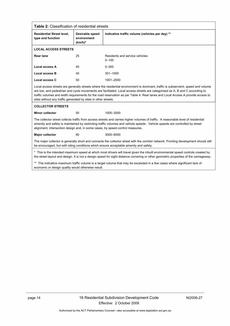
Table 2: Classification of residential streets
Residential Street level, type and function
Desirable speed environment (km/h)*
Indicative traffic volume (vehicles per day) **
LOCAL ACCESS STREETS
Rear lane 25 Residents and service vehicles: 0–100
Local access A 40 0–300
Local access B 40 301–1000
Local access C 50 1001–2000
Local access streets are generally streets where the residential environment is dominant, traffic is subservient, speed and volume are low, and pedestrian and cycle movements are facilitated. Local access streets are categorised as A, B and C according to traffic volumes and width requirements for the road reservation as per Table 4. Rear lanes and Local Access A provide access to sites without any traffic generated by sites in other streets.
COLLECTOR STREETS
Minor collector 50 1000–3000
The collector street collects traffic from access streets and carries higher volumes of traffic. A reasonable level of residential amenity and safety is maintained by restricting traffic volumes and vehicle speeds. Vehicle speeds are controlled by street alignment, intersection design and, in some cases, by speed-control measures.
Major collector 60 3000–6000
The major collector is generally short and connects the collector street with the corridor network. Fronting development should still be encouraged, but with siting conditions which ensure acceptable amenity and safety.
* This is the intended maximum speed at which most drivers will travel given the inbuilt environmental speed controls created by the street layout and design. It is not a design speed for sight distance cornering or other geometric properties of the carriageway.
** The indicative maximum traffic volume is a target volume that may be exceeded in a few cases where significant lack of economic or design quality would otherwise result.
NI2008-27 16 Residential Subdivision Development Code Effective: 2 October 2009
page 15
Authorised by the ACT Parliamentary Counsel—also accessible at www.legislation.act.gov.au
Table 3: Spacing of junctions along traffic routes
Minimum spacing of staggered junctions Road type Typical average junction spacing*
Left – right stagger Right – left stagger
Local access street
40 40 20
Collector (minor)
40 40 20
Collector (major)
80 40 20
2-lane sub-arterial
100 60 30
3-lane sub-arterial
100 100 30
Divided sub-arterial
150 150 50
Divided arterial
150 150 50
Divided major arterial
200 150 50
* The typical average junction spacing relates to the total number of junctions along both sides of the specified traffic route. Each crossroad counts as one junction. A right–left stagger on a three-lane sub-arterial of higher road also counts as one junction. Other junctions may form T-junctions or allow only restricted vehicle movements.
Notes:
1. Median breaks on major arterials are generally spaced at 300 m, with a minimum of 150 m. A right–left stagger counts as a break.
2. Left-in and left-out turns may supplement crossroads and staggered junctions but should be avoided in greenfield subdivisions.
3. Four way intersections are permitted where intersection design and projected future traffic volumes meet AUSROADS recommended limits.
page 16 16 Residential Subdivision Development Code Effective: 2 October 2009
NI2008-27
Authorised by the ACT Parliamentary Counsel—also accessible at www.legislation.act.gov.au
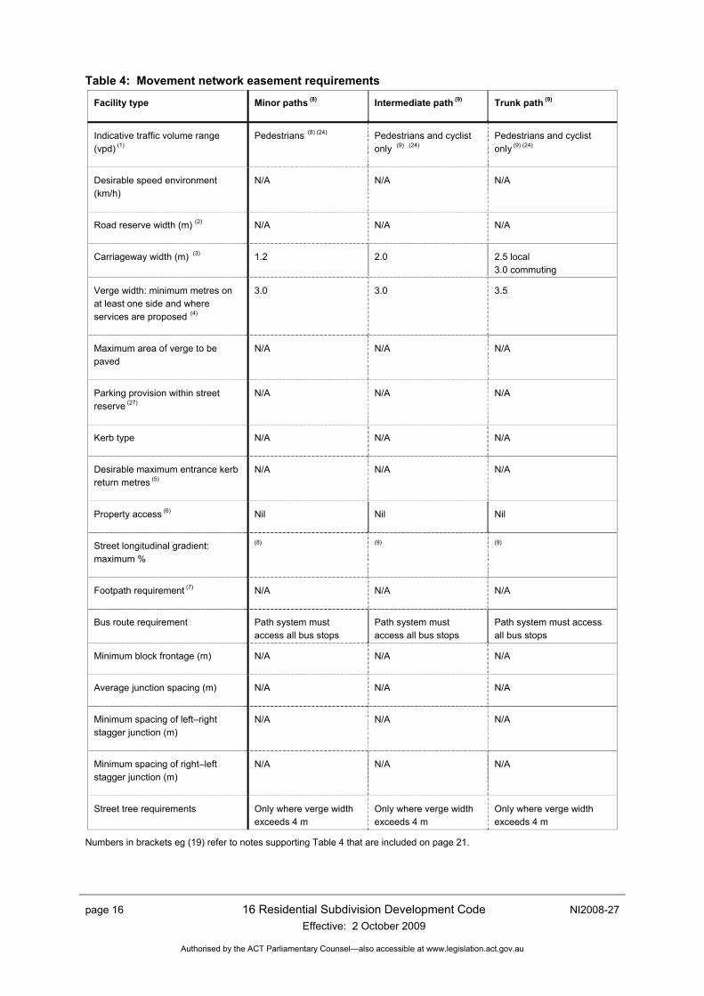
Table 4: Movement network easement requirements
Facility type
Minor paths (8) Intermediate path (9) Trunk path (9)
Indicative traffic volume range (vpd) (1)
Pedestrians (8) (24) Pedestrians and cyclist only (9) (24)
Pedestrians and cyclist only (9) (24)
Desirable speed environment (km/h)
N/A N/A N/A
Road reserve width (m) (2)
N/A N/A N/A
Carriageway width (m) (3)
1.2 2.0 2.5 local 3.0 commuting
Verge width: minimum metres on at least one side and where services are proposed (4)
3.0 3.0 3.5
Maximum area of verge to be paved
N/A N/A N/A
Parking provision within street reserve (27)
N/A N/A N/A
Kerb type
N/A N/A N/A
Desirable maximum entrance kerb return metres (5)
N/A N/A N/A
Property access (6)
Nil Nil Nil
Street longitudinal gradient: maximum %
(8) (9) (9)
Footpath requirement (7)
N/A N/A N/A
Bus route requirement
Path system must access all bus stops
Path system must access all bus stops
Path system must access all bus stops
Minimum block frontage (m)
N/A N/A N/A
Average junction spacing (m)
N/A N/A N/A
Minimum spacing of left–right stagger junction (m)
N/A N/A N/A
Minimum spacing of right–left stagger junction (m)
N/A N/A N/A
Street tree requirements
Only where verge width exceeds 4 m
Only where verge width exceeds 4 m
Only where verge width exceeds 4 m
Numbers in brackets eg (19) refer to notes supporting Table 4 that are included on page 21.
NI2008-27 16 Residential Subdivision Development Code Effective: 2 October 2009
page 17
Authorised by the ACT Parliamentary Counsel—also accessible at www.legislation.act.gov.au
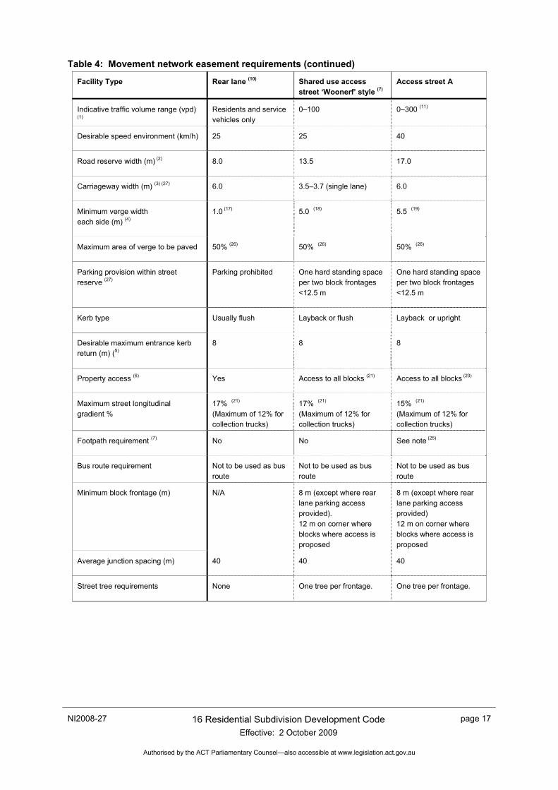
Table 4: Movement network easement requirements (continued)
Facility Type Rear lane (10) Shared use access street ‘Woonerf’ style (7)
Access street A
Indicative traffic volume range (vpd)
(1) Residents and service vehicles only
0–100 0–300 (11)
Desirable speed environment (km/h)
25 25 40
Road reserve width (m) (2)
8.0 13.5 17.0
Carriageway width (m) (3) (27)
6.0 3.5–3.7 (single lane) 6.0
Minimum verge width each side (m) (4)
1.0 (17) 5.0 (18) 5.5 (19)
Maximum area of verge to be paved
50% (26) 50% (26) 50% (26)
Parking provision within street reserve (27)
Parking prohibited One hard standing space per two block frontages <12.5 m
One hard standing space per two block frontages <12.5 m
Kerb type
Usually flush Layback or flush Layback or upright
Desirable maximum entrance kerb return (m) (5)
8 8 8
Property access (6)
Yes Access to all blocks (21) Access to all blocks (20)
Maximum street longitudinal gradient %
17% (21) (Maximum of 12% for collection trucks)
17% (21) (Maximum of 12% for collection trucks)
15% (21) (Maximum of 12% for collection trucks)
Footpath requirement (7)
No No See note (25)
Bus route requirement
Not to be used as bus route
Not to be used as bus route
Not to be used as bus route
Minimum block frontage (m)
N/A 8 m (except where rear lane parking access provided). 12 m on corner where blocks where access is proposed
8 m (except where rear lane parking access provided) 12 m on corner where blocks where access is proposed
Average junction spacing (m)
40 40 40
Street tree requirements
None One tree per frontage. One tree per frontage.
page 18 16 Residential Subdivision Development Code Effective: 2 October 2009
NI2008-27
Authorised by the ACT Parliamentary Counsel—also accessible at www.legislation.act.gov.au
Table 4: Movement network easement requirements (continued)
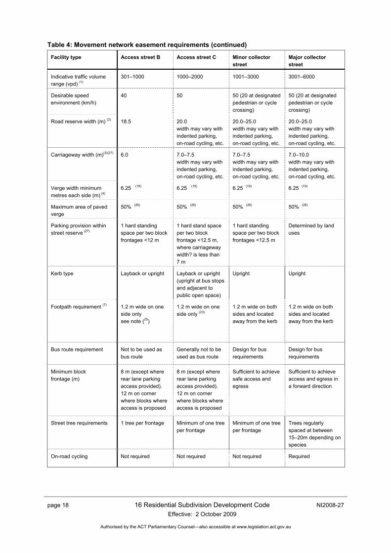
Facility type Access street B Access street C Minor collector street
Major collector street
Indicative traffic volume range (vpd) (1)
301–1000 1000–2000 1001–3000 3001–6000
Desirable speed environment (km/h)
40 50 50 (20 at designated pedestrian or cycle crossing)
50 (20 at designated pedestrian or cycle crossing)
Road reserve width (m) (2) 18.5 20.0 width may vary with indented parking, on-road cycling, etc.
20.0–25.0 width may vary with indented parking, on-road cycling, etc.
20.0–25.0 width may vary with indented parking, on-road cycling, etc.
Carriageway width (m)(3)(27) 6.0 7.0–7.5 width may vary with indented parking, on-road cycling, etc.
7.0–7.5 width may vary with indented parking, on-road cycling, etc.
7.0–10.0 width may vary with indented parking, on-road cycling, etc.
Verge width minimum metres each side (m) (4)
6.25 (19) 6.25 (19) 6.25 (19) 6.25 (19)
Maximum area of paved verge
50% (26) 50% (26) 50% (26) 50% (26)
Parking provision within street reserve (27)
1 hard standing space per two block frontages <12 m
1 hard stand space per two block frontage <12.5 m, where carriageway width? is less than 7 m
1 hard standing space per two block frontages <12.5 m
Determined by land uses
Kerb type Layback or upright Layback or upright (upright at bus stops and adjacent to public open space)
Upright Upright
Footpath requirement (7) 1.2 m wide on one side only see note (25)
1.2 m wide on one side only (23)
1.2 m wide on both sides and located away from the kerb
1.2 m wide on both sides and located away from the kerb
Bus route requirement Not to be used as bus route
Generally not to be used as bus route
Design for bus requirements
Design for bus requirements
Minimum block frontage (m)
8 m (except where rear lane parking access provided). 12 m on corner where blocks where access is proposed
8 m (except where rear lane parking access provided). 12 m on corner where blocks where access is proposed
Sufficient to achieve safe access and egress
Sufficient to achieve access and egress in a forward direction
Street tree requirements
1 tree per frontage Minimum of one tree per frontage
Minimum of one tree per frontage
Trees regularly spaced at between 15–20m depending on species
On-road cycling Not required Not required Not required Required
NI2008-27 16 Residential Subdivision Development Code Effective: 2 October 2009
page 19
Authorised by the ACT Parliamentary Counsel—also accessible at www.legislation.act.gov.au
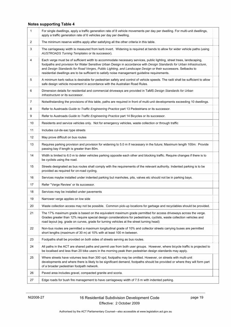
Notes supporting Table 4 1 For single dwellings, apply a traffic generation rate of 8 vehicle movements per day per dwelling. For multi-unit dwellings,
apply a traffic generation rate of 6 vehicles per day per dwelling.
2 The minimum reserve widths apply after satisfying all the other criteria in this table.
3 The carriageway width is measured from kerb invert. Widening is required at bends to allow for wider vehicle paths (using AUSTROADS Turning Templates or its successor).
4 Each verge must be of sufficient width to accommodate necessary services, public lighting, street trees, landscaping, footpaths and provision for Water Sensitive Urban Design in accordance with Design Standards for Urban Infrastructure, and Design Standards for Road Verges, Public Lighting, and Landscape Design or their successors. Setbacks to residential dwellings are to be sufficient to satisfy noise management guideline requirements.
5 A minimum kerb radius is desirable for pedestrian safety and control of vehicle speeds. The radii shall be sufficient to allow safe design vehicle movement in accordance with the Australian Road Rules.
6 Dimension details for residential and commercial driveways are provided in TaMS Design Standards for Urban Infrastructure or its successor.
7 Notwithstanding the provisions of this table, paths are required in front of multi-unit developments exceeding 10 dwellings.
8 Refer to Austroads Guide to Traffic Engineering Practice part 13 Pedestrians or its successor.
9 Refer to Austroads Guide to Traffic Engineering Practice part 14 Bicycles or its successor.
10 Residents and service vehicles only. Not for emergency vehicles, waste collection or through traffic
11 Includes cul-de-sac type streets
12 May prove difficult on bus routes
13 Requires parking provision and provision for widening to 5.0 m if necessary in the future; Maximum length 100m: Provide passing bay if length is greater than 80m.
14 Width is limited to 6.0 m to deter vehicles parking opposite each other and blocking traffic. Require changes if there is to be cyclists using the road.
15 Streets designated as bus routes shall comply with the requirements of the relevant authority. Indented parking is to be provided as required for on-road cycling.
16 Services maybe installed under indented parking but manholes, pits, valves etc should not be in parking bays.
17 Refer '’Verge Review’ or its successor.
18 Services may be installed under pavements
19 Narrower verge applies on low side
20 Waste collection access may not be possible. Common pick-up locations for garbage and recyclables should be provided.
21 The 17% maximum grade is based on the equivalent maximum grade permitted for access driveways across the verge. Grades greater than 12% require special design considerations for pedestrians, cyclists, waste collection vehicles and road layout (eg. grade on curves, grade for turning vehicles at the street turning head)
22 Non-bus routes are permitted a maximum longitudinal grade of 10% and collector streets carrying buses are permitted short lengths (maximum of 30 m) at 10% with at least 100 m between.
23 Footpaths shall be provided on both sides of streets serving as bus routes.
24 All paths in the ACT are shared paths and permit use from both user groups. However, where bicycle traffic is projected to be localised and less than 20 bike users in the morning peak then pedestrian design standards may apply.
25 Where streets have volumes less than 300 vpd, footpaths may be omitted. However, on streets with multi-unit developments and where there is likely to be significant demand, footpaths should be provided or where they will form part of a broader pedestrian footpath network.
26 Paved area includes gravel, compacted granite and scoria.
27 Edge roads for bush fire management to have carriageway width of 7.5 m with indented parking.
page 20 16 Residential Subdivision Development Code Effective: 2 October 2009
NI2008-27
Authorised by the ACT Parliamentary Counsel—also accessible at www.legislation.act.gov.au
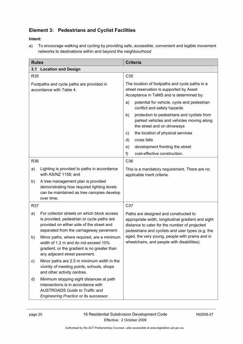
Element 3: Pedestrians and Cyclist Facilities Intent: a) To encourage walking and cycling by providing safe, accessible, convenient and legible movement
networks to destinations within and beyond the neighbourhood
Rules Criteria 3.1 Location and Design R35
Footpaths and cycle paths are provided in accordance with Table 4.
C35
The location of footpaths and cycle paths in a street reservation is supported by Asset Acceptance in TaMS and is determined by:
a) potential for vehicle, cycle and pedestrian conflict and safety hazards
b) protection to pedestrians and cyclists from parked vehicles and vehicles moving along the street and on driveways
c) the location of physical services
d) cross falls
e) development fronting the street
f) cost-effective construction.
R36
a) Lighting is provided to paths in accordance with AS/NZ 1158; and
b) A tree management plan is provided demonstrating how required lighting levels can be maintained as tree canopies develop over time.
C36
This is a mandatory requirement. There are no applicable merit criteria.
R37
a) For collector streets on which block access is provided, pedestrian or cycle paths are provided on either side of the street and separated from the carriageway pavement.
b) Minor paths, where required, are a minimum width of 1.2 m and do not exceed 10% gradient, or the gradient is no greater than any adjacent street pavement.
c) Minor paths are 2.5 m minimum width in the vicinity of meeting points, schools, shops and other activity centres.
d) Minimum stopping sight distances at path intersections is in accordance with AUSTROADS Guide to Traffic and Engineering Practice or its successor.
C37
Paths are designed and constructed to appropriate width, longitudinal gradient and sight distance to cater for the number of projected pedestrians and cyclists and user types (e.g. the aged, the very young, people with prams and in wheelchairs, and people with disabilities).
NI2008-27 16 Residential Subdivision Development Code Effective: 2 October 2009
page 21
Authorised by the ACT Parliamentary Counsel—also accessible at www.legislation.act.gov.au
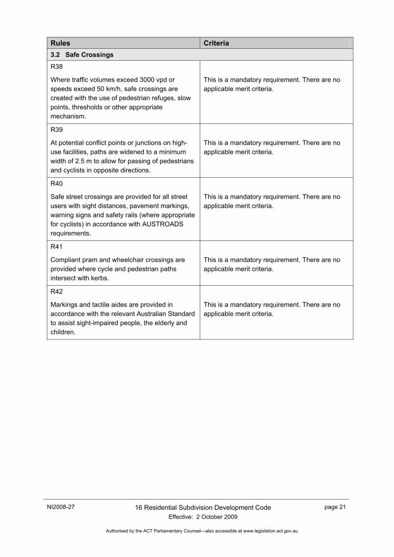
Rules Criteria 3.2 Safe Crossings
R38
Where traffic volumes exceed 3000 vpd or speeds exceed 50 km/h, safe crossings are created with the use of pedestrian refuges, slow points, thresholds or other appropriate mechanism.
This is a mandatory requirement. There are no applicable merit criteria.
R39
At potential conflict points or junctions on high-use facilities, paths are widened to a minimum width of 2.5 m to allow for passing of pedestrians and cyclists in opposite directions.
This is a mandatory requirement. There are no applicable merit criteria.
R40
Safe street crossings are provided for all street users with sight distances, pavement markings, warning signs and safety rails (where appropriate for cyclists) in accordance with AUSTROADS requirements.
This is a mandatory requirement. There are no applicable merit criteria.
R41
Compliant pram and wheelchair crossings are provided where cycle and pedestrian paths intersect with kerbs.
This is a mandatory requirement. There are no applicable merit criteria.
R42
Markings and tactile aides are provided in accordance with the relevant Australian Standard to assist sight-impaired people, the elderly and children.
This is a mandatory requirement. There are no applicable merit criteria.
page 22 16 Residential Subdivision Development Code Effective: 2 October 2009
NI2008-27
Authorised by the ACT Parliamentary Counsel—also accessible at www.legislation.act.gov.au
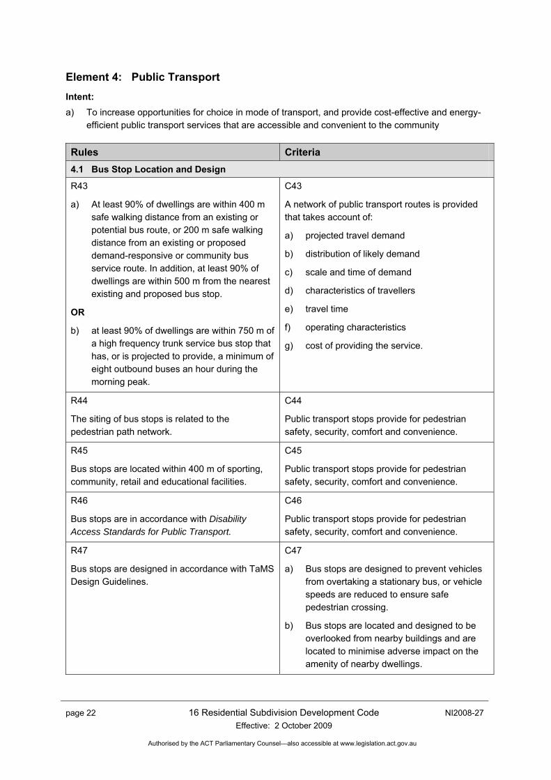
Element 4: Public Transport Intent: a) To increase opportunities for choice in mode of transport, and provide cost-effective and energy-
efficient public transport services that are accessible and convenient to the community
Rules Criteria 4.1 Bus Stop Location and Design
R43
a) At least 90% of dwellings are within 400 m safe walking distance from an existing or potential bus route, or 200 m safe walking distance from an existing or proposed demand-responsive or community bus service route. In addition, at least 90% of dwellings are within 500 m from the nearest existing and proposed bus stop.
OR
b) at least 90% of dwellings are within 750 m of a high frequency trunk service bus stop that has, or is projected to provide, a minimum of eight outbound buses an hour during the morning peak.
C43
A network of public transport routes is provided that takes account of:
a) projected travel demand
b) distribution of likely demand
c) scale and time of demand
d) characteristics of travellers
e) travel time
f) operating characteristics
g) cost of providing the service.
R44
The siting of bus stops is related to the pedestrian path network.
C44
Public transport stops provide for pedestrian safety, security, comfort and convenience.
R45
Bus stops are located within 400 m of sporting, community, retail and educational facilities.
C45
Public transport stops provide for pedestrian safety, security, comfort and convenience.
R46
Bus stops are in accordance with Disability Access Standards for Public Transport.
C46
Public transport stops provide for pedestrian safety, security, comfort and convenience.
R47
Bus stops are designed in accordance with TaMS Design Guidelines.
C47
a) Bus stops are designed to prevent vehicles from overtaking a stationary bus, or vehicle speeds are reduced to ensure safe pedestrian crossing.
b) Bus stops are located and designed to be overlooked from nearby buildings and are located to minimise adverse impact on the amenity of nearby dwellings.
NI2008-27 16 Residential Subdivision Development Code Effective: 2 October 2009
page 23
Authorised by the ACT Parliamentary Counsel—also accessible at www.legislation.act.gov.au
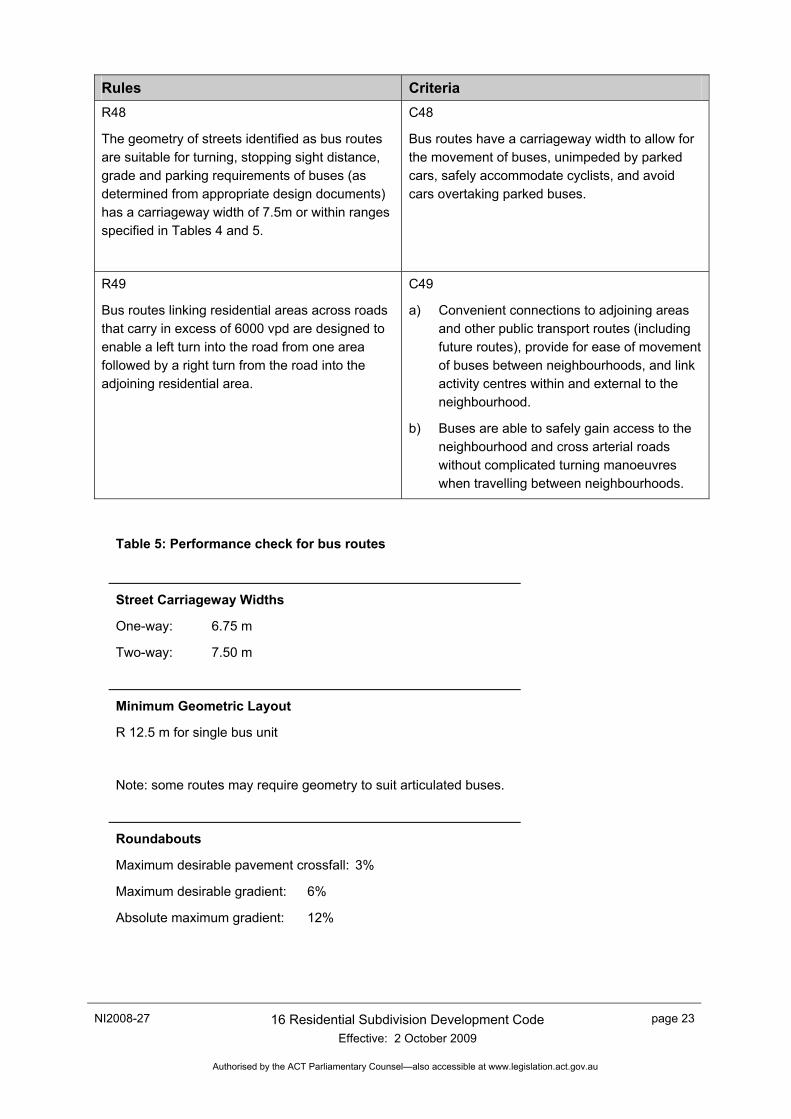
Rules Criteria R48
The geometry of streets identified as bus routes are suitable for turning, stopping sight distance, grade and parking requirements of buses (as determined from appropriate design documents) has a carriageway width of 7.5m or within ranges specified in Tables 4 and 5.
C48
Bus routes have a carriageway width to allow for the movement of buses, unimpeded by parked cars, safely accommodate cyclists, and avoid cars overtaking parked buses.
R49
Bus routes linking residential areas across roads that carry in excess of 6000 vpd are designed to enable a left turn into the road from one area followed by a right turn from the road into the adjoining residential area.
C49
a) Convenient connections to adjoining areas and other public transport routes (including future routes), provide for ease of movement of buses between neighbourhoods, and link activity centres within and external to the neighbourhood.
b) Buses are able to safely gain access to the neighbourhood and cross arterial roads without complicated turning manoeuvres when travelling between neighbourhoods.
Table 5: Performance check for bus routes
Street Carriageway Widths
One-way: 6.75 m
Two-way: 7.50 m
Minimum Geometric Layout
R 12.5 m for single bus unit
Note: some routes may require geometry to suit articulated buses.
Roundabouts
Maximum desirable pavement crossfall: 3%
Maximum desirable gradient: 6%
Absolute maximum gradient: 12%
page 24 16 Residential Subdivision Development Code Effective: 2 October 2009
NI2008-27
Authorised by the ACT Parliamentary Counsel—also accessible at www.legislation.act.gov.au
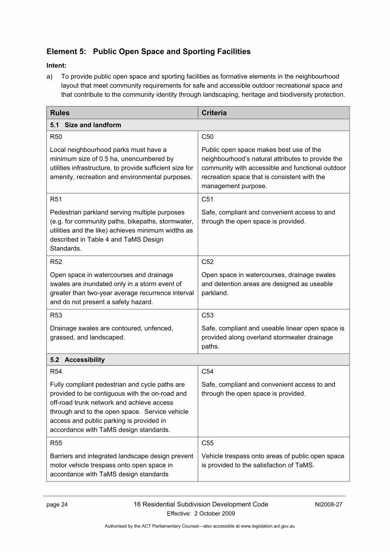
Element 5: Public Open Space and Sporting Facilities Intent: a) To provide public open space and sporting facilities as formative elements in the neighbourhood
layout that meet community requirements for safe and accessible outdoor recreational space and that contribute to the community identity through landscaping, heritage and biodiversity protection.
Rules Criteria 5.1 Size and landform
R50
Local neighbourhood parks must have a minimum size of 0.5 ha, unencumbered by utilities infrastructure, to provide sufficient size for amenity, recreation and environmental purposes.
C50
Public open space makes best use of the neighbourhood’s natural attributes to provide the community with accessible and functional outdoor recreation space that is consistent with the management purpose.
R51
Pedestrian parkland serving multiple purposes (e.g. for community paths, bikepaths, stormwater, utilities and the like) achieves minimum widths as described in Table 4 and TaMS Design Standards.
C51
Safe, compliant and convenient access to and through the open space is provided.
R52
Open space in watercourses and drainage swales are inundated only in a storm event of greater than two-year average recurrence interval and do not present a safety hazard.
C52
Open space in watercourses, drainage swales and detention areas are designed as useable parkland.
R53
Drainage swales are contoured, unfenced, grassed, and landscaped.
C53
Safe, compliant and useable linear open space is provided along overland stormwater drainage paths.
5.2 Accessibility
R54
Fully compliant pedestrian and cycle paths are provided to be contiguous with the on-road and off-road trunk network and achieve access through and to the open space. Service vehicle access and public parking is provided in accordance with TaMS design standards.
C54
Safe, compliant and convenient access to and through the open space is provided.
R55
Barriers and integrated landscape design prevent motor vehicle trespass onto open space in accordance with TaMS design standards
C55
Vehicle trespass onto areas of public open space is provided to the satisfaction of TaMS.
NI2008-27 16 Residential Subdivision Development Code Effective: 2 October 2009
page 25
Authorised by the ACT Parliamentary Counsel—also accessible at www.legislation.act.gov.au
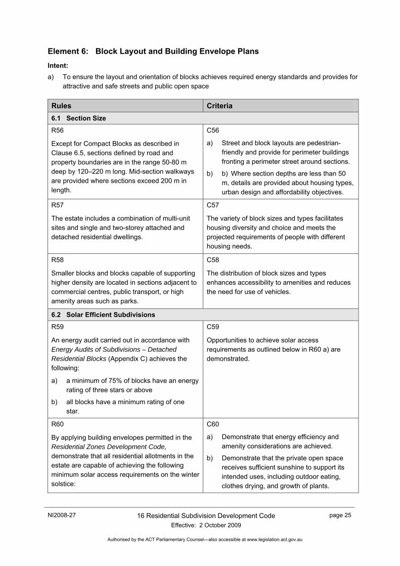
Element 6: Block Layout and Building Envelope Plans Intent: a) To ensure the layout and orientation of blocks achieves required energy standards and provides for
attractive and safe streets and public open space
Rules Criteria 6.1 Section Size
R56
Except for Compact Blocks as described in Clause 6.5, sections defined by road and property boundaries are in the range 50-80 m deep by 120–220 m long. Mid-section walkways are provided where sections exceed 200 m in length.
C56
a) Street and block layouts are pedestrian-friendly and provide for perimeter buildings fronting a perimeter street around sections.
b) b) Where section depths are less than 50 m, details are provided about housing types, urban design and affordability objectives.
R57
The estate includes a combination of multi-unit sites and single and two-storey attached and detached residential dwellings.
C57
The variety of block sizes and types facilitates housing diversity and choice and meets the projected requirements of people with different housing needs.
R58
Smaller blocks and blocks capable of supporting higher density are located in sections adjacent to commercial centres, public transport, or high amenity areas such as parks.
C58
The distribution of block sizes and types enhances accessibility to amenities and reduces the need for use of vehicles.
6.2 Solar Efficient Subdivisions
R59
An energy audit carried out in accordance with Energy Audits of Subdivisions – Detached Residential Blocks (Appendix C) achieves the following:
a) a minimum of 75% of blocks have an energy rating of three stars or above
b) all blocks have a minimum rating of one star.
C59
Opportunities to achieve solar access requirements as outlined below in R60 a) are demonstrated.
R60
By applying building envelopes permitted in the Residential Zones Development Code, demonstrate that all residential allotments in the estate are capable of achieving the following minimum solar access requirements on the winter solstice:
C60
a) Demonstrate that energy efficiency and amenity considerations are achieved.
b) Demonstrate that the private open space receives sufficient sunshine to support its intended uses, including outdoor eating, clothes drying, and growth of plants.
page 26 16 Residential Subdivision Development Code Effective: 2 October 2009
NI2008-27
Authorised by the ACT Parliamentary Counsel—also accessible at www.legislation.act.gov.au
Rules Criteria a) north-facing, habitable rooms achieve a
minimum of three hours of direct sunlight onto the floor or wall of the main daytime living area between 9.00 am and 3.00 pm on 21 June.
b) 50% of the private open space achieves at least three hours of direct sunlight between 9.00 am and 3.00 pm over private open space.
6.3 Multi-unit Sites
R61
Multi-unit sites are located within 200 m of a commercial zone, public transport node, or public open space.
C61
Multi unit sites are located within walking distance of key focal areas of the suburb such as commercial areas, open space and public transport.
R62
Sites for multi-unit development sit within a public road layout that provides similar address and frontage opportunities as the urban structure for single residential blocks.
C62
Multi unit sites exist within the legible road structure of the neighbourhood.
R63
When providing access to more than four attached dwellings, shared driveways run east–west and maximise solar access to dwellings.
C63
Site planning allows living areas and private open space to have good solar access.
R64
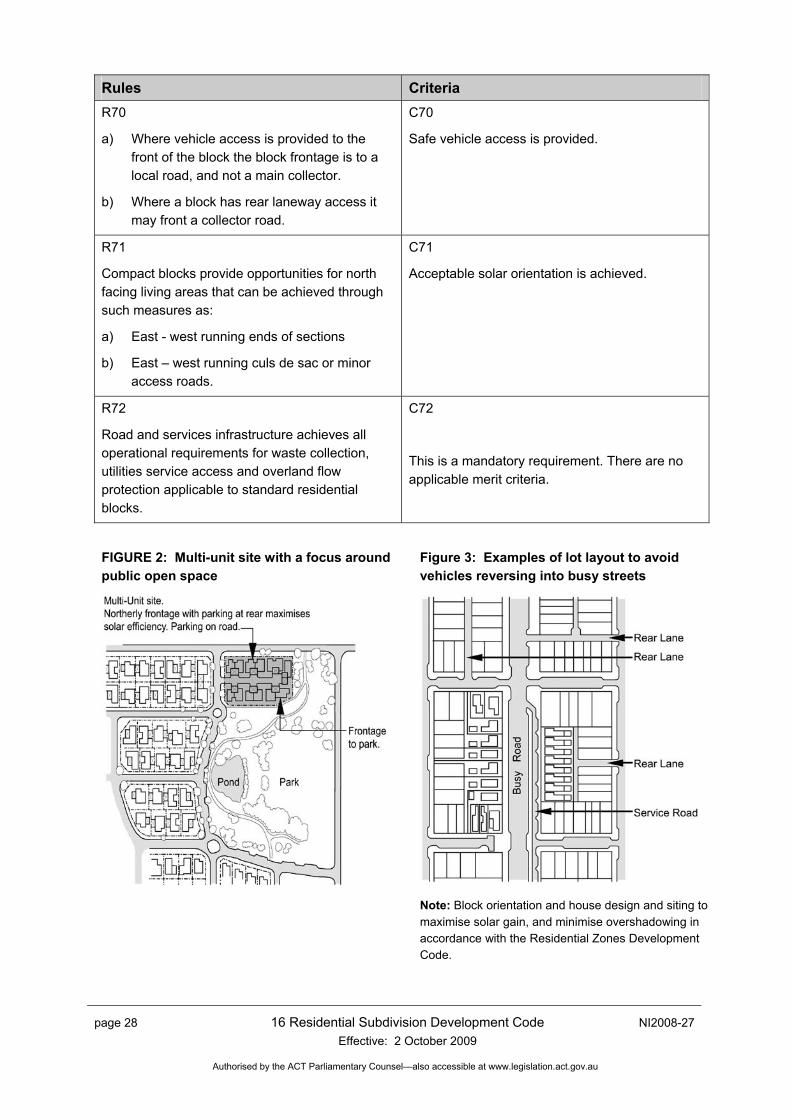
Units are sited around a central court with individual dwellings facing the surrounding streets or open space as shown in Figure 2.
C64
Units address public streets or open space. Continuous rear fencing along public roads is avoided.
R65
Where internal private roads maintained by the body corporate accommodate more than 300 vehicle movements a day, the roads are developed with the same opportunities for on-street parking, pedestrian paths, verge landscaping and Water Sensitive Urban Design as the public roads described in Table 4.
C65
The development achieves safety, amenity and functionality through the design of the internal roads.
NI2008-27 16 Residential Subdivision Development Code Effective: 2 October 2009
page 27
Authorised by the ACT Parliamentary Counsel—also accessible at www.legislation.act.gov.au
Rules Criteria 6.4 Security, Surveillance, Safety, and Amenity R66
Where blocks adjoin streets with traffic volumes in excess of 3000 vpd, the block layout achieves one or more of the following:
a) Incorporates service roads or rear lane access adjacent to busier arterial roads;
b) Uses battle-axe blocks to provide vehicle access from a side or rear street;
c) Provides pedestrian access to the busy road where vehicle access is not provided;
d) Arranges blocks to side onto busier streets with vehicle access from a side street;
e) Where road safety standards are met, on-street parking is provided;
f) Provides for forward exit from garages and driveways for larger blocks; or
g) Incorporates shared driveways to garages at the rear of the blocks to facilitate exit in a forwards direction.
C66
Block size and layout facilitates safe vehicular access and egress to busy streets. Possible techniques are illustrated in Figure 3.
R67
a) Blocks front streets or public open space.
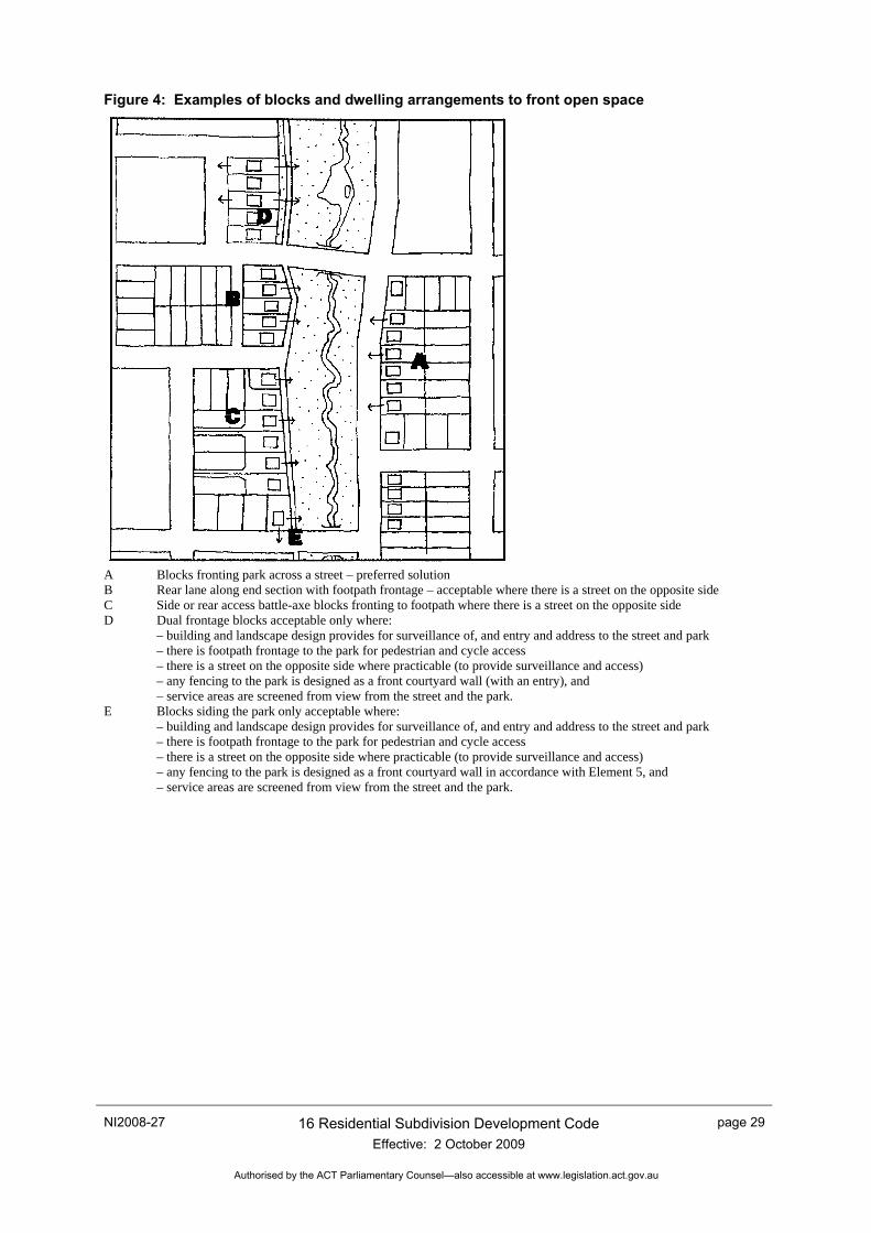
b) Where blocks abut public open space the principles described in Figure 4 are applied.
C67
Blocks are set out so that buildings on them are oriented to front streets or open spaces to contribute to the quality of the public domain, to provide good amenity for residents, and to facilitate personal and property security, deterrence of crime and vandalism of footpaths and public open space.
R68
Battle-axe blocks are used only where they:
a) front parks, natural areas or recreation areas such as golf courses
b) provide frontage to major roads.
c) are necessary to provide vehicle access to sloping sites.
C68
This is a mandatory requirement. There are no applicable merit criteria.
6.5 Compact blocks (defined as blocks having a site area of 250m2 or less) R69
Compact blocks are located:
a) Opposite parkland open space; or
b) Within 100m of parkland open space; or
c) Adjacent to a minimum 10m wide verge.
C69
This is a mandatory requirement. There are no applicable merit criteria.
page 28 16 Residential Subdivision Development Code Effective: 2 October 2009
NI2008-27
Authorised by the ACT Parliamentary Counsel—also accessible at www.legislation.act.gov.au
Rules Criteria R70
a) Where vehicle access is provided to the front of the block the block frontage is to a local road, and not a main collector.
b) Where a block has rear laneway access it may front a collector road.
C70
Safe vehicle access is provided.
R71
Compact blocks provide opportunities for north facing living areas that can be achieved through such measures as:
a) East - west running ends of sections
b) East – west running culs de sac or minor access roads.
C71
Acceptable solar orientation is achieved.
R72
Road and services infrastructure achieves all operational requirements for waste collection, utilities service access and overland flow protection applicable to standard residential blocks.
C72
This is a mandatory requirement. There are no applicable merit criteria.
FIGURE 2: Multi-unit site with a focus around public open space
Figure 3: Examples of lot layout to avoid vehicles reversing into busy streets
Note: Block orientation and house design and siting to maximise solar gain, and minimise overshadowing in accordance with the Residential Zones Development Code.
NI2008-27 16 Residential Subdivision Development Code Effective: 2 October 2009
page 29
Authorised by the ACT Parliamentary Counsel—also accessible at www.legislation.act.gov.au
Figure 4: Examples of blocks and dwelling arrangements to front open space
A Blocks fronting park across a street – preferred solution B Rear lane along end section with footpath frontage – acceptable where there is a street on the opposite side C Side or rear access battle-axe blocks fronting to footpath where there is a street on the opposite side D Dual frontage blocks acceptable only where: – building and landscape design provides for surveillance of, and entry and address to the street and park – there is footpath frontage to the park for pedestrian and cycle access – there is a street on the opposite side where practicable (to provide surveillance and access) – any fencing to the park is designed as a front courtyard wall (with an entry), and – service areas are screened from view from the street and the park. E Blocks siding the park only acceptable where: – building and landscape design provides for surveillance of, and entry and address to the street and park – there is footpath frontage to the park for pedestrian and cycle access – there is a street on the opposite side where practicable (to provide surveillance and access) – any fencing to the park is designed as a front courtyard wall in accordance with Element 5, and – service areas are screened from view from the street and the park.
page 30 16 Residential Subdivision Development Code Effective: 2 October 2009
NI2008-27
Authorised by the ACT Parliamentary Counsel—also accessible at www.legislation.act.gov.au
Element 7: Utilities, Waste Management and Sediment and Erosion Control Intent: a) To ensure that residential areas are adequately serviced with sewerage, water, stormwater, fire-
fighting, electricity, gas, street lighting and communication services in a timely, cost-effective, coordinated and efficient manner that supports sustainable development practices and asset maintenance needs and to promote the use of road verges or other public land for the provision of reticulated services where topography and other site constraints allow.
Rules Criteria 7.1 Viability of Services
R73
Land development occurs only where adequate stormwater, sewerage and water supplies for domestic and fire-fighting purposes can be provided and maintained in accordance with utility codes and standards made under or in accordance with ACT law.
C73
This is a mandatory requirement. There are no applicable merit criteria.
7.2 Utility Services on Leased and Unleased Land
R74
a) Utility services comply with utility standards.
b) Subject to agreement between the land manager and utility provider, water, electricity, gas and communication services are located within road reservations or other Territory Land that is, and is to remain, unleased.
c) Subject to agreement between the proponent and the utility provider, and for the purpose of maximising land utilisation, preference is given to locating sewage and stormwater services within road reservations, or other Territory Land that is, and is to remain, unleased.
C74
This is a mandatory requirement. There are no applicable merit criteria.
NI2008-27 16 Residential Subdivision Development Code Effective: 2 October 2009
page 31
Authorised by the ACT Parliamentary Counsel—also accessible at www.legislation.act.gov.au
Rules Criteria R75
a) Where utility standards require sewerage and stormwater services to be located within leased blocks, those services:
i) are contained within service reservations and accessed by means of utility, emergency or maintenance access routes complying with Figures 5 and 6 and Table 7
ii) are on a block of sufficient size to accommodate service reservations and utility access routes, whilst providing comparable building footprint area to similar but unencumbered blocks
iii) where possible, are located in service reservations directly accessible from unleased Territory Land
iv) where possible, are co-located with private open space to maximise land utilisation
C75
This is a mandatory requirement. There are no applicable merit criteria
7.3 Shared Trenching
R76
Compatible minor service reticulation in the road verge may be located in shared trenching where permitted by utility standards.
This is a mandatory requirement. There is no applicable criterion.
R77
Written acceptance of service reservation alignments has been provided by Territory and Municipal Services (TaMS) and other relevant utility providers.
This is a mandatory requirement. There is no applicable criterion.
7.4 Width of Service Reservations and Service Access Elements
R78
All sewerage and stormwater reticulation on land that is to be leased is located in a service reservation. The widths of service reservations are agreed by the utility provider and comply with the relevant section of Table 6. More than one easement may be required, as is shown in Figure 6..
This is a mandatory requirement. There is no applicable criterion.
page 32 16 Residential Subdivision Development Code Effective: 2 October 2009
NI2008-27
Authorised by the ACT Parliamentary Counsel—also accessible at www.legislation.act.gov.au
Rules Criteria 7.5 Width of Service Reservation and Emergency Access to Minor Service Reticulation R79
Where service reservations for sewerage reticulation cannot be adequately accessed directly from public land, maintenance and emergency access routes are provided on each affected leased block to provide obstruction-free access from public land to the service reservation.
This is a mandatory requirement. There is no applicable criterion.
R80
The widths of maintenance and access routes are approved by the utility provider and comply with the relevant section of Table 6.
This is a mandatory requirement. There is no applicable criterion.
R81
Where corner blocks require service reservations in the rear corner, the service reservation is extended along a side boundary to link with the road verge as shown in Figure 5 and 6.
This is a mandatory requirement. There is no applicable criterion.
7.6 Separation of Private and Utility Services R82
Where the permissible footprints of buildings are located adjacent to a service reservation, the relevant service provider determines and provides written approval of the extent and width of a private service zone required for private stormwater and sanitary drains, electricity and communication cables, gas, water and irrigation pipes associated with the development of the lease. This zone is documented in the EDP to provide adequate separation of private services from utility assets, and to prevent damage to private services when the utility is repairing or replacing its assets (see Figure 5). More than one private service zone may be required.
This is a mandatory requirement. There is no applicable criterion.
7.7 Recording Utility Access Requirements in Leases
R83
Where services are proposed to be included in leased land the proponent:
a) consults with each utility service provider during the preparation of the EDP and obtains written confirmation that the provider’s service reservations and maintenance and emergency access route requirements are included
This is a mandatory requirement. There is no applicable criterion.
NI2008-27 16 Residential Subdivision Development Code Effective: 2 October 2009
page 33
Authorised by the ACT Parliamentary Counsel—also accessible at www.legislation.act.gov.au
Rules Criteria b) provides a written undertaking that all
designated service reservations, maintenance and emergency access routes, and utility pipe protection envelops are recorded on the Deposited Plans that will be referred to in the subsequent leases in the manner shown in Appendix B
c) includes in the EDP the standard lease clauses applying to service reservations, maintenance and emergency access routes and utility pipe protection envelopes.
7.8 Design and Construction Qualifications
R84
Sewerage facilities, water supply mains, stormwater, electricity, communications services, gas and street lighting are designed by persons who are qualified by reference to codes and standards made under or in accordance with ACT law.
This is a mandatory requirement. There is no applicable criterion.
7.9 Overland Flow Paths for Sewage and Stormwater Spillage R85
Overland flow paths must be provided to ensure that surcharge of sewage or stormwater from utility network overflow points (such as manholes) or future residential sanitary drain overflow relief gullies, will not be obstructed by proposed building footprints and will comply with utility and residential plumbing standards.
This is a mandatory requirement. There is no corresponding merit criterion.
7.10 Location of Sewage and Stormwater Connections
R86
Unless specifically approved by the utility provider, the sewer and stormwater ties are at the low point of the block in accordance with utility standards.
This is a mandatory requirement. There is no corresponding merit criterion.
R87
a) Subject to agreement between the proponent and the utility provider, the sewer and stormwater ties may be located away from the low point.
b) Written approval is provided by TaMS and other utility service providers, and any special requirements imposed by the service authorities are incorporated in the design.
This is a mandatory requirement. There is no applicable criterion.
page 34 16 Residential Subdivision Development Code Effective: 2 October 2009
NI2008-27
Authorised by the ACT Parliamentary Counsel—also accessible at www.legislation.act.gov.au
Rules Criteria 7.11 Clearance Between Utility Equipment and Landscape Elements
R88
The location of and accessibility to meters, control valves, manholes and utility connections are acceptable to service providers and determined in accordance with utility standards to minimise conflict with proposed driveways, fencing, courtyard walls or other permanent paving, vegetation or structures mandated by the development.
This is a mandatory requirement. There is no applicable criterion.
7.12 Noise and odour buffer zones
R89
Buffer zones complying with utility requirements are provided between dwellings and utility service equipment such as sewer vents or pump stations to protect residential amenity from odour and noise nuisance. This buffer zone is agreed with the utility provider and documented in the EDP.
This is a mandatory requirement. There is no applicable criterion.
7.13 Waste management
R90
Waste management is in accordance with the latest version of the Development Control Code for Best Practice Waste Management in the ACT, TaMS 2006.
C90
Evidence is provided of industry acceptance of arrangements for the kerbside collection of residential waste from detached dwellings and for the internal collection of waste from multi-unit sites.
R91
In accordance with the Development Control Code for Best Practice Waste Management in the ACT (TaMS 2006), garbage collection vehicle access is provided as follows:
a) to mobile garbage bins for all single unit dwellings and multi unit and cluster developments up to and including 10 units.
b) to garbage hoppers in an approved structure for multi-unit sites in excess of 10 dwellings.
This is a mandatory requirement. There is no applicable criterion.
R92
Demolition waste leaving the site is diverted to a recycling or reprocessing operator for the particular type of waste material. Evidence of proper recycling, reprocessing or disposal is obtained and kept for 12 months after practical completion of the project.
This is a mandatory requirement. There is no applicable criterion.
NI2008-27 16 Residential Subdivision Development Code Effective: 2 October 2009
page 35
Authorised by the ACT Parliamentary Counsel—also accessible at www.legislation.act.gov.au
Rules Criteria 7.14 Sediment and Erosion Control Plan
R93
A Sediment and Erosion Control Concept Plan satisfies the requirements of the Environment Protection Authority.
This is a mandatory requirement. There is no applicable criterion.
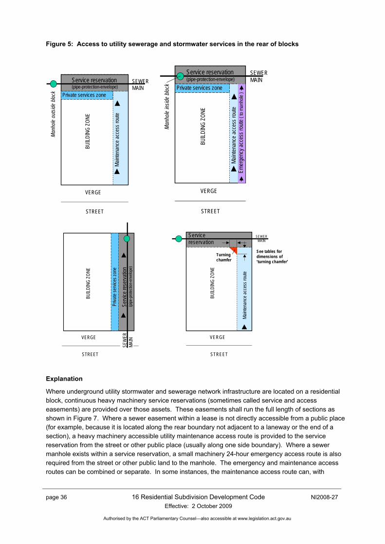
page 36 16 Residential Subdivision Development Code Effective: 2 October 2009
NI2008-27
Authorised by the ACT Parliamentary Counsel—also accessible at www.legislation.act.gov.au
Figure 5: Access to utility sewerage and stormwater services in the rear of blocks
SEWERMAIN
Maint
enan
ce ac
cess
route
VERGE
STREET
Private services zoneBU
ILDIN
G ZO
NE
Man
hole
outsi
deblo
ck
Service reservation(pipe-protection-envelope)
Service reservation(pipe-protection-envelope)
SEWERMAIN
Maint
enan
ce ac
cess
route
VERGE
STREET
Private services zone
BUILD
ING
ZONE
Man
hole
inside
block
Emer
genc
y acc
ess r
oute
( to m
anho
le )
SEW
ERMA
INVERGE
STREET
Priva
te se
rvice
s zon
e
BUILD
ING
ZONE
Servi
ce re
serva
tion
(pipe
-pro
tectio
n-en
velop
e)
SEWERMAIN
VERGE
STREET
BUILD
ING
ZONE
See tables for dimensions of‘turning chamfer’
Turningchamfer
Servicereservation
Maint
enan
ce ac
cess
route
Explanation
Where underground utility stormwater and sewerage network infrastructure are located on a residential block, continuous heavy machinery service reservations (sometimes called service and access easements) are provided over those assets. These easements shall run the full length of sections as shown in Figure 7. Where a sewer easement within a lease is not directly accessible from a public place (for example, because it is located along the rear boundary not adjacent to a laneway or the end of a section), a heavy machinery accessible utility maintenance access route is provided to the service reservation from the street or other public place (usually along one side boundary). Where a sewer manhole exists within a service reservation, a small machinery 24-hour emergency access route is also required from the street or other public land to the manhole. The emergency and maintenance access routes can be combined or separate. In some instances, the maintenance access route can, with
NI2008-27 16 Residential Subdivision Development Code Effective: 2 October 2009
page 37
Authorised by the ACT Parliamentary Counsel—also accessible at www.legislation.act.gov.au
consent from the relevant utility service provider, be through a garage (see ‘Additional requirements’ below), provided adequate passageway and vertical clearances can be provided as shown in Table 7.
Additional requirements:
Special footing designs may be required for structures sited adjacent to underground utility sewers, water mains and stormwater mains (located both within and outside the property boundaries). The relevant utility service provider may require engineering drawings and certification from a chartered engineer to confirm that the footings will not exert any load onto the sewerage main or water main and the structure will remain stable when the main is excavated for repair or replacement.
A private services zone is to be provided to allow sufficient space between the building and a service and access easement to lay private in-ground services and to deposit spoil from excavation works in the easement. Sanitary drains, plumbing, irrigation pipes, communication and electricity cables are not to be laid inside any service and access easement.
Where access from an adjacent walkway, parkland or another acceptable alternative access route can be provided to the rear of the property, plant access along the side boundary may not be required (subject to agreement of the relevant utility service provider).
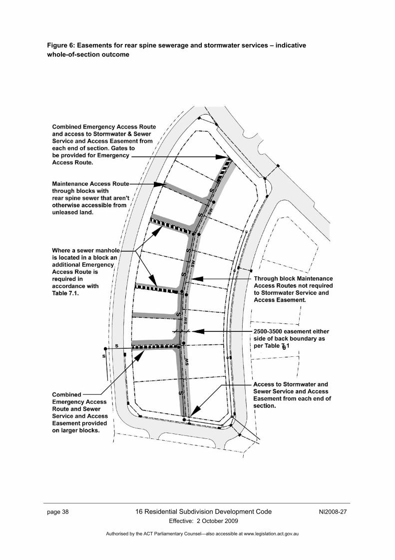
page 38 16 Residential Subdivision Development Code Effective: 2 October 2009
NI2008-27
Authorised by the ACT Parliamentary Counsel—also accessible at www.legislation.act.gov.au
Figure 6: Easements for rear spine sewerage and stormwater services – indicative whole-of-section outcome
6
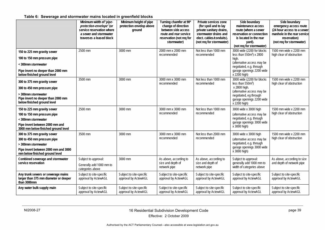
NI2008-27 16 Residential Subdivision Development Code Effective: 2 October 2009
page 39
Authorised by the ACT Parliamentary Counsel—also accessible at www.legislation.act.gov.au
Table 6: Sewerage and stormwater mains located in greenfield blocks
Minimum width of ‘pipe-protection-envelope’ (or
service reservation where a sewer and stormwater traverses a leased block
Minimum height of pipe protection envelop above
ground
Turning chamfer at 90º change of direction
between side access route and rear service
reservation (not req for stormwater)
Private services zone (for spoil and to lay
private sanitary drains, stormwater drains and elect. cables/conduits). (not req for stormwater)
Side boundary maintenance access route (where a sewer
reservation or connection is located in the rear
yard). (not req for stormwater)
Side boundary emergency access route
(24 hour access to a sewer manhole in the rear service
reservation) (not req for stormwater)
150 to 225 mm gravity sewer
100 to 150 mm pressure pipe
< 300mm stormwater
Pipe invert no deeper than 2000 mm below finished ground level
2500 mm 3000 mm 2000 mm x 2000 mm recommended
Not less than 1000 mm recommended
3000 wide (2200 for blocks less than 550m²) x 2800 high. (alternative access may be negotiated, e.g. through garage openings 2200 wide x 2200 high)
1500 mm wide x 2200 mm high clear of obstruction
300 to 375 mm gravity sewer
300 to 450 mm pressure pipe
> 300mm stormwater Pipe invert no deeper than 2000 mm below finished ground level
3500 mm 3000 mm 3000 mm x 3000 mm recommended
Not less than 1000 mm recommended
3000 wide (2200 for blocks less than 550m²) x 2800 high. (alternative access may be negotiated, eg through garage openings 2200 wide x 2200 high)
1500 mm wide x 2200 mm high clear of obstruction
150 to 225 mm gravity sewer 100 to 150 mm pressure pipe < 300mm stormwater Pipe invert between 2000 mm and 3000 mm below finished ground level
2500 mm 3000 mm 3000 mm x 3000 mm recommended
Not less than 1000 mm recommended
3000 wide x 3000 high (alternative access may be negotiated, e.g. through garage openings 3000 wide x 3000 high)
1500 mm wide x 2200 mm high clear of obstruction
300 to 375 mm gravity sewer 300 to 450 mm pressure pipe > 300mm stormwater Pipe invert between 2000 mm and 3000 mm below finished ground level
3500 mm 3000 mm 3000 mm x 3000 mm recommended
Not less than 2000 mm recommended
3000 wide x 3000 high (alternative access may be negotiated, e.g. through garage openings 3000 wide x 3000 high)
1500 mm wide x 2200 mm high clear of obstruction
Combined sewerage and stormwater service reservation
Subject to approval: Generally add 1000 mm to categories above
3000 mm As above, according to size and depth of network pipe
As above, according to size and depth of network pipe
Subject to approval: generally add 1000 mm to width of categories above
As above, according to size and depth of network pipe
Any trunk sewers or sewerage mains larger than 375 mm diameter or deeper than 3000mm
Subject to site-specific approval by ActewAGL
Subject to site-specific approval by ActewAGL
Subject to site-specific approval by ActewAGL
Subject to site-specific approval by ActewAGL
Subject to site-specific approval by ActewAGL
Subject to site-specific approval by ActewAGL
Any water bulk supply main
Subject to site-specific approval by ActewAGL
Subject to site-specific approval by ActewAGL
Subject to site-specific approval by ActewAGL
Subject to site-specific approval by ActewAGL
Subject to site-specific approval by ActewAGL
Subject to site-specific approval by ActewAGL
page 40 16 Residential Subdivision Development Code Effective: 2 October 2009
NI2008-27
Authorised by the ACT Parliamentary Counsel—also accessible at www.legislation.act.gov.au
Part B(2) – Additional requirements that apply when an Estate Development Plan is not supported by a Precinct Code
This subsection of the Code is to be used where an EDP is not supported by a Precinct Code.
Element 1: Neighbourhood Design Intent: a) To provide safe, convenient, accessible and attractive neighbourhoods that meet the diverse and
changing needs of the community This encompasses offering a wide choice in good quality housing and associated community and commercial facilities, providing for local employment opportunities, encouraging walking, cycling and use of public transport, minimising energy and water consumption, and promoting a sense of place through neighbourhood focal points and the creation of a distinctive identity that recognises and, where relevant, preserves the natural environment.
Rules Criteria 1.1 Structure and Composition
There is no applicable rule.
C94
The subdivision layout gives the residential environment a strong and positive identity by responding to site characteristics, setting, landmarks and views, and through the street and open space networks.
There is no applicable rule.
C95
The layout optimises the walkable access to centres, schools and public transport nodes through compact and legible transport networks.
R96
An energy audit carried out in accordance with Energy Audits of Subdivisions – Detached Residential Blocks (Appendix C) demonstrates the following:
a) at least 75% of blocks have an energy rating of three stars or above
b) all blocks have a minimum rating of one star.
C96
The street and block orientation and block dimensions facilitate the siting and design of dwellings that maximise use of passive solar energy to cost effectively achieve Building Code of Australia five-star rating.
There is no applicable rule.
C97
The block layout provides a mix of block sizes and enables a variety of good quality housing types and other compatible land uses.
NI2008-27 16 Residential Subdivision Development Code Effective: 2 October 2009
page 41
Authorised by the ACT Parliamentary Counsel—also accessible at www.legislation.act.gov.au
Rules Criteria
There is no applicable rule.
C98
The block layout provides for higher densities in areas close to services, public transport and public open space, or with high levels of amenity.
There is no applicable rule.
C99
The street and block layout provides well-distributed public open spaces that:
a) offer a range of uses and activities with clearly defined management objectives
b) are cost-effective to maintain
c) where appropriate, contribute to stormwater management and environmental care.
There is no applicable rule.
C100
Linear or regional open spaces are located to define the neighbourhood boundaries, except where internal open space spines connect elements of the neighbourhood and, where appropriate, provide community focal points.
There is no applicable rule.
C101
The urban structure takes into account the existing and proposed conditions on adjoining land and achieves the effective integration of the whole suburb.
1.2 Movement Networks
There is no applicable rule.
C102
The street network provides efficient internal accessibility and appropriate external connections for local vehicle, pedestrian and cycle movements, and for emergency and service and waste collection vehicles.
There is no applicable rule.
C103
The street network acknowledges safety objectives with road hierarchy and traffic management to restrain vehicle speed, deter through traffic, and create safe conditions for other road users and is appropriate for expected traffic.
page 42 16 Residential Subdivision Development Code Effective: 2 October 2009
NI2008-27
Authorised by the ACT Parliamentary Counsel—also accessible at www.legislation.act.gov.au
Rules Criteria
There is no applicable rule.
C104
The vehicle, cyclist, pedestrian networks, land use mix and block density minimise fossil fuel use by reducing local vehicle trips, travel distances and speeds, maximising public transport effectiveness, and encouraging walking and cycling to daily activities.
There is no applicable rule.
C105
The distribution and design of land uses minimises the whole-of-life infrastructure costs.
There is no applicable rule.
C106
Public transport, pedestrian and cycleways, and street networks complement each other and are accessible to people with disabilities, older people, and people with prams.
There is no applicable rule.
C107
The street network takes account of the topography and vegetation (including existing trees and regeneration), respects any existing or potential site assets, and takes advantage of opportunities for views and vistas.
1.3 Water Sensitive Urban Design
There is no applicable rule.
C108
The best practice urban water management techniques that are outlined in Water Sensitive Urban Design General Code are incorporated.
1.4 Bushfire Risk Mitigation
There is no applicable rule.
C109
Streets abutting areas of high bushfire hazard on the long-term urban edge or conservation area have been designed to the requirements of the Emergency Services Authority and ACTPLA, and provide emergency vehicle access, buffer zones, fence types and special building requirements as outlined in Planning for Bushfire Risk Mitigation General Code.
There is no applicable rule.
C110
An independently prepared bushfire risk assessment has been referred to the relevant authorities for comment ahead of the development application being determined by ACTPLA.
NI2008-27 16 Residential Subdivision Development Code Effective: 2 October 2009
page 43
Authorised by the ACT Parliamentary Counsel—also accessible at www.legislation.act.gov.au
Rules Criteria 1.5 Traffic Noise
There is no applicable rule.
C111
Long-term forecasts for traffic volumes have been taken into account and potential areas of excessive noise levels together with remediation techniques are identified in accordance with ACT Noise Management Guidelines or its successor.
There is no applicable rule.
C112
Achievement of an acceptable indoor noise level has been determined using the Australian Standard 3671 – Acoustics – Road traffic noise intrusion – building siting and construction. Techniques adopted to achieve these requirements may include a combination of:
a) building setback from the road
b) to acoustic barriers between buildings and road
c) building design that provides acoustic insulation.
1.6 Tree Protection
R113
All Exceptional, High, and Medium Value Trees are retained and protected in accordance with a tree management plan approved by the Conservator.
C113
Having regard to the advice from the Conservator, justification for tree removals is provided and forms part of the development application to be considered by the Authority.
1.7 Heritage Protection
R114
a) ACT Heritage has provided written confirmation that there are no sites within the development area that are either listed or nominated to the Heritage Register.
OR
b) Where a heritage site that has been listed or nominated to the Heritage Register is within a development area, a statement of compliance has been provided by the Heritage Council that confirms the proposal meets the requirements of the Heritage Act 2004.
This is a mandatory requirement. There is no applicable criterion.
page 44 16 Residential Subdivision Development Code Effective: 2 October 2009
NI2008-27
Authorised by the ACT Parliamentary Counsel—also accessible at www.legislation.act.gov.au
Rules Criteria 1.8 Contaminated Sites
R115
a) The EPA has provided written confirmation that there are no contaminated sites within the development area.
OR
b) Where a contaminated site(s) exists within a development area, an Environmental Site Assessment Report and Independent Audit as required by EPA has been endorsed by the EPA.
This is a mandatory requirement. There is no applicable criterion.
NI2008-27 16 Residential Subdivision Development Code Effective: 2 October 2009
page 45
Authorised by the ACT Parliamentary Counsel—also accessible at www.legislation.act.gov.au
Element 2: Street Networks Intent: a) To create street networks in which the function of each street is clearly identified, providing
acceptable levels of access, safety and convenience for all users
Rules Criteria 2.1 Traffic Impacts and Residential Amenity
There is no applicable rule.
C116
Traffic generated by a development is within the acceptable environmental capacity of the roads and streets.
There is no applicable rule.
C117
The street network is designed to reduce traffic speeds and volumes to acceptable levels, with most dwellings fronting streets having less than the maximum desirable traffic volume of 3000 vpd.
There is no applicable rule.
C118
Multiple entry and egress points are provided to the subdivision to distribute traffic flows, improve permeability, and meet needs for movement during an emergency.
There is no applicable rule.
C119
The street network takes account of natural drainage, overland flow paths, and open space systems.
There is no applicable rule.
C120
Road and block layout achieves the following objectives:
a) surveillance over public parks and conservation areas is maximised.
b) the street network is orientated to promote efficient solar access for dwellings.
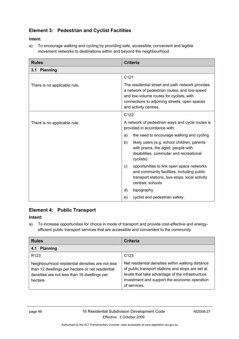
page 46 16 Residential Subdivision Development Code Effective: 2 October 2009
NI2008-27
Authorised by the ACT Parliamentary Counsel—also accessible at www.legislation.act.gov.au
Element 3: Pedestrian and Cyclist Facilities Intent: a) To encourage walking and cycling by providing safe, accessible, convenient and legible
movement networks to destinations within and beyond the neighbourhood
Rules Criteria 3.1 Planning
There is no applicable rule.
C121
The residential street and path network provides a network of pedestrian routes, and low-speed and low-volume routes for cyclists, with connections to adjoining streets, open spaces and activity centres.
There is no applicable rule.
C122
A network of pedestrian ways and cycle routes is provided in accordance with:
a) the need to encourage walking and cycling
b) likely users (e.g. school children, parents with prams, the aged, people with disabilities, commuter and recreational cyclists)
c) opportunities to link open space networks and community facilities, including public transport stations, bus stops, local activity centres, schools
d) topography
e) cyclist and pedestrian safety.
Element 4: Public Transport Intent: a) To increase opportunities for choice in mode of transport and provide cost-effective and energy-
efficient public transport services that are accessible and convenient to the community
Rules Criteria 4.1 Planning
R123
Neighbourhood residential densities are not less than 12 dwellings per hectare or net residential densities are not less than 16 dwellings per hectare.
C123
Net residential densities within walking distance of public transport stations and stops are set at levels that take advantage of the infrastructure investment and support the economic operation of services.

NI2008-27 16 Residential Subdivision Development Code Effective: 2 October 2009
page 47
Authorised by the ACT Parliamentary Counsel—also accessible at www.legislation.act.gov.au
Rules Criteria R124
Routes for regular bus services are designed in accordance with Table 5.
C124
The street network offers opportunities for cost-effective operation of demand-responsive services should the need arise, providing for both peak and off-peak regular services and the potential future provision of demand–responsive services.
There is no applicable rule.
C125
The alignment and geometry of the streets that form the bus route allow for the efficient and unimpeded movement of buses without facilitating high traffic speeds.
Element 5: Public Open Space and Sporting Facilities Intent: a) To provide public open space and sporting facilities as formative elements in the neighbourhood
layout that meet community requirements for safe and accessible outdoor recreational space and that contribute to the community identity through landscaping, heritage and biodiversity protection
Rules Criteria 5.1 Neighbourhood Design Focal Point
R126
To provide elements of the open space hierarchy in accordance in accordance with TaMS design standards 14 to 25.
C126
Open space provides public focal points for the neighbourhood with clearly defined management functions.
5.2 Identify Management Purpose
R127
Public open space is identified with the typical management objectives for each urban park and sportsground type as summarised in Tables 7 and 8 and as reflected in plans of management.
C127
Open space has a clear management purpose and is not formed from residual areas or used as buffers to incompatible development.
5.3 Open Space Hierarchy and Recreation Settings
There is no applicable rule.
C128
The provision of public open space is in accordance with management considerations and any relevant strategic plan of management prepared under the Land (Planning and Environment) Act 1991 for that district or area.
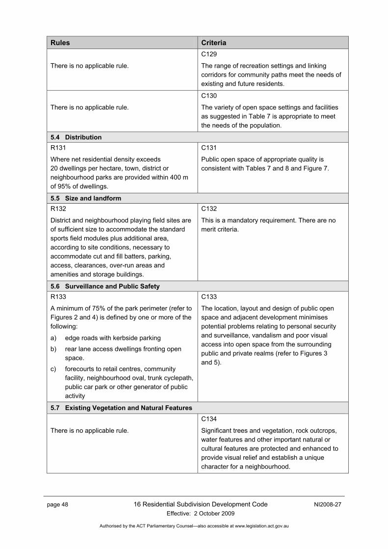
page 48 16 Residential Subdivision Development Code Effective: 2 October 2009
NI2008-27
Authorised by the ACT Parliamentary Counsel—also accessible at www.legislation.act.gov.au
Rules Criteria
There is no applicable rule.
C129
The range of recreation settings and linking corridors for community paths meet the needs of existing and future residents.
There is no applicable rule.
C130
The variety of open space settings and facilities as suggested in Table 7 is appropriate to meet the needs of the population.
5.4 Distribution R131
Where net residential density exceeds 20 dwellings per hectare, town, district or neighbourhood parks are provided within 400 m of 95% of dwellings.
C131
Public open space of appropriate quality is consistent with Tables 7 and 8 and Figure 7.
5.5 Size and landform R132
District and neighbourhood playing field sites are of sufficient size to accommodate the standard sports field modules plus additional area, according to site conditions, necessary to accommodate cut and fill batters, parking, access, clearances, over-run areas and amenities and storage buildings.
C132
This is a mandatory requirement. There are no merit criteria.
5.6 Surveillance and Public Safety R133
A minimum of 75% of the park perimeter (refer to Figures 2 and 4) is defined by one or more of the following:
a) edge roads with kerbside parking
b) rear lane access dwellings fronting open space.
c) forecourts to retail centres, community facility, neighbourhood oval, trunk cyclepath, public car park or other generator of public activity
C133
The location, layout and design of public open space and adjacent development minimises potential problems relating to personal security and surveillance, vandalism and poor visual access into open space from the surrounding public and private realms (refer to Figures 3 and 5).
5.7 Existing Vegetation and Natural Features
There is no applicable rule.
C134
Significant trees and vegetation, rock outcrops, water features and other important natural or cultural features are protected and enhanced to provide visual relief and establish a unique character for a neighbourhood.
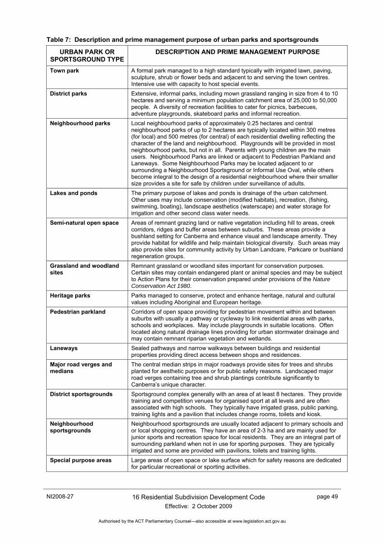
NI2008-27 16 Residential Subdivision Development Code Effective: 2 October 2009
page 49
Authorised by the ACT Parliamentary Counsel—also accessible at www.legislation.act.gov.au
Table 7: Description and prime management purpose of urban parks and sportsgrounds
URBAN PARK OR SPORTSGROUND TYPE
DESCRIPTION AND PRIME MANAGEMENT PURPOSE
Town park A formal park managed to a high standard typically with irrigated lawn, paving, sculpture, shrub or flower beds and adjacent to and serving the town centres. Intensive use with capacity to host special events.
District parks Extensive, informal parks, including mown grassland ranging in size from 4 to 10 hectares and serving a minimum population catchment area of 25,000 to 50,000 people. A diversity of recreation facilities to cater for picnics, barbecues, adventure playgrounds, skateboard parks and informal recreation.
Neighbourhood parks Local neighbourhood parks of approximately 0.25 hectares and central neighbourhood parks of up to 2 hectares are typically located within 300 metres (for local) and 500 metres (for central) of each residential dwelling reflecting the character of the land and neighbourhood. Playgrounds will be provided in most neighbourhood parks, but not in all. Parents with young children are the main users. Neighbourhood Parks are linked or adjacent to Pedestrian Parkland and Laneways. Some Neighbourhood Parks may be located adjacent to or surrounding a Neighbourhood Sportsground or Informal Use Oval, while others become integral to the design of a residential neighbourhood where their smaller size provides a site for safe by children under surveillance of adults.
Lakes and ponds The primary purpose of lakes and ponds is drainage of the urban catchment. Other uses may include conservation (modified habitats), recreation, (fishing, swimming, boating), landscape aesthetics (waterscape) and water storage for irrigation and other second class water needs.
Semi-natural open space Areas of remnant grazing land or native vegetation including hill to areas, creek corridors, ridges and buffer areas between suburbs. These areas provide a bushland setting for Canberra and enhance visual and landscape amenity. They provide habitat for wildlife and help maintain biological diversity. Such areas may also provide sites for community activity by Urban Landcare, Parkcare or bushland regeneration groups.
Grassland and woodland sites
Remnant grassland or woodland sites important for conservation purposes. Certain sites may contain endangered plant or animal species and may be subject to Action Plans for their conservation prepared under provisions of the Nature Conservation Act 1980.
Heritage parks Parks managed to conserve, protect and enhance heritage, natural and cultural values including Aboriginal and European heritage.
Pedestrian parkland Corridors of open space providing for pedestrian movement within and between suburbs with usually a pathway or cycleway to link residential areas with parks, schools and workplaces. May include playgrounds in suitable locations. Often located along natural drainage lines providing for urban stormwater drainage and may contain remnant riparian vegetation and wetlands.
Laneways Sealed pathways and narrow walkways between buildings and residential properties providing direct access between shops and residences.
Major road verges and medians
The central median strips in major roadways provide sites for trees and shrubs planted for aesthetic purposes or for public safety reasons. Landscaped major road verges containing tree and shrub plantings contribute significantly to Canberra’s unique character.
District sportsgrounds Sportsground complex generally with an area of at least 8 hectares. They provide training and competition venues for organised sport at all levels and are often associated with high schools. They typically have irrigated grass, public parking, training lights and a pavilion that includes change rooms, toilets and kiosk.
Neighbourhood sportsgrounds
Neighbourhood sportsgrounds are usually located adjacent to primary schools and or local shopping centres. They have an area of 2-3 ha and are mainly used for junior sports and recreation space for local residents. They are an integral part of surrounding parkland when not in use for sporting purposes. They are typically irrigated and some are provided with pavilions, toilets and training lights.
Special purpose areas Large areas of open space or lake surface which for safety reasons are dedicated for particular recreational or sporting activities.
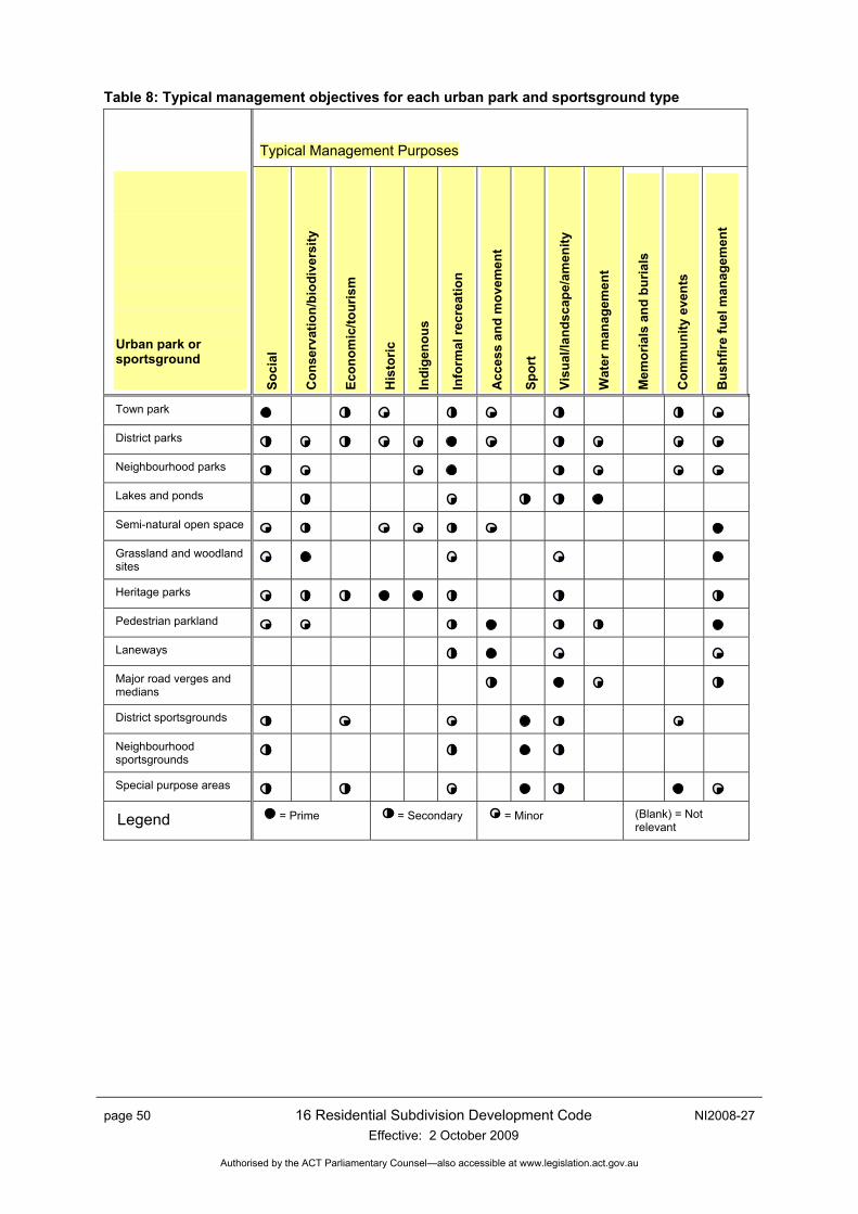
page 50 16 Residential Subdivision Development Code Effective: 2 October 2009
NI2008-27
Authorised by the ACT Parliamentary Counsel—also accessible at www.legislation.act.gov.au
Table 8: Typical management objectives for each urban park and sportsground type
Typical Management Purposes
Urban park or sportsground
Soci
al
Con
serv
atio
n/bi
odiv
ersi
ty
Econ
omic
/tour
ism
His
toric
Indi
geno
us
Info
rmal
recr
eatio
n
Acc
ess
and
mov
emen
t
Spor
t
Visu
al/la
ndsc
ape/
amen
ity
Wat
er m
anag
emen
t
Mem
oria
ls a
nd b
uria
ls
Com
mun
ity e
vent
s
Bus
hfire
fuel
man
agem
ent
Town park District parks Neighbourhood parks Lakes and ponds
Semi-natural open space Grassland and woodland sites
Heritage parks Pedestrian parkland Laneways Major road verges and medians
District sportsgrounds
Neighbourhood sportsgrounds
Special purpose areas
Legend = Prime = Secondary = Minor (Blank) = Not relevant
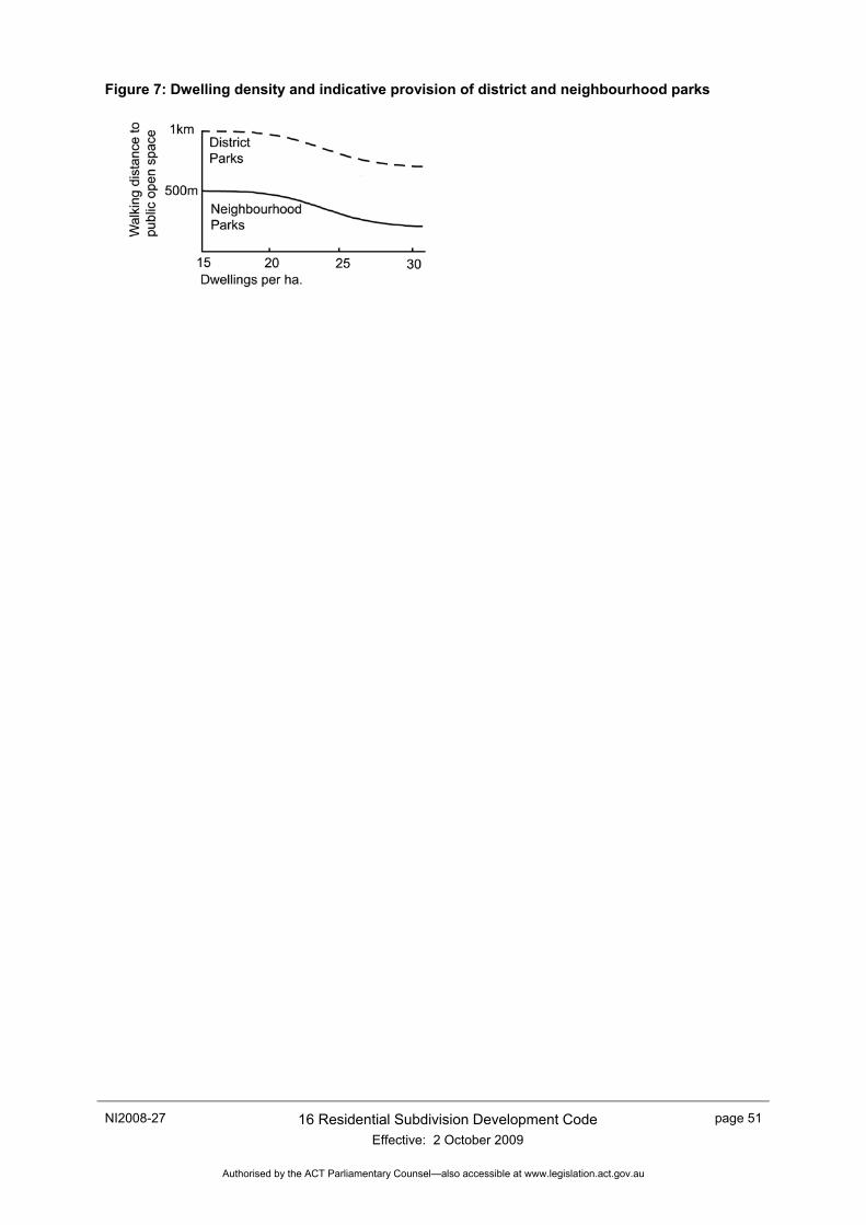
NI2008-27 16 Residential Subdivision Development Code Effective: 2 October 2009
page 51
Authorised by the ACT Parliamentary Counsel—also accessible at www.legislation.act.gov.au
Figure 7: Dwelling density and indicative provision of district and neighbourhood parks

page 52 16 Residential Subdivision Development Code Effective: 2 October 2009
NI2008-27
Authorised by the ACT Parliamentary Counsel—also accessible at www.legislation.act.gov.au
Appendix A – Legislation and Other Documents
Legislation
Road Transport (Safety and Traffic Management) Act 1999
Road Transport (General) Act 1999
Territory Plan
Discrimination Act 1991
Planning and Development Bill 200X
Industry standards
AUSTROADS. Guide to Traffic Engineering Practice, Part 1: Traffic Flow.
AUSTROADS. Guide to Traffic Engineering Practice, Part 2: Roadway Capacity.
AUSTROADS. Guide to Traffic Engineering Practice, Part 3: Roadway Capacity.
AUSTROADS. Guide to Traffic Engineering Practice, Part 4: Roadway Capacity.
AUSTROADS. Guide to Traffic Engineering Practice, Part 5: Intersections of Grade.
AUSTROADS. Guide to Traffic Engineering Practice, Part 6: Roundabouts.
AUSTROADS. Guide to Traffic Engineering Practice, Part 7: Traffic Signals.
AUSTROADS. Guide to Traffic Engineering Practice, Part 8: Traffic Control Devices.
AUSTROADS. Guide to Traffic Engineering Practice, Part 9: Arterial Road Traffic Management.
AUSTROADS. Guide to Traffic Engineering Practice, Part 10: Local Area Traffic Management.
AUSTROADS. Guide to Traffic Engineering Practice, Part 13:Pedestrians
AUSTROADS. Guide to Traffic Engineering Practice, Part 14: Bicycles
AUSTROADS. Guide to Geometric Design of Major Urban Roads.
Standards Australia. Guide to Traffic Engineering Practice, Part 10: Local Area Traffic Management.
Standards Australia. AS 1348.1 Road and Traffic Engineering: Glossary of terms, Road Design and Construction.
Standards Australia AS 3845: Road Safety Barrier Systems.
RTA NSW. Guide to Traffic Generating Developments.
ACT Department of Territory and Municipal Services (TaMS) (Formerly Department of Urban Services). Design Standards for Urban Infrastructure Parts 1 to 25. http://www.roads.act.gov.au/downloads
ACT Planning and Land Authority (October 2000). ACT Parking and Vehicular Access Guidelines. http://www.actpla.act.gov.au/tools_resources/legislation_plans_registers/registers/planning_guidelines Canberra ACT.
NI2008-27 16 Residential Subdivision Development Code Effective: 2 October 2009
page 53
Authorised by the ACT Parliamentary Counsel—also accessible at www.legislation.act.gov.au
ACT Planning and Land Authority (2000). ACT Crime Prevention and Urban Design Resource Manual. http://www.actpla.act.gov.au/tools_resources/legislation_plans_registers/registers/planning_guidelines
ACT Planning and Land Authority (February 2006). Planning for Bushfire Risk Mitigation. http://www.actpla.act.gov.au/tools_resources/legislation_plans_registers/registers/planning_guidelines Canberra ACT.
ACT Planning and Land Authority (April 2006). Water Sensitive Urban Design – Guidelines for sustainable development in Canberra (Draft) Canberra ACT
ACT Planning and Land Authority. Canberra Bicycle 2000 A bicycle strategy for the Australian Capital Territory. Canberra ACT http://apps.actpla.act.gov.au/bikebits/intro.htm
ACT Planning and Land Authority, 1996, Noise Management Guidelines (Draft).
ACT Planning and Land Authority, 1996, Fences Guideline (Draft
ACT Planning and Land Authority, 2004, Sustainable Transport Plan..
National Road Transport Commission date, Australian Road Rules,
NSW RTA date, Noise Barriers and Catalogue of Selection Possibilities.
AUSTROADS, date, Cycling Australia: The National Strategy.
Territory and Municipal Services 2006, Development Control Code for Best Practice Waste Management in the ACT, ACT Government, Canberra.
page 54 16 Residential Subdivision Development Code Effective: 2 October 2009
NI2008-27
Authorised by the ACT Parliamentary Counsel—also accessible at www.legislation.act.gov.au
Appendix B – Services Easement
a) The Authority, on behalf of the Commonwealth, grants over that part of the land (“Land”) identified as a services easement on the Deposited Plan an easement (“Easement”) in favour of:
i) the Territory and its successors;
ii) Actew Distribution Limited ACN 073 025 224 and its successors;
iii) AGL Gas Company (ACT) Pty Limited ACN 008 552 663 and its successors; and
iv) Actew Corporation Limited ACN 069 381 960 and its successors,
(collectively or separately referred to as the “service provider”).
b) The service provider may:
i) provide, maintain and replace services supplied by that service provider through the Land within the site of the Easement; and
ii) do anything reasonably necessary for that purpose, including without limitation:
• entering or passing through the Land; • taking anything on to the Land; and • carrying out work, including without limitation, constructing, placing, repairing or maintaining
pipes, poles, wires, cables, conduits, structures and equipment.
c) In exercising the powers in paragraph 2, the service provider must take all reasonable steps to:
i) ensure that the work carried out on the Land causes as little disruption, inconvenience and damage as is practicable; and
ii) ensure that the Land is restored as soon as practicable to a condition that is similar to its condition before the work was carried out. 4.
d) Paragraph 3(2), does not require the service provider to restore the Land to a condition that would result in:
i) an interference with:
• any service on or through the Land; or • access to any service on or through the Land; or
ii) a contravention of a law of the Territory; or
iii) any building or structure placed or constructed on any part of the Land comprising the Easement.
e) The Lessee must not place or construct, nor permit to be placed or constructed, a building or structure or any part of a building or structure on any part of the Land comprising the Easement.
f) For the purposes of the Easement, “services”, includes, without limitation, the supply of water, gas, electricity and discharge or drainage of water, stormwater and sewage.
g) Nothing in this clause diminishes or affects any rights or powers of a service provider conferred under any statute, regulation or law.
NI2008-27 16 Residential Subdivision Development Code Effective: 2 October 2009
page 55
Authorised by the ACT Parliamentary Counsel—also accessible at www.legislation.act.gov.au
Appendix C – Energy Audits of Subdivisions – Detached Residential Blocks
1 Rationale Behind Energy Audit Solar access in winter is achieved through orientation of living areas in dwellings to receive the greatest amount of sunlight. The solar heat gain is greater in winter than in summer as the sun is lower in the sky and hence the angle of incidence to vertical windows is less. Exclusion of sun in summer can be achieved through design of eaves, the insulation capacity of building materials, and the use of appropriate landscaping.
It has been established in various studies of passive solar housing design that the ideal orientation and proportion of a dwelling to maximise the use of solar energy is a rectangular plan, with the sides in a ratio of 1.5:1 to 1.6:1, and with the long axis of the dwelling running in a generally east–west direction within an arc of 20 degrees north to 30 degrees south of east. If there is a preference, then about 10 degrees south of east is best, because it lets more sun in during the early morning in winter. The principles of passive solar house design are explained in greater detail in section 4 of this appendix (Residential Buildings’ Insulation Requirements).
It is considered that the greatest opportunities for cost effectiveness in energy conservation arise where land subdivision and housing layout are conceived and executed together, so that as many buildings as possible can be sited according to passive solar house design principles and are not allowed to overshadow other buildings and thus block their solar access. However, apart from integrated developments where a group of dwellings is designed and built together, the subdivision of land and the construction of dwellings usually occur as discrete events and are undertaken by different proponents. It is thus necessary to consider, at the subdivision stage, whether sufficient opportunities will be provided by the block layout for leaseholders to later build dwellings for optimal solar access. This is commonly referred to as achieving a solar efficient subdivision.
2 Principles of Solar Efficient Subdivision Blocks within the subdivision should ideally be oriented and proportioned so that a dwelling could be built on the block with the living areas able to receive sufficient sunlight for passive solar climate control, as follows:
Since most houses are rectangular in shape and tend to be built parallel to the boundaries, they are most easily sited with correct orientation on those blocks that are aligned principally north–south or east–west, with the north–south boundary within the arc of 20 degrees west and 30 degrees east of north. Rectangular, rather than splayed, shaped lots allow the best opportunities for solar orientation and lot yield efficiency.
Along streets running east–west, the side of the block adjacent to the street should be wide enough to accommodate the long side of the building, including driveway access and minimum distances to boundaries (see Figure 8).
Along streets running north–south the long side of the block should be oriented east–west to allow north-facing orientation of the building. The width of the block should be sufficient to prevent overshadowing from neighbouring blocks (see Figure 9).
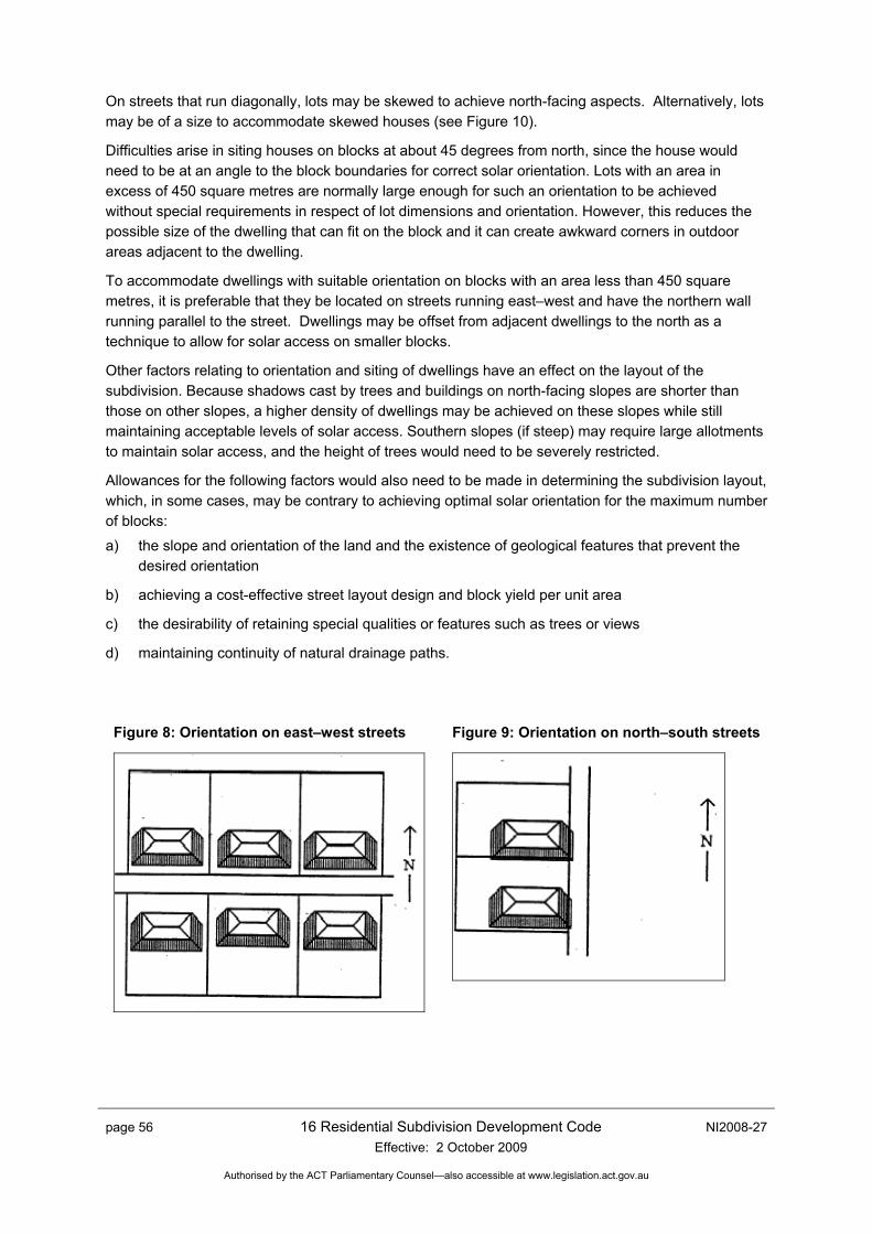
page 56 16 Residential Subdivision Development Code Effective: 2 October 2009
NI2008-27
Authorised by the ACT Parliamentary Counsel—also accessible at www.legislation.act.gov.au
On streets that run diagonally, lots may be skewed to achieve north-facing aspects. Alternatively, lots may be of a size to accommodate skewed houses (see Figure 10).
Difficulties arise in siting houses on blocks at about 45 degrees from north, since the house would need to be at an angle to the block boundaries for correct solar orientation. Lots with an area in excess of 450 square metres are normally large enough for such an orientation to be achieved without special requirements in respect of lot dimensions and orientation. However, this reduces the possible size of the dwelling that can fit on the block and it can create awkward corners in outdoor areas adjacent to the dwelling.
To accommodate dwellings with suitable orientation on blocks with an area less than 450 square metres, it is preferable that they be located on streets running east–west and have the northern wall running parallel to the street. Dwellings may be offset from adjacent dwellings to the north as a technique to allow for solar access on smaller blocks.
Other factors relating to orientation and siting of dwellings have an effect on the layout of the subdivision. Because shadows cast by trees and buildings on north-facing slopes are shorter than those on other slopes, a higher density of dwellings may be achieved on these slopes while still maintaining acceptable levels of solar access. Southern slopes (if steep) may require large allotments to maintain solar access, and the height of trees would need to be severely restricted.
Allowances for the following factors would also need to be made in determining the subdivision layout, which, in some cases, may be contrary to achieving optimal solar orientation for the maximum number of blocks:
a) the slope and orientation of the land and the existence of geological features that prevent the desired orientation
b) achieving a cost-effective street layout design and block yield per unit area
c) the desirability of retaining special qualities or features such as trees or views
d) maintaining continuity of natural drainage paths.
Figure 8: Orientation on east–west streets
Figure 9: Orientation on north–south streets
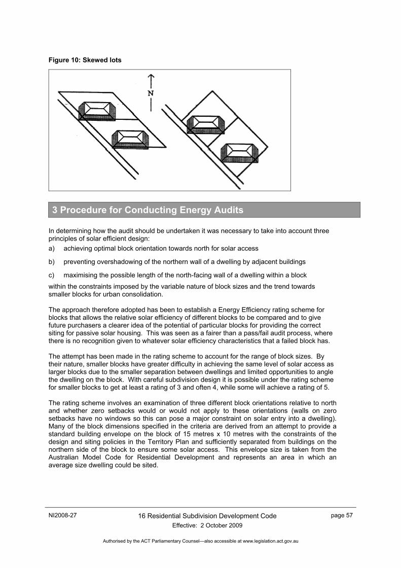
NI2008-27 16 Residential Subdivision Development Code Effective: 2 October 2009
page 57
Authorised by the ACT Parliamentary Counsel—also accessible at www.legislation.act.gov.au
Figure 10: Skewed lots
3 Procedure for Conducting Energy Audits
In determining how the audit should be undertaken it was necessary to take into account three principles of solar efficient design: a) achieving optimal block orientation towards north for solar access
b) preventing overshadowing of the northern wall of a dwelling by adjacent buildings
c) maximising the possible length of the north-facing wall of a dwelling within a block
within the constraints imposed by the variable nature of block sizes and the trend towards smaller blocks for urban consolidation. The approach therefore adopted has been to establish a Energy Efficiency rating scheme for blocks that allows the relative solar efficiency of different blocks to be compared and to give future purchasers a clearer idea of the potential of particular blocks for providing the correct siting for passive solar housing. This was seen as a fairer than a pass/fail audit process, where there is no recognition given to whatever solar efficiency characteristics that a failed block has. The attempt has been made in the rating scheme to account for the range of block sizes. By their nature, smaller blocks have greater difficulty in achieving the same level of solar access as larger blocks due to the smaller separation between dwellings and limited opportunities to angle the dwelling on the block. With careful subdivision design it is possible under the rating scheme for smaller blocks to get at least a rating of 3 and often 4, while some will achieve a rating of 5. The rating scheme involves an examination of three different block orientations relative to north and whether zero setbacks would or would not apply to these orientations (walls on zero setbacks have no windows so this can pose a major constraint on solar entry into a dwelling). Many of the block dimensions specified in the criteria are derived from an attempt to provide a standard building envelope on the block of 15 metres x 10 metres with the constraints of the design and siting policies in the Territory Plan and sufficiently separated from buildings on the northern side of the block to ensure some solar access. This envelope size is taken from the Australian Model Code for Residential Development and represents an area in which an average size dwelling could be sited.

page 58 16 Residential Subdivision Development Code Effective: 2 October 2009
NI2008-27
Authorised by the ACT Parliamentary Counsel—also accessible at www.legislation.act.gov.au
4 Energy Audits Requirements
All proposals for residential subdivisions of more than 30 blocks are required to include an energy audit of the proposal.
The aim of the energy audit is to make clear to the Authority and to the public the extent to which a subdivision proposal maximises the opportunities for leaseholders to build dwellings with ideal proportions and orientation for passive internal climate control utilising solar energy. The extent of solar access provided is judged by the percentage of blocks of suitable orientation and dimensions that allow an average size dwelling to be sited on the block, preferably with its long axis running in a generally east–west direction whilst still maintaining acceptable setbacks from boundaries.
4.1 Information to be provided
A site plan of the area at a scale of at least 1:1000 must be provided, showing the street and subdivision pattern, contours, and trees remaining after the subdivision work is complete. The area and boundary dimensions and bearings of each block must be shown on the subdivision pattern. Nominated zero setback boundaries should also be marked. The proposed use of each block should be indicated, –namely, residential blocks, sites for multi-unit developments or other non-residential uses.
4.2 Audit process
The audit process involves rating each block against a 5-tier rating scheme. The rating of a block is calculated by first determining which of the three criteria listed in Table 10 below would apply to the block. In the case of the first two criteria, the frontage dimension of the block is then matched against the figures in the four columns to determine the rating of the block. In the case of the third criteria, a standard building envelope of 15 m x 10 m must be fitted onto the block with the required setbacks as described in note 5 below. Blocks that do not meet any of the criteria received one star only.
4.3 Audit Presentation
Each block on the plan should be marked with its star rating as determined from Table 9.
Table 9: Criteria for Determining Block Rating Rating 2 3 4 5
Criteria Minimum frontage dimension (m)1
no zero setbacks <15 15 17 19 one zero setback <13 13 15 17
a) Blocks facing an east–west street2
See Figure 12. two zero setbacks <9 9 11 13 no zero setbacks <14 14 16 18
b) Blocks facing a north–south street2, 3
See Figure 13. a zero setback on southern boundary4
<12 12 14 16
c) Any blocks not able to be rated under criteria (a) or (b). See Figure 14.
Minimum distance from northern boundary
See Note 5 for details - 2 4 6
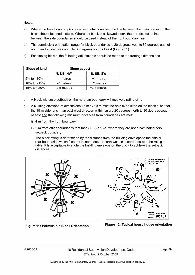
NI2008-27 16 Residential Subdivision Development Code Effective: 2 October 2009
page 59
Authorised by the ACT Parliamentary Counsel—also accessible at www.legislation.act.gov.au
Notes:
a) Where the front boundary is curved or contains angles, the line between the main corners of the block should be used instead. Where the block is a skewed block, the perpendicular line between the side boundaries should be used instead of the front boundary line.
b) The permissible orientation range for block boundaries is 20 degrees west to 30 degrees east of north, and 20 degrees north to 30 degrees south of east (Figure 11).
c) For sloping blocks, the following adjustments should be made to the frontage dimensions
Slope aspect Slope of land N, NE, NW S, SE, SW
5% to <10% -1 metres +1 metre 10% to <15% -2 metres +2 metres 15% to <20% -2.5 metres +2.5 metres
a) A block with zero setback on the northern boundary will receive a rating of 1.
b) A building envelope of dimensions 15 m by 10 m must be able to be sited on the block such that the 15 m side runs in an east-west direction within an arc 20 degrees north to 30 degrees south of east and the following minimum distances from boundaries are met:
i) 4 m from the front boundary
ii) 2 m from other boundaries that face SE, S or SW, where they are not a nominated zero setback boundary.
The block rating is determined by the distance from the building envelope to the side or rear boundaries which face north, north east or north west in accordance with the rating table. It is acceptable to angle the building envelope on the block to achieve the setback distances.
Figure 11: Permissible Block Orientation
Figure 12: Typical house house orientation
page 60 16 Residential Subdivision Development Code Effective: 2 October 2009
NI2008-27
Authorised by the ACT Parliamentary Counsel—also accessible at www.legislation.act.gov.au
A summary table should also be provided showing the following information: Rating Number of blocks % of total
5 4 3 2 1 Total 100%