respect care for kwikwetlem first nation our interests
TRANSCRIPT

1
Kwikwetlem First Nation Interests
As Related to Kinder Morgan Canada’s
Proposed Trans Mountain Pipeline
Expansion Project in Kwikwetlem
Territory
Respect
and
Care for
Our
Lands,
Water,
and
Heritage

2
Respect and Care for Our Lands, Water, and
Heritage
Report on Kwikwetlem Interests as Related to Kinder Morgan Canada’s
Proposed Trans Mountain Pipeline Expansion Project
Part A – Heritage and Traditional Knowledge and Use
Part B – Aboriginal Interest and Use
August 2014
3
Acknowledgements
This document has been prepared by and for the Kwikwetlem community. As designated stewards of our territory and its resources, the project has proceeded under the direction of Kwikwetlem Chief and Council; Land and Resources Manager June Harris coordinated the technical team and organized community participation in the study.
Many Kwikwetlem community members and elders shared their knowledge of Kwikwetlem heritage and history through interviews and/or community meetings. Sincere thanks are offered to those who participated; your knowledge is grounded in strong family histories and generations of use and stewardship of the territory.
A project team assisted with background research, report write-up and mapping. Nicole Oakes and Doug Brown of Brown & Oakes Archaeology provided traditional knowledge and use (TKUS) research assistance and coordination. Paul Lepage of Lepage Associates prepared the the socio-economic (AIUS) review. Breanna Charleyboy of Kwikwetlem First Nation assisted with GIS map production and analysis.
Terms of Use
This report has been prepared to facilitate discussions between Kwikwetlem First Nation and Kinder Morgan Company for the Trans Mountain Expansion Project and is not intended for public dissemination.

4
Table of Contents
Acknowledgements ................................................................................................................... 3
Terms of Use ............................................................................................................................. 3
Table of Contents ...................................................................................................................... 4
1.0 Introduction ....................................................................................................................... 5
Project ................................................................................................................................... 6
2.0 Kwikwetlem Territory and Geographic Area of Interest .................................................... 7
Part A .............................................................................................................................. 1
3.0 Kwikwetlem Cultural Heritage, Traditional Knowledge & Land Use .................................. 1
Methods and Community Engagement ................................................................................ 1
Recorded Descriptions of Kwikwetlem Life and Land Use ................................................... 2
Archaeological Sites .............................................................................................................. 5
4.0 The Trans Mountain Expansion Project ............................................................................ 11
Kwikwetlem Community Perspectives ............................................................................... 11
Traditional Knowledge and Land Use ................................................................................. 11
5.0 TKUS Summary and Recommendations ........................................................................... 19
General Comments ............................................................................................................. 19
Fraser Heights/Surrey Bend ................................................................................................ 20
Fraser River Crossing (Colony Farm / Cape Horn) .............................................................. 20
Fraser Mills / Brunette River ............................................................................................... 21
Burnaby Mountain .............................................................................................................. 22
Burrard Inlet - South ........................................................................................................... 22
6.0 Heritage Best Practices – Kwikwetlem First Nation and TMEP ....................................... 23
7.0 TKUS References .............................................................................................................. 24
Part B ............................................................................................................................ 26
8.0 Socio-economic Data Collection: Kinder Morgan Trans Mountain Pipeline Expansion Project ..................................................................................................................................... 26

5
List of Figures
Figure 1. Kwikwetlem Territory and Interest Areas, TMEP ...................................................... 3
Figure 2. Archaeological Sites and Recorded Place Names, TMEP .......................................... 10
List of Tables
Table 1. Kwikwetlem Traditional Place and Practice Categories .......................................... 7
Table 2. Kwikwetlem Natural Resources and Uses ............................................................... 8
Table 3. Kwikwetlem TKUS: Fraser Heights/Surrey Bend ................................................................ 12
Table 4. Kwikwetlem TKUS: Fraser Crossing .................................................................................... 14
Table 4. Kwikwetlem TKUS: Fraser Mills / Brunette River ............................................................... 16
Table 5. Kwikwetlem TKUS: Burnaby Mountain .............................................................................. 17
Table 6. Kwikwetlem TKUS: Burrard Inlet – South .......................................................................... 18

6
1.0 Introduction
Scope and Purpose
This document presents Kwikwetlem cultural heritage and socio-economic interests as they pertain to Kinder Morgan Canada’s (KMC) proposed Trans Mountain Pipeline Expansion Project (TMEP) within Kwikwetlem First Nation traditional territory. The purpose of the report is to:
Define and describe the areas of Kwikwetlem territorial interests within the proposed TMEP corridor.
Identify and evaluate potential effects of the Project on Kwikwetlem cultural heritage interests.
Identify and evaluate Kwikwetlem social and economic interests within the proposed development area.
Set forth best-practice requirements regarding heritage and archaeological studies.
Present recommendations for appropriate mitigation strategies to address potential impacts on Kwikwetlem heritage and socio-economic interests.
Provide recommendations designed to enhance the working partnership between Kwikwetlem First Nation and Kinder Morgan Canada.
Part A of this report presents a summary of heritage information drawn from a Traditional Knowledge and Land Use Study (TKUS) conducted to address Kwikwetlem cultural heritage interests associated with the Trans Mountain Expansion Project. The study includes a compilation and summary of recorded and traditional (oral) Kwikwetlem heritage information, a review of known archaeological resources, and Kwikwetlem land and resource knowledge as it pertains to the Project area.
Part B of the report provides the Aboriginal Interests Use Study in relation to the Kinder Morgan Canada project to expand the Trans Mountain Pipeline capacity through Kwikwetlem traditional territory.
Project
Kinder Morgan Canada intends to increase shipment capacity by twinning the existing Trans Mountain Pipeline over an approximately 980 km route. New and expanded pump stations, storage facilities, terminal expansion and other ancillary infrastructure form the pipeline expansion project.
The proposed KMC developments span approximately 29 km across the breadth of Kwikwetlem traditional territory. The proposed pipeline will cross landforms, waterways, and culturally significant landscapes that have supported and helped to define Kwikwetlem people for millennia. The new proposed corridor and ancillary

7
facilities join those installed decades ago and represent the latest component in an expanding pipeline infrastructure within the territory. Historically, such developments have conferred few benefits to the Kwikwetlem and in most cases negatively affected Kwikwetlem interests. This study is intended to ensure that the current KMC Project proceeds with a clear understanding of Kwikwetlem’s interests in the project area and the paramount need to respect and care for our community, our lands, our water and our cultural heritage.
2.0 Kwikwetlem Territory and Geographic Area of Interest
Kwikwetlem First Nation currently occupies two reserves, Coquitlam I.R. 1 and Coquitlam I.R. 2, both located along the lower Coquitlam River near its confluence with the Fraser (Figure 1). The reserves lie within Kwikwetlem Core Territory – those lands, waters, and resources centred on the Coquitlam watershed and within which the Nation asserts title and rights. An adjoining Area of Use and Interest marks the region of regular ancient and ongoing travel, resource use, and social interaction surrounding the core territory and in which the Nation asserts resource and heritage management interests. For the purposes of this document, ‘Kwikwetlem territory’ refers to and encompasses the core territory and territory of use and interest.
The practice of demarcating precise and exclusive First Nation territories is a political practice born largely out of negotiation requirements for treaty settlements and land claims. In the past, First Nation communities collectively acknowledged a group’s core territory but afforded considerable flexibility in the rights of extended family members, respected friends, or neighbouring groups to use a range of locations for hunting, trapping, fishing, plant gathering, travel, spiritual activities, and so on (see for example Suttles 1955; Duff 1952). For this reason, it is common for First Nations to hold overlapping territorial interests in lands and resources based on longstanding relationships and traditional use.
For the purposes of this project, Kwikwetlem asserts interests in any KMC project area west of the Centre Creek watershed (ca. 176 St., Surrey) to Westridge Marine Terminal. This zone of asserted interests will be referred to here as the project area or study area.
Kwikwetlem asserts an inherent right to govern all lands, waters and resources within Kwikwetlem territory. The Nation seeks to protect, manage and preserve heritage sites, heritage objects, heritage places and resources in our territory, according to traditional values and practices. We are stewards of generations to come and hold a responsibility to protect, promote and enhance Kwikwetlem lands, resources and culture in perpetuity
(Kwikwetlem Heritage Policy rev. 2013)

8
Figure 1. Kwikwetlem Territory and Interest Areas related to the TMEP.
1
Part A
3.0 Kwikwetlem Cultural Heritage, Traditional Knowledge & Land Use
The purpose of this section is to summarize Kwikwetlem cultural heritage interests and provide heritage and cultural resource management recommendations specific to the Trans Mountain Expansion Project (TMEP). The goal is to encourage and facilitate culturally sensitive project planning in Kwikwetlem traditional territory.
This report provides a summary of information gathered for planning requirements of the TMEP. The information provided here should be regarded as provisional and subject to amendment. Readers should also be aware that the report is not a comprehensive presentation of Kwikwetlem heritage and traditional land use information, but rather provides information for KMC TMEP purposes. This study presents traditional use information pertaining to the study area as well as traditional practices known to contribute to Kwikwetlem interests in the project area.
Methods and Community Engagement
Kwikwetlem Traditional Knowledge and Use Study (TKUS) methods have been developed and implemented over the course of several project-specific studies. TKUS approaches utilize additive data collection approaches so that each study assists in the development of a comprehensive TKU database. Individual or small group interviews provide the principle source of information about cultural heritage, resources and land use, traditional and contemporary practices, and community and family histories. A comprehensive questionnaire template is used to guide the interviews as needed, although discussions are informally structured and designed to pursue interviewee interests and areas of expertise and knowledge.
Twelve individuals were interviewed for this study. A community information meeting was also held with an additional eleven band members to review existing information and gather new information pertaining to Kwikwetlem traditional knowledge and land use in the project area. Documentary research into historic archival ‘grey’ literature pertaining to Kwikwetlem continued as part of this study with a range of previously un-investigated data sources reviewed.
“It is important today that we let these people know to care for our lands, water, and heritage.”
2
One purpose of Kwikwetlem traditional knowledge research is to advance and protect Kwikwetlem aboriginal rights and title within our traditional territory. Traditional use information is confidential and original records are retained by Kwikwetlem First Nation. Information summaries and mapping generated from the TKUS database are provided solely to assist in land use planning discussions with the Nation.
Recorded Descriptions of Kwikwetlem Life and Land Use
Ethnographic and traditional use information indicate a deep connection between Kwikwetlem people and the Coquitlam watershed, an area that includes Coquitlam Lake, the Coquitlam River above and below Coquitlam Lake, the lower Pitt River, and the adjacent north and south banks of the Fraser River.
The Nation is one of many Halkomelem-speaking groups that have occupied the lower Fraser River for hundreds of generations. Halkomelem is a set of three related languages spoken from the lower Fraser Canyon to Vancouver Island. Hul’q’umi’num’ is spoken by First Nations on eastern Vancouver Island, Halq’eméylem is the upriver language spoken by First Nations from the Stave River up to the lower Fraser Canyon, and hən q əmin em is spoken by peoples downriver of the Stave to the mouth of the Fraser, including Kwikwetlem, Katzie, Musqueam, Kwantlen, Tsawwassen, and Tsleil-Waututh Nations. Halkomelem speakers, and Coast Salish peoples as a whole, share many common cultural traditions and close regional social ties.
Prior to the arrival of Europeans, the Coast Salish of the Fraser Valley along with other Northwest Coast groups maintained some of the highest population densities of hunter/gatherer societies anywhere in the world (Boyd 1999). Introduced disease resulted in catastrophic losses among First Nation communities in the 18th and 19th centuries (Harris 1997). This, along with Euro-Canadian restrictions on First Nation culture and language through the late 19th century, has led to a generally poor popular understanding of the rich cultural traditions of Coast Salish peoples.
Sophisticated artistic traditions, complex ritual practices, elaborate cedar plank architecture, large villages, and the division of society into distinct social classes are all hallmarks of a rich Coast Salish culture that has been in place for at least 2,500 years, built on cultural traditions originating at least 9,000 years ago (Mitchell 1971; Ames and Maschner 1999). Sources of information on traditional Coast Salish social, economic, and political life include Carlson (2001), Duff (1952), and Suttles (1990).
Information specific to life and land use among the Kwikwetlem is available in the early historic and ethnographic literature, but none of the records can be described as thorough or exhaustive. No early ethnographers or anthropologists spent extended time in Kwikwetlem territory or among Kwikwetlem informants. Observations of Kwikwetlem life were instead recorded as part of broader regional summaries, or while ethnographers were conducting studies with neighbouring groups.

3
Kwikwetlem Territory
Accounts by anthropologists describe Kwikwetlem territory as encompassing the Coquitlam Lake drainage: Coquitlam River above and below Coquitlam Lake and the north side of the Fraser River east of the Coquitlam River (Duff 1952:20, 24; Suttles (1955:12). No specific boundary is given for the western or southern side of the territory in these published accounts, but a few references indicate that Kwikwetlem territory once included New Westminster and historically may have extended at least as far west as the area around Pattullo Bridge. A Kwantlen informant suggested to Hill-Tout, for example, that the Kwikwetlem were the original inhabitants of the lands around New Westminster that only recently became Kwantlen territory (in Maude 1978:68). Kenyon (1953) recorded the eastern extent of Kwikwetlem territory by the presence of two Kwikwetlem named villages on the east side of the Pitt River mouth, a demarcation corroborated by Suttles’ review (1955:12).
More recently collected archival and oral histories pertaining to Kwikwetlem demonstrate the regular use and occupation of the core territory as shown in Figure 1, and regular travel within, and social and resource links to, the broader territory of use and interest.
The name Kwikwetlem is linked to a small red sockeye salmon that once ran in large numbers exclusively in Coquitlam River and spawned in Coquitlam Lake. This sockeye was driven nearly to extinction by the construction of the Coquitlam Dam in 1914, an acute loss to the Kwikwetlem given its role as a food mainstay and a hallmark of Kwikwetlem culture. The earliest recorded association of ‘Coquitlam’ with this salmon run is found in a local newspaper history review (see side bar).
The importance of this unique salmon run to Kwikwetlem is reflected in the name of the historic village Slakaya’nc1 situated at the mouth of the Coquitlam River at what is now Coquitlam I.R. 1. It is likely this same sockeye species that figures prominently in a renowned Coast Salish creation story that recounts the origin of sockeye salmon. In this story, Coquitlam is featured as one of only a few named locales along the lower Fraser River as a place of abundant salmon, and a place where salmon were born (see Boas 1895; Wells 1987).
1 Translated by Kwikwetlem William, a prominent early 20
th century Elder, to refer to ‘young’ and
‘sockeye’.
The word is of Indian origin, and pronounced by them as if it were spelled Kwere-quit-lam, and means small red salmon, a fish which teemed up the Coquitlam every year in April…. From this small fish, the locality and the river took the name…” (Coquitlam Star, October 6, 1911)

4
Statements regarding the affiliation of Kwikwetlem to other groups are perhaps the most common references to Kwikwetlem in lower Fraser ethnographies. Kwikwetlem are described as a community of ‘former slaves’, or ‘people in servitude to the Kwantlen’ (Boas 1894:2; Burns n.d.; Hill-Tout in Maude 1978:54-56; Jenness 1955:86). Burns describes the Kwikwetlem as slaves “who made war bows and canoes” and helped make the Kwantlen “unbeatable” (n.d.). Boas and Hill-Tout also recount stories of the Kwikwetlem as slaves of the Kwantlen, who during a time of great strife caused either by war or hunger, “about four or five generations ago” became free. Jenness on the other hand suggests the Kwikwetlem were not slaves but people who had become divorced from established family names and status as result of a great famine “about four generations ago”. At this time many families disappeared entirely, leaving survivors to be assisted by, but beholden to, larger villages.
The degree to which social competition between neighbours may play into an ethnographic portrayal of Kwikwetlem as ‘slaves’ requires review (see Suttles 1968:4, 5). There are a number of indicators in the ethnography to suggest that the Kwikwetlem have a more complex social standing and history than those few passages that characterize the community in such singular terms. For example, in his review Hill-Tout states that the Kwikwetlem were the original occupants of New Westminster before they were held in servitude by the Kwantlen (1902). In addition, both Katzie and Kwantlen informants connect Kwikwetlem social standing with their own ancestral origin stories, suggesting that any ‘fall in status’ must have occurred at times in the distant past, and that this history played a role in ongoing competitive relationships between the Kwikwetlem and their neighbours.
It certainly may be that in times past a crisis befell the Kwikwetlem which influenced their social standing for a time with other groups. Unravelling actual events from the practice by others to promote their own interests would be difficult, especially in the absence of a detailed Kwikwetlem ethnography. But certainly, while the remembered past is deep in Coast Salish communities, by the time of the earliest written records the Kwikwetlem had transcended social conscriptions of the past. As with other Coast Salish groups, the Kwikwetlem had their own leaders of ancestral descent, are linked with stories of creation and transformers, held family names, owned tangible and intangible property, hosted and participated in winter dance rituals, and held important intermarriage connections with established families throughout the region. Nearly every early historic document describing aboriginal communities along the lower Fraser includes ‘Coquitlam’ as an independent community, and notes the presence of multiple Kwikwetlem villages associated with the territorial lands of the Coquitlam drainage. In short, Kwikwetlem was a community that, by the time Europeans arrived, displayed important elements of social standing and autonomy among Coast Salish communities.
5
Kwikwetlem Settlements and Named Places
Recorded village locations and place names are one way to document the long standing history of a people in a region. These names provide a record of significant landmarks and locations in a region and situate the natural landscape within a millennia-old cultural worldview (McHalsie 2001). Because few ethnographers spent time in Kwikwetlem territory, the known record of named settlements and locales in the territory is certainly incomplete.
In 1935, Diamond Jenness recorded Kwikwetlem stories and place names during the course of his work with Katzie Elder, Old Pierre, who often referred to Kwikwetlem stories and people. In 1955, Wayne Suttles published Jenness’s manuscript and appended additional information related to him by Old Pierre`s son, Simon Pierre. Walter Kenyon (1953) visited the Kwikwetlem reserves in the early 1950’s and recorded several names told to him by Chief Kwikwetlem William. Beyond these recordings, no ethnographer spent significant time in Kwikwetlem communities or with Kwikwetlem informants. In more recent decades, Stó:lō researchers have compiled the record of Stó:lō place names as a means by which to demonstrate aboriginal rights and title and highlight the connection of the landscape to First Nation heritage.
The known record of Kwikwetlem place names are found throughout the territory and include house and village locations, geographic features, and resource and activity locales, as well as many spirit and transformer sites--places where xexá:ls - ‘the transformer’, a central figure in hən q əmin em cosmology, created landscape or resource features.
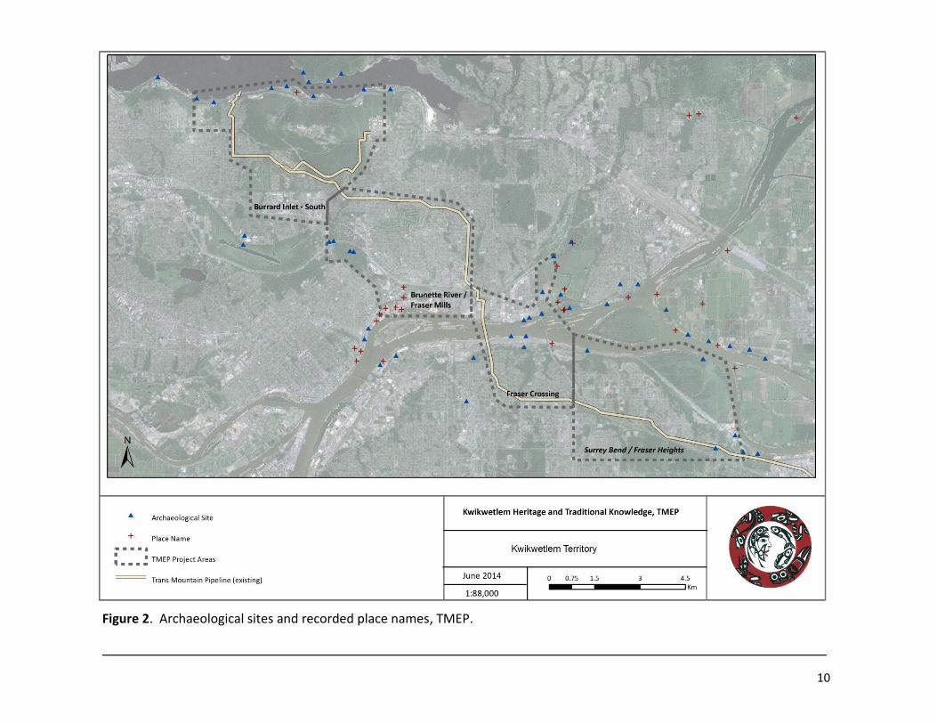
Named places in the vicinity of the KMC TMEP are discussed below and shown in Figures 2.
Archaeological Sites
Archaeological sites in Kwikwetlem territory cover the spectrum of site types typical of the Central Coast Salish region, from isolated artifact finds to large multi-component village sites, burial places, fishing locales, well-preserved organic artifacts, lithic or stone tool working remains, and so on. Only one site (DhRq 21 on the lower Pitt River, see sidebar) has been systematically excavated to investigate the extent and kinds of subsurface deposits, and this site shows rich deposits indicative of intensive and long-term occupation spanning much of the last 4,500 years.
6
Known archaeological site locations within Kwikwetlem territory indicate that all parts of the territory were occupied and used, from riverside locations to higher elevation uplands. Until recently, most known sites in the territory were found along the shorelines of the Coquitlam, Fraser and Pitt rivers, certainly important settlement areas in the past, but also the most accessible and frequently surveyed locations for archaeological sites. Recent archaeological investigations around Coquitlam Lake have led to many new recorded site locations along this narrow, upland, mid-elevation reservoir shoreline. The number and density of sites here show that inland locales were also regularly and intensively used through the millennia.
Despite the presence of known sites across Kwikwetlem territory, the archaeological record contains significant gaps. Few research-based archaeological surveys or inventory projects have occurred, historically the most common way that archaeological sites are recognized and recorded. Large parts of the territory are also heavily urbanized and were developed prior to or without attention to archaeological assessment. Today much land in Kwikwetlem territory is privately held or under the jurisdiction of municipal managers. These latter groups have been slow to embrace archaeological assessment procedures prior to development, or engage in discussions with First Nations with respect to heritage planning or protection measures, leaving much of the territory unstudied.
There is little doubt that many existing archaeological sites remain undetected in urbanized or forested areas throughout Kwikwetlem territory. TKUS research has uncovered numerous newspaper reports from the 1940’s onward reporting archaeological finds and sites in the territory that have never been relocated and recorded. Today, these sites, even if disturbed by modern land alterations, have good potential to still contain cultural materials.
Known archaeological sites in the vicinity of the KMC TMEP are discussed below and shown in Figure 2.
Traditional Knowledge
Oral histories are the foundation of Coast Salish culture – stories, witnessing of events, and teachings serve to connect people in a shared social network, link the present to the past, and ground individuals and communities to places. Younger generations are expected to be attentive to the stories told by Elders and to both remember and learn the lessons held in stories about appropriate interactions with others and the land. More formal stories, ceremonial events, or proclamations of names, marriages, genealogies, or gift and debt obligations shared at community or region wide gatherings – winter dances, potlatches, or smokehouse gatherings –form a collective remembered public record. The prescribed protocols for who, when, and how information is publicly shared, recognition of particularly skilled orators, and the calling of multiple respected
7
witnesses to attest to the information shared at gatherings all serve to make oral knowledge an increasingly recognized and sound “historical” record.
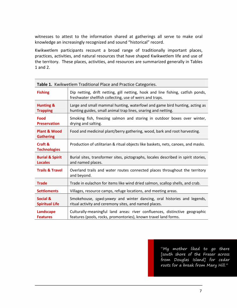
Kwikwetlem participants recount a broad range of traditionally important places, practices, activities, and natural resources that have shaped Kwikwetlem life and use of the territory. These places, activities, and resources are summarized generally in Tables 1 and 2.
Table 1. Kwikwetlem Traditional Place and Practice Categories.
Fishing Dip netting, drift netting, gill netting, hook and line fishing, catfish ponds, freshwater shellfish collecting, use of weirs and traps.
Hunting & Trapping
Large and small mammal hunting, waterfowl and game bird hunting, acting as hunting guides, small animal trap lines, snaring and netting.
Food Preservation
Smoking fish, freezing salmon and storing in outdoor boxes over winter, drying and salting.
Plant & Wood Gathering
Food and medicinal plant/berry gathering, wood, bark and root harvesting.
Craft & Technologies
Production of utilitarian & ritual objects like baskets, nets, canoes, and masks.
Burial & Spirit Locales
Burial sites, transformer sites, pictographs, locales described in spirit stories, and named places.
Trails & Travel Overland trails and water routes connected places throughout the territory and beyond.
Trade Trade in eulachon for items like wind dried salmon, scallop shells, and crab.
Settlements Villages, resource camps, refuge locations, and meeting areas.
Social & Spiritual Life
Smokehouse, sxwó:yxwey and winter dancing, oral histories and legends, ritual activity and ceremony sites, and named places.
Landscape Features
Culturally-meaningful land areas: river confluences, distinctive geographic features (pools, rocks, promontories), known travel land forms.
“My mother liked to go there [south shore of the Fraser across from Douglas Island] for cedar roots for a break from Mary Hill.”

8
Table 2. Kwikwetlem Natural Resources and Uses.
Foo
d
Mate
rials
Me
dicin
e
Trade
Ce
rem
on
ial
Un
spe
cified
Foo
d
Mate
rials
Trade
Ce
rem
on
ial
Un
spe
cified
Plant & Wood Harvesting
T R E E S H E R B A C E O U S P L A N T S
Red cedar wood Stinging nettles
Red cedar bark Cattails
Red cedar root Salal
Yellow cedar Devil’s club
Cascara bark Labrador tea
Yew wood & bark “Frog leaf”
Douglas Fir Oregon grape
Birch S H R U B S
Cottonwood Salmon berries/shoots
Cherry bark Huckleberries
Big leaf maple Cranberries
Crab apple Blueberries
Alder Blackberries
Sap Saskatoon berries
Cottonwood Saskatoon wood
Balsam Hazelnuts
Hunting & Trapping
C A R N I V O R E S U N G U L A T E S
Bear Deer
Cougar Mountain goat
Wolverine Elk
Coyote
Wolf
Lynx
S M A L L M A M M A L
B I R D S
Rabbit Pheasant
Mink Grouse
Marten Geese
Fisher Duck
Beaver Swan
Muskrat
9
Table 2 (cont). Kwikwetlem Natural Resources and Uses.
Foo
d
Mate
rials
Me
dicin
e
Trade
Ce
rem
on
ial
Un
spe
cified
Foo
d
Mate
rials
Trade
Ce
rem
on
ial
Un
spe
cified
Fish and Shellfish
M A R I N E F R E S H W A T E R
Sockeye salmon Sturgeon
Chum salmon Jack springs
Coho salmon Cut throat Trout
Steelhead Brook & Rainbow Trout
Eulachon Carp
S H E L L F I S H Catfish
Freshwater clams Red-sided Shiner
Scallop shell Three-spine Stickleback
Marine shellfish Crayfish
Freshwater shellfish
“During the small pox epidemics people were buried in mass graves on the west side of Colony Farm.”
10
Figure 2. Archaeological sites and recorded place names, TMEP.
11
4.0 The Trans Mountain Expansion Project
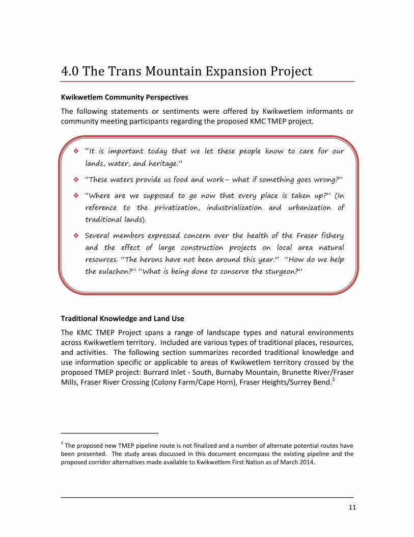
Kwikwetlem Community Perspectives
The following statements or sentiments were offered by Kwikwetlem informants or community meeting participants regarding the proposed KMC TMEP project.
“It is important today that we let these people know to care for our
lands, water, and heritage.”
“These waters provide us food and work– what if something goes wrong?”
“Where are we supposed to go now that every place is taken up?” (In
reference to the privatization, industrialization and urbanization of
traditional lands).
Several members expressed concern over the health of the Fraser fishery
and the effect of large construction projects on local area natural
resources. “The herons have not been around this year.” “How do we help
the eulachon?” “What is being done to conserve the sturgeon?”
Traditional Knowledge and Land Use
The KMC TMEP Project spans a range of landscape types and natural environments across Kwikwetlem territory. Included are various types of traditional places, resources, and activities. The following section summarizes recorded traditional knowledge and use information specific or applicable to areas of Kwikwetlem territory crossed by the proposed TMEP project: Burrard Inlet - South, Burnaby Mountain, Brunette River/Fraser Mills, Fraser River Crossing (Colony Farm/Cape Horn), Fraser Heights/Surrey Bend.2
2 The proposed new TMEP pipeline route is not finalized and a number of alternate potential routes have
been presented. The study areas discussed in this document encompass the existing pipeline and the proposed corridor alternatives made available to Kwikwetlem First Nation as of March 2014.
12
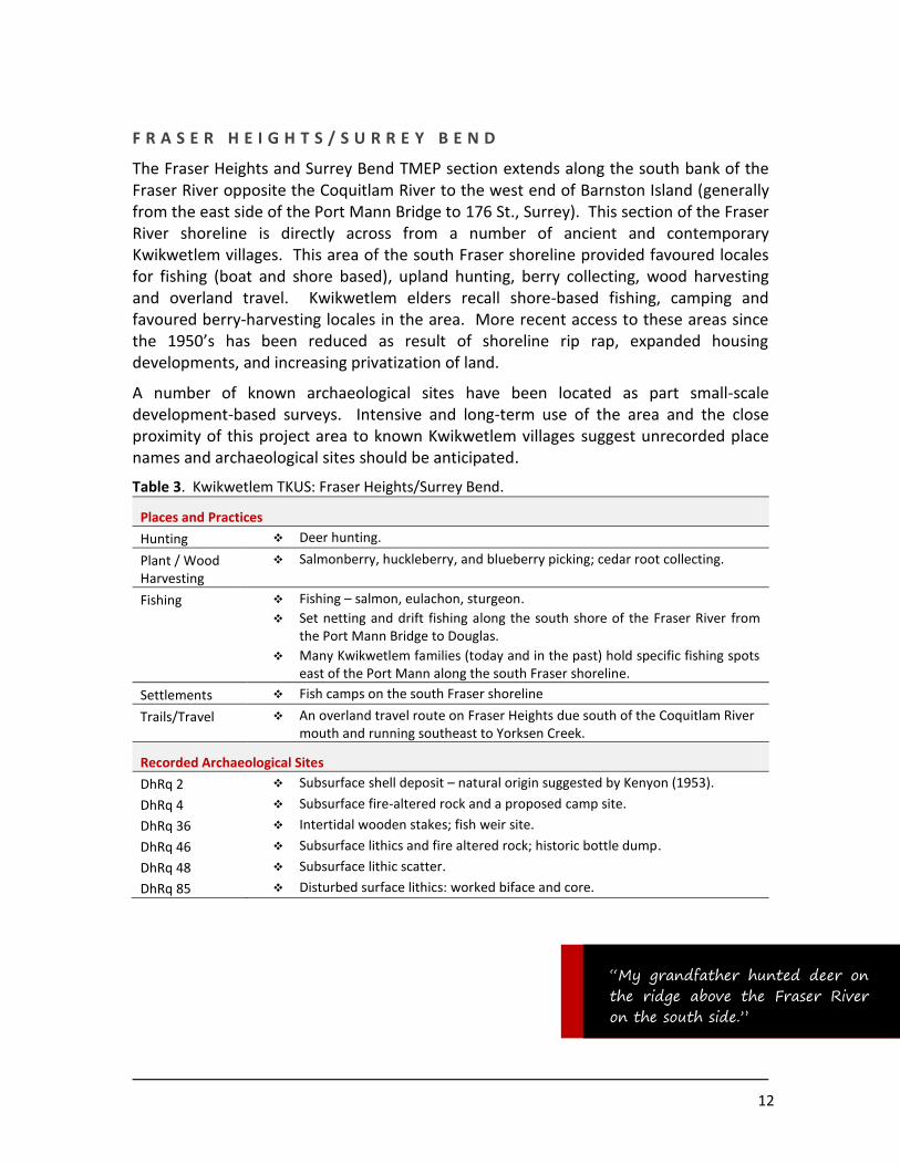
F R A S E R H E I G H T S / S U R R E Y B E N D
The Fraser Heights and Surrey Bend TMEP section extends along the south bank of the Fraser River opposite the Coquitlam River to the west end of Barnston Island (generally from the east side of the Port Mann Bridge to 176 St., Surrey). This section of the Fraser River shoreline is directly across from a number of ancient and contemporary Kwikwetlem villages. This area of the south Fraser shoreline provided favoured locales for fishing (boat and shore based), upland hunting, berry collecting, wood harvesting and overland travel. Kwikwetlem elders recall shore-based fishing, camping and favoured berry-harvesting locales in the area. More recent access to these areas since the 1950’s has been reduced as result of shoreline rip rap, expanded housing developments, and increasing privatization of land.
A number of known archaeological sites have been located as part small-scale development-based surveys. Intensive and long-term use of the area and the close proximity of this project area to known Kwikwetlem villages suggest unrecorded place names and archaeological sites should be anticipated.
Table 3. Kwikwetlem TKUS: Fraser Heights/Surrey Bend.
Places and Practices
Hunting Deer hunting.
Plant / Wood Harvesting
Salmonberry, huckleberry, and blueberry picking; cedar root collecting.
Fishing Fishing – salmon, eulachon, sturgeon.
Set netting and drift fishing along the south shore of the Fraser River from the Port Mann Bridge to Douglas.
Many Kwikwetlem families (today and in the past) hold specific fishing spots east of the Port Mann along the south Fraser shoreline.
Settlements Fish camps on the south Fraser shoreline
Trails/Travel An overland travel route on Fraser Heights due south of the Coquitlam River mouth and running southeast to Yorksen Creek.
Recorded Archaeological Sites
DhRq 2 Subsurface shell deposit – natural origin suggested by Kenyon (1953).
DhRq 4 Subsurface fire-altered rock and a proposed camp site.
DhRq 36 Intertidal wooden stakes; fish weir site.
DhRq 46 Subsurface lithics and fire altered rock; historic bottle dump.
DhRq 48 Subsurface lithic scatter.
DhRq 85 Disturbed surface lithics: worked biface and core.
“My grandfather hunted deer on the ridge above the Fraser River on the south side.”
13
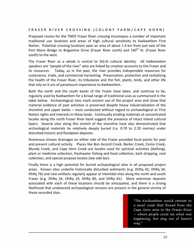
F R A S E R R I V E R C R O S S I N G ( C O L O N Y F A R M / C A P E H O R N )
Proposed routes for the TMEP Fraser River crossing encompass a number of important traditional use locations and areas of high cultural sensitivity to Kwikwetlem First Nation. Potential crossing locations span an area of about 1.4 km from just east of the Port Mann Bridge to Brigantine Drive (Fraser River north) and 140th St. (Fraser River south) to the west.
The Fraser River as a whole is central to Stó:lō cultural identity. All Halkomelem speakers are “people of the river” who are linked by creation accounts to the Fraser and its resources. Today, as in the past, the river provides indispensible resources for sustenance, trade, and commercial harvesting. Preservation, protection and revitalizing the health of the Fraser River, its tributaries and the fish, plants, birds, and other life that rely on it are of paramount importance to Kwikwetlem.
Both the north and the south banks of the Fraser have been, and continue to be, regularly used by Kwikwetlem for a broad range of traditional uses as summarized in the table below. Archaeological sites mark ancient use of the project area and show that material evidence of past activities is preserved despite heavy industrialization of the shoreline and upper banks – most conducted without regard to archaeological or First Nation rights and interests in these lands. Continually eroding materials at concentrated locales along the north Fraser River bank suggest the presence of intact inland cultural layers. Several sites along this stretch of the shoreline have also demonstrated that archeological materials lie relatively deeply buried (i.e. 0.70 to 2.20 metres) under disturbed historic and floodplain deposits.
Numerous stream drainages on either side of the Fraser provided focal points for past and present cultural activity. Places like Bon Accord Creek, Barker Creek, Como Creek, Mundy Creek, and Cape Horn Creek are locales used for spiritual activities (bathing), plant or medicine collection, freshwater fishing and food collection, bark stripping, root collection, and special purpose locales (see side bar).
Finally there is a high potential for buried archaeological sites in all proposed project areas. Known sites underlie historically disturbed sediments (e.g. DhRq 43, DhRq 34, DhRq 76) and new artifacts regularly appear at intertidal sites along the north and south Fraser (e.g. DhRq 34, DhRq 19, DhRq 80, and DhRq 81). More extensive deposits associated with each of these locations should be anticipated, and there is a strong likelihood that undetected archaeological remains are present in the general vicinity of these recorded sites.
“The Kwikwetlem would retreat to a small creek that flowed from the Cape Horn area to the Fraser River – where people could see what was happening, but stay out of harm’s way.”

14
Table 4. Kwikwetlem TKUS: Fraser Crossing.
Places and Practices
Hunting & Trapping
Birds & fowl, ungulates (with the exception of mountain goat), carnivores, small mammals
Plant/Wood
Harvesting
Nearly all noted plant species; in particular cattails, stinging nettle, alder, hazelnuts, salmonberries, huckleberries, cranberries, wapato, cranberry.
Fishing All fish species. Many family-held fishing spots along the north Fraser shoreline.
Trails/Travel Overland trails – From Coquitlam I.R. 1 west through Colony Farm through Cape Horn, Fraser Mills, to Sapperton (and beyond).
Burials Smallpox and raiding burials at Colony Farm.
Settlements Village locations, fishing camps, along the north bank of the Fraser, fishing camps along the south bank, refuge locations along Cape Horn.
Place Names
slakәya’nc Village at I.R. 1 - Kwikwetlem William translates “slaka”, from which word
“sockeye” is derived, and “yanc”, meaning “young” (1953:48). DhRq-11.
th’qwa:ya:la Settlement – “any fish container” (McHalsie 2001)
miss-kew-um McHalsie (2001) locates this place name at or near the location of archaeological site DhRq 19, ‘the Mary Hill’ site.
tl’ékwela Means “deaf” (McHalsie 2001); xexá:ls turned a deaf warrior to stone “just above the mouth of the Coquitlam River” (Jenness 1955:22).
kwikwetl’em The Coquitlam River and drainage, and perhaps also a fishing site at the river mouth (McHalsie 2001).
spi:petolh A whirlpool in the Coquitlam River; “baby vision seer” (Jenness 1955).
xvmuthkvi’um
A creek and fishing location on the south bank of the Fraser River, just east of the Port Mann Bridge.
Recorded Archaeological Sites
DhRq 11 Named village site at Coquitlam I.R. 1
DhRq 19 Village site (Mary Hill site) with preserved wet-site material and broad ranging artifact types. Radiocarbon dates ca. 1,400 years old.
DhRq 34 Intertidal surface and upper bank subsurface artifacts.
DhRq 43 Subsurface cultural depression; likely resource processing feature
DhRq 37 Intertidal wooden stakes; fish weir site.
DhRq 38 Intertidal wooden stakes; intertidal surface artifacts including large leaf shaped and other point styles, ground stone,
DhRq 76 Subsurface charcoal and fire altered rock concentration.
DhRq 80 Intertidal surface lithics including expended nephrite adze
DhRq 81 Intertidal surface lithics
DhRq 86 Surface and subsurface lithics including 1 flake tool and fire-altered rock
New site-pending Deeply buried subsurface organic artifact.
15
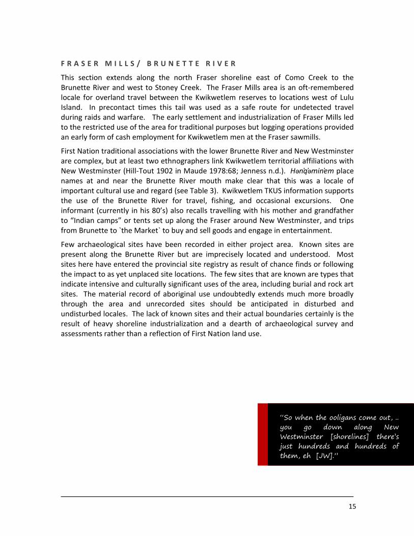
F R A S E R M I L L S / B R U N E T T E R I V E R
This section extends along the north Fraser shoreline east of Como Creek to the Brunette River and west to Stoney Creek. The Fraser Mills area is an oft-remembered locale for overland travel between the Kwikwetlem reserves to locations west of Lulu Island. In precontact times this tail was used as a safe route for undetected travel during raids and warfare. The early settlement and industrialization of Fraser Mills led to the restricted use of the area for traditional purposes but logging operations provided an early form of cash employment for Kwikwetlem men at the Fraser sawmills.
First Nation traditional associations with the lower Brunette River and New Westminster are complex, but at least two ethnographers link Kwikwetlem territorial affiliations with New Westminster (Hill-Tout 1902 in Maude 1978:68; Jenness n.d.). Hən q əmin em place names at and near the Brunette River mouth make clear that this was a locale of important cultural use and regard (see Table 3). Kwikwetlem TKUS information supports the use of the Brunette River for travel, fishing, and occasional excursions. One informant (currently in his 80’s) also recalls travelling with his mother and grandfather to “Indian camps” or tents set up along the Fraser around New Westminster, and trips from Brunette to `the Market` to buy and sell goods and engage in entertainment.
Few archaeological sites have been recorded in either project area. Known sites are present along the Brunette River but are imprecisely located and understood. Most sites here have entered the provincial site registry as result of chance finds or following the impact to as yet unplaced site locations. The few sites that are known are types that indicate intensive and culturally significant uses of the area, including burial and rock art sites. The material record of aboriginal use undoubtedly extends much more broadly through the area and unrecorded sites should be anticipated in disturbed and undisturbed locales. The lack of known sites and their actual boundaries certainly is the result of heavy shoreline industrialization and a dearth of archaeological survey and assessments rather than a reflection of First Nation land use.
“So when the ooligans come out, .. you go down along New Westminster [shorelines] there’s just hundreds and hundreds of them, eh [JW].”

16
Table 4. Kwikwetlem TKUS: Fraser Mills / Brunette River.
Places and Practices
Hunting Ungulate and carnivore hunting
Plant / Wood Harvesting
Berry and root gathering at Brunette
Fishing The past and current Kwikwetlem Fraser fishery extends from Douglas Island to the Pattullo Bridge.
Brunette River freshwater fish and resources.
Settlement Fishing and market camps from the Brunette River mouth south to New Westminster
Trails/Travel Known travel route from Coquitlam IR 1 west through Colony Farm through Cape Horn, Fraser Mills to Sapperton (and beyond).
Canoe route to Burnaby Mountain/Burrard Inlet via Brunette River and Burnaby Lake and then overland northward.
Burial & Cultural Landscape
A potential burial site and petroglyph site.
Place Names
skaiametl
sta’tәlәw
scli’qәn
sxw
a’aymәl
sxeyumu
tsitslhes
skwekwte’xwqen
schechi:les
sxwóyemlh
stá’telew
Suttles (1955:12) presents three village names at the mouth and lower reaches of the Brunette River (Sta’tələw, Scli’qən’, Sx
wa’ayməl).
Parsons (1981:36) notes a ‘fishing camp’ at the mouth of the creek downstream of the B.C. Penitentiary, as well as a named site (Sxeyumu) at the Penitentiary site itself, which she associates with Musqueam or Kwantlen.
Rozen (1979) records a Kwantlen summer camp.
McHalsie (2001) records a fishing camp (Tsitslhes) at the mouth of the Brunette River that may mean “dried out” or “drying up down at the mouth”; (Skwekwte’xwqen); (Schechi:les) meaning “strong lungs”; a transformation event (Sxwóyemlh) meaning “place where people died” and where a warrior was transformed to stone; and, a settlement (Stá’telew) “located on a creek just downriver from the modern penitentiary”.
Recorded Archaeological Sites
DhRr 7 Surface lithic scatter, area now under industrial complex
DhRr 29 Surface lithics (including projectile point); site imprecisely defined – shoreline of Brunette R.
DhRr 30 Sandstone petroglyph in the Brunette River
DhRr 75 Named site; nipple-topped hand found in dredge pile.
DhRr 112 Cultural depression
DhRr 232 Subsurface lithics
DhRr 255 Possible burial mounds and cairn

17
B U R N A B Y M O U N T A I N
Burnaby Mountain provided important forest and inland resources for inhabitants of Burrard Inlet in particular although other neighbouring nations, including Kwikwetlem, hold knowledge regarding use of the mountain for hunting, wood and plant resources, and overland travel. A water and overland travel route from the Brunette River to Burrard Inlet via Burnaby Lake and Burnaby Mountain was shown by local First Nations men to early colonialists scouting for viable overland routes to link early New Westminster with Burrard Inlet (G.S. Blake letter to Colonel R.C. Moody, April 1859). This travel route was described as an “Indian trail” by Capilano elder, August Jack Khahtsahlano to city archivist J.S. Matthews in the early 1930’s, before the “whitemans came” (2011, Vol. 3:169). The mountain also provided prime upland areas for hunting and medicinal and food plant collection particularly in the early spring when salmonberry, Indian plum, red elderberry, and other plant species important to aboriginal subsistence began producing at elevations around 200 metres on the south slope, almost 3 weeks earlier than elsewhere in the area (Crampton 1980).
No archaeological sites have been identified in this part of the Project corridor, although systematic surveys for sites or assessments that have preceded development activities have been very few. Archaeological sites should be anticipated, but are likely low density site types and those that may be difficult to detect in both the developed and remaining forested environment
Table 5. Kwikwetlem TKUS: Burnaby Mountain.
Places and Practices
Hunting Deer and bear hunting
Plant / Wood Harvesting
Berry picking: salmonberry, Indian plum, red elderberry; cedar bark and root gathering
Trails / Travel Route to Burnaby Mountain/Burrard Inlet via Brunette River and Burnaby Lake and then overland northward.
Place Names
'T[C]hluk-Thluk-Way-Tun'
August Jack Khahtsahlano noted this name, meaning "where the bark gets peeled in Spring". The base of Burnaby Mountain along Burrard Inlet.
“Where are we supposed to go now that every place is taken up?” (In reference to the privatization, industrialization and urbanization of traditional lands).
18
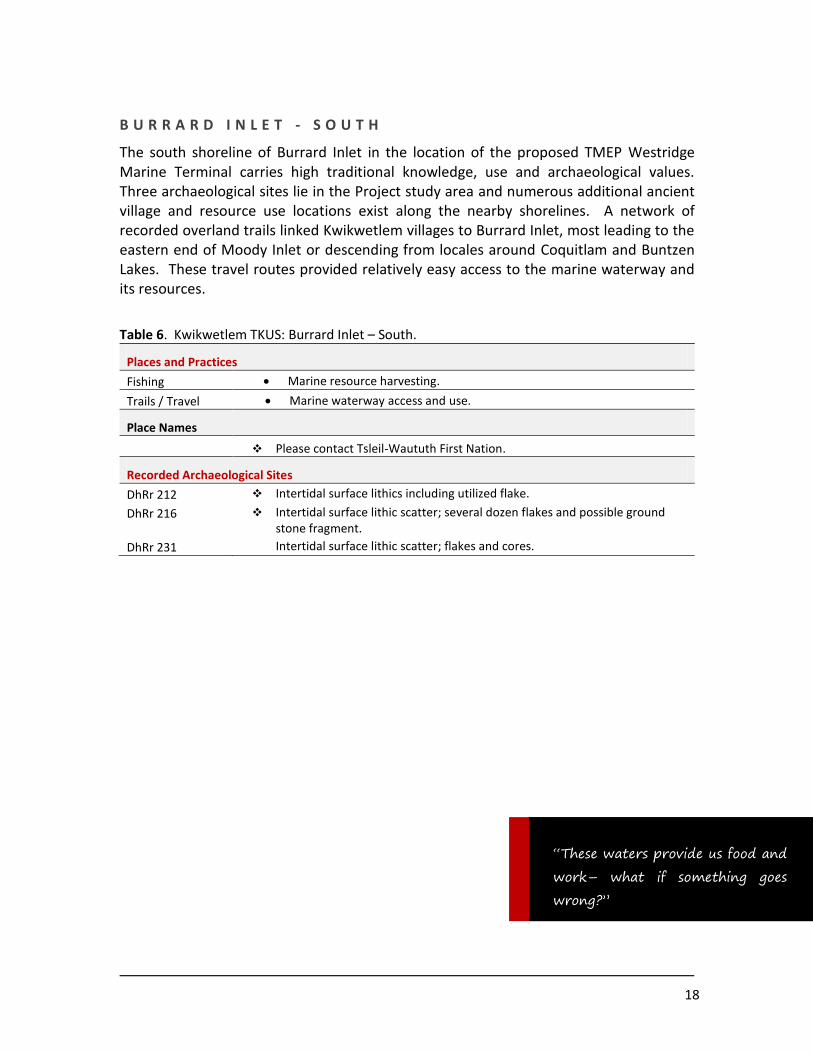
B U R R A R D I N L E T - S O U T H
The south shoreline of Burrard Inlet in the location of the proposed TMEP Westridge Marine Terminal carries high traditional knowledge, use and archaeological values. Three archaeological sites lie in the Project study area and numerous additional ancient village and resource use locations exist along the nearby shorelines. A network of recorded overland trails linked Kwikwetlem villages to Burrard Inlet, most leading to the eastern end of Moody Inlet or descending from locales around Coquitlam and Buntzen Lakes. These travel routes provided relatively easy access to the marine waterway and its resources.
Table 6. Kwikwetlem TKUS: Burrard Inlet – South.
Places and Practices
Fishing Marine resource harvesting.
Trails / Travel Marine waterway access and use.
Place Names
Please contact Tsleil-Waututh First Nation.
Recorded Archaeological Sites
DhRr 212 Intertidal surface lithics including utilized flake.
DhRr 216 Intertidal surface lithic scatter; several dozen flakes and possible ground stone fragment.
DhRr 231 Intertidal surface lithic scatter; flakes and cores.
“These waters provide us food and
work– what if something goes
wrong?”

19
5.0 TKUS Summary and Recommendations
The following identifies potential effects of the Project on Kwikwetlem heritage interests and provides recommendations to Kinder Morgan Canada regarding project design, implementation, and operation in each of the defined areas.
Kwikwetlem’s definition of heritage sites includes places with physical evidence of past human activity (as protected under the terms of the Heritage Conservation Act) as well as meaningful cultural landscapes, places of spiritual significance, named locales, known travel routes, and other places of cultural value regardless of the presence of physical remains.
General Comments
KMC TMEP developments will impact and contribute to the cumulative impacts of traditional use areas across Kwikwetlem territory. Many of the proposed TMEP project areas have been subject to considerable urban development and industrial alteration, and the proposed Project will contribute to the ongoing loss of heritage places.
The alteration of traditional lands and landscapes and access restrictions that limit opportunities to engage in traditional activities represent a profound cultural loss to the Kwikwetlem community. Historic developments have led to known and unrecorded archaeological sites impacted without the due application of heritage conservation measures or appropriate consideration of the aboriginal cultural value of these places.
Today, the Nation commits to record and preserve sites wherever possible, and requires that current and proposed land development proceed according to culturally-sensitive land planning. In cases where proposed projects will result in loss of cultural heritage places or landscapes, proponents are expected to mitigate heritage losses and contribute to heritage research and/or preservation efforts designed to offset the reduction in heritage value caused by a development.
Detail project design plans for the TMEP are not available, including the actual expansion corridor. There are currently multiple proposed corridor alternatives in Kwikwetlem territory, many well offset the existing KMC pipeline. For this reason, corridor-specific traditional use sites and land use polygons cannot be provided and the following provides broad recommendations for culturally-sensitive land use and project planning and expectations for Kwikwetlem cultural-heritage best practice.
20
Fraser Heights/Surrey Bend
Based on the range of known traditional uses, the Fraser Heights/Surrey Bend project area is considered to be of high cultural sensitivity.
Given the extent of historic disturbance along the south Fraser shoreline in this project area, KMC design plans should seek to minimize impacts to areas of previously undisturbed lands.
Archaeological impact assessments should precede all ground-disturbing project activities.
A program of deep machine archaeological assessment testing should be devised for potential works along the lowland flood plain terrain along Surrey Bend and the base of Fraser Heights.
Given the extent of the built environment along the current proposed pipeline route, a program for archaeological construction monitoring should be implemented for this project area.
KMC should make arrangements with Kwikwetlem to undertake periodic intertidal shoreline monitoring along the south Fraser River bank to assess and record the presence of eroding cultural material in this segment of the project corridor.
Kwikwetlem cultural heritage is linked to the natural habitat and resources of this project area – efforts to clean, protect, and revitalize stream and habitat restoration for native species are a priority.
Fraser River Crossing (Colony Farm / Cape Horn)
This part of the project area is of profound cultural heritage significance to Kwikwetlem.
A very broad range of traditional uses associate with the Colony Farm and Cape Horn regions: these uses include almost the full breadth of traditional use categories: hunting, fishing, plant gathering, settlements, spiritual uses, ceremonial activities, technological production, and more.
TMEP design plans should seek to minimize impacts to areas of previously undisturbed lands.
Kwikwetlem places a high priority on the detection and recording of all archaeological sites in this project area. ANY project activities must be preceded by archaeological impact assessment. This applies to staging and laydown locations, equipment storage sites, tunnelling or tunnel access locations and so on.

21
A program of deep machine archaeological assessment testing must be applied to project works on all floodplain terrain.
KMC should make arrangements with Kwikwetlem to undertake periodic intertidal shoreline monitoring along the north Fraser River bank to assess and record the presence of eroding cultural material in this segment of the project corridor.
Colony Farm, creek drainages, and the Coquitlam Wildlife Management Area all represent culturally-important and environmentally-sensitive places. Kwikwetlem is actively engaged in habitat restoration and enhancement in this locale, and projects undertaken here must be consistent with Kwikwetlem’s immediate and long-term environmental rehabilitation goals.
Fraser Mills / Brunette River
Based on the range of known and projected traditional uses, the Fraser Mills / Brunette River project area is of high cultural sensitivity to Kwikwetlem First Nation.
Traditional knowledge held by Kwikwetlem and neighbouring nations indicates long term aboriginal use of the area.
No archaeological sites are currently recorded in the Fraser Mills area. There is however little doubt that such riverside locations would have attracted a range of precontact uses and the lack of sites reflects the lack of attention to aboriginal heritage in land planning and development. Municipal and private developments continue in this area at a high rate without archaeological assessments. Kwikwetlem will require assessment of all subsurface works in the selected corridor.
Given the extent of the built environment along the current proposed pipeline route, a program for archaeological construction monitoring should be implemented for this project area.
KMC should establish a work arrangement with Kwikwetlem to undertake periodic systematic shoreline monitoring along the north Fraser shoreline to record and assess the presence of eroding cultural material fronting the project location.
22
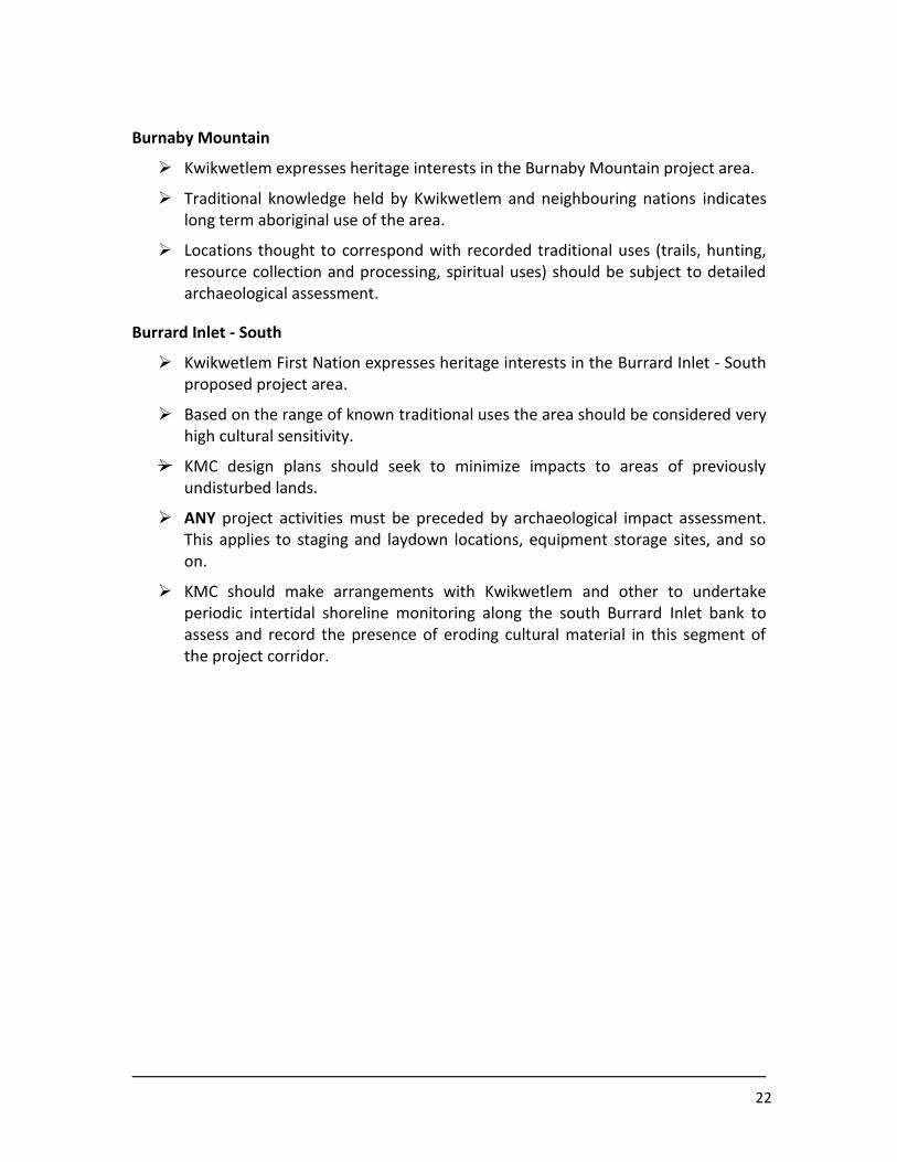
Burnaby Mountain
Kwikwetlem expresses heritage interests in the Burnaby Mountain project area.
Traditional knowledge held by Kwikwetlem and neighbouring nations indicates long term aboriginal use of the area.
Locations thought to correspond with recorded traditional uses (trails, hunting, resource collection and processing, spiritual uses) should be subject to detailed archaeological assessment.
Burrard Inlet - South
Kwikwetlem First Nation expresses heritage interests in the Burrard Inlet - South proposed project area.
Based on the range of known traditional uses the area should be considered very high cultural sensitivity.
KMC design plans should seek to minimize impacts to areas of previously undisturbed lands.
ANY project activities must be preceded by archaeological impact assessment. This applies to staging and laydown locations, equipment storage sites, and so on.
KMC should make arrangements with Kwikwetlem and other to undertake periodic intertidal shoreline monitoring along the south Burrard Inlet bank to assess and record the presence of eroding cultural material in this segment of the project corridor.
23
6.0 Heritage Best Practices – Kwikwetlem First Nation and TMEP
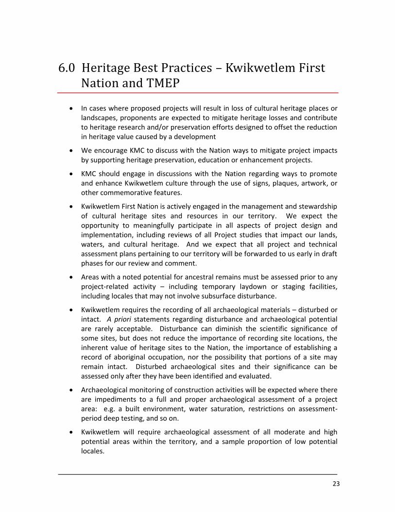
In cases where proposed projects will result in loss of cultural heritage places or landscapes, proponents are expected to mitigate heritage losses and contribute to heritage research and/or preservation efforts designed to offset the reduction in heritage value caused by a development
We encourage KMC to discuss with the Nation ways to mitigate project impacts by supporting heritage preservation, education or enhancement projects.
KMC should engage in discussions with the Nation regarding ways to promote and enhance Kwikwetlem culture through the use of signs, plaques, artwork, or other commemorative features.
Kwikwetlem First Nation is actively engaged in the management and stewardship of cultural heritage sites and resources in our territory. We expect the opportunity to meaningfully participate in all aspects of project design and implementation, including reviews of all Project studies that impact our lands, waters, and cultural heritage. And we expect that all project and technical assessment plans pertaining to our territory will be forwarded to us early in draft phases for our review and comment.
Areas with a noted potential for ancestral remains must be assessed prior to any project-related activity – including temporary laydown or staging facilities, including locales that may not involve subsurface disturbance.
Kwikwetlem requires the recording of all archaeological materials – disturbed or intact. A priori statements regarding disturbance and archaeological potential are rarely acceptable. Disturbance can diminish the scientific significance of some sites, but does not reduce the importance of recording site locations, the inherent value of heritage sites to the Nation, the importance of establishing a record of aboriginal occupation, nor the possibility that portions of a site may remain intact. Disturbed archaeological sites and their significance can be assessed only after they have been identified and evaluated.
Archaeological monitoring of construction activities will be expected where there are impediments to a full and proper archaeological assessment of a project area: e.g. a built environment, water saturation, restrictions on assessment-period deep testing, and so on.
Kwikwetlem will require archaeological assessment of all moderate and high potential areas within the territory, and a sample proportion of low potential locales.
24
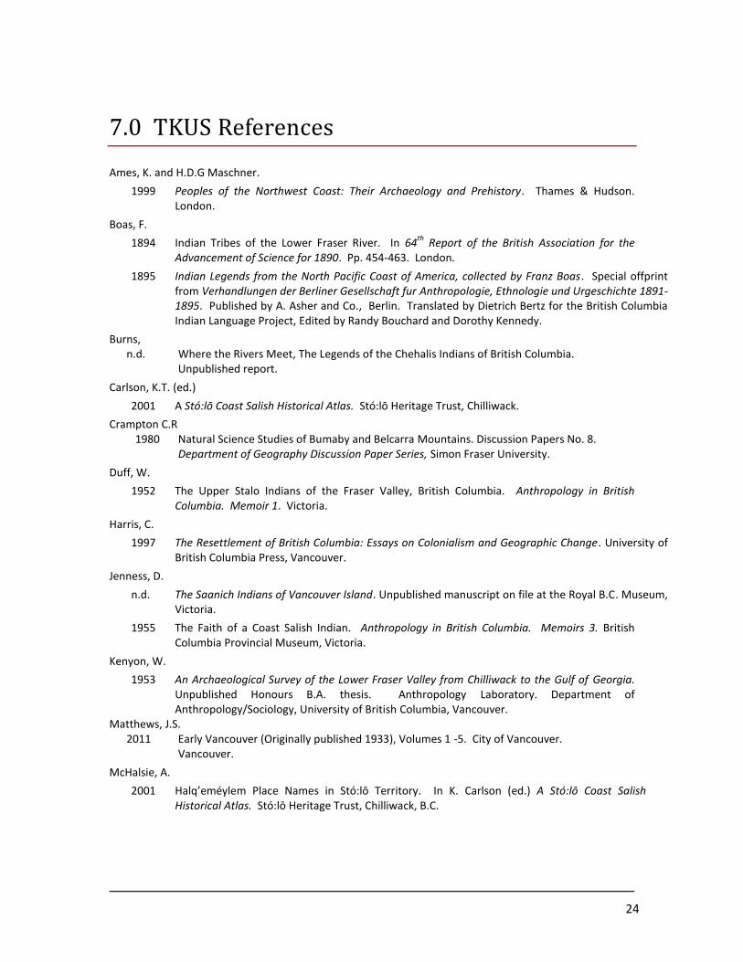
7.0 TKUS References
Ames, K. and H.D.G Maschner.
1999 Peoples of the Northwest Coast: Their Archaeology and Prehistory. Thames & Hudson. London.
Boas, F.
1894 Indian Tribes of the Lower Fraser River. In 64th
Report of the British Association for the Advancement of Science for 1890. Pp. 454-463. London.
1895 Indian Legends from the North Pacific Coast of America, collected by Franz Boas. Special offprint from Verhandlungen der Berliner Gesellschaft fur Anthropologie, Ethnologie und Urgeschichte 1891-1895. Published by A. Asher and Co., Berlin. Translated by Dietrich Bertz for the British Columbia Indian Language Project, Edited by Randy Bouchard and Dorothy Kennedy.
Burns, n.d. Where the Rivers Meet, The Legends of the Chehalis Indians of British Columbia.
Unpublished report.
Carlson, K.T. (ed.)
2001 A Stó:lō Coast Salish Historical Atlas. Stó:lō Heritage Trust, Chilliwack.
Crampton C.R 1980 Natural Science Studies of Bumaby and Belcarra Mountains. Discussion Papers No. 8.
Department of Geography Discussion Paper Series, Simon Fraser University.
Duff, W.
1952 The Upper Stalo Indians of the Fraser Valley, British Columbia. Anthropology in British Columbia. Memoir 1. Victoria.
Harris, C.
1997 The Resettlement of British Columbia: Essays on Colonialism and Geographic Change. University of British Columbia Press, Vancouver.
Jenness, D.
n.d. The Saanich Indians of Vancouver Island. Unpublished manuscript on file at the Royal B.C. Museum, Victoria.
1955 The Faith of a Coast Salish Indian. Anthropology in British Columbia. Memoirs 3. British Columbia Provincial Museum, Victoria.
Kenyon, W.
1953 An Archaeological Survey of the Lower Fraser Valley from Chilliwack to the Gulf of Georgia. Unpublished Honours B.A. thesis. Anthropology Laboratory. Department of Anthropology/Sociology, University of British Columbia, Vancouver.
Matthews, J.S. 2011 Early Vancouver (Originally published 1933), Volumes 1 -5. City of Vancouver.
Vancouver.
McHalsie, A.
2001 Halq’eméylem Place Names in Stó:lō Territory. In K. Carlson (ed.) A Stó:lō Coast Salish Historical Atlas. Stó:lō Heritage Trust, Chilliwack, B.C.

25
Maud, R. (ed.)
1978 The Salish People – The Local Contributions of Charles Hill-Tout, Vol. 3, The Mainland Halkomelem. Talonbooks, Vancouver.
Parsons, M.
1981 Fraser River Estuary Heritage Resource Inventory. Heritage Conservation Branch, Victoria.
Rozen, D. 1979 Lower Fraser Valley Planning Study: Ethnographic Sites in the Greater Vancouver Regional
District. In L. Ham (ed.), The Evaluation of Archaeological Sites in the Greater Vancouver Regional District: Proposals for Management. Heritage Conservation Branch, Victoria.
Suttles, W.
1955 Katzie Ethnographic Notes. Anthropology in British Columbia Memoir, No. 2. British Columbia Provincial Museum, Victoria.
1968 Coast Salish Essays. University of Washington Press, Portland.
1990 Central Coast Salish. In Suttles, W. (ed.) Handbook of North American Indians - Northwest Coast, pp. 453-475. Vol. 7. Smithsonian Institution, Washington D.C.
26
Part B
8.0 Socio-economic Data Collection: Kinder Morgan Trans Mountain Pipeline Expansion Project
27
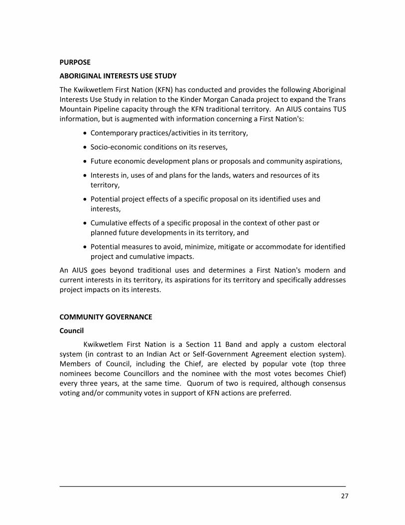
PURPOSE
ABORIGINAL INTERESTS USE STUDY
The Kwikwetlem First Nation (KFN) has conducted and provides the following Aboriginal Interests Use Study in relation to the Kinder Morgan Canada project to expand the Trans Mountain Pipeline capacity through the KFN traditional territory. An AIUS contains TUS information, but is augmented with information concerning a First Nation's:
Contemporary practices/activities in its territory,
Socio-economic conditions on its reserves,
Future economic development plans or proposals and community aspirations,
Interests in, uses of and plans for the lands, waters and resources of its territory,
Potential project effects of a specific proposal on its identified uses and interests,
Cumulative effects of a specific proposal in the context of other past or planned future developments in its territory, and
Potential measures to avoid, minimize, mitigate or accommodate for identified project and cumulative impacts.
An AIUS goes beyond traditional uses and determines a First Nation's modern and current interests in its territory, its aspirations for its territory and specifically addresses project impacts on its interests.
COMMUNITY GOVERNANCE
Council
Kwikwetlem First Nation is a Section 11 Band and apply a custom electoral system (in contrast to an Indian Act or Self-Government Agreement election system). Members of Council, including the Chief, are elected by popular vote (top three nominees become Councillors and the nominee with the most votes becomes Chief) every three years, at the same time. Quorum of two is required, although consensus voting and/or community votes in support of KFN actions are preferred.
28
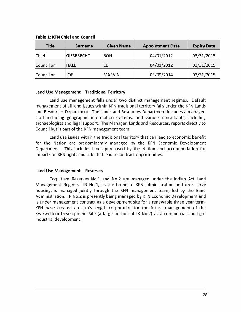
Table 1: KFN Chief and Council
Title Surname Given Name Appointment Date Expiry Date
Chief GIESBRECHT RON 04/01/2012 03/31/2015
Councillor HALL ED 04/01/2012 03/31/2015
Councillor JOE MARVIN 03/09/2014 03/31/2015
Land Use Management – Traditional Territory
Land use management falls under two distinct management regimes. Default management of all land issues within KFN traditional territory falls under the KFN Lands and Resources Department. The Lands and Resources Department includes a manager, staff including geographic information systems, and various consultants, including archaeologists and legal support. The Manager, Lands and Resources, reports directly to Council but is part of the KFN management team.
Land use issues within the traditional territory that can lead to economic benefit for the Nation are predominantly managed by the KFN Economic Development Department. This includes lands purchased by the Nation and accommodation for impacts on KFN rights and title that lead to contract opportunities.
Land Use Management – Reserves
Coquitlam Reserves No.1 and No.2 are managed under the Indian Act Land Management Regime. IR No.1, as the home to KFN administration and on-reserve housing, is managed jointly through the KFN management team, led by the Band Administration. IR No.2 is presently being managed by KFN Economic Development and is under management contract as a development site for a renewable three year term. KFN have created an arm’s length corporation for the future management of the Kwikwetlem Development Site (a large portion of IR No.2) as a commercial and light industrial development.

29
POPULATION AND ECONOMIC PROFILE
The registered population of the Kwikwetlem First Nation as of May, 2014 is included in Table 2 below:
Table 2: Population and Residency
Labour Force, Labour Market
Details regarding the KFN labour force were not available. The labour market for KFN members is short on supply but high on demand. KFN have been successful in acquiring public sector civil contracts through aboriginal rights accommodation and through regular market mechanisms. KFN frequently employ non-KFN Aboriginal workforce for both administration and contract work.
Education and Skills
No quantitative information was available regarding the education and skill levels of KFN members. Anecdotally, KFN suffers from only minor structural employment in two forms: Members who, for personal reasons are not ready or willing to enter the workforce, and members in between work positions for short periods of time. Members unemployed for short periods of time relate mostly to work in construction fields with down time between jobs and projects.
Residency # of People
Registered Males On Own Reserve 22
Registered Females On Own Reserve 13
Registered Males On Other Reserves 3
Registered Females On Other Reserves 1
Registered Males Off Reserve 24
Registered Females Off Reserve 18
Total Registered Population 81
30
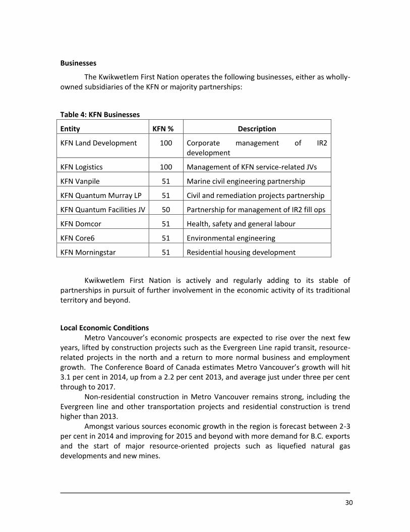
Businesses
The Kwikwetlem First Nation operates the following businesses, either as wholly-owned subsidiaries of the KFN or majority partnerships:
Table 4: KFN Businesses
Entity KFN % Description
KFN Land Development 100 Corporate management of IR2 development
KFN Logistics 100 Management of KFN service-related JVs
KFN Vanpile 51 Marine civil engineering partnership
KFN Quantum Murray LP 51 Civil and remediation projects partnership
KFN Quantum Facilities JV 50 Partnership for management of IR2 fill ops
KFN Domcor 51 Health, safety and general labour
KFN Core6 51 Environmental engineering
KFN Morningstar 51 Residential housing development
Kwikwetlem First Nation is actively and regularly adding to its stable of partnerships in pursuit of further involvement in the economic activity of its traditional territory and beyond.
Local Economic Conditions Metro Vancouver’s economic prospects are expected to rise over the next few
years, lifted by construction projects such as the Evergreen Line rapid transit, resource-related projects in the north and a return to more normal business and employment growth. The Conference Board of Canada estimates Metro Vancouver’s growth will hit 3.1 per cent in 2014, up from a 2.2 per cent 2013, and average just under three per cent through to 2017. Non-residential construction in Metro Vancouver remains strong, including the Evergreen line and other transportation projects and residential construction is trend higher than 2013.
Amongst various sources economic growth in the region is forecast between 2-3 per cent in 2014 and improving for 2015 and beyond with more demand for B.C. exports and the start of major resource-oriented projects such as liquefied natural gas developments and new mines.

31
The Kwikwetlem First Nation market area (Coquitlam, Port Coquitlam and Pitt Meadows) includes 8.5% of Metro Vancouver‟ s total population, 9.2% of the region‟ s total land mass, 8.8% of land in the region zoned industrial, and just 4.8% of the region’s development-ready industrial land.
Generally, local economic conditions have been excellent during the last decade and the KFN have benefitted greatly from expansion of both residential and commercial construction as well as from a number of large public sector projects, including the Port Mann Bridge and Highway 1 redevelopment, Evergreen Line and the redevelopment of the Riverview site. KFN expect further opportunities for employment, contracting and other forms of involvement leading to economic prosperity for KFN and its members through several anticipated projects. Among these projects are at least three development and upgrade projects for Fortis BC, several transmission projects with BC Hydro, disposal of assets through the Province’s Release of Assets for Economic Generation program and the expansion of the Transmountain Pipeline, to name a few.
Local employment and other economic indicators are presently, and are forecast to be, positive and the KFN are capitalizing on these circumstances.
Economic Development Plans
Kwikwetlem First Nation conducts a full revision of its economic development strategy every five years. The KFN are currently in the process of completing a comprehensive community plan that includes a detailed strategic economic development plan, slated for completion in the Fall of 2014. KFN economic development plans in the past have focused on the development of Coquitlam Indian Reserve No. 2 (IR2), however, the current draft strategic plan includes a significant focus on a diversity of business and investment strategies beyond IR2. Amongst the opportunities in the draft plan are fee simple land purchases, investments in resource businesses, partnerships in a variety of industries and wide-scale business involvement in the economy of the KFN traditional territory.
UTILITIES, SERVICES AND INFRASTRUCTURE
Community Infrastructure
Kwikwetlem First Nation occupies two federal Indian reserves with a gross area of 84.5 hectares.
32
Table 5: Kwikwetlem Reserves
No. Name Location Hectares
08009 COQUITLAM 1 NEW WESTMINSTER DISTRICT, IN TP.38, W.C.M., ON RIGHT BANK OF THE COQUITLAM RIVER, 4 MILES EAST OF NEW WESTMINSTER
2.60
08010 COQUITLAM 2 NEW WESTMINSTER DISTRICT, IN TPS. 38&39, W.C.M. ON LEFT BANK OF THE COQUITLAM RVR, 2 MILES FROM MOUTH ON FRASER RVR
81.90
Coquitlam 1 (IR1)
Coquitlam Indian Reserve No. 1 (IR1) is a fully serviced subdivision that comprises housing, the Band office and Hall complex, a boathouse/workshop and various outbuildings. The on-site road is basic gravel sections with patches of asphalt. There are no curbing or storm water catchment provisions beyond the two catch basins (the connection details are not on record but are likely to be outfalls to existing watercourses). There is also a 300mm culvert under the existing subdivision roadway that drains to the adjacent catch basin.
Potable water service is a 150mm PVC main under the existing subdivision roadway. Connections to housing and buildings are 25mm PVC. The water source is the City of Coquitlam system. Fire protection is provided by 2 hydrants located adjacent to the existing subdivision roadway that are connected to the 150mm water main. The sanitary service is 200mm gravity PVC main that terminates to two septic holding tanks and an effluent pump station. House and building sanitary connections are 100mm PVC. The effluent from IR1 is lifted through a 75mm HDPE force main to an offsite connection on the City of Coquitlam sanitary system.
Hydro, telephone and television/broadband-cable services are aerial cable systems that are mounted on standard wooden poles situated along the existing subdivision road alignment. Cable service connections to houses and buildings are therefore aerial.
An IR1 roadway improvement project has been tendered that will see existing road sections connected to create a single and continuous access road through the existing subdivision. The new roadway will be paved and curbed to create a storm water runoff catchment to the two existing catch basins. Street lighting standards will be installed and energized by underground cable. A further project is being contemplated that will convert all aerial cable systems (hydro, telephone, cable) within the existing subdivision to underground duct banks. This project will also involve the incremental conversion of all aerial services to houses and buildings to underground.
33
Coquitlam 2 (IR2)
IR2 presently has two residential water service connections, one at the North entry to the certificate of possession property and the other at the southeast corner of IR2 where, until recently, seven community homes were located. Limited electrical service is provided at the same locations, but there are no sanitary or stormwater connections within IR2
Approximately 50 hectares of IR2 are protected from flooding from the Coquitlam River by dikes at the Southern lot line and north-south dike (referred to as the Traboulay Trail). The latter dike was constructed in 1994 and is fully within the Federal reserve and managed by the KFN, although under recurring contract for maintenance with the City of Port Coquitlam.
IR2 is an active development site that averages 30,000 cubic metres of residentially-classified structural fill material placed on a monthly basis. The filling seeks to achieve three goals for the Nation: Achieving an elevation above floodplain and hydrostatic ground water pressure, achieving an elevation drainage profile that allows positive drainage without the use of pumping for sanitary and stormwater, and lastly for income generation through tipping fees.
KFN receives federal funding for the following programs: Community development, including New Housing; Water and Sewer System Maintenance; Water Quality, and General municipal services.
Health and Social Services
As a result of its small population, Kwikwetlem First Nation provides limited health and social services and relies predominantly on outside services. Health Canada provides support to KFN through Brighter Futures, Disease Control, Aboriginal Diabetes and the general health planning and management funding available to First Nations.
Social development funding to KFN includes general service delivery, social development, special needs, national child benefit, adult in-home care and family violence.
Emergency Services
Although emergency management is a provincial/territorial responsibility, Aboriginal Affairs and Northern Development Canada (AANDC) is responsible for emergency management in First Nation communities. AANDC has an agreement with the BC Government to ensure that BC First Nations communities receive the same emergency response and services as other communities in BC. The Province manages

34
programs like Emergency Social Services and Disaster Financial Assistance and AANDC covers eligible costs for First Nations.
AANDC works closely with First Nation communities, the Province, FNESS and other partners to ensure the communities are supported and know where to seek assistance during emergencies. AANDC has staff dedicated to working with First Nations during emergencies. A duty officer is available 24/7 to answer calls about emergencies and a team of AANDC staff has been trained to work with the Province and other partners to support First Nation communities during emergencies.
Emergency Management BC (EMBC) is responsible for supporting local governments in emergency management. EMBC makes its resources available to support any BC community that is threatened by an emergency or disaster. EMBC works with local governments, including First Nations, to provide training and support before, during and after emergencies.
There are many organizations that support First Nations before, during and after emergencies including federal and provincial governments and non-government organizations (NGOs). Different organizations may be called upon in each emergency situation depending on the expertise and resources required. For example, Health Canada may become involved if air or water quality needs to be assessed. When wildfires occur, the BC Wildfire Management Branch plays the central role in emergency response in the province. The Canadian Red Cross helps communities prevent and prepare for health emergencies. Other NGOs that may assist include the Salvation Army, the Mennonite Society and animal welfare organizations like the Canadian Disaster Animal Response Team and Noah’s Wish.
If the Local Government and/or Chief and Council issue an evacuation order for the KFN community, Emergency Social Services (ESS) is intended to meet the immediate basic needs of evacuees including food, lodging, clothing, transportation and incidentals for 72 hours. If individuals or families require assistance beyond the ESS level of service, KFN Band Council will coordinate with agencies to provide assistance.
Kwikwetlem First Nation has an emergency evacuation plan, with a flooding event of the Coquitlam River for the residents of IR1 being the primary threat. The evacuation plan includes assignment of drivers and riders for an evacuation and is available on the KFN website and is provided to every home as a detailed brochure. All other emergency services, including fire, police and ambulance, are provided by local authorities and the RCMP.

35
Education and Training Services
Kwikwetlem First Nation receives education funding for both K1-K12 and post-secondary. Among other support through both program and application based programs are: the training employment support initiative, professional and institutional development, band employee benefit, and planning and skill development programs.
KFN have benefitted from extensive training opportunities related to the projects for which the Nation has been involved, including the flagging and heavy equipment operation at the KFN Development Site and a variety of on-the-job or project specific training related to KFN contracts and accommodation involvement in large regional public sector projects. For the most part, this latter training has come at no expense to the Nation.
KFN have trained archaeology assistants and monitors as a result of the extensive needs for archaeological investigations within the KFN traditional territory. KFN have entered into an agreement with Core6 Environmental to train KFN members in environmental science based collection, monitoring and investigation measures as part of a partnership with the environmental engineering group.
SOCIAL AND CULTURAL WELL BEING
Culture, Quality of Life and Health
Detailed information on the cultural history of the Kwikwetlem People is included in the first section of this report. In their traditional society, KFN practiced a variety of trades and economic activities, including: traders, carvers, healers, prophets, hunters, fishermen, weavers, storytellers, warriors, dispute resolution experts and others.
With the arrival of the Europeans (Xwelitems or "Hungry People") many of KFN traditions were challenged and threatened. With the Potlatch Laws, KFN spirituality was declared immoral and illegal. Impacts on environment and natural resource extraction essentially removed the KFN right to sell and trade salmon and residential school policy removed children from the Community where they were taught to reject their Elders' teachings. Other laws meant to extinguish culture included restrictions on travel from reserves and We were forbidden to move about freely among our villages and the application of paternalistic community governance and management systems that had no reflection on the system of values or self-governance objectives of the Nation.
Despite a resurgence of interest in the history and culture of the Kwikwetlem People, the sense of culture among the membership has been challenged.
36
NON-TRADITIONAL LAND USE
KFN have followed a policy of aggressive expansion of their involvement in the economy of their traditional territory since the Council election of 2009. As a result, the KFN are involved in a diversity of projects throughout the Territory and that diversification is expected to continue into the foreseeable future as the Nation develops broader partnerships and improves its financial capacity and experience.
Further, as the Nation improves its financial circumstance, develops equity and opportunities for land purchases present themselves, the KFN will continue to buy land within the Territory when the business case supports it.
KFN continue to undertake their seasonal fishing rights and are actively seeking opportunities for forestry, mining and aggregate, as well as assets for both aboriginal and contemporary tourism products.
KFN CONTEMPORARY INTERESTS
Land Related
IR1
Coquitlam Indian Reserve No. 1 (IR1) is the home to the majority of KFN members and the seat of administration for the Nation. The Reserve also houses ancillary buildings such as community hall and canoe shed. With recent multiplex housing developments for community members on IR1 and the expansion of staff and services, IR1 is nearing capacity.
IR2
Coquitlam Indian Reserve No. 2 (IR2) is currently predominantly being planned as a commercial development site with only minor speculative space being considered for community residential. The area protected by the dike will become the Kwikwetlem Development Site (KDS) and be developed for commercial, while the area of IR2 not protected by the dike is within the floodplain and is not considered developable for commercial or residential use. The area of IR2 not protected by the dike will likely remain as the community cemetery, green space and may provide as filtration for managed stormwater from the development site.
In the interim, as the KDS prepares for future development, active fill operations continue to bring residential and commercial characterized structural fill material for the improvement of the KDS and as a source of income for the Nation. Further, the KDS is also being used as a bare land lease facility for areas not impacted by fill operations. The KFN have recently begun advertising the space available for lease at the KDS and have arrived at lease arrangements with Kiewit and BC Earthworks Exchange. KFN are
37
also discussing the use of the KDS for Kinder Morgan and FortisBC as construction laydown and storage for the transmountain pipeline project and various FortisBC projects, respectively.
Fee Simple Land Purchases
KFN are actively seeking to invest through purchase of strategic parcels of fee simple land within the Region. The KFN have made unsuccessful offers for lands related to the provincial Release of Assets for Economic Generation program but many of those opportunities continue to be available with more surplus provincial lands slated for release. Other surplus provincial and federal lands are also being considered and the KFN are also interested in private fee simple lands.
Kwikwetlem First Nation has an agreement with the Province of British Columbia to sell approximately 25 acres of land subdivided from the Colony Farm Forensic Psychiatric Facility adjacent to IR1. This process of purchase and transfer is expected to occur in 2014. The KFN expect to develop approximately two-thirds of the land South of the Facility for light industrial use and the remainder for community service buildings.
KFN are pursuing a policy of expansion of their land base and have the financial capacity to achieve this expansion in the near term as opportunities that meet the economic and community objectives of the policy present themselves.
Land Settlement
Although the Kwikwetlem First Nation is not involved in the BC treaty negotiation process, the KFN expect that some form of land settlement will occur in the future. As such, there’s the potential for any lands to within the KFN traditional territory to come under a land settlement agreement

38
Economic Presence
Mostly as a response to a tremendous expansion in First Nation consultation and the resultant efforts at accommodation, the Kwikwetlem First Nation has grown to include various partnerships for active involvement in both, the projects tied to accommodation of Aboriginal rights and title, and a spectrum of other projects requiring First Nation involvement.
Pilings, dredging, caissons and marine related design and build construction work: KFN is a partner in KFN Vanpile (51%) for various marine civil engineering and civil construction works. KFN Vanpile is able to provide a wide range of services including, marine construction, pile driving, dredging, slope protection, densification, concrete floats, underwater installations and related environmental remediation. KFN Vanpile is currently involved in a subcontract on the Glenrose Tidal Marsh Project (Port Metro Vancouver).KFN Vanpile are particulary interested in the works envisioned for the Westridge Terminal and potentially the design build opportunities for the entire facility.
Environmental Remediation and related services: KFN have a multi-project partnership with Quantum Murray, a national environmental remediation and demolition company. Quantum Murray holds contracts for emergency spill and site remediation services for large national clients such as Canadian Pacific Railways. The KFN hold a 51% stake in the KFN Quantum-Murray Joint Venture. The Joint Venture successfully completed the Wilson Farm Project ($4million), and has won the contracts for the Riverview Demolition/Remediation Project ($TBD) and the Port Metro Vancouver Glenrose Tidal Marsh Project ($1.8 million).
KFN is interested in the opportunity of providing emergency and spill response services in partnership with Quantum Murray within the KFN traditional territory.
Fill Site Services and Construction Laydown: KFN and Quantum Facilities (a division of Quantum Murray) are equal partners in the management of the KFN Development Site, which manages the KFN residential and commercial fill site at Pitt River Road in Port Coquitlam. The fill site accepts residential quality fill at present along with limited amounts of asphalt and cement for road building. The KFN and Quantum Facilities expect to be in a position to receive fill characterized for commercial use by mid- 2014 as part of its fill plan for the KFN Development Site.
The KFN Development Site is approximately 120 acres and has several areas available for lease as construction laydown in proximity to the various route options for the Project.
39
Hydrocarbon Waste Remediation: KFN also has a partnership arrangement with Envirogreen Technologies, a BC-based contaminated waste remediation firm. Envirogreen’s thermal desorption technology offers a complete solution for the remediating of special waste hydrocarbons such as: Contaminated soils (gasoline, diesel, jet fuel, Bunker-C, crude oil, waste oils, lube oils, hydraulic oils), petroleum and waste oil tank bottoms, slop tank cleaning solids, polycatalyst, digester bugs, settling pond sludges and bottoms, coal tar and creosote contaminated soils (PAH’s), waste paints (liquid and semi-solid), activated charcoal, and contaminated wood waste materials. The KFN have had a longstanding relationship with the owners of Envirogreen (formerly owners of Quantum Murray) and are actively looking for partnership opportunities where the KFN would be 51% owners.
Road building and maintenance and Excavation: KFN have working relationships with a number of local mid-size ($50+ million bonding capacity) general road, building and excavation contractors. All the firms we work with have excellent reputations and maintain large inventories of owned and leased heavy equipment. Dependent on the scale of works (bigger is better), the KFN would be very interested in road building and related works as well as non-specialized excavation. Among the companies that KFN could partner are BA Blacktop, Matcon, B&D Contracting, etc. The KFN have established relationships with these and other companies with a view towards a 51% partnership for KFN on projects.
Paving and Curbs: KFN has capacity as a general contractor for parking lots, road realignments and other asphalt and concrete works. These projects could be taken on directly with no partner, completed through subcontracting.
Other Civil Services: Utilities installation and relocation, design engineering, specialty excavation, trucking and pre-loading.
Environmental Science and Engineering and Support Services: KFN Core 6 Environmental is a 51% JV between KFN and Core 6 Environmental, a full service environmental consulting firm. Core 6 is the KFN partner on the present Riverview contaminated sites project, and our contractor for a full environmental assessment of the Kwikwetlem Development Site, pre-development. KFN, Core 6 and Domcor (see below) are also presently working cooperatively on developing training programs for environmental support services for First Nations.
40
The KFN Core 6 Environmental JV can provide the following services:
Contaminated Site Investigations Remediation & Risk Management Brownfield Assessment & Remediation Human Health and Ecological Risk Assessment Toxicological Studies & Consulting Hydrogeology Project Permitting & Environmental Impact Assessment Species & Habitat Assessment / Riparian Area Assessment Review and Expert Witness Support CSAP (Contaminated Site Approved Professional) Support Emergency Response Support
Modulars, Workforce Accommodation: KFN has partnerships and working relationships with ATCO, Britco and Shelter, modular and portable site office providers as well as workforce accommodation buildings and services. KFN and Britco are presently negotiating an agreement (terms still being negotiated) for joint involvement in large scale public sector projects within the KFN traditional territory.
Labour Supply: KFN Domcor is a 51% joint venture with Domcor Health, Safety and Security, Inc. The JV provides a fully integrated suite of health and safety services, including First Aid, Traffic Control and Security solutions. Domcor offers community-based training in all aspects of a health and safety program, delivered locally or globally. Domcor brings its proven industrial training programs, including first aid training and confined space training to its JV with KFN.
KFN Domcor can provide core services such as Security (lay down yards, construction, access control to sites, etc), First Aid services – subject to location of work and proximity of Hospitals, MTC units with OFAIIIs, Traffic Control for trucks and deliveries, CSO’s for construction safety, and general labour and more.
Landscaping: Hard and soft landscaping services are available through a number of KFN relationships, including Wilco, B&D Contracting, Moscone Bros and other smaller firms.
Habitat compensation: KFN can provide services in terms of the non-scientific works, including civil works, heavy equipment, specialized marine equipment or general project management support.
Micro-piling: The KFN has a longstanding relationship with Kani Foundation Technologies, a specialist in micro-piling. This is highly technical work and there are few service providers regionally.