restoring urban wetlands for increased coastal resiliency ... presentations/july... · restoring...
TRANSCRIPT

Restoring urban wetlands for increased coastal resiliency: needs and priorities in NYC Marit Larson1, Leah Beckett1 and Jamie Ong2 1NYC Dept. of Parks & Recreation 2Natural Areas Conservancy Conference on Ecological and Ecosystem Restoration July 28, 2014
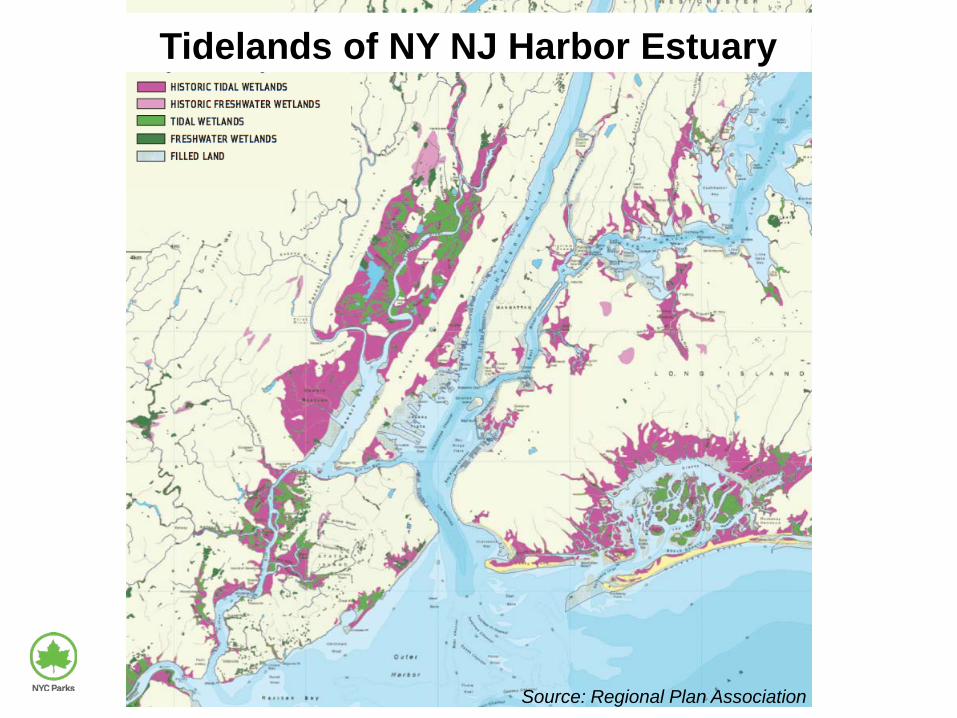
Tidelands of NY NJ Harbor Estuary
Source: Regional Plan Association

Habitat — fish and horseshoe crabs spawning and rearing; bird feeding and nesting
Water quality enhancement — filtering, nutrient and pollutant absorption and uptake
Recreation — birding, walking, painting, fishing
Storm and flood protection — wave attenuation, storm surge reduction
Climate regulation — carbon sequestration
Lost wetland values

Hurricane Sandy inundation over historic wetlands

Strategies Tactics
Restore elevation, substrate & hydrology
• Excavate historic fill • Place clean sand to cap or reconstruct • Remove or breach berms • Control invasive plants (mechanically,
chemically) • Remove anthropogenic marine debris • Remediate oil spills • Establish stable toe (erosion control) • Prevent dumping • Remove marine debris
Restore and manage vegetation
Reduce impacts
Goal: Restore and reconstruct marsh for habitat, water quality and other benefits

Pugsley Creek (1.2 ac)
Small scale salt marsh restoration Fill removal, sand placement, berm breach
Calvert Vaux Pk (0.5 ac)
Soundview Pk w/ ACE (3.2 ac)
Turtle Cove (2ac)

Large scale salt marsh restoration Fill removal, sand placement
U.S.ACE & Parks: Gerritsen Ck (20 ac) U.S. ACE: Jamaica Bay (>100 ac)

Completed coastal wetlands restoration / GI
Restoration in NYC since 1990: >200 acres, >40 projects
Jamaica Bay
New York Harbor
Long Island Sound
Arthur Kill
Completed projects

Jamaica Bay
New York Harbor
Long Island Sound
Arthur Kill
Next coastal restoration / GI opportunities?
Over 90 identified sites with coastal wetlands restoration / GI potential
Local proposals (NY Rising) Regional plans (ACE CRP)
Post-Sandy conceptual plans (RBD, ACE) New context Increasing site constraints Vulnerability to SLR and other impacts Emphasis on coastal protection
Completed projects
Potential projects

Value
Impacts
x
x x
x
x
x
x x
x
x
x
x
No Immediate Action Lower Priority
Preserve Conserve Monitor
Manage Restore Protect x
x
x
Synthesize data from landscape and field assessments (with additional metrics) to identify salt marsh most in need of management and restoration
Conceptual model for prioritizing sites

Framework for assessing restoration needs and opportunities
Field Analysis • Ecological condition • Anthropogenic impacts • Elevation and erosion
Landscape Analysis
• Filled wetlands • Recent historic loss • Inundation modeling • Marsh buffer conditions • Hydraulics & geomorphology • Socio-economic factors
NYCDPR Assessing Urban Salt Marshes

Existing conditions: vegetation cover sampling
Long Island Sound
Arthur Kill
Jamaica Bay

05
10152025303540
Long Isl Sound Jamaica Bay Arthur Kill
Avg.
Per
cent
Cov
er
Bare soil
Salt Panne
Man-Made Ditch
Tidal Creek
0
2
4
6
8
10
12
Long Isl Sound Jamaica Bay Arthur Kill
Avg.
Per
cent
Cov
er
Fill
Garbage
Wrack
Conditions influencing vegetation

Mapped debris, fill and vegetation loss
Long Island Sound
Arthur Kill Jamaica Bay
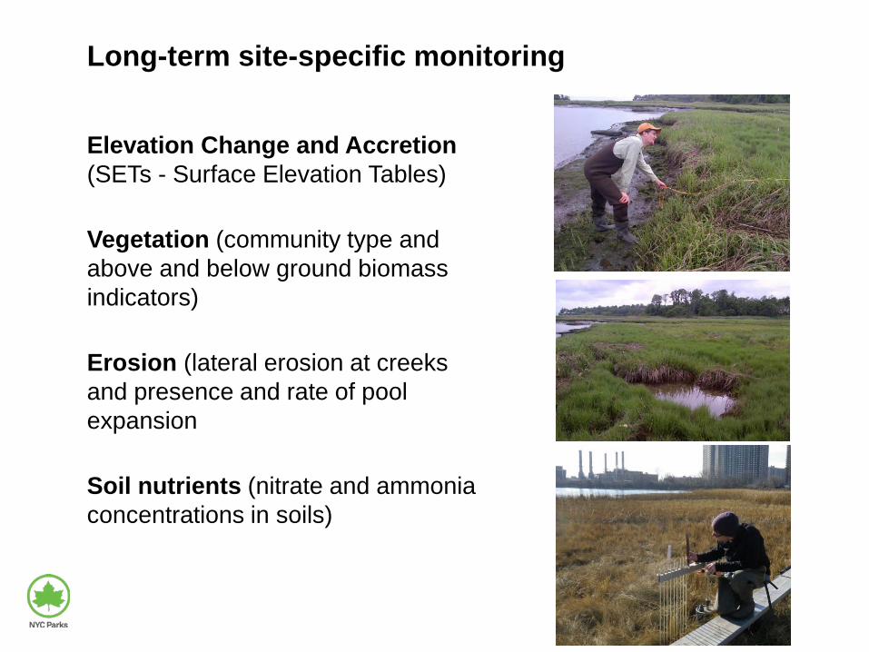
Long-term site-specific monitoring
Elevation Change and Accretion (SETs - Surface Elevation Tables)
Vegetation (community type and above and below ground biomass indicators)
Erosion (lateral erosion at creeks and presence and rate of pool expansion
Soil nutrients (nitrate and ammonia concentrations in soils)
N

Marsh restoration needs:
Boat remains
Debris piles
Scattered debris
Treated wood debris piles Boats
Miscellaneous floatable debris Fill and construction rubble

Potential scour Tidal creek expansion
Marsh restoration needs:
Infrastructure impeding salt marsh Waters edge marsh loss

Opportunities for fill removal
Big Egg Marsh
Jamaica Bay
Sunset Cove Park, Queens: ~7 acres of contaminated fill on historic salt marsh

Sunset Cove restoration project
Feasibility factors • Fill height, extent and quality • Community support • Adjacent land use • Ecological uplift • Exposure

Recent salt marsh loss
• Overlay 1974 salt marsh boundaries with 2012 mapping to calculate areas of marsh loss along the waters edge from 1974 to 2012
• Identify sites with greatest loss: 1974-2012
1974 2012
Example from Idlewild Park, Queens, NY
Marsh loss in red

0 10 20
Hutchinson OuterIdlewild OuterIdlewild Inner
Alley Creek OuterPelham Bay Cove
Spring CreekPelham Turtle Cove
Saw Mill Creek OuterFour Sparrow
Hutchinson InnerSaw Mill Creek Inner 2
Fresh CreekPugsley Creek
Alley Creek InnerSaw Mill Creek Inner 1
Arlington MarshWestchester Creek
Average
Marsh loss (acres)
SITE
Feasibility of addressing marsh loss

SLAMM (Sea Level Affecting Marshes Model): Alley Creek, LIS
Developed Dry Land Undeveloped Dry Land Swamp Tidal Fresh Marsh Transitional Salt Marsh Regularly-flooded Marsh Tidal Flat Estuarine Open Water Irregularly-flooded Marsh Tidal Swamp Flooded Developed Dry Land
2100 scenario (67.8 inches SLR)
What is percent likelihood of: Coastal Marsh Habitat Change Flooded Developed Land Open Water ?
Initial condition in 2008
Inundation modeling

Current priority sites No. of Sites Total Size (ac) Approx. Cost
25 117 $120,000,000
Potential Restoration Tactics City-wide
Landfill excavation
WaterwardReconstructionWrack/DebrisRemovalLawn to MarshConversionWave Break/LivingShoreline
NYC Parkland priorities in Jamaica Bay

Prioritization criteria
• Political & community support Regional plan, property type, committed NGOs, leveraging of related commitments / goals
• Feasibility Proof of concept, regulatory support, cost, construction access, technical complexity
• Coastal resiliency value Future change in inundation
frequency, sustainability of design, inundation tolerance
• Ecological value Size, species of concern, connectivity to other coastal ecosystems
24

Partners Natural Areas Conservancy U.S. EPA, Region 2 NYS Dept. of State NYS Dept. Environmental Conservation U.S.ACE NY-NJ Harbor Estuary Program American Littoral Society Jamaica Bay Ecowatchers NYC DEP New England Interstate Pollution Control Commission Partners for the Delaware Estuary NYC Parks interns The Nature Conservancy
Contact: Marit Larson, [email protected]
25
—