review and update of the railway development strategy 2000 · on-going railway planning..... 68....
TRANSCRIPT

AECOM in association with MVA Hong Kong Ltd.
Executive Summary
Agreement No. CE 35/2010 (CE)
September 2014
Review and Update of the Railway Development Strategy 2000


HIGHWAYS DEPARTMENT RAILWAY DEVELOPMENT OFFICE
Review and Update of the Railway Development Strategy 2000
Executive Summary September 2014
Agreement No. CE 35/2010 (CE)
in association with MVA Hong Kong Ltd.

Review and Update of the Railway Development Strategy 2000
Executive Summary
Page i September 2014
Table of Contents
1. INTRODUCTION ..................................................................................................... 1
1.1 Overview ..................................................................................................... 1
1.2 Background ................................................................................................. 1
2. STUDY OBJECTIVES ............................................................................................ 4
2.1 RDS-2 Objectives and Strategy ................................................................... 4
2.2 The Need for RDS-2U ................................................................................. 4
2.3 Study Components ...................................................................................... 5
2.4 Study Process ............................................................................................. 6
3. PLANNING AND DEMAND CONTEXT .................................................................. 8
3.1 Introduction .................................................................................................. 8
3.2 Population and Employment Levels ............................................................. 8
3.3 Land Use and Development ........................................................................ 9
3.4 Cross-boundary Development and Transport Trends ................................ 12
3.5 Findings and Direction of Updating the Railway Development Strategy ..... 14
4. EXISTING NETWORK PERFORMANCE ............................................................. 16
4.1 Network Capacity and Level of Service Benchmarks ................................. 16
4.2 Existing Railway Network Performance ..................................................... 20
4.3 Future Reference Scenario ........................................................................ 21
4.4 Relief Measures ......................................................................................... 22
5. NETWORK DEVELOPMENT ................................................................................ 24
5.1 Overview of Network Development Study Process .................................... 24
5.2 Strategic Development and Evaluation Process ........................................ 24
5.3 Railway Schemes from RDS-2 .................................................................. 26
5.4 Major Regional Railway Corridors considered in RDS-2U.......................... 27
5.5 Local Enhancement Schemes ................................................................... 29
5.6 Summary of the Preliminary Corridor/Scheme Assessment ....................... 31
5.7 Public Views .............................................................................................. 35
6. NETWORK EVALUATION ................................................................................... 38
6.1 Development of the Preferred Network ...................................................... 38
6.2 The Northern Link and Kwu Tung Station .................................................. 40
6.3 Hung Shui Kiu Station ................................................................................ 42
6.4 Tung Chung West Extension ..................................................................... 43
6.5 Tuen Mun South Extension........................................................................ 45
Review and Update of the Railway Development Strategy 2000
Executive Summary
Page ii September 2014
6.6 East Kowloon Line ..................................................................................... 46
6.7 South Island Line (West) ........................................................................... 48
6.8 North Island Line ....................................................................................... 49
6.9 Other Railway Schemes ............................................................................ 51
6.10 Evaluation of the Combined Network ......................................................... 56
6.11 Economic and Financial Performance ....................................................... 58
6.12 Benefits of Railway Development .............................................................. 59
7. IMPLEMENTATION .............................................................................................. 63
7.1 Implementation Programme ....................................................................... 63
7.2 Funding of Railway Projects ...................................................................... 65
8. RAILWAY DEVELOPMENT PROPOSALS .......................................................... 67
9. ON-GOING RAILWAY PLANNING....................................................................... 68

Review and Update of the Railway Development Strategy 2000
Executive Summary
Page iii September 2014
Abbreviations
General
AAHK Hong Kong Airport Authority
BCP
BTS
Boundary Control Point
Boundary Train Service
C&SD Census and Statistics Department
CBD Central Business District
CEDD Civil Engineering and Development Department
CEPA Mainland and Hong Kong Closer Economic Partnership Arrangement
EB Eastbound
EIRR Economic Internal Rate of Return
FCA Frontier Closed Area
FIRR Financial Internal Rate of Return
GDP Gross Domestic Product
GHG Green House Gas
HK2030 Hong Kong 2030: Planning Vision and Strategy
HKBCF Hong Kong Boundary Crossing Facility
HKCEC Hong Kong Convention and Exhibition Centre
HKIA Hong Kong International Airport
HKSAR Hong Kong Special Administrative Region
HSR High Speed Rail
IVS Individual Visit Scheme
KCRC Kowloon Canton Railway Corporation
LegCo Legislative Council
MTR Mass Transit Railway
MTRCL MTR Corporation Limited
NB Northbound
NCS Network Constraints Study
NDA New Development Area
NDS Network Development Study
NENT North East New Territories
NOx Nitrogen Oxides
NT New Territories
NT North New Territories North
NWNT North West New Territories
ODP Outline Development Plan
OZP Outline Zoning Plan
Pax
PE
Passengers
Public Engagement
PE1 Stage 1 Public Engagement Exercise
PE2 Stage 2 Public Engagement Exercise

Review and Update of the Railway Development Strategy 2000
Executive Summary
Page iv September 2014
PlanD Planning Department
PODP Preliminary Outline Development Plan
pphpd Passenger per hour per direction
ppsm Persons per square metre
PRD Pearl River Delta
PT Public Transport
RDS-2 Second Railway Development Study
RDS-2000
RDS-2U
Railway Development Strategy 2000
Review and Update of the Railway Development Study 2000
RSP Respirable Suspended Particulates
SB Southbound
SEA Strategic Environmental Assessment
SENT South East New Territories
SWNT South West New Territories
SZIA Shenzhen International Airport
TPDEM-2009 2009-Based Territorial Population and Employment Data Matrices
tph
TTS
Trains per hour
Through Train Service
V/C Volume to Capacity Ratio
WB Westbound
WKCD West Kowloon Cultural District
Lines
5HC Fifth Harbour Crossing
AEL Airport Express Line
DRL Disney Resort Line
EKL East Kowloon Line
ERL East Rail Line
EWC East West Corridor
FHC Fourth Harbour Crossing
ISL Island Line
KSL Kowloon Southern Link
KTE Kwun Tong Line Extension
KTL Kwun Tong Line
LMCSL Lok Ma Chau Spur Line
LRT Light Rail Transit
MOL Ma On Shan Line
NIL North Island Line
NOL Northern Link
NSC North South Corridor
OWC Outer Western Corridor

Review and Update of the Railway Development Strategy 2000
Executive Summary
Page v September 2014
PRL Port Rail Line
REL Regional Express Line
SCL Shatin to Central Link
SIL South Island Line
SIL(E) South Island Line (East)
SIL(W) South Island Line (West)
SSWL Siu Sai Wan Line
TCL Tung Chung Line
TDL Tai Wai to Diamond Hill Link
TKL Tseung Kwan O Line
TMTWL Tuen Mun to Tsuen Wan Link
TWL Tsuen Wan Line
WEL Hong Kong – Shenzhen Western Express Line
WIL West Island Line
WRL West Rail Line
XRL Hong Kong Section of the Guangzhou-Shenzhen-Hong Kong Express Rail Link
Stations
ADM Admiralty Station
CAB
CES
Causeway Bay Station
Central South Station
CHH
CWA
Choi Hung Station
Choi Wan Station
DIH Diamond Hill Station
EXH Exhibition Station
HOK Hong Kong Station
HSK Hung Shui Kiu Station
HUH Hung Hom Station
KOB Kowloon Bay Station
KOT Kowloon Tong Station
KOW Kowloon Station
KSR Kam Sheung Road Station
KTU Kwu Tung Station
LMC Lok Ma Chau Station
MEF Mei Foo Station
NOP North Point Station
OCP Ocean Park Station
POA Po Lam Station
POT Po Tat Station
PRE Prince Edward Station

Review and Update of the Railway Development Strategy 2000
Executive Summary
Page vi September 2014
QUB Quarry Bay Station
SCP Science Park Station
SIH Siu Hong Station
SKM Shek Kip Mei Station
SMP Sau Mau Ping Station
STI Shun Tin Station
TAM Tamar Station
TAW Tai Wai Station
TCE Tung Chung East Station
TCW Tung Chung West Station
TIH Tin Hau Station
TIS Tin Shui Wai Station
TMS Tuen Mun South Station
TST Tsim Sha Tsui Station
TUC Tung Chung Station
TUM Tuen Mun Station
TWW Tsuen Wan West Station
WCH Wong Chuk Hang Station
YAT Yau Tong Station

Review and Update of the Railway Development Strategy 2000
Executive Summary
Page 1 September 2014
1. INTRODUCTION
1.1 Overview
1.1.1 In December 1994, the Government formulated the first Railway Development Strategy to provide a framework for planning the future expansion of Hong Kong’s railway network. Based on the needs of different regions, a number of strategic ideas for railways were proposed in order to lay the cornerstone for Hong Kong’s railway development.
1.1.2 The Railway Development Strategy 2000 (RDS-2000) was announced in May 2000, which mapped out a plan for the expansion of Hong Kong’s railway network up to 2016 and set out the territory-wide railway development blueprint, to implement the policy of using railways as the backbone of our passenger transport system. Since the start of RDS-2000, the rail network has greatly expanded with eight lines opening in the 2000s and a further five lines under construction. Upon completion of the five lines, the total length of railways in Hong Kong will be increased to more than 270 km from 148 km in year 2000.
1.1.3 The overall objective of this Study (RDS-2U) is to review and update the findings and recommendations of the previous Second Railway Development Study (RDS-2) and the RDS-2000, taking into account the latest development plans and policy objectives. The findings of RDS-2U are intended to provide a basis for the Government to prepare an updated Railway Development Strategy for the long-term railway development of Hong Kong up to year 2031. The report also includes consideration of other projects that are not recommended within the implementation programme.
1.2 Background
1.2.1 When the RDS-2000 was announced, there were only six railway lines and the Light Rail in operation (see Figure 1.1). The total length of Hong Kong’s railways was approximately 148 km, with 57 railway stations and 54 light rail stations. The railway network then expanded rapidly with eight railway projects completed in the 2000s. At present, the total length of Hong Kong’s railways is approximately 218 km with 84 railway stations and 68 light rail stations. The average daily patronage exceeds 4.5 million, accounting for about 40% of the public transport demand and approximately 60% of the cross-boundary passenger land trips between the Mainland and Hong Kong. Rail has indeed become the backbone of our passenger transport system.

Review and Update of the Railway Development Strategy 2000
Executive Summary
Page 2 September 2014
Figure 1.1 Hong Kong’s Railway Network in 2000
1.2.2 Currently, five railway projects are under construction. They include the West Island Line (WIL), the Hong Kong Section of the Guangzhou-Shenzhen-Hong Kong Express Rail Link (XRL), the South Island Line (East) (SIL(E)), the Kwun Tong Line Extension (KTE) and the Shatin to Central Link (SCL). Upon completion of these five projects, the total length of railways in Hong Kong will be increased to more than 270 km. There will be 99 railway stations and 68 light rail stations, serving areas inhabited by more than 70% of the local population and forming an easily accessible mass transit network. It is anticipated that the rail share1 of local public transport trips will increase to 43%, which further underlines the Government’s policy of using railways as the backbone of the local passenger transport system (see Figure 1.2).
1 Rail share is defined as the use of rail modes (heavy rails, Airport Express, Light Rail and trams) as a
proportion of all public transport boardings (including public light buses, ferries, franchised and non-franchised buses, taxis, and the above rail modes).

Review and Update of the Railway Development Strategy 2000
Executive Summary
Page 3 September 2014
Figure 1.2 Hong Kong’s Railway Network in 2020
1.2.3 These new railway projects will provide the public with added convenience and improved transport services in the following aspects:
(i) Extended railway catchment: The SIL(E) will extend the local railway network to Ocean Park, Wong Chuk Hang and Ap Lei Chau. The WIL will provide services to Sai Ying Pun, The University of Hong Kong, and Kennedy Town. In the New Territories (NT) and Kowloon, the SCL and KTE will interchange at Ho Man Tin and further extend the railway network to serve Hin Keng, Kai Tak, To Kwa Wan, Ma Tau Wai and Whampoa areas to conveniently serve the residents’ daily transport needs in these areas;
(ii) Reduced road-based transport demands: The SCL will provide an alternative for passengers crossing the harbour, thus reducing the burden on cross-harbour routes. The WIL, the SIL(E) and the KTE will help relieve the congestion on key road links including trunk roads from the Western District to Central area, Aberdeen Tunnel and Nathan Road respectively; and
(iii) Strengthen cross-boundary transportation: The XRL will significantly reduce the intercity journey times within the Pearl River Delta (PRD). Journey time by rail between Hong Kong and Guangzhou will be shortened from almost 100 minutes to 48 minutes. This rail link will also connect Hong Kong with the national high-speed rail network.
Review and Update of the Railway Development Strategy 2000
Executive Summary
Page 4 September 2014
2. STUDY OBJECTIVES
2.1 RDS-2 Objectives and Strategy
2.1.1 The overall objective of the RDS-2 was to provide Government with the basis to formulate a strategy for development of the railway system to serve the Hong Kong Special Administrative Region (HKSAR) up to the planning horizon of 2016. RDS-2 covered passenger, freight, domestic and cross-boundary services, and took into account a range of possible planning, economic and development scenarios. It aimed to ensure that the railway network expansion plan was safe, efficient, financially viable and environmentally acceptable; supported by an appropriate institutional framework.
2.1.2 Specifically RDS-2, recommended a preferred railway network expansion plan which was able to:
Facilitate timely accessibility to strategic growth areas for housing and economic development, thereby helping to stimulate further developments along the railway corridors;
Relieve bottlenecks in the railway system;
Meet cross-boundary passenger and freight traffic demands and ensure compatibility and integration with the railway system in the Mainland; and
Increase the railway share in the overall transport system, and thereby help to reduce the environmental impact of road-based transport.
2.1.3 The findings of RDS-2 provided a basis for Government to prepare the RDS-2000 strategy for development of the Hong Kong railway network beyond 2000.
2.2 The Need for RDS-2U
2.2.1 Following the completion of RDS-2, there have been some major changes in the planning circumstances in Hong Kong. At the same time, there have been increases in the cross-boundary travel demands resulting from closer economies and social activities between the Mainland and Hong Kong. In the past decade, with the implementation of the Mainland and Hong Kong Closer Economic Partnership Arrangement (CEPA) and the Individual Visit Scheme (IVS) for mainland residents, there has been an upsurge in the overall cross-boundary passenger demand and railway usage, and this is expected to continue. The development of the railway network in many PRD cities, and extensive coverage of the intercity and high speed rail network, will further promote intercity rail travel. There is a need to examine the cross-boundary railway planning framework to account for the strategic developments, sustainability of public transport and land use planning in Hong Kong, Shenzhen and nearby PRD cities.
2.2.2 For Hong Kong’s domestic railway network, many District Councils and the public continue to make requests to expand the railway network to meet increasing public aspirations. Moreover, the Rail Merger in 2007 opened up new possibilities for integrating the rail networks of MTR Corporation Limited (MTRCL) and the former Kowloon Canton Railway Corporation (KCRC) to improve railway services for the travelling public.

Review and Update of the Railway Development Strategy 2000
Executive Summary
Page 5 September 2014
2.2.3 Although many of the objectives of RDS-2 still remain valid, it is against this background that the RDS-2U was initiated and a comprehensive review and update of the RDS-2000 has now been undertaken.
2.2.4 On the basis of the RDS-2000, the consultancy study examined the needs of the future railway network to fulfil the following objectives :
(a) To cover more areas and provide railway service to more people;
(b) To enhance the accessibility and connectivity of major infrastructure and New Development Areas (NDAs);
(c) To relieve bottlenecks of the railways and trunk roads;
(d) To unleash the potential for developments and redevelopments along the railway corridors; and
(e) To improve network robustness2.
2.2.5 In implementing any railway proposals consideration must be given to:
Minimising disruption to the existing network and impact on the local communities and the environment;
Use of proven technology to deliver the desired results; and
Be affordable and cost-effective.
2.3 Study Components
2.3.1 The Study comprised two main elements, namely:
A Network Development Study; and
A series of Topical Studies on specific issues.
2.3.2 The Network Development Study (NDS) included studies on transport planning and modeling, land use and development, railway system, engineering feasibility, as well as economic and financial appraisals. As part of the evaluation process, the NDS included a Strategic Environmental Assessment (SEA) to ensure that environmental considerations and minimum environmental impacts were considered when developing the network expansion strategy.
2.3.3 The Topical Studies involved investigations into a number of specific issues that played an important role in the formulation of the railway network expansion strategy:
A Cross-boundary Passenger Study – to investigate cross-boundary passenger travel demands and associated facilities to identify the transport
2 Network robustness (or operational resilience) is the ability of the railway system to operate satisfactorily
during unscheduled service disruptions on specific parts of the network. It can be achieved by providing operationally-independent rail route options so that if a train service of a particular route is delayed or unavailable, the affected passengers can take an alternative route and so reduce the impact caused by the initial incident.
Review and Update of the Railway Development Strategy 2000
Executive Summary
Page 6 September 2014
corridors and other planning considerations which would help to shape the railway network planning in the NT;
A Network Constraints Study (NCS) – to review the committed railway network to be built by 2020, and to examine railway network robustness and operability, with the view to identifying potential future capacity shortfalls and bottlenecks in the network beyond 2020;
A review of the existing Railway Services to identify possible areas of enhancement and improvement of the existing railway network covering express services, extension of service hours and Through Train Services;
An investigation into the effect of Induced Demand on the patronage forecasts and analysis of subsequent implication on the implementation of railway projects;
An investigation into international and local Park-and-Ride practices to identify successful contributing factors in developing future Park-and-Ride facilities in Hong Kong; and
An investigation of the various Funding Methods and Options for implementation of new railway projects that could serve as references for the situation for Hong Kong.
2.4 Study Process
2.4.1 The technical study process has included extensive analysis of the latest planning data and forecasting information. The ways to provide railway service in future key development areas and to improve the service of the railway network in developed areas have been explored. Various conceptual railway schemes have been reviewed and rationalised, some of which had been proposed in the RDS-2000 and some by the Government or the public.
2.4.2 The study and consultation process have been conducted in two stages, with a view to recommending a new railway development strategy that is cost-effective in meeting the transport needs and supports the future development of Hong Kong in an environmentally friendly manner.
Stage 1 Study – Major Regional Corridors (i) Conduct Passenger Transport Demand Forecasts: The latest planning
information has been examined to analyse the long-term local passenger transport demands and forecast major growth areas, having regard to the development potential and needs of various districts in Hong Kong.
(ii) Review the Demands for Major Regional Railway Corridors Serving
Key Development Areas: On the basis of the above demand forecasts, a preliminary review of the demand for new major regional railway corridors in key future development areas was conducted to enhance railway coverage for associated areas and major infrastructure. Conceptual railway schemes were preliminarily assessed from different perspectives, such as engineering feasibility, environmental impact, operational considerations and service levels.

Review and Update of the Railway Development Strategy 2000
Executive Summary
Page 7 September 2014
2.4.3 A three-month Stage 1 Public Engagement Exercise (PE1) was held from 20 April to 21 July 2012. The public was consulted on the preliminary ideas and conceptual schemes of the major regional railway corridors serving key future development areas. Analysis results on the major functions, planning considerations, traffic demand, as well as constraints from technical, environmental and other aspects were presented to allow early engagement of the public in the discussion and planning process.
Stage 2 Study – Network Integration and Local Enhancement Schemes
2.4.4 Having completed the PE1 exercise, the Stage 2 studies focused on two key areas:
(i) Optimisation and Integration of Railway Network: The conceptual schemes of major regional railway corridors were optimised in view of the public comments collected in the PE1 exercise, and integrated into the existing railway network with adjustments where necessary, with a view to developing a holistic and more cost-effective railway development framework for Hong Kong; and
(ii) Study of Local Enhancement Schemes: The patronage of the
integrated railway network was forecast to assess potential bottleneck locations, with particular reference to the usage of the urban sections of the existing railway network. As the urban area has adopted a high development density with comprehensive railway coverage, the study mainly focused on local enhancement schemes such as: parallel lines to enhance network capacity; line extensions or spur lines; and new stations to increase the overall capacity of the railway network and reduce road-based feeder needs.
2.4.5 After completing the relevant studies, the public was further consulted on the local enhancement schemes. A three-month Stage 2 Public Engagement Exercise (PE2) was held from 21 February to 20 May 2013.
2.4.6 Following the completion of the public consultation, the public views at both stages were collated such that the planning of the major regional railway corridors and local enhancement schemes could be further optimised in a coordinated manner (with adjustments, additions and deletions where necessary).
2.4.7 The findings of RDS-2U are intended to provide a basis for the Government to prepare an updated Railway Development Strategy for the long-term railway development of Hong Kong.

Review and Update of the Railway Development Strategy 2000
Executive Summary
Page 8 September 2014
3. PLANNING AND DEMAND CONTEXT
3.1 Introduction
3.1.1 Since the 1970’s, railway development has been instrumental in supporting land and economic development in Hong Kong. Although the case for future generations of railway expansion would depend on a wide range of factors and policy directions of the Government, key factors remain unchanged but their relative importance may be different in the future according to the relative priorities of social, environment, economic and development; as well as the role of Hong Kong in connecting to Shenzhen, PRD and the Mainland.
3.1.2 Railways now accounts for around 40% of the travel in the public transport in the HKSAR and 60%3 of cross-boundary passenger trips. They are a vital part of the HKSAR’s transport network and essential in sustaining economic, social and land-use development. The importance of railways will increase in future with the continued growth of internal travel demands and increased economic ties and social interactions with the Mainland.
3.2 Population and Employment Levels
3.2.1 RDS-2 was conducted in the late 1990s. Based on the relatively high growth rate assumed in the mid-1990s, the projections were for Hong Kong population to reach 8.9 million by 2016 which represented a compound growth rate of 2.3% per annum from 1996. Since year 2000, local population growth trends have slowed considerably and the recorded population growth rate from 2000 to 2012 was 0.6% per annum.
3.2.2 A comparison of the HKSAR planning data forecasts used in RDS-2 and RDS-2U is presented in Table 3.1. The transport forecasts in this study were based on the planning forecasts released in 2010 by the Census and Statistics Department (C&SD) which take account of past trends and future planning parameters. On this basis, the population in 2016 is forecast at 7.44 million - 17% lower than the RDS-2 forecast for the same year. The long-term population forecast for 2031 of 8.46 million is 5% lower than the 2016 population level adopted in RDS-2.
3.2.3 In addition to overall population levels, the HKSAR employment forecasts adopted for use in RDS-2U are much lower than in RDS-2. For example, the RDS-2U employment total for 2016 is 19% lower than in RDS-2.
3 The average rail share percentage was estimated based on the statistics in the Monthly Traffic and
Transport Digest (excluding ferry transport) in November 2013.

Review and Update of the Railway Development Strategy 2000
Executive Summary
Page 9 September 2014
Table 3.1 Comparison of Planning Data Forecasts used in RDS-2 and RDS-2U
1 2 RDS-2 RDS-2U
Actual Projected Actual Projected
(Millions) 1996 2011 2016 2009 2016 2021 2031
Population 6.21 8.34 8.93 7.00 7.44 7.80 8.46
Employment 2.98 4.17 4.37 3.35 3.55 3.65 3.70
Note: (1) Extracted from the findings of the RDS-2. (2) Local population and employment data for RDS-2U are extracted from the 2009-based
Territorial Population and Employment Data Matrices (TPEDM) of the PlanD.
3.2.4 In addition to the level of population, transport forecasts are also influenced by the changes in the type of population in terms of the level of their trip making. The trend of ageing population is more pronounced as compared with the forecast adopted in RDS-2 and results in less people of working age and a substantial increase in the number of retired people. This is important as it leads to less work related trips, relatively lower peak demands and increased trips for social activities in the off-peak periods.
3.2.5 Based on the planning information, the residential population in the western NT4 is estimated to grow by more than 40% by 2031, and this is much higher than the forecast growth of approximately 10% and 20% for the urban area and eastern NT5 respectively. As for employment in the districts, the western NT is expected to record a growth of about 35% by 2031, which is higher than the forecast growth of 5% in the urban area and 15% in the eastern NT. These changes in the distribution of population and employment will inevitably affect the level of transport demand across different districts.
3.3 Land Use and Development
3.3.1 Due to the slowdown in population growth and housing demand in 2000, a number of planned developments in the NT were temporarily shelved in 2003 subject to further review. Subsequently, the “Hong Kong 2030: Planning Vision and Strategy” (HK2030) was announced in 2007 to provide a long-term spatial planning framework to guide the development and the provision of major infrastructure in:
Providing adequate and steady land supply to cope with the social and economic developments;
Promoting sustainable development by seeking to optimise the available development opportunities by making use of brownfield land and opening up greenfield land for development; and
Continuing with rail-based development to promote a more balanced territorial development pattern and to balance conservation and development.
4 The western New Territories include Tuen Mun, Yuen Long, Tin Shui Wai, northern Lantau, outlying islands
and rural areas in the vicinities of the above regions. 5
The eastern New Territories include Shatin, Ma On Shan, Tai Po, Fanling, Sheung Shui, Tseung Kwan O and rural areas in the vicinities of the above regions.

Review and Update of the Railway Development Strategy 2000
Executive Summary
Page 10 September 2014
3.3.2 Under the HK2030 study, the recommended development strategy has proposed to make use of the development opportunities of the built-up areas and the existing new towns and prioritising the development of NDAs in Hung Shui Kiu, Kwu Tung North, Fanling North and Ping Che/Ta Kwu Ling, thus altering the planning condition of the northern NT and the distribution of demand for future rail services.
3.3.3 As announced in the 2014 Policy Address, increasing land supply is fundamental to addressing Hong Kong's housing needs, as well as our continued social and economic development. In the short to medium term, the Government is stepping up efforts to increase land supply through on-going land use reviews and optimising the use of developed land. In the longer term, the Government will develop new land extensively through new development areas in the NT and Lantau, reclamation outside Victoria Harbour, rock cavern development and underground space development. Amongst these measures, the NDAs at Kwu Tung North and Fanling North, Hung Shui Kiu NDA, and Tung Chung New Town extension are being investigated. The objective is to build up a land reserve for Hong Kong's sustainable development and to respond more flexibly and timely to present and future needs.
3.3.4 In addition, the Government has decided to first lift the development moratorium at the south of Pokfulam, i.e. the area close to Wah Fu Estate, for public housing development and the future redevelopment of Wah Fu Estate. Other measures include increasing the maximum domestic plot ratios allowed in different “density zones” as appropriate and introducing a Pilot Scheme for Arbitration on Land Premium. Given that some of these proposals are still at a preliminary stage, this Study has only taken consideration of these initiatives in the planning of the railway schemes.
3.3.5 It will be necessary to take the latest land use planning into account when taking forward individual railway proposals6.
Key Development and Redevelopment Areas
3.3.6 The current Study has taken into consideration other development and redevelopment projects as follows (refer to Figure 3.1).
6 The Chief Executive announced in the 2014 Policy Address that the Government would commence the
Preliminary Feasibility Study on Developing the New Territories North (NT North), and Ping Che/Ta Kwu Ling NDA is subject to replanning under the study. The Government would also initiate strategic studies on artificial islands in central waters between Hong Kong Island and Lantau Island for the development of the East Lantau Metropolis. These proposals have not been taken into account in this Study given their very preliminary nature.
Review and Update of the Railway Development Strategy 2000
Executive Summary
Page 11 September 2014
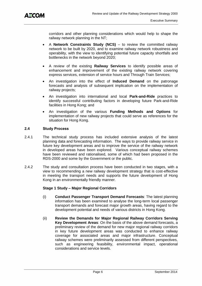
Figure 3.1 Key Development and Redevelopment Areas
3.3.7 Major projects include:
West Kowloon Cultural District (WKCD);
Kai Tak Development;
Lok Ma Chau Loop Project;
Kwun Tong Town Centre Redevelopment;
Public Rental Housing Development at Anderson Road;
Anderson Road Quarry;
Remaining Development of Tung Chung;
Ex- Cha Kwo Ling Kaolin Mine;
Sha Tau Kok Rural Township and Surrounding Area; and
Master Redevelopment Plan for Ocean Park and Subsequent Expansion Concepts.
3.3.8 The implementation of these projects will create additional populations and employment opportunities in various districts. Major leisure and tourism facilities may also attract visitors and thus affect the transport demand. It will be necessary to keep in view any changes in the development parameters and new proposals, and take them into account when individual railway proposals are taken forward.

Review and Update of the Railway Development Strategy 2000
Executive Summary
Page 12 September 2014
3.4 Cross-boundary Development and Transport Trends
Cross-boundary Passenger Demands
3.4.1 The long-term railway development strategy will also need to allow for cross-boundary transport needs. Social and economic interactions between Guangdong, Hong Kong and Macao have become more commonplace, with increasing cross-boundary transport demand. Cross-boundary railway services (including through train and boundary train services) are expected to continue as the backbone of cross-boundary transport. Together with cross-boundary vehicle and ferry services, railways will help to provide flexible and diversified services for a sustainable cross-boundary transport system which can meet different travelers’ demands.
3.4.2 Between 2000 and 2010, the total number of cross-boundary passengers by rail, road and ferry rose from 330,000 to 569,000 per day, recording an over 70% increase over the decade.
3.4.3 According to the Planning Departments (PlanD’s) “Northbound Southbound: Cross-boundary Travel Survey 20117”, as a result of the implementation of the IVS in the Mainland, the number of mainland passengers increased rapidly from a daily average of 39,200 in 2003 to 136,000 in 2011, registering an average annual growth of 17%. Visitors from the Mainland represented 10% of all cross-boundary travelers in 2003 and this increased to 24% by 2011. With the rise in income of mainland residents, it is envisaged that the number of mainland cross-boundary visitors will experience further growth. The increasing trend of cross-boundary traffic demand induced by the mainland visitors is expected to continue in the short to medium term.
3.4.4 According to the above survey report, the number of people travelling between the Mainland and Hong Kong at least once a week increased from 368,500 in 1999 to 702,800 in 2011, with an average annual growth of more than 6%. The majority (76%) of frequent travelers live in Hong Kong, although this has fallen from 90% in 1999 as a higher proportion of frequent travelers reside in the Mainland. With further economic ties between the Mainland and Hong Kong, people and enterprises in both places will become closer, and so the demand for cross-boundary public transport is expected to continue to grow.
3.4.5 Currently, cross-boundary travel in the PRD mainly relies on vehicular, ferry and railway services, while the majority of cross-boundary travel are land-based. With the additional passenger handling capacity from the committed Hong Kong Boundary Control Facilities and Liantang/Heung Yuen Wai Boundary Control Point (BCP), the overall cross-boundary passenger handling capacity would be sufficient to accommodate the future cross-boundary passenger demand forecast in 2031.
3.4.6 To maintain a good level of cross-boundary services and to further enhance assessibility of the cross-boundary railway network to support wider social and economic activities within the PRD region in future, the Government should regularly review whether there may be a need to consider any appropriate cross-
7
Northbound Southbound 2011, Survey Report on Cross-boundary Travel Survey 2011, HKSAR Planning Department, (October 2012)

Review and Update of the Railway Development Strategy 2000
Executive Summary
Page 13 September 2014
boundary transport projects as it can take a lengthy time to implement cross-boundary infrastructure.
Rail Network Planning in the Pearl River Delta
3.4.7 The PRD railway network is divided into three tiers. In addition to (i) the metro-lines network in individual cities and (ii) the national High Speed Rail (HSR) network, Guangdong has also put forward the Rail Transport Plan for Urban Integration of the PRD in the 2000s, which suggested connecting the nine cities in the region (including Guangzhou, Shenzhen, Zhuhai, Foshan, Jiangmen, Dongguan, Zhongshan, Huizhou and Zhaoqing) via inter-city lines. The target is to connect the nine cities within an hour and thereby forming a “One-hour Living Circle” (see Figure 3.2). Guangzhou, Shenzhen and Zhuhai would become the hubs of this railway network.
Figure 3.2 High Speed and Intercity Railway Planning in the PRD
3.4.8 Current cross-boundary train services comprise Through Train Service (TTS) connecting Hung Hom to Guangzhou East via an eastern corridor and Boundary Train Service (BTS) serving east and central cross-boundary corridors at Lo Wu and Lok Ma Chau respectively.
3.4.9 HSR services will be available via a central corridor by the XRL connecting West Kowloon to South Guangzhou (Shibi) and various major cities in the Mainland.
3.4.10 Upon completion of the XRL project, three of the cross-boundary railway services to Shenzhen (two BTS and XRL) lead to Lo Wu and Futian areas in central Shenzhen as shown in Figure 3.2. Travelling to the eastern or western parts of Shenzhen may be done via the vehicle boundary crossings or by interchanging

Review and Update of the Railway Development Strategy 2000
Executive Summary
Page 14 September 2014
with the Shenzhen Metro at Lo Wu or Futian. Similarly, the western coast of the PRD is only accessible via ferry or vehicle routes.
3.4.11 If a new cross-boundary railway route is to be constructed, then the following aspects are identified as important considerations:
It should serve a route that is not served by the existing railways and those under construction. As western Shenzhen is the key development area of Shenzhen and will become a new transportation hub, the emphasis should be placed on better serving the cross-boundary rail travel demand to western Shenzhen; and
It should be able to enhance the existing connections to the PRD railway network and serve a different function from the existing and committed cross-boundary railways and infrastructure.
Aviation Development Trends
3.4.12 The Hong Kong International Airport (HKIA) was commissioned in July 1998 and passenger throughput increased by over 70% from 30.4 million in 1999 to 56.5 million in 2012, representing an average annual increase of around 4.8%. In 2011, the Hong Kong Airport Authority (AAHK) published the Hong Kong International Airport Master Plan 2030 to explore the way forward for the airport development programme over the next 20 years. Implementation of the three-runway system could further increase the demand for feeder transport to and from the airport (including road and railway).
3.4.13 The rapid economic development of China has seen a strong growth in total air passenger throughput in the PRD, which soared from 85 to 124 million between 2005 and 2010, and is projected to increase to 233 and 387 million in 2020 and 2030 respectively.
3.4.14 Within this context of strong growth in air passengers, the potential demand for a dedicated cross-boundary rail link between HKIA and Shenzhen International Airport (SZIA) is less clear and depends on the extent of synergy and co-operation – or competition – between the two airports. At present, both airports in Hong Kong and Shenzhen operate unilaterally and the assessments of potential rail connections have assumed that any co-operation between the airports would occur on a market-driven basis i.e. the status quo situation.
3.5 Findings and Direction of Updating the Railway Development Strategy
3.5.1 The review of the domestic and international context has covered the changes in the planning parameters and cross-boundary traffic demand, and included forecasts for the long-term transport demands in Hong Kong. In broad terms, upon completion of the committed railway projects, it was considered that the railway network will be largely adequate to meet the potential additional demand in the short to medium term in respect of:
3.5.2 Coverage: The coverage of the existing and committed railway network will be largely extensive, providing railway services to most of the existing major residential and commercial areas. Most people will be able to use the railway service by accessing the railway stations on foot or by using short feeder service.

Review and Update of the Railway Development Strategy 2000
Executive Summary
Page 15 September 2014
As there is limited room for significant coverage expansion due to spatial constraints in the urban area, the extension of existing lines and adding new stations will help to improve railway service in some areas not currently served by rail;
3.5.3 Connectivity: The connectivity of railway lines in the urban area (Kowloon and Hong Kong Island) is already quite extensive. The railway lines connect various destinations, allowing inter-regional trips to be made without significant detours. The emphasis in these areas will be on relieving currently congested sections of the railway network. By comparison, future developments areas such as northern Lantau, North West New Territories (NWNT) and North East New Territories (NENT) are of much larger scale which will create opportunities for improvement in rail connectivity in the eastern and western part of Hong Kong, such as connecting the NWNT and NENT (with higher population growth) and improving rail connectivity in northern Lantau (with higher employment growth); and
3.5.4 Capacity: The overall capacity of the railway network will increase significantly upon completion of the committed railway projects, which should be sufficient to meet the transport demand in the short to medium term. However, bottleneck situations may arise in some urban sections of the railway network in the peak hours. Further assessment of crowding and relief measures are discussed in Chapter 4.
3.5.5 There are a number of railway lines currently under construction to cater for the planned growth and demands within the urban area. While further large scale expansion of the railway network in the urban areas is faced with spatial constraints. With the active planning of the NDAs in the NT, it is considered worthwhile for RDS-2U to explore new major regional railway corridors with a primary focus on serving the NT region and smaller scale expansion such as extending existing railway lines, adding new stations or building parallel lines to improve the railway service in some urban areas not currently served by rail.

Review and Update of the Railway Development Strategy 2000
Executive Summary
Page 16 September 2014
4. EXISTING NETWORK PERFORMANCE
4.1 Network Capacity and Level of Service Benchmarks
4.1.1 The Network Constraints Study (NCS) comprised a review of current and future passenger loadings, passenger level of service (i.e. “service level benchmark”) in order to identify critical links in the future railway network that may require improvement measures to relieve congestion and to indicate corridors where new railway schemes should be considered.
4.1.2 The NCS examined the robustness and operability of the existing railway network and future network including schemes that are presently committed.
4.1.3 Crowding in the railway network arises when either the capacity of the railway line or station capacity is reached. These capacities formed the basis of the subsequent network assessments and identification of the existing and future network constraints. The NCS has looked at the RDS-2 assumptions and reviewed whether the passenger level of service (or “service level benchmark”) should be adjusted to reflect the current passenger behaviour on trains and stations as discussed below. Potential short, medium and longer term relief measures, together with possible new railway schemes are discussed.
Line Capacity
4.1.4 The Line Capacity (or “Passenger Line Capacity”) is defined as the number of passengers that can be carried in one direction in a given period of time and is measured in passenger per hour per direction (pphpd). The line capacity depends on the number of trains operated in an hour, the train formation (number of cars per train), car design and train loading profile (average number of passengers per car).
4.1.5 In RDS-2, the “Line Capacity8“ was defined by a band bounded by:
Maximum Capacity – the maximum theoretical hourly capacity is based on the maximum frequency and maximum train capacity averaged over the peak hours (roughly equivalent to a standing density of 6 persons per square metre (ppsm)); and
Desirable Capacity – defined as 90% of the maximum capacity (roughly equivalent to a standing density of 5 ppsm depending on the train car configuration).
Passenger Service Level Benchmarks
4.1.6 The level of service for a railway line is quantified using the ratio of Peak Hourly Passenger Demand (V) to the Maximum Capacity (C) which is expressed as the Volume-to-Capacity (V/C) ratio, which represents the average operating conditions of the railway service in the peak hour.
4.1.7 In RDS-2, the level of service for a railway line was rated as either “under-capacity” or “near-to-capacity” with the “near to capacity” category taken as 90%
8 Reference RDS-2 Final Report, Chapter 2 – Railway Planning Standards Section 2.5 on Capacities.

Review and Update of the Railway Development Strategy 2000
Executive Summary
Page 17 September 2014
of the “Maximum Capacity”, i.e. having a V/C ratio of 0.9 (when demand is at “Desirable Capacity”). As discussed below, the habits and preferences of railway passengers have changed to the extent that the “Desirable Capacity” (i.e. 90% of the theoretical maximum or approximately 5 ppsm) on the network is now considered lower than in RDS-2.
4.1.8 To better understand the service level capacity, the MTR planning standards, international standards, passenger attitudes and the maximum observed line capacities were reviewed and summarised below.
MTR Planning Standards
To enhance the customer service of the railway service, MTRCL has committed that all new railway lines will adopt 4 ppsm as the target service benchmark where resources and other relevant factors permit; and
For existing lines, the MTRCL have added extra trains to the network in order to ease crowding in MTR stations and trains, and to improve the train service.
International Standards
The typical international planning standards for desirable densities in other major cities range between 3.3 to 6 ppsm depending on the specific circumstances, such as demographic characteristics, travel pattern and transport demand in a country.
Observed Line Capacity
In the 1980s, the passenger flows on the Tsuen Wan Line (TWL) were as high as 87,000 pphpd. This had reduced to 61,000 pphpd by late 1990s. This decline in rail passenger demand was due to a combination of factors such as passengers’ expectation for more space in train cars, more choice of railway lines and greater competition from buses arising from improvements in the quality of services, more comfortable buses and greater convenience of smartcard fare payment; and
Even though passenger loadings on the TWL and Island Line (ISL) are substantially lower today than in the 1990’s, it is observed during peak hours that passengers are often unwilling or unable to board the first available train and will choose to wait for the next or subsequent trains. This is considered to be due to passengers having higher expectations of the railway service.
MTR Passenger Attitudes
It has been observed that MTR passengers do not uniformly occupy the space on trains; with cars closest to the lobby escalator generally attracting more passengers than those located at the ends of the platform;
Increasing numbers of railway passengers read newspapers and use mobile devices, such as tablet computers or smart phones during their trips desiring more space in train cars; and
As revealed from the survey questionnaire conducted in September 2011 as

Review and Update of the Railway Development Strategy 2000
Executive Summary
Page 18 September 2014
part of the Public Engagement (PE) exercise of RDS-2U, many people consider that the most desirable area for improvement in the existing railway service was to reduce the level of crowding in the train car. This is a direct reflection of the passenger density and supports the above observations of current passenger behaviour.
Review of the Current MTR Peak Line Loadings
4.1.9 In comparison to the passenger loadings achieved in the 1990’s, the currently achieved maximum line loadings are lower. The observed maximum line loadings in the peak hour on the MTR system in 2010 and 2011 at maximum points in the networks are summarised in Table 4.1.
Table 4.1 2010 and 2011 Observed MTR Maximum Peak Line Loadings
Line Section
Observed Line
Loading (pphpd)
Peak Frequency Operated
(tph)
Average Passengers
per Train
% of Maximum Capacity
1(6 ppsm)
Year 2010
TWL (Nathan Road Corridor) 55,000 28 1,964 79%
TWL (Cross Harbour) 56,000 28 2,000 80%
ISL (Causeway Bay) 54,000 30 1,800 72%
Year 2011
TWL (Cross Harbour) 52,000 28 1,857 74%
ISL (Causeway Bay) 53,000 30 1,767 70%
Note: (1) assumes a train capacity of 2,500 passengers per train (with 6.0 ppsm on average).
4.1.10 The line sections are located on the busiest lines of the railway network. From site observations, passengers were unwilling to board a relatively crowded train and instead chose to wait on the platform for another train as they perceived that the train was full. By calculation, Table 4.1 provides the implied train capacities based on the observed peak hour frequency, which range from 1,800 to 2,000 per train in 2010 and 1,750 to 1,900 per train in 2011, equivalent to some 70% to 80% of the “Maximum Capacity”.
Evaluation Criteria
4.1.11 As discussed earlier, current passenger behaviour and attitudes indicate that MTR passengers are now less willing to board highly crowded trains than they were 20 to 30 years ago. Although passengers’ desired comfort level on trains varies according to the railway line, location within the train car and at different times of the day, it can generally be concluded that when the loading on the train car reaches an average density of around 70% to 80% of the “Maximum Capacity”, passengers tend to remain or to be left behind on the platform.
4.1.12 For RDS-2U, a sensitivity analysis was undertaken to evaluate the “Desirable Capacity” of a line by taking into consideration the current passenger habits and attitudes, (i.e. to reflect the above observation of when the train loading reaches around 70% to 80% of the “Maximum Capacity” or approximately 4ppsm over the peak hour, passengers tend to remain or be left behind on the platform) as well as the new service benchmark committed by MTR (i.e. the service level for new railway lines is pitched at 4 ppsm where resources and other relevant factors

Review and Update of the Railway Development Strategy 2000
Executive Summary
Page 19 September 2014
permit, which is around 70% of the “Maximum Capacity” depending on the train car configuration. For a typical heavy rail train operating in the urban area, 4 ppsm is equivalent to approximately 71.2% of the “Maximum Capacity”). In this respect, when a line reaches a V/C between 0.7 and 0.9, it is considered a reasonable indication that the performance of a railway line in terms of its passenger level of service will need to be closely monitored as it will be “near-to-capacity”. A V/C of 0.7 is considered an appropriate trigger level for monitoring purposes (refer to Table 4.2). This approach was consistent with feedback received during the PE in that the public generally viewed the current railway network as being very crowded on some busy line sections.
Table 4.2 Line Capacity Evaluation allowing for Recent Railway Passenger Habit (Sensitivity Analysis)
Level Range of V/C Ratio Description
The line is “near-to-capacity” and the Near to capacity V/C above 0.7
line needs to be closely monitored.
Under capacity V/C below 0.7 The line operates acceptably
4.1.13 Based on the above line capacity review, the existing and future committed line capacities are shown in Table 4.3. The lower bound of the “Desirable Capacity” represents the sensitivity analysis conducted in RDS-2U (which considers the observed MTR line loadings, current passenger behaviour and attitudes and the 4ppsm service benchmark for new railway lines committed by MTR), and is set at 70% of the “Maximum Capacity” for a conservative evaluation approach. The upper bound represents the level adopted previously in RDS-2 and is approximately 90% of the “Maximum Capacity”.

Review and Update of the Railway Development Strategy 2000
Executive Summary
Page 20 September 2014
Table 4.3 Estimated Line Capacities
Railway Line
Maximum 1
Capacity
2 (pphpd)
Desirable Capacity
2 (pphpd)
Upper 3
bound Lower
4bound
5Existing Lines
East Rail Line (ERL) 101,000 91,000 71,000
Kwun Tong Line (KTL), TWL, ISL, Tseung Kwan O Line (TKL)
85,000 77,000 60,000
Tung Chung Line (TCL) 66,000 60,000 46,000
West Rail Line (WRL) 64,000 58,000 45,000
Ma On Shan Line (MOL) 32,000 29,000 22,000
6Committed Lines
SCL – North South Corridor 9
(NSC) 80,000 72,000 56,000
KTL/KTE 85,000 77,000 60,000
ISL/WIL 85,000 77,000 60,000
SCL – East West Corridor 10
(EWC) 75,000 68,000 53,000
SIL(E) 27,000 24,000 19,000
Notes: (1) Based on a loading density of 6 ppsm. (2) Passenger per hour in one direction, rounded to the nearest thousand. (3) In RDS-2, the “Desirable Capacity” is taken as 90% of the “Maximum Capacity“.
(4) Under the sensitivity analysis in RDS-2U, the “Desirable Capacity” is taken as 70% of the “Maximum Capacity” based on the observed line loadings, the current passenger behaviour, attitudes and the 4ppsm service benchmark for new railway lines committed by MTR.
(5) Excluding DRL and AEL as these are not urban/sub-regional lines. (6) For RDS-2U evaluation purposes, the “Maximum Capacity” and “Desirable
Capacity” for the committed lines are estimated based on the train car configuration of similar existing lines which are subject to refinement upon establishment of the train fleet for the committed lines.
4.2 Existing Railway Network Performance
4.2.1 The existing railway network comprises four urban lines (i.e. TWL, KTL, TKL and ISL), four sub-regional lines (i.e. TCL, ERL, WRL and MOL) and special lines (i.e. Disney Resort Line (DRL) and Airport Express Line (AEL)).
4.2.2 The crowding levels on the lines in the morning peak hour are generally higher than those in the evening peak hour. Average passenger loadings for all railway lines in the both morning and evening peak hours were below a V/C of 0.9 as shown in Table 4.1. However, the maximum observed line loadings on the ISL and TWL were up to V/C of 0.74 which indicates that the busiest sections of the ISL and TWL were “near-to-capacity” in 2011 and should be closely monitored based on the “Desirable Capacity” of between 0.7 and 0.9.
9 North-South Corridor (NSC) – is formed by the ERL, Lok Ma Chau Spur Line (LMCSL) and Hung Hom to
Admiralty Section of the SCL. 10
East-West Corridor (EWC) – is formed by the WRL, Tai Wai to Hung Hom Section of the SCL and Ma On Shan Line (MOL).

Review and Update of the Railway Development Strategy 2000
Executive Summary
Page 21 September 2014
4.3 Future Reference Scenario
Growth in Demand
4.3.1 The future network constraints assessment was based on the assumed transport network (i.e. Reference Case) which includes the existing network plus the committed infrastructure schemes such as the WIL, SIL(E), SCL, KTE and XRL for various design years. Reference Cases for the design years of 2021, 2026 and 2031 have been adopted for assessment in this Study.
4.3.2 The travel demand forecasts used in the assessment were based on the assumptions summarised in Chapter 3 – Planning and Demand Context. The changes in railway demand will be dependent upon a number of key factors including but not limited to the following that are summarised below for the period from 2009 to 2031:
Population up by 21% from 7.00 million to 8.46 million;
Employment up by 10% from 3.35 million to 3.70 million;
Personal income - as represented by real Gross Domestic Product (GDP) per capita – up by 61% (as real GDP increases by a factor of 1.95 and population by 1.21, where GDP per capita is 1.95 / 1.21 = 1.61);
Private vehicle fleet size (car and motorcycles) up by 60% from 421,000 to 675,500; and
An ageing population with the proportion of seniors (over 65 years) rising from 13% of the resident population in 2011 to 26% by 2031.
Reference Forecasts
4.3.3 The reference forecasts output from the demand forecasting process show that total daily public transport boardings are forecast to increase from 13.1 million in 2009 to 15.2 million in 2021 and to 16.9 million in 2031. This represents a 29% increase from 2009 to 2031.
4.3.4 After the opening of the committed railway schemes, the railway network will attract more rail travellers and the rail market share will improve from 40% currently to around 43% in 2021 and 2031.
Future Reference Network Performance
4.3.5 In the future year Reference Case network, with the committed railway schemes in place, the line capacity assessments show that the V/C ratios are generally lower than in 2011 (refer to Table 4.4). This improvement is due to the new railway schemes and higher train service frequencies providing relief to the existing lines.

Review and Update of the Railway Development Strategy 2000
Executive Summary
Page 22 September 2014
Table 4.4 Forecast Morning Peak Hour Maximum Loaded Line Section
Rail Line Direction Busiest Section
Maximum 1
Capacity(pphpd)
V/C
2021 2026 2031
ISL WB TIH to CAB 85,000 0.75 0.75 0.75
TWL SB TST to ADM 85,000 0.58 0.59 0.60
TKL SB YAT to QUB 85,000 0.49 0.48 0.48
KTL EB CHH to KOB 85,000 0.54 0.51 0.52
TCL EB KOW to HOK 66,000 0.39 0.42 0.44
SIL(E) NB OCP to ADM 27,000 0.59 0.59 0.59
SCL-EWC EB TWW to MEF 75,000 0.53 0.55 0.65
SCL-NSC SB TAW to KOT 80,000 0.59 0.60 0.64
Notes: (1) Based on a loading density of 6 ppsm
4.3.6 Based on the “Desirable Capacities” presented in Table 4.3 (which include the effect of the current railway passenger behaviour), the ISL will be “near-to-capacity” on the section from Tin Hau (TIH) and Causeway Bay (CAB) in the morning peak hour for the forecast year 2021 and onwards. The other railway lines were found to be operating within capacity in the Reference Case network although some lines may face crowding issues when the railway network is further expanded.
4.4 Relief Measures
4.4.1 The assessment in this Chapter has assessed the future situation with the committed network in place and found that the ISL, plus some other major lines such as the EWC and NSC (refer to Table 4.4) are forecast to operate at a relatively high V/C. In addition, with some new railway schemes recommended in RDS-2U in place which connect to these lines, passenger demands are likely to increase further as discussed in Chapter 6.
4.4.2 The analysis indicates that several critical sections of the railway network will need to be closely monitored such that relief measures may be implemented depending on the build up of crowding of the railway line over time.
4.4.3 While building new railway infrastructure may take 8 to 10 years, some practical measures could be considered to alleviate the current situation in the short to medium term. Potential short, medium and longer term relief measures have been examined as summarised in Table 4.5.
4.4.4 Longer-term capacity enhancement measures are generally more extensive requiring significantly capital investment, major modifications to existing lines or construction of new lines. Such measures generally take a much longer time frame to implement as they require extensive planning and design and so should be implemented only when other approaches to mitigate crowding have been fully exhausted.

Review and Update of the Railway Development Strategy 2000
Executive Summary
Page 23 September 2014
4.4.5 On the above basis, it will be important to monitor the future performance of railway lines with higher V/C ratios (such as the ISL and EWC in particular) in terms of their passenger levels of service so that appropriate relief measures can be considered and provided in a timely manner.
Table 4.5 Summary of the Potential Relief Measures
Scheme Remark
Short-term Measures
Increase in number of cars
per train Only feasible where platforms can allow for longer trains
Increase of service frequency Scope depends on
system signalling
Increase of train car capacity:
Multi-purpose space;
Folding seat, perch seat, configuration.
other seat
Effective in the most carriages
crowded
Fare Incentives Effect depends on price differential,
with social considerations
Other mitigation measures:
Station management;
Passenger flow management.
Safety measures to help achieve capacity
Medium and Longer-term Measures
Signalling lines
system upgrades on existing
Allows increases frequency
MTRCL’s planned existing lines
in service
upgrades for
Enhancement to existing infrastructure
Station upgrades
Longer trains or more frequent services may depend on platform lengthening and/or trackwork
Potential new schemes
Relief effect is scheme-specific
Can provide additional capacity the corridor
in
4.4.6

Review and Update of the Railway Development Strategy 2000
Executive Summary
Page 24 September 2014
5. NETWORK DEVELOPMENT
5.1 Overview of Network Development Study Process
5.1.1 The NDS consisted of three major stages as described below.
Strategic Strategic development stage focused on the long term Development passenger demands forecasts for 2031, exploring development Stage potential mainly in the NT and the railway development
potential in the sub-regions and corridors. This provided the context for understanding the potential needs for different rail links and service types. In addition, local enhancement schemes such as line extensions, new stations and parallel lines were also considered to serve more areas and increase coverage of the rail network.
The NCS (refer to Chapter 4) focused on the existing system and provided potential additional strategic links to be considered in the NDS. Potential schemes were evaluated under a range of criteria for operational and engineering feasibility, environmental impact and financial viability. Schemes which passed this evaluation were taken forward for detailed network appraisal, while the remaining schemes were not taken forward.
Detailed Detailed network assessment stage focused on selecting the Network better performing railways in the corridor. The main emphasis Evaluation was placed on economic (transport benefits and costs), Stage financial and operation issues. The railway proposals would be
made acceptable in engineering and environmental terms.
Public feedback was taken into consideration of the railway proposals.
Preferred The rail proposals forming the Preferred Railway Network Network Development Plan were subject to further economic and Phasing financial appraisals and an overall assessment using a range of Stage evaluation criteria. This lead to recommendations on a phased
and prioritised railway expansion plan for the HKSAR.
5.2 Strategic Development and Evaluation Process
5.2.1 The strategic development process produced a set of schemes for evaluation. The study process involved a review of RDS-2 projects that had not yet been implemented, proposals suggested by the public and other studies.
5.2.2 The first steps in the process involved classification of the possible railway schemes into two broad categories:
Major Regional Railway Corridors; and
Local Enhancement Schemes.
Review and Update of the Railway Development Strategy 2000
Executive Summary
Page 25 September 2014
5.2.3 The evaluation process involved examining schemes in each of these categories in turn in a hierarchical manner starting with the major regional corridors and then working down to the local enhancement schemes. The evaluation process involved:
A review of the development context and planned transport infrastructure in Hong Kong and the Mainland;
A general review of the strategic requirements;
The assembly of railway schemes from a wide range of proposals; and
The systematic review of railway schemes by main function against the evaluation criteria.
5.2.4 The evaluation was based on criteria including the performance of each scheme in terms of:
Serve NDAs and redevelopment opportunities;
Support major transport infrastructure;
Support cross-boundary travel;
Improve network linkages, coverage and capacity;
Engineering and operation viability;
Environmentally acceptability;
Cost effectiveness; and
Preliminary financial performance.
5.2.5 In considering potential railway schemes, issues examined included:
Patronage: domestic and cross-boundary passenger demands, line usage and marginal fare revenues;
Planning: assessment of compatibility with strategic planning objectives; consistency with local planning intentions; development potential at stations; and land use impacts;
Environment: a broad overview of strategic environmental issues for areas which Government has defined as having strategic value through statutory or procedural protection;
Engineering: an overview of the “constructability” of each route, by identifying alignment requirements together with associated infrastructure;
Operation: the pattern of railway operations over the new railway infrastructure, and how they integrate with existing and committed services; and
Review and Update of the Railway Development Strategy 2000
Executive Summary
Page 26 September 2014
Cost: the capital and operating costs, and first stage financial and economic assessments.
5.3 Railway Schemes from RDS-2
5.3.1 The starting point for developing the railway schemes for the updated railway expansion plan was the schemes from RDS-2, which identified a set of new priority railway schemes grouped into six packages, other railway development schemes and longer term railway possibilities.
Priority Railway Schemes
Shatin to Central Link (SCL) - (Tai Wai to Diamond Hill Link (TDL), East Kowloon Line of SCL (DIH to HUH Section) and Fourth Harbour Crossing (FHC));
Island Line Extensions (North Island Line (NIL) and WIL);
Kowloon Southern Link (KSL);
Northern Link (NOL);
Regional Express Line (REL); and
Port Rail Line (PRL).
Other Railway Development Schemes
These schemes consisted of development-led line extensions and new stations to be evaluated on a case by case basis in integrated land use/transport studies. New stations were considered at Kwu Tung NDA, Tung Chung West (New Town Extension) and Hung Shui Kiu NDA amongst others.
Longer Term Railway Possibilities
Deep Bay Link - new corridor between Deep Bay and the developing nodes in west Shenzhen;
Outer Western Corridor (OWC) – new corridor linking Hong Kong Island – Lantau – NWNT dependent on future development on Lantau;
East West Kowloon Line – new corridor to serve South East Kowloon and relieve other urban lines;
Fifth Harbour Crossing – new harbour crossing;
Chek Lap Kok Link – new corridor between NWNT and HKIA; and
South Island Line – new corridor to serve population in Southern and Western District on Hong Kong Island.
5.3.2 All of the priority railway schemes from RDS-2, except the NOL, NIL and PRL, have now been implemented, and are under construction. The REL was

Review and Update of the Railway Development Strategy 2000
Executive Summary
Page 27 September 2014
5.3.2 All of the priority railway schemes from RDS-2, except the NOL, NIL and PRL, have now been implemented, and are under construction. The REL was developed into the XRL and is now under construction. The PRL was proposed as a new freight rail connection from Lo Wu to a new port rail terminal in Kwai Chung. However, as the Government decided not to pursue the PRL due to the decline of rail freight volume, and as the use of railway for freight transport or cross-boundary goods was no longer a policy objective, it was not pursued in this study.
5.3.3 In RDS-2000, the South Island Line (SIL) was considered as one of the long term possibilities. However, during 2000s, the Aberdeen Tunnel became increasingly congested with traffic queues in peak hours extending from the tunnel to Wong Chuk Hang, which caused significant traffic problems in Southern District and hindered the operation of other road-based transport modes. As external traffic in Southern District hinged on the Aberdeen Tunnel, the Government decided to advance the development of the SIL(E). Whilst the SIL(E) project is under construction, the planning and design for South Island Line (West) (SIL(W)) was subject to further review of the land use planning intentions in the Southern District.
5.3.4 Those remaining schemes (NOL, NIL, SIL(W)), together with the development-led schemes consisting of the line extensions, new stations and the long term development schemes from RDS-2 were the starting point for developing the railway expansion plan.
5.3.5 Some of the RDS-2 schemes that have not yet been implemented remain valid as these could serve areas where large population increases are planned to occur. In addition to this, the development planning context and transport infrastructure highlighted in Chapter 3 led to a number of other corridors to be added to the schemes studied in RDS-2. For RDS-2U, the review was split into major regional corridors (including cross-boundary) and local enhancement schemes.
5.4 Major Regional Railway Corridors considered in RDS-2U
5.4.1 Under this Study, six railway corridors that would enhance regional connectivity were examined as indicated below and shown on Figure 5.1:
Cross-boundary corridor (i.e. Hong Kong – Shenzhen Western Express Line);
NWNT to NENT corridor (i.e. NOL);
NWNT to SWNT corridor (i.e. Coastal Railway from Tuen Mun to Tsuen Wan);
SWNT to SENT corridor (i.e. Shatin to Urban);
Lantau to Urban corridor (i.e. Outer Western Corridor); and
SENT corridor (i.e. Railway connections to Sai Kung).

Review and Update of the Railway Development Strategy 2000
Executive Summary
Page 28 September 2014
Figure 5.1 Major Regional Railway Corridors
5.4.2 The rationale for each corridor was based on the following considerations:
Serve NDAs and redevelopment opportunities;
Support major transport infrastructure;
Support cross-boundary travel; and
Improve network linkages.
5.4.3 The review of the major regional railway corridors identified the following key components (see Figure 5.2):
The development of the NOL corridor to serve the new NDAs, cross-boundary travel and east-west movements in the railway network;
A new east-west railway corridor through NWNT to SWNT in the form of the Tuen Mun to Tsuen Wan Link (TMTWL); Further extension of the NWNT to SWNT corridor to the Shatin area to provide east-west connectivity through the NT;
Expansion of the cross-boundary services from north Lantau and NWNT to western Shenzhen to support the major growth poles such as Qianhai on the western PRD, Hong Kong’s own airport expansion plan and the new Hong Kong Boundary Crossing Facility (HKBCF);

Review and Update of the Railway Development Strategy 2000
Executive Summary
Page 29 September 2014
Improved rail connectivity between NWNT and north Lantau, possibly combined with the Hong Kong-Shenzhen Western Express Line (WEL) and linked to the existing railway system such as the EWC and TCL; and
Improve rail connectivity to Sai Kung to provide an alternative to road-based transport.
Figure 5.2 Summary of Key Components of Major Regional Railway Corridors
5.5 Local Enhancement Schemes
5.5.1 The local enhancement schemes would focus on the committed network by improving connectivity, fill in gaps in the current network with no rail coverage, and provide relief to line sections in the network which are forecast to be under pressure in the long term. The schemes were studied by geographical areas as indicated below:
New Territories
Extension of the TCL to Tung Chung West (i.e. Tung Chung West Extension);
Extension of the EWC to Tuen Mun South (i.e. Tuen Mun South Extension);
Hung Shiu Kiu (HSK) station;
Kwu Tung (KTU) station; and
Science Park (SCP) station.
Kowloon
East Kowloon Line (EKL); and

Review and Update of the Railway Development Strategy 2000
Executive Summary
Page 30 September 2014
Fifth Harbour Crossing (5HC).
Hong Kong Island
North Island Line (NIL);
South Island Line (West) SIL(W);
Siu Sai Wan Line (SSWL); and
Extension of the SCL-NSC to Central South (CES) station.
5.5.2 The review of the local enhancement schemes identified the following key components for evaluation (see Figure 5.3):
The NIL corridor along the north shore of Hong Kong Island to improve network linkage, relieve the pressure on the ISL and serve the Central and Wanchai waterfront;
The continued development of the SIL corridor to reach large residential catchments in Aberdeen and Wah Fu. This would provide additional passenger transport capacity along the Pokfulam transport corridor to help to relieve the existing transport constraint related to the development potential along the Pokfulam area;
An East Kowloon corridor through the urban Kowloon area serving areas in Anderson Road and Sau Mau Ping which are currently only served by road-based transport; and
Line extensions and new stations to serve existing and planned development centres along or adjacent to existing railway lines that are worth consideration as smaller scale railway projects. These projects include:-
- Tung Chung West (TCW) Extension;
- Tuen Mun South (TMS) Extension;
- SSWL;
- KTU station;
- HSK station; and
- SCP station.
5.5.3 The Fifth Harbour Crossing (5HC) was not recommended as, based on the latest transport forecasts for 2031, the average train loading on the four harbour-crossing railway lines (TCL, TWL, TKL and SCL-NSC) would be maintained at around 60% in the morning peak and will have sufficient capacity for the future demand. It was considered there was no urgent need to build a 5HC railway line although there would be a need to continue to monitor the harbour-crossing traffic and if needed, conduct studies in a timely manner to balance the cross-harbour passenger flows.
5.5.4 The SCL-NSC extension to CES station was not recommended for further assessment as no suitable sites for a station could be identified. Locations that

Review and Update of the Railway Development Strategy 2000
Executive Summary
Page 31 September 2014
were found to be suitable would entail high risk to existing buildings due to shallow foundations in poor ground conditions.
Figure 5.3 The Key Components of the Local Enhancement Schemes 5.6 Summary of the Preliminary Corridor/Scheme Assessment
5.6.1 The levels of demand and overall transport performance of the corridor/schemes were examined as a 2031 ‘snapshot’ by the way of model runs carried out using the 2009-based TPEDM planning data set. The economic, financial and operational aspects were considered with the aim of selecting the better performing railways in the corridor, and taking into account the public engagement opinions.
5.6.2 The summary findings of the preliminary review of potential corridors/schemes are shown in Table 5.1. Although several alternatives were considered in many of the corridors, generally only one of the alternatives would be developed for further examination. Where alternatives are closely matched (i.e. NIL) difference comparison (one on one comparisons) will be applied to determine the better option.

Review and Update of the Railway Development Strategy 2000
Executive Summary
Page 32 September 2014
Table 5.1 Summary of the Preliminary Corridor/Scheme Assessment
Main Corridor/Scheme Assumed Alignment Key Summary
Major Cross-boundary Rail Corridor (i.e. WEL)
Airport Rail Link Although the WEL could potentially improve the connectivity with the Mainland, its effectiveness would hinge on external factors, such as the passenger demand for inter-airport transit services as well as the likely cross-boundary transport demand between Qianhai and Hong Kong, which depends largely on the pace and breadth of Qianhai’s development and its impact on Hong Kong. The financial viability and economic benefits had yet to be proven.
Cross-boundary Spur Line
Domestic Spur Line
NWNT to NENT (i.e. NOL)
Corridor NOL Kwu
via Kam Sheung Road Tung/Lok Ma Chau
to The NOL could support NENT NDAs such as Kwu Tung North and travel. Line extension could potentially serve more developments North and cross-boundary travel to Lok Ma Chau BCP.
facilitate east-west in NENT and NT
NOL via Kam Tai Po
Sheung Road to The southerly NOL alignment corridor. Transport demand was NENT corridor.
revealed a lack of development potential along the unable to support two east-west lines in the NWNT to
NWNT to SWNT (i.e. TMTWL)
Corridor TMTWL elevated
via the option
coastal corridor TMTWL had only modest transport demands given the dispersed population along the coastline. The revenue generating potential, financial viability and economic benefits would require further review. The availability of a site for building a depot was found to be an issue. It could be viewed as a long term corridor as an alternative route to the EWC for Tuen Mun residents.
TMTWL via the coastal underground option
corridor Same findings underground.
as the elevated option, but higher cost due to this option being located
SWNT to SENT Corridor (i.e. Shatin to Urban)
Shatin to Kwai Chung The Shatin to Urban schemes showed only modest levels of demand at present as there are road tunnels linking the two areas which are served by bus services. Suitable land sites for a depot could not be identified. The assessment revealed lack of development potential and low economic returns and financial viability.
Shatin to Mei Foo
SENT Corridor (i.e. Rail connections to Sai Kung)
Sai Kung to Science Park Environmental impacts were considered severe as it would pass through the country park, villages and scarce land resources. Rail connections to Sai Kung lacked revenue generating potential due to restricted development along the corridor.

Review and Update of the Railway Development Strategy 2000
Executive Summary
Page 33 September 2014
Main Corridor/Scheme Assumed Alignment Key Summary
Outer (OWC)
Western
Corridor New corridor linking Hong Kong Island – Lantau – NWNT
The OWC was mentioned as a long term possibility in RDS2000 and was dependent on the Green Island Reclamation and substantial additional development on Lantau. At the time of assessment, the Green Island Reclamation on Hong Kong Island had been shelved whereas proposals on Lantau development were still of very preliminary nature, the OWC was not considered further. While the OWC or the like may be revisited to support Lantau development, any investigation in this respect would be outside the scope of this Study.
EKL DIH to Po Lam The EKL could provide additional transport capacity to address the growing transport demand and new developments in north Kwun Tong, though there will be engineering challenges to overcome.
Choi Hung to Po Lam The EKL option was not favourable due impact on the KTL operations. Technical satisfactorily resolved.
to the issues
impractical connection involving deep stations
at CHH and could not be
NIL
‘Swap’ Scheme The daily
NIL ‘Swap’ would require significant modifications to travel patterns of many people on Hong Kong Island.
existing ISL and affect the
‘Interchange’ Scheme The NIL ‘Interchange’ would function similarly would not affect the operation of the ISL.
to the NIL ‘Swap’ except this option
SIL(W) Wong Chuk Hang Kong University
to Hong The SIL(W) could provide additional further development and revitalization was modest.
transport capacity and support opportunities for along the corridor, although the economic return
TCW Extension TCL to TCW station The line extension could support the Tung Chung New Town development in particular the existing and future population in Tung Chung West.
TMS Extension EWC to TMS station The line extension could serve a large existing population in Tuen Mun South.
SSWL ISL Extension The ISL extension would require costly property resumption. Could be considered if the property obstruction were removed. The area is well served by existing road-based public transport.

Review and Update of the Railway Development Strategy 2000
Executive Summary
Page 34 September 2014
Main Corridor/Scheme Assumed Alignment Key Summary
Bifurcation Scheme The Bifurcation scheme was less favourable due to economic performance and financial viability. The area based public transport.
impact is well
on ISL operation, served by existing
poor road-
Feeder Scheme The Feeder scheme was less favourable due to impact on ISL, poor economic and financial performance; and the elevated line would have severe environmental impacts. The area is well served by existing road-based transport.
KTU Station Station on the LMCSL The station could support Kwu Tung North NDA on the LMCSL or combined with NOL.
and either be a stand-alone scheme
HSK Station Station on the EWC The station could support the Hung Shui Kiu NDA.
SCP Station Station on the NSC Transport demand was modest as the long distance away from the intended financial performances were poor.
station would be sited on the catchment at Science Park.
existing ERL and a The economic and

Review and Update of the Railway Development Strategy 2000
Executive Summary
Page 35 September 2014
5.7 Public Views
5.7.1 The planning and development of the railway network has been instrumental in supporting land and economic development in Hong Kong. Railways will not only provide connections and linkages, but also affect the pattern and extent of urban development and redevelopment. The essence of sustainable development is to balance environmental, social, and economic objectives, and the interests of different areas of society. It is therefore important to build consensus in the community in order to take forward railway development.
5.7.2 In view of the importance and far reaching implications of the RDS proposals, a two stage public engagement exercise was conducted to seek the general public’s views on the railway proposals, and to raise consciousness and understanding on the broader implications of the railway schemes. The first stage PE1 focused on three major regional railway corridors (the WEL, NOL and TMTWL) and took place between April and July 2012. The second stage PE2, carried out from February to May 2013, focused on optimisation and integration of the railway network and also some local enhancement schemes (NIL, SSWL, SIL(W), TMS Extension, HSK station, TCW Extension, and KTU station). A public survey was also carried out in September 2011.
5.7.3 In the course of the consultation, comments were gathered during some forty meetings and forums held with the general public and various committees and organizations, including the Railway Sub-committee of the Legislative Council (LegCo) Transport Panel, District Councils, political parties, and focus groups. In addition, over 11,600 written submissions were received through various channels, including the study website, post, email and fax. We also received many verbal comments at the aforementioned public forums, focus group meetings, and through the hotline.
5.7.4 While the railway proposals were generally welcomed by the public, there were mixed reviews on specific projects. Many looked forward to an early implementation programme. The majority agreed that land use and transport should be planned in an integrated manner and that the railways should continue to serve as the backbone of the public transportation system in Hong Kong, with feeder services helping to increase usage of the railway lines.
5.7.5 During the PE, many suggestions for changes or additions to the ten proposed railway schemes were received from the public. These suggestions were subject to further study to determine how they could best be integrated into the railway development strategy. Some of the major comments received during the PE are summarised in the following paragraphs.
5.7.6 Western Express Line (WEL) – Comments were divided. Whilst there was support to further enhance rail links with the western areas of Shenzhen, many doubted the viability of the airport to airport link. Although there was some support for a domestic rail link between Tuen Mun and the HKIA, it was noted that the Tuen Mun to Chek Lap Kok Road Link was due to commence construction in 2014 which would affect the timing of such a domestic rail link. In summary, it was generally considered that there is no urgency for implementation of WEL.

Review and Update of the Railway Development Strategy 2000
Executive Summary
Page 36 September 2014
5.7.7 Northern Link (NOL) – The public were invited to comment on their preference to connect to either Kwu Tung or Lok Ma Chau. There was support for both options. As such both options have been preserved. A number of people suggested that the NOL should be built as soon as possible. Many academics and experts suggested that the transport and development plans in this area needed to be better integrated.
5.7.8 Kwu Tung (KTU) Station – The general public supported the implementation of the KTU station and agreed that if the Kwu Tung North NDA was to be developed, the KTU station should be built at the same time to meet local transport demand. Many members of the public were concerned that the ERL could not accommodate the additional passengers from the KTU station as the patronage of the LMCSL would increase once the Kwu Tung North NDA was implemented.
5.7.9 Tung Chung West (TCW) Extension – The majority of the public agreed that the TCW Extension should tie in with the Tung Chung New Town expansion plan, as the railway could provide convenient railway services to the area and improve accessibility to other areas in Hong Kong. Many members of the public and professionals agreed that the TCW Extension would be beneficial to the existing community in Yat Tung Estate by providing a more direct railway connection in lieu of the expensive and inconvenient existing feeder services between Yat Tung Estate and TUC station. Some members of the public were concerned about the possible impact the railway may have on the environment especially on the important ecological areas such as Tung Chung River and Tung Chung Bay.
5.7.10 South Island Line (West) (SIL(W)) – There was general support for the early implementation of the SIL(W) to relieve the traffic congestion in the road network of Aberdeen and Pokfulam. The majority of the public considered that the SIL(W) would complement the future developments or redevelopment in the Southern District, such as the potential redevelopment of Wah Fu and Tin Wan, and support IT development in Cyberport. While there was general consensus on the development of the “Aberdeen” section in the local community, there were some reservations from the local community in Pokfulam on the need and design of the “Pokfulam” section. Some members of the public and professionals suggested that more detailed information on the estimated cost for construction and maintenance, as well as cost and benefit analysis on implementing the SIL(W) in one phase or two phases should be provided to facilitate public discussion.
5.7.11 Tuen Mun South (TMS) Extension – The general public, especially Tuen Mun residents, supported the early implementation of the TMS Extension as it would improve accessibility and reduce travel time. Some members of the public considered that the TMS Extension would not only improve the public transport services from Tuen Mun South to the urban area, but also enhance connectivity between Yuen Long and Tuen Mun Districts by relieving the crowding in the Light Rail network, benefitting the local economy in Tuen Mun.
5.7.12 East Kowloon Line (EKL) - As a result of public comments, further studies were undertaken on the options to provide a rail link to serve some of the residential areas in East Kowloon, in particular the north Kwun Tong areas including the existing and future developments at Anderson Road and Sau Mau Ping. The public expressed concerns relating to traffic congestion in the area, which has been steadily growing with a lot of development and redevelopment activity in the area. A number of options were considered and assessed for proposed possible

Review and Update of the Railway Development Strategy 2000
Executive Summary
Page 37 September 2014
rail link through the north Kwun Tong area, including those suggestions put forward during the public consultation exercise. A potential new railway corridor to run through the densely populated areas in Choi Wan, Shun Tin, Sau Mau Ping, Po Tat and the new developments at Anderson Road was found to be worthy of consideration. Strategically the EKL would provide additional transport capacity to address the growing transport demand in the north Kwun Tong area and improve connectivity to the existing railway network by connecting to existing KTL, TKL and the committed SCL-EWC. The assessment of the EKL is provided in Chapter 6.
5.7.13 Tuen Mun to Tsuen Wan Link (TMTWL) – The opinions were divided on the need for this link. Supporters argued that it would help serve the existing communities along this coastline, stimulate development in the area, and provide an alternative route to the WRL. Others argued that the transport modes to this area were sufficient to serve existing transport demands, and they were not in favour of an elevated railway along the coastline that would potentially block existing views and cause significant disruption during construction. Similarly, many people were not in favour of increased development along the coastline. As such, the timing of the TMTWL would appear to be long-term and linked to whether there are significant population change along the coastal area between Tuen Mun and Tsuen Wan. The TMS Extension, presented in PE2 could carry out a similar function and serve the more populated areas in Tuen Mun that may have otherwise been served by part of the TMTWL.
5.7.14 North Island Line (NIL) – An “Interchange” scheme and a “Swap” scheme were presented in the public engagement exercise. The “Interchange” scheme received wider support as it was seen to have fewer impacts on the existing rail network.
5.7.15 Siu Sai Wan Line (SSWL) – Three schemes were presented for this link with the local residents supporting in principle for extending the railway service to Siu Sai Wan. There was a general consensus that the “Extension” scheme would present the most direct connection. It was thought by many that the existing road transport modes could cater for the transport demand.
Review and Update of the Railway Development Strategy 2000
Executive Summary
Page 38 September 2014
6. NETWORK EVALUATION
6.1 Development of the Preferred Network
6.1.1 In RDS-2U, the process of identifying the component railway schemes in the recommended network development strategy was undertaken as a sequential process. Firstly, individual schemes were assessed as stand-alone schemes. Secondly, the preferred schemes were combined into a single network (the Combined Network) to confirm that the network as a whole performed as expected based on the individual components. Thirdly, the priority and timing of the schemes in the preferred network was assessed.
6.1.2 As many of the proposed schemes are smaller scale projects such as line extensions and new stations, the assessment process could treat most of the schemes under consideration as stand-alone schemes which would be considered independently of other network components as they were not dependent upon or potentially undermined by other schemes.
6.1.3 However, there were a number of schemes that could not be treated entirely independently from one another:
Cross Boundary Schemes – the WEL and NOL have some overlap in that the sub-regional aspects of WEL (cross boundary spur between NWNT and Qianhai) could share some of the function of the NOL scheme which improves accessibility to Lok Ma Chau BCP;
Schemes to Serve the Tuen Mun area – There were three schemes to extend the domestic railway network to Tuen Mun, namely the WEL (involving extension of the EWC), TMTWL, and the TMS Extension;
Rail Options at Hung Shui Kiu Station – HSK station could be provided as either a new station on the EWC, or as an interchange station with WEL;
Cumulative Effect of NWNT Schemes on the EWC – A number of schemes will increase the passenger load on the EWC. These schemes include WEL, NOL and KTU station, HSK station, and the TMS Extension. The assessment of the Combined Network has assessed the cumulative effect on the EWC; and
Cumulative Effect of New Schemes on the ISL – a number of schemes currently under construction including the WIL, SIL(E) and NSC will impact flows on the Hong Kong Island North railway network. The potential future schemes of the SIL(W) also require interchange with the extended ISL and so the flows on Hong Kong Island North need to be considered as a whole.
6.1.4 In terms of the assessment of these schemes, two points emerge from the above discussion. Firstly, it is clear that the inclusion or exclusion of the WEL is a key decision in developing the railway network expansion plan for the NWNT as it could appear with several other schemes. Secondly, due to the cumulative effects of individual schemes and the impacts of new schemes on connecting lines, the Combined Network should be reviewed for any crowding issues.

Review and Update of the Railway Development Strategy 2000
Executive Summary
Page 39 September 2014
Evaluation Process
Table 6.1 Evaluation Criteria and Measures
Criteria Measures
Connectivity with the Mainland (only for NOL WEL)
and Supports Cross-boundary passenger travel
Transport Policy -Encouraging Rail
Use
Rail usage and minimise road traffic
Travel Quality Enhance rail passenger Level of Service
Social Enhance rail network coverage; to jobs and social opportunities
Improve accessibility
Engineering and Operational
Feasibility
Impacts and disruption to existing infrastructures, construction difficulties/risks
Operationally efficient, secure, safe and reliable service
Development Potential Improved rail access to existing and planned areas of development; spare capacity for future growth
Environmental Environmental Impacts
Reduction in Road Traffic
Economic and Financial Value for Money
Phasing Dependency on programmes for other lines infrastructure
and
6.1.5 Drawing from the public views collected in Stage 1 and Stage 2 of the public engagement exercise, further assessment were conducted on the RDS proposals, such that the planning of the major regional and local enhancement corridors can be further optimised in a coordinated manner in order to provide recommendations on the future railway development.
6.1.6 The evaluation criteria used to measure the performance of the schemes are
listed in Table 6.1, and focused on the following indicators:
Transport policy and passenger demand – which is also an indicator of environmental and economic benefits;
Access to existing and planned areas of development; and
Economic benefits and value for money – cost, economic and financial viability.
6.1.7 The proposed new railway schemes were assessed and evaluated against the Reference Case network (refer to Section 4.3.1). The financial and economic criteria were quantified in money terms. Where possible, the criteria were quantified using objective indicators such as the population within the new station catchment areas. In other cases, such as engineering challenges and environmental impacts, the issues were assessed qualitatively.
6.1.8 Although the various schemes represented a range of scales in terms of the size of investment and level of benefit, the monetised assessment criteria for the

Review and Update of the Railway Development Strategy 2000
Executive Summary
Page 40 September 2014
financial and economic user benefit evaluation (which quantifies both the benefits and costs of a scheme) can be compared across schemes on a consistent basis.
6.1.9 The next section briefly describes each scheme of these new corridors and stations, followed by a description of other schemes which have not been recommended in the railway expansion plan.
6.2 The Northern Link and Kwu Tung Station
Figure 6.1 Conceptual Scheme of the Northern Link + Kwu Tung Station
6.2.1 The NOL corridor and KTU station is proposed to fulfil the following functions:
To support Kwu Tung North NDA by providing a new KTU station on the LMCSL;
To provide a new domestic service enabling east-west passenger travel between NWNT and NENT;
To promote cross-boundary rail travel in the NWNT and WRL(EWC) corridor via the Lok Ma Chau Spur Line Control Point;
To provide network robustness by allowing route choices to the urban area via the ERL(NSC) and the WRL (EWC); and
To help develop the northern NT (and Boundary Areas).
6.2.2 The NOL will be a new railway line providing shuttle services between Kam Sheung Road (KSR) station on the existing WRL(EWC) and a new station at Kwu Tung on the LMCSL (see Figure 6.1). The NOL service will have a route length of about 10.7 km and a journey time of about 7 minutes. Passengers will be able

Review and Update of the Railway Development Strategy 2000
Executive Summary
Page 41 September 2014
to interchange at the KSR with the EWC, and at KTU with the LMCSL. NWNT passengers travelling to/from Lok Ma Chau Spur Line Control Point would need to interchange between NOL and LMCSL at Kwu Tung. Therefore, provision should be made for a future spur line to provide a direct service to Lok Ma Chau Spur Line Control Point. Further extension of the NOL beyond Kwu Tung North and intermediate stations along the corridor between Kam Sheung Road and Kwu Tung will depend on the land use planning as well as other potential development areas in the NT North under review in other studies.
6.2.3 The planning and engineering study for NENT NDAs was jointly commissioned by PlanD and Civil Engineering Development Department (CEDD) to determine the suitability of the NENT NDAs identified in “HK2030 Study”. The study established a planning and development framework for Kwu Tung North and Fanling North NDAs to meet long-term housing demand and development plans for Hong Kong. The study stated that the key design concept of the NDAs was for a rail-based public transport development. Subsequently, the revised development proposals for Kwu Tung North and Fanling North NDAs have been promulgated in July 2013 and subsequently, the adopted Outline Development Plans (ODPs) and statutory Outline Zoning Plans (OZPs) for Kwu Tung North and Fanling North were published in December 2013.
6.2.4 The proposed planning indicates that Kwu Tung North and Fanling North NDAs will reflect higher development intensity to increase the housing supply, with Kwu Tung North having a population of 105,500 and 31,200 employment, and Fanling North having a population of 71,400 and 6,500 employment when fully developed.
6.2.5 The NENT NDAs study indicates that these NDAs would be developed in phases, and major construction works are anticipated to commence in 2018 with the first population intake in 2023. The entire NDAs project is expected to be completed by 2031.
6.2.6 Although KTU station is an essential component of the NOL, the station on the LMCSL could be constructed as an initial phase of the NOL in order to provide a railway service for the initial population intake of Kwu Tung North NDA which may be in place by 2023. If KTU station is to be constructed before the NOL, then the station shall include the necessary works and provisions to facilitate the future NOL and the flexibility to further extend the NOL to serve other potential developments from the policy initiatives of developing the NT North to include new town and employment clusters.
6.2.7 In the public engagement exercise of RDS-2U, the public generally supported the NOL and expressed a preference for constructing KTU station in advance of any development in the area. However, there were general concerns on the conservation of lifestyle of the people in the rural area as the NOL could introduce development pressure and the potential impacts on the ecologically-sensitive areas such as the Mai Po Nature Reserve, fishponds, wetlands, egretry and agricultural farm lands which should be addressed and mitigated during the design development of the scheme.
6.2.8 Based on the above considerations, an implementation window of the NOL and KTU station in the period 2018 to 2023 would be compatible with the planning intentions in the area.
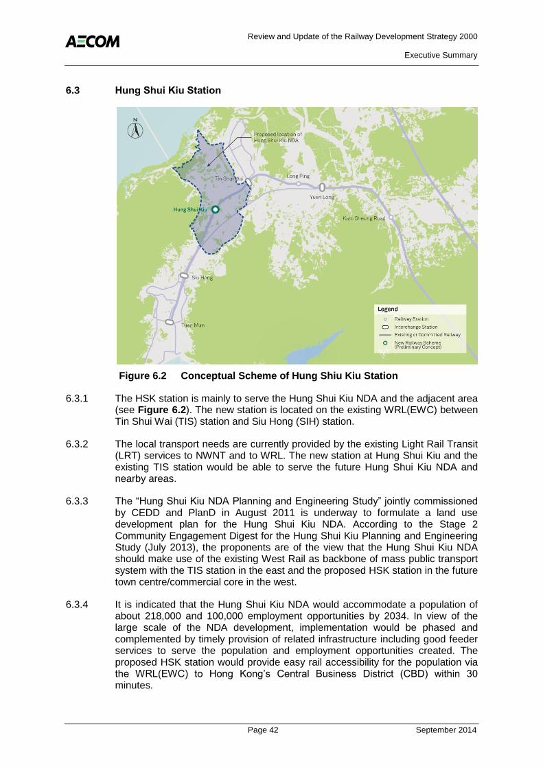
Review and Update of the Railway Development Strategy 2000
Executive Summary
Page 42 September 2014
6.3 Hung Shui Kiu Station
Figure 6.2 Conceptual Scheme of Hung Shiu Kiu Station
6.3.1 The HSK station is mainly to serve the Hung Shui Kiu NDA and the adjacent area (see Figure 6.2). The new station is located on the existing WRL(EWC) between Tin Shui Wai (TIS) station and Siu Hong (SIH) station.
6.3.2 The local transport needs are currently provided by the existing Light Rail Transit (LRT) services to NWNT and to WRL. The new station at Hung Shui Kiu and the existing TIS station would be able to serve the future Hung Shui Kiu NDA and nearby areas.
6.3.3 The “Hung Shui Kiu NDA Planning and Engineering Study” jointly commissioned by CEDD and PlanD in August 2011 is underway to formulate a land use development plan for the Hung Shui Kiu NDA. According to the Stage 2 Community Engagement Digest for the Hung Shui Kiu Planning and Engineering Study (July 2013), the proponents are of the view that the Hung Shui Kiu NDA should make use of the existing West Rail as backbone of mass public transport system with the TIS station in the east and the proposed HSK station in the future town centre/commercial core in the west.
6.3.4 It is indicated that the Hung Shui Kiu NDA would accommodate a population of about 218,000 and 100,000 employment opportunities by 2034. In view of the large scale of the NDA development, implementation would be phased and complemented by timely provision of related infrastructure including good feeder services to serve the population and employment opportunities created. The proposed HSK station would provide easy rail accessibility for the population via the WRL(EWC) to Hong Kong’s Central Business District (CBD) within 30 minutes.

Review and Update of the Railway Development Strategy 2000
Executive Summary
Page 43 September 2014
6.3.5 The implementation programme of the NDA indicated a start of site formation in 2020, with the first intake of population in 2024, and full occupation by 2034.
6.3.6 The general public and many professionals agreed that the HSK station should be planned and implemented in tandem with the Hung Shui Kiu NDA to integrate land use planning and transport. Many suggested that the HSK station should tie in with the population intake of the Hung Shui Kiu NDA.
6.3.7 The implementation window for HSK station in the period 2021 to 2024 would be compatible with the planning intentions of the Hung Shui Kiu area.
6.4 Tung Chung West Extension
Figure 6.3 Conceptual Scheme of the Tung Chung West Extension (and possible Tung Chung East Station)
6.4.1 The TCW Extension is to serve the Tung Chung New Town expansion as well as existing residents.
6.4.2 The TCL will be extended westward by about 1.5 km from its existing terminus at Tung Chung (TUC) station to a new station in Tung Chung West. The location of the new station is planned to serve the existing Yat Tung Estate and other potential developments nearby (see Figure 6.3).
6.4.3 Tung Chung New Town has a current population of about 82,000, whereas Tung Chung West is home to approximately 40,000 residents and is limited to the vicinities of Yat Tung Estate. The remaining areas of Tung Chung West is largely rural villages, fallow land and open countryside. A number of bus routes are currently available in the district, with feeder routes to TUC station and to the urban areas to satisfy the diversified transport needs of the population.

Review and Update of the Railway Development Strategy 2000
Executive Summary
Page 44 September 2014
6.4.4 PlanD and CEDD are jointly conducting the “Planning and Engineering Study on the Remaining Development in Tung Chung – Feasibility Study” where Tung Chung West is included as part of its potential New Town Extension Zone for further development. The RODP is being formulated and the public will be consulted in the next stage of public engagement. The initial intake of the housing development is indicated in 2024. Also, the public housing in Area 39 is under construction and scheduled for completion in 2018.
6.4.5 The majority of the public agreed that the TCW Extension should tie in with the new town extension plan, since the railway would provide convenient rail accessibility to other areas in Hong Kong. However, some green groups and members of the public were concerned about the possible impact the railway may have on the environment especially to the important ecologically areas such as Tung Chung River and Tung Chung Bay.
6.4.6 Based on the above considerations, the timing of this extension should be coordinated with the development plans in the Tung Chung West area and an implementation window in the period 2020 to 2024 would be compatible with the current indicated development programme.
6.4.7 Depending on the RODP for the further development of the Tung Chung New Town, there is possibility of adding a Tung Chung East (TCE) station in the reclamation site (see Figure 6.3) to support the potential new developments in Tung Chung East area under study by PlanD and CEDD. Details of this proposed railway station will be subject to the findings of this planning study.

Review and Update of the Railway Development Strategy 2000
Executive Summary
Page 45 September 2014
6.5 Tuen Mun South Extension
Figure 6.4 Conceptual Scheme of Tuen Mun South Extension
6.5.1 The TMS Extension is to enhance the connectivity of the Tuen Mun South area by facilitating direct access to the existing West Rail service and to promote the use of railway as the main mode of public transport.
6.5.2 The line extension will extend the WRL(EWC) about 2.4 km southwards from the existing terminus at Tuen Mun (TUM) station to Tuen Mun South (see Figure 6.4).
6.5.3 Tuen Mun is the most populated new town in the NWNT with a population of about 490,000 and the area near Tuen Mun Ferry Pier is one of the major residential areas in the region, which is currently home to approximately 90,000 residents. Tuen Mun South residents currently intending to use the West Rail service usually need to travel to TUM station by LRT or feeder bus. With the TMS Extension, residents would have direct rail access to the railway network for travel to the urban area and other regions in NT.
6.5.4 The general public, especially Tuen Mun residents supported the early implementation of the rail extension as it would improve accessibility to West Rail and reduce travelling time to the urban area. However, some were concerned that the elevated railway may bring about visual and landscaping impacts to Tuen Mun River Channel and to nearby sensitive receivers.
6.5.5 The feasibility of extending the railway underground has been explored. However, the presence of existing structures and the steep gradient from the elevated

Review and Update of the Railway Development Strategy 2000
Executive Summary
Page 46 September 2014
station at Tuen Mun to Tuen Mun South would make this option operationally and technically not feasible. At the implementation stage, it will be necessary to address the visual and landscaping aspects related to elevated extension on the Tuen Mun River Channel, which is a scenic spot in the district; and on the residents living nearby.
6.5.6 As the line extension brings benefits to the existing community and promotes the use of the railway, an implementation window in the period 2019 to 2022 is indicated for planning purposes.
6.6 East Kowloon Line
Figure 6.5 Conceptual Scheme of East Kowloon Line
6.6.1 The EKL is proposed to fulfil the following functions:
A direct railway service to areas currently not within the railway existing catchment such as Choi Wan (CWA), Shun Tin (STI), Sau Mau Ping (SMP) and Po Tat (POT) communities as well as future catchments in Anderson Road;
Additional transport capacity along this corridor to address the growing transport demand; and
An alternative route to the existing routes of KTL and TKL for trips between the Tseung Kwan O area and Kowloon, and enhance network robustness by operating a parallel route to the KTL.

Review and Update of the Railway Development Strategy 2000
Executive Summary
Page 47 September 2014
6.6.2 The EKL is a 7.8 km long railway running through the mid-levels of the north Kwun Tong area (see Figure 6.5). The railway line will be connected to the KTL (at Diamond Hill) and TKL (at Po Lam) via transfer subway. The new railway line will be able to provide additional transport capacity to address the growing transport demand in the densely populated areas of Choi Wan, Shun Tin, Sau Mau Ping and Po Tat areas, as well as the committed major public development projects in the area, which include the Public Rental Housing Development at Anderson Road, and the future land use of the Anderson Road Quarry. It is indicated that the planned population at the Development at Anderson Road will be about 48,300 with an initial population intake in 2015/16. At the Anderson Road Quarry, site formation has started and is planned to be completed in 2019, after which the housing development will take some years to complete. The Anderson Road Quarry is planned to have a population of about 25,000. Upon the completion of these two major development projects, the population of Sau Mau Ping District is expected to increase by about 73,000.
6.6.3 The 2011–2012 Policy Address announced that a visionary, coordinated and integrated approach should be adopted to expedite the transformation of Kowloon East. This intention is to develop the new Kai Tak Development area, Kwun Tong and Kowloon Bay, into an attractive alternative CBD to support Hong Kong’s continuing economic development. Following the Policy Address, the Energizing Kowloon East project was initiated by the Development Bureau, which aims to identify ageing industrial areas in Kwun Tong and Kowloon Bay for other commercial business uses. If these projects are realised, it will attract new population and activity to Kowloon East and increase the traffic demand in the region.
6.6.4 The EKL scheme was developed after the PE exercise in view of the strong demands from the public, transport needs associated with the major development projects and the growing pressure on the road network (which has limited capacity for further expansion) in the north Kwun Tong area. Having analysed several alternative alignments of the EKL, the current proposal is considered the most optimum in terms of balancing the transport needs in the north Kwun Tong area and overcoming the physical constraints given that there is limited space for railway development and technical challenges in overcoming the hilly topography and dense urban clusters.
6.6.5 The large scale of the development in this area indicates the need for the EKL to provide additional capacity along this transport corridor as the existing road-based capacity has very limited expansion capacity to meet the anticipated transport demand arising from the new developments. The EKL will additionally offer an alternative route to the existing TKL and KTL for trips between the Tseung Kwan O area and Kowloon.
6.6.6 The implementation window for the EKL in the period 2019 to 2025 would be compatible with the planned development programme in the Anderson Road/Sau Mau Ping area.

Review and Update of the Railway Development Strategy 2000
Executive Summary
Page 48 September 2014
6.7 South Island Line (West)
Figure 6.6 Conceptual Scheme of South Island Line (West)
6.7.1 The SIL(W) scheme is proposed to fulfil the following functions:
Address the growing transport demand in the western part of the Southern District;
Provide additional transport capacity to relieve the constrained transport network in this area;
Increase network robustness by providing an alternative route to the north shore of Hong Kong Island via WIL; and
Serve tourism in Aberdeen.
6.7.2 The SIL(W) is a 7.4 km long railway serving the western areas of Hong Kong Island between Aberdeen and Western District (see Figure 6.6). The railway line will extend the rail coverage to serve new catchments in Aberdeen, Wah Fu, Cyberport, and Pokfulam and connect to the SIL(E) and WIL to improve network connectivity and operational resilience.
6.7.3 The key growth areas have been identified near Wah Fu and Aberdeen and the residential population in the western part of the Southern District is estimated to grow to nearly 100,000 in 2031. If any new development projects are implemented, there would be an increasing transport demand in the area.

Review and Update of the Railway Development Strategy 2000
Executive Summary
Page 49 September 2014
6.7.4 The Chief Executive also announced in the 2014 Policy Address that the Government had decided to partially lift the development moratorium (The Pokfulam area is governed by the “Pokfulam Moratorium” which prohibits any new land sale and lease modification for more intensive development) at the south of Pokfulam, i.e. the area close to Wah Fu Estate, for public housing development and the future redevelopment of Wah Fu Estate. The SIL(W) could provide the additional transport capacity to fulfil the increased transport needs.
6.7.5 There was strong public support for the implementation of the SIL(W) to serve the residents in Aberdeen, Tin Wan and Wah Fu. Members of the public also considered that the SIL(W) could complement the future development / redevelopment in the Southern District. However, there was some concern that the SIL(W) would have impacts on the social, environmental, ecological and landscape and suggested that assessments should be carried out to identify these impacts when considering this new railway line.
6.7.6 Based on the above considerations, implementation of the SIL(W) may be planned to tie in with the potential Wah Fu Redevelopment and partial lifting of the Pokfulam Moratorium. An implementation window in the period of 2021 to 2026 is recommended but would depend on the actual development pace and build up of transport demand.
6.8 North Island Line
Figure 6.7 Conceptual Schemes of the North Island Line
6.8.1 The NIL has been identified to perform the following functions:
Relieve the crowding on the ISL by providing a parallel railway line/service to the existing ISL;
Improve distribution of harbour crossing passengers. As the traffic on the cross-harbour lines is not evenly distributed, extension of the TCL would enable passenger flows to become more balanced in terms of the usage;

Review and Update of the Railway Development Strategy 2000
Executive Summary
Page 50 September 2014
Meet the transport demand of the expanding CBD; and
Increase railway network robustness by providing an alternative transport corridor.
6.8.2 The NIL is an extension of both the TCL and TKL along the north of the Hong Kong Island, in a new corridor from Hong Kong (HOK) station to North Point (NOP) station connecting the vicinities of Tamar, the Hong Kong Convention and Exhibition Centre (HKCEC) and Victoria Park. The total route length is about 5 km (see Figure 6.7).
6.8.3 Two rail service options were presented during the public engagement exercise the “Interchange” scheme and the “Swap” scheme. In the “Interchange” scheme, the TCL would extend eastward from HOK station while the TKL would extend westward from NOP station. The extensions of both railway lines would form the alignment running through in the vicinity of Tamar, HKCEC and Victoria Park. The interchange between the TCL and TKL would be located at Tamar station. In the “Swap” option, the TCL extends eastward from Hong Kong Station and joins the eastern half of the Island Line (the section from Fortress Hill Station to Chai Wan Station), while the Tseung Kwan O Line extends westward from North Point Station and joins the western half of the Island Line (the section from Tin Hau Station to Sheung Wan Station, which will be further extended to Sai Ying Pun, Hong Kong University and Kennedy Town Stations upon the commissioning of the West Island Line). As the existing section of the Island Line from Tin Hau Station to Fortress Hill Station can no longer be operated, two new railway corridors are formed and passengers may interchange between the two at Quarry Bay Station, North Point Station or Central/Hong Kong Station.
6.8.4 The initial transport forecasts undertaken showed that the “Interchange” scheme would have similar levels of performance to the “Swap” scheme in reducing the crowding on the ISL, with the added benefit of maintaining the current service pattern of the ISL to minimise the disruption to existing travelling habits of passengers, in particular to many residents living on the north shore of Hong Kong Island.
6.8.5 Although the “Swap” scheme provided a marginally better economic performance it was not recommended due to the negative impact on passenger’s travelling patterns, residents living in Fortress Hill and Eastern District, and the complex operational aspects of implementing the “Swap”. Additionally, the “Swap” would require additional TCL trains leading to a higher cost. In view of the above, the “Interchange” scheme was preferred.
6.8.6 The ISL serves as the backbone of the entire transport system on the north shore of Hong Kong Island providing mass public transport capacity to cater for the travel needs of the people to/from various places on Hong Kong Island. Furthermore, the NIL will help support the expansion of the CBD to the new harbourfront of the Central and Wanchai North by providing more convenient access to the planned commercial developments/redevelopment sites in the area.
6.8.7 The traffic forecasts indicate that the loading on the ISL could reach some 1.4 million passenger trips per day by 2031, which would be about 40% higher than the present level. The morning peak critical link load has been identified as the west bound section from TIH to CAB where the morning peak hour passenger

Review and Update of the Railway Development Strategy 2000
Executive Summary
Page 51 September 2014
flow is forecast to be some 64 thousand trips, or 75% of the maximum capacity. However, there are several infrastructure projects that may affect the forecasts, including the commencement of operation of the WIL (2014), SIL(E) (2015), SCL (2018-2020); operation of the Central and Wanchai Bypass (2018) and other possible measures which may alleviate the crowding on the ISL.
6.8.8 In the public consultation, the general public supported the NIL and believed that it would relieve the congested ISL by diverting passengers to the new railway line. However, some queried that it would further intensify commercial development on the north shore of the Hong Kong Island, leading to more pollution and traffic congestion.
6.8.9 As the NIL will alleviate the crowding on the existing rail network, extend the rail catchment to key business and activity centres on the harbourfrount, increase network robustness and improve east-west rail connectivity. It is suggested that after completion of the current committed railway projects and the Central and Wanchai Bypass (CWB), passenger traffic on the existing railway network should be monitored in order to assess the appropriate implementation window of the NIL. The timing for implementing NIL will depend on the performance of the ISL and changes in the travel pattern upon the commissioning of the committed railway projects as well as CWB and Island East Corridor Link. On current indications, an implementation window by 2026 to 2031 is recommended for planning purposes.
6.9 Other Railway Schemes
6.9.1 Three other railway proposals were put forth in the two stages of Public Engagement but are not recommended in the Railway Development Expansion Plan due to present uncertainty or constraints regarding these schemes. It would be pre-mature to set targets for their implementation within the time frame of this Study. Assessments on these schemes are summarised below.

Review and Update of the Railway Development Strategy 2000
Executive Summary
Page 52 September 2014
Hong Kong – Shenzhen Western Express Line (WEL)
Figure 6.8 Conceptual Scheme of Western Express Line
6.9.2 The WEL comprises three components: an Airport Rail Link between HKIA and SZIA for airport passengers; a Cross-boundary Spur Line service between the NWNT and the Western regions of Shenzhen (including Qianhai development area); and a Domestic Spur Line service connecting the NWNT and northern Lantau (see Figure 6.8).
6.9.3 As noted above (in Section 6.1.4), it was clear that the inclusion or exclusion of the WEL would be a key decision in developing the recommended railway network expansion plan for the NWNT as it could affect several other schemes. The first step in the process was therefore to assess the WEL scheme.
Review and Update of the Railway Development Strategy 2000
Executive Summary
Page 53 September 2014
6.9.4 The main conclusion from the evaluation of the WEL (or any of its individual components) was that it should not be recommended for the expanded railway network in 2031. The main reasons for this are:
The monetised assessment indicates that the scheme does not perform well in either economic or financial terms even under the high cross boundary demand scenario;
The construction cost of the WEL is estimated to exceed $115B;
The basis for the scheme relies on external factors – such as the passenger demand for inter-airport transit services as well as the likely cross-boundary transport demand between Qianhai and Hong Kong, which depends largely on the pace and breadth of Qianhai’s development and its impact on Hong Kong;
There are concerns that in the medium term, some functions of WEL – i.e. to improve the cross-boundary transport provisions and to better connect Shenzhen and Hong Kong International Airports – will be well served by new road infrastructure that is currently under construction such as the Tuen Mun to Chek Lap Kok Link in Hong Kong, compounding to the Yanjiang
Expressway ( 沿江高速 ) in operation;
There are other significant improvements in cross-boundary connections scheduled to open in the next few years including the XRL and the Hong Kong-Zhuhai-Macao Bridge. These will add significant cross-boundary capacity and connectivity to the already extensive existing railway and cross-boundary coach network. The requirement for further cross-boundary schemes may be reviewed after these new schemes have been implemented;
The scheme would increase the peak hour loading on the critical line section of the EWC (TWW-MEF) which is forecast to be near to capacity. If the scheme was to be implemented in future, the performance of this section would need careful review as other schemes also increase the loading on this section;
The level of wider economic benefits accruing from the scheme are estimated to be relatively small in proportion and do not affect the finding of the monetised assessment; and
Lack of land identified for the depot – No suitable large parcels of land could be identified in the NWNT for the WEL depot. Sites considered are either at odds with the latest land use planning or would impact on substantial areas of land and require acquisition of private land which will increase the capital costs. The proposed depot at Siu Ho Wan would require reclamation.
6.9.5 There are no other transport-related or development-related considerations that over-ride the above and support implementation of the WEL within the RDS-2U timeframe. The development areas that are served by WEL can be better served – in terms of domestic connections – by other railway and road schemes under consideration.

Review and Update of the Railway Development Strategy 2000
Executive Summary
Page 54 September 2014
6.9.6 In the public engagement exercise, there were mixed views on the WEL. Some respondents agreed that there was a need for a cross-boundary railway corridor between Hong Kong and Qianhai to enhance economic development, whereas many respondents had doubts as to the market demand and cost-effectiveness of the Airport Link and thought that it should only be implemented if there was a clear cooperation between the SZIA and the HKIA.
6.9.7 The WEL scheme was therefore not considered for inclusion in the recommended 2031 network. The individual components (Airport Rail Link, Cross-boundary Spur Line, and Domestic Spur Line) are also not recommended as these do not perform well in economic terms as stand-alone schemes. The WEL scheme could be revisited if there are significant increases in cross-boundary traffic and significant changes in market conditions for airport passengers/development parameters.
The Coastal Railway between Tuen Mun and Tsuen Wan
Figure 6.9 Conceptual Scheme of Tuen Mun to Tsuen Wan Link
6.9.8 The concept for the TMTWL included a railway station at Tuen Mun South and five intermediate stations along the 20 km coastal corridor (see Figure 6.9). In the public consultation, the majority of the public views considered that the railway should be in tunnel so as to avoid environmental and visual impacts along the scenic coastal area.
6.9.9 The transport assessment found that the proposed extension of the existing WRL to Tuen Mun South would be a more cost-effective proposal to provide railway services to this populated area. For Tuen Mun residents, the relative travel time advantages of using the TMTWL over West Rail would be limited, as interchange to other railway lines would still be required in the Tsuen Wan area for onward train journeys to other areas in Hong Kong. Additionally, road-based public transport already provides an efficient service along the Tuen Mun to Tsuen Wan corridor, which will further improve after the completion of the improvement works on Tuen Mun Road.

Review and Update of the Railway Development Strategy 2000
Executive Summary
Page 55 September 2014
6.9.10 The current local population is mainly concentrated at the eastern and western ends of this corridor while the remaining population is scattered and dispersed along the 20 km long coastline between Tuen Mun and Tsuen Wan. According to the latest planning conditions, the residential population within the coastline between Tuen Mun and Tsuen Wan will remain low and forecast to increase by about 11% by 2021, with no significant growth or changes in population distribution beyond this date. Unless there are new land use and development opportunities emerging along the coastal area between Tuen Mun and Tsuen Wan, the TMTWL would not be cost-effective due to its limited patronage and high project costs.
6.9.11 This railway line could be considered for the long term, subject to any major changes in population along the coastal areas between Tuen Mun and Tsuen Wan.
Siu Sai Wan Line
Figure 6.10 Conceptual Scheme Siu Sai Wan Line
6.9.12 The study found that the best option to serve the Siu Sai Wan residents with a railway service would be to extend the ISL as it would be direct and more convenient (refer to Figure 6.10). This was also the views of many local residents. However, as the route of the “Extension” scheme is currently constrained or blocked by several private properties, the implementation of this option might be reconsidered when these constraints are removed through future redevelopment of the surrounding buildings. Other schemes, i.e. “Bifurcation” and “Feeder” were considered, but were not recommended due to the potential impacts on the ISL operation, or lack of any significant improvement over the

Review and Update of the Railway Development Strategy 2000
Executive Summary
Page 56 September 2014
existing and convenient road-based feeder services connecting Siu Sai Wan to the existing railway stations.
Other Suggestions
6.9.13 Other railway development suggestions were received from the public during the PE exercise. These suggestions have been assessed to optimise the overall planning for the railway development.
6.9.14 Some of the proposals had been reviewed at an earlier stage of this Study but were found not worthy of further consideration. Some were considered technically infeasible due to conflicts with existing buildings and infrastructure, poor geological conditions and environmental constraints along the proposed alignments. Some others were found operationally infeasible in view of the complications of interfacing with the existing railway lines and spatial problems in the provisioning of railway depots and stations. There were also suggestions on railway connection to areas with no planned developments and a relatively low transport demand. These railway suggestions have no priority on current indication, and may be revisited if planning parameters or physical conditions change significantly.
6.10 Evaluation of the Combined Network
Rail Transport Performance
6.10.1 The analysis of the Combined Network (comprising the existing and committed network and the proposed new railway schemes) considered the cumulative effects of the individual schemes and the impacts on the Combined Network in 2031.
6.10.2 The findings from the transport assessment of the Combined Network in 2031 are summarised in Table 6.2. The main points to note are:
Rail trips increase by around 500,000 per weekday;
The combined network enables a total annual travel time benefit of 50 million hours across all modes of travel;
Overall public transport passenger hours (all Public Transport (PT) modes excluding taxi) spent travelling on an average weekday reduces by 100,000 hours. This represents a saving of 1% to 2% on the overall total of 8.5 million hours, although relative benefits in some of the new railway corridors are greater;
Total rail passenger distance travelled increases by 9.0 million passenger kilometres – this represents an increase of 12% on the overall total of 73 million in the Reference Case;
The rail share of public transport increases from 43% in the Reference Case to 45-50% in the Combined Network. This demonstrates that the Combined Network will support the transport policy to promote railway as the backbone of the passenger transport system; and
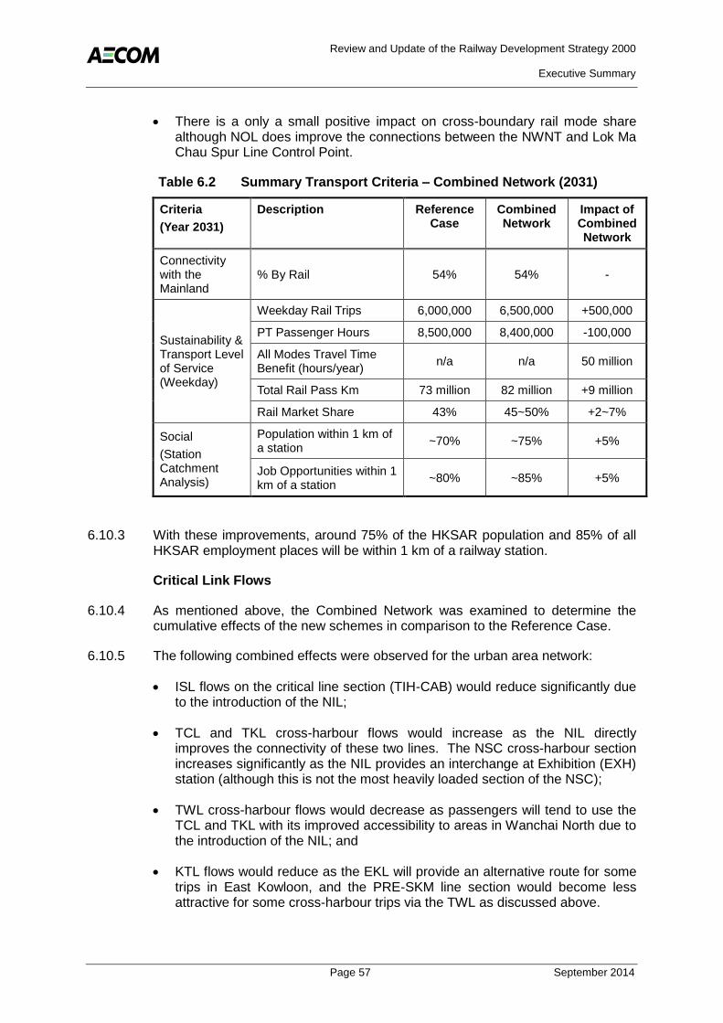
Review and Update of the Railway Development Strategy 2000
Executive Summary
Page 57 September 2014
There is a only a small positive impact on cross-boundary rail mode share although NOL does improve the connections between the NWNT and Lok Ma Chau Spur Line Control Point.
Table 6.2 Summary Transport Criteria – Combined Network (2031)
Criteria Description Reference Combined Impact of Case Network Combined (Year 2031)
Network
Connectivity with the % By Rail 54% 54% - Mainland
Weekday Rail Trips 6,000,000 6,500,000 +500,000
Sustainability & Transport Level of Service (Weekday)
PT Passenger Hours 8,500,000 8,400,000 -100,000
All Modes Travel Time n/a n/a 50 million
Benefit (hours/year)
Total Rail Pass Km 73 million 82 million +9 million
Rail Market Share 43% 45~50% +2~7%
Social Population within 1 km of ~70% ~75% +5%
a station (Station Catchment Analysis)
Job Opportunities within 1 ~80% ~85% +5%
km of a station
6.10.3 With these improvements, around 75% of the HKSAR population and 85% of all HKSAR employment places will be within 1 km of a railway station.
Critical Link Flows
6.10.4 As mentioned above, the Combined Network was examined to determine the cumulative effects of the new schemes in comparison to the Reference Case.
6.10.5 The following combined effects were observed for the urban area network:
ISL flows on the critical line section (TIH-CAB) would reduce significantly due to the introduction of the NIL;
TCL and TKL cross-harbour flows would increase as the NIL directly improves the connectivity of these two lines. The NSC cross-harbour section increases significantly as the NIL provides an interchange at Exhibition (EXH) station (although this is not the most heavily loaded section of the NSC);
TWL cross-harbour flows would decrease as passengers will tend to use the TCL and TKL with its improved accessibility to areas in Wanchai North due to the introduction of the NIL; and
KTL flows would reduce as the EKL will provide an alternative route for some trips in East Kowloon, and the PRE-SKM line section would become less attractive for some cross-harbour trips via the TWL as discussed above.

Review and Update of the Railway Development Strategy 2000
Executive Summary
Page 58 September 2014
6.10.6 For the NT area, the main effect of the Combined Network would be to increase demand on the EWC in the morning peak hour on the critical line section (KSR-MEF) while for the NSC, the forecast for the critical line section (TAW-KOT) are similar to the Reference Case.
6.10.7 The assessment found that two lines - ISL and the EWC would have V/C ratios in the band range of 0.7 to 0.9 in either the Reference Case (i.e. ISL) or Combined Network (i.e. EWC). The V/Cs of these two railway lines indicate they are ‘near to capacity’ based on the service level benchmark requiring closer monitoring of the passenger usage and potential relief measures. The main findings of the EWC and ISL are summarised below:
East West Corridor Flows
The critical line section (KSR-TWW) of the EWC is forecast to reach V/C of 0.64 in 2031 under the Reference Case. For the Combined Network, the effect of the new railway schemes in the NT – in particular, the NOL, HSK station and TMS Extension would increase the flows on (KSR-TWW) line section of the EWC by around 23%, indicating a V/C of 0.79 and would mean the railway line in terms of its passenger level of service is “near-to-capacity” and the passenger usage on the EWC should be closely monitored; and
The growth in the passenger usage on the critical line section of the EWC should therefore be monitored following the introduction of the EWC service pattern in 2018 to confirm that the large forecast increases in EWC demand are actually achieved. If this was the case, then relief measures as presented in Chapter 4, will need to be further investigated. Any such measures should be coordinated with the ongoing planning of the NT, as the planning data forecasts maybe above those assumed for this assessment. If planning intentions were to change significantly, new corridor schemes may also warrant consideration.
Hong Kong Island and Cross Harbour Flows
The introduction of the NIL would reduce the flows on the critical line section (TIH-CAB) of the ISL by about 17,000 pphpd from 64,000 to 47,000. This represents a V/C reduction of 0.75 (Reference Case) to 0.56 (for the Combined Network); and
The NIL redistributes and balances the V/C ratios on the four cross-harbour routes as the new corridor enables improved routing options, and also some trips from Tseung Kwan O to West Kowloon may choose to use the NIL and cross the harbour twice. The flows increase on the cross-harbour sections of the TCL, TKL and the NSC while the flows on the TWL decrease. Total cross-harbour flows are 15% higher in the Combined Network than the Reference Case due to both distributional and mode shift changes.
6.11 Economic and Financial Performance
6.11.1 The preliminary cost estimates, as shown in Table 6.3, for the network development is in the order of HK$110 billion (in 2013 prices). The costs of individual schemes will be refined following detailed engineering, environmental

Review and Update of the Railway Development Strategy 2000
Executive Summary
Page 59 September 2014
and financial studies which will be carried out in conjunction with the implementation of the railway proposals.
Table 6.3 Preliminary Capital Cost Estimates
Scheme Cost Estimate 1
(HK$ billions, 2013 prices)
NOL and KTU Station 23
HSK Station 3
TCW Extension 6
TMS Extension 5.5
EKL 27.5
SIL(W) 25
NIL 20
Total Network 110
Note 1: Capital costs analysis is carried out in 2011 price data and factored 2013 prices
6.11.2 The Combined Network is forecast to have a positive Economic Internal Rate of Return (EIRR) of around 2%.
6.12 Benefits of Railway Development
6.12.1 Railways will continue to be vital in supporting the society, people’s livelihood and economic development in Hong Kong. Investment in the railway infrastructure can help growth in the domestic and regional economies. Transport infrastructure can stimulate opportunities for redevelopment and development by improving connectivity and in effect bring communities closer together by opening up new markets, new job opportunities and new opportunities for growth.
6.12.2 With the addition of the proposed railway schemes in the railway development expansion plan, the number of stations would increase from 99 in 2020 to 114 by 2031, and the total length of railway will increase from 270 km in 2020 to over 300 km. This level of rail coverage will help support Hong Kong’s future planning, transport and environmental aims to year 2031and beyond. The benefits are highlighted below.
6.12.3 The magnitude of these new railway schemes are also a reflection of the committed railway network which will be relatively comprehensive in terms of coverage, connectivity and capacity and hence the new schemes tend to be smaller in scale than previous railway schemes proposed in the RDS-2000.
Integrated land use / transport development
6.12.4 As the proposals under the HK2030 study are gradually being implemented, the RDS-2U strategy reflects the current development context of Hong Kong with the majority of the new rail schemes focused to either support current or future developments in the NT.
6.12.5 With the continued population growth and the need for steady supply of land to cope with the social and economic developments, there is a need to optimise the available redevelopment/development opportunities in the urban areas and

Review and Update of the Railway Development Strategy 2000
Executive Summary
Page 60 September 2014
continue with rail-based development to meet increases in transport demand. The new railway schemes proposed in the urban area tend to focus on specific corridors to either support redevelopment/developments, provide additional transport capacity in areas where road-based transport expansion is limited, complete missing links in the network, or to provide relief to the railway network.
6.12.6 Integrated land use/transport development has underpinned the sustainable growth of Hong Kong with railways forming the backbone of the strategy. The symbiotic relationship of rail and development has created a sustainable urban form and has enabled Hong Kong to build a railway network with less public expenditure than any other city in the world. The railway expansion proposals in RDS-2U further reinforce integrated land use/transport development of potential development areas such as NDAs and the support for urban renewal.
6.12.7 With the railway expansion proposals in place in 2031, about 75% of the population and about 85% of job opportunities would be within 1 km of a railway station. With proper integration of railway planning and land development, it would create synergy in broadening the living space for residents in Hong Kong and provide focus for planned NDAs in the NT, release the development potential of peripheral areas and facilitate local development and economic activities.
Serve Hong Kong’s transport demand
6.12.8 The proposed railway network expansion will bring a high level of connectivity and enhanced accessibility to new development areas, relieve critical transport corridors by providing additional transport capacity and improve operational robustness. The railway proposals will provide adequate capacity and travel conditions to meet forecast 2031 demand and provide scope for further passenger growth.
6.12.9 The proposed railway network expansion will offer fast, reliable and improved connectivity by delivering shorter journey times and make travel easier through the HKSAR. The comprehensive railway network coverage will facilitate co-ordination with other public transport services at key interchange nodes, maximise efficiency of services to passengers in terms of time and costs to meet forecast demand.
6.12.10 With the implementation of the proposed new railway projects, the rail share of public transport trips would increase from around 43% in 2020 to about 45%-50% in 2031. The rail share for cross-harbour movements, which are highly constrained by road capacity, will increase from 52% in 2009 to 72% in the 2031 Reference Case and 77% in the expanded railway network. These levels of rail usage are comparable to those achieved in other world cities with high quality public transport systems.
Providing a high level of transport service
6.12.11 The expanded railway network will help shorten journey time and make travel easier across the territory. The railway schemes will provide adequate capacity and travel conditions to meet the forecast transport demand in 2031 and allow for further passenger growth. Typical journey times for some selected routes in 2031 are as follows:

Review and Update of the Railway Development Strategy 2000
Executive Summary
Page 61 September 2014
Tin Shui Wai to Sheung Shui 35 minutes
Sau Mau Ping to Tsim Sha Tsui 35 minutes
Tseung Kwan O to Tamar 22 minutes
Wah Fu to Wanchai 25 minutes
Economic Benefits
6.12.12 The investments in the Railway Network will bring significant direct (transport) economic benefit to the Hong Kong society, valued at some 3-4 billion HKD per year by 2031.
6.12.13 The direct economic benefits are estimated at about 2% reflecting the fact that the Reference Case network already provides significant rail coverage to the major corridors. Further improvements to the railway network do not tend to give the large rates of return that were gained on previous railway extensions to large development areas not previously served by railway.
6.12.14 The various railway proposals represent a range of scales in terms of the size of investment and level of benefit. However, the transport benefit is not an end in itself, as it is an enabler which can unlock potential and help the economy to grow. Some of the schemes such as the EKL and SIL(W) bring less direct transport benefits as they function as feeder lines into the main railway network and transfer many existing public transport users to railway. These railway schemes need to be looked upon differently as they have important indirect benefits as highlighted below:
Support of land-use proposals and development opportunities – the railway network expansion can improve accessibility to the existing and planned areas of development and provide additional capacity for future growth. A rail connection can provide enhanced connectivity and capacity to a development area which can potentially raise the attractiveness of the area to future residents, and also support higher levels of development through providing non-road-based transport links;
Promote a greener environment – compared with road-based transport, the net pollutant emissions of railways are generally lower. The issue of road congestion can also be mitigated to a certain extent;
Creation of job opportunities - direct, indirect and induced benefits to the railway operator and a variety of trades (e.g. construction, railway operation and maintenance, station retail, logistics, related supply chain, other commercial activities in the vicinity, etc); and
Transport service of higher quality – relief of crowding on rail services in terms of comfort levels and more route choices are valued by passengers but not reflected in travel time savings alone. The improved accessibility to employment and other activities will also encourage the shift from private car usage to public transport modes.
6.12.15 All these indirect benefits are not readily captured in the “monetised” transport assessments but should be considered in the overall appraisal of the transport proposals as they bring a range of benefits to the economy, shape the direction

Review and Update of the Railway Development Strategy 2000
Executive Summary
Page 62 September 2014
of development and redevelopment, impact on a wide range of sustainability issues such as housing, employment and many other quality aspects of life.
Environmental benefits
6.12.16 Rail supports urban development and reinforces more sustainable patterns of development. It complements initiatives being taken in urban transport to reduce carbon and improve air quality. The rail market share in the public transport system would rise to some 45%-50% of total trips by 2031. This would translate to environmental benefits amounting to a reduction in roadside air pollutants by some 190 tonnes of Nitrous Oxides (NOx) per year and 143,000 tonnes of Green House Gas (GHG) per year, i.e. reduction of about 2%-4% of the roadside air pollutants and GHG per year. At the same time, the relief to road congestion can benefit the overall productivity and competitiveness of Hong Kong.

Review and Update of the Railway Development Strategy 2000
Executive Summary
Page 63 September 2014
7. IMPLEMENTATION
7.1 Implementation Programme
7.1.1 Railway projects involve enormous investment of public funds and have profound impacts on society, people’s livelihood and economic development therefore requiring prudent and comprehensive planning. As planning and implementation of railway projects is a complex process and it can often take more than 10 or more years for a railway to take shape from formulation to completion. Therefore, it is essential that the planning and implementation process should start early in order to achieve timely delivery of any new railway services.
7.1.2 In determining the priorities and timing for implementation of the recommended railway schemes, the following factors have been considered:-
Support future land use development and local housing demand;
Serve Hong Kong’s transport needs: high level of connectivity, relieve critical transport corridors and provides operational robustness;
Economic benefits; and
Support from public and local communities.
7.1.3 The projects listed in Table 7.1 are proposed as they could serve committed or new development areas, meet transport needs, provide relief for critical transport corridors and bring economic benefits to Hong Kong. The timing of the implementation of individual projects should be flexible to better suit the pace of development. There may also be interfaces with other projects and financial as well as technical considerations which will affect the timing of schemes.
Table 7.1 Implementation Programme
Package Remarks
NOL and KTU Station The NOL will be enhance east-west connectivity and facilitate cross-boundary movements; improve network robustness and serve the Kwu Tung North NDAs in the NT. Land reserve and design provisions should be made for intermediate stations along its alignment to serve the potential developments, and bifurcation between the KSR station and the LMC station. Flexibility should also be retained for extending the NOL to serve the potential developments in future taking into account the policy initiatives of developing NT North to include a new town and employment clusters which are under study.
Likely implementation window: 2018 to 2023
HSK Station The station will support and tie in with the development pace of the Hung Shui Kiu NDA.
Likely Implementation window: 2021 to 2024
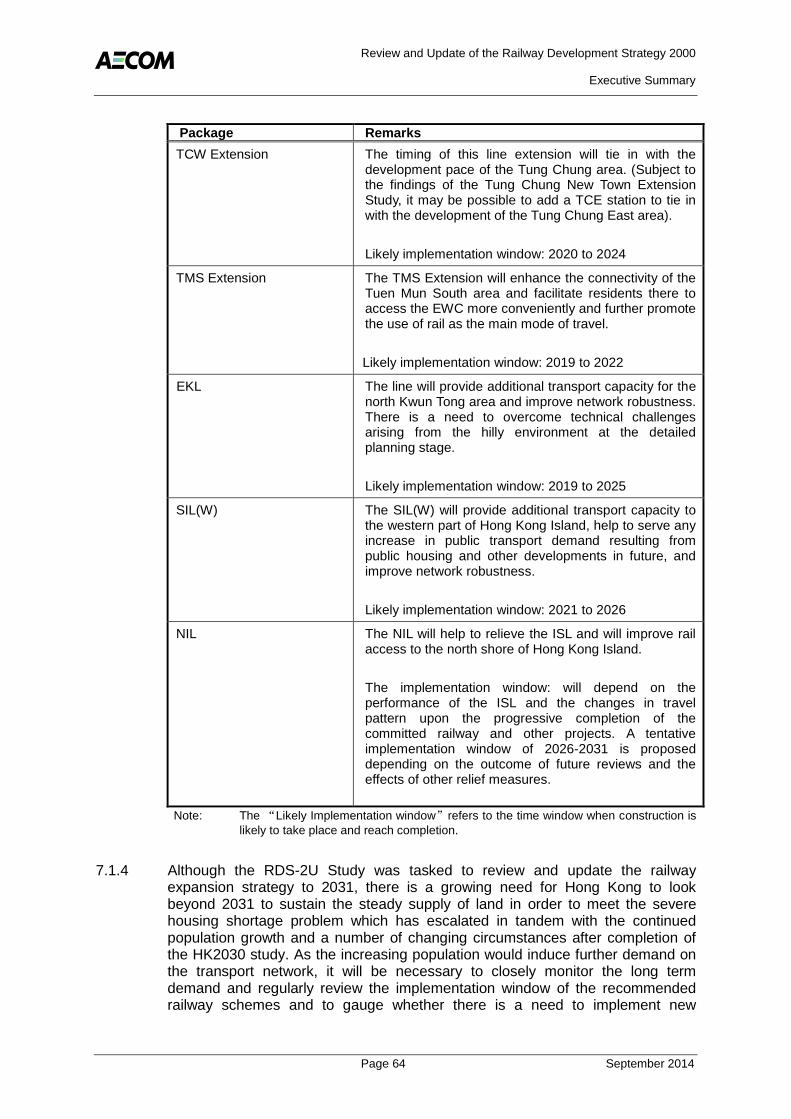
Review and Update of the Railway Development Strategy 2000
Executive Summary
Page 64 September 2014
Package Remarks
TCW Extension The timing of this line extension will tie in with the development pace of the Tung Chung area. (Subject to the findings of the Tung Chung New Town Extension Study, it may be possible to add a TCE station to tie in with the development of the Tung Chung East area).
Likely implementation window: 2020 to 2024
TMS Extension The TMS Extension will enhance the connectivity of the Tuen Mun South area and facilitate residents there to access the EWC more conveniently and further promote the use of rail as the main mode of travel.
Likely implementation window: 2019 to 2022
EKL The line will provide additional transport capacity for the north Kwun Tong area and improve network robustness. There is a need to overcome technical challenges arising from the hilly environment at the detailed planning stage.
Likely implementation window: 2019 to 2025
SIL(W) The SIL(W) will provide additional transport capacity to the western part of Hong Kong Island, help to serve any increase in public transport demand resulting from public housing and other developments in future, and improve network robustness.
Likely implementation window: 2021 to 2026
NIL The NIL will help to relieve the ISL and will improve rail access to the north shore of Hong Kong Island.
The implementation window: will depend on the performance of the ISL and the changes in travel pattern upon the progressive completion of the committed railway and other projects. A tentative implementation window of 2026-2031 is proposed depending on the outcome of future reviews and the effects of other relief measures.
Note: The “Likely Implementation window”refers to the time window when construction is
likely to take place and reach completion.
7.1.4 Although the RDS-2U Study was tasked to review and update the railway expansion strategy to 2031, there is a growing need for Hong Kong to look beyond 2031 to sustain the steady supply of land in order to meet the severe housing shortage problem which has escalated in tandem with the continued population growth and a number of changing circumstances after completion of the HK2030 study. As the increasing population would induce further demand on the transport network, it will be necessary to closely monitor the long term demand and regularly review the implementation window of the recommended railway schemes and to gauge whether there is a need to implement new

Review and Update of the Railway Development Strategy 2000
Executive Summary
Page 65 September 2014
transport infrastructure or improvement works to meet the transport demand beyond the time frame of the RDS-2U Study.
7.1.5 The justification, location, timing and financing details of any new lines and additional railway stations will be subject to more detailed studies as part of local or regional planning studies and project feasibility studies.
7.2 Funding of Railway Projects
7.2.1 RDS-2U has reviewed the existing funding models for railway development and the present arrangements with the railway corporation for financing, building and operating railways and concluded that these methods are still capable and suitable for implementation of new railway projects.
7.2.2 Following RDS-2, but prior to the Rail Merger in 200711, all railway projects were implemented under what is now known as the Ownership Approach. The Rail Merger of 2007 gave rise to a new model for financing railways known as the Concession Approach. Currently, the two approaches for implementing railway projects in Hong Kong are the Ownership approach and the Concession approach.
Ownership approach - the operator will be responsible for funding, design, construction, operation and maintenance of the railway, and ultimately own the railway; and
Concession approach - the Government will be responsible for providing, at its cost, the necessary railway infrastructure of the railway. Upon completion of the railway project, the operator will be granted a service concession and pay the Government service concession payments for the right to operate the railway.
7.2.3 The Government has provided the following list of criteria to be considered when selecting between the Ownership or Concession approach12:
Whether Government should take a longer term view on investment in railway infrastructure and would like to retain the ownership of the railway, thereby retaining the residual value of the railway;
Whether Government would be prepared to input more resources, including staff and cash outlay, to implement the railway under the concession approach;
Whether Government would be prepared to bear the construction risks and operating risks under the concession approach, e.g. lower revenue as a result of patronage being lower than anticipated;
The financial implications for Government;
Whether the selected approach would allow the MTRCL to effectively co-ordinate the planning and implementation of the railway and the above station/depot property development; and
11
The Rail Merger of 2007 granted MTRCL the right to operate KCRC’s railway lines under a concession
agreement for a period of 50 years. 12
Source: Annex C of Legislative Council Brief: Shatin to Central Link and MTR Kwun Tong Line Extension [No.THB(T)CR 10/1016/99]

Review and Update of the Railway Development Strategy 2000
Executive Summary
Page 66 September 2014
Whether the ownership of the new railway by the Government will facilitate the smooth implementation of the railway networks.
7.2.4 For railways that are not financially viable, funding support from Government may be necessary to bridge this funding gap – see illustration in Figure 7.1. A ‘funding gap’ exists if a railway project is considered financially not viable on the basis that its projected discounted revenues (both fare and non-fare) net of projected discounted expenditures (construction, operation and maintenance) falls short of the operator’s expected return on capital, allowing for financing costs.
Figure 7.1 Illustration of Funding Gap Issue
7.2.5 Project funding from the Government can come in various forms, examples of previous forms of Government funding in Hong Kong include capital grants and granting of property development rights. As each railway project is unique in its nature, the form of funding support for railway projects should be project specific and the Government will consider the most viable options for providing funding support for each railway project on a case-by-case basis.

Review and Update of the Railway Development Strategy 2000
Executive Summary
Page 67 September 2014
8. RAILWAY DEVELOPMENT PROPOSALS
8.1.1 Following the evaluation of the railway expansion schemes, the railway schemes recommended for the railway development expansion plan are shown in Figure 8.1 and listed below.
Figure 8.1 Hong Kong’s Railway Network in 2031
(a) Northern Link – a major regional corridor formed by linking EWC (at Kam Sheung Road) to the LMCSL at a new station at Kwu Tung.
Kwu Tung Station – a new station on the LMCSL between the existing stations at Sheung Shui and Lok Ma Chau. This station may be provided as part of the NOL above.
(b) Hung Shui Kiu Station – a new station on the existing WRL(EWC) between the existing stations at Tin Shui Wai and Siu Hong.
(c) Tung Chung West Extension – formed by extending the existing TCL westward with a new station at Tung Chung West.
(d) Tuen Mun South Extension – formed by extending the EWC from Tuen Mun to Tuen Mun South area.
(e) East Kowloon Line – a new corridor running in the north Kwun Tong area connecting the KTL, TKL and SCL-NSC.
(f) South Island Line (West) – a new corridor linking the SIL(E) and the WIL/ISL.
(g) North Island Line – a new railway corridor on the north shore of Hong Kong Island formed by the extension of the existing TCL and TKL.

Review and Update of the Railway Development Strategy 2000
Executive Summary
Page 68 September 2014
9. ON-GOING RAILWAY PLANNING
9.1.1 The findings of RDS-2U form a basis for Government to prepare the Railway Development Strategy for the long-term railway development of the HKSAR. The Railway Development Strategy will facilitate early consultation with the public and the relevant detailed studies of individual projects in future. Moreover, it will allow the Government to make timely reservation of land for the railway corridors and ancillary facilities to ensure that the planning and design of the individual projects can be implemented in a timely manner in response to the actual needs of society and the pace of local developments.
9.1.2 As mentioned earlier, the findings are based on available information of the current land use and planning studies. According to the 2014 Policy Address, the Government is reviewing and stepping up efforts to increase the land supply in the short to medium term through on-going land reviews and optimising the use of developed land. In the long-term, the Government’s objective is to build a land reserve for the sustainable development and to respond more flexibly and timely to future needs through developing new land extensively through NDAs in the NT (including vast tracts of undeveloped land in the NT North, developments at Lantau or its vicinity), reclamation outside Victoria Harbour, rock cavern development and development of underground space, etc. These studies are all at a preliminary stage and findings are yet to be confirmed, hence this document does not specifically address these land development projects.
9.1.3 The Railway Development Strategy should therefore be continuously monitored and where appropriate updated to accommodate the ever changing social, economic and planning environment in conjunction with other strategic transport and/or land use planning studies for the HKSAR. By doing so, the railway development and the planning of land uses and infrastructure can be properly coordinated to achieve planning efficiencies, cost effectiveness and meet the transport needs of the HKSAR.
