review article archaeoseismological potential of the
TRANSCRIPT
REVIEW ARTICLE
CURRENT SCIENCE, VOL. 119, NO. 11, 10 DECEMBER 2020 1767
*For correspondence. (e-mail: [email protected])
Archaeoseismological potential of the Indian subcontinent Miklós Kázmér1,*, Ashit Baran Roy2 and Siddharth Prizomwala3 1Department of Palaeontology, Eötvös University & MTA-ELTE Geological, Geophysical and Space Science Research Group, Budapest, Hungary 2Department of Geology, Mohanlal Sukhadia University, Udaipur 313 001, India 3Institute of Seismological Research, Raisan, Gandhinagar 382 009, India
Mountainous perimeter of the Indian subcontinent is seismically active, while the Peninsula is considered a stable region. Short instrumental records of earth-quakes in India make it imperative to use historical and archaeological means to understand the past seismic activity. We review the status of achaeoseis-mology in India, Pakistan and Bangladesh. Data are provided on seismic activity affecting Delhi, Konark (Odisha) and Mahabalipuram (Tamil Nadu) during historical times. The study intends to highlight the vital need to employ achaeoseismology coupled with other geological information to better assess the past seismological records. Keywords: Archaeoseismology, historical earthquakes, instrumental observations, masonry structures. ARCHAEOSEISMOLOGY is an emerging field in the study of past earthquakes based on the analysis of damaged archaeological sites1. Combined with document-based historical seismology2, and geology-based paleoseismo-logy3, it provides essential information on past earth-quakes which occurred beyond the century-long span of instrumental seismology4–6. Archaeoseismology can be vague about the specific earthquake responsible for the destruction of sites, but it can find evidence for events unrecorded in historical documents. There was hardly any documentation of earthquakes in the Indian subcontinent before the arrival of the British about two and a half centuries ago7. While some histori-cal data have been recorded as far back in time as 1636, most are available only since the second half of the 19th century8. These have been compiled in form of mono-graphs on historical earthquakes first by Oldham9 and later by Iyengar and Sharma10, and others. Instrumental observations started in 1898 with the establishment of the first seismograph in Pune, Maha-rashtra, India11. However, serious use of seismographs in the Indian subcontinent was initiated only after the inci-dence of the Koyna Dam earthquake in 1967. After the Bhuj earthquake of 2001, various seismic networks were established in the entire region of the Indian subconti-nent. Unfortunately, even a decade-long instrumental
record is not sufficient to understand the recurrence of damaging earthquakes.
Archeoseismology: Indian scenario
Three archaeologically dated earthquakes were described from Harappan site of Kalibangan, Rajasthan, in 1963–64, based mainly on vivid interpretation of field data12. Some important data came later from Dholavira in Kachchh, Western Gujarat, based on seismic interpretation of Harap-pan destruction sites13. Bisht14 found places showing trac-es of seismic episodes during the third millennium BC, based on the identification of three collapse levels. One of these includes a southward-tilted wall. Roy et al.15 highlighted the analytical approach, emphasizing that geomorphologic character of a seismic landscape in the Rann of Kachchh, western Gujarat, is to be interpreted together with the study of structural damage of buildings within that landscape. Recently, Shirvalkar and Rawat16 have suggested that the main event of seismicity took place around 2200 BC, which collapsed and tilted walls of a Matura Harappan settlement (Kotada Bhadli, Kachchh). Kovach et al.13 provided details of the archaeological sites at Banbhore, Brahmanabad (Mansurah), Kalibangan and Dholavira in the Kachchh area (Table 1, Figure 1). Rajendran17 reported evidence of earthquake-related destruction in the Ter region in Maharashtra. He was also demonstrated evidence of restoration in several ancient Hindu temples in that area. Based on the identification of extensive damage in the 9th century Punvareshwar tem-ple in the Manjal area in Kachchh, Rajendran et al.18 sug-gested that the Bhuj earthquake was the highest intensity earthquake in the peninsula in the past 1200 years. Pho-tographs of rotated masonry of the 12th century Katarmal temple near Almora and evidence of restoration of tem-ples bearing contemporary inscriptions in the Garwhal region, Uttarakhand indicate the importance of archaeo-seismological observations for the analysis of Himalayan seismicity19. Bilham and Lodi20 found active faults through docu-mentation of damaged sites; they assigned seismic para-meters to these features. The region around Mansurah in Sindh, Pakistan, has been generally perceived as a low-intensity seismic hazard zone, because it has witnessed

REVIEW ARTICLE
CURRENT SCIENCE, VOL. 119, NO. 11, 10 DECEMBER 2020 1768
Table 1. Important archaeoseismological sites in the Indian subcontinent. For locations see Figure 1
Site Country, State Longitude/latitude Reference
Mansurah Pakistan, Sindh 25.882°N, 68.777°E 20 Brahmanabad Pakistan 31°26′46″N, 74°31′34″E 13, 54 Samawani Pakistan ~25°40′20″N, 68°29′15″E 54 Banbhore Pakistan 24°45′20″N, 67°31′25″E 13 Kalibangan India, Rajasthan 29°28′23″N, 74°07′45″E 13 Khabha, Jaisalmer India, Rajasthan 26°48′31″N, 70°37′43″E 29 Pandrethan India, Jammu & Kashmir 34.056°N, 74.860°E 21 Payar India, Jammu & Kashmir 33.861°N, 74.9402°E 21 Naranag India, Jammu & Kashmir 34.3534°N, 74.9771°E 21 Pattan India, Jammu & Kashmir 34.153°N, 74.563°E 21, 23 Sugandhesa India, Jammu & Kashmir 34.1530°N, 74.5622°E 21 Chamba India, Himachal Pradesh 32°32′44″N, 76°07′33″E 25 Qutub Minar complex India, Delhi 28°31′26″N, 77°11′10″E Present study Dholavira India, Gujarat 23°53′14″N, 70°12′48″E 13, 15 Diu India, Diu 20°42′19″N, 70°58′45″E 55 Ter India, Maharashtra 18°19′19″N, 76°08′32″E 17 Talakad India, Karnataka 12°11′03″N, 77°01′25″E 30 Mahabalipuram India, Tamil Nadu 12°36′59″N, 80°11′57″E Present study Konark India, Odisha 19°53′15″N, 80°05′41″E Present study Mahasthan Bangladesh 24°57′34″N, 89°20′45″E 28
Figure 1. Sites of archaeoseismological studies in the Indian subcon-tinent (red circles). See Table 1 for details. Locations with new infor-mation presented in this study underlined. only a few incidences of earthquakes in the past 200 years. They warn that this is dangerous thinking: there was an earthquake of intensity VIII only about 300 years ago20. The authors suggested that the possibility of occur-rence of a high-intensity earthquake cannot be ruled out in the future. A similar reasoning is advanced for the Pandrethan Hindu temple site in Kashmir, India, from
archaeoseismic studies based on damaged masonry struc-tures. Low-intensity instrumental data were countered by a high-intensity (VIII–IX) earthquake in the region21. Masonry temples in Kashmir, which were affected by more than one earthquake, display structural damage. As-signing these to individual earthquakes is a difficult task. However, studies on earthquake-damaged temples in Garhwal and Kumaon, Uttarakhand22 allowed recognition of various earthquakes which had caused damage to these structures. Bilham et al.21 and Sana et al.23 used old pho-tographs to separate blocks broken or fallen before and after the 1885 earthquake, when the images were taken. A similar approach was used by Malik et al.24 in Gujarat, based on a study of old drawings and sketches. Detailed deformation analysis of whole buildings and minor details of temples yielded information on directivity of seismic waves, allowing differentiation between two adjacent rupture zones active at different times25. Damage of buildings is heavily influenced by the nature of the subsoil (hard rock or soft alluvium), and any preventive method against collapse applied by the builder. Hough et al.26 considered these factors when discussing repeated mega-earthquakes in Kashmir, based mostly on historical sources. Archaeological excavations can be supplemented by geophysical methods, including ground-penetrating radar. It is a useful tool to discover and describe displaced walls and warped floors at earthquake-damaged archaeological sites. This method helps under-stand the major earthquake which destroyed Ahichchhatra in Uttar Pradesh in the 11–12th century AD (refs 12, 27). In low-lying, sediment-covered areas near the conflu-ence of Ganga and Brahmaputra rivers, evidence of seis-mic destruction is dated by archaeological excavations. A good example comes from Mahasthangar in the Rajshahi
REVIEW ARTICLE
CURRENT SCIENCE, VOL. 119, NO. 11, 10 DECEMBER 2020 1769
division of Bangladesh through the study of the exhumed city wall, which collapsed during an earthquake in the 12th century AD (ref. 28). Barring the study of Harappa sites and some other iso-lated places, archeoseismological studies in the Peninsula are limited in number. There are also examples of recent studies of earthquake-induced destruction of the Paliwal villages near Jaisalmer, Rajasthan29, and the Talakad temples near Mysore in Karnataka30. Roy and Purohit31 advocated that there cannot be any better terrane than the Peninsular Indian Shield for initiat-ing such studies in the future. The Peninsula has been persistently described as a ‘stable continental region’32,33; though some potential, yet undetected seismic structures have been identified34. Youthful geomorphology and ac-centuated relief are in apparent contrast with low recorded seismicity. Studies on historical seismicity are slowly developing, while archaeoseismology of the Peninsula is still in its infancy. We wanted to add some data to its poorly understood seismic history, suggesting that archaeoseismology can contribute to the identification of seismically hazardous zones. We conducted a preliminary study of three sites in order to highlight the importance of such studies in different parts of the Indian subcontinent. These include Qutub Minar complex in Delhi, Konark near Bhubanes-war (Odisha) and Mahabalipuram in the south of Chennai (Tamil Nadu). All these are considered to constitute parts of the ‘stable’ Indian Shield. A brief description of these studies seems appropriate to understand the importance of archaeoseismicity in the subcontinent outside the Hima-layan terrain.
Results
Studies around Delhi
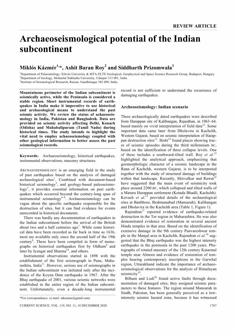
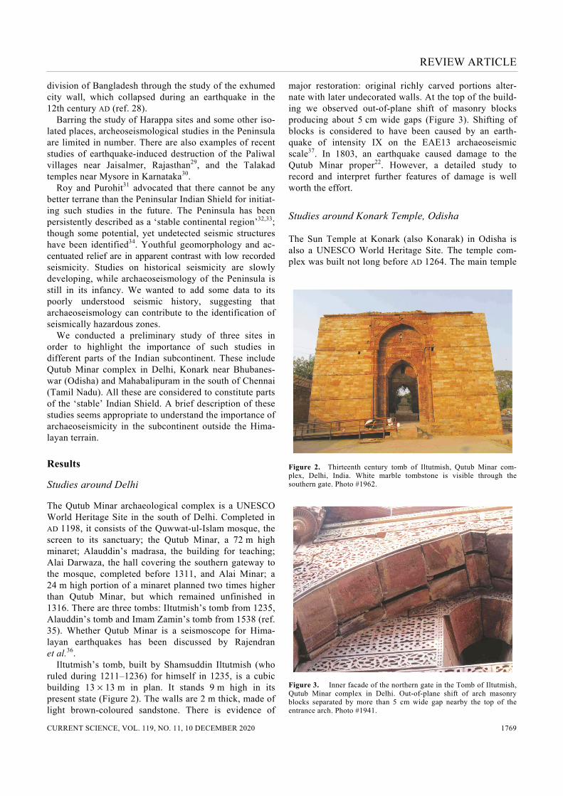
The Qutub Minar archaeological complex is a UNESCO World Heritage Site in the south of Delhi. Completed in AD 1198, it consists of the Quwwat-ul-Islam mosque, the screen to its sanctuary; the Qutub Minar, a 72 m high minaret; Alauddin’s madrasa, the building for teaching; Alai Darwaza, the hall covering the southern gateway to the mosque, completed before 1311, and Alai Minar; a 24 m high portion of a minaret planned two times higher than Qutub Minar, but which remained unfinished in 1316. There are three tombs: Iltutmish’s tomb from 1235, Alauddin’s tomb and Imam Zamin’s tomb from 1538 (ref. 35). Whether Qutub Minar is a seismoscope for Hima-layan earthquakes has been discussed by Rajendran et al.36. Iltutmish’s tomb, built by Shamsuddin Iltutmish (who ruled during 1211–1236) for himself in 1235, is a cubic building 13 × 13 m in plan. It stands 9 m high in its present state (Figure 2). The walls are 2 m thick, made of light brown-coloured sandstone. There is evidence of
major restoration: original richly carved portions alter-nate with later undecorated walls. At the top of the build-ing we observed out-of-plane shift of masonry blocks producing about 5 cm wide gaps (Figure 3). Shifting of blocks is considered to have been caused by an earth-quake of intensity IX on the EAE13 archaeoseismic scale37. In 1803, an earthquake caused damage to the Qutub Minar proper22. However, a detailed study to record and interpret further features of damage is well worth the effort.
Studies around Konark Temple, Odisha
The Sun Temple at Konark (also Konarak) in Odisha is also a UNESCO World Heritage Site. The temple com-plex was built not long before AD 1264. The main temple
Figure 2. Thirteenth century tomb of Iltutmish, Qutub Minar com-plex, Delhi, India. White marble tombstone is visible through the southern gate. Photo #1962.
Figure 3. Inner facade of the northern gate in the Tomb of Iltutmish, Qutub Minar complex in Delhi. Out-of-plane shift of arch masonry blocks separated by more than 5 cm wide gap nearby the top of the entrance arch. Photo #1941.
REVIEW ARTICLE
CURRENT SCIENCE, VOL. 119, NO. 11, 10 DECEMBER 2020 1770
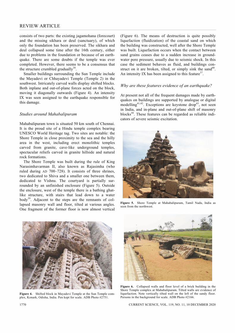
consists of two parts: the existing jagamohana (forecourt) and the missing sikhara or deul (sanctuary), of which only the foundation has been preserved. The sikhara and deul collapsed some time after the 16th century, either due to problems in the foundation or because of an earth-quake. There are some doubts if the temple was ever completed. However, there seems to be a consensus that the structure crumbled gradually38. Smaller buildings surrounding the Sun Temple include the Mayadevi or Chhayadevi Temple (Temple 2) in the southwest. Intricately carved walls display shifted blocks. Both inplane and out-of-plane forces acted on the block, moving it diagonally outwards (Figure 4). An intensity IX was seen assigned to the earthquake responsible for this damage.
Studies around Mahabalipuram
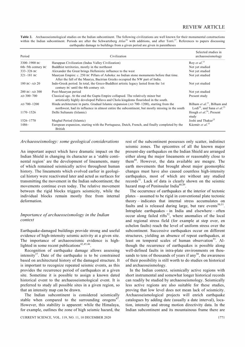
Mahabalipuram town is situated 50 km south of Chennai. It is the proud site of a Hindu temple complex bearing UNESCO World Heritage tag. Two sites are notable: the Shore Temple in close proximity to the sea and the hilly area in the west, including erect monolithic temples carved from granite, cave-like underground temples, spectacular reliefs carved in granite hillside and natural rock formations. The Shore Temple was built during the rule of King Narasimhavarman II, also known as Rajasimha (who ruled during AD 700–728). It consists of three shrines, two dedicated to Shiva and a smaller one between them, dedicated to Vishnu. The courtyard is partially sur-rounded by an unfinished enclosure (Figure 5). Outside the enclosure, west of the temple there is a bathing ghat-like structure, with stairs that lead down to a water body39. Adjacent to the steps are the remnants of col-lapsed masonry wall and floor, tilted at various angles. One fragment of the former floor is now almost vertical
Figure 4. Shifted block in Mayadevi Temple at the Sun Temple com-plex, Konark, Odisha, India. Pen kept for scale. ADB Photo #2751.
(Figure 6). The means of destruction is quite possibly liquefaction (fluidization) of the coastal sand on which the building was constructed, well after the Shore Temple was built. Liquefaction occurs when the contact between sand grains ceases due to a sudden increase in ground-water pore pressure, usually due to seismic shock. In this case the sediment behaves as fluid, and buildings con-struct on it are broken, tilted, or simply sink the sand40. An intensity IX has been assigned to this feature37.
Why are these features evidence of an earthquake?
At present not all of the frequent damages made by earth-quakes on buildings are supported by analogue or digital modelling41,42. Exceptions are keystone drop43, not seen in India, and in-plane and out-of-plane shift of masonry blocks44. These features can be regarded as reliable indi-cators of severe seismic excitation.
Figure 5. Shore Temple at Mahabalipuram, Tamil Nadu, India as seen from the northwest.
Figure 6. Collapsed walls and floor level of a brick building in the Shore Temple complex at Mahabalipuram. Tilted walls are evidence of liquefaction. Note vertically tilted wall on the left of the sandy floor. Persons in the background for scale. ADB Photo #2166.
REVIEW ARTICLE
CURRENT SCIENCE, VOL. 119, NO. 11, 10 DECEMBER 2020 1771
Table 2. Archaeoseismological studies on the Indian subcontinent. The following civilizations are well known for their monumental constructions within the Indian subcontinent. Periods are after the Schwartzberg Atlas56 with additions, and after Torri.57. References to papers discussing earthquake damage to buildings from a given period are given in parentheses
Period
Civilization
Selected studies in archaeoseismology
3300–1900 BC Harappan Civilization (Indus Valley Civilization) Roy et al.15 6th–5th century BC Buddhist territories, mostly in the northeast Not yet studied 333–326 BC Alexander the Great brings Hellenistic influence to the west Not yet studied 321–181 BC Mauryan Empire: c. 250 BC Pillars of Ashoka: no Indian stone monuments before that time.
After the fall of the Maurya, Bactrian Greeks occupied the NW part of India. Not yet studied
180 BC–AD 20 Indo-Greek period. In total, the Greco-Buddhist artistic legacy lasted from the 1st century BC until the 4th century AD.
Not yet studied
200 BC–AD 300 Post-Mauryan period Not yet studied AD 300–700 Classical age. At the end the Gupta Empire collapsed. The relatively minor but
artistically highly developed Pallava and Chola kingdoms flourished in the south. Present study
AD 700–1200 Hindu architecture in parts. Gradual Islamic expansion (AD 700–1200), starting from the northwest, had its influence in almost entire the subcontinent, but mostly missing in the south
Bilham et al.21, Bilham and Lodi20, and Sana et al.23
1170–1526 Delhi Sultanate (Islamic) Hough et al.26; Present study
1526–1770 Mughal Period (Islamic) Joshi and Thakur25 1486– European expansion, starting with the Portuguese, Dutch, French, and finally completed by the
British Kázmér et al.55
Archaeoseismology: some geological considerations
An important aspect which have dramatic impact on the Indian Shield in changing its character as a ‘stable conti-nental region’ are the development of lineaments, many of which remained seismically active throughout human history. The lineaments which evolved earlier in geologi-cal history were reactivated later and acted as surfaces for transmitting the movement in the Indian subcontinent; the movements continue even today. The relative movement between the rigid blocks triggers seismicity, while the individual blocks remain mostly free from internal deformation.
Importance of archaeoseismology in the Indian context
Earthquake-damaged buildings provide strong and useful evidence of high-intensity seismic activity at a given site. The importance of archaeoseismic evidence is high-lighted in some recent publications42,45,46. Recognition of earthquake damage allows assessing intensity37. Date of the earthquake is to be constrained based on architectural history of the damaged structure. It is important to recognize repeated seismic events, as this provides the recurrence period of earthquakes at a given site. Sometime it is possible to assign a known dated historical event to the archaeoseismological event. It is preferred to study all possible sites in a given region, so that an intensity map can be drawn. The Indian subcontinent is considered seismically stable when compared to the surrounding orogens47. However, this stability is apparent: while the Himalaya, for example, outlines the zone of high seismic hazard, the
rest of the subcontinent possesses only scatter, indistinct seismic zones. The epicentres of all the known major present-day earthquakes on the Indian Shield are arranged either along the major lineaments or reasonably close to them48. However, the data available are meagre. The earth movements that brought about major geomorphic changes must have also caused countless high-intensity earthquakes, most of which are without any studied records31. Lack of data is clearly shown on the seismic hazard map of Peninsular India48,49. The occurrence of earthquakes at the interior of tectonic plates – assumed to be rigid in conventional plate tectonic theory – indicates that internal stress accumulates on faults and is released during large, but rare events50,51. Intraplate earthquakes – in India and elsewhere – often occur along failed rifts52, where anomalies of the local and regional stress field (for example at step over, en echelon faults) reach the level of uniform stress over the subcontinent. Successive earthquakes occur on different structures, yielding an absence of repeat earthquakes, at least on temporal scales of human observation53. Al-though the recurrence of earthquakes is possible along well-defined faults in intra-plate environments on thou-sands to tens of thousands of years if any50, the awareness of their possibility is still worth to do studies on historical and archaeoseismology. In the Indian context, seismically active regions with short instrumental and somewhat longer historical records can readily be studied by archaeoseismology. Seismically less active regions are also suitable for these studies, proving that low level does not mean lack of seismicity. Archaeoseismological projects will enrich earthquake catalogues by adding date (usually a date interval), loca-tion, intensity and strong motion directivity data. In the Indian subcontinent and its mountainous frame there are
REVIEW ARTICLE
CURRENT SCIENCE, VOL. 119, NO. 11, 10 DECEMBER 2020 1772
significant and well-researched studies available, as out-lined above. The concept of ‘stable’ interior of the Penin-sula has been proved to be a myth. Information through published data is available. The present study emphasizes the possibility of successful archaeoseismological re-search in view of the presence of important archaeologi-cal sites of different ages in the Indian subcontinent. All historical periods of the subcontinent have witnessed masonry buildings, which are worth studying (Table 2). The most widespread are those from the con-struction period of the 7th to 12th century AD. At those times there were strong, centralized states investing in memorial masonry buildings. Availability of suitable raw material and capable workforce created monuments for eternity. Any damage or demolition of these buildings must be considered – beyond the common causes of man-made damage, neglect or weather calamity – as caused by earthquakes. Properly carved masonry is the best to rec-ognize minor displacements causing misfit of stones. However, the Indian way of stone-carving, with attention to minute details makes it hard – but not impossible – to recognize these displacements. Intensive restoration by various rulers throughout the millennia, followed by the attention of British colonial authorities and by the Archaeological Survey of India in modern times modified and re-built collapsed parts and used other methods to hide or replace damaged portions, e.g. shifted blocks. While restoration ensures that ancient buildings will exist in future, it commonly destroys evi-dence of past seismicity. This is not an Indian problem alone: ideally a trained archaeoseismologist should survey all buildings before large-scale restoration projects are begun.
1. Stiros, S. C. and Jones, R. E. (eds), Archaeoseismology, British School at Athens, Fitch Laboratory Occasional Paper, 1997, vol. 7, p. 268.
2. Guidoboni, E. and Ebel, J., Earthquakes and Tsunamis in the Past. A Guide to Techniques in Historical Seismology, Cambridge University Press, Cambridge, UK, 2009.
3. McCalpin, J., Paleoseismology, Academic Press, San Diego, USA, 1999.
4. Dewey, J. and Byerly, P., The early history of seismometry (to 1900). Bull. Seismol. Soc. Am., 1969, 59(1), 183–227.
5. Rodríguez-Pascua, M. A., Silva, P. G., Giner-Robles, J. L., Pérez-López, R., Perucha, M. and Martín-González, F., Arquesismo-logía: una nueva herramenienta para la sismología y la protección del patrimonio. Rev. Otarq, 2016, 1, 151–169.
6. Silva, P. G., Reicherter, K., Giner-Robles, J. L., Rodríguez-Pascua, M. A., Grützner, Ch., García-Jiménez, P. and Pérez-López, R., Arqueosismología del Conjunto Arqueológico Romano de Baelo Claudia (Cádiz, Sur de España): estado de la cuestión. II Jornadas Internacionales de Baelo Claudia, 2016, pp. 63–91.
7. Roy, A. B., Seismicity in the Peninsular Indian Shield: some geological considerations. Curr. Sci., 2006, 91(4), 456–463.
8. Martin, S. and Szeliga, W., A catalog of felt intensity data for 570 earthquakes in India from 1639 to 2009. Bull. Seismol. Soc. Am., 2010, 100(2), 562–569.
9. Oldham, T., A catalogue of Indian earthquakes. Mem. Geol. Surv. India, 1883, 19, 163–2015.
10. Iyengar, R. N. and Sharma, S. D., Earthquake History of India in Medieval Times, Central Building Research Institute, Roorkee, 1999.
11. Jain, S. K. and Nigam, N. C., Historical developments and current status of earthquake engineering in India. In 12th World Confe-rence on Earthquake Engineering, Auckland, New Zealand, 30 January–4 February 2000, Paper no. 1792, p. 8.
12. Vikrama, B. H., Sravanthi, S., Malik, J. N. and Dikshit, O., Arc-haeological evidences for a 12th–14th century earthquake at Ahichhatra, Barreilly (UP), India. In International Symposium on the 2001 Bhuj Earthquake and Advances in Earthquake Science – AES-2001, Institute of Seismological Research, Gandhinagar, 22–24 January 2011, pp. 113–114.
13. Kovach, R. L., Grijalva, K. and Nur, A., Earthquakes and civiliza-tions of the Indus Valley: a challenge for archaeoseismology. Geol. Soc. Am. Spec. Pap., 2010, 471, 119–127.
14. Bisht, R. S., Major earthquake occurrences in archaeological strata of Harappan settlement at Dholavira (Kachchh, Gujarat). In Inter-national Symposium on the 2001 Bhuj Earthquake and Advances in Earthquake Science – AES-2001, Institute of Seismological Research, Gandhinagar, 22–24 January 2011, pp. 112–113.
15. Roy, A. B., Chatterjee, A. and Chauhan, N. K., Late Quaternary deformation and paleoseismicity: insight into geomorphotectonic evolution of Kachchh, western Indian subcontinent. J. Geol. Soc. India, 2013, 81, 31–40.
16. Shirvalkar, P. and Rawat, Y. S., Excavations at Kotada Bhadli. In Taluka: Nakhatrana, District: Kachchh Gujarat, 2010–2014. Wheeler Excavation Report, Archaeological Survey of India, New Delhi, May 2017, p. 208.
17. Rajendran, C. P., Deformational features in the river bluffs at Ter, Osmanabad district, Maharashtra: evidence for an ancient earth-quake. Curr. Sci., 1997, 72(10), 750–755.
18. Rajendran, K., Rajendran, C. P., Thakkar, M. and Tuttle, M. P., The 2001 Kutch (Bhuj) earthquake: coseismic surface features and their significance. Curr. Sci., 2001, 80(11), 1397–1405.
19. Rajendran, C. P. and Rajendran, K., The status of the central seis-mic gap: a perspective based on the spatial and temporal aspects of the large Himalayan earthquakes. Tectonophysics, 2005, 395, 19–39.
20. Bilham, R. and Lodi, S., The door knockers of Mansurah: strong shaking in a region of low perceived seismic risk, Sindh, Pakistan. Geol. Soc. Am. Spec. Pap, 2010, 471, 29–37.
21. Bilham, R., Bali, B. R., Bhat, M. I. and Hough, S., Historical earthquakes in Srinagar, Kashmir: clues from the Shiva temple at Pandrethan. Geol. Soc. Am. Spec. Pap., 2010, 471, 1–12.
22. Rajendran, C. P., Rajendran, K., Sanwal, J. and Sandiford, M., Archeological and historical database on the Medieval earthquakes of the Central Himalaya: ambiguities and inferences. Seismol. Res. Lett., 2013, 84(6), 1098–1108.
23. Sana, H., Bhat, F. A. and Sana, S., The ancient temples of Kash-mir turned from marvel to ruin by earthquakes? A case study of the Pattan twin temples (AD 883–902). Seismol. Res. Lett., 2018, 90(1), 358–365.
24. Malik, J. N., Gadhavi, M. S., Satuluri, S., Kumar, S., Sahoo, S. and Vikrama, B., Unravelling the hidden truth from Vigukot in the Great Rann of Kachchh, western India by surface and sub-surface mapping. Curr. Sci., 2017, 113(10), 1906–1917.
25. Joshi, M. and Thakur, V. C., Signatures of 1905 Kangra and 1555 Kashmir earthquakes in Medieval period temples of Chamba Region, northwest Himalaya. Seismol. Res. Lett., 2016, 87, 1150–1160.
26. Hough, S., Bilham, R. and Bhat, I., Kashmir Valley mega-erthquakes. Am. Sci., 2009, 97, 42–49.
27. Sravanthi, S., Malik, J. N. and Vikrama, B., Ground penetrating radar investigations at Ahichchhatra: an attempt to identify buried subsurface structures. In 14th International Conference on Ground Penetrating Radar, Shanghai, China, 4–8 June 2012, pp. 625–630.
REVIEW ARTICLE
CURRENT SCIENCE, VOL. 119, NO. 11, 10 DECEMBER 2020 1773
28. Helly, B., Berliet, E. and Faticoni, B., Archaeology of earthquakes at Mahasthangar (Province of Bogra, Bangladesh). In International Symposium on the 2001 Bhuj Earthquake and Advances in Earth-quake Science – AES-2001, Institute of Seismological Research, Raisan, Gandhinagar, Gujarat, 22–24 January 2011, pp. 116– 117.
29. Roy, A. B., Bhu, H., Sharma, P. and Vaishnav, K., Deserted nine-teenth century Paliwal villages around Jaisalmer, western Raja-sthan, India: historical evidence of palaeoseismicity. Curr. Sci., 2017, 112(5), 402–405.
30. Roy, A. B. and Sethumadhav, M. S., The ‘mystic’ sand-dune cov-ered temples of Talakad, Mysore district, Karnataka: evidence of earthquake-related destruction. Curr. Sci., 2014, 107(2), 246–254.
31. Roy, A. B. and Purohit, R., Indian Shield. Precambrian Evolution and Phanerozoic Reconstitution. Elsevier, Amsterdam, The Netherlands, 2018, p. 356.
32. Rastogi, B. K. et al., The deadliest stable continental region earth-quake occurred near Bhuj on 26 January 2001. J. Seismol., 2001, 5, 609–615.
33. Nath, S. K. and Thingbaijam, K. K. S., Probabilistic seismic hazard assessment of India. Seismol. Res. Lett., 2012, 83(1), 135–149.
34. Rajendran, C. P., Whose fault is it? Curr. Sci., 2011, 101(3), 263–264.
35. Page, J. A. and Sharma, Y. D., Qutb Minar and Adjoining Monu-ments, World Heritage Series, Archaeological Survey of India, New Delhi, 2002.
36. Rajendran, C. P. et al., Footprints of an elusive mid-14th century earthquake in the central Himalaya: Consilience of evidence from Nepal and India. Geol. J., 2019, 54, 2829–2846.
37. Rodríguez-Pascua, M. A., Silva, P. G., Peérez-López, R., Giner-Robles, J.-L., Martín-González, F. and Perucha, M. A., Prelimi-nary intensity correlation between macroseismic scales (ESI07 and EMS98) and earthquake archaeological effects (EAEs). In Seismic Hazard, Critical facilities and Slow Active Faults. PATA Days (eds Grützner, C. et al.), Proceedings of the 4th International INQUA Meeting on Paleoseismology, Active Tectonics and Arc-haeoseismology (PATA), Aachen, Germany, 9–14 October 2013, pp. 221–224.
38. Mitra, D., Konarak, World Heritage Series, Archaeological Survey of India, New Delhi, 2003.
39. Sivaramamurti, C. and Narasimhaiah, B., Mahabalipuram, World Heritage Series, Archaeological Survey of India, New Delhi, 2006.
40. Bray, J. D. and Dashti, S., Liquefaction-induced building move-ments. Bull. Earthq. Eng., 2014, 12, 1129–1156.
41. Rodríguez-Pascua, M. A., Pérez-López, R., Giner-Robles, J. L. and Garduño-Monroy, V. H., A comprehensive classification of earthquake archaeological effects (EAE) in archaeoseismology: application to ancient remains of Roman and Mesoamerican cul-tures. Quaternary Int., 2011, 242, 20–30.
42. Kázmér, M., Damage to ancient buildings from earthquakes. In Encyclopedia of Earthquake Engineering (eds Beer, M. et al.), Springer, Berlin, Germany, 2015, pp. 500–506.
43. Kamai, R. and Hatzor, Y. H., Numerical analysis of block stone displacements in ancient masonry structures: a new method to
estimate historic ground motions. Int. J. Num. Anal. Methods Geomech., 2008, 32, 1321–1340.
44. Vasconcelos, Lourenço, P. B., Mouzakis, H. and Karapitta, L., Experimental investigations on dry stone masonry walls. In 1st International Conference on Restoration of Heritage Masonry Structures, Cairo, Egypt, 24–27 April 2006, pp. P31-1–P31-10.
45. Marco, S., Recognition of earthquake-related damage in archaeo-logical sites: examples from the Dead Sea fault zone. Tectono-physics, 2008, 453, 148–156.
46. Silva, P. G., Sintubin, M. and Reicherter, K., New advances in studies of earthquake archeology and paleoseismology. Quater-nary Int., 2011, 242(1), 1–3.
47. Kayal, J. R., Seismotectonics of Peninsular India and Sri Lanka. In Microearthquake Seismology and Seismotectonics of South Asia, Springer, Dordrecht, The Netherlands, 2008, pp. 348–449.
48. Murthy, Y. S. and Raval, U., Bouguer gravity image of India and the neighbouring ESCAP region: a study of tectonics and natural resources. J. Geophys., 2000, 21, 59–70.
49. Ashish, Lindholm, C., Parvez, I. A. and Kühn, D., Probabilistic earthquake hazard assessment for Peninsular India. J. Seismol., 2016, 20, 629–653.
50. Calais, E., Mattioli, G., DeMets, C., Nocquet, J.-M., Stein, S., Newman, A. and Rydelek, P., Tectonic strain in plate interiors? Nature, 2005, 438, E9–E10.
51. Craig, T. J., Calais, E., Fleitout, L., Bollinger, L. and Scotti, O., Evidence for the release of long-term tectonic strain stored in con-tinental interiors through intraplate earthquakes. Geophys. Res. Lett., 2016, 43, 6826–6836.
52. Gangopadhyay, A. and Talwani, P., Symptomatic features of intraplate earthquakes. Seismol. Res. Lett., 2003, 74(6), 863–883.
53. Talwani, P., On the nature of intraplate earthquakes. J. Seismol., 2017, 21, 47–68.
54. Bilham, R., Lodi, S., Hough, S., Bukhary, S., Khan, A. M. and Rafeeqi, S. F. A., Seismic hazard in Karachi, Pakistan: uncertain past, uncertain future. Seismol. Res. Lett., 2007, 78(6), 601–613.
55. Kázmér, M., Bhatt, N., Ukey, V., Prizomwala, S., Taboroši, D. and Székely, B., Archaeological evidence for modern coastal uplift at Diu, Saurashtra Peninsula, India. Geoarchaeology, 2016, 31(5), 376–387.
56. Schwartzberg, J. (ed.), A Historical Atlas of South Asia, Chicago University Press, Chicago, USA, 1978; http://dsal.uchicago.edu/ reference/schwartzberg/ (accessed on 8 January 2019).
57. Torri, M., For a new periodization of Indian history: the history of India as part of the history of the world. Stud. Hist., 2014, 30(1), 89–108.
ACKNOWLEDGEMENTS. We thank Kaushik Dey for assistance during field work and the anonymous reviewer for providing insightful and constructive comments that helped to improve the manuscript. S.P. thanks the Department of Geology, Institute of Seismological Research, Gandhinagar for support. Received 24 June 2019; revised accepted 24 September 2020 doi: 10.18520/cs/v119/i11/1767-1773