review of dda’s transit oriented development guidelines
TRANSCRIPT
REVIEW OF DDA’s TRANSIT ORIENTED DEVELOPMENT
GUIDELINES FOR DELHI
Abstract: Metro rail is being introduced in a big way in all of India’s Tier-I and
some Tier-II cities too. The introduction of TOD guidelines is being clearly
being watched and will be emulated all over the country. Accessibility is fine
but in the process the increased FAR, ground coverage and height would lead
to densification and judicial use of infrastructure is argued by the proponents of
the scheme. This article analyses the public ground per capita versus (the total
area under plots to be developed) buildable plot ratio around metro stations in
Delhi bringing out the resultant Quality of life.
Harikrishna Gopal Nambiar B.Arch., A.I.I.A., A.I.T.P.
The Delhi Development Authority has formulated Transit Oriented
Development guidelines for metro stations and track areas in the Master Plan of
Delhi 2021. An FAR of 450-500 is offered in the 800 metre radius of metro
station and 500 metre on either side along metro track. It is not difficult to
imagine its effect on the city. And height restrictions are removed subject to
approval by Airports Authority of India (AAI).
Any city has public spaces and private spaces, that is precisely what we are
going to analyse in the case of Delhi. I would refer to the very interesting article
on this subject by Shirish Patel, Alpa Sheth & Neha Panchal (2017), their area
of analysis being Mumbai & Dharavi.
There are three basic definitions we must be clear about to understand the
analysis:
1. Public Ground area (PGA): Residents of a city need Public spaces for
IEEESEM
IEEE-SEM, Volume 9, Issue 3, March-2021 ISSN 2320-9151 1
Copyright © 2021 IEEE-SEM Publications
Health and recreation, which they share with others. These include:
i. Built up spaces for hospitals, schools, Police stations, Fire
brigade, electric sub-station & other common amenities.
ii. Recreational area (parks and playgrounds)
iii. Footpaths, roads & public parking.
UDPFI guidelines state this should be minimum 23sq.m. per capita and
National Building code for low income housing states it should be minimum
16sq.m. per capita.
2. Buildable Plot ratio (BPR) : The ratio of total area under plots
Commercial, Residential, Industrial or Mixed use excluding common
amenities.
3. Built-up Area (BUA) : The total area available for human habitation
Commercial & Residential in all plots and all floors. It is expressed
per capita, i.e. total floor area/population.
Today we are talking about densifying Delhi to use infrastructure more
efficiently, but the question is, is there room for further densification. Given in
the table below is the Green space available in the 500 metre catchment of a few
metro stations of Delhi metro.
Green areas available:
Metro Station Green area in sq.metres
1. Janakpuri West 141,371
2. Subhash Nagar 103,330
3. Green Park 36,244
4. Hauz Khas 165,695
Source: Primary Survey 2020
IEEESEM
IEEE-SEM, Volume 9, Issue 3, March-2021 ISSN 2320-9151 2
Copyright © 2021 IEEE-SEM Publications
WHO (World Health Organisation) recommends a minimum of 9 sq.metre of
urban green space per person, India has followed a standard of 8 sq. metres per
person.
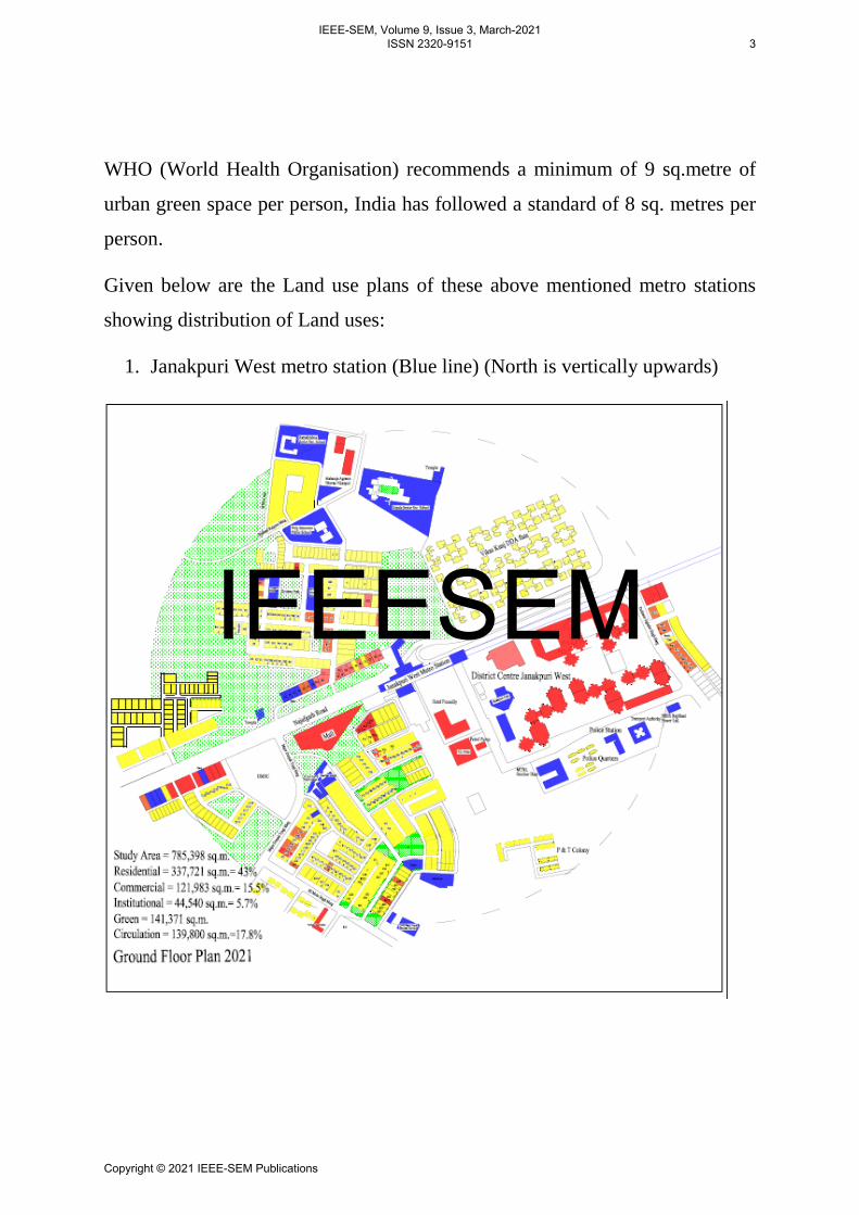
Given below are the Land use plans of these above mentioned metro stations
showing distribution of Land uses:
1. Janakpuri West metro station (Blue line) (North is vertically upwards)
IEEESEM
IEEE-SEM, Volume 9, Issue 3, March-2021 ISSN 2320-9151 3
Copyright © 2021 IEEE-SEM Publications
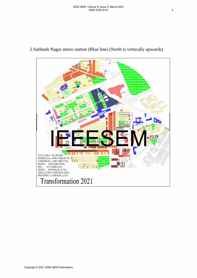
2.Subhash Nagar metro station (Blue line) (North is vertically upwards)
IEEESEM
IEEE-SEM, Volume 9, Issue 3, March-2021 ISSN 2320-9151 4
Copyright © 2021 IEEE-SEM Publications
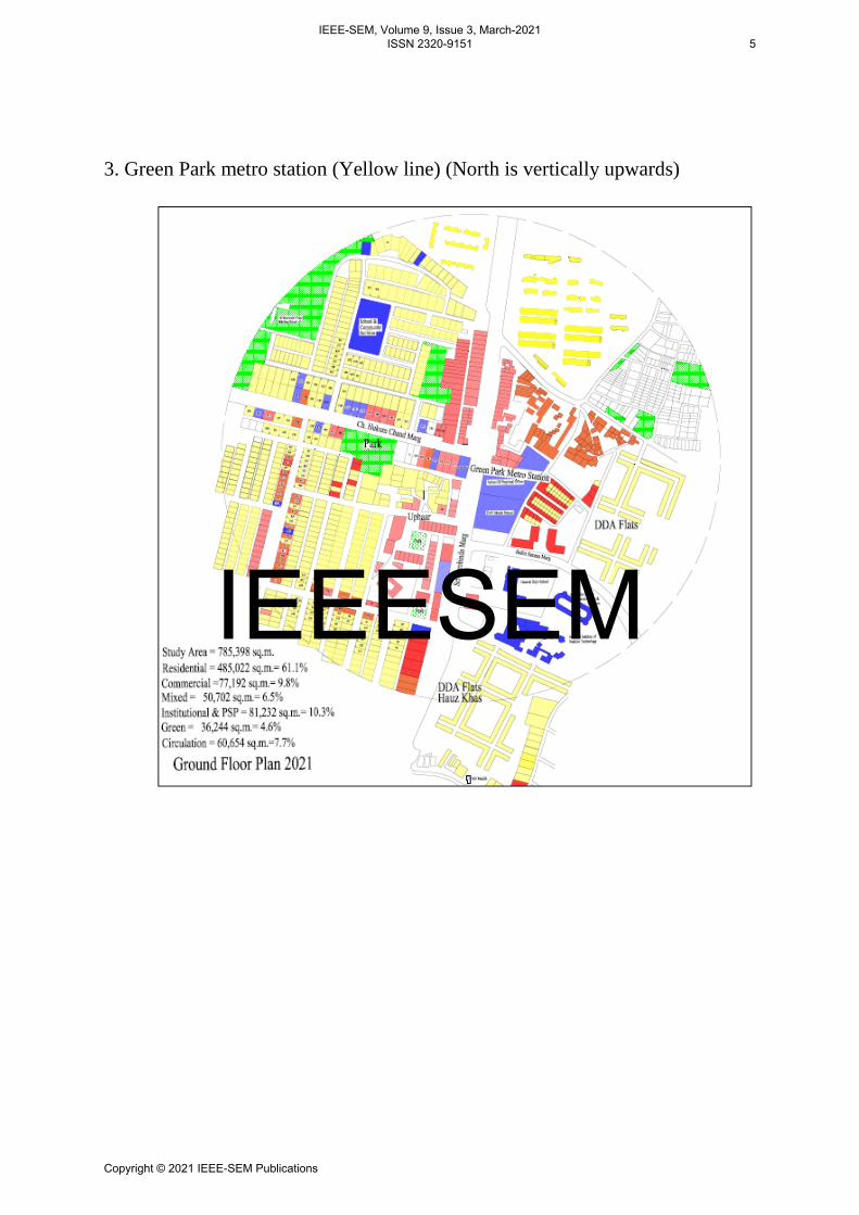
3. Green Park metro station (Yellow line) (North is vertically upwards)
IEEESEM
IEEE-SEM, Volume 9, Issue 3, March-2021 ISSN 2320-9151 5
Copyright © 2021 IEEE-SEM Publications
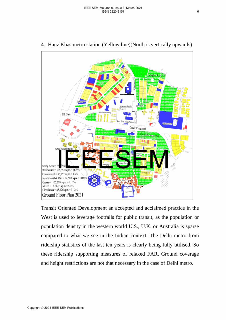
4. Hauz Khas metro station (Yellow line)(North is vertically upwards)
Transit Oriented Development an accepted and acclaimed practice in the
West is used to leverage footfalls for public transit, as the population or
population density in the western world U.S., U.K. or Australia is sparse
compared to what we see in the Indian context. The Delhi metro from
ridership statistics of the last ten years is clearly being fully utilised. So
these ridership supporting measures of relaxed FAR, Ground coverage
and height restrictions are not that necessary in the case of Delhi metro.
IEEESEM
IEEE-SEM, Volume 9, Issue 3, March-2021 ISSN 2320-9151 6
Copyright © 2021 IEEE-SEM Publications
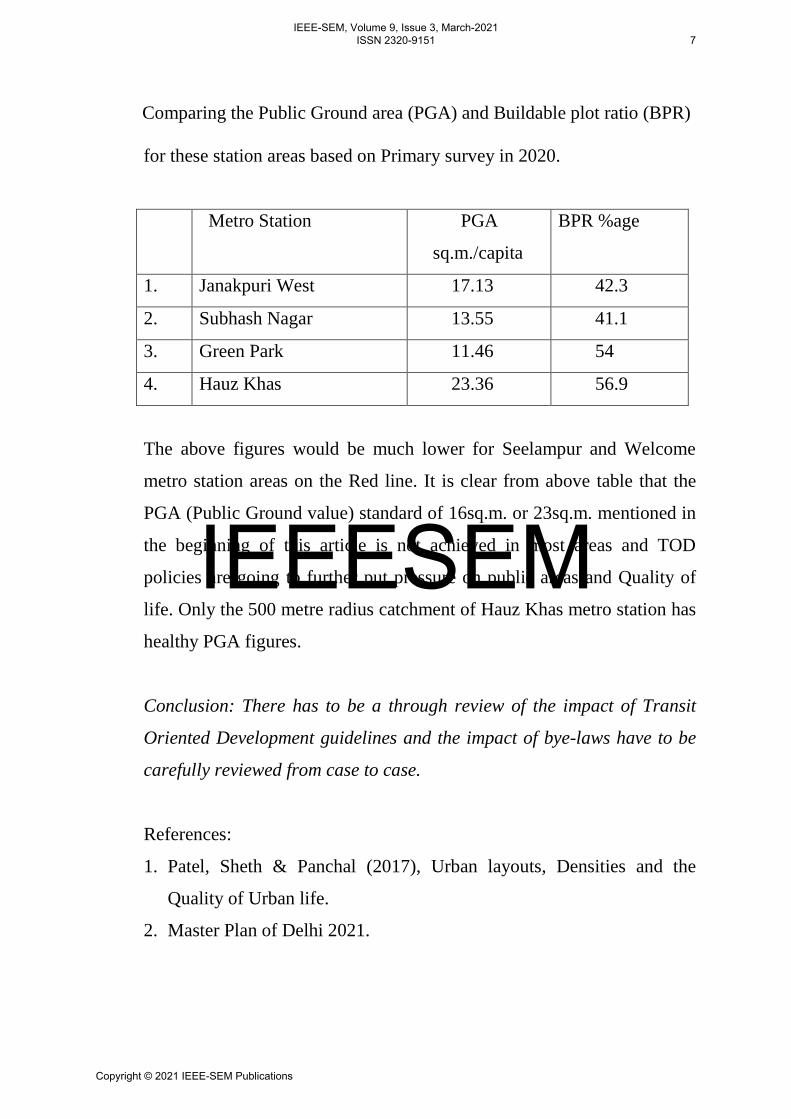
Comparing the Public Ground area (PGA) and Buildable plot ratio (BPR)
for these station areas based on Primary survey in 2020.
Metro Station PGA
sq.m./capita
BPR %age
1. Janakpuri West 17.13 42.3
2. Subhash Nagar 13.55 41.1
3. Green Park 11.46 54
4. Hauz Khas 23.36 56.9
The above figures would be much lower for Seelampur and Welcome
metro station areas on the Red line. It is clear from above table that the
PGA (Public Ground value) standard of 16sq.m. or 23sq.m. mentioned in
the beginning of this article is not achieved in most areas and TOD
policies are going to further put pressure on public areas and Quality of
life. Only the 500 metre radius catchment of Hauz Khas metro station has
healthy PGA figures.
Conclusion: There has to be a through review of the impact of Transit
Oriented Development guidelines and the impact of bye-laws have to be
carefully reviewed from case to case.
References:
1. Patel, Sheth & Panchal (2017), Urban layouts, Densities and the
Quality of Urban life.
2. Master Plan of Delhi 2021.
IEEESEM
IEEE-SEM, Volume 9, Issue 3, March-2021 ISSN 2320-9151 7
Copyright © 2021 IEEE-SEM Publications