review of environmental factors - csu.edu.au · • a new 300mm underground stormwater drainage...
TRANSCRIPT

Review of Environmental Factors
Village Drive Upgrade CSU Bathurst Campus
(Our Reference: 28067-PR01_A) © Barnson Pty Ltd 2018. Confidential.

i Reference: 28067-PR01_A
Disclaimer This report has been prepared solely for Charles Sturt University (CSU) (the client) in accordance with the scope provided by the client and for the purpose(s) as outlined throughout this report. Barnson Pty Ltd accepts no liability or responsibility for or in respect of any use or reliance upon this report and its supporting material by anyone other than the client.
Report Title: Review of Environmental Factors Project Name: Village Drive Upgrade Client: Charles Sturt University Project No. 28067 Report Reference 28067-PR01_A Date: 27/2/2018 Revision: Final
Prepared by: Reviewed by:
Erika Dawson B. Urb & Reg. Planning (hons), Grad. Dip Bushfire Protection, RPIA, MFPAA Senior Town Planner
Kristie Vaughan B. Urb & Reg. Planning Senior Town Planner

ii Reference: 28067-PR01_A
LIST OF CONTENTS 1 INTRODUCTION ........................................................................................................................ 1
1.1 Background ..................................................................................................................... 1 1.2 Proponent ....................................................................................................................... 1 1.3 Determining Authority ................................................................................................... 1 1.4 Purpose of this Report .................................................................................................... 1
2 PROPOSED ACTIVITY ................................................................................................................. 2 2.1 Summary of the Activity ................................................................................................. 2 2.2 Location of the Activity ................................................................................................... 2 2.3 Description of the Activity .............................................................................................. 6 2.4 Objectives of the Proposal ............................................................................................. 7
3 PROJECT JUSTIFICATION ........................................................................................................... 8 3.1 Need for the Project ....................................................................................................... 8 3.2 Consideration of Alternatives ......................................................................................... 8
3.2.1 Alternatives ............................................................................................................ 8 3.2.2 Do Nothing Approach ............................................................................................. 8
4 STATUTORY & PLANNING FRAMEWORK .................................................................................. 9 4.1 Introduction .................................................................................................................... 9 4.2 Environmental Planning & Assessment Act 1979 (EP&A Act) ..................................... 12
4.2.1 Application of Biodiversity Conservation Act 2016 (BC Act) & Fisheries Management Act 1994 (FM Act) ......................................................................................... 12 4.2.2 Duty to Consider Environmental Impact ............................................................. 12 4.2.3 Activities for which an EIS is required .................................................................. 13
4.3 Environmental Planning & Assessment Regulation 2000 (EP&A Regulation) ............. 13 4.3.1 Factors for consideration ..................................................................................... 13
4.4 State Environmental Planning Policy (Infrastructure) 2008 (ISEPP) ............................ 17 4.4.1 Permissibility ........................................................................................................ 17 4.4.2 Consultation ......................................................................................................... 18
4.5 Bathurst Regional Local Environmental Plan 2014 ...................................................... 24 4.6 Other Legislation .......................................................................................................... 24
4.6.1 Environment Protection and Biodiversity Conservation Act 1999 ...................... 24 4.6.2 National Parks and Wildlife Act 1974 ................................................................... 25 4.6.3 Biodiversity Conservation Act 2016 ..................................................................... 26
4.6.3.1 Is the development likely to significantly affect threatened species? ......... 26 4.6.3.2 Biodiversity Development Assessment Report / Species Impact Statement 27
4.7 Summary of Licences, Permits, Approvals and Notifications ...................................... 27 5 STAKEHOLDER CONSULTATION ............................................................................................. 29
5.1 Authority Consultation ................................................................................................. 29 5.2 Local Community .......................................................................................................... 29 5.3 Notification Requirements under the Infrastructure SEPP 2007 ................................ 29

iii Reference: 28067-PR01_A
6 EXISTING ENVIRONMENT ....................................................................................................... 31 6.1 Introduction .................................................................................................................. 31 6.2 Topography ................................................................................................................... 31 6.3 Surrounding Land Uses ................................................................................................. 31 6.4 Geology & Soils ............................................................................................................. 33 6.5 Groundwater ................................................................................................................ 33 6.6 Surface Water ............................................................................................................... 33 6.7 Terrestrial Biodiversity ................................................................................................. 34 6.8 Aboriginal Heritage ....................................................................................................... 35 6.9 European Heritage ....................................................................................................... 35 6.10 Natural Hazards ........................................................................................................ 36
7 IMPACT ASSESSMENT ............................................................................................................. 37 7.1 Introduction .................................................................................................................. 37 7.2 Impact Assessment & Mitigation Measures ................................................................ 38 7.3 Future Implications & Cumulative Impacts .................................................................. 48
8 CONCLUSION .......................................................................................................................... 49 9 REFERENCES ........................................................................................................................... 50
APPENDICES Appendix A – Title & DP Appendix B – Detail Survey Appendix C – Development Plans Appendix D – AHIMS Search
LIST OF TABLES Table 1 – Activity Overview .............................................................................................................. 6 Table 2 – Applicable Legislation ....................................................................................................... 9 Table 3 – Section 111 Considerations ............................................................................................ 12 Table 4 – Factors for likely impact of an activity on the environment .......................................... 14 Table 5 – ISEPP Consultation Requirements .................................................................................. 19 Table 6 – Impact on Matters of National Environmental Significance .......................................... 24 Table 7 – Approval Summary Table ............................................................................................... 27 Table 8 – Authority Consultation ................................................................................................... 29 Table 9 – ISEPP Notification Requirements ................................................................................... 29 Table 10 – Environmental Assessment of Impacts ........................................................................ 38
LIST OF FIGURES Figure 1 – Site Location .................................................................................................................... 2
iv Reference: 28067-PR01_A
Figure 2 – Site Aerial Photograph .................................................................................................... 3 Figure 3 – Location of Works Plan ................................................................................................... 3 Figure 4 – Biodiversity Value Map ................................................................................................. 27 Figure 5 – Heritage Item Location .................................................................................................. 36
LIST OF PLATES Plate 1 – View south along Village Drive from northern extent of proposed works ...................... 4 Plate 2 – View north along Village Drive from Carpark P2 .............................................................. 4 Plate 3 – View north along Village Drive from intersection with Wiradjuri Road ........................... 5 Plate 4 – Example of concrete strip and road to be replaced ......................................................... 5 Plate 5 - CD Blake Auditorium Gymnasium.................................................................................... 31 Plate 6 - Gravel carpark, playing fields and tennis, netball and basketball courts ........................ 32 Plate 7 - Chancellor’s Office ........................................................................................................... 32 Plate 8 - Accommodation units ...................................................................................................... 33 Plate 9 - Existing vegetation adjacent to the accommodation buildings and carpark .................. 34 Plate 10 - Existing vegetation opposite carpark P1 ....................................................................... 35

1 Reference: 28067-PR01_A
1 INTRODUCTION
1.1 Background This Review of Environmental Factors (REF) has been prepared by Barnson Pty Ltd on behalf of Charles Sturt University (CSU) for the proposed upgrade of Village Drive at the Bathurst Campus of CSU.
This REF provides an assessment of the environmental impact from the proposed activity, including a description of all mitigation measures to be implemented.
1.2 Proponent CSU is the proponent for the activity.
1.3 Determining Authority Pursuant to clause 227 of the Environmental Planning and Assessment Regulation 2000 (EP&A Regulation), CSU is prescribed as a ‘public authority’ for the purpose of being a ‘determining authority’ within the meaning of Part 5 of the Environmental Planning and Assessment Act 1979 (EP&A Act). This is only where development is permitted without consent (by State Environmental Planning Policy (Infrastructure) 2007 or State Environmental Planning Policy (Educational Establishments and Child Care Facilities) 2017) on land vested in, leased by or otherwise under the control or management of the university.
Therefore, for the purposes of the proposed development, CSU is the determining authority.
1.4 Purpose of this Report The purpose of this REF is to assist CSU to fulfil its obligations as a determining authority for the proposed activity in accordance with Part 5 of the EP&A Act and Part 14 of the EP&A Regulation.
2 Reference: 28067-PR01_A
2 PROPOSED ACTIVITY
2.1 Summary of the Activity The proposed activity involves the upgrade of Village Drive from the exit of the Mitchell Drive roundabout to Wiradjuri Road. The overall works package for the development also includes works to the adjacent Carparks 2, 3, and 4; however, the carpark works do not form part of the development assessed in this REF.
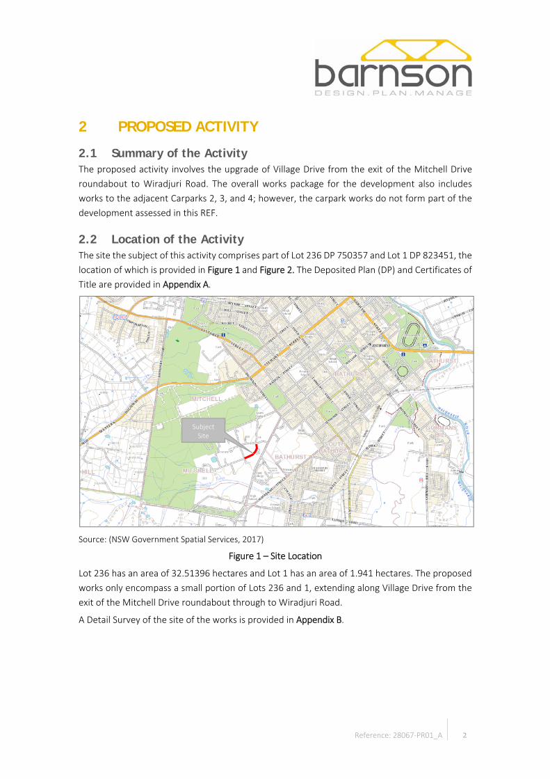
2.2 Location of the Activity The site the subject of this activity comprises part of Lot 236 DP 750357 and Lot 1 DP 823451, the location of which is provided in Figure 1 and Figure 2. The Deposited Plan (DP) and Certificates of Title are provided in Appendix A.
Source: (NSW Government Spatial Services, 2017)
Figure 1 – Site Location
Lot 236 has an area of 32.51396 hectares and Lot 1 has an area of 1.941 hectares. The proposed works only encompass a small portion of Lots 236 and 1, extending along Village Drive from the exit of the Mitchell Drive roundabout through to Wiradjuri Road.
A Detail Survey of the site of the works is provided in Appendix B.
Subject Site

3 Reference: 28067-PR01_A
Source: (Google Earth, 2017)
Figure 2 – Site Aerial Photograph
Figure 3 – Location of Works Plan
Lot 236 DP 750357
Lot 1 DP 823451

4 Reference: 28067-PR01_A
Plate 1 – View south along Village Drive from northern extent of proposed works
Plate 2 – View north along Village Drive from Carpark P2
5 Reference: 28067-PR01_A
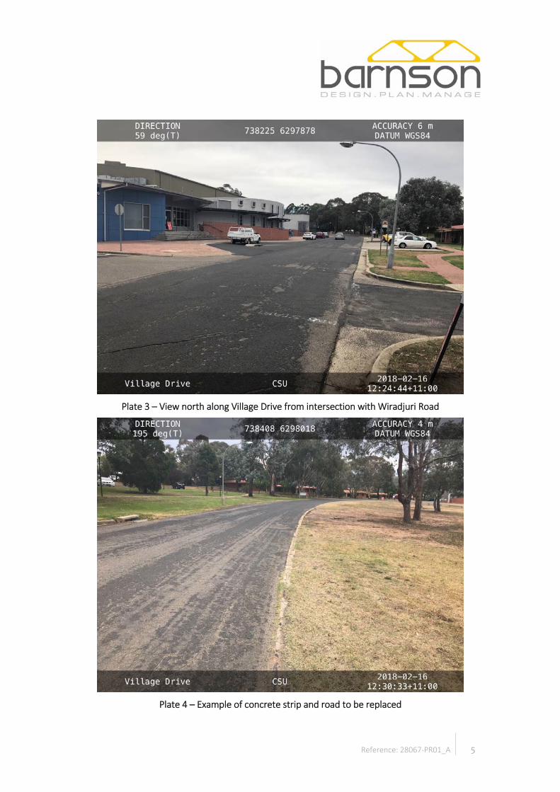
Plate 3 – View north along Village Drive from intersection with Wiradjuri Road
Plate 4 – Example of concrete strip and road to be replaced
6 Reference: 28067-PR01_A
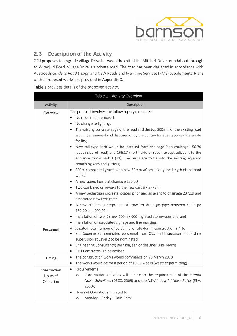
2.3 Description of the Activity CSU proposes to upgrade Village Drive between the exit of the Mitchell Drive roundabout through to Wiradjuri Road. Village Drive is a private road. The road has been designed in accordance with Austroads Guide to Road Design and NSW Roads and Maritime Services (RMS) supplements. Plans of the proposed works are provided in Appendix C.
Table 1 provides details of the proposed activity.
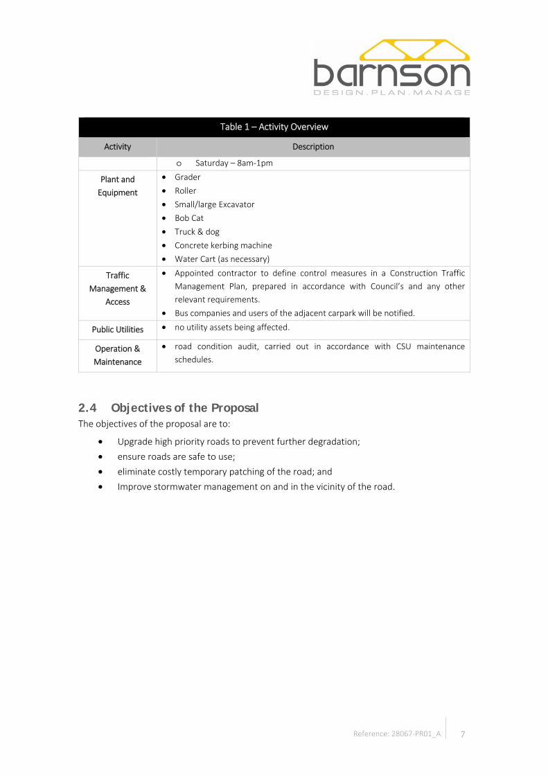
Table 1 – Activity Overview
Activity Description
Overview The proposal involves the following key elements: • No trees to be removed; • No change to lighting; • The existing concrete edge of the road and the top 300mm of the existing road
would be removed and disposed of by the contractor at an appropriate waste facility;
• New roll type kerb would be installed from chainage 0 to chainage 156.70 (south side of road) and 166.17 (north side of road), except adjacent to the entrance to car park 1 (P1). The kerbs are to tie into the existing adjacent remaining kerb and gutters;
• 300m compacted gravel with new 50mm AC seal along the length of the road works;
• A new speed hump at chainage 120.00; • Two combined driveways to the new carpark 2 (P2); • A new pedestrian crossing located prior and adjacent to chainage 237.19 and
associated new kerb ramp; • A new 300mm underground stormwater drainage pipe between chainage
190.00 and 200.00; • Installation of two (2) new 600m x 600m grated stormwater pits; and • Installation of associated signage and line marking.
Personnel Anticipated total number of personnel onsite during construction is 4-6. • Site Supervisor; nominated personnel from CSU and Inspection and testing
supervision at Level 2 to be nominated. • Engineering Consultancy; Barnson, senior designer Luke Morris • Civil Contractor- To be advised
Timing • The construction works would commence on 23 March 2018 • The works would be for a period of 10-12 weeks (weather permitting).
Construction Hours of
Operation
• Requirements o Construction activities will adhere to the requirements of the Interim
Noise Guidelines (DECC, 2009) and the NSW Industrial Noise Policy (EPA, 2000);
• Hours of Operations – limited to: o Monday – Friday – 7am-5pm
7 Reference: 28067-PR01_A
Table 1 – Activity Overview
Activity Description
o Saturday – 8am-1pm
Plant and Equipment
• Grader • Roller • Small/large Excavator • Bob Cat • Truck & dog • Concrete kerbing machine • Water Cart (as necessary)
Traffic Management &
Access
• Appointed contractor to define control measures in a Construction Traffic Management Plan, prepared in accordance with Council’s and any other relevant requirements.
• Bus companies and users of the adjacent carpark will be notified.
Public Utilities • no utility assets being affected.
Operation & Maintenance
• road condition audit, carried out in accordance with CSU maintenance schedules.
2.4 Objectives of the Proposal The objectives of the proposal are to:
• Upgrade high priority roads to prevent further degradation; • ensure roads are safe to use; • eliminate costly temporary patching of the road; and • Improve stormwater management on and in the vicinity of the road.
8 Reference: 28067-PR01_A
3 PROJECT JUSTIFICATION
3.1 Need for the Project The proposed works aligns with CSU’s road condition audit and meets the university’s objectives for campus roads.
3.2 Consideration of Alternatives
3.2.1 Alternatives Alternatives to the project would include a different location and different design of the road. Within the precinct, there are no other suitable location for road. The works utilise the existing road alignment and minimise impact on existing infrastructure and vegetation. The materials used provide the most cost-effective method of road construction and match in with the existing.
3.2.2 Do Nothing Approach The 'do nothing' approach infers undertaking no works relating to the upgrade works. This option is not acceptable as it would result in:
• University objectives not being meet; • ongoing deterioration of the road and high maintenance costs; and • increased risk of work health and safety (WH&S) incidences.

9 Reference: 28067-PR01_A
4 STATUTORY & PLANNING FRAMEWORK
4.1 Introduction The proposed road upgrade falls under the definition of ‘road’ which may be carried out without development consent:
• pursuant to clause 2.3 of Bathurst Regional Local Environmental Plan 2014 (LEP) as the site is located within the SP2 Infrastructure Zone; and
• by or on behalf of a public authority pursuant to Clause 94 of State Environmental Planning Policy (Infrastructure) 2007 (ISEPP).
The proposed road works comprises an activity and therefore requires consideration of its environmental impacts under Part 5 of the Environmental Planning & Assessment Act 1979 (EP&A Act). The proponent for the activity is CSU. The nominated determining authority for the activity is CSU.
This section of the report outlines the statutory and planning approval requirements of the activity. The following table outlines the legislation and subordinate legislation that may be applicable to the development. Detailed consideration of those relevant to the works is provided in the following sections.
Table 2 – Applicable Legislation
Legislation Comment Applicability
Yes No
Acts
Environmental Planning and Assessment Act 1979
Provides the framework for land use planning in NSW. Part 5 is applicable to the proposed works. Addressed in Section 4.2.
☒ ☐
Environment Protection & Biodiversity Conservation Act 1999
Provides protection for matters of National Environmental Significance. Addressed in Section 4.6.1.
☒ ☐
Biodiversity Conservation Act 2016
Outlines the framework for assessment and approval of biodiversity impacts associated with developments that require consent under the Environmental Planning and Assessment Act 1979.
Addressed in Section 4.6.3.
☒ ☐
Heritage Act 1977 Provides for the protection of heritage items of local and state significance. Where works are likely to impact upon an item listed on the State Heritage Register (SHR) approvals are required. No SHR listed
☐ ☒

10 Reference: 28067-PR01_A
Table 2 – Applicable Legislation
Legislation Comment Applicability
Yes No
items on the site. No further consideration of Act required.
Roads Act 1993 Provides for the ownership and management of public roads and also requires the consent of the appropriate roads authority for various works in respect of certain public roads.
Section 138 of the Roads Act requires the consent of the appropriate roads authority for various works in respect of public roads and classified roads. No works are proposed in, on or under a public road. No further consideration of Act required.
☐ ☒
Fisheries Management Act 1994
Applies to all inland waters in the NSW, except for those waters classified as Commonwealth waters. The objective of this Act is to conserve, develop, and share the fishery resources of the State for the benefit of present and future generations. The works would not impact any waters. No further consideration of Act required.
☐ ☒
National Parks and Wildlife Act 1974
The National Parks and Wildlife Act 1974 (NPW Act) provides for the management of all national parks, historic sites, nature reserves, reserves, Aboriginal areas and state game reserves. It also provides for the protection and care of native flora and fauna, and Aboriginal places and objects throughout NSW.
Addressed in Section 4.6.2.
☒ ☐
Noxious Weed Act 1993 Provides for the identification, classification and control of noxious weeds in NSW. No permits or approvals are required; however, it is the responsibility of CSU to ensure that any noxious weeds identified within the project boundary are removed and disposed of accordingly. No further consideration of Act required.
☐ ☒
Protection of the Environment Operations Act 1997
The object of the Act is to achieve the protection, restoration and enhancement of the quality of the NSW environment. There is a broad allocation of
☐ ☒

11 Reference: 28067-PR01_A
Table 2 – Applicable Legislation
Legislation Comment Applicability
Yes No
responsibilities under the Act between the EPA, local councils and other public authorities.
The EPA is made the regulatory authority for
• activities listed in Schedule 1 to the Act and the premises where they are carried out
• activities carried out by a State or public authority • other activities in relation to which a licence
regulating water pollution is issued
In nearly all other cases, the regulatory authority is the relevant local council.
No licences/approvals are required for the works under the POEO Act.
Rural Fire Act 1997 Amongst other things, the Act requires approval (s.100B) for certain types of developments in areas designated as being bushfire prone. The site is not bushfire prone, therefore no further consideration of the Act is required in relation to the works.
☐ ☒
Water Management Act, 2000 Governs the issue of new water licences and the trade of water licences and allocations for those water sources (rivers, lakes and groundwater) in NSW where water sharing plans have commenced. Under the WM Act, should water need to be extracted from a surface water source defined in gazetted water sharing plan then three licence/approvals must be obtained. No water extraction required. No further consideration of Act required.
☐ ☒
Regulations
Environmental Planning and Assessment Regulation 2000
Provides detailed requirements of the provisions of the EP&A Act. Provisions relevant to the proposed works are addressed in Section 4.3.
☐ ☒

12 Reference: 28067-PR01_A
4.2 Environmental Planning & Assessment Act 1979 (EP&A Act)
4.2.1 Application of Biodiversity Conservation Act 2016 (BC Act) & Fisheries Management Act 1994 (FM Act)
Section 5AA of the EP&A Act notes that Part 7 of the BC Act and Part 7A of the FM Act relate to the operation of the EP&A Act. These Acts are addressed in Table 2 and Section 4.6.3.
4.2.2 Duty to Consider Environmental Impact Section 111 of the EP&A Act requires:
(1) For the purpose of attaining the objects of this Act relating to the protection and enhancement of the environment, a determining authority in its consideration of an activity shall, notwithstanding any other provisions of this Act or the provisions of any other Act or of any instrument made under this or any other Act, examine and take into account to the fullest extent possible all matters affecting or likely to affect the environment by reason of that activity.
This report addresses the provisions of Section 111 and the table below outlines the specific considerations of the subsections of Section 111.
Table 3 – Section 111 Considerations
Matter for Consideration Effect of Activity
(2) Repealed N/A
(3) Without limiting subsection (1), a determining authority shall consider the effect of an activity on any wilderness area (within the meaning of the Wilderness Act 1987) in the locality in which the activity is intended to be carried on.
N/A – No wilderness area in the locality.
(4) Repealed N/A
CSU is a prescribed determining authority, being a person prescribed for the purposes of the definition of a public authority in Section 4(1) of the EP&A Act to allow them to be a determining authority for the purposes of Part 5 of the EP&A Act.
Section 111A of the EP&A Act enables the Environmental Planning and Assessment Regulation 2000 (EP&A Regulation) to make specific provisions for prescribed determining authorities in relation to their environmental impact assessment functions. These include:
(a) the manner in which environmental impact assessment functions must be exercised including the matters that must be considered in the exercise of those functions,

13 Reference: 28067-PR01_A
(b) requirements for public and other consultation in connection with environmental impact assessment functions, including requirements for consultation with the Secretary and the consideration of advice given by the Secretary,
(c) requirements for the documentation of the exercise of environmental impact assessment functions (assessment documentation),
(d) requirements for making assessment documentation available to the Minister and the Secretary and for the public release of assessment documentation,
(e) requirements for auditing the exercise of environmental impact assessment functions and compliance with requirements imposed by or under the regulations.
The regulations may also make provision for an approved code to address the above matters.
In this instance no provisions of the EP&A Regulations are applicable in relation to Section 111A of the EP&A Act.
4.2.3 Activities for which an EIS is required Section 112 provides that where an activity:
• Is a prescribed activity; • An activity of a prescribed kind; or • Is likely to significantly affect the environment,
an environmental impact statement (EIS) is to be prepared and other notification requirements exist. The proposed activity would not trigger any of the above requirements and as such Section 112 provisions are not applicable.
4.3 Environmental Planning & Assessment Regulation 2000 (EP&A Regulation)
4.3.1 Factors for consideration Clause 228 of the Environmental Planning & Assessment Regulation 2000 (EP&A Regulation) outlines the factors to be taken into account when consideration is being given to the likely impact of an activity on the environment as required by Section 111 of the EP&A Act. The specific factors as outlined by Clause 228(2) are outlined below in relation to the activity, with further consideration provided in Section 7.

14 Reference: 28067-PR01_A
Table 4 – Factors for likely impact of an activity on the environment
Factor
Impact
Comment
Nil
or N
/A
Tem
pora
ry
Min
or
Sign
ifica
nt1
Will the activity cause:
(a) any environmental impact on a community, ☐ ☒ ☒ ☐ The works would have a temporary impact during construction.
(b) any transformation of a locality, ☐ ☐ ☒ ☐ The works would provide for an improved road surface and stormwater management.
(c) any environmental impact on the ecosystems of the locality, ☐ ☐ ☒ ☐ The works would provide for improved management of stormwater.
(d) any reduction of the aesthetic, recreational, scientific or other environmental quality or value of a locality,
☐ ☒ ☒ ☐ During construction works, potential reduction.
(e) any effect on a locality, place or building having aesthetic, anthropological, archaeological, architectural, cultural, historical, scientific or social significance or other special value for present or future generations,
☐ ☐ ☒ ☐ During construction, minor impact on existing environment. Post construction, would provide for improved road and stormwater environment.
The buildings on site identified as being of local heritage significance are located at a distance to the works and as such would not be impacted by the works.

15 Reference: 28067-PR01_A
Table 4 – Factors for likely impact of an activity on the environment
Factor
Impact
Comment
Nil
or N
/A
Tem
pora
ry
Min
or
Sign
ifica
nt1
(f) any impact on the habitat of protected animals (within the meaning of the Biodiversity Conservation Act 2016),
☒ ☐ ☐ ☐ No known habitat to be affected.
(g) any endangering of any species of animal, plant or other form of life, whether living on land, in water or in the air,
☒ ☐ ☐ ☐ No known species of animal, plant or other form of life to be endangered as a result of the works.
(h) any long-term effects on the environment, ☒ ☐ ☐ ☐ No long terms effects on the environment to result from the works.
(i) any degradation of the quality of the environment, ☐ ☒ ☒ ☐ Possible minor temporary degradation during construction works.
(j) any risk to the safety of the environment, ☐ ☒ ☒ ☐ Possible minor temporary risk to the safety of the environment during construction works.
(k) any reduction in the range of beneficial uses of the environment, ☒ ☐ ☐ ☐ No reduction in the range of beneficial uses of the environment expected from the works.
(l) any pollution of the environment, ☐ ☒ ☒ ☐ Possible minor temporary pollution of the environment during construction works.
(m) any environmental problems associated with the disposal of waste,
☒ ☐ ☐ ☐ Nil expected. Waste to be disposed of an appropriately licensed facility.

16 Reference: 28067-PR01_A
Table 4 – Factors for likely impact of an activity on the environment
Factor
Impact
Comment
Nil
or N
/A
Tem
pora
ry
Min
or
Sign
ifica
nt1
(n) any increased demands on resources (natural or otherwise) that are, or are likely to become, in short supply,
☒ ☐ ☐ ☐ No increase in demands on resources.
(o) any cumulative environmental effect with other existing or likely future activities,
☒ ☐ ☐ ☐ No cumulative effects expected.
(p) any impact on coastal processes and coastal hazards, including those under projected climate change conditions.
☒ ☐ ☐ ☐ Site not affected by coastal processes or hazards.
Notes:
1 A significant impact will trigger the need for an Environmental Impact Statement

17 Reference: 28067-PR01_A
4.4 State Environmental Planning Policy (Infrastructure) 2008 (ISEPP)
4.4.1 Permissibility Clause 94 of (ISEPP) states:
(1) Development for the purpose of a road or road infrastructure facilities may be carried out by or on behalf of a public authority without consent on any land. However, such development may be carried out without consent on land reserved under the National Parks and Wildlife Act 1974 only if the development:
(a) is authorised by or under the National Parks and Wildlife Act 1974, or (b) is, or is the subject of, an existing interest within the meaning of section 39 of that
Act, or (c) is on land to which that Act applies over which an easement has been granted and
is not contrary to the terms or nature of the easement.
An assigned construction contractor will be carrying out the works on behalf of a public authority being CSU. CSU is considered to be a Public Authority as defined (s.4(1)) in the EP&A Act:
‘Public authority’ means:
(a) a public or local authority constituted by or under an Act, or (b) a Public Service agency, or (c) a statutory body representing the Crown, or (d) a Public Service senior executive within the meaning of the Government Sector
Employment Act 2013, or (e) a statutory State owned corporation (and its subsidiaries) within the meaning of the
State Owned Corporations Act 1989, or (f) a chief executive officer of a corporation or subsidiary referred to in paragraph (e), or (g) a person prescribed by the regulations for the purposes of this definition.
Clause 227 of the EP&A Regulation prescribes the following as a public authority:
(4) For the purpose of the definition of public authority in section 4 (1) of the Act, the following universities are prescribed, but only so as to allow each university to be a determining authority within the meaning of Part 5 of the Act for development that is permitted without consent on land vested in, leased by or otherwise under the control or management of the university, under a provision of State Environmental Planning Policy (Infrastructure) 2007 or State Environmental Planning Policy (Educational Establishments and Child Care Facilities) 2017:
(a) Charles Sturt University, (b) …, … (j) ….

18 Reference: 28067-PR01_A
Therefore, CSU is a public authority for the purposes of being a determining authority under Part 5 of the EP&A Act in relation to carrying out development without consent under the ISEPP.
The road works can therefore be carried out without development consent.
4.4.2 Consultation Division 1 of Part 2 of the ISEPP outlines consultation requirements. These requirements are outlined below in relation to the proposed works.
19 Reference: 28067-PR01_A
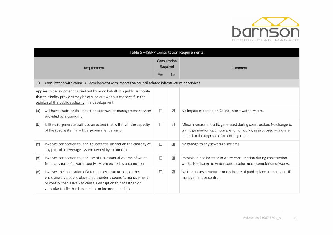
Table 5 – ISEPP Consultation Requirements
Requirement
Consultation Required Comment
Yes No
13 Consultation with councils—development with impacts on council-related infrastructure or services
Applies to development carried out by or on behalf of a public authority that this Policy provides may be carried out without consent if, in the opinion of the public authority, the development:
(a) will have a substantial impact on stormwater management services provided by a council, or
☐ ☒ No impact expected on Council stormwater system.
(b) is likely to generate traffic to an extent that will strain the capacity of the road system in a local government area, or
☐ ☒ Minor increase in traffic generated during construction. No change to traffic generation upon completion of works, as proposed works are limited to the upgrade of an existing road.
(c) involves connection to, and a substantial impact on the capacity of, any part of a sewerage system owned by a council, or
☐ ☒ No change to any sewerage systems.
(d) involves connection to, and use of a substantial volume of water from, any part of a water supply system owned by a council, or
☐ ☒ Possible minor increase in water consumption during construction works. No change to water consumption upon completion of works.
(e) involves the installation of a temporary structure on, or the enclosing of, a public place that is under a council’s management or control that is likely to cause a disruption to pedestrian or vehicular traffic that is not minor or inconsequential, or
☐ ☒ No temporary structures or enclosure of public places under council’s management or control.

20 Reference: 28067-PR01_A
Table 5 – ISEPP Consultation Requirements
Requirement
Consultation Required Comment
Yes No
(f) involves excavation that is not minor or inconsequential of the surface of, or a footpath adjacent to, a road for which a council is the roads authority under the Roads Act 1993 (if the public authority that is carrying out the development, or on whose behalf it is being carried out, is not responsible for the maintenance of the road or footpath).
☐ ☒ No excavation of a council road or footpath or land adjacent to.
14 Consultation with councils—development with impacts on local heritage
Applies to development carried out by or on behalf of a public authority that may be carried out without consent, if the development
(a) is likely to have an impact that is not minor or inconsequential on a local heritage item (other than a local heritage item that is also a State heritage item) or a heritage conservation area, and
☐ ☒ Lot 236 DP750357 forms part of the subject site and contains a Local Environmental Plan listed heritage item (I182) being ‘Charles Sturt University and Agricultural Research Station: Original Farm and Farm School Buildings’.
The works are replacing an existing road, which is well removed from the heritage listed item (refer Section 6.9). As such, the works are not expected to impact on the heritage item.
15 Consultation with councils—development with impacts on flood liable land

21 Reference: 28067-PR01_A
Table 5 – ISEPP Consultation Requirements
Requirement
Consultation Required Comment
Yes No
A public authority, or a person acting on behalf of a public authority, must not carry out, on flood liable land, development that this Policy provides may be carried out without consent and that will change flood patterns other than to a minor extent unless the authority or person has consulted with council.
☐ ☒ The land is not mapped as being flood liable under Bathurst Regional Local Environmental Plan 2014.
16 Consultation with public authorities other than councils
A public authority, or a person acting on behalf of a public authority, must not carry out specified development that this Policy provides may be carried out without consent unless the authority or person has consulted with the relevant authority, as outlined below:
(a) development adjacent to land reserved under the National Parks and Wildlife Act 1974 or to land acquired under Part 11 of that Act—the Office of Environment and Heritage,
☐ ☒ The development is not:
• adjacent to land reserved under the National Parks and Wildlife Act 1974; or
• land acquired under Part 11 of that Act.
(b) development on land in Zone E1 National Parks and Nature Reserves or in a land use zone that is equivalent to that zone—the Office of Environment and Heritage,
☐ ☒ The development is not:
• on land in Zone E1 National Parks and Nature Reserves; or • in a land use zone that is equivalent to that zone

22 Reference: 28067-PR01_A
Table 5 – ISEPP Consultation Requirements
Requirement
Consultation Required Comment
Yes No
(c) development adjacent to an aquatic reserve or a marine park declared under the Marine Estate Management Act 2014—the Department of Industry,
☐ ☒ The development is not adjacent to an aquatic reserve or a marine park declared under the Marine Estate Management Act 2014
(d) development in the foreshore area within the meaning of the Sydney Harbour Foreshore Authority Act 1998—the Sydney Harbour Foreshore Authority,
☐ ☒ the development is not in the foreshore area.
(e) development comprising a fixed or floating structure in or over navigable waters—Roads and Maritime Services,
☐ ☒ The development does not comprise a fixed or floating structure in or over navigable waters.
(f) development for the purposes of a health services facility, correctional centre or group home, or for residential purposes, in an area that is bush fire prone land (as defined by the Act)—the NSW Rural Fire Service,
☐ ☒ the development is not for the purposes of a health services facility, correctional centre or group home, or for residential purposes, in an area that is bush fire prone land.
(g) development that may increase the amount of artificial light in the night sky and that is on land within the dark sky region as identified on the dark sky region map—the Director of the Observatory,
☐ ☒ The development is not on land within the dark sky region as identified on the dark sky region map.
(h) development on defence communications facility buffer land within the meaning of clause 5.15 of the Standard Instrument—the Secretary of the Commonwealth Department of Defence,
☐ ☒ The development is not on defence communications facility buffer land.

23 Reference: 28067-PR01_A
Table 5 – ISEPP Consultation Requirements
Requirement
Consultation Required Comment
Yes No
(i) development on land in a mine subsidence district within the meaning of the Mine Subsidence Compensation Act 1961—the Mine Subsidence Board.
☐ ☒ The development is not on land in a mine subsidence district.

24 Reference: 28067-PR01_A
4.5 Bathurst Regional Local Environmental Plan 2014 The Bathurst Regional Local Environmental Plan 2014 (BRLEP) applies to the site. The site is zoned SP2 Infrastructure under the LEP and roads are permissible without consent in the SP2 Zone.
The application of the Infrastructure SEPP overrides the need to consider zoning controls, as developments covered by the Infrastructure SEPP are permissible on any land without consent.
However, the Infrastructure SEPP provides consultation and notification provisions where activities are likely to substantially impact upon council related infrastructure or items of local heritage significance.
The subject site is listed on the LEP as containing an item of heritage significance:
• Item I182 - Charles Sturt University and Agricultural Research Station (including dormitory block, administration block, Ponton Theatre, secretary’s residence, brick farm buildings, WWII building, and original farm and farm school buildings).
The impact of the activity on these items has been considered in Section 6.9 and it has been determined that it would not impact on the significance of the item.
4.6 Other Legislation
4.6.1 Environment Protection and Biodiversity Conservation Act 1999
The Commonwealth Environment Protection and Biodiversity Conservation Act 1999 (EPBC Act) requires the approval of the Commonwealth Minister for the Environment for actions that may have a significant impact on matters of national environmental significance (NES).
The EPBC Act lists seven matters of NES which must be addressed when assessing the impacts of a project. An assessment of how the project may impact on matters of NES is outlined below.
Table 6 – Impact on Matters of National Environmental Significance
Matter of NES Impact from Activity
World heritage properties There are no World Heritage Properties that would be affected by the activity.
National heritage places There are no National heritage places that would be affected by the activity.
Wetlands of international importance There are no Wetlands of international importance that would be affected by the activity.

25 Reference: 28067-PR01_A
Table 6 – Impact on Matters of National Environmental Significance
Matter of NES Impact from Activity
Commonwealth listed threatened species and ecological communities
There are no Commonwealth listed threatened species or ecological communities that are likely to be affected by the activity.
Commonwealth listed migratory species There are no Commonwealth listed migratory species that are likely to be affected by the activity.
Nuclear action The proposed activity would not involve any nuclear activities.
Commonwealth marine areas The proposed activity would not be undertaken in or affect any Commonwealth marine areas.
As the activity, would not significantly impact on any matters of NES and would not be carried out on Commonwealth land, an approval under the EPBC Act is required.
4.6.2 National Parks and Wildlife Act 1974 The National Parks and Wildlife Act 1974 (NPW Act) provides for the management of all national parks, historic sites, nature reserves, reserves, Aboriginal areas and state game reserves. It also provides for the protection and care of native flora and fauna, and Aboriginal places and objects throughout NSW. Under the Act it is an offence to:
• Knowingly destroy, deface or damage an Aboriginal object or place without consent;
• Pick or harm any plant or animal that is protected or is a threatened species, population or ecological community; or
• Damage any critical habitat, or habitat of a threatened species, an endangered population or an endangered ecological community or reserved land.
It is not expected that the activity would impact upon any Aboriginal objects or places. However, the following mitigation measures are to be included in the unlikely event that they are uncovered:
• All personnel working within the project site are to be made aware of the potential for Aboriginal items/objects within the project vicinity.
• In the event of an unexpected find of an Aboriginal heritage item (or suspected item) work will cease in the affected area and the site supervisor is to contact OEH for advice on how to proceed.

26 Reference: 28067-PR01_A
4.6.3 Biodiversity Conservation Act 2016
4.6.3.1 Is the development likely to significantly affect threatened species?
Clause 7.2 of the Biodiversity Conservation Act 2016 (BC Act) identifies the following circumstances where an activity is likely to significantly affect threatened species:
(a) it is likely to significantly affect threatened species or ecological communities, or their habitats, according to the test in section 7.3, or
(c) it is carried out in a declared area of outstanding biodiversity value.
Each of these is addressed below.
Section 7.3 Test To determine whether an activity is likely to significantly affect threatened species or ecological communities, or their habitats, the following is to be taken into account in accordance with Section 7.3 of the BC Act:
(a) in the case of a threatened species, whether the proposed development or activity is likely to have an adverse effect on the life cycle of the species such that a viable local population of the species is likely to be placed at risk of extinction,
(b) in the case of an endangered ecological community or critically endangered ecological community, whether the proposed development or activity:
(i) is likely to have an adverse effect on the extent of the ecological community such that its local occurrence is likely to be placed at risk of extinction, or
(ii) is likely to substantially and adversely modify the composition of the ecological community such that its local occurrence is likely to be placed at risk of extinction,
(c) in relation to the habitat of a threatened species or ecological community:
(i) the extent to which habitat is likely to be removed or modified as a result of the proposed development or activity, and
(ii) whether an area of habitat is likely to become fragmented or isolated from other areas of habitat as a result of the proposed development or activity, and
(iii) the importance of the habitat to be removed, modified, fragmented or isolated to the long-term survival of the species or ecological community in the locality,
(d) whether the proposed development or activity is likely to have an adverse effect on any declared area of outstanding biodiversity value (either directly or indirectly),
(e) whether the proposed development or activity is or is part of a key threatening process or is likely to increase the impact of a key threatening process.
Comment: The proposed activity involves the upgrade works to a small portion of an existing road. It will not result in the removal of any existing trees and would have a minor impact on existing manicured lawn adjacent to the road. To ensure existing trees adjacent to the works are protected, protection measures are proposed during works. Therefore,

27 Reference: 28067-PR01_A
the proposed activity is not likely to significantly affect threatened species or ecological communities, or their habitats.
Declared Area of Outstanding Biodiversity Value The site is not mapped on the Biodiversity Value Map as being land with a high biodiversity value as defined by the BC Act (refer Figure 4).
Source: (NSW Government, 2017)
Figure 4 – Biodiversity Value Map
4.6.3.2 Biodiversity Development Assessment Report / Species Impact Statement
As outlined in Section 4.6.3.1, the proposed development is not likely to significantly affect threatened species as defined by Section 7.2 of the BC Act. Therefore, a Biodiversity Development Assessment Report or a Species Impact Statement is not required to accompany the application for development consent.
4.7 Summary of Licences, Permits, Approvals and Notifications Specific approvals required for the construction, maintenance and operation of the proposed activity are outlined in the following table.
Table 7 – Approval Summary Table
Legislation Authority Requirement
EP&A Act CSU CSU approval of impact of works pursuant to section 111 of the Act.
Area of works

28 Reference: 28067-PR01_A
TBA CSU Provision of finances for works.

29 Reference: 28067-PR01_A
5 STAKEHOLDER CONSULTATION
5.1 Authority Consultation Relevant authorities were consulted about the proposed activity and asked to provide comment and advice on environmental requirements (refer Table 8).
Table 8 – Authority Consultation
Authority Comment
BRC Consultation revealed no Council assets being affected by the works.
5.2 Local Community No specific community consultation has been undertaken for this project.
5.3 Notification Requirements under the Infrastructure SEPP 2007 Under the ISEPP CSU is the determining authority for the activity under Part 5 of the EP&A Act. Whilst such activities do not require development consent from Council, the ISEPP does require consultation where works are anticipated to impact upon council infrastructure, local heritage items and specified public authorities. The following tables outline the consultation requirements for the proposed activity.
Table 9 – ISEPP Notification Requirements
Impact Authority Notification
Period
Applicability
Yes No
Will have a substantial impact on stormwater management services provided by a council
BRC 21 days ☐ ☒
Is likely to generate traffic to an extent that will strain the capacity of the road system in a local government area
BRC 21 days ☐ ☒
Involves connection to, and a substantial impact on the capacity of, any part of a sewerage system owned by a council
BRC 21 days ☐ ☒
Involves connection to, and use of a substantial volume of water from, any part of a water supply system owned by a council
BRC 21 days ☐ ☒
Involves the installation of a temporary structure on, or the enclosing of, a public place that is under a council’s management or control that is likely to cause a disruption to pedestrian or vehicular traffic that is not minor or inconsequential
BRC 21 days ☐ ☒

30 Reference: 28067-PR01_A
Table 9 – ISEPP Notification Requirements
Impact Authority Notification
Period
Applicability
Yes No
Involves excavation that is not minor or inconsequential of the surface of, or a footpath adjacent to, a road for which a council is the roads authority under the Roads Act 1993 (if the public authority that is carrying out the development, or on whose behalf it is being carried out, is not responsible for the maintenance of the road or footpath).
BRC 21 days ☐ ☒
Development that is adjacent to land reserved under the National Parks and Wildlife Act 1974
DECCW 21 days ☐ ☒
Development that is adjacent to a marine park declared under the Marine Parks Act 1997
Marine Parks
Authority
21 days ☐ ☒
Development that is adjacent to an aquatic reserve declared under the Fisheries Management Act 1994.
DECCW 21 days ☐ ☒

31 Reference: 28067-PR01_A
6 EXISTING ENVIRONMENT
6.1 Introduction This section of the report outlines the existing environment in which the activity is to be carried out.
6.2 Topography The land in the vicinity of the proposed works generally slopes from southeast to the northwest. Levels for the site are shown on the plans attached at Appendix B. The land on which the road is located and its immediate surrounds are generally flat with slightly steeper areas further out from the road.
6.3 Surrounding Land Uses The site is located within the Charles Sturt University Bathurst Campus. To the south east of Village Drive is the Chancellors Office, carparking and accommodation units. To the north west of Village Drive is the CD Blake Auditorium Gymnasium, a gravel carpark, playing fields and tennis, netball and basketball courts.
Plate 5 - CD Blake Auditorium Gymnasium

32 Reference: 28067-PR01_A
Plate 6 - Gravel carpark, playing fields and tennis, netball and basketball courts
Plate 7 - Chancellor’s Office

33 Reference: 28067-PR01_A
Plate 8 - Accommodation units
6.4 Geology & Soils The site is located within the Bathurst (ba) Soil Landscape as identified on the Soil Landscapes of the Bathurst 1:250 000 Sheet (Kovac, Murphy, & Lawrie, 1990). The Bathurst soil landscape is located on hills around Bathurst and has non-calcic brown soils with yellow solodic soils on the lower slopes and in drainage lines. Sands and mottled yellow solodic soils also occur (Kovac, Murphy, & Lawrie, 1990).
6.5 Groundwater A search of the Department of Primary Industries – Office of Water (DPI Water) All Groundwater website indicates there are no registered groundwater bores within 500m of the site. The nearest groundwater bore is on the Bathurst Ag Research Station on Research Station Drive (Lot 186 DP 750357). It is for stock purposes, has a standing water level of 12.5m and final depth of 48m.
6.6 Surface Water The site does not contain any permanent or ephemeral water courses. The nearest surface water to the site is an unnamed drainage line, which is approximately 320m north of the site.
34 Reference: 28067-PR01_A
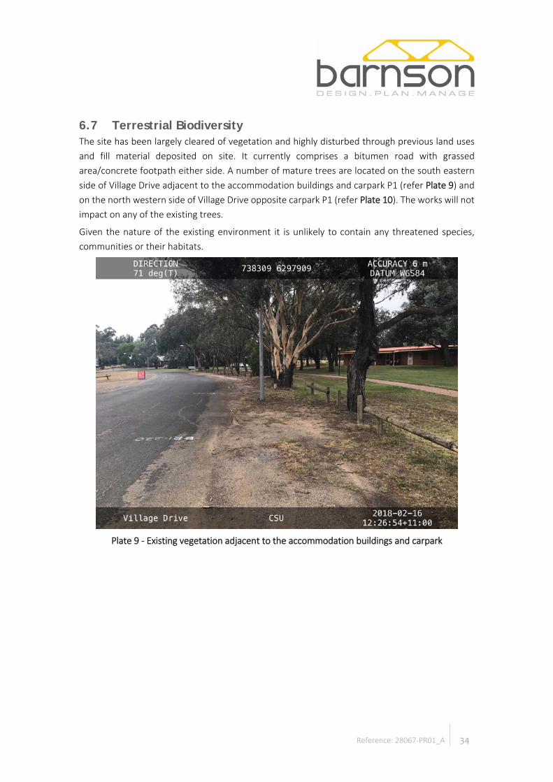
6.7 Terrestrial Biodiversity The site has been largely cleared of vegetation and highly disturbed through previous land uses and fill material deposited on site. It currently comprises a bitumen road with grassed area/concrete footpath either side. A number of mature trees are located on the south eastern side of Village Drive adjacent to the accommodation buildings and carpark P1 (refer Plate 9) and on the north western side of Village Drive opposite carpark P1 (refer Plate 10). The works will not impact on any of the existing trees.
Given the nature of the existing environment it is unlikely to contain any threatened species, communities or their habitats.
Plate 9 - Existing vegetation adjacent to the accommodation buildings and carpark

35 Reference: 28067-PR01_A
Plate 10 - Existing vegetation opposite carpark P1
6.8 Aboriginal Heritage A search of the Aboriginal Heritage Information Management System (AHIMS) was undertaken for the site and its immediate surrounds. There are no known items of Aboriginal cultural heritage on or within the vicinity of the site. A copy of the AHIMS Search is provided in Appendix D.
The site has been heavily disturbed as a result of previous activities on site. Therefore, it is unlikely that any items of Aboriginal heritage significance would be located on site.
6.9 European Heritage The subject site is affected by one local heritage listing:
• Item I182 - Charles Sturt University and Agricultural Research Station (including dormitory block, administration block, Ponton Theatre, secretary’s residence, brick farm buildings, WWII building, and original farm and farm school buildings).
Figure 5 shows the location of the heritage item’s buildings in relation to the proposed works.

36 Reference: 28067-PR01_A
Source: (NSW Planning & Environment, 2017)
Figure 5 – Heritage Item Location
6.10 Natural Hazards The subject site is not known to be affected by flooding, bushfire or land stability hazards.
Heritage Item
Extent of works

37 Reference: 28067-PR01_A
7 IMPACT ASSESSMENT
7.1 Introduction This section of the REF provides details on the potential environmental impacts associated with the proposed activity. Aspects of the environment potentially impacted upon by the proposal will be considered in the following table. Consideration of the factors specified in the guidelines ‘Is an EIS required?’ (DUAP 1999) is undertaken as required under clause 228(1)(b) of the Environmental Planning and Assessment Regulations 2000. The factors specified under this clause are also considered in Section 4.3 of this report. Mitigation measures are provided to ameliorate identified potential impacts.
The significance criteria for impacts is described below:
• Adverse Impact - Impact is a major problem. The impacts of the project are likely to be important considerations due to extensive disturbance resulting in adverse environmental impacts. These impacts are of concern to the project, as it is expected that there will be permanent changes to the local topography. Depending upon the relative importance attached to the issue during the decision- making process, mitigation measures and detailed design work will not remove the impacts upon the affected project infrastructure. Residual impacts would predominate.
• Moderately Adverse - Impact is considered to be moderate. The impacts within the project area are likely to result in significant changes to features of the local environment. These impacts represent issues where adverse outcomes would be experienced but mitigation measures and detailed design work can ameliorate some of the consequences upon affected infrastructure. Some residual impacts would still arise. The cumulative impacts of such issues may lead to an increase in the overall impacts upon a particular area or on a particular resource and hence may become key decision-making issues.
• Low Adverse - Impact recognisable but acceptable. These impacts are likely to be important only on a local scale and are unlikely to be of significant importance in the decision-making process. These impacts are generally of relevance for enhancing the subsequent design of the project and in the consideration of mitigation measures.
• Negligible - Minimal change. No impacts or those which are beneath levels of perception within normal bounds or variation or within the margin of forecasting error.

38 Reference: 28067-PR01_A
7.2 Impact Assessment & Mitigation Measures The general environment of the project has been described in Section 6 of this report. The following table provides an analysis of all possible environmental impacts associated with the activity.
Table 10 – Environmental Assessment of Impacts
Environmental Considerations Ap
plic
able
Impact Level Construction
Phase
Impact Level Operational
Phase Safeguards/ Mitigation Measures
Geology & Soils
Will the proposal impact soils and or land stability?
☒ Low Negligible • The appointed contractor prepares a Soil and Water Management Plan, in accordance with Managing Urban Stormwater: Soils and Construction prepared by Landcom, prior to the commencement of works to ensure sediment does not migrate off site during construction.
• Install silt fences, sandbags and/or hay bales where required down gradient of disturbed areas, base of embankments, existing drainage lines, earthworks and stockpiles as required.
• Erosion and sedimentation control measures to be inspected daily and after rainfall. Inspections to be recorded in job diary.
• Divert clean runoff around disturbed areas, where practicable. • Any material brought to site shall be certified as being clean fill.
Is it possible the proposal will require the transportation of soils, fill or gravel material to site?
☒ Moderate Negligible
Groundwater
Is the proposal likely to impact groundwater within the local area?
☒ Low Negligible • Should groundwater be encountered during excavation, works are to cease and direction sought from the CSU Works Manager.
• No vehicles to be refuelled in table drains.

39 Reference: 28067-PR01_A
Table 10 – Environmental Assessment of Impacts
Environmental Considerations
Appl
icab
le
Impact Level Construction
Phase
Impact Level Operational
Phase Safeguards/ Mitigation Measures
• Vehicles (plant and machinery) to be refuelled in bunded areas only. • A petrochemical spill kit is to be maintained on site.
Surface Water
Is there potential for the proposal to impact a waterbody, wetland, water course or natural waterway?
☒ Low Negligible • Ensure no works are undertaken near drainage lines. • Ensure all chemicals are removed from areas where spillages could result in
pollution of the surrounding water courses. • Ensure implementation of suitable erosion and sediment control measures as
outlined by the approved ESCP developed in accordance with the 'Blue Book'. • Adherence to the approved CEMP for the project. • Stop work and stabilise if flooding is predicted. • Ensure all plant is in good working order and regularly maintained. • No refuelling or maintenance of plant to be undertaken near watercourses. • Works to be undertaken in a systematic way to ensure that scheduled activities
are completed promptly and are therefore protected from any predicted high rainfall and/or flooding.
• Move potentially contaminating substances to higher ground or implement flood proofing around the items.
• In the event of rainfall during the construction period, the road surface is to be inspected and traffic speed limits reduced to reflect the state of the road.
• Disturbed areas adjacent to the road will be remediated in accordance with the CEMP developed for the project, using appropriate species asap after shaping is
Is the proposal likely to change the flow regime or flood levels in the area?
☐ n/a n/a
Will the proposal require a Part-7 permit from NSW DPI-Fisheries?
☐ n/a n/a

40 Reference: 28067-PR01_A
Table 10 – Environmental Assessment of Impacts
Environmental Considerations
Appl
icab
le
Impact Level Construction
Phase
Impact Level Operational
Phase Safeguards/ Mitigation Measures
complete, to improve soil stability and reduce erosion and sedimentation of local drainage lines and watercourses.
Biodiversity
Will the proposal result in vegetation clearance or modification?
☒ Low Negligible • No trees are to be removed. • All trees within the vicinity of the works are to be protected in accordance with
AS 4970-2009 Protection of trees on development sites.
Will the proposal have a significant effect on threatened or endangered flora species, populations, or their habitats, or critical habitat?
☐ n/a n/a
Will the proposal endanger, displace or disturb fauna (including fauna of conservation significance) or create a new barrier to fauna movement?
☐ n/a n/a
Will the proposal have a significant effect on threatened or endangered fauna species,
☐ n/a n/a

41 Reference: 28067-PR01_A
Table 10 – Environmental Assessment of Impacts
Environmental Considerations
Appl
icab
le
Impact Level Construction
Phase
Impact Level Operational
Phase Safeguards/ Mitigation Measures
populations, or their habitats, or critical habitat?
Is the proposal likely to impact on an ecological community of conservation significance?
☐ n/a n/a
Is the proposal likely to cause a threat to the biological diversity or ecological integrity of an ecological community?
☐ n/a n/a
Is there potential for the proposal to introduce noxious weeds, vermin, feral species or genetically modified organisms into an area?
☒ Low Negligible
European Heritage
Will the proposal impact known buildings, bridges or other known built heritage items in the area
☐ n/a n/a • N/A.
42 Reference: 28067-PR01_A
Table 10 – Environmental Assessment of Impacts
Environmental Considerations
Appl
icab
le
Impact Level Construction
Phase
Impact Level Operational
Phase Safeguards/ Mitigation Measures
Aboriginal Heritage
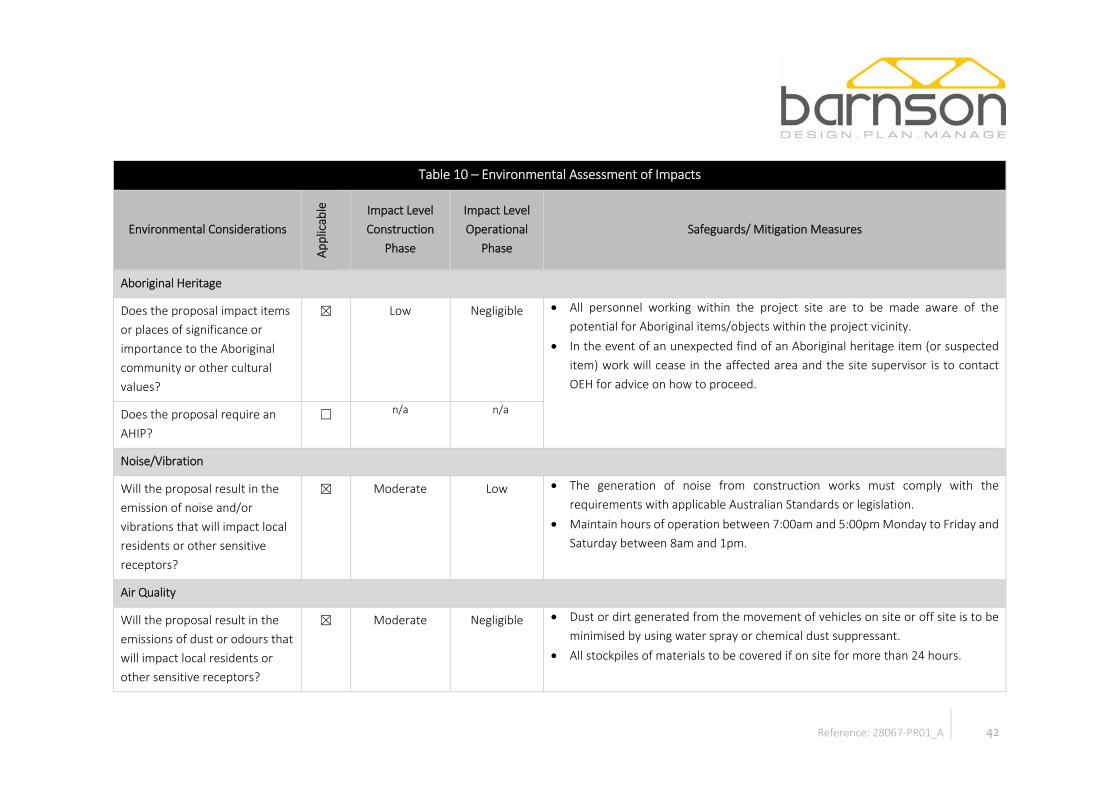
Does the proposal impact items or places of significance or importance to the Aboriginal community or other cultural values?
☒ Low Negligible • All personnel working within the project site are to be made aware of the potential for Aboriginal items/objects within the project vicinity.
• In the event of an unexpected find of an Aboriginal heritage item (or suspected item) work will cease in the affected area and the site supervisor is to contact OEH for advice on how to proceed.
Does the proposal require an AHIP?
☐ n/a n/a
Noise/Vibration
Will the proposal result in the emission of noise and/or vibrations that will impact local residents or other sensitive receptors?
☒ Moderate Low • The generation of noise from construction works must comply with the requirements with applicable Australian Standards or legislation.
• Maintain hours of operation between 7:00am and 5:00pm Monday to Friday and Saturday between 8am and 1pm.
Air Quality
Will the proposal result in the emissions of dust or odours that will impact local residents or other sensitive receptors?
☒ Moderate Negligible • Dust or dirt generated from the movement of vehicles on site or off site is to be minimised by using water spray or chemical dust suppressant.
• All stockpiles of materials to be covered if on site for more than 24 hours.

43 Reference: 28067-PR01_A
Table 10 – Environmental Assessment of Impacts
Environmental Considerations
Appl
icab
le
Impact Level Construction
Phase
Impact Level Operational
Phase Safeguards/ Mitigation Measures
• During remediation/excavation or windy conditions, water dampening is to be used to minimise dust.
• Program construction activities to avoid periods of strong winds if dust is a problem. If not possible to re-schedule, use water to dampen exposed stockpiles and exposed areas.
• Supervisors and contractors to undertake and record maintenance checks of plant/equipment brought to site to ensure they are in suitable mechanical condition.
• Ensure machinery or plant is not left running idle when not in use for extended periods of time.
Natural Resources
Is the proposal likely to affect the use of, or the community’s ability to use natural resources in the locality?
☒ Low Negligible • If water is to be obtained from local creeks, it will be subject to a works approval in accordance with the Water Management Act 2000.
Is the proposal likely to result in the depletion of natural resources, including water, timber or other fuels?
☐ n/a n/a
44 Reference: 28067-PR01_A
Table 10 – Environmental Assessment of Impacts
Environmental Considerations
Appl
icab
le
Impact Level Construction
Phase
Impact Level Operational
Phase Safeguards/ Mitigation Measures
Community / Social / Visual Amenity
Will the proposal impact traffic access and movement in the area?
☒ Low Negligible • Appointed contractor to define control measures in a Construction Traffic Management Plan, prepared in accordance with Council’s and any other relevant requirements.
Is the proposal likely to affect community services or infrastructure?
☒ Negligible Negligible
Is the proposal likely to impact community safety?
☒ Low Negligible
Will the proposal impact sites considered recreationally important to the local community?
☒ Low Negligible
Is the proposal likely to affect economic factors, including employment, industry and property value?
☒ Low Negligible
Will the proposal affect the visual or scenic landscape?
☒ Low Negligible

45 Reference: 28067-PR01_A
Table 10 – Environmental Assessment of Impacts
Environmental Considerations
Appl
icab
le
Impact Level Construction
Phase
Impact Level Operational
Phase Safeguards/ Mitigation Measures
Waste
Does the proposal involve the generation or disposal of gaseous, liquid or solid wastes?
☒ Low Negligible • Excavated materials will be transported to and disposed of at an appropriate waste facility.
Hazardous Materials
Does the proposal involve the use, storage, or transport of chemical or hazardous substances?
☒ Low Negligible • No bulk storage of hazardous substances or dangerous goods on the site. • Minimise fuel volumes stored on site. • Provide bunding and impervious storage areas for necessary fuels and chemicals.
Bunded areas shall have a storage capacity of 110% of the volume stored and be designed and installed with any relevant requirements of Australian Standards or applicable legislation.
• Ensure refuelling and servicing, or any other activity that may result in the spillage of a chemical, fuel or lubricant where contamination of a waterway could occur is undertake in a manner that minimises risk to the environment.
• Emergency procedures shall be displayed in a prominent position within the site working area. All staff to be familiar with the location and contents of the emergency procedures.
• Spill kit will be maintained on the site when chemicals or fuel are being stored on site.
• Spillages of chemicals will be cleaned up immediately.
Will the proposal result in the generation of chemicals, which may build up residues in the environment?
☐ n/a n/a

46 Reference: 28067-PR01_A
Table 10 – Environmental Assessment of Impacts
Environmental Considerations
Appl
icab
le
Impact Level Construction
Phase
Impact Level Operational
Phase Safeguards/ Mitigation Measures
• Disposal of all wastes by licensed waste contractors to licensed waste receiving facility.
• A waste and materials tracking log will be maintained and will include information on disposal of excavated soil to appropriate landfill facilities.
• All disposal/transport dockets to be provided to CSU. • Any potentially contaminated materials will be assessed and classified prior to
off-site disposal. No off-site disposal to be undertaken without the CSU’s prior approval.
• If wastewater is to be removed from site (toilets or other tinkered waste water), it is to be removed by a licensed contractor and recorded on the waste log.
• Any soils or other materials suspected of being contaminated or otherwise containing hazardous materials shall be isolated and stockpiled/stored separately with appropriate containment if necessary to minimise the potential for cross contamination.
Bushfire
Is the proposal likely to increase bushfire risk
☐ Negligible Negligible • n/a
Climate Change
Is the proposal likely to impact the long term climatic
☒ Low Low • n/a

47 Reference: 28067-PR01_A
Table 10 – Environmental Assessment of Impacts
Environmental Considerations
Appl
icab
le
Impact Level Construction
Phase
Impact Level Operational
Phase Safeguards/ Mitigation Measures
conditions of the area, or influence climate change?

48 Reference: 28067-PR01_A
7.3 Future Implications & Cumulative Impacts Clause 228(2) of the EP&A Regulation requires that assessment of any cumulative environmental impacts with other existing or likely future activities be undertaken during the assessment process. Cumulative impacts arise from activities which may not be significant in their own right, yet when combined with similar activities over a broader scale, create a significant impact upon any factor of the environment.
Impacts arising from vegetation clearing, soil disturbance, erosion and sedimentation and noise and dust will be minimised through comprehensive site management as outlined in previous sections of this report. The cumulative impacts from vegetation removal has been considered as low to negligible and is deemed to be within acceptable limits given the nature of the project and available vegetation on surrounding lands and replacement planting.
The cumulative impact of ensuring the works are undertaken is beneficial to the local wider community through provision of public facilities. The proposal will also ensure access is maintained and improved for all users.
Preservable environmental impacts are assessed as being minor due to the nature of the works.

49 Reference: 28067-PR01_A
8 CONCLUSION
This REF has been prepared to assess the environmental impacts associated with the construction, operation and maintenance of the proposed road upgrade. CSU is a public authority for the purpose of being a determining authority as defined in the EP&A Act. As such, the activity does not require council consent under Part 4 of the EP&A Act. The activity is being assessed and approved under Part 5 of the EP&A Act.
The proposed activity will provide the upgrading of an existing private road within the Bathurst campus of CSU.
The proposal complies with the provisions of s.111 of the EP&A Act, cl.228 of the EP&A Regulation as shown in Section 4.
The proposal and its associated environmental impacts are unlikely to have a significant impact on the environment providing the recommended mitigation measures are employed. The road will provide for improved access for road users and improved management of stormwater on site. It would maximise social and economic benefits, whilst minimising any adverse environmental impacts. It is therefore considered suitable for approval.

50 Reference: 28067-PR01_A
9 REFERENCES
Google Earth. (2017). Google Earth.
Kovac, M., Murphy, B. W., & Lawrie, J. W. (1990). Soil Landscapes of the Bathurst 1:250 000 Sheet. Sydney: Soil Conservation Service of NSW.
NSW Government. (2017, September 1). Biodiversity Value Map. Retrieved from https://www.lmbc.nsw.gov.au/Maps/index.html?viewer=BVMap
NSW Government Spatial Services. (2017, January 18). Six Maps. Retrieved from http://maps.six.nsw.gov.au/
NSW Planning & Environment. (2017). Find a Property. Retrieved from https://www.planningportal.nsw.gov.au/find-a-property

51 Reference: 28067-PR01_A
Appendix A – Title & DP

NEW SOUTH WALES LAND REGISTRY SERVICES - TITLE SEARCH -----------------------------------------------------
FOLIO: 1/823451 ------
SEARCH DATE TIME EDITION NO DATE ----------- ---- ---------- ---- 12/2/2018 3:45 PM - -
CERTIFICATE OF TITLE HAS NOT ISSUED
LAND ---- LOT 1 IN DEPOSITED PLAN 823451 LOCAL GOVERNMENT AREA BATHURST REGIONAL PARISH OF BATHURST COUNTY OF BATHURST TITLE DIAGRAM DP823451
FIRST SCHEDULE -------------- THE STATE OF NEW SOUTH WALES
SECOND SCHEDULE (2 NOTIFICATIONS) --------------- * 1 LAND EXCLUDES MINERALS * 2 THE LAND IS A RESERVE WITHIN THE MEANING OF PART 5 OF THE CROWN LANDS ACT 1989 AND THERE ARE RESTRICTIONS ON TRANSFER AND OTHER DEALINGS IN THE LAND UNDER THAT ACT, WHICH MAY REQUIRE CONSENT OF THE MINISTER.
NOTATIONS --------- 2228252 NOTE: ADDITION TO RESERVED CROWN LAND SEE GAZ. 10.5.1996 FOL 2158
UNREGISTERED DEALINGS: NIL
*** END OF SEARCH ***
Barnson Pty Ltd (Mudgee) PRINTED ON 12/2/2018
* Any entries preceded by an asterisk do not appear on the current edition of the Certificate of Title.Warning: the information appearing under notations has not been formally recorded in the Register.
URBISPRO PTY LTD - hereby certifies that the information contained in this document has been providedelectronically by the Registrar General in accordance with section 96B(2) of the Real Property Act 1900.
Note: Information contained in this document is provided by URBISPRO PTY LTD (ABN 35 164 894 517),http://www.urbispro.com.au/ an approved NSW Information Broker
© Office of the Registrar-General 2018

NEW SOUTH WALES LAND REGISTRY SERVICES - TITLE SEARCH -----------------------------------------------------
FOLIO: 236/750357 ------
SEARCH DATE TIME EDITION NO DATE ----------- ---- ---------- ---- 12/2/2018 3:45 PM - -
CERTIFICATE OF TITLE HAS NOT ISSUED
LAND ---- LOT 236 IN DEPOSITED PLAN 750357 AT CITY OF BATHURST LOCAL GOVERNMENT AREA BATHURST REGIONAL PARISH OF BATHURST COUNTY OF BATHURST (FORMERLY KNOWN AS PORTION 236) TITLE DIAGRAM CROWN PLAN 5573.2009
FIRST SCHEDULE -------------- THE STATE OF NEW SOUTH WALES
SECOND SCHEDULE (5 NOTIFICATIONS) --------------- 1 LAND EXCLUDES MINERALS AND IS SUBJECT TO RESERVATIONS AND CONDITIONS IN FAVOUR OF THE CROWN - SEE MEMORANDUM S700000A * 2 DEDICATED AS : FOR PUBLIC SCHOOL PURPOSES GAZ 3.10.1958 FOL 3065 * 3 AF901301 RESERVE TRUST: CHARLES STURT UNIVERSITY RESERVE TRUST SEE GOVERNMENT GAZETTE 29/11/1996 FOLIO 7767 * 4 THE LAND IS A RESERVE WITHIN THE MEANING OF PART 5 OF THE CROWN LANDS ACT 1989, AND THE CONSENT OF THE MINISTER IS REQUIRED TO SALE, LEASE, EASEMENT, MORTGAGE OR LICENCE - SEE SECTION 102. * 5 THE LAND IS DEDICATED FOR A PUBLIC PURPOSE
NOTATIONS ---------
UNREGISTERED DEALINGS: NIL
*** END OF SEARCH ***
Barnson Pty Ltd (Mudgee) PRINTED ON 12/2/2018
* Any entries preceded by an asterisk do not appear on the current edition of the Certificate of Title.Warning: the information appearing under notations has not been formally recorded in the Register.
URBISPRO PTY LTD - hereby certifies that the information contained in this document has been providedelectronically by the Registrar General in accordance with section 96B(2) of the Real Property Act 1900.
Note: Information contained in this document is provided by URBISPRO PTY LTD (ABN 35 164 894 517),http://www.urbispro.com.au/ an approved NSW Information Broker
© Office of the Registrar-General 2018
Req:R101127 /Doc:CP 05573-2009 P /Rev:18-Oct-2013 /Sts:OK.OK /Prt:12-Feb-2018 15:46 /Seq:1 of 1Ref:Barnson Pty Ltd (Mudgee) /Src:I


52 Reference: 28067-PR01_A
Appendix B – Detail Survey

VILLAGE
DRIVE
WIR
RI
PLAC
E
7
0
4
.
0
0
7
0
4
.
0
0
7
0
4
.0
0
7
0
3
.
0
0
7
0
3
.0
0
7
0
3
.
0
0
703.00
7
0
3
.
0
0
7
0
2
.0
0
702.00
7
0
2
.0
0
701.0
0
701.0
0
7
0
1
.0
0
WIR
AD
JURI
RO
AD
1
Dubbo - Head Office
NATAA
Dubbo & Bathurst This drawing is to be read in conjunction with general building drawings, specifications and other consultant's drawings applicable to this project.All figured dimensions are to be checked prior to the commencement of work. Immediately notify Barnson Pty Ltd of any discrepancies.
Barnson Pty Ltd . Confidential. Subject to the Barnson terms of engagement.
A1 - Original size - Scales as notedA3 - Minimisation - Not to scale
Accredited Laboratories
q
u
a
l
i
t
y
m
a
n
a
g
em
e
n
t
I
S
O
9
0
0
1
trust-mark.com
R
ADDITIONAL SERVICES13/12/2017BISSUED FOR INTERNAL REVIEW13/11/2017A
CHARLES STURT UNIVERSITY 7th NOVEMBER 2017S.R.D. J.R.C.
S.R.D. S.R.D.
2017
FOR INTERNAL REVIEW
DETAIL SURVEY OVER PART OFVILLAGE DRIVE, CSU BATHURST CAMPUSPANORAMA AVENUE, MITCHELL, N.S.W. 2795
PLAN OF DETAIL SURVEY2
N
SHEE
T
T
WO
AD
JOIN
S
·
·
·
·
DIAL BEFOREYOU DIGwww.1100.com.au
LEGEND

7
0
4
.
0
0
7
0
4
.
0
0
7
0
4
.
0
0
7
0
4
.
0
0
7
0
3
.
0
0
7
0
3
.
0
0
7
0
3
.
0
0
7
0
2
.0
0
7
0
2
.0
0
702.00
701.00
701.0
0
70
1.0
0
700.00
7
0
0
.0
0
2
Dubbo - Head Office
NATAA
Dubbo & Bathurst This drawing is to be read in conjunction with general building drawings, specifications and other consultant's drawings applicable to this project.All figured dimensions are to be checked prior to the commencement of work. Immediately notify Barnson Pty Ltd of any discrepancies.
Barnson Pty Ltd . Confidential. Subject to the Barnson terms of engagement.
A1 - Original size - Scales as notedA3 - Minimisation - Not to scale
Accredited Laboratories
q
u
a
l
i
t
y
m
a
n
a
g
em
e
n
t
I
S
O
9
0
0
1
trust-mark.com
R
ADDITIONAL SERVICES13/12/2017BISSUED FOR INTERNAL REVIEW13/11/2017A
CHARLES STURT UNIVERSITY 7th NOVEMBER 2017S.R.D. J.R.C.
S.R.D. S.R.D.
2017
FOR INTERNAL REVIEW
DETAIL SURVEY OVER PART OFVILLAGE DRIVE, CSU BATHURST CAMPUSPANORAMA AVENUE, MITCHELL, N.S.W. 2795
PLAN OF DETAIL SURVEY2
N
SHEE
T
O
NE
AD
JOIN
S
VILLAGE
DRIV
E
··
·
·
DIAL BEFOREYOU DIGwww.1100.com.au
LEGEND

53 Reference: 28067-PR01_A
Appendix C – Development Plans


54 Reference: 28067-PR01_A
Appendix D – AHIMS Search

AHIMS Web Services (AWS)Search Result Purchase Order/Reference : 28067
Client Service ID : 328749
Date: 19 February 2018Erika Dawson
2 littlebourne Street
Bathurst New South Wales 2795
Dear Sir or Madam:
AHIMS Web Service search for the following area at Datum :GDA, Zone : 55, Eastings : 738225 - 738411,
Northings : 6297878 - 6298029 with a Buffer of 50 meters, conducted by Erika Dawson on 19 February
2018.
Email: [email protected]
Attention: Erika Dawson
The context area of your search is shown in the map below. Please note that the map does not accurately
display the exact boundaries of the search as defined in the paragraph above. The map is to be used for
general reference purposes only.
A search of the Office of the Environment and Heritage AHIMS Web Services (Aboriginal Heritage Information
Management System) has shown that:
0
0
Aboriginal sites are recorded in or near the above location.
Aboriginal places have been declared in or near the above location. *

If your search shows Aboriginal sites or places what should you do?
Important information about your AHIMS search
You can get further information about Aboriginal places by looking at the gazettal notice that declared it.
Aboriginal places gazetted after 2001 are available on the NSW Government Gazette
(http://www.nsw.gov.au/gazette) website. Gazettal notices published prior to 2001 can be obtained from
Office of Environment and Heritage's Aboriginal Heritage Information Unit upon request
Aboriginal objects are protected under the National Parks and Wildlife Act 1974 even if they are not recorded
as a site on AHIMS.
You must do an extensive search if AHIMS has shown that there are Aboriginal sites or places recorded in the
search area.
If you are checking AHIMS as a part of your due diligence, refer to the next steps of the Due Diligence Code of
practice.
AHIMS records information about Aboriginal sites that have been provided to Office of Environment and
Heritage and Aboriginal places that have been declared by the Minister;
Information recorded on AHIMS may vary in its accuracy and may not be up to date .Location details are
recorded as grid references and it is important to note that there may be errors or omissions in these
recordings,
Some parts of New South Wales have not been investigated in detail and there may be fewer records of
Aboriginal sites in those areas. These areas may contain Aboriginal sites which are not recorded on AHIMS.
This search can form part of your due diligence and remains valid for 12 months.
The information derived from the AHIMS search is only to be used for the purpose for which it was requested.
It is not be made available to the public.
3 Marist Place, Parramatta NSW 2150
Locked Bag 5020 Parramatta NSW 2220
Tel: (02) 9585 6380 Fax: (02) 9873 8599
ABN 30 841 387 271
Email: [email protected]
Web: www.environment.nsw.gov.au