review of land use planning documents for...
TRANSCRIPT
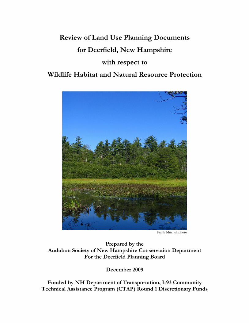
Review of Land Use Planning Documents
for Deerfield, New Hampshire
with respect to
Wildlife Habitat and Natural Resource Protection
Frank Mitchell photo
Prepared by the
Audubon Society of New Hampshire Conservation Department For the Deerfield Planning Board
December 2009
Funded by NH Department of Transportation, I-93 Community
Technical Assistance Program (CTAP) Round 1 Discretionary Funds

Review of Land Use Planning Documents for Deerfield, NH with respect to Wildlife Habitat and Natural Resource Protection, Audubon Society of NH, for Deerfield NH Planning Board, funded by NHDOT Community Technical Assistance Program (CTAP) Round 1 Discretionary Funds, Dec 2009
Deerfield Wildlife Habitat and Natural Resource Protection Assessment
Table of Contents
(1) Introduction 1-1
(2) Habitat and Natural Resource Review: Analysis by Land Use and Planning Topic 2-1
(3) Habitat and Natural Resource Review: Recommendations by Planning Document 3-1
(4) Spatial Analysis of Important Habitat and Natural Resources with respect to Current 4-1
Zoning Fire Hazard Zone
(5) Voluntary Practices to Protect Habitat 5-1
(6) Addressing Wildlife Habitat and Natural Resource Protection In Municipal Land Use
Documents: Ideas for New Hampshire Municipalities 6-1
(7) List of Useful Resources 7-1
(8) Background Information for Analysis 8-1

Section 1: Introduction to the Review of Land Use Planning Documents with respect to Wildlife Habitat and Natural Resources for Deerfield, NH
Introduction 1-1
Review of Land Use Planning Documents for Deerfield, NH with respect to Wildlife Habitat and Natural Resource Protection, Audubon Society of NH, for Deerfield NH Planning Board, funded by NHDOT Community Technical Assistance Program (CTAP) Round 1 Discretionary Funds, Dec 2009
I. Introduction
Background Historically, New Hampshire has depended on natural resources to support its economy – from agriculture to forest products to tourism. The State’s natural resources - aquifers, productive soils, flood storage areas, productive forest lands, and high quality wildlife habitat –are not distributed evenly across the landscape. As development affects increasing proportions of New Hampshire’s land, towns have a critical opportunity to identify and protect the natural resource values on which our economy and quality of life depend. The N.H. Fish & Game Department completed the State’s first Wildlife Action Plan in 2005, with goals of restoring declining species and keeping common species common. Engaging municipalities in this effort is a critical component of the plan, since the vast majority of land use decisions are made at the local level. To that end, the Department contracted with the Audubon Society of New Hampshire (ASNH) and The Jordan Institute in 2007 to develop tools that would aid municipalities in efforts to protect important wildlife habitat and other natural resources. The process for reviewing land use planning documents with respect to wildlife habitat and natural resources is one product of that contract. The Jordan Institute has since focused their work on energy-efficient buildings, and ASNH has continued to adapt and apply the review process for communities across the State. Review Process The review process utilizes a template document to guide review of municipal land use planning documents with respect to protection for wildlife habitat and other natural resources. The template addresses 20 land use and planning topics that New Hampshire municipalities might consider addressing in their Master Plan and land use regulations in order to protect their community’s natural resources and rural character. (One topic, Urban Growth Boundaries, is not pertinent to Deerfield, and was not included in this analysis.) Some topics are interrelated and provide alternate strategies for protecting a given resource or addressing a particular problem, such as sprawl. This review evaluated the current level of protection for wildlife habitat and natural resources provided by the Town of Deerfield’s land use regulations, and identified additional opportunities for regulatory protection. The review included the following:
• Master Plan adopted in 2009;
• Zoning Ordinance adopted in 2008;
• Site Plan Review Regulations adopted in 1990;
• Subdivision Regulations adopted in 1990;
• Hazard Mitigation Plan adopted in 2007;
• Open Space Plan 2007 draft;
• Source Water Protection Plan prepared in 2008; and
• CTAP Community Planning Road Map prepared/adopted in 2009.
Section 1: Introduction to the Review of Land Use Planning Documents with respect to Wildlife Habitat and Natural Resources for Deerfield, NH
Introduction 1-2
Review of Land Use Planning Documents for Deerfield, NH with respect to Wildlife Habitat and Natural Resource Protection, Audubon Society of NH, for Deerfield NH Planning Board, funded by NHDOT Community Technical Assistance Program (CTAP) Round 1 Discretionary Funds, Dec 2009
How to use this document This report is organized into sections to facilitate its use for multiple purposes. Section Content Page
Analysis by Topic Ideas on how to address a particular natural resources issue in Deerfield’s land-use planning regulations
2-1
Recommendations by Document Ideas for additions and revisions to master plan, zoning ordinance, subdivision and site plan review regulations
3-1
Spatial Analysis of Natural Resources Discussion of how natural resources are distributed across Deerfield’s landscape and their relationship with hazard zones.
4-1
Voluntary Practices to Protect Habitat Ideas to discuss in pre-application conferences with developers
5-1
Addressing Wildlife Habitat and Natural Resource Protection In Municipal Land Use Documents: Ideas for New Hampshire Municipalities
Generic ideas and sample language for addressing wildlife habitat and other natural resources in municipal land-use planning documents
6-1
Useful Resources Sources of information to facilitate natural resources planning
7-1
Summary of Findings Topics with recommendations for considering Master Plan revisions include forests and forestry, impervious surfaces, light pollution, landscaping and natural vegetation, ridgeline protection, watersheds, and wildlife habitat. Zoning Ordinance recommendations include considering adoption of a Forest Management zone or overlay district; a Village District; outdoor lighting ordinance, steep slope, ridgeline protection, and stormwater ordinances. We include recommendations for revising Subdivision and Site Plan Review regulations with respect to most topics. Deerfield is entirely zoned as Agricultural-Residential, with overlay districts identifying specific areas for wetlands conservation, floodplain development regulation, commercial/industrial development, and senior housing. In the absence of zoning districts, fire hazard zones provide a useful framework for applying regulations designed to protect both natural resources and public safety. Next steps This report provides a starting place for efforts to improve local protection of wildlife habitat and natural resources. Potential next steps, which may be undertaken by the Planning

Section 1: Introduction to the Review of Land Use Planning Documents with respect to Wildlife Habitat and Natural Resources for Deerfield, NH
Introduction 1-3
Review of Land Use Planning Documents for Deerfield, NH with respect to Wildlife Habitat and Natural Resource Protection, Audubon Society of NH, for Deerfield NH Planning Board, funded by NHDOT Community Technical Assistance Program (CTAP) Round 1 Discretionary Funds, Dec 2009
Board, an appointed working group, or a planning consultant, include identifying and prioritizing action items from the various recommendations, developing a time table for action, and implementing document revisions and policy changes. Key resources This document is meant to be a resource and contains references to additional resources and model ordinances. In particular, we refer frequently to Innovative Land Use Planning Techniques: A Handbook for Sustainable Development. This document, compiled by the NH Department of Environmental Services, NH Association of Regional Planning Commissions, NH Office of Energy and Planning, and NH Municipal Association in 2008, is a critical reference for New Hampshire planning boards. It is available for download in three versions at http://des.nh.gov/organization/divisions/water/wmb/repp/innovative_land_use.htm. Available versions include the complete document (pdf), individual complete chapters (pdf), and model ordinances (Word). We also strongly recommend use of Integrated Landscaping: Following Nature’s Lead to advise developers on landscaping strategies. This document is available in hard copy for $20 plus $4 shipping and handling through the University of New Hampshire Cooperative Extension web site.

Section 2: Analysis by Land Use and Planning Topic
2-1
Review of Land Use Planning Documents for Deerfield, NH with respect to Wildlife Habitat and Natural Resource Protection, Audubon Society of NH, for Deerfield NH Planning Board, funded by NHDOT Community Technical Assistance Program (CTAP) Round 1 Discretionary Funds, Dec 2009
Analysis by Land Use and Planning Topic
This chapter provides a comprehensive analysis of current provisions for protecting important
natural resources and wildlife habitat in Deerfield’s land use planning documents. Some topics are
interrelated and provide alternate strategies for protecting a given resource or addressing a particular
problem, such as sprawl. Each section includes a brief description of the topic and how it affects
human quality of life and wildlife survival, a brief summary of pertinent provisions in current
documents and recommendations for revisions if stronger protections are desired by the Town.
Legal review of proposed revisions is always advisable.
Land Use and Planning Topic Page
Agriculture and Productive Soils 2
Energy Efficiency 4
Floodplains 6
Forests and Forestry 8
Green Infrastructure 10
Groundwater 11
Growth Management and Sprawl 13
Impervious Surfaces 14
Landscaping and Natural Vegetation 15
Light Pollution 16
Natural Hazards 17
Natural Services Network 18
Shorelands, Surface Waters, and Wetlands 19
Steep Slopes and Ridgelines 20
Stormwater Management and Erosion Control 22
Terrain Alteration 24
Village District 25
Watersheds 26
Wildlife Habitat 27
Section 2: Analysis by Land Use and Planning Topic
2-2
Review of Land Use Planning Documents for Deerfield, NH with respect to Wildlife Habitat and Natural Resource Protection, Audubon Society of NH, for Deerfield NH Planning Board, funded by NHDOT Community Technical Assistance Program (CTAP) Round 1 Discretionary Funds, Dec 2009
Agriculture and Productive Soils
Agriculture is an important component of New Hampshire’s economy and environment, and makes
vital contributions to the State’s food supply. New Hampshire’s glacial history has left the state with
limited areas of productive soils suitable for agriculture. These soils are critical to the future of food
production in New Hampshire. Prime agricultural soils and soils of statewide importance are
included in the NH Natural Services Network. Agricultural lands are important to native wildlife by
providing breeding habitat for grassland birds, migration stopover habitat for waterfowl, and
wintering habitat for wild turkeys. (See Section IV for Deerfield-specific information.)
Current Provisions Master Plan includes farming in vision statement; includes objectives of protecting existing farmlands and prime agricultural soils and promoting agriculture. Zoning Ordinance addresses agricultural soils in Absolute Criteria for All Proposals. Open Space Plan discusses prime includes agricultural soils as priority in criteria for acquisition and protection; Appendix B discusses prime and unique farmland and farmland of statewide importance. CTAP Road Map includes goal of protecting agricultural lands and strengthening local agriculture. Recommendations Master Plan
• None. Zoning Ordinance
• Consider adopting Agricultural Incentive Zoning (See Chapter 1.7, “Agricultural Incentive Zoning,” in Innovative Land Use Planning Techniques).
Subdivision Regulations
• Consider specifying inclusion of existing agricultural lands and economically important soils (identified in Natural Resources Network) to Item 8 of Design Review Plat Layout and Submission Details.
• Consider adding additional item to Section 37. Parks, Open Space and Natural Features to address agricultural lands, e.g., “Protection of agricultural lands: The Planning Board shall, wherever possible, protect economically important soils and agricultural lands.”
• Consider including agriculture as an appropriate use of open space (VI.37).
• Consider revising Special Studies provision of Formal Plat Layout and Submission Details to address contaminants in general, rather than pesticides specifically (VI.30).
Agricultural Incentive Zoning includes ordinances and regulations
to protect and sustain agricultural lands and uses. An agricultural overlay district makes sense for Deerfield because the Town’s agricultural lands are widely scattered.

Section 2: Analysis by Land Use and Planning Topic
2-3
Review of Land Use Planning Documents for Deerfield, NH with respect to Wildlife Habitat and Natural Resource Protection, Audubon Society of NH, for Deerfield NH Planning Board, funded by NHDOT Community Technical Assistance Program (CTAP) Round 1 Discretionary Funds, Dec 2009
Site Plan Review Regulations
• Consider adding agricultural lands and economically important soils to (D) in Existing Data, Data Required for Formal Application Submittal and Review for Site Plan Review.
• Consider adding agricultural lands and economically important soils to (G) in Proposed Data, Data Required for Formal Application Submittal and Review for Site Plan Review.
• Consider adding provision to Section V, Design and Construction Requirements, to address protection of agricultural lands.

Section 2: Analysis by Land Use and Planning Topic
2-4
Review of Land Use Planning Documents for Deerfield, NH with respect to Wildlife Habitat and Natural Resource Protection, Audubon Society of NH, for Deerfield NH Planning Board, funded by NHDOT Community Technical Assistance Program (CTAP) Round 1 Discretionary Funds, Dec 2009
Energy Efficiency
Energy efficient design of neighborhoods and buildings has long-term economic benefits for
residents and taxpayers as well as environmental benefits of resource conservation and reduced
pollution. In addition, energy efficient buildings are more comfortable throughout the year and
more buffered from temperature changes and artificial lighting needs during power outages.
Energy efficiency benefits wildlife by decreasing the habitat loss and degradation associated with
producing electricity and the global impacts of burning fossil fuels.
Current Provisions Master Plan includes specific goals and objectives for energy efficiency under Housing, Natural Resources and Open Space, and Community Facilities. Recommendations
Master Plan:
• Consider including an energy efficiency chapter, including goals and objectives such as: o Develop a process for measuring and reducing energy use in municipal and private
buildings and grounds, with the stated goal of achieving net zero energy use. o Encourage passive solar orientation and floor plans with living space on the south. o Require high performance building practices identified in the NH Climate Action Plan
(Mar 2009 and subsequent) to maximize energy efficiency, including: � Instrumented air sealing and thermographic inspections of building shell � EnergyStar appliances and lighting � Water saving measures � Domestic hot water upgrades � Renewable energy supply � Consider revising Community Facilities chapter to recommend requiring that new
construction or renovation on Town-owned property exceed the NH Energy Code
pursuant to the schedule identified in 2030 Challenge.
Zoning Ordinance:
• None.
Subdivision Regulations:
• Consider incorporating energy efficiency provisions into Article VII, Section 33, Street Layout (See Chapter 3.5, “Energy Efficient Development,” in Innovative Land Use Planning Techniques).
• Consider adding Section on Outdoor Illumination that includes energy efficiency provisions to Article VII (See Chapter 3.5, “Energy Efficient Development,” in Innovative Land Use Planning Techniques).
Section 2: Analysis by Land Use and Planning Topic
2-5
Review of Land Use Planning Documents for Deerfield, NH with respect to Wildlife Habitat and Natural Resource Protection, Audubon Society of NH, for Deerfield NH Planning Board, funded by NHDOT Community Technical Assistance Program (CTAP) Round 1 Discretionary Funds, Dec 2009
Site Plan Review Regulations
• Consider including a new section on Energy Performance in General Provisions, requiring new construction and major renovations to meet the Architecture 2030 schedule of energy use reduction for attaining net zero energy use by 2030.
• Consider incorporating energy efficiency provisions into Section V, Design and Construction Requirements for Access Design (5.1), Illumination (5.8). (See Chapter 3.5, “Energy Efficient Development,” in Innovative Land Use Planning Techniques).
Section 2: Analysis by Land Use and Planning Topic
2-6
Review of Land Use Planning Documents for Deerfield, NH with respect to Wildlife Habitat and Natural Resource Protection, Audubon Society of NH, for Deerfield NH Planning Board, funded by NHDOT Community Technical Assistance Program (CTAP) Round 1 Discretionary Funds, Dec 2009
Floodplains
Floodplains are low-lying lands where water spreads out after overflowing the banks of streams and
rivers during periods of snowmelt or heavy precipitation. In addition to providing critical storage
areas for floodwaters, they provide the surface over which a river’s meanders can shift over time.
Development in floodplains may result in damage to private property and public investments such
as roads and utilities, risks to public health and safety, and increased flooding downstream.
Floodplains are included in the NH Natural Services Network as Flood Storage Areas. Floodplains
provide important habitat for furbearing mammals, a number of amphibians, several species of
turtles, and numerous breeding and migrating birds. (See Section IV for Deerfield-specific
information.)
Current Provisions Master Plan recommends continuing to use municipal zoning ordinances to direct growth away
from environmentally sensitive areas, including floodplains. Open Space Plan Appendix C includes
discussion of floodplains. Hazard Mitigation Plan includes discussion of riverine flood events.
Zoning Ordinance includes floodplain development regulations. Subdivision Regulations require
inclusion of 100-year flood elevation data in Formal Plat Layout and Submission Details and
Construction Detail Sheets. Site Plan Review Regulations require inclusion of 100-year flood
elevation data in Data Required for Formal Application Submittal, and include Flood Control
provisions.
Recommendations
Master Plan:
• None.
Open Space Plan
• Consider including floodplains among Deerfield’s most sensitive areas in Section 7:
Priorities for Deerfield, Criteria for Acquisition and Protection of Open Space.
• Consider designating floodplains on Map #2: Development Constraints and Map #6:
Wetlands and Riparian Zones.
Zoning Ordinance:
• None.
Subdivision Regulations:
• Consider increasing design storm frequency requirements (Section 42.A.) for minor brook culverts, particularly those with a history of flooding.
Site Plan Review Regulations:
• None.
Excavation Regulations:
Section 2: Analysis by Land Use and Planning Topic
2-7
Review of Land Use Planning Documents for Deerfield, NH with respect to Wildlife Habitat and Natural Resource Protection, Audubon Society of NH, for Deerfield NH Planning Board, funded by NHDOT Community Technical Assistance Program (CTAP) Round 1 Discretionary Funds, Dec 2009
• Consider adopting regulations governing excavations below the 100-year flood elevation.

Section 2: Analysis by Land Use and Planning Topic
2-8
Review of Land Use Planning Documents for Deerfield, NH with respect to Wildlife Habitat and Natural Resource Protection, Audubon Society of NH, for Deerfield NH Planning Board, funded by NHDOT Community Technical Assistance Program (CTAP) Round 1 Discretionary Funds, Dec 2009
Forests and Forestry
Forests provide the natural vegetation for most of New Hampshire’s landscape. They play important
roles in providing clean air, clean water, and opportunities for recreation; moderating climate;
protecting watersheds; and contributing to aesthetic values and rural character. Forestry is a
significant component of New Hampshire’s economy, providing fuel, fiber, and solid wood
products to state, regional, national, and international markets. Forests provide essential habitat for
the majority of New Hampshire’s wildlife species. Harvesting patterns contribute to the diversity of
forest age classes, species compositions, and structures on the New Hampshire landscape, providing
diverse habitats for native wildlife.
Current Provisions Master Plan recommends local economic base consistent with rural character, recognizes importance
of natural resources to town character and well-being, promotes protection of natural resources and
environmental quality, and acknowledges importance of considering natural resources in planning
for economic development. Open Space Plan Appendix A includes brief discussion of open
woodlands and forest stewardship. Hazard Mitigation Plan discusses risk of wild land fires and
includes map of wild land fire risk zones. Zoning Ordinance addresses important forest soils and
opportunity to practice forestry in Absolute Criteria for All Proposals. Subdivision and Site Plan
Review regulations include provision of open space. CTAP Road Map includes goal of
strengthening local forestry.
Recommendations Master Plan:
• Consider adding forests to list of valued community resources in the fourth guiding principle of the Vision for Deerfield.
• Consider acknowledging the economic value of forests in Natural Resources and Open Space, Land Use, and Economic Development chapters of Master Plan.
• Consider specifically addressing natural resource-based businesses (e.g., agriculture and forestry) in the Economic Development chapter.
Open Space Plan
• Consider including a discussion of forest-based industries in Section 4: The Economic Benefits of Open Space.
• Consider including a subsection on the importance of forests in Section 6: Ecological Benefits.
Zoning Ordinance:
• Consider adopting a Forest Management overlay district to promote forestry and discourage development in areas where Wild Fire Hazard (See Hazard Mitigation Plan) and high quality wildlife habitat overlap (see map provided). The Lyme, NH zoning ordinance includes a
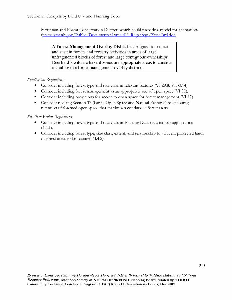
Section 2: Analysis by Land Use and Planning Topic
2-9
Review of Land Use Planning Documents for Deerfield, NH with respect to Wildlife Habitat and Natural Resource Protection, Audubon Society of NH, for Deerfield NH Planning Board, funded by NHDOT Community Technical Assistance Program (CTAP) Round 1 Discretionary Funds, Dec 2009
Mountain and Forest Conservation District, which could provide a model for adaptation. (www.lymenh.gov/Public_Documents/LymeNH_Regs/regs/ZoneOrd.doc)
Subdivision Regulations:
• Consider including forest type and size class in relevant features (VI.29.8, VI.30.14).
• Consider including forest management as an appropriate use of open space (VI.37).
• Consider including provisions for access to open space for forest management (VI.37).
• Consider revising Section 37 (Parks, Open Space and Natural Features) to encourage retention of forested open space that maximizes contiguous forest areas.
Site Plan Review Regulations:
• Consider including forest type and size class in Existing Data required for applications (4.4.1).
• Consider including forest type, size class, extent, and relationship to adjacent protected lands of forest areas to be retained (4.4.2).
A Forest Management Overlay District is designed to protect
and sustain forests and forestry activities in areas of large
unfragmented blocks of forest and large contiguous ownerships.
Deerfield’s wildfire hazard zones are appropriate areas to consider
including in a forest management overlay district.

Section 2: Analysis by Land Use and Planning Topic
2-10
Review of Land Use Planning Documents for Deerfield, NH with respect to Wildlife Habitat and Natural Resource Protection, Audubon Society of NH, for Deerfield NH Planning Board, funded by NHDOT Community Technical Assistance Program (CTAP) Round 1 Discretionary Funds, Dec 2009
Green Infrastructure
Green infrastructure consists of the network of undeveloped lands and waters that support human
life and economic activity as well as native wildlife populations. Major components of this network
include large blocks of unfragmented lands, smaller undeveloped patches, and linear connections.
Backyard vegetation and street trees also contribute to the network. Green infrastructure provides
essential services, including solar energy conversion, nutrient cycling, air and water purification, and
climate moderation, that enable ecosystems to function and support life. At a local scale, the
presence of green infrastructure enhances human quality of life, contributes to property values, and
provides wildlife habitat.
Current Provisions Master Plan includes goals and objectives that support protection of open space, natural resources,
environmental quality, and rural character. Open Space Plan provides extensive information and
recommendations regarding green infrastructure. Zoning Ordinance includes Wetlands
Conservation District; addresses protection of significant habitat, vegetation, open space, and
ecologically sensitive areas in Absolute Criteria for All Proposals. Subdivision Regulations includes
providing for adequate open space in purpose; authorizes Planning Board to require preservation of
natural features and designation of buffer zones in Required Improvements. Site Plan Review
Regulations CTAP Road Map includes goals of maintaining farms and forests, protecting wildlife
corridors, establishing and conserving an interconnected green infrastructure.
Recommendations Master Plan:
• Consider amending Master Plan and Open Space Plan to include discussion of green infrastructure.
Zoning Ordinance:
• Consider adopting overlay districts to protect green infrastructure as discussed elsewhere in this document.
Subdivision Regulations:
• Addressed collectively through other topics within this document.
Site Plan Review Regulations:
• Addressed collectively through other topics within this document.
Section 2: Analysis by Land Use and Planning Topic
2-11
Review of Land Use Planning Documents for Deerfield, NH with respect to Wildlife Habitat and Natural Resource Protection, Audubon Society of NH, for Deerfield NH Planning Board, funded by NHDOT Community Technical Assistance Program (CTAP) Round 1 Discretionary Funds, Dec 2009
Groundwater
Groundwater includes water stored in stratified drift (i.e., sand and gravel) aquifers and in bedrock
(i.e., deep or artesian) aquifers, and is the most common source of drinking water in New
Hampshire. Potable groundwater is a critical resource for New Hampshire communities. High-
yield aquifers are included in the NH Natural Services Network as Water Supply Lands.
Groundwater is important to wildlife as the source of springs and seeps which provide water in
upland areas and feed surface waters and wetlands.
Current Provisions Master Plan recommends adoption of ground water protection regulations and wellhead protection program and continuing to use zoning ordinances to direct growth away from environmentally sensitive areas, including aquifers and existing well recharge areas. Open Space Plan includes an extensive discussion of aquifers as a priority for protection. Source Water Protection Plan provides specific recommendations for protecting groundwater, including specific options for an Aquifer Protection Overlay Ordinance and Groundwater Protection standards for inclusion in Site Plan Review Regulations. Zoning Ordinance includes aquifers in ecologically sensitive areas to be considered in Absolute Criteria for All Proposals. Site Plan Review Regulations authorize Planning Board to require hydrogeological investigations and pesticide analysis of groundwater. Excavation Regulations require aquifer data in Excavation Plan and prohibits excavation that would damage a known aquifer. CTAP Road Map includes goal of protecting ground water and aquifers and recommendation to develop a groundwater/aquifer protection ordinance. Recommendations Master Plan:
• None.
Zoning Ordinance:
• Consider adopting an aquifer overlay district (See Town of Deerfield Source Water Protection Plan and Chapter 2.5, “Protection of Groundwater and Surface Water Resources,” in Innovative Land Use Planning Techniques).
Subdivision Regulations:
• Consider including mapped aquifers on location map required in Layout Specification and Submission Details (VI.29.A.8, VI.30.A.14).
• Consider revising Special Studies provision of Formal Plat Layout and Submission Details to address contaminants in general, rather than pesticides specifically (VI.30).
• Consider encouraging minimization of roads on lands overlaying mapped aquifers in Street Layout requirements (VII.33).
• Consider including discussion of aquifer recharge and preventing groundwater pollution in requirements for Drainage Improvements (VII.36).
Site Plan Review Regulations:
• Consider including site location with respect to mapped aquifers in the Existing Data required for an application (4.4.1).
Section 2: Analysis by Land Use and Planning Topic
2-12
Review of Land Use Planning Documents for Deerfield, NH with respect to Wildlife Habitat and Natural Resource Protection, Audubon Society of NH, for Deerfield NH Planning Board, funded by NHDOT Community Technical Assistance Program (CTAP) Round 1 Discretionary Funds, Dec 2009
• Consider including measures to prevent groundwater contamination in Design and Construction Requirements (Section V) for any developments proposed for lands overlaying mapped aquifers (See Town of Deerfield Source Water Protection Plan).

Section 2: Analysis by Land Use and Planning Topic
2-13
Review of Land Use Planning Documents for Deerfield, NH with respect to Wildlife Habitat and Natural Resource Protection, Audubon Society of NH, for Deerfield NH Planning Board, funded by NHDOT Community Technical Assistance Program (CTAP) Round 1 Discretionary Funds, Dec 2009
Growth Management and Sprawl
Growth management includes a variety of techniques and strategies intended to encourage orderly
growth and development in areas appropriate for development, protect important natural resources,
and discourage sprawl. Growth management helps to prevent deterioration of human quality of life
and property values and loss and degradation of wildlife habitat that result from uncontrolled
growth. Sprawl refers to dispersed, automobile-dependent development that segregates residential,
commercial, industrial, and business uses. Sprawl contributes to air pollution and inefficient use of
time and resources, which have negative impacts on human health, economic well-being, and quality
of life. The inefficient use of land associated with sprawl results in excessive loss and degradation of
wildlife habitat.
Current Provisions Master Plan includes control of growth and development in Vision for Deerfield and recommends encouraging growth in already-developed areas and using subdivision phasing to limit rate and extent of development in rural areas, adopting a Village District, and allowing mixed use and higher densities in village centers. Open Space Plan includes discussion of costs and economic consequences of sprawl. CTAP Road Map includes recommendations to develop zoning that would support village areas and to consider mixed use development on the same lot.
Recommendations Master Plan:
• None.
Zoning Ordinance:
• Consider adopting Village Districts to achieve Master Plan objectives (LU-2) of promoting development in existing developed areas and discouraging development in rural areas.
• Consider adopting a village land use district as suggested in the Future Land Use Recommendations in the Master Plan.
• Explore the appropriateness for Deerfield of other innovative zoning techniques to prevent sprawl. (See Chapters 1.2, “Lot Size Averaging – One Size Does Not Fit All” and 1.4, “Feature-based Density,” in Innovative Land Use Planning Techniques).
Subdivision Regulations:
• See Zoning Ordinance, above.
Site Plan Review Regulations:
• See Zoning Ordinance, above.

Section 2: Analysis by Land Use and Planning Topic
2-14
Review of Land Use Planning Documents for Deerfield, NH with respect to Wildlife Habitat and Natural Resource Protection, Audubon Society of NH, for Deerfield NH Planning Board, funded by NHDOT Community Technical Assistance Program (CTAP) Round 1 Discretionary Funds, Dec 2009
Impervious Surfaces
Impervious surfaces include buildings, exposed rock, concrete, and other materials through which
water cannot move. Impervious surfaces increase stormwater run-off, potentially leading to erosion,
sedimentation, flooding, and reduced groundwater supplies. Effects of impervious surfaces are
detrimental to both humans and wildlife. Impervious surfaces also contribute to heat island effects
and reduce air quality. (See also Stormwater Management and Erosion Control).
Current Provisions Master Plan recommends adoption of groundwater protection and use of Low Impact Development Guidelines. Site Plan Review Regulations authorize Planning Board to allow permeable pavement and to waive or modify paving to reduce runoff. Recommendations Master Plan:
• Consider specifically addressing minimization of impervious surfaces in Land Use Chapter.
Zoning Ordinance:
• Consider adopting maximum impervious lot coverage for each zoning district.
Subdivision Regulations:
• Consider including total impervious surface and percent of project area in Plat Submission Details (VI.30).
Site Plan Review Regulations:
• Consider including total impervious surface and percent of project area, and impervious area and percent for each lot in Proposed Data for Application Submittal (4.4.2).

Section 2: Analysis by Land Use and Planning Topic
2-15
Review of Land Use Planning Documents for Deerfield, NH with respect to Wildlife Habitat and Natural Resource Protection, Audubon Society of NH, for Deerfield NH Planning Board, funded by NHDOT Community Technical Assistance Program (CTAP) Round 1 Discretionary Funds, Dec 2009
Landscaping and Natural Vegetation
Landscaping refers to visible, human-modified features of a plot of land, including vegetation, water
features, shape of terrain, fences and other material objects. Landscaping contributes to the
aesthetics of neighborhoods and communities, enhances property values, improves urban air quality,
and can reduce heating and cooling costs. Natural vegetation includes the native trees, shrubs,
wildflowers, grasses, ferns, and mosses that grow on a land parcel before it is cleared for
development. Maintaining as much natural vegetation on a development site as practical prevents
erosion, mediates microclimate, contributes to human quality of life and property values, and saves
the time, cost, and risks of installing new plantings. Landscaping benefits wildlife by providing
backyard habitat. Natural vegetation provides higher wildlife habitat value than new plantings.
Current Provisions Master Plan acknowledges the public benefits of protecting environmental quality. Zoning Ordinance includes requirement for suitable on-site landscaping in Standards Applicable to Special Exceptions and addresses trees and vegetation in Absolute Criteria for All Proposals in the Community Character Compatibility Standards for Scenic Roads. Subdivision Regulations include street tree locations in Construction Detail Sheets, information on significant vegetation in Formal Plat Layout and Submission Details, and street trees, buffer zones, and protection of natural features in Required Improvements. Site Plan Review Regulations require a landscaping plan and encourage retention and protection of natural vegetation. CTAP Road Map notes the Town’s lack of general landscaping requirements.
Recommendations Master Plan:
• Consider specifically addressing landscaping and natural vegetation.
• Consider including native vegetation in the list of community resources in the fourth bullet of the guiding principles in the Vision for Deerfield.
Zoning Ordinance:
• Consider adopting general standards for landscaping (currently exist only for special exceptions and scenic roads).
Subdivision Regulations:
• Consider requiring a landscaping plan and specifying standards and guidelines for same, including maximizing retention of native vegetation.
• Consider replacing “tree masses” with “stands of trees” or “large trees” or “stands of large trees” in VII.37.D.
• Consider amending VI.30.A. to include existing vegetation to be retained.
Site Plan Review Regulations:
• Consider revising Section 5.12.D. by listing “existing vegetation to be retained” among existing significant natural features in Proposed Data Required (4.4.2.G).

Section 2: Analysis by Land Use and Planning Topic
2-16
Review of Land Use Planning Documents for Deerfield, NH with respect to Wildlife Habitat and Natural Resource Protection, Audubon Society of NH, for Deerfield NH Planning Board, funded by NHDOT Community Technical Assistance Program (CTAP) Round 1 Discretionary Funds, Dec 2009
Light Pollution
Light pollution includes any adverse effects of artificial light, including sky glow, glare, light trespass,
decreased night visibility and energy waste. Controlling light pollution conserves energy and
resources, saves money, and prevents public health and safety hazards and nuisances. Controlling
light pollution can avoid negative impacts of artificial light on wildlife, particularly on migratory
birds.
Current Provisions Master Plan recommends investigating lighting regulations within Village Districts. Site Plan Review Regulations prohibit light trespass. CTAP Road Map notes that Town lacks dark skies ordinance.
Recommendations Master Plan:
• Consider addressing as specific topic in Land Use, Housing, Economic Development, Natural Resources and Open Space, and/or a new energy conservation chapter.
Zoning Ordinance:
• Consider adopting an outdoor lighting ordinance to prevent light pollution in all zoning districts. (See Chapter 3.4, “preserving Dark Skies,” in Innovative Land Use Planning Techniques).
Subdivision Regulations:
• Consider adopting standards for outdoor lighting in Required Improvements (Article VII).
Site Plan Review Regulations:
• Consider addressing dark skies in Illumination standards (5.8).

Section 2: Analysis by Land Use and Planning Topic
2-17
Review of Land Use Planning Documents for Deerfield, NH with respect to Wildlife Habitat and Natural Resource Protection, Audubon Society of NH, for Deerfield NH Planning Board, funded by NHDOT Community Technical Assistance Program (CTAP) Round 1 Discretionary Funds, Dec 2009
Natural Hazards
New Hampshire’s most common natural hazard is flooding. Forest fires are infrequent in the
State, and are usually controlled before spreading very far. Landslides are most likely in
mountainous areas, but can occur locally anywhere slopes exist. Land use practices can mitigate or
exacerbate the risks of natural hazards. Development that reduces infiltration and storage of
precipitation can exacerbate downstream flooding. Scattered residential development in extensive
forests both increases the risk of forest fires and makes fighting them more difficult and dangerous.
On steep slopes, increased water in soils from precipitation or leach fields, soil vibration from
construction or traffic, undercutting at the foot of slope, and increased weight from new buildings)
above all can trigger slope failure. Climate change may alter the frequency of these hazards if
precipitation events become more sporadic and intense. Natural hazards can threaten human health
and safety, damage public and private property, and degrade or destroy wildlife habitat.
Current Provisions Master Plan recommends consideration of a steep slopes ordinance and implementing the strategies outlined in the Hazard Mitigation Plan. Hazard Mitigation Plan addresses natural hazards including flooding, erosion and mudslides, and wildland fires. Zoning Ordinance includes Wetlands Conservation District and Floodplain Development Regulations, and addresses known areas of natural and geological hazards in Absolute Criteria for All Proposals. Subdivision Regulations include flood elevation data in Formal Plat Layout and Submission Details, require that land to be subdivided can safely support buildings without danger to health or peril from fire, flood, soil failure or other hazard, and require review of subdivisions involving designated flood areas to ensure reasonable safety from flooding. Site Plan Review Regulations address flood control in Design and Construction Requirements.
Recommendations Master Plan:
• None. Zoning Ordinance:
• Consider adopting overlay districts to address site-specific hazards (Steep Slopes, Wild Fire hazard areas)
Subdivision and Site Plan Review Regulations:
• Consider adopting special standards for subdivisions in wildfire hazard areas to minimize the potential for wildland fires involving structures and structural fires involving wildlands. Such standards might include mandatory cluster, maximum distance from collector road, maximum driveway length, and landscaping specifications. (See National Fire Protection Association. 2008. NFPA 1144: Standard for Reducing Structure Ignition Hazards from Wildland Fire.)(Building code standards, such as inflammable roofing and siding materials, may also be desirable.)

Section 2: Analysis by Land Use and Planning Topic
2-18
Review of Land Use Planning Documents for Deerfield, NH with respect to Wildlife Habitat and Natural Resource Protection, Audubon Society of NH, for Deerfield NH Planning Board, funded by NHDOT Community Technical Assistance Program (CTAP) Round 1 Discretionary Funds, Dec 2009
Natural Services Network
The New Hampshire Natural Services Network (NSN) is a GIS-based tool identifying lands that
provide important ecological services that are difficult and expensive to replicate. Loss of these
services affects human health, safety, quality of life, and economic opportunity. Created by a
collaborative of planning and natural resource professionals, this tool can be adapted for use at
multiple scales and refined to incorporate additional data. Base maps for this network consist of
four components: water supply lands, flood storage lands, productive soils, and important wildlife
habitat. (See Section IV for Deerfield-specific information.)
� Water supply lands include highly transmissive aquifers identified by the US Geological Survey and favorable gravel well sites identified by NH DES.
� Flood storage lands include 100-year floodplains identified by FEMA and lacustrine (associated with lakes), riverine (associated with rivers), and palustrine (other non-tidal) wetlands identified by the USFWS National Wetlands Inventory.
� Productive soils include prime farmland and farmland of statewide importance identified by the Natural Resource Conservation Service.
� Important wildlife habitat includes habitat of statewide priority and habitat of eco-regional priority identified by the NH Fish & Game Department Wildlife Action Plan.
Current Provisions See Agriculture and Productive Soils; Floodplains; Groundwater; Shorelands, Surface Waters, and Wetlands; and Wildlife Habitat.
Recommendations Master Plan:
• Consider including discussion of the Natural Services Network in Land Use Chapter.
Zoning Ordinance:
• Consider adopting overlay districts to protect components of Natural Services Network as discussed elsewhere in this document.
Subdivision Regulations:
• See Agriculture and Productive Soils; Floodplains; Groundwater; Shorelands, Surface Waters, and Wetlands; and Wildlife Habitat.
Site Plan Review Regulations:
• See Agriculture and Productive Soils; Floodplains; Groundwater; Shorelands, Surface Waters, and Wetlands; and Wildlife Habitat.

Section 2: Analysis by Land Use and Planning Topic
2-19
Review of Land Use Planning Documents for Deerfield, NH with respect to Wildlife Habitat and Natural Resource Protection, Audubon Society of NH, for Deerfield NH Planning Board, funded by NHDOT Community Technical Assistance Program (CTAP) Round 1 Discretionary Funds, Dec 2009
Shorelands, Surface Waters, and Wetlands
Shorelands, surface waters, and wetlands comprise the visible parts of the land’s hydrological
network. These resources govern the quality and availability of water for human and livestock
consumption, recreational activities, industrial uses, and wildlife habitat. Shorelands, also called
riparian areas, are frequently used as travel corridors for wildlife moving across the landscape. (See
Section IV for Deerfield-specific information.)
Current Provisions Master Plan acknowledges importance of protecting surface waters and their shorelines, and
recommends adoption of zoning regulations to further protect wetlands; adoption of riparian buffer
regulations to protect 1st, 2nd and 3rd order streams, rivers and lakes; working with state and local
organizations to protect and enhance surface waters; working with agencies and organizations to
manage and improve water quality among regional watersheds; and continuing to use zoning
ordinances to direct growth away from environmentally sensitive areas, including wetlands. Open
Space Plan includes discussions of water quality and quantity and wetlands and watersheds;
considers prime wetlands, aquifers, vernal pools, and streams and lakes as priority criteria for open
space protection. Zoning Ordinance includes Wetlands Conservation District and Pleasant Lake
Watershed Ordinance and includes lakeshores in ecologically sensitive areas to be considered in
Absolute Criteria for All Proposals. Subdivision Regulations require information on bodies of water
and water courses in Formal Plat Layout and Submission Details; authorize Planning Board to
require wetland mapping and to require a buffer of at least 50 feet around surface waters and
wetlands; and address stormwater management in Design Standards. Site Plan Review Regulations
require information on streams, marshes, lakes, ponds, and poorly and very poorly drained soils for
Formal Application Submittal; prohibit increased runoff beyond the property boundaries; and
require erosion and sedimentation plans. Excavation regulations require information on lakes and
streams in Excavation Plan and prohibit excavation within 75 feet of wetlands, streams, and water
bodies.
Recommendations Master Plan:
• None. Zoning Ordinance:
• None. Subdivision, Site Plan Review, and Excavation Regulations:
• Consider specifying that wetland and riparian buffers be vegetated, requiring that they be marked on the ground, and increasing their required width to 100 feet.

Section 2: Analysis by Land Use and Planning Topic
2-20
Review of Land Use Planning Documents for Deerfield, NH with respect to Wildlife Habitat and Natural Resource Protection, Audubon Society of NH, for Deerfield NH Planning Board, funded by NHDOT Community Technical Assistance Program (CTAP) Round 1 Discretionary Funds, Dec 2009
Steep Slopes and Ridgelines
Steep slopes are often defined as grades equal to or exceeding 15%, i.e., areas where the elevation
increases 15 feet in 100 feet of horizontal distance. Slopes with such high gradients are vulnerable to
failure, when the pull of gravity on slope materials exceeds the forces of friction and cohesion that
hold them in place. Protecting steep slopes prevents damage to public and private property resulting
from slope failure; environmental damage such as erosion, sedimentation, and drainage problems;
excessive cuts and fills; and unsightly slope scars. Ridgelines form the boundary between
watersheds, and land uses in these sensitive areas can have negative impacts for great distances
downstream. Ridgeline development is also visible over large areas and affects community aesthetics
and rural character. Many ridgelines have shallow soils that support mast-bearing trees, such as
oaks, hickories, and beech, which provide important food sources for wildlife. Ridgeline protection
benefits wildlife by protecting these food sources and important travel routes for large mammals.
Protection of steep slopes benefits wildlife by preventing habitat degradation of uplands, wetlands,
and surface waters.
Current Provisions Master Plan recommends considering adoption of steep slopes ordinance. Open Space Plan Appendix B includes discussion of steep slopes. Hazard Mitigation Plan discusses risk of Erosion and mudslides and includes map of steep slopes. Subdivision Regulations require topographic map of site in Layout Specification and Submissions Details and limit grades of roads and side slopes. Site Plan Review Regulations require topographic contours in Formal Application Submittal. Recommendations Master Plan:
• Consider addressing ridgeline protection in Land Use and/or Natural Resources and Open Space chapters.
Open Space Plan
• Consider including steep slopes in list of Deerfield’s most sensitive natural areas in Section 7: Priorities for Deerfield, Criteria for Acquisition and protection of Open Space
• Consider including steep slopes on Map #2: Development Constraints. Zoning Ordinance:
• Consider adopting a Ridgeline Protection ordinance or overlay district. (See Lakes Region Planning Commission. 2005. Regulating Development on Steep Slopes, Hillsides, and Ridgelines and Chapter 2.2, “Steep Slope and Ridgeline Protection,” in Innovative Land Use Planning Techniques).
• Consider adopting steep slopes ordinance or overlay district as suggested in Master Plan Strategy NR-1.2. (See Lakes Region Planning Commission. 2005. Regulating Development on Steep Slopes, Hillsides, and Ridgelines and Chapter 2.2, “Steep Slope and Ridgeline Protection,” in Innovative Land Use Planning Techniques).
Section 2: Analysis by Land Use and Planning Topic
2-21
Review of Land Use Planning Documents for Deerfield, NH with respect to Wildlife Habitat and Natural Resource Protection, Audubon Society of NH, for Deerfield NH Planning Board, funded by NHDOT Community Technical Assistance Program (CTAP) Round 1 Discretionary Funds, Dec 2009
Subdivision Regulations:
• Consider specifically requiring identification of steep slopes in Design Review Plat Layout and Submission Details (VI.29.8).
Site Plan Review Regulations:
• Consider including areas of steep slopes in Data Required for Formal Application Submittal.

Section 2: Analysis by Land Use and Planning Topic
2-22
Review of Land Use Planning Documents for Deerfield, NH with respect to Wildlife Habitat and Natural Resource Protection, Audubon Society of NH, for Deerfield NH Planning Board, funded by NHDOT Community Technical Assistance Program (CTAP) Round 1 Discretionary Funds, Dec 2009
Stormwater Management and Erosion Control
Stormwater runoff refers to precipitation that cannot soak into the ground and subsequently ponds
or flows over the earth’s surface. Management of this runoff is important for preventing soil
erosion, water pollution, and flooding, and for ensuring adequate recharge of groundwater. Erosion
control prevents damage to private property and public investments such as roadways, conserves the
productivity of upland soils, and prevents degradation of wetlands and surface waters. Stormwater
management and erosion control benefit wildlife by preventing degradation of upland and aquatic
habitats. (See also Impervious Surfaces, Steep Slopes and Ridgelines.)
Current Provisions Master Plan recommends improving erosion and sediment control regulations, adopting steep slopes ordinance, increasing regulatory protection of wetlands, adopting Low Impact Development strategies. Open Space Plan Appendix B includes discussion of erosion potential on steep slopes. Hazard Mitigation Plan discusses risk of erosion and mudslides. Zoning Ordinance includes prohibition on substantially increasing runoff onto adjacent property and roads in Criteria for Special Exception and addresses minimizing stormwater runoff in intent of Pleasant Lake Watershed Ordinance. Subdivision Regulations require adequate provision for surface water drainage, storm drainage facilities for streets, storm water easements or drainage rights-of-way (on request) where subdivisions are traversed by watercourses, drainage ways, channels or streams, and approved plans and specifications for stormwater management systems; prohibit off-site runoff. Site Plan Review Regulations require adequate storm water drainage system, prohibit off-site runoff, require an erosion and sedimentation control plan, authorize Planning Board to waive or modify paving to reduce runoff.
Recommendations Master Plan:
• None. Zoning Ordinance:
• Consider adding a General Provision (III) to include the prohibition on substantially increasing runoff onto adjacent property and roads currently expressed in Criteria for a Special Exception.
• Consider adopting a steep slopes ordinance as recommended in Master Plan. (See Chapter 2.2, “Steep Slope and Ridgeline Protection,” in Innovative Land Use Planning Techniques).
• Consider adopting a stormwater ordinance as suggested in the Master Plan. “Permanent
(Post-construction) Stormwater Management” (Chapter 2.1) in Innovative Land Use Planning
Techniques: A Handbook for Sustainable Development provides model language for a zoning
ordinance article that addresses stormwater management and information about pertinent
existing ordinances in New Hampshire.
Subdivision Regulations:
• Consider revising Street Design standards (VII.34) to discourage closed drainage and encourage intermittent swales and Low Impact Development practices (see Transportation

Section 2: Analysis by Land Use and Planning Topic
2-23
Review of Land Use Planning Documents for Deerfield, NH with respect to Wildlife Habitat and Natural Resource Protection, Audubon Society of NH, for Deerfield NH Planning Board, funded by NHDOT Community Technical Assistance Program (CTAP) Round 1 Discretionary Funds, Dec 2009
Research Board. 2006. Evaluation of Best Management Practices for Highway Runoff Control. National Cooperative Highway Research Program, NCHRP Report 565. http://onlinepubs.trb.org/onlinepubs/nchrp/nchrp_rpt_565.pdf)
• Consider including Low Impact Development practices in Design Standards (VIII).
• Consider allowing permeable pavement for sidewalks with Board approval (VIII. 46).
• Consider revising Section 27.C.3. to include drainage to groundwater.
• Review “Erosion and Sediment Control During Construction” (Chapter 2.8) in Innovative
Land Use Planning Techniques: A Handbook for Sustainable Development and adopt new regulations
and standards as appropriate.
Site Plan Review Regulations:
• Consider including Low Impact Development practices in Design and Construction Requirements (V).
• Review “Erosion and Sediment Control During Construction” (Chapter 2.8) in Innovative
Land Use Planning Techniques: A Handbook for Sustainable Development and adopt new regulations
and standards as appropriate.
Low Impact Development (LID) refers to a land planning and engineering
design approach for managing stormwater runoff. LID emphasizes conservation
and use of on-site natural features to protect water quality. This approach uses
engineered, small-scale, hydrologic controls to enable infiltrating, filtering,
storing, evaporating, and detaining runoff close to its source.
Section 2: Analysis by Land Use and Planning Topic
2-24
Review of Land Use Planning Documents for Deerfield, NH with respect to Wildlife Habitat and Natural Resource Protection, Audubon Society of NH, for Deerfield NH Planning Board, funded by NHDOT Community Technical Assistance Program (CTAP) Round 1 Discretionary Funds, Dec 2009
Terrain Alteration
Terrain alteration refers to earth-moving operations, including cut and fill, which reshape the topography of the land in a way that interferes with natural runoff or creates unnatural runoff. State law (RSA 485-A:6, A:17) requires a permit from the Department of Environmental Services for activities that disturb more than 100,000 square feet of terrain (50,000 square feet within protected shorelands), but municipalities may adopt more stringent regulations. Terrain alteration can result in soil erosion and increased stormwater runoff, leading to water pollution and damage to public and private property damage. Terrain alteration results in direct and indirect loss of wildlife habitat.
Current Provisions Master Plan acknowledges public benefits of protecting environmental quality. Subdivision Regulations require that street grades conform as closely as possible to original topography. Site Plan Review Regulations include existing and proposed grades and topographic contours in required data for Formal Application Submittal. Excavation Regulations require restoration plan including restored topography. Recommendations Master Plan:
• None. Zoning Ordinance:
• None. Subdivision Regulations:
• Consider including Terrain Alteration section in Design Standards (VIII). . Site Plan Review Regulations:
• Consider including Terrain Alteration section in Design and Construction Requirements (V).

Section 2: Analysis by Land Use and Planning Topic
2-25
Review of Land Use Planning Documents for Deerfield, NH with respect to Wildlife Habitat and Natural Resource Protection, Audubon Society of NH, for Deerfield NH Planning Board, funded by NHDOT Community Technical Assistance Program (CTAP) Round 1 Discretionary Funds, Dec 2009
Village District
A village district is a defined zoning area that accommodates mixed development, including the
residential, commercial, and office uses that evolved in traditional New England villages. Village
districts can be designed to encompass or expand existing village centers or to enable the
development of new villages at desired locations, such as at crossroads or other nodes of activity.
This planning tool provides economic benefits by concentrating services and infrastructure needs
and helps to prevent sprawl. Village districts benefit wildlife by concentrating development on the
landscape, resulting in larger contiguous areas of undeveloped land.
Current Provisions Master Plan recommends considering adoption of Village District. CTAP Road Map includes recommendation to develop zoning that would support village areas. Recommendations Master Plan:
• None. Zoning Ordinance:
• Consider adopting a Village District Overlay zone as recommended in Master Plan and CTAP Road Map.
Subdivision Regulations:
• To be determined pending adoption of overlay zone. Site Plan Review Regulations:
• To be determined pending adoption of overlay zone.
Section 2: Analysis by Land Use and Planning Topic
2-26
Review of Land Use Planning Documents for Deerfield, NH with respect to Wildlife Habitat and Natural Resource Protection, Audubon Society of NH, for Deerfield NH Planning Board, funded by NHDOT Community Technical Assistance Program (CTAP) Round 1 Discretionary Funds, Dec 2009
Watersheds
A watershed is the area of land that drains into a particular water body. The cumulative effects of
land uses within a watershed can lead to problems with water quality and flooding, and their
associated negative impacts on humans and wildlife.
Current Provisions Master Plan includes clean water in valued community resources; places strong emphasis on
protecting open space and maintaining rural character; recommends considering riparian buffers for
lower order streams, continuing to use zoning ordinances to direct growth away from wetlands,
floodplains, and aquifers, and working closely agencies and organizations to manage and improve
water quality among regional watersheds. Open Space Plan includes discussions of water quality and
quantity and wetlands and watersheds; considers prime wetlands, aquifers, vernal pools, and streams
and lakes as priority criteria for open space protection. Zoning Ordinance includes Wetlands
Conservation District and Pleasant Lake Watershed Ordinance. Subdivision Regulations authorize
Planning Board to require wetland mapping and hydrogeological studies and include requirement for
drainage improvements. Site Plan Review Regulations include watercourses, waterbodies, streams,
marshes, lakes, ponds, storm drainage plan, and stormwater run-off calculations in data required for
Formal Application Submittal; require storm water drainage system, erosion and sedimentation
plans.
Recommendations Master Plan:
• Consider adding a goal of adopting land use policies that manage cumulative impacts of land use within a watershed.
Open Space Plan
• Consider including discussion of watersheds as context for conservation planning.
• Consider including map depicting watersheds and drainage networks, including stream orders and topography.
• Consider increasing clarity of watershed boundaries on Wetlands and Riparian Zones and Co-occurrence maps.
Zoning Ordinance:
• Consider adopting a Lamprey River Watershed Ordinance. Subdivision and Site Plan Review Regulations:
• Consider including location within watershed in Existing Data required for application submittal.
• See also Impervious Surfaces, Stormwater Management and Erosion Control.

Section 2: Analysis by Land Use and Planning Topic
2-27
Review of Land Use Planning Documents for Deerfield, NH with respect to Wildlife Habitat and Natural Resource Protection, Audubon Society of NH, for Deerfield NH Planning Board, funded by NHDOT Community Technical Assistance Program (CTAP) Round 1 Discretionary Funds, Dec 2009
Wildlife Habitat
Wildlife habitat includes the resources that native species need to survive: food, water, and shelter,
including safe places to produce young, and safe travel routes between areas of critical resources.
High quality wildlife habitat identified in the NH Fish & Game Department’s Wildlife Action Plan is
included in the NH Natural Services Network. The NH Wildlife Connectivity Model identifies
potential travel corridors between large areas of protected land. Wildlife habitat contributes to
human amenities such as clean water, clean air, recreation opportunities, aesthetic values, and rural
character. (See Section IV for Deerfield-specific information.)
Current Provisions Master Plan includes wildlife in valued community resources; places strong emphasis on protecting open space and maintaining rural character; recommends considering riparian buffers for lower order streams and using the NH Wildlife Action Plan to inform natural resource protection strategies. Open Space Plan includes discussion of biodiversity, rare species and natural communities, and wildlife crossings; includes wildlife habitats and wildlife corridors in priority criteria for open space protection; provides justification and strategies for open space protection. Zoning Ordinance includes Wetlands Conservation District and addresses significant wildlife habitat in Absolute Criteria for All Proposals. Subdivision Regulations include provision of adequate open space in Purposes and authorize Planning Board to require wetland mapping and environmental impact studies. Site Plan Review Regulations include provision of adequate open space in Purposes. CTAP Road Map includes goal of protecting wildlife and wildlife corridors and maintaining farms and forests. Recommendations Master Plan:
• Consider adding strategies under Natural Resources and Open Space Goal NR-1 to encourage protection of high quality wildlife habitat and wildlife connectivity zones.
Open Space Plan:
• Consider including discussion of available habitat types and areas of high quality habitat in Section 6: Ecological Benefits.
• Consider including data from New Hampshire Wildlife Action Plan maps on Map #5: Habitat Features.
• Consider updating the Wildlife Crossings subsection to reflect results of connectivity analysis.
• Consider including map of wildlife connectivity zones.
Zoning Ordinance:
• Consider adopting a Forest Management overlay district to promote retention of large blocks of contiguous forested land and discourage development in areas where Wild Fire Hazard (See Hazard Mitigation Plan) and high quality wildlife habitat overlap. The Lyme, NH zoning ordinance includes a Mountain and Forest Conservation District, which could
Section 2: Analysis by Land Use and Planning Topic
2-28
Review of Land Use Planning Documents for Deerfield, NH with respect to Wildlife Habitat and Natural Resource Protection, Audubon Society of NH, for Deerfield NH Planning Board, funded by NHDOT Community Technical Assistance Program (CTAP) Round 1 Discretionary Funds, Dec 2009
provide a model for adaptation. (www.lymenh.gov/Public_Documents/LymeNH_Regs/regs/ZoneOrd.doc)
• Consider adopting an overlay zone or performance district to protect high quality wildlife habitat and wildlife connectivity zones identified by the NH Fish & Game Department’s Wildlife Action Plan.
Subdivision Regulations:
• Consider adopting special standards for subdivisions in identified areas of high quality wildlife (per NHFG Wildlife Action Plan) to minimize habitat destruction and fragmentation. Such standards might include mandatory cluster, maximum distance from collector road, maximum driveway length, and landscaping specifications.
• Consider adopting special standards for subdivisions in identified wildlife connectivity zones. Such standards could include mandatory cluster with connecting open space and culverts that provide for wildlife passage.
• Consider requiring identification and protection of special habitats such as vernal pools, deer wintering areas, and important mast stands in subdivision layouts.
• Consider requiring sloped (Cape Cod) curbing where curbing is required.
Site Plan Review Regulations:
• Consider adopting special standards for identified areas of high quality wildlife habitat (per NHFG Wildlife Action Plan) to minimize habitat destruction and fragmentation. Such standards might include maximum lot coverage, maximum distance from collector road, connectivity of open space, and landscaping specifications.
• Consider adopting special standards for identified wildlife connectivity zones, such as connectivity of open space and culverts that provide for wildlife passage.
• Consider requiring identification and protection of special habitats such as vernal pools, deer wintering areas, and important mast stands in site plans.
• Consider requiring sloped (Cape Cod) curbing where curbing is required.
• Consider including authorization of Planning Board to require environmental impact studies.
Section 3. Recommendations by Planning Document
3-1
Review of Land Use Planning Documents for Deerfield, NH with respect to Wildlife Habitat and Natural Resource Protection, Audubon Society of NH, for Deerfield NH Planning Board, funded by NHDOT Community Technical Assistance Program (CTAP) Round 1 Discretionary Funds, Dec 2009
Section 3: Recommendations by Planning Document
A. Master Plan
Energy Efficiency
• Consider including an energy efficiency chapter, including goals and objectives such as: o Develop a process for measuring and reducing energy use in municipal and private
buildings and grounds, with the stated goal of achieving net zero energy use. o Encourage passive solar orientation and floor plans with living space on the south. o Require high performance building practices identified in the NH Climate Action Plan
(Mar 2009 and subsequent) to maximize energy efficiency, including: � Instrumented air sealing and thermographic inspections of building shell � EnergyStar appliances and lighting � Water saving measures � Domestic hot water upgrades � Renewable energy supply � Consider revising Community Facilities chapter to recommend requiring that new
construction or renovation on Town-owned property exceed the NH Energy Code
pursuant to the schedule identified in 2030 Challenge.
Forests and Forestry:
• Consider adding forests to list of valued community resources in the fourth guiding
principle of the Vision for Deerfield.
• Consider acknowledging the economic value of forests in Natural Resources and Open
Space, Land Use, and Economic Development chapters of Master Plan.
• Consider specifically addressing natural resource-based businesses (e.g., agriculture and
forestry) in the Economic Development chapter.
Green Infrastructure:
• Consider including discussion of green infrastructure.
Impervious Surfaces:
• Consider specifically addressing minimization of impervious surfaces in Land Use
Chapter.
Landscaping and Natural Vegetation:
• Consider specifically addressing landscaping and natural vegetation.
• Consider including native vegetation in the list of community resources in the fourth
bullet of the guiding principles in the Vision for Deerfield.
Section 3. Recommendations by Planning Document
3-2
Review of Land Use Planning Documents for Deerfield, NH with respect to Wildlife Habitat and Natural Resource Protection, Audubon Society of NH, for Deerfield NH Planning Board, funded by NHDOT Community Technical Assistance Program (CTAP) Round 1 Discretionary Funds, Dec 2009
Light Pollution:
• Consider addressing as specific topic in Land Use, Housing, Economic Development,
Natural Resources and Open Space, and/or new energy conservation chapter.
Natural Services Network:
• Consider including discussion of the Natural Services Network in Land Use Chapter.
Steep Slopes and Ridgelines:
• Consider addressing ridgeline protection in Land Use and/or Natural Resources and Open
Space chapters.
Watersheds:
• Consider adding a goal of adopting land use policies that manage cumulative impacts of
land use within a watershed.
Wildlife Habitat:
• Consider adding strategies under Natural Resources and Open Space Goal NR-1 to
encourage protection of high quality wildlife habitat and wildlife connectivity zones.
Section 3. Recommendations by Planning Document
3-3
Review of Land Use Planning Documents for Deerfield, NH with respect to Wildlife Habitat and Natural Resource Protection, Audubon Society of NH, for Deerfield NH Planning Board, funded by NHDOT Community Technical Assistance Program (CTAP) Round 1 Discretionary Funds, Dec 2009
Section 3: Recommendations by Document
B. Open Space Plan Floodplains
• Consider including floodplains among Deerfield’s most sensitive areas in Section 7: Priorities for Deerfield, Criteria for Acquisition and Protection of Open Space.
• Consider designating floodplains on Map #2: Development Constraints and Map #6: Wetlands and Riparian Zones.
Forests and Forestry
• Consider including a discussion of forest-based industries in Section 4: The Economic Benefits of Open Space.
• Consider including a subsection on the importance of forests in Section 6: Ecological Benefits.
Green Infrastructure
• Consider including discussion of green infrastructure in Section 6: Ecological Benefits. Steep Slopes and Ridgelines
• Consider including steep slopes in list of Deerfield’s most sensitive natural areas in Section 7: Priorities for Deerfield, Criteria for Acquisition and protection of Open Space.
• Consider including steep slopes on Map #2: Development Constraints.
Watersheds
• Consider including discussion of watersheds as context for conservation planning.
• Consider including map depicting watersheds and drainage networks, including stream orders and topography.
• Consider increasing clarity of watershed boundaries on Wetlands and Riparian Zones and Co-occurrence maps.
Wildlife Habitat
• Consider including discussion of available habitat types and areas of high quality habitat in Section 6: Ecological Benefits.
• Consider including data from New Hampshire Wildlife Action Plan maps on Map #5: Habitat Features.
• Consider updating the Wildlife Crossings subsection to reflect results of connectivity analysis.
• Consider including map of wildlife connectivity zones.

Section 3. Recommendations by Planning Document
3-4
Review of Land Use Planning Documents for Deerfield, NH with respect to Wildlife Habitat and Natural Resource Protection, Audubon Society of NH, for Deerfield NH Planning Board, funded by NHDOT Community Technical Assistance Program (CTAP) Round 1 Discretionary Funds, Dec 2009
Section 3. Recommendations by Planning Document
3-5
Review of Land Use Planning Documents for Deerfield, NH with respect to Wildlife Habitat and Natural Resource Protection, Audubon Society of NH, for Deerfield NH Planning Board, funded by NHDOT Community Technical Assistance Program (CTAP) Round 1 Discretionary Funds, Dec 2009
Section 3: Recommendations by Document
C. Zoning Ordinance
Agriculture and Productive Soils:
• Consider adopting Agricultural Incentive Zoning (See Chapter 1.7, “Agricultural Incentive Zoning,” in Innovative Land Use Planning Techniques).
Forests and Forestry:
• Consider adopting a Forest Management zoning district to promote forestry and discourage development in areas where Wild Fire Hazard (See Hazard Mitigation Plan) and high quality wildlife habitat overlap (See map provided). The Lyme, NH zoning ordinance includes a Mountain and Forest Conservation District, which could provide a model for adaptation. (www.lymenh.gov/Public_Documents/LymeNH_Regs/regs/ZoneOrd.doc)
Green Infrastructure:
• Consider adopting overlay districts to protect green infrastructure as discussed elsewhere in this document.
Groundwater:
• Consider adopting an aquifer overlay district (See Town of Deerfield Source Water Protection Plan and Chapter 2.5, “Protection of Groundwater and Surface Water Resources,” in Innovative Land Use Planning Techniques).
Growth Management and Sprawl:
• Consider adopting Village Districts to achieve Master Plan objectives (LU-2) of promoting development in existing developed areas and discouraging development in rural areas.
• Consider adopting a village land use district as suggested in the Future Land Use Recommendations in the Master Plan.
• Explore the appropriateness for Deerfield of other innovative zoning techniques to prevent sprawl. (See Chapters 1.2, “Lot Size Averaging – One Size Does Not Fit All” and 1.4, “Feature-based Density,” in Innovative Land Use Planning Techniques).
Impervious Surfaces:
• Consider adopting maximum impervious lot coverage for each zoning district.
Landscaping and Natural Vegetation:
• Consider adopting general standards for landscaping (currently exist only for special exceptions and scenic roads).
Section 3. Recommendations by Planning Document
3-6
Review of Land Use Planning Documents for Deerfield, NH with respect to Wildlife Habitat and Natural Resource Protection, Audubon Society of NH, for Deerfield NH Planning Board, funded by NHDOT Community Technical Assistance Program (CTAP) Round 1 Discretionary Funds, Dec 2009
Light Pollution:
• Consider adopting an outdoor lighting ordinance to prevent light pollution in all zoning districts. (See Chapter 3.4, “preserving Dark Skies,” in Innovative Land Use Planning Techniques).
Natural Hazards:
• Consider adopting overlay districts to address site-specific hazards (Floodplains, Steep Slopes, Wild Fire hazard areas).
Natural Services Network:
• Consider adopting overlay districts to protect components of Natural Services Network as discussed elsewhere in this document.
Steep Slopes and Ridgelines:
• Consider adopting a Ridgeline Protection ordinance or overlay district. (See Lakes Region Planning Commission. 2005. Regulating Development on Steep Slopes, Hillsides, and Ridgelines and Chapter 2.2, “Steep Slope and Ridgeline Protection,” in Innovative Land Use Planning Techniques).
• Consider adopting steep slopes ordinance or overlay district as suggested in Master Plan Strategy NR-1.2. (See Lakes Region Planning Commission. 2005. Regulating Development on Steep Slopes, Hillsides, and Ridgelines and Chapter 2.2, “Steep Slope and Ridgeline Protection,” in Innovative Land Use Planning Techniques).
Stormwater Management and Erosion Control:
• Consider adding a General Provision (III) to include the prohibition on substantially increasing runoff onto adjacent property and roads currently expressed in Criteria for a Special Exception.
• Consider adopting a steep slopes ordinance as recommended in Master Plan. (See Chapter 2.2, “Steep Slope and Ridgeline Protection,” in Innovative Land Use Planning Techniques).
• Consider adopting a stormwater ordinance as suggested in the Master Plan. “Permanent (Post-construction) Stormwater Management” (Chapter 2.1) in Innovative Land Use Planning Techniques: A Handbook for Sustainable Development provides model language for a zoning ordinance article that addresses stormwater management and information about pertinent existing ordinances in New Hampshire.
Village District:
• Consider adopting a Village District Overlay zone as recommended in Master Plan and CTAP Road Map.
Section 3. Recommendations by Planning Document
3-7
Review of Land Use Planning Documents for Deerfield, NH with respect to Wildlife Habitat and Natural Resource Protection, Audubon Society of NH, for Deerfield NH Planning Board, funded by NHDOT Community Technical Assistance Program (CTAP) Round 1 Discretionary Funds, Dec 2009
Watersheds:
• Consider adopting a Lamprey River Watershed Ordinance.
Wildlife Habitat:
• Consider adopting a Forest Management zoning district to promote retention of large blocks of contiguous forested land and discourage development in areas where Wild Fire Hazard (See Hazard Mitigation Plan) and high quality wildlife habitat overlap (See map provided). The Lyme, NH zoning ordinance includes a Mountain and Forest Conservation District, which could provide a model for adaptation. (www.lymenh.gov/Public_Documents/LymeNH_Regs/regs/ZoneOrd.doc)
• Consider adopting an overlay zone or performance district to protect high quality wildlife habitat and wildlife connectivity zones identified by the NH Fish & Game Department’s Wildlife Action Plan.
Section 3. Recommendations by Planning Document
3-8
Review of Land Use Planning Documents for Deerfield, NH with respect to Wildlife Habitat and Natural Resource Protection, Audubon Society of NH, for Deerfield NH Planning Board, funded by NHDOT Community Technical Assistance Program (CTAP) Round 1 Discretionary Funds, Dec 2009
Section 3: Recommendations by Document
D. Subdivision Regulations
General: Deerfield’s current Subdivision Regulations strongly suggest a Preliminary Conceptual
Consultation to review basic concepts of a subdivision proposal. Such consultations provide an
opportunity to identify ecologically sensitive areas within a project area and suggest strategies
for minimizing environmental impacts before a developer has invested in engineering studies and
surveys. Deerfield may wish to consider making such consultations mandatory, at least in
natural resource overlay districts, if not throughout the Town.
Agriculture and Productive Soils:
• Consider specifying inclusion of existing agricultural lands and economically important
soils (identified in Natural Resources Network) to Item 8 of Design Review Plat Layout
and Submission Details.
• Consider adding additional item to Section 37. Parks, Open Space and Natural Features
to address agricultural lands, e.g., “Protection of agricultural lands: The Planning Board
shall, wherever possible, protect economically important soils and agricultural lands.”
• Consider including agriculture as an appropriate use of open space (VI.37).
• Consider revising Special Studies provision of Formal Plat Layout and Submission
Details to address contaminants in general, rather than pesticides specifically (VI.30).
Energy Efficiency:
• Consider incorporating energy efficiency provisions into Article VII, Section 33, Street
Layout (See Chapter 3.5, “Energy Efficient Development,” in Innovative Land Use
Planning Techniques).
• Consider adding Section on Outdoor Illumination that includes energy efficiency
provisions to Article VII (See Chapter 3.5, “Energy Efficient Development,” in
Innovative Land Use Planning Techniques).
Floodplains:
• Consider increasing the design storm frequency requirements (Section 42.A.) for minor
brook culverts, particularly those with a history of flooding.
Forests and Forestry:
• Consider including forest type and size class in relevant features (VI.29.8, VI.30.14).
• Consider including forest management as an appropriate use of open space (VI.37).
• Consider including provisions for access to open space for forest management (VI.37).

Section 3. Recommendations by Planning Document
3-9
Review of Land Use Planning Documents for Deerfield, NH with respect to Wildlife Habitat and Natural Resource Protection, Audubon Society of NH, for Deerfield NH Planning Board, funded by NHDOT Community Technical Assistance Program (CTAP) Round 1 Discretionary Funds, Dec 2009
• Consider revising Section 37 (Parks, Open Space and Natural Features) to encourage
retention of forested open space that maximizes contiguous forest areas.
Groundwater:
• Consider including mapped aquifers on location map required in Layout Specification
and Submission Details (VI.29.A.8, VI.30.A.14).
• Consider revising Special Studies provision of Formal Plat Layout and Submission
Details to address contaminants in general, rather than pesticides specifically (VI.30).
• Consider encouraging minimization of roads on lands overlaying mapped aquifers in
Street Layout requirements (VII.33).
• Consider including discussion of aquifer recharge and preventing groundwater pollution
in requirements for Drainage Improvements (VII.36).
Impervious Surfaces:
• Consider including total impervious surface and percent of project area, and impervious
area and percent for each lot in Plat Submission Details (VI.30).
Landscaping and Natural Vegetation:
• Consider requiring a landscaping plan and specifying standards and guidelines for same,
including maximizing retention of native vegetation.
• Consider replacing “tree masses” with “stands of trees” or “large trees” or “stands of
large trees” in VII.37.D.
• Consider amending VI.30.A. to include existing vegetation to be retained.
Light Pollution:
• Consider adopting standards for outdoor lighting in Required Improvements (Article VII)
Natural Hazards:
• Consider adopting special standards for subdivisions in wildfire hazard areas to minimize
the possibility of wildland fires involving structures and structural fires involving
wildlands. Such standards might include mandatory cluster, maximum distance from
collector road, maximum driveway length, and landscaping specifications. (See National
Fire Protection Association. 2008. NFPA 1144: Standard for Reducing Structure Ignition
Hazards from Wildland Fire.)(Building code standards, such as inflammable roofing and
siding materials, may also be desirable.)
Shorelands, Surface Waters, and Wetlands:
Section 3. Recommendations by Planning Document
3-10
Review of Land Use Planning Documents for Deerfield, NH with respect to Wildlife Habitat and Natural Resource Protection, Audubon Society of NH, for Deerfield NH Planning Board, funded by NHDOT Community Technical Assistance Program (CTAP) Round 1 Discretionary Funds, Dec 2009
• Consider specifying that wetland and riparian buffers be vegetated, requiring that they be
marked on the ground, and increasing their required width to 75 feet as required in
Excavation Regulations.
• Steep Slopes and Ridgelines:
• Consider specifically requiring identification of steep slopes in Design Review Plat
Layout and Submission Details (VI.29.8).
Stormwater Management and Erosion Control:
• Consider revising Street Design standards (VII.34) to discourage closed drainage and
encourage intermittent swales and Low Impact Development practices (see
Transportation Research Board. 2006. Evaluation of Best Management Practices for
Highway Runoff Control. National Cooperative Highway Research Program, NCHRP
Report 565. http://onlinepubs.trb.org/onlinepubs/nchrp/nchrp_rpt_565.pdf)
• Consider including Low Impact Development practices in Design Standards (VIII).
• Consider allowing permeable pavement for sidewalks with Board approval (VIII. 46).
• Consider revising Section 27.C.3. to include drainage to groundwater.
• Review “Erosion and Sediment Control During Construction” (Chapter 2.8) in Innovative
Land Use Planning Techniques: A Handbook for Sustainable Development and adopt
new regulations and standards as appropriate.
Terrain Alteration:
• Consider including Terrain Alteration section in Design Standards (VIII).
Village District:
• To be determined pending adoption of overlay zone.
Watersheds:
• Consider including location within watershed in Existing Data required for application
submittal.
• See also Impervious Surfaces, Stormwater Management and Erosion Control.
Wildlife Habitat:
• Consider adopting special standards for subdivisions in identified areas of high quality
wildlife (per NHFG Wildlife Action Plan) to minimize habitat destruction and
fragmentation. Such standards might include mandatory cluster, maximum distance from
collector road, maximum driveway length, and landscaping specifications.
• Consider adopting special standards for subdivisions in identified wildlife connectivity
zones. Such standards could include mandatory cluster with connecting open space and
culverts that provide for wildlife passage.
Section 3. Recommendations by Planning Document
3-11
Review of Land Use Planning Documents for Deerfield, NH with respect to Wildlife Habitat and Natural Resource Protection, Audubon Society of NH, for Deerfield NH Planning Board, funded by NHDOT Community Technical Assistance Program (CTAP) Round 1 Discretionary Funds, Dec 2009
• Consider requiring identification and protection of special habitats such as vernal pools,
deer wintering areas, and important mast stands in subdivision layouts.
• Consider requiring sloped (Cape Cod) curbing where curbing is required.
Section 3. Recommendations by Planning Document
3-12
Review of Land Use Planning Documents for Deerfield, NH with respect to Wildlife Habitat and Natural Resource Protection, Audubon Society of NH, for Deerfield NH Planning Board, funded by NHDOT Community Technical Assistance Program (CTAP) Round 1 Discretionary Funds, Dec 2009
Section 3: Recommendations by Document
E. Site Plan Review Regulations
Agriculture and Productive Soils:
• Consider adding agricultural lands and economically important soils to (D) in Existing
Data, Data Required for Formal Application Submittal and Review for Site Plan Review.
• Consider adding agricultural lands and economically important soils to (G) in Proposed
Data, Data Required for Formal Application Submittal and Review for Site Plan Review.
• Consider adding provision to Section V, Design and Construction Requirements, to
address protection of agricultural lands.
Energy Efficiency:
• Consider incorporating energy efficiency provisions into Section V, Design and
Construction Requirements for Access Design (5.1), Illumination (5.8). (See Chapter
3.5, “Energy Efficient Development,” in Innovative Land Use Planning Techniques).
• Consider incorporating energy efficiency provisions into Section 6.1, Construction
Standards (See Chapter 3.5, “Energy Efficient Development,” in Innovative Land Use
Planning Techniques).
Forests and Forestry:
• Consider including forest type and size class in Existing Data required for applications
(4.4.1).
• Consider including forest type, size class, extent, and relationship to adjacent protected
lands of forest areas to be retained (4.4.2).
Groundwater:
• Consider including location with respect to mapped aquifers in the Existing Data required
for an application (4.4.1).
• Consider including measures to prevent groundwater contamination in Design and
Construction Requirements (Section V) for any developments proposed for lands
overlaying mapped aquifers.
Impervious Surfaces:
• Consider including total impervious surface and percent of project area, and impervious
area and percent for each lot in Proposed Data for Application Submittal (4.4.2).
Landscaping and Natural Vegetation:
Section 3. Recommendations by Planning Document
3-13
Review of Land Use Planning Documents for Deerfield, NH with respect to Wildlife Habitat and Natural Resource Protection, Audubon Society of NH, for Deerfield NH Planning Board, funded by NHDOT Community Technical Assistance Program (CTAP) Round 1 Discretionary Funds, Dec 2009
• Consider supporting Section 5.12.D. with by listing “existing vegetation to be retained”
among existing significant natural features in Proposed Data Required (4.4.2.G).
Light Pollution:
• Consider addressing dark skies in Illumination standards (5.8).
Natural Hazards:
• Consider adopting special standards for subdivisions in wildfire hazard areas to minimize
the possibility of wildland fires involving structures and structural fires involving
wildlands. Such standards might include mandatory cluster, maximum distance from
collector road, maximum driveway length, and landscaping specifications. (See National
Fire Protection Association. 2008. NFPA 1144: Standard for Reducing Structure Ignition
Hazards from Wildland Fire.)(Building code standards, such as inflammable roofing and
siding materials, may also be desirable.)
Shorelands, Surface Waters, and Wetlands:
• Consider specifying that wetland and riparian buffers be vegetated, requiring that they be
marked on the ground, and increasing their required width to 75 feet as required in
Excavation Regulations.
Steep Slopes and Ridgelines:
• Consider including areas of steep slopes in Data Required for Formal Application
Submittal.
• Stormwater Management and Erosion Control:
• Consider including Low Impact Development practices in Design and Construction
Requirements (V).
• Review “Erosion and Sediment Control During Construction” (Chapter 2.8) in Innovative
Land Use Planning Techniques: A Handbook for Sustainable Development and adopt
new regulations and standards as appropriate.
Terrain Alteration:
• Consider including Terrain Alteration section in Design and Construction Requirements
(V).
Village District:
• To be determined pending adoption of overlay zone.
Watersheds:

Section 3. Recommendations by Planning Document
3-14
Review of Land Use Planning Documents for Deerfield, NH with respect to Wildlife Habitat and Natural Resource Protection, Audubon Society of NH, for Deerfield NH Planning Board, funded by NHDOT Community Technical Assistance Program (CTAP) Round 1 Discretionary Funds, Dec 2009
• Consider including location within watershed in Existing Data required for application
submittal.
• See also Impervious Surfaces, Stormwater Management and Erosion Control.
Wildlife Habitat:
• Consider adopting special standards for identified areas of high quality wildlife (per
NHFG Wildlife Action Plan) to minimize habitat destruction and fragmentation. Such
standards might include maximum lot coverage, maximum distance from collector road,
connectivity of open space, and landscaping specifications.
• Consider adopting special standards for identified wildlife connectivity zones.
Connectivity of open space and culverts that provide for wildlife passage.
• Consider requiring identification and protection of special habitats such as vernal pools,
deer wintering areas, and important mast stands in site plans.
• Consider requiring sloped (Cape Cod) curbing where curbing is required.
• Consider including authorization of Planning Board to require environmental impact
studies when appropriate.
Section 3: Recommendations by Document
F. Excavation Regulations
Floodplains:
• Consider adopting regulations governing excavations below the 100-year flood elevation.
Section 3. Recommendations by Planning Document
3-15
Review of Land Use Planning Documents for Deerfield, NH with respect to Wildlife Habitat and Natural Resource Protection, Audubon Society of NH, for Deerfield NH Planning Board, funded by NHDOT Community Technical Assistance Program (CTAP) Round 1 Discretionary Funds, Dec 2009
Section 3: Recommendations by Document
G. Checklists for Preliminary Conceptual Consultations
Deerfield currently has no checklist for Preliminary Conceptual Consultations in either the
Subdivision or the Site Plan Review application process. Such a checklist would ensure that
potential natural resource impacts of a proposed development were identified and addressed
early in the planning process.
Agriculture and Productive Soils
Checklist items
• Active or recently active agricultural lands
• Soils categorized as Prime farmland, Farmland of statewide importance, or Farmland
of local importance
Discussion topics
• How can protection of agricultural lands be accommodated in the development
proposal?
Energy Efficiency
Checklist items
• Existing topography (two foot contour interval)
Discussion topics
• Are there opportunities to take advantage of passive or active solar through road
layout and building orientation?
• Will the project be following any performance standards (e.g., Energy Star, LEED,
2030 Challenge)?
• How will the project address pedestrian and bicycle access?
Floodplains
Checklist items
• Soils subject to frequent or occasional flooding
• Lands below the 1% flood frequency (100-year flood) elevation
Discussion topics
• Will the proposed project avoid impacts to flood-prone areas?
• Will the proposed project increase drainage into flood-prone areas?
Forests and Forestry
Checklist items
• Project location relative to wildfire hazard zones

Section 3. Recommendations by Planning Document
3-16
Review of Land Use Planning Documents for Deerfield, NH with respect to Wildlife Habitat and Natural Resource Protection, Audubon Society of NH, for Deerfield NH Planning Board, funded by NHDOT Community Technical Assistance Program (CTAP) Round 1 Discretionary Funds, Dec 2009
• Project location relative to contiguous forest area
• Size class and species composition of current forest cover
Discussion topics
• Will driveway lengths be minimized for buildings in wildfire hazard zones?
• Will fire resistant materials be used for buildings in wildfire hazard zones?
• Will the proposed project minimize clearing of mature forest?
• Will the proposed project minimize fragmentation of existing forest?
• Will the proposed project provide opportunities and access for future forest
management?
Groundwater
Checklist items
• Favorable gravel well analysis
• Location with respect to stratified drift aquifers
Discussion topics
• Will the proposed project present groundwater contamination risks?
• Will the proposed project inhibit groundwater recharge?
Landscaping and Natural Vegetation
Checklist items
• Existing vegetation
Discussion topics
• Will the proposed project minimize disturbance to existing natural vegetation?
Natural Services Network
Checklist items
• Location with respect to mapped Natural Services Network components
Discussion topics
• How will the proposed project address protection of Natural Services Network
components?
Shorelands, Surface Waters, and Wetlands
Checklist items
• Hydrologic features
• Soils classified as poorly or very poorly drained
• Soils subject to frequent or occasional ponding
• Soils classified as hydric
Discussion topics

Section 3. Recommendations by Planning Document
3-17
Review of Land Use Planning Documents for Deerfield, NH with respect to Wildlife Habitat and Natural Resource Protection, Audubon Society of NH, for Deerfield NH Planning Board, funded by NHDOT Community Technical Assistance Program (CTAP) Round 1 Discretionary Funds, Dec 2009
• Can the proposed project be designed to avoid impacts to shorelands, wetlands, and
associated buffers?
Steep Slopes and Ridgelines
Checklist items
• Slopes in excess of 15%
• Existing topography
Discussion topics
• Does the project minimize construction on ridgelines?
• Does the project avoid disturbance of steep slopes?
Stormwater Management and Erosion Control
Checklist items
• Existing drainage patterns on and adjacent to site
Discussion topics
• Does the proposed project present any unusual stormwater management challenges?
Terrain Alteration
Checklist items
• Existing topography (two foot contour interval)
Discussion topics
• Will the proposed project involve substantial terrain alteration?
Watersheds
Checklist items
• Location within HUC 12 watershed
Discussion topics
• Does the proposed project significantly increase impervious surface within the
watershed? How can impervious surface be minimized?
Wildlife Habitat
Checklist items
• Existing habitat types (per NHFG Wildlife Action Plan)
• Deer wintering areas
• Vernal pools
• Wetlands
• Surface waters
• Headwater streams
• Mast stands

Section 3. Recommendations by Planning Document
3-18
Review of Land Use Planning Documents for Deerfield, NH with respect to Wildlife Habitat and Natural Resource Protection, Audubon Society of NH, for Deerfield NH Planning Board, funded by NHDOT Community Technical Assistance Program (CTAP) Round 1 Discretionary Funds, Dec 2009
• Location relative to Important Wildlife Habitat identified in NH Natural Services
Network
• Location relative to identified wildlife connectivity zones
Discussion topics
• Does the proposed project impact any habitat types that are locally rare or unusual?
• Does the project area include any deer wintering areas, headwater streams, important
mast stands, shorelands or riparian areas, or vernal pools? If so, review the pertinent
voluntary practices in Section V and discuss feasible options for implementation.
• Will the project impact areas identified as Important Wildlife Habitat? How can such
impacts be minimized?
• Is the project area within an identified wildlife connectivity zone? How can the
project be designed to maintain wildlife movement options?

Section 3. Recommendations by Planning Document
3-19
Review of Land Use Planning Documents for Deerfield, NH with respect to Wildlife Habitat and Natural Resource Protection, Audubon Society of NH, for Deerfield NH Planning Board, funded by NHDOT Community Technical Assistance Program (CTAP) Round 1 Discretionary Funds, Dec 2009
Section 3: Recommendations by Document
H. Subdivision Application Checklist
Agriculture and Productive Soils
• Agricultural lands to be protected
Energy Efficiency
• [Road layout is included on current checklist]
• Bicycle and pedestrian corridors
Floodplains
• [Flood Hazard Areas are included on current checklist]
Forests and Forestry
• [Wooded areas are included on current checklist]
• Access to post-development forest blocks exceeding 20 acres
Green Infrastructure
• [Wooded areas are included on current checklist]
• Natural vegetation features to be retained
• Landscaping detail
• Swales detail
• Open space to be maintained
• Wetland buffers to be maintained
Groundwater
• Aquifer protection measures (recharge and water quality)
Impervious Surfaces
• [Road layout is included on current checklist]
• Curbing detail
• Sidewalk detail
• Total impervious surface calculation
• Areas of pervious pavement
Landscaping and Natural Vegetation

Section 3. Recommendations by Planning Document
3-20
Review of Land Use Planning Documents for Deerfield, NH with respect to Wildlife Habitat and Natural Resource Protection, Audubon Society of NH, for Deerfield NH Planning Board, funded by NHDOT Community Technical Assistance Program (CTAP) Round 1 Discretionary Funds, Dec 2009
• Natural vegetation features to be retained
• Landscaping detail
Light Pollution
• Street lighting fixtures, specifications, and locations
Natural Hazards
• [Flood Hazard Areas are included on current checklist]
• Driveway length
• Fire protection plan
Natural Services Network
• Map of Natural Services Network components with respect to proposed roads and lot
lines
Shorelands, Surface Waters, and Wetlands
• [Soil Symbols & Names, Depth to Seasonal High Water Table, Poorly Drained & Very
Poorly Drained Soils, Wetlands are included on current checklist]
• Hydrology
• Vegetated buffer details
Steep Slopes and Ridgelines
• [Steep slopes are included on current checklist]
• Mapped ridgelines
Stormwater Management and Erosion Control
• [Culvert Sizes and Locations; Size, Location, Slope & Inlet & Outlet Elevations of
Drains; Size of and Distance to Nearest Storm Drains; Wetlands; Steep Slopes; and Flood
Hazard Areas are included on current checklist)
• Existing and proposed drainage patterns
• Stormwater basin detail
• Swales detail
• Application of Low Impact Development practices
• Design calculations for detention/retention facilities
• Design calculations for drainage improvements
• Drainage calculations, pre- and post-construction
• Erosion and sedimentation control devices
• Landscaping detail

Section 3. Recommendations by Planning Document
3-21
Review of Land Use Planning Documents for Deerfield, NH with respect to Wildlife Habitat and Natural Resource Protection, Audubon Society of NH, for Deerfield NH Planning Board, funded by NHDOT Community Technical Assistance Program (CTAP) Round 1 Discretionary Funds, Dec 2009
Terrain Alteration
• [Topography at Two-foot Intervals for Original Grade and Finished Grade are included
on current checklist]
• Cut and fill volumes
Watersheds
• Total impervious surface
Wildlife Habitat
• [Wetlands, Rock Outcroppings, and Wooded Areas are included on current checklist]
• Habitat areas to be protected
Section 3: Recommendations by Document
I. Site Plan Review Application Checklist
Agriculture and Productive Soils
• Agricultural lands to be protected
Energy Efficiency
• Road layout
• Bicycle and pedestrian corridors
• Indication of proposed building performance standards
• Building orientation(s)
Floodplains
• Flood Hazard Areas
Forests and Forestry
• Forested areas to be retained
• Access to post-development forest blocks exceeding 20 acres
Green Infrastructure
• Natural vegetation features to be retained
• Landscaping detail
• Swales detail
• Open space to be maintained
• Wetland buffers to be maintained
Groundwater

Section 3. Recommendations by Planning Document
3-22
Review of Land Use Planning Documents for Deerfield, NH with respect to Wildlife Habitat and Natural Resource Protection, Audubon Society of NH, for Deerfield NH Planning Board, funded by NHDOT Community Technical Assistance Program (CTAP) Round 1 Discretionary Funds, Dec 2009
• Aquifer protection measures (recharge and water quality)
Impervious Surfaces
• Road layout
• Curbing detail
• Driveway detail
• Sidewalk detail
• Total impervious surface calculation
• Areas of pervious pavement
Landscaping and Natural Vegetation
• Natural vegetation features to be retained
• Landscaping detail
Light Pollution
• Outdoor lighting fixtures, specifications, and locations
Natural Hazards
• Flood Hazard Areas
• Driveway length
• Fire protection plan
Natural Services Network
• Map of Natural Services Network components with respect to site improvements
Shorelands, Surface Waters, and Wetlands
• Hydrology
• Wetlands
• Vegetated buffer details
Steep Slopes and Ridgelines
• Steep slopes
• Mapped ridgelines
Stormwater Management and Erosion Control
• Culvert Sizes and Location
• Size, Location, Slope & Inlet & Outlet Elevations of Drains
• Size of and Distance to Nearest Storm Drains
• Wetland
Section 3. Recommendations by Planning Document
3-23
Review of Land Use Planning Documents for Deerfield, NH with respect to Wildlife Habitat and Natural Resource Protection, Audubon Society of NH, for Deerfield NH Planning Board, funded by NHDOT Community Technical Assistance Program (CTAP) Round 1 Discretionary Funds, Dec 2009
• Steep Slopes
• Existing and proposed drainage patterns
• Stormwater basin detail
• Swales detail
• Application of Low Impact Development practices
• Design calculations for detention/retention facilities
• Design calculations for drainage improvements
• Drainage calculations, pre- and post-construction
• Erosion and sedimentation control devices
• Landscaping detail
Terrain Alteration
• Topography at Two-foot Intervals for Original Grade and Finished Grade
• Cut and fill volumes
Watersheds
• Total impervious surface
Wildlife Habitat
• Habitat areas to be protected
Spatial Analysis of Deerfield’s Important Natural Resources with respect to Identified Hazard Zones
4-1
Review of Land Use Planning Documents for Deerfield, New Hampshire with respect to Wildlife Habitat and Natural Resource Protection, Audubon Society of New Hampshire Conservation Department, December 2009
Spatial Analysis of Deerfield’s Important Natural Resources
Introduction
Maps provide useful tools for understanding the distribution of important natural resources on the landscape and how current zoning supports or hinders their protection. Several tools have been developed recently to help municipalities assess the spatial distribution of natural resources within their boundaries. The New Hampshire Natural Services Network (NSN) is a GIS-based tool created by a collaborative of planning and natural resource professionals. The NSN identifies lands throughout the State that provide important ecological services on which human life and economic opportunity depend, and which are difficult and expensive to replicate.
Natural Services Network base maps (Figure 1) include four components:
Water supply lands include highly transmissive aquifers identified by the US Geological Survey and favorable gravel well sites identified by the NH Department of Environmental Services.
Flood storage lands include 100-year floodplains identified by FEMA and lacustrine (associated with lakes), riverine (associated with rivers), and palustrine (other non-tidal) wetlands identified by the USFWS National Wetlands Inventory.
Productive soils include prime farmland and farmland of statewide importance identified by the
Natural Resource Conservation Service.
Important wildlife habitat includes habitat of statewide priority and habitat of ecoregional priority identified by the NH Fish & Game Department Wildlife Action Plan.
The NH Wildlife Connectivity Model was developed in 2008 by NH Audubon and NH Fish & Game biologists. The model includes set of raster data layers consisting of cost surfaces for 16 native wildlife species. Each cost surface was created by assigning a “cost” value for each species to each 30 meter square of land. The cost value reflects the ease or difficulty of moving across it for the species in question, and is based on land cover, distance to road (weighted for traffic volume), distance to riparian area, and slope. The 16 cost surfaces can be used individually or in combination to identify wildlife connectivity zones by determining least cost routes between selected polygons. The mean cost surface (Figure 2), which averages cost values for the 16 species, is the most useful for general planning purposes. Data Sources Data layer Source
NH Natural Services Network GRANIT NH Wildlife Connectivity Model NH Fish & Game Department Mean cost surface Identified Hazard Zones map Hazard Mitigation Plan

Spatial Analysis of Deerfield’s Important Natural Resources with respect to Identified Hazard Zones
4-2
Review of Land Use Planning Documents for Deerfield, New Hampshire with respect to Wildlife Habitat and Natural Resource Protection, Audubon Society of New Hampshire Conservation Department, December 2009
Methods Since Deerfield has a single zoning district, we used the identified Wild Fire Hazard Zones (Figure 3) as a basis for analyzing the distribution of important natural resources within the Town. Using ArcView software, we delineated Deerfield’s Wild Fire hazard zones from the Identified Hazard Zones map, overlaid the result on each component of the New Hampshire Natural Services Network, and calculated resource areas within each hazard zone. We used the mean cost surface from the Wildlife Connectivity Model to evaluate connectivity zones at the regional and local scales. For the regional assessment, we used the polygons associated with Bear Brook, Northwood Meadows and Pawtuckaway state parks, Manchester Water Works lands in Candia, and the Epsom conservation lands adjacent to the Deerfield town line as end points. For the local assessment endpoints, we used polygons associated with all protected lands in Deerfield that exceed 100 acres. Appendix A lists the various parcels associated with each of the endpoint polygons. Results and Discussion Geographical setting At 52 square miles, Deerfield is the largest town in Rockingham Country. It is located in the headwaters of two regional watersheds—Great Bay to the east, and Merrimack River to the west. The Town includes portions of Pawtuckaway and Bear Brook state parks, the two largest unfragmented areas in southeastern New Hampshire; other significant unfragmented areas exist to the north around Saddleback Mountain and to the northwest around Nottingham Mountain.
Water Supply Lands Deerfield encompasses 20 acres of water supply lands and 3388 acres of other identified aquifers, distributed as shown in Table 1 and Figure 4. As noted in the Open Space Plan, Deerfield’s most significant aquifers are located in the Deerfield Fairgrounds/Lower Hartford Brook area, the Spruce Pond area in Bear Brook State Park, north of Freese’s Pond, north of Pleasant Lake, and along routes 107 and 43 east of the Deerfield Community School. Approximately 33% (1113 acres) of the other identified aquifers (but none of the water supply lands) is currently protected by conservation ownership or easement. While a substantial area of aquifer is protected within Bear Brook State Park, adoption of an aquifer overlay district could help to protect remaining aquifers within the Town.
Table 1. Distribution of Water Supply Lands across Deerfield’s Wild Fire Hazard Zones
Area Acres of water supply lands Acres of other aquifers Deerfield total 20 3,388 Northwest Hazard Zone 0 0 Southwest Hazard Zone 0 1,312 Northeast Hazard Zone 0 62 Southeast Hazard Zone 0 136 Non-hazard zone 20 1,878
Flood Storage Areas Deerfield encompasses 4,344 acres of flood storage area, distributed as shown in Table 2 and Figure 5. Deerfield’s flood storage areas are numerous and widely scattered. Most are relatively narrow, as they are

Spatial Analysis of Deerfield’s Important Natural Resources with respect to Identified Hazard Zones
4-3
Review of Land Use Planning Documents for Deerfield, New Hampshire with respect to Wildlife Habitat and Natural Resource Protection, Audubon Society of New Hampshire Conservation Department, December 2009
associated with lakes, ponds, and low order streams. The Town’s most extensive flood storage areas are adjacent to Back Creek, Bear Brook, Beaver Pond, Freese’s Pond, Griffin Brook, Hartford Brook, the Lamprey River, Mud Pond, Nichols Brook, the North Branch River, Spruce Pond, and Thurston Pond. Approximately 28% (1,204 acres) of Deerfield’s flood storage area is protected by conservation ownership or easement. The Zoning Ordinance includes Floodplain Development Regulations, which apply to Special Flood Hazard Areas identified in the Hazard Mitigation Plan.
Table 2. Distribution of Flood Storage Areas across Deerfield’s Wild Fire Hazard Zones
Area Acres of flood storage areasDeerfield total 4,344 Northwest Hazard Zone 207 Southwest Hazard Zone 669 Northeast Hazard Zone 768 Southeast Hazard Zone 458 Non-hazard zone 2,242
Productive Soils Deerfield encompasses 2, 256 acres of productive soils, distributed as shown in Table 3 and Figure 6. Concentrations of productive soils occur in South Deerfield and near Deerfield Center. Approximately 5% (118 acres) of Deerfield’s productive soils are currently protected by conservation ownership or easement. An agricultural overlay district, combined with fee or easement acquisition of currently unprotected productive soils would help to safeguard the future of this important resource.
Table 3. Distribution of Productive Soils across Deerfield’s Wild Fire Hazard Zones
Area Acres of productive soilsDeerfield total 2,256 Northwest Hazard Zone 117 Southwest Hazard Zone 318 Northeast Hazard Zone 153 Southeast Hazard Zone 51 Non-hazard zone 1,617
Important Wildlife Habitat Deerfield encompasses 19,701 acres of important wildlife habitat, distributed as shown in Table 4 and Figure 7. The majority of the upland acreage is Appalachian oak-pine and hemlock-hardwood-pine forest, other important habitat includes scattered patches of floodplain forest, grassland, rocky ridge and talus slope, peatland, wet meadow/shrub wetland, and much of the Town’s hydrological network, which is among the highest quality of the Tidal Coastal Watershed Group. Approximately 2% (4,934 acres) of Deerfield’s important wildlife habitat is currently protected by conservation ownership or easement. Approximately 60% of Deerfield’s land area has been identified as important wildlife habitat; more than half

Spatial Analysis of Deerfield’s Important Natural Resources with respect to Identified Hazard Zones
4-4
Review of Land Use Planning Documents for Deerfield, New Hampshire with respect to Wildlife Habitat and Natural Resource Protection, Audubon Society of New Hampshire Conservation Department, December 2009
of this habitat lies within the four Wild Fire Hazard Zones. A combination of strategies will be needed to protect this resource. Fee and easement acquisition of large blocks of unfragmented land, minimizing development in rural areas, locating and protecting unique habitat features such as mast stands, deer wintering areas, clusters of vernal pools, south- and southeast-facing ledges and outcrops, and maintaining landscape connectivity will all contribute to maintaining viable wildlife habitat.
Table 4. Distribution of Important Wildlife Habitat across Deerfield’s Wild Fire Hazard Zones
Area Acres of important wildlife habitat Deerfield total 19,701 Northwest Hazard Zone 1,695 Southwest Hazard Zone 3,862 Northeast Hazard Zone 2,883 Southeast Hazard Zone 2,043 Non-hazard zone 9,218
Major regional-scale wildlife connectivity zones extend across the Town’s northeast, northwest, and southwest corners (Figure 8). Local-scale connectivity zones (Figure 9). Areas of regional-scale connectivity zones that overlap with identified important habitat have strong justification for fee or easement acquisition. Overlay districts can help to maintain connectivity elsewhere in the Town.
Wildlife Habitat Types Deerfield encompasses eight wildlife habitat types recognized by the New Hampshire Wildlife Action Plan.
Aquatic habitats encompass areas of flowing or impounded water, including lakes, ponds, rivers and streams. New Hampshire’s Wildlife Action Plan evaluates aquatic habitats within seven watershed groupings, in which small-scale watersheds with similar geology and other characteristics are considered together. Aquatic habitats support fish, various species of reptiles, amphibians, mammals, birds, and numerous invertebrates. In addition to their habitat value, aquatic systems provide water for human domestic and industrial uses and a variety of recreational opportunities. The quality of aquatic habitats depends heavily on land use and human activity within the surrounding watershed. Pleasant Lake is Deerfield’s only large water body; a number of smaller ponds occur within the Town. Since Deerfield is in the headwaters area for two major watersheds, most of its flowing waters are first and second order streams.
Floodplain forests occur on lowlands adjacent to river channels and are subject to periodic flooding. The vegetation of a particular floodplain forest depends on the underlying soil and the frequency and duration of flooding. Silver maple floodplain forests occur along New Hampshire’s major rivers, including the Androscoggin, Connecticut, Merrimack, and Pemigewasset, and the lower reaches of their larger tributaries. Floodplain forests dominated by red maple, sycamore, or swamp white oak occur along floodplains of smaller rivers, such as those in Deerfield. Floodplain forests provide important habitat for furbearing mammals, a number of amphibians, several species of turtles, and numerous breeding and migrating birds. Beyond their habitat value, floodplains provide critical storage area for floodwaters during spring run-off

Spatial Analysis of Deerfield’s Important Natural Resources with respect to Identified Hazard Zones
4-5
Review of Land Use Planning Documents for Deerfield, New Hampshire with respect to Wildlife Habitat and Natural Resource Protection, Audubon Society of New Hampshire Conservation Department, December 2009
and periods of unusually high rainfall, and provide the surface over which a river’s meanders can shift over time. Deerfield’s limited floodplain forests are associated with Back Creek, Bean River, Hartford Brook, and the Lamprey River.
Marsh and shrub wetlands occur on poorly drained soils and can be classified into three general categories. Wet meadows occur on soils that are saturated for much of the growing season but rarely flooded, and typically support non-woody vegetation up to a meter tall. Fresh-water marshes occur where the water table is at or above the soil surface throughout the year, and typically support non-woody emergent vegetation such as cattails. Shrub swamps occur on soils that are flooded in the spring and may contain pockets of standing water throughout the year. These wetlands are dominated by shrubs such as buttonbush, highbush blueberry, and winterberry holly. Marsh and shrub wetlands provide important habitat for a unique suite of wetlands-dependent wildlife, including beaver and muskrat, spotted and Blandings’ turtles, leopard frogs and spring peepers, and American Bittern, Pied-billed Grebe, American Black Duck, and Virginia Rail. Beyond their habitat value, marsh and shrub wetlands are critical areas for storing waters from spring runoff and high precipitation events and filtering out sediment and pollutants before gradual releases to groundwater and streams. Marsh and shrub wetlands are widely distributed in Deerfield, and are typically associated with streams.
Peatlands occur in wet areas where cold temperatures and lack of oxygen inhibit decomposition so much that over time, dead plant material accumulates into a thick layer of peat. These organic wetlands may receive their water mostly from precipitation or from slow-moving surface or groundwater. Peatlands provide habitat for wetlands-dependent wildlife, including several species of concern. These unique wetlands are extremely important to nitrogen and carbon cycling in the environment. Many of Deerfield’s peatlands are located within Bear Brook State Park.
Grasslands identified as important habitat include contiguous areas of at least 25 acres where the vegetation consists primarily of grasses, herbs, and sedges. Natural grasslands occur during the successional cycle of beaver flowages, which have been greatly reduced in number and extent since European colonization. Today, most of New Hampshire’s major grasslands are of human origin, including hayfields, airports, and capped landfills. Grasslands support a number of species of conservation concern, including birds, reptiles, and amphibians. Deerfield’s large grasslands are located in South Deerfield, on Leavitt’s Hill, and along North and Nottingham roads.
Appalachian oak-pine forests occur extensively in southern New Hampshire at elevations below 900 ft., and as isolated patches on sand plains and dry, rocky ridges in the central part of the State. They are associated with dry, sandy, nutrient-poor soils where fire was historically an important agent of natural disturbance. Oaks, hickories, and pines dominate the overstory of these forests, and mountain laurel may be abundant in the understory. Extensive development has dramatically reduced the extent of this forest system and has severely fragmented what remains. This forest type supports more than 100 species of birds, mammals, amphibians, and reptiles, including several threatened and endangered species. In addition to providing important habitat, forests play important roles in storing and cycling water, carbon, and many nutrients, and in trapping air pollutants, generating oxygen, and mediating climate. Appalachian oak-pine forest is the predominant forest type in Deerfield, and occurs widely throughout the Town.

Spatial Analysis of Deerfield’s Important Natural Resources with respect to Identified Hazard Zones
4-6
Review of Land Use Planning Documents for Deerfield, New Hampshire with respect to Wildlife Habitat and Natural Resource Protection, Audubon Society of New Hampshire Conservation Department, December 2009
Hemlock-hardwood-pine forests occur south of the White Mountains at elevations between 900 and 1500 feet. They are transitional between the oak-pine forest systems to the south and the northern hardwood-conifer systems to the north, and include species common to each. Eastern hemlock, American beech, red oak, and white pine are the dominant overstory species in typical hemlock-hardwood-pine forests. Witch hazel, maple-leaved viburnum, and black huckleberry are typical of the understory. This is the most widely distributed forest type in New Hampshire, and covers nearly half of the state’s land area. Extensive development has dramatically reduced the extent of this forest system and has severely fragmented what remains. This forest type supports almost 150 species of birds, mammals, amphibians, and reptiles, including several threatened and endangered species. In addition to providing important habitat, forests play important roles in storing and cycling water, carbon, and many nutrients, and in trapping air pollutants, generating oxygen, and mediating climate. Hemlock-hardwood-pine forest is widespread in Deerfield.
Rocky ridges include ledge outcrops and shallow-to-bedrock soils on New Hampshire’s lower ridges and summits (below the alpine zone). Montane rocky ridges occur at elevations of 1300 to 3000 feet, and support open woodlands with some combination of red spruce, red pine, and red oak. Appalachian oak rocky ridges occur at elevations below 1200 feet in southern New Hampshire, and support sparse to open woodlands of southern oaks (black, chestnut scarlet, white) and pines. Talus slopes occur below cliffs and steep mountain slopes where rock has fallen and accumulated from above. Vegetation on talus slopes ranges from lichen barrens to open woodlands whose species composition depends on climate, elevation, and nutrient availability. These habitat types are uncommon and widely scattered in New Hampshire, and provide important habitat for several species of conservation concern, including bobcat. Deerfield’s rocky ridges and talus slopes are associated with Mt. Pawtuckaway and Nottingham Mountain.
Spatial Analysis of Deerfield’s Important Natural Resources with respect to Identified Hazard Zones
4-7
Review of Land Use Planning Documents for Deerfield, New Hampshire with respect to Wildlife Habitat and Natural Resource Protection, Audubon Society of New Hampshire Conservation Department, December 2009
Deerfield’s Identified Hazard Zones as a Basis for Conservation Planning
Hazard mitigation and natural resource protection can be mutually supportive when key areas for these purposes overlap. We examined Deerfield’s hazard zones with respect to their natural resource values and found five areas with strong overlap. These areas could be designated as a special overlay district designed to minimize risks associated with wild fires and protect natural resource values. Additional fee and easement acquisitions in these areas would provide multiple benefits of reducing development in a hazard zone and protecting high value natural resources.
Area 1. Nottingham Mountain and vicinity (Northwest Wild Fire Hazard Zone) This area encompasses the entire 2,305-acre Northwest Wild Fire Hazard Zone, and includes 620 acres of slopes exceeding 15%. The entire hazard zone overlaps strongly with important natural resource values, including 207 acres of flood storage areas, 117 acres of productive soils, and 1,636 acres of highest quality wildlife habitat for New Hampshire, with nearly 90% of the area in a single unfragmented block. Habitat types include Appalachian oak-pine and hemlock-hardwood pine forests, rocky ridge and talus slope, wet meadow/shrub wetland, and peatlands. Area 1 provides important connectivity between its 545 acres of currently protected land in several currently isolated parcels and more than 900 protected acres across the town line in Epsom. The area also includes a concentration of high co-occurrence values along Griffin and Hartford brooks. Additional fee and easement acquisitions in this area would provide multiple benefits of reducing development in a hazard zone, protecting high value wildlife habitat, and connecting several parcels of already protected land.
Area 2: Bear Brook State Park extension - Southwest Hazard Zone The 4,094-acre portion of the hazard zone southeast of South Road has the strongest overlap with important natural resource values, and includes 322 acres of slopes exceeding 15%. Although the area includes no water supply lands as defined by the Natural Services Network, the GRANIT database identifies 1,312 acres of high yield aquifer within its boundaries. The area encompasses 642 acres of flood storage area, 193 acres of productive soils, and 3,655 acres of highest quality wildlife habitat for New Hampshire, with nearly 90% of the area in a single unfragmented block. Habitat types include Appalachian oak-pine and hemlock-hardwood-pine forest, rocky ridge and talus slope, peatland, wet meadow/shrub wetland, and grassland. This area provides important connectivity between Bear Brook and Pawtuckaway state parks. The area also includes a concentration of high co-occurrence values within Bear Brook State Park and along the North Branch River. Area 2 includes 1,952 acres currently within the boundaries of Bear Brook State Park. Additional fee and easement acquisitions in this area would increase the extent of protected land associated with the State Park.
Area 3: Pawtuckaway State Park extension – Southeast Wild Fire Hazard Zone This area encompasses the entire 2305-acre Southeast Wild Fire Hazard Zone, and includes 571 acres of slopes exceeding 15%. The area includes 478 acres of flood storage area, 51 acres of productive soils, and 2,043 acres of highest quality wildlife habitat for New Hampshire. Habitat types include Appalachian oak-pine and hemlock-hardwood-pine forest, rocky ridge and talus slope, peatland, and wet meadow/shrub wetland. This area includes a regional connectivity zone between and Bear Brook State Park. The area also

Spatial Analysis of Deerfield’s Important Natural Resources with respect to Identified Hazard Zones
4-8
Review of Land Use Planning Documents for Deerfield, New Hampshire with respect to Wildlife Habitat and Natural Resource Protection, Audubon Society of New Hampshire Conservation Department, December 2009
includes several areas of high co-occurrence values, most of which are associated with streams. Area 3 includes 516 acres currently within the boundaries of 5,535-acre Pawtuckaway State Park and an additional 88 acres of protected land in isolated parcels. Additional fee and easement acquisitions in this area could increase the extent of protected land associated with the Pawtuckaway Mountains and connect existing areas of protected land. Area 4: Northeast Corner – Northeast Wild Fire Hazard Zone This area encompasses the 4,547-acre Northeast Wild Fire Hazard Zone, with 286 acres of slopes exceeding 15% and numerous areas vulnerable to high winds. The area includes 62 acres of high yield aquifer, 768 acres of flood storage area, 153 acres of productive soils, and 2883 acres of highest quality wildlife habitat for New Hampshire. Habitat types include Appalachian oak-pine, hemlock-hardwood-pine, and floodplain forests, grasslands, peatlands, and wet meadow/shrub wetland. This area is extremely important for providing connectivity between Northwood Meadows State Park/Forest Peters Wildlife Management Area and the protected areas to the southeast. Area 4 includes 1,766 acres of currently protected land in several currently isolated parcels, and abuts the 5,535-acre Pawtuckaway State Park. Additional fee and easement acquisitions in this area could connect existing areas of protected land.
Area 5: East Central Connection This area encompasses the 2,547-acre area between the northeast and southeast wild fire hazard zones. While outside identified wild fire hazard zones, the area includes 296 acres of steep slopes, 370 acres of flood storage area, and 1,314 acres of highest quality wildlife habitat for New Hampshire. The area provides important connectivity between Northwood Meadows State Park/Forest Peters Wildlife Management Area and Pawtuckaway State Park. Additional fee and easement acquisitions in this area could enhance the value of the 530 acres of protected land currently existing within the area and provide connections to other protected lands.

Spatial Analysis of Deerfield’s Important Natural Resources with respect to Identified Hazard Zones
4-9
Review of Land Use Planning Documents for Deerfield, New Hampshire with respect to Wildlife Habitat and Natural Resource Protection, Audubon Society of New Hampshire Conservation Department, December 2009
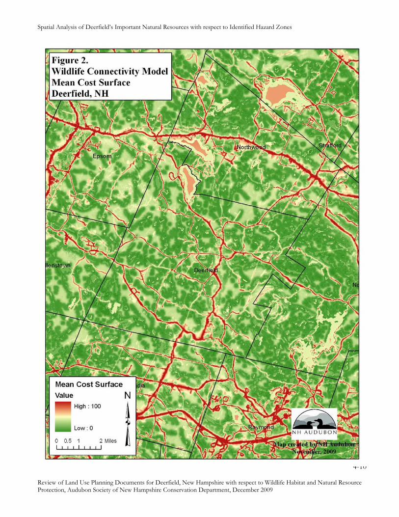
Spatial Analysis of Deerfield’s Important Natural Resources with respect to Identified Hazard Zones
4-10
Review of Land Use Planning Documents for Deerfield, New Hampshire with respect to Wildlife Habitat and Natural Resource Protection, Audubon Society of New Hampshire Conservation Department, December 2009
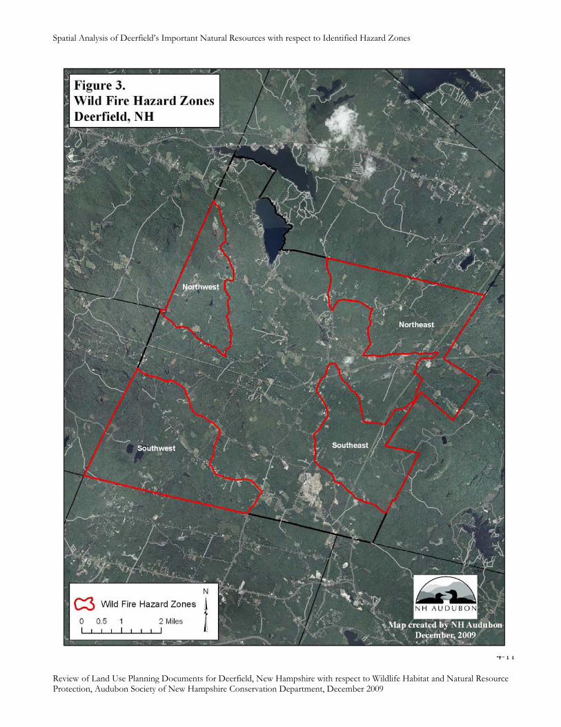
Spatial Analysis of Deerfield’s Important Natural Resources with respect to Identified Hazard Zones
4-11
Review of Land Use Planning Documents for Deerfield, New Hampshire with respect to Wildlife Habitat and Natural Resource Protection, Audubon Society of New Hampshire Conservation Department, December 2009

Spatial Analysis of Deerfield’s Important Natural Resources with respect to Identified Hazard Zones
4-12
Review of Land Use Planning Documents for Deerfield, New Hampshire with respect to Wildlife Habitat and Natural Resource Protection, Audubon Society of New Hampshire Conservation Department, December 2009
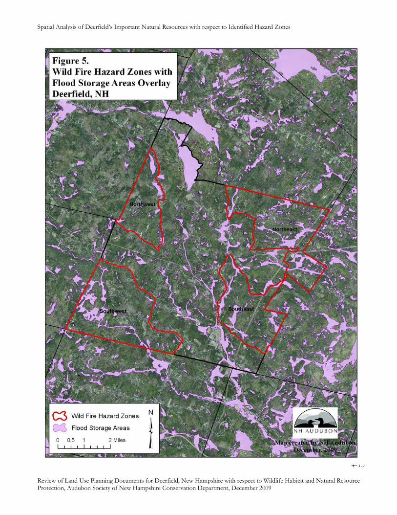
Spatial Analysis of Deerfield’s Important Natural Resources with respect to Identified Hazard Zones
4-13
Review of Land Use Planning Documents for Deerfield, New Hampshire with respect to Wildlife Habitat and Natural Resource Protection, Audubon Society of New Hampshire Conservation Department, December 2009

Spatial Analysis of Deerfield’s Important Natural Resources with respect to Identified Hazard Zones
4-14
Review of Land Use Planning Documents for Deerfield, New Hampshire with respect to Wildlife Habitat and Natural Resource Protection, Audubon Society of New Hampshire Conservation Department, December 2009

Spatial Analysis of Deerfield’s Important Natural Resources with respect to Identified Hazard Zones
4-15
Review of Land Use Planning Documents for Deerfield, New Hampshire with respect to Wildlife Habitat and Natural Resource Protection, Audubon Society of New Hampshire Conservation Department, December 2009
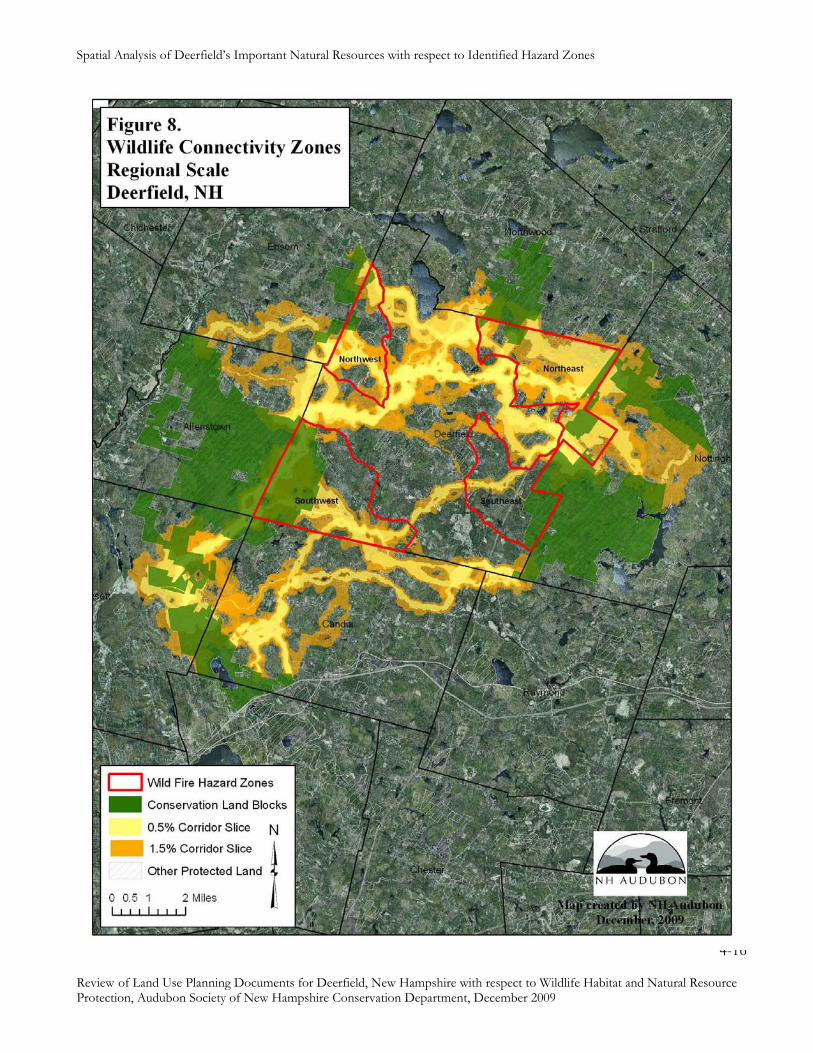
Spatial Analysis of Deerfield’s Important Natural Resources with respect to Identified Hazard Zones
4-16
Review of Land Use Planning Documents for Deerfield, New Hampshire with respect to Wildlife Habitat and Natural Resource Protection, Audubon Society of New Hampshire Conservation Department, December 2009
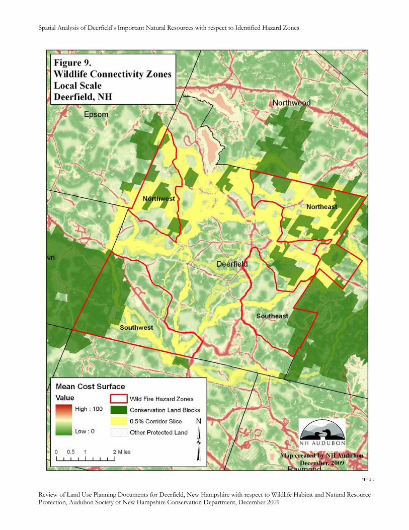
Spatial Analysis of Deerfield’s Important Natural Resources with respect to Identified Hazard Zones
4-17
Review of Land Use Planning Documents for Deerfield, New Hampshire with respect to Wildlife Habitat and Natural Resource Protection, Audubon Society of New Hampshire Conservation Department, December 2009

Spatial Analysis of Deerfield’s Important Natural Resources with respect to Identified Hazard Zones
4-18
Review of Land Use Planning Documents for Deerfield, New Hampshire with respect to Wildlife Habitat and Natural Resource Protection, Audubon Society of New Hampshire Conservation Department, December 2009
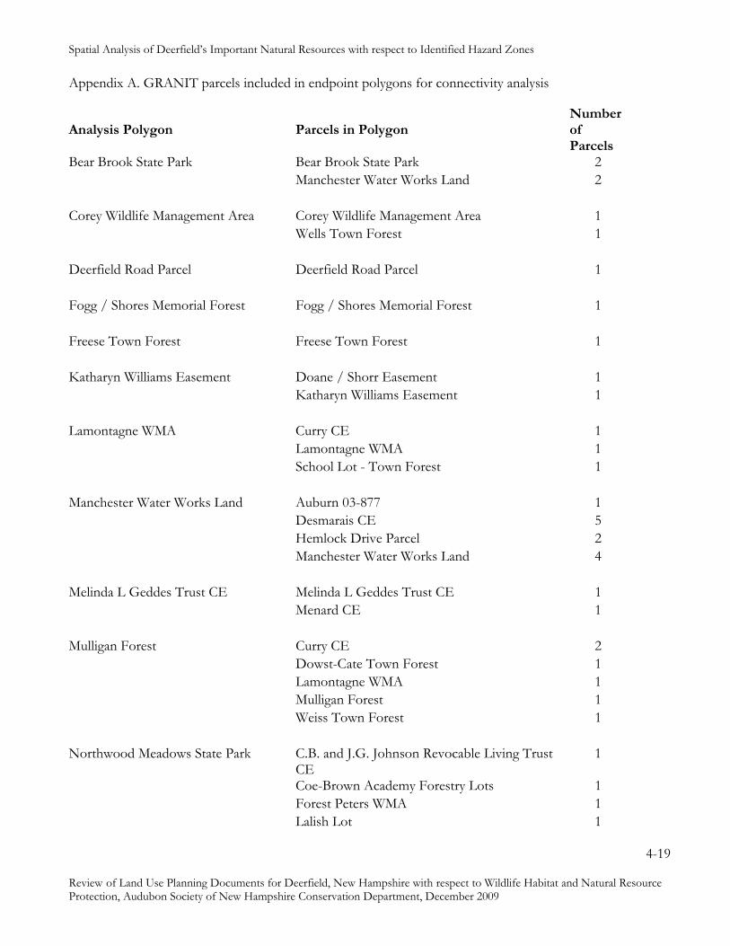
Spatial Analysis of Deerfield’s Important Natural Resources with respect to Identified Hazard Zones
4-19
Review of Land Use Planning Documents for Deerfield, New Hampshire with respect to Wildlife Habitat and Natural Resource Protection, Audubon Society of New Hampshire Conservation Department, December 2009
Appendix A. GRANIT parcels included in endpoint polygons for connectivity analysis
Analysis Polygon
Parcels in Polygon
Number of Parcels
Bear Brook State Park Bear Brook State Park 2 Manchester Water Works Land 2 Corey Wildlife Management Area Corey Wildlife Management Area 1 Wells Town Forest 1 Deerfield Road Parcel Deerfield Road Parcel 1 Fogg / Shores Memorial Forest Fogg / Shores Memorial Forest 1 Freese Town Forest Freese Town Forest 1 Katharyn Williams Easement Doane / Shorr Easement 1 Katharyn Williams Easement 1 Lamontagne WMA Curry CE 1 Lamontagne WMA 1 School Lot - Town Forest 1 Manchester Water Works Land Auburn 03-877 1 Desmarais CE 5 Hemlock Drive Parcel 2 Manchester Water Works Land 4 Melinda L Geddes Trust CE Melinda L Geddes Trust CE 1 Menard CE 1 Mulligan Forest Curry CE 2 Dowst-Cate Town Forest 1 Lamontagne WMA 1 Mulligan Forest 1 Weiss Town Forest 1 Northwood Meadows State Park C.B. and J.G. Johnson Revocable Living Trust
CE 1
Coe-Brown Academy Forestry Lots 1 Forest Peters WMA 1 Lalish Lot 1

Spatial Analysis of Deerfield’s Important Natural Resources with respect to Identified Hazard Zones
4-20
Review of Land Use Planning Documents for Deerfield, New Hampshire with respect to Wildlife Habitat and Natural Resource Protection, Audubon Society of New Hampshire Conservation Department, December 2009
Analysis Polygon
Parcels in Polygon
Number of
Parcels Northwood Meadows State Park McNeil Conservation Area Town Forest 1 Northwood Meadows State Park 1 Parsonage Lot - Town Forest 1 Town of Northwood Land 1 UNH Saddleback Mountain 1 Wallman C.M. CE 1 Olsen/Villnave CE Epsom Town Forest 1 Fokas, et al. 2 Hart Town Forest 1 Jackson CE 1 Olsen/Villnave CE 1 Steward Easement 1 Pawtuckaway State Park Brower 1 Pawtuckaway State Park 1 Rosenfield / Mallette Easement 1 Stillbach CE 1 Willoughby Easement 1 Pendleton CE H. and J. Burbank CE 1 H. Burbank CE 1 Jaeger CE 1 Lewis Builders, Inc. CE 1 Malovin CE 1 Pendleton CE 2 Steve Cruikshank Memorial Easement 1 Woodman State Forest Doles Marsh WMA 3 Woodman Marsh WMA 2 Woodman State Forest 1

Review of Land Use Planning Documents for Deerfield, NH with respect to Wildlife Habitat and Natural
Resource Protection, Audubon Society of NH, for Deerfield NH Planning Board, funded by NHDOT Community Technical Assistance Program (CTAP) Round 1 Discretionary Funds, Dec 2009
Section 5: Voluntary Practices to Protect Wildlife Habitat
5-1
Balancing Development and Rural Character:
Voluntary Practices to Protect Important Wildlife Habitat Features
During Development and Other Land Use Changes
Prepared by
New Hampshire Audubon
and
The Jordan Institute
for the
New Hampshire Fish & Game Department
December 2007
Expanded June 2009
Review of Land Use Planning Documents for Deerfield, NH with respect to Wildlife Habitat and Natural
Resource Protection, Audubon Society of NH, for Deerfield NH Planning Board, funded by NHDOT Community Technical Assistance Program (CTAP) Round 1 Discretionary Funds, Dec 2009
Section 5: Voluntary Practices to Protect Wildlife Habitat
Copyright 2007 New Hampshire Audubon and The Jordan Institute 5-2
Voluntary Practices to Protect Important Wildlife Habitat Features
Introduction
Voluntary practices provide opportunities for communities to encourage protection of habitat and
other natural resources during development in the absence of regulations. Voluntary practices
are particularly useful tools for protecting habitat features that are scattered on the landscape,
such as deer wintering areas or vernal pools. Such features benefit from flexible approaches to
protection that can be designed through discussions between planners and developers, rather than
by “one-size-fits-all” regulations. Voluntary practices also can be incorporated into incentive
approaches, such as density bonuses, to protect natural resources in communities with minimal
land use regulations.
Successful application of voluntary practices depends on pre-application conferences between
planners and developers. These meetings provide an opportunity for developers to share ideas
about prospective use of a land parcel before investing in surveys and engineering studies, and
for municipal planners to share concerns about natural resources associated with the parcel that
are important to the community. The parties can then develop consensus on an approach to
development that protects the important resources, and the points of agreement become special
conditions of the subdivision or site plan permit.
This document includes voluntary practices designed to protect the following habitats:
Deer wintering areas
Important mast stands
Headwater streams
Natural vegetation
Raptor nest trees
Shorelands and riparian areas
Vernal pools
For each topic, we provide a brief issue statement, objectives for the voluntary practices, a
justification and benefits section, a list of implementation strategies, and technical references.
We welcome comments and suggestions from municipalities on the usefulness of these practices,
ways in which they might be improved, and additional topics for which voluntary practices
might be helpful.

Review of Land Use Planning Documents for Deerfield, NH with respect to Wildlife Habitat and Natural
Resource Protection, Audubon Society of NH, for Deerfield NH Planning Board, funded by NHDOT Community Technical Assistance Program (CTAP) Round 1 Discretionary Funds, Dec 2009
Section 5: Voluntary Practices to Protect Wildlife Habitat
Copyright 2007 New Hampshire Audubon and The Jordan Institute 5-3
Deer Wintering Areas
Issue: Human activity in deer wintering areas can have negative impacts on both people and
deer.
Objectives
• Avoid destruction of deer wintering habitat.
• Minimize disturbance of wintering deer from human activity and domestic dogs.
• Minimize negative interactions between deer and people, including
o Wildlife/vehicle collisions
o Human exposure to wildlife-borne diseases
o Property damage from foraging deer.
Justification/Benefits
The white-tailed deer is both ecologically and economically important in New Hampshire. Deer
hunting has a significant economic impact in the state, with estimated annual expenditures of
$47,344,000 associated with big game hunting in New Hampshire, based on data from 2001
(U.S. Dept. of the Interior and U.S. Dept. of Commerce 1993). Deer are also popular subjects for
wildlife observation and photography. Such “non-consumptive use” of wildlife (not specifically
deer) in New Hampshire generated an estimated $325,658,000 in 2001, more than half of which
was spent by non-residents.
Local deer densities in New Hampshire range from less than 6 per sq. mi. in the White
Mountains to 16-19 per sq. mi. in the southern part of the state, and average about 10 per square
mile statewide (Gustafson 2004).
New Hampshire is near the northern limit of the white-tailed deer’s range, which extends to the
north shore of the Saint Lawrence River in Quebec (Halls 1984). In northern areas with severe
winters, deer maintain distinctly different ranges during the winter and during the milder part of
the year.
Nutritional stress during severe winters may result in more than 30% mortality of adults, as well
as high mortality of fawns born the following spring (Lavigne 1999).
Studies in the northeast indicate that deer begin to move from summer/fall range to wintering
areas when snow depths reach approximately 15 inches (Tierson et al. 1985). They commonly
move 4-5 miles between summer and winter ranges, and may move more than 25 miles (Lavigne
1999).
Roads do not pose barriers to deer movement, as they do with many other species of wildlife.
Deer commonly cross highways and other busy roads. In fact, collisions with vehicles on New
Review of Land Use Planning Documents for Deerfield, NH with respect to Wildlife Habitat and Natural
Resource Protection, Audubon Society of NH, for Deerfield NH Planning Board, funded by NHDOT Community Technical Assistance Program (CTAP) Round 1 Discretionary Funds, Dec 2009
Section 5: Voluntary Practices to Protect Wildlife Habitat
Copyright 2007 New Hampshire Audubon and The Jordan Institute 5-4
Hampshire highways have killed more than 1000 deer annually since 1989 (Gustafson 2004).
Based on recent population estimates of approximately 82,000 deer statewide, about 12% of the
deer herd is lost to road mortality each year. With increasing numbers of vehicles, there is
increasing mortality due to collisions. Deer killed by cars has increased from 662 in 1987
(accounting for 80% of all deer mortality) to 1292 in 2003 (91 % of total mortality (Gustafsen
2004). From 1995 to 2003, there were seven years in which collisions accounted for 93% or
more of deer mortality, and three years in which vehicle collisions caused 96% of all deer
mortality.
Deer wintering areas occur in softwood stands of various types, often in riparian areas. In
northern New Hampshire, deer wintering areas are typically located in low elevation stands of
red spruce, balsam fir, and northern white cedar. These areas may cover areas of more than 1000
acres and support hundreds of deer. In the southern part of the state, wintering areas are
typically scattered patches of hemlock as small as a half acre. Such small wintering areas
accommodate 20 or 30 deer during bouts of severe weather and 15 inches or more of snow, but
deer in southern New Hampshire do not typically spend long periods of time in these “yards.” In
mild winters, deer may not “yard up” at all in southern New Hampshire (Gustafson, pers.
commun.).
Deer wintering areas consist of core areas with dense coniferous trees that reduce snow
accumulation and provide shelter from wind, adjacent to mixed hardwood and coniferous trees
that provide an accessible food supply. Softwood canopy height of at least 35 feet and average
canopy cover of 65-70% are required to provide functional shelter (Reay et al.1990).
Deer are hosts of the black-legged tick (or “deer tick”), which is a vector in the transmission of
Lyme disease. Black-legged ticks occur throughout most of southern and central New
Hampshire. Many factors influence the occurrence of black-legged ticks and incidence of Lyme
disease among humans, but in general, areas of high deer densities are more likely to exhibit
greater black-legged tick abundance and higher Lyme disease incidence rates in humans
(Gustafsen 2004).
Deer and human populations have increased since the early 1980’s, especially in the southern
part of the state, resulting in greater potential for human-deer conflicts. Calls to Wildlife
Services for assistance with deer damage rose sharply form 1988 through 1993, but have
remained fairly consistent since then. From 1993 to 2002, requests that were agriculturally
related accounted for about half of all calls, varying from 39-62% for that time period (Gustafsen
2004).
Implementation Strategies
Review of Land Use Planning Documents for Deerfield, NH with respect to Wildlife Habitat and Natural
Resource Protection, Audubon Society of NH, for Deerfield NH Planning Board, funded by NHDOT Community Technical Assistance Program (CTAP) Round 1 Discretionary Funds, Dec 2009
Section 5: Voluntary Practices to Protect Wildlife Habitat
Copyright 2007 New Hampshire Audubon and The Jordan Institute 5-5
• Identify deer wintering areas on site map, including core shelter area, surrounding hardwood
buffer extending at least 200 feet from perimeter of core, and corridors connecting wintering
areas to surrounding habitats.
• Avoid any clearing or other construction activity within identified deer wintering areas.
• Locate houses to discourage winter intrusion of humans and domestic dogs into identified
wintering areas.
• Locate roads to avoid fragmenting of deer use areas, and plan for low traveling speeds to
minimize the potential for vehicle-deer collisions.
• Install fences around residential properties adjacent to buffer habitat to discourage intrusions
of humans and dogs.
• Avoid landscaping techniques that attract deer into the interior of the neighborhood.
• Discourage intentional feeding of deer, and encourage fencing of gardens to reduce
attraction of deer to residential properties.
References
FSSWT (New Hampshire Forest Sustainability Standards Work Team) 1997. Good Forestry in
the Granite State: Recommended Voluntary Forest Management Practices for New Hampshire.
New Hampshire Division of Forests & Lands, DRED and Society for the Protection of New
Hampshire Forests, Concord.
Gustafson, K.A. 2004. New Hampshire White-tailed Deer Assessment 2004. New Hampshire
Fish & Game Department, Concord.
Halls, L.K., ed. 1984. White-tailed Deer: Ecology and Management. Stackpole Books,
Harrisburg, PA.
Lavigne, G.R. 1999. White-tailed Deer Assessment and Strategic Plan 1997. Maine Department
of Inland Fisheries and Wildlife, Augusta.
Reay, R.S., D.W. Blodgett, B.S. Burns, S.J. Weber, ad T. Frey. 1990. Management Guide for
Deer-Wintering Areas in Vermont. Vermont Department of Forests, Parks, & Recreation and
Department of Fish & Wildlife, Montpelier, VT.

Review of Land Use Planning Documents for Deerfield, NH with respect to Wildlife Habitat and Natural
Resource Protection, Audubon Society of NH, for Deerfield NH Planning Board, funded by NHDOT Community Technical Assistance Program (CTAP) Round 1 Discretionary Funds, Dec 2009
Section 5: Voluntary Practices to Protect Wildlife Habitat
Copyright 2007 New Hampshire Audubon and The Jordan Institute 5-6
Tierson, W.C., G.F. Mattfeld, R.W. Sage, Jr., and D.F. Behrend. 1985. Seasonal movements and
home ranges of white-tailed deer in the Adirondacks. Journal of Wildlife Management 49(3):
760-769.
U.S. Dept. of the Interior, Fish and Wildlife Service and U.S. Department of Commerce, Bureau
of the Census. 2003. 2001 National Survey of Fishing, Hunting, and Wildlife-Associated
Recreation – New Hampshire. U.S. Government Printing Office, Washington, DC.
Review of Land Use Planning Documents for Deerfield, NH with respect to Wildlife Habitat and Natural
Resource Protection, Audubon Society of NH, for Deerfield NH Planning Board, funded by NHDOT Community Technical Assistance Program (CTAP) Round 1 Discretionary Funds, Dec 2009
Section 5: Voluntary Practices to Protect Wildlife Habitat
Copyright 2007 New Hampshire Audubon and The Jordan Institute 5-7
Floodplain Forests
Issue: Clearing floodplain forests increases bank erosion and downstream flood damage and
destroys important wildlife habitat.
Objectives:
• Protect floodplain forest vegetation to mitigate flood damage and maintain biodiversity.
• Minimize recreational activity in floodplain forests to prevent soil compaction and
wildlife disturbance.
Justification/Benefits
A floodplain is a valley floor where water spreads out after overtopping the banks of a stream
(Gordon et al. 1992, Riley 1998).
Annual shallow river flooding is common in the northern United States during spring snowmelt
(Daniels and Daniels 2003).
The timing, duration, and depth of flooding are important influences on floodplain vegetation
(Mitsch and Gosselink 1986, McKevlin et al. 1997).
In New Hampshire, floodplain forests occur primarily along third and higher order rivers
(Sperduto 2005).
Floodplain plants are specially adapted to tolerate inundation for part of the year (Mitsch and
Gosselink 1986, Verry et al. 2000).
Small elevation changes within a floodplain result in large changes in the depth and duration of
flooding, and in the resulting plant communities (Mitsch and Gosselink 1986).
Long histories of stream meanders, erosion, and deposition create variable topography within
floodplains, resulting in complex vegetation patterns. Floodplain systems often include sloughs,
oxbows, shrub swamps, wet meadows, and vernal pools, as well as floodplain forests.
Two major types of floodplain forests in occur in northern New Hampshire and the White
Mountains. These forests develop along rivers with floods of high intensity and short duration
that result from mountain runoff. One type consists primarily of sugar maple, red oak, ironwood,
white ash, black cherry, and white pine; the other of balsam fir, red maple, white pine, and
speckled alder (Sperduto 2005).

Review of Land Use Planning Documents for Deerfield, NH with respect to Wildlife Habitat and Natural
Resource Protection, Audubon Society of NH, for Deerfield NH Planning Board, funded by NHDOT Community Technical Assistance Program (CTAP) Round 1 Discretionary Funds, Dec 2009
Section 5: Voluntary Practices to Protect Wildlife Habitat
Copyright 2007 New Hampshire Audubon and The Jordan Institute 5-8
Silver maple floodplain forests occur along the Connecticut and Merrimack rivers and the lower
reaches of their major tributaries. White ash, American elm, hackberry, and Eastern cottonwood
also may grow in these forests (Sperduto 2005).
Red maple dominates the floodplain forests along smaller rivers in central and southern New
Hampshire. These forests also may include black ash, black cherry, and ironwood (Sperduto
2005).
During floods, floodplain forests slow water movement, capture sediment and nutrients, and
shelter aquatic organisms from strong currents (Gordon et al. 1992).
Floodplain forests provide buffers between developed areas and waterways (Daniels and Daniels
2003).
Floodplain forests facilitate the recharge of aquifers during periods of inundation (Verry et al.
2000, Gordon et al. 1992).
Floodplain forests facilitate the transfer of nutrients from aquatic to terrestrial ecosystems by
capturing organic matter and sediments from floodwaters during periods of inundation (Gordon
et al. 1992).
Floodplain forests provide a natural filtering system for stormwater runoff (Daniels and Daniels
2003).
New Hampshire’s floodplain forests provide important habitat for native wildlife, including
wood turtle, northern leopard frog, American woodcock, northern oriole, blue-gray gnatcatcher,
yellow-throated vireo, otter, eastern red bat, and silver-haired bat (NHFG 2005).
Implementation Strategies
• Avoid or minimize clearing and other construction activity within floodplain forests.
• Locate houses to discourage intrusion of pets into floodplain forests.
• Design recreational facilities to minimize impacts on floodplain forests.
References
Daniels, T. and K. Daniels. 2003. The Environmental Planning Handbook for Sustainable
Communities and Regions. American Planning Association, Chicago IL.
Review of Land Use Planning Documents for Deerfield, NH with respect to Wildlife Habitat and Natural
Resource Protection, Audubon Society of NH, for Deerfield NH Planning Board, funded by NHDOT Community Technical Assistance Program (CTAP) Round 1 Discretionary Funds, Dec 2009
Section 5: Voluntary Practices to Protect Wildlife Habitat
Copyright 2007 New Hampshire Audubon and The Jordan Institute 5-9
Gordon, N.D., T. A. McMahon, and B.L. Finlayson. 1992. Stream Hydrology. John Wiley &
Sons, New York.
McKevlin, M.R., D.D. Hook, and A.A. Rozelle. 1997. Adaptations of plants to flooding and soil
waterlogging. Pp. 173-204 in M.G. Messina and W. H. Conner, eds. Southern forested wetlands:
ecology and management. Lewis Publishers, New York.
NHFG. 2005. New Hampshire Wildlife Action Plan. NH Fish & Game Department, Concord,
NH.
Riley, A.L. 1998. Restoring Streams in Cites: A guide for planners, policymakers, and citizens.
Island Press, Washington, D.C.
Sperduto, D.D. 2005. Natural Community Systems of New Hampshire. NH Natural Heritage
Bureau and The Nature Conservancy, Concord, NH.
Verry, E.S., J.W. Hornbeck, and C. A. Dolloff. 2000. Riparian Management in Forests of the
Continental Eastern United States. Lewis Publishers, Boca Raton, FL.

Review of Land Use Planning Documents for Deerfield, NH with respect to Wildlife Habitat and Natural
Resource Protection, Audubon Society of NH, for Deerfield NH Planning Board, funded by NHDOT Community Technical Assistance Program (CTAP) Round 1 Discretionary Funds, Dec 2009
Section 5: Voluntary Practices to Protect Wildlife Habitat
Copyright 2007 New Hampshire Audubon and The Jordan Institute 5-10
Headwater streams
Issue: Alteration of headwater streams can degrade important aquatic habitat and affect flow
regimes and water quality downstream in the watershed.
Objective
• Avoid destruction and degradation of headwater streams and adjacent riparian habitats from
development and other human activities.
Justification & Benefits
Streams are categorized based on their size and relationship to the rest of the stream network.
Ephemeral streams flow only during snowmelt or heavy rains; intermittent streams flow for
several, but not all months of the year; and perennial streams flow year-round. First-order
perennial streams are the smallest distinct channels, and originate from springs and seeps, where
groundwater comes to the surface. Second-order streams are formed when two first-order
streams join. Third-order streams are formed from two second-order streams, and so on up to
fifth-order streams, which are large rivers.
A river’s headwaters include the small streams and wetlands in the higher elevations of a
watershed. Headwater streams are typically only a few feet wide and a few inches to a few feet
deep. They include ephemeral, intermittent, and first- and second-order perennial streams.
Headwaters also include small wetlands that are hydrologically connected to stream channels by
groundwater.
Headwater streams are numerous and widespread, comprising at least 80% of the stream network
in the United States (Meyer et al. 2007a).
Several comprehensive watershed surveys suggest that USGS maps show less than 20% of the
actual stream network in humid regions of the country, such as the northeast (Meyer et al.
2007a).
Headwater streams and wetlands are critically important to the health and functions of the rivers
they feed, and their destruction or degradation can severely impair downstream reaches.
Headwaters play key roles in maintaining water quality and quantity, stream and river channel
integrity, and aquatic biodiversity (Lowe and Likens 2005).
Because they are small, headwater streams are highly vulnerable to impacts from terrain
alteration and other human activities.

Review of Land Use Planning Documents for Deerfield, NH with respect to Wildlife Habitat and Natural
Resource Protection, Audubon Society of NH, for Deerfield NH Planning Board, funded by NHDOT Community Technical Assistance Program (CTAP) Round 1 Discretionary Funds, Dec 2009
Section 5: Voluntary Practices to Protect Wildlife Habitat
Copyright 2007 New Hampshire Audubon and The Jordan Institute 5-11
The winding channels, streambed rocks and gravel, debris dams of logs and leaf litter, and
streamside vegetation of headwater streams slow surface runoff and enable water to seep into
and recharge underlying groundwater.
In the northeastern U.S., first-order streams contribute approximately 70% of the mean annual
water volume in second order streams and approximately 55% of that in fourth and higher order
rivers (Alexander et al. 2007).
Terrain alteration and impervious surfaces that increase the rate of flow in headwater streams can
increase erosion and sedimentation along downstream reaches.
A study in northern New Hampshire documented declines of spring salamander populations in
streams degraded by sedimentation (Lowe and Bolger 2002).
Heavy sediment loads retard the growth of submerged aquatic plants, clog fish and larval
amphibian gills, smother fish eggs, disrupt fish behavior, and eliminate habitat for fish eggs and
fry (Bjornn and Reiser 1991, Waters 1995).
Streams receive nutrients in the form of leaf litter and other debris, which supports a variety of
aquatic invertebrates. Many invertebrates, their eggs and larvae are prey for small fish,
salamanders, and mammals such as the water shrew.
Headwater streams remove or transform nutrients more effectively than larger streams through
physical, chemical, and biological processes.
Recent research on a sampling of watersheds across North America suggests that half the nitrate
removal within a river basin occurs in headwater streams (Meyers et al. 2007).
A study of eight northeastern watersheds suggests that wetlands associated with first order
streams are responsible for 90% of wetland phosphorus removal (Meyers et al. 2007a).
A mathematical model based on field data from 14 headwater streams across North America
suggests that 64% of inorganic nitrogen entering a small stream is retained or transformed within
1,000 yards (Meyers et al. 2007a).
Some headwater streams process organic material eight times more efficiently than fourth-order
reaches downstream (Meyers et al. 2007a).
Processed organic matter forms the basis of food web for the entire river. Nutrients in the form
of dissolved organic carbon, particles of fungus and leaf litter, dead plants, insects, fish and other
animals, all flow downstream to support populations of other species. In Alaska, a study of
fishless headwater streams concluded that enough insects and other invertebrates drifted

Review of Land Use Planning Documents for Deerfield, NH with respect to Wildlife Habitat and Natural
Resource Protection, Audubon Society of NH, for Deerfield NH Planning Board, funded by NHDOT Community Technical Assistance Program (CTAP) Round 1 Discretionary Funds, Dec 2009
Section 5: Voluntary Practices to Protect Wildlife Habitat
Copyright 2007 New Hampshire Audubon and The Jordan Institute 5-12
downstream to support half of the fish population of downstream river reaches (Meyers et al.
2007a).
Headwater streams include a broad array of habitats, from cold, fast-moving brooks with
alternating pools and riffles to shallow, muddy seeps, outflows of beaver ponds, and cool, clear
springs. Elevation, slope, substrate, channel shape, water chemistry, and surrounding uplands
all influence the aquatic life of headwater streams. Studies of three unmapped headwater
streams in North Carolina documented more than 290 species of bacteria, fungi, plants, snails,
insects, crayfish, fish, and amphibians, some of which were unique to these environments
(Meyer et al. 2007b).
Some fish species, including brook trout, use headwater streams for reproduction, seasonal
feeding areas, and refuge during flood conditions.
Headwater wetlands also support important biological diversity. Studies have documented 274
at-risk plant and animal species in isolated wetlands, more than one-third of which are restricted
to these habitats (Meyer et al. 2007).
Implementation strategies
• Conduct field survey of parcel to identify headwater streams and wetlands, including springs
and seeps.
• Avoid disturbance to headwater streams and wetlands.
• Avoid terrain alteration and impervious surfaces that will increase flow rates in headwater
streams.
• Avoid or minimize road crossings of headwater streams.
• Avoid construction activity within 100 ft. of ephemeral, intermittent, first and second order
streams, and headwater wetlands.
References
Alexander, R.G., E.W. Boyer, R.A. Smith, G.E. Schwarz, and R.B. Moore. 2007. The role of
headwater streams in downstream water quality. Journal of the American Water Resources
Association 43: 41-59.

Review of Land Use Planning Documents for Deerfield, NH with respect to Wildlife Habitat and Natural
Resource Protection, Audubon Society of NH, for Deerfield NH Planning Board, funded by NHDOT Community Technical Assistance Program (CTAP) Round 1 Discretionary Funds, Dec 2009
Section 5: Voluntary Practices to Protect Wildlife Habitat
Copyright 2007 New Hampshire Audubon and The Jordan Institute 5-13
Bjorn, R.C. and D.W. Reiser. 1991. Habitat requirements of salmonids in streams. Pp. 83-138 in
W.R. Meehan, ed. Influences of Forest and Rangeland Management on Salmonid Fishes and
Thier Habitat. American Fisheries Society, Bethesda, MD.
Lowe, W.H., and D.T. Bolger. 2002. Local and landscape-scale predictors of salamander
abundance in New Hampshire headwater streams. Conservation Biology 16:183-193.
Manual of Best Management Practices (BMPs) for Agriculture in New Hampshire: Best
Management Practices for the Handling of Agricultural Compost, Fertilizer, and Manure. New
Hampshire Dept. of Agriculture, Markets, and Food, Concord, NH. 41pp.
Meyer, J.L., L.A. Kaplan, D. Newbold, C.J. Woltemade, J.B. Zedler, R. Beilfuss, Q. Carpenter,
R. Semlitsch, M.C. Watzin, and P.H. Zedler. 2007a. Where Rivers are Born: The Scientific
Imperative for Defending Small Streams and Wetlands. American Rivers and Sierra Club,
Washington, D.C.
Meyer, J.L., D.L. Strayer, J.B. Wallace, S.L. Eggert, G.S. Helfman, and N.E. Leonard. 2007b.
The cotribution of headwater streams to biodiversity in river networks. Journal of the American
Wter resources Association 43: 86-103.
New Hampshire Forest Sustainability Standards Work Team. 1997. Good Forestry in the
Granite State: Recommended Voluntary Forest Management Practices for New Hampshire. New
Hampshire Division of Forests & Lands, DRED; and the Society for the Protection of New
Hampshire Forests.
Waters, T.F. 1995. Sediment in streams: sources, biological effects and control. American
Fisheries Society. Bethesda, MD.

Review of Land Use Planning Documents for Deerfield, NH with respect to Wildlife Habitat and Natural
Resource Protection, Audubon Society of NH, for Deerfield NH Planning Board, funded by NHDOT Community Technical Assistance Program (CTAP) Round 1 Discretionary Funds, Dec 2009
Section 5: Voluntary Practices to Protect Wildlife Habitat
Copyright 2007 New Hampshire Audubon and The Jordan Institute 5-14
Mast stands
Issue: Development may destroy or eliminate wildlife access to stands of nut-producing trees,
especially oak, beech, and hickory, which provide high value food sources important to winter
survival of some wildlife species, especially black bears.
Objectives
• Ensure access to adequate fall food supply for mast-dependent wildlife.
• Minimize negative interactions between mast-dependent wildlife and people, including
o Wildlife/vehicle collisions
o Human exposure to wildlife-borne diseases
o Property damage from deer and bears.
Justification/Benefits
Wild nuts, known as hard mast, are especially important food sources for native wildlife. New
Hampshire’s wild nut crops become available during the time of year when wildlife are preparing
for winter by storing food or increasing their fat reserves.
American beech and red, white, and black oaks are the most widespread and abundant mast-
producing tree species in New Hampshire. Scarlet, chestnut, and swamp white oaks; bitternut,
mockernut, pignut, and shagbark hickories; beaked and American hazelnuts; and butternut also
occur in New Hampshire, but are less abundant and have limited distribution in the state.
The American chestnut, formerly one of the most important mast-bearing trees in eastern North
America, has nearly disappeared since accidental introduction of an Asian virus from Asia in the
early 1900’s. The resulting blight essentially eliminated the chestnut from New Hampshire’s
forests by about 1920 (Silver 1957). This loss increases the importance of the remaining mast-
producing species.
Another New Hampshire mast-bearing tree, the butternut, is falling victim throughout its range
in eastern North America to a rapidly spreading fungus disease (Schlarbaum et al. 1997).
American beech is also being severely impacted by a disease (an insect and fungus complex),
which was introduced to Nova Scotia in the mid-1800’s (Houston 2004) and reached New
Hampshire by 1949 (Gavin and Peart 1993). Studies have shown that diseased beech forests
have reduced foliage and mast compared to healthy stands (Storer et al. 2004).
Single ounces of acorns, beechnuts, hazelnuts, and hickory nuts contain 109, 163, 177, and 186
calories, respectively (compared to 15 calories in one ounce of apple) (Nutrition Data 2005).
Review of Land Use Planning Documents for Deerfield, NH with respect to Wildlife Habitat and Natural
Resource Protection, Audubon Society of NH, for Deerfield NH Planning Board, funded by NHDOT Community Technical Assistance Program (CTAP) Round 1 Discretionary Funds, Dec 2009
Section 5: Voluntary Practices to Protect Wildlife Habitat
Copyright 2007 New Hampshire Audubon and The Jordan Institute 5-15
Production of heavy wild nut crops is typically cyclical. Intervals between heavy crops are
typically 2-8 years for American beech, 1-3 years for shagbark hickory, 4-10 years for white oak,
2-5 years for red oak, 2-3 years for black oak, and 4-5 years for chestnut oak (Burns and Honkala
1990). Maintaining a diversity of nut-bearing species within a local area increases the likelihood
of at least one good mast crop in a given year.
New Hampshire’s native nut-bearing trees typically begin to produce large numbers of nuts at
40-60 years of age (Burns and Honkala 1990).
A typical white oak tree growing in a forest probably produces about 10,000 acorns in a good
year (Rogers 1990).
Wildlife species that rely heavily on nuts (hard mast) include black bear; white-tailed deer; red,
gray, and northern and southern flying squirrels, eastern chipmunk, white-footed mouse, fisher,
pine marten, wood duck, ruffed grouse, wild turkey, and blue jay (Martin et al. 1961).
Black bears are especially dependent on beech nuts in order to accumulate fat reserves for
winter, and may concentrate on finding beech nuts above other foods during the fall. Bears may
travel up to 100 linear miles outside of their normal range during the fall in order to take
advantage of localized sources of nuts, as well as berries, other fruits, and agricultural crops
(Miller 1975, Elowe 1987, Kolenosky and Strathearn 1987, Pelton 2003 in Timmins 2004).
Food abundance influences the age at which bears first reproduce, the size and frequency of
litters, seasonal movements, and mortality rates (Pelton 1980).
Research in Maine indicates that nearly four times as many female black bears may reproduce in
years of high beechnut production as do so in years of poor production (Jakubas et al. 2004).
When female bears lack sufficient fat reserves, fertilized eggs may not implant, fetuses may be
absorbed, or cubs may die at birth from malnutrition (Timmins 2004).
Bears are more likely to damage field corn and raid dumpsters, bird feeders, and beehives in
years of poor acorn and beechnut crops (Timmins 2004).
Bears prefer birdseed to most available natural foods (Hammond 2002).
Bears that overcome their natural wariness of humans to approach backyard bird feeders are at
increased risk of being killed as nuisance bears or by collisions with vehicles (Hammond 2002).
Adult black bears followed by radio telemetry in the vicinity of the Stratton Mountain Ski Resort
in Vermont stayed an average of 200-400 m from year-round houses, with avoidance distances
varying by sex and season (Hammond 2002).

Review of Land Use Planning Documents for Deerfield, NH with respect to Wildlife Habitat and Natural
Resource Protection, Audubon Society of NH, for Deerfield NH Planning Board, funded by NHDOT Community Technical Assistance Program (CTAP) Round 1 Discretionary Funds, Dec 2009
Section 5: Voluntary Practices to Protect Wildlife Habitat
Copyright 2007 New Hampshire Audubon and The Jordan Institute 5-16
Implementation Strategies
• Consult with New Hampshire Fish & Game Department biologists to identify locations of
o black bear habitat blocks
o important mast stands
in your area of interest.
Within or adjacent to black bear habitat blocks
• Avoid construction of houses within 300 m of important mast stands.
• Avoid construction of paved roads within 200 m of important mast stands.
• Maintain travel opportunities between important mast stands and large blocks of protected
or undeveloped habitat.
In other areas
• Avoid locating house lots within important mast stands.
• Avoid locating roads between important mast stands and large blocks of protected or
undeveloped habitat.
References
Burns, R.M. and B.H. Honkala. 1990. Silvics of North America, Volume 2, Hardwoods. USDA
Forest Service Agriculture Handbook 654, Washington, D.C.
Elowe, K. 1987. Factors affecting black bear reproductive success and cub survival in
Massachusetts. Ph. D. Thesis, Univ. Massachusetts, Amherst. 71pp.
Gavin, D.G., and D.R. Peart. 1993. Effects of beech bark disease on the growth of American
beech (Fagus grandifolia). Canadian Journal of Forest Research 23, 1566-1575) in E.F. Latty.
2004. Stand-level patterns and Ecosystem Consequences of Beach Bark Disease. Pages 36-42
in Beech Bark Disease: Proceedings of the Beech Bark Disease Symposium, USDA Forest
Service, Northeast Forest Experiment Station, Gen. Tech. Rep. NE-331.
Review of Land Use Planning Documents for Deerfield, NH with respect to Wildlife Habitat and Natural
Resource Protection, Audubon Society of NH, for Deerfield NH Planning Board, funded by NHDOT Community Technical Assistance Program (CTAP) Round 1 Discretionary Funds, Dec 2009
Section 5: Voluntary Practices to Protect Wildlife Habitat
Copyright 2007 New Hampshire Audubon and The Jordan Institute 5-17
Hammond, F.M. 2002. Stratton Mountain Black Bear Study: The Effects of Resort and
Residential Development on Black Bears in Vermont Final Report. Vermont Agency of Natural
Resources Department of Fish and Wildlife
Houston, D.R. 2004. Beech Bark Disease: 1934 to 2004: What’s new since Ehrlich? Keynote
Address. Pages 2-13 in Beech Bark Disease: Proceedings of the Beech Bark Disease
Symposium, USDA Forest Service, Northeast Forest Experiment Station, Gen. Tech. Rep. NE-
331.
Houston, D.R., E.J. Parker, and D. Lonsdale. 1979. Beech bark disease: patterns of spread and
development of the initiating agent Cryptococcus fagisuga. Canadian Journal of Forest Research
9, 336-344. in E.F. Latty. 2004. Stand-level patterns and Ecosystem Consequences of Beach
Bark Disease. Pages 36-42 in Beech Bark Disease: Proceedings of the Beech Bark Disease
Symposium, USDA Forest Service, Northeast Forest Experiment Station, Gen. Tech. Rep. NE-
331.
Jakubas, W.J., C.R. McLaughlin, P.G. Jensen, and S.A. McNulty. 2004. Alternate year
beechnut production and its influence on bear and marten populations. Pages 79-87 in Beech
Bark Disease: Proceedings of the Beech Bark Disease Symposium, USDA Forest Service,
Northeast Forest Experiment Station, Gen. Tech. Rep. NE-331.
Kolensosky, G.B., and S.M. Strathearn. 1987. Black bear. Pages 442-455 in M. Novak, J.A.
Baker, M.E. Obbard, and B. Mollock, eds. Wild furbearer management and conservation in
North America. Ont. Minist. Nat. Resour., Toronto, Can.
Martin, A.C., H.S. Zim and A.L. Nelson. 1961. American wildlife and plants: a guide to wildlife
food habits. Dover Publications., New York.
Miller, T.O. 1975. Factors influencing black bear habitat selection of Cheat Mountain, West
Virginia. M.S. Thesis. West Virginia University, Morgantown. 61pp.
NutritionData. 2005. www.nutritiondata.com/facts-001, 14 October 2005
Pelton, M.R. 1980. Final report to Office of Surface Mining regarding potential impacts on
black bears of mining on the Shavers Fork Basin, Monongahela National Forest, West Virginia.
University of Tennessee, Knoxville. 36pp.
__. 2003. Black bear (Ursus americanus). Pages 547-555 in G.A. Feldhamer, B.C.
Thompson, and J.A. Chapman, eds. Wild mammals of North America. John Hopkins University
Press, Baltimore and London. 1368 pp.
Review of Land Use Planning Documents for Deerfield, NH with respect to Wildlife Habitat and Natural
Resource Protection, Audubon Society of NH, for Deerfield NH Planning Board, funded by NHDOT Community Technical Assistance Program (CTAP) Round 1 Discretionary Funds, Dec 2009
Section 5: Voluntary Practices to Protect Wildlife Habitat
Copyright 2007 New Hampshire Audubon and The Jordan Institute 5-18
Schlarbaum, S.E., F. Hebard, P.C. Spaine, and J.C. Kamalay. 1997. Three American tragedies:
chestnut blight, butternut canker, and Dutch elm disease. Pp. 45-54 in Britton, K.O., Ed.
Proceedings of Exotic Pests of Eastern Forests, Apri 8-10 1997, Nashville, TN. Tennessee
Exotic Pest Plant Council.
Silver, H. 1957. A History of New Hampshire Game and Furbearers. NH Fish & Game Dept.,
Survey Report No. 6. Concord, NH. 466pp.
Storer, A.J., J.N. Rosemeier, B.L. Beachy, and D.J. Flaspohler. Potential effects of beech bark
disease and decline in beech abundance on birds and small mammals. Pages 72-78 in Beech
Bark Disease: Proceedings of the Beech Bark Disease Symposium, USDA Forest Service,
Northeast Forest Experiment Station, Gen. Tech. Rep. NE-331.
Timmins, A.A. 2004. New Hampshire Black Bear Assessment. New Hampshire Fish and
Game Dept., Concord. 92pp.
Natural vegetation
Issue: Some development approaches remove excessive natural vegetation from the site and
replace it with generic landscaping after road and building construction have been completed.
Objectives
• Minimize loss of natural vegetation resulting from construction activities.
• Capture asset value of existing vegetation by retaining special vegetative features of the site
(e.g., large diameter shade trees, clumps of native flowering shrubs, patches of native
vegetation).
Justification/Benefits
Most of New Hampshire’s natural vegetation consists of forests, which currently cover about
84% of the state’s area. Retaining natural vegetation on developed sites reduces air pollution,
soil erosion, stormwater runoff, heating and cooling costs, and glare and reflection from street
traffic. Natural vegetation also provides privacy and visual screening, absorbs sound, and
contributes to the aesthetic quality and uniqueness of a property, neighborhood, and community.
Generic landscaping materials often are poorly adapted for site conditions, require water and
fertilizer, have a high mortality rate, and require numerous growing seasons to mature enough to

Review of Land Use Planning Documents for Deerfield, NH with respect to Wildlife Habitat and Natural
Resource Protection, Audubon Society of NH, for Deerfield NH Planning Board, funded by NHDOT Community Technical Assistance Program (CTAP) Round 1 Discretionary Funds, Dec 2009
Section 5: Voluntary Practices to Protect Wildlife Habitat
Copyright 2007 New Hampshire Audubon and The Jordan Institute 5-19
provide full benefits. Natural vegetation maintains rural character by enabling new
developments to blend into the New Hampshire landscape.
An acre of trees uses about 2.6 tons of carbon dioxide each year (American Forestry
Association).
Large (diameter >30 inches) trees in Chicago removed approximately 70 times more polllution
from the air in 1991 than small (diameter < 3 inches) trees (Nowak 1994).
The surfaces of leaves and twigs trap particulate pollution that contributes to asthma and other
respiratory problems. One study found that a street with no trees had 4-100 times more dust
particles in the air than a nearby street with trees (Nelson 1975).
Thirty-seven medium-sized trees on approximately 6 acres can slow stormwater runoff by 37%
during heavy rain (Maine Forest Service 2000).
Pavement and roofs retain 5-30% of the rainfall from a 5- to 10-year storm; an average lawn (2-
7% slope) retains 75-82%, and a forested area retains 80-95% (Anderson 2000).
Red and sugar maple, basswood, and northern red oak trees in full foliage block more than 80%
of the sun’s visible radiation (Moffat et al. 1994).
Air pressure from winter winds affects the air in a building by pushing out air that is already
warmed and pushing in cold air that has to be heated. A building’s heat loss due to wind is
proportional to wind speed squared - as wind speed doubles, heat loss quadruples (Moffat et al.
1994).
A study in central Pennsylvania found that wind speeds 2 meters above the ground were 60%
lower in winter and 67% lower in summer in a residential neighborhood with 67% tree cover
compared to a neighborhood with no trees (Heisler 1990).
A typical mature deciduous tree evaporates 100 gallons of water per day during sunny summer
weather, using about 660,000 BTUs of energy and cooling the air as effectively as five average
(10,000 BTU) air conditioners (Moffat et al. 1994).
Approximately 3-8% of current electric demand for cooling is used to compensate for urban heat
islands. A city’s resulting demand for electricity increases by 1.5-2% for each temperature
increase of one degree Fahrenheit (Akbari et al. 1990 in McPherson 1994).
Computer simulations suggest that increasing vegetation is a more cost-effective strategy for
mitigating heat island effects than reducing fuel use with energy-efficient vehicles and
appliances (Akbari et al. 1988 in McPherson 1994).

Review of Land Use Planning Documents for Deerfield, NH with respect to Wildlife Habitat and Natural
Resource Protection, Audubon Society of NH, for Deerfield NH Planning Board, funded by NHDOT Community Technical Assistance Program (CTAP) Round 1 Discretionary Funds, Dec 2009
Section 5: Voluntary Practices to Protect Wildlife Habitat
Copyright 2007 New Hampshire Audubon and The Jordan Institute 5-20
Vegetation scatters transmitted sound (Aylor 1972); wind moving through foliage and birds
singing from trees and shrubs can mask offensive noise (Robinette 1972).
Mature vegetation can add 6-15% to the value of developed land and 20-30% to that of
undeveloped land (Minnesota Society of Arboriculture 1996).
Twenty years of extensive research suggests that 15% tree cover in urban districts, 25% in urban
residential and light commercial districts, and 50% in suburban residential districts are
appropriate landscaping goals (Smith 1999).
Tree replacement (including purchase, delivery, and planting) costs $214-$455 for a one-inch
diameter sapling and $1360-$2890 for a 5-inch diameter tree, depending on delivery distance
(information from a central New Hampshire nursery).
Implementation Strategies
• On large lots, minimize the disturbed footprint of the development.
• Identify existing trees and vegetation patches to retain for landscaping.
• Design site plan to incorporate existing trees and vegetation patches into permanent site
landscaping. Large shade trees, such as oaks and maples, and native flowering shrubs, such
as dogwoods and shadberries, make attractive choices for retention in lawn areas.
• Avoid locating driveways, high pedestrian-use areas, and excavation and fill sites within the
root protection zones of trees and vegetation patches designated for retention .
• Protect designated trees and vegetation patches during construction activities.
Definitions
Root Protection Zone: the area extending from a tree’s trunk to the dripline of its longest
branches.
References
Anderson, L.T. 2000. Planning the Built Environment. Planners Press, American Planning
Association, Chicago.
Aylor, D.E. 1972. Noise reduction by vegetation and ground. Journal of the Acoustic Society of
America 51(1): 197-205.
Review of Land Use Planning Documents for Deerfield, NH with respect to Wildlife Habitat and Natural
Resource Protection, Audubon Society of NH, for Deerfield NH Planning Board, funded by NHDOT Community Technical Assistance Program (CTAP) Round 1 Discretionary Funds, Dec 2009
Section 5: Voluntary Practices to Protect Wildlife Habitat
Copyright 2007 New Hampshire Audubon and The Jordan Institute 5-21
Maine Forest Service. 2000. What do trees have to do with it? A Forestry Guide for
Communities. Maine Forest Service, Department of Conservation, Augusta, ME.
McPherson. E.G. 1994. Cooling Urban Heat islands with sustainable landscapes. Pp.151-171 in
R.H. Platt, R.A. Rowntree, and P.C. Muick, The Ecological City, Preserving and Restoring
Urban Biodiversity. University of Massachusetts Press, Amherst, MA.
Moffat, A.S., M. Schiler, and the Staff of Green Living. 1994. Energy-efficient and
Environmental Landscaping. Appropriate Solutions Press, South Newfane, VT.
Nelson, W.R., Jr. 1975. Trees in the landscape; a look beyond the obvious. Journal of
Arboriculture 1: 121-128.
Nowak, D.J. 1994. Air pollution removal by Chicago’s urban forest. Pp. 63-81 in E.G.
McPherson, D.J. Nowak, and R.A. Rowntree, eds. Chicago’s Urban Forest Ecosystem: Results
of the Chicago Urban Forest Climate Project. General Technical Report NE-186, USDA Forest
Service, Northeastern Forest Experiment Station , Radnor, PA.
Robinette, G.O. 1972. Plants/People/and Environmental Quality. USDI National Park Service,
Washington, DC.
Simons, K., ed. 1996. Minnesota Supplement to the Guide for Plant Appraisal with Regional
Tree Appraisal Factors. Minnesota Society of Arboriculture.
Smith, D. 1999. The case for greener cities. American Forests Autumn 1999:35 – 37.
Review of Land Use Planning Documents for Deerfield, NH with respect to Wildlife Habitat and Natural
Resource Protection, Audubon Society of NH, for Deerfield NH Planning Board, funded by NHDOT Community Technical Assistance Program (CTAP) Round 1 Discretionary Funds, Dec 2009
Section 5: Voluntary Practices to Protect Wildlife Habitat
Copyright 2007 New Hampshire Audubon and The Jordan Institute 5-22
Shorelands and Riparian Areas
Issue: Development near wetlands and surface waters may result in removal of natural
vegetation along banks and shorelines. Naturally vegetated streambanks and shorelines protect
water quality and provide important wildlife habitat. Removal of riparian vegetation can result
in serious damage to water quality and overall health of aquatic habitats within a watershed.
Objectives
• Maintain functional riparian and shoreland buffers to protect water quality.
• Maintain functional riparian habitat.
Justification/Benefits:
Riparian areas are upland habitats adjacent to wetlands and water bodies.
Soils in riparian areas are highly productive. Runoff from surrounding uplands and occasional
flooding concentrate nutrients, sediments, and organic debris in riparian areas and high water
tables provide abundant moisture to support plant growth.
Riparian areas support lush, diverse vegetation. Many plant species growing in riparian areas are
adapted to tolerate flooding.
Natural vegetation in riparian areas slows surface runoff during storm events and snowmelt,
enabling water to infiltrate the soil and sediments, nutrients, and debris to settle out before
reaching the wetland or water body.
During flood events, riparian vegetation stabilizes stream banks and shorelines and traps debris
and sediments, thus reducing erosion and sedimentation which can degrade water quality.
Riparian vegetation physically slows floodwaters and uses large volumes of water and nutrients
that would otherwise enter wetlands and water bodies.
Loss of riparian vegetation along small intermittent streams can mobilize large amounts of
sediment and cause significant water level fluctuations in wetlands and waterbodies downstream
(Chase et al. 1995).
Riparian habitats typically support higher biological diversity than adjacent upland and aquatic
habitats (Porter 1981).
Natural vegetation along streams and rivers helps maintain suitable conditions for aquatic
wildlife by shading the water, minimizing sedimentation and nutrient input, and providing large
woody debris which is essential to many aquatic species.
Review of Land Use Planning Documents for Deerfield, NH with respect to Wildlife Habitat and Natural
Resource Protection, Audubon Society of NH, for Deerfield NH Planning Board, funded by NHDOT Community Technical Assistance Program (CTAP) Round 1 Discretionary Funds, Dec 2009
Section 5: Voluntary Practices to Protect Wildlife Habitat
Copyright 2007 New Hampshire Audubon and The Jordan Institute 5-23
Loss of shade increases water temperatures and temperature fluctuations, reducing dissolved
oxygen available to aquatic animals and can increasing stress from toxic compounds.
Some aquatic animals, such as brook trout, require clear, cool, well-oxygenated water.
Heavy sediment loads in water inhibit the growth of algae and other aquatic plants that
form the basis of the food web in these ecosystems, reduces visibility for aquatic animals, and
clog gills of fish and larval amphibians.
Riparian vegetation is an important source of organic debris in aquatic habitats. This debris
provides nutrients, shelter, and substrates for attachment of eggs and non-mobile invertebrates.
Reduced riparian buffers are associated with decreased in aquatic biodiversity in streams
(Vannote et al. 1980).
The lush vegetation of riparian areas provides an important wildlife food source in the spring.
Snow melts earlier in valleys than surrounding uplands, and large mammals seek the green
vegetation of riparian areas after emerging from hibernation (bears) or leaving their wintering
areas (deer and moose).
Insects and feed on lush riparian vegetation and flying species with aquatic larvae provide
important food sources for breeding and migrating birds. Riparian forests tend to support higher
bird density and species richness than adjacent upland forests of similar vegetative structure and
composition (Stauffer and Best 1980).
Riparian vegetation provides nest sites for waterfowl, which nest in tree cavities (wood duck,
common goldeneye, common and hooded mergansers) or on the ground (American black duck,
mallard, ring-necked duck,) up to several hundred meters away from the water (DeGraaf and
Rudis 1986).
At least 15 of New Hampshire’s breeding bird species require both wetlands or water bodies for
foraging and nearby upland areas for nesting (DeGraaf and Rudis 1986).
Riparian areas provide relatively safe corridors for wildlife to travel through developed areas
between important habitats.
Turtles spend much of their lives in aquatic habitats but nest in upland habitats, and may travel
long distances to find suitable nest sites in loose dry soil.
Wood, spotted, and Blanding’s turtles travel overland for many miles during spring and summer
to forage and find mates as well as to nest, and depend on dense vegetation to protect them from
predators.

Review of Land Use Planning Documents for Deerfield, NH with respect to Wildlife Habitat and Natural
Resource Protection, Audubon Society of NH, for Deerfield NH Planning Board, funded by NHDOT Community Technical Assistance Program (CTAP) Round 1 Discretionary Funds, Dec 2009
Section 5: Voluntary Practices to Protect Wildlife Habitat
Copyright 2007 New Hampshire Audubon and The Jordan Institute 5-24
Star-nosed moles, water shrews, northern ribbon snakes spend their lives in riparian areas.
Review of Land Use Planning Documents for Deerfield, NH with respect to Wildlife Habitat and Natural
Resource Protection, Audubon Society of NH, for Deerfield NH Planning Board, funded by NHDOT Community Technical Assistance Program (CTAP) Round 1 Discretionary Funds, Dec 2009
Section 5: Voluntary Practices to Protect Wildlife Habitat
Copyright 2007 New Hampshire Audubon and The Jordan Institute 5-25
Implementation Strategies
• Identify and map wetlands and water bodies, including streams and wetlands not shown on
USGS topographic maps, and associated buffers on or adjacent to the property.
• Delineate boundaries of buffer areas on all lots with permanent markers (e.g., metal markers
attached to trees).
• Avoid removal of natural vegetation within designated buffers.
• Avoid road crossings of streams and wetlands.
• Avoid construction of roads or houses within 100 ft. of wetlands and water bodies.
• Maintain connectivity among wetland and water bodies.
Technical References:
Chase, V., L. Deming, and F. Latawiec. 1995. Buffers for Wetlands and Surface Waters: A
Guidebook for New Hampshire Municipalities. Audubon Society of New Hampshire, Concord,
NH. 80pp.
DeGraaf, R.M., and D.D. Rudis. 1986. New England Wildlife: Habitat, Natural History, and
Distribution. USDA Forest Service Gen. Tech. Rep. NE-108.
Foss, C.R. 1989. Wetlands as Crucial Habitat for New Hampshire’s Wildlife. Audubon Society
of New Hampshire, Concord. 3pp.
Montgomery, G.L. 1996. Riparian Areas: Reservoirs of Diversity. Natural Resource
Conservation Service, Working Paper N. 13. Lincoln NB.
Porter, B.W. 1981. The wetland edge as a community and its value to wildlife. Pp. 15-25 in B.
Richardson, ed. Selected Proceedings on the Midwest Conference on Wetland Values and
Management. Freshwater Society, Nevarre, MN.
Stauffer, D.F., and L.B. Best. 1980. Habitat selection by birds of riparian communities:
evaluating effects of habitat alterations. Journal of Wildlife Management 44:1-15.
Vannote, R.I., G.W. Minshall, K.W. Cummins, J.R. Sedell, and C.E. Cushing. 1980. The river
continuum concept. Canadian Journal of Fisheries and Aquatic Sciences 37:130-137.

Review of Land Use Planning Documents for Deerfield, NH with respect to Wildlife Habitat and Natural
Resource Protection, Audubon Society of NH, for Deerfield NH Planning Board, funded by NHDOT Community Technical Assistance Program (CTAP) Round 1 Discretionary Funds, Dec 2009
Section 5: Voluntary Practices to Protect Wildlife Habitat
Copyright 2007 New Hampshire Audubon and The Jordan Institute 5-26
Vernal pools
Issue: Development can destroy the temporary wetlands and adjacent upland areas that
populations of vernal pool-breeding amphibians require for survival.
Objectives
• Maintain adequate upland and wetland habitat to support populations of vernal pool-breeding
amphibians.
• Minimize degradation of pools and surrounding habitats by development and human activity.
Justification/Benefits
Vernal pools are small, seasonally flooded wetlands that are isolated from permanent
waterbodies. Because they are isolated and typically shallow, most pools dry up during summer
months, and thus do not support fish populations.
Some amphibians and invertebrates are specifically adapted to breed in temporary, fishless
ponds. In New Hampshire, these species include Wood Frogs, Marbled, Blue-spotted, Jefferson,
and Spotted salamanders, and fairy shrimp. Wood frog egg masses lack toxic compounds
characteristic of the eggs of amphibians that breed in permanent water that have fish (Henrikson
1990, Crossland 1998 in Calhoun and deMaynadier 2004), and the larvae of wood frogs and
pool-breeding salamanders have insufficient defensive adaptations to survive fish predation
(Kats et al. 1988 in Calhoun and deMaynadier 2004).
Additional species of amphibians and invertebrates use vernal pools for feeding, breeding, or
safe resting areas but do not require them. These include clam shrimp, fingernail clams,
caddisflies, four-toed salamanders, eastern newts, spring peepers, American toads, grey
treefrogs, and green frogs.
Vernal pools provide important foraging habitat for many animal species, including Spotted and
Blanding’s turtles. Vernal pools are critically important to these turtles in the early spring, when
they emerge from hibernation with low energy reserves. Vernal pools, with concentrated
invertebrate and amphibian eggs and larvae, provide rich food sources and relative safety from
predators.
The total weight of amphibians breeding in a vernal pool in Massachusetts was greater than the
total weight of breeding birds and small mammals in 50 acres of surrounding forest (Windmiller
1990).
Among the vernal pool amphibians, spotted and blue-spotted salamanders and wood frogs are
relatively common and widespread, while others are rare. Marbled Salamanders are endangered
Review of Land Use Planning Documents for Deerfield, NH with respect to Wildlife Habitat and Natural
Resource Protection, Audubon Society of NH, for Deerfield NH Planning Board, funded by NHDOT Community Technical Assistance Program (CTAP) Round 1 Discretionary Funds, Dec 2009
Section 5: Voluntary Practices to Protect Wildlife Habitat
Copyright 2007 New Hampshire Audubon and The Jordan Institute 5-27
in New Hampshire; Blanding’s and Spotted turtles and Jefferson’s salamanders are species of
conservation concern.
Although vernal pool specialists sometimes breed in permanent waters that support fish
populations, their breeding success is extremely limited in such sites, resulting in low
recruitment of juveniles and thus, low long-term survival (Petranka 1998 in Calhoun and
deMaynadier 2004).
Individuals typically return to breed in the same vernal pool they grew up in (Duellman and
Trueb 1986, Berven and Grudzin 1990, Sinsch 1990).
Vernal pool amphibians typically remain in a pool for about two weeks to breed and spend the
rest of the year in the surrounding landscape, leaving their eggs in the pool to develop and hatch.
Researchers have found that salamanders travel at least 500 ft (152 m) from their breeding pools,
and juvenile wood frogs disperse as far as ¾ mile (1200 m) from the pools in which they hatch
(Calhoun and deMaynadier 2004).
More than 700 species of multi-cellular animals, including 22 vertebrates, have been reported
from vernal pools in the glaciated Northeast. (Colburn 2004).
The diversity of species in a particular pool depends on many factors, including size, depth,
hydrology, water chemistry, and surrounding upland habitat. Pools in close proximity often
support very different species of wildlife (especially invertebrates), so each pool contributes
significantly to the biodiversity of the surrounding landscape (Colburn 2004).
Vernal pools produce a substantial amount of invertebrate and vertebrate prey for other wildlife
in the forest ecosystem, and are important linkages, or “stepping stones” for wildlife traveling
among wetlands.
Adult vernal pool amphibians play an important role in the ecology of the surrounding forest up
to 0.25 mi from a breeding pool, consuming insects on the forest floor and providing prey for
other wildlife species (Semlitsch et al. 1996, Skelly et al. 1999, Wilbur 1980, Pough 1983, Ernst
and Barbour 1989).
Vernal pool amphibians may play an important role in forest nutrient cycling by regulating soil
invertebrates that break down organic materials (Burton and Likens 1975, Wyman 1998 in
Calhoun and deMaynadier 2004).
Frogs and salamanders are vulnerable to drying out, due to their thin skin, and therefore require
upland habitats that are damp and relatively cool. They survive best in areas with deep,

Review of Land Use Planning Documents for Deerfield, NH with respect to Wildlife Habitat and Natural
Resource Protection, Audubon Society of NH, for Deerfield NH Planning Board, funded by NHDOT Community Technical Assistance Program (CTAP) Round 1 Discretionary Funds, Dec 2009
Section 5: Voluntary Practices to Protect Wildlife Habitat
Copyright 2007 New Hampshire Audubon and The Jordan Institute 5-28
uncompacted leaf litter, downed woody debris, and patches of canopy shade (deMaynadier and
Hunter 1995, DiMaura and Hunter 2002 in Calhoun and deMaynadier 2004).
Wood frog numbers declined by 40% and spotted salamander numbers by 53% within four years
after construction began at a development that affected approximately 25% of the forested
upland within 1000 ft. of a breeding pool in Massachusetts (Windmiller in Calhoun and Klemens
2002).
Vernal pools are commonly destroyed or degraded simply because they are not recognized as
important habitats.
Alteration of the uplands surrounding a vernal pool can seriously degrade its habitat value.
Existing federal and state wetlands regulations do not adequately protect vernal pools, primarily
because of their small size and isolation from permanent waterbodies.
Implementation Strategies
• Identify shallow, isolated wetlands that could be seasonal pools on National Wetland
Inventory (NWI) Maps and on aerial photos. Conduct field surveys to verify whether identified
wetlands are seasonal pools. Document locations of vernal pools on the site plan.
• Avoid any disturbance to a pool basin and associated vegetation.
• Avoid actions that will degrade the water quality in a vernal pool.
• Avoid actions that will cause a loss of tree canopy, compaction of soil and leaf litter, creation
of deep ruts, erosion, sedimentation, or alteration of vegetation and coarse woody debris within
100 feet of a pool.
• Avoid permanent construction and minimize vegetation removal and terrain alteration within
400 feet of a pool.
• Minimize roads, developments, and other fragmenting features between pools, and between
pools and other wetlands.
Definitions
Mole salamander: Any salamander of the genus Ambystoma, all of which spend most of their
time in underground burrows.
Review of Land Use Planning Documents for Deerfield, NH with respect to Wildlife Habitat and Natural
Resource Protection, Audubon Society of NH, for Deerfield NH Planning Board, funded by NHDOT Community Technical Assistance Program (CTAP) Round 1 Discretionary Funds, Dec 2009
Section 5: Voluntary Practices to Protect Wildlife Habitat
Copyright 2007 New Hampshire Audubon and The Jordan Institute 5-29
Vernal pool: A seasonal water body that is deepest in spring or fall, lacks a permanent surface
water connection with other wetlands or water bodies, and lacks an established fish population
(Calhoun and Klemens 2002).
References
Berven, K.A. and T.A. Grudzien. 1990. Dispersal in the wood frog (Rana sylvatica):
Implications for genetic population structure. Evolution 44: 2047-2056.
Burton, T.M. and G. E. Likens. 1975. Energy flow and nutrient cycling in salamander
populations in the Hubbard Brook Experimental Forest, New Hampshire. Ecology 56:1068-
1080.
Calhoun, A.J.K. and M.W. Klemens. 2002. Best development practices: Conserving pool-
breeding amphibians in residential and commercial developments in the northeastern United
States. MCA Technical Paper No. 5, Metropolitan Conservation Alliance, Wildlife Conservation
Society, Bronx, New York.
Calhoun, A.J.K. and P. deMaynadier. 2004. Forestry habitat management guidelines for vernal
pool wildlife. MCA Technical Paper No. 6, Metropolitan Conservation Alliance, Wildlife
Conservation Society, Bronx, New York.
Colburn, E. A. Vernal pools: natural history and conservation. The MacDonald & Woodward
Publishing Co., Blacksburg, VA. 426pp.
Crossland, M.R. 1998. The effect of tadpole size on predation success and tadpole survival.
Journal of Herpetology 32:443-446.
deMaynadier, P.G. and M.L. Hunter, Jr. 1995. The relationship between forest management and
amphibian ecology: A review of the North American literature. Environmental Reviews 3: 230-
261.
deMaynadier, P.G. and M.L. Hunter, Jr. 1999. Forest canopy closure and juvenile emigration by
pool-breeding amphibians in Maine. Journal of Wildlife Management 63:441-450.
DiMauro, D. and M.L. Hunter, Jr. 2002. Reproduction of amphibians in natural and
anthropogenic temporary pools in managed forests. Forest Science 48:397-406.
Duellman, W.E. and L. Trueb. 1986. Biology of amphibians. McGraw-Hill, New York.

Review of Land Use Planning Documents for Deerfield, NH with respect to Wildlife Habitat and Natural
Resource Protection, Audubon Society of NH, for Deerfield NH Planning Board, funded by NHDOT Community Technical Assistance Program (CTAP) Round 1 Discretionary Funds, Dec 2009
Section 5: Voluntary Practices to Protect Wildlife Habitat
Copyright 2007 New Hampshire Audubon and The Jordan Institute 5-30
Faccio, S.D. 2003. Postbreeding emigration and habitat use by Jefferson and spotted
salamanders in Vermont. Journal of Herpetology 37(3): 479-489.
FSSWT (New Hampshire Forest Sustainability Standards Work Team) 1997. Good Forestry in
the Granite State: Recommended Voluntary Forest Management Practices for New Hampshire.
New Hampshire Division of Forests & Lands, DRED and Society for the Protection of New
Hampshire Forests, Concord.
Gibbs, J.P. 1993. Importance of small wetlands for the persistence of local populations of
wetland-associated animals. Wetlands 13:25-31.
Gibbs, J.P. 1998. Amphibian movements in response to forest edges, roads, and streambeds in
southern New England. Journal of Wildlife Management 62:584-589.
DiMauro, D. and M.L. Hunter, Jr. 2002. Reproduction of amphibians in natural and
anthropogenic temporary pools in managed forests. Forest Science 48:397-406.
Henrikson, B.I. 1990. Predation on amphibian eggs and tadpoles by common predators in
acidified lakes. Holarctic Ecology 13:201-206.
Kats, L.B., J.W. Petranka, and A. Sih. 1988. Anti-predator defenses and the persistence of
amphibian larvae with fishes. Ecology 69:1865-1870.
Lehtinen, R.M., S.M. Galatowitsch, and J.R. Tester. 1999. Consequences of habitat loss and
fragmentation for wetland amphibian assemblages. Wetlands 19:1-12.
Petranka, J.W. 1998. Predation by tadpoles of Rana sylvatica on embryos of Ambystoma
maculatum: Implications of ecological role reversals by Rana (predator) and Ambystoma (prey).
Herpetologica 54: 1-12.
Semlitsch, R.D. 1981. Terestrial activity and summer home range of the mole salamander,
Ambystoma talpoideum. Canadian Journal of Zoology 59: 315-322.
Wyman, R.L. 1998. Experimental assessment of salamanders as predators of detrital food webs:
Effects on invertebrates, decomposition and the carbon cycle. Biodiversity and Conservation
7:641-650.
Review of Land Use Planning Documents for Deerfield, NH with respect to Wildlife Habitat and Natural
Resource Protection, Audubon Society of NH, for Deerfield NH Planning Board, funded by NHDOT Community Technical Assistance Program (CTAP) Round 1 Discretionary Funds, Dec 2009
Section 5: Voluntary Practices to Protect Wildlife Habitat
Copyright 2007 New Hampshire Audubon and The Jordan Institute 5-31
Woodland Raptor Nests
Issue: Suitable trees for raptor nests are limited in number and elimination of nest trees can lead
to population declines.
Objectives
• Avoid disturbance of nesting raptors
• Avoid removal of or damage to active and potential nest trees
• Minimize disturbance to areas surrounding known and potential nest trees
• Avoid removal or degradation of critical nesting, foraging, and wintering habitat
Justification/Benefits
Raptors, or birds of prey, capture other vertebrate animals for food. Prey for various raptor
species may include birds, mammals, reptiles, amphibians, fish, and large insects.
Hawks and owls are important predators in New Hampshire’s forests, helping to regulate
populations of prey species, particularly rodents.
Eleven species of forest-dwelling raptors breed in New Hampshire, including seven species of
hawks and four species of owls.
Raptors need large home ranges compared to other forest birds in order to find enough food to
survive and raise young. Saw-whet owls, New Hampshire’s smallest raptors, have home ranges
of about 350 acres (Simpson 1972). Larger species of hawks and owls may use areas ranging
from 0.3 sq mi to more than 2 square miles (DeGraaf and Rudis 1987).
Forest-dwelling hawks build large stick nests supported by strong branches. Such nests are
typically placed against the trunk of a white pine on a whorl of branches or in a three-pronged
fork of a large deciduous tree.
Large trees are necessary to support hawk nests. Northern Goshawk nest trees typically have
diameters of at least 12” (Speiser and Bosakowski 1987) and those of Red-shouldered Hawks, at
least 17” (Nelson and Titus 1988).
Unlike songbird nests, which seldom survive a New England winter, the large stick nests of
hawks persist for multiple years and may be used by the same pair or by a succession of species
over the course of many breeding seasons.
Owls do not build their own nests, but use tree cavities and old nests of hawks or great blue
herons.

Review of Land Use Planning Documents for Deerfield, NH with respect to Wildlife Habitat and Natural
Resource Protection, Audubon Society of NH, for Deerfield NH Planning Board, funded by NHDOT Community Technical Assistance Program (CTAP) Round 1 Discretionary Funds, Dec 2009
Section 5: Voluntary Practices to Protect Wildlife Habitat
Copyright 2007 New Hampshire Audubon and The Jordan Institute 5-32
Saw-whet Owls and Eastern Screech-Owls nest in cavities of trees at least 12” in diameter;
Barred Owl cavity nests are in trees with diameters of at least 20” (Thomas et al. 1979).
Many of New Hampshire’s forest raptors are relatively tolerant of human activity, and may nest
within sight of houses if there is adequate habitat for hunting nearby.
Implementation Strategies
• Inspect large trees for the presence of cavities and large stick nests.
• Maintain undeveloped open space for approximately 165 ft (50 m) around trees with large
stick nests.
• Retain large cavity trees when clearing for development.
References
DeGraaf, R.M. and D. D. Rudis. 1987. New England Wildlife: Habitat, Natural History, and
Distribution. USDA Forest Service, Northeastern Forest Experiment Station, General Technical
Report NE-108.
Nelson, B.B., and K. Titus. 1988. “Silvicultural practices and raptor habitat associations in the
Northeast.” Pages 171-179 in Pendleton, B.G., M.N. LeFranc, Jr., M.B. Moss, eds. Proceedings
of the northeast raptor management symposium and workshop; 1988, May 16-18, Syracuse, N.Y.
Scientific and Technical Series No. 13, Institute for Wildlife Research, National Wildlife
Federation, Washington, DC.
Simpson, M.B., Jr. 1972. The saw-whet owl population of North Carolina’s southern Great
Balsam Mountains. Chat 36: 39-47.
Speiser, R., and T. Bosakowski. 1987. Nest site selection in northern goshawks in northern New
Jersey and southeastern New York. Condor 89:387-394.
Thomas, J.W., R. Anderson, C. Maser, E. Bull. 1979. Snags. In Thomas, J.W., ed. Wildlife
habitats in managed forests: the Blue Mountains of Oregon and Washington. Agric. Handbook
553, U.S. Dept. of Agriculture, Washington, D.C. 512pp.
Review of Land Use Planning Documents for Deerfield, NH with respect to Wildlife Habitat and Natural
Resource Protection, Audubon Society of NH, for Deerfield NH Planning Board, funded by NHDOT Community Technical Assistance Program (CTAP) Round 1 Discretionary Funds, Dec 2009
Section 5: Voluntary Practices to Protect Wildlife Habitat
Copyright 2007 New Hampshire Audubon and The Jordan Institute 5-33
Wetlands
Issue: Development sometimes results in degradation of wetland habitat through alteration of
adjacent uplands, dredging or filling of the wetland itself, or increased human activity.
Objectives
• Avoid loss and degradation of wetland habitats.
• Maintain ecological functions of wetlands.
Justification/Benefits
Wetlands occur in sites where the water table is at or near the surface of the ground. They may
be transitional areas between open water and upland ecosystems, or they may be isolated from
open water habitats. Wetlands occur in freshwater, saltwater, and estuarine environments.
All wetlands share three characteristics:
• very poorly drained (hydric) soils;
• flooding during all or part of the year; and
• presence of plants that are adapted to survive in flooded or saturated soils.
In New Hampshire, common wetland types include floodplain forests, swamps, marshes,
peatlands, seasonal pools (see separate topic), seeps, and springs (see definitions below).
Wetlands and their associated riparian areas are ecologically important, supporting a high
diversity of plant and animal life.
Wetlands play important roles in protecting water quality, storing floodwaters, and replenishing
groundwater.
Wetlands protect and improve water quality by acting as filters that trap or transform excess
nutrients, heavy metals, and other harmful pollutants.
Wetlands act as sponges during storm events or snow melt, absorbing large volumes of water and
releasing water gradually into groundwater and downstream flow.
Research suggests that wetland draining and levee construction reduced the storage capacity of
Mississippi River floodplains from the equivalent of 60 days worth of river discharge before
European settlement to about 12 days of discharge in the late twentieth century, resulting in more
frequent and more severe floods (Mitsch and Gosselink 1986).
Coastal wetlands are extremely important for reducing damage from hurricanes and other severe
storms. Salt marshes and estuaries absorb much of the energy of storm surges and buffer coastal
uplands from the full force of the water.
Review of Land Use Planning Documents for Deerfield, NH with respect to Wildlife Habitat and Natural
Resource Protection, Audubon Society of NH, for Deerfield NH Planning Board, funded by NHDOT Community Technical Assistance Program (CTAP) Round 1 Discretionary Funds, Dec 2009
Section 5: Voluntary Practices to Protect Wildlife Habitat
Copyright 2007 New Hampshire Audubon and The Jordan Institute 5-34
Wetlands increase the volume of water able to replenish groundwater by holding precipitation
and runoff for long periods of time.
Nearly one third of New Hampshire's wildlife species depend on wetlands for all or part of their
life cycle.
Aquatic species of invertebrates, fish, amphibians, reptiles, birds, and mammals inhabit
permanent wetlands. Terrestrial animals often forage on the abundant food sources in wetlands,
including plants, insects, and other prey.
Wetlands provide "stepping stones" across the landscape for small animals that require water and
dense cover while seeking food, mates, or nest sites, or when dispersing.
Riverine wetlands that extend along watercourses provide travel corridors for many wildlife
species, including wide-ranging animals such as moose, deer, black bear, and bobcat.
Seeps provide important water sources and foraging areas for black bears in spring and early
summer (Elowe 1984), and for early spring migrants such as robins and woodcocks.
Seeps and springs provide cool water to nearby streams during hot summer months when water
temperature and dissolved oxygen may limit survival of some fish and other aquatic species.
Implementation Strategies
• Avoid dredging and filling of wetlands.
• Use cluster subdivision design to minimize impacts on wetlands.
• Avoid fragmenting wetland clusters with roads and buildings.
• Avoid use of heavy equipment within 50 ft. of a spring or seep.
• Avoid constructing roads or buildings downstream of seeps where they would intercept water
flow.
• Maximize undeveloped open space adjacent to wetlands.
• Minimize disturbance of uplands that drain directly into wetland basins.
• Minimize human activities near wetlands that negatively impact water quality, wildlife
populations, or wildlife habitat.
• See also implementation strategies for Shorelands and Riparian Areas.
• Maintain safe access for wildlife between wetlands and areas of undeveloped upland habitat.
Definitions

Review of Land Use Planning Documents for Deerfield, NH with respect to Wildlife Habitat and Natural
Resource Protection, Audubon Society of NH, for Deerfield NH Planning Board, funded by NHDOT Community Technical Assistance Program (CTAP) Round 1 Discretionary Funds, Dec 2009
Section 5: Voluntary Practices to Protect Wildlife Habitat
Copyright 2007 New Hampshire Audubon and The Jordan Institute 5-35
Floodplain forest: forest on low terraces along river banks that are inundated by overflow during
periods of high water. Silver maple dominates floodplain forests along New Hampshire’s major
rivers; floodplain forests along smaller rivers are more diverse, with red maple, black ash, black
cherry, and ironwood as major components and hackberry, American elm, eastern cottonwood,
boxelder, sycamore, swamp white oak, and river birch sometimes present.
Marsh: wetland dominated by herbaceous (non-woody) vegetation such as cat-tails, grasses,
sedges, and rushes.
Peatland: wetland where dead vegetation accumulates in a thick mat because highly acidic
conditions inhibit decomposition. Sphagnum moss is characteristic of peatlands; typical
vegetation also includes leatherleaf, labrador tea, bog rosemary, pitcher plant, sundew, wild
cranberries, and several species of orchids.
Seep: small area where groundwater comes to the surface, saturating the soil for much or all of
the growing season. Sensitive fern, skunk cabbage, and jewelweed often grow in seeps.
Spring: location where water flows out of the ground, originating a stream or feeding an existing
water body.
Swamp: wetland dominated by woody vegetation. Shrub swamps and red maple swamps are
common in New Hampshire.
References
Elowe, K.D. 1984. Home Range, Movements, and Habitat Preferences of Black Bear (Ursus
americanus) in Western Massachusetts. M.S. Thesis. University of Massachusetts, Amherst.
Mitsch, W.J., and J.G. Gosselink. 1986. Wetlands. Van Nostrand Reinhold Co., NY.

Section 6: Ideas for New Hampshire Municipalities
6-1
Review of Land Use Planning Documents for Deerfield, NH with respect to Wildlife Habitat and Natural Resource Protection, Audubon Society of NH, for Deerfield NH Planning Board, funded by NHDOT Community Technical Assistance Program (CTAP) Round 1 Discretionary Funds, Dec 2009
Addressing Wildlife Habitat and Natural Resource Protection
In Municipal Land Use Documents:
Ideas for New Hampshire Municipalities
New Hampshire Audubon and The Jordan Institute
December 2007
Revised June 2008
Revised May 2009

Section 6: Ideas for New Hampshire Municipalities
Copyright 2007 New Hampshire Audubon and The Jordan Institute
Review of Land Use Planning Documents for Deerfield, NH with respect to Wildlife Habitat and Natural Resource Protection, Audubon Society of NH, for Deerfield NH Planning Board, funded by NHDOT Community Technical Assistance Program (CTAP) Round 1 Discretionary Funds, Dec 2009
6-2
Municipal Land Use Documents Land use regulations provide New Hampshire municipalities with a number of tools for natural resource and wildlife habitat protection. New Hampshire land use law designates the Master Plan as the basis for all municipal land use regulations. The Master Plan must identify important resources and issues and articulate policies to address them. Towns may then enact ordinances, regulations, and codes to implement the policies. We have identified 20 topics that New Hampshire towns might consider addressing in their land use documents in order to protect their community’s natural resources and rural character. Some topics are interrelated and provide alternate strategies for protecting a given resource or addressing a particular problem, such as sprawl. This document provides information to help towns consider the benefits and begin to draft policies regarding each of the 20 topics. Information on each topic includes a brief description, a discussion of potential treatment in a Master Plan, where to find a sample zoning ordinance and, in some cases, sample subdivision and site plan review regulations, and where appropriate, sample application checklist items. These documents are intended to provide municipal Planning Boards with ideas for possible revisions of land use planning documents. Legal review of proposed revisions is always advisable.
Section 6: Ideas for New Hampshire Municipalities
Copyright 2007 New Hampshire Audubon and The Jordan Institute
Review of Land Use Planning Documents for Deerfield, NH with respect to Wildlife Habitat and Natural Resource Protection, Audubon Society of NH, for Deerfield NH Planning Board, funded by NHDOT Community Technical Assistance Program (CTAP) Round 1 Discretionary Funds, Dec 2009
6-3
Agriculture and Productive Soils Agriculture is an important component of New Hampshire’s economy and environment, and makes vital contributions to the State’s food supply. New Hampshire’s glacial history has left the state with limited areas of productive soils suitable for agriculture. These soils are critical to the future of food production in New Hampshire. Prime agricultural soils and soils of statewide importance are included in the NH Natural Services Network. Agricultural lands are important to native wildlife by providing breeding habitat for grassland birds, migration stopover habitat for waterfowl, and wintering habitat for wild turkeys. Master Plan In order to enact ordinances and regulations designed to promote agriculture, a municipality must address this topic in the Master Plan with a description of agriculture’s role in the community and inclusion of pertinent goal or objective statements. Economic Development, Land Use, and Natural Resources chapters of a Master Plan all provide opportunities to discuss the role of agriculture and productive soils in the community. Sample Master Plan goals/objectives pertaining to agriculture and productive soils include:
o Promote the protection of remaining agricultural lands within the Town. o Provide incentives to local farmers to maintain agricultural activities as a viable means
of self-employment. o Review local ordinances and regulations to ensure that opportunities exist for
economically viable agriculture. o Encourage the continuation of working farms within the Town.
Zoning Ordinance In order to enact regulations designed to promote agriculture, a municipality should include language in the zoning ordinance that authorizes the adoption of such regulations. Purposes of a Zoning Ordinance that include maintaining rural character may provide justification for regulations pertaining to agriculture. The “Agricultural Incentive Zoning” chapter of Innovative Land Use Planning Techniques: A Handbook for Sustainable Development provides model language for an Agricultural Conservation District Ordinance and examples of agricultural zoning in New Hampshire municipalities. Subdivision and Site Plan Review Regulations The “Agricultural Incentive Zoning” chapter of Innovative Land Use Planning Techniques: A Handbook for Sustainable Development provides model performance standards for agricultural zones. Sample application checklist items pertaining to agriculture include:
Pre-application checklist o Active or recently active agricultural lands o Soils categorized as Prime farmland, Farmland of statewide importance, or Farmland of
local importance Application checklist o Protected agricultural lands

Section 6: Ideas for New Hampshire Municipalities
Copyright 2007 New Hampshire Audubon and The Jordan Institute
Review of Land Use Planning Documents for Deerfield, NH with respect to Wildlife Habitat and Natural Resource Protection, Audubon Society of NH, for Deerfield NH Planning Board, funded by NHDOT Community Technical Assistance Program (CTAP) Round 1 Discretionary Funds, Dec 2009
6-4
Energy Efficiency
Energy efficient design of neighborhoods and buildings has long-term economic benefits for residents and taxpayers as well as environmental benefits of resource conservation and reduced pollution. Energy efficiency benefits wildlife by decreasing the habitat loss and degradation associated with producing electricity and the global impacts of burning fossil fuels. Master Plan In order to enact ordinances and regulations designed to promote energy efficiency, a municipality must address this topic in the Master Plan and include goal or objective statements. Community Facilities, Economic Development and Land Use chapters of a Master Plan provide opportunities to discuss a community’s desire to encourage energy efficiency. Sample Master Plan goals/objectives pertaining to energy efficiency include:
o Review and revise local ordinances, regulations, and codes to promote energy efficient design of neighborhoods and buildings.
o Improve the energy efficiency of schools and municipal buildings. o Encourage landscaping designs that reduce heating and cooling costs. o Assess currently available bicycle and pedestrian opportunities within the Town,
including access to local facilities and businesses as well as recreational opportunities. o Develop and implement a bicycle and pedestrian plan for the Town.
Zoning Ordinance In order to enact regulations designed to promote energy efficiency, a municipality should include language in the zoning ordinance that authorizes the adoption of such regulations. Purposes of a Zoning Ordinance that include conserving natural resources, protecting property values, and preventing damage to the environment or adverse environmental impacts may provide justification for regulations pertaining to energy efficiency. The “Energy Efficient Development” chapter of Innovative Land Use Planning Techniques: A Handbook for Sustainable Development provides model language for a zoning ordinance article that addresses energy efficient development. Subdivision and Site Plan Review Regulations The “Energy Efficient Development” chapter of Innovative Land Use Planning Techniques: A Handbook for Sustainable Development provides a list of fundamental concepts to address energy efficiency in design standards of subdivision and site plan review regulations. Sample application checklist items pertaining to energy efficiency include: Application checklist
o Proposed building performance standards (e.g., Energy Star, LEED, 2030 Challenge) o Road layout o Building orientation
Building Codes

Section 6: Ideas for New Hampshire Municipalities
Copyright 2007 New Hampshire Audubon and The Jordan Institute
Review of Land Use Planning Documents for Deerfield, NH with respect to Wildlife Habitat and Natural Resource Protection, Audubon Society of NH, for Deerfield NH Planning Board, funded by NHDOT Community Technical Assistance Program (CTAP) Round 1 Discretionary Funds, Dec 2009
6-5
The “Energy Efficient Development” chapter of Innovative Land Use Planning Techniques: A Handbook for Sustainable Development provides model construction standards for building codes that address energy efficiency.
Section 6: Ideas for New Hampshire Municipalities
Copyright 2007 New Hampshire Audubon and The Jordan Institute
Review of Land Use Planning Documents for Deerfield, NH with respect to Wildlife Habitat and Natural Resource Protection, Audubon Society of NH, for Deerfield NH Planning Board, funded by NHDOT Community Technical Assistance Program (CTAP) Round 1 Discretionary Funds, Dec 2009
6-6
Floodplains
Floodplains are low-lying lands where water spreads out after overflowing the banks of streams and rivers during periods of snowmelt or heavy precipitation. In addition to providing critical storage areas for floodwaters, they provide the surface over which a river’s meanders can shift over time. Development in floodplains may result in damage to private property and public investments such as roads and utilities, risks to public health and safety, and increased flooding downstream. Floodplains provide important habitat for furbearing mammals, a number of amphibians, several species of turtles, and numerous breeding and migrating birds. Master Plan In order to enact ordinances and regulations designed to protect floodplains, a municipality must address this topic in the Master Plan, with a discussion of floodplain locations and extent and inclusion of pertinent goal or objective statements. Land Use and Natural Resources chapters of a Master Plan provide opportunities to discuss the importance of protecting floodplains in the community. Sample Master Plan goals/objectives pertaining to floodplains include:
o Identify local priorities for open space protection that include floodplains. o Adopt a floodplain overlay district. o Create a comprehensive map of floodplains within the Town, including floodplains of
low order streams. Zoning Ordinance In order to enact regulations designed to protect floodplains, a municipality should include provisions for floodplain protection in the zoning ordinance. The Lyme, NH zoning ordinance includes a Flood Prone Area Conservation District (Article 3.27.5), which provides one model for addressing this issue (www.lymenh.gov/Public_Documents/LymeNH_Regs/regs/ZoneOrd.doc). The Concord, NH zoning ordinance includes a Flood Hazard Overlay District (chapter 28, Article 28-3-2), which provides another approach (http://www.municode.com/RESOURCES/ gateway.asp?PID=10210&SID=29). Subdivision and Site Plan Review Regulations Sample application checklist items pertaining to floodplains include:
Pre-application checklist o Soils subject to frequent or occasional flooding o Lands below the 1% flood frequency (100-year flood) elevation Application checklist o Stormwater management plan
Section 6: Ideas for New Hampshire Municipalities
Copyright 2007 New Hampshire Audubon and The Jordan Institute
Review of Land Use Planning Documents for Deerfield, NH with respect to Wildlife Habitat and Natural Resource Protection, Audubon Society of NH, for Deerfield NH Planning Board, funded by NHDOT Community Technical Assistance Program (CTAP) Round 1 Discretionary Funds, Dec 2009
6-7
Forests and Forestry Forests provide the natural vegetation for most of New Hampshire’s landscape. They play important roles in providing clean air and water and opportunities for recreation; moderating climate; protecting watersheds; and contributing to aesthetic values and rural character. Forests provide essential habitat for the majority of New Hampshire’s wildlife species. Forestry is a significant component of New Hampshire’s economy, providing fuel, fiber, and solid wood products to state, regional, national, and international markets. Harvesting patterns contribute to the diversity of forest age classes, species compositions, and structures on the New Hampshire landscape, providing diverse habitats for native wildlife. Master Plan In order to enact ordinances and regulations designed to protect forests and promote forestry, a municipality must address these topics in the Master Plan with a description of forests and forestry’s role in the community and inclusion of pertinent goal or objective statements. Economic Development, Land Use, and Natural Resources chapters of a Master Plan all provide opportunities to discuss the importance of forests and the role of forestry in the community. Sample Master Plan goals/objectives pertaining to forests and forestry include:
o Identify local priorities for open space protection that include large blocks of contiguous forest land.
o Protect large blocks of contiguous forest to provide timber and fuel sources, watershed protection, climate moderation, air quality protection, wildlife habitat, recreation sites, and education opportunities.
o Maintain and protect urban forests to provide climate moderation, air quality protection, and wildlife habitat.
o Acquire and manage town forests to provide forest products and recreational opportunities.
o Provide incentives to local forest landowners to maintain forest management as an economically viable activity.
o Review local ordinances and regulations to ensure that opportunities exist for economically viable forestry.
Zoning Ordinance In order to enact regulations designed to promote forests and forestry, a municipality should include language in the zoning ordinance that authorizes the adoption of such regulations. New Hampshire law includes forestry in the definition of agriculture (NH RSA 21:34-a). Purposes of a Zoning Ordinance that include conserving natural resources and maintaining rural character may provide justification for regulations pertaining to forests and forestry. The Lyme, NH zoning ordinance includes a Mountain and Forest Conservation District, which could provide a model for other municipalities to adapt. (www.lymenh.gov/Public_Documents/LymeNH_Regs/regs/ZoneOrd.doc) Subdivision and Site Plan Review Regulations Sample application checklist items pertaining to forestry include:
Pre-application checklist

Section 6: Ideas for New Hampshire Municipalities
Copyright 2007 New Hampshire Audubon and The Jordan Institute
Review of Land Use Planning Documents for Deerfield, NH with respect to Wildlife Habitat and Natural Resource Protection, Audubon Society of NH, for Deerfield NH Planning Board, funded by NHDOT Community Technical Assistance Program (CTAP) Round 1 Discretionary Funds, Dec 2009
6-8
o Contiguous forest area exceeding 50 acres pre- and post-development o Size class and species composition of current forest cover Application checklist o Access to post-development forest lands o Forest area maintained as open space
Section 6: Ideas for New Hampshire Municipalities
Copyright 2007 New Hampshire Audubon and The Jordan Institute
Review of Land Use Planning Documents for Deerfield, NH with respect to Wildlife Habitat and Natural Resource Protection, Audubon Society of NH, for Deerfield NH Planning Board, funded by NHDOT Community Technical Assistance Program (CTAP) Round 1 Discretionary Funds, Dec 2009
6-9
Green Infrastructure
Green infrastructure consists of the network of undeveloped lands and waters that support human life and economic activity as well as native wildlife. Green infrastructure provides the essential services, including solar energy conversion, nutrient cycling, air and water purification, and climate moderation, that enable ecosystems to function and support life. At a local scale, the presence of green infrastructure enhances human quality of life, contributes to property values, and provides wildlife habitat. Master Plan In order to enact ordinances and regulations designed to protect green infrastructure, a municipality must address this topic in the Master Plan with inclusion of pertinent goal or objective statements. Land Use and Natural Resources chapters of a Master Plan provide opportunities to discuss the importance of green infrastructure to the community. The New Hampshire Natural Services Network can help inform a green infrastructure plan (see Natural Services Network in this document). Sample Master Plan goals/objectives pertaining to green infrastructure include:
o Develop and adopt a green infrastructure plan for the Town. o Identify and map critical green infrastructure within the Town. o Review and revise local policies and regulations to support protection of critical green
infrastructure.
Zoning Ordinance In order to enact regulations pertaining to green infrastructure, a municipality should include language in the zoning ordinance that authorizes the adoption of such regulations. Purposes of a Zoning Ordinance that include conserving natural resources and maintaining rural character may provide justification for regulations pertaining to green infrastructure. Sample ordinance purposes pertaining to green infrastructure include:
o Maintain the Town’s green infrastructure for future generations; o Protect and maintain a green infrastructure network within the Town; o Protect green infrastructure within the Town to maintain essential ecological services.
Subdivision and Site Plan Review Regulations Sample application checklist items pertaining to green infrastructure include: Pre-application checklist
o Existing vegetation o Existing hydrologic features o Location with respect to Natural Services Network o Underlying components of Natural Services Network o Location with respect to town green infrastructure plan Application checklist o Natural vegetation features to be retained o Landscaping detail o Swales detail o Open space to be retained

Section 6: Ideas for New Hampshire Municipalities
Copyright 2007 New Hampshire Audubon and The Jordan Institute
Review of Land Use Planning Documents for Deerfield, NH with respect to Wildlife Habitat and Natural Resource Protection, Audubon Society of NH, for Deerfield NH Planning Board, funded by NHDOT Community Technical Assistance Program (CTAP) Round 1 Discretionary Funds, Dec 2009
6-10
Groundwater
Groundwater includes water stored in stratified drift (i.e., sand and gravel) aquifers and in bedrock (i.e., deep or artesian) aquifers, and is the most common source of drinking water in New Hampshire. Potable groundwater is a critical resource for New Hampshire communities. Groundwater is important to wildlife as the source of springs and seeps which provide water in upland areas and feed surface waters and wetlands. Master Plan In order to enact ordinances and regulations designed to protect groundwater, a municipality must address this topic in the Master Plan with a description of the community’s groundwater resources and inclusion of pertinent goal or objective statements. Land Use and Natural Resources chapters of a Master Plan provide opportunities to discuss the importance of groundwater to the community. Sample Master Plan goals/objectives pertaining to groundwater include:
o Develop/maintain/implement a wellhead protection plan. o Adopt an aquifer protection ordinance to ensure adequate recharge and prevent
contamination of important aquifers. o Review and revise the Town’s aquifer protection regulations based on the State’s most
recent stratified drift aquifer maps. o Develop a groundwater quality map for the town. o Work with adjacent towns to protect shared aquifers.
Zoning Ordinance In order to enact regulations designed to protect groundwater, a municipality should include language in the zoning ordinance that authorizes the adoption of such regulations. Purposes of a Zoning Ordinance that include conserving natural resources, protecting property values, promoting public health and safety, and preventing damage to the environment or adverse environmental impacts may provide justification for regulations pertaining to groundwater. The NH Department of Environmental Services has published a Model Groundwater Protection Ordinance (www.des.nh.gov/DWSPP/pdf/ModelOrdinance.pdf). The “Protection of Groundwater and Surface Water for Drinking Water Supply” chapter of Innovative Land Use Planning Techniques: A Handbook for Sustainable Development provides information about existing groundwater protection ordinances in New Hampshire. Subdivision and Site Plan Review Regulations Sample application checklist items pertaining to groundwater include:
Pre-application checklist o Favorable gravel well analysis

Section 6: Ideas for New Hampshire Municipalities
Copyright 2007 New Hampshire Audubon and The Jordan Institute
Review of Land Use Planning Documents for Deerfield, NH with respect to Wildlife Habitat and Natural Resource Protection, Audubon Society of NH, for Deerfield NH Planning Board, funded by NHDOT Community Technical Assistance Program (CTAP) Round 1 Discretionary Funds, Dec 2009
6-11
Growth Management and Sprawl
Growth management includes a variety of techniques and strategies intended to encourage orderly growth and development in areas appropriate for development, protect important natural resources, and discourage sprawl. Growth management helps to prevent deterioration of human quality of life and property values and loss and degradation of wildlife habitat that result from uncontrolled growth. Sprawl refers to dispersed, automobile-dependent development that segregates residential, commercial, industrial, and business uses. Sprawl contributes to air pollution and inefficient use of time and resources, which have negative impacts on human health, economic well-being, and quality of life. The inefficient use of land associated with sprawl results in excessive loss and degradation of wildlife habitat. Master Plan In order to enact ordinances and regulations designed to implement growth management and prevent sprawl, a municipality must address this topic in the Master Plan with inclusion of pertinent goal or objective statements. Economic Development, Land Use, and Natural Resources chapters of a Master Plan provide opportunities to discuss growth management and importance of limiting sprawl in the community. Sample Master Plan goals/objectives pertaining to growth management and sprawl include:
o Explore the desirability of adopting growth management practices such as urban growth boundaries, village districts, or natural resource overlay districts.
o Adopt growth management strategies to protect natural resources, maintain rural character, and prevent scattered development and sprawl.
o Encourage development in designated areas (i.e., within Village District or Urban Growth Boundary) to prevent scattered development and sprawl.
o Review and revise zoning ordinances to ensure that they do not inadvertently encourage sprawl.
o Adopt innovative land use techniques to avoid sprawl.
Zoning Ordinance In order to enact regulations pertaining to growth management and sprawl, a municipality should include language in the zoning ordinance that authorizes the adoption of such regulations. The “Growth Management,” “Urban Growth Boundary and Urban Service District,” “Village Plan Alternative,” “Feature-based Density,” “Lot Size Averaging – One Size Does Not Fit All,” chapters of Innovative Land Use Planning Techniques: A Handbook for Sustainable Development provide model language for zoning ordinance articles that address growth management and sprawl and information about existing growth management ordinances in New Hampshire. Subdivision and Site Plan Review Regulations Pertinent application checklist items will depend on the particular growth management strategies adopted. Refer to the Greenfield Development, Green Infrastructure, Sprawl, Urban Growth Boundary, and Village District sections of this document and the Innovative Land Use Planning Techniques chapters listed above for ideas.
Section 6: Ideas for New Hampshire Municipalities
Copyright 2007 New Hampshire Audubon and The Jordan Institute
Review of Land Use Planning Documents for Deerfield, NH with respect to Wildlife Habitat and Natural Resource Protection, Audubon Society of NH, for Deerfield NH Planning Board, funded by NHDOT Community Technical Assistance Program (CTAP) Round 1 Discretionary Funds, Dec 2009
6-12
Impervious Surfaces
Impervious surfaces include buildings, exposed rock, concrete, and other materials through which water cannot move. Impervious surfaces increase run-off of precipitation, potentially leading to erosion, sedimentation, flooding, and reduced groundwater supplies which are detrimental to both humans and wildlife. Impervious surfaces also contribute to heat island effects and reduce air quality. Master Plan In order to enact ordinances and regulations designed to minimize impervious surfaces, a municipality must address this topic in the Master Plan with inclusion of pertinent goal or objective statements. Economic Development, Land Use, and Transportation chapters of a Master Plan provide opportunities to discuss policies regarding impervious surfaces in the community. Sample Master Plan goals/objectives pertaining to impervious surfaces include:
o Encourage appropriate road sizes within subdivisions that minimize paving while ensuring adequate and safe access for emergency response vehicles.
o Review and revise local policies and regulations to minimize impervious surfaces. Zoning Ordinance In order to enact regulations pertaining to impervious surfaces, a municipality should include language in the zoning ordinance that authorizes the adoption of such regulations. Purposes of a Zoning Ordinance that include conserving natural resources, maintaining rural character, and preventing damage to the environment or adverse environmental impacts may provide justification for regulations pertaining to impervious surfaces. The “Permanent (Post-construction) Stormwater Management” chapter of Innovative Land Use Planning Techniques: A Handbook for Sustainable Development provides model language for a zoning ordinance article that addresses impervious surfaces in the context of stormwater management and includes information about existing stormwater management ordinances in New Hampshire. Subdivision and Site Plan Review Regulations Sample application checklist items pertaining to impervious surfaces include: Application checklist
o Curbing detail o Driveway detail o Sidewalk detail o Road layout o Pavement widths

Section 6: Ideas for New Hampshire Municipalities
Copyright 2007 New Hampshire Audubon and The Jordan Institute
Review of Land Use Planning Documents for Deerfield, NH with respect to Wildlife Habitat and Natural Resource Protection, Audubon Society of NH, for Deerfield NH Planning Board, funded by NHDOT Community Technical Assistance Program (CTAP) Round 1 Discretionary Funds, Dec 2009
6-13
Landscaping and Natural Vegetation Landscaping refers to refers to visible, human-modified features of a plot of land, including vegetation, water features, shape of terrain, fences and other material objects. Landscaping contributes to the aesthetics of neighborhoods and communities, enhances property values, improves urban air quality, and can reduce heating and cooling costs. Natural vegetation includes the native trees, shrubs, wildflowers, grasses, ferns, and mosses that grow on a land parcel before it is cleared for development. Maintaining as much natural vegetation on a development site as practical prevents erosion, mediates microclimate, contributes to human quality of life and property values, and saves the time, cost, and risks of installing new plantings. Landscaping benefits wildlife by providing backyard habitat. Natural vegetation provides higher wildlife habitat value than new plantings. Master Plan In order to enact ordinances and regulations pertaining to landscaping and natural vegetation, a municipality must address these topics in the Master Plan with goal or objective statements. Economic Development, Land Use, and Natural Resources chapters of a Master Plan all provide opportunities to discuss the importance of landscaping and natural vegetation in the community. Sample Master Plan goals/objectives pertaining to landscaping and natural vegetation include:
o Review and revise local policies and regulations to minimize destruction of natural vegetation during construction activities.
o Review and revise local policies and regulations to encourage the use of native species in landscaping during construction activities.
o Review and revise local policies and regulations to discourage the use of plants that require significant inputs of water and nutrients in landscaping.
o Encourage landscaping designs that reduce heating and cooling costs. Zoning Ordinance In order to enact regulations pertaining to landscaping and natural vegetation, a municipality should include language in the zoning ordinance that authorizes the adoption of such regulations. Purposes of a Zoning Ordinance that include maintaining rural character and protecting property values may provide justification for regulations pertaining to landscaping. The “Landscaping” chapter of Innovative Land Use Planning Techniques: A Handbook for Sustainable Development provides model language for a zoning ordinance article that addresses landscaping and information about existing landscaping ordinances in New Hampshire. This model ordinance includes a Special Provision that calls for minimizing site disturbance and retaining existing vegetation whenever possible. Subdivision and Site Plan Review Regulations The “Landscaping” chapter of Innovative Land Use Planning Techniques: A Handbook for Sustainable Development provides model language for subdivision and site plan review regulations pertaining to landscaping. Sample application checklist items pertaining to landscaping include:
Pre-application checklist o Existing vegetation

Section 6: Ideas for New Hampshire Municipalities
Copyright 2007 New Hampshire Audubon and The Jordan Institute
Review of Land Use Planning Documents for Deerfield, NH with respect to Wildlife Habitat and Natural Resource Protection, Audubon Society of NH, for Deerfield NH Planning Board, funded by NHDOT Community Technical Assistance Program (CTAP) Round 1 Discretionary Funds, Dec 2009
6-14
Application checklist o Natural vegetation features to be retained o Landscaping detail o Swales detail
Section 6: Ideas for New Hampshire Municipalities
Copyright 2007 New Hampshire Audubon and The Jordan Institute
Review of Land Use Planning Documents for Deerfield, NH with respect to Wildlife Habitat and Natural Resource Protection, Audubon Society of NH, for Deerfield NH Planning Board, funded by NHDOT Community Technical Assistance Program (CTAP) Round 1 Discretionary Funds, Dec 2009
6-15
Light Pollution
Light pollution includes any adverse effects of artificial light, including sky glow, glare, light trespass, decreased night visibility and energy waste. Controlling light pollution conserves energy and resources, saves money, and prevents public health and safety hazards and nuisances. Controlling light pollution can avoid negative impacts of artificial light on wildlife, particularly on migratory birds. . Master Plan In order to enact ordinances and regulations designed to prevent light pollution, a municipality must address this topic in the Master Plan with inclusion of pertinent goal or objective statements. Community Facilities, Economic Development, Housing, Land Use, Natural Resources, and Transportation chapters of a Master Plan all provide opportunities to discuss desired policies toward light pollution in the community. Sample Master Plan goals/objectives pertaining to light pollution and dark sky preservation include:
o Review and revise local policies and regulations to prevent light trespass. o Review and revise local policies and regulations to encourage dark sky preservation.
Zoning Ordinance In order to enact regulations designed to control light pollution, a municipality should include language in the zoning ordinance that authorizes the adoption of such regulations. Purposes of a Zoning Ordinance that include maintaining rural character, protecting property values, and preventing damage to the environment or adverse environmental impacts may provide justification for regulations pertaining to lighting. The New England Light Pollution Advisory Group (NELPAG) provides model language for an outdoor lighting ordinance to address light pollution, based on successful ordinances in Kennebunkport, ME and Tucson, AZ. (www.cfa.harvard.edu/nelpag/ordbylaw.html) Subdivision and Site Plan Review Regulations The International Dark Sky Association provides simple guidelines that could serve as design standards in subdivision and site plan regulations. (www.darksky.org/programs/simple-guidelines-for-lighting-ordinances.php) Sample application checklist items pertaining to light pollution include: Application checklist
o Outdoor lighting fixtures and locations o Street Lighting
Section 6: Ideas for New Hampshire Municipalities
Copyright 2007 New Hampshire Audubon and The Jordan Institute
Review of Land Use Planning Documents for Deerfield, NH with respect to Wildlife Habitat and Natural Resource Protection, Audubon Society of NH, for Deerfield NH Planning Board, funded by NHDOT Community Technical Assistance Program (CTAP) Round 1 Discretionary Funds, Dec 2009
6-16
Natural Hazards
Natural hazards are dangers to people and property associated with natural phenomena such as weather, geological, or ecological processes. New Hampshire’s most common natural hazard is flooding. Forest fires are infrequent in the State, and are usually controlled before spreading very far. Landslides are most likely in mountainous areas, but can occur locally anywhere potentially unstable slopes exist. Land use practices can mitigate or exacerbate the risks of natural hazards. Development that reduces infiltration and storage of precipitation can exacerbate downstream flooding. Scattered residential development in extensive forests both increases the risk of forest fires and makes fighting them more difficult and dangerous. Increased weight (from new buildings) above a steep slope, increased water within the soils of a steep slope (from precipitation or leach fields), vibration of soils on a steep slope (from construction or traffic), and undercutting at the foot of a steep slope all can trigger slope failure. Climate change may alter the frequency of all these hazards if precipitation events become more sporadic and intense. Natural hazards can threaten human health and safety, damage public and private property, and degrade or destroy wildlife habitat. Master Plan In order to enact ordinances and regulations designed to address natural hazards, a municipality must address this topic in the Master Plan with inclusion of pertinent goal or objective statements and a discussion of the types and locations of natural hazards within the Town. The Land Use chapter of a Master Plan provides an opportunity to discuss natural hazards in the community. Sample Master Plan goals/objectives pertaining to natural hazards include:
o Create a map of natural hazards in the Town. o Review and revise local policies and regulations to minimize development in areas
vulnerable to natural hazards. o Review and revise local policies and regulations to minimize structure vulnerability to
forest fires. o Review and revise local policies to ensure that development does not increase risks from
natural hazards.
Zoning Ordinance In order to enact regulations pertaining to natural hazards, a municipality should include language in the zoning ordinance that authorizes the adoption of such regulations. Purposes of a Zoning Ordinance that include protecting property values, promoting public health and safety, and preventing damage to the environment or adverse environmental impacts may provide justification for regulations pertaining to natural hazards. Many New Hampshire towns use a Floodplain Development Ordinance or a Flood Hazard Overlay District (e.g., www.lymenh.gov/ Public_Documents/LymeNH_Regs/ regs/ZoneOrd.doc; www.ci.concord.nh.us/codeadmin/ ZoningInfo) to address flood hazards. Subdivision and Site Plan Review Regulations Sample application checklist items pertaining to natural hazards include:

Section 6: Ideas for New Hampshire Municipalities
Copyright 2007 New Hampshire Audubon and The Jordan Institute
Review of Land Use Planning Documents for Deerfield, NH with respect to Wildlife Habitat and Natural Resource Protection, Audubon Society of NH, for Deerfield NH Planning Board, funded by NHDOT Community Technical Assistance Program (CTAP) Round 1 Discretionary Funds, Dec 2009
6-17
Pre-application checklist o Soils subject to frequent or occasional flooding o Lands below the 1% flood frequency (100-year flood) elevation o Excessively drained soils o Slopes exceeding 15% Application checklist o Driveway length o Fire protection plan o Post-construction topography o Cut and fill volumes o Slope stabilization measures if appropriate

Section 6: Ideas for New Hampshire Municipalities
Copyright 2007 New Hampshire Audubon and The Jordan Institute
Review of Land Use Planning Documents for Deerfield, NH with respect to Wildlife Habitat and Natural Resource Protection, Audubon Society of NH, for Deerfield NH Planning Board, funded by NHDOT Community Technical Assistance Program (CTAP) Round 1 Discretionary Funds, Dec 2009
6-18
Natural Services Network
The New Hampshire Natural Services Network is a GIS-based tool identifying lands that provide important ecological services that are difficult and expensive to replicate. Loss of these services affects human health, safety, quality of life, and economic opportunity. Created by a collaborative of planning and natural resource professionals, this tool can be adapted for use at multiple scales and refined to incorporate additional data. Base maps for this network consist of four components: water supply lands, flood storage areas, productive soils, and important wildlife habitat.
� Water supply lands include highly transmissive aquifers identified by the US Geological Survey and favorable gravel well sites identified by NH DES.
� Flood storage areas include 100-year floodplains identified by FEMA and lacustrine (associated with lakes), riverine (associated with rivers), and palustrine (other non-tidal) wetlands identified by the USFWS National Wetlands Inventory.
� Productive soils include prime farmland and farmland of statewide importance identified by the Natural Resource Conservation Service.
� Important wildlife habitat includes habitat of statewide priority and habitat of eco-regional priority identified by the NH Fish & Game Department Wildlife Action Plan.
Master Plan In order to enact ordinances and regulations designed to address natural hazards, a municipality must address this topic in the Master Plan with inclusion of pertinent goal or objective statements and a discussion of the composition and extent of natural services network lands within the Town. The Land Use and Natural Resources chapters of a master plan provide opportunities to discuss the importance of a natural services network to the community. Sample master plan goals/objectives pertaining to natural services networks include:
o Maintain a natural services network map for the Town. o Adopt regulations and policies to protect the Town’s natural services network. o Review and revise the Town’s Open Space Plan to ensure adequate protection of
essential ecological services. o Ensure that development will not adversely impact important natural resources and
ecological services. Zoning Ordinance In order to enact regulations pertaining to the Natural Services Network, a municipality should include language in the zoning ordinance that authorizes the adoption of such regulations. Purposes of a Zoning Ordinance that include conserving natural resources, maintaining rural character, protecting property values, promoting public health and safety, and preventing damage to the environment or adverse environmental impacts may provide justification for regulations pertaining to the Natural Services Network. Towns might use conservation overlay districts to address individual components of the natural services network or the network as a whole. Subdivision and Site Plan Review Regulations Sample application checklist items pertaining to the Natural Services Network include:
Section 6: Ideas for New Hampshire Municipalities
Copyright 2007 New Hampshire Audubon and The Jordan Institute
Review of Land Use Planning Documents for Deerfield, NH with respect to Wildlife Habitat and Natural Resource Protection, Audubon Society of NH, for Deerfield NH Planning Board, funded by NHDOT Community Technical Assistance Program (CTAP) Round 1 Discretionary Funds, Dec 2009
6-19
Pre-application checklist o Location with respect to Natural Services Network o Underlying components of the Natural Services Network Application checklist o Provisions for protecting/maintaining key ecological services

Section 6: Ideas for New Hampshire Municipalities
Copyright 2007 New Hampshire Audubon and The Jordan Institute
Review of Land Use Planning Documents for Deerfield, NH with respect to Wildlife Habitat and Natural Resource Protection, Audubon Society of NH, for Deerfield NH Planning Board, funded by NHDOT Community Technical Assistance Program (CTAP) Round 1 Discretionary Funds, Dec 2009
6-20
Shorelands, Surface Waters, and Wetlands
Shorelands, surface waters, and wetlands comprise the visible parts of the land’s hydrological network. These resources govern the quality and availability of water for human and livestock consumption, recreational activities, industrial uses, and wildlife habitat. Master Plan In order to enact ordinances and regulations designed to protect shorelands, surface waters, and wetlands, a municipality must address this topic in the Master Plan with a discussion of the locations of these resources in the community and inclusion of pertinent goal or objective statements. As these features are also protected by state and federal laws, towns may elect to provide more stringent protections. Land Use and Natural Resources chapters of a Master Plan provide opportunities to discuss the importance of protecting shorelands, surface waters, and wetlands in the community. Sample Master Plan goals/objectives pertaining directly to shorelands, surface waters, and wetlands include:
o Protect the Town’s water resources. o Protect the Town’s natural resources, including water, agricultural, forest, wildlife, and
geologic resources. See also the Erosion, Steep Slopes, and Stormwater Runoff sections of this document. Zoning Ordinance In order to enact regulations pertaining to landscaping, a municipality should include language in the zoning ordinance that authorizes the adoption of such regulations. Purposes of a Zoning Ordinance that include conserving natural resources, maintaining rural character, protecting property values, promoting public health and safety, and preventing damage to the environment or adverse environmental impacts may provide justification for regulations pertaining to The “Shoreland Protection” chapter of Innovative Land Use Planning Techniques: A Handbook for Sustainable Development provides model language for a zoning ordinance article that addresses shorelands, surface waters, and wetlands and information about existing shoreland protection ordinances in New Hampshire. Subdivision and Site Plan Review Regulations Sample application checklist items pertaining to shorelands, surface waters and wetlands include:
Pre-application checklist o Hydrologic features Application checklist o Vegetated buffers detail o Stormwater management plan
Section 6: Ideas for New Hampshire Municipalities
Copyright 2007 New Hampshire Audubon and The Jordan Institute
Review of Land Use Planning Documents for Deerfield, NH with respect to Wildlife Habitat and Natural Resource Protection, Audubon Society of NH, for Deerfield NH Planning Board, funded by NHDOT Community Technical Assistance Program (CTAP) Round 1 Discretionary Funds, Dec 2009
6-21
Steep Slopes and Ridgelines Steep slopes are often defined as grades equal to or exceeding 15%, i.e., areas where the elevation increases 15 feet in 100 feet of horizontal distance. Slopes with such high gradients are vulnerable to failure, when the pull of gravity on slope materials exceeds the forces of friction and cohesion that hold them in place. Protecting steep slopes prevents damage to public and private property resulting from slope failure; environmental damage such as erosion, sedimentation, and drainage problems; excessive cuts and fills; and unsightly slope scars. Ridgelines form the boundary between watersheds, and land uses in these sensitive areas can have negative impacts for great distances downstream. Ridgeline development is also visible over large areas and affects community aesthetics and rural character. Many ridgelines have shallow soils that support mast-bearing trees, such as oaks, hickories, and beech, which provide important food sources for wildlife. Ridgeline protection benefits wildlife by protecting these food sources and important travel routes for large mammals. Protection of steep slopes benefits wildlife by preventing habitat degradation of uplands, wetlands, and surface waters. Master Plan In order to enact ordinances and regulations designed to protect steep slopes and ridgelines, a municipality must address this topic in the Master Plan with a discussion of the location and extent of steep slopes and ridgelines in the community and inclusion of pertinent goal or objective statements. Land Use and Natural Resources chapters of a Master Plan provide opportunities to discuss the importance of protecting steep slopes and ridgelines in the community. Sample Master Plan goals/objectives pertaining to steep slopes and ridgelines include:
o Review and revise local policies and regulations to ensure protection of steep slopes. o Protect water quality by regulating development on steep slopes. o Identify local priorities for open space protection that include undisturbed ridgelines. o Protect downstream areas from excessive flooding and degraded water quality by
restricting ridgeline development. o Protect scenic resources by restricting ridgeline development.
Zoning Ordinance In order to enact regulations designed to protect steep slopes and ridgelines, a municipality should include language in the zoning ordinance that authorizes the adoption of such regulations. Purposes of a Zoning Ordinance that include conserving natural resources, maintaining rural character, protecting property values, promoting public health and safety, and preventing damage to the environment or adverse environmental impacts may provide justification for regulations pertaining to steep slopes. The “Steep Slope and Ridgeline Protection” chapter of Innovative Land Use Planning Techniques: A Handbook for Sustainable Development provides a model ordinance for steep slope protection and information about existing steep slope ordinances in New Hampshire. Subdivision and Site Plan Review Regulations Sample application checklist items pertaining to steep slopes include:
Pre-application checklist o Slopes in excess of 15% o Mapped ridgelines

Section 6: Ideas for New Hampshire Municipalities
Copyright 2007 New Hampshire Audubon and The Jordan Institute
Review of Land Use Planning Documents for Deerfield, NH with respect to Wildlife Habitat and Natural Resource Protection, Audubon Society of NH, for Deerfield NH Planning Board, funded by NHDOT Community Technical Assistance Program (CTAP) Round 1 Discretionary Funds, Dec 2009
6-22
Stormwater Management and Erosion Control Stormwater runoff refers to precipitation that cannot soak into the ground and subsequently ponds or flows over the earth’s surface. Management of this runoff is important for preventing soil erosion, water pollution, and flooding, and for ensuring adequate recharge of groundwater. Erosion control prevents damage to private property and public investments such as roadways, conserves the productivity of upland soils, and prevents degradation of wetlands and surface waters. Stormwater management and erosion control benefit wildlife by preventing degradation of upland and aquatic habitats. Master Plan In order to enact ordinances and regulations designed to control stormwater runoff and promote erosion control, a municipality must address this topic in the Master Plan with inclusion of pertinent goal or objective statements. Land Use and Natural Resources chapters of a Master Plan provide opportunities to discuss the importance of stormwater management and erosion control in the community. Sample Master Plan goals/objectives pertaining to stormwater management and erosion control include:
o Review and revise local policies and regulations to minimize stormwater runoff from developed lands.
o Review and revise local policies and regulations to minimize erosion during construction activities.
o Review and revise local policies and regulations to ensure that future development will minimize stormwater runoff and erosion potential.
o Review and revise local ordinances to ensure that all subdivision and site plan proposals minimize stormwater runoff and erosion potential.
Zoning Ordinance In order to enact regulations pertaining to landscaping and designed to promote erosion control, a municipality should include language in the zoning ordinance that authorizes the adoption of such regulations during construction based on NH RSA 674:16 (Grant of Power), RSA 674:17 (Purposes of Zoning Ordinance), and RSA 674:21 (Innovative Land Use Controls, Environmental Characteristics). Purposes of a Zoning Ordinance that include conserving natural resources, protecting property values, promoting public health and safety, and preventing damage to the environment or adverse environmental impacts may provide justification for regulations pertaining to stormwater management. The “Permanent (Post-construction) Stormwater Management” chapter of Innovative Land Use Planning Techniques: A Handbook for Sustainable Development provides model language for a zoning ordinance article that addresses stormwater management and information about pertinent existing ordinances in New Hampshire. Subdivision and Site Plan Review Regulations The “Erosion and Sediment Control During Construction” chapter of Innovative Land Use Planning Techniques: A Handbook for Sustainable Development provides model subdivision and site plan regulations to address erosion control, including design standards and construction practices.
Section 6: Ideas for New Hampshire Municipalities
Copyright 2007 New Hampshire Audubon and The Jordan Institute
Review of Land Use Planning Documents for Deerfield, NH with respect to Wildlife Habitat and Natural Resource Protection, Audubon Society of NH, for Deerfield NH Planning Board, funded by NHDOT Community Technical Assistance Program (CTAP) Round 1 Discretionary Funds, Dec 2009
6-23
Sample application checklist items pertaining to stormwater include: Pre-application checklist o Existing drainage patterns on and adjacent to site Application checklist o Culvert crossings o Application of Low Impact Development practices o Drainage, existing and proposed o Drainage culvert trench detail o Drainage structures o Erosion and sedimentation control devices o Landscaping detail o Stormwater basin detail o Swales detail o Underdrain detail o Design calculations for detention/retention facilities o Design calculations for drainage improvements o Drainage calculations, pre- and post-construction

Section 6: Ideas for New Hampshire Municipalities
Copyright 2007 New Hampshire Audubon and The Jordan Institute
Review of Land Use Planning Documents for Deerfield, NH with respect to Wildlife Habitat and Natural Resource Protection, Audubon Society of NH, for Deerfield NH Planning Board, funded by NHDOT Community Technical Assistance Program (CTAP) Round 1 Discretionary Funds, Dec 2009
6-24
Terrain Alteration
Terrain alteration refers to earth-moving operations, including cut and fill, that reshape the topography of the land. State law requires a permit from the Department of Environmental Services for activities that disturb more than 100,000 square feet of terrain (50,000 square feet within protected shorelands), but municipalities may adopt more stringent regulations. Terrain alteration can result in soil erosion and increased stormwater runoff, leading to water pollution and damage to public and private property damage. Terrain alteration results in direct and indirect loss of wildlife habitat.
Master Plan In order to enact ordinances and regulations designed to limit terrain alteration, a municipality must address this topic in the Master Plan with inclusion of pertinent goal or objective statements. Land Use and Natural Resources chapters of a Master Plan provide opportunities to discuss the desired policies regarding terrain alteration to the community. Sample Master Plan goals/objectives pertaining to terrain alteration include:
o Encourage development that is sensitive to the natural environment. o Adopt regulations to minimize the extent of terrain alteration associated with
development in order to maintain natural hydrologic patterns, maintain rural character, and protect property and public safety.
Zoning Ordinance In order to enact regulations pertaining to terrain alteration, a municipality should include language in the zoning ordinance that authorizes the adoption of such regulations. Purposes of a Zoning Ordinance that include conserving natural resources, maintaining rural character, protecting property values, and preventing damage to the environment or adverse environmental impacts may provide justification for regulations pertaining to terrain alteration. Subdivision and Site Plan Review Regulations Sample application checklist items pertaining to terrain alteration include:
Pre-application checklist o Existing topography (two foot contour interval) Application checklist o Post-construction topography o Cut and fill volumes
Section 6: Ideas for New Hampshire Municipalities
Copyright 2007 New Hampshire Audubon and The Jordan Institute
Review of Land Use Planning Documents for Deerfield, NH with respect to Wildlife Habitat and Natural Resource Protection, Audubon Society of NH, for Deerfield NH Planning Board, funded by NHDOT Community Technical Assistance Program (CTAP) Round 1 Discretionary Funds, Dec 2009
6-25
Urban Growth Boundary
An urban growth boundary is a mapped line that separates land where infrastructure, such as public water and sewer, can support dense development from land designated for lower density development. This planning tool provides economic benefits by concentrating services and infrastructure needs and helps to prevent sprawl. Urban growth boundaries benefit wildlife by concentrating development on the landscape, resulting in larger contiguous areas of undeveloped land. Master Plan In order to adopt an urban growth boundary, a municipality must address this topic in the Master Plan with inclusion of pertinent goal or objective statements. Economic Development and Land Use chapters of a Master Plan provide opportunities to discuss the role of an urban growth boundary in the community. Sample Master Plan goals/objectives pertaining to urban growth boundaries include:
o Adopt an urban growth boundary to concentrate development and prevent sprawl. Zoning Ordinance In order to enact regulations pertaining to urban growth boundaries, a municipality should include language in the zoning ordinance that authorizes the adoption of such regulations. Purposes of a Zoning Ordinance that include conserving natural resources and maintaining rural character may provide justification for adopting an urban growth boundary. The “Urban Growth Boundary and Urban Service District” chapter of Innovative Land Use Planning Techniques: A Handbook for Sustainable Development provides model language for a zoning ordinance article that creates an urban growth boundary and information about pertinent existing ordinances in New Hampshire. Sample application checklist items pertaining to urban growth boundaries include: Pre-application checklist
o Location with respect to Urban Growth Boundary
Section 6: Ideas for New Hampshire Municipalities
Copyright 2007 New Hampshire Audubon and The Jordan Institute
Review of Land Use Planning Documents for Deerfield, NH with respect to Wildlife Habitat and Natural Resource Protection, Audubon Society of NH, for Deerfield NH Planning Board, funded by NHDOT Community Technical Assistance Program (CTAP) Round 1 Discretionary Funds, Dec 2009
6-26
Village District
A village district is a defined zoning area that accommodates mixed development, including the residential, commercial, and office uses that evolved in traditional New England villages. Village districts can be designed to encompass or expand existing village centers or to enable the development of new villages at desired locations, such as at crossroads or other nodes of activity. This planning tool provides economic benefits by concentrating services and infrastructure needs and helps to prevent sprawl. Village districts benefit wildlife by concentrating development on the landscape, resulting in larger contiguous areas of undeveloped land. Master Plan In order to create a village district, a municipality must address this topic in the Master Plan with inclusion of pertinent goal or objective statements. Economic Development and Land Use chapters of a Master Plan provide opportunities to discuss the role of one or more village districts in the community. Sample Master Plan goals/objectives pertaining to village districts include:
o Create a (or several) village district(s) to concentrate development and prevent sprawl. Zoning Ordinance In order to enact regulations pertaining to a village district, a municipality should include language in the zoning ordinance that authorizes the adoption of such regulations. Purposes of a Zoning Ordinance that include conserving natural resources and maintaining rural character may provide justification for adopting one or more village districts. The “Urban Growth Boundary and Urban Service District” chapter of Innovative Land Use Planning Techniques: A Handbook for Sustainable Development provides model language for a zoning ordinance article that creates an urban growth boundary and information about pertinent existing ordinances in New Hampshire. Information in this chapter could be adapted to create a “village growth boundary” in smaller communities. The “Village Plan Alternative Subdivision” chapter of Innovative Land Use Planning Techniques: A Handbook for Sustainable Development provides model language for a Village Plan Alternative Subdivision zoning ordinance and information about considerations for its application in New Hampshire. This chapter addresses creation of new village centers. Subdivision and Site Plan Review Regulations Sample application checklist items pertaining to village districts include: Pre-application checklist
o Location with respect to Village District
Section 6: Ideas for New Hampshire Municipalities
Copyright 2007 New Hampshire Audubon and The Jordan Institute
Review of Land Use Planning Documents for Deerfield, NH with respect to Wildlife Habitat and Natural Resource Protection, Audubon Society of NH, for Deerfield NH Planning Board, funded by NHDOT Community Technical Assistance Program (CTAP) Round 1 Discretionary Funds, Dec 2009
6-27
Watersheds
A watershed is the area of land that drains into a particular water body. The cumulative effects of land uses within a watershed can lead to problems with water quality and flooding, and their associated negative impacts on humans and wildlife. Master Plan In order to adopt policies pertaining to watersheds, a municipality must address this topic in the Master Plan with inclusion of pertinent goal or objective statements. Land Use and Natural Resources chapters of a Master Plan provide opportunities to discuss the relationships of watersheds to the community. Sample Master Plan goals/objectives pertaining to watersheds include:
o Review and revise zoning ordinances to consider the position of land within its watershed. o Adopt land use policies that manage cumulative impacts of land use within a watershed.
Zoning Ordinance In order to enact regulations pertaining to landscaping, a municipality should include language in the zoning ordinance that authorizes the adoption of such regulations. Purposes of a Zoning Ordinance that include conserving natural resources, maintaining rural character, protecting property values, promoting public health and safety, and preventing damage to the environment or adverse environmental impacts may provide justification for regulations pertaining to watersheds. Watershed associations exist in many parts of New Hampshire and provide opportunities for towns to work together in protecting watersheds. The “Shoreland Protection” and “Permanent (Post-construction) Stormwater Management” chapters of Innovative Land Use Planning Techniques: A Handbook for Sustainable Development provides model language for zoning ordinance articles that help to protect watersheds and information about pertinent existing ordinances in New Hampshire. Subdivision and Site Plan Review Regulations The “Erosion and Sediment Control During Construction” chapter of Innovative Land Use Planning Techniques: A Handbook for Sustainable Development provides model subdivision and site plan regulations to address erosion control, including design standards and construction practices. Sample application checklist items pertaining to watersheds include:
Pre-application checklist o Location within HUC 12 watershed
Section 6: Ideas for New Hampshire Municipalities
Copyright 2007 New Hampshire Audubon and The Jordan Institute
Review of Land Use Planning Documents for Deerfield, NH with respect to Wildlife Habitat and Natural Resource Protection, Audubon Society of NH, for Deerfield NH Planning Board, funded by NHDOT Community Technical Assistance Program (CTAP) Round 1 Discretionary Funds, Dec 2009
6-28
Wildlife Habitat Wildlife habitat includes the resources that native species need to survive: food, water, shelter, including safe places to produce young. Wildlife habitat contributes to human amenities such as clean water, clean air, recreation opportunities, aesthetic values, and rural character. Master Plan In order to enact ordinances and regulations designed to protect wildlife habitat, a municipality must address this topic in the Master Plan with inclusion of pertinent goal or objective statements. Land Use and Natural Resources chapters of a Master Plan provide opportunities to discuss the importance of wildlife habitat to the community. Sample Master Plan goals/objectives pertaining to wildlife habitat include:
o Promote development that protects important wildlife habitat and travel corridors. o Identify local priorities for open space protection that include core areas of important
wildlife habitat. Zoning Ordinance In order to enact regulations pertaining to wildlife habitat, a municipality should include language in the zoning ordinance that authorizes the adoption of such regulations. Purposes of a Zoning Ordinance that include conserving natural resources, maintaining rural character, and preventing adverse environmental impacts may provide justification for regulations pertaining to wildlife habitat. The “Growth Management,” “Feature-based Density,” “Lot Size Averaging – One Size Does Not Fit All,” and “Shoreland Protection” chapters of Innovative Land Use Planning Techniques: A Handbook for Sustainable Development provides model language for zoning ordinance articles that provide opportunities to protect wildlife habitat during development and information about pertinent existing ordinances in New Hampshire. Subdivision and Site Plan Review Regulations The “Wildlife Habitat Management” chapter of Innovative Land Use Planning Techniques: A Handbook for Sustainable Development provides model language for subdivision and site plan review regulations pertaining to wildlife habitat and a comprehensive application checklist. Sample application checklist items pertaining to wildlife habitat include:
Pre-application checklist o Existing habitat types (per NHFG Wildlife Action Plan) o Deer wintering areas o Vernal pools o Wetlands o Surface waters o Headwater streams o Mast stands o Location relative to high quality habitat for state and ecologic region Application checklist o Habitat areas to be protected
Review of Land Use Planning Documents for Deerfield, NH with respect to Wildlife Habitat and
Natural Resource Protection, Audubon Society of NH, for Deerfield NH Planning Board, funded by NHDOT Community Technical Assistance Program (CTAP) Round 1 Discretionary Funds, Dec 2009
Section 7: Useful Resources for Communities
Copyright 2007 New Hampshire Audubon and The Jordan Institute
(Revised June 2009)
7-1
Some Useful Resources for Communities
Center for Watershed Protection. 1998. Better Site Design: A Handbook for Changing
Development Rules in Your Community. Center for Watershed Protection, Ellicott
City, MD. (Provides model development principles for street width and length, right-of-
way length, cul-de-sacs, vegetated open channels, parking lots, ratios, and codes,
structured parking, parking lot run-off open space design, setbacks and frontages,
sidewalks, driveways, open space management, rooftop runoff, buffer systems and
maintenance, clearing and grading, tree conservation, conservation incentives, and
stormwater outfalls.)
Chase-Rowell, L., K. Hartnett, M. Tebo, and M. Wyzga. 2007. Integrated Landscaping:
Following Nature’s Lead. University of New Hampshire Cooperative Extension and NH
Fish and Game Department. (A manual for design, establishment, and ongoing
maintenance of plant systems suitable for landscaping in New Hampshire.)
Daniels, T. and K. Daniels. 2003. The Environmental Planning Handbook for
Sustainable Communities and Regions. Planners Press, American Planning
Association, Chicago. (A comprehensive textbook that addresses taking stock of the
local environment and creating an environmental action plan; the legal, economic,
ethical, and ecological foundations of environmental planning; planning for sustainable
water supply, water quality, and air quality; planning for solid waste and recycling, toxic
substances and toxic waste; protecting landscapes, planning for wildlife habitat,
managing wetlands and coastal zones; planning for natural hazards and natural disasters;
planning for farmland and ranchland, forestry, and mining; transportation planning and
the environment; planning for energy and sustainable built environments; greenfield
development and site designs.)
Duerksen, C. and C. Snyder. 2005. Nature-Friendly Communities: Habitat Protection
and Land Use Planning. Island Press, Washington, D.C. (Introductory chapters
addressing benefits of nature protection and key program elements and best tools,
followed by 20 case studies from around the United States.)
Duerksen, C.J. and S. Richman. Tree Conservation Ordinances. Planning Advisory
Service Report Number 446. American Planning Association and Scenic America,
Washington, D.C. (Report for planners providing information on establishing the value
of trees, legal aspects of tree conservation, crafting an effective tree conservation
ordinance, and the politics and practice of tree conservation.)

Review of Land Use Planning Documents for Deerfield, NH with respect to Wildlife Habitat and
Natural Resource Protection, Audubon Society of NH, for Deerfield NH Planning Board, funded by NHDOT Community Technical Assistance Program (CTAP) Round 1 Discretionary Funds, Dec 2009
Section 7: Useful Resources for Communities
Copyright 2007 New Hampshire Audubon and The Jordan Institute
(Revised June 2009)
7-2
FEMA. 2005. Reducing Damage from Localized Flooding: A Guide for
Communities. FEMA 511. Federal Emergency Management Administration,
Washington, D.C. (Discusses community-level tools and techniques, including activities
regulations, public information and awareness, warning and emergency services;
neighborhood-level tools and techniques, including area analysis and redevelopment; and
site-specific tools and techniques, including retrofitting and flood insurance.)
Honachefsky, W.B. 1999. Ecologically Based Municipal Land Use Planning. Lewis
Publishers, Boca Raton, FL. (A text of theory and practice of ecologically sensitive land
use planning, with numerous examples and case studies.)
McElfish, J.M., Jr. 2004. Nature-Friendly Ordinances: Local Measures to Conserve
Biodiversity. Environmental Law Institute, Washington, D.C. (A guidebook for
communities that covers comprehensive plans, zoning districts, overlay zones,
agricultural protection zoning, cluster zoning, incentive zoning, performance zoning,
traditional neighborhood development (TND), development applications and information
requirements, planned unit developments (PUDs), exactions and proffers, subdivision
regulation, transfer of development rights (TDRs), purchase of development rights
(PDRs), urban growth boundaries, priority development areas/urban service boundaries,
adequate public facilities requirements, transportation strategies, revitalization incentives,
floodplain management, wetlands and watercourses, stormwater management/sediment
and erosion control, steep slope limitations, forest conservation/tree protection,
vegetation controls, utility right-of-way siting and management, and public open space
acquisition and management.)
Moffat, A.S., M. Schiler, and the Staff of Green Living. 1994. Energy-efficient and
Environmental Landscaping. Appropriate Solutions Press, South Newfane, VT.
(Provides rationale, principles, and recommended practices for energy-efficient
landscaping in cool climates, hot and arid climates, hot and humid climates, and
temperate climates; information on water-efficient landscaping, landscaping for wildlife,
natural lawn care, pest management, recycling yard waste, gardening with native plants,
landscape design, planning, and basic skills; and several useful appendices.)
Randolph, J. 2004. Environmental Land Use Planning and Management. Island Press,
Washington, D.C. (A comprehensive textbook including chapters on management of
human-environment interactions; environmental planning; land use planning for
environmental management; collaborative environmental management and public
participation; land conservation for working landscapes, open space and ecological
protection; sustainable, livable, and smart land use development; local government smart
growth management; regional state, and federal management of environmentally
sensitive lands; natural hazard mitigation; ecosystem and watershed management;
Review of Land Use Planning Documents for Deerfield, NH with respect to Wildlife Habitat and
Natural Resource Protection, Audubon Society of NH, for Deerfield NH Planning Board, funded by NHDOT Community Technical Assistance Program (CTAP) Round 1 Discretionary Funds, Dec 2009
Section 7: Useful Resources for Communities
Copyright 2007 New Hampshire Audubon and The Jordan Institute
(Revised June 2009)
7-3
environmental geospatial data and geographic information systems; soils, topography and
land use; land use stream flow, and runoff pollution; land use and groundwater; landscape
ecology, urban forestry, and wetlands; land use wildlife habitats and biodiversity; and
integration methods for environmental land analysis.)
Williams, E., ed. 2008. Innovative Land Use Planning Techniques: A Handbook for
Sustainable Development. N.H. Department of Environmental Services, N.H.
Association of Regional Planning Commissions, N.H. Office of Energy and Planning,
and N.H. Local Government Center. WD-01-19. (Provides technical advice about
innovative land use planning techniques for New Hampshire municipalities, including
background information, legal considerations, model ordinances and regulations, and
working examples from New Hampshire cities and towns.)
Review of Land Use Planning Documents for Deerfield, New Hampshire
with respect to Wildlife Habitat and Natural Resource Protection
New Hampshire Audubon December 2009

Purpose of Review
The intent of this audit is to assess the current level of protection for wildlife habitat and natural resources provided by Deerfield’s land use regulations and identify additional opportunities for regulatory protection.
Process of Review
New Hampshire Audubon staff compiled a template document to guide review of municipal land use planning documents with respect to protection for wildlife habitat and other natural resources. The template addresses 20 topics that New Hampshire towns might consider addressing in their Master Plan and land use regulations in order to protect their community’s natural resources and rural character. Some topics are interrelated and provide alternate strategies for protecting a given resource or addressing a particular problem, such as sprawl. This document itemizes the provisions in Deerfield’s Master Plan, Zoning Ordinance, and Site Plan Review and Subdivision regulations that pertain to each topic, and assesses need for additional language in these documents if stronger protection is desired by the Town. Planning Board members may refer to accompanying documents that provide sample master plan goals and objectives, zoning ordinance purposes, and application checklist items, as well as chapters of Innovative Land Use Techniques in preparation by New Hampshire’s regional planning commissions and the Department of Environmental Services for ideas in considering revisions of land use planning documents. Legal review of proposed revisions is always advisable.
8-2

Summary of Findings
The current master plan for the Town of Deerfield, New Hampshire, was adopted in 2009; the current zoning ordinance was adopted in 2008 and amended annually thereafter; the site plan review and subdivision regulations were adopted in 1990. The following paragraphs summarize the findings of our review. Detailed findings are presented in the following section of this report. The document “Addressing Wildlife Habitat and Natural Resource Protection in Municipal Land Use Documents: Ideas for New Hampshire Municipalities” provides helpful information for addressing audit findings. Agriculture and Productive Soils Energy Efficiency Floodplains Forests and Forestry Green Infrastructure Groundwater Growth Management and Sprawl Impervious Surfaces Landscaping and Natural Vegetation Light Pollution Natural Hazards Natural Services Network Shorelands, Surface Waters, and Wetlands Steep Slopes and Ridgelines Stormwater Management and Erosion Control Terrain Alteration Urban Growth Boundary Village District
8-3

Watersheds Wildlife Habitat
8-4
Detailed Findings
Agriculture and Productive Soils Agriculture is an important component of New Hampshire’s economy and environment, and makes vital contributions to the State’s food supply. New Hampshire’s glacial history has left the state with limited areas of productive soils suitable for agriculture. These soils are critical to the future of food production in New Hampshire. Prime agricultural soils and soils of statewide importance are included in the NH Natural Services Network. Agricultural lands are important to native wildlife by providing breeding habitat for grassland birds, migration stopover habitat for waterfowl, and wintering habitat for wild turkeys. Master Plan A Vision for Deerfield: Addressed specifically in a Vision for Deerfield (Volume I):
• A flourishing community that welcomes and offers a home for businesses, artisans, farmers, and environmentally friendly, light industrial development that can provide jobs for teenagers and others, and that provides increased opportunities for home and local business growth. Because we believe that rural and green values can co-exist with a vital economic community, we strive to cluster our businesses to prevent a draw on our natural resources and services, thereby providing a sense of community and nurturing economic vitality.
Goals, Objectives and Strategies: Addressed specifically in Goals, Objectives and Strategies Chapter of Volume I: Land Use:
Goal LU-1: Promote development that will preserve the natural and cultural features that contribute to Deerfield’s rural character.
Objective: Protect existing farmlands and prime agricultural soils. Strategy 1.3: Update the Town’s existing Agricultural/Residential District to protect farmland.
Economic Development: Goal ED-1: Encourage limited economic development that will be consistent with the Town’s rural character, as well as support the needs of the community, to create a sustainable local economic base.
Objective: Explore the feasibility of utilizing grant programs through the US Department of Agriculture (USDA) such as the Rural Business Enterprise Grants (RBEG) Program, Rural Business Opportunity Grants (RBOG)
Natural Resources and Open Space: Goal NR-1: ‘Recognize the town’s natural resources and cultural and historic amenities from the basis of the overall character and well-being of the town.’
Objective: Establish an Agricultural Commission to study, promote and protect agriculture within the community.
Economic Development Chapter:
8-5

The Economic Development chapter of the Master Plan recommends continuing to protect open space and prime agricultural soils as a means of preserving a local agricultural and tourism economy. Regional Concerns Chapter: The Regional Concerns chapter of the Master Plan recommends working with the UNH Office of Sustainability, the NH Farm to School Program, and the NH Center for a Food Secure Future to support the growth of local agriculture and farmers markets. CTAP Build-Out Chapter, Volume II: Addressed in Continue to Protect the Rural Character and Natural Environment These areas include but are not limited to:
• Farmland Soils Zoning Ordinance Article II, Establishment of Districts & District Regulations: Addressed by inclusion of agriculture as permitted use in Agricultural Residential zone. Absolute Criteria for All Proposals: Addressed in Absolute Criteria for All Proposals
• “If the project contains lands that are ecologically sensitive and/or important (e.g. aquifers, lakeshores, agricultural soils of prime and/or statewide importance, important forest soils), has development of these areas been avoided and/or has the land been set aside as permanent open space? Does the proposal allow for the practice of recreational, farming, or forestry activities in those important areas so suited?”
Subdivision Regulations No specific references Excavation Regulations No specific references Site Plan Review Regulations Section I, General Provisions: Addressed indirectly in 1.2 Purposes C. Provide for open spaces and green spaces of adequate proportions H. Include such provisions as will tend to create conditions favorable for health, safety, convenience and prosperity.
8-6

Energy Efficiency Energy efficient design of neighborhoods and buildings has long-term economic benefits for residents and taxpayers as well as environmental benefits of resource conservation and reduced pollution. Energy efficiency benefits wildlife by decreasing the habitat loss and degradation associated with producing electricity and the global impacts of burning fossil fuels. Master Plan A Vision for Deerfield: Addressed in a Vision for Deerfield (Volume I):
• A well-managed town that controls its growth and development, keeping it in line with the existing character, appearance and beauty of the town as well as the town’s tax base and ability to provide necessary services and facilities, while protecting and enhancing its existing community, cultural, educational and natural resources.
• A community that encourages a well rounded mix of various housing types available to all ages, including affordable housing for the elderly, young people, and others, and tax breaks which would allow the elderly to continue to stay within their own homes. Housing is planned to enhance the character of Deerfield while protecting and minimizing the impacts on services and resources.
Goals, Objectives and Strategies: Addressed in Goals, Objectives and Strategies of Volume I: Housing:
Goal H-2: Change regulations to require high performance construction and renovation practices for buildings and grounds.
Objective: Review the existing land use regulations to identify where revisions can be made to encourage the use of energy efficient planning techniques. Strategies:
• H-2.1: Phase in adoption of the 2030 Challenge of making all buildings carbon neutral by the year 2030 over the next two years, using the Code Equivalents provided by Architecture 2030.
• H-2.2: Consider requiring a Home Energy Rating System (HERS) sticker for all new construction and major renovations.
• H-2.3: Encourage use of the practices outlined by the US Green Building Council Leadership in Energy Environmental Design (LEED), and certification for all major projects.
• H-2.4: Review the Energy Efficient Development Ordinance developed by the state of NH’s REPP in light of Strategies H-2.1 through 2.3 for additional ideas, or to suggest modifications to that ordinance.
Natural Resources and Open Space: Goal NR – 2: Update the Town’s regulations to encourage energy efficiency and green building practices.
Objective: Evaluate the Town’s current Site Plan and Subdivision Regulations to determine if Low Impact Development (LID) Guidelines could be developed for Deerfield. Strategies:
8-7

• NR-2.2: Utilize local media to educate the community on climate change and the importance of energy conservation (via Town Newsletter, website, etc.).
• NR-2.3: Update the Town’s planning and zoning regulations to encourage the use of energy efficient appliances and green building practices.
• NR-2.4: Offer incentives to businesses to use more energy efficient appliances throughout the office.
Community Facilities: Goal CF-1: Continue to plan for and provide the best available community services at the least expense to the taxpayer.
Objective: Utilize energy efficient materials, products and equipment when replacing or updating community facilities buildings and/or equipment.
Land Use Chapter: The themes guiding the draft Future Land Use Map include implementing the principles of Smart Growth. Housing Chapter: The Housing chapter of the Master Plan recommends using low-impact design to promote construction of sustainable residential neighborhoods. Economic Development Chapter: The Economic Development chapter of the Master Plan recommends considering development of a “fast track” process for commercial and industrial projects that have been nationally recognized for their “green” building and business practices. The Economic Development chapter of the Master Plan cites encouragement of green buildings and open space among the key economic development needs and concerns in the region. Community Facilities Chapter: The Community Facilities chapter of the Master Plan recommends using energy efficient materials, products, and equipment when replacing or updating community facilities, buildings, and/or equipment. Zoning Ordinance No specific references Subdivision Regulations No specific references Excavation Regulations No specific references Site Plan Review Regulations Section I, General Provisions: Addressed in Purposes of Site Plan Review Regulations
8-8

• To provide for the harmonious and aesthetically pleasing development of the municipality and its environs
• To include such provisions as will tend to create conditions favorable for health, safety, convenience and prosperity
8-9
Floodplains Floodplains are low-lying lands where water spreads out after overflowing the banks of streams and rivers during periods of snowmelt or heavy precipitation. In addition to providing critical storage areas for floodwaters, they provide the surface over which a river’s meanders can shift over time. Floodplain development results in damage to private property and public investments such as roads and utilities, risks to public health and safety, and increased flooding downstream. Floodplains provide important habitat for furbearing mammals, a number of amphibians, several species of turtles, and numerous breeding and migrating birds.
Master Plan A Vision for Deerfield: Addressed by implication in a Vision for Deerfield (Volume I):
• An attractive town that values its history, environment, scenic beauty, open space, clean water, clean air, and wildlife and seeks to protect these and other community resources through managed growth and careful planning.
Land Use Chapter: Future Land Use Recommendations in the Master Plan include continuing to use the Town’s municipal zoning ordinances to direct growth away from environmentally sensitive areas, including floodplains. CTAP Build-Out Chapter, Volume II: Addressed in Continue to Protect the Rural Character and Natural Environment These areas include but are not limited to:
• Floodplains Zoning Ordinance Absolute Criteria for All Proposals: Addressed in Absolute Criteria for All Proposals
• “If located in a Flood Hazard Area, does the project conform to the town floodplain development regulations?”
Subdivision Regulations Article I, General Provisions: Addressed in Section 3, Purpose of Subdivision Regulations
• Provide against such scattered or premature subdivision of land as would involve danger or injury to health, safety, or prosperity by reason of the lack of… drainage… or necessitate the excessive expenditure of public funds or the supply of such services
Article V, Required Improvements and Agreements: Addressed in Section 27, Premature Subdivisions
• the Board may provide against the premature subdivision of land which would involve danger of injury to health, safety or prosperity by reasons of lack of … drainage …
8-10

• Adequate provision for surface water drainage to existing water courses or storm drains exist
Article VI, Layout Specifications and Submission Details: Addressed in Section 30, Formal Plat Layout and Submission Details
• The areas of all proposed lots shall be to the nearest one hundredth of an acre. This determination of lot size shall include the acreage of poorly drained soils and very poorly drained soils.
• All relevant features including soils information, existing structures, bodies of water, water courses, and significant vegetation that may influence the design of the subdivision
• The 100 year flood elevation data shall be provided for that portion of the subdivision located within a “Special Flood Hazard Area” as designated on the Flood Boundary and Flooding Maps and Flood Insurance Rate Maps for the Town of Deerfield
Addressed in Section 31, Construction Detail Sheets
• Construction detail sheets shall show the following information. o Plans and profiles showing …the location and elevation of the one hundred year
floodplain, where applicable. Article VII, Required Improvements: Addressed in Section 34, Street Design
• Where a subdivision is traversed by a watercourse, drainage way, channel or stream, there shall be provided, upon request, a storm water easement or drainage right-of-way.
Addressed in Section 36, Drainage Improvements
• Removal of spring or surface water: The Subdivider may be required by the Planning Board to carry away, by pipe or open ditch, any spring or surface water that may exist either previous to or as a result of the subdivision. Adequate easements for storm water drainage shall be established along any natural channel and in such other locations as may be necessary to provide satisfactory disposal of storm water from streets and other portions of the subdivision. The locations and minimum width of such easements shall be approved by the Planning Board.
• Drainage structure to accommodate potential development upstream: A culvert or other drainage facility shall, in each case, be of an adequate size to accommodate potential runoff from its entire upstream drainage area, whether inside or outside the subdivision boundaries. The Planning Board shall approve the design and size of facility based on anticipated water runoff under conditions of total potential development permitted by the Zoning Ordinance in the watershed.
• Responsibility for drainage downstream: The Subdivider’s engineer shall also study the effect of such subdivision on the existing downstream drainage facilities outside the subdivision boundaries…
• Flood hazard areas: Subdivisions involving land designated as flood areas shall be reviewed to determine whether such proposals will be reasonably safe from flooding
Article VIII, Design Standards: Addressed in Section 42, Storm Sewers and Drainage Appurtenances
8-11

• All areas of a subdivision shall be graded to prevent ponding of water or eroding of property. In addition to the installation of curbs or gutters along the streets as required by Section 34, storm sewers or other drainage appurtenances shall be constructed throughout the entire subdivision to carry off water from all inlets and catch basins and be connected to an adequate outfall. The storm water drainage system shall be in accordance with the drainage laws of the State of New Hampshire. Provisions shall be made to accommodate the increased runoff caused by changed soil and surface conditions during and after development. Sediment shall be trapped in runoff basins or by other acceptable methods, until the disturbed area is stabilized… The plans and specifications for the disposing of stormwater and the construction thereof shall be approved by the Planning Board... No increase in surface runoff shall be permitted if such increased runoff passes beyond the property lines unless it is to be within an approved public storm drainage system.
• Design storm frequency requirements shall be as follows: o Major streams, rivers, bridges, culverts: Fifty-year storm or flood of record o Minor brook culverts: fifteen-year storm o Storm sewers: ten-year storm
Excavation Regulations III, Submission Documents: Addressed in Excavation Regulations, III. Submission Documents
• The restoration shall contain the following information: o Restored topography and drainage at the completion of the restoration phase
IV, Project Site Requirements: Addressed in Excavation Regulations, IV. Project Site Requirements
• Topography: …the topography of the land shall be left so that water draining from the site leaves the property at the original, natural drainage points and in the natural rate of flow.
V, Prohibited Projects: Addressed in Excavation Regulations, V. Prohibited Projects
• The regulator shall not grant a permit: o For excavation within 75 feet of wetlands (poorly or very poorly drained soils),
streams or open bodies of water. The natural vegetation shall be retained within this 75 foot buffer. A high intensity soil survey may be required by the Planning Board to accurately identify wetland areas.
Site Plan Review Regulations Section I, General Provisions: Addressed in Purposes of Site Plan Review Regulations
• To provide for the safe and attractive development or change or expansion of the use of the site and guard against such conditions as would involve danger or injury to health, safety, or prosperity by reason of:
o Inadequate drainage or conditions conducive to flooding of the property or that of another
8-12

Section V, Design and Construction Requirements: Addressed in Flood Control
o to assure that flood hazards are minimized
8-13

Forests and Forestry Forests provide the natural vegetation for most of New Hampshire’s landscape. They play important roles in providing clean air and water and opportunities for recreation; moderating climate; protecting watersheds; and contributing to aesthetic values and rural character. Forestry is a significant component of New Hampshire’s economy, providing fuel, fiber, and solid wood products to state, regional, national, and international markets. Forests provide essential habitat for the majority of New Hampshire’s wildlife species. Harvesting patterns contribute to the diversity of forest age classes, species compositions, and structures on the New Hampshire landscape, providing diverse habitats for native wildlife. Master Plan A Vision for Deerfield: Addressed in a Vision for Deerfield (Volume I):
• A town that recognizes the interdependence of its residents, businesses, government and natural resources with each other, and both encourages and protects that interdependence in all aspects of the town through communication, participation, cooperation and careful planning.
• An attractive town that values its history, environment, scenic beauty, open space, clean water, clean air, and wildlife and seeks to protect these and other community resources through managed growth and careful planning.
• A town that values recreation and builds upon existing opportunities both natural, cultural and social to promote recreational activities accessible to all, including the development of programs for teenagers and seniors, and a system of recreational paths and trails for walking, bicycling, horseback riding and winter sports as well as accessing services, resources, and connecting neighborhoods.
• A flourishing community that welcomes and offers a home for businesses, artisans, farmers, and environmentally friendly, light industrial development that can provide jobs for teenagers and others, and that provides increased opportunities for home and local business growth. Because we believe that rural and green values can co-exist with a vital economic community, we strive to cluster our businesses to prevent a draw on our natural resources and services, thereby providing a sense of community and nurturing economic vitality.
Goals, Objectives and Strategies: Addressed in Goals, Objectives and Strategies of Volume I: Economic Development:
Goal ED-1: Encourage limited economic development that will be consistent with the Town’s rural character, as well as support the needs of the community, to create a sustainable local economic base.
Natural Resources and Open Space: Goal NR-1: ‘Recognize the town’s natural resources and cultural and historic amenities from the basis of the overall character and well-being of the town.’
Land Use: Goal LU-1: Promote development that will preserve the natural and cultural features that contribute to Deerfield’s rural character.
8-14
Land Use Chapter: The Future Land Use section of the Land Use chapter of the Master Plan notes that in the Community Survey and Community Profile, Deerfield residents placed a high priority on preservation of open space and natural resources that contribute to Deerfield’s rural character. The Land Use chapter of the Master Plan acknowledges the public benefits of protecting environmental quality. Economic Development Chapter: The Economic Development chapter of the Master Plan cites aesthetic qualities associated with open space and woodlands as factors contributing to the increase in Deerfield’s median household income from 1990 to 2000. The Economic Development chapter of the Master Plan acknowledges the importance of considering natural resources in planning for economic development. Regional Concerns Chapter: The Regional Concerns section of the Land Use chapter of the Master Plan recommends continued involvement in regional issues relating to natural resource protection. CTAP Build-Out Chapter, Volume II: Addressed in Continue to Protect the Rural Character and Natural Environment These areas include but are not limited to:
• Forest Resources • Open Space/Land Conservation
Zoning Ordinance Article I, Preamble and Title: Addressed in Preamble of Zoning Ordinance “for the purposes of …assuring proper use of natural resources” Absolute Criteria for All Proposals: Addressed in Absolute Criteria for All Proposals
• “Does the project preserve significant existing vegetation and landforms to the extent practical?”
• “If the site contains an area which serves as habitat for wildlife and/or plant species identified by NH Fish and Game/NH Natural Heritage Bureau as significant and in particular need of attention, have special precautions been implemented in the plan to prevent the creation of environmental influences adverse to the preservation of these areas?”
• “If the project contains lands that are ecologically sensitive and/or important (e.g. …important forest soils), has development of these areas been avoided and/or has the
8-15
land been set aside as permanent open space? Does the proposal allow for the practice of… forestry activities in those important areas so suited?”
• “If the project contains lands that are ecologically sensitive and/or important (e.g. aquifers, lakeshores, agricultural soils of prime and/or statewide importance, important forest soils), has development of these areas been avoided and/or has the land been set aside as permanent open space? Does the proposal allow for the practice of recreational, farming, or forestry activities in those important areas so suited?”
Article III, General Provisions: Addressed in Statement of Intent for Pleasant Lake Watershed Ordinance
• Protect the natural areas and wildlife habitats within the overlay district by maintaining ecological balance.
Subdivision Regulations Article I, General Provisions: Addressed in Section 3, Purpose of Subdivision Regulations
• Provide for open spaces of adequate proportions Article VI, Layout Specifications and Submission Details: Addressed in Section 30, Formal Plat Layout and Submission Details
• All relevant features including soils information, existing structures, bodies of water, water courses, and significant vegetation that may influence the design of the subdivision
Article VII, Required Improvements: Addressed in Section 37, Parks, Open Space and Natural Features
• Reservation of park areas: o If no such areas are so delineated within the boundaries of a subdivision, the
Planning Board may, where appropriate, as outlined in Section 28, require that the plat layout show sites of a character, extent and location suitable for the development of a park, playground or other recreation purpose. Said area(s) shall not exceed fifteen (15) percent of the total area of the subdivision and shall have a sufficient legal restriction to assure permanence of use for open space and maintenance with respect thereto.
• Preservation of natural features: The Planning Board shall, whenever possible, establish the preservation of those natural features which add value to residential/commercial developments and to the community, such as tree masses, watercourses, historic sites, vistas and similar irreplaceable assets.
Excavation Regulations IV, Project Site Requirements: Addressed in Excavation Regulations, IV. Project Site Requirements
• Timber Removal: The applicable New Hampshire statutes and regulations pertaining to forest practice and timber harvesting shall apply to the removal of vegetative cover at excavation sites
Site Plan Review Regulations
8-16

Section I, General Provisions: Addressed in Purposes of Site Plan Review Regulations
• To provide open spaces and green spaces of adequate proportions
8-17

Green Infrastructure Green Infrastructure consists of the network of undeveloped lands and waters that support human life and economic activity as well as native wildlife. Green infrastructure provides the essential services, including solar energy conversion, nutrient cycling, air and water purification, and climate moderation, that enable ecosystems to function and support life. At a local scale, the presence of green infrastructure enhances human quality of life, contributes to property values, and provides wildlife habitat. Master Plan A Vision for Deerfield: Addressed in a Vision for Deerfield (Volume I):
• A well-managed town that controls its growth and development, keeping it in line with the existing character, appearance and beauty of the town as well as the town’s tax base and ability to provide necessary services and facilities, while protecting and enhancing its existing community, cultural, educational and natural resources.
• An attractive town that values its history, environment, scenic beauty, open space, clean water, clean air, and wildlife and seeks to protect these and other community resources through managed growth and careful planning.
Goals, Objectives and Strategies: Addressed in Goals, Objectives and Strategies of Volume I: Land Use:
Goal LU-1: Promote development that will preserve the natural and cultural features that contribute to Deerfield’s rural character.
Strategy LU-1.2: Adopt zoning regulations to further protect the Town’s Wetlands.
Natural Resources and Open Space: Goal NR-1: ‘Recognize the town’s natural resources and cultural and historic amenities from the basis of the overall character and well-being of the town.’
Objectives: • Consider the adoption of riparian buffer regulations to protect the Town’s
1st, 2nd and 3rd order streams, rivers and lakes. • The Town should work with and support local and state organizations that
strive to protect and enhance the surface waters in Deerfield. • Utilize the New Hampshire Department of Fish & Game’s Wildlife Action
Plan and other available resources to identify important natural resources and prepare strategies designed to preserve them for future enjoyment.
Land Use Chapter: The Land Use chapter of the Master Plan acknowledges the public benefits of protecting environmental quality. The Future Land Use section of the Land Use chapter of the Master Plan notes that in the Community Survey and Community Profile, Deerfield residents placed a high priority on preservation of open space and natural resources that contribute to Deerfield’s rural character.
8-18

The themes guiding the draft Future Land Use Map include protecting the rural character and natural environment of Deerfield. Future Land Use Recommendations in the Master Plan include consideration of open space within the Village Districts. Housing Chapter: The Housing section of the Land Use chapter of the Master Plan recommends using low-impact design to promote construction of sustainable residential neighborhoods. Economic Development Chapter: The Economic Development section of the Land Use chapter of the Master Plan acknowledges the importance of considering natural resources in planning for economic development. Transportation Chapter: The Transportation chapter of the Master Plan recommends use of the “Alternative Geometric Roadway Design Standards for Low Volume Residential Streets” to promote sustainable infrastructure and environmental stewardship. The Transportation chapter of the Master Plan recommends promoting future development of services, employment, and retail in existing town centers to reduce vehicle emissions and promote pedestrian and bicycle traffic. CTAP Build-Out Chapter, Volume II: Addressed in Continue to Protect the Rural Character and Natural Environment These areas include but are not limited to:
• Open Space/Land Conservation Zoning Ordinance Article I, Preamble and Title: Addressed in Preamble of Zoning Ordinance “for the purposes of …assuring proper use of natural resources” Article II, Establishment of Districts & District Regulations: The intent of the Wetlands Conservation District ordinance includes …control of development and land uses on naturally occurring wetlands which will contribute to pollution of surface and ground water by sewage or toxic substance. …prevention of the destruction of or significant changes to natural wetlands which provide flood protection, groundwater recharge, pollution abatement, and augmentation of stream flow during dry periods. …protection of unique and unusual natural areas.
8-19
….protection of wildlife habitats and maintenance of ecological balances. …prevention of the expenditure of municipal funds for the purposes of providing and/or maintaining essential services and utilities which might be required as a result of misuse or abuse of wetlands. …encouraging low-intensity uses that can be harmoniously, appropriately, and safely located in wetlands. … requirement of a Special Exception for any Docks, Open Decks, and Stairways proposed for location within the building setback from any body of water, including rivers, streams, lakes, or ponds. Absolute Criteria for All Proposals: Addressed in Absolute Criteria for All Proposals
• “Does the project preserve significant existing vegetation and landforms to the extent practical?”
• “If the site contains an area which serves as habitat for wildlife and/or plant species identified by NH Fish and Game/NH Natural Heritage Bureau as significant and in particular need of attention, have special precautions been implemented in the plan to prevent the creation of environmental influences adverse to the preservation of these areas?”
• “If the project contains land noted in the Master Plan as important conservation/recreation lands, have provisions been made to permanently preserve that space?”
• “If the project contains lands that are ecologically sensitive and/or important (e.g. aquifers, lakeshores, agricultural soils of prime and/or statewide importance, important forest soils), has development of these areas been avoided and/or has the land been set aside as permanent open space? Does the proposal allow for the practice of recreational, farming, or forestry activities in those important areas so suited?”
Article III, General Provisions: Addressed in Statement of Intent for Pleasant Lake Watershed Ordinance
• Protect aquifers that serve as existing or potential water supplies and the aquifer recharge system.
• Protect continuous surface waters and wetlands by minimizing stormwater runoff. • Protect the natural areas and wildlife habitats within the overlay district by
maintaining ecological balance. Subdivision Regulations Article I, General Provisions: Addressed in Section 3, Purpose of Subdivision Regulations
• Provide for open spaces of adequate proportions Article VII, Required Improvements:
8-20

Addressed in Section 37, Parks, Open Space and Natural Features • Preservation of natural features: The Planning Board shall, whenever possible, establish
the preservation of those natural features which add value to residential/commercial developments and to the community, such as tree masses, watercourses, historic sites, vistas and similar irreplaceable assets.
• Buffer Zones: The Planning Board may require the designation of buffer zones of at least fifty (50) feet in width around surface water, wetlands or other natural features which may be adversely affected by erosion or storm water runoff. The Planning Board may require a vegetative buffer to provide screening where non-residential development abut a residential zone.
Excavation Regulations No specific references Site Plan Review Regulations Section I, General Provisions: Addressed in Purposes of Site Plan Review Regulations
• To provide for the safe and attractive development or change or expansion of the use of the site and guard against such conditions as would involve danger or injury to health, safety, or prosperity.
• To provide open spaces and green spaces of adequate proportions
8-21
Groundwater Groundwater includes water stored in stratified drift (i.e., sand and gravel) aquifers and in bedrock (i.e., deep or artesian) aquifers, and is the most common source of drinking water in New Hampshire. Potable groundwater is a critical resource for New Hampshire communities. Groundwater is important to wildlife as the source of springs and seeps which provide water in upland areas and feed surface waters and wetlands. Master Plan A Vision for Deerfield: Addressed in a Vision for Deerfield (Volume I):
• A town that recognizes the interdependence of its residents, businesses, government and natural resources with each other, and both encourages and protects that interdependence in all aspects of the town through communication, participation, cooperation and careful planning.
• An attractive town that values its… environment,... clean water
Goals, Objectives and Strategies: Addressed in Goals, Objectives and Strategies of Volume I: Natural Resources and Open Space:
Goal NR-1: ‘Recognize the town’s natural resources and cultural and historic amenities from the basis of the overall character and well-being of the town.’
Objective: Consider the adoption of ground water protection regulations and a wellhead protection program.
Land Use Chapter: The Land Use chapter of the Master Plan acknowledges the public benefits of protecting environmental quality. Future Land Use Recommendations in the Master Plan include continuing to use the Town’s municipal zoning ordinances to direct growth away from environmentally sensitive areas, including wetlands, aquifers, and existing water well recharge areas. Regional Concerns Chapter: The Regional Concerns chapter of the Master Plan recommends continued involvement in regional issues relating to natural resource protection. The Regional Concerns chapter of the Master Plan recommends working closely the Southern NH Planning Commission, NH Department of Environmental Services, and non-governmental organizations to manage and improve water quality among regional watersheds of which Deerfield is a part. CTAP Build-Out Chapter, Volume II: Addressed in Continue to Protect the Rural Character and Natural Environment These areas include but are not limited to:
• Aquifers
8-22

Zoning Ordinance Article I, Preamble and Title: Addressed in Preamble of Zoning Ordinance “for the purposes of …assuring proper use of natural resources” Article II, Establishment of Districts & District Regulations: The intent of the Wetlands Conservation District ordinance includes …control of development and land uses on naturally occurring wetlands which will contribute to pollution of surface and ground water by sewage or toxic substance. …prevention of the destruction of or significant changes to natural wetlands which provide flood protection, groundwater recharge, pollution abatement, and augmentation of stream flow during dry periods. Absolute Criteria for All Proposals: Addressed in Absolute Criteria for All Proposals
• “If the project contains lands that are ecologically sensitive and/or important (e.g. aquifers, lakeshores, agricultural soils of prime and/or statewide importance, important forest soils), has development of these areas been avoided and/or has the land been set aside as permanent open space? Does the proposal allow for the practice of recreational, farming, or forestry activities in those important areas so suited?”
Article III, General Provisions: Addressed in Statement of Intent for Pleasant Lake Watershed Ordinance
• Protect aquifers that serve as existing or potential water supplies and the aquifer recharge system.
• Protect water quality degradation through the regulation of land uses and development.
Subdivision Regulations Article I, General Provisions: Addressed in Section 3, Purpose of Subdivision Regulations
• Provide against such scattered or premature subdivision of land as would involve danger or injury to health, safety, or prosperity by reason of the lack of water supply, drainage, transportation, schools, fire protection, or other public services, or necessitate the excessive expenditure of public funds or the supply of such services
Article VI, Layout Specifications and Submission Details: Addressed in Section 30, Formal Plat Layout and Submission Details
• Special studies, if required by the Planning Board, that may include but are not limited to the following:
o Hydrogeological investigations o Pesticide analysis of soils and groundwater
8-23

Excavation Regulations III, Submission Documents: Addressed in Excavation Regulations, III. Submission Documents
• Excavation Plan: …The plan shall be prepared by a registered professional engineer licensed in the state of New Hampshire. Other information which must be contained in the plan is:
o Aquifer limits/location as identified by the U.S. Geological Survey o The elevation of the highest annual average ground-water table within or next to
the proposed excavation o A hydrogeological report, prepared by a qualified scientist describing the property
to be excavated and what impact the proposed excavation will have on the groundwater of the site may be required…
o Boring logs or test pit data that extends to either seasonal high-water table, ledge or a minimum of six feet below the maximum proposed excavation depth, including location and soils data; groundwater contours; characterization of groundwater quality
IV, Project Site Requirements: Addressed in Excavation Regulations, IV. Project Site Requirements
• Excavation within aquifer Areas (RSA 155-E:4 VI): No excavation project shall substantially damage any aquifer identified on mapping prepared by the U.S. Geological Survey…
o The excavation shall not detrimentally affect the quality of the groundwater contained in the aquifer by directly contributing to pollution or by increasing the long term susceptibility of the aquifer to potential pollutants
o The excavation shall not cause a significant reduction in the long term volume of water contained in the aquifer or in the storage capacity of the aquifer
• The Planning Board may require that the Applicant provide data or reports prepared by a Professional Engineer or Ground-water consultant which assesses the potential aquifer damage caused by the proposed excavation project
V, Prohibited Projects: Addressed in Excavation Regulations, V. Prohibited Projects
• The regulator shall not grant a permit: o Where excavation would damage a known aquifer, so designated by the U.S.
Geological Survey, or would be lower than four feet vertical to the known aquifer or within 4 feet, vertical, to seasonal high water
Site Plan Review Regulations Section I, General Provisions: Addressed in Purposes of Site Plan Review Regulations
• To provide for the safe and attractive development or change or expansion of the use of the site and guard against such conditions as would involve danger or injury to health, safety, or prosperity by reason of:
o Inadequate protection for quality of groundwater
8-24
Growth Management and Sprawl Growth management includes a variety of techniques and strategies intended to encourage orderly growth and development in areas appropriate for development, protect important natural resources, and discourage sprawl. Growth management helps to prevent deterioration of human quality of life and property values and loss and degradation of wildlife habitat that result from uncontrolled growth. Sprawl refers to dispersed, automobile-dependent development that segregates residential, commercial, industrial, and business uses. Sprawl contributes to air pollution and inefficient use of time and resources, which have negative impacts on human health, economic well-being, and quality of life. The inefficient use of land associated with sprawl results in excessive loss and degradation of wildlife habitat. Master Plan A Vision for Deerfield: Addressed in a Vision for Deerfield (Volume I):
• A well-managed town that controls its growth and development, keeping it in line with the existing character, appearance and beauty of the town as well as the town’s tax base and ability to provide necessary services and facilities, while protecting and enhancing its existing community, cultural, educational and natural resources.
• An attractive town that values its history, environment, scenic beauty, open space, clean water, clean air, and wildlife and seeks to protect these and other community resources through managed growth and careful planning.
• A safe town with well-maintained public roadways lined with stone walls and trees, where speed limits are enforced, traffic and noise is reduced, and with a system in place to collect fees from new development for future road improvements that are planned to enhance the character of the town while protecting its resources.
Goals, Objectives and Strategies: Addressed in Goals, Objectives and Strategies of Volume I: Land Use:
Goal LU-1: Promote development that will preserve the natural and cultural features that contribute to Deerfield’s rural character.
Objectives: • Encourage new development in already developed areas. • Limit rate and extent of development in rural areas through subdivision
phasing controls. Goal LU-2: Guide and Promote development and growth in areas that are already developed in an effort to reduce impacts on natural resources and infrastructure and to minimize sprawl.
Community Facilities: Goal CF-2: Explore the feasibility of creating an all ages community center.
Strategy CF-2.2: Encourage development of recreational areas in close proximity to residential areas to reduce the need for additional vehicle trips.
Land Use Chapter:
8-25
The themes guiding the draft Future Land Use Map include protecting the rural character and natural environment of Deerfield. The themes guiding the draft Future Land Use Map include creating strong Town Villages. Future Land Use Recommendations in the Master Plan include adopting a Village District to regulate development in the Historic Villages to maintain Deerfield’s rural character. The Future Land Use section of the Land Use chapter of the Master Plan proposes that land use in the Historic Town Villages be changed to allow higher density development and mixed use. The themes guiding the draft Future Land Use Map include implementing the principles of Smart Growth. Future Land Use Recommendations in the Master Plan include a Planning Board review of minimum lot size requirements to evaluate the potential for a greater variety of housing options. Transportation Chapter: The Transportation chapter of the Master Plan recommends use of the “Alternative Geometric Roadway Design Standards for Low Volume Residential Streets” to promote sustainable infrastructure and environmental stewardship. The Transportation chapter of the Master Plan recommends promoting future development of services, employment, and retail in existing town centers to reduce vehicle emissions and promote pedestrian and bicycle traffic. CTAP Build-Out Chapter, Volume II: Addressed in Implement Smart Growth Principles in the Context of Deerfield Examples of Smart Growth Principles specific to Deerfield: …locate workforce housing targeted for Deerfield residents in the Historic Village Areas …continue to encourage connectivity between developments to foster walkability …allow a mix of uses in areas of Town to encourage walkability and to potentially decrease the number of resident vehicle trips per day Zoning Ordinance Article I, Preamble and Title: Addressed in Preamble of Zoning Ordinance “for the purposes of …promoting health and general welfare …preventing overcrowding of the land …assuring proper use of natural resources Absolute Criteria for All Proposals:
8-26
Addressed in Absolute Criteria for All Proposals • “Does the project meet the adopted goals and objectives as set out in the Deerfield Master
Plan: is the area suitable for development, conform to the planned pattern of growth, and fit into both the natural and man-made environments?”
Subdivision Regulations No specific references Excavation Regulations No specific references Site Plan Review Regulations Section I, General Provisions: Addressed in Purposes of Site Plan Review Regulations
• To provide for the safe and attractive development or change or expansion of the use of the site and guard against such conditions as would involve danger or injury to health, safety, or prosperity.
• To provide for the harmonious and aesthetically pleasing development of the municipality and its environs
8-27

Impervious Surfaces Impervious surfaces include buildings, exposed rock, concrete, and other materials through which water cannot move. Impervious surfaces increase run-off of precipitation, potentially leading to erosion, sedimentation, flooding, and reduced groundwater supplies which are detrimental to both humans and wildlife. Impervious surfaces also contribute to heat island effects and reduce air quality. Master Plan A Vision for Deerfield: Addressed in a Vision for Deerfield (Volume I):
• An attractive town that values its history, environment, scenic beauty, open space, clean water, clean air, and wildlife and seeks to protect these and other community resources through managed growth and careful planning.
Goals, Objectives and Strategies: Addressed in Goals, Objectives and Strategies of Volume I: Natural Resources and Open Space:
Goal NR-1: ‘Recognize the town’s natural resources and cultural and historic amenities from the basis of the overall character and well-being of the town.’
Objectives: • Consider the adoption of ground water protection regulations and a
wellhead protection program. • The Town should work with and support local and state organizations that
strive to protect and enhance the surface waters in Deerfield. Goal NR-2: Update the Town’s regulations to encourage energy efficiency and green building practices.
Objective: Evaluate the Town’s current Site Plan and Subdivision Regulations to determine if Low Impact Development (LID) Guidelines could be developed for Deerfield. Strategy NR- 2.1: Review the existing stormwater regulations to identify where LID techniques could be implemented.
Land Use: Goal LU-1: Promote development that will preserve the natural and cultural features that contribute to Deerfield’s rural character.
Strategy LU-1.2: Adopt zoning regulations to further protect the Town’s Wetlands.
Land Use Chapter: The Land Use chapter of the Master Plan acknowledges the public benefits of protecting environmental quality. Zoning Ordinance No specific references Subdivision Regulations
8-28
Article VI, Layout Specifications and Submission Details: Addressed in Section 31, Construction Detail Sheets
• Construction detail sheets shall show the following information. Where requirements have been waived, applicable specifications may be omitted:
o Plans and profiles showing the locations and a typical section of street pavements, including curbs and gutters, manholes and catch basins; the location of street trees, and street signs; the location, size and invert elevations of existing and proposed storm water drains and fire hydrants; the exact location and size of all water, and other underground utilities or structures; and the location and elevation of the one hundred year floodplain, where applicable.
Article VII, Required Improvements: Addressed in Section 37, Parks, Open Space and Natural Features
• Reservation of park areas: o If no such areas are so delineated within the boundaries of a subdivision, the
Planning Board may, where appropriate, as outlined in Section 28, require that the plat layout show sites of a character, extent and location suitable for the development of a park, playground or other recreation purpose. Said area(s) shall not exceed fifteen (15) percent of the total area of the subdivision and shall have a sufficient legal restriction to assure permanence of use for open space and maintenance with respect thereto.
Excavation Regulations No specific references Site Plan Review Regulations Section V, Design and Construction Requirements: Addressed in Access Design, and Parking Areas and Access Drives
o to allow the Planning Board to waive or modify paving to reduce runoff. o to allow permeable pavement
8-29

Landscaping and Natural Vegetation Landscaping refers to refers to visible, human-modified features of a plot of land, including vegetation, water features, shape of terrain, fences and other material objects. Landscaping contributes to the aesthetics of neighborhoods and communities, enhances property values, improves urban air quality, and can reduce heating and cooling costs. Natural vegetation includes the native trees, shrubs, wildflowers, grasses, ferns, and mosses that grow on a land parcel before it is cleared for development. Maintaining as much natural vegetation on a development site as practical prevents erosion, mediates microclimate, contributes to human quality of life and property values, and saves the time, cost, and risks of installing new plantings. Landscaping benefits wildlife by providing backyard habitat. Natural vegetation provides higher wildlife habitat value than new plantings. Master Plan A Vision for Deerfield: Addressed in a Vision for Deerfield (Volume I):
• An attractive town that values its history, environment, scenic beauty, open space, clean water, clean air, and wildlife and seeks to protect these and other community resources through managed growth and careful planning.
Goals, Objectives and Strategies: Addressed in Goals, Objectives and Strategies of Volume I: Transportation:
Goal T-1: Maintain and improve the existing transportation network in Town to provide a safe, efficient and balanced system.
Objective: Ensure subdivision and site plan regulations include traffic calming practices and road design and widths that reduce negative impact on scenic resources, Vehicular speed and pedestrian/bike safety.
Land Use Chapter: The Land Use chapter of the Master Plan acknowledges the public benefits of protecting environmental quality. The themes guiding the draft Future Land Use Map include protecting the rural character and natural environment of Deerfield. Regional Concerns Chapter: The Regional Concerns chapter of the Master Plan recommends continued involvement in regional issues relating to natural resource protection. Zoning Ordinance Article II, Establishment of Districts & District Regulations: Standards Applicable to Special Exceptions include requirement for suitable on-site landscaping. Absolute Criteria for All Proposals:
8-30
Addressed in Absolute Criteria for All Proposals in the Community Character Compatibility Standards for Scenic Roads: “Does the project maintain stonewalls, trees, vegetation and other amenities consistent with scenic road designation or other roads with potential scenic road designation?” Subdivision Regulations Article VI, Layout Specifications and Submission Details: Addressed in Section 30, Formal Plat Layout and Submission Details
• All relevant features including soils information, existing structures, bodies of water, water courses, and significant vegetation that may influence the design of the subdivision
Addressed in Section 31, Construction Detail Sheets • Construction detail sheets shall show the following information. Where requirements
have been waived, applicable specifications may be omitted: o Plans and profiles showing the locations and a typical section of street pavements,
including curbs and gutters, manholes and catch basins; the location of street trees, and street signs; the location, size and invert elevations of existing and proposed storm water drains and fire hydrants; the exact location and size of all water, and other underground utilities or structures; and the location and elevation of the one hundred year floodplain, where applicable.
Article VII, Required Improvements: Addressed in Section 34, Street Design
• Improvements: Streets shall be graded and improved with pavements, curbs and gutters, sidewalks, storm drainage facilities, water mains, sewers, streetlights and signs, street trees and fire hydrants, except where waivers may be requested and the Planning Board may waive, subject to appropriate conditions, such improvements as it considers may be omitted without jeopardy to the public health, safety and general welfare. Pedestrian easements shall be improved as required by the Planning Board.
Addressed in Section 37, Parks, Open Space and Natural Features
• Preservation of natural features: The Planning Board shall, whenever possible, establish the preservation of those natural features which add value to residential/commercial developments and to the community, such as tree masses, watercourses, historic sites, vistas and similar irreplaceable assets.
• Buffer Zones: The Planning Board may require the designation of buffer zones of at least fifty (50) feet in width around surface water, wetlands or other natural features which may be adversely affected by erosion or storm water runoff. The Planning Board may require a vegetative buffer to provide screening where non-residential development abut a residential zone.
Excavation Regulations II, Excavation Permit Application: Addressed in Excavation Regulations, II. Excavation Permit Application
• The Application submission shall include: o A restoration plan describing the process of site grading ad re-vegetation
following completion of the excavation project
8-31
III, Submission Documents: Addressed in Excavation Regulations, III. Submission Documents
• Restoration Plan: … The character of the restored landscape shall blend with the surrounding natural features. The restored site shall be rendered in a condition that will preclude its future use in a manner consistent with the zoning ordinance and map.
IV, Project Site Requirements: Addressed in Excavation Regulations, IV. Project Site Requirements
• Topsoil Cover: …This should be undertaken in a phased manner to minimize erosion potential. Topsoil may be revegetated during the period of storage.
• Visual Barriers: A vegetative or topographical buffer shall be maintained between surrounding streets, highways, commercial and residential land uses and the excavation sites…
• Vegetative Cover: Portions of the site shall have trees or shrubs planted to provide screening, erosion control and for the restoration of the natural beauty of the site…
V, Prohibited Projects: Addressed in Excavation Regulations, V. Prohibited Projects
• The regulator shall not grant a permit: o For excavation within 75 feet of wetlands (poorly or very poorly drained soils),
streams or open bodies of water. The natural vegetation shall be retained within this 75 foot buffer. A high intensity soil survey may be required by the Planning Board to accurately identify wetland areas.
Site Plan Review Regulations Section V, Design and Construction Requirements: Addressed in Erosion and Sedimentation Plans
o “Whenever practical, natural vegetation shall be retained, protected, and supplemented.”
Addressed in Landscaping and Screening o to require a landscaping plan
8-32

Light Pollution Light pollution includes any adverse effects of artificial light, including sky glow, glare, light trespass, decreased night visibility and energy waste. Controlling light pollution conserves energy and resources, saves money, and prevents public health and safety hazards and nuisances. Controlling light pollution can avoid negative impacts of artificial light on wildlife, particularly on migratory birds. Master Plan A Vision for Deerfield: Addressed in a Vision for Deerfield (Volume I):
• A well-managed town that controls its growth and development, keeping it in line with the existing character, appearance and beauty of the town as well as the town’s tax base and ability to provide necessary services and facilities, while protecting and enhancing its existing community, cultural, educational and natural resources.
Land Use Chapter: Future Land Use Recommendations in the Master Plan include investigation of lighting regulations within the Village Districts. Zoning Ordinance No specific references Subdivision Regulations No specific references Excavation Regulations No specific references Site Plan Review Regulations Section V, Design and Construction Requirements: Addressed in Illumination
o to prohibit light trespass
8-33

Natural Hazards New Hampshire’s most common natural hazard is flooding. Forest fires are infrequent in the State, and are usually controlled before spreading very far. Landslides are most likely in mountainous areas, but can occur locally anywhere slopes occur. Land use practices can mitigate or exacerbate the risks of natural hazards. Development that reduces infiltration and storage of precipitation can exacerbate downstream flooding. Scattered residential development in extensive forests both increases the risk of forest fires and makes fighting them more difficult and dangerous. Increased weight above a steep slope (from new buildings), increased water within the soils of a steep slope (from precipitation or leach fields), vibration of soils on a steep slope (from construction or traffic), and undercutting at the foot of a steep slope all can trigger slope failure. Climate change may alter the frequency of all these hazards if precipitation events become more sporadic and intense. Natural hazards can threaten human health and safety, damage public and private property, and degrade or destroy wildlife habitat. Master Plan A Vision for Deerfield: Addressed in a Vision for Deerfield (Volume I):
• A safe town with well-maintained public roadways lined with stone walls and trees, where speed limits are enforced, traffic and noise is reduced, and with a system in place to collect fees from new development for future road improvements that are planned to enhance the character of the town while protecting its resources.
Goals, Objectives and Strategies: Addressed in Goals, Objectives and Strategies of Volume I: Community Facilities:
Goal CF-1: Continue to plan for and provide the best available community services at the least expense to the taxpayer.
Objective: Ensure that the public health and safety needs of the residents are met. Strategy CF-1.3: Seek to implement the recommendations set forth in the Deerfield Water Resource Plan (an appendix to the Hazard Mitigation Plan) to ensure sufficient fire protection capability.
Goal CF-3: Encourage the Town’s public safety facilities and equipment to adequately support the community’s needs.
Objectives: Update the Town’s Emergency Operations Center and designated shelters to support the needs of the community in the event of a disaster. Strategies:
• CF-3.1: Upgrade the Town’s phone system to ensure proper function in the event of an emergency (reverse 911).
• CF-3.2: Obtain generators for use in facilities designated as emergency shelters in the Town’s Hazard Mitigation and Emergency Operations Plans.
8-34
• CF-3.3: Educate the community on emergency preparedness and what to do in the event of an emergency (i.e. location of shelters, food bank, emergency operations center, etc).
• CF-3.4: Work to accomplish the implementation strategies, created to potentially reduce hazard impacts, as set forth in the Town’s Hazard Mitigation Plan.
Natural Resources and Open Space:
Strategy NR-1.2: Consider the establishment of a steep slopes ordinance to restrict and/or prohibit development in areas which may have high risk of erosion and mud slides.
Land Use Chapter: The Land Use chapter of the Master Plan acknowledges the public benefits of protecting capital investments, protection of environmental quality, and ensuring the coordinated development of public services and infrastructure, such as roads, emergency services and schools. Zoning Ordinance Article I, Preamble and Title: Addressed in Preamble of Zoning Ordinance “for the purposes of …promoting health and general welfare” Article II, Establishment of Districts & District Regulations: Addressed in purpose of Wetlands Conservation District: “to protect the public health, safety and general welfare by controlling and guiding the use of land areas that have been found to be subjected to high water tables for extended periods of time.” Absolute Criteria for All Proposals: Addressed in Absolute Criteria for All Proposals
• “If the project contains known areas of natural or geological hazard (e.g., slopes over 15%, rock falls, flood hazard areas) or soil conditions unfavorable to development (e.g., wetlands and/or poorly and very poorly drained soils) have these areas been set aside from development and/or protected through easement, deed restrictions, or other protective covenants?”
• “If located in a Flood Hazard Area, does the project conform to the town floodplain development regulations?”
Article III, General Provisions: Addressed in Statement of Intent for Pleasant Lake Watershed Ordinance
• Protect Public Health Subdivision Regulations Article I, General Provisions: Addressed in Section 3, Purpose of Subdivision Regulations
8-35

• Provide against such scattered or premature subdivision of land as would involve danger or injury to health, safety, or prosperity by reason of the lack of water supply, drainage, transportation, schools, fire protection, or other public services, or necessitate the excessive expenditure of public funds or the supply of such services
• Include provisions which will tend to create conditions favorable to health, safety, convenience or prosperity
Article VI, Layout Specifications and Submission Details: Addressed in Section 30, Formal Plat Layout and Submission Details
• The 100 year flood elevation data shall be provided for that portion of the subdivision located within a “Special Flood Hazard Area” as designated on the Flood Boundary and Flooding Maps and Flood Insurance Rate Maps for the Town of Deerfield
Article VII, Required Improvements: Addressed in Section 32, Minimum Standards; Waiver
• Character of land: Land to be subdivided shall be of such character that it can be used safely for building purposes without danger to health or peril from fire, flood, soil failure or other hazard
Addressed in Section 36, Drainage Improvements
• Flood hazard areas: Subdivisions involving land designated as flood areas shall be reviewed to determine whether such proposals will be reasonably safe from flooding
Excavation Regulations No specific references Site Plan Review Regulations Section I, General Provisions: Addressed in Purposes of Site Plan Review Regulations
• To provide for the safe and attractive development or change or expansion of the use of the site and guard against such conditions as would involve danger or injury to health, safety, or prosperity by reason of:
o Inadequate drainage or conditions conducive to flooding of the property or that of another
o To include such provisions as will tend to create conditions favorable for health, safety, convenience and prosperity
Section V, Design and Construction Requirements: Addressed in Flood Control
o to assure that flood hazards are minimized
8-36

Natural Services Network The New Hampshire Natural Services Network is a GIS-based tool identifying lands that provide important ecological services that are difficult and expensive to replicate. Loss of these services affects human health, safety, quality of life, and economic opportunity. Created by a collaborative of planning and natural resource professionals, this tool can be adapted for use at multiple scales and refined to incorporate additional data. Base maps for this network consist of four components: water supply lands, flood storage lands, productive soils, and important wildlife habitat.
Water supply lands include highly transmissive aquifers identified by the US Geological Survey and favorable gravel well sites identified by NH DES.
Flood storage lands include 100-year floodplains identified by FEMA and lacustrine (associated with lakes), riverine (associated with rivers), and palustrine (other non-tidal) wetlands identified by the USFWS National Wetlands Inventory.
Productive soils include prime farmland and farmland of statewide importance identified by the Natural Resource Conservation Service.
Important wildlife habitat includes habitat of statewide priority and habitat of eco-regional priority identified by the NH Fish & Game Department Wildlife Action Plan.
Master Plan A Vision for Deerfield: Addressed in a Vision for Deerfield (Volume I):
• A town that recognizes the interdependence of its residents, businesses, government and natural resources with each other, and both encourages and protects that interdependence in all aspects of the town through communication, participation, cooperation and careful planning.
• A well-managed town that controls its growth and development, keeping it in line with the existing character, appearance and beauty of the town as well as the town’s tax base and ability to provide necessary services and facilities, while protecting and enhancing its existing community, cultural, educational and natural resources.
• An attractive town that values its history, environment, scenic beauty, open space, clean water, clean air, and wildlife and seeks to protect these and other community resources through managed growth and careful planning.
Goals, Objectives and Strategies: Addressed in Goals, Objectives and Strategies of Volume I: Land Use:
Goal LU-1: Promote development that will preserve the natural and cultural features that contribute to Deerfield’s rural character.
Strategy LU-1.2: Adopt zoning regulations to further protect the Town’s Wetlands.
Natural Resources and Open Space: Goal NR-1: ‘Recognize the town’s natural resources and cultural and historic amenities from the basis of the overall character and well-being of the town.’
Objectives:
8-37

• Consider the adoption of riparian buffer regulations to protect the Town’s 1st, 2nd and 3rd order streams, rivers and lakes.
• The Town should work with and support local and state organizations that strive to protect and enhance the surface waters in Deerfield.
• Consider the adoption of ground water protection regulations and a wellhead protection program.
• Utilize the New Hampshire Department of Fish & Game’s Wildlife Action Plan and other available resources to identify important natural resources and prepare strategies designed to preserve them for future enjoyment.
Land Use Chapter: The Land Use chapter of the Master Plan acknowledges the public benefits of protecting environmental quality. Regional Concerns Chapter: The Regional Concerns chapter of the Master Plan recommends continued involvement in regional issues relating to natural resource protection. CTAP Build-Out Chapter, Volume II: Addressed in Continue to Protect the Rural Character and Natural Environment These areas include but are not limited to:
• Farmland Soils • Wetlands • Rivers, Lakes and Shorelines • Aquifers • Floodplains • Forest Resources • Open Space/Land Conservation
Zoning Ordinance Article I, Preamble and Title: Addressed in Preamble of Zoning Ordinance “for the purposes of …assuring proper use of natural resources” Article II, Establishment of Districts & District Regulations: The Zoning Ordinance includes a Wetlands Conservation District, the purpose of which is “to protect the public health, safety and general welfare by controlling and guiding the use of land areas that have been found to be subjected to high water tables for extended periods of time.” The intent of the Wetlands Conservation District ordinance includes …control of development and land uses on naturally occurring wetlands which will contribute to pollution of surface and ground water by sewage or toxic substance.
8-38
…prevention of the destruction of or significant changes to natural wetlands which provide flood protection, groundwater recharge, pollution abatement, and augmentation of stream flow during dry periods. …protection of unique and unusual natural areas. ….protection of wildlife habitats and maintenance of ecological balances. …prevention of the expenditure of municipal funds for the purposes of providing and/or maintaining essential services and utilities which might be required as a result of misuse or abuse of wetlands. …encouraging low-intensity uses that can be harmoniously, appropriately, and safely located in wetlands. … requirement of a Special Exception for any Docks, Open Decks, and Stairways proposed for location within the building setback from any body of water, including rivers, streams, lakes, or ponds. Absolute Criteria for All Proposals: Addressed in Absolute Criteria for All Proposals
• “If the site contains an area which serves as habitat for wildlife and/or plant species identified by NH Fish and Game/NH Natural Heritage Bureau as significant and in particular need of attention, have special precautions been implemented in the plan to prevent the creation of environmental influences adverse to the preservation of these areas?”
• “If the project contains land noted in the Master Plan as important conservation/recreation lands, have provisions been made to permanently preserve that space?”
• “If the project contains lands that are ecologically sensitive and/or important (e.g. aquifers, lakeshores, agricultural soils of prime and/or statewide importance, important forest soils), has development of these areas been avoided and/or has the land been set aside as permanent open space? Does the proposal allow for the practice of recreational, farming, or forestry activities in those important areas so suited?”
Article III, General Provisions: Addressed in Statement of Intent for Pleasant Lake Watershed Ordinance
• Protect aquifers that serve as existing or potential water supplies and the aquifer recharge system.
• Protect continuous surface waters and wetlands by minimizing stormwater runoff. • Protect water quality degradation through the regulation of land uses and
development. Subdivision Regulations Article I, General Provisions: Addressed in Section 3, Purpose of Subdivision Regulations
8-39
• Provide for open spaces of adequate proportions Article VI, Layout Specifications and Submission Details: Addressed in Section 30, Formal Plat Layout and Submission Details
• The areas of all proposed lots shall be to the nearest one hundredth of an acre. This determination of lot size shall include the acreage of poorly drained soils and very poorly drained soils.
• A topographical map of the entire site shall be prepared • All relevant features including soils information, existing structures, bodies of water,
water courses, and significant vegetation that may influence the design of the subdivision • Special studies, if required by the Planning Board, that may include but are not limited to
the following: o Pesticide analysis of soils and groundwater o Wetland mapping o High intensity soil survey
Article VII, Required Improvements: Addressed in Section 37, Parks, Open Space and Natural Features
• Preservation of natural features: The Planning Board shall, whenever possible, establish the preservation of those natural features which add value to residential/commercial developments and to the community, such as tree masses, watercourses, historic sites, vistas and similar irreplaceable assets.
• Buffer Zones: The Planning Board may require the designation of buffer zones of at least fifty (50) feet in width around surface water, wetlands or other natural features which may be adversely affected by erosion or storm water runoff. The Planning Board may require a vegetative buffer to provide screening where non-residential development abut a residential zone.
Excavation Regulations III, Submission Documents: Addressed in Excavation Regulations, III. Submission Documents
• Excavation Plan: …The plan shall be prepared by a registered professional engineer licensed in the state of New Hampshire. Other information which must be contained in the plan is:
o Boring logs or test pit data that extends to either seasonal high-water table, ledge or a minimum of six feet below the maximum proposed excavation depth, including location and soils data; groundwater contours; characterization of groundwater quality
V, Prohibited Projects: Addressed in Excavation Regulations, V. Prohibited Projects
• The regulator shall not grant a permit: o For excavation within 75 feet of wetlands (poorly or very poorly drained soils),
streams or open bodies of water. The natural vegetation shall be retained within this 75 foot buffer. A high intensity soil survey may be required by the Planning Board to accurately identify wetland areas.
8-40
Site Plan Review Regulations Section I, General Provisions: Addressed in Purposes of Site Plan Review Regulations
• To provide for the safe and attractive development or change or expansion of the use of the site and guard against such conditions as would involve danger or injury to health, safety, or prosperity by reason of:
o Inadequate drainage or conditions conducive to flooding of the property or that of another
o Inadequate protection for quality of groundwater
8-41

Steep Slopes and Ridgelines Steep slopes are often defined as grades equal to or exceeding 15%, i.e., areas where the elevation increases 15 feet in 100 feet of horizontal distance. Slopes with such high gradients are vulnerable to failure, when the pull of gravity on slope materials exceeds the forces of friction and cohesion that hold them in place. Protecting steep slopes prevents damage to public and private property resulting from slope failure; environmental damage such as erosion, sedimentation, and drainage problems; excessive cuts and fills; and unsightly slope scars. Ridgelines form the boundary between watersheds, and land uses in these sensitive areas can have negative impacts for great distances downstream. Ridgeline development is also visible over large areas and affects community aesthetics and rural character. Many ridgelines have shallow soils that support mast-bearing trees, such as oaks, hickories, and beech, which provide important food sources for wildlife. Ridgeline protection benefits wildlife by protecting these food sources and important travel routes for large mammals. Protection of steep slopes benefits wildlife by preventing habitat degradation of uplands, wetlands, and surface waters. Master Plan A Vision for Deerfield: Addressed in a Vision for Deerfield (Volume I):
• An attractive town that values its history, environment, scenic beauty, open space, clean water, clean air, and wildlife and seeks to protect these and other community resources through managed growth and careful planning.
• A well-managed town that controls its growth and development, keeping it in line with the existing character, appearance and beauty of the town as well as the town’s tax base and ability to provide necessary services and facilities, while protecting and enhancing its existing community, cultural, educational and natural resources.
Addressed in Goals, Objectives and Strategies of Volume I: Natural Resources and Open Space:
Goal NR-1: ‘Recognize the town’s natural resources and cultural and historic amenities from the basis of the overall character and well-being of the town.’
Strategy NR-1.2: Consider the establishment of a steep slopes ordinance to restrict and/or prohibit development in areas which may have high risk of erosion and mud slides.
Land Use Chapter: The Land Use chapter of the Master Plan acknowledges the public benefits of protecting environmental quality. Future Land Use Recommendations in the Master Plan include continuing to use the Town’s municipal zoning ordinances to direct growth away from environmentally sensitive areas, including wetlands. CTAP Build-Out Chapter, Volume II: Addressed in Continue to Protect the Rural Character and Natural Environment These areas include but are not limited to:
• Steep Slopes
8-42
Regional Concerns Chapter: The Regional Concerns chapter of the Master Plan recommends continued involvement in regional issues relating to natural resource protection. The Regional Concerns chapter of the Master Plan recommends working closely the Southern NH Planning Commission, NH Department of Environmental Services, and non-governmental organizations to manage and improve water quality among regional watersheds of which Deerfield is a part. Zoning Ordinance No specific references Subdivision Regulations Article VIII, Design Standards: Addressed in Section 41, Street Improvements
• Grading Roadway and Side Slopes: The roadway and side slopes thereof shall be considered as part of a site’s improvements and as such, shall be constructed substantially in accordance with the street cross-sectional design standards. Side slopes shall not exceed one-foot vertical rise per every four (4) feet of horizontal length without a retaining structure or other special considerations... All side slopes have to be loamed and seeded.
Excavation Regulations IV, Project Site Requirements: Addressed in Excavation Regulations, IV. Project Site Requirements
• Slopes: All restored slopes shall be left at a maximum slope of 3:1(three horizontal feet for each one foot of vertical drop) unless it can be clearly demonstrated by the applicant that a steeper slope can be adequately vegetated and stabilized. Under no case shall a slope be left steeper than 2:1.
Site Plan Review Regulations No specific references
8-43

Shorelands, Surface Waters, and Wetlands Shorelands, surface waters, and wetlands comprise the visible part of the land’s hydrological network. These resources govern the quality and availability of water for human and livestock consumption, recreational activities, industrial uses, and wildlife habitat. Master Plan A Vision for Deerfield: Addressed in a Vision for Deerfield (Volume I):
• A town that recognizes the interdependence of its residents, businesses, government and natural resources with each other, and both encourages and protects that interdependence in all aspects of the town through communication, participation, cooperation and careful planning.
• An attractive town that values its history, environment, scenic beauty, open space, clean water, clean air, and wildlife and seeks to protect these and other community resources through managed growth and careful planning.
Goals, Objectives and Strategies: Addressed in Goals, Objectives and Strategies of Volume I: Land Use:
Goal LU-1: Promote development that will preserve the natural and cultural features that contribute to Deerfield’s rural character.
Strategy LU-1.2: Adopt zoning regulations to further protect the Town’s Wetlands.
Natural Resources and Open Space: Goal NR-1: ‘Recognize the town’s natural resources and cultural and historic amenities from the basis of the overall character and well-being of the town.’
Objectives: • Consider the adoption of riparian buffer regulations to protect the Town’s
1st, 2nd and 3rd order streams, rivers and lakes. • The Town should work with and support local and state organizations that
strive to protect and enhance the surface waters in Deerfield. Land Use Chapter: The Land Use chapter of the Master Plan acknowledges the public benefits of protecting environmental quality. Future Land Use Recommendations in the Master Plan include continuing to use the Town’s municipal zoning ordinances to direct growth away from environmentally sensitive areas, including wetlands. Regional Concerns Chapter: The Regional Concerns chapter of the Master Plan acknowledges the importance of protecting the region’s surface waters and their shorelines.
8-44

The Regional Concerns chapter of the Master Plan recommends continued involvement in regional issues relating to natural resource protection. The Regional Concerns chapter of the Master Plan recommends working closely the Southern NH Planning Commission, NH Department of Environmental Services, and non-governmental organizations to manage and improve water quality among regional watersheds of which Deerfield is a part. CTAP Build-Out Chapter, Volume II: Addressed in Continue to Protect the Rural Character and Natural Environment These areas include but are not limited to:
• Wetlands • Rivers, Lakes and Shorelines
Zoning Ordinance Article I, Preamble and Title: Addressed in Preamble of Zoning Ordinance “for the purposes of …assuring proper use of natural resources” Article II, Establishment of Districts & District Regulations: The Zoning Ordinance includes a Wetlands Conservation District, the purpose of which is “to protect the public health, safety and general welfare by controlling and guiding the use of land areas that have been found to be subjected to high water tables for extended periods of time.” The intent of the Wetlands Conservation District ordinance includes …control of development and land uses on naturally occurring wetlands which will contribute to pollution of surface and ground water by sewage or toxic substance. …prevention of the destruction of or significant changes to natural wetlands which provide flood protection, groundwater recharge, pollution abatement, and augmentation of stream flow during dry periods. …protection of unique and unusual natural areas. ….protection of wildlife habitats and maintenance of ecological balances. …prevention of the expenditure of municipal funds for the purposes of providing and/or maintaining essential services and utilities which might be required as a result of misuse or abuse of wetlands. …encouraging low-intensity uses that can be harmoniously, appropriately, and safely located in wetlands.
8-45
… requirement of a Special Exception for any Docks, Open Decks, and Stairways proposed for location within the building setback from any body of water, including rivers, streams, lakes, or ponds. Absolute Criteria for All Proposals: Addressed in Absolute Criteria for All Proposals
• “If the site contains an area which serves as habitat for wildlife and/or plant species identified by NH Fish and Game/NH Natural Heritage Bureau as significant and in particular need of attention, have special precautions been implemented in the plan to prevent the creation of environmental influences adverse to the preservation of these areas?”
• “If the project contains land noted in the Master Plan as important conservation/recreation lands, have provisions been made to permanently preserve that space?”
• “If the project contains lands that are ecologically sensitive and/or important (e.g. aquifers, lakeshores, agricultural soils of prime and/or statewide importance, important forest soils), has development of these areas been avoided and/or has the land been set aside as permanent open space? Does the proposal allow for the practice of recreational, farming, or forestry activities in those important areas so suited?”
Article III, General Provisions: Addressed in Statement of Intent for Pleasant Lake Watershed Ordinance
• Protect continuous surface waters and wetlands by minimizing stormwater runoff. • Protect the natural areas and wildlife habitats within the overlay district by
maintaining ecological balance. Subdivision Regulations Article I, General Provisions: Addressed in Section 3, Purpose of Subdivision Regulations
• Provide against such scattered or premature subdivision of land as would involve danger or injury to health, safety, or prosperity by reason of the lack of water supply, drainage, transportation, schools, fire protection, or other public services, or necessitate the excessive expenditure of public funds or the supply of such services
Article V, Required Improvements and Agreements: Addressed in Section 27, Premature Subdivisions
• the Board may provide against the premature subdivision of land which would involve danger of injury to health, safety or prosperity by reasons of lack of water supply, drainage …
• Adequate provision for surface water drainage to existing water courses or storm drains exist
Article VI, Layout Specifications and Submission Details: Addressed in Section 30, Formal Plat Layout and Submission Details
8-46

• All relevant features including soils information, existing structures, bodies of water, water courses, and significant vegetation that may influence the design of the subdivision
• Special studies, if required by the Planning Board, that may include but are not limited to the following:
o Hydrogeological investigations o Wetland mapping
Article VII, Required Improvements: Addressed in Section 34, Street Design
• Watercourses: Where a watercourse separates a proposed street from abutting property, provision shall be made for access to all lots by means of culverts or other structure of suitable design.
• Where a subdivision is traversed by a watercourse, drainage way, channel or stream, there shall be provided, upon request, a storm water easement or drainage right-of-way.
Addressed in Section 36, Drainage Improvements
• Removal of spring or surface water: The Subdivider may be required by the Planning Board to carry away, by pipe or open ditch, any spring or surface water that may exist Deerfield Subdivision Regulations 45 either previous to or as a result of the subdivision. Adequate easements for storm water drainage shall be established along any natural channel and in such other locations as may be necessary to provide satisfactory disposal of storm water from streets and other portions of the subdivision. The locations and minimum width of such easements shall be approved by the Planning Board.
Addressed in Section 37, Parks, Open Space and Natural Features
• Preservation of natural features: The Planning Board shall, whenever possible, establish the preservation of those natural features which add value to residential/commercial developments and to the community, such as tree masses, watercourses, historic sites, vistas and similar irreplaceable assets.
• Buffer Zones: The Planning Board may require the designation of buffer zones of at least fifty (50) feet in width around surface water, wetlands or other natural features which may be adversely affected by erosion or storm water runoff. The Planning Board may require a vegetative buffer to provide screening where non-residential development abut a residential zone.
Article VIII, Design Standards: Addressed in Section 42, Storm Sewers and Drainage Appurtenances
• All areas of a subdivision shall be graded to prevent ponding of water or eroding of property. In addition to the installation of curbs or gutters along the streets as required by Section 34, storm sewers or other drainage appurtenances shall be constructed throughout the entire subdivision to carry off water from all inlets and catch basins and be connected to an adequate outfall. The storm water drainage system shall be in accordance with the drainage laws of the State of New Hampshire. Provisions shall be made to accommodate the increased runoff caused by changed soil and surface conditions during and after development. Sediment shall be trapped in runoff basins or by other acceptable methods,
8-47
until the disturbed area is stabilized… The plans and specifications for the disposing of stormwater and the construction thereof shall be approved by the Planning Board... No increase in surface runoff shall be permitted if such increased runoff passes beyond the property lines unless it is to be within an approved public storm drainage system.
• Design storm frequency requirements shall be as follows: o Major streams, rivers, bridges, culverts: Fifty-year storm or flood of record o Minor brook culverts: fifteen-year storm o Storm sewers: ten-year storm
Excavation Regulations III, Submission Documents: Addressed in Excavation Regulations, III. Submission Documents
• Excavation Plan: …The plan shall be prepared by a registered professional engineer licensed in the state of New Hampshire. Other information which must be contained in the plan is:
o Lakes, streams, significant natural and man-made features V, Prohibited Projects: Addressed in Excavation Regulations, V. Prohibited Projects
• The regulator shall not grant a permit: o For excavation within 75 feet of wetlands (poorly or very poorly drained soils),
streams or open bodies of water. The natural vegetation shall be retained within this 75 foot buffer. A high intensity soil survey may be required by the Planning Board to accurately identify wetland areas.
Site Plan Review Regulations No specific references
8-48
Stormwater Management and Erosion Control Stormwater runoff refers to precipitation that cannot soak into the ground and subsequently ponds or flows over the earth’s surface. Management of this runoff is important for preventing soil erosion, water pollution, and flooding, and for ensuring adequate recharge of groundwater. Erosion control prevents damage to private property and public investments such as roadways, conserves the productivity of upland soils, and prevents degradation of wetlands and surface waters. Stormwater management and erosion control benefit wildlife by preventing degradation of upland and aquatic habitats. Master Plan A Vision for Deerfield: Addressed in a Vision for Deerfield (Volume I):
• An attractive town that values its history, environment, scenic beauty, open space, clean water, clean air, and wildlife and seeks to protect these and other community resources through managed growth and careful planning.
• A safe town with well-maintained public roadways lined with stone walls and trees, where speed limits are enforced, traffic and noise is reduced, and with a system in place to collect fees from new development for future road improvements that are planned to enhance the character of the town while protecting its resources.
Goals, Objectives and Strategies: Addressed in Goals, Objectives and Strategies of Volume I: Land Use:
Goal LU-1: Promote development that will preserve the natural and cultural features that contribute to Deerfield’s rural character.
Strategy LU-1.2: Adopt zoning regulations to further protect the Town’s Wetlands.
Natural Resources and Open Space: Goal NR-1: ‘Recognize the town’s natural resources and cultural and historic amenities from the basis of the overall character and well-being of the town.’
Objectives: • Update the land use regulations to specifically address erosion and
sediment control. • Consider the adoption of ground water protection regulations and a
wellhead protection program. • The Town should work with and support local and state organizations that
strive to protect and enhance the surface waters in Deerfield. Strategies:
• NR-1.1: Continue to develop and improve the Town’s erosion and sediment control regulations.
• NR-1.2: Consider the establishment of a steep slopes ordinance to restrict and/or prohibit development in areas which may have high risk of erosion and mud slides.
Goal NR – 2: Update the Town’s regulations to encourage energy efficiency and green building practices.
8-49
Strategy NR-2.1: Review the existing stormwater regulations to identify where LID techniques could be implemented.
Land Use Chapter: The Land Use chapter of the Master Plan acknowledges the public benefits of protecting capital investments, protection of environmental quality, and ensuring the coordinated development of public services and infrastructure, such as roads, emergency services and schools. Future Land Use Recommendations in the Master Plan include adoption of Low Impact Development as a strategy for stormwater management. CTAP Build-Out Chapter, Volume II: Addressed in Continue to Protect the Rural Character and Natural Environment These areas include but are not limited to:
• Floodplains Zoning Ordinance Article II, Establishment of Districts & District Regulations: Criteria for a Special Exception include a prohibition on substantially increasing runoff onto adjacent property and roads. Article III, General Provisions: Addressed in Statement of Intent for Pleasant Lake Watershed Ordinance
• Protect continuous surface waters and wetlands by minimizing stormwater runoff. • Minimize storm water runoff
Subdivision Regulations Article V, Required Improvements and Agreements: Addressed in Section 27, Premature Subdivisions
• Adequate provision for surface water drainage to existing water courses or storm drains exist
Article VI, Layout Specifications and Submission Details: Addressed in Section 30, Formal Plat Layout and Submission Details
• Where proposed show location of storm drainage systems Article VII, Required Improvements: Addressed in Section 34, Street Design
• Improvements: Streets shall be graded and improved with pavements, curbs and gutters, sidewalks, storm drainage facilities, water mains, sewers, streetlights and signs, street trees and fire hydrants, except where waivers may be requested and the Planning Board may waive, subject to appropriate conditions, such improvements as it considers may be omitted without jeopardy to the public health, safety and general welfare. Pedestrian easements shall be improved as required by the Planning Board.
• No tree, shrub or building shall be placed or erected in any easement for utility or drainage purposes or within the right-of-way of any street, except at the owner’s risk as to
8-50
• Where a subdivision is traversed by a watercourse, drainage way, channel or stream, there shall be provided, upon request, a storm water easement or drainage right-of-way.
Addressed in Section 36, Drainage Improvements
• Removal of spring or surface water: The Subdivider may be required by the Planning Board to carry away, by pipe or open ditch, any spring or surface water that may exist Deerfield Subdivision Regulations 45 either previous to or as a result of the subdivision. Adequate easements for storm water drainage shall be established along any natural channel and in such other locations as may be necessary to provide satisfactory disposal of storm water from streets and other portions of the subdivision. The locations and minimum width of such easements shall be approved by the Planning Board.
• Drainage structure to accommodate potential development upstream: A culvert or other drainage facility shall, in each case, be of an adequate size to accommodate potential runoff from its entire upstream drainage area, whether inside or outside the subdivision boundaries. The Planning Board shall approve the design and size of facility based on anticipated water runoff under conditions of total potential development permitted by the Zoning Ordinance in the watershed.
• Responsibility for drainage downstream: The Subdivider’s engineer shall also study the effect of such subdivision on the existing downstream drainage facilities outside the subdivision boundaries…
Addressed in Section 37, Parks, Open Space and Natural Features
• Buffer Zones: The Planning Board may require the designation of buffer zones of at least fifty (50) feet in width around surface water, wetlands or other natural features which may be adversely affected by erosion or storm water runoff. The Planning Board may require a vegetative buffer to provide screening where non-residential development abut a residential zone.
Article VIII, Design Standards: Addressed in Section 41, Street Improvements
• Grading Roadway and Side Slopes: The roadway and side slopes thereof shall be considered as part of a site’s improvements and as such, shall be constructed substantially in accordance with the street cross-sectional design standards. Side slopes shall not exceed one-foot vertical rise per every four (4) feet of horizontal length without a retaining structure or other special considerations... All side slopes have to be loamed and seeded.
• At all times during construction, the sub grade and all ditches shall be constructed and maintained so that the roadbed will be effectively drained to prevent erosion
Addressed in Section 42, Storm Sewers and Drainage Appurtenances • All areas of a subdivision shall be graded to prevent ponding of water or eroding of
property. In addition to the installation of curbs or gutters along the streets as required by Section 34, storm sewers or other drainage appurtenances shall be constructed throughout
8-51
the entire subdivision to carry off water from all inlets and catch basins and be connected to an adequate outfall. The storm water drainage system shall be in accordance with the drainage laws of the State of New Hampshire. Provisions shall be made to accommodate the increased runoff caused by changed soil and surface conditions during and after development. Sediment shall be trapped in runoff basins or by other acceptable methods, until the disturbed area is stabilized… The plans and specifications for the disposing of stormwater and the construction thereof shall be approved by the Planning Board... No increase in surface runoff shall be permitted if such increased runoff passes beyond the property lines unless it is to be within an approved public storm drainage system.
Excavation Regulations IV, Project Site Requirements: Addressed in IV, Project Site Requirements
• Topsoil Cover: …This should be undertaken in a phased manner to minimize erosion potential. Topsoil may be revegetated during the period of storage.
• Vegetative Cover: Portions of the site shall have trees or shrubs planted to provide screening, erosion control and for the restoration of the natural beauty of the site…
Site Plan Review Regulations Section I, General Provisions: Addressed in Purposes of Site Plan Review Regulations
• To provide for the safe and attractive development or change or expansion of the use of the site and guard against such conditions as would involve danger or injury to health, safety, or prosperity by reason of:
o Inadequate drainage or conditions conducive to flooding of the property or that of another
Section V, Design and Construction Requirements: Addressed in Access Design and Strom Drainage
o to allow the Planning Board to waive or modify paving to reduce runoff. o to require an adequate storm water drainage system and prohibit off-site runoff
Addressed in Erosion and Sedimentation Plans o to require an erosion and sedimentation control plan
8-52
Terrain Alteration
Terrain alteration refers to earth-moving operations, including cut and fill, that reshape the topography of the land. State law requires a permit from the Department of Environmental Services for activities that disturb more than 100,000 square feet of terrain (50,000 square feet within protected shorelands), but municipalities may adopt more stringent regulations. Terrain alteration can result in soil erosion and increased stormwater runoff, leading to water pollution and damage to public and private property damage. Terrain alteration results in direct and indirect loss of wildlife habitat.
Master Plan A Vision for Deerfield: Addressed in a Vision for Deerfield (Volume I):
• An attractive town that values its history, environment, scenic beauty, open space, clean water, clean air, and wildlife and seeks to protect these and other community resources through managed growth and careful planning.
• A well-managed town that controls its growth and development, keeping it in line with the existing character, appearance and beauty of the town as well as the town’s tax base and ability to provide necessary services and facilities, while protecting and enhancing its existing community, cultural, educational and natural resources.
Land Use Chapter: The Land Use chapter of the Master Plan acknowledges the public benefits of protecting environmental quality. Zoning Ordinance No specific references Subdivision Regulations Article VII, Required Improvements: Addressed in Section 33, Street Layout
• Relation to topography: The street plan of a proposed subdivision shall bear a logical relationship to the topography of the property, and all streets shall be arranged so as to obtain as many of the building sites as possible at or above grade of the streets. Grades of streets shall conform as closely as possible to original topography
Excavation Regulations No specific references Site Plan Review Regulations No specific references
8-53

Urban Growth Boundary An urban growth boundary is a mapped line that separates land where infrastructure, such as public water and sewer, can support dense development from land designated for lower density development. This planning tool provides economic benefits by concentrating services and infrastructure needs and helps to prevent sprawl. Urban growth boundaries benefit wildlife by concentrating development on the landscape, resulting in larger contiguous areas of undeveloped land. Master Plan Not Applicable to Deerfield Zoning Ordinance Not Applicable to Deerfield Subdivision Regulations Not Applicable to Deerfield Excavation Regulation Not Applicable to Deerfield Site Plan Review Regulations Not Applicable to Deerfield
8-54

Village District A village district is a defined zoning area that accommodates mixed development, including the residential, commercial, and office uses that evolved in traditional New England villages. Village districts can be designed to encompass or expand existing village centers or to enable the development of new villages at desired locations, such as at crossroads or other nodes of activity. This planning tool provides economic benefits by concentrating services and infrastructure needs and helps to prevent sprawl. Village districts benefit wildlife by concentrating development on the landscape, resulting in larger contiguous areas of undeveloped land. Master Plan A Vision for Deerfield: Addressed in a Vision for Deerfield (Volume I):
• A well-managed town that controls its growth and development, keeping it in line with the existing character, appearance and beauty of the town as well as the town’s tax base and ability to provide necessary services and facilities, while protecting and enhancing its existing community, cultural, educational and natural resources.
• An attractive town that values its history, environment, scenic beauty, open space, clean water, clean air, and wildlife and seeks to protect these and other community resources through managed growth and careful planning.
Goals, Objectives and Strategies: Addressed in Goals, Objectives and Strategies of Volume I: Land Use:
Goal LU-1: Promote development that will preserve the natural and cultural features that contribute to Deerfield’s rural character. Goal LU-2: Guide and Promote development and growth in areas that are already developed in an effort to reduce impacts on natural resources and infrastructure and to minimize sprawl.
Objective: Consider developing a Village District Overlay zone to promote mixed-use and small-scale commercial, public and institutional uses in concentrated village centers.
Housing: Goal H-1: To provide safe, affordable housing opportunities for all ages and economic levels.
Objective: Explore the feasibility for creating a Village District that would allow mixed use and higher intensity development within the Town Villages.
Goal H-3: Encourage the design of housing that will be consistent with the rural character of Deerfield while offering a broad range of housing needs and opportunities.
Economic Development: Goal ED-2: Continue to encourage the establishment of home businesses as a means of allowing residents to live and work within Town.
Land Use Chapter:
8-55
The Future Land Use section of the Land Use chapter of the Master Plan notes that in the Community Survey and Community Profile, Deerfield residents placed a high priority on preservation of open space and natural resources that contribute to Deerfield’s rural character. The Future Land Use section of the Land Use chapter of the Master Plan proposes that land use in the Historic Town Villages be changed to allow higher density development and mixed use. The themes guiding the draft Future Land Use Map include creating strong Town Villages. The themes guiding the draft Future Land Use Map include implementing the principles of Smart Growth. Future Land Use Recommendations in the Master Plan include adopting a Village District to regulate development in the Historic Villages to maintain Deerfield’s rural character. Future Land Use Recommendations in the Master Plan include consideration of open space within the Village Districts. Future Land Use Recommendations in the Master Plan include a Planning Board review of minimum lot size requirements to evaluate the potential for a greater variety of housing options. Housing Chapter: The Housing chapter of the Master Plan recommends using low-impact design to promote construction of sustainable residential neighborhoods. CTAP Build-Out Chapter, Volume II: Addressed in the Strategies, Tools and Actions Increase Density in the Historic Town Village…by implementing the following techniques:
…update the zoning to create a new Village District zoning designation
…enhance historic character of the Historic Village Centers through architectural design standards
…implementing the characteristics of livable and walkable communities These include:
• Walkability • A Civic Core and Mix of Neighborhood Uses • An Interconnected Street Network • Sensitivity to Human Scale • Neighborhoods and Villages • Use Land Efficiently • Encourage Mixed Use • Promote Good Design • Enhance Environmental Benefits
8-56
Addressed in Implement Smart Growth Principles in the Context of Deerfield Examples of Smart Growth Principles specific to Deerfield: …locate workforce housing targeted for Deerfield residents in the Historic Village Areas …continue to encourage connectivity between developments to foster walkability …allow a mix of uses in areas of Town to encourage walkability and to potentially decrease the number of resident vehicle trips per day …require that open space land within conservation subdivisions be contiguous, usable parcels of land Future Land Use Recommendations Chapter, Volume II: Addressed in Village Land Use District
• Establish Village land use districts that allow for mixed use Zoning Ordinance No specific references Subdivision Regulations No specific references Excavation Regulations No specific references Site Plan Review Regulations Section I, General Provisions: Addressed in Purposes of Site Plan Review Regulations
• To provide for the harmonious and aesthetically pleasing development of the municipality and its environs
8-57
Watersheds A watershed is the area of land that drains into a particular water body. The cumulative effects of land uses within a watershed can lead to problems with water quality and flooding, and their associated negative impacts on humans and wildlife. Master Plan A Vision for Deerfield: Addressed in a Vision for Deerfield (Volume I):
• A town that recognizes the interdependence of its residents, businesses, government and natural resources with each other, and both encourages and protects that interdependence in all aspects of the town through communication, participation, cooperation and careful planning.
• An attractive town that values its history, environment, scenic beauty, open space, clean water, clean air, and wildlife and seeks to protect these and other community resources through managed growth and careful planning.
Land Use Chapter: The Land Use chapter of the Master Plan acknowledges the public benefits of protecting environmental quality. Future Land Use Recommendations in the Master Plan include continuing to use the Town’s municipal zoning ordinances to direct growth away from environmentally sensitive areas, including wetlands, floodplains, aquifers, and existing water well recharge areas. Regional Concerns Chapter: The Regional Concerns chapter of the Master Plan recommends working closely the Southern NH Planning Commission, NH Department of Environmental Services, and non-governmental organizations to manage and improve water quality among regional watersheds of which Deerfield is a part. CTAP Build-Out Chapter, Volume II: Addressed in Continue to Protect the Rural Character and Natural Environment These areas include but are not limited to:
• Wetlands • Rivers, Lakes and Shorelines • Aquifers
Zoning Ordinance Article II, Establishment of Districts & District Regulations: The Zoning Ordinance includes a Wetlands Conservation District, the purpose of which is “to protect the public health, safety and general welfare by controlling and guiding the use of land areas that have been found to be subjected to high water tables for extended periods of time.” Article III, General Provisions: Addressed in Statement of Intent for Pleasant Lake Watershed Ordinance
8-58

• Protect water quality degradation through the regulation of land uses and development.
Subdivision Regulations Article VI, Layout Specifications and Submission Details: Addressed in Section 30, Formal Plat Layout and Submission Details
• Special studies, if required by the Planning Board, that may include but are not limited to the following:
o Nutrient loading o Hydrogeological investigations o Pesticide analysis of soils and groundwater o Wetland mapping
Article VII, Required Improvements: Addressed in Section 36, Drainage Improvements
• Drainage structure to accommodate potential development upstream: A culvert or other drainage facility shall, in each case, be of an adequate size to accommodate potential runoff from its entire upstream drainage area, whether inside or outside the subdivision boundaries. The Planning Board shall approve the design and size of facility based on anticipated water runoff under conditions of total potential development permitted by the Zoning Ordinance in the watershed.
• Responsibility for drainage downstream: The Subdivider’s engineer shall also study the effect of such subdivision on the existing downstream drainage facilities outside the subdivision boundaries…
Excavation Regulations No specific references Site Plan Review Regulations No specific references
8-59

Wildlife Habitat Wildlife habitat includes the resources that native species need to survive: food, water, shelter, including safe places to produce young. Wildlife habitat contributes to human amenities such as clean water, clean air, recreation opportunities, aesthetic values, and rural character. Master Plan A Vision for Deerfield: Addressed in a Vision for Deerfield (Volume I):
• A town that recognizes the interdependence of its residents, businesses, government and natural resources with each other, and both encourages and protects that interdependence in all aspects of the town through communication, participation, cooperation and careful planning.
• An attractive town that values its history, environment, scenic beauty, open space, clean water, clean air, and wildlife and seeks to protect these and other community resources through managed growth and careful planning.
Goals, Objectives and Strategies: Addressed in Goals, Objectives and Strategies of Volume I: Land Use:
Goal LU-1: Promote development that will preserve the natural and cultural features that contribute to Deerfield’s rural character.
Strategy LU-1.2: Adopt zoning regulations to further protect the Town’s Wetlands.
Natural Resources and Open Space: Goal NR-1: ‘Recognize the town’s natural resources and cultural and historic amenities from the basis of the overall character and well-being of the town.’
Objectives: • Consider the adoption of riparian buffer regulations to protect the Town’s
1st, 2nd and 3rd order streams, rivers and lakes. • The Town should work with and support local and state organizations that
strive to protect and enhance the surface waters in Deerfield. • Evaluate the Town’s current site plan and subdivision regulations to
determine if Low Impact Development (LID) Guidelines could be developed.
• Utilize the New Hampshire Department of Fish & Game’s Wildlife Action Plan and other available resources to identify important natural resources and prepare strategies designed to preserve them for future enjoyment.
Land Use Chapter: The Land Use chapter of the Master Plan acknowledges the public benefits of protecting environmental quality. The Future Land Use section of the Land Use chapter of the Master Plan notes that in the Community Survey and Community Profile, Deerfield residents placed a high priority on preservation of open space and natural resources that contribute to Deerfield’s rural character.
8-60

The themes guiding the draft Future Land Use Map include protecting the rural character and natural environment of Deerfield. Future Land Use Recommendations in the Master Plan include consideration of open space within the Village Districts. Economic Development Chapter: The Economic Development chapter of the Master Plan cites aesthetic qualities associated with open space and woodlands as factors contributing to the increase in Deerfield’s median household income from 1990 to 2000. Regional Concerns Chapter: The Regional Concerns chapter of the Master Plan recommends continued involvement in regional issues relating to natural resource protection. CTAP Build-Out Chapter, Volume II: Addressed in Continue to Protect the Rural Character and Natural Environment These areas include but are not limited to:
• Wetlands • Rivers, Lakes and Shorelines • Open Space/Land Conservation
Zoning Ordinance Article I, Preamble and Title: Addressed in Preamble of Zoning Ordinance “for the purposes of …assuring proper use of natural resources” Article II, Establishment of Districts & District Regulations: The intent of the Wetlands Conservation District ordinance includes …control of development and land uses on naturally occurring wetlands which will contribute to pollution of surface and ground water by sewage or toxic substance. …prevention of the destruction of or significant changes to natural wetlands which provide flood protection, groundwater recharge, pollution abatement, and augmentation of stream flow during dry periods. …protection of unique and unusual natural areas. ….protection of wildlife habitats and maintenance of ecological balances. …prevention of the expenditure of municipal funds for the purposes of providing and/or maintaining essential services and utilities which might be required as a result of misuse or abuse of wetlands.
8-61
…encouraging low-intensity uses that can be harmoniously, appropriately, and safely located in wetlands. … requirement of a Special Exception for any Docks, Open Decks, and Stairways proposed for location within the building setback from any body of water, including rivers, streams, lakes, or ponds. Absolute Criteria for All Proposals: Addressed in Absolute Criteria for All Proposals
• “Does the project preserve significant existing vegetation and landforms to the extent practical?”
• “If the site contains an area which serves as habitat for wildlife and/or plant species identified by NH Fish and Game/NH Natural Heritage Bureau as significant and in particular need of attention, have special precautions been implemented in the plan to prevent the creation of environmental influences adverse to the preservation of these areas?”
• “If the project contains land noted in the Master Plan as important conservation/recreation lands, have provisions been made to permanently preserve that space?”
• “If the project contains lands that are ecologically sensitive and/or important (e.g. aquifers, lakeshores, agricultural soils of prime and/or statewide importance, important forest soils), has development of these areas been avoided and/or has the land been set aside as permanent open space? Does the proposal allow for the practice of recreational, farming, or forestry activities in those important areas so suited?”
Article III, General Provisions: Addressed in Statement of Intent for Pleasant Lake Watershed Ordinance
• Protect the natural areas and wildlife habitats within the overlay district by maintaining ecological balance.
Subdivision Regulations Article I, General Provisions: Addressed in Section 3, Purpose of Subdivision Regulations
• Provide for open spaces of adequate proportions Article VI, Layout Specifications and Submission Details: Addressed in Section 30, Formal Plat Layout and Submission Details
• Special studies, if required by the Planning Board, that may include but are not limited to the following:
o Nutrient loading o Hydrogeological investigations o Pesticide analysis of soils and groundwater o Environmental impact studies o Wetland mapping
8-62
8-63
Article VII, Required Improvements: Addressed in Section 37, Parks, Open Space and Natural Features
• Reservation of park areas: o If no such areas are so delineated within the boundaries of a subdivision, the
Planning Board may, where appropriate, as outlined in Section 28, require that the plat layout show sites of a character, extent and location suitable for the development of a park, playground or other recreation purpose. Said area(s) shall not exceed fifteen (15) percent of the total area of the subdivision and shall have a sufficient legal restriction to assure permanence of use for open space and maintenance with respect thereto.
Excavation Regulations No specific references Site Plan Review Regulations Section I, General Provisions: Addressed in Purposes of Site Plan Review Regulations
• To provide open spaces and green spaces of adequate proportions