review of the mackenzie igneous event property for … · watts, griffis and mcouat - ii - table of...
TRANSCRIPT

Revised April 29, 2005 April 5, 2005 Watts, Griffis and McOuat Limited Toronto, Canada Consulting Geologists and Engineers
REVIEW OF THE
MACKENZIE IGNEOUS EVENT PROPERTY
FOR
5050 NUNAVUT LIMITED
AND
ADRIANA VENTURES INC.
prepared by
Pierre LaBrèque, P.Eng. Senior Associate Geologist

Watts, Griffis and McOuat
- ii -
TABLE OF CONTENTS
Page
1. SUMMARY ..........................................................................................................................1
2. INTRODUCTION................................................................................................................52.1 INTRODUCTION ........................................................................................................5 2.2 TERMS OF REFERENCE ...........................................................................................5 2.3 SOURCES OF INFORMATION .................................................................................6 2.4 UNITS AND CURRENCY ..........................................................................................6 2.5 RELIANCE ON OTHER EXPERTS ...........................................................................6
3. PROPERTY LOCATION AND DESCRIPTION.............................................................73.1 LOCATION ..................................................................................................................73.2 PROPERTY DESCRIPTION .......................................................................................7
4. ACCESSIBILITY, CLIMATE, LOCAL RESOURCES, INFRASTRUCTUREAND PHYSIOGRAPHY ..................................................................................................124.1 ACCESS .....................................................................................................................124.2 CLIMATE...................................................................................................................124.3 LOCAL RESOURCES ...............................................................................................12 4.4 INFRASTRUCTURE .................................................................................................13 4.5 PHYSIOGRAPHY AND NATURE...........................................................................14
5. HISTORY ...........................................................................................................................155.1 REGIONAL ................................................................................................................155.2 MIE PROPERTY........................................................................................................16
6. GEOLOGICAL SETTING ...............................................................................................216.1 REGIONAL GEOLOGY............................................................................................21 6.2 LOCAL GEOLOGY...................................................................................................25
7. DEPOSIT TYPES AND MODELS ..................................................................................27
8. MINERALIZATION .........................................................................................................31
9. EXPLORATION................................................................................................................33
10. DRILLING........................................................................................................................34

Watts, Griffis and McOuat
- iii -
TABLE OF CONTENTS (continued)
Page
11. SAMPLING METHODS, PREPARATION, ANALYSES AND SECURITY...........36
12. DATA VERIFICATION...............................................................................................37
13. ADJACENT PROPERTIES ...........................................................................................38
14. MINERAL PROCESSING AND METALLURGICAL TESTS .................................40
15. MINERAL RESOURCE AND MINERAL RESERVE ESTIMATES .......................41
16. OTHER RELEVANT DATA AND INFORMATION .................................................42
17. INTERPRETATION AND CONCLUSIONS ...............................................................43
18. RECOMMENDATIONS.................................................................................................45
CERTIFICATE.......................................................................................................................48
REFERENCES........................................................................................................................50
APPENDIX 1: IOL MINERAL EXPLORATION AGREEMENT ...................................57
LIST OF TABLES
1. Land holdings..................................................................................................................92. IOL lands mineral exploration agreements schedule of payments and work
commitments .................................................................................................................11 3. Drillhole and collar location, MIE property .................................................................35 4. Budget ...........................................................................................................................47
LIST OF FIGURES
1. Location map...................................................................................................................82. Land Status....................................................................................................................103. Simplified geology of the Muskox Intrusion ................................................................23 4. Schematic model of layered mafic-utramafic intrusions ..............................................28 5. Potential gravity model cross-section ...........................................................................30

Watts, Griffis and McOuat
- 1 -
1. SUMMARY
Watts, Griffis and McOuat Limited ("WGM") was engaged by 5050 Nunavut Limited
("5050 Nunavut") to prepare a National Instrument 43-101 ("NI 43-101") report on the
Mackenzie Igneous Event Property ("MIE Property") in support of an application for the
reactivation of Adriana Ventures Inc. ("Adriana").
The writer visited the property on August 12, 2004, and reviewed relevant reports, surveys,
studies, maps and government assessment records pertaining to the geology and the past
exploration activities.
The MIE Property is located 60 kilometres south of the coastal hamlet of Kugluktuk (formerly
called Coppermine), in Nunavut. The property is approximately 540 sq. km. in size and is
centred over the northern half of the exposed portion of the Muskox Intrusion. Mineral claims
and Inuit Owned Lands Exploration Agreements held by Gordon Addie have been acquired
by 5050 Nunavut.
The Muskox Intrusion is a textbook example of a layered mafic to ultramafic intrusive body
with a well formed feeder dyke ‘keel’, giving it a martini glass or sailboat hull shaped vertical
cross-section. Post-emplacement tilting of this area (approximately 5° to the north) and
subsequent erosion resulted in exposing the full igneous sequence; from underlying feeder
dyke, through the entire igneous sequence, up to the hangingwall contact and overlying cover
rocks. The Muskox Intrusion was a subvolcanic magma chamber that acted as a conduit for
the lower portion of the overlying Coppermine Volcanics. The Muskox Intrusion (MIE),
Coppermine Volcanics, and the Mackenzie Dyke Swarm comprise the Mackenzie Igneous
Event. The Mackenzie Igneous Event, or Mackenzie Event, is referred to as a Continental-
type Large Igneous Province ("LIP"). This type (Continental) and scale (5-10 million km3) of
LIP host world-class Copper-nickel and PGE (Platinum Group Elements) deposits elsewhere,
including Bushveld, Great Dyke, Noril’sk-Talnakh, Stillwater, and Jinchuan.

Watts, Griffis and McOuat
- 2 -
The MIE Property contains exposures of the upper half of the igneous stratigraphy of the
Muskox intrusion as well as footwall rocks of the Coronation Supergroup and overlying
Dismal Lakes Group sediments and Coppermine volcanics. The lower portion of the igneous
stratigraphy is projected to occur below surface on this property, as these layers have been
intersected in deep drillholes, and are corroborated by continuous geophysical anomalies.
Two of three deep stratigraphic drillholes drilled by the Geological Survey of Canada
("GSC") are located within the MIE Property. Modelling of geophysical data (Thomas, 2002
and 2003) indicates that immediately north of All Night Lake, the western flank of the
intrusion breached a large sedimentary basin, potentially providing a large surface area for
metal-bearing fluids to have accumulated along the footwall of the magma chamber.
Exploration within this magmatic complex has identified concentrations of sulphides
containing Copper- Nickel (Cu-Ni) and Platinum Group Element ("PGE") mineralization
located within or in close proximity to the footwall contact, as well as anomalous PGE
mineralization in specific layers, including chromitite-bearing horizons. Geophysical surveys
have demonstrated that the approximate location and depth of the magma chamber’s axis and
footwall contact can be determined, and that some conductive targets are mineralized.
Exploration efforts to date on the Muskox Intrusion have not discovered any significant
economic deposits.
WGM concludes that this property has the potential to host large Copper-nickel and/or PGE
deposits.
Watts, Griffis and McOuat
- 3 -
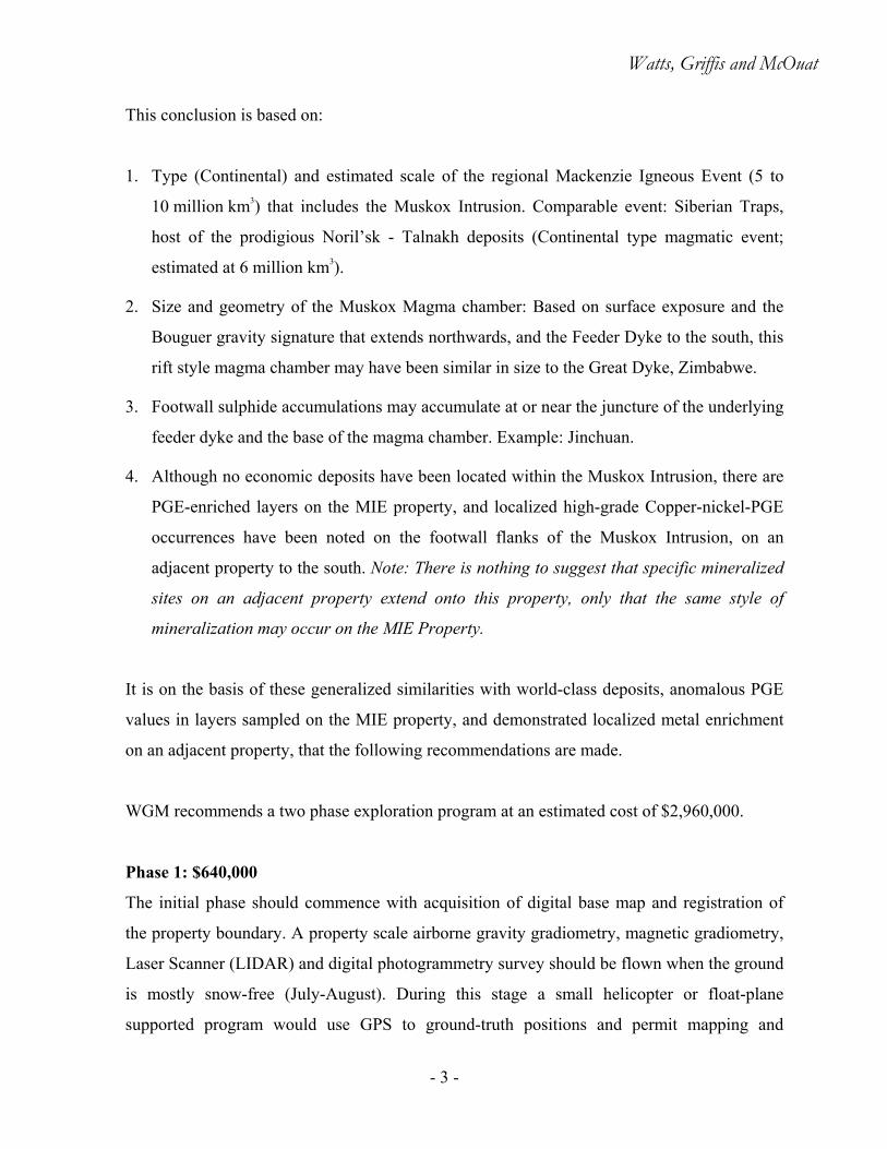
This conclusion is based on:
1. Type (Continental) and estimated scale of the regional Mackenzie Igneous Event (5 to
10 million km3) that includes the Muskox Intrusion. Comparable event: Siberian Traps,
host of the prodigious Noril’sk - Talnakh deposits (Continental type magmatic event;
estimated at 6 million km3).
2. Size and geometry of the Muskox Magma chamber: Based on surface exposure and the
Bouguer gravity signature that extends northwards, and the Feeder Dyke to the south, this
rift style magma chamber may have been similar in size to the Great Dyke, Zimbabwe.
3. Footwall sulphide accumulations may accumulate at or near the juncture of the underlying
feeder dyke and the base of the magma chamber. Example: Jinchuan.
4. Although no economic deposits have been located within the Muskox Intrusion, there are
PGE-enriched layers on the MIE property, and localized high-grade Copper-nickel-PGE
occurrences have been noted on the footwall flanks of the Muskox Intrusion, on an
adjacent property to the south. Note: There is nothing to suggest that specific mineralized
sites on an adjacent property extend onto this property, only that the same style of
mineralization may occur on the MIE Property.
It is on the basis of these generalized similarities with world-class deposits, anomalous PGE
values in layers sampled on the MIE property, and demonstrated localized metal enrichment
on an adjacent property, that the following recommendations are made.
WGM recommends a two phase exploration program at an estimated cost of $2,960,000.
Phase 1: $640,000
The initial phase should commence with acquisition of digital base map and registration of
the property boundary. A property scale airborne gravity gradiometry, magnetic gradiometry,
Laser Scanner (LIDAR) and digital photogrammetry survey should be flown when the ground
is mostly snow-free (July-August). During this stage a small helicopter or float-plane
supported program would use GPS to ground-truth positions and permit mapping and
Watts, Griffis and McOuat
- 4 -
sampling for a physical properties database (location, lithology, composition, structure,
density, magnetic susceptibility, and spectral signature). The final component of this phase
involves integrating data to create a 3-D interpretation of the Muskox magma chamber and
surrounding rocks.
Phase 2: $2,320,000 – contingent upon the results of Phase 1.
The second phase of the exploration program would drill-test ‘high-ranking’ geophysical and
geological targets generated from Phase 1. Site-specific gravity and SQUID EM geophysical
surveys should be carried out over 8 priority targets. A 3,000 m drill program is proposed,
this would include downhole geophysical testing of the drillholes.

Watts, Griffis and McOuat
- 5 -
2. INTRODUCTION
2.1 INTRODUCTION
This report is prepared at the request of the directors of 5050 Nunavut Limited ("5050
Nunavut") to review available data and make recommendations regarding future exploration.
The report will also assist Adriana Ventures Inc. ("Adriana") in determining if acquisition
of this property is appropriate, with respect to their plan to reactivate as a mineral exploration
company. 5050 Nunavut Limited has acquired a large (540 km2) property situated 60 km
south of Kugluktuk in Nunavut, Canada. The property is centred on part of the Muskox
Intrusion, a layered mafic-ultramafic intrusive known to contain Ni-Cu-PGE sulphide
mineralization along its basal contact and PGE-Chromite mineralization within layers.
5050 Nunavut plans to conduct exploration with the goal of locating economic concentrations
of mineralization. The company plans to compile and model existing geophysical data and
complete additional detailed surveys designed to locate and outline potential structural traps
that may host sulphide mineralization, primarily along the ‘keel’ and elsewhere along the
basal contact.
2.2 TERMS OF REFERENCE
Watts, Griffis and McOuat Limited ("WGM") has undertaken an independent technical
review of the property and has prepared this report in compliance with National
Instrument 43-101 ("NI 43-101") standards. WGM considers the Mackenzie Igneous Event
("MIE") property as a property of merit, suitable to support the reactivation of a public
company, Adriana Ventures Inc. This report describes the materially significant aspects of the
MIE property and recommended exploration program but is not intended as a full or detailed
property description or review due to the vast amount of work and data that has been
accumulated by previous industry, government and academic workers on the Muskox
Intrusion. The author of this report examined information available as listed under

Watts, Griffis and McOuat
- 6 -
"References" and presents his summary of the information he deems material to this technical
review.
2.3 SOURCES OF INFORMATION
The author visited the property together with G. Addie in August 2004, examined the host
stratigraphy and confirmed that no field work had been undertaken on the property since
2001.
The author has reviewed assessment files available on the internet and at the Geological
Survey of Canada ("GSC") in Ottawa, as well as numerous publicly available technical
reports by previous explorers and provided by the property owner. Numerous discussions
were also held with the Principals of GPR Geophysics Inc. and ARKEX Limited to
investigate the capabilities of modern geophysical techniques.
WGM has also reviewed the land tenure and legal agreements covering the MIE Property.
2.4 UNITS AND CURRENCY
Metric units are used throughout this report unless noted otherwise. Currency is quoted in
Canadian dollars ("C$").
2.5 RELIANCE ON OTHER EXPERTS
WGM has verified land tenure by reliance on records or copies of records provided by the
Mining Recorder’s Office, or the office of NTI.

Watts, Griffis and McOuat
- 7 -
3. PROPERTY LOCATION AND DESCRIPTION
3.1 LOCATION
The property is located in Nunavut, Canada, 60 km south of the coastal hamlet of Kugluktuk
(formerly called Coppermine), approximately 540 km north of Yellowknife, (Figure 1).
3.2 PROPERTY DESCRIPTION
The property is composed of 37 contiguous staked claims on Crown lands (subject to the
Canada Mining Regulations) covering approximately 85,000 acres and two adjacent Inuit
Owned Lands Mineral Exploration Agreements (CO62-04-01 & CO62-04-02), between
Nunavut Tunngavik Incorporated and Gordon Addie, signed April 1, 2004. These agreements
cover 19,711 hectares (ha) of mineral rights. 5050 Nunavut acquired 100% interest in this
property from Gordon Addie. Property rights are sub-surface only (Table 1 and Figure 2).
Crown land mineral claims were located with handheld GPS. IOL Agreements were acquired
via a paper-staking application process. Outside boundaries of IOL CO62 have been
surveyed. Internal boundaries are described by latitude and longitude. There are no known
workings or improvements on the MIE property. Permits to conduct the first phase of
proposed exploration are in place.
Work Commitments and Annual Fees
Mineral claims require $2.00/acre of allowed work to be performed annually, or money paid
in lieu. The next deadline for completing field work is October 5, 2006. The cost of
maintaining Inuit Owned Land parcels escalates with time. CO62-04-01 and CO62-04-02
became effective April 1, 2004. The first anniversary date has been extended by six

250,0
00m
.E.
250,0
00m
.E.
750,0
00m
.E.
7,250,000m.E7,250,000m.E
7,000,000m.E7,500,000m.E7,500,000m.E
1,0
00,0
00m
.E.
500,0
00m
.E.
500,0
00m
.E.
Sn
ow
dri
ft
Rel
ian
ce
Bat
hu
rst
Inle
t
Det
ah
YE
LL
OW
KN
IFE
Rae
Cam
lare
nIn
dia
nV
illag
eL
acL
aM
artr
e
Dis
cove
ry
Saw
mill
Bay
Lu
pin
Po
rtR
adiu
m
Co
pp
erm
ine
MIE
PR
OP
ER
TY
Coro
nati
on
Gulf
Bath
urs
tIn
let
NU
NAV
UT
NO
RT
HW
EST
TE
RR
ITO
RY
040
200
Kil
om
etre
s
UT
MN
AD
83,Z
one
11
N
Pro
per
tyL
oca
tion
Map
Fig
ure
1.
MIE
PR
OP
ER
TY,N
UN
AV
UT
GA
NR
EV
\G
AN
_01_Location_M
ap.c
dr
Lastre
vis
ion
date
:M
onday,
4A
pril2005
Watts, Grif fis and McOuat
Arctic
Circle
Nfl
d.
P.E
.I. N
.S.
N.B
.O
nt.
NV
T.
Man.
Sask.
Alt
.
YT
B.C
.
N.W
.T.
Que. Ott
aw
a
CA
NA
DA
Scale
kmkm
030
030
060
090
0
Iqa
luit
Yel
low
kn
ife
Reg
ina
Ed
mo
nto
nV
icto
ria
Wh
iteh
ors
e
Qu
йb
ec
St
Jo
hn
’s
Ch
arl
ott
eto
wn
Ha
lifa
x
Fre
der
icto
nW
inn
ipeg
To
ron
to
En
larg
edM
ap
Are
a
MIE
PR
OP
ER
TY
U.S
.A.
GR
EE
NL
AN
D
ICE
LA
ND

Watts, Griffis and McOuat
- 9 -
TABLE 1 LAND HOLDINGS
Inuit Owned Lands Acquired Hectares Expiry date NTS CO62-04-01 April 1, 2004 9,847 hectares Oct 1, 2005 86O/03 CO62-04-02 April 1, 2004 9,864 hectares Oct 1, 2005 86O/03
Mineral Claims GA 1 Oct 5, 2004 2582.5 acres Oct 5, 2006 86O/04 GA 2 Oct 5, 2004 2582.5 acres Oct 5, 2006 86O/04 GA 3 Oct 5, 2004 2582.5 acres Oct 5, 2006 86O/04 GA 4 Oct 5, 2004 2582.5 acres Oct 5, 2006 86O/03,04 GA 5 Oct 5, 2004 2582.5 acres Oct 5, 2006 86O/03 GA 6 Oct 5, 2004 2582.5 acres Oct 5, 2006 86O/03 GA 7 Oct 5, 2004 2582.5 acres Oct 5, 2006 86O/03 GA 8 Oct 5, 2004 2582.5 acres Oct 5, 2006 86O/04 GA 9 Oct 5, 2004 2582.5 acres Oct 5, 2006 86O/04 GA 10 Oct 5, 2004 2582.5 acres Oct 5, 2006 86O/03,04 GA 11 Oct 5, 2004 2582.5 acres Oct 5, 2006 86O/03 GA 12 Oct 5, 2004 2582.5 acres Oct 5, 2006 86O/04 GA 13 Oct 5, 2004 2582.5 acres Oct 5, 2006 86O/04 GA 14 Oct 5, 2004 2582.5 acres Oct 5, 2006 86O/04 GA 15 Oct 5, 2004 2582.5 acres Oct 5, 2006 86O/03,04 GA 16 Oct 5, 2004 2582.5 acres Oct 5, 2006 86O/03 GA 17 Oct 5, 2004 2582.5 acres Oct 5, 2006 86O/04 GA 18 Oct 5, 2004 2582.5 acres Oct 5, 2006 86O/04 GA 19 Oct 5, 2004 2582.5 acres Oct 5, 2006 86O/04 GA 20 Oct 5, 2004 2582.5 acres Oct 5, 2006 86O/03,04 GA 21 Oct 5, 2004 2582.5 acres Oct 5, 2006 86O/03 GA 22 Oct 5, 2004 2582.5 acres Oct 5, 2006 86O/03 GA 23 Oct 5, 2004 2582.5 acres Oct 5, 2006 86O/03 GA 24 Oct 5, 2004 2401.75 acres Oct 5, 2006 86O/03 GA 25 Oct 5, 2004 2582.5 acres Oct 5, 2006 86O/03 GA 26 Oct 5, 2004 2582.5 acres Oct 5, 2006 86O/03 GA 27 Oct 5, 2004 2582.5 acres Oct 5, 2006 86O/03 GA 28 Oct 5, 2004 2582.5 acres Oct 5, 2006 86O/03 GA 29 Oct 5, 2004 2517.94 acres Oct 5, 2006 86O/03 GA 30 Oct 5, 2004 2582.5 acres Oct 5, 2006 86O/03,04 GA 39 Oct 5, 2004 778.35 acres Oct 5, 2006 86O/03 GA 40 Oct 5, 2004 573.26 acres Oct 5, 2006 86O/03 GA 41 Oct 5, 2004 1903.88 acres Oct 5, 2006 86O/03 GA 42 Oct 5, 2004 1903.88 acres Oct 5, 2006 86O/03 GA 43 Oct 5, 2004 611.56 acres Oct 5, 2006 86O/03 GA 44 Oct 5, 2004 356.49 acres Oct 5, 2006 86O/03 GA 45 Oct 5, 2004 1771.37 acres Oct 5, 2006 86O/03

F89924GA 44
F89925GA 45
F89886
GA 6
F89885
GA 5
F89884
GA 4
F89883
GA 3
F89882
GA 2
F89881
GA 1
F89891
GA 11
F89890
GA 10
F89889
GA 9
F89888
GA 8F89887
GA 7
F89923GA 43
F89922
GA 42
F89921
GA 41
F89896
GA 16
F89895
GA 15
F89894
GA 14
F89893
GA 13
F89892
GA 12
F89920GA 40
F89904GA 24
F89903GA 23
F89902GA 22
F89901GA 21
F89900GA 20
F89899GA 19
F89898GA 18
F89897GA 17
F89919
GA 30
F89909
GA 29
F89908
GA 28
F89907
GA 27
F89906
GA 26
F89905
GA 25GA 30
CO62-04-02
CO62-99-03-A
STBW-03-01
CO62-04-01
CO62-04-01
LakeDrill
7,4
30
,00
0m
.N.
7,4
50
,00
0m
.N.
7,4
60
,00
0m
.N.
7,4
40
,00
0m
.N.
560,000m.E. 570,000m.E. 580,000m.E.7
,44
0,0
00
m.N
.
560,000m.E.
7,4
60
,00
0m
.N.
7,4
50
,00
0m
.N.
MIE PROPERTY
LakeSpeers
Lake
All Night
MouseLake
Coppermine River
0 1 5
KilometresUTM NAD83, Zone 11
N
Land Status Map
Figure 2.
MIE PROPERTY, NUNAVUT
GAN REV \ GAN_06_Claim_Map.cdrLast revision date: Monday, 4 April 2005
Watts, Grif fis and McOuat

Watts, Griffis and McOuat
- 11 -
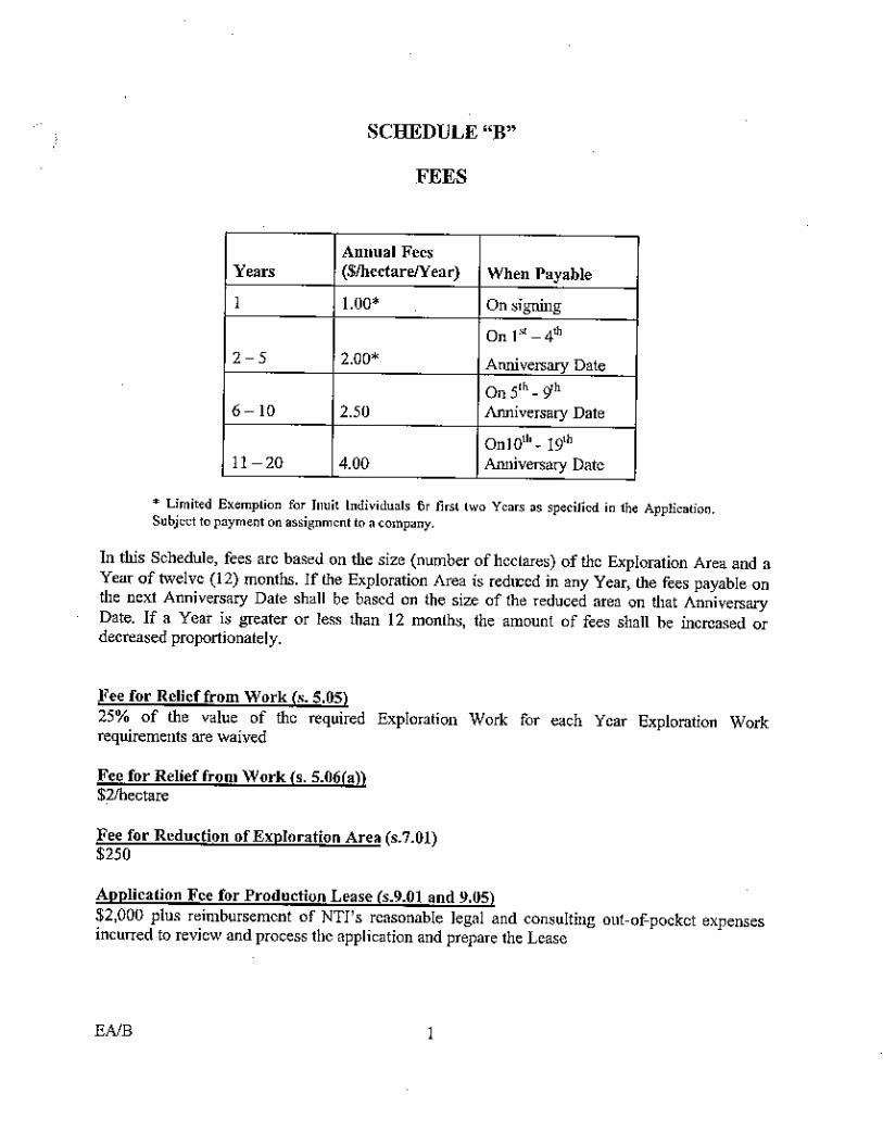
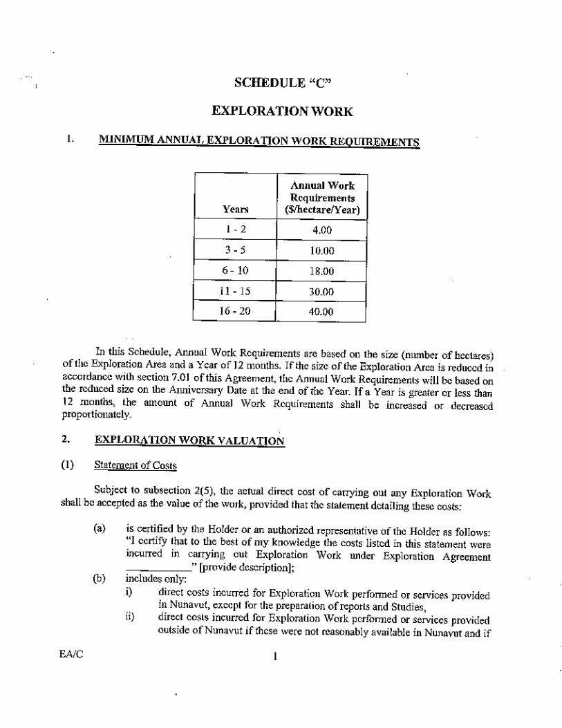
months, to October 1, 2005 by payment of an additional $9,855.50. The first anniversary
work commitment then increases from $4/hectare to $6/hectare to incorporate the additional
½ year extension. Phase 1 of the recommended work program will fulfil current work
commitment obligations on the listed mineral claims and IOL parcels up to October 2006. An
IOL fee payment of $39,422 will come due on October 1, 2005.
TABLE 2 IOL LANDS MINERAL EXPLORATION AGREEMENTS
SCHEDULE OF PAYMENTS AND WORK COMMITMENTS Anniversary Oct 1 Annual Fees Work Commitment (On Signing) $1.50/hectare (Paid) 1 2005 $2.00/hectare $6.00/hectare 2 2006 $2.00/hectare $4.00/hectare 3 - 5 2007 - 2009 $2.00/hectare $10.00/hectare 6 - 10 2010 - 2014 $2.50/hectare $18.00/hectare 11 - 15 2015 - 2019 $4.00/hectare $30.00/hectare 16 - 20 2020 - 2024 $4.00/hectare $40.00/hectare
Nunavut Tunngavik Incorporated retains the right to a 12% Net Profits Interest if portions of
IOL CO62 are converted to lease and are brought into commercial production. Mines
established on Crown land are subject to royalties as prescribed by Sections 64 to 69 of the
Canada Mining Regulations ("CMR").

Watts, Griffis and McOuat
- 12 -
4. ACCESSIBILITY, CLIMATE, LOCAL RESOURCES, INFRASTRUCTURE AND
PHYSIOGRAPHY
4.1 ACCESS
The MIE property is located 60 km (northern edge) to 90 km (southern edge) south of
Kugluktuk, Nunavut, and is 500 to 530 km north of Yellowknife, N.W.T.
Access to the nearest community, Kugluktuk, is by air. Kugluktuk has a municipal airport
with daily commuter flights to and from Yellowknife. Float, wheel, and skied aircraft and
helicopters are all supported from Kugluktuk, but are based and chartered out of Yellowknife.
The MIE property contains several lakes large enough for planes (typically Twin Otters) to
land on. These include Mouse, All Night, Speers, and Drill Lakes.
Vehicular travel on the property is prohibited during the summer to protect the tundra and
permafrost. Winter haulage roads may be permitted to allow ground transport of bulk fuel
and equipment. Snowmobiles are permitted during the winter.
4.2 CLIMATE
The region is a sub-arctic desert with limited rainfall. Kugluktuk receives 200 mm
precipitation annually, with most arriving in the summer as rain. Lake ice typically begins
melting in mid-June, and freezing begins again in late September or early October.
4.3 LOCAL RESOURCES
Water is available throughout the property for all exploration needs.

Watts, Griffis and McOuat
- 13 -
4.4 INFRASTRUCTURE
Kugluktuk
Kugluktuk (population 1,200) is on the shore of the Coronation Gulf. Most heavy materiel
(such as building supplies, vehicles, and bulk fuel) arrives by summer barge from Hay River.
Daily flights from Yellowknife provide fresh provisions and air transport for the community.
There are two hotels, a taxi, two general stores, and other basic infrastructure for a small
community. Bulk fuel (diesel, heating oil, Av-gas, and helicopter fuel) is usually available.
The availability of supplies and services in Kugluktuk is limited.
A preliminary survey confirmed the opportunity to establish a deep-water port at Kugluktuk,
if economics justified its development.
Unskilled labour is available locally, but most skilled workers will need to be brought in. As a
condition of exploration, local Inuit are to be hired and trained, and Inuit companies
contracted, when possible. Experienced workers for all phases of exploration and
development, and most supplies and services are readily available in Yellowknife, a well-
established mining and logistics centre.
MIE Property
There is no permanent infrastructure inland from Kugluktuk. Permits to create winter road
access from Kugluktuk to the property have been approved in the past. The nearest
exploration camp is located at the western edge of the MIE property, where Hornby Bay
Exploration Limited maintains a large camp on the shoreline of Mouse Lake. With
appropriate permits, temporary camps can be constructed within the property.

Watts, Griffis and McOuat
- 14 -
4.5 PHYSIOGRAPHY AND NATURE
The property is located in an area of moderate relief. Elevations range from 270 m to 650 m
above sea level. Vegetation is typical of the South Arctic ecozone and consists of lichens,
mosses, wet sedge meadows and willows. Small stands of stunted spruce trees exist within
the valleys of the Coppermine River and Melville Creek. Wildlife includes herds of caribou
and occasional muskoxen. Grizzly bears occasionally traverse the area. The West Kitikmeot
Land Use Plan provides details on individual species found in the region.

Watts, Griffis and McOuat
- 15 -
5. HISTORY
5.1 REGIONAL
Pre-European Mining
Until recently, the Inuit of this region collected native copper from surface and used it to
create implements. As a result early European and Canadian explorers called the Inuit of this
area the Copper Eskimo.
Early Exploration
In the 1770s, the Hudson Bay Company dispatched Samuel Hearne to search for the source of
the copper used by the Inuit. He eventually found native copper, but not in economic
quantities.
Twentieth Century Exploration
Exploration of the Coppermine volcanics took place in the 1930s and in the 1960s. The
Coppermine staking rush of the 1960s resulted in the discovery of over 250 separate copper
mineral occurrences within 1:250,000 scale mapsheets 86O and 86N (Carriere and Kirkham
1992). This exploration resulted in the discovery of the DOT 47 (or Wreck Lake) deposit. It is
a tabular copper deposit, located within a conjugate fault associated with the regional-scale
northeast-trending Teshierpi Fault. The 1970s saw large scale uranium exploration in the
region. A number of uranium occurrences were found within Hornby Bay Group sedimentary
rocks. In the 1980s the area was the focus of copper-nickel-PGE exploration, primarily within
the exposed portion of the Muskox Intrusion. Exploration in the 1990s included the Muskox
Intrusion, and the commencement of large-scale diamond exploration throughout the arctic.
Twenty-first Century Exploration
Present exploration in the area involves all the previously known mineralized areas, and for
all the above-mentioned minerals.

Watts, Griffis and McOuat
- 16 -
5.2 MIE PROPERTY
Records indicate that various companies mapped and conducted detailed exploration on the
MIE property during the periods: 1955-59 Inco Limited/Canadian Nickel Company Limited;
1977 BP Minerals; 1986-1988 Equinox and International Platinum; 1996-2001 Muskox
Minerals.
The Muskox Intrusion was discovered in 1956 by Inco Limited/Canadian Nickel Company
Limited ("INCO") as the result of an airborne reconnaissance survey. During the summers of
1957-59, INCO conducted extensive surficial and near-surface exploration for Ni-Cu
mineralization at the Muskox Intrusion. Nineteen of 117 shallow holes they drilled on the
intrusion are located on this property (Hulbert, 2005). Despite the good results obtained from
two of these holes:
1. 7.6% Cu, 3.21% Ni, 16 g (Pd+Pt+Au)/t over 5,48 m in the Pyrrhotite Lake area; and
2. 9.3% Cu, 3.5% Ni and 22 g (Pd+Pt+Au)/t over 1.3 m in the Speers Lake area, they
abandoned the property. It is not known if INCO carried out any follow up work, they
only reported that they did not consider this property to be of economic interest to them at
that time.
C.H. Smith of the Geological Survey of Canada ("GSC") produced a preliminary geological
map of the Muskox Intrusion in 1959-60. In 1961-62, the GSC flew aeromagnetic and
conducted gravity surveys (GSC geophysics paper 1739). The following year the GSC
conducted a drilling programme consisting of three holes for a total of 10,000 feet (3,400 m).
Two of the three stratigraphic holes, labelled North (1,130 m deep) and East (700 m deep),
are located on the property. This drilling was designed to provide a complete stratigraphic
section of the Muskox Intrusion, from the roof to the basal contact and to test the nature of the
unexposed part of the layered intrusion for petrological and structural purposed to assist in
determining the origin and cooling history of the structure. These holes were subsequently
surveyed with a variety of down hole geophysical instruments used to conduct geophysical
profiles of the strata. The drilling and testing were designed for the purposes of scientific
Watts, Griffis and McOuat
- 17 -
study, mineralization was not targeted with these drillholes. The total stratigraphic thickness
was determined to be at least 2,000 m, depending where it is measured. The resultant
stratigraphic profile and model generated from the results is shown in Figure 5. When Hulbert
later re-sampled drillhole GSC South, a horizon was found, (311 m above the bottom) that
graded 2.01 ppm Pt and 3.13 ppm Pd. This lower horizon has never been followed up..
From 1959 to the present, the GSC have authored approximately forty articles related to the
Muskox Intrusion - including maps, papers, open files, compilations and presentations. These
include the 1965 mineralogical studies on the native metals of the Muskox Intrusion, (paper
65-02). Between the years 1965-69, the geochemistry of the sulphides and sulphur isotopes of
the intrusion was studied by (Chamberlain and Sasaki) and the 1971, T.N. Irvine published
his theory of the emplacement of the Muskox Intrusion (paper 71-1).
In 1977, BP Minerals ("BP") acquired most of the Muskox Intrusion as part of a huge
property. Although their focus at that time was uranium exploration, they also examined and
sampled the chromitite layers located within the MIE Property. P. Laznicka, on behalf of BP,
estimated an unclassified resource of 5 million tons grading 15.3% Cr2O3 with some
anomalous values of Ni, Cu, Pd and Pt. This historical estimate was not prepared according to
NI 43-101 standards and neither WGM nor 50-50 Nunavut nor Adriana has audited these
estimates nor made any attempt to classify them according to NI 43-101 standards. It is
presented because WGM considers it to be relevant and significant (see Section 8:
Mineralization, for details). These estimates should not be relied upon. After the field season
of 1977, they abandoned further exploration of the Muskox Intrusion.
In the late 1980s, Equinox Resources Ltd and International Platinum Company carried out
extensive exploration work including mapping, surface sampling, shallow drilling and local
geophysics. Within the MIE property, International Platinum drilled eleven holes (1,182 m)
and Equinox drilled four (769 m). Equinox reported values of up to 4.3 oz Pd/t, 0.3 oz Pt/t
and 0.2 oz Au/t from trench samples. Only one drillhole returned significant assay of
4.8% Cu, 2.0% Ni, 5.8 g (Pd+Pt+Au)/t over 13.74 metres of core length. Most of this

Watts, Griffis and McOuat
- 18 -
drilling, tested the Pyrrhotite Lake area, in the southern part of the intrusion, south of the
property.
The Government of Nunavut, archives record numerous geophysical surveys, namely
horizontal loop-EM were carried out on the claims held by 50/50 Nunavut. These EM
surveys outline a number of conductors most of which, were categorized as “near surface”.
Equinox tested several of these by drilling without significant results.
In 1995, Muskox Holdings Ltd. which later became Muskox Minerals Corp., staked the
Muskox Intrusion and commenced exploration in 1996. Airborne geophysical surveys
(HummingbirdTM Magnetic and Electromagnetic) were flown over much of the exposed
intrusion, including the northern (475 line-km) and southern portions (880 line-km) of the
current property. They also mapped and sampled chromite-bearing horizons.
The gravity survey delineated a North-South trending dense body more than one km long
which coincides with the interpreted massive sulphide anomaly detected by the UTEM survey
(Seeman, 1996).
In 1999, a deep penetrating ground geophysical survey was carried out by Zonge Engineering
and Research using the Controlled Source Audio-Frequency Magnetotellurics ("CSAMT")
technique. The survey which covered 42 line-km with readings at every 100 m outlined a very
strong conductor, 400 m wide on three adjacent lines spaced 500 m apart. The conductor was
located over the base of the southernmost end of the layered series, (south of the property of
50/50 Nunavut Limited) and is consistent with interpreted sulphide concentrations in the
feeder dyke.
In 2000 and 2001, additional geophysical surveys including ground magnetics, AMT and a
Controlled Source Audio-frequency Magnetotellurics were carried out to detail existing
anomalies and to test areas of known sulphide concentrations reported by previous operators.

Watts, Griffis and McOuat
- 19 -
Muskox Minerals drilled 40 holes totalling 9,300 m to test the main geophysical targets and to
confirm values previously reported from the holes drilled by INCO and Equinox. Records
indicate that some of these holes reportedly have been surveyed using the Crone Pulse EM
techniques. The current Muskox Minerals web site portrays the summary of their previous
work but does not detail the results of their most recent surveys. They do however provide a
table of mineralized intersections from within the Basal Margin.
Basal Margin Occurrences Grades Widths (m) Pyrrhotite Lake 16.0 g Pd/t, 7.6% Cu, 3.2% Ni 5.5 N.Speers Lake 43.1 g Pd/t, 0.6 g Pt/t 0.1 S.Speers Lake 47.7 g Pd/t, 5.0 g Pt/t, 4.6 g Au/t 0.4 SE McGregor Lake 126.2 g Pd/t, 11.5 g Pt/t 5.6 g Au/t 0.8 Sulphide Breccia 9.3 g Pd/t, 1.4 g Pt/t 0.1
Complete details of these exploration programs and their results are contained within several
volumes of assessment reports for each of: Equinox, International Platinum, and Muskox
Minerals (see references).
In 2002, a “Spectrem” airborne survey was flown over much of the area as part of a
option/joint venture agreement between Anglo American Exploration Canada ("AAEC")
and Muskox Minerals. This program also included data compilation, targeted UTEM and
PEM ground geophysics, over the western margin area. Eight holes totalling approximately
2,030 metres were drilled to follow up targets identified in 2003-2004. These results have not
been published. AAEC did not exercise its option.
Except for the above airborne survey, exploration on the 50/50 Nunavut property has been
idle for the last few years.
Mike Thomas, a research geophysicist with the GSC, collected and compiled density and
magnetic susceptibility measurements of each lithology in and around the intrusion. He then
performed inverse modelling of gravity and magnetic data across several cross-sections. This
work has improved the definition of the footwall geometry of the intrusion, re-aligned the
intrusion’s footwall axis and demonstrated that both magnetism and gravity are effective

Watts, Griffis and McOuat
- 20 -
exploration tools on this property (Thomas 2002, 2003). In 2004, 5050 Nunavut Limited hired
a graduate student to collect more magnetic susceptibility measurements from archived core
and hand specimens.
In 2005, Larry Hulbert is expected to release a new GSC Open File; a digital geology map of
the Muskox Intrusion. It will include a compilation of copper and nickel samples taken over
the intrusion and will indicate the collar locations of all previous drillholes. Three hundred
and eighty-five copper-nickel samples plot within the MIE property.
The GSC holes remain significant to the future development of this property. Core from these
historic holes is maintained in the GSC core library in Ottawa. Data from the core established
the stratigraphic column for the Muskox Intrusion, and has allowed a wide range of scientific
investigations to be carried out, resulting in progressive refinements of the geological model.
Re-sampling by Hulbert identified new mineralized layers of interest. Most recently,
measurements of physical/geophysical rock properties has allowed new geophysical inverse
modelling techniques to be applied. If the GSC holes had been drilled to day it would have
cost 50/50 Nunavut Limited in excess of $680,000.
There are no known resources on the property.

Watts, Griffis and McOuat
- 21 -
6. GEOLOGICAL SETTING
6.1 REGIONAL GEOLOGY
The Muskox Intrusion is located within the Bear Province of the Precambrian Shield.
Basement rocks in this area are Paleoproterozoic in age and are mapped as Coronation
Supergroup: Akaitcho Group, Recluse Group, Epworth Group, Hepburn Intrusive Suite, and
the Hornby Bay Group. The Hornby Bay Group sits unconformably above the other Groups.
Coronation Supergroup rocks are unconformably overlain by Mesoprotorozoic Dismal lakes
Group sediments.
The Mackenzie Igneous Event was then injected into existing strata at 1.267Ga ±2Ma.
The Coppermine Homocline subsequently tilted the rocks of the region approximately 5° to
the North.
Erosion and glaciation produced the current exposures and surficial landscape. Local
depressions are till covered, and there are minor eskers present.
Detailed regional paragenetic sequence, stratigraphy and structural history are described in:
Barager and Donaldson, 1973; Kerans, 1981; Hoffman and Hall, 1993; Cook and MacLean,
2004; and Hulbert, 2005.
6.1.1 MACKENZIE IGNEOUS EVENT
The Muskox Intrusion, Coppermine Volcanics, and the Mackenzie Dyke Swarm comprise the
Mackenzie Igneous Event. The Mackenzie Igneous Event, also described as the Mackenzie
Event, is classified as a Continental-type Large Igneous Province ("LIP"). The Mackenzie
Igneous Event, dated at 1.267Ga ±2Ma, is one of the largest continental magmatic events
known. The Mackenzie Dyke Swarm has been exposed by erosion over 100° of arc (that

Watts, Griffis and McOuat
- 22 -
equates to an area of exposure of 2.7 million square kilometres). This Giant Dyke Swarm
radiates southwards from a focal point in Nunavut, throughout the Canadian Shield, extending
as far as south as Quebec and Ontario (Buchan and Ernst, 2004). This type, ‘Continental’, and
scale of igneous event - magma volume estimate: 5-10 million km3 (Ernst, per comm., 2004)
is similar in size to the Siberian Traps, which are estimated at 6 million km3. Much of the
magma was expelled to surface, forming laterally extensive flood basalts called the
Coppermine volcanics where exposed, and the Tweed Lake volcanics further to the west. This
three kilometre thick package of flows and related sills extends for hundreds of kilometres
east (Bathurst Inlet) and west (Mackenzie River) of the Muskox magma chamber, and extends
from the MIE property northwards.
Muskox Intrusion
The Muskox Intrusion exhibits a ‘hull and keel’ shaped vertical profile (Figure 3). The
Muskox Intrusion has a north-south trend and an exposed strike length of approximately
120 km.
North of the Coppermine River the "main body" of the intrusion is exposed. It has a funnel-
shaped cross-section with walls dipping inwards approximately 25° to 35°. The entire
intrusion plunges to the north at about 5° and has an exposed maximum width of about 12 km.
It is between the East and West margins of the magma chamber that laterally-extensive layers
have developed.
The Muskox Intrusion has been subdivided into marginal zones, a layered series, a
granophyric roof zone and a feeder/keel dyke.
Feeder Dyke
The feeder dyke (150 to 400 m wide) is comprised of segments consisting of fine-grained
gabbro and picrite. According to Irvine and Smith (1967), this dyke was fed only a small
portion of the magma (cycle 1) that makes up the main body. It is believed that most of the

Historical Outline ofMuskox Minerals Property
Section Can
oe
Lake
Fau
lt
MIE PROPERTY
StarbridgeLake
McGregorLake
Coppermine River
SpeersLake
0 2 10
Kilometres
N
Dismal Lake andHornby Bay Group
SIMPLIFIED GEOLOGY
Coronation Supergroup
Copper Creek Formation
Keel Dyke
Roof Zone
Muskox Intrusion
Margin Zones
Layered Series
GSC drill hole location
Location ofoccurrences
referencedbasal margin
N. SpeersLake
S. SpeersLake
SulphideBreccia
SE McGregor Lake
PyrrhotiteLake
Simplified Geology Of The Muskox Intrusion
Figure .3
MIE PROPERTY, NUNAVUT
GAN REV \ GAN_02_SimplifiedGeol_MuskoxIntrusion.cdrLast revision date: April 2005Thursday, 28
Watts, Grif fis and McOuat
EastHole
NorthHole
SouthHole

Watts, Griffis and McOuat
- 24 -
magma in the main body entering laterally from the north (Irvine counted 25 cycles) or from
other magma chambers located at depth. Hulbert (per comm. 2005) has identified at least two
sites along the exposed feeder dyke where more than one magma pulse entered the magma
chamber from below. His evidence includes breccia fragments from an earlier pulse, and
identification of a later Cu-Ni-PGE rich sulphide magma with a distinct isotopic signature.
The feeder dyke walls are approximately vertical. External contacts are sharp and in places
show some metamorphism with the host metasediments. Within the dyke itself, the contacts
between the gabbro and picrite are gradational and are generally symmetric from the walls to
the core.
Marginal Zones
The marginal zones are described as grading upwards from tholeiitic gabbro along the
footwall contact, through picrite, to a feldspar peridotite. The margins of the intrusion are
sulphide-rich, and are gossanous along much of their surface exposure.
Layered Series
The layered series occupy the bulk of the intrusion and consist of a differentiated series of
mafic-ultramafic magma layers. This sequence comprises 42 mapable layers of 18 different
rock types, distributed in some 25 cyclic units. Generalizing, dunite is found at the base,
followed stratigraphically upward by pyroxenite, then gabbro and at the top a granophyre-rich
gabbro. Much of the olivine in the exposed portion of the intrusion has been serpentinized.
Individual layers range in thickness from 10 to 1,100 feet (3-350 m); have well developed
contacts, and relatively constant compositions. Cookenboo et al (1998) and Williams (2003)
note that the Muskox Intrusion acted as a subvolcanic chamber conduit for the lower portion
of the overlying Coppermine Volcanics.

Watts, Griffis and McOuat
- 25 -
6.2 LOCAL GEOLOGY
Outcrop Lithologies within the MIE Property
The northern part of the property consists of flows and sills of the Coppermine volcanics.
These continental flood basalts were extruded onto stromatolitic carbonates of the Dismal
Lakes Group.
Dismal Lakes sediments are thinner (300 m) on the east side of the property than on the west.
The western half of the property lies on the eastern edge of a major sedimentary basin. Sills
(related to the Muskox Intrusion) outcrop within the sedimentary package in the southwest
quadrant of the property.
The Muskox Intrusion is well exposed along the eastern side of the MIE property. The
southeast corner of the property has exposures of the upper half of the layered sequence and
the east footwall and hangingwall margin rocks. Two chromite-rich horizons (each less than a
metre thick) are located near the top of the Layered Series and have been traced continuously
for more than 17 kilometres on surface. These laterally extensive mineralized horizons are
thought to underlie much of the MIE property.
Contact metamorphism is visible along the edge of the intrusion in the form of a gossanous
aureole. This metamorphic aureole overprints the metasedimentary schists of the Epworth
Group and gneisses and granitic migmatitic rocks of the Hepburn metamorphic plutonic belt.
A conspicuous major fault at the south end of the property is the Canoe Lake Fault. Where
exposed it cuts the western flank of the intrusion. South of All Night Lake it has a north-south
strike with a sub-vertical dip. There are no exposures of the fault north of All Night Lake.
Kerans (1981) projected the fault northwards, and split it into splays; one extending north
from the exposed fault trace and an eastern splay modelled as shallowing into a thrust fault,
located above the Muskox Intrusion and below the Coppermine volcanics. The northward
projection of the western splay of Canoe Lake fault is not supported by recent work. Recent

Watts, Griffis and McOuat
- 26 -
mapping by Henderson (2000) confirmed the synform displayed on the original 1967 GSC
map and did not note any major offset in the stratigraphy. This interpretation is corroborated
by geophysical data (Thomas, 2002 and 2003).
The same geophysical modelling by Thomas, GSC, indicates that the Muskox magma
chamber breached a sedimentary basin located on the west side of the MIE property, north of
All Night Lake. This modelling explains differences in the western and eastern flanks of a
Bouguer gravity anomaly caused by the Muskox Intrusion. The model is supported by
exposures of Muskox-related sills, directly over this interpreted western embayment of the
Muskox magma chamber.
Note: Lower layers of the Muskox Intrusion are inferred to underlay the exposed layers for the following reasons: continuity has been confirmed where holes have drilled deep enough reach those layers; continuous geophysical signatures such as gravity imply continuity; and remanent magnetism measurements of the layers demonstrate a north to south flow direction (Robertson 1969).

Watts, Griffis and McOuat
- 27 -
7. DEPOSIT TYPES AND MODELS
Ultramafic to mafic layered intrusions derive from primitive magmas, formed by the melting
of the mantle. The deep cracking of a craton permits copper-nickel-PGE bearing magma to
rise. When sulphide minerals form from the magma they may precipitate and accumulate in
cavities, in breccias, along shear zones, in layers, and in fractures which can be called
"structural traps". If there is sufficient enrichment of metals of economic interest, and a large
enough volume of those concentrated metals, a deposit of economic size can be formed.
Most models for the formation of magmatic Cu-Ni and PGE ore mineralization note that
mineralization tends to concentrate along stratiform layers, at the margins around the rim of
the intrusive, in portions of feeder dykes that remained open for more than one magma pulse,
at the base of layered complexes, and in a few other places mostly associated with gabbroic
phases (Figure 4).
Noril’sk-Talnakh, the Great Dyke of Zimbabwe, the Stillwater Complex in Montana, the
Bushveld Complex in South Africa, and Voisey’s Bay in Labrador are locations that exhibit
these types of deposits. These important deposits/mining regions are all associated with
Continental-type Large Igneous Provinces ("LIPs").
Most of the copper-nickel-PGE mineralization found in these intrusions is located at the
contact between the intrusive rocks and the basement (host rocks). At Jinchuan, massive
sulphides are located within the upper part of the feeder dyke right at the bottom of the
"funnel".
Recognition of footwall traps and local changes in flow regime are becoming increasingly
important exploration criteria. Example: Basal sulphide accumulations in Komatiitic olivine-
rich channel flows. Flow regime/footwall traps in magma conduits also are described for
Jinchuan, Noril’sk-Talnakh, and Voisey’s Bay.

Hyp
oth
etic
al
sulp
hid
eacc
um
ula
tions
Leg
end
:
Great Dyke
Jinchuan
Stillwater
Bushveld
Mafi
cL
ava
Flo
ws
Mafi
cL
ava
Flo
ws
Mafi
cL
ava
Flo
ws
Base
men
tR
ock
sB
ase
men
tR
ock
sB
ase
men
tR
ock
s
Sch
emati
cM
odel
Of
Laye
red
Mafi
c-U
ltra
mafi
cIn
tru
sion
s
Fig
ure
.4
MIE
PR
OP
ER
TY,N
UN
AV
UT
GA
NR
EV
\G
AN
_05_H
ypoth
etical_
Sulp
hid
e_A
ccum
ula
tions.c
dr
Lastre
vis
ion
date
:M
onday,
4A
pril2005
Watts, Grif fis and McOuat
Sch
emati
cm
odel
of
laye
red
mafi
c-ult
ram
afi
cin
trusi
ons
conta
inin
gw
orl
d-c
lass
min
eral
dep
osi
tes
and
Musk
ox
Intr
usi
on.
Sca
leva
ries
bet
wee
nin
trusi
ons.

Watts, Griffis and McOuat
- 29 -
Layered PGE targets are modelled from Bushveld, Stillwater, Great Dyke, and other layered
mafic/ultramafic complexes. Grades and/or thicknesses may improve toward the axis of the
intrusion, ‘up-stream’ in the direction of flow, and where later fluids have contacted or
penetrated the layers. A rich deposit sub-type of these layered complexes are pipe-like bodies
that cross-cut the igneous stratigraphy.
Several references, including Cookenboo and Soever (2002), go into further detail with
respect to these deposit models and how they might assist in focussing future exploration
within the Muskox Intrusion.
Applying Cu-Ni and PGE Exploration Models to the MIE Property
The MIE property covers the northern portion of the exposed Muskox Intrusion. WGM
believes that this area should be systematically examined for copper-nickel and PGE deposits.
Recent advances in ground and airborne geophysical techniques and geophysical inversion
models should permit delineation of the intrusive-basement contact and identify potential
structural traps that may host concentrations of sulphide minerals.
Geophysical studies by Thomas, aimed at defining the geological structures within the
Muskox Intrusion, have provided excellent insights for exploration crews on which to focus
future field exploration.
A cross section based on an inverse gravity model (Figure 5) shows the western flank of the
intrusion flattening to the west. This indicates that potential structural traps for mineralizing
fluids exist within the western part of the intrusion, as well as the intrusion’s primary axis.

Pote
nti
al
Gra
vity
Model
Cro
ss-S
ecti
on
Fig
ure
.5
MIE
PR
OP
ER
TY,N
UN
AV
UT
GA
NR
EV
\G
AN
_04_P
ote
ntial_
Gra
vity_M
odel.cdr
Lastre
vis
ion
date
:M
onday,
4A
pril2005
Watts, Grif fis and McOuat

Watts, Griffis and McOuat
- 31 -
8. MINERALIZATION
Disseminated sulphides are found throughout the intrusion. A detailed study of the sulphide
minerals undertaken by Chamberlain in 1967 was followed in 1969 by a study on sulphur
isotopes, by Sasaki. Most of the sulphides are concentrated either along the inward dipping
footwall contacts with the basement formations or in close association with two chromite-rich
horizons. Massive sulphides found within the basal complex consist mostly as a pyrrhotite-
matrix breccia.
The granophyre-rich gabbro and mafic granophyre constituting the top of the layered series
and base of the roof also contain iron-rich sulphides. Minor amounts of sulphides are also
found scattered throughout the intrusive.
Sulphide mineralization shows a preferential association with gabbro instead of picrite in the
margins of the intrusive body. Sulphide concentrations along the basal contact zone are better
developed in granitic gneisses than pelitic schists.
Sulphides associated with the chromite-rich horizons (chromitite reefs) contain anomalous
palladium, platinum, nickel and copper. These horizons are continuous across the intrusion
and have a variable thickness between 45 cm to 1 m (Cookenboo and Soever, 2002). Equinox
drilled below the chromite horizons, intersecting other anomalous layers that also contain
minor sulphides. There have been no follow-up investigations of these lower horizons.
In 1977, Professor P. Laznicka, on behalf of BP Minerals, estimated 5 million tons (20 cm
thickness x 6 km long x 1 km down dip, using a specific gravity of 4 for the ore) with a tenor
of 15.3% Cr2O3, 0.15% Ni, 0.25% Cu and minor Pt and Pd. This historical estimate was not
prepared according to NI 43-101 standards and neither WGM nor 50-50 Nunavut nor Adriana
has audited these estimates nor made any attempt to classify them according to NI 43-101
standards. It is presented because WGM considers it to be relevant and significant. These
estimates should not be relied upon.

Watts, Griffis and McOuat
- 32 -
Problems with this estimate are listed below:
1. The estimation used only surface data.
2. Lateral variability in thickness was not considered.
3. Extrapolated a constant grade down-dip 1,000 m without corroborating drill data.
4. Only in-house assays were used, and based on later sampling (1986-2001).
5. The Pt and Pd values do not fall within the range of values noted by independent assay
labs.
This work does however confirm that these chromite horizons are laterally extensive and that
they may carry anomalous concentrations of Cu, Ni, Pt and Pd mineralization.

Watts, Griffis and McOuat
- 33 -
9. EXPLORATION
5050 Nunavut has not carried out exploration work on the MIE property, but is in the process
of compiling available geophysical and geological data for modelling. In 2004, a graduate
student collected magnetic susceptibility measurements from the historic GSC drillholes and
from archived hand specimens. This high quality data, collected under the supervision of
Thomas, GSC, will be used for geophysical modelling of the data collected in Phase 1 of the
proposed exploration program.
Proposed exploration is outlined in Section 18: Recommendations.

Watts, Griffis and McOuat
- 34 -
10. DRILLING
The North and East GSC stratigraphic drillholes are on the property.
Seventeen holes (totalling approximately 3,700 m) were drilled by the GSC, Equinox, and
International Platinum (IPCO). Another 19 holes were drilled by Inco on this property, but the
drill depths are not public. Total holes drilled within the MIE Property: 36.
A new compilation map of the Muskox Intrusion, prepared by Hulbert for release in 2005,
displays the locations of all historic drill locations, including those not noted in previous
assessment reports. Although information about these shallow holes would assist in
geological modelling, this older data does not include any important ore intercepts or assays
on the MIE property that could be incorporated into a resource calculation.
Drillhole and collar locations (Table 3) within the MIE Property are listed from north to
south. Locations are in UTM metres, North American Datum 1927, Canada ("NAD27,
Canada").

Watts, Griffis and McOuat
- 35 -
TABLE 3 DRILLHOLE AND COLLAR LOCATION, MIE PROPERTY
Hole Name Easting Northing Depth (m) Company IPCO88-07 581 830 7 451 996 86 IPCO IPCO88-22 581 568 7 451 602 93.6 IPCO INCO-14195 580 037 7 449 232 ? INCO INCO-14194 581 065 7 448 744 ? INCO INCO-14135 580 465 7 448 381 ? INCO INCO-14134 580 147 7 448 218 ? INCO INCO-14133 580 182 7 447 769 ? INCO INCO-14132 580 209 7 447 600 ? INCO INCO-14128 580 071 7 447 264 ? INCO INCO-14127 580 014 7 447 110 ? INCO INCO-14126 580 095 7 446 779 ? INCO INCO-14129 580 068 7 446 032 ? INCO IPCO88-04 580 071 7 445 917 48.3 IPCO IPCO88-05 580 336 7 445 886 69 IPCO INCO-14130 579 884 7 445 509 ? INCO GSC-EAST 577 972 7 444 909 700 GSC IPCO88-03 579 854 7 444 761 121 IPCO INCO-14131 579 877 7 444 393 ? INCO IPCO88-06 579 043 7 443 115 109 IPCO GSC-NORTH 575 425 7 442 820 1130 GSC IPCO-88-02 579 748 7 442 588 130 IPCO IPCO88-09 579 650 7 441 600 90.5 IPCO IPCO88-08 578 926 7 441 367 161 IPCO IPCO88-01 578 629 7 439 636 92.5 IPCO IPCO88-10 578 718 7 439 621 81.4 IPCO INCO-14198 579 260 7 437 753 ? INCO EQNX86-1 577 026 7 437 335 200 EQUINOX INCO-14199 579 030 7 437 087 ? INCO EQNX86-3 574 443 7 436 981 260 EQUINOX INCO-14174 573 764 7 436 625 ? INCO EQNX86-2 575 381 7 436 452 133 EQUINOX INCO-14175 573 779 7 436 368 ? INCO INCO-14200 578 989 7 436 073 ? INCO INCO-15810 578 500 7 435 961 ? INCO EQNX86-4 574 716 7 435 315 176 EQUINOX INCO-14170 577 398 7 434 902 ? INCO

Watts, Griffis and McOuat
- 36 -
11. SAMPLING METHODS, PREPARATION, ANALYSES AND SECURITY
In the course of the work done on the Muskox Intrusion, two types of rock samples have been
taken. The first are surface rocks: grab samples and channel/trench samples. The second are
core samples collected from drillholes. According to available information from past records,
sampling procedures were typical of major mining companies doing exploration. Drill cores
have been split and half of the core was sent to the lab while the other half was kept as a
reference.
From the programs in the 1980s to 2002, samples have typically been analyzed for multi-
element ICP plus semi-quantitative fire assay followed by an ICP-MS finish for Pd, Pt and
Au. Wherever it had been essential, other analytical techniques have been used. Most of the
assays have been done by the independent and accredited ACME and ALS-Chemex labs.
Reference samples, check assays, and blanks have been used for quality control.
With respect to prior analyses, two items are flagged for caution. The first is that BP’s (1977)
in-house platinum and palladium assays of a chromite-bearing horizon are orders of
magnitude lower than subsequent assays of the same horizon sampled repeatedly by
subsequent companies. The 1977-era BP platinum/palladium assays should not be used. Also,
most of samples (1980s to present) analysed for chrome are ICP only. As chromite is only
partially digested in the ICP process, chrome ICP values should not be used for resource
estimates or for metal ratio calculations.
Watts, Griffis and McOuat
- 37 -
12. DATA VERIFICATION
The writer found no evidence of work done on the property since 2001. Given the nature of
the mineralization targeted, re-sampling of surface exposures was not considered relevant. It
was the writer’s opinion that considering the quality of the technical data available from
previous studies, primarily the GSC data and assessment reports, additional surface sampling
was not warranted for this report.
Previous independent reviewers of the adjacent Muskox property, (Cookenboo and Soever,
2002) confirmed that adequate supervision was in place for core logging and sampling.
WGM was unable to verify all the data prior to the 1990s, but the writer found no reason to
doubt the accuracy and the validity of previously reported assays, with one exception. BP’s
in-house platinum and palladium assays were substantially below subsequent, independent
assays of the same layer.

Watts, Griffis and McOuat
- 38 -
13. ADJACENT PROPERTIES
There is no assurance that the high-grade mineralization described below on adjacent
properties continues onto the MIE Property. The author has not verified the information
published on adjacent properties, and the information is not necessarily indicative of the
mineralization on the MIE property.
Muskox Minerals has two properties on the Muskox Intrusion, a large parcel immediately to
the south, and a smaller block to the north. The following results are all from the Muskox
Minerals property immediately south of the MIE Property. Hulbert re-sampled drillhole GSC
South and found a horizon (311 m above the bottom) that graded 2.01 ppm Pt and
3.13 ppm Pd. This lower horizon has never been followed up. Inco, Equinox, and Muskox
Minerals all encountered localized areas of high-grade material on the flanks of the east and
west footwall.
Selected High-grade Examples:
Equinox 1986 East margin - surface samples one kilometre apart, south of Speers Lake:
A53MX113F: Gold: 0.118 oz/ton Pt: 0.262 oz/ton Pd: 1.379 oz/ton Cu: 6.1% A53MX118F: Gold: 0.132 oz/ton Pt: 0.124 oz/ton Pd: 1.448 oz/ton Cu: 8.8%
Equinox 1987 East margin - trench samples VAL1 area south of Mcgregor Lake:
P53MX1052: Pt: 2.2 ppm Pd: 45.3 ppm Cu: 6.52% Ni: 0.17% P53MX1053: Pt: 8.9 ppm Pd: 76.2 ppm Cu: 9.3% Ni: 0.37%
Muskox Minerals drillhole data for Pyrrhotite Lake area, in Cookenboo & Soever (2003):
Drillhole From (m) To (m) Interval (m) Pd+Pt+Au (g/tonne) Cu% Ni% 00-MU003 99.7 109 9.30 6.71 2.11 3.91 Including 102.7 103.3 0.60 8.36 8.82 4.05 103.3 104.2 0.90 15.12 10.00 8.13 104.2 105.2 1.00 32.36 10.00 7.61 105.2 105.45 0.25 14.71 5.06 0.70

Watts, Griffis and McOuat
- 39 -
Drillhole 00-MU003 was drilled vertically, and the stated intervals are core length, not true
thickness of the sulphides, which would be less than the stated core length.
Hornby Bay Exploration Limited has a large block of claims adjacent and southwest of the
MIE property. Their interest is in uranium occurrences in the Hornby Bay sedimentary
formation. Hornby Bay sediments are presumed to underlie the Dismal Lakes carbonates
along the southwest edge of the MIE Property. Hornby Bay maintains a large camp located at
Mouse Lake on the western edge of the MIE Property. It may be practical to share
camp/logistics costs with Hornby Bay, as they are also planning a field program for 2005.

Watts, Griffis and McOuat
- 40 -
14. MINERAL PROCESSING AND METALLURGICAL TESTS
No records were found that indicated that mineral processing or metallurgical tests have been
made on material from the Muskox Intrusion to date.

Watts, Griffis and McOuat
- 41 -
15. MINERAL RESOURCE AND MINERAL RESERVE ESTIMATES
In 1977, Laznicka on behalf of BP Minerals attempted to do a quick estimate of the
chromium-rich horizons as detailed in this text (Section 8). This historical estimate was not
prepared according to NI 43-101 standards and neither WGM nor 50-50 Nunavut nor Adriana
has audited these estimates nor made any attempt to classify them according to NI 43-101
standards. It is presented because WGM considers it to be relevant and significant. These
estimates should not be relied upon.

Watts, Griffis and McOuat
- 42 -
16. OTHER RELEVANT DATA AND INFORMATION
No other relevant data or information was encountered in the course of the preparation of this
technical report.

Watts, Griffis and McOuat
- 43 -
17. INTERPRETATION AND CONCLUSIONS
The Muskox Intrusion has been a target of research and sporadic exploration since 1955.
Various portions of the intrusion have been explored by ground and airborne geophysical
techniques, by surface mapping and sampling, and by diamond drilling. Exploration to date
has failed to outline a sulphide deposit of economic significance. Records indicate that
previous work however, has been limited to testing the surface and shallow targets.
WGM has previously studied a number of similar igneous, layered intrusive complexes and
their various styles of mineralization. Concentration of mineralization, especially in structural
traps and along the basal contacts is well documented in many of these. Based on WGM’s
experience, exploration to search for structural traps and bodies of sulphide mineralization
along the basal contact between the intrusive and the basement/host rocks at depth is
warranted. Recent geophysical inversion modelling tools provide a three dimensional view of
various geological components and help in locating potential structural traps, where sulphides
may be concentrated. Airborne and ground gravity surveys may also help to outline zones of
higher densities possibly containing sulphides rich in nickel, copper and PGE.
The Muskox Intrusion may host potential ore structures at or near the top of the feeder dyke,
and along the base of the magma chamber. A good example of this type of deposit is Jinchuan
where the Ni-Cu and PGE sulphides are located at the top of the feeder dyke.
Footwall/basal contacts are the most prospective places to find rich copper-nickel-PGE
mineralization. Noril’sk-Talnakh and the Sudbury irruptive are good examples.
The Bushveld, Great Dyke, and the Stillwater Complex are examples of large PGE deposits
found within specific layers (or horizons related to a specific time or magma pulse).
WGM believes that 5050 Nunavut should carry out the recommended program consisting of
state of the art geophysical surveys and data modelling, including magnetic, electromagnetic,

Watts, Griffis and McOuat
- 44 -
and gravity to maximize their opportunities to identifying the potential structural traps where
sulphides could accumulate at the basal contact of the intrusion and the upper part of the
feeder dyke. As the footwall/basal targets do not outcrop on the property, (they are below the
surface) drilling will be required to test them.

Watts, Griffis and McOuat
- 45 -
18. RECOMMENDATIONS
The primary exploration targets on the property are accumulations of massive sulphides
located on structural traps along the basal margin of the intrusive, and at the top or within the
keel. Further definition of these targets is dependant upon the modelling and interpretation of
existing geophysical data, and new surveys. The resulting targets, which are expected to be
found at depths of 350 to 1,500 m, will need to be drill tested. A secondary target, the
potential of PGE mineralization associated within specific layers, may require additional
surface surveys, mapping and shallow drilling. Drilling for footwall sulphides will penetrate
overlying PGE-enriched layers.
WGM recommends a two-phase exploration program:
Phase 1:
Before field work commences, a current digital base map needs to be acquired and basic
property location information needs to be recorded. This is the critical first step required
which will serve as the base for the compilation of all historical data and the registering of all
new digital datasets as they are acquired.
The focus of further exploration for the property is dependant on the development of a
detailed structural and stratigraphic model of the intrusive body. Prior gravity and magnetic
surveys completed during the past 35 years have provided only partial coverage of the
intrusion. To allow the required modelling coverage of the complete intrusive would be
required. Recent advances in airborne gravity and magnetic data acquisition hardware and
resolution software, especially the capability to collect and resolve gradient gravity and three
dimensional magnetic data, now provide the tools to enable the development of such a
detailed model. The completion of such a survey should be the first step. While several
options are available, a combined fixed wing gravity gradiometry, magnetic gradiometry,
LIDAR, and digital imagery survey may be the most cost effective. This will result in a very
accurate DEM surface/topographic map, a digital orthophoto, and two independent physical
properties data sets for mapping and modelling. Ground truthing of locations and geological

Watts, Griffis and McOuat
- 46 -
features, combined with systematic sample collection for physical properties, is required for
accurate modelling. A short (1 or 2 week) ground program with helicopter or float plane
support could commence at the same time as the airborne survey or shortly thereafter.
Mathematical inversion analysis and modelling of all available historical data generated from
geophysical surveys, whether from the federal government or mining companies, will also be
very helpful in helping to develop the detailed structural and geological models to focus
further exploration and define drill targets.
Phase 2:
A ground-based SQUID EM geophysical survey should be employed over the detailed follow
up targets requiring better definition. The SQUID EM system has proven useful in selectively
resolving and defining near surface targets, and as such can help eliminate those anomalies.
Other ground based geophysical surveys, capable of defining target depths would be viable
alternatives.
Well defined targets, deemed drill ready could be drilled immediately upon permitting. If
deep holes are planned, it may be prudent to plan for a winter drilling program, given the
short summer drill season, the length of time required to arrange permits and the current
shortage of drills and drillers. Down hole geophysical surveys of all holes drilled will be
critical to maximizing the search radius of each hole.
WGM considers the proposed budget summarized in the following table as reasonable to
achieve the objectives of the program as outlined.

Watts, Griffis and McOuat
- 47 -
TABLE 4 BUDGET
Items Costs Phase 1 – Data Compilation / Target Identification
Part A: Acquisition and preparation of digital base map $10,000 Part B: Airborne Gravity Gradiometry / Magnetic Gradiometry /
LIDAR / Digital Photogrammetry 3240 line-km @US$125/km (converted to C$150) Mob/Demob
486,000
15,000Part C: Reconnaissance geology/sampling/surveying 25,000 Project supervision/report preparation 5,000 Part D: Geophysical data interpretation 9,000 $550,000 Contingency 90,000
TOTAL PHASE 1 $640,000
Phase 2 – Target Refinement / Testing the targets SQUID EM Ground Survey/ or equivalent, 8 target sites $80,000 Ground Gravity Survey, 8 target sites 40,000 Diamond drilling: 3,000 m @ $250/m 750,000 Down hole geophysics est. @ 10/m 30,000 Lab/assays 45,000 Fuel Costs: 450 drums @ $850/drum 382,500 Core logging, sampling, and facilities etc 20,000 Consulting : 100 days @ $750/day 75,000 Aircraft support and transportation charges etc. 225,000 Accommodation: food, lodging, etc…. $1,200/day x 90 days 108,000 Helicopter support: 60 @ $4,000/day 240,000 $1,995,500 Contingency 324,500
TOTAL PHASE 2 $2,320,000
GRAND TOTAL PHASES 1 AND 2 $2,960,000
Watts, Griffis and McOuat
- 48 -
CERTIFICATE
To Accompany the Report titled"Review of the Mackenzie Igneous Event Project for
5050 Nunavut Limited and Adriana Ventures Inc." dated April 5, 2005,and revised April 29, 2005
I, Pierre C. LaBrèque, do hereby certify that:
1. I reside at 245, des Chrysanthèmes, La Prairie, Québec, Canada J5R 4G4.
2. I graduated with a degree in Geological Engineering from Ecole Polytechnique, University of Montreal in 1971 and I have practised my profession continuously since that time.
3. I am a member of the Ordre des Ingénieurs du Québec.
4. I am a Senior Associate Geologist with Watts, Griffis and McOuat Limited, a firm of consulting engineers and geologists, which has been authorized to practice professional engineering by the Professional Engineers Ontario since 1969, and professional geoscience by the Association of Professional Geoscientists of Ontario.
5. I have read the definition of "qualified person" set out in National Instrument 43-101 and certify that by reason of my education, affiliation with a professional association and past relevant work experience, I fulfil the requirements to be a "qualified person" for the purposes of NI 43-101. I have been involved with a number of property evaluations for projects of “magmatic type” Cu- Ni mineralization, most recently the evaluation, in Central Asian, of the Tajikistan, Cu-Ni belt.
6. I am responsible for the preparation of the technical report relating to the Mackenzie Igneous Event Project for 5050 Nunavut Limited.
7. I visited the property on August 12, 2004.
8. I have not had prior involvement with the property that is the subject of the Technical Report.
9. I am not aware of any material fact or material change with respect to the subject matter of the technical Report that is not reflected in the Technical Report, the omission to disclose which makes the Technical Report misleading.
10. I am independent of the issuer applying all the tests in section 1.5 of NI 43-101.

Watts, Griffis and McOuat
- 49 -
11. Neither I, nor any affiliated entity of mine, is at present, under an agreement, arrangement or understanding or expects to become, an insider, associate, affiliated entity or employee of 5050 Nunavut Limited or any associated or affiliated entities.
12. Neither I, nor any affiliated entity of mine own, directly or indirectly, nor expect to receive, any interest in the properties or securities of 5050 Nunavut Limited or any associated or affiliated companies.
13. Neither I, nor any affiliated entity of mine, have earned the majority of our income during the preceding three years from 5050 Nunavut Limited or any associated or affiliated companies.
14. I have read the NI 43-101 and Form 43-101F1 and have prepared the technical report in compliance with this NI 43-101 and Form 43-101F1; and have prepared the report in conformity with generally accepted Canadian mining industry practice.
signed by " Pierre C. LaBrèque "
Pierre C. LaBrèque, P.Eng. April 29, 2005

Watts, Griffis and McOuat
- 50 -
REFERENCES
Baragar, W.R.A. and Donaldson, J.A.
1973 Coppermine and Dismal Lakes map-area, GSC-paper 71-39.
Buchan K.L. and Ernst, R.E.
2004 Diabase dyke swarms and related units in Canada and adjacent regions.
GSC Map 2022A.
Burwash R.A., Green, A.G., Jessop, A.M., and Kanasewich, E.R.
1993 Geophysical and petrological characteristics of the basement rocks of
the Western Canada Basin. Geological Society of America, The
Geology of North America, v. D-1, pp. 55-77.
Carriere, J.J. and Kirkham, R.V.
1992 Copper Deposits and Occurrences; Dismal Lakes (086N) and
Coppermine (086O) mapsheets. GSC Open File 2575.
Cook, D.G. and MacLean, B.C.
2004 Subsurface Proterozoic Stratigraphy and Tectonics of the Western
Plains of the Northwest Territories. GSC Bulletin 575.
Cookenboo, H.
2000 Muskox Summary Technical report – platinum group and Base Metal
exploration of the Muskox Intrusion, Muskox Minerals Corp.
2000 Ni, Cu, and PGE Exploration of the Muskox Intrusion (MU Claims),
Nunavut, for Muskox Minerals Corp. DIAND Assessment Report
084299.

Watts, Griffis and McOuat
- 51 -
1999 Ni, Cu and PGE Exploration of the Muskox Intrusion and its
Subsurface Extensions (CO Claims 18 and 19), Nunavut Territory, for
Muskox Minerals Corp. DIAND Assessment Report 084235.
1999 Ni, Cu and PGE exploration of the Muskox Intrusion and its subsurface
extensions (TI claims).
Cookenboo, H., et al.
1999 Ni, Cu and PGE Exploration of the Muskox (MU, EA and TI claim
groups), N.W.T., for Muskox Holdings Ltd. DIAND Assessment
Report 084154
1998 Ni, Cu and PGE exploration of the Muskox Intrusion (MU,EA and TI
claim groups).
Cookenboo, H. and Soever, A.
2002 Muskox Project, Technical Report, Muskox Minerals Corp.
Dredge, L.A.
2001 Where the River meets the sea. GSC Misc. Report 69.
Ernst, R.E. and Hulbert, L.J.
2003 Background Pt-Pd Levels in mafic Large Igneous Provinces (LIPs) in
Canada; GSC Open File 4472
Findlay, D.C. and Smith, C.H.
1965 The Muskox Drilling Project. GSC paper 66-44.
Francis, D.
1994 Chemical interaction between picritic magma and upper crust along the
margins of the Muskox Intrusion. NWT, GSC paper 92-12.
Watts, Griffis and McOuat
- 52 -
Gall, Q.
1997 Report on Lithochemical, Soil Chemical and Geophysical Surveys on
Parts of the Muskox Intrusion, McGregor Lake Area, District of
Mackenzie, for Inukshuk Exploration Ltd. and Muskox Holdings Ltd.
DIAND Assessment Report 083906.
1997 Report on Geological, Land, Geophysical and Geochemical Surveys
Completed by Canamera Geological Ltd., for Inukshuk Capital Ltd.
Melville Creek – Coppermine River Area, DIAND Assessment Report
084003.
Gittings, F.W.
1988 Report on the 1988 exploration program on the Muskox property
Coppermine River area, NWT. International Platinum Exploration
Canada Inc. DIAND Assessment File 082758.
1986 Report on the geology and geochemistry of the Muskox property,
Coppermine area, NWT. International Platinum Exploration Canada
Inc. DIAND Assessment File 082590.
Henderson, M.
2000 Geology Map and accompanying notes on the Muskox North property,
prepared for Trilogy Metals Inc.
Hoffman, P. and Hall, L.
1993 Geology, Slave craton and environs, District of Mackenzie, NWT, GSC
open file 2559.

Watts, Griffis and McOuat
- 53 -
Hulbert, L. and Muskox Minerals Corp.
2005 Geology of the Muskox Intrusion, and Associated Cu + Ni
Occurrences. 1:50,000 map and digital data. GSC Open File
Hulbert, L.
2002 Magmatic Platinum Group Element Environments in Canada: Present
and Future Exploration Target Areas. A PowerPoint presentation for
the 2002 Robinson Lecture, GSC – GAC.
Irvine, T.N.
1977 Origin of chromitite layers in the Muskox Intrusion and other
stratiform intrusions: a new interpretation. Geology, v. 5.
1975 Crystallization sequences in the Muskox Intrusion and other layered
intrusions. Origin of chromitite layers and similar deposits of other
magmatic ores. Geochimica et Cosmochimica Acta.
1971 Emplacement of the Muskox Intrusion. GSC paper 71-1A.
Irvine, T.N. et al.
1988 Muskox Intrusion, GSC open file 1440.
Irvine, T.N. and Baragar W.
1972 Muskox Intrusion and Coppermine River Lavas, NWT, 24th
International Geological Congress.
Irvine T.N. and Smith C.H.
1969 Primary oxide minerals in the layered series of the Muskox intrusion.
In Magmatic Ore Deposits, H.D.B. Wilson (ed.), Economic Geology
Monograph, v. 4.

Watts, Griffis and McOuat
- 54 -
Kerans, C.
1983 Timing of emplacement of the Muskox Intrusion: constraints from
Coppermine Homocline cover Strata. Canadian Journal of Earth
Sciences, v. 20.
Kerans, C. et al.
1981 Tectonism and depositional history of the Helikian Hornby Bay and
Dismal Lakes groups, District of Mackenzie, GSC paper 81-10.
Kitikmeot Geoscience Ltd.
2001 Muskox project summary and preliminary exploration proposal for
1002/2002, Muskox Minerals Corp.
Kovacs A. and Boyle I.
1999 Hummingbird Magnetic and Electromagnetic Airborne Geophysical
Survey, for Muskox Holdings Ltd. Muskox Property, DIAND
Assessment Report 084154.
Lewis, P.
1998 Structural Analysis of the Muskox Intrusion and Implications to Ni-Cu-
PGE Exploration. (Appendix F of DIAND Assessment Report
084154).
McCarthy, P.
2000 Muskox North property, Geology. Property report prepared for Trilogy
Metals.
MDRU, UBC
2002 Short Course #34, Environments of PGE deposits.

Watts, Griffis and McOuat
- 55 -
Page, J.W., Culbert, R.R., and Martin, L.S.
1986 Geochemical, Geophysical and Diamond Drill Reports on the Muskox
Property, N.W.T., for Equinox Resources Limited. DIAND
Assessment Report 082562.
1986 Geochemical, Geophysical, and Drill Program Reports on the Muskox
Property, N.W.T., for Equinox Resources Limited. DIAND Assessment
Report 082563.
Polzer, B. and Lafortune, G.
1996 Logistics and interpretation report on a UTEM Survey at the Kahuna
Area property for Canamera Geological Ltd. DIAND Assessment
Report 084003.
Robertson, W.A.
1969 Magnetization Directions in the Muskox intrusion and Associated
Dykes and Lavas. GSC Bulletin 167.
Roach, T.A, et al.
1990s Composition of Chromite in the Upper Chromitite, Muskox Layered
Intrusion, Northwest Territories. Abstract.
Seeman, D.A.
1996 The Kahuna Gravity Survey. Muskox Minerals Corp.
Smith, C.H.
1961 Notes on the Muskox Intrusion, Coppermine River area, GSC 61-25.
Smith, C.H., Irvine, T.N. and Findlay, D.C.
1967 Geological maps of the Muskox Intrusion, GSC maps 1213A and
1214A.
Watts, Griffis and McOuat
- 56 -
Thomas, M.D.
2002 Geological Significance of Gravity and Magnetic Signatures of the
Muskox Intrusion, Northwestern Canadian Shield. PowerPoint
presentation given at SAGA.
2003 Gravity and magnetic signatures of the Muskox layered intrusion -
Developing a Geological and Geochemical Framework for Ni-Cu-PGE
Exploration. http://nrd.nrcan.gc.ca/slavecomp/muskox_poster_e.php
Watts, Griffis and McOuat Limited
2001 Guidelines for core logging and handling.
2000 Trip report on a site visit to the Muskox property, December 2000.
2000 Trip report on a site visit to the Muskox property, August 2000.
West Kitikmeot Regional Land Use Plan – Preliminary Draft plan March 10, 2004.

Watts, Griffis and McOuat
- 57 -
APPENDIX 1:
IOL MINERAL EXPLORATION AGREEMENT