review origin and evolution of the great lakes
TRANSCRIPT

518
J. Great Lakes Res. 27(4):518–546Internat. Assoc. Great Lakes Res., 2001
REVIEW
Origin and Evolution of the Great Lakes
Grahame Larson1,* and Randall Schaetzl2
1Dept. of Geological SciencesMichigan State University
East Lansing, Michigan 48824
2Dept. of GeographyMichigan State University
East Lansing, Michigan 48824
ABSTRACT. This paper presents a synthesis of traditional and recently published work regarding theorigin and evolution of the Great Lakes. It differs from previously published reviews by focusing on threetopics critical to the development of the Great Lakes: the glaciation of the Great Lakes watershed duringthe late Cenozoic, the evolution of the Great Lakes since the last glacial maximum, and the record of lakelevels and coastal erosion in modern times.
The Great Lakes are a product of glacial scour and were partially or totally covered by glacier ice atleast six times since 0.78 Ma. During retreat of the last ice sheet large proglacial lakes developed in theGreat Lakes watershed. Their levels and areas varied considerably as the oscillating ice margin openedand closed outlets at differing elevations and locations; they were also significantly affected by channeldowncutting, crustal rebound, and catastrophic inflows from other large glacial lakes.
Today, lake level changes of about a 1/3 m annually, and up to 2 m over 10 to 20 year time periods,are mainly climatically-driven. Various engineering works provide small control on lake levels for somebut not all the Great Lakes. Although not as pronounced as former changes, these subtle variations inlake level have had a significant effect on shoreline erosion, which is often a major concern of coastalresidents.
INDEX WORDS: Glacial geology, geologic history, proglacial lakes, Great Lakes basin, shorelineerosion, lake levels.
INTRODUCTION
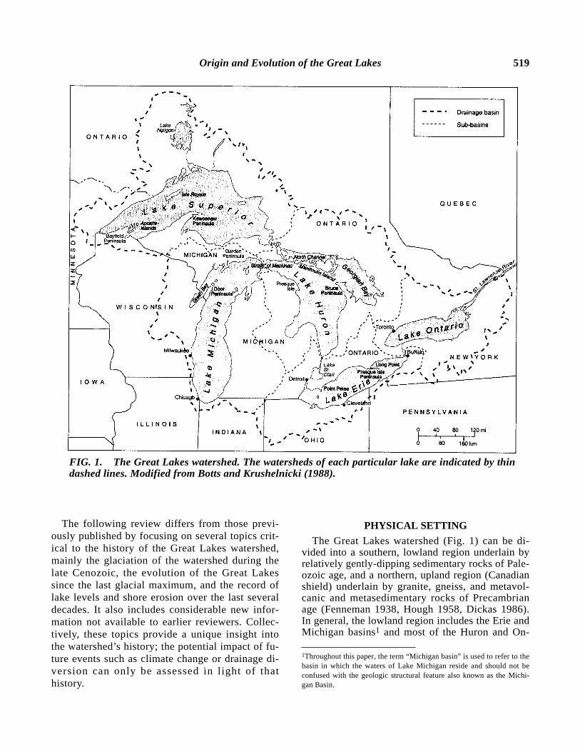
The North American Great Lakes watershed (Fig.1) covers about 765,990 km2 and is home to one-tenth of the population of the United States andone-quarter the population of Canada. It includespart or all of eight U.S. states and a Canadianprovince, and contains the five Great Lakes whichcollectively represent the largest unfrozen freshwa-ter body on Earth.
The origins of the watershed are a product ofmultiple glaciations during the late Cenozoic aswell as redirected drainage, particularly during re-treat of the last ice sheet. As a result, its historyand evolution have long attracted the attention of
*Corresponding author: E-mail: [email protected]
glacial and Quaternary geologists and have re-sulted in a number of excellent reviews during thelast 85 years (Leverett and Taylor 1915; Hough1958, 1963, 1966; Fullerton 1980; Mickelson etal.1982; Dyke and Prest 1987; Karrow 1989). Inaddition, there have been several syntheses thathave focused on parts of the Great Lakes water-shed (Chapman and Putnam 1984, Dreimanis andKarrow 1972, Farrand and Eschman 1974, Barnett1992, Dreimanis 1977) and some of the best re-views specific to development of glacial and postglacial lakes can be found in Farrand 1969, Karrowet al. 1975, Karrow and Calkin 1985, Larsen 1987,Teller 1987, Hansel and Mickelson 1988, Schnei-der and Fraser 1990, Colman et al. 1994a, andLewis et al.1994.
Origin and Evolution of the Great Lakes 519
The following review differs from those previ-ously published by focusing on several topics crit-ical to the history of the Great Lakes watershed,mainly the glaciation of the watershed during thelate Cenozoic, the evolution of the Great Lakessince the last glacial maximum, and the record oflake levels and shore erosion over the last severaldecades. It also includes considerable new infor-mation not available to earlier reviewers. Collec-tively, these topics provide a unique insight intothe watershed’s history; the potential impact of fu-ture events such as climate change or drainage di-version can only be assessed in l ight of thathistory.
PHYSICAL SETTING
The Great Lakes watershed (Fig. 1) can be di-vided into a southern, lowland region underlain byrelatively gently-dipping sedimentary rocks of Pale-ozoic age, and a northern, upland region (Canadianshield) underlain by granite, gneiss, and metavol-canic and metasedimentary rocks of Precambrianage (Fenneman 1938, Hough 1958, Dickas 1986).In general, the lowland region includes the Erie andMichigan basins1 and most of the Huron and On-
FIG. 1. The Great Lakes watershed. The watersheds of each particular lake are indicated by thindashed lines. Modified from Botts and Krushelnicki (1988).
1Throughout this paper, the term “Michigan basin” is used to refer to thebasin in which the waters of Lake Michigan reside and should not beconfused with the geologic structural feature also known as the Michi-gan Basin.

520 Larson and Schaetzl
tario basins. Except for broad, low morainal ridgesand a few bedrock escarpments, it tends to be anarea of low relief, and is generally blanketed by acontinuous mantle of glacial sediments, oftengreater than 50 m in thickness and in places over350 m thick (Rieck and Winters 1993, Soller 1998).The upland region includes most of the Superiorand Georgian Bay basins and parts of the Ontariobasin. It can be distinguished topographically by adistinct bedrock-dominated topography formed as aresult of bedrock structure and differential erosionby glaciers. Thin, discontinuous glacial sedimentsblanket this region (Fenneman 1938, LaBerge1994).
Preglacial Landscape
Prior to Quaternary glaciations, the Great Lakeswatershed was subjected to long-term subaerial ero-sion. Evidence for this, however, is sparse and in-cludes fragments of former bedrock valley systemsdeveloped on the preglacial bedrock landscape (Fig. 2). Of these, the best known is the Laurentiandrainage system, which can be traced in the subsur-face from the western end of the Ontario basin tothe southern end of the Georgian Bay basin(Spencer 1891, White and Karrow 1971, Eyles etal. 1985). It formerly extended eastward throughthe Ontario basin to the head of the St. Lawrencevalley and included tributaries that reached as farwest as the Erie, Huron, Superior, and Michiganbasins (Spencer 1907, Horberg and Anderson1956). The Teays-Mahomet valley system occurssouth of the watershed and was tributary to the an-cient Mississippi drainage system (Tight 1903, Hor-berg 1950, Gray 1991, Teller and Goldthwait 1991).Both the Laurentian and Teays-Mahomet systems,evolved throughout the late Tertiary and Quater-nary, were undoubtedly modified by repeatedglaciations. It is therefore doubtful that the inte-grated drainage networks depicted in Figure 2 ex-isted at any one time.
Evidence for preglacial weathering processes andsoil formation occurs in the form of saprolite(highly weathered rock, in place) that is found inQuebec (LaSalle and De Kimpe 1989, Bouchardand Pavich 1989) and in the Adirondack Mountainsof New York (Muller 1965), though some of thesemay also have formed during an interglacial period.Neither saprolite nor residuum have been reportedin the Great Lakes watershed proper, probably be-cause of removal by Quaternary glaciers or becauseit now lies deeply buried beneath glacial sediments.
Finally, deep weathering of limestones within thewatershed led to the development of karst—sink-holes, underground streams, and caves. These fea-tures, common on the Devonian limestone (Fig. 3),were undoubtedly partially eroded by Quaternaryglaciations, and then covered by (filled with)glacial sediments (Farrand 1995). A particularly in-teresting solution feature developed on Silurianlimestone is the Pipe Creek Jr. sinkhole located justsouth of the Great Lakes watershed in GrantCounty, Indiana (Farlow et al. 1997, 1998, 2001;Holman 1998). It is buried by drift and is filled withlocally derived rubble containing a diverse assem-blage of late Miocene to early Pliocene (LateHemphillian) fossil vertebrates and plants.
Origin of the Lake Basins
The Ontario, Erie, Huron, Superior, and Michi-gan basins owe their origin mainly to channeling ofice flow along major bedrock valley systems thatexisted prior to glaciation, and to increased glacialscouring and erosion in areas of relatively weakbedrock (Fenneman 1938, Hough 1958, Cvancaraand Melik 1961, Wold et al. 1981). This is particu-
FIG. 2. Preglacial drainage systems inferred forthe Great Lakes region. Sites where magnetically-reversed sediments (> 0.78 Ma) have been docu-mented are shown by an open circle. In part, afterSpencer (1907), Horberg and Anderson (1956),and Gray (1991).

Origin and Evolution of the Great Lakes 521
FIG. 3. Bedrock geology of the Great Lakes watershed. All bedrock shownin the C-D transect is Precambrian in age; different stippling and shadingpatterns are shown to differentiate one rock unit from another, and do notrefer back to the key shown above. Modified from Hough (1958) and West-john and Weaver (1998).
522 Larson and Schaetzl
larly evident from Figure 3, which shows parts ofthe Huron, Erie, and Michigan basins conformingto the outcrop pattern of Devonian and Upper Sil-urian rocks that are, in large part, erodible shalesand limestones. Likewise, a belt of weak Ordovi-cian shales underlies Green Bay (on the west sideof the Michigan basin), North Channel and Geor-gian Bay (on the northern and northeastern part ofthe Huron basin), and much of the southern half ofthe Ontario basin. Even the Superior basin, whichlies almost wholly within the Canadian Shield, islargely developed along the length of a structuralbasin that includes sandstones of Precambrian ageand Upper Keweenawan (late Precambrian) sedi-mentary rocks that are slightly metamorphosed andconsiderably less resistant to glacial erosion than
underlying, older volcanic rocks (Hough 1958,Dickas 1986).
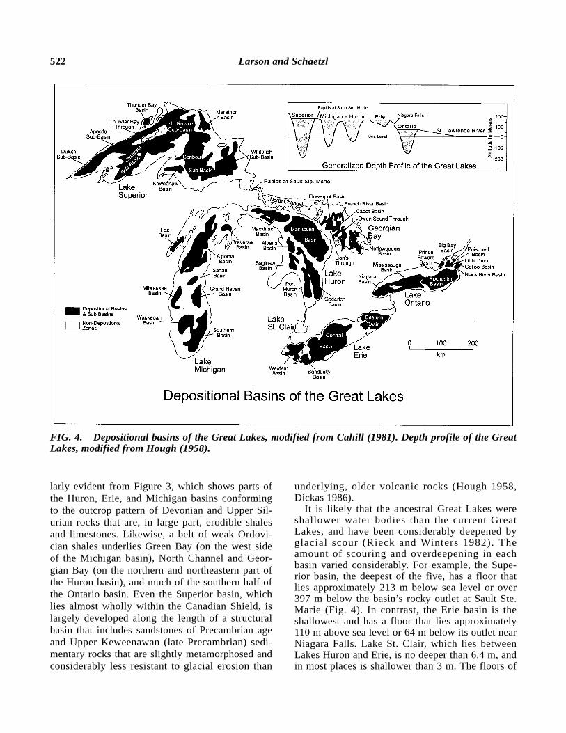
It is likely that the ancestral Great Lakes wereshallower water bodies than the current GreatLakes, and have been considerably deepened byglacial scour (Rieck and Winters 1982). Theamount of scouring and overdeepening in eachbasin varied considerably. For example, the Supe-rior basin, the deepest of the five, has a floor thatlies approximately 213 m below sea level or over397 m below the basin’s rocky outlet at Sault Ste.Marie (Fig. 4). In contrast, the Erie basin is theshallowest and has a floor that lies approximately110 m above sea level or 64 m below its outlet nearNiagara Falls. Lake St. Clair, which lies betweenLakes Huron and Erie, is no deeper than 6.4 m, andin most places is shallower than 3 m. The floors of
FIG. 4. Depositional basins of the Great Lakes, modified from Cahill (1981). Depth profile of the GreatLakes, modified from Hough (1958).

Origin and Evolution of the Great Lakes 523
the Superior, Huron, and northern part of the Michi-gan basins also tend to be irregular and complicatedby the presence of resistant bedrock layers. In con-trast, the floors of the Erie, Ontario, and southernpart of the Michigan basins tend to be relativelysmooth due to the “softness” and relative homo-geneity of the underlying bedrock.
In many places, Quaternary sediments underliethe floor of the Great Lakes. In the Michigan,Huron, Erie, and Ontario basins their thickness canexceed 100 m and in the Superior basin they canexceed 250 m (Soller 1993, 1998). These sedi-ments, particularly within the Erie basin, indicatethat lake floor topography is not just the product ofglacial erosion but also of glacial and post glacialdeposition. Each basin can also be subdivided indepositional basins and subbasins (Fig. 4) that arecurrently receiving the bulk of fine-grained sedi-ment washing into the Great Lakes (Cahill 1981).Their number, depth, size, and shape, however, varyfrom basin to basin. For example, the Erie basin in-cludes four depositional basins, most of which areshallow, broad, and semicircular. In contrast, theHuron basin contains 10, most of which are deep,elongate, or irregularly shaped.
Islands and Peninsulas
Most of the Great Lakes islands and major penin-sulas are underlain by resistant bedrock that haswithstood erosion from multiple glaciations. Forexample, Silurian dolomite forms the Door andGarden peninsulas, and islands that separate GreenBay from Lake Michigan (Figs. 1, 3). The samebedrock (Niagaran series) also occurs along thenorthern shore of Lake Michigan and forms the is-lands that separate North Channel and GeorgianBay from Lake Huron. Additionally, it forms LakeHuron’s Bruce Peninsula (Fig. 1) and can be tracedsoutheastward along a broad arch to where it formsa prominent escarpment over which the NiagaraRiver flows at Niagara Falls. Most of the islands inLake Michigan just west of the Straits of Mackinacare also associated with resistant dolomite andlimestone of the Bois Blanc Formation (Devonian).The archipelago known as the Less Cheneaux Is-lands, east of the Straits, are knobs of resistant En-gadine dolomite (Silurian). The small islands at thewestern end of Lake Erie are likewise associatedwith resistant layers of the Columbus Limestoneand Upper Bass Island Dolomite (Devonian). In theSuperior basin, resistant bedrock associated withthe multiple strata of Portage Lake volcanics (Ke-
weenawan) form the backbone of the KeweenawPeninsula as well as much of Isle Royale (Figs. 1,3). In the western part of the basin, resistant sand-stone of the Bayfield Group (Precambrian) formsthe Apostle Islands and underlies the BayfieldPeninsula.
GLACIAL HISTORY
The record of the most recent glaciation is wellpreserved in the Great Lakes watershed and in-cludes a number of stratigraphic sections that havebeen studied in great detail; the most commonlycited sections are shown in Figure 5. The strati-graphic record is incomplete, however, for glacia-tions that preceded the last, mainly because muchof the sedimentary record has either been com-pletely eroded away by subsequent glaciations, oris buried too deeply to be easily studied (Blewett1991, Rieck and Winters 1993). South and west ofthe Great Lakes watershed, however, where glacialerosion was less severe, the record of earlierglaciations is better preserved and provides someinsight to the watershed’s early glacial history.Oceanic records, particularly oxygen isotope ratios(18O) from deep sea sediments, also provide cluesas to when global ice volumes may have been largeenough to allow glacier ice to invade the watershed(Ruddiman and Raymo 1988).
FIG. 5. Locations of organic deposits in glacialsediments within the Great Lakes watershed, datedbetween 64.5 and 25 ka. Also shown are the loca-tions of major stratigraphic sections, and the max-imum southern extent of the Wisconsin glaciation.Note that Voegelli Farm and Oak Crest Bog sec-tions lie outside the Great Lakes watershed.

524 Larson and Schaetzl
Evidence of Early Glaciations
Glaciolacustrine silts having reversed magneticpolarity have been reported in Pennsylvania (Gard-ner et al. 1994), West Virginia (Bonnett et al.1991), Ohio (Hoyer 1976, 1983), Indiana (Bleuer1976), Illinois (Johnson 1986) and Wisconsin(Baker et al. 1983) (Fig. 2). Their presence hasbeen used to argue that glacial ice had penetratedinto at least part of the Great Lakes watershed be-fore the Matuyama-Brunhes geomagnetic reversal2
of approximately 0.78 Ma3 (Fullerton 1986, John-son 1986). The magnetically reversed silts in Wis-consin, however, are particularly noteworthybecause they may be the same age as magneticallyreversed glacial sediments in Iowa and Nebraskadated at > 2.01 Ma (Richmond and Fullerton 1986).If so, it would suggest that glacier ice extendedacross much of the northern Great Plains and possi-bly into the western end of the Great Lakes water-shed during the Matuyama-Reunion reversal whichoccurred around 2.14 Ma (Richmond and Fullerton1986). On the other hand, it appears that most, ifnot all, of the existing loess-stratigraphic (wind-blown silt) units in the Mississippi Valley areyounger than 0.79 Ma (Pry and Johnson 1988,Clark et al. 1989, Forman et al. 1992, Leigh andKnox 1993) and the lack of older loess-stratigraphicunits there suggests that glacier ice rarely advancedinto the upper Mississippi watershed (Iowa andMinnesota) prior to 0.79 Ma (Leigh and Knox1993).
The oxygen isotope marine record likewiseshows that initiation of moderate-sized ice sheets inthe Northern Hemisphere began no earlier than 2.4Ma and that large-scale ice sheets, comparable insize to the ones that covered much of North Amer-ica and northern Europe during the last glaciation,did not develop until about 0.8–0.7 Ma (Ruddimanand Raymo 1988). The marine record also indicatesthat large ice sheets in the northern hemispherehave waxed and waned on a ~100,000 year cyclesince about 0.74 Ma (Ruddiman and Raymo 1988,Shackleton et al.1988).
Evidence for Multiple Glaciations
Many sites in Ohio, Indiana, and Illinois showstratigraphic evidence for multiple glaciations.
When viewed collectively they indicate that theGreat Lakes watershed must have been glaciatedpartially or totally at least six times since 0.78 Ma(Fullerton 1986, Johnson 1986) and that someglaciations must have extended as far south asnorthern Kentucky (Leighton and Ray 1965, Ray1974, Swadley 1980).
The last two glaciations extended to the OhioRiver near Cincinnati and are referred to as the Illi-noian and Wisconsin glaciations, which occurredbetween 0.302 and 0.132 Ma, and between 0.79 Maand 10 ka, respectively (Richmond and Fullerton1986). Separating the two is the Sangamon inter-glaciation which, from Ohio westward to Iowa andKansas, is often represented by an extensive andwell developed soil (paleosol, geosol) believed tohave formed in a climate warmer and perhaps drierthan present (Follmer 1978, Schaetzl 1986, Curryand Pavich 1996). Glacial deposits older than thosedeposited by the Illinoian ice (referred to as pre-Illi-noian) also occur in these states but, because theircorrelation with respect to the Pearlette ash wasthrown into doubt about 30 years ago, their absoluteage has yet to be worked out (Hallberg 1986).
The best evidence for multiple glaciations in theGreat Lakes watershed occurs in the Don ValleyBrickyard near Toronto (Fig. 5) where a fossilifer-ous sand (Don Formation) rests on till and is over-lain by a thick sequence of sediments associatedwith the Wisconsin glaciation. The fossils found inthe sand include pelecypods and gastropods (Cole-man 1933, Baker 1931, Kerr-Lawson et al. 1992),pollen and plant remains (Terasmae 1960, Richardet al. 1999), diatoms (Duthie and Mannada Rani1967), caddisflies (Williams and Morgan 1977), os-tracods (Poplawski and Karrow 1981), and verte-brates (Karrow 1969, Harington 1990). Studies ofthe diatoms, caddisflies, and ostracods all indicatethat the sand was deposited in a freshwater estuaryor river mouth environment and in a climate typicalof temperate North America today (Duthie andMannada Rani 1967, Williams and Morgan 1977,Poplawski and Karrow 1981). Studies of the pollenand plant remains indicate the presence of a hard-wood forest which was yielding to spruce/pine(Terasmae 1960, Richard et al. 1999). On the basisof the pollen record it has been suggested that theannual mean temperature at the time the sand wasdeposited was probably 3°C warmer than present(Terasmae 1960). The general consensus is thatsand at the brickyard was probably deposited dur-ing the Sangamon interglaciation, whereas the un-derlying till was most likely deposited during the
2A geomagnetic reversal is when the earth’s magnetic fields periodicallyreverses polarity. 3Throughout this paper “Ma” refers to million years and “ka” refers tothousand of years. Ages < 65 ka are in radiocarbon years.

Origin and Evolution of the Great Lakes 525
Illinoian glaciation (Terasmae 1960, Karrow 1984,Karrow 1990).
Evidence for multiple glaciations also occurs atGarfield Heights, near Cleveland (Fig. 5), where awell developed paleosol formed on outwash gravelis overlain by a series of tills. The paleosol hasbeen associated with the Sangamon interglaciation(White 1953, 1968), but it may have just as likelyformed before the Illinoian glaciation (Fullerton1986).
Other sites in and adjacent to the Great Lakeswatershed that contain paleosols or organic bedsthat probably represent interglaciations (Fullerton1986) occur east of Lake Ontario on the Ontario-Quebec border (Anderson et al. 1990), in north-western Pennsylvania (White 1969), in westernNew York (Calkin et al.1982), and in Illinois, Indi-ana, and Iowa (Ruhe 1956, Follmer 1982, Olson1989, Johnson and Balek 1991). Of particular inter-est is also a pollen record from south-central Illi-nois. It shows that that region was characterized bydeciduous forest with bald cypress during the Sang-amon interglaciation (Grüger 1972a, Grüger 1972b,Teed 2000).
Advance of the Last Ice Sheet
During the Wisconsin glaciation the LaurentideIce Sheet, centered in northern and eastern Canada,expanded southward and eventually covered the en-tire Great Lakes watershed. While at its maximum,it probably had two centers from which ice flow ra-diated, one located near Labrador and the other im-mediately west of Hudson Bay; the thickness of iceat the centers was probably between 2,500 and3,000 m (Boulton et al. 1985). Over the GreatLakes watershed, however, it was considerablythinner. Recent estimates based on glaciologicaltheory place it between 750 and 2,500 m (Hughes etal. 1981, Boulton et al. 1985). The reason for sucha wide range in estimated thickness is that the cal-culation of the lower value takes into account basalshear-stress conditions that occur when imperme-able and deformable sediments, such as shale,clayey till, or fine lacustrine sediments, underliethat glacier bed (Boulton et al. 1985), whereas cal-culation of the higher value takes into account basalshear-stress conditions that occur when only perme-able and nondeformable bedrock (or sediments) un-derlies the glacier bed (Hughes et al. 1981). Thepresence of highly impermeable and/or deformablebeds beneath the ice would also mean ice movedmore rapidly and had a gentler surface slope than
ice that flowed across mainly permeable and/ornondeformable beds (Boulton et al. 1985, Claytonet al.1985, Clark 1992).
Stratigraphic evidence from Scarborough Bluffsnear Toronto (Fig. 5) indicates that during the earlypart of the Wisconsin glaciation, between 65 to 79ka, ice advanced from the northeast and dammed alake in the Ontario basin (Karrow 1984). How farwest the ice advanced, however, is debatable(Fullerton 1986, Karrow 1989, Eyles and Westgate1987, Dreimanis 1992, Hicock and Dreimanis 1992,Miller et al. 1992, Szabo 1992), but it probably didnot extend as far as western Indiana. In the Michi-gan and Superior basins no reliable stratigraphic ev-idence exists to suggest the presence of glacier icethere during the early part of the Wisconsin glacia-tion. However, it is likely that large lakes existed inthose basins at this time.
At Scarborough Bluffs (Fig. 5), stratigraphic evi-dence also shows that during the middle part of theWisconsin glaciation, between 35 and 65 ka, themargin of the ice sheet oscillated within the Ontariobasin (Karrow 1969, 1984, 1989). Exactly where itoscillated has been debated (Karrow 1984, 1989;Eyles and Westgate 1987; Eyles and Williams1992), but i t is clear that i t terminated in aproglacial lake. Fine-grained sediments in a high-level, ice-dammed lake in the Finger Lakes regionof New York contain wood that has yielded a radio-carbon age of 41.9 ka. This finding also supportsthe presence of glacier ice in the Ontario basin dur-ing the middle part of the Wisconsin glaciation(Bloom and McAndrew 1972).
In contrast to the eastern end of the Great Lakeswatershed, there is no firm stratigraphic evidenceelsewhere in the watershed to suggest the presenceof glacier ice during the middle part of the Wiscon-sin glaciation (Winters et al. 1986). In fact, radio-carbon ages from buried organic deposits found inthe Erie, Huron, and Michigan basins (Fig. 5) showthat much of the southern part of the watershed wasgenerally free of glacial ice during the interval from64.5 to 25 ka (Winters et al. 1986; Curry andFollmer 1992; Karrow 1984, 1989). The associationof fine-grained sediments with some of the organicdeposits also suggests that lakes were present andthat their levels fluctuated—probably as the resultof glacier ice blocking drainage to the east(Dreimanis et al. 1966, Winters et al. 1986). Attimes, some of the lake drainage may also havebeen directed southward into the Illinois River, car-rying with it sediment that may have been thesource for the Roxana loess along the lower Illinois
526 Larson and Schaetzl
River valley (Winters et al. 1988). An alternativeexplanation for the loess, however, is that it was de-rived from flood plains of proglacial rivers associ-ated with an ice advance into the upper MississippiRiver valley (Minnesota and western Wisconsin)sometime between 55 ka and 27 ka (Johnson andFollmer 1989; Leigh and Knox 1993, 1994; Leigh1994). If true, it would suggest that glacier iceprobably also extended into Superior basin and per-haps even into the northern end of the Michiganbasin during the middle part of the Wisconsinglaciation (Grimley 2000).
Some buried organic deposits have yielded pollenthat sheds light on the vegetation and climate thatexisted in unglaciated parts of the Great Lakes wa-tershed during the middle part of the Wisconsinglaciation. For example, an extensive pollen recordobtained from Port Talbot along the north shore ofLake Erie (Figure 5) shows initial warm and dryclimatic conditions (but cooler than an interglacial)followed by climatic cooling and possibly a forest-tundra environment (Berti 1975). Another pollenrecord from near Kalkaska in northern lower Michi-gan (Fig. 5) shows that about 35 ka the vegetationthere evolved from a cold, open forest into a closedboreal forest not unlike that of the northern GreatLakes today (Winters et al. 1986). In contrast,pollen from Voegelli Farm (Whittecar and Davis1982) and Oak Crest Bog (Meyers and King 1985),just outside of the watershed in northern Illinois(Fig. 5), shows the existence there of a forest oropen woodland dominated by pine and spruce dur-ing the period 47 to 24 ka (Heusser and King 1988).Lastly, pollen from south-central Illinois shows thatduring the same time interval that region was char-acterized by prairie with oak/hickory stands(Grüger 1972a, 1972b; Teed 2000).
During the late part of the Wisconsin glaciation,between 35 and 10 ka, the margin of the Laurentideice sheet advanced in a series of sublobes that even-tually covered the entire Great Lakes watershed(Grimley 2000). This expansion and subsequentwithdrawal was characterized by a series of majorand minor advances and retreats, evidence forwhich occurs in the stratigraphic record and in thecross cutting relationship of end moraines. Al-though no compelling evidence exists to suggestthat any major advance or retreat of a sublobe wasout of phase with the rest, minor advances or re-treats may not have been synchronous (Mickelsonet al.1982).
Ice initially advanced into the Michigan basinabout 26 ka (Winters and Rieck 1991), and by about
20 to 19 ka the ice margin reached its mostsoutherly position in east-central Illinois (Fig. 5)(Hansel and Johnson 1992). There, it fluctuated forabout 3,000 years, at times retreating as far north asthe southern end of the Michigan basin before read-vancing to a slightly less southerly position thanthat of the previous advance (Hansel and Johnson1992, Johnson et al.1997).
In the Erie basin a minor ice advance may haveoccurred as early as about 27.5 ka, but it probablydid not extend much beyond the southern shore ofLake Erie (Fullerton 1986). This was followed byan ice advance into the Erie and Huron basins atabout 22 ka (Karrow 1984), and by about 21 ka iceextended well into southwestern Ohio and south-central Indiana where it coalesced with ice flowingsouthward out of the Michigan basin (Fig. 5)(Fullerton 1986). There, the ice margin fluctuatedfor nearly 4,000 years, at times overriding forestsand burying logs beneath glacial sediments (Lowellet al.1990, 1999a). Farther east, however, in north-eastern Ohio, northern Pennsylvania, and westernNew York, the advance of ice was constrained bythe Appalachian Plateau and did not extend as farsouth as it did further west (Muller and Calkin1993). By about 20.5 ka the ice margin in the Supe-rior basin also advanced well into northern Wiscon-sin and east-central Minnesota (Match andSchneider 1986).
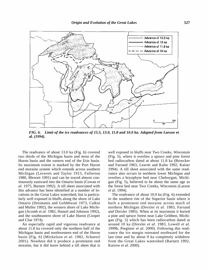
Retreat of the Last Ice Sheet
After reaching its maximum extent and oscillat-ing near that position for several thousand years,the southern margin of the Laurentide ice sheetbegan a general retreat northward into the GreatLakes watershed, interrupted by several major read-vances that culminated at about 15.5, 13.0, 11.8,and 10.0 ka (Fig. 6). The readvance of about 15.5ka extended into central and western New York,northeastern Pennsylvania and northeastern Ohio,central Ohio and Indiana, southern lower Michigan,northwestern Indiana, northeastern Illinois and east-ern Wisconsin (Mickelson et al. 1982). In places,the limit of this advance is marked by a well devel-oped end moraine, but in some areas it is poorly de-fined due to collapse topography or obscured by alater readvance of the ice margin. The readvance ofabout 15.5 also deposited till which today locallyforms steep bluffs along the Lake Erie (Barnett1987, Szabo and Bruno 1996) and southern LakeMichigan shore (Hansel 1983, Mickelson et al.1984, Monaghan et al.1986b).
Origin and Evolution of the Great Lakes 527
The readvance of about 13.0 ka (Fig. 6) coveredtwo thirds of the Michigan basin and most of theHuron basin and the eastern end of the Erie basin.Its maximum extent is marked by the Port Huronend moraine system which extends across southernMichigan (Leverett and Taylor 1915, Fullerton1980, Blewett 1991) and can be traced almost con-tinuously eastward into the Ontario basin (Cowan etal. 1975, Barnett 1992). A till sheet associated withthis advance has been identified at a number of lo-cations in the Great Lakes watershed, but is particu-larly well exposed in bluffs along the shore of LakeOntario (Dreimanis and Goldthwait 1973, Calkinand Muller 1992), the western shore of Lake Michi-gan (Acomb et al.1982, Hansel and Johnson 1992),and the southeastern shore of Lake Huron (Cooperand Clue 1974).
An especially rapid and vigorous readvance atabout 11.8 ka covered only the northern half of theMichigan basin and northwestern end of the Huronbasin (Fig. 6) (Mickelson et al. 1982, Schaetzl2001). Nowhere did it produce a prominent endmoraine, but it did leave behind a till sheet that is
well exposed in bluffs near Two Creeks, Wisconsin(Fig. 5), where it overlies a spruce and pine forestbed radiocarbon dated at about 11.8 ka (Broeckerand Farrand 1963, Leavitt and Kalin 1992, Kaiser1994). A till sheet associated with the same read-vance also occurs in northern lower Michigan andoverlies a bryophyte bed near Cheboygan, Michi-gan (Fig. 5), believed to be about the same age asthe forest bed near Two Creeks, Wisconsin (Larsonet al.1994).
The readvance of about 10.0 ka (Fig. 6) extendedto the southern rim of the Superior basin where itbuilt a prominent end moraine across much ofnorthern Michigan (Drexler et al. 1983, Farrandand Drexler 1985). When at its maximum it burieda pine and spruce forest near Lake Gribben, Michi-gan (Fig. 5) which has been radiocarbon dated ataround 10 ka (Drexler et al. 1983, Lowell et al.1999b, Pregitzer et al. 2000). Following this read-vance the ice margin retreated northward for thelast time and by about 9 ka completely withdrewfrom the Great Lakes watershed (Barnett 1992,Karrow et al.2000).
FIG. 6. Limit of the ice readvances of 15.5, 13.0, 11.8 and 10.0 ka. Adapted from Larson etal. (1994).

528 Larson and Schaetzl
EVOLUTION OF THE GREAT LAKES
The record of glacial and postglacial lakes in theGreat Lakes watershed consists of bars, lake floorsediments, and abandoned spillways and channels,as well as wave-cut cliffs, beach ridges, and deltasthat indicate shorelines now abandoned (Fig. 7).Not surprisingly, the spillways are of particular im-portance because they controlled the level of lakesand were subject to periodic ice blockage, isostaticuplift, and downcutting. In general, they can be di-vided into those that channeled water from one lakebasin to another and those that discharged into riversystems that drained out of the watershed (Fig. 7).A set of spillways, located along the north shore ofthe Superior basin, also periodically channeledwater into the watershed from glacial Lake Agassiz,
which occupied an ice dammed basin in parts ofManitoba, Ontario, Saskatchewan, Minnesota, andthe Dakotas (Teller 1985).
Besides contributing information about lake lev-els, former shorelines shed light on the history ofglacial retreat and isostatic uplift. For example, theshoreline associated with glacial Lake Algonquin(Fig. 7), which formed about 11 ka and was one ofthe last of the major glacial lakes to develop in thewatershed, has been traced almost continuouslyfrom the Huron and northern Michigan basins to theeastern end of the Superior basin (Eschman andKarrow 1985, Farrand and Drexler 1985, Larsen1987). (It cannot be traced further west into the Su-perior basin because ice associated with the read-vance of about 10.0 ka destroyed the shoreline.) An
FIG. 7. Locations of shorelines of prominent proglacial lakes in the Great Lakes water-shed, and their spillways and outlets. After Karrow (1984).

Origin and Evolution of the Great Lakes 529
increase of the Algonquin shoreline elevation at thepresent time of over 150 m, northeastward acrossthe Huron basin, is due to differential isostatic up-lift since abandonment of the lake just after about10.5 ka (Fullerton 1980, Karrow et al.1975, Kaszy-cki 1985).
The Glacial Great Lakes
As the southern margin of the Laurentide icesheet receded, large proglacial lakes formed in thelake basins between high topography to the southand the ice margin to the north. These lakes gener-ally widened and expanded northward with the re-treat of the ice margin, but during readvances theywere displaced by glacier ice and made smaller (ortotally displaced).
The first of the proglacial lakes formed about 16ka when the ice margin retreated northward somedistance into the watershed (Fig. 8A). The lakesformed included glacial Lake Milwaukee which oc-cupied the southern part of the Michigan basin andpresumably drained south into the Mississippidrainage system (Schneider and Need 1985), andglacial Lake Leverett which occupied the Erie basinand for a time drained east over the Niagara Escarp-ment to the Atlantic (Mörner and Dreimanis 1973,Karrow 1984, Fullerton 1980, Barnett 1992). Athird unnamed glacial lake probably existed atabout this time in the southern part of the Huronbasin and drained south into the Erie basin (Karrow1984). All three of the lakes, however, lasted lessthan 1,000 years and were completely destroyed bythe ice readvance of about 15.5 ka.
Glacial Lakes from 15.5 ka to 13 ka
With subsequent ice-marginal retreat after the icereadvance of about 15.5 ka, large glacial lakes onceagain formed in the Great Lakes watershed (Fig.8B). One of these was glacial Lake Chicago whichdeveloped in the Michigan basin and drained southinto the Mississippi drainage system via an outletnear Chicago (Figs. 7, 8B) (Leverett and Taylor1915). The lake persisted through the readvances ofabout 13.0 and 11.8 ka, except for two brief inter-vals when drainage appears to have been temporar-ily diverted northward across the northern tip ofsouthern Michigan (Hough 1963, 1966; Bretz 1964;Hansel et al. 1985; Colman et al. 1994a). It in-cluded at least two phases or lake levels, the Glen-wood phase being the earliest and highest, followedby the Calumet phase (Leverett and Taylor 1915;
Hough 1963, 1966; Bretz 1964; Hansel et al. 1985;Colman et al. 1994a). Exactly when the Calumetphase began has been debated (Farrand and Es-chman 1974, Fullerton 1980, Hansel et al. 1985)but one explanation proposed for the change in lakelevels has been periodic downcutting of the outletnear Chicago (Bretz 1951, 1955; Kehew 1993).More recently, however, it has been proposed thatmajor changes alone in the net input of glacial melt-water and precipitation entering the Michigan basincould explain the differences in lake levels (Hanseland Mickelson 1988).
Another important proglacial lake was glacialLake Maumee. It developed in the Erie basin (Fig.8B) and formed slightly earlier than did glacialLake Chicago (Leverett and Taylor 1915). Initially,it discharged southwest into the Wabash Valley viaan outlet near Fort Wayne, Indiana, and thence tothe Ohio River (Figs. 7, 8B) (Leverett and Taylor1915, Eschman and Karrow 1985). Later, however,as the ice margin retreated northward, the lake ex-panded into the southern part of the Huron basinand drained north and then west across the “thumb”of southern Michigan via an unknown buried outlet(Leverett and Taylor 1915, Eschman and Karrow1985). Following a minor readvance of the ice mar-gin it drained via the Imlay Channel that today cutsnorth and then west across the axis of the “thumb”(Leverett and Taylor 1915, Eschman and Karrow1985). Once across the “thumb,” drainage fromglacial Lake Maumee was directed west down theglacial Grand River Valley and into glacial LakeChicago (Leverett and Taylor 1915, Eschman andKarrow 1985). The change from a southwestern to anorthern outlet led to several lake phases known asMaumee I, II, and III (Leverett and Taylor 1915). Ithas been suggested, however, that the last twophases may have continued to drain southwest viathe outlet near Fort Wayne despite the opening of anorthern outlet (Bleuer and Moore 1972).
Late in the history of glacial Lake Maumeedrainage was also directed into Early Lake Saginawwhich developed in the Saginaw lowlands as the icemargin retreated northward (Leverett and Taylor1915, Eschman and Karrow 1985). Early Lake Sag-inaw drained west into the glacial Grand Valley viaan outlet near Maple Rapids, Michigan (Leverettand Taylor 1915, Eschman and Karrow 1985) and itis possible that the outlet may have been intermit-tently incised due to an increase in the amount ofmeltwater from the retreating ice front (Bretz1951), or from the addition of water by catastrophic

530 Larson and Schaetzl
FIG. 8. Locations and general extent of the major proglacial lakes associatedwith the retreat of the Laurentide ice sheet.

Origin and Evolution of the Great Lakes 531
draining of glacial Lake Maumee (Eschman andKarrow 1985).
Both Early Lake Saginaw and glacial LakeMaumee were replaced by glacial Lake Arkona justprior to about 13.5 ka when the ice margin finallyretreated far enough north across the “thumb” toallow for the merging of water in the Huron andErie basins with that in the Saginaw lowlands (Fig.8C) (Leverett and Taylor 1915, Fullerton 1980).Glacial Lake Arkona, which drained into the glacialGrand Valley via the outlet near Maple Rapids, thenexpanded northward and eastward against the re-treating ice margin until a still lower outlet becameice free near the Trent lowlands in Ontario (Es-chman and Karrow 1985; Barnett 1985, 1992). As aresult, glacial Lake Arkona drained and was re-placed by two eastward-draining low-level lakes,glacial Lake Ypsilanti in the Erie basin (Kunkle1963) and an unnamed lake in the Huron basin (Fig.8D) (Dreimanis and Karrow 1972, Fullerton 1980,Eschman and Karrow 1985). At about the sametime the Indian River lowland and Straits of Mack-inac may have become ice free, resulting in a dropin the level of glacial Lake Chicago and develop-ment of a low-level lake (intra-Glenwood lowphase) in the Michigan basin that drained east intothe Huron basin via the Straits (Fig. 8D) (Hough1958, 1963, 1966; Hansel et al. 1985; Monaghanand Hansel 1990).
Glacial Lakes from 13 ka to 11.8 ka
The readvance of about 13 ka to the Port Huronmoraine closed off the Trent lowland outlet andproduced glacial Lake Saginaw in the Huron basinand glacial Lake Whittlesey in the Erie basin. Italso closed off the Indian River lowlands whichlead to restoration of glacial Lake Chicago in theMichigan basin. Glacial Lake Whittlesey drainednorth and then west across the “thumb” of Michi-gan into glacial Lake Saginaw via the Ubly chan-nel, whereas glacial Lake Saginaw drained westinto the glacial Grand Valley via Maple Rapids andthence into glacial Lake Chicago (Figs. 7, 8E) (Lev-erett and Taylor 1915, Fullerton 1980, Eschman andKarrow 1985, Calkin and Feenstra 1985). Subse-quent retreat of the ice margin, however, resulted inthe northward and eastward expansion of bothglacial Lake Saginaw and glacial Lake Whittlesey,and eventually they coalesced to the level of glacialLake Warren which formed after down-cutting ofthe spillway at Maple Rapids, possibly by cata-strophic drainage from glacial Lake Whittlesey
(Kehew 1993). As the ice margin continued to re-treat north and eastward, a new lower outlet forglacial Lake Warren became exposed just south ofBuffalo, New York which drained east into the Mo-hawk River valley (Eschman and Karrow 1985,Calkin and Feenstra 1985).
The new outlet near Buffalo led to drainage ofglacial Lake Warren and the establishment ofglacial Lake Grassmere and later glacial LakeLundy in the Huron and Erie basins. These newlakes also appear to have drained eastward into theMohawk River Valley (Eschman and Karrow 1985,Calkin and Feenstra 1985) but their actual outletsremain uncertain (Hough 1958, Eschman and Kar-row 1985, Calkin and Feenstra 1985). In addition, itis generally believed that a short-lived low-levellake, glacial Lake Wayne, developed in the Huronand Erie basins before the level of glacial LakeWarren fell to the level of glacial Grassmere, andthat this lake drained east into the Mohawk RiverValley (Fullerton 1980, Muller and Prest 1985).
When a still lower outlet just north of Buffalo be-came ice free soon after 12.5 ka, water levels in theErie basin fell resulting in Early Lake Erie whichdrained north via the Niagara River and then intothe Ontario basin where glacial Lake Iroquois wasexpanding northeastward against the retreating icemargin and draining via an outlet near Rome, NewYork (Figs. 7, 8F). Early Lake Erie probably occu-pied only the eastern end of the Erie basin, but intime isostatic uplift of the outlet caused the watersto deepen resulting in the lake’s westward expan-sion (Fig. 8G) (Lewis et al. 1966, Calkin and Feen-stra 1985, Coakley and Lewis 1985).
At about 12 ka Early Lake Algonquin was alsoforming in the Huron basin. It initially drainedsouth into the Erie basin via an outlet at Port Huron(Hough 1958, 1963), but soon its level fell to a low(Kirkfield) phase when an outlet (Fenelon Falls)near the head of the Trent River Valley again be-came ice free and channeled water east into glacialLake Iroquois and thence into the Mohawk Valleyvia Rome, New York (Eschman and Karrow 1985).Possible deglaciation of the Straits of Mackinac atabout the same time may also have caused glacialLake Chicago to drain and allow the low-waterphase of glacial Lake Algonquin to extend into theMichigan basin (Broecker and Farrand 1963,Fullerton 1980, Larson et al. 1994). This low-waterphase in the Michigan basin persisted until ice asso-ciated with the readvance of about 11.8 ka oncemore blocked the Straits, thus reestablishing glacialLake Chicago (Hansel et al. 1985, Colmanet al.

532 Larson and Schaetzl
1994a). Thereafter, the Straits once more becameice free, which allowed glacial Lake Chicago todrain for the last time and be replaced once againby the low-water phase of glacial Lake Algonquin(Lewis et al.1994, Hansel et al.1985).
Glacial Lakes after 11.8 ka
Continued retreat of the ice margin northwardfrom the north slope of the Adirondack Mountainsjust after 11.8 ka ultimately caused glacial LakeIroquois to drain in a series of steps that led toEarly Lake Ontario (Sutton et al. 1972, Muller andPrest 1985). This low-level lake (Fig. 8G) drainedto the Champlain Sea via the Upper St. LawrenceValley, and eventually was replaced by presentLake Ontario when its outlet was raised by isostaticuplift (Anderson and Lewis 1985).
In the Huron basin, continued northward retreatof the ice margin was followed by uplift of the out-let (Fenelon Falls) near the head of the Trent Valleywhich caused glacial Lake Algonquin to slowlytransgress southward (Eschman and Karrow 1985).An environment dominated by strong easterlywinds and high waves at this time is suggested bythe presence of immense spits that trail off to thenorthwest of islands in glacial Lake Algonquin, innorthern lower Michigan (Krist and Schaetzl 2001).Whether glacial Lake Algonquin again reached thelevel of the Port Huron outlet is debated (Eschmanand Karrow 1985, Finamore 1985, Kaszycki 1985,Larsen 1987, Lewis and Anderson 1992) but, due tothe uncovering of a succession of lower outlets atthe head of the Ottawa River near North Bay, On-tario shortly after 11 ka (Fig. 7), the level of glacialLake Algonquin rapidly fell to form a series ofshort-lived post Algonquin lakes. The last in the se-ries of lower lake stages occurred around 10 ka(Fig. 8G) and include Lake Hough in the GeorgianBay basin (Lewis 1969), Lake Stanley in the Huronbasin (Hough 1955, Eschman and Karrow 1985,Karrow 1989), and Lake Chippewa in the Michiganbasin (Hough 1955, 1958; Hansel et al.1985).
In the Superior basin the ice margin retreatedfrom the south rim about 11 ka, resulting in the for-mation of glacial Lake Ontonogan which drainedwest into glacial Lake Duluth located in the westernend of the basin (Clayton 1983). From there,drainage was south into the St. Croix River Valleyvia the Brule and Portage outlets, and thence downthe Mississippi River. Continued retreat of the icemargin, however, led to drainage of these lakes andallowed glacial Lake Algonquin to flood northward
into the Superior basin until it was displaced by theice associated with the readvance of about 10.0 ka(Farrand and Drexler 1985). Glacial lakes Ontono-gan and Duluth were then reestablished along thesouthwestern rim of the basin and a new glaciallake, Minong, was formed in the eastern end of thebasin (Fig. 8G) (Farrand and Drexler 1985). Thisnew lake drained east via an outlet just west ofSault Ste. Marie and expanded to fill the Superiorbasin as the ice margin once again retreated north-ward. Subsequent downcutting of the lake’s outlethowever, caused the level of the lake to drop in sev-eral steps and eventually stabilize on a bedrock sillnear Sault Ste. Marie to form Lake Houghton (Far-rand and Drexler 1985).
The Postglacial Lakes
Deglaciation of the north rim of the Superiorbasin by about 9 ka (Barnett 1992) marked the endof the glacial history of the Great Lakes watershed.Isostatic uplift continued, however, and its effecthas had a major role in the postglacial evolution ofthe Great Lakes (Leverett and Taylor 1915, Hough1958, Larsen 1985b). For example, uplift of theoutlet (North Bay) for Lake Hough in the GeorgianBay basin forced waters to again transgress south-ward and westward across the Huron and Michiganbasins as well as northwestward across the Superiorbasin until they once more spilled over outlets atPort Huron and Chicago, creating the NipissingGreat Lakes about 5.5 to 5.0 ka (Figs. 7, 8H) (Es-chman and Karrow 1985, Hansel et al. 1985, Far-rand and Drexler 1985). With downcutting of thePort Huron outlet, however, the Chicago outlet wasabandoned at about 4 ka and the level of LakeNipissing eventually fell to that of modern LakeHuron and Lake Michigan (Eschman and Karrow1985, Hansel et al. 1985, Thompson and Baedke1997, Baedke and Thompson 2000). Commensuratewith, as well as shortly after, the high Nipissingstillstand, sediment accumulation rates in the LakeMichigan basin slowed considerably, presumablydue to a decrease in coastal erosion (Rea et al.1980, Colman et al. 2000). An intermediate levelcommon to all three basins known as Lake Algomaalso may have developed about 3 ka, but there issome debate as to whether strands related to thislevel were the result of temporary stabilization ofthe outlet at Port Huron or whether this high standwas climatically induced (Larsen 1985b). High lakestands during the Holocene were times of rapidbluff erosion and concomitant building of large

Origin and Evolution of the Great Lakes 533
perched dune fields at various sites in the GreatLakes watershed (Arbogast 2000, Loope and Arbo-gast 2000).
Recently, study of the internal architecture andtiming of development of beach ridges at five sitesaround Lake Michigan has produced four relativecurves of late Holocene lake level for Lake Michi-gan that show similar lake level variations butrecord different rates of vertical movement due toglacial isostasy and/or tectonism (Thompson andBaedke 1997). Subtraction of best-fit rates of re-bound from these curves has resulted in residuallake level curves that, when combined andsmoothed, show the timing and magnitude ofprominent lake level events in the Michigan basinsince the end of Lake Nipissing (Baedke andThompson 2000). These events include, among oth-ers, a rapid fall in lake level associated with the endof Lake Nipissing, a significant rise in lake levelsprobably associated with Lake Algoma, and a sec-ond significant rise in lake levels centered about1,700 years ago (Baedke and Thompson 2000).
In the upper Great Lakes, isostatic uplift of thebedrock sill near Sault Ste. Marie, coupled withdrainage of the Nipissing Great Lakes, led to theseparation of the Superior and Huron basins about2.2 ka and formation/isolation of modern Lake Su-perior (Farrand 1969, Farrand and Drexler 1985).
Impact of Glacial Lake Agassiz
The Great Lakes played an important role in thedispersal of waters from glacial Lake Agassizwhich developed about 11.7 ka as the margin of theLaurentide Ice sheet retreated northward into theHudson Bay watershed (Fig. 9) (Fenton et al.1983,Teller 1985). The maximum extent covered at onetime by glacial Lake Agassiz was about 350,000km2 (Teller 1994). During the interval from 11 to10.5 ka (Moorhead Phase, Fig. 9) and from 9.5 to8.5 ka (Nipigon Phase) the Superior basin appearsto have received large continuous volumes of out-flow from the lake (Teller and Thorleifson 1983;Teller 1985, 1987). Some, however, have ques-tioned whether glacial Lake Agassiz actuallydrained east into the Superior basin during the in-terval from 11 to 10.5 ka and, instead, propose thatit drained west at that time (Minning et al. 1994).
The outflows into the Superior basin from glacialLake Agissiz were the result of retreat of the icemargin in the vicinity of Thunder Bay and the LakeNipigon basin (Fig. 7) which exposed several lowoutlets to the Superior basin (Teller and Thorleifson
1983; Teller 1985, 1987). Glacial Lake Agassiz out-flow was interrupted, however, during the intervalfrom 10.5 to 9.5 ka by the ice readvance of about10.0 ka, which temporarily blocked outlets near theNipigon basin (Teller and Thorleifson 1983, 1987).
At times, outflows from glacial Lake Agassizinto the Superior basin must have been punctuatedby periodic outbursts of catastrophic discharge(Teller and Thorleifson 1983, Teller 1985, Lever-ington et al. 2000). The first of these outburstsprobably occurred shortly after 11 ka and spilledeastward into the Superior basin, flooding glacialLake Duluth. From there, drainage would have beensouth into the Michigan basin via the Whitefish-AuTrain channel in northern Michigan (Fig. 7), result-ing in flooding of glacial Lake Algonquin (Clayton1983). Shortly thereafter, however, as the ice mar-gin retreated further north, subsequent catastrophicoutbursts passed eastward through glacial Lake Mi-nong in the Superior basin and directly into glacialLake Algonquin in the Lake Huron basin via the St.Marys River Valley (Drexler et al. 1983, Clayton1983). Outbursts occurring during the interval from9.5 to 8.5 ka were likewise directed eastward bySault Ste. Marie to the Huron basin (Clayton 1983,Teller and Thorleifson 1983, Teller 1987), which atthat time had already fallen to its Stanley low level(Prest 1970, Eschman and Karrow 1985, Barnett1992, Lewis et al. 1994). These outbursts are
FIG. 9. Map showing glacial Lake Agassiz andGreat Lakes ~10.8 ka, during the first episode ofeastward discharge of glacial Lake Agassiz intothe Great Lakes basin. Modified from Lewis andAnderson (1989), and Lewis et al. (1994).

534 Larson and Schaetzl
thought to have flooded Lake Stanley, producingtemporary higher lake levels known as the Earlyand Main Lake Mattawa highstands (Lewis et al.1994).
The catastrophic discharges from glacial LakeAgassiz must have had a profound effect on thewater level in the basins of the upper Great Lakes(Teller 1985) and some of these diversions mighthave resulted in brief surges in lake levels on theorder of 20 m (Farrand and Drexler 1985). Evi-dence for such surges, however, may exist only insediments at the bottoms of the lakes. For example,the Wilmette bed which occurs in lake bottom sedi-ments within the Michigan basin has been attrib-uted to an episode of catastrophic discharge fromglacial Lake Agassiz after 11 ka (Teller 1987; Col-man et al. 1994a, b, c). In the Lake Huron basin,however, no equivalent to the Wilmette bed hasbeen observed. However, negative excursions in the18O isotopic composition of ostracodes and bi-valves in southwestern Lake Huron and easternLake Erie have been associated with this discharge(Lewis and Anderson 1992, Lewis et al. 1994, Reaet al. 1994). A negative isotope excursion in bio-genic carbonate and changes in ostracode assem-blages within younger lake bottom sediments in theMichigan basin also appear to mark a secondepisode of catastrophic discharge around 8.9 ka,which may have had at least two pulses (Colman etal. 1994b, c). Within the Huron basin this episodeappears to be marked by a positive isotopic excur-sion in ostracodes and bivalves (Rea et al. 1994).“Varved” red and gray clays within lake bottomsediments of the Superior basin also may coincide
with the second episode of catastrophic discharge(Teller 1985).
HISTORICAL LAKE LEVEL CHANGES
Historically, the Great Lakes have been in a con-stant state of flux (Karrow and Calkin 1985,Thompson 1992). As lake levels change and asshorezone materials erode or accrete, the physicallocation of the water-land interface, i.e., the shore-line, changes. As noted above, an indeterminablenumber of lake level changes have occurred since16 ka, as outlets changed subtly in location, weredowncut or uplifted, or as new, lower outletsopened. Recently, however, human activity, whichis focused and most dense along the shorelines, hasadded a new dimension to the changes taking placeon the Great Lakes.
Changes in lake levels over the past 6 ka arefairly well documented, although not all data are incomplete agreement (Thompson 1992, Andertonand Loope 1995, Lichter 1995, Delcourt et al.1996,Arbogast and Loope 1999, Baedke and Thompson2000). Many lake level changes in the last 8 kahave had dramatic effects on ancient cultures(Larsen 1985a, Butterfield 1986). Many lateHolocene lake level fluctuations were, at least inpart, climatically-driven (Fraser et al. 1975, 1990;Hamblin 1987), still others were due to changes oc-curring at the lake outlets (Calkin and Feenstra1985, Larsen 1985b, Monaghan et al. 1986a). Mid-range cycles, at least those observed by Europeansettlers and their descendants since the early 1800s,are well documented for the Great Lakes (Fig. 10)
FIG. 10. Lake level fluctuations on the Great Lakes, since 1915 and annually. After Botts andKrushelnicki (1988).

Origin and Evolution of the Great Lakes 535
(Bishop 1990). These cycles occur despite the mod-ulation of flows from several of the lake outlets andthe placement of outlet control works at criticalpoints within the basin (Brunk 1968, Derecki 1985,Bishop 1990). Human-induced factors that also af-fect lake levels include diversion of water from thebasin, consumptive use of water by municipalities,construction of control structures, and land use al-teration (e.g., urbanization of the watershed, defor-estation) (Davis 1976, Bruce 1984, Bishop 1990,Changnon and Changnon 1996). Increased evapora-tion under a possible greenhouse-enhanced climate,coupled with even more consumptive use of theGreat Lakes waters, could lead to lower lake levelsin the near future (Bruce 1984, Hamblin 1987,Sousounis and Bisanz 2000).
Highest lake levels usually occur during pro-longed periods of higher than normal precipitationand/or cooler than normal temperatures (Croley1986, Bishop 1990). The latter acts to reduce evap-orative losses from the lakes. Notable, high lakelevels were observed on most of the Great Lakesfrom 1853 to 1862, 1882 to 1887, 1928 to 1931,1943 to 1955, in the early and late 1970s, and againin the mid 1980s (Fig. 10) (Quinn and Sellinger1990). At times such as these, shoreline erosion isoften pronounced (Hadley 1976, Changnon 1993,Folger et al. 1994, Fraser et al. 1990). Notably lowlake levels were recently observed in 1926, 1934,and 1964 (Fig. 10), and again from 1999 to 2001.
Imposed upon the longer-term fluctuations areannual and daily cycles (Fig. 10) (Platzman 1966).Annual or seasonal variations in water levels aredue to subtle changes in the balance between (1) in-puts incident upon the basin, as precipitation, sur-face runoff, and groundwater contributions, (2)outflows (runoff entering the St. Lawrence River),and (3) evaporation (Bruce 1984). Low lake levelsare generally found in mid- to late-winter, whenprecipitation is minimal and much of what hasfallen is tied up on the land as snow (Botts andKrushelnicki 1988). It follows, then, that lake levelsare highest in July, after additions of summer pre-cipitation, spring snowmelt and runoff (Fig. 10).
Shore Types
Several distinct types of shorelines exist on theGreat Lakes, each varying in form and composition(Fig. 11). Examples are cliffs of bedrock and drift,wide sandy strands, rocky and rubbly coasts,swampy and marshy flats, among many others.Bedrock cliffs are most common on Lakes Superior
and Huron, where hard dolomite or crystallinebedrock has resisted the attack of ice and waves,and where continued wave erosion coupled withslow bluff recession have kept the bases of thebluffs free of sediment. Cliffs 40–80 m in height arecommon along the northern Lake Superior shore-line (Upchurch 1976, Johnson and Johnston 1995)whereas beaches are often sandy or gravelly alongthe southeastern margins of the lake (Adams andKregear 1969). Limestone bedrock and gravel out-crop along much of the shoreline of Lake Huronimmediately east of the Mackinac Bridge. Highlimestone and dolomite cliffs are common whereverthe Niagara cuesta intersects Lakes Michigan andHuron, as on the eastern margin of Green Bay(Door peninsula), the Garden, Bruce, and PresqueIsle peninsulas, and the western margin of Mani-toulin Island (Powers 1958). Coasts in these areasconsist of rocky headlands and small pocketbeaches with rounded limestone gravels and sands.Bluffs cut into glacial sediments are especiallyprominent along southeastern Lake Huron, the cen-tral part of Lake Michigan (both sides), and thenorthern and southern shores of Lake Erie (Lee1975, Pavey et al.1994, Fig. 11).
Many Lake Erie shores are low and marshy, al-though in some sections bluffs of shale or clay-richglacial drift are present (Rukavina and Zeman 1987,Carter and Guy 1988). Spits such as Point Pelee,Long Point, Presque Isle, and Cedar Point marklarge accumulations of sandy sediments (Pincus1959). Beaches are poorly-developed on Lake On-
FIG. 11. Generalized shorezone types for theGreat Lakes. Source: U.S. Army Corps of Engi-neers, Detroit.

536 Larson and Schaetzl
tario (Sutton et al. 1972). Rather, bluffs of varyingheights are quite common. Numerous embaymentscut into these cliffs have formed where drownedriver valleys enter the lake. Many of these embay-ments have acted as sand “traps” (Upchurch 1976).
The Great Lakes boast some of the best, widesand beaches in the world (Chrzastowski et al.1994, Folger et al. 1994). The beaches on the east-ern shore of Lake Michigan are especially notewor-thy in this regard. These sands originated as glacialsediments derived from rocks ground up by the iceinto particles 0.05 to 2 mm in diameter and washedout by meltwaters as the ice receded. As Holocenelake levels fluctuated (see above), many of thesesands were alternately inundated by rising waters orleft high and dry on abandoned beaches. In the lat-ter instance, westerly winds lifted these sands intodunes on the eastern shores of Lakes Huron andMichigan (Olson 1958, Hazlett 1986, Arbogast andLoope 1999). It is the latter dunes that comprise thelargest inland dune system, associated with lakes, inthe world.
Recent Shoreline Erosion
Over the past century, humans have controlledlake outlets, regulated flow of water into and out ofthe lakes, and altered shorezone characteristics(Davidson-Arnott and Keizer 1982), leading to un-precedented rates of erosion along some stretchesof shoreline, and to shorezone aggradation in oth-ers. Shoreline erosion is an ongoing environmentalconcern along much of the Great Lakes’ coastalareas (Buckler and Winters 1975, 1983; Rasid andHufferd 1989; Jibson and Staude 1991; Barnes etal. 1994). Much of the most serious erosion is oc-curring along sandy, highly erodible beaches on theeastern coast of Lake Michigan, southern LakeErie, and Lake Superior, where long east-westfetches lead to large waves during storms (Fig. 12)(May et al. 1983, LaMoe and Winters 1989, Rasidet al. 1989, Dilley and Rasid 1990, Highman andShakoor 1998). Sand and shoreline deposits are al-most always in a state of flux, as waves and cur-rents move the sediments landward in summer andout to deeper waters in winter. Evidence is mount-ing, however, that human interference with the hy-drologic system has caused it to becomeimbalanced (Omohundro 1973).
Natural shoreline erosion and recession is a func-tion of the following variables: (1) presence andheight of uplands above lake level, (2) compositionand erodibility of shorezone materials, (3) exposure
to storms, waves, and surges, including storm dura-tion and intensity, (4) lake levels (arguably themajor factor in determining rates of bluff retreat(Jibson et al. 1994), (5) offshore water profile andbeach width, (6) rates of longshore transport of sed-iment in the coastal zone, and (7) presence or ab-sence of lake ice (Buckler and Winters 1983, Carterand Guy 1988, Lawrence 1994, Angel 1995, John-son and Johnston 1995, Amin and Davidson-Arnott1997). Sandy, stratified sediments in associationwith high lake levels and stormy conditions pro-mote the greatest amount of shoreline recession(Omohundro 1973, Carter and Guy 1988, Jibson etal. 1994). Normally, storms and their associatedwaves pound the beach and undercut bluff slopes,especially if lake levels are high, leading to slump-ing and bluff retreat and in so doing providing thebeach with its main source of sand (Lee 1975,Rukavina and Zeman 1987, Vallejo and Degroot1988). This is the main way that Great Lakes coastserode (Jibson et al.1994). The sediment released tothe surf zone at the base of eroding bluffs is actedon by waves and longshore currents, to be ulti-mately moved to deeper waters where much of it isstored in offshore bars. Shorefast ice can shield thebluff from waves and therefore prevent such ero-sion. Under natural conditions, movement of sandto offshore bars is the main agent by which sand islost from the shorezone. The beaches are continu-ally replenished by streams that bring sediment tothe lakeshores and by erosion of bluffs and othershorezone sediments (Rukavina and Zeman 1987).
FIG. 12. Generalized areas of shorezone erosionand progradation on the Great Lakes. Source:U.S. Army Corps of Engineers, Detroit.

Origin and Evolution of the Great Lakes 537
The sand in the shorezone is then moved along theshore by waves and offshore currents in longshoretransport (Lawrence 1994).
However, two recent types of human interventionhave seriously reduced the supply of sand to theshore zone and facilitated the loss of sand to deeperwater: (1) dams on rivers that are tributary to theGreat Lakes, and most importantly (2) jetties andother engineering structures at river mouths (Omo-hundro 1973, Shabica and Pranschke 1994). The ef-fects of damming tributaries is obvious—sedimentsettles out in the relatively still waters of inlandreservoirs and is not allowed to be transported tothe Great lakes shore. Jetties function differently.They are engineering structures erected at rivermouths, resembling two long walls that border bothsides of the river and extend from the river banksand mouth, just inland of a harbor, to relativelydeep waters in the lake proper. Jetties affect beachreplenishment by diverting sand and other sedi-ments that move along the shore by lake processes,into deep water (Bush et al. 1996). Once there,these sediments can no longer be transported to thebeach by waves and are therefore permanently lostfrom the beach system. For this reason, coastal ero-sion is often most severe near harbor structures,rather than at more “open” coasts (Folger et al.1994, Shabica and Pranschke 1994). Dredging ofriver mouths for shipping and boating purposes canfacilitate further transport of sand and sediment intodeep water.
Once the main source of sand to the beach sys-tem, river mouths and harbors have now becomesites of beach impoverishment. Thus, shoreline ero-sion or retrogression, a natural process, has beenmuch more dominant than has shoreline prograda-tion (Powers 1958), and should be considered,when development along the always-variable GreatLakes shorelines is contemplated.
SUMMARY
The basins that contain the Great Lakes are theproduct of repeated scour and erosion of relativelyweak bedrock by continental glaciers that advancedinto the Great Lakes watershed beginning perhapsas early as 2.4 Ma. Most of the scouring, however,probably occurred after about 0.78 Ma whenepisodic glaciation of North America was muchmore extensive, with ice cover sometimes extend-ing as far south as Kentucky. The number of timesthe watershed was completely glaciated is notknown for certain because of an incomplete terres-
trial record. However, stratigraphic evidence fromoutside the watershed indicates that glacier ice ex-tended over all or part of the watershed at least sixtimes since 0.78 Ma. Information about the envi-ronment present between the glaciations is also lim-ited, but in one location within the watershed pollenand fossils have been found that suggest that duringthe last interglaciation, the climate was probablysimilar to or warmer than present.
In contrast to earlier glaciations, the last glacia-tion of the Great Lakes watershed is well docu-mented by glacial sediments, recessional moraines,and buried organic deposits. It shows that the east-ern part of the watershed was first glaciated be-tween 65 to 79 ka and that the ice margin oscillatedthere until about 25 ka. At this time a boreal forest-tundra environment had also established itself inmuch of the unglaciated part of the watershed.After about 25 ka, the ice margin advanced fromboth the north and east to cover all of the watershedand by 18 to 21 ka it extended as far south as theOhio River and as far west as northern Wisconsinand east-central Minnesota. After about 18 ka theice margin began to retreat, but that retreat was in-terrupted by several major readvances at about15.5, 13.0, 11.8, and 10.0 ka. After 10.0 ka the icemargin continued to retreated northward and byabout 9.0 ka completely withdrew from the water-shed for the last time.
During the retreat of the ice margin large glaciallakes developed within the basins of the GreatLakes. Their surface elevation and extent variedconsiderably over time as outlets were eitherblocked or uncovered by glacier ice. Outlets werealso subject to isostatic rebound as well as by chan-nel downcutting, which likewise affected the levelof the glacial lakes and the lakes that followed. Onseveral occasions lake levels were affected by cata-strophic influx of meltwater from glacial LakeAgassiz which developed outside of the GreatLakes basin.
Issues associated with the modern Great Lakescenter on lake levels and shoreline configurations.Lake levels are, and have always been, in a state offlux. Today, lake levels have a typical seasonal vari-ation of less than a half meter. However, larger fluc-tuations of 1 to 2 m happen during extended dry orwet periods and create problems for lake users whoexpect lake levels to be essentially static.
Great Lakes beaches are widely variable, frombedrock promontories to wide expanses of fine,washed sand. Many of the sandy beaches arebacked up by large dunes, and many of the high

538 Larson and Schaetzl
bluffs are topped with perched dunes. High lakelevels, coupled with human activities and engineer-ing structures, have accelerated the naturally occurring processes of shoreline erosion and retreat.Low lake levels raise other issues, such as access tomarinas and inadequate water depth in harbors andconnecting channels for shipping, often necessitat-ing dredging. This litany of issues illustrates theconstant change that is the earmark of the GreatLakes, both recently and throughout the past 2+Ma.
REFERENCESAcomb., L.J., Mickelson, D.M., and Evenson, E.B.,
1982. Till stratigraphy and late glacial events in theLake Michigan Lobe of eastern Wisconsin. Geologi-cal. Society America of Bulletin93:289–296.
Adams, C.E., and Kregear, R.D. 1969. Sedimentary andfaunal environments of eastern Lake Superior. In Pro-ceddings of the 12th Conference Great LakesResearch, pp. 1–20. International Association ofGreat Lakes Research.
Amin, S.M.N., and Davidson-Arnott, R.G.D. 1997. Astatistical analysis of the controls on shoreline erosionrates, Lake Ontario. Journal of Coastal Research13:1093–1101.
Anderson, T.W., and Lewis, C.F.M. 1985. Postglacialwater-level history of the Lake Ontario basin. In Qua-ternary Evolution of the Great Lakes, eds. P.F. Kar-row and P.E. Calkin, Geological Association ofCanada Special Paper 30:231–253.
———, Matthews, J.V., Mott, R.J., and Richard, S.H.1990. The Sangamonian Pointe-Fortune site, Ontario-Québec border. Géographie Physique Quaternaire44:271–287.
Anderton, J.B., and Loope, W.L. 1995. Buried soils in aperched dunefield as indicators of Late Holocenelake-level change in the Lake Superior basin. Quater-nary Research44:190–199.
Angel, J.R. 1995. Large-scale storm damage on the U.S.shores of the Great Lakes. Journal of Great LakesResearch21:287–293.
Arbogast, A.F. 2000. Estimating the time since final sta-bilization of a perched dune field along Lake Supe-rior. Professional Geographer 52:594–606.
———, and Loope, W.L. 1999. Maximum-limiting agesof Lake Michigan coastal dunes: Their correlationwith Holocene lake level history. Journal of GreatLakes Research25:372–382.
Baedke, S.J., and Thompson, T.A. 2000. A 4,700-yearrecord of Lake level and isostasy for Lake Michigan.Journal of Great Lakes Research26:416–426.
Baker, F.C. 1931. A restudy of the interglacial molluscanfauna of Toronto, Canada. Transactions Illinois StateAcademy Science23:368–366.
Baker, R.W., Diehl, J.F., Simpson, T.W., Zelazney,
L.W., and Beske-Diehl, S. 1983. Pre-Wisconsinglacial stratigraphy, chronology and paleomagneticsof west-central Wisconsin. Geological Society ofAmerica Bulletin94:1442–1449.
Barnes, P.W., Kempema, E.W., Reimnitz, E., andMcCormick, M. 1994. The influence of ice on south-ern Lake Michigan coastal erosion. Journal of GreatLakes Research20:179–195.
Barnett, P.J. 1985. Glacial Retreat and Lake Levels,North Central Lake Erie basin, Ontario. In Quater-nary Evolution of the Great Lakes, eds. P.F. Karrowand P.E. Calkin, Geological Association of CanadaSpecial Paper 30:185–195.
———. 1987. Quaternary stratigraphy and sedimentol-ogy, north-central shore Lake Erie, Ontario, Canada.Ph.D. Dissertation, University of Waterloo.
———. 1992. Quaternary Geology of Ontario. In Geol-ogy of Ontario, eds. P.C. Thurston, H.R. Williams,R.H. Sutcliffe, and G.M. Stott, Ontario GeologicalSurvey Special Volume 4:1011–1088.
Berti, A.A. 1975. Paleobotany of Wisconsinan interstadi-als, eastern Great Lakes region, North America. Qua-ternary Research5:591–619.
Bishop, C.T. 1990. Historical variation of water levels inLakes Erie and Michigan-Huron. Journal of GreatLakes Research16:406–425.
Bleuer, N.K. 1976. Remnant magnetism of Pleistocenesediments in Indiana. Proceedings of the IndianaAcademy Science 85:277–294.
———, and Moore, M.C. 1972. Glacial stratigraphy ofthe Fort Wayne area and the draining of glacial LakeMaumee. Proceedings of the Indiana Academy Sci-ences81:195–209.
Blewett, W. 1991. Characteristics, correlations, andrefinements of Leverett and Taylor’s Port Huronmoraine in Michigan. East Lakes Geographer26:52–60.
Bloom, A. L., and McAndrew, J.H. 1972. Schedule andguidebook. Friends of the Pleistocene, Eastern Sec-tion, 35th Annual Reunion Guidebook, 20 pp.
Bonnett, R.B., Noltimier, H.C., and Sanderson, D.D.1991. A paleomagnetic study of the early PleistoceneMinford Silt Member, Teays Formation, West Vir-gina. In Geology and Hydrogeology of the Teays-Mahomet Bedrock Valley Systemeds. W.N. Melhorn,and J.P. Lempton. Geological Society of AmericaSpecial Paper 258:9–17.
Botts, L., and Krushelnicki, B. 1988. The Great Lakes.An Environmental Atlas and Resource Book. US EPAand Environment Canada, Chicago IL and Toronto,Canada.
Bouchard, M., and Pavich, M.J. 1989. Characteristicsand significance of pre-Wisconsinan saprolites in thenorthern Appalachians. Zeitschrift für Geomorpholo-gie 72:125–137.
Boulton, G.S., Smith, G.D., Jones, A.S., and Newsome,J. 1985. Glacial geology and glaciology of the last

Origin and Evolution of the Great Lakes 539
mid-latitude ice sheet. Journal of the Geological Soci-ety London142:447–474.
Bretz, J.H. 1951. The stages of Lake Chicago—theircauses and correlations. American Journal of Science249:401–429.
———. 1955. Geology of the Chicago region, Part II—The Pleistocene.Illinois State Geological Survey Bul-letin 65.
———. 1964. Correlation of glacial lake stages in theHuron-Erie and Michigan basins. Journal of Geology72:618–627.
Broecker, W.S., and Farrand, W.R. 1963. Radiocarbonage of the Two Creeks forest bed, Wisconsin. Geolog-ical Society of America Bulletin280:795–802.
Bruce, J.P. 1984. Great Lakes levels and flows: past andfuture. Journal of Great Lakes Research10:126–134.
Brunk, I.W. 1968. Evaluation of channel changes in St.Clair and Detroit Rivers. Water Resources Research4:1335–1346.
Buckler, W.R., and Winters, H.A. 1975. Rate of bluffrecession at selected sites along the southeastern shoreof Lake Michigan. Michigan Academician8:l79–186.
———, and Winters, H.A. 1983. Lake Michigan bluffrecession. Annals of the Association American Geog-raphers73:89–110.
Bush, D.M., Pilkey, O.H. Jr., and Neal, W.J.. 1996. Liv-ing by the Rules of the Sea. Durham, NC: Duke Uni-versity Press.
Butterfield, I.W. 1986. Water configurations in thehuman environment from the Main Algonquin to theNipissing I stages of the Great Lakes in the SaginawValley, Michigan. Michigan Archeology32:101–137.
Cahill, R. A., 1981. Geochemistry of recent Lake Michi-gan sediments. Illinois State Geological Survey Circu-lar 517.
Calkin, P.E., and Feenstra, B.H.. 1985. Evolution of theErie-basin Great Lakes. In Quaternary Evolution ofthe Great Lakes, eds. P.F. Karrow and P.E. Calkin,Geological Association of Canada Special Paper30:150–170.
———, and Muller, E.H. 1992. Pleistocene stratigraphyof the Erie and Omtario Lake Bluffs in New York.Society of Economic Paleontologists and Mineralo-gists Special Publication48:385–396.
———, Muller, E.H., and Barnes, J.H.. 1982. TheGowanda Hospital interstadial site, New York. Ameri-can Journal of Science252:1110–1142.
Carter, C.H., and Guy, D.E. Jr. 1988. Coastal erosion:processes, timing and magnitudes at the bluff toe.Marine Geology84:1–17.
Changnon, S.A. 1993. Changes in climate and levels ofLake Michigan: shoreline impacts at Chicago. Cli-mate Change23:213–230.
———, and Changnon, J.M. 1996. History of theChicago diversion and future implications. Journal ofGreat Lakes Research22:100–118.
Chapman, L.J., and Putnam, D.F. 1984. The Physiogra-
phy of Southern Ontario. Ontario Geological SurveySpecial Volume 2.
Chrzastowski, M.J., Thompson, T.A., and Trask, C.B.1994. Coastal geomorphology and littoral cell divi-sions along the Illinois-Indiana coast of Lake Michi-gan. Journal of Great Lakes Research20:27–43.
Clark, P.U. 1992. Surface form of the southern Lauren-tide Ice Sheet and its implications to ice-sheet dynam-ics. Geological Society of America Bulletin104:595–605.
———, Nelson, A.R., McCoy, W.D., Miller, B.B., andBarnes, D.B. 1989. Quaternary aminostratigraphy ofMississippi Valley loess. Geological Society. OfAmerica Bulletin101:918–926.
Clayton, L. 1983. Chronology of Lake Agassiz drainageto Lake Superior. In Glacial Lake Agassiz, eds. J.T.Teller, and L. Clayton, Geological Association ofCanada Special Paper 26:291–307.
———, J.T. Teller, and Attig, J.W. 1985. Surging of thesouthwestern part of the Laurentide ice sheet. Boreas14:235–244.
Coakley, J.P., and Lewis, C.F.M. 1985. Postglacial lakelevels in the Erie basin. In Quaternary Evolution ofthe Great Lakes, eds. P.F. Karrow and P.E. Calkin,Geological Association of Canada Special Paper30:195–212.
Coleman, A.P. 1933. The Pleistocene of the Torontoregion. Ontario Department of Mines Annual Report41, pt. 7.
Colman, S.M., Clark, J.A., Clayton, L., Hansel, A.K.,and Larsen, C.E. 1994a. Deglaciation, lake levels, andmeltwater discharge in the Lake Michigan Basin. InLate glacial history of large proglacial lakes andmeltwater runoff along the Laurentide ice sheet, eds.J.T. Teller, and A.E. Kehew, Quaternary ScienceReviews13:879–890.
———, Forester, R.M., Reynolds, R.L., Sweetkind, D.S.,King, J.W., Gangemi, P., Jones, G.A., Keigwin, L.D.,and Foster, D.S. 1994b. Lake-level history of LakeMichigan for the past 12,000 years: the record fromdeep lacustrine sediments. Journal of Great LakesResearch20:73–92.
———, Keigwin, L.D., and Forester, R.M. 1994c. Twoepisodes of meltwater influx from glacial Lake Agas-siz into the Lake Michigan basin and their climaticcontrasts. Geology22:547–550.
———, King, J.W., Jones, G.A., Reynolds, R.L., andBothner, M.H. 2000. Holocene and recent sedimentaccumulation rates in Southern Lake Michigan. Qua-ternary Science Reviews 19:1563–1580.
Cooper, A.J., and Clue, J. 1974. Quaternary geology ofthe Grand Bend-Parkhill area, southern Ontario.Ontario Geological Survey Report188.
Cowan, W., Karrow, P., Cooper, A., and Morgan, A.1975. Late Quaternary stratigraphy of the Waterloo-Lake Huron area, southwestern Ontario. Field trip 7.

540 Larson and Schaetzl
In Field trip guidebook, ed. P.G. Telford, GeologicalAssociation Canada, Waterloo, Ontario. pp. 180–222.
Croley, T.E. II. 1986. Understanding recent high GreatLakes water levels. Great Lakes EnvironmentalResearch Laboratory Pub. 499. Ann Arbor, MI.
Curry, B.B., and Follmer, L.R. 1992. Last interglacial-glacial transition in Illinois: 135–25 ka. In The LastInterglacial-Glacial Transition in North America, eds.P.U. Clark, and P.D. Lea, Geological Society ofAmerica Special Paper 270:71–88.
———, and Pavich, M.J. 1996. Absence of glaciation inIllinois during Marine Isotope Stages 3 through 5.Quaternary Research46:19–26.
Cvancara, A.M. and Melik, J.C. 1961. Bedrock Geologyof Lake Huron. In Great Lakes Research DivisionPub. 7, Institute for Science and Technology, Univ.Michigan, Ann Arbor, MI pp.116–125.
Davidson-Arnott, R.G.D., and Keizer, H.I. 1982. Shoreprotection in the town of Stoney Creek, southwestLake Ontario, 1934–1979: Historical changes anddurability of structures. Journal of Great LakesResearch8:635–647.
Davis, M.B. 1976. Erosion rates and land-use history insouthern Michigan. Environmental Conservation3:139–148.
Delcourt, P.A., Petty, W.H., and Delcourt, H.R. 1996.Late-Holocene formation of Lake Michigan beachridges correlated with a 70-yr oscillation in global cli-mate. Quaternary Research45:321–326.
Derecki, J.A. 1985. Effect of channel changes in the St.Clair River since 1900. Journal of Great LakesResearch11:201–207.
Dickas, A.B. 1986. Comparative Precambrian stratigra-phy and structure along the mid-continent rift. Ameri-can Association of Petroleum Geologists Bulletin70:225–238.
Dilley, R.S., and Rasid, H. 1990. Human response tocoastal erosion: Thunder Bay, Lake Superior. Journalof Coastal Research6:779–788.
Dreimanis, A. 1977. Late Wisconsin glacial retreat in theGreat Lakes region, North America. Annals New YorkAcademy of Science288:70–89.
———. 1992. Early Wisconsinan in the north-central partof the Lake Erie basin: a new interpretation, In TheLast Interglacial-Glacial Transit ion in NorthAmerica, eds. P.U. Clark, and P.D. Lea, GeologicalSociety of America Special Paper 270:109–118.
———, and Goldthwait, R. 1973. Wisconsin glaciationsin the Huron, Erie, and Ontario lobes. In The Wiscon-sinan Stage, eds R. Black, R. Goldthwait, and H.Willman. Geological Society of America Memoir136:71–106.
———, and Karrow, P.F. 1972. Glacial history of theGreat Lakes-St. Lawrence region, the classification ofthe Wisconsin(an) stage, and its correlatives. 24thInternational Geological Congress. pp. 5–15.
———, Terasmae, J., and McKenzie, G.D. 1966. The
Port Talbot Interstade of the Wisconsin glaciation.Canadian Journal of Earth Sciences 3:305–325.
Drexler, C.W., Farrand, W.R., and Hughes, J.D. 1983.Correlation of glacial lakes in the Superior basin witheastward discharge events from Lake Agassiz. InGlacial Lake Agassiz, eds. J.T. Teller, and L. Clayton,Geological Association of Canada Special Paper26:261–290.
Duthie, H.C., and Mannada Rani, R.G. 1967. Diatomassemblages from Pleistocene interglacial beds atToronto, Ontario. Canadian Journal of Botany45:2249–2261.
Dyke, A.S., and Prest, V.K. 1987. Late Wisconsinan andHolocene history of the Laurentide ice sheet. Gèogra-phie Physique Quaternaire41:237–263.
Eschman, D.F., and Karrow, P.F. 1985. Huron basinglacial lakes: a review. In Quaternary Evolution of theGreat Lakes, eds. P.F. Karrow and P.E. Calkin, pp.79–93. Geological Association of Canada SpecialPaper 30.
Eyles, N., and Westgate, J.A. 1987. Restricted regionalextent of the Laurentide ice sheet in the Great Lakesbasin during early Wisconsin glaciation. Geology15:537–540.
———, and Williams, N.S. 1992. The sedimentary andbiological record of the last interglacal-glacial transi-tion at Toronto, Canada. In The Last Interglacial-Glacial Transition in North America, eds. P.U. Clark,and P.D. Lea, Geological Society of America SpecialPaper 270:119–128.
———, Clark, B.M., Kaye, B.G., Howard, K.W.F., andEyles, C.H. 1985. The application of basin analysistechniques to glacial terrains: An example from theLake Ontario basin, Canada. Geoscience Canada12:22–32.
Farlow, J.O., Sunderman, J.A., Holman, J.A., Swinehart,A.L., and Havens, J.J. 1997. Pipe Creek Jr. Sinkhole,a diverse pre-Wisconsinan terrestrial biota from GrantCounty, Indiana. Proceedings of the Indiana AcademySciences113, p.115.
———, Sunderman, J.A., Holman, J.A., Swinehart, A.L.,and Havens, J.J. 1998. Pipe Creek Jr. Sinkhole, a latetertiary terrestrial biota from Grant County, Indiana.Journal Vertebrate Paleontology, Abstracts of Papers18, p. 40a.
———, Sunderman, J.A., Havens, J.J., Swinehart, A.L.,Holman, J.A., Richards, R.L., Miller, N.G., Martin,R.A., Hunt, R.M. Jr., Storrs, G.W., Curry, B.B.,Fluegeman, R.H., Dawson, M.R., and Flint, M.E.T.2001. The Pipe Creek sinkhole biota, a diverse lateTertiary continental fossil assemblage from GrantCounty, Indiana. American Midland Naturalist145:367–378.
Farrand, W.R. 1969. The Quaternary history of LakeSuperior. In Proc. 12th Conf. Great Lakes Res., Inter-national Association Great Lakes Research, pp.181–197.
Origin and Evolution of the Great Lakes 541
———. 1995. The Pleistocene glacial record in the areaof Alpena, Montmorency and Presque Isle Counties,Michigan. In Karst Geology of the Northeast LowerPeninsula, Michigan, ed. T.J. Black, Michigan BasinGeological Society, Department of Geol. Sciences,Michigan State University. pp. 35–41.
———, and Drexler, C.W. 1985. Late Wisconsinan andHolocene History of the Lake Superior basin. In Qua-ternary Evolution of the Great Lakes, eds. P.F. Kar-row and P.E. Calkin, Geological Association ofCanada Special Paper 30:17–32.
———, and Eschman, D.F. 1974. Glaciation of the south-ern peninsula of Michigan: a review. Michigan Acad-emician7:31–56.
Fenneman, N.M. 1938. Physiography of Eastern UnitedStates.McGraw-Hill, New York.
Fenton, M.M., Moron, S.R., Teller, J.T., and Clayton, L.1983. Quaternary stratigraphy and history in thesouthern part of the Lake Agassiz basin. In GlacialLake Agassiz, eds. J.T. Teller, and L. Clayton, Geo-logical Association Canada of Special Paper26:49–74.
Finamore, P.F. 1985. Glacial Lake Algonquin and theFenelon Falls outlet. In Quaternary Evolution of theGreat Lakes, eds. P.F. Karrow and P.E. Calkin, Geo-logical Association of Canada Special Paper30:125–132.
Folger, D.W., Colman, S.M., and Barnes, P.W. 1994.Overview of the southern Lake Michigan coastal ero-sion study. Journal of Great Lakes Research20:2–8.
Follmer, L.R. 1978. The Sangamon soil in its typearea—a review. In Quaternary Soils, ed. W.C.Mahaney, Geo Abstracts, Norwich. pp. 125–165.
———. 1982. The geomorphology of the Sangamon sur-face: its spatial and temporal attributes. In Space andTime in Geomorphology, ed. C. Thorn, Boston, MA:Allen and Unwin, pp. 117–146.
Forman, S.L., Bettis, E.A., III, Kemmis, T.J., and Miller,B.B. 1992. Chronologic evidence for multiple periodsof loess deposition during the late Pleistocene in theMissouri and Mississippi River Valley, United States:Implications for the activity of the Laurentide IceSheet. Paleogeography Paleoclimatology Paleoecol-ogy 93:71–83.
Fraser, G.S., Larsen, C.E., and Hester, N.C. 1975. Cli-matically controlled high lake levels in the LakeMichigan and Huron basins. Anais AcademiaBrasileira Ciencias(Suplemento) 47:51–66.
———, Larsen, C.E., and Hester, N.C. 1990. Climaticcontrol of lake levels in the Lake Michigan and LakeHuron basins. In Late Quaternary History of the LakeMichigan Basin. Geological Society of America Spe-cial Paper 251:75–90.
Fullerton, D.S. 1980. Preliminary correlation of Post-Erie interstadial events (16000–10000 radiocarbonyears before present), central and eastern Great Lakesregion and Hudson, Champlain, and St. Lawrence
lowlands, United States and Canada. U.S. GeologicalSurvey Professional Paper 1089.
———. 1986. Stratigraphy and correlation of glacialdeposits from Indiana to New York and New Jersey.In Quaternary Glaciations in the Northern Hemi-sphere, eds. V. Sibrava, D.Q. Bowen, and G.M. Rich-mond, Quaternary Science Reviews5:23–36.
Gardner, T.W., Sasowsky, I.D., and Schmidt, V.A. 1994.Reversed-polarity glacial sediments and revisedglacial chronology, West Branch Susquehanna RiverValley, central Pennsylvania. Quaternary Research42:131–135.
Gray, H.H. 1991. Origin and history of the Teaysdrainage system: The view from midstream. Geologyand hydrogeology of the Teays-Mahomet BedrockValley System, Geological Society of America SpecialPaper258:43–50.
Grimley, D.A. 2000. Glacial and nonglacial sedimentcontributions to Wisconsin Episode loess in the cen-tral United States. Geological Society of America Bul-letin 112:1475–1495.
Grüger, E. 1972a. Late Quaternary vegetation develop-ment in south-central Illinois, U.S.A. QuaternaryResearch2:217–231.
———. 1972b. Pollen and seed studies of Wisconsin veg-etation in Illinois, U.S.A. Geological Society of Amer-ica Bulletin83:2715–2734.
Hadley, D.W. 1976. Shoreline erosion in southeasternWisconsin. Wisconsin Geological and Natural HistorySurvey Special Report no. 5.
Hallberg, G.R. 1986. Pre-Wisconsin glacial stratigraphyof the Central Plains region in Iowa, Nebraska,Kansas, and Missouri. Quaternary Science Reviews5:11–15.
Hamblin, P.F. 1987. Meteorological forcing and waterlevel fluctuations on Lake Erie. Journal of GreatLakes Research13:436–453.
Hansel, A.K. 1983. The Wadsworth Till Member of Illi-nois and the equivalent Oak Creek Formation of Wis-consin. In Late Pleistocene History of SoutheasternWisconsin, eds. D.M. Mickelson and L. Clayton. Geo-science Wisconsin7:1–16.
———, and Johnson, W.H. 1992. Fluctuations of theLake Michigan lobe during the late Wisconsinsubepisode. Sveriges Geologiska Unfersöking, SeriesCa, 81:133–144.
———, and Mickelson, D.M. 1988. A reevaluation of thetiming and causes of high lake phases in the LakeMichigan basin. Quaternary Research29:113–128.
———, Mickelson, D.M., Schneider, A.F., and Larsen,C.E. 1985. Late Wisconsin and Holocene history ofthe Lake Michigan basin. In Quaternary Evolution ofthe Great Lakes, eds. P.F. Karrow and P.E. Calkin,Geological Association of Canada Special Paper30:39–53.
Harington, C.R. 1990. Vertebrates of the last interglacia-

542 Larson and Schaetzl
tion in Canada: a review with new data. Gèographie.Physique Quaternaire44:375–387.
Hazlett, B.T. 1986. The vegetation and flora of the Nord-house dunes, Manistee National Forest, MasonCounty, Michigan. Michigan Botonist25:74–92.
Heusser, L.E., and King, J.E. 1988. North America, withSpec. emphasis on the development of the Pacificcoastal forest and prairie/forest boundary prior to thelast glacial maximum. In Vegetational History, eds. B.Huntly, and T. Webb III. Dordecht, Netherlands:Kluwer Academic Publ. pp. 193–236.
Hicock, S.R., and Dreimanis, A. 1992. Sunnybrook driftin the Toronto area, Canada: Reinvestigation and rein-terpretation. In The Last Interglacial-Glacial Transi-tion in North America, eds. P.U. Clark, and P.D. Lea,Geological Society of America Special Paper270:139–161.
Highman, T.A., and Shakoor, A. 1998. Role of soil jointsin causing bluff erosion along the Lake Erie shoreline,northeast Ohio. Environmental and Engineering Geo-science4:195–207.
Holman, J.A. 1998. Pre-Wisconsinan amphibian and rep-tile remains from northeastern Indiana. Michigan Aca-demician30:358–359
Horberg, C.L. 1950. Bedrock topography of Illinois. Illi-nois State Geological Survey Bulletin 73.
———, and Anderson, R.C. 1956. Bedrock topographyand Pleistocene glacial lobes in central United States.Journal of Geology64:101–106.
Hough, J.L. 1955. Lake Chippewa, a low stage of LakeMichigan indicated by bottom sediments. GeologicalSociety of America Bulletin73:613–619.
———. 1958. Geology of the Great Lakes.Urbana, IL:University Illinois Press.
———. 1963. The prehistoric Great Lakes of NorthAmerica. American Scientist51:84–109.
———. 1966. Correlation of glacial lake stages in theHuron-Erie and Michigan basins. Journal of Geology74:62–77.
Hoyer, M.C. 1976. Quaternary valley fill of the aban-doned Teays drainage system of southern Ohio. Ph.D.dissertation, Ohio State University.
———. 1983. Sediments of the Teays drainage system insouthern Ohio. Geological Society of AmericaAbstracts with Program 15, p.60.
Hughes, T., Denton, G.H., Anderson, B.G., Schilling,D.H., Fastook, J.L., and Lingle, C.S. 1981. The lastgreat ice sheet: A global view. In The Last Great IceSheets, eds. G.H. Denton, and T.J. Hughes, NewYork: John Wiley and Sons. pp. 263–317.
Jibson, R.W., and J.M.G. Staude. 1991. Bluff recessionrates along the Lake Michigan shoreline in Illinois.U.S. Geological Survey Open File Report91-0583.
———, Odum, J.K., and Staude, J.-M. 1994. Rates andprocesses of bluff recession along the Lake Michiganshoreline in Illinois. Journal of Great Lakes Research20:135–152.
Johnson, B.L., and Johnston, C.A. 1995. Relationship oflithology and geomorphology to erosion of the west-ern Lake Superior coast. Journal of Great LakesResearch21:3–16.
Johnson, D.L., and Balek, C.L. 1991. The genesis ofQuaternary landscapes with stone lines. PhysicalGeography 12:385–395.
Johnson, W.H. 1986. Stratigraphy and correlation of theglacial deposits of the Lake Michigan Lobe prior to14 ka BP. In Quaternary Glaciations in the NorthernHemisphere, eds. V. Sibrava, D.Q. Bowen, and G.M.Richmond, Quaternary Science Reviews5:17–22.
———, and Follmer, L.R. 1989. Source and origin ofRoxana Silt and middle Wisconsinan midcontinentglacial activity. Quaternary Research31:319–331.
———, Hansel, A.K., Bettis III, E.A., Karrow, P.F., Lar-son, G.J., Lowell, T.V. and Schneider, A.F. 1997.Late Quaternary temporal and event classifications,Great Lakes Region, North America. QuaternaryResearch47:1–12.
Kaiser, K.F. 1994. Two Creeks interstadial dated throughdendrochronology and AMS. Quaternary Research42:288–298.
Karrow, P.F. 1969. Stratigraphic studies in the TorontoPleistocene. Proceedings Geological Association ofCanada20:4–16.
———. 1984. Quaternary stratigraphy and history, GreatLakes-St. Lawrence region. In Quaternary Stratigra-phy of Canada—A Canadian Contribution to IGCPProject 24, Geological Survey Canada Paper 84-10,pp. 137–153.
———. 1989. Quaternary geology of the Great Lakessubregion. Chapter 4, Quaternary Geology of Canadaand Greenland, Geological Survey of Canada, Geol-ogy of Canada, No. 1. pp. 326–350.
———. 1990. Interglacial beds at Toronto, Ontario. Gèo-graphie. Physique Quaternaire44:289–297.
———, and Calkin, P. 1985. Quaternary Evolution of theGreat Lakes. Geological Association of Canada Spe-cial Paper 30.
———, Anderson, T.W., Clarke, A.H., Delorme, L.D.,and Sreenivads, M.R. 1975. Paleontology and age ofLake Algonguin sediments in southwestern Ontario,Canada. Quaternary Research5:49–87.
———, Dreimanis, A., and Barnett, P.J. 2000. A pro-posed diachronic revision of Late Quaternary time-stratigraphic classification in the eastern and northernGreat Lakes area. Quaternary Research54:1–12.
Kaszycki, C.A., 1985. History of Glacial Lake Algo-nquin in the Haliburton region, south central, Ontario.In Quaternary Evolution of the Great Lakes, eds. P.F.Karrow and P.E. Calkin, Geological Association ofCanada Special Paper30:109–123.
Kehew, A.E. 1993. Glacial-lake outburst erosion of theGrand Valley, Michigan, and its impacts on glaciallakes in the Lake Michigan basin. QuaternaryResearch39:36–44.

Origin and Evolution of the Great Lakes 543
Kerr-Lawson, L.J., Karrow, P.F., Edwards, T.W.D., andMackie, G.L. 1992. A paleoenvironmental study ofmolluscs from the Don Formation [Sangamonian?),Don Valley Brickyard, Toronto, Ontario. CanadianJournal of Earth Sciences29:2406–2417.
Krist, F., and Schaetzl, R.J. 2001. Paleowind (11,000BP) directions derived from lake spits in northernMichigan.Geomorphology38:1–18.
Kunkle, G.R. 1963. Lake Ypsilanti: A probable LatePleistocene low-level stage in the Erie basin. Journalof Geology71:72–75.
LaBerge, G.L. 1994. Geology of the Lake SuperiorRegion.Geoscience Press, Tuscon, AZ.
LaMoe, J.P., and Winters, H.A. 1989. Wave energy esti-mates and bluff recession along Lake Michigan’ssoutheast shore. Professional Geographer41:349–358.
Larsen, C.E. 1985a. Geoarchaeological interpretation ofGreat Lakes coastal environments. In ArchaeologicalSediments in Context, eds. J.K. Stein, and W.R. Far-rand, Institute Quaternary Studies, University Maine,Orono. pp. 91–109.
———. 1985b. Lake level, uplift, and outlet incision, theNipissing and Algoma Great Lakes. In QuaternaryEvolution of the Great Lakes, eds. P.F. Karrow andP.E. Calkin, Geological Association of Canada Spe-cial Paper 30:63–77.
———. 1987. Geological history of glacial Lake Alo-gonquin and the upper Great Lakes. U.S. Geol.. Sur-vey Bulletin1801.
Larson, G.J., Lowell, T.V., and Ostrom, N.E. 1994. Evi-dence for the Two Creeks interstade in the LakeHuron basin. Canadian of Journal Earth Sciences31:793–797.
LaSalle P., and De Kimpe, C. 1989. Saprolites andrelated materials in Quebec. Zeitschrift für Geomor-phologie 72:139–147.
Lawrence, P.L. 1994. Natural hazards of shoreline blufferosion: a case study of Horizon View, Lake Huron.Geomorphology10:65–81.
Leavitt, S.T., and Kalin, R.M. 1992. A new tree-ringwidth, 13C, 14C investigation of the Two Creeks site.Radiocarbon34:792–797.
Lee, K.K. 1975. Bluff recession in Lake Michigan shore-line erosion. Journal of Soil Water Conservation30:138–139.
Leigh, D.S. 1994. Roxana silt of the Upper MississippiValley: Lithology, source, and paleoenvironment.Geological Society of America Bulletin106:430–442.
———, and Knox, J.C. 1993. AMS radiocarbon age ofthe upper Mississippi Valley Roxana silt. QuaternaryResearch.39:282–289.
———, and Knox, J.C. 1994. Loess of the upper Missis-sippi Valley Driftless area. Quaternary Research.42:30–40.
Leighton, M.M., and Ray, L.L. 1965. Glacial deposits ofNebraskan and Kansan age in northern Kentucky.
U.S. Geological Survey Professional Paper525-B:126–131.
Leverett, F., and Taylor, F.B. 1915. The Pleistocene ofIndiana and Michigan and the history of the GreatLakes. U.S. Geological Survey Monograph53.
Leverington, D.W., Mann, J.D., and Teller, J.T. 2000.Changes in the bathymetry and volume of glacialLake Agassiz between 11,000 and 9300 14C B.P.Quaternary Research54:174–181.
Lewis, C.F.M. 1969. Late Quaternary history of lake lev-els in the Huron and Erie basins. In Proc. 12th Conf.Great Lakes Res., pp. 250–270. International Associa-tion of Great Lakes Research.
———, and Anderson, T.W. 1989. Oscillations of levelsand cool phases of the Laurentide Great Lakes causedby inflows from glacial Lakes Agassiz and Barlow-Ojibway. Journal of Paleolimnology2:99–146.
———, and Anderson, T.W. 1992. Stable isotope (O andC) and pollen trends in Lake Erie, evidence for locallyinduced climatic reversal of Younger Dryas age in theGreat Lakes basin. Climate Dynamics6:241–250.
———, Anderson, T.W., and Berti, A.A. 1966. Surveyand palynological studies of early Lake Erie deposits.Great Lakes Research Division, University MichiganPublication 15:176–191.
———, Moore, T.C., Rae, D.K., Dettman, Smith, A.M.,and Mayer, LA. 1994. Lakes of the Huron Basin:Their record of runoff from the Laurentide ice sheet.Quaternary Science Reviews13:891–922.
Lichter, J. 1995. Lake Michigan beach-ridge and dunedevelopment, lake level, and variability in regionalwater balance. Quaternary Research44:181–189.
Loope, W.L., and Arbogast, A.F. 2000. Dominance of a~150 year cycle of sand supply change in LateHolocene dune-building along the eastern shore ofLake Michigan. Quaternary Research54:414–422.
Lowell, T.V., Savage, K.M., Brockman, C.S., and Stuck-enrath, R. 1990. Radiocarbon analysis from Cincin-nati, Ohio and their implications for glacial strati-graphic interpretations. Quaternary Research34:1–11.
———, Hayward, R.K., and Denton, G.H. 1999a. Role ofclimatic oscillations in determining ice-margin posi-tion: hypothesis, examples, and implications. InGlacial Processes: Past and Present, eds. D.M. Mick-elson, and J.W. Attig, Geological Society of AmericaSpecial Paper337:193–203.
———, Larson, G.J., Hughes, J.D., and Denton, G.H.1999b. Age verification of the Lake Gribben forestbed and the Younger Dryas advance of the Laurentideice sheet. Canadian Journal of Earth Sciences36:383–393.
Match, C.L., and Schneider, A.F. 1986. Stratigraphy andcorrelation of the glacial deposits of the glacial lobecomplex in Minnesota and northwestern Wisconsin.In Quaternary Glaciations in the Northern Hemi-
544 Larson and Schaetzl
sphere, eds. V. Sibrava, D.Q. Bowen, and G.M. Rich-mond, Quaternary Science Reviews5:59–64.
May, S.K., Dolan, R., and Hayden, B.P. 1983. Erosion ofU.S. shorelines. EOS Transaction of the AmericanGeophysical Union64:521–523.
Meyers, R.L., and King., J.E. 1985. Wisconsinan inter-stadial vegetation of northern Illinois. In Illinoian andWisconsinan stratigraphy and environments in northIllinois; the Altonian revised. Illinois State GeologicalSurvey Guidebook 19:75–86.
Mickelson, D.M., Clayton, L., Fullerton, D.D., andBorns, Jr., H.W. 1982. The Late Wisconsin glacialrecord of the Lauentide Ice Sheet in the United States.In Late Quaternary Environments of the UnitedStates, Volume 1. The Late Pleistocene, UniversityMinnesota Press, Minneapolis. pp. 3–37.
———, Clayton, L., Baker, R.W., Mode, W.N., andSchneider, A.F. 1984. Pleistocene stratigraphic unitsof Wisconsin. Wisconsin Geological and Natural His-tory Survey Miscellaneous Paper84-1.
Miller, B.A., McCoy, W.D, Wayne, W.J., and Brock-man, C.S. 1992. Ages of the Whitewater andFairhaven tills in southwestern Ohio and southeasternIndiana. In The Last Interglacial-Glacial Transition inNorth America, eds. P.U. Clark, and P.D. Lea,Geo-logical Society of America Special Paper270:89–98.
Minning, G.V., Cowan, W.R., Sharpe, D.R., and War-men, T.A. 1994. Quaternary geology and drift geo-chemistry, Lake of the Woods area, Ontario. Geologi-cal Survey of Canada Memoir436.
Monaghan, G.W., and Hansel, A.K. 1990. Evidence forthe intre-Glenwood (Mackinaw) low-water phase ofglacial Lake Chicago.Canadian Journal of Earth Sci-ences27:1236–1241.
———, Fay, L., and Lovis, W.A. 1986a. Nipissing trans-gression in the Saginaw Bay region, Michigan. Cana-dian Journal of Earth Sciences23:1851–1854.
———, Larson, G.J., and Gephart, G.D. 1986b. LateWisconsinan drift stratigraphy of the Lake Michiganlobe in southwestern Michigan. Geological Society ofAmerica Bulletin97:329–334.
Mörner, N.A., and Dreimanis, A. 1973. The Erie inster-stade. Geological Society of America Memoir136:107–134.
Muller, E.H. 1965. INQUA Field Conference A. Guide-book. New York. 7th Congress, International Associa-tion of Quaternary Research (INQUA), Boulder, CO.
———, and Calkin, P.E. 1993. Timing of Pleistoceneglacial events in New York State. Canadian Journalof Earth Sciences 30:1829–1845.
———, and Prest, V.K. 1985. Glacial Lakes in theOntario basin. In Quaternary Evolution of the GreatLakes, eds. P.F. Karrow and P.E. Calkin, GeologicalAssociation of Canada Special Paper 30:213–229.
Olson, C.G. 1989. Soil geomorphic research and theimportance of paleosol stratigraphy to Quaternary
investigations, midwestern USA. Catena Suppl.16:129–142.
Olson, J.S. 1958. Rates of succession and soil changeson southern Lake Michigan sand dunes. BotanicalGazette119:125–170.
Omohundro, W. 1973. High water and shoreline erosionon the Great Lakes. Shore and Beach41:14–18.
Pavey, R.R., Stone, B.D., and Prosser, C. 1994. Tilllithostratigraphy, bluff morphology, and erosion ratesin the Lake Erie coastal zone of Ohio.U.S. Geologi-cal Survey Open File Report94-0200. pp. 32–34.
Pincus, H.J. 1959. Type features of the Ohio shoreline ofLake Erie. Proc. Am. Soc. Civil Engineers 85, WW4,Part 1, Paper 2297, J. Waterways and Harbors Divi-sion, pp. 1–27.
Platzman, G.W. 1966. The daily variation of water levelon Lake Erie.Journal of Geophysical Research71:2472–2483.
Poplawski, S., and Karrow, P.F. 1981. Ostracodes andpaleoenvironments of the late Quaternary Don andScarborough formations, Toronto, Canada. CanadianJournal of Earth Sciences18:1497–1505.
Powers, W.E. 1958. Geomorphology of the Lake Michi-gan shoreline. Final Report, Earth Sciences Division,Office Naval Research, Navy Department Project no.NR 387-015.
Pregitzer, K.S., Reed, D.D., Bornhorst, T.J., Foster,D.R., Mroz, G.D., McLachlan, J.S., Laks, P.S.,Stokke, D.D., Martin, P.E., and Brown, S.E. 2000. Aburied spruce forest provides evidence at the standand landscape scale for the effects of environment onvegetation at the Pleistocene/Holocene boundary.Journal of Ecology88:45–53.
Prest, 1970. Quarternary geology of Canada. In Geologyand Economic Minerals of Canada, Geological Surveyof Canada, Economic Geology Report no. 1, FifthEdition, pp. 675–764.
Pry, K., and Johnson, R. 1988. Stratigraphy, geochem-istry, and thermoluminescence ages of lower Missis-sippi Valley loess. Earth Surface Processes and Land-forms13:103–124.
Quinn, F.H., and C.E. Sellinger. 1990. Lake Michiganrecord levels of 1838, a present perspective. Journalof Great Lakes Research16:133–138.
Rasid, H., and Hufferd, J. 1989. Hazards of living on theedge of water: the case of Minnesota Point, Duluth.Human Ecology17:85–100.
———, Dilley, R.S., Baker, D., and Otterson, P. 1989.Coping with the effects of high water levels on prop-erty hazards: north shore of Lake Superior. Journal ofGreat Lakes Research15:205–216.
Ray, L.L. 1974. Geomorphology and Quaternary geol-ogy of the glaciated Ohio River Valley—A reconnais-sance study.U.S. Geological Survey ProfessionalPaper826.
Rea, D.K., Bourbonniere, R.A., and Meyers, P.A. 1980.Southern Lake Michigan sediments—changes in accu-

Origin and Evolution of the Great Lakes 545
mulation rate, mineralogy, and organic content. Jour-nal of Great Lakes Research6:321–330.
———, Moore Jr., T.C., Lewis, C.F.M., Mayer, L.A.,Dettman, D.L., Smith, A.J., and Dobson, D.M. 1994.Stratigraphy and paleolimnology of the lowerHolocene sediments in northern Lake Huron andGeorgian Bay. Canadian Journal of Earth Sciences31:1586–1605.
Richard, P.J.H., Occhietti, S., Clet, M., and Larouchhe,A.C. 1999. Paléophytogèographie de la formation deScarborough: nouvelles donneès et implications.Canadian Journal of Earth Sciences36:1589–1602.
Richmond, G.M., and Fullerton, D.S. 1986. Summationof Quaternary glaciations in the United States ofAmerica. In Quaternary Glaciations in the NorthernHemisphere, eds. V. Sibrava, D.Q. Bowen, and G.M.Richmond, Quaternary Science Reviews5:183–196.
Rieck, R.L., and Winters, H.A. 1982. Low altitudeorganic deposits in Michigan: Evidence for Pre-Woodfordian Great Lakes and paleosurfaces. Geolog-ical Society of America Bulletin93:726–734.
———, and Winters, H.A. 1993. Drift volume in thesouthern peninsula of Michigan—a prodigious Pleis-tocene endowment. Physical Geography14:478–493.
Ruddiman, W.F., and Raymo, M.E. 1988. NorthernHemisphere climate regimes during the past 3 Ma:possible tectonic connections. Philosophical Transac-tions of the Royal Society London B318:411–430.
Ruhe, R.V. 1956. Geomorphic surfaces and the nature ofsoils. Soil Science 82:441–455.
Rukavina, N.A., and Zeman, A.J. 1987. Erosion and sed-imentation along a cohesive shoreline—the north-central shore of Lake Erie. Journal of Great LakesResearch13:202–217.
Schaetzl, R.J. 1986. The Sangamon Paleosol in BrownCounty, Kansas.Kansas Academy of Science Trans-actions89:152–161.
———. 2001. Late Pleistocene ice flow directions andthe age of glacial landscapes in northern LowerMichigan. Physical Geography22:28–41.
Schneider, A.F., and Fraser, G.S 1990. Late QuaternaryHistory of the Lake Michigan basin, Geological Soci-ety of America Special Paper 251.
———, and Need, E.A. 1985. Lake Milwaukee: an“early” proglacial lake in the Lake Michigan basin. InQuaternary Evolution of the Great Lakes, eds. P.F.Karrow and P.E. Calkin, Geological Association ofCanada Special Paper30:55–62.
Shabica, C., and Pranschke, F. 1994. Survey of littoraldrift sand deposits along the Illinois and Indianashores of Lake Michigan. Journal of Great LakesResearch20:61–72.
Shackleton, N.J., Imbrie, J., and Pisias, N.G. 1988. Theevolution of oceanic oxygen-isotope variability in theNorth Atlantic over the past three million years.Philosophical Transactions of the Royal Society Lon-don B318:679–699.
Soller, D.R. 1993. Map showing the thickness and char-acter of Quaternary sediments in the glaciated UnitedStates east of the Rocky Mountains: northeasternstates, the Great Lakes, and parts of southern Ontarioand the Atlantic offshore area (East of 80° 31′ WestLongitude) U.S. Geolological Survey MiscellaneousSeries Map I-1970-A, 1:1,000,000.
———. 1998. Map showing the thickness and characterof Quaternary sediments in the glaciated United Stateseast of the Rocky Mountains: northern Great LakesStates and Central Mississippi Valley States, theGreat Lakes, and southern Ontario (80° 31′ to 93°West Longitude). U.S. Geological Survey Miscella-neous Series Map I-1970-B, 1:1,000,000.
Sousounis, P.J., and Bisanz, J.M. (eds.) 2000. Preparingfor a Changing Climate, The Potential Consequencesof Climate Variability and Change: Great LakesOverview. A summary by the Great Lakes RegionalAssessment Group for the U.S. Global ChangeResearch Program. University of Michigan.
Spencer, J.W. 1891. Origin of the basins of the GreatLakes of America. American Geologist7:86–97.
———. 1907. The falls of Niagara, their evolution andvarying relations to the Great Lakes, characteristics ofthe power and the effect of its diversion. GeologicalSurvey of Canada Report970.
Sutton, R.G., Lewis, T.L., and Woodrow, D.L. 1972.Post-Iroquois lake stages and shoreline sedimentationin eastern Ontario basin. Journal of Geology80:346–356.
Swadley, W.C. 1980. New evidence supportingNebraskan age for origin of Ohio River in north-central Kentucky. U.S. Geological Survey Profes-sional Paper 1126:H1–H7.
Szabo, J.P. 1992. Reevaluation of early Wisconsinanstratigraphy of northern Ohio. In The Last Inter-glacial-Glacial Transition in North America, eds.P.U. Clark, and P.D. Lea, Geological Society of Amer-ica Special Paper270:99–107.
———, and Bruno, P.W. 1996. Interpretation of lithofa-cies of the Ashtabula till along the south shore ofLake Erie, northeastern Ohio. Canadian Journal ofEarth Sciences34:66–75.
Teller, J.T. 1985. Glacial Lake Agassiz and its influenceon the Great Lakes. In Quaternary Evolution of theGreat Lakes, eds. P.F. Karrow and P.E. Calkin, Geo-logical Association of Canada Special Paper30:1–16.
———. 1987. Proglacial lakes and the southern marginof the Laurentide Ice Sheet. In The Geology of NorthAmerica: and Adjacent Oceans during the LastDeglaciation, eds. W.F. Ruddiman, and H.E. WrightJr., Geolological Society of America, The Geology ofNorth America, K-3:39–69.
———. 1994. Lake Agassiz; Manitoba, Ontario,Saskatchewan, North Dakota and Minnesota (Canadaand USU). InGlobal Geologic Record of Lake Basins,Volume 1, eds. Gierlowski-Kordesch and K. Kelts,

546 Larson and Schaetzl
IGCP Project 244,, World and Regional GeologySeries, Cambridge University Press, 363–370.
———, and Goldthwait., R.P. 1991. The Old KentuckyRiver, a major tributary to the Teays River. In Geol-ogy and Hydrogeology of the Teays-MahometBedrock Valley System, eds. W.N. Melhorn, and J.P.Lempton, Geological Society of America SpecialPaper 258:29–41.
———, and Thorleifson, L.H. 1983. The Lake Agassiz-Lake Superior connection. In Glacial Lake Agassiz,eds. J.T. Teller, and L. Clayton, Geological Associa-tion of Canada Special Paper 26:261–290.
———, and Thorleifson, L.H. 1987. Catastrophic flood-ing into the Great Lakes from Lake Agassiz. In Cata-strophic Flooding, eds. L. Mayer, and D. Nash, Allenand Unwin, London. pp. 121–138.
Terasmae, J. 1960. Contributions to Canadian palynol-ogy no. 2, Part I—A palynological study of post-glacial deposits in the St. Lawrence Lowlands, PartII—A palynological study of Pleistocene interglacialbeds at Toronto, Ontario. Geological Survey ofCanada Bulletin 56.
Thompson, T.A. 1992. Beach-ridge development andlake-level variation in southern Lake Michigan. Sedi-mentary Geology80:305–318.
———, and Baedke, S.J. 1997. Strandplain evidence for late Holocene lake-level variations in Lake Michi-gan. Geological Society of America Bulletin109:666–682.
Tight, W.G. 1903. Drainage modifications in southeast-ern Ohio and adjacent parts of West Virgina and Ken-tucky. U.S. Geological Survey Professional Paper13.
Teed, R. 2000. A >130,000-year-long pollen record fromPittsburg Basin, Il l inois. Quaternary Research54:264–274.
Upchurch, S.B. 1976. Basin Physiography. InGreatLakes Basin Framework Study. Appendix 4: Limnol-ogy of Lakes and Embayments. Limnology WorkGroup, NOAA and US Department of Commerce. pp.17–25.
Vallejo, L.E., and Degroot, R. 1988. Bluff response towave action. Engineering Geology26:1–16.
Westjohn, D.B., and Weaver, T.L. 1998. Hydrogeologicframework of the Michigan Basin regional aquifersystem.U.S. Geological Survey Professional paper1418.
White, G.W. 1953. Sagamon soil and early Wisconsinloesses at Cleveland, Ohio. American Journal of Sci-ence251:362–368.
———. 1968. Age and correlation of Pleistocene depositsat Garfield Hights (Cleveland), Ohio. GeologicalSociety of America Bulletin79:749–752.
———. 1969. Pleistocene deposits of the northwesternAllegheny Plateau, U.S.A.. Quarterly Journal of theGeological Society London124:131–149.
White, O.L., and Karrow, P.F. 1971. New evidence forSpencer’s Laurentian River. In Proceedings 14thConference Great Lakes Research, pp. 394–400.International Association of Great Lakes Research.
Whittecar, G.R., and Davis, A.M. 1982. Sedimentologyand palynology of middle Wisconsinan deposits in thePecatonica River Valley, Wisconsin and Illinois. Qua-ternary Research17:228–240.
Williams, N.E., and Morgan, A.V. 1977. Fossil caddis-flies (Insecta: Trichoptera) from the Don Formation,Toronto, Ontario, and their use in paleoecology.Canadian Journal of Zoology55:519–527.
Winters, H.A., and Rieck, R.L. 1991. Late glacial terraintransformation in Michigan. Michigan Academician23:137–148.
———, Alford, J.A., and Rieck, R.L. 1988. The anom-alous Roxana Silt and a mid-Wisconsinan event inand near southern Michigan. Quaternary Research29:25–35.
———, Rieck, R.L., and Kapp, R.O. 1986. Significanceand ages of mid-Wisconsinan organic deposits insouthern Michigan. Physical Geography7:292–305.
Wold, R.J., Paull, R.A., Wolosin, C.A., and Friedel, R.J.1981. Geology of central Lake Michigan.AmericanAssociation Petroleum Geology65:1621–1632.
Submitted: 21 June 2000Accepted: 26 July 2001Editorial handling: Philip Keillor