rezoning from rf to cd (based on rm-70) development … · recreation and culture; (g) ... • the...
TRANSCRIPT

City of Surrey PLANNING & DEVELOPMENT REPORT
File: 7913-0285-00
Planning Report Date: September 29, 2014
PROPOSAL:
• Rezoning from RF to CD (based on RM-70) • Development Permit
in order to permit the development of a 5-storey apartment building with a 2-storey townhouse base, consisting of 65 dwelling units.
LOCATION: 10598, 10606 & 10620 - 132 Street
OWNER: Marcus S Tan
ZONING: RF
OCP DESIGNATION: Multiple Residential

Staff Report to Council File: 7913-0285-00
Planning & Development Report
Page 2 RECOMMENDATION SUMMARY • By-law Introduction and set date for Public Hearing for Rezoning. • Approval t0 reduce indoor amenity space. • Approval to draft Development Permit. DEVIATION FROM PLANS, POLICIES OR REGULATIONS • None. RATIONALE OF RECOMMENDATION • Complies with the "Multiple Residential" designation in the OCP Designation and the "Low to
Mid Rise up to 2.5 FAR" designation in the City Centre Land Use Plan. • The proposed density and building form are appropriate for this part of Surrey City Centre. • Proposed setbacks achieve a more urban, pedestrian streetscape.
• The proposed development assists in achieving a finer grained road network, with the
applicant providing a dedication for a new east-west lane along the north property line to connect through the block from 132 Street to 132A Street.

Staff Report to Council File: 7913-0285-00
Planning & Development Report
Page 3 RECOMMENDATION The Planning & Development Department recommends that: 1. a By-law be introduced to rezone the subject site from "Single Family Residential Zone
(RF)" (By-law No. 12000) to "Comprehensive Development Zone (CD)" (By-law No. 12000) and a date be set for Public Hearing.
2. Council approve the applicant's request to reduce the amount of required indoor amenity
space from 195 square metres (2,099 square feet) to 39 square metres (425 square feet). 3. Council authorize staff to draft Development Permit No. 7913-0285-00 generally in accordance
with the attached drawings (Appendix II). 4. Council instruct staff to resolve the following issues prior to final adoption:
(a) ensure that all engineering requirements and issues including restrictive covenants, dedications, and rights-of-way where necessary, are addressed to the satisfaction of the General Manager, Engineering;
(b) submission of a subdivision layout to the satisfaction of the Approving Officer; (c) submission of a finalized tree survey and a statement regarding tree preservation
to the satisfaction of the City Landscape Architect; (d) submission of a landscaping plan and landscaping cost estimate to the
specifications and satisfaction of the Planning and Development Department; (e) resolution of all urban design issues to the satisfaction of the Planning and
Development Department; (f) registration of a Section 219 Restrictive Covenant to adequately address the City’s
needs with respect to public art, to the satisfaction of the General Manager Parks, Recreation and Culture;
(g) the applicant address the concern that the development will place additional
pressure on existing park facilities to the satisfaction of the General Manager, Parks, Recreation and Culture;
(h) demolition of existing buildings and structures to the satisfaction of the Planning
and Development Department; (i) the applicant adequately address the impact of reduced indoor amenity space; and
(j) registration of statutory right-of-way and Section 219 Restrictive Covenant to
support the installation and operation of the District Energy system.

Staff Report to Council File: 7913-0285-00
Planning & Development Report
Page 4 REFERRALS Engineering: The Engineering Department has no objection to the project
subject to the completion of Engineering servicing requirements as outlined in Appendix III.
School District: Projected number of students from this development: 4 Elementary students at K.B. Woodward Elementary School 2 Secondary students at Kwantlen Park Secondary School (Appendix IV) The applicant has advised that the dwelling units in this project are expected to be constructed and ready for occupancy by the summer of 2016.
Parks, Recreation & Culture:
Parks, Recreation & Culture Department has indicated concerns about the pressure this project will place on existing parks, recreation and culture facilities in the area.
SITE CHARACTERISTICS Existing Land Use: Single family dwellings to be removed. Adjacent Area:
Direction Existing Use OCP Designation Existing Zone
North:
Single family dwellings. Multiple Residential RF
East:
Single family dwellings. Multiple Residential RF
South:
Single family dwellings. Multiple Residential RF
West (Across 132 Street):
Vacant single family lot and vacant single family lots under Application No. 7912-0207-00 for 5 RF-9 lots (Third Reading).
Urban RF
DEVELOPMENT CONSIDERATIONS • The subject site includes three properties located at 10598, 10606 and 10620 - 132 Street in the
City Centre area.
• The 0.5-acre (2,194-square metre) subject site is currently zoned "Single Family Residential Zone (RF)", designated Multiple Residential in the Official Community Plan (OCP) and designated "Low to Mid Rise up to 2.5 FAR" in the City Centre Land Use Concept Plan.

Staff Report to Council File: 7913-0285-00
Planning & Development Report
Page 5
• The applicant is proposing to rezone the site from "Single Family Residential Zone (RF)" to
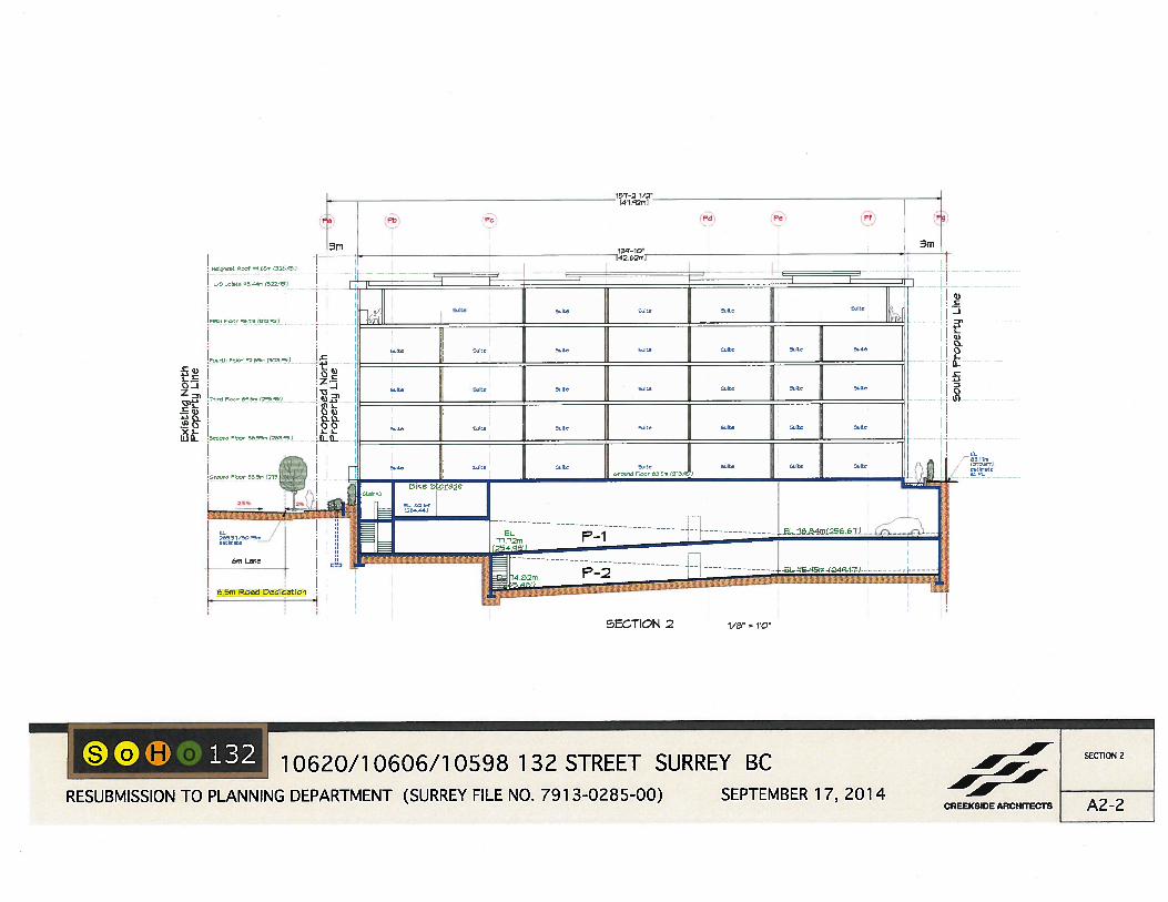
"Comprehensive Development Zone (CD)", based on the RM-70 Zone, in order to allow the construction of a five-storey apartment building with a two-storey townhouse base fronting 132 Street. The proposal includes 60 apartment units and 5 townhouses for a total of sixty-five (65) dwelling units.
• The floor area ratio (FAR) proposed for this development is 2.48, which complies with the
maximum 2.5 FAR proposed under the City Centre Land Use Concept Plan. However, given the 8.5-metre (28- ft.) wide dedication of a new east-west green lane, along the north property line, the City Centre Land Use Concept Plan allows for the developer to include this portion of road dedication in the gross density calculation. Therefore, based upon this provision, the proposed gross density is 1.84 FAR.
• Vehicular access is proposed from a new east-west lane along the north property line. An 8.5-metre (28-ft.) wide dedication will be provided to enable this lane access, which will also facilitate lane access to adjacent properties when they redevelop.
PROPOSED CD BY-LAW (Appendix V) • Although the proposed building conforms in terms of height and massing to the type of
building found in the RM-70 Zone, the proposed density and lot coverage cannot be accommodated in the RM-70 Zone. The proposed floor area ratio (FAR) of 2.48 exceeds the maximum FAR of 1.50 permitted in the RM-70 Zone but it complies with the maximum 2.5 FAR proposed under the City Centre Land Use Concept Plan.
• Although the proposed density could be accommodated within the RM-135 Zone, the RM-135
Zone is designed to accommodate and regulate high-rise residential development and is, therefore, not appropriate for a five-storey building form.
• As a result of the proposed density, the applicant has applied to rezone the site to a
Comprehensive Development (CD) Zone. • The proposed CD By-law will be based upon the "Multiple Residential 70 Zone (RM-70)". A
table comparing the RM-70 Zone to the proposed CD By-law is provided below:
RM-70 Zone Proposed CD By-law
Density (Floor Area Ratio)
1.5 FAR (net) 2.48 FAR (net)
Lot Coverage
33% 52%
Building Setbacks (metres)
7.5 m from all lot lines West (132 Street): 4.5 m North: 0.9 m South: 0.6 m East: 1.2 m
Building Height (metres)
50 m 18 m

Staff Report to Council File: 7913-0285-00
Planning & Development Report
Page 6
RM-70 Zone Proposed CD By-law
Off-Street Parking • 1.04 spaces per dwelling unit, for all studio, 1-bedroom and 1-bedroom with den units.
• 1.2 spaces per dwelling unit, for all 2-bedroom and larger units, including attached townhouse units.
• 0.16 space per dwelling unit for visitors.
• The underground parking structure must be set back a minimum of 2.0 metres (6.6 ft.) from the front lot line.
• Parking has been provided in accordance with the Zoning By-law requirements for City Centre.
• Parking requirements for the RM-70 Zone are reduced by 20% in Surrey City Centre.
• The underground parking structure will be permitted to be located 1.3 metres (4 ft.) from the front lot line.
Bicycle Parking • 1.2 bicycle spaces for every dwelling unit.
• 6 bicycle spaces for visitors for each multiple residential building.
• Same as RM-70 Zone, however, the proposed development will exceed the minimum required.
• The maximum lot coverage has been increased from the 33% in the RM-70 Zone to 52%.
• The proposed lot coverage is typical for a 5-storey apartment building on a smaller site.
• The reduced setback along the west (132 Street) achieves a more urban, pedestrian-oriented
streetscape, consistent with the goals of the City Centre Plan.
• The reduced setback along the north is to accommodate a staircase to the underground parking structure. The proposed building is located 11.5 metres (38 ft.) from the neighbouring property.
• The reduced setback along the south is a side yard condition and includes a low Allan Block wall with a guard rail with layered planting and an evergreen cedar hedge to screen and provide privacy from the neighbouring property.
• The reduced setback along the east is a rear yard condition and includes a 1.8-metre (6-ft.) high fence and a cedar hedge to screen the underground parking structure located 1.2 metres (4 ft.) from the property line. The setback from the proposed building to the property line is 7.5 metres (25 ft.).

Staff Report to Council File: 7913-0285-00
Planning & Development Report
Page 7 PRE-NOTIFICATION Pre-notification letters were sent on February 18, 2014 to a total of 72 neighbouring property owners. Staff received two phone calls from property owners within the pre-notification area concerned about the 5-storey apartment form of development proposed in an existing single family neighbourhood. (Staff indicated that the subject site is designated Low to Mid Rise up to 2.5 FAR in the City
Centre Land Use Concept Plan and the proposed form of development is in compliance with this designation.)
DESIGN PROPOSAL AND REVIEW Building Design • The proposed apartment building will be five storeys in height with a two-storey townhouse
base fronting 132 Street, comprising a total of 65 residential dwelling units. The unit mix consists of 25 studio, 28 1-bedroom and 12 2-bedroom units, 5 of which are two-storey townhouse units.
• Given the single family interface along the 132 Street frontage, roof patios have been provided allowing the building to be set back on the fifth floor and the massing reduced.
• The dwelling units will range in size from 30 square metres (325 sq.ft.) for a studio unit to 116 square metres (1,248 sq.ft.) for the largest townhouse unit.
• The proposed building fronts 132 Street with one vehicular entry to the site proposed via a new lane from 132 Street at the northwest corner of the subject site. The proposed lane provides direct access to the two-level underground parking facility.
• Private pedestrian access to each of the street-oriented townhouse units is provided from 132 Street. Private entries to the townhouse units include an entry marker with an individual light fixture and the unit address.
• Terraced landscaping is proposed in front of each townhouse unit to delineate public and private space and to provide the individual unit patios some privacy. Fencing around the townhouse patios will include masonry walls and individual glass panel entry gates.
• The proposed building is an urban and moderately contemporary building form with clean lines and extensive use of brown brick on the lower two levels on the façade fronting 132 Street.
• The proposed colour palette is a darker taupe on the third and fourth floor above the brick, transitioning to a lighter grey at the top.
• The building materials include masonry and FiberCement lap siding. Black window frames
and sliding glass balcony doors, and prefinished horizontal metal railings on transparent balconies provide a colour accent.

Staff Report to Council File: 7913-0285-00
Planning & Development Report
Page 8 Indoor Amenity Space • The amenity space is located on the main floor of the building adjacent to the main entrance
lobby and provides access to the outdoor amenity space. This indoor space incorporates a large meeting/party room, kitchen facilities and washroom.
• The proposed indoor amenity space totals 39 square metres (425 sq. ft.), which is 156 square metres (1,679 sq. ft.) less than the 195 square metres (2,099 sq. ft.) required under the Zoning By-law (3.0 square metres/32 sq. ft. per dwelling unit).
• The applicant has agreed to provide a monetary contribution of $62,400 (based on $1,200 per unit) in accordance with the City policy, to address the shortfall in the required indoor amenity space.
Landscaping and Outdoor Amenity Space • The 132 Street streetscape elevation includes a terraced masonry wall with layered planting
behind and in front.
• Each townhouse unit includes a private patio framed by the terraced wall with layered planting consisting of a variety of shrubs. Each private entrance also includes a Paperbark Maple tree at the street.
• Along the east property line a 1.8-metre (6 ft.) high wood fence and landscaping will be installed to screen and provide privacy from neighbouring properties.
• Along the south property line, a low Allan Block wall with a guard rail with layered planting and an Evergreen Cedar hedge will be installed to screen and provide privacy from neighbouring properties.
• The proposed outdoor amenity area consists of a 195-square metre (2,100 sq. ft.) open patio space located on the eastern portion of the site. This space can be accessed through the indoor amenity space or a pedestrian entrance from 132 Street.
• The outdoor amenity space incorporates garden plots, garden shed, seating area with benches, chairs and a barbeque as well as a mini badminton play area on a raised turf lawn area. The proposed outdoor amenity area meets the Zoning By-law requirement for outdoor amenity space.
Parking and Bicycle Storage • The Zoning By-law, for sites within City Centre, requires that 55 residential parking spaces be
provided for all 1-bedroom and smaller units, 14 spaces for all 2-bedroom and larger units and 10 visitor parking, for a total of 79 parking spaces. The proposed development provides 80 parking spaces overall, which exceeds this requirement.

Staff Report to Council File: 7913-0285-00
Planning & Development Report
Page 9 • The CD By-law will allow for the underground parking structure to be located at 1.3 metres
(4 ft.) from the front lot line, which is less than the 2.0-metre (7 ft.) setback required under the Zoning By-law. The reduced setback is needed to accommodate the underground parkade on this relatively narrow site. The Engineering Department has no concerns with the relaxation.
• For bicycle parking, the Zoning By-law requires that 78 bicycle parking spaces be provided for
residents and 6 bicycle spaces be provided for visitors. The development proposes 90 bicycle parking spaces overall, which exceeds the minimum required.
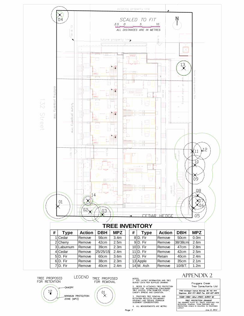
TREES • Glen Murray, ISA Certified Arborist of Froggers Creek Tree Consultants Ltd. prepared an
Arborist Assessment for the subject property.
• The report identifies 14 protected trees within the subject site and immediately adjacent to the subject site, which will be impacted by the proposed development. The table below provides a summary of the tree retention and removal by tree species: Table 1: Summary of Tree Preservation by Tree Species:
Tree Species Existing Remove Retain
Deciduous Trees
Apple 1 1 0 Cherry 1 1 0
Laburnum 1 1 0 Mountain Ash 1 1 0
Coniferous Trees Douglas Fir 8 7 1
Western Red Cedar 2 2 0
Total 14 13 1
Total Replacement Trees Proposed (excluding Boulevard Street Trees) 25
Total Retained and Replacement Trees 26
Contribution to the Green City Fund $300
• The Arborist Assessment states that there are a total of 14 protected trees on the site. It was
determined that 1 tree (Douglas Fir) can be retained on the neighbouring property at 10599 – 132A Street. The proposed tree retention was assessed taking into consideration the location of services, building footprints, road dedication and proposed lot grading.

Staff Report to Council File: 7913-0285-00
Planning & Development Report
Page 10 • For those trees that cannot be retained, the applicant will be required to plant trees on a 2 to 1
replacement ratio. This will require a total of 26 replacement trees on the site. The applicant is proposing 25 replacement trees. The deficit of 1 replacement tree will,therefore, require a cash-in-lieu payment of $300 to the Green City Fund, in accordance with the City’s Tree Protection By-law.
• The new trees on the site will consist of a variety of tree species including Paperback Maple,
Pyramidal European Hornbeam and Swedish Columnar Aspen.
• In addition to the replacement trees, boulevard street trees will be planted on 132 Street. The number will be determined at the servicing agreement stage by the Engineering Department.
• In summary, a total of 26 trees are proposed to be retained or replaced on the site with a
contribution of $300 to the Green City Fund. DISTRICT ENERGY • The subject site is located within Service Area B, as defined in the "City Centre District Energy
System By-law" (see Appendix VIII for location). The District Energy (DE) System consists of three primary components:
o Community energy centres, City-operated facilities that generate thermal heat energy
for distribution through a piped hot water network;
o Distribution piping that links the community energy centres with buildings connected to the system; and
o City-owned Energy Transfer Stations (ETS) located within the building connected to the system. The ETS transfers heat energy from the distribution system to the building’s mechanical system, and is used to meter the amount of energy used.
• All new developments within Service Area B with a build-out floor area ratio (FAR) between
1.0 and 2.5 will be required to incorporate hydronic thermal energy systems to allow for future connection to the City’s district energy system but will not be required to utilize hydronic systems for space heating within individual residential units. Hydronic systems will be required for all other space heating and hot water heating in the building.
• It should be noted that heat generation equipment (e.g. boilers) will need to be provided by the developer until such time as the development can be connected to the DE system.
• It should also be noted that the project is required to be compatible for a future connection to the City's DE System.
• In order to avoid conflicts between the DE System and other utilities, the location of the ETS and related service connections are confirmed by Engineering and the applicant at the servicing agreement stage. The Engineering Department also requires the applicant to register a statutory right-of-way and Section 219 Restrictive Covenant over the subject site for City access to, and maintenance and operation of, the ETS and to prevent conflicts with other utilities.

Staff Report to Council File: 7913-0285-00
Planning & Development Report
Page 11
• Prior to the issuance of a building permit, the Engineering Department must confirm that the
applicant has met the requirements of the "City Centre District Energy System By-law". SUSTAINABLE DEVELOPMENT CHECKLIST The applicant prepared and submitted a sustainable development checklist for the subject site on December 17, 2013. The table below summarizes the applicable development features of the proposal based on the seven (7) criteria listed in the Surrey Sustainable Development Checklist.
Sustainability Criteria
Sustainable Development Features Summary
1. Site Context & Location
(A1-A2)
• The subject site is located within the Surrey City Centre. • The proposed development complies with the land use designation of
the City Centre Land Use Plan.
2. Density & Diversity (B1-B7)
• The proposed density is 1.84 FAR (gross). • The proposed development will include a mix of housing types,
including apartment and townhouse units. • The proposed development intends to provide a range of unit sizes
from studio, to 1-bedroom and 2-bedroom units. 3. Ecology &
Stewardship (C1-C4)
• The proposed development includes natural landscaping. • Twenty-five replacement trees will be planted in addition to a variety
of shrubs, grass, perennials and ground cover. • The proposed development will provide provisions for recycling
within the underground parkade. 4. Sustainable
Transport & Mobility
(D1-D2)
• The proposed development incorporates reduced parking, as permitted within the City Centre area and will provide for secure, all weather bicycle parking.
5. Accessibility & Safety
(E1-E3)
• The overall design of the proposed development incorporates CPTED principles throughout.
• Enclosed exiting stair for safety and security. • All proposed landscaping is designed to provide good sight lines to
fenestration to reduce hidden corners. • The design of the project does provide for 7% adaptable units.
6. Green Certification (F1)
• Not applicable.
7. Education & Awareness
(G1-G4)
• The typical notifications to area residents has occurred (i.e. development proposal sign and Pre-notification letter).

Staff Report to Council File: 7913-0285-00
Planning & Development Report
Page 12 ADVISORY DESIGN PANEL ADP Date: May 22, 2014 The applicant has resolved all of the outstanding items from the ADP review to the satisfaction of the Planning and Development Department (see Appendix VI). INFORMATION ATTACHED TO THIS REPORT The following information is attached to this Report: Appendix I. Lot Owners, Action Summary and Project Data Sheets Appendix II. Site Plan, Building Elevations, Landscape Plans and Perspective Appendix III. Engineering Summary Appendix IV. School District Comments Appendix V. Summary of Tree Survey and Tree Preservation Appendix VI. ADP Comments Appendix VII. Proposed CD By-law Appendix VIII. Map of Service Area B – District Energy
original signed by Judith Robertson Jean Lamontagne General Manager Planning and Development JLM/da \\file-server1\net-data\csdc\generate\areaprod\save\21203926059.doc DRV 9/25/14 12:56 PM

\\file-server1\net-data\csdc\generate\areaprod\save\21203926059.doc DRV 9/25/14 12:56 PM
APPENDIX I
Information for City Clerk Legal Description and Owners of all lots that form part of the application: 1. (a) Agent: Name: Don Andrew
Creekside Architects Ltd. Address: Unit 201, 1444 - Alberni Street Vancouver, BC V6G 2Z4 Tel: 604-733-3125
2. Properties involved in the Application
(a) Civic Addresses: 10598, 10606 and 10620 - 132 Street
(b) Civic Address: 10620 - 132 Street Owner: Marcus S Tan PID: 010-167-773 Lot 155 Section 22 Block 5 North Range 2 West New Westminster District Plan 16445 (c) Civic Address: 10606 - 132 Street Owner: Marcus S Tan PID: 010-167-790 Lot 156 Section 22 Block 5 North Range 2 West New Westminster District Plan 16445 (d) Civic Address: 10598 - 132 Street Owner: Marcus S Tan PID: 005-604-877 Lot 157 Section 22 Block 5 North Range 2 West New Westminster District Plan 16445
3. Summary of Actions for City Clerk's Office
(a) Introduce a By-law to rezone the site.

\\file-server1\net-data\csdc\generate\areaprod\save\21203926059.doc DRV 9/25/14 12:56 PM
DEVELOPMENT DATA SHEET
Proposed Zoning: CD (based on the RM-70 Zone)
Required Development Data Minimum Required / Maximum Allowed
Proposed
LOT AREA* (in square metres) Gross Total 2,194 m2 Road Widening area 569 m2 Undevelopable area Net Total 1,625 m2 LOT COVERAGE (in % of net lot area) Buildings & Structures 52% Paved & Hard Surfaced Areas 20% Total Site Coverage 72% SETBACKS ( in metres) Front (132 Street) 4.5 m Rear (East) 1.2 m North 0.9 m South 0.6 m BUILDING HEIGHT (in metres/storeys) Principal 18 m Accessory 4.5 m NUMBER OF RESIDENTIAL UNITS Studio 25 One Bed 28 Two Bedroom 12 Three Bedroom + Total 65 FLOOR AREA: Residential 4,030 m2 FLOOR AREA: Commercial Retail Office Total FLOOR AREA: Industrial FLOOR AREA: Institutional TOTAL BUILDING FLOOR AREA 4,030 m2 * If the development site consists of more than one lot, lot dimensions pertain to the entire site.

\\file-server1\net-data\csdc\generate\areaprod\save\21203926059.doc DRV 9/25/14 12:56 PM
Development Data Sheet cont'd
Required Development Data Minimum Required / Maximum Allowed
Proposed
DENSITY # of units/ha /# units/acre (gross) # of units/ha /# units/acre (net) FAR (gross) 1.84 FAR (net) 2.48 AMENITY SPACE (area in square metres) Indoor 195 m2 39 m2 Outdoor 195 m2 195 m2 PARKING (number of stalls) Commercial Industrial Residential Bachelor + 1 Bedroom 53 55 2-Bed 14 15 3-Bed Residential Visitors 10 10 Institutional Total Number of Parking Spaces 77 80 Number of disabled stalls 1 4 Number of small cars 16 22 Tandem Parking Spaces: Number / % of
Total Number of Units
Size of Tandem Parking Spaces width/length
Heritage Site NO Tree Survey/Assessment Provided YES


l.tSURREY ~ the future lives here.
INTER-OFFICE MEMO
TO: Manager, Area Planning & Development - North Surrey Division Planning and Development Department
FROM: Development Services Manager, Engineering Department
DATE: September 22, 2014 PROJECT FILE:
RE: Engineering Requirements Location: 10598, 106o6 & 1062o 132 Street
REZONE/SUBDIVISION
Property and Right-of Way Requirements • dedicate 4·942 metres along 132 Street for a 30.o-metre arterial road standard; • dedicate 8.5 metres for the green lane; and • provide a o.s-metre Stat. Right-of-Way (SROW) along 132 Street.
Works and Services • construct east side of 132 Street to the new City Centre standard; • provide cash-in-lieu for so% of future median; • construct an interim curb bulge from the south property line to north of the 106 Avenue
intersection (exact location to be determined during the design review process). Provide cash-in-lieu for removal;
• construct the greenlane; • construct drainage facilities to service the lane; • provide storm, sanitary and water service connections; • cap and abandon each unused existing service connection; and • meet the conditions of the City Centre District Energy System By-law.
A Servicing Agreement is required prior to Rezone/Subdivision.
DEVELOPMENT PERMIT
There are no engineering requirements relative to issuance of the Development Permit.
Remi Dube, P.Eng. Development Services Manager
SSA
NOTE: Detailed Land Development Engineering Review available on file

School Enrolment Projections and Planning Update:The following tables illustrate the enrolment projections (with current/approved ministrycapacity) for the elementary and secondary schools serving the proposed development.
THE IMPACT ON SCHOOLS
APPLICATION #: 130285 00
K.B. Woodward Elementary
SUMMARY The proposed 5 townhouse units and
60 lowrise unitsare estimated to have the following impacton the following schools:Projected # of students for this development:
Elementary Students: 4Secondary Students: 2
September 2013 Enrolment/School Capacity
K.B. Woodward ElementaryEnrolment (K/1-7): 68 K + 419 Capacity (K/1-7): 40 K + 425 Kwantlen Park Secondary
Kwantlen Park SecondaryEnrolment (8-12): 1437Capacity (8-12): 1200 Functional Capacity*(8-12); 1296
Projected cumulative impact of development in the last 12 months (not including the subject project) in the subject catchment areas:
Elementary Students: 0Secondary Students: 110Total New Students: 110
*Functional Capacity at secondary schools is based on space utilization estimate of 27 students per instructional space. The number of instructional spaces is estimated by dividing nominal facility capacity (Ministry capacity) by 25.
There are no new capital projects proposed at the elementary school and no new capital projects identified for the secondary school. The school district may consider enrolment moves or program changes to help reduce overcrowding at Kwantlen Park Secondary. The capacity for K B Woodward has been adjusted for the implementation of full day Kindergarten and the inclusion of a "Strongstart" program for preschool age children and their parents. The actual enrolment results for the City Centre Planning Area, including this application could be higher than projected, and could drive future additions to existing schools or result in new school sites to accommodate actual school age growth in the City Centre, including the planned growth within KB Woodward Elementary catchment.
Wednesday, February 19, 2014Planning
0
100
200
300
400
500
600
700
2009 2010 2011 2012 2013 2014 2015 2016 2017 2018 2019
Enrolment
Capacity
0
200
400
600
800
1000
1200
1400
1600
2009 2010 2011 2012 2013 2014 2015 2016 2017 2018 2019
Enrolment
Capacity
FunctionalCapacity

TREE PRESERVATION SUMMARY
Surrey Project No: Project Location: 10598-10620 132nd Street, Surrey BC Project Arborist: Glenn Murray for Froggers Creek Tree Consultants Ltd. I.S.A. Certification # PN-0795B NOTE: A detailed assessment of the existing trees, submitted by the Arborist, is on file. The following is a summary of the Tree Assessment Report for quick reference.
1. General assessment of the site and tree resource: The site is 3 large flat lots with a few trees scattered around the property. There are 5 onsite protected trees and 8 neighbouring trees. All of the trees on this property and the neighbouring property have been topped very hard and have re-grown. They are all in poor structural condition and could be potentially hazardous. There are two undersized trees located on the survey that I have removed from my drawing.
2. Summary of Proposed Tree Removal and Replacement: � The summary will be available before final adoption.
A Number of Protected Trees Identified 6 B Number of Protected Trees assessed as Hazardous 0 C Number of Protected Trees to be Removed 6 D Number of Protected Trees to be Retained 0 E Number of Replacement Trees Required (C-B) X 2 or (I) X 3 12 F Number of Replacement Trees Proposed G Number of Replacement Trees in Deficit (E-F) H Number of Retained and Replacement Trees on Site (D+F+3) I Number of Lots Proposed in the Project J Average Number of Trees per Lot (H/I)
3. Tree Protection and Tree Replacement Plans X The Tree Protection Plan is attached.
Dated: November 29, 2012 Glenn Murray – Board Certified Master Arborist I.S.A. Certification # PN-0795B
Certified Tree Risk Assessor #0049 Froggers Creek Tree Consultants Ltd.
# Type Action DBH MPZ # Type Action DBH MPZ 1 Cedar Remove 56cm 3.4m 8 D. Fir Remove 50cm 0.0m2 Cherry Remove 42cm 2.5m 9 D. Fir Remove 38/38cm 2.6m3 Laburnum Remove 39cm 2.3m 10 D. Fir Remove 47cm 2.8m4 Cedar Remove 25/25/15 2.4m 11 D. Fir Remove 42cm 2.5m5 D. Fir Remove 60cm 3.6m 12 D. Fir Retain 40cm 2.4m6 D. Fir Remove 38cm 2.3m 13 Apple Remove 35cm 2.1m7 D. Fir Remove 40cm 2.4m 14 M. Ash Remove 10/8/7. 1.2m
TREE INVENTORY

c:\users\j12\desktop\13-0285\adp.docx
Advisory Design Panel Minutes
2E - Community Room B City Hall 13450 - 104 Avenue Surrey, B.C. THURSDAY, MAY 22, 2014 Time: 4:10 pm
Present:
Chair - L. Mickelson Panel Members: N. Baldwin T. Bunting E. Mashig G. McGarva C. Taylor M. Searle
Guests:
Don Andrew, Creekside Architects Ltd. Randall Jang, Richard Jang, Evergreen Living Ltd. Robert Ciccozzi, Robert Ciccozzi Architecture Inc. Marc McCaull, Streetside Developments Ltd. Meredith Mitchell, M2 landscape Architecture
Staff Present:
T. Ainscough, City Architect - Planning & Development
H. Bello, Senior Planner - Planning & Development
M. Rondeau, Senior Planner - Planning & Development
H. Dmytriw, Legislative Services
B. NEW SUBMISSIONS
1. 4:00PM File No.: 7913-0285-00 New or Resubmit: New Description: Rezoning from RF to CD and a Development
Permit to allow the development of a 5-storey apartment building consisting of 65 units.
Address: 10598, 10606 and 10620 – 132 Street, City Centre Architect: Don Andrew, Creekside Architects Ltd. Landscape Architect: Meredith Mitchell, M2 Landscape Architecture Planner: Jennifer McLean Urban Design Planner: Mary Beth Rondeau
The Urban Design Planner presented an overview of the proposed project and highlighted that this is a new building. • The site is located at the edge of City Centre. • Across the street are single family residences; there is no interest in increased
density in this area. • A lane has successfully been incorporated on the site. • Although this area is identified as 4 storey to step down to single family across the
street, a 5th storey is supported given that it is setback from the street. • The architecture design started out as a contemporary scheme but contrasted with
the neighbourhood; the architecture is now more subdued in character. • The parking podium along the east property lines is setback partly due to tree root
zones from the adjacent site that extend into the setback area but also because this first development site would have a wall at the property line where the east sites, some of which are single family, are still waiting to develop.
• The proposal generally meets the intent of the policy for use, form and density and staff have no specific issues.
The Project Architect presented an overview of the site plan, building plans, elevations, cross sections, and streetscapes and highlighted the following: • The lots east of the site are generally holding properties waiting for development. • Parking will be one stall per unit, plus visitor parking.

Advisory Design Panel - Minutes May 22, 2014
c:\users\j12\desktop\13-0285\adp.docx Page 2 J 09/23/14 10:57 AM
• There is a 7-8’ grade drop across the front of the site. The front entry is at street grade, the units north of the entry are above grade as site slopes.
• Rear of building has an amenity facility. Stairwell to podium is enclosed. • Character of the building is defined with a white architectural line above the
second floor and at the roofline. • There are a high number of balconies, roofs and eyebrows. Are looking to add
screening to the windows. Minimal windows on side walls. • The smaller units and most balconies are broken up with coloured elements. • Materials consist of brick, cement plank siding, paneling, vinyl soffits and detail
wood at entry close to ground residential windows and residential siding. The Landscape Architect reviewed the landscape plans and highlighted the following: • Trees on the front townhouse entrances to be on grade with the enough soil given
the parking below drops. • Entry at corner, with a sidewalk, trellised and runs straight through to the amenity
area at the back. • Retaining/parapet wall at back was pulled back for maintenance access. • The 6-8’ wall along the east internal property line is fully screened by a cedar
hedge. The continuous planting bed will be built up. • A long raised turf area creates a linear space with a garden shed, walk through,
shared garden plots, BBQ space, seating space, and an amenity room on the south east side. This is a passive space versus an active space and provides good eyes on the street with a separation and designation between public and private spaces.
ADVISORY DESIGN PANEL STATEMENT OF REVIEW Rezoning from RF to CD and a Development Permit to allow the development of a 5-storey apartment building consisting of 65 units. 10598, 10606 and 10620 – 132 Street, City Centre File No. 7913-0285-00 It was Moved by T. Bunting Seconded by G. McGarva That the Advisory Design Panel (ADP) recommends that the applicant address the following recommendations and revise and resubmit to Planning staff. Carried
STATEMENT OF REVIEW COMMENTS
Site • Generally a very competent scheme. Scale, massing and character all generally
successful and logical.
Building Form and Character • Building form is broken up successfully. The building will be a good context
building to start the area.

Advisory Design Panel - Minutes May 22, 2014
c:\users\j12\desktop\13-0285\adp.docx Page 3 J 09/23/14 10:57 AM
• The setback of the parking podium on the east property line leaves a 10’ remnant strip which is difficult to resolve particularly for future development. Consider alternatives such as lowering podium, enlarging the setback or reducing it.
(The future development can have the option of build up to property line and fill the gap.)
• In general, consider more simplicity and reducing the number of materials in the
palette. The mix of materials and detailing needs development as the hierarchy of materials is not sorted out.
(The number of materials are reduced with majority being lap siding and very few areas of panel siding to avoid too many joint lines.)
• Could be more brick on vertical bays at the north and south ends of the building. As “book ends” they appear weak and could be strengthened by making them appear more solid. (Reviewed the current use of brick and prefer no change on this.)
• Need to see joint pattern on Hardie-panel. Consider other material given joints. (Reduced the use of panel siding to only very few areas such as top floor post and roof edge where visual impacts of joint lines are minimal.)
• Reconsider window placement that always seem to be centered at each room.
Some visual play may result from considering asymmetrical treatment in some instances. Consider carefully window placement and size and number for the studio suites where the sleeping and living areas are not yet demarcated.
(Adjusted the front town house entry location and as a result windows are not centered on the front bays, creating some sort of asymmetry.)
• Consider putting the living/dining room on the corner thus creating a more interesting fenestration pattern on the public north elevation.
(Modified the corner unit interior layout (Unit A on north east corner) to have the living space on the corner so more window openings can be incorporated on the public north elevation.)
• The wood elements on balconies need to be stronger with more wood and asymmetrical.
(Wood elements on balconies are now wrapping up around the corner to give stronger visual impacts and asymmetry.)
• Colours are a bit bland; nothing stands out and are all background colours. Ensure the “taupe” cladding is not too dark overall. (Adjusted colors slightly and with less material types. The “taupe” cladding is

Advisory Design Panel - Minutes May 22, 2014
c:\users\j12\desktop\13-0285\adp.docx Page 4 J 09/23/14 10:57 AM
used in contrast with brighter colour to give a clean and modern looking.)
• The colour white advances too much and should be subdued.
(Subdued the white colour and restricted the use of bright colour only at very limited areas to make the key elements stand out.)
• There should be a stronger main entrance. Consider elevator as part of lobby visual flow. (The two storey “white” line at the front was broken and lowered at the entry lobby canopy with deep overhang to make the main entry stands out. The elevator stays at the same place after reviewing both the ground floor plan and underground floor plan for exiting purposes.)
• Recommend revamp the interface of the unit south of the main entrance facing 132nd. Appears below grade with privacy issues. (Revamped the interior layout of the suite south of the main entrance to have the kitchen instead of bedroom on the front to solve the privacy and safety concerns. Relocated the suite entry closer to the higher point of grade to make sure a flat entry. Added planters with 5’ tall metal fence around the entry lobby area to separate the public area from private domain.)
• Soffits on 5th storey to be stronger, deeper. The black trim element is too busy. (Increased the soffit overhang on the top (fifth floor) by 1’ to ensure a deeper and stronger shadow line. Replaced the black trim with a similar colour to siding to subdue the visual impacts.)
• Would be helpful to get more site context information on drawings.
(Added context map on sheet A0-3.)
Landscaping • The community gardens are nice. Hopefully 6-8 hours of summer sun will be
sufficient.
• Consider opportunities for rain water collection (cistern) and composting area.
(Will consider local rain water collection at the garden shed on backside but not likely to apply that to more extensive areas due to plumbing and hygiene issues.)
• Nice separation between public and private spaces along street.
• Consider moving BBQ and outdoor eating area closer to an indoor amenity area.
(The BBQ area is now relocated closer to the indoor amenity room.)

Advisory Design Panel - Minutes May 22, 2014
c:\users\j12\desktop\13-0285\adp.docx Page 5 J 09/23/14 10:57 AM
• Good screening between units, but still neighbourly.
• Short term bike parking (bike racks) at the main entrance.
(Bike parking is now incorporated into main entry under the canopy.
• Give consideration to what the un-programed lawn area may be used for.
(On the landscape plan it is called out as “Mini Badminton Area” and can also serve as a gathering place for residents.)
CPTED • Good relationship between townhouse units and street; “good eyes on street”.
• The 10’ remnant strip is a CPTED issue. The next development cannot mirror it.
(As stated earlier in this document, the future development would have the option to build up to the property line and fill the gap in between.)
• The bike storage will be a vulnerable spot. (Will add security measures for crime prevention.)
• The unit situated immediately to the south of the main entrance is flush with the grade or below and needs to be better resolved for CPTED.
(This has been addressed earlier in this document under “Building Form and Character” section.)
Accessibility • Elevator call button panels to be horizontal. • Provide power doors at entrances. • Call button panels at entrances to be on the horizontal. • Provide emergency call buttons in parking lobby.
(Will address the above details at building permit and construction drawing phase.)
• Washrooms to be wheelchair accessible.
(Ground floor amenity washroom is now wheelchair accessible.)
• Locate elevator closer to the lobby.
(Reviewed the location and prefer no change on this.)
• Parking space to be closer to elevator.
(Reviewed and right now not possible due to the restriction of parking stall layout, will adjust when possible in further development of the project.)

Advisory Design Panel - Minutes May 22, 2014
c:\users\j12\desktop\13-0285\adp.docx Page 6 J 09/23/14 10:57 AM
• Accessible unit on main floor to be relocated due to CPTED issues. (This has been addressed in this document under “Building Form and Character” section.)
• Recommend 5% of units be wheelchair accessible.
(There are 4 adaptable units (one per floor) altogether out of 65 units in total, the percentage is 6%.)
Sustainability • Future use of the District Energy would be good to have hot water heating beyond
the minimum required in this sub-area.
(Will incorporate the suggestion once mechanical engineer is on board.)

- 1 -
CITY OF SURREY
BYLAW NO.
A by-law to amend Surrey Zoning By-law, 1993, No. 12000, as amended . . . . . . . . . . . . . . . . . . . . . . . . . . . . . . . . . . . . . . . . . . . . . . . . . . . . . . . . . . . THE CITY COUNCIL of the City of Surrey ENACTS AS FOLLOWS: 1. Surrey Zoning By-law, 1993, No. 12000, as amended, is hereby further amended, pursuant
to the provisions of Section 903 of the Local Government Act, R.S.B.C. 1996 c. 323, as
amended by changing the classification of the following parcels of land, presently shown
upon the maps designated as the Zoning Maps and marked as Schedule "A" of Surrey
Zoning By-law, 1993, No. 12000, as amended as follows:
FROM: SINGLE FAMILY RESIDENTIAL ZONE (RF) TO: COMPREHENSIVE DEVELOPMENT ZONE (CD) _____________________________________________________________________________
Parcel Identifier: 010-167-773 Lot 155 Section 22 Block 5 North Range 2 West New Westminster District Plan 16445
10620 - 132 Street
Parcel Identifier: 010-167-790
Lot 156 Section 22 Block 5 North Range 2 West New Westminster District Plan 16445
10606 - 132 Street
Parcel Identifier: 005-604-877 Lot 157 Section 22 Block 5 North Range 2 West New Westminster District Plan 16445
10598 - 132 Street
(hereinafter referred to as the "Lands")
2. The following regulations shall apply to the Lands:
A. Intent This Comprehensive Development Zone is intended to accommodate and regulate the development of medium density, multiple unit residential buildings and ground-oriented multiple unit residential buildings and related amenity space, which are to be developed in accordance with a comprehensive design.

- 2 -
B. Permitted Uses
The Lands and structures shall be used for multiple unit residential buildings and ground-oriented multiple unit residential buildings.
C. Lot Area
Not applicable to this Zone. D. Density
1. The floor area ratio shall not exceed 2.5. 2. The indoor amenity space required in Sub-section J.1(b) of this Zone is
excluded from the calculation of floor area ratio. E. Lot Coverage
The lot coverage shall not exceed 52%. F. Yards and Setbacks
1. Buildings and structures shall be sited in accordance with the following minimum setbacks:
Setback Front Rear Side Side Yard Yard Yard Yard Use (West) (East) (North) (South) Principal Buildings and Accessory Buildings and Structures
4.5 m [15 ft.]
1.2 m [4 ft.]
0.9 m [3 ft.]
0.6 m [2 ft.]
Measurements to be determined as per Part 1 Definitions of Surrey Zoning By-law, 1993, No. 12000, as amended.
2. Notwithstanding Sub-section E.17(b) of Part 4 General Provisions of Surrey
Zoning By-law, 1993, No. 12000, as amended, stairs of four risers or less may encroach into the required setbacks.
3. Notwithstanding Sub-section A.2(c) of Part 5 Off-Street Parking and
Loading/Unloading of Surrey Zoning By-law, 1993, No. 12000, as amended, an underground parking facility may be located up to 1.3 metres [4 ft.] from the front lot line.

- 3 -
G. Height of Buildings Measurements to be determined as per Part 1 Definitions of Surrey Zoning By-law,
1993, No. 12000, as amended. 1. Principal buildings: The building height shall not exceed 18 metres [59 ft.]. 2. Accessory buildings and structures: The building height shall not exceed 4.5
metres [15 ft.]. H. Off-Street Parking
1. Resident and visitor parking spaces shall be provided as stated in Table C.6. of Part 5 Off-Street Parking and Loading/Unloading of Surrey Zoning By-law, 1993, No. 12000, as amended.
2. All required resident parking spaces shall be provided as underground
parking or as parking within building envelope.
I. Landscaping
1. All developed portions of the lot not covered by buildings, structures or paved areas shall be landscaped including the retention of mature trees. This landscaping shall be maintained.
2. Along the developed sides of the lot which abut a highway, a continuous
landscaping strip of not less than 1.5 metres [5 ft.] in width shall be provided within the lot.
3. The boulevard areas of highways abutting a lot shall be seeded or sodded
with grass on the side of the highway abutting the lot, except at driveways. 4. Garbage containers and passive recycling containers shall be located within
the underground parking or within a building. J. Special Regulations
1. Amenity space shall be provided on the lot as follows:
(a) Outdoor amenity space, in the amount of 3.0 square metres [32 sq. ft.] per dwelling unit and shall not be located within the required setbacks; and
(b) Indoor amenity space, in the amount of 3.0 square metres [32 sq. ft.]
per dwelling unit.
2. Balconies are required for all dwelling units which are not ground-oriented and shall be a minimum of 5% of the dwelling unit size or 4.6 square metres [50 sq. ft.] per dwelling unit, whatever is greater.

- 4 -
K. Subdivision
Lots created through subdivision in this Zone shall conform to the following minimum standards:
Lot Size Lot Width Lot Depth
1,500 sq. m. [0.37 acre]
45 metres [148 ft.]
25 metres [82 ft.]
Dimensions shall be measured in accordance with Section E.21 of Part 4 General Provisions of Surrey Zoning By-law, 1993, No. 12000, as amended.
L. Other Regulations In addition to all statutes, bylaws, orders, regulations or agreements, the following
are applicable, however, in the event that there is a conflict with the provisions in this Comprehensive Development Zone and other provisions in Surrey Zoning By-law, 1993, No. 12000, as amended, the provisions in this Comprehensive Development Zone shall take precedence:
1. Definitions are as set out in Part 1 Definitions of Surrey Zoning By-law,
1993, No. 12000, as amended. 2. Prior to any use, the Lands must be serviced as set out in Part 2 Uses
Limited, of Surrey Zoning By-law, 1993, No. 12000, as amended and in accordance with the servicing requirements for the RM-135 Zone as set forth in the Surrey Subdivision and Development By-law, 1986, No. 8830, as amended.
3. General provisions are as set out in Part 4 General Provisions of Surrey
Zoning By-law, 1993, No. 12000, as amended. 4. Additional off-street parking requirements are as set out in Part 5
Off-Street Parking and Loading/Unloading of Surrey Zoning By-law, 1993, No. 12000, as amended.
5. Sign regulations are as set out in Surrey Sign By-law, 1999, No. 13656, as
amended. 6. Special building setbacks are as set out in Part 7 Special Building Setbacks,
of Surrey Zoning By-law, 1993, No. 12000, as amended. 7. Building permits shall be subject to the Surrey Building Bylaw, 2012, No.
17850, as amended. 8. Building permits shall be subject to Surrey Development Cost Charge
By-law, 2014, No. 18148, as may be amended or replaced from time to time, and the development cost charges shall be based on the RM-135 Zone.

- 5 -
10. Tree regulations are set out in Surrey Tree Protection By-law, 2006, No.
16100, as amended.
11. Development permits may be required in accordance with the Surrey Official Community Plan, 1996, By-law No. 12900, as amended.
3. This By-law shall be cited for all purposes as "Surrey Zoning Bylaw, 1993, No. 12000,
Amendment By-law, , No. ." PASSED FIRST READING on the th day of , 20 . PASSED SECOND READING on the th day of , 20 . PUBLIC HEARING HELD thereon on the th day of , 20 . PASSED THIRD READING on the th day of , 20 . RECONSIDERED AND FINALLY ADOPTED, signed by the Mayor and Clerk, and sealed with the Corporate Seal on the th day of , 20 . ______________________________________ MAYOR ______________________________________ CLERK \\file-server1\net-data\csdc\generate\areaprod\save\23022775085.doc J 9/23/14 10:55 AM

Produced by GIS Section: May 31, 2012, CS/AW8
DISTRICT ENERGY SERVICE AREA
(SERVICE AREA A & SERVICE AREA B)
132 S
T
96 AVE
140 S
T
128 S
T
104 AVE
108 AVE
144 S
T
100 AVE
KING GEORGE BLVD
112 AVE
FRASER HWY
102 AVE
WHA
LLEY
BLVD
138 S
T
UNIVE
RSITY
DR
134 S
T
OLD YALE RD
136 S
T105 AVE
111 AVE
GROSVENOR RD
98 AVE
137 S
T135A ST
94A AVE
97A AVE
98B AVE
137A
ST
HILTON RD
CITY
PARK
WAY
106 AVE
103 AVE
104A AVE
105A AVE
104A AVE
103 AVE
CITY
PARK
WAY
103 AVE
106 AVE
100 AVE
134 S
T106 AVE
128 S
T
138 S
T
.
LEGEND
Service Area AService Area BCity Centre Boundary
LO
CA
TIO
N
SERVICEAREA A
SERVICEAREA B