rf report proposed wireless facility 724 route 6 … · rf report . proposed wireless facility ....
TRANSCRIPT

C Squared Systems, LLC 65 Dartmouth Drive Auburn, NH 03032
Phone: (603) 644 2800 [email protected]
RF Report
Proposed Wireless Facility 724 Route 6
Wellfleet, MA 02667
May 11, 2015

Verizon Wireless Wellfleet 2 MA
TABLE OF CONTENTS
1. Overview .................................................................................................................................................... 1
2. Introduction ................................................................................................................................................ 1
3. The Proposed Facility ................................................................................................................................ 3
4. Coverage and Capacity Objectives ............................................................................................................ 3
5. Site Search, Selection Process and Alternate Candidates Evaluation ........................................................ 4
6. Pertinent Site Data...................................................................................................................................... 4
7. Coverage Analysis and Propagation Plots ................................................................................................. 5
8. Certification of Non-Interference ............................................................................................................... 8
9. Summary .................................................................................................................................................... 8
10. Statement of Certification ........................................................................................................................ 8
11. Attachments.............................................................................................................................................. 9
LIST OF TABLES Table 1: Verizon Wireless Site Information Used in Coverage Analysis ...................................................... 4
Table 2: Capacity Offload Summary ............................................................................................................. 6
ATTACHMENTS Attachment A: Wellfleet 2 – Existing 700 MHz LTE Coverage
Attachment B: Wellfleet 2 – 700 MHz LTE Coverage with Proposed Site
Attachment C: Wellfleet 2 – Existing 700 MHz LTE Coverage (Overloaded Sectors)
Attachment D: Wellfleet 2 – 700 MHz LTE Coverage Offload with Proposed Site
Attachment E: Wellfleet 2 – Existing 700 MHz LTE Drive Data
Attachment F: Wellfleet 2 – Area Terrain Map
C Squared Systems, LLC i May 11, 2015

Verizon Wireless Wellfleet 2 MA
1. Overview
This RF Report is submitted on behalf of Verizon Wireless in support of the Varsity Wireless application to the Cape Cod Commission and the Town of Wellfleet for the installation and operation of a wireless facility located at 724 Route 6 in Wellfleet, MA. Verizon Wireless’ proposed facility consists of a ground based equipment shelter and collocation on the proposed 90’ monopole tower.
This report concludes that the proposed site is needed to fill in coverage gaps and provide capacity relief to southern sections of Wellfleet in order to improve deficient service areas along U.S. Route 6, Marconi Beach Road, Marconi Station Road, the Cape Cod Rail Trail, and the surrounding residential, business, community, and tourist attraction areas.
Included in this report is: a brief summary of the site’s objectives, maps showing Verizon Wireless’ current network plan, and predicted Radio Frequency coverage of the subject site and the surrounding sites in Verizon Wireless’ network.
2. Introduction
Verizon Wireless provides digital communications voice and data services using 3rd Generation (3G) CDMA/EVDO technology in the 800 MHz and 1900 MHz frequency bands, and is in the midst of deploying advanced 4th Generation (4G) voice and data services over LTE technology in the 700 MHz, PCS, and AWS frequency bands as allocated by the FCC. These networks are used by mobile devices for fast web browsing, media streaming, and other applications that require broadband connections. The mobile devices that benefit from these advanced networks are not limited to basic handheld phones, but also include devices such as smartphones, PDA’s, tablets, and laptop air-cards. With the evolving rollout of 4G LTE services and devices, Verizon Wireless customers will have even faster connections to people, information, and entertainment.
As explained within this report, Verizon Wireless has identified the need to add a new facility to its existing network of sites in the Wellfleet area to improve coverage and provide ample capacity to a significant gap in coverage that now exists in southern Wellfleet, in order to support reliable communications and meet the growing demand in the area.
In order to maintain a reliable and robust communications system for the individuals, businesses, public safety workers and others who use its network, Verizon Wireless deploys a network of cell sites (also called wireless communications facilities) throughout the areas in which it is licensed to provide service. These cell sites consist of antennas mounted on structures, such as buildings and towers, supported by radio and power equipment. The receivers and transmitters at each of these sites process signals within a limited geographic area known as a “cell.”
Mobile subscriber handsets and wireless devices operate by transmitting and receiving low power radio frequency signals to and from these cell sites. Handset signals that reach the cell site are transferred through land lines (or other means of backhaul transport) and routed to their destinations by sophisticated electronic equipment. In order for Verizon Wireless’ network to function effectively, there must be adequate overlapping coverage between the “serving cell” and adjoining cells. This not only allows a user to access the network initially, but also allows for the transfer or “hand-off” of calls and data transmissions from one cell to another, and prevents unintended disconnections or “dropped calls.”
C Squared Systems, LLC 1 May 11, 2015

Verizon Wireless Wellfleet 2 MA
Verizon Wireless’ antennas also must be located high enough above ground level to allow transmission (a.k.a. propagation) of the radio frequency signals above trees, buildings and other natural or man-made structures that may obstruct or diminish the signals. Areas without adequate radio frequency coverage have substandard service, characterized by dropped and blocked calls, slow data connections, or no wireless service at all, and are commonly referred to as coverage gaps.
The size of the area potentially served by each cell site depends on several factors including the number of antennas used, the height at which the antennas are deployed, the topography of the surrounding land, vegetative cover, and natural or man-made obstructions in the area. The actual service area at any given time also depends on the number of customers who are on the network in range of that cell site. As customers move throughout the service area, the transmission from the phone or other device is automatically transferred to the Verizon Wireless facility with the best reception, without interruption in service, provided that there is overlapping coverage between the cells.
Each cell site must be primarily designed to strike a balance between the overall geographic coverage area it will serve, and the site’s capacity to support the usage within the coverage footprint. In rural areas, cell sites are generally designed to have broader coverage footprints because the potential traffic is sparser and distributed over a larger area. In more densely populated suburban and urban environments, the capacity to handle calls and data transmissions is of increasing concern, and cell sites must limit their coverage footprint to an area where the offered network traffic can be supported by the radio equipment and resources. Due to the aggressive historical and projected growth of mobile usage, particularly for mobile data (51% in 2014-2015, 47% CAGR 2014-2019 in North America)1, instances arise where the usage demand can no longer be supported by the site(s) serving an area, and new facilities must be integrated to provide capacity relief to the overloaded sites.
We have concluded that by installing the proposed wireless communication facility at 724 Route 6 at an antenna centerline height of 87’, Verizon Wireless will be able to fill the substantial coverage gap that it now experiences, and provide improved coverage and capacity to residents, businesses, and traffic corridors within southern sections of Wellfleet, that are currently located within deficient service areas of Verizon Wireless’ network.
1 “Cisco Visual Networking Index: Global Mobile Data Traffic Forecast Update, 2014-2019”, February 3, 2015, Cisco Systems, Inc. http://www.cisco.com/en/US/solutions/collateral/ns341/ns525/ns537/ns705/ns827/white_paper_c11-520862.pdf
C Squared Systems, LLC 2 May 11, 2015

Verizon Wireless Wellfleet 2 MA
3. The Proposed Facility
As shown on the plans submitted with the application, Verizon Wireless’ proposal consists principally of the following elements:
1) A 12’ x 26’ telecommunications equipment shelter, to be located within Varsity Wireless’ proposed 57’ x 57’ fenced compound;
2) Twelve (12) panel antennas (four per sector) mounted on the proposed 90’ monopole tower, at a centerline elevation of 87’ above ground level;
3) Remote Radio Heads (RRH) with accessory junction boxes and surge suppressors mounted alongside the antennas;
4) A liquid propane tank, located on a 4’ x 10’ concrete pad within the fenced compound;
5) An ice bridge from the proposed equipment shelter to the proposed monopole to protect cabling between Verizon Wireless’ equipment and the cable entry port located near the base of the monopole.
4. Coverage and Capacity Objectives
As mentioned above, Verizon Wireless is in the process of rolling out its 4G LTE high-speed wireless broadband system in the 700 MHz, PCS, and AWS frequency bands, in accordance with its licenses from the FCC. In order to expand and enhance their wireless services throughout New England, Verizon Wireless must fill in existing coverage gaps and address capacity, interference, and high-speed broadband issues. As part of this effort, Verizon Wireless has determined that significant coverage gaps and insufficient network capacity exist in and around the southern sections of Wellfleet, MA, as described further below.
Verizon Wireless currently operates wireless facilities, similar to the proposed facility, within Wellfleet and the surrounding towns of Eastham, Orleans, Provincetown, and Truro, MA. Due in large part to the distances between the existing sites, the intervening topography, and volume of user traffic in the area, these existing facilities do not provide sufficient coverage and capacity to portions of Wellfleet. Specifically, Verizon Wireless determined that much of southern Wellfleet is without reliable service in the following areas and town roads:
• U.S. Route 6, between Cahoon Hollow Road and Pinewood Circle • Marconi Beach Road • Marconi Station Road • The Cape Cod Rail Trail • The business, retail, and tourist attraction areas along U.S. Route 6 • The surrounding residential roads and neighborhoods within Wellfleet
The proposed site located at 724 Route 6 (“Wellfleet 2”) is needed to fill in these targeted coverage and capacity gaps, in order to improve network quality and reliability for Verizon Wireless subscribers traveling along these roads, as well as to the numerous residences, businesses, and visitors in this area.
C Squared Systems, LLC 3 May 11, 2015
Verizon Wireless Wellfleet 2 MA
5. Site Search, Selection Process and Alternate Candidates Evaluation
To find a site that provides acceptable service, fills the gaps in coverage, and provides sufficient capacity relief, computer modeling software is used to define a search area. The search ring identifies the area within which a site could be located (assuming that sufficient height is used) that would have a high probability of addressing the significant coverage gap and meeting the capacity objectives established by the Verizon Wireless RF (Radio Frequency) engineers.
Once a search ring is determined, Verizon Wireless’ real estate specialists search within the proximity of the defined area for existing buildings, towers and other structures of sufficient height that would meet the defined objectives. If none are found, then the focus shifts to “raw land” sites. A suitable site must satisfy the technical requirements identified by the RF engineers, must be available for lease, and must have access to a road and be otherwise suitable for constructing a cell site of the required size and height. Every effort is made to use existing structures before pursuing a “raw land” build to minimize the number of towers throughout the towns being serviced.
After a search of the area had been completed, Verizon Wireless determined that collocating on the proposed Varsity Wireless facility at 724 Route 6 is the best solution to fulfill the targeted coverage and capacity objectives.
6. Pertinent Site Data
Table 1 below details the site-specific information for the existing, approved, and proposed Verizon Wireless sites used to perform the coverage analysis and generate the coverage plots provided herein.
Site Name Address City/State Location Structure
Type
Antenna Height
(ft AGL) Status
Latitude Longitude
Brewster 1657 Main Street Brewster, MA 41° 45' 24.7" N 70° 05' 28.1” W Lattice 119 On-Air Harwich 2 Freemans Way Brewster, MA 41° 44' 13.9" N 70° 00' 38.2" W Guyed 154 On-Air Eastham Nauset Road Eastham, MA 41° 52' 01.8" N 69° 58' 51.8" W Lattice 140 On-Air Orleans Finlay Road Orleans, MA 41° 46' 34.6" N 69° 59' 49.8" W Lattice 150 On-Air
Provincetown 9 Ryder Street Ext. Provincetown, MA 42° 02' 54.6" N 70° 10' 57.7" W Rooftop 38 On-Air Provincetown 3 108 Mt. Gilboa Road Provincetown, MA 42° 03' 54.1" N 70° 09' 29.0" W Water Tank 78 Approved
Truro 344 Route 6 North Truro, MA 42° 01' 18.8" N 70° 04' 29.6" W Lattice 130 On-Air Truro South 115 Route 6 Truro, MA 41° 59’ 08.8” N 70° 02’ 28.8” N Lattice 165 On-Air
Wellfleet Repl Gross Hill Road Wellfleet, MA 41° 56' 49.6" N 70° 01' 04.0" W Monopole 130 On-Air Wellfleet 2 724 Route 6 Wellfleet, MA 41° 53' 48.5" N 69° 59' 04.1" W Monopole 87 Proposed
Table 1: Verizon Wireless Site Information Used in Coverage Analysis2
2 Some sites listed in this table are outside the plot view but are included for completeness of information.
C Squared Systems, LLC 4 May 11, 2015

Verizon Wireless Wellfleet 2 MA
7. Coverage Analysis and Propagation Plots
The signal propagation plots provided in this report show coverage for the 700 MHz frequency range and were produced using deciBel Planner™, a Windows-based RF propagation computer modeling program and network planning tool. The software takes into account the geographical features of an area, land cover, antenna models, antenna heights, RF transmitting power and receiver thresholds to predict coverage and other related RF parameters used in site design and network expansion.
The plots included as attachments show coverage based on RSRP (Reference Signal Receive Power) signal strengths of -90 dBm and -95 dBm. All other areas (depicted in white) fall within coverage areas characterized by poor service quality, low data throughput, and the substantial likelihood of unreliable service.
Attachments A - F are discussed below:
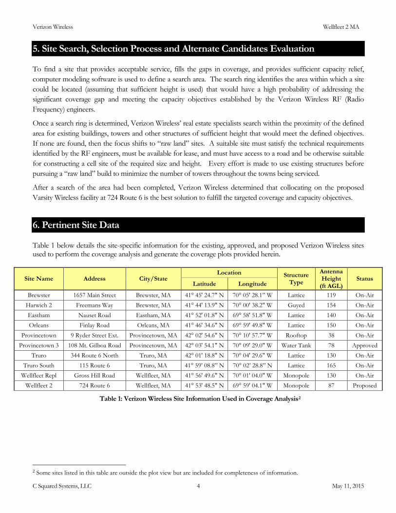
o Attachment A titled “Wellfleet 2 - Existing 700 MHz LTE Coverage” shows the existing coverage provided to the southern areas of Wellfleet from the “On-Air” and “Approved” sites listed in Table 1. “On-Air” sites are existing Verizon Wireless facilities, and “Approved” sites are defined as those that have the necessary approvals in place to begin construction shortly, and are expected to be turned on-air in the near future. The green areas represent the desired level of coverage for this area, whereas the orange areas represent a slightly lower signal strength. As shown in this plot and described in the Coverage and Capacity Objectives section of this report, much of southern Wellfleet is in an area of deficient coverage. These coverage gaps include U.S. Route 6, Marconi Beach Road, Marconi Station Road, the Cape Cod Rail Trail, the business, retail, and tourist attraction areas, and the surrounding residential neighborhoods.
o Attachment B titled “Wellfleet 2 - 700 MHz LTE Coverage with Proposed Site” shows the composite coverage with the proposed “Wellfleet 2” facility. As shown by the additional areas of coverage, the proposed facility will provide coverage to:
~ 1.6 mi along U.S. Route 6 ~ 1.2 mi along Marconi Beach Rd ~ 0.8 mi along Marconi Station Rd ~ 250 new residents3 in the surrounding area The Cape Cod Rail Trail The surrounding roads and neighborhoods such as:
Eastwind Circle, Lieutenant Island Road, Bond Street, Wixom Avenue, Freejum Road, Homestead Lane, Franklin Lane, Richards Way, and Long Avenue.
3 Residential population counts are based upon the 2010 U.S. Census. Please note that this does not include employee, visitor, or seasonal counts in the area.
C Squared Systems, LLC 5 May 11, 2015

Verizon Wireless Wellfleet 2 MA
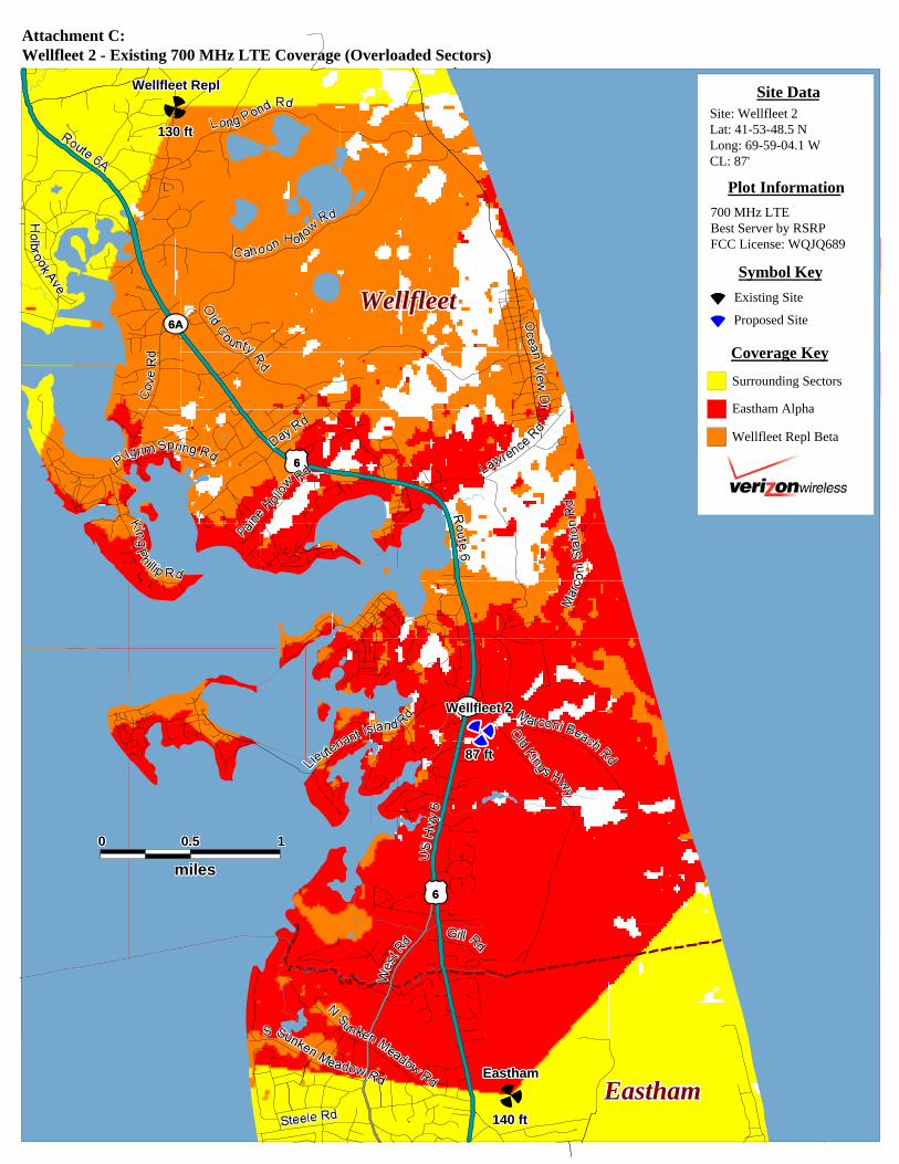
o Attachment C titled “Wellfleet 2 - Existing 700 MHz LTE Coverage (Overloaded Sectors)” depicts the areas primarily served by the sectors (a.k.a. signal “footprints”) of the existing Verizon Wireless sites in the area, which are shown by the unique color for each particular sector of interest. For clarity, all other sectors of less interest with respect to the proposed site are shown in yellow. As demand for wireless voice and data services continues to grow, Verizon Wireless manages the footprint of each sector so that it can support the demand within the area it is primarily serving. In addition to improving coverage to the area, the proposed site is also needed to serve existing and anticipated demand in the vicinity, and thereby offload some of the burden experienced by the surrounding sites. In that way, those sites will be able to more adequately serve the demand for service in the areas nearer to those surrounding sites. Please note that the outer parts of each sector footprint include areas that presently have signal strength below the targeted value required for reliable service to Verizon Wireless’ customers. The fact that low-level signal is capable of reaching these areas does not mean that these areas experience adequate coverage. These unreliable areas of low signal level impose a significant capacity burden on the sites primarily serving the area.
o Attachment D titled “Wellfleet 2 - 700 MHz LTE Coverage Offload with Proposed Site” shows the composite coverage with the overall footprint of the proposed facility in blue. As shown in this map, the proposed “Wellfleet 2” facility is an effective solution to provide substantial capacity relief to the area, particularly to the overloaded “Eastham” alpha and “Wellfleet Repl” beta sectors. The proposed facility is centrally located in the area of deficient coverage and along U.S. Route 6, making it particularly suited to distribute the traffic load across multiple sectors, and provide a dominant server to this pocket of heavy usage. Table 2 below details the capacity relief based on the sector footprints shown in Attachments C and D.
Residental Pops Area (mi2)
Residental Pops Area (mi2)
Total Residential Pops Offloaded
Area Offloaded (mi2/%)
Eastham Alpha 1078 6.17 671 3.55 407 ( 37.8%) 2.62 ( 42.5%)Wellfleet Repl Beta 720 4.64 605 4.04 115 ( 16%) 0.6 ( 12.9%)
SectorCurrent
With"Wellfleet 2"
Offload Summary
Table 2: Capacity Offload Summary4
4 Residential population counts are based upon the 2010 U.S. Census. Please note that this does not include employee, visitor, or seasonal counts in the area.
C Squared Systems, LLC 6 May 11, 2015

Verizon Wireless Wellfleet 2 MA
o Attachment E titled “Wellfleet 2 – Existing 700 MHz LTE Drive Data” presents empirical drive test data of Verizon Wireless’ existing network collected on October 1st, 2014. Drive testing consists of traveling along the area roadways in a vehicle equipped with a sophisticated setup of equipment configured to collect a variety of system performance metrics on a specific operator’s network. The measurement displayed is RSRP of Verizon Wireless’ 700 MHz LTE network, and is the same parameter reflected in the radio frequency propagation maps presented in Attachments A & B. This data was collected with a calibrated LTE scanning receiver configured to specifically scan Verizon Wireless’ LTE network. The empirical drive data is an “apples-to-apples” comparison to the existing coverage modeling depicted in Attachment A, and further confirms the presence of an expansive gap in coverage along Route 6 and the surrounding areas in southern Wellfleet.
o Attachment F titled “Wellfleet 2 – Area Terrain Map” details the topography around the area of deficient service targeted for improvement by the proposed “Wellfleet 2” site. These terrain features play a key role in determining site designs and dictating the unique coverage achieved from a given location. This map is included to provide a visual representation of the topographical variations that must be considered when siting a wireless facility. The darker blue and green shades correspond to lower elevations, whereas the yellow, red, and white shades indicate higher elevations.
C Squared Systems, LLC 7 May 11, 2015

Verizon Wireless Wellfleet 2 MA
8. Certification of Non-Interference
Verizon Wireless certifies that the proposed facility will not cause interference to any lawfully operating emergency communication system, television, telephone or radio, in the surrounding area. The FCC has licensed Verizon Wireless to transmit and receive in the Upper C-Block of the 700 MHz band, B Block of the Cellular (850 MHz) band, the E and F Blocks of the PCS (1900 MHz) band, and the A and B Blocks of the AWS (2100 MHz) band of the RF spectrum. As a condition of the FCC licenses, Verizon Wireless is prohibited from interfering with other licensed devices that are being operated in a lawful manner. Furthermore, no emergency communication system, television, telephone, or radio is licensed to operate on these frequencies, and therefore interference is highly unlikely.
9. Summary
In undertaking its build-out of 4G LTE service in Barnstable County, Verizon Wireless has determined that an additional facility is needed to provide reliable service and adequate capacity in the southern areas of the Town of Wellfleet, MA. Verizon Wireless determined that constructing a wireless communications facility at 724 Route 6 in Wellfleet at an antenna centerline of 87 feet (AGL) will provide additional coverage and capacity needed in the targeted coverage areas including key roadways such U.S. Route 6, Marconi Beach Road, Marconi Station Road, the surrounding residential neighborhoods, and the business, retail and tourist attraction areas. The proposed site was chosen in consideration of the existing neighboring site designs and the network needs of the area. Without the installation at the proposed site, Verizon Wireless will be unable to improve and expand their existing 4G LTE wireless communication services in this area of Wellfleet; therefore Verizon Wireless respectfully requests that the Cape Cod Commission and the Town of Wellfleet act favorably upon the proposed facility.
10. Statement of Certification
I certify to the best of my knowledge that the statements in this report are true and accurate.
Keith Vellante May 11, 2015 RF Engineer Date C Squared Systems, LLC
C Squared Systems, LLC 8 May 11, 2015

Verizon Wireless Wellfleet 2 MA
11. Attachments
C Squared Systems, LLC 9 May 11, 2015
*)
*)
$#
$#
11111111111111111111111110000000000000000000000000 0.50.50.50.50.50.50.50.50.50.50.50.50.50.50.50.50.50.50.50.50.50.50.50.50.5
milesmilesmilesmilesmilesmilesmilesmilesmilesmilesmilesmilesmilesmilesmilesmilesmilesmilesmilesmilesmilesmilesmilesmilesmiles
WellfleetWellfleetWellfleetWellfleetWellfleetWellfleetWellfleetWellfleetWellfleetWellfleetWellfleetWellfleetWellfleetWellfleetWellfleetWellfleetWellfleetWellfleetWellfleetWellfleetWellfleetWellfleetWellfleetWellfleetWellfleetWellfleetWellfleetWellfleetWellfleetWellfleetWellfleetWellfleetWellfleetWellfleetWellfleetWellfleetWellfleetWellfleetWellfleetWellfleetWellfleetWellfleetWellfleetWellfleetWellfleetWellfleetWellfleetWellfleetWellfleet
EasthamEasthamEasthamEasthamEasthamEasthamEasthamEasthamEasthamEasthamEasthamEasthamEasthamEasthamEasthamEasthamEasthamEasthamEasthamEasthamEasthamEasthamEasthamEasthamEasthamEasthamEasthamEasthamEasthamEasthamEasthamEasthamEasthamEasthamEasthamEasthamEasthamEasthamEasthamEasthamEasthamEasthamEasthamEasthamEasthamEasthamEasthamEasthamEastham
6A6A
6A6A
66
66
140 ft140 ft140 ft140 ft140 ft140 ft140 ft140 ft140 ft140 ft140 ft140 ft140 ft140 ft140 ft140 ft140 ft140 ft140 ft140 ft140 ft140 ft140 ft140 ft140 ft140 ft140 ft140 ft140 ft140 ft140 ft140 ft140 ft140 ft140 ft140 ft140 ft140 ft140 ft140 ft140 ft140 ft140 ft140 ft140 ft140 ft140 ft140 ft140 ft140 ft140 ft140 ft140 ft140 ft140 ft140 ft140 ft140 ft140 ft140 ft140 ft140 ft140 ft140 ft140 ft140 ft140 ft140 ft140 ft140 ft140 ft140 ft140 ft140 ft140 ft
130 ft130 ft130 ft130 ft130 ft130 ft130 ft130 ft130 ft130 ft130 ft130 ft130 ft130 ft130 ft130 ft130 ft130 ft130 ft130 ft130 ft130 ft130 ft130 ft130 ft130 ft130 ft130 ft130 ft130 ft130 ft130 ft130 ft130 ft130 ft130 ft130 ft130 ft130 ft130 ft130 ft130 ft130 ft130 ft130 ft130 ft130 ft130 ft130 ft130 ft130 ft130 ft130 ft130 ft130 ft130 ft130 ft130 ft130 ft130 ft130 ft130 ft130 ft130 ft130 ft130 ft130 ft130 ft130 ft130 ft130 ft130 ft130 ft130 ft130 ft
87 ft87 ft87 ft87 ft87 ft87 ft87 ft87 ft87 ft87 ft87 ft87 ft87 ft87 ft87 ft87 ft87 ft87 ft87 ft87 ft87 ft87 ft87 ft87 ft87 ft87 ft87 ft87 ft87 ft87 ft87 ft87 ft87 ft87 ft87 ft87 ft87 ft87 ft87 ft87 ft87 ft87 ft87 ft87 ft87 ft87 ft87 ft87 ft87 ft87 ft87 ft87 ft87 ft87 ft87 ft87 ft87 ft87 ft87 ft87 ft87 ft87 ft87 ft87 ft87 ft87 ft87 ft87 ft87 ft87 ft87 ft87 ft87 ft87 ft87 ft
EasthamEasthamEasthamEasthamEasthamEasthamEasthamEasthamEasthamEasthamEasthamEasthamEasthamEasthamEasthamEasthamEasthamEasthamEasthamEasthamEasthamEasthamEasthamEasthamEasthamEasthamEasthamEasthamEasthamEasthamEasthamEasthamEasthamEasthamEasthamEasthamEasthamEasthamEasthamEasthamEasthamEasthamEasthamEasthamEasthamEasthamEasthamEasthamEasthamEasthamEasthamEasthamEasthamEasthamEasthamEasthamEasthamEasthamEasthamEasthamEasthamEasthamEasthamEasthamEasthamEasthamEasthamEasthamEasthamEasthamEasthamEasthamEasthamEasthamEastham
Wellfleet ReplWellfleet ReplWellfleet ReplWellfleet ReplWellfleet ReplWellfleet ReplWellfleet ReplWellfleet ReplWellfleet ReplWellfleet ReplWellfleet ReplWellfleet ReplWellfleet ReplWellfleet ReplWellfleet ReplWellfleet ReplWellfleet ReplWellfleet ReplWellfleet ReplWellfleet ReplWellfleet ReplWellfleet ReplWellfleet ReplWellfleet ReplWellfleet ReplWellfleet ReplWellfleet ReplWellfleet ReplWellfleet ReplWellfleet ReplWellfleet ReplWellfleet ReplWellfleet ReplWellfleet ReplWellfleet ReplWellfleet ReplWellfleet ReplWellfleet ReplWellfleet ReplWellfleet ReplWellfleet ReplWellfleet ReplWellfleet ReplWellfleet ReplWellfleet ReplWellfleet ReplWellfleet ReplWellfleet ReplWellfleet ReplWellfleet ReplWellfleet ReplWellfleet ReplWellfleet ReplWellfleet ReplWellfleet ReplWellfleet ReplWellfleet ReplWellfleet ReplWellfleet ReplWellfleet ReplWellfleet ReplWellfleet ReplWellfleet ReplWellfleet ReplWellfleet ReplWellfleet ReplWellfleet ReplWellfleet ReplWellfleet ReplWellfleet ReplWellfleet ReplWellfleet ReplWellfleet ReplWellfleet ReplWellfleet Repl
Wellfleet 2Wellfleet 2Wellfleet 2Wellfleet 2Wellfleet 2Wellfleet 2Wellfleet 2Wellfleet 2Wellfleet 2Wellfleet 2Wellfleet 2Wellfleet 2Wellfleet 2Wellfleet 2Wellfleet 2Wellfleet 2Wellfleet 2Wellfleet 2Wellfleet 2Wellfleet 2Wellfleet 2Wellfleet 2Wellfleet 2Wellfleet 2Wellfleet 2Wellfleet 2Wellfleet 2Wellfleet 2Wellfleet 2Wellfleet 2Wellfleet 2Wellfleet 2Wellfleet 2Wellfleet 2Wellfleet 2Wellfleet 2Wellfleet 2Wellfleet 2Wellfleet 2Wellfleet 2Wellfleet 2Wellfleet 2Wellfleet 2Wellfleet 2Wellfleet 2Wellfleet 2Wellfleet 2Wellfleet 2Wellfleet 2Wellfleet 2Wellfleet 2Wellfleet 2Wellfleet 2Wellfleet 2Wellfleet 2Wellfleet 2Wellfleet 2Wellfleet 2Wellfleet 2Wellfleet 2Wellfleet 2Wellfleet 2Wellfleet 2Wellfleet 2Wellfleet 2Wellfleet 2Wellfleet 2Wellfleet 2Wellfleet 2Wellfleet 2Wellfleet 2Wellfleet 2Wellfleet 2Wellfleet 2Wellfleet 2
Symbol Key
Greater than -90 dBm
Coverage Key
Existing Site
Plot Information
700 MHz LTE RSRPFCC License: WQJQ689
-90 dBm to -95 dBm
Less than -95 dBm
Proposed Site
Site Data
Attachment A:Wellfleet 2 - Existing 700 MHz LTE Coverage
Site: Wellfleet 2Lat: 41-53-48.5 NLong: 69-59-04.1 WCL: 87'

*)
*)
$#
$#
11111111111111111111111110000000000000000000000000 0.50.50.50.50.50.50.50.50.50.50.50.50.50.50.50.50.50.50.50.50.50.50.50.50.5
milesmilesmilesmilesmilesmilesmilesmilesmilesmilesmilesmilesmilesmilesmilesmilesmilesmilesmilesmilesmilesmilesmilesmilesmiles
WellfleetWellfleetWellfleetWellfleetWellfleetWellfleetWellfleetWellfleetWellfleetWellfleetWellfleetWellfleetWellfleetWellfleetWellfleetWellfleetWellfleetWellfleetWellfleetWellfleetWellfleetWellfleetWellfleetWellfleetWellfleetWellfleetWellfleetWellfleetWellfleetWellfleetWellfleetWellfleetWellfleetWellfleetWellfleetWellfleetWellfleetWellfleetWellfleetWellfleetWellfleetWellfleetWellfleetWellfleetWellfleetWellfleetWellfleetWellfleetWellfleet
EasthamEasthamEasthamEasthamEasthamEasthamEasthamEasthamEasthamEasthamEasthamEasthamEasthamEasthamEasthamEasthamEasthamEasthamEasthamEasthamEasthamEasthamEasthamEasthamEasthamEasthamEasthamEasthamEasthamEasthamEasthamEasthamEasthamEasthamEasthamEasthamEasthamEasthamEasthamEasthamEasthamEasthamEasthamEasthamEasthamEasthamEasthamEasthamEastham
6A6A
6A6A
66
66
140 ft140 ft140 ft140 ft140 ft140 ft140 ft140 ft140 ft140 ft140 ft140 ft140 ft140 ft140 ft140 ft140 ft140 ft140 ft140 ft140 ft140 ft140 ft140 ft140 ft140 ft140 ft140 ft140 ft140 ft140 ft140 ft140 ft140 ft140 ft140 ft140 ft140 ft140 ft140 ft140 ft140 ft140 ft140 ft140 ft140 ft140 ft140 ft140 ft140 ft140 ft140 ft140 ft140 ft140 ft140 ft140 ft140 ft140 ft140 ft140 ft140 ft140 ft140 ft140 ft140 ft140 ft140 ft140 ft140 ft140 ft140 ft140 ft140 ft140 ft
130 ft130 ft130 ft130 ft130 ft130 ft130 ft130 ft130 ft130 ft130 ft130 ft130 ft130 ft130 ft130 ft130 ft130 ft130 ft130 ft130 ft130 ft130 ft130 ft130 ft130 ft130 ft130 ft130 ft130 ft130 ft130 ft130 ft130 ft130 ft130 ft130 ft130 ft130 ft130 ft130 ft130 ft130 ft130 ft130 ft130 ft130 ft130 ft130 ft130 ft130 ft130 ft130 ft130 ft130 ft130 ft130 ft130 ft130 ft130 ft130 ft130 ft130 ft130 ft130 ft130 ft130 ft130 ft130 ft130 ft130 ft130 ft130 ft130 ft130 ft
87 ft87 ft87 ft87 ft87 ft87 ft87 ft87 ft87 ft87 ft87 ft87 ft87 ft87 ft87 ft87 ft87 ft87 ft87 ft87 ft87 ft87 ft87 ft87 ft87 ft87 ft87 ft87 ft87 ft87 ft87 ft87 ft87 ft87 ft87 ft87 ft87 ft87 ft87 ft87 ft87 ft87 ft87 ft87 ft87 ft87 ft87 ft87 ft87 ft87 ft87 ft87 ft87 ft87 ft87 ft87 ft87 ft87 ft87 ft87 ft87 ft87 ft87 ft87 ft87 ft87 ft87 ft87 ft87 ft87 ft87 ft87 ft87 ft87 ft87 ft
EasthamEasthamEasthamEasthamEasthamEasthamEasthamEasthamEasthamEasthamEasthamEasthamEasthamEasthamEasthamEasthamEasthamEasthamEasthamEasthamEasthamEasthamEasthamEasthamEasthamEasthamEasthamEasthamEasthamEasthamEasthamEasthamEasthamEasthamEasthamEasthamEasthamEasthamEasthamEasthamEasthamEasthamEasthamEasthamEasthamEasthamEasthamEasthamEasthamEasthamEasthamEasthamEasthamEasthamEasthamEasthamEasthamEasthamEasthamEasthamEasthamEasthamEasthamEasthamEasthamEasthamEasthamEasthamEasthamEasthamEasthamEasthamEasthamEasthamEastham
Wellfleet ReplWellfleet ReplWellfleet ReplWellfleet ReplWellfleet ReplWellfleet ReplWellfleet ReplWellfleet ReplWellfleet ReplWellfleet ReplWellfleet ReplWellfleet ReplWellfleet ReplWellfleet ReplWellfleet ReplWellfleet ReplWellfleet ReplWellfleet ReplWellfleet ReplWellfleet ReplWellfleet ReplWellfleet ReplWellfleet ReplWellfleet ReplWellfleet ReplWellfleet ReplWellfleet ReplWellfleet ReplWellfleet ReplWellfleet ReplWellfleet ReplWellfleet ReplWellfleet ReplWellfleet ReplWellfleet ReplWellfleet ReplWellfleet ReplWellfleet ReplWellfleet ReplWellfleet ReplWellfleet ReplWellfleet ReplWellfleet ReplWellfleet ReplWellfleet ReplWellfleet ReplWellfleet ReplWellfleet ReplWellfleet ReplWellfleet ReplWellfleet ReplWellfleet ReplWellfleet ReplWellfleet ReplWellfleet ReplWellfleet ReplWellfleet ReplWellfleet ReplWellfleet ReplWellfleet ReplWellfleet ReplWellfleet ReplWellfleet ReplWellfleet ReplWellfleet ReplWellfleet ReplWellfleet ReplWellfleet ReplWellfleet ReplWellfleet ReplWellfleet ReplWellfleet ReplWellfleet ReplWellfleet ReplWellfleet Repl
Wellfleet 2Wellfleet 2Wellfleet 2Wellfleet 2Wellfleet 2Wellfleet 2Wellfleet 2Wellfleet 2Wellfleet 2Wellfleet 2Wellfleet 2Wellfleet 2Wellfleet 2Wellfleet 2Wellfleet 2Wellfleet 2Wellfleet 2Wellfleet 2Wellfleet 2Wellfleet 2Wellfleet 2Wellfleet 2Wellfleet 2Wellfleet 2Wellfleet 2Wellfleet 2Wellfleet 2Wellfleet 2Wellfleet 2Wellfleet 2Wellfleet 2Wellfleet 2Wellfleet 2Wellfleet 2Wellfleet 2Wellfleet 2Wellfleet 2Wellfleet 2Wellfleet 2Wellfleet 2Wellfleet 2Wellfleet 2Wellfleet 2Wellfleet 2Wellfleet 2Wellfleet 2Wellfleet 2Wellfleet 2Wellfleet 2Wellfleet 2Wellfleet 2Wellfleet 2Wellfleet 2Wellfleet 2Wellfleet 2Wellfleet 2Wellfleet 2Wellfleet 2Wellfleet 2Wellfleet 2Wellfleet 2Wellfleet 2Wellfleet 2Wellfleet 2Wellfleet 2Wellfleet 2Wellfleet 2Wellfleet 2Wellfleet 2Wellfleet 2Wellfleet 2Wellfleet 2Wellfleet 2Wellfleet 2Wellfleet 2
Attachment B:Wellfleet 2 - 700 MHz LTE Coverage with Proposed Site
Symbol Key
Greater than -90 dBm
Coverage Key
Existing Site
Plot Information
700 MHz LTE RSRPFCC License: WQJQ689
-90 dBm to -95 dBm
Less than -95 dBm
Proposed Site
Site Data
Site: Wellfleet 2Lat: 41-53-48.5 NLong: 69-59-04.1 WCL: 87'
*)
*)
$#
$#
11111111111111111111111110000000000000000000000000 0.50.50.50.50.50.50.50.50.50.50.50.50.50.50.50.50.50.50.50.50.50.50.50.50.5
milesmilesmilesmilesmilesmilesmilesmilesmilesmilesmilesmilesmilesmilesmilesmilesmilesmilesmilesmilesmilesmilesmilesmilesmiles
WellfleetWellfleetWellfleetWellfleetWellfleetWellfleetWellfleetWellfleetWellfleetWellfleetWellfleetWellfleetWellfleetWellfleetWellfleetWellfleetWellfleetWellfleetWellfleetWellfleetWellfleetWellfleetWellfleetWellfleetWellfleetWellfleetWellfleetWellfleetWellfleetWellfleetWellfleetWellfleetWellfleetWellfleetWellfleetWellfleetWellfleetWellfleetWellfleetWellfleetWellfleetWellfleetWellfleetWellfleetWellfleetWellfleetWellfleetWellfleetWellfleet
EasthamEasthamEasthamEasthamEasthamEasthamEasthamEasthamEasthamEasthamEasthamEasthamEasthamEasthamEasthamEasthamEasthamEasthamEasthamEasthamEasthamEasthamEasthamEasthamEasthamEasthamEasthamEasthamEasthamEasthamEasthamEasthamEasthamEasthamEasthamEasthamEasthamEasthamEasthamEasthamEasthamEasthamEasthamEasthamEasthamEasthamEasthamEasthamEastham
6A6A
6A6A
66
66
140 ft140 ft140 ft140 ft140 ft140 ft140 ft140 ft140 ft140 ft140 ft140 ft140 ft140 ft140 ft140 ft140 ft140 ft140 ft140 ft140 ft140 ft140 ft140 ft140 ft140 ft140 ft140 ft140 ft140 ft140 ft140 ft140 ft140 ft140 ft140 ft140 ft140 ft140 ft140 ft140 ft140 ft140 ft140 ft140 ft140 ft140 ft140 ft140 ft140 ft140 ft140 ft140 ft140 ft140 ft140 ft140 ft140 ft140 ft140 ft140 ft140 ft140 ft140 ft140 ft140 ft140 ft140 ft140 ft140 ft140 ft140 ft140 ft140 ft140 ft
130 ft130 ft130 ft130 ft130 ft130 ft130 ft130 ft130 ft130 ft130 ft130 ft130 ft130 ft130 ft130 ft130 ft130 ft130 ft130 ft130 ft130 ft130 ft130 ft130 ft130 ft130 ft130 ft130 ft130 ft130 ft130 ft130 ft130 ft130 ft130 ft130 ft130 ft130 ft130 ft130 ft130 ft130 ft130 ft130 ft130 ft130 ft130 ft130 ft130 ft130 ft130 ft130 ft130 ft130 ft130 ft130 ft130 ft130 ft130 ft130 ft130 ft130 ft130 ft130 ft130 ft130 ft130 ft130 ft130 ft130 ft130 ft130 ft130 ft130 ft
87 ft87 ft87 ft87 ft87 ft87 ft87 ft87 ft87 ft87 ft87 ft87 ft87 ft87 ft87 ft87 ft87 ft87 ft87 ft87 ft87 ft87 ft87 ft87 ft87 ft87 ft87 ft87 ft87 ft87 ft87 ft87 ft87 ft87 ft87 ft87 ft87 ft87 ft87 ft87 ft87 ft87 ft87 ft87 ft87 ft87 ft87 ft87 ft87 ft87 ft87 ft87 ft87 ft87 ft87 ft87 ft87 ft87 ft87 ft87 ft87 ft87 ft87 ft87 ft87 ft87 ft87 ft87 ft87 ft87 ft87 ft87 ft87 ft87 ft87 ft
EasthamEasthamEasthamEasthamEasthamEasthamEasthamEasthamEasthamEasthamEasthamEasthamEasthamEasthamEasthamEasthamEasthamEasthamEasthamEasthamEasthamEasthamEasthamEasthamEasthamEasthamEasthamEasthamEasthamEasthamEasthamEasthamEasthamEasthamEasthamEasthamEasthamEasthamEasthamEasthamEasthamEasthamEasthamEasthamEasthamEasthamEasthamEasthamEasthamEasthamEasthamEasthamEasthamEasthamEasthamEasthamEasthamEasthamEasthamEasthamEasthamEasthamEasthamEasthamEasthamEasthamEasthamEasthamEasthamEasthamEasthamEasthamEasthamEasthamEastham
Wellfleet ReplWellfleet ReplWellfleet ReplWellfleet ReplWellfleet ReplWellfleet ReplWellfleet ReplWellfleet ReplWellfleet ReplWellfleet ReplWellfleet ReplWellfleet ReplWellfleet ReplWellfleet ReplWellfleet ReplWellfleet ReplWellfleet ReplWellfleet ReplWellfleet ReplWellfleet ReplWellfleet ReplWellfleet ReplWellfleet ReplWellfleet ReplWellfleet ReplWellfleet ReplWellfleet ReplWellfleet ReplWellfleet ReplWellfleet ReplWellfleet ReplWellfleet ReplWellfleet ReplWellfleet ReplWellfleet ReplWellfleet ReplWellfleet ReplWellfleet ReplWellfleet ReplWellfleet ReplWellfleet ReplWellfleet ReplWellfleet ReplWellfleet ReplWellfleet ReplWellfleet ReplWellfleet ReplWellfleet ReplWellfleet ReplWellfleet ReplWellfleet ReplWellfleet ReplWellfleet ReplWellfleet ReplWellfleet ReplWellfleet ReplWellfleet ReplWellfleet ReplWellfleet ReplWellfleet ReplWellfleet ReplWellfleet ReplWellfleet ReplWellfleet ReplWellfleet ReplWellfleet ReplWellfleet ReplWellfleet ReplWellfleet ReplWellfleet ReplWellfleet ReplWellfleet ReplWellfleet ReplWellfleet ReplWellfleet Repl
Wellfleet 2Wellfleet 2Wellfleet 2Wellfleet 2Wellfleet 2Wellfleet 2Wellfleet 2Wellfleet 2Wellfleet 2Wellfleet 2Wellfleet 2Wellfleet 2Wellfleet 2Wellfleet 2Wellfleet 2Wellfleet 2Wellfleet 2Wellfleet 2Wellfleet 2Wellfleet 2Wellfleet 2Wellfleet 2Wellfleet 2Wellfleet 2Wellfleet 2Wellfleet 2Wellfleet 2Wellfleet 2Wellfleet 2Wellfleet 2Wellfleet 2Wellfleet 2Wellfleet 2Wellfleet 2Wellfleet 2Wellfleet 2Wellfleet 2Wellfleet 2Wellfleet 2Wellfleet 2Wellfleet 2Wellfleet 2Wellfleet 2Wellfleet 2Wellfleet 2Wellfleet 2Wellfleet 2Wellfleet 2Wellfleet 2Wellfleet 2Wellfleet 2Wellfleet 2Wellfleet 2Wellfleet 2Wellfleet 2Wellfleet 2Wellfleet 2Wellfleet 2Wellfleet 2Wellfleet 2Wellfleet 2Wellfleet 2Wellfleet 2Wellfleet 2Wellfleet 2Wellfleet 2Wellfleet 2Wellfleet 2Wellfleet 2Wellfleet 2Wellfleet 2Wellfleet 2Wellfleet 2Wellfleet 2Wellfleet 2
Attachment C:Wellfleet 2 - Existing 700 MHz LTE Coverage (Overloaded Sectors)
Symbol Key
Surrounding Sectors
Coverage Key
Existing Site
Plot Information
700 MHz LTEBest Server by RSRPFCC License: WQJQ689
Eastham Alpha
Wellfleet Repl Beta
Proposed Site
Site DataSite: Wellfleet 2Lat: 41-53-48.5 NLong: 69-59-04.1 WCL: 87'

*)
*)
$#
$#
11111111111111111111111110000000000000000000000000 0.50.50.50.50.50.50.50.50.50.50.50.50.50.50.50.50.50.50.50.50.50.50.50.50.5
milesmilesmilesmilesmilesmilesmilesmilesmilesmilesmilesmilesmilesmilesmilesmilesmilesmilesmilesmilesmilesmilesmilesmilesmiles
WellfleetWellfleetWellfleetWellfleetWellfleetWellfleetWellfleetWellfleetWellfleetWellfleetWellfleetWellfleetWellfleetWellfleetWellfleetWellfleetWellfleetWellfleetWellfleetWellfleetWellfleetWellfleetWellfleetWellfleetWellfleetWellfleetWellfleetWellfleetWellfleetWellfleetWellfleetWellfleetWellfleetWellfleetWellfleetWellfleetWellfleetWellfleetWellfleetWellfleetWellfleetWellfleetWellfleetWellfleetWellfleetWellfleetWellfleetWellfleetWellfleet
EasthamEasthamEasthamEasthamEasthamEasthamEasthamEasthamEasthamEasthamEasthamEasthamEasthamEasthamEasthamEasthamEasthamEasthamEasthamEasthamEasthamEasthamEasthamEasthamEasthamEasthamEasthamEasthamEasthamEasthamEasthamEasthamEasthamEasthamEasthamEasthamEasthamEasthamEasthamEasthamEasthamEasthamEasthamEasthamEasthamEasthamEasthamEasthamEastham
6A6A
6A6A
66
66
140 ft140 ft140 ft140 ft140 ft140 ft140 ft140 ft140 ft140 ft140 ft140 ft140 ft140 ft140 ft140 ft140 ft140 ft140 ft140 ft140 ft140 ft140 ft140 ft140 ft140 ft140 ft140 ft140 ft140 ft140 ft140 ft140 ft140 ft140 ft140 ft140 ft140 ft140 ft140 ft140 ft140 ft140 ft140 ft140 ft140 ft140 ft140 ft140 ft140 ft140 ft140 ft140 ft140 ft140 ft140 ft140 ft140 ft140 ft140 ft140 ft140 ft140 ft140 ft140 ft140 ft140 ft140 ft140 ft140 ft140 ft140 ft140 ft140 ft140 ft
130 ft130 ft130 ft130 ft130 ft130 ft130 ft130 ft130 ft130 ft130 ft130 ft130 ft130 ft130 ft130 ft130 ft130 ft130 ft130 ft130 ft130 ft130 ft130 ft130 ft130 ft130 ft130 ft130 ft130 ft130 ft130 ft130 ft130 ft130 ft130 ft130 ft130 ft130 ft130 ft130 ft130 ft130 ft130 ft130 ft130 ft130 ft130 ft130 ft130 ft130 ft130 ft130 ft130 ft130 ft130 ft130 ft130 ft130 ft130 ft130 ft130 ft130 ft130 ft130 ft130 ft130 ft130 ft130 ft130 ft130 ft130 ft130 ft130 ft130 ft
87 ft87 ft87 ft87 ft87 ft87 ft87 ft87 ft87 ft87 ft87 ft87 ft87 ft87 ft87 ft87 ft87 ft87 ft87 ft87 ft87 ft87 ft87 ft87 ft87 ft87 ft87 ft87 ft87 ft87 ft87 ft87 ft87 ft87 ft87 ft87 ft87 ft87 ft87 ft87 ft87 ft87 ft87 ft87 ft87 ft87 ft87 ft87 ft87 ft87 ft87 ft87 ft87 ft87 ft87 ft87 ft87 ft87 ft87 ft87 ft87 ft87 ft87 ft87 ft87 ft87 ft87 ft87 ft87 ft87 ft87 ft87 ft87 ft87 ft87 ft
EasthamEasthamEasthamEasthamEasthamEasthamEasthamEasthamEasthamEasthamEasthamEasthamEasthamEasthamEasthamEasthamEasthamEasthamEasthamEasthamEasthamEasthamEasthamEasthamEasthamEasthamEasthamEasthamEasthamEasthamEasthamEasthamEasthamEasthamEasthamEasthamEasthamEasthamEasthamEasthamEasthamEasthamEasthamEasthamEasthamEasthamEasthamEasthamEasthamEasthamEasthamEasthamEasthamEasthamEasthamEasthamEasthamEasthamEasthamEasthamEasthamEasthamEasthamEasthamEasthamEasthamEasthamEasthamEasthamEasthamEasthamEasthamEasthamEasthamEastham
Wellfleet ReplWellfleet ReplWellfleet ReplWellfleet ReplWellfleet ReplWellfleet ReplWellfleet ReplWellfleet ReplWellfleet ReplWellfleet ReplWellfleet ReplWellfleet ReplWellfleet ReplWellfleet ReplWellfleet ReplWellfleet ReplWellfleet ReplWellfleet ReplWellfleet ReplWellfleet ReplWellfleet ReplWellfleet ReplWellfleet ReplWellfleet ReplWellfleet ReplWellfleet ReplWellfleet ReplWellfleet ReplWellfleet ReplWellfleet ReplWellfleet ReplWellfleet ReplWellfleet ReplWellfleet ReplWellfleet ReplWellfleet ReplWellfleet ReplWellfleet ReplWellfleet ReplWellfleet ReplWellfleet ReplWellfleet ReplWellfleet ReplWellfleet ReplWellfleet ReplWellfleet ReplWellfleet ReplWellfleet ReplWellfleet ReplWellfleet ReplWellfleet ReplWellfleet ReplWellfleet ReplWellfleet ReplWellfleet ReplWellfleet ReplWellfleet ReplWellfleet ReplWellfleet ReplWellfleet ReplWellfleet ReplWellfleet ReplWellfleet ReplWellfleet ReplWellfleet ReplWellfleet ReplWellfleet ReplWellfleet ReplWellfleet ReplWellfleet ReplWellfleet ReplWellfleet ReplWellfleet ReplWellfleet ReplWellfleet Repl
Wellfleet 2Wellfleet 2Wellfleet 2Wellfleet 2Wellfleet 2Wellfleet 2Wellfleet 2Wellfleet 2Wellfleet 2Wellfleet 2Wellfleet 2Wellfleet 2Wellfleet 2Wellfleet 2Wellfleet 2Wellfleet 2Wellfleet 2Wellfleet 2Wellfleet 2Wellfleet 2Wellfleet 2Wellfleet 2Wellfleet 2Wellfleet 2Wellfleet 2Wellfleet 2Wellfleet 2Wellfleet 2Wellfleet 2Wellfleet 2Wellfleet 2Wellfleet 2Wellfleet 2Wellfleet 2Wellfleet 2Wellfleet 2Wellfleet 2Wellfleet 2Wellfleet 2Wellfleet 2Wellfleet 2Wellfleet 2Wellfleet 2Wellfleet 2Wellfleet 2Wellfleet 2Wellfleet 2Wellfleet 2Wellfleet 2Wellfleet 2Wellfleet 2Wellfleet 2Wellfleet 2Wellfleet 2Wellfleet 2Wellfleet 2Wellfleet 2Wellfleet 2Wellfleet 2Wellfleet 2Wellfleet 2Wellfleet 2Wellfleet 2Wellfleet 2Wellfleet 2Wellfleet 2Wellfleet 2Wellfleet 2Wellfleet 2Wellfleet 2Wellfleet 2Wellfleet 2Wellfleet 2Wellfleet 2Wellfleet 2
Attachment D:Wellfleet 2 - 700 MHz LTE Coverage Offload with Proposed Site
Symbol Key
Surrounding Sectors
Coverage Key
Existing Site
Plot Information
700 MHz LTEBest Server by RSRPFCC License: WQJQ689
Eastham Alpha
Wellfleet Repl Beta
Proposed Site
Site Data
Wellfleet 2
Site: Wellfleet 2Lat: 41-53-48.5 NLong: 69-59-04.1 WCL: 87'

*)
*)
$#
$#
11111111111111111111111110000000000000000000000000 0.50.50.50.50.50.50.50.50.50.50.50.50.50.50.50.50.50.50.50.50.50.50.50.50.5
milesmilesmilesmilesmilesmilesmilesmilesmilesmilesmilesmilesmilesmilesmilesmilesmilesmilesmilesmilesmilesmilesmilesmilesmiles
WellfleetWellfleetWellfleetWellfleetWellfleetWellfleetWellfleetWellfleetWellfleetWellfleetWellfleetWellfleetWellfleetWellfleetWellfleetWellfleetWellfleetWellfleetWellfleetWellfleetWellfleetWellfleetWellfleetWellfleetWellfleetWellfleetWellfleetWellfleetWellfleetWellfleetWellfleetWellfleetWellfleetWellfleetWellfleetWellfleetWellfleetWellfleetWellfleetWellfleetWellfleetWellfleetWellfleetWellfleetWellfleetWellfleetWellfleetWellfleetWellfleet
EasthamEasthamEasthamEasthamEasthamEasthamEasthamEasthamEasthamEasthamEasthamEasthamEasthamEasthamEasthamEasthamEasthamEasthamEasthamEasthamEasthamEasthamEasthamEasthamEasthamEasthamEasthamEasthamEasthamEasthamEasthamEasthamEasthamEasthamEasthamEasthamEasthamEasthamEasthamEasthamEasthamEasthamEasthamEasthamEasthamEasthamEasthamEasthamEastham
6A6A
6A6A
66
66
140 ft140 ft140 ft140 ft140 ft140 ft140 ft140 ft140 ft140 ft140 ft140 ft140 ft140 ft140 ft140 ft140 ft140 ft140 ft140 ft140 ft140 ft140 ft140 ft140 ft140 ft140 ft140 ft140 ft140 ft140 ft140 ft140 ft140 ft140 ft140 ft140 ft140 ft140 ft140 ft140 ft140 ft140 ft140 ft140 ft140 ft140 ft140 ft140 ft140 ft140 ft140 ft140 ft140 ft140 ft140 ft140 ft140 ft140 ft140 ft140 ft140 ft140 ft140 ft140 ft140 ft140 ft140 ft140 ft140 ft140 ft140 ft140 ft140 ft140 ft
130 ft130 ft130 ft130 ft130 ft130 ft130 ft130 ft130 ft130 ft130 ft130 ft130 ft130 ft130 ft130 ft130 ft130 ft130 ft130 ft130 ft130 ft130 ft130 ft130 ft130 ft130 ft130 ft130 ft130 ft130 ft130 ft130 ft130 ft130 ft130 ft130 ft130 ft130 ft130 ft130 ft130 ft130 ft130 ft130 ft130 ft130 ft130 ft130 ft130 ft130 ft130 ft130 ft130 ft130 ft130 ft130 ft130 ft130 ft130 ft130 ft130 ft130 ft130 ft130 ft130 ft130 ft130 ft130 ft130 ft130 ft130 ft130 ft130 ft130 ft
87 ft87 ft87 ft87 ft87 ft87 ft87 ft87 ft87 ft87 ft87 ft87 ft87 ft87 ft87 ft87 ft87 ft87 ft87 ft87 ft87 ft87 ft87 ft87 ft87 ft87 ft87 ft87 ft87 ft87 ft87 ft87 ft87 ft87 ft87 ft87 ft87 ft87 ft87 ft87 ft87 ft87 ft87 ft87 ft87 ft87 ft87 ft87 ft87 ft87 ft87 ft87 ft87 ft87 ft87 ft87 ft87 ft87 ft87 ft87 ft87 ft87 ft87 ft87 ft87 ft87 ft87 ft87 ft87 ft87 ft87 ft87 ft87 ft87 ft87 ft
EasthamEasthamEasthamEasthamEasthamEasthamEasthamEasthamEasthamEasthamEasthamEasthamEasthamEasthamEasthamEasthamEasthamEasthamEasthamEasthamEasthamEasthamEasthamEasthamEasthamEasthamEasthamEasthamEasthamEasthamEasthamEasthamEasthamEasthamEasthamEasthamEasthamEasthamEasthamEasthamEasthamEasthamEasthamEasthamEasthamEasthamEasthamEasthamEasthamEasthamEasthamEasthamEasthamEasthamEasthamEasthamEasthamEasthamEasthamEasthamEasthamEasthamEasthamEasthamEasthamEasthamEasthamEasthamEasthamEasthamEasthamEasthamEasthamEasthamEastham
Wellfleet ReplWellfleet ReplWellfleet ReplWellfleet ReplWellfleet ReplWellfleet ReplWellfleet ReplWellfleet ReplWellfleet ReplWellfleet ReplWellfleet ReplWellfleet ReplWellfleet ReplWellfleet ReplWellfleet ReplWellfleet ReplWellfleet ReplWellfleet ReplWellfleet ReplWellfleet ReplWellfleet ReplWellfleet ReplWellfleet ReplWellfleet ReplWellfleet ReplWellfleet ReplWellfleet ReplWellfleet ReplWellfleet ReplWellfleet ReplWellfleet ReplWellfleet ReplWellfleet ReplWellfleet ReplWellfleet ReplWellfleet ReplWellfleet ReplWellfleet ReplWellfleet ReplWellfleet ReplWellfleet ReplWellfleet ReplWellfleet ReplWellfleet ReplWellfleet ReplWellfleet ReplWellfleet ReplWellfleet ReplWellfleet ReplWellfleet ReplWellfleet ReplWellfleet ReplWellfleet ReplWellfleet ReplWellfleet ReplWellfleet ReplWellfleet ReplWellfleet ReplWellfleet ReplWellfleet ReplWellfleet ReplWellfleet ReplWellfleet ReplWellfleet ReplWellfleet ReplWellfleet ReplWellfleet ReplWellfleet ReplWellfleet ReplWellfleet ReplWellfleet ReplWellfleet ReplWellfleet ReplWellfleet ReplWellfleet Repl
Wellfleet 2Wellfleet 2Wellfleet 2Wellfleet 2Wellfleet 2Wellfleet 2Wellfleet 2Wellfleet 2Wellfleet 2Wellfleet 2Wellfleet 2Wellfleet 2Wellfleet 2Wellfleet 2Wellfleet 2Wellfleet 2Wellfleet 2Wellfleet 2Wellfleet 2Wellfleet 2Wellfleet 2Wellfleet 2Wellfleet 2Wellfleet 2Wellfleet 2Wellfleet 2Wellfleet 2Wellfleet 2Wellfleet 2Wellfleet 2Wellfleet 2Wellfleet 2Wellfleet 2Wellfleet 2Wellfleet 2Wellfleet 2Wellfleet 2Wellfleet 2Wellfleet 2Wellfleet 2Wellfleet 2Wellfleet 2Wellfleet 2Wellfleet 2Wellfleet 2Wellfleet 2Wellfleet 2Wellfleet 2Wellfleet 2Wellfleet 2Wellfleet 2Wellfleet 2Wellfleet 2Wellfleet 2Wellfleet 2Wellfleet 2Wellfleet 2Wellfleet 2Wellfleet 2Wellfleet 2Wellfleet 2Wellfleet 2Wellfleet 2Wellfleet 2Wellfleet 2Wellfleet 2Wellfleet 2Wellfleet 2Wellfleet 2Wellfleet 2Wellfleet 2Wellfleet 2Wellfleet 2Wellfleet 2Wellfleet 2
Attachment E:Wellfleet 2 - Existing 700 MHz LTE Drive Data
Symbol Key
Greater than -90 dBm
Coverage Key
Existing Site
Plot Information
700 MHz LTE RSRPDrive Date: 10/01/2014FCC License: WQJQ689
-90 dBm to -95 dBm
Less than -95 dBm
Proposed Site
Site Data
Site: Wellfleet 2Lat: 41-53-48.5 NLong: 69-59-04.1 WCL: 87'

*)
*)
$#
$#
11111111111111111111111110000000000000000000000000 0.50.50.50.50.50.50.50.50.50.50.50.50.50.50.50.50.50.50.50.50.50.50.50.50.5
milesmilesmilesmilesmilesmilesmilesmilesmilesmilesmilesmilesmilesmilesmilesmilesmilesmilesmilesmilesmilesmilesmilesmilesmiles
WellfleetWellfleetWellfleetWellfleetWellfleetWellfleetWellfleetWellfleetWellfleetWellfleetWellfleetWellfleetWellfleetWellfleetWellfleetWellfleetWellfleetWellfleetWellfleetWellfleetWellfleetWellfleetWellfleetWellfleetWellfleetWellfleetWellfleetWellfleetWellfleetWellfleetWellfleetWellfleetWellfleetWellfleetWellfleetWellfleetWellfleetWellfleetWellfleetWellfleetWellfleetWellfleetWellfleetWellfleetWellfleetWellfleetWellfleetWellfleetWellfleet
EasthamEasthamEasthamEasthamEasthamEasthamEasthamEasthamEasthamEasthamEasthamEasthamEasthamEasthamEasthamEasthamEasthamEasthamEasthamEasthamEasthamEasthamEasthamEasthamEasthamEasthamEasthamEasthamEasthamEasthamEasthamEasthamEasthamEasthamEasthamEasthamEasthamEasthamEasthamEasthamEasthamEasthamEasthamEasthamEasthamEasthamEasthamEasthamEastham
6A6A
6A6A
66
66
140 ft140 ft140 ft140 ft140 ft140 ft140 ft140 ft140 ft140 ft140 ft140 ft140 ft140 ft140 ft140 ft140 ft140 ft140 ft140 ft140 ft140 ft140 ft140 ft140 ft140 ft140 ft140 ft140 ft140 ft140 ft140 ft140 ft140 ft140 ft140 ft140 ft140 ft140 ft140 ft140 ft140 ft140 ft140 ft140 ft140 ft140 ft140 ft140 ft140 ft140 ft140 ft140 ft140 ft140 ft140 ft140 ft140 ft140 ft140 ft140 ft140 ft140 ft140 ft140 ft140 ft140 ft140 ft140 ft140 ft140 ft140 ft140 ft140 ft140 ft
130 ft130 ft130 ft130 ft130 ft130 ft130 ft130 ft130 ft130 ft130 ft130 ft130 ft130 ft130 ft130 ft130 ft130 ft130 ft130 ft130 ft130 ft130 ft130 ft130 ft130 ft130 ft130 ft130 ft130 ft130 ft130 ft130 ft130 ft130 ft130 ft130 ft130 ft130 ft130 ft130 ft130 ft130 ft130 ft130 ft130 ft130 ft130 ft130 ft130 ft130 ft130 ft130 ft130 ft130 ft130 ft130 ft130 ft130 ft130 ft130 ft130 ft130 ft130 ft130 ft130 ft130 ft130 ft130 ft130 ft130 ft130 ft130 ft130 ft130 ft
87 ft87 ft87 ft87 ft87 ft87 ft87 ft87 ft87 ft87 ft87 ft87 ft87 ft87 ft87 ft87 ft87 ft87 ft87 ft87 ft87 ft87 ft87 ft87 ft87 ft87 ft87 ft87 ft87 ft87 ft87 ft87 ft87 ft87 ft87 ft87 ft87 ft87 ft87 ft87 ft87 ft87 ft87 ft87 ft87 ft87 ft87 ft87 ft87 ft87 ft87 ft87 ft87 ft87 ft87 ft87 ft87 ft87 ft87 ft87 ft87 ft87 ft87 ft87 ft87 ft87 ft87 ft87 ft87 ft87 ft87 ft87 ft87 ft87 ft87 ft
EasthamEasthamEasthamEasthamEasthamEasthamEasthamEasthamEasthamEasthamEasthamEasthamEasthamEasthamEasthamEasthamEasthamEasthamEasthamEasthamEasthamEasthamEasthamEasthamEasthamEasthamEasthamEasthamEasthamEasthamEasthamEasthamEasthamEasthamEasthamEasthamEasthamEasthamEasthamEasthamEasthamEasthamEasthamEasthamEasthamEasthamEasthamEasthamEasthamEasthamEasthamEasthamEasthamEasthamEasthamEasthamEasthamEasthamEasthamEasthamEasthamEasthamEasthamEasthamEasthamEasthamEasthamEasthamEasthamEasthamEasthamEasthamEasthamEasthamEastham
Wellfleet ReplWellfleet ReplWellfleet ReplWellfleet ReplWellfleet ReplWellfleet ReplWellfleet ReplWellfleet ReplWellfleet ReplWellfleet ReplWellfleet ReplWellfleet ReplWellfleet ReplWellfleet ReplWellfleet ReplWellfleet ReplWellfleet ReplWellfleet ReplWellfleet ReplWellfleet ReplWellfleet ReplWellfleet ReplWellfleet ReplWellfleet ReplWellfleet ReplWellfleet ReplWellfleet ReplWellfleet ReplWellfleet ReplWellfleet ReplWellfleet ReplWellfleet ReplWellfleet ReplWellfleet ReplWellfleet ReplWellfleet ReplWellfleet ReplWellfleet ReplWellfleet ReplWellfleet ReplWellfleet ReplWellfleet ReplWellfleet ReplWellfleet ReplWellfleet ReplWellfleet ReplWellfleet ReplWellfleet ReplWellfleet ReplWellfleet ReplWellfleet ReplWellfleet ReplWellfleet ReplWellfleet ReplWellfleet ReplWellfleet ReplWellfleet ReplWellfleet ReplWellfleet ReplWellfleet ReplWellfleet ReplWellfleet ReplWellfleet ReplWellfleet ReplWellfleet ReplWellfleet ReplWellfleet ReplWellfleet ReplWellfleet ReplWellfleet ReplWellfleet ReplWellfleet ReplWellfleet ReplWellfleet ReplWellfleet Repl
Wellfleet 2Wellfleet 2Wellfleet 2Wellfleet 2Wellfleet 2Wellfleet 2Wellfleet 2Wellfleet 2Wellfleet 2Wellfleet 2Wellfleet 2Wellfleet 2Wellfleet 2Wellfleet 2Wellfleet 2Wellfleet 2Wellfleet 2Wellfleet 2Wellfleet 2Wellfleet 2Wellfleet 2Wellfleet 2Wellfleet 2Wellfleet 2Wellfleet 2Wellfleet 2Wellfleet 2Wellfleet 2Wellfleet 2Wellfleet 2Wellfleet 2Wellfleet 2Wellfleet 2Wellfleet 2Wellfleet 2Wellfleet 2Wellfleet 2Wellfleet 2Wellfleet 2Wellfleet 2Wellfleet 2Wellfleet 2Wellfleet 2Wellfleet 2Wellfleet 2Wellfleet 2Wellfleet 2Wellfleet 2Wellfleet 2Wellfleet 2Wellfleet 2Wellfleet 2Wellfleet 2Wellfleet 2Wellfleet 2Wellfleet 2Wellfleet 2Wellfleet 2Wellfleet 2Wellfleet 2Wellfleet 2Wellfleet 2Wellfleet 2Wellfleet 2Wellfleet 2Wellfleet 2Wellfleet 2Wellfleet 2Wellfleet 2Wellfleet 2Wellfleet 2Wellfleet 2Wellfleet 2Wellfleet 2Wellfleet 2
Attachment F:Wellfleet 2 - Area Terrain Map
Symbol Key
Existing Site
Proposed Site
Site Data
40 feet
Terrain Key
50 feet
60 feet
70 feet
30 feet
20 feet
10 feet
Site: Wellfleet 2Lat: 41-53-48.5 NLong: 69-59-04.1 WCL: 87'
80 feet
90 feet
100 feet