richmond-san rafael (rsr) bridge updates
TRANSCRIPT

Richmond-San Rafael (RSR) Bridge Updates
Transportation Authority of Marin Board of Commissioners
September 23, 2021

1. Load Rating Study/Maintenance Projects
2. RSR Access Improvement Pilot Projects
3. RSR Forward
4. Westbound 3rd Lane Study
5. Marin Water Pipeline
AGENDA
2

• June 2020 RSR Specific Observations:
• No need for immediate replacement.
• Replacement cost controls over other costs.
• Lowest-cost scenario using net present value is to maintain existing bridge in Desired State of Good Repair through extended service life.
• Other considerations may render an earlier replacement more desirable.
ASSET MANAGEMENT STUDYToll Bridge Asset Management Plans (AMP)
RSR Bridge: Opened in 1956
3

• Load rating study identified the need for localized strengthening of the superstructure for new Federal load and design requirements from MAP 21.
• Status: Retrofit is scheduled for completion in March 2022.
Current Configuration
Future Alternative Configuration
Original Configuration
4
ASSET MANAGEMENT STUDYStructural Load Rating Study Update
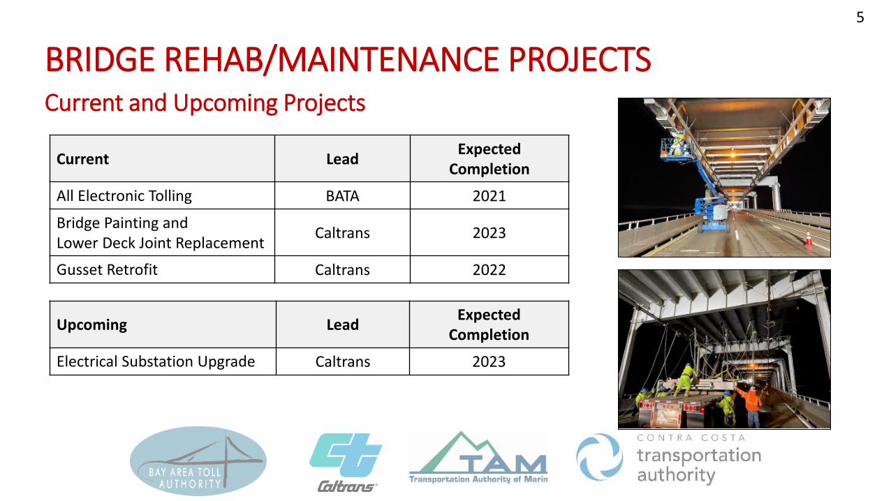
Current Lead Expected Completion
All Electronic Tolling BATA 2021
Bridge Painting and Lower Deck Joint Replacement Caltrans 2023
Gusset Retrofit Caltrans 2022
Upcoming Lead Expected Completion
Electrical Substation Upgrade Caltrans 2023
5
BRIDGE REHAB/MAINTENANCE PROJECTSCurrent and Upcoming Projects

PKG DESCRIPTION STATUS
A I-580 Eastbound: PEAK PERIOD USE LANE OPENED APR. 2018
B1 I-580 Westbound: 10’ BICYCLE/PEDESTRIAN PATHSir Francis Drake Blvd Off Ramp: 8’ BICYCLE PATH
OPENED NOV. 2019OPENED AUG. 2020
B2 Francisco Blvd East: BICYCLE/PEDESTRIAN PATH (SIDEWALK) FINAL DESIGN & R/W
Sir Francis Drake Blvd Off Ramp
6
RSR ACCESS IMPROVEMENT PILOT PROJECTS

• Caltrans Headquarters and UC Berkeley PATH are leading the pilot studies and reports, which started in Summer 2018 and the Final Report is expected to be completed in Summer 2024.
• Scope includes collecting bike/ped counts, traffic data, maintenance impacts, incident data, surveys, conducting quarterly meetings, and preparing a final report.
• Final decision on pilot projects is not expected until completion of pilot studies.
7
RSR ACCESS IMPROVEMENT PILOT PROJECTSPilot Study

• General Observations 2020:• Peak in May ’20, consistent through
summer weather.• Lower in Fall/Winter ’20, likely due to
poor air quality and colder weather.
• 2021 Monthly Trip Averages:• Weekends: 3,500 – 4,500 trips/month• Weekdays: 2,300 – 3,300 trips/month
0
1,000
2,000
3,000
4,000
5,000
6,000
7,000
8,000
Jan-
20
Feb-
20
Mar
-20
Apr-
20
May
-20
Jun-
20
Jul-2
0
Aug-
20
Sep-
20
Oct
-20
Nov
-20
Dec-
20
Jan-
21
Feb-
21
Mar
-21
Apr-
21
May
-21
Jun-
21
Jul-2
1
Aug-
21
Sep-
21
Oct
-21
Nov
-21
Dec-
21
Trip
s/M
onth
Monthly Bicycle Trips (EB+WB)
2020 2021
Weekends
Weekdays
Source: UC Berkeley PATH Quarterly Update 8/2
8
RSR ACCESS IMPROVEMENT PILOT PROJECTSBicycle Counts (up to June 2021)

PPUL Opened
Bike/Ped Path Opened
Source: Bay Area Incident Management Dashboard
Incident Management Plan
• Achieve incident response time of 30 minutes
• Added mileposts/markers to locate incidents, per Fire officials request
• Provide operational and maintenance training to CT, Fire Department, CHP
• Upper Deck: Implemented incident response measures due to elimination of shoulder (i.e., ATV, pusher wheels)
• Lower Deck: Coordinate with Caltrans to adjust lane arrows to assist with incident response
9
RSR ACCESS IMPROVEMENT PILOT PROJECTSVehicle Crashes Per Month

(2020-2024)
INCREASE TRANSIT FREQUENCY
REWARDS
OPEN ROAD TOLLING I-580 WB HOV LANE
RICHMOND PKWY INTERCHANGE DESIGN ALTERNATIVE ASSESMENT
BIKE GAP CLOSURES/IMPROVEMENTS
COMMUTE MANAGEMENT TECHNOLOGY PLATFORM
QUICK BUILD BIKE ACCESS IMPROVEMENTS
E-BIKE SHARE
Signing & Striping
Miles App for Green Trips
E-BIKE COMMUTE PROGRAMFirst/Last Mile Connections
Inform & Support Employer TDM
Improvements TBD based on Design Alternatives Assessment
Increase frequency of Golden Gate TransitTransbay Route 40X
Rebates and Incentives
RSR RIDESRides on Bridge led by local organizations and retailers
10
RSR FORWARD

Richmond Pkwy Interchange
6 MILESI-580 WESTBOUND
Convert GP Lane to HOV
21
3
2
3
Open Road Tolling1TO RSR BRIDGE
11
RSR FORWARDOpen Road Tolling/I-580 WB HOV LANE Project (2024)

• Show benefits/drawbacks of a third WB traffic lane between 5:00AM and 11:00AM on weekdays
• Lane would be created by moving the barrier on the bridge daily
• Identify improvements in Marin County, if needed
• Previously collected traffic data was used to generate the results• Richmond side data: 2016• San Rafael side data: 2018-2019• Combined data set converted using Year 2019 INRIX data.RS
R B
ridge
–W
B T
hird
Lan
e St
udy
12
WB THIRD LANE STUDYTraffic Study
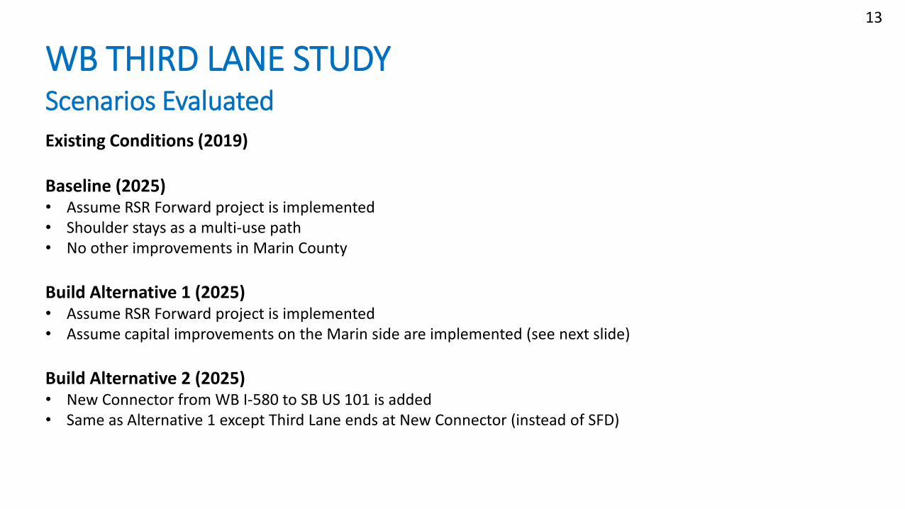
Existing Conditions (2019)
Baseline (2025)• Assume RSR Forward project is implemented • Shoulder stays as a multi-use path• No other improvements in Marin County
Build Alternative 1 (2025)• Assume RSR Forward project is implemented• Assume capital improvements on the Marin side are implemented (see next slide)
Build Alternative 2 (2025)• New Connector from WB I-580 to SB US 101 is added• Same as Alternative 1 except Third Lane ends at New Connector (instead of SFD)
RSR
Brid
ge –
WB
Thi
rd L
ane
Stud
y13
WB THIRD LANE STUDYScenarios Evaluated

Build Alternative 1• Improvements on RSR Bridge (signage): up to $20 M• Widening of portion of RSR bridge: $30 M• Relocate Francisco Blvd. on-ramp and widen I-580: $35 M• Barrier Operating Costs ($1M per year for 5-Year Pilot): $5 M• Total: Approximately $70-$90 M
Build Alternative 2• Build Alternative 1: $90 M• Direct Connector near Bellam: $220 M • Total: Approximately $310 MRS
R B
ridge
–W
B T
hird
Lan
e St
udy
14
WB THIRD LANE STUDYCapital Improvements SummaryCosts Escalated to 2025

Capital Projects to Support Third Lane (Marin side)
Close Hook On-Ra m p
Ne w WB I-580 On-Ra m p Loca t ion
Wid e n Tre s t le
Wid e n Ma in St re e t Und e rc ross ing
Ne w Re ta ining Wa ll b e twe e n I-580 & Fra nc isco Blvd E
Wid e n Ins id e a nd Outs id e Should e rs
No Acce ss From Fra nc isco Blvd E to
Sir Fra nc is Dra ke
Ad d Cha ng e a b le Pe a k Use La ne
Sig ns Across Brid g e

RSR
Brid
ge –
WB
Thi
rd L
ane
Stud
y
16
16
WB THIRD LANE STUDYConceptual WB 580 to SB US 101 Connector
RSR
Brid
ge –
WB
Thi
rd L
ane
Stud
y
-
1,000
2,000
3,000
4,000
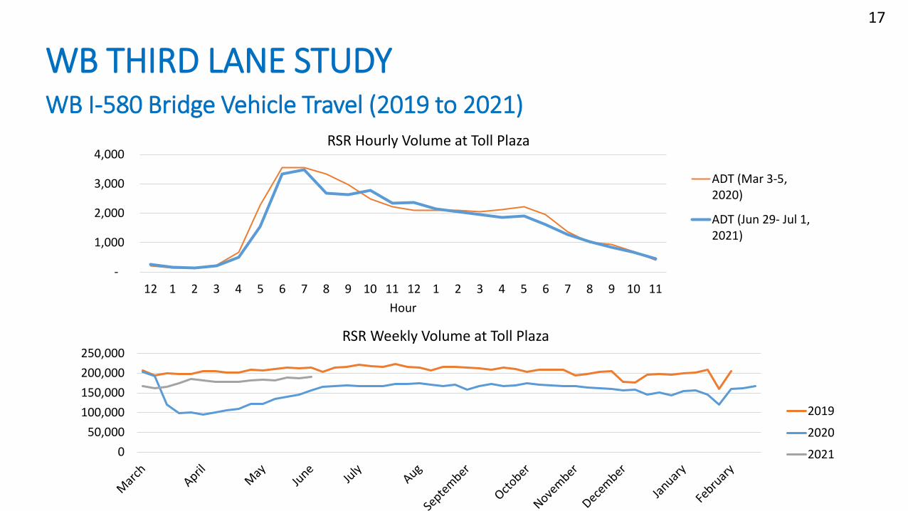
12 1 2 3 4 5 6 7 8 9 10 11 12 1 2 3 4 5 6 7 8 9 10 11Hour
RSR Hourly Volume at Toll Plaza
ADT (Mar 3-5,2020)
ADT (Jun 29- Jul 1,2021)
050,000
100,000150,000200,000250,000
RSR Weekly Volume at Toll Plaza
2019
2020
2021
17
WB THIRD LANE STUDYWB I-580 Bridge Vehicle Travel (2019 to 2021)

RSR
Brid
ge –
WB
Thi
rd L
ane
Stud
y
Study results are reported by OD Pair• I-80/I-580 Split to NB US 101• I-80/I-580 Split to SB US 101
18
WB THIRD LANE STUDYOrigin-Destination Pairs

RSR
Brid
ge –
WB
Thi
rd L
ane
Stud
y
2018 Origin/Destination Data Shows:Of the traffic that comes across the bridge and continues to US 101• 79% of AM traffic continues north onto NB US 101 • 21% of AM traffic continues south onto SB US 101
• These numbers do not include traffic that exits to local roads
79%
21%
19
WB THIRD LANE STUDYWB I-580 to US 101 Traffic Split

RSR
Brid
ge –
WB
Thi
rd L
ane
Stud
yWB THIRD LANE STUDYWB I-580 Travel Time: From I-80/I-580 Split to NB US 101 (Downtown San Rafael)
20
Scenario Cost Est. (millions)
Average Travel Time Albany to
101 (Minutes)
Average, Savings
over Baseline
Peak Hour Travel Time (Minutes)
Peak, Savings
over Baseline
Existing (2019) N/A 23.7 34.7
Baseline (incl. RSR Forward)
BATA-funded 24.3 43.0
Alt 1: Part time lane to 101 $70-90 22.7 7% 32.0 27%
Alt 2: Part time lane to 101 ~$310 19.2 21% 31.5 27%

RSR
Brid
ge –
WB
Thi
rd L
ane
Stud
y21
WB THIRD LANE STUDYWB I-580 Travel Time: From I-80/I-580 Split to SB US 101
Scenario Cost Est. (millions)
Average Travel Time Albany to
101 (Minutes)
Average, Savings
over Baseline
Peak Hour Travel Time
(Minutes)
Peak, Savings
over Baseline
Existing (2019) N/A 30.4 47.9
Baseline (incl. RSR Forward)
BATA-funded 32.6 48.7
Alt 1: Part time lane to SFD $70-90 35.5 <9%> 52.0 <6%>
Alt 2: Part time lane to DC ~$310 20.6 37% 32.7 31%
RSR
Brid
ge –
WB
Thi
rd L
ane
Stud
y
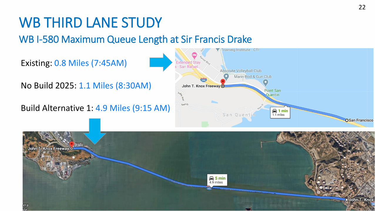
Existing: 0.8 Miles (7:45AM)
No Build 2025: 1.1 Miles (8:30AM)
Build Alternative 1: 4.9 Miles (9:15 AM)
22
22
WB THIRD LANE STUDYWB I-580 Maximum Queue Length at Sir Francis Drake

• Peak period use lane on the upper deck would require significant new construction on the Marin County side.
• Direct access from Francisco Boulevard East/Morphew Street to Sir Francis Drake Boulevard would not be able to be maintained with the project.
• Traffic headed to northbound US 101 would have a peak hour time savings of 11 minutes with the project (Alt 1) in 2025.
• However, traffic headed to southbound US 101 would have an increased peak hour delay of 3 minutes with the project (Alt 1) in 2025.
• Travel time savings only possible with construction of WB-SB Direct Connector.
• The Project may shift the congestion and bottlenecks from the toll plaza area to Sir Francis Drake Blvd.
• MTC/BATA has raised concerns that the PPU Lane will result in Induced Demand for vehicles WB on the Bridge, potentially in conflict with the goals of RSR Forward.
RSR
Brid
ge –
WB
Thi
rd L
ane
Stud
y23
WB THIRD LANE STUDYSummary
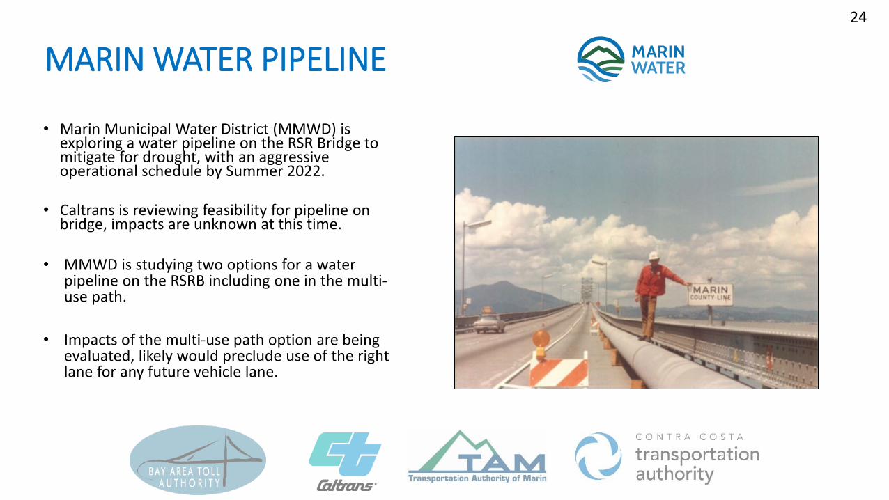
• Marin Municipal Water District (MMWD) is exploring a water pipeline on the RSR Bridge to mitigate for drought, with an aggressive operational schedule by Summer 2022.
• Caltrans is reviewing feasibility for pipeline on bridge, impacts are unknown at this time.
• MMWD is studying two options for a water pipeline on the RSRB including one in the multi-use path.
• Impacts of the multi-use path option are being evaluated, likely would preclude use of the right lane for any future vehicle lane.
24
MARIN WATER PIPELINE

• Asset Management Study resulted in no immediate need for bridge replacement and identified need for retrofit/maintenance projects.
• RSR Access Improvement Project Pilot studies are ongoing and Final Report is expected in Summer 2024.
• RSR Forward near-term strategies to improve transportation demand management and relieve congestion on the westbound bridge approach.
• Westbound 3rd Lane Study shows improvement in peak hour travel time savings for some drivers/destinations, slightly worsens others; would require significant new construction in Marin. Cost to implement estimated at $70-90M.
• Marin Water evaluating pipeline options across bridge in response to drought.
25
SUMMARY

THANK YOU