richmondshire local plan 2012-2028
TRANSCRIPT

Richmondshire Local Plan2012-2028Core Strategy
Adopted 9 December 2014


Richmondshire Local Plan Core StrategyAdopted 9 December 2014
The Local Plan Core Strategy will guide development in our towns and villages outside the Yorkshire Dales National Park up to 2028 - to support a growing and changing local population.
Extensive consultation has informed the choices we have made when producing it, helping the Council to strike the balance between the many demands for change and how they can be met locally. Whether you live in a town or village, have been posted here by the Army or are looking for somewhere to live or work, future development is important to you. It helps create local housing and employment opportunities as well as providing investment in local schools, roads and essential services.
We want to secure the best possible quality of life for all our communities - and strong towns are at the heart of our approach. Richmond, Catterick Garrison and Leyburn each have important roles to play for local communities across the whole district. Development here will encourage confidence and help to keep services local as far as possible.
But we live in a very rural part of North Yorkshire where local communities and businesses reach the remotest areas. For this reason we will support the necessary housing and economic development across the whole area to help promote a living countryside.
Future development must respect and enhance the great and historic landscape we all enjoy. It is not simply about preserving everywhere as it is - we need to adapt to the long term challenges that climate change presents to us all by finding more sustainable and energy efficient ways of living, meeting future energy demands and avoiding flood risk.
The Council is planning positively for our local communities and I am confident of the bright future this strategy will bring.
Foreword
Councillor John BlackieLeader of Richmondshire District Council
i

Richmondshire Local Plan Core StrategyAdopted 9 December 2014ii

Richmondshire Local Plan Core StrategyAdopted 9 December 2014
Chapter 1: IntroductionThe Local Plan Core Strategy .............................................................................. 1
Chapter 2: Richmondshire’s ChallengesSettlements ........................................................................................................ 5Population......................................................................................................... 6Housing ............................................................................................................ 7Military ............................................................................................................. 8Economy ........................................................................................................... 8Transport and Accessibility .................................................................................. 9Environment ...................................................................................................... 10The Key Strategic Issues ...................................................................................... 11
Chapter 3: The Strategic ApproachVision for 2028 ................................................................................................. 12Strategic Objectives ........................................................................................... 13The Policy Framework ......................................................................................... 14Local Objectives ................................................................................................ 15Spatial Principles ................................................................................................ 16Spatial Principle SP1: Sub Areas .......................................................................... 16Spatial Principle SP2: Settlement Hierarchy ........................................................... 19Spatial Principle SP3: Rural Sustainability ............................................................. 23Spatial Principle SP4: The Scale and Distribution of Housing Development ............. 23Spatial Principle SP5: The Scale and Distribution of Economic Development ........... 27Spatial Strategy Summary and Key Diagram ......................................................... 32
Sub Area StrategiesCentral Richmondshire ....................................................................................... 34Lower Wensleydale ............................................................................................ 42North Richmondshire ......................................................................................... 49
Chapter 4: Core PoliciesRole of the Core Policies ..................................................................................... 53Core Policy CP1: Planning Positively .................................................................... 53Core Policy CP2: Responding to Climate Change ................................................. 54Core Policy CP3: Achieving Sustainable Development ........................................... 59Core Policy CP4: Supporting Sites for Development .............................................. 62Core Policy CP5: Providing a Housing Mix ........................................................... 65Core Policy CP6: Providing Affordable Housing .................................................... 67Core Policy CP7: Promoting a Sustainable Economy ............................................. 71Core Policy CP8: Achieving Rural Sustainability .................................................... 74Core Policy CP9: Supporting Town and Local Centres ........................................... 76Core Policy CP10: Developing Tourism ................................................................ 83
Contents
iii

Richmondshire Local Plan Core StrategyAdopted 9 December 2014iv
Core Policy CP11: Supporting Community, Cultural and Recreations Assets ............ 84 Core Policy CP12: Conserving and Enhancing Environmental and Historic Assets .... 86Core Policy CP13: Promoting High Quality Design ............................................... 92 Core Policy CP14: Providing and Delivering Infrastructure ..................................... 94
Chapter 5: Implementation and DeliveryImplementation ................................................................................................. 95Infrastructure Delivery Plan ................................................................................. 96Existing Infrastructure ......................................................................................... 97Infrastructure Delivery - Risks ............................................................................... 99Community Infrastructure Levy (CIL) .................................................................... 100Monitoring and Review ....................................................................................... 103
Annexes:Annex 1: Richmondshire Local Plan Superseded Policies ........................................ 107Annex 2: Glossary and Acronyms ........................................................................ 109
List of Figures:Figure 1: Richmondshire Plan Area ...................................................................... 4Figure 2: Richmondshire Population Ageing 2001 - 2011 ..................................... 6Figure 3: Spatial Principle 1: Sub Areas ............................................................... 18Figure 4: Spatial Principle 2: Settlement Hierarchy ................................................ 22 Figure 5: Spatial Principle 5: Employment Distribution ........................................... 30Figure 6: Key Diagram ....................................................................................... 31 Figure 7: Central Richmondshire Sub Area ........................................................... 33Figure 8: Central Richmondshire Spatial Strategy .................................................. 36Figure 9: Strategic Development Growth Area - Richmond and Catterick Garrison .. 39Figure 10: Lower Wensleydale Sub Area .............................................................. 44Figure 11: Lower Wensleydale Spatial Strategy ...................................................... 46Figure 12: Strategic Development Growth Area - Leyburn ..................................... 47Figure 13: North Richmondshire Sub Area ........................................................... 50Figure 14: North Richmondshire Spatial Strategy .................................................. 51Figure 15: Catterick Garrison Town Centre .......................................................... 80Figure 16: Richmond Town Centre ...................................................................... 81Figure 17: Leyburn Town Centre .......................................................................... 82
List of Tables:Table 1: Expected Change in Local Employment Sectors ........................................ 9Table 2: Policy Framework: Local Objectives ........................................................ 15Table 3: Scale and Distribution of Housing up to 2028 ......................................... 26Table 4: Households in Need .............................................................................. 66 Table 5: Annual Housing Delivery and Need ........................................................ 68Table 6: Local Plan Infrastructure Delivery Plan Projects ......................................... 101Table 7: Spatial Principles and Core Policies: Indicators and Targets ....................... 104

Richmondshire Local Plan Core StrategyAdopted 9 December 2014 1
Chapter 1: Introduction
The Local Plan Core Strategy
1.1 The Local Plan Core Strategy presents Richmondshire District Council’s overall vision and strategy for delivering sustainable development up to 2028 in the District outside the Yorkshire Dales National Park. It replaces the strategic elements and most of the saved policies of the Richmondshire Local Plan 2001 (See Annex 1 for Superseded Policies).
1.2 The requirement to produce a Local Development Framework (LDF) with a Core Strategy was established by the Planning and Compulsory Purchase Act 2004, but this changed to a Local Plan with the Localism Act 2011 and the National Planning Policy Framework (NPPF, March 2012). What had been consulted upon previously as the LDF Core Strategy has therefore now been updated and rebranded to be part of the new Local Plan system.
1.3 This Plan seeks to achieve sustainable development through spatial planning. Ultimately, this is concerned with making sure that the right development happens in the right places to encourage growth and support local needs while not harming the local area. This reflects the common theme and the presumption in favour of sustainable development set out in the NPPF, with which this Plan should be consistent in all respects.
1.4 The Local Plan Core Strategy provides the local perspective on future development consistent with the current statutory development plan system. The Council responded to the expected abolition of Regional Spatial Strategies (RSS) by publishing its Local Strategy Statement (2011) setting a locally distinct strategic context for future development. This context reflects several stages of preparation and consultation from early 2009 to late 2011. Details of this process, its regulatory compliance and, most importantly, how the Local Plan Core Strategy has been shaped by consultation responses are given in the Local Plan Core Strategy Consultation Statement. The Yorkshire and Humber RSS was finally revoked in February 2013. The Council consulted on the impact of this change in its Development Target Review (August 2013) and respondents agreed that the final revocation had little impact on the Council’s development strategy.
1.5 The approach to sustainable development set out in this Local Plan Core Strategy is supported by a Sustainability Appraisal (SA) incorporating a Strategic Environmental Assessment (SEA). As a key part of ensuring that the Local Plan achieves sustainable development, the Council must undertake a separate and concurrent evaluation of the choices at the same time as the main Local Plan documents are prepared. That report, and all the background reports referred to in this document, are available online at: www.richmondshire.gov.uk.
1.6 The Local Plan Core Strategy is an important vehicle for the coordination and delivery of several related strategies across the plan area - including Community Strategies, the County Council’s Local Transport Plan and School Organisation Plan, health bodies’ strategies and the Highways Agency’s programme. Central to these is the Richmondshire Sustainable Community Strategy 2010-2015, prepared by the Richmondshire Local Strategic Partnership. The Community Strategy guides activities to promote the economic, social and environmental wellbeing of the area and improve the quality of life for everyone in this rural area.

Richmondshire Local Plan Core StrategyAdopted 9 December 2014
It focuses on: affordable housing facilities for young people community safety local access to public services quality of the environment
1.7 Richmondshire has many local growth issues in common with its neighbouring districts. The introduction of the York, North Yorkshire and East Riding Local Enterprise Partnership (LEP) has created a strong focus on the key drivers to change and the resources required to secure them. This is captured in the LEP’s five priorities:
profitable and ambitious small and micro businesses a global leader in food manufacturing, agri-tech and biorenewables inspired people successful and distinctive places a well connected economy
Neighbouring authorities, including Darlington and County Durham, have been engaged throughout the development of this strategy. The strategic significance of relevant issues has been addressed throughout this process.
1.8 The Core Strategy is the first part of the Council’s Local Plan, which needs to be supplemented by further detailed policies and guidance, in the following additional key planning documents:
Delivering Development Plan - defining development limits for the larger settlements on the proposals maps and identifying detailed policies and site allocations for the following: Housing Employment Town Centre Uses MoD Uses Infrastructure Open Space and Green Infrastructure Sport and Leisure Facilities
Site evaluation in the allocations process will include consideration of infrastructure requirements.
Supplementary Planning Documents - providing detailed guidance on the implementation of Core Strategy policies covering: Affordable Housing Guidance Heritage and Design Guidance Settlement Development Guidance
The timetable for their production will be published in the Council’s Local Development Scheme.
2

Richmondshire Local Plan Core StrategyAdopted 9 December 2014
1.9 Minerals and waste planning issues are dealt with through North Yorkshire County Council’s Minerals and Waste Local Plans. The minerals planning authority is responsible for safeguarding mineral resources of economic importance and for establishing consultation arrangements with local planning authorities to ensure that minerals safeguarding issues are taken into account in relevant development decisions. The Coal Authority is responsible for identification of Development High Risk areas that are most likely to be subject to land stability and other public safety hazards. Within these areas the Coal Authority will expect many new development proposals to be accompanied by a Coal Mining Risk Assessment.
1.10 The Local Plan Core Strategy is an integrated spatial planning package for the future of the plan area. All its spatial principles and policies apply wherever relevant and should be read together when considering a specific proposal or issue. This is a complex document and a glossary of terms is provided in Annex 2. The following chapters cover:
Richmondshire’s Challenges A picture of the local area and the issues that need to be addressed. The Strategic Approach A concise Vision for the future, which identifies a set of Strategic Objectives
to guide delivery. It defines five Spatial Principles which give the Strategy its distinctive local dimensions and applies these through three sub area strategies for North and Central Richmondshire and Lower Wensleydale.
Core Policies Courses of action for development proposals to ensure they deliver the Local
Plan Core Strategy’s vision and objectives. Implementation and Delivery The approach to implementation, infrastructure delivery and monitoring,
including the Infrastructure Delivery Plan covering, for example, road and utility improvements and schools necessary to achieve delivery of the strategy.
3

Richmondshire Local Plan Core StrategyAdopted 9 December 2014
Figure 1: Richmondshire Plan Area
4

Richmondshire Local Plan Core StrategyAdopted 9 December 2014 5
Chapter 2: Richmondshire’s Challenges
2.1 The Richmondshire plan area, shown on Figure 1, is situated in the east of the District and lies outside the Yorkshire Dales National Park. It stretches from the Tees Valley and Vale of Mowbray lowlands in the east, through the Pennine fringe into lower Swaledale and Wensleydale in the northern Yorkshire Dales. It also includes a small outlying area around Tan Hill.
2.2 The plan area sits within a wider geographic context bordering Darlington in the Tees Valley and the deeply rural Yorkshire and Durham Dales and rural lowlands. Darlington acts as a sub-regional centre for much of the plan area population, providing retail and other services, and employment. It is linked by several roads, including the A1, A66, A167 and B1263. The Richmondshire and Hambleton plan areas share many similarities, reflected in shared transport links between towns and villages. The A684 runs through Wensleydale to Bedale and the A1 at Leeming Bar. The Wensleydale Railway currently links Northallerton and Leeming Bar with Redmire via Leyburn. The towns of Leyburn, Richmond and Catterick Garrison provide important services and employment opportunities across this wide area and to the settlements within the Yorkshire Dales National Park. Barnard Castle provides a similar role for small settlements in the north of the plan area. The short boundary with Harrogate runs through a remote rural area in the Nidderdale Area of Outstanding Natural Beauty.
Settlements
2.3 Richmond was awarded ‘Great Town of the Year’ by the Academy of Urbanism, in 2009. Historically it has been the main administrative and service centre for the District. Its significance remains but, with the post-war growth of the military base at Catterick Garrison and neighbouring settlements, it is no longer as dominant as it once was and it has lost out to the growth in Darlington and other larger centres. A large part of the town and its immediate surroundings have been designated as Conservation Areas. Richmond Castle and its dramatic setting, together with outstanding built heritage, is a major tourism draw.
2.4 Hipswell, Scotton and Colburn - including the Catterick Garrison main military site - is generally known as Catterick Garrison. This masks a complicated area that has evolved through the growth of military facilities, which have coalesced with the settlements. The building of a Tesco superstore and more recently a major leisure centre has begun to create a town centre that will continue to develop with the proposals for further redevelopment in the same area. Retail evidence shows that the impact of the superstore extends across the whole District. Although there is a strong military character to this area it is not exclusive and there are now large areas of open market housing following the disposal of military accommodation and development on former military land. Colburn is the largest domestic settlement offering a range of housing and other services. A number of employment locations have been developed mainly in Colburn. The area has grown around the A6136 and there are concerns about the capacity of this road which is subject to some congestion at peak times. The Catterick Garrison Strategic Transport Assessment (2011) has reviewed this and concluded that the capacity of the road can be increased to meet future development requirements with a set of specific junction improvements.

Richmondshire Local Plan Core StrategyAdopted 9 December 20146
2.5 Leyburn is the main town serving a wide rural catchment area covering Lower Wensleydale and Upper Swaledale. It is a market town serving the local agricultural economy and is also an important tourist centre. The town sits at a crossroads and operates as a hub for public transport in the area. Its connections favour east west travel along Wensleydale towards Bedale and Northallerton.
2.6 There are over 70 villages which vary in size considerably and are distributed across this large rural area.
Population
2.7 The population of the plan area is estimated to be 44,690 (Census, 2011), which is 86% of the District total. Two thirds of this population live in the seven largest settlements, with estimated populations of Catterick Garrison 16,180, Richmond 8,410, Catterick Village (including Marne Barracks) 3,155, Leyburn 2,550 and Brompton on Swale 1,880. Both Catterick Garrison and Catterick Village have large numbers of personnel living in communal accommodation. Despite the presence of a large military population, the population age structure tends to be older than regional and national profiles. The retirement age population accounts for 17.5% of the District total, but this proportion will be smaller for the plan area, because of the military population. The plan area can expect an increase in its age profile as the ‘baby boom’ generation reaches retirement age during the plan period. Figure 2 below, using population data obtained from the 2001 and 2011 Censuses, highlights how the District population is ageing. 95.4% of the local population is white, which is greater than regional and national levels.
Figure 2: Richmondshire Population Ageing 2001 - 2011

Richmondshire Local Plan Core StrategyAdopted 9 December 2014 7
2.8 Population change occurs mainly through migration to and from Richmondshire. This is driven by a mix of higher education, housing market options, military policy and rural attractiveness. The small size of the plan area population combined with its very large military component presents a methodological challenge for both population estimation and projection. The Office of National Statistics (ONS) series of projections based on 2001 Census were inflated through an error affecting the calculation of international migration (Development Target Review, August 2013). Although main 2011 Census results have been published at the time of writing, the first set of projections based on the full Census results has not been prepared. The interim mid-2011 based population and household projections are not considered suitable for strategic planning (DTR, 2013). But, in projecting prevailing recessionary trends they do indicate reduced local prospects in the absence of development. The Richmondshire Scrutiny of Population Estimates and Projections (2012) provided a revision to the mid 2008 based projections which addressed the migration overestimate using improved ONS methodology. These results showed a reduction in the level of expected growth over the plan period. The Core Strategy has adopted this revised, but more realistic, level of growth for strategic development which is greater than the depressed growth indicated by the mid-2011 interim projections.
Housing
2.9 There are about 19,600 (2011) dwellings in the plan area, of which just over 85% are owner occupied or privately rented, which is higher than regional and national levels. The mix of tenures in the plan area includes nearly 1,750 military homes or 10% of total dwelling stock. There is a much lower proportion of social rented housing (11%) compared to regional and national levels. The vacancy rate, including holiday homes and second homes, is 7.7%. This falls to 2.1% when only market properties are included (Empty and Underused Property Research, 2009).
2.10 There are two distinct Housing Market areas in Richmondshire. The central and northern parts of the plan area fall mainly into the Darlington and the Tees Valley area. The remaining, predominantly rural area, participates in much wider high value and leisure markets characterised by affluent commuters, quality of life, second and holiday homes. In-migration and rural attractiveness are strong drivers of the housing market. The ratio of lower quartile house price to lower quartile earnings has varied between 9.97 in 2005 and 8.44 in 2010 (CLG, 2012). The North Yorkshire Strategic Housing Market Assessment (NYSHMA, 2011) confirms the ongoing affordable housing issue. Over the next five years 260 homes per year are estimated to be in housing need but cannot afford to move to address this need. This includes households seeking adaptations and emerging households which may look outside the District for their housing needs. It is also based on assumptions concerning access to housing finance products available at the time of writing. The lower average household income of £22,100 in the District is a barrier to owner-occupation for many families. The average lower quartile house price is £145,000 and requires a household income of £58,500 to purchase it (assuming a maximum mortgage spend of 20% of income and no other equity). The private rented sector has been buoyant, but affordability issues place increased pressure on the available stock. Rents were comparatively low compared with more urban markets in North Yorkshire. Social housing waiting lists accounted for 7% of households.

Richmondshire Local Plan Core StrategyAdopted 9 December 2014
Military
2.11 There are two substantial military sites in the plan area. The Catterick Garrison main site has grown within the parishes of Hipswell, Scotton and Colburn since it was established in 1915, while Marne Barracks is at Catterick Village by the A1. The military population, following the complete 4 Brigade relocation from Germany, is estimated to be nearly 10,500 personnel and dependants, which is nearly a quarter of the plan area population.
2.12 The Army Basing Plan (MoD, 2013) presented the overall movements in military units required to return the Army from Germany and modernise it. This plan identified major unit movements in to and out of Catterick Garrison up until 2017. The net impact of these movements is not expected to change the overall size of the military presence in Richmondshire. National policy is for military personnel to stay at a home base for most of their career and to be deployed from there, aiming for personnel and their families to settle near to their base. The development of a modern town centre contributes to the objective to make Catterick Garrison an attractive home for soldiers and their families, and meet the aspirations of the wider local community.
Economy
2.13 The plan area’s working age population is about 30,600 of which an estimated 24,500 are economically active. The level of qualifications at all levels is higher than regional and national levels. The claimant rates for employment related benefits remain well below national and regional levels (NOMIS). Average earnings in Richmondshire are lower than regional and national levels for both residents and for jobs located in the District.
2.14 The Ministry of Defence (MoD) employs about 9,400 people in the plan area, including military personnel (Economic Impact Study of the Military in North Yorkshire, 2010). The gross impact of this through salaries is estimated to be £204m.
2.15 Middleham, in Lower Wensleydale, is an important centre for the horse racing industry employing 227 people and with around 550 racehorses in training. The total value of this industry to the area is estimated to be £12.7m (Lower Wensleydale Study 2009).
2.16 The Employment Land Review Update (2012) looked at the structure of the local economy and how it was expected to change. It is based on the Regional Econometric Model forecast dated October 2011. The assumptions supporting this projection had not been seriously affected by the economic downturn. The overall projected growth in local jobs would be 2,200 by 2026 if expected trends are realised. The table below summarises the results for the main local employment sectors, which account for 90% of local employment outside the armed forces. Employment sectors have been ranked by their relative size in terms of the numbers of people employed. In general, the local economy is expected to retain its strong service sector. But, the mix of services is expected to change, with a sharp reduction in public service employment and also a rise in retail employment. This growth is focussed mainly on the service sector and relies heavily on housing growth to deliver the necessary consumption to drive it. The potential for such growth should be related to housing growth projections, particularly when projected employment growth could outstrip growth in the local workforce, without increased migration or in-commuting to fill the deficit. The Employment-led Demographic Forecasts (2014) indicated that this projected level of employment growth would require an increased level of in migration to support it and a raised development
8

Richmondshire Local Plan Core StrategyAdopted 9 December 2014
target if all of the increase in the local workforce was to be accommodated in the District. As economic recovery begins, the projected increase in local economic growth is likely to be delayed and is dependent, on the delivery of the A1 upgrade through the District and the building of Catterick Garrison Town Centre.
Table 1: Expected Change in Local Employment Sectors
Rank(based on number of
people employed)
Growth
2011 2026 %
All Industry - - 6.5
Agriculture, Forestry and Fishing 2 3 14.8
Business Services 5 6 -9.4
Construction 1 2 5.6
Education 11 10 -3.9
Health 8 9 10.9
Hotels and Catering 4 4 13.9
Other Financial and Business Services 9 8 17.2
Other Services 3 1 44.9
Public Administration and Defence 7 11 -15.4
Retailing 10 5 32.5
Wholesaling 6 7 12.8
Transport and Accessibility
2.17 Transport and accessibility in the plan area reflects the housing market areas. The north eastern area facing the Tees Valley is close to the national road network via the A1 and A66. The main strategic road (A1) junctions in the plan area are Scotch Corner in the north to Richmond (A6108), Catterick Village along the A6136 to Hipswell, Scotton and Colburn, and from Leeming Bar through Wensleydale along the A684 to Leyburn and the Yorkshire Dales National Park.
2.18 The A1 motorway upgrade between Dishforth and Leeming Bar has improved access to existing employment and residential areas, and this will be improved further when the proposed A684 Bedale bypass is also built. The completion of the northern section of the proposed A1 upgrade from Leeming Bar to Barton is expected by 2017. The proposed Catterick Central junction upgrade will substantially improve access to the plan area. The Catterick Garrison Strategic Transport Assessment (2011) identified a number of road junctions along the A6136, which are near to or approaching capacity. Potential mitigation measures to enable future development were also identified and funding for these is being sought.
2.19 Richmond and centres in Catterick Garrison have regular bus services that connect them to Darlington. Leyburn is a hub for local bus services through Wensleydale and across to Richmond. The most rural parts of the plan area have more limited services, and frequency depends on how near they are to the main routes through the area.
9

Richmondshire Local Plan Core StrategyAdopted 9 December 2014
2.20 Mainline and local train services can be reached at Darlington and Northallerton. The Wensleydale Railway is a tourist railway operating between Leeming Bar and Redmire via Leyburn. It was extended to reach Northallerton in November 2014 when a new platform was opened.
2.21 Accessibility reduces as you move further away from the main corridors and into the more rural areas. Although the most rural wards in the plan area are among the least deprived in the country, the Index of Multiple Deprivation (IMD, 2010) places them in the country’s most deprived areas when measured by the limited access to services and the housing market alone.
Environment
2.22 The plan area lies to the east of the Yorkshire Dales National Park, and the lower stretches of the Swale and Ure valleys form natural extensions of this nationally designated landscape area. The Nidderdale and North Pennines Areas of Outstanding Natural Beauty (AONB) extend from the south and north-west into small parts of the plan area. Within the remainder of the area there are many other identifiable landscapes with their own distinctive qualities and character. Many areas have a local landscape importance, particularly around the historic settlements. The present landscape has been influenced by several country estates. The Ministry of Defence (MoD) is the largest single landowner and operates training estates over very substantial areas of moorland.
2.23 The plan area is rich in its green infrastructure, encompassing extensive habitats, major landscape features such as river corridors and flood meadows, along with wide green corridors and ecological networks. The Tees, Swale and Ure river corridors are important wildlife habitats, as are the upland moorland areas, all supporting the locally rich biodiversity. Numerous areas, sites and other features provide a network of nature conservation resources spread across the plan area. There are 11 Sites of Special Scientific Interest, along with over 200 local Sites of Importance for Nature Conservation, including Foxglove Covert, an important Local Nature Reserve in the Catterick Garrison military estate. West of the plan area, the North Pennines Dales Meadows, are designated as a Special Area of Conservation and this overlaps in part with the North Pennine Moors Special Protection Area which has rare and vulnerable birdlife. Both of these areas are of European importance.
2.24 Over 1,200 archaeological sites are identified by the North Yorkshire Environmental Record in the plan area. There are 41 designated Conservation Areas, and over 1,200 listed buildings and structures. In addition to formally recognised built heritage, there are many other buildings of genuine quality or features which enrich the urban and rural environments that give the plan area its local distinctiveness. Scott’s Dyke is a nationally important linear earthwork running through the plan area and along the eastern edge of Richmond.
2.25 There is very little contaminated land and air quality is good. The River Swale and River Tees floodplains limit development, particularly in lowland areas. The River Ure floodplain does not pass through any settlements in the plan area. Large parts of the plan area provide important sources of groundwater. In the area east of the A1 and north of the A66 the district has potentially viable commercial wind energy resources.
10
Richmondshire Local Plan Core StrategyAdopted 9 December 2014
The Key Strategic Issues
2.26 The assessment of the plan area identifies a number of local challenges for a future development strategy, including:
achieving rural sustainability, while retaining local character developing a complementary relationship between town centres in Richmond
and Catterick Garrison supporting the integration of communities in the wider Garrison area through
the development of a main town centre and related services securing wider local benefits of a sustained military presence improving access to facilities in the villages dealing with poor housing mix and lack of access to affordable housing promoting a more diverse rural economy with better paid jobs developing the quality of the tourism offer conserving and enhancing natural and built heritage increasing installed renewable electricity and heat capacity and reducing carbon
emissions complementing neighbouring areas and supporting communities in the Yorkshire
Dales National Park.
11

Richmondshire Local Plan Core StrategyAdopted 9 December 2014
Chapter 3: The Strategic Approach
3.1.1 This chapter explores the challenges identified in Chapter 2 and considers the sort of place the plan area could be in 2028. It outlines strategic and local objectives designed to deliver this vision. The five Spatial Principles at the heart of the Core Strategy are defined and these address the different roles of sub areas, settlements, rural communities and the scale and distribution of housing and economic development. It also looks at the different characteristics of the three main sub areas and sets out their spatial strategies.
3.1.2 The following vision has evolved through the preparation of the Core Strategy and the many views expressed about local needs and aspirations. It guides the approach set out in the rest of this document.
Vision for 2028
In 2028, sustainable growth in the Richmondshire plan area’s towns and villages supports the quality of life of rural communities and addresses their needs for local homes, work and leisure, through development and the provision of services. This growth has also complemented neighbouring areas, by supporting communities in the Yorkshire Dales National Park and the regeneration strategy in the Tees Valley.
The towns of Richmond, Catterick Garrison and Leyburn play distinct roles as centres for local communities and are the main focus for housing and employment offering a wide range of services and facilities. Their growth has led to improvements in links to and from surrounding villages and other centres. Richmond has realised the potential offered by its heritage and increased its economic importance to the surrounding area. Private and military investments have transformed Hipswell, Scotton, Colburn and Catterick Garrison into an excellent living environment shared by local and military communities with a modern town centre, high quality development and improved road junctions. Historic Richmond and a modern Catterick Garrison town centre complement each other in the range of facilities and opportunities they offer to the District. Leyburn continues to be an important centre for a large rural area extending over Wensleydale and Swaledale. It retains its character and sense of place while offering wider housing and employment choices. The villages and countryside beyond continue to reflect their high quality settings, but a flexible approach to development has provided a range of accessible housing and employment opportunities for local people.
A diverse, competitive and successful rural economy, providing access to local job opportunities has grown alongside market and affordable homes. More people live and work locally, with commuting to and from the plan area reduced. The area’s strong rural cultural identity, with its rich variety of environmental and historic assets, has been sustained and enhanced. Local measures have helped the area to respond to climate change and mitigate the impact of development. Installed renewable electricity and heat opportunities have been realised and green renewable and low carbon industries have developed. These have supported the achievement of challenging levels of renewable energy provision and low carbon developments.
12

Richmondshire Local Plan Core StrategyAdopted 9 December 2014
3.1.3 The vision for 2028 imagines a future for the plan area which reflects its local characteristics, the challenges it faces and its potential for change. Realising this vision is a role that needs to be shared by the Council, local communities and investors. Only then can the resources for change be guided through an appropriate set of policies and later on by specific schemes or actions. The Core Strategy complements other plans by guiding development choices through the decisions of the Council as the local planning authority.
Strategic Objectives
3.1.4 The local strategic context was reassessed in the Local Strategy Statement (LSS) published by the Council in February 2011. The LSS summarised the local approach and replaced the Regional Spatial Strategy (RSS) with the following six strategic objectives for the plan area:
1. Overall change in Richmondshire should reflect the needs of the area and its relative lack of potential for growth, taking into account the great concern to protect its high quality environment. This should ensure consistency in its relationships with its neighbours with similar or different objectives.
2. A managed approach to ensure an appropriate level of housing and employment provision which will meet local social and economic needs helps to reduce commuting out of the plan area and supports regeneration and growth in the Tees Valley. Consistent with this, housing provision will be based on 180 dwellings per annum. This will provide support for the rural economy and local social and community needs, including scope to provide for the identified need for affordable housing.
3. Development and provision of services will be concentrated in locations which reflect a defined sustainable settlement hierarchy. This hierarchy is headed by the settlements of Richmond and Catterick Garrison, where the strategy will seek to support their distinct roles in providing the main local focus for housing and employment (and also shopping, leisure, education, health, cultural activities and facilities), and will seek to encourage improvements in their accessibility from surrounding areas, and improved public transport links to other centres. Leyburn will be encouraged to fulfil its important service function to a wide rural area extending outside of the plan area, including provision of market and affordable housing, and new job opportunities to address local needs. Important priorities for Leyburn will include its enhancement and protection as an attractive and vibrant place, with excellent environmental, economic and social resources serving the wider rural area.
4. Development in Richmond and Catterick Garrison will promote their complementary roles and provision of facilities. It will recognise their close relationship in terms of provision of services and impact of development in one on the other. The balance of physical development will be concentrated in the Catterick Garrison area rather than in Richmond because of its limited physical scope for expansion.
13
Richmondshire Local Plan Core StrategyAdopted 9 December 2014
5. Rural sustainability will be supported, by: safeguarding local quality of life, environmental values and characteristics encouraging a more diverse, competitive and successful economy, with
access to economic opportunities and increased self sufficiency within the rural economy, in ways which should allow people to live and work locally
meeting locally generated needs for both market and affordable housing, and supporting the social needs of rural communities
promoting its rural cultural identity, including supporting the role of market towns and tourism
supporting communities to provide for their own needs.
6. Priority will be given to protecting and conserving the rich variety of environmental and historic assets and mitigating and adapting to the prospects of climate change, including through measures which support the achievement of challenging levels of renewable energy provision and low carbon developments.
The Policy Framework
3.1.5 Action to support the delivery of these objectives through development will be guided by the policy framework set out in this document. This is an integrated response to local conditions in the plan area which supports sustainable development, enabling people to satisfy their basic needs and enjoy a better quality of life, without compromising the quality of life for future generations.
3.1.6 The policy framework begins with five Spatial Principles (SP1 - SP5). These give geographical structure to the overall strategy for the plan area. Three sub area strategies, for Central Richmondshire (CRSS), Northern Richmondshire (NRSS) and Lower Wensleydale (LWSS) provide specific responses to the different circumstances of these areas. Core Policies (CP1 - CP14) provide direction for the delivery of development, ensuring that it responds to local needs and respects local conditions. The final element of the policy framework explains how local infrastructure can be improved to respond to the growth anticipated by the overall strategy and how the Council will ensure that the strategy responds to change.
3.1.7 The delivery of the overall strategy is summarised in Table 2 by linking detailed local objectives to the elements of the policy framework, which are expanded through the remainder of this document.
14

Richmondshire Local Plan Core StrategyAdopted 9 December 2014
Table 2: Policy Framework: Local Objectives
Local Objective Policy
1. Thriving and sustainable communities are supported by locating development where it will enable people to access jobs and key services like education, training, healthcare, recreation and other facilities
SP1-SP5, CP3, CP4 and CP11
2. The need for travel is reduced and access to jobs and key services by sustainable forms of transport, such as public transport, walking and cycling, is made safer and easier
SP1 - SP5 and CP3
3. The dynamic character of rural communities is supported across the whole plan area and their social and economic fabric is sustained
SP3 and CP8
4. Local and military authorities work together to create lasting and mixed communities, which will benefit the whole District
SP4, SP5 and CRSS
5. Future population and employment growth is accommodated in line with local requirements and responsive to neighbouring areas
SP4 and SP5
6. Good quality housing is provided with an appropriate mix of different sizes, types and tenures which meet the housing needs of local communities
SP4, CP5 and CP6
7. The adverse impact of society on the environment and the implications of climate change are responded to
CP2
8. The historic heritage, character and identity of local towns and villages is protected and enhanced by ensuring that new developments are appropriate in terms of scale and location in the context of settlement form and character
CRSS, LWSS, NRSS, CP4 and CP12
9. The countryside, wildlife diversity and habitats are protected and improved
CP4 and CP12
10. Local economic growth is supported in ways which are compatible with environmental objectives and deliver increased prosperity for the whole community
SP3, SP5, CP7 and CP10
11. Vibrant and prosperous towns are supported to function as service centres with a range of good quality jobs, businesses, shops and services
CRSS, LWSS, CP9 and CP10
12. High quality design of new developments helps to create attractive and safe places to live, work and play in
CP13
13. Effective partnership between public and private organisations and local communities delivers the vision for the plan area
CP14, Infrastructure Delivery Plan
15

Richmondshire Local Plan Core StrategyAdopted 9 December 2014
3.1.8 Further planning policy documents will be produced after the Core Strategy to provide additional detail where necessary.
Spatial Principles
3.1.9 The five Spatial Principles (SP) are at the heart of the Core Strategy and make it locally distinct to the needs of the plan area.
SP1: Sub Areas identifies three sub areas and the strategic approach for each
SP2: Sustainable Settlement Hierarchy defines the levels of the hierarchy, the roles of each level and identifies the settlements
SP3: Rural Sustainability identifies the approach towards supporting the rural environment and economy
SP4: Scale and Distribution of Housing sets the total scale of open market and military related housing to be provided in the
plan area, together with proportions for each sub area and each level in the settlement hierarchy
SP5: Scale and Distribution of Economic Development sets the overall scale of employment land to be provided in the plan area, together with
the approach to key employment areas
Spatial Principle SP1: Sub Areas
3.1.10 The plan area is made up of many settlements that have developed over a long period to reflect the different characters of the area. Wensleydale, Swaledale and Teesdale give the basic framework for the local settlement pattern. Separated by upland areas, the dales give a strong east-west dimension to the local area. Leyburn and its neighbouring villages sit in Wensleydale, Richmond sits in Swaledale and the lower reaches of Teesdale form the northern boundary. The local road network also reflects this pattern: the A6108 leads through Richmond and into Swaledale; the A66 follows Teesdale and the A684 passes through Wensleydale. There are limited north-south connections between these routes apart from the A1, which runs through the Vale of Mowbray in the east of the plan area.
3.1.11 The Catterick Garrison Town Centre Retail Study (2006) and the Plan Our Future (2009) consultation responses show the centres of preference for local people. These also tend to conform to the traditional dales pattern, despite the strong influence of Darlington in the north. Together, Richmond and Catterick Garrison fulfil district centre roles, providing a range of services with a catchment that extends westwards into the remoter rural areas. Leyburn fulfils the local centre role set in its well known high quality rural context. The northern part of the plan area is sparse and may be subject to development pressure from Darlington.
16

Richmondshire Local Plan Core StrategyAdopted 9 December 2014
3.1.12 Three sub areas, which broadly reflect local geography and settlement pattern, are defined in the Core Strategy with a relevant policy response to each:
Central Richmondshire contains the traditional District centre, main centres of population, Catterick Garrison military facilities and areas for potential
development. Lower Wensleydale is the most discrete, with its very clear centre in Leyburn set in
a remoter rural area of great quality extending from the Upper Dales in the west towards Bedale and the A1 in the east.
North Richmondshire is a predominantly rural landscape with distributed settlements, which look to the larger centres of Darlington, Barnard Castle or Richmond.
Spatial Principle SP1: Sub Areas
Within the plan area, a different strategic approach will be taken for each of the following three broad sub areas:
Central Richmondshire is the area of greatest growth, reflecting the location of the main towns of Richmond and Catterick Garrison, the scope for development and the scale of existing facilities and infrastructure. This is the area where most housing and employment related development will take place.
Lower Wensleydale is an area of modest growth, reflecting the location of Leyburn within the sub area, which has a substantial capability to support its rural hinterland. The scale of development in this sub area will also reflect its role in supporting and providing for the needs of the adjacent part of Richmondshire which lies within the Yorkshire Dales National Park.
North Richmondshire is an area of more modest growth, reflecting its largely rural nature, the limited services available within its settlements and the need to resist development pressures from and support the regeneration of neighbouring Tees Valley settlements particularly Darlington. The strategy in this area will be to limit the scale of new housing development, in order to resist further in-migration from these adjacent parts, and decrease pressures for cross-boundary commuting.
17

Richmondshire Local Plan Core StrategyAdopted 9 December 2014
Figure 3: Spatial Principle 1: Sub Areas
18

Richmondshire Local Plan Core StrategyAdopted 9 December 2014
Spatial Principle SP2: Settlement Hierarchy
3.1.13 The Core Strategy supports thriving local communities by directing development to support the range of local services, facilities and employment opportunities, which should achieve a better balance between homes and jobs. Development should also be directed away from the most sensitive environments, including areas of biodiversity importance. Overall, this approach seeks to focus development on selected settlements where it can make the most positive benefit.
3.1.14 The main towns in the plan area are linked to a network of smaller settlements. Major services such as health, employment or shopping are more likely to be found in these centres. A range of additional services are also found in smaller settlements further reducing the need to travel. There are several primary schools and village halls in the more remote parts of the plan area. This pattern of services and the links between settlements is at the heart of the settlement hierarchy. The Settlement Facilities Study (2011) captured a full picture of the provision of, and access to, facilities across the plan area and has been used to inform the settlement hierarchy, which will be used to organise future service provision and development. This approach was endorsed in the Local Strategy Statement.
3.1.15 Spatial Principle SP2 aims to reflect and strengthen the centres at Richmond, Catterick Garrison and Leyburn and the network of communities extending from them into the villages found in the large rural hinterlands. The detailed implications of applying the settlement hierarchy are addressed in the Spatial Principles, Sub Area Strategies and Core Policies following Spatial Principle SP2. The settlement hierarchy is built around both the size of a settlement and the role it serves to local people. Four levels are defined:
Principal Towns Local Service Centres Primary Service Villages Secondary Service Villages
Principal Towns - Richmond and Catterick Garrison
3.1.16 Principal towns are the main local focus for housing and employment. They also provide shopping, leisure, education, health, cultural activities and facilities. They are accessible from surrounding areas with public transport links to other centres. They have viable town centres and contribute much to local character. Richmond and Catterick Garrison are the largest settlements with the most facilities. Catterick Garrison is a complicated area in which the three villages of Hipswell, Scotton and Colburn plus the Catterick Garrison main site have coalesced and a new town centre is emerging. Richmond and Catterick Garrison are closely related, in terms of location, service provision and impact of development in one on the other. Their future is considered in these terms and achieving their complementary development is a key local objective for the Core Strategy.
Local Service Centre - Leyburn
3.1.17 Although Local Service Centres are smaller than Principal Towns they are important hubs for a range of local housing, employment and services. Leyburn’s role as an important service centre in Richmondshire should not be underestimated. Although a small town in its own right, it is at the centre of rural communities extending into wide areas of Wensleydale and Swaledale including the Yorkshire Dales National Park.
19

Richmondshire Local Plan Core StrategyAdopted 9 December 2014
Primary Service Villages
3.1.18 Primary Service Villages provide services that supplement those found in larger towns and help meet needs in dispersed communities throughout the wider rural hinterland. A key principle, when looking at the scope for future development in these villages, is the maintenance of existing or new services. Primary Service Villages have been identified from the Settlement Facilities Study (2011) as fulfilling the following criteria:
the availability of a good range of community facilities and services - a primary school, food shop, community hall and sport and recreation facilities
their location throughout the sub area - seeking to ensure good access to local services
public transport access to larger centres potential for some further development availability of local employment
3.1.19 The settlements that best fulfil these criteria are:
Central Richmondshire Brompton on Swale Catterick Village Scorton
Lower Wensleydale Middleham
North Richmondshire Barton Melsonby Middleton Tyas
Secondary Service Villages
3.1.20 Secondary Service Villages share some of the attributes of the Primary Service Villages but are smaller in size. Examples include remoter villages like Spennithorne and Ravensworth which are served by small primary schools, or Aldbrough, which has a GP surgery. The presence of these services also suggests clusters of neighbouring settlements sharing and supporting services between them. This category includes:
Lower Wensleydale Finghall-Harmby-Spennithorne cluster Hunton
North Richmondshire Aldbrough-Caldwell-Eppleby cluster Dalton-Newsham-Ravensworth cluster Gilling West North Cowton
20

Richmondshire Local Plan Core StrategyAdopted 9 December 2014
Spatial Principle SP2: Settlement Hierarchy
A settlement hierarchy is defined to organise development and service provision in the plan area and improve links between the settlements in the hierarchy, particularly by public transport
The levels of the hierarchy are: Principal Towns: Richmond and Catterick Garrison Acting in a complementary manner to constitute the main focus in the
plan area for housing, employment, shopping, leisure, education, health and cultural activities and facilities.
Local Service Centre: Leyburn Serving the needs of its surrounding sub area, in particular providing
appropriate levels of market and affordable housing, job opportunities and assisting in achieving long term economic and social sustainability.
Primary Service Villages With key services to supplement those provided in the towns to help meet
the needs of the dispersed rural communities.Central Richmondshire:Brompton on Swale, Catterick Village and ScortonLower Wensleydale:MiddlehamNorth Richmondshire:Barton, Melsonby and Middleton Tyas
Secondary Service Villages Settlements with fewer services that support the needs and sustainability of
rural communities. Lower Wensleydale:Finghall-Harmby-Spennithorne and HuntonNorth Richmondshire:Aldbrough-Caldwell-Eppleby, Dalton-Newsham-Ravensworth, Gilling West and North Cowton
3.1.21 Spatial Principle SP2 establishes the Core Strategy’s settlement hierarchy to guide later sections. The approach to specific settlements is described in Spatial Principle SP4 (Scale and Distribution of Housing Development), Spatial Principle SP5 (Scale and Distribution of Economic Development), CRSS (Central Richmondshire Spatial Strategy) LWSS (Lower Wensleydale Spatial Strategy) and NRSS (North Richmondshire Spatial Strategy). The approach to areas and settlements beyond the Spatial Principle SP2 Settlement Hierarchy is provided in Spatial Principle SP3 and Core Policy CP8.
21

Richmondshire Local Plan Core StrategyAdopted 9 December 2014
Figure 4: Spatial Principle 2: Settlement Hierarchy
22

Richmondshire Local Plan Core StrategyAdopted 9 December 2014
Spatial Principle SP3: Rural Sustainability
3.1.22 Local rural distinctiveness is a key thread for the Core Strategy, relevant to the whole plan area and its neighbours. It reflects local concerns and priorities, evident through consultation responses. Of all the plan area’s 70 plus settlements, only Richmond, the Hipswell/Scotton/Colburn area, Catterick Village, Leyburn and Brompton on Swale have more than 1,000 residents. The Council needs to strike the balance between growth and protecting the countryside when promoting locally distinctive rural communities. Its approach is based on support for development in the larger settlements which meets local needs. But, it also recognises that the countryside is a living, working place that
also needs to adapt to economic change through appropriate diversification of traditional rural industries and the re-use of their buildings, which contribute character to the local landscape.
Spatial Principle SP3: Rural Sustainability
Priority will be given to supporting the rural sustainability of the whole plan area, protecting and enhancing its environmental assets and character, and sustaining the social and economic fabric of its communities, by promoting:
a sustainable rural economy social and economic regeneration conservation or improvement of the rural environment appropriate rural housing schemes to achieve sustainable communities the appropriate reuse of redundant buildings renewable energy generation and associated technologies.
3.1.23 Spatial Principle SP3 promotes the rural vitality and quality of the whole plan area. Two main threads take this approach forward through the rest of the strategy. Spatial Principle SP1 Sub Areas and Spatial Principle SP2 Settlement Hierarchy give a pattern of settlements for organising development in this rural area. Core Policy CP8 provides the approach to the very large extent of the plan area outside the Spatial Principle SP2 Settlement Hierarchy including all the countryside and the smaller settlements. The rest of the Core Strategy supports these and works towards the continued sustainability of rural communities.
Spatial Principle SP4: The Scale and Distribution of Housing Development
3.1.24 The changing population is the most significant driver for local growth and having an appropriate scale and distribution of housing development is fundamental to responding to this change until 2028. The provision of future military related housing is an additional consideration for development policy, but this is driven by national defence strategy.
23

Richmondshire Local Plan Core StrategyAdopted 9 December 2014
Scale of Housing Development
3.1.25 Population and household forecasts are the normal starting point when considering the scale of housing development. The Richmondshire population has proved difficult to project consistently and household projections have fluctuated widely in the past 10 years. The Regional Spatial Strategy proposed an annual target of 200 additional new houses each year. The ONS/CLG mid-2006 based household forecasts increased this to 400, which was subsequently decreased to 250 each year by the mid-2008 household forecasts. The first household projection following publication of the main 2011 Census results indicate a much reduced target of 80 homes per annum. The reasons for this variation stem from incorrect assumptions concerning international migration in the 2001 based series of population projections and the impact of the large military population on modelling assumptions. The international migration methodology problem has since been addressed by ONS in recent improvements to its methodology. The latest mid-2011 based interim population and household forecasts (April 2013) present a different problem tantamount to the population standing still over the whole plan period, with any household growth accounted for by decreasing household size. This comes from projecting forward the severe recessionary trends of the preceding five years. These issues were reviewed in detail in the Richmondshire Scrutiny of Population Estimates and Projections (2012) and the Development Target Review (August, 2013). Together these conclude that the growth expectations projected in the Richmondshire Scrutiny of Population Estimates and Projections (2012) presented the most realistic growth trend and indicated a housing target of an average of 180 houses each year.
3.1.26 The employment-led demographic forecast (2014) indicated that the projected level of employment growth (2,200 jobs) would require an increased level of in-migration to support it and a raised development target if all of the increase in the local workforce was to be accommodated in the District. This level of growth is unlikely to be fully realised because the projected increase in local economic growth is likely to be delayed as economic recovery begins and is dependent, to a large extent on the delivery of the A1 upgrade through the District and the building of Catterick Garrison Town Centre. Growth in military housing will also contribute to the local workforce, further reducing the need to increase the development target. It is therefore an unrealistic basis for development planning.
3.1.27 The target of 180 homes each year is not a ceiling for the level of expected growth. It is considered to be realistic, deliverable and therefore an achievable target to address current and future needs. A managed approach will be taken should further suitable, sustainable and deliverable housing sites come forward - they will be considered on their merits. This housing target is also based on change in the whole Richmondshire population, but is related to development in the area outside of the Yorkshire Dales National Park. This recognises the national park’s policy to address locally defined housing needs, the limited capacity for new housing development in this area and the district wide roles of the main towns in the Plan area. Monitoring of delivery against the target will, therefore, include net new housing development in the National Park area. It will also be related to economic growth indicators to enable the relationship between economic growth and housing growth to be managed.
24

Richmondshire Local Plan Core StrategyAdopted 9 December 2014
Distribution of Housing Development
3.1.28 The distribution of housing development is based on the Spatial Principle SP1 Sub Areas, the Spatial Principle SP2 Settlement Hierarchy and the Spatial Principle SP3 Support for Sustainable Rural Communities. This reflects the roles and potentials of the individual settlements in each tier and their location across the plan area. Development is prioritised in locations close to existing facilities and infrastructure subject to its feasibility in terms of a range of constraints, infrastructure capacities, the availability of developable land and its consequences in terms of the local environmental impact of development.
3.1.29 Most of the plan area’s development is expected to proceed in Catterick Garrison. Although Richmond performs the role of Principal Town, physical constraints around it are a major limit to future development extensions. The important role of Leyburn as Lower Wensleydale’s Local Service Centre recommends additional modest growth. The Primary and Secondary Service Villages require an appropriate scale of development to meet local needs and support the continued delivery of local services, like primary schools and shops, in the most rural areas. There are few settlements with capacity for major growth in North Richmondshire. The approach for this area reflects its pattern of smaller settlements and the aim to reduce out-commuting to the Tees Valley. Small scale limited development in accordance with specific Core Policies is also appropriate in the remaining 40 villages beyond the Spatial Principle SP2 Settlement Hierarchy to support rural sustainability subject to respect for environmental considerations.
Military Housing Development
3.1.30 The implementation of the Army Basing Plan (MoD 2013) will not be complete until 2017. The likely scale of additional service families’ housing required for military personnel at Catterick Garrison needs to be dealt with separately and planned for flexibly to account for changing national priorities. The Catterick Garrison Long Term Development Plan (CGLTDP, 2008) indicated that space is available on MoD sites to accommodate a large amount of new military housing. Current expectations for additional accommodation are more modest and flow from an expectation to consolidate this type of accommodation. Initial estimates suggest that, subject to military housing policy, between 300 and 500 homes could be built. Although plans have not been confirmed for this development, it is necessary to retain military expansion capacity in the Core Strategy to ensure reasonable options for national defence policy can be addressed in the local context.
Gypsies and Travellers
3.1.31 The most recent gypsy and travellers accommodation assessment (GTAA 2013) indicates a high level of vacancy in current provision and no expected demand. This is reflected in the lack of unauthorised encampments, enforcement action or applications for additional sites in Richmondshire, which does not call for strategic allocations. Any identified need can be met on existing sites and applications for further sites will be dealt with in the development management process, consistent with Planning Policy for Travellers Sites (CLG 2012) using Core Policy CP4.
25

Richmondshire Local Plan Core StrategyAdopted 9 December 2014
Spatial Principle SP4: Scale and Distribution of Housing Development
The Council, housing providers and service providers will together seek to achieve the completion of 180 homes per year for general housing needs over the whole plan area to 2028. The additional dwellings will be distributed between the sub areas and settlement hierarchy as follows:
Sub Area distribution (Spatial Principle SP1) Central Richmondshire ........................ 79% Lower Wensleydale ............................. 12% North Richmondshire .......................... 9%
Settlement Hierarchy (Spatial Principle SP2) Catterick Garrison ...............................62%Richmond ...........................................8%Leyburn ...............................................7%Primary Service Villages ........................13%Secondary Service Villages ...................5%Elsewhere in the plan area ....................5%
Provision is also made for the development of up to 500 homes for military service families’ accommodation at the Catterick Garrison main military site by 2028, if required, and will be additional to the general housing requirement in Catterick Garrison.
Additional Gypsy and Traveller accommodation requirements will be met through Core Policy CP4.4.
3.1.32 The following table provides further detail of the expected scale and distribution of housing up to 2028.
Table 3: Scale and Distribution of Housing up to 2028
Settlement Type CentralRichmondshire
Lower Wensleydale
NorthRichmondshire Total
Catterick Garrison 1,900 62% - - - - 1,900 62%
Richmond 250 8% - - - - 250 8%
Leyburn 0 - 215 7% - - 215 7%
Primary Service Village
240 8% 45 1.5% 105 3% 390 13%
Secondary Service Village
- - 45 1.5% 11 0 4% 155 5%
Elsewhere 20 1% 60 2% 70 2% 150 5%
Total 2410 79% 365 12% 285 9% 3,060 100%
Note: (1) Military housing requirements are additional to these targets and should be met on sites owned by MoD. (2) Table contents have been rounded and may not add up exactly.
26

Richmondshire Local Plan Core StrategyAdopted 9 December 2014
Spatial Principle SP5: The Scale and Distribution of Economic Development
3.1.33 Sustainable communities need a thriving economy and the Core Strategy aims to support the local economy ensuring continuing access to local work opportunities. Spatial Principle SP5 builds on Spatial Principle SP3’s support for a sustainable rural economy by establishing the scale of employment land needed to support local growth and the strategic intentions for key sites within the plan area.
The Local Economy
3.1.34 Richmondshire’s local economy reflects its rural situation with important tourism, service and land based sectors. It also has a large public sector, dominated by the Ministry of Defence. The local workforce is highly economically active, skilled and there is low unemployment. There is scope to promote certain key business sectors, such as the digital and creative sector, and food and drink, particularly if aligned with tourism. There are also problems to overcome: low wage levels reflecting the industry mix; a low manufacturing base and reducing agricultural employment. The District’s sparse rural character can often be a barrier for local people accessing employment opportunities and for employers seeking staff and appropriate infrastructure. The degree of out-commuting to work, particularly north to the Tees Valley is also of concern. The plan area’s important employment locations are in Richmond, Catterick Garrison, Leyburn and adjacent to the A1 at Brompton on Swale. In addition, land based industries are spread across the rural area.
Central Richmondshire
3.1.35 The Richmond Swale Valley Community Initiative (RSVCI) Strategic Framework (2009 - 2014) prioritised economic diversification and attracting new business. Richmond’s important tourism offer and scope for creative industries is recognised, as is the need for complementary growth in Catterick Garrison to address the limited capacity for development in Richmond. The Local Enterprise Partnership has recognised that Catterick Garrison offers the greatest potential for economic growth in this part of North Yorkshire. The Economic Impact of the Military Presence in North Yorkshire (February 2010) looked at the economic impact of the military and its likely future growth. This study showed that military related employment accounts for 44% of total employment in Richmondshire. Military procurement is expected to continue on a predominantly national basis with few local growth opportunities apart from smaller local supply-chain contracting opportunities. The upgrade of the A1 to motorway standard through the District and its associated junction improvements will promote the longer term potential of the local economy as a whole through better connectivity particularly for the key employment areas in Richmond, Catterick Garrison and at Gatherley Road. It also introduces the prospect of appropriate development related to the Catterick Central junction, but subject to the known flood risk, archaeological and natural constraints and the feasibility of any connection to the strategic road network and links to the local road network.
27

Richmondshire Local Plan Core StrategyAdopted 9 December 2014
Lower Wensleydale
3.1.36 ‘A Sustainable Future for Lower Wensleydale: Leyburn and Middleham reports’ (Miller Consulting, August 2009) provides a similar local perspective for Lower Wensleydale. Local employment is mainly in agriculture, construction, the horse racing industry and tourism, but there is significant outward commuting, by mainly higher skilled individuals. The reports recommended infrastructure improvements - including better broadband coverage, improved car parking, support for the horse racing industry, encouragement of retail and hospitality sectors, development of the creative industries and railway related improvements. The Wensleydale Railway Socio-Economic Study (2009) concluded that expansion of the railway westwards to Aysgarth and eastwards to the main line at Northallerton would have economic benefits, in terms of new jobs and opening up access to remoter rural communities.
North Richmondshire
3.1.37 North Richmondshire is predominantly rural, but also has major trunk road junctions at Scotch Corner and Barton. There are a few employment locations in the area. The Aske Hall development provides a range of employment units within former estate buildings near to Richmond. Dalton Gates is a small industrial estate on the site of a former wartime airfield five miles from Darlington. Although well located for both the A1 and A66, only a small amount of employment development has taken place at Scotch Corner. Planning permission was first granted for a major seven hectare employment development next to Scotch Corner 20 years ago and remains a planning commitment, but development has not yet started. The A1 upgrade improves prospects for this site and motorway related development at both the Scotch Corner and Barton junctions.
Employment Land Supply and Development Prospects
3.1.38 The Employment Land Review (ELR, 2012) reassessed the scale and distribution of the existing employment land supply. Around 25 hectares of employment land are identified in the plan area’s key employment locations in Catterick Garrison, Richmond, Leyburn and A1 related sites with planning permission, including the Scotch Corner site. The Council’s commercial property register also showed about 28,000m2 of vacant floorspace, which is equivalent to about seven hectares of employment land. The Catterick Garrison Long Term Development Plan (CGLTDP 2008) also identified locations for potential military related employment development within existing military sites, which do not feature in traditional assessments of employment land.
3.1.39 The ELR (2012) anticipated growth of just over 2,200 jobs locally. The pattern of growth had changed, both in overall scale and also expected drivers of economic growth since the last ELR was carried out in 2007, and needs no more than an additional two hectares of traditional employment land up to 2026. Currently available land, therefore, provides more than enough scope and flexibility for the expected growth. The ELR (2012) shows that most employment growth is expected to come from other industry sectors. The direct relationship between employment growth in these sectors, floorspace and land is much less clear. These sectors include retailing and wholesaling uses whose land requirements need to be assimilated within town centres and will be provided, to a large extent, in the proposed Catterick Garrison town centre development rather than in making specific allocations.
28

Richmondshire Local Plan Core StrategyAdopted 9 December 2014
3.1.40 The estimates of future employment growth and their related land requirements should be read in the context they have been produced under. Pessimistic economic prospects, limited development at key employment locations and an oversupply of employment land points to a more focused approach. But a reasonable supply of employment land will also need to be maintained to enable economic recovery. At the same time alternative uses should be considered for long standing sites that have not been developed or attracted interest, where this supports the Core Strategy.
3.1.41 Future employment development should complement housing growth, which recommends the promotion of sites in Catterick Garrison reflecting its capacity for a range of opportunities, including prestige type developments. This will focus on sites at Colburn Business Park and Walkerville Industrial Estate. At the same time a more flexible approach to the Colburndale mixed use site enables the creation of a neighbourhood centre adjacent to these areas offering further scope for other employment uses.
3.1.42 The removal of sites considered in the ELR (2012) with clear alternative uses leaves about 12 hectares of employment land, including the commitment at Scotch Corner. A reduction in the current supply of employment land enables a greater emphasis to be placed on existing employment areas at Gallowfields in Richmond, Harmby Road in Leyburn, the stables around Middleham and next to the A1 at Gatherley Road. Development in these places should seek to improve and consolidate each location and its infrastructure through a mix of appropriate uses, for example locating transport related development near to the A1 at Gatherley Road. Periodic reviews will ensure that this strategic employment land capacity continues to be sufficient and relevant.
3.1.43 Further employment development can also be encouraged within, or if opportunities cannot be found, close to the town centres to help maintain a closer relationship between local homes and work places. This could include refurbishments or more intensive developments making better use of upper floors while respecting the quality of the town centres.
3.1.44 In addition to appropriate motorway related development and existing key employment areas, small scale economic development in Primary and Secondary Service Villages which meets local needs will be supported, reflecting the role of these settlements in Spatial Principle SP2. Beyond these villages, again reflecting the intentions of Spatial Principle SP3, small scale limited development would be appropriate to support rural sustainability, subject to satisfying important environmental considerations in these areas.
29

Richmondshire Local Plan Core StrategyAdopted 9 December 2014
Figure 5: Spatial Principle 5: Employment Distribution
30

Richmondshire Local Plan Core StrategyAdopted 9 December 2014
Figure 6: Key Diagram
31

Richmondshire Local Plan Core StrategyAdopted 9 December 2014
Spatial Principle SP5: Scale and Distribution of Economic Development
Employment development should secure diverse economic improvement within the high quality environment. The Council, its partners and service providers will ensure that 12 hectares of land for employment development, excluding military related needs, are brought forward in the period to 2028 to sustain the economy of the plan area.
Major employment development will be encouraged on sites in the Colburn area
Support will be given for: development which enables the consolidation and improvement of the
existing employment areas at the following key employment locations: Colburn Gallowfields Estate, Richmond Gatherley Road, Brompton on Swale Harmby Road, Leyburn Stables around Middleham
military related development on sites within the Catterick Garrison main site and Marne Barracks
appropriate town centre business and tourism uses small scale development elsewhere to meet local employment needs
The complete loss of existing employment sites will be resisted where suitable alternative locations do not exist.
Appropriate economic development opportunities related to the A1 upgraded junctions at Catterick Central, Scotch Corner and Barton will be considered subject to a detailed appraisal of their requirements to link directly with the strategic road network, the feasibility of this link and local conditions that exist in these locations.
Spatial Strategy Summary and Key Diagram
3.1.45 The spatial approach of the Core Strategy is summarised in the Key Diagram (Figure 6). This shows how the scale and distribution of development conforms to the local context set out in this Chapter.
32

Richmondshire Local Plan Core StrategyAdopted 9 December 2014
Figure 7: Central Richmondshire Sub Area
33

Richmondshire Local Plan Core StrategyAdopted 9 December 2014
Sub Area Strategies
3.2 Central Richmondshire
3.2.1 Central Richmondshire is defined by the River Swale and higher ground rising to the north and south; and has a population of around 31,000 people, which is about two thirds of the plan area. The major settlements are Richmond and the Garrison Area, incorporating Colburn, Scotton and Hipswell and the Army’s Catterick Garrison main site. The A1 runs through the east of the area, where there are the three large villages of Catterick Village, Brompton on Swale and Scorton. Good road links connect this area to Darlington in the Tees Valley City Region. Darlington exerts influence as the sub-regional centre serving a wide rural hinterland extending over Central Richmondshire and is reflected in housing market and travel to work areas.
3.2.2 Richmond is the historic centre of Richmondshire with an estimated population of 8,410. It has an active community and has benefited from a sustained renaissance strategy led by the Richmond and Swale Valley Community Initiative (RSVCI). It has two important cultural centres - the Georgian Theatre and the recently renovated Station, which also provides a range of other activities including business. Richmond is performing only adequately as a retail centre. All areas around Richmond have been assessed for new development, and strategic scale development has been ruled out because of environmental and historic constraints, with the river to the south, archaeological interests to the east and landscape and topography issues elsewhere. This would not exclude some limited opportunities for small scale development within or on the edge of the town. As a result, the development needs of Richmond will be mainly met in Catterick Garrison with some smaller scale development in the nearby Primary Service Villages.
3.2.3 Catterick Garrison is a complicated place where the three villages of Hipswell, Scotton and Colburn, plus the Catterick Garrison main site have coalesced. It has a total population of around 16,200. Despite its larger population Catterick Garrison has lacked a distinct centre. One is now emerging around Gough Road and Richmond Road, with the recently completed library and leisure centre, the Richmondshire Walk development including Tesco, and neighbouring independent retail and commercial facilities. The proposed Garrison Town Centre development adds further direction to future growth towards a stronger modern centre to the benefit of the whole District, offering a range of services and facilities for which there is only limited scope in Richmond and elsewhere. Catterick Garrison has an attractive setting based on a strong network of wooded green spaces, public footpaths and cycleways, which also act as biodiversity corridors. Outside the centre the village identities remain distinct, as do the military areas.
3.2.4 The Catterick Garrison main military site was established in 1915 and is now home to over 7,500 personnel and their families, giving a total military population of about 10,500. This population is unusual in rural North Yorkshire. Its age structure is younger as a result of the significant military presence and large numbers of personnel live in communal military accommodation. National military policy seeks to enable personnel and their families to settle near to their base, and in support of this the Catterick Garrison Long Term Development Plan (CGLTDP, 2008) aims for:
a community which integrates military and civilian communities in an environmentally sustainable way, and which encourages social and economic development.
34

Richmondshire Local Plan Core StrategyAdopted 9 December 2014
Military related development in Catterick Garrison is driven by national defence policy and is, to a large extent, independent of local conditions apart from the local capacity for development. The CGLTDP has been superseded by the Army Basing Plan (2013) which envisages a set of unit movements contributing to overall army modernisation up to 2017, but with no significant change in the overall military presence.
Central Richmondshire Spatial Strategy
3.2.5 The Central Richmondshire Spatial Strategy (CRSS) addresses the challenges facing this area: sustaining and strengthening Richmond; improving Catterick Garrison to create a modern vibrant centre; accommodating growth; adapting to military change and creating a wider range of more integrated opportunities in Central Richmondshire for work, housing, leisure and shopping which reduce the need to travel to more distant centres. It takes its direction from the Core Strategy’s Spatial Principles (figure 8) as the sub area for the largest amount of new development. Most of this will take place in Catterick Garrison, reflecting the opportunities for growth and constraints in the two Principal Towns. Some 79% of housing development (2,410 houses) in the plan area is expected to be delivered in this sub area. Provision is also made for the development of military related facilities and 500 additional service family homes if required to enable the implementation of national military strategy locally.
3.2.6 The strategy for Central Richmondshire is focused on the important and related roles of Richmond and Catterick Garrison and the balance to be struck between accommodating the growth that provides for the improvement in quality of life for the District and protection of its historical and natural assets. The historic centre of Richmond, and Catterick Garrison’s growing centre, are just two miles apart and this close relationship presents some unique opportunities. The principle of their complementary growth has been long established, and was renewed in the Council’s Local Strategy Statement (2011). Together they can provide a range of services and facilities that neither town could aspire to on its own, while recognising the impact of development in one on the other. By 2028, Richmond and Catterick Garrison will be distinct but complementary Principal Towns offering a wide range of sustainable services, housing choices, employment and enhanced retail and leisure opportunities.
3.2.7 Historic Richmond will be an important centre offering opportunities for enhanced shopping, jobs, recreation and leisure provision, as well as providing improved educational and social benefits to the local population. Richmond’s high quality local environment will be protected and enhanced and attract a growing visitor economy. The plan will support this national historic jewel as a living town, protecting and enhancing its unique heritage, character and setting. Support will also be given to a broad range of commercial and retail functions in the town centre and the strengthening and diversification of the town’s retail offer, including - but not limited to - the development of specialist retail, cultural and tourism service and administrative roles. In the absence of a capacity for strategic development in Richmond, small scale opportunities for new housing and employment development to strengthen and sustain its Principal Town role will be sought within, and on the edge of, its built-up areas.
35

Richmondshire Local Plan Core StrategyAdopted 9 December 2014
Figure 8: Central Richmondshire Spatial Strategy
36

Richmondshire Local Plan Core StrategyAdopted 9 December 2014
3.2.8 Catterick Garrison will provide excellent services, facilities and high quality development to thriving communities, bringing together the opportunities for development resulting from the District’s growth needs together with the changing military context. At its heart will be a vibrant town centre serving retail, commercial, social and community needs, which is well connected to its diverse communities. New development will integrate with and respond to the area’s network of green spaces, serving to enhance and retain its distinct and separate character and sense of place. The physical opportunities and availability of land in this area enable the provision of goods and services at a scale that cannot be met within Richmond, enhancing the district’s retail offer and retention of local expenditure lost from the district, particularly for comparison goods. The scale and nature of development in Catterick Garrison envisaged in the Core Strategy, offers opportunities for renewable and low carbon energy development. The Local Renewable and Low Carbon Energy Capacity Study (2012) for the plan area will inform the Council’s requirements for new development in this area and, in accordance with Core Policy CP2, requires new development of sufficient scale to investigate district heating opportunities.
3.2.9 The Catterick Garrison town centre development provides the key focus for strategic housing and economic development in Richmondshire. The constraints and opportunities for new development have been assessed for all areas around Catterick Garrison (Hipswell, Scotton and Colburn: Development Search Areas and Strategic Directions of Development, 2011). This assessment supports a ‘town centre first’ strategy, which prioritises development within the built-up area close to the town centre, preferably on previously developed land, and extending south eastwards from there ultimately into an area of greenfield land. A strategic growth area is defined (Figure 9), which is well related to the existing landscape and complements the existing settlement pattern. This area benefits from several access points to the existing road network and is not seriously affected by flooding. The existing green corridors alongside Sour Beck would be maintained by high quality and well landscaped development and strategic flood risk assessment of development proposals will be required to ensure flood risk issues in the area are fully investigated and provided for. Figure 9 indicates the general direction of strategic growth and, although not definitive, provides guidance for the identification of strategic development sites that are well related to this area. Development areas will be formally defined in the Delivering Development Plan through specific land use and settlement development limit policies. Prior to the allocation of land in the Delivering Development Plan, the Council will consider development proposals that are well related to this area and contribute to the overall strategy for Catterick Garrison.
3.2.10 The roles of the town centres of Richmond and Catterick Garrison are further defined in Core Policy CP9: Supporting Town and Local Centres. Commercial development in Catterick Garrison or Richmond will be expected to address the potential consequences upon the other centre in line with Core Policy CP9.
37

Richmondshire Local Plan Core StrategyAdopted 9 December 2014
3.2.11 The overall approach places the greatest emphasis for development on Colburn, Scotton and Hipswell and to a lesser extent on the villages near the A1. This places high demands on the infrastructure in this area and the timely delivery of necessary infrastructure improvements to support the growth will be critical. The Catterick Garrison Strategic Transport Assessment (2011) demonstrates that the scale of development, including potential military requirements, is feasible subject to necessary junction upgrades to maintain local highway network capacity. Increased capacity in schools, waste water treatment and water mains upgrading are all addressed in the Infrastructure Delivery Plan (See Chapter 5).
3.2.12 Reflecting the approach proposed in Spatial Principle SP2, Brompton on Swale, Catterick Village and Scorton are Primary Service Villages with services supplementing those provided in larger towns and supporting the rural population. They have some scope for development, which will be assessed in the context of focusing on new, or the maintenance of existing levels of services in partnership with other providers, and subject to infrastructure, environmental and historic constraints. Outside these villages, again reflecting the intentions of Spatial Principles SP2 and SP3, smaller scale limited development could also be appropriate, if it is in accord with the Core Strategy.
38

Richmondshire Local Plan Core StrategyAdopted 9 December 2014
Figure 9: Strategic Development Growth Area - Richmond and Catterick Garrison
39

Richmondshire Local Plan Core StrategyAdopted 9 December 2014
Central Richmondshire Spatial Strategy
Support will be given for:
1. Development which strengthens and sustains Richmond within its significant environmental and infrastructure constraints and is:
a. Sympathetic town centre development of commercial, retail, cultural, leisure and tourism uses at an appropriate scale, form and location which protects and enhances:
i. its role as Principal Town and historical centre of Richmondshireii. the town centre offer and its vitality and viabilityiii. the provision of services and facilities which can be shared with
Catterick Garrisoniv. the high quality physical environmentv. the key views of the town and its settingvi. sustainable transport connections between the two centres of
Richmond and the Garrison Area. b. Small scale, high quality, new housing development in sustainable
locations, which protects and enhances: i. the unique historical heritage of the townii. the exceptional high quality landscape setting of the towniii. the key views of the town and its settingiv. other significant environmental assets, including archaeology
and nature conservation designations.c. Employment development at Gallowfields Trading Estate, which:
i. promotes an appropriate range of non-town centre uses complementary to Richmond town centre
ii. secures improvements in the stock and condition of existing premises and the visual amenity of the site as a whole
iii. encourages reduced heavy goods vehicle movementsiv. protects and enhances the setting and views of the unique
historical heritage of the town, its landscape setting and other significant environmental assets including archaeology and nature conservation designations
v. limits further expansion to land to the north east of Racecourse Road.
d. The development of sustainable and accessible brownfield sites within the town will be encouraged in preference to edge of settlement sites.
e. Development will not be allowed where infrastructure constraints cannot be satisfactorily addressed by the proposed development, including highways and drainage in Richmond.
40

Richmondshire Local Plan Core StrategyAdopted 9 December 2014
2. Development which supports the strategic growth of Catterick Garrison and helps to create a diverse and cohesive town of urban villages set within a strong green infrastructure setting, including:
a. Town centre development, including the provision of major comparison goods retailing, in the location indicated in Figure 9, which:
i. creates a balanced and thriving town centre with excellent services and facilities
ii. protects and enhances the vitality and viability of the Catterick Garrison town centre and its Principal Town role
iii. provides for District and local retail needsiv. enables the provision of services and facilities which can be
shared with Richmondv. integrates with local communitiesvi. provides the required transportation infrastructure and
improves sustainable transport connections with neighbouring communities and between the two centres of Richmond and Catterick Garrison
vii. provides high quality development and public realm. b. High quality new housing and employment development, which
pending the Delivering Development Plan, is well related to the strategic direction of growth indicated in Figure 9, and:
i. encourages existing vacant and previously developed sites in the built-up area, south east from Catterick Garrison town centre first, subject to the demonstrable availability and deliverability of sites
ii. enhances the distinctive identities of Hipswell, Scotton and Colburn
iii. promotes a neighbourhood centre in Colburniv. protects and enhances the green infrastructure of the area v. incorporates low carbon and renewable energy design,
integrated with existing and planned development informed by the Local Renewable and Low Carbon Energy Capacity Study
vi. provides the required improvements to the A6136 phased with the delivery of new development as set out in the Infrastructure Delivery Plan
vii. provides improved accessibility for public transport and non-motorised users within the built-up area, particularly
between the new development, town centre and social and recreational facilities
viii. enhances the existing employment areas in Colburnix. supports integration of military and non military communitiesx. enables the operation of existing or future military units and
provides for military personnel and their families at Catterick Garrison main site.
41

Richmondshire Local Plan Core StrategyAdopted 9 December 2014
3. Development in the Primary Service Villages of Brompton on Swale, Catterick Village and Scorton which:
a. maintains and enhances the Primary Service Village roles of these three villages
b. facilitates the continued development of the Gatherley Road residential area and its integration with Brompton on Swale
c. consolidates and enhances the Gatherley Road employment area particularly for general industry and logistics, reflecting its location in relation to the A1 and the growth areas of the plan and secures improvements to the stock and condition of existing premises and infrastructure
d. enables the operation of existing or future military units and provides for military personnel and their families at Marne Barracks
e. enhances the tourism and recreational potential of Catterick Racecourse subject to ensuring that it respects the character and heritage value of the Catteractonium Scheduled Ancient Monument
f. protects and enhances the provision of local facilities g. is of an appropriate scale, location and designh. is on existing vacant and previously developed sites in the built-up area
as far as reasonably practicable.4. Development will be considered at the new Catterick Central junction on the
upgraded A1 subject to Spatial Principle SP5.5. Development outside of the settlement hierarchy, which meets identified local
needs in accordance with the Core Strategy.
3.3 Lower Wensleydale
3.3.1 Lower Wensleydale is an attractive rural area rich in environmental and historic heritage bordering the Yorkshire Dales National Park. It has a strong local identity focused on Leyburn. This area has provided the gateway for travellers heading west through the Dales, with Middleham Castle and Jervaulx Abbey reminders of its historic significance. It is also an agricultural area with a strong horse racing tradition.
3.3.2 Its main settlements are Leyburn and Middleham, which provide a central focus for several smaller villages. Leyburn is identified as a Local Service Centre, serving a population of approximately 8,000 people, of which about 2,550 reside in Leyburn itself (2011 Census). It is a market town, central to the local agricultural economy and also a popular stop for travellers on the route across the northern Pennines. This traditional role has now evolved into the town becoming a visitor gateway to Wensleydale and the neighbouring dales within the Yorkshire Dales National Park.
3.3.3 Leyburn sits at a crossroads and operates as a hub for public transport in the Lower Wensleydale area. Access to the area may be improved by the upgrading works to the A1 and also through the Wensleydale Railway as it progresses towards Northallerton. Leyburn’s connections favour west-east travel along Wensleydale towards the Vale of Mowbray. The reinstatement of the Wensleydale Railway could provide an alternative to car transport locally and aims to reconnect with the national rail network in the future.
42

Richmondshire Local Plan Core StrategyAdopted 9 December 2014
3.3.4 An attractive rural environment helps to sustain the strongest housing market in the plan area. This creates affordability issues and limits available workforce. An ageing population and the lowest household income in the District may impede the longer term vitality of this area. Although Lower Wensleydale is well located for tourism, research indicates that the majority of tourists are day visitors.
3.3.5 Local employment is closely related to supplying the needs of this rural area. Agriculture and land-based businesses are numerous and Leyburn supports a number of light industrial firms. The horse racing industry is prominent around Middleham and is estimated to contribute an additional £3.1m into the local economy from an annual turnover of the stables of £12.7m (Lower Wensleydale Study, 2009).
Lower Wensleydale Spatial Strategy
3.3.6 The Lower Wensleydale Spatial Strategy (LWSS) seeks to enhance the strong identities and community relationships in the sub area. Although it is a large rural area, the towns of Leyburn and Middleham create a strong focus for all but the eastern most part of the area. This focus also extends further up Wensleydale into the Yorkshire Dales National Park.
3.3.7 Rural communities and the rural economy are not restricted to the main centres of population. The village schools in Spennithorne and Hunton extend the network of local communities into the more rural areas and the spatial strategy seeks to retain these important local services. Small scale development is also expected in these areas and will include the conversion of existing but redundant buildings to enable flexibility for local housing and business needs.
43

Richmondshire Local Plan Core StrategyAdopted 9 December 2014
Figure 10: Lower Wensleydale Sub Area
44

Richmondshire Local Plan Core StrategyAdopted 9 December 2014
3.3.8 The LWSS expresses the approach to development growth in this sub area. In Lower Wensleydale, 12% (365 dwellings) of the District’s housing growth requirement will need to be delivered. The approach has been produced following the consideration of local conditions, local views and the expectations from national policy. It should be read in conjunction with the whole policy framework presented in the Local Plan Core Strategy. Other policies will detail how, for example, elements of future development should proceed; how the quality of the local environment should be enhanced; and how affordable housing should be provided.
3.3.9 In accordance with Policy CP4 Supporting Sites for Development, broad locational guidance for new development is considered appropriate at this stage to help facilitate growth and so as not to cause delays to developments. Within Leyburn there is limited scope for new housing and employment, but where opportunities do exist, these should remain the priority and focus for new development as they are most sustainable. All areas around the town have been assessed for new development in the context of the constraints identified.
3.3.10 The preferred area for housing is identified to the north and north west of the town as this area is relatively close to the town centre and schools, is poorer quality agricultural land and has good vehicular access. It will have minimal impact on the town’s character and the surrounding countryside. The creation of new footpath routes through the grounds of Thornborough Hall will be important to help better link the north western housing area to Leyburn’s town centre. This broad area for housing growth in Leyburn is identified in Figure 12.
3.3.11 Given the limited take up of available employment land within Leyburn, there is not a need to identify a new area for employment expansion for the settlement within this Sub Area Strategy. However, new industry and commerce is considered to be most suited to the south east of the town and there are various existing opportunities for development in this area. It will be important to balance these development opportunities with the need to protect the separation of Leyburn and Harmby.
45
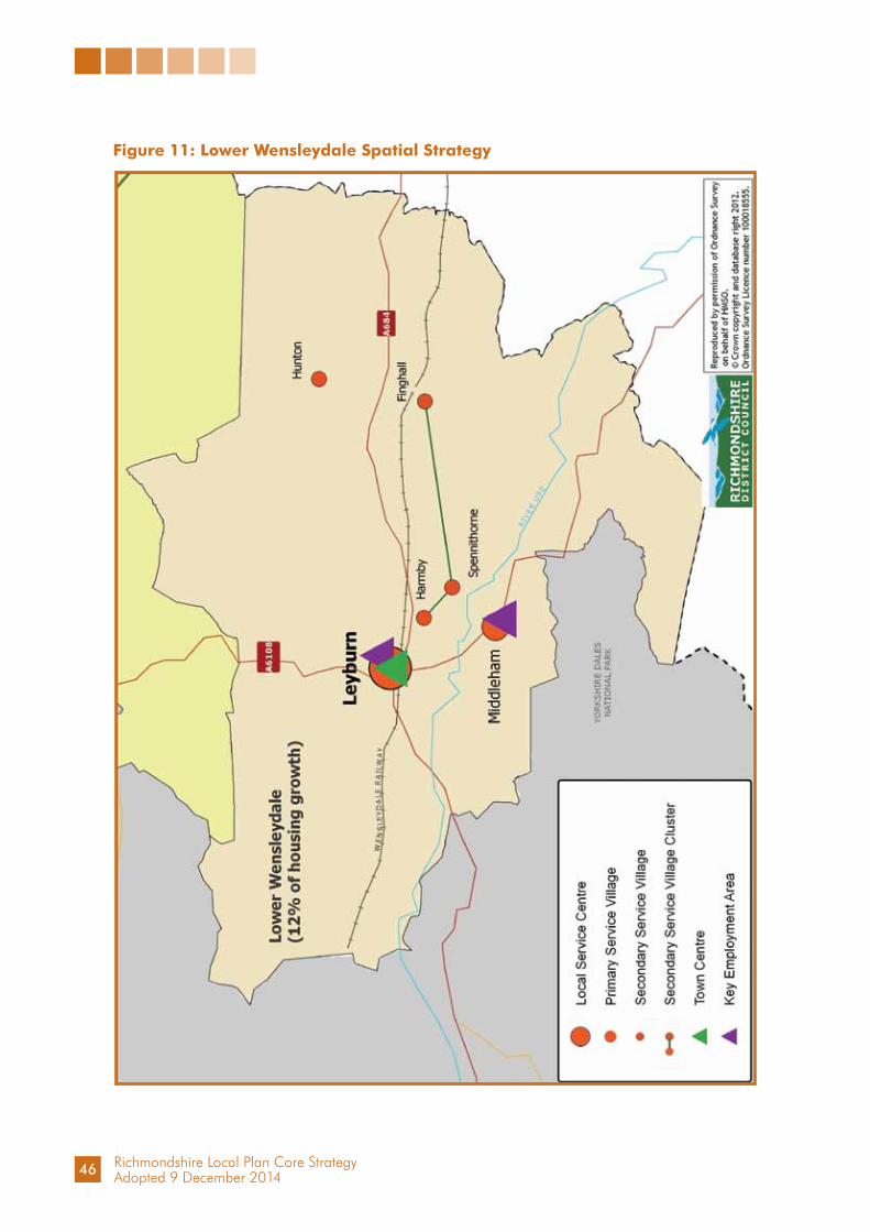
Richmondshire Local Plan Core StrategyAdopted 9 December 2014
Figure 11: Lower Wensleydale Spatial Strategy
46

Richmondshire Local Plan Core StrategyAdopted 9 December 2014
Figure 12: Strategic Development Growth Area - Leyburn
47

Richmondshire Local Plan Core StrategyAdopted 9 December 2014
Lower Wensleydale Spatial Strategy
The Spatial Strategy for the Lower Wensleydale sub area comprises: Local Service Centre - Leyburn: support will be given to maintaining the vitality and viability of the town
centre, through encouragement of further appropriate retail, business and tourism uses, environmental and infrastructure improvements, and developments associated with the expansion of the evening economy
support will be given to Leyburn’s role as a gateway settlement to the Yorkshire Dales
the scale and location of further housing and employment development in the town will reflect its role in the sub area, including serving the Yorkshire Dales National Park
the preferred direction of strategic growth for housing is in the area to the north and north west of the town
development should incorporate low carbon and renewable energy design integrated with existing and planned development informed by the Local Renewable and Low Carbon Energy Capacity Study for the plan area
the preference for new development is on existing vacant and previously developed sites in the built-up area
the separation of Leyburn from the nearby settlement of Harmby will be maintained support will be given to mixed use development but the complete loss of
existing employment sites will be resisted retention and enhancement of the auction market will be encouraged,
reflecting the importance of the facility to the town support will be given to tourism and operational developments associated
with the operation of the Wensleydale Railway development of arts and workshop space for creative industries and provision
of further cultural facilities will be encouragedPrimary Service Village - Middleham: support will be given to the Primary Service Village role of Middleham,
although environmental constraints suggest that there is limited potential for additional development beyond its existing built confines
support will be given to developments and infrastructure related to tourism and the horse racing industry, including priority towards the retention of existing facilities, within the settlement and in the surrounding area
Secondary Service Villages - Harmby - Spennithorne - Finghall (cluster) and Hunton: small scale and limited development may be acceptable in these Secondary
Service Villages where it supports the social and economic needs and sustainability of the local community
Elsewhere in the rural parts of the sub area, sustainable development in accordance with Spatial Principle SP3 will be supported, particularly development which reflects the sub area’s role as an entry point and provides for the needs of the adjacent part of Richmondshire in the Yorkshire Dales National Park.
48

Richmondshire Local Plan Core StrategyAdopted 9 December 2014
3.4 North Richmondshire
3.4.1 The North Richmondshire area sits in a triangle formed by Richmond, Barnard Castle and Darlington. The landscape extends from the Tees Lowlands in the east to an extensive area of moorland in the west. The western part has a major military training area and borders the Yorkshire Dales National Park. The River Tees runs along a major part of its northern boundary.
3.4.2 The A1 and A66 trunk routes converge at Scotch Corner in the middle of this area. The ease of communications provided by the A1, A66 and A167 place most of this area in the Darlington travel to work and housing market areas.
3.4.3 About 7,600 people live in this area. Their age profile is older than the District as a whole, and has been influenced by migration from the Tees Valley and the loss of younger people through education, work and housing opportunities.
3.4.4 Settlements in this area are more closely aligned to Tees Valley from Barnard Castle to Darlington along the A66, A1 and A167 routes. The largest settlements are Barton (840), Melsonby (735) and Middleton Tyas (580), but there is no clear local service centre for the whole area. The recently revised Settlement Facilities Study (RDC, 2011) shows that none of the villages in the North Richmondshire sub-area have more than one shop each, but this area does have seven primary schools and eleven village halls, suggesting a dispersed pattern of active settlements.
3.4.5 An attractive rural environment in North Richmondshire sustains a strong housing market that creates affordability issues and limits the available workforce. The area operates in the Darlington housing market. The Index of Multiple Deprivation (IMD 2007) records the limited range of services and the difficulty of access to the housing market in this area. All wards are in the bottom quartile for access to services and barriers to housing and the most extreme is in the bottom two per cent.
3.4.6 Agriculture is the dominant land use, but mineral extraction has also had an impact, particularly at Forcett and Barton. There are important parkland areas such as those at Forcett Hall and Aske Hall and the Iron Age fortifications at Stanwick Camp are of national archaeological importance.
3.4.7 Employment within the area is predominantly agricultural. The tourism sector includes a number of high quality hotels and the Croft Circuit motor racing track. There are few employment centres. The development of the Aske Hall business units near to Richmond and other smaller units across the sub area take advantage of the area’s good communications and this has promoted diversification in this rural area. Dalton Gates is a small industrial estate on the site of a former wartime airfield five miles from Darlington. Although well located for both the A1 and A66, only a small amount of employment development has taken place at Scotch Corner. Planning permission was first granted for a major seven hectare employment development next to Scotch Corner 20 years ago and remains a planning commitment, but development has not yet started and little interest has been forthcoming. The A1 upgrade improves prospects for this site and motorway related development at both Scotch Corner and Barton junctions.
49

Richmondshire Local Plan Core StrategyAdopted 9 December 2014
Figure 13: North Richmondshire Sub Area
Note: North Richmondshire also includes Tan Hill to the west of the District (see Figure 1)
50

Richmondshire Local Plan Core StrategyAdopted 9 December 2014
Figure 14: North Richmondshire Spatial Strategy
51

Richmondshire Local Plan Core StrategyAdopted 9 December 2014
North Richmondshire Spatial Strategy
3.4.8 North Richmondshire is a large sub area, which does not have a clear functional focus. It is better understood in terms of the characteristics shared by its many settlements, their rural location, small size and reliance on larger settlements outside the area for a range of services including ones outside the District. The spatial strategy seeks to retain and enhance the existing range of services that help to sustain local communities. It does this by focussing an amount of available development into selected locations. It does not, however, discount the remaining settlements and addresses the need for appropriate but very small development in the most rural areas, mainly from the conversion of existing but redundant buildings.
3.4.9 The proposed North Richmondshire Spatial Strategy (NRSS) also seeks to support a strengthened District centre (Richmond/Catterick Garrison) and regeneration in Darlington by constraining development in the sub area, particularly near the boundary with Darlington.
3.4.10 The NRSS has been produced after consideration of local conditions, local views and the expectations from national policy. It should be read in conjunction with the whole framework presented in the Core Strategy. Other policies will detail how, for example, elements of future development should proceed, how the quality of the local environment should be enhanced and how affordable housing should be provided.
3.4.11 There are few settlements with capacity for major growth in North Richmondshire. The housing target for this area (285) reflects its pattern of smaller settlements and the aim to reduce further potential out-commuting to the Tees Valley.
North Richmondshire Spatial Strategy
Growth in North Richmondshire will be modest and development will be small in scale, reflecting the role of the Sub Area and its relationship to Darlington.
In the Primary Service Villages of Middleton Tyas, Barton and Melsonby support will be given for: the Primary Service Village roles of these three villages which, whilst relatively
separate, share a close geographical relationship to the A1 and A66.In the Secondary Service Villages of Newsham - Ravensworth - Dalton (cluster), Eppleby - Caldwell - Aldbrough (cluster), North Cowton and Gilling West: small scale and a modest level of development may be acceptable where it
supports the social and economic needs and sustainability of the local community.
Elsewhere in the rural parts of the Sub Area, sustainable development in accordance with Spatial Principle SP3 will be supported.
At junctions on the upgraded A1 motorway, priority will be given to: consolidation of the existing and committed employment development at
Scotch Corner, with no further expansion onto undeveloped land the approved A1:Barton junction Service Area proposal appropriate motorway related development will be considered subject to
Spatial Principle SP5
52

Richmondshire Local Plan Core StrategyAdopted 9 December 2014
Chapter 4: Core Policies4.1.1 Taking forward the Spatial Strategy identified in Chapter 3, this chapter proposes a
number of Core Policies which provide strategic direction and translate the vision, strategic objectives and spatial principles within the Local Plan Core Strategy into courses of action.
4.1.2 The Core Policies (CP1 - CP14) provide more detail to the strategic approach to and delivery of development proposed within the Local Plan Core Strategy for the Richmondshire Plan Area throughout the plan period to 2028. The Core Policies also aim to ensure that the strategic approach to development responds to local needs and respects local conditions.
Core Policy CP1: Planning Positively
4.1.3 Richmondshire in 2028 is envisaged as a place where people value, understand, enjoy, respect and have pride in their environment, and where needs are met whilst sustaining and enhancing the natural as well as our built and historic environment. Underpinning this is the stated intention to achieve sustainability by ensuring that our actions balance and integrate the social, economic and environmental components of our communities and meet the needs of today without compromising the ability of future generations to meet theirs.
4.1.4 The National Planning Policy Framework (NPPF) advises that planning authorities should have a policy framework based on a presumption in favour of sustainable development and expects a clear policy on decision taking in the Local Plan to reflect this presumption. All policies within this document respond to this and guide how the presumption is to be applied locally. Therefore, this document and its policies should be read as a whole. To ensure that positive planning, and a presumption in favour of sustainable development, is delivered in the Richmondshire plan area, Core Policy CP1 sets out the approach the Council will take, working with developers and other partners, to achieve this in considering planning applications.
53
Richmondshire Local Plan Core StrategyAdopted 9 December 2014
Core Policy CP1: Planning Positively
When considering development proposals, the Council will take a positive approach that reflects the presumption in favour of sustainable development contained in the National Planning Policy Framework. It will always work proactively with applicants jointly to find solutions which mean that proposals can be approved wherever possible, and to secure development that improves the economic, social and environmental conditions in the plan area.
Planning applications that accord with the policies in this Local Plan (and, where relevant, with policies in Neighbourhood Plans) will be approved without delay, unless material considerations indicate otherwise.
Where there are no policies relevant to the application or relevant policies are out of date at the time of making the decision then the Council will grant permission unless material considerations indicate otherwise - taking into account whether: any adverse impacts of granting planning permission would significantly and
demonstrably outweigh the benefits, when assessed against the policies in the National Planning Policy Framework, taken as a whole
specific policies in that Framework indicate that development should be restricted.
Core Policy CP2: Responding to Climate Change
4.2.1 The importance of responding to Climate Change and reducing carbon emissions is embodied in the Strategic Vision and Strategic Objectives.
4.2.2 The National Planning Policy Framework states that Planning Authorities should adopt proactive strategies to mitigate and adapt to climate change in line with the Climate Change Act (2008). The Climate Change Act sets a legally binding target to reduce the UK’s 1990 carbon emissions by 34% by 2020, 50% by 2025, and 80% by 2050. The UK Low Carbon Transition Plan sets out an approach to meeting national carbon saving targets. The UK is committed to supply 15% of gross energy consumption from renewable sources by 2020. The UK Renewable Energy Strategy anticipates that renewables will need to contribute around 30% of electricity supply, 12% of heating energy and 10% of transport energy to meet this target.
4.2.3 A 2011 Vantage Point carbon modelling assessment for Richmondshire revealed that the Council is unlikely to meet the national Climate Change interim target of 34% carbon reduction by 2020 (and 80% cut by 2050) simply through Central Government’s Low Carbon Transition Plan actions alone.
4.2.4 To support the move to a low carbon future and in determining applications, the National Planning Policy Framework requires planning authorities to identify opportunities where development can draw its energy supply from decentralised, renewable or low carbon energy supply systems, plan for new development in locations and ways which reduce greenhouse gas emissions; and actively support energy efficiency improvements to existing buildings.
54

Richmondshire Local Plan Core StrategyAdopted 9 December 2014
Core Policy CP2: Responding to Climate Change
1. Supporting Renewable and Low Carbon Energy Generation The Local Planning Authority will support and encourage the generation of
renewable and low carbon energy that:a. responds positively to the opportunities identified in the ‘Richmondshire
Local Renewable and Low Carbon Energy Capacity Study’ (2012) and that study’s Energy Opportunities Map
b. satisfactorily addresses landscape and visual impacts on visual receptors or landscape character (particularly including cumulative impacts or impacts in the National Parks and Areas of Outstanding Natural Beauty arising from intervisibility) in accordance with the framework set out in ‘Managing Landscape Change: Renewable and Low Carbon Energy Developments - A Sensitivity Framework of North Yorkshire and York’ (2012)
c. demonstrates benefits for local communities.
2. Ensuring Carbon Savings In accordance with the energy hierarchy all new development will be expected
to make carbon savings by:a. New Development All new residential development will be expected to exceed the
minimum level of the Code for Sustainable Homes or equivalent standards prevailing through Part L of building regulations at the time by achieving the highest level of Code for Sustainable Homes or equivalent standards that is feasible and viable on site
All new residential development of ten dwellings or more and non-residential development of 1000m2 gross external floorspace will be expected to submit an energy statement that shows consideration of opportunities to deliver carbon savings in excess of Building Regulation requirements and to demonstrate that carbon savings have been maximised by incorporating these opportunities into design. Where greater carbon savings could be achieved through coordination and linking of infrastructure with neighbouring sites, this should be applied and demonstrated
All new development of ten dwellings or more and non-residential development with a gross external floorspace of 1000m2 which, pending its detailed definition in the Delivering Development Plan, is well related to the strategic direction of growth indicated in Figure 8, for Catterick Garrison and Figure 11, for Leyburn, will be required to demonstrate reasonable endeavours will be undertaken to actively contribute towards the development of a district heating network including: Establishing a new network onsite Connecting to existing networks if/where available Designing development to enable future connection
55

Richmondshire Local Plan Core StrategyAdopted 9 December 2014
b. Where carbon saving requirements are not feasible or viable on- site, the Council will coordinate and accept contributions towards ‘allowable solutions’, or similar, to provide cost effective carbon reduction and benefit communities elsewhere in the District.
3. Climate Change Adaptation All new development will be expected to be adaptable to climate change in
terms of both its location and the specific design and layout of buildings and associated external spaces. Development proposals should:
a. Demonstrate how their design, orientation, materials and construction will minimise mechanical cooling needs and risk of overheating
b. Demonstrate how green infrastructure will be incorporated, including tree planting, green roofs and walls, and soft landscaping, where possible
c. Be steered away from flood risk areas by adopting a sequential approach as set out in prevailing national guidance
d. Be designed to minimise flood risk on-site and elsewhere, by: Incorporating Sustainable Drainage Systems (SuDS) unless they are
demonstrated to be impracticable or they will pose an unacceptable pollution risk. SuDS should minimise surface water flood risk, protect waterways and provide aesthetic and ecological benefits
Not building over or culverting watercourses unless it is to facilitate essential access
Encouraging the opening of existing culverts.e. Show how development will seek to minimise waste production.
Supporting Renewable and Low Carbon Energy Generation
4.2.5 To help increase the use and supply of renewable and low carbon energy, local planning authorities should recognise the responsibility on all communities to contribute to energy generation from renewable or low carbon sources and have a positive strategy and policies to promote and maximise energy from renewable and low carbon sources.
4.2.6 The ‘Low Carbon and Renewable Energy Capacity in Yorkshire and Humber Study’ (2011), provides a technical appraisal of the potential resources available for use in renewable and low carbon energy generation. It highlighted that the main opportunity in Richmondshire for renewable electricity is from commercial scale wind energy (although severely constrained and outside of the National Park) and for renewable heat is from biomass. Smaller scale technologies, such as hydro, solar photovoltaics, solar thermal and heat pumps may also be able to make a significant contribution if widespread delivery is achieved.
4.2.7 It is also important to recognise that, although Richmondshire has the technical capacity for generating electricity and heat from renewable or low carbon resources, opportunities and constraints vary across the District. The ‘Richmondshire Local Renewable and Low Carbon Energy Capacity Study’ (2012) builds on the regional study to develop an Energy Opportunities Map (EOM) for the District (outside of the National Park). It identifies areas where there are specific physical, social and environmental
56

Richmondshire Local Plan Core StrategyAdopted 9 December 2014
constraints that would restrict renewable and low carbon energy delivery, and also identifies areas where there might be specific spatial opportunities - such as delivery of infrastructure accompanying strategic growth. Although the deployment of renewable energy will not be precluded outside these areas, it is expected that the EOM represents the most promising areas for renewable and low carbon energy generation. Larger scale copies of the Energy Opportunities Map are available where required and are accessible on the Council’s website. National Planning Practice Guidance (Paragraph: 003 Reference ID: 5-003-20140306) states that: Whilst local authorities should design their policies to maximise renewable and low carbon energy development, there is no quota which the Local Plan has to deliver. The plan will therefore seek to maximise the development of the opportunities identified for renewable electricity generation. This will contribute to the achievement of the UK’s legal commitment to cut greenhouse gas emissions and meet increased energy demand from renewable sources.
4.2.8 There is also significant resource for generating heat from renewable fuels. Delivery of the infrastructure to distribute this heat is however potentially more onerous. The greatest opportunity to maximise this potential comes from developing a district heating network coordinated with delivery of strategic development around Catterick Garrison. The delivery of 1900 general housing need homes and the 500 MoD service families’ homes in this area, presents a significant opportunity for all new homes to obtain their heat from a District Heating Network. The delivery of this project does however present considerable coordination challenges which would need to be addressed in order for it to be developed.
4.2.9 The Sensitivity Framework developed within the ‘Managing Landscape Change: Renewable and Low Carbon Energy Developments - A Sensitivity Framework of North Yorkshire and York’ (2012) will be used in conjunction with the ‘Richmondshire Local Renewable and Low Carbon Energy Capacity Study’ (2012) to guide assessment of all applications for renewable electricity and heat production installations. Commercial scale proposals for low carbon and renewable energy schemes that respond favourably to the opportunities and satisfactorily address the sensitivities identified in these documents and which meet the Spatial Principles and Core Policies, will be encouraged and supported. However long distant views of and intervisibility between adjacent nationally important landscapes in the Yorkshire Dales National Park to the west and North Yorkshire Moors National Park to the east, together with international nature conservation designations, means that all the plan area is judged to be of at least medium landscape and visual sensitivity. It rises to high sensitivity in the upland areas bordering the Yorkshire Dales National Park. Therefore potential for larger scale technologies and multiple schemes are constrained.
4.2.10 Development proposals should take into account specific planning considerations for renewable and low carbon energy development identified by the National Planning Practice Guidance (NPPG).
4.2.11 In accordance with the energy hierarchy all new development will be expected to make carbon savings by:
lean use of energy clean efficient energy supply use of green renewable and decentralised energy.
57

Richmondshire Local Plan Core StrategyAdopted 9 December 2014
New Development
4.2.12 New development across Richmondshire will add to energy demands and could have wider environmental consequences. Sustainable development and good environmental performance is a priority for Richmondshire, and all new residential development will be expected to exceed the minimum level of the Code for Sustainable Homes or equivalent standards prevailing through Part L of building regulations at the time by achieving the highest level of Code for Sustainable Homes or equivalent standards that is feasible and viable on site. In addition to providing a framework for assessing the energy credits, the Code for Sustainable Homes will also deliver wider sustainability performance of buildings. The Richmondshire Affordable Housing Viability Assessment (2011) demonstrates that there is likely to be capacity in property values to maintain viability while incorporating cost uplifts associated with higher standards. In addition during the seven year period 2004 - 2011, 23% of planning permissions granted were on sites for single dwellings, with an average of 57 per annum. The majority of these were in the villages and smaller settlements. If it is considered that the application of standards in excess of the minimum would make development unviable, the developer will be expected to demonstrate this through an open-book approach.
4.2.13 The Council will also have regard to any potential environmental impacts arising from proposed measures, particularly when assessing measures impacting upon historic and environmental assets - for example listed buildings.
4.2.14 Larger scale developments can often utilise economies of scale to deliver greater carbon savings. As such, developments over ten dwellings or 1000m² will be expected to submit an Energy Statement demonstrating how policy will be met and examining opportunities for achieving greater carbon savings.
4.2.15 The Leyburn and Catterick Garrison Strategic Growth Areas have been identified as having the greatest potential for establishing a district heating network and/or a combined heat and power network. For residential and non-residential developments proposed in these areas, developers will be required to investigate the potential to deliver and/or actively contribute towards or connect to the network, and to implement these plans unless it can be shown to be technically or financially unviable. The Council will act to coordinate delivery of a network in this area and will facilitate the involvement of Energy Service Companies (ESCo) where suitable. Preference will be given to schemes that also capitalise on using biomass as a fuel source.
4.2.16 Proposed changes to Part L of the Building Regulations will increase energy efficiency and reduce carbon associated with new development. Where new development is unable to meet required carbon reduction levels, developers can contribute to ‘allowable solutions’ which reduce carbon elsewhere. The Council aims to coordinate and assess ‘allowable solutions’ to ensure that they will deliver cost-efficient carbon reduction and wider benefits in the District and may make provisions for them in the Community Infrastructure Levy (CIL).
4.2.17 It is the responsibility of the applicant to demonstrate they have investigated all options to maximise energy savings. Proposals which do not do so will be required to demonstrate that it is not feasible or viable, or that there would be significant adverse environmental impacts as a consequence of the above requirements which could not be satisfactorily mitigated or compensated.
58

Richmondshire Local Plan Core StrategyAdopted 9 December 2014
Climate Change Adaptation and Flood Risk Mitigation
4.2.18 Emissions already released have contributed to continuing climate change. As such, it is recognised that Richmondshire needs to be prepared for these future changes in climate. All new development should demonstrate that it has taken climate change effects into account in its design.
4.2.19 The National Planning Policy Framework (NPPF) sets out the approach to consideration of development in areas at risk of flooding and must begin with the application of a sequential, risk-based approach to the location of development to avoid where possible flood risk to people and property and manage any residual risk. The aim of the sequential test is to steer new development to areas with the lowest probability of flooding. The North West Yorkshire Level 1 Strategic Flood Risk Assessment (2010) provides the basis for applying this test and informed the distribution of development and identification of the strategic growth areas within the strategy. It identifies the general areas and scale of flood risk in the plan area. This indicates particular flood risks relating to the Swale - downstream of Richmond, particularly around Catterick Village; to Skeeby Beck with problems for Gilling West; and the Tees - properties in Croft on Tees at risk from the Tees and Clow Beck. The Ure is considered unlikely to result in flood risks because the river runs through rural areas and wide natural floodplains. If following the application of the sequential test it is not possible for the development to be located in zones with a lower probability of flooding, the exception test will be applied if appropriate. To comply with Core Policy CP2 flood risk assessments will be required for all new housing proposals of 1ha or more in Flood Risk Zone 1 and for all housing in Flood Risk Zones 2 or 3. In the Catterick Strategic Development Area all applications must include assessments to determine the most vulnerable areas to flooding and demonstrate an appropriate strategy to protect and mitigate against potential impacts.
4.2.20 Flood risk arising from surface water runoff from new development should be reduced by incorporating Sustainable Drainage Systems (SuDS) in the design of development. SuDS solutions should be easy to manage, provide both attenuation and water treatment, require little or no energy input, and be aesthetically attractive and ecologically beneficial.
Core Policy CP3: Achieving Sustainable Development
4.3.1 In Chapter 3, which establishes the fundamental Spatial Strategy at the heart of the Local Plan Core Strategy, the importance of securing sustainable development was identified as key to guiding all the elements of the plan - and this is encapsulated in the Strategic Objectives and Spatial Principles. Core Policy CP3 seeks to bring together a number of the main ways, and primary considerations, which need to be taken into account in securing development which is sustainable. It addresses basic factors and considerations relating to location, transport and accessibility. Issues to be addressed through good design are dealt with by Core Policy CP13.
59

Richmondshire Local Plan Core StrategyAdopted 9 December 2014
4.3.2 It is important to ensure that sustainable development is treated in an integrated way in development plans and that those plans should seek to:
provide a positive planning framework for sustainable economic growth promote urban and rural regeneration, including mixed use developments for
locations that allow the creation of linkages between different uses promote communities which are inclusive, healthy, safe and crime-free bring forward sufficient land of a suitable quality in appropriate locations provide improved access for all to jobs, health, education, shops, leisure and
community facilities, open space, sport and recreation by ensuring that new development is located where everyone can access services or facilities on foot, bicycle or public transport rather than having to rely on access by car - while recognising that this may be more difficult in rural areas
focus developments that attract a large number of people, especially retail and leisure development, in existing centres
reduce the need to travel and encourage accessible public transport provision to secure more sustainable patterns of transport development
promote the more efficient use of land through higher density, mixed use development and the use of suitably located previously developed land and buildings
enhance as well as protect biodiversity, natural habitats, the historic environment and landscape and townscape character
minimise the impacts of airborne pollution address climate change, pollution and natural hazards, and safeguard natural
resources.
4.3.3 Taking this into account, the following Policy seeks to draw together a statement of the primary considerations for the achievement of sustainable development in the plan area.
Core Policy CP3: Achieving Sustainable Development
1. Support will be given for sustainable development which promotes:a. the efficient use of land and infrastructure including developments with a
sustainable and complementary mix of usesb. the conservation of scarce resources and reduction of their use, and
encouragement of the use and re-use of sustainable resourcesc. the health, economic and social well-being, amenity and safety of the
populationd. a reduction in social inequalities and disadvantages within the communitye. the quality of natural resources including water, air, land and biodiversity
and minimises the impacts of airborne pollutionf. the protection of the best and most versatile agricultural landg. the natural drainage of surface water mitigating the effects of flash
flooding of rivers, drains and droughth. the vitality of the area
60
Richmondshire Local Plan Core StrategyAdopted 9 December 2014
i. a high quality and adaptability of development j. the character and quality of local landscapes and the wider countrysidek. the distinctiveness, character, townscape and setting of settlementsl. the historic, environmental and cultural features of acknowledged
importancem. the provision of essential services to the publicn. the reduction of waste, the promotion of recycling and the provision of
suitable and accessible sites which foster sustainable waste management.
2. Development proposals will be encouraged to re-use or adapt existing buildings. Where this is not practicable or is shown to be a less sustainable solution, proposals should seek to reuse existing materials, where possible.
3. Development will be encouraged to utilise previously developed land first (brownfield land), where that land is in a sustainable location and is not of high environmental value, in preference to greenfield sites. The use and development of land will be assessed against the community’s housing, economic and social requirements. The sustainability and enhancement of the natural and built environment, minimisation of energy consumption and the need to travel will also be key factors. Development that would significantly harm the natural or built environment, or that would generate a significant adverse traffic impact, without appropriate mitigation, will not be permitted.
4. Development Proposals will be expected to provide an appropriate risk assessment and remediation strategy that addresses any issues of land contamination or land instability arising from past uses or activities. Where relevant non-mineral development is proposed within Mineral Safeguarding Areas defined by the mineral planning authority, the local planning authority will expect consideration to be afforded to the extraction of the mineral resource prior to development.
5. Development and the provision of services should, as far as possible, be located so as to minimise the need to travel. Convenient access via foot, cycle and public transport should exist or be provided, where possible, encouraging the use of these modes of travel for local journeys and reducing the need to travel by private car and improving the accessibility of services to all. Transport schemes that lead to improvements in accessibility will be supported. The potential for more sustainable means of transport related to the uses and users of the development must be addressed. This includes the preparation of travel plans and consideration of the scope to utilise local sourcing of materials and supply chains. The use of locally reclaimed, and the re-use of more sustainable, building materials will be supported where appropriate, where this does not harm the character and appearance of historic and environmental assets.
61

Richmondshire Local Plan Core StrategyAdopted 9 December 2014
Core Policy CP4: Supporting Sites for Development
4.4.1 Core Policy CP4 defines the general extent of development in settlements defined in the Spatial Principles where development and activities will be supported. Core Policy CP4 is essential for the plan’s implementation and provides guidance to facilitate development, set a context for Neighbourhood Planning and support the preparation of future detailed land availability policies.
4.4.2 There is a continuing impetus to meet needs for development for housing or employment driving the need to identify specific sites. Facing this is a delay until land availability policies can be updated and adopted in the Delivering Development Plan. The ability to meet immediate needs, or to make pressing decisions on planning applications, should not be frustrated by the time taken to prepare future detailed policies and flexibility is needed until this is produced and adopted.
4.4.3 The Local Plan Core Strategy establishes the strategic principles to guide change in the plan area. Spatial Principle SP2 sets out a settlement hierarchy for the plan area and explains its justification. This gives a framework for more detailed decision making about service provision and new development reflecting roles in the hierarchy. Spatial Principle SP3 recognises that the large rural area outside of the settlement hierarchy is also a living and working environment containing many villages where appropriate development will be required. Spatial Principle SP4 indicates the broad distribution for new housing in the settlement hierarchy and elsewhere in the countryside. Most new homes will be concentrated in the Principal Towns of Richmond and Catterick Garrison and the Local Service Centre at Leyburn, followed by the Primary Service Villages, the Secondary Service Villages and then elsewhere in the smallest settlements.
4.4.4 Settlement Development Limits were established in the Richmondshire Local Plan (1999-2006) Policy 23 and defined on the Proposals Map for most settlements, down to the very small villages, but excluded the Catterick Garrison Administrative Area. The defined boundaries sought to manage the expansion of settlements into the surrounding countryside, taking account of prevailing development needs and opportunities. They sought to ensure new development is sympathetic in scale and location to the form and character of the settlement, does not conflict with environmental and other policies, and respects local infrastructure and facilities capacity. These aims remain important, but the Settlement Development Limits are becoming out of date and there is now increasingly limited opportunity for new development in many settlements.
4.4.5 The Settlement Development Limits should be reviewed to guide the location of future development to 2028. This is a time consuming task and pending their formal review the strategic approach needs to allow for ongoing growth to support local services and ensure community sustainability and wellbeing. Core Policy CP4 therefore refers to areas adjacent to Settlement Development Limits and main built-up confines until the Richmondshire Local Plan (1999-2006) Policy 23 designations on the Proposals Map are superseded. This is expected to be undertaken through the Delivering Development Plan or future revisions to the Local Plan.
4.4.6 The scope for development adjacent to the settlement edge depends on the application of other policies and in particular Core Policies CP2, CP3, CP4, CP8, CP12 and CP14. In all cases, development proposals must respect the scale, form and character of the settlement and its service and infrastructure provision.
62

Richmondshire Local Plan Core StrategyAdopted 9 December 2014
The settlement’s position in the hierarchy and the scale of housing development established in Spatial Principle SP4 will be particularly important factors guiding the scale of development in individual settlements. The scope for development and activities in the higher order settlements will be greater than in those further down the hierarchy and will be limited in the smaller settlements.
4.4.7 The criteria in this policy guide decision making by addressing location issues including infrastructure availability, local environmental impact and any settlement and area specific guidance. Location criteria seek to ensure that development is well-related to an existing settlement and priority should be given to sites within Settlement Development Limits or main built-up confines first, where such developable opportunities still exist. They also seek that existing infrastructure either has capacity, or extra capacity or facilities will be provided, in accordance with Core Policy CP14. Environmental criteria ensure that locally important matters, such as open spaces or flooding risks, are taken into account in accordance with Core Policies CP2, CP3, CP11 and CP12. Cross reference is made to the broad locational guidance included in the Sub Area Strategies (Chapter 3) for specific settlements where significant change or pressures for change are anticipated.
4.4.8 Neighbourhood level planning and local ownership of decisions will require specific support and encouragement. This needs clear guidance which links the area-wide development plan to support community planning initiatives, wherever they may come forward, and encourage development and change, consistent and complementary with its wider context. Settlement Development Guidance will be produced to provide detailed Local Plan assessments of each settlement. These would provide an initial step towards Neighbourhood Planning for those communities wishing to establish locally detailed policies.
4.4.9 The Council’s updated Gypsies and Travellers Accommodation Assessment (October 2013) shows that there is high vacancy rate on local sites and no expected demand for this available capacity. Planning Policy for Travellers Sites (CLG, March 2012) requires a criterion based policy to assess applications for other private sites. This approach to the release of sites is analogous to that for general development set out in Core Policy CP4 subject to the specific requirements of the national policy for travellers sites provided for in CP4.4.
Core Policy CP4: Supporting Sites for Development
Development or activities of a scale and nature appropriate to secure the sustainability of each settlement in the hierarchy defined in Spatial Principle SP2 and elsewhere through Spatial Principle SP3 will be supported taking account of the following:
1. Proposals should reflect and deliver:a. the strategy for the future development of the plan area, in particular in terms
of the scale and distribution of development defined in the Core Strategyb. an effective response to Climate Change in accordance with Core Policy
CP2 and sustainable development in accordance with Core Policy CP3, and consistent with national planning policy relating to the achievement of sustainable development and communities
63
Richmondshire Local Plan Core StrategyAdopted 9 December 2014
c. the settlement or location specific guidance contained in the Sub Area Strategies and supplementary guidance
d. development which provides for the social and economic needs of the local community
e. development that is proportionate to the existing settlement size and local service provision
f. the expressed preferences of the local community about the type, form and location of development in each settlement, advanced through Neighbourhood Planning processes
g. any future planning policy documents, including masterplans concerning detailed matters relating to the layout, design or other aspects of the development.
2. The location of any development proposal should be:a. consistent with the Delivering Development Plan or revised Local Plan land
availability policies once published. Pending the Delivering Development Plan or revisions to Local Plan land availability policies, development proposals should be in, or if deliverable opportunities do not exist within, adjacent to the settlement’s Development Limits as defined on the Local Plan 1999-2006 Proposals Map or main built up confines where they do not exist
b. in all cases: i. accessible and well related to existing facilitiesii. within the capacity of existing infrastructure, or it can be demonstrated
that necessary additional infrastructure will be provided.3. Development should be consistent with the requirements of Core Policies,
and should not:a. impact adversely on the character of the settlement or its setting, important
open spaces and views; designated and undesignated heritage assets and the character of the landscape
b. lead to the loss of, or adverse impact on, or cause deterioration of important nature conservation, water bodies or biodiversity or geodiversity sites
c. result in the unacceptable loss of locally important open spaces or community facilities
d. be located in areas of flood risk or contribute to flood risk elsewheree. cause significant adverse impact on amenity or highway safety.
4. Provision will be made for travelling groups at the existing site of Lime Kiln Wood at Catterick Village. Where required, proposals for additional Gypsies and Travellers and Travelling showpeople sites, should satisfy the requirements of all policies contained within the Local Plan Core Strategy, where applicable, and be consistent with national policy for travellers sites, in particular they should: a. not dominate but should respect the scale and form of the existing settlementb. be well related and in proportion to accessible local service provision,
including schools and healthcare, reducing the need to travel as well as avoiding undue pressure on local infrastructure and services
64

Richmondshire Local Plan Core StrategyAdopted 9 December 2014
c. provide for the social and economic needs of the local community, appropriate to provide a safe and healthy environment for residents and encouraging a peaceful and integrated co-existence with the local community
d. positively enhance the environment and increase its openness through well planned landscaping which should avoid isolating the site from the rest of the community
e. consider the effect of the local environmental quality including noise and air quality on the health and wellbeing of travellers resulting from existing neighbouring and future proposed development uses.
5. Proposals for new traveller site development in the open countryside away from existing settlements will be strictly limited.
Core Policy CP5: Providing a Housing Mix
4.5.1 Providing an appropriate housing mix is an essential ingredient to help meet local needs. Offering a range of dwelling types to meet both needs and aspirations helps to reduce pressure on the limited housing supply and therefore influences affordability. It also enables residents to stay in their community and creates more mixed communities, allowing a greater participation in the local economy.
4.5.2 It is not only the size of a dwelling which is important but also how easy it is to adapt the dwelling to allow a resident to remain in occupation throughout their life. This in turn relates to accessibility which allows those with a disability or impairment to enjoy the dwelling to their full advantage. The plan can play a role in promoting the type and tenure of dwellings to be developed.
4.5.3 To inform the practical application of Core Policy CP5 the Council will ensure that its evidence base is both robust and up-to-date. A District-wide Strategic Housing Market Assessment (SHMA) was conducted in 2011. Parish based housing needs surveys are also
undertaken. This research informs policy making concerning property size, type and tenure requirements including those for local needs arising from particular sectors of the community
and the provision of dwellings to lifetime homes standard and extra-care schemes.
4.5.4 The changing shape of Richmondshire’s population is an important consideration for future development. 2011 Census shows that, apart from the skewed younger age groups caused by the large military presence, the local population is broadly similar in structure to the national and regional populations. Between 2001 and 2011, the local population has aged as expected suggesting lower levels of movement, which are also observed in local migration statistics. The familiar “baby-boom” spike now sits at about 65 and is slightly larger in proportion to regional and national populations. Assuming no major migration changes then this spike in the population will age towards 80 by the end of the plan period. Of equal note is the smaller population of younger adults, with a deep trough around age 35, revealing a marked imbalance in the local population once the military population is accounted for. In general, the Richmondshire older population appears proportionately fitter and healthier and has a higher life expectancy than the regional and national populations in both 2011 Census and Public Health observatory results. Although a military component will affect this picture, this does not affect local older age groups and it is also likely that earlier migration trends and local quality of life have contributed to this fitter older population.
65

Richmondshire Local Plan Core StrategyAdopted 9 December 2014
4.5.5 The long term changes in the local household profile expects growth in older person households, which will be either single person or couples; little or no growth in households aged 45 - 54 and some growth where the head of household is aged 25 - 34. This demographic change translates into demand for one and two-bedroom properties to accommodate the rising rate of smaller households and accounts for over 50% of demands for new dwellings. In comparison three-bedroom dwellings accounts for 39% and four-bedroom accommodation accounts for 10% of future demand. This evidence suggests that Core Policy CP5 should currently promote developments providing 10% of dwellings with one bedroom, 40% of dwellings with two bedrooms, 40% of dwellings with three bedrooms and 10% of dwellings with four or more bedrooms.
4.5.6 The type of dwelling required centres predominantly on traditional two storey houses although there is a potential demand for apartment/studio-type accommodation or one bedroom bungalows to provide for the needs of smaller households.
4.5.7 The SHMA provides evidence on the type and tenure of affordable housing and indicates that the greatest need is for one and two bedroom properties in all sub areas, as follows:
Table 4: Households in Need
Households in Need
Sub Area Number of Bedrooms Required(Bedroom Standard Model)
1 2 3 4+
Central Richmondshire 40% 50% 8% 2%
Lower Wensleydale 39% 46% 15% 0%
North Richmondshire 69% 31% 0% 0%
Total 43% 47% 8% 2%
4.5.8 A range of affordable housing under differing tenures can play a role in bridging the gap between social renting and owner occupation by allowing an occupier to acquire further equity in a property. The SHMA demonstrates that approximately 20% of households currently in affordable housing need could afford a 50% equity stake in an intermediate home at the average lower quartile price across the sub areas of £157,500. The study suggests that an appropriate split in the tenures of affordable housing should be 80% social rented and 20% intermediate products.
4.5.9 Affordable rent was introduced as an alternative, and in addition, to social rent, which could provide another stepping stone between tenures. The financial capacity of those households in housing need may be stretched to afford this tenure type. For example only 30% of households in housing need could afford an 80% affordable rent for a two bedroom home and less than 20% could afford a three bedroom home.
4.5.10 The SHMA identified that older people constitute 27% of all households, rising to over 48% by 2026. Of this number approximately 21% are in housing need, equating to 52 households in need annually. Over 70% of those households wish to stay in Richmondshire, many of which (37.1%) would prefer to stay in their own home while 35% would consider moving to a specialist older persons’ development (sheltered/extra care).
66

Richmondshire Local Plan Core StrategyAdopted 9 December 2014
The majority (42.8%) would prefer a bungalow while 14% would consider a flat in a purpose-built scheme. Therefore provision should be made within new housing schemes for affordable bungalows or small scale developments of apartments suitable for older people, proportionate to the identified level of need.
Core Policy CP5: Providing a Housing Mix
Proposals for housing must take account of the local housing requirements across all sectors of the community in terms of size, type and tenure, and also the accessibility and adaptability of dwellings.
Core Policy CP6: Providing Affordable Housing
4.6.1 The provision of more affordable housing to meet local needs is a key objective of the Council and Government. Development conditions vary from site to site and this policy ensures that affordable housing provision is subject to thorough economic viability assessment. Most affordable homes will be provided through the strategic scale and distribution of housing planned in Spatial Principle SP4. This places affordable homes directly in relation to local service provision. This approach may not address all needs that may arise in this rural area and provision is made for the exceptional development of affordable homes where permission may not normally be granted. The overall sizes, types and tenures of dwellings, both market and affordable, will be negotiated and determined on a site by site basis with regard to the most up-to-date evidence on local housing need and demand in accordance with Core Policy CP5.
4.6.2 The North Yorkshire Strategic Housing Market Assessment (NYSHMA) confirmed the high level of local housing need and the severe problems of affordability. It found that Richmondshire has experienced a rise in average house prices since 2000 peaking, in line with wider markets, at a high of £228,700 in 2007/08. The income required to purchase a lower quartile house, based on a 3.5 times multiplier of household income is £41,429. However, in the current market many lending institutions require that mortgage repayments should be less than 20% of household income. Therefore, the income level required to purchase a lower quartile property would be £58,495. This provides a stark illustration of the affordability issue in the plan area where the average median gross household income is just less than £23,000 pa. Lower quartile house prices do show some variation across the three sub areas (£123,488 in Central Richmondshire, £170,000 in Lower Wensleydale and £179,000 in North Richmondshire) although median gross household incomes remain reasonably similar. Therefore, the affordability ratio between median gross household income and a lower quartile house in the Central area is in excess of five times income which extends to over eight times in North Richmondshire.
4.6.3 Spatial Principle SP4 sets out the scale and distribution of housing across the plan area, providing the spatial distribution of the proposed 180 dwellings per year build rate. It is through this pattern of development that most affordable homes will be delivered. The SHMA (2011) evidence indicates that over the next five years 260 households per year are estimated to be in housing need but cannot afford to move to address this need. This includes all households indicating that their homes did not meet their current needs, but a number of these could address the issues identified without the need for a new home.
67

Richmondshire Local Plan Core StrategyAdopted 9 December 2014
This includes homes where adaptations would be needed and households seeking homes in other areas, for example. It is also based on assumptions concerning access to housing finance products available at the time of writing. This level of demand is also not apparent from the parish level housing needs surveys. Although the SHMA does need to be read with care, it remains more important than ever to set the most ambitious affordable housing targets possible, whilst maintaining the viability of local development.
4.6.4 The Richmondshire Affordable Housing Viability Assessment (AHVA), 2011) examined the impact of differing percentages of affordable housing on a range of sites across the plan area. In particular it considered an appropriate target and threshold in the light of the varying local market and land supply conditions. It recommended general affordable housing targets of 30% in North Richmondshire and 40% in Central Richmondshire and Lower Wensleydale as viable to maximise delivery across the three sub areas. The following table demonstrates the proportion of proposed development in each sub area compared to the ‘gross annual housing need’ identified in the SHMA. It can be seen that affordable housing need outstrips proposed delivery across all sub areas.
Table 5: Annual Housing Delivery and Need
Sub Area Proposed Housing Delivery (pa)
Housing Need (pa)
Market Affordable
% No. % No.
Central RichmondshireCatterick GarrisonRichmondElsewhere
79(62)(8)(9)
142(112)(14)(16)
@40% = 57 72 180
Lower Wensleydale 12 22 @40% = 9 21 51
North Richmondshire 9 16 @30% = 5 7 18
Total 100 180 71 100 249
4.6.5 The AHVA did not find any evidence to suggest that a lower site size threshold would affect viability or hold sites back, except where significant constraints or abnormal site conditions prevail - for example barn conversions. It found that smaller sites can generate ‘exclusivity’ and hence produce higher land values. During the seven year period 2004 - 2011, some 23% of planning permissions granted were on sites for single dwellings, with an average of 57 per annum. The majority of these were in the villages and smaller settlements and a relatively high proportion were in the higher value Council Tax bands. The Council will therefore seek contributions from all housing developments regardless of size, in order to maximise the provision of affordable housing and in effect set the threshold at a single dwelling net gain.
4.6.6 It is most practical to deliver affordable homes on-site in larger developments. The overall sizes, types and tenures of dwellings, both market and affordable, will be negotiated and determined on a site by site basis with regard to the most up-to-date evidence on local housing need and demand in accordance with Core Policy CP5. Commuted sum contributions will also be considered when, for example sites are small
68

Richmondshire Local Plan Core StrategyAdopted 9 December 2014
and contributions would not provide a complete home. The Council expects to pool any commuted sums received to be used in support of furthering affordable housing provision across the district. Single dwellings that are built to meet an affordable housing need will not make a contribution so long as that home is retained as an affordable home in perpetuity. This enables landowners to provide local small scale housing for family members or employees on their land, subject to its suitability for development.
4.6.7 If the application of the sub area target on the total number of dwellings proposed does not produce a whole number of affordable dwellings, then the balance will be provided as a financial contribution. This is equal to the net cost of providing the target proportion of affordable dwellings on a development proposal less whole affordable dwellings and can be calculated as follows:
AHC = ((T x F x C) – (T X P)) x R
Where:
AHC = Affordable housing contributionT = Affordable housing target percentageF = Average gross internal floor area per dwelling of the proposed development OR 100m2, whichever is lessC = Total cost per m2 of an affordable dwelling. (Prevailing construction cost, land, services and infrastructure, professional fees)P = Transfer Price (price paid by Registered Provider for an affordable dwelling)R = Remaining fraction of an affordable home after whole affordable homes are subtracted
4.6.8 Local Needs Housing Schemes assist to deliver housing which cannot be provided by the market and play an important role in sustaining the rural economy by providing the opportunity for local people to live and work in the same rural community. They are restricted to 100% affordable housing in perpetuity and, in most cases, their construction is subsidised through grant funding and below market land costs on sites that would not normally be granted planning permission. Such exceptional development is additional to the direct delivery of affordable housing through the development strategy. The Delivering Development Plan or revised detailed Local Plan land availability policies will, through the formal review of settlement development limits, deliver the flexible approach to land supply expected by NPPF (2012). This will enable exceptions to be defined for SP2 settlements. Until such a time, exceptions will be identified when development targets have been met or commitments are failing to deliver. The criteria to be used in the selection of appropriate Local Needs Housing Scheme sites will be CP4 1b-3e, this will ensure that these sites respect their proposed settings and reflect the local capacity for this additional development.
69

Richmondshire Local Plan Core StrategyAdopted 9 December 2014
4.6.9 Local Needs Housing Schemes are provided for eligible occupiers who have a ‘local connection’ to the settlement in which the homes are built, as their main or principal residence and have a need to reside there because they are:
i. existing residents of the relevant parish establishing a separate householdii. a head of household - or their partner - who is in, or is taking up, permanent
employment in an already established business within the relevant parishiii. householders currently living permanently in a dwelling which is either
shared but not self contained, overcrowded or is otherwise unsatisfactory by environmental health standards and which is within the relevant parish
iv. persons having to leave tied accommodation within the relevant parishv. persons currently living in accommodation which is temporary or occupied on
insecure termsvi. persons having a medical need for alternative accommodationvii. former residents of the relevant parish with immediate relatives in the parish
accepted in writing by the Council as having an exceptional need to return to the area.
Categories set out in paragraphs (i), (ii), (iii), (iv), (v) and (vi) will apply only to those who have resided or worked permanently in the relevant parish for the preceding three years. Housing provided through the Policy should be offered in the first instance to those who meet the local connection criteria relating to the Parish within which the need has been identified. If, no eligible occupier can be found within the Parish then those who meet the local connection criteria in the immediate neighbouring Parishes will be eligible. If no one here is available, then a third priority area would then become valid, embracing all Parishes, including those which fall within the Yorkshire Dales National Park.
4.6.10 The NPPF suggests that ‘local planning authorities should in particular consider whether allowing some market housing would facilitate the provision of significant additional affordable housing to meet local needs’. Examples of such circumstances may include: where no grant is available or, where a reduced grant rate and/or abnormal site development costs render the proposed scheme economically unviable. Cross-subsidy may be permitted where:
a parish housing needs survey has identified a housing need; and, a suitable site has been found but HCA grant would not be available for a minimum of two years
a reduced grant rate and/or abnormal site conditions make a 100% affordable housing scheme economically unviable
the applicant is a Community Land Trust as defined in The Housing and Regeneration Act 2008 or any successor legislation.
The maximum number of open market dwellings permitted will be the minimum required to subsidise the development of the affordable housing. The Council will expect an ‘open-book’ approach to any application to cross-subsidise on an exception site and will not accept any land valuations which exceed comparable financial transactions in the Plan area.
70

Richmondshire Local Plan Core StrategyAdopted 9 December 2014
4.6.11 An Affordable Housing Supplementary Planning Document (SPD) will support the delivery of policy CP6 by providing detailed guidance regarding the implementation of the policy. The areas within the policy that the SPD provides further explanation and guidance on are:
Calculating commuted payments Market Housing cross-subsidy Building your own affordable home/ Single plot exception sites Transfer Prices Safeguarding Affordable Housing Exempt Accommodation Application Negotiations Financial Viability
Core Policy CP6: Providing Affordable Housing
The Council will work with private developers and registered providers to achieve the following targets for affordable housing in all developments with a net gain in dwellings, subject to economic viability assessment:Central Richmondshire and Lower Wensleydale ...................................... 40%North Richmondshire Sub Area ........................................................... 30%
In general, the affordable housing contribution will be met on site. Commuted sums in lieu of on-site provision will be considered where some or all of the contribution would not provide for a complete home. Commuted sums may be considered where they enable the Council to achieve greater affordable housing benefits than on-site.
The affordable housing contribution will be waived on small scale schemes whose purpose is to meet a proven local affordable housing need. Where the contribution is waived the dwellings must remain affordable in perpetuity. The contribution will be payable should the dwellings be sold on the open market.
Small scale Local Needs Housing Schemes may be permitted on suitable sites where development would not normally be permitted. These schemes must meet a proven local affordable housing need and the dwellings must remain affordable in perpetuity. Their suitability for development will be assessed through Core Policy CP4 1b - 3e. The Council may accept an element of on-site market housing to help subsidise the delivery of the affordable homes.
Core Policy CP7: Promoting a Sustainable Economy
4.7.1 The context for Core Policy CP7 is set out nationally through Policies 1 and 3 of the NPPF and, more locally, in Spatial Principle SP5 of this Core Strategy. The evidence base for the policy includes:
the Joint Employment Land Review (JELR) (2007) revised by the Employment Land Review Update (ELR) (2011)
the Economic Impact of Military Presence in North Yorkshire (2010) A Sustainable Future for Lower Wensleydale: Leyburn and Middleham Reports,
(Miller, 2009).
71

Richmondshire Local Plan Core StrategyAdopted 9 December 2014
4.7.2 Core Policy CP7 identifies priority measures, providing support for - and promotion of - development to ensure that the Richmondshire economy is able to develop sustainably.
4.7.3 Core Policy CP7 supports the delivery of the economic elements of the Sub Area Spatial Strategies (CRSS, LWSS and NRSS) and the Spatial Principles, particularly SP2, SP3 and SP5. The Infrastructure Delivery Plan (IDP) also provides further support for the delivery of Core Policy CP7 and identifies infrastructure investment projects, resulting from stakeholder engagement, required to deliver development.
Core Policy CP7: Promoting a Sustainable Economy
In order to develop and sustain the economy of Richmondshire, in accordance with Spatial Principle SP5, support will be given to:
a. the development of employment activities that diversify the current offer in Richmondshire, and in particular those activities that will provide high quality jobs which can capitalise on and/or enhance the skills of the resident population
b. development which promotes the sustainable growth of the key economic sectors within the area, particularly agriculture, food, military, retail, tourism, leisure and equine enterprises
c. the development of digital, creative and cultural enterprisesd. green, renewable and low carbon industriese. sustaining small and medium sized enterprises, including the development of
support services to encourage existing and new business to growf. the provision of education and training facilities to develop the District’s
skills baseg. strengthening and enhancing the role and performance of Richmond, Catterick
Garrison and Leyburn town centres to ensure their continued vitality and viabilityh. safeguarding the unnecessary loss of valued facilities and servicesi. small scale rural economic development to meet local needsj. the provision of high quality sites and premises suitable for B1 uses in
Richmond, Catterick Garrison and Leyburnk. the development of mixed use sites, high quality layouts, landscaping
and designl. developing institutional and commercial links with the Tees Valley and the
North Eastm. infrastructure necessary to support economic development, including
communications, high speed broadband and transport investment.
4.7.4 The JELR (2007), ELR Update (2011) and Miller studies (2009) provide background evidence for Core Policy CP7. They establish the sectors that are important, and forecast to be important, within the Richmondshire economy. In order to sustain and develop the Richmondshire economy, encouragement and positive planning for these growing sectors in appropriate locations will be key. Future local plan documents will provide land for employment, reflecting the needs of the growing sectors ensuring supply of the right type, quality and quantity of employment land. This will be informed by latest evidence and economic forecasting available at the time.
72

Richmondshire Local Plan Core StrategyAdopted 9 December 2014
4.7.5 JELR and the Miller studies acknowledge the importance of the digital and creative industries to Richmondshire and the rural economy. The update to the Employment Land Review does not explicitly identify the importance of this sector. However, it is identified within the wider industry sector of Business Services and Other Services. Furthermore, as considered within the JELR and Miller studies, a significant number of jobs in this sector are through self-employment, home working and micro business which are difficult to capture data for. The absence of consideration to this industry within the updated ELR should not be seen as undermining the importance of the sector for the rural economy and the need to support development of digital, creative and rural enterprises. In order to facilitate the growth of this sector and the wider rural economy improvements to the communications infrastructure (including high speed broadband) will be vital, particularly given its links with home working. In line with current national policy, these improvements are supported through Core Policy CP7.
4.7.6 The development of green, renewable, low carbon industries and movement towards a low carbon future is considered in Yorkshire Forward’s Low Carbon Rural Capitals Scoping Study (Arup, 2008) to be an inextricable part of the creation of sustainable settlements. Support to the industries in Core Policy CP7(d) will be key to the achievement of rural sustainability and therefore the wider objectives of the Local Plan Core Strategy.
4.7.7 Current evidence points to a net outflow of residents for employment with strong links to Hambleton District and Darlington (SHMA, 2011). To achieve the overall objectives of having a sustainable rural economy (Spatial Principle SP3) and reduce the use of energy, particularly given potential implications for rising fuel costs, shorter journeys to work and an increased containment of the labour force across skills and professions will be required. Core Policy CP7 seeks to promote the provision of high quality jobs to enable highly skilled people to live and work within the District, reducing current levels of out commuting to places such as Darlington. The provision of education and training facilities is critical to ensure that new members to the workforce have the necessary skills and can adapt to a diversifying economy and respond to needs of emerging and growing employment sectors.
4.7.8 The continued vitality and viability of the towns of Richmond, Catterick Garrison and Leyburn, and the lower order settlements will be needed for a prosperous and sustainable rural economy. It will be essential to balance new housing with economic development including retail and leisure opportunities. Support is therefore given through Core Policy CP9 for developments which strengthen and enhance the role and performance of the District’s centres and for development in those settlements which provide a role in supporting rural/remote communities. This acknowledges the importance of appropriately scaled development, outside the centres of Richmond, Catterick Garrison and Leyburn, which support the wider rural economy and provide for the most sustainable options in villages or other locations that are remote from local services. This is consistent with Spatial Principles SP2 and SP3, Core Policies CP8, CP9, CP11 and current national policy.
4.7.9 The commercial role of towns is important to the overall function, vitality and viability of town centres, and the provision of high quality sites and premises for B1 uses within Richmond, Catterick Garrison and Leyburn are important.
73

Richmondshire Local Plan Core StrategyAdopted 9 December 2014
4.7.10 The provision of necessary infrastructure will be critical to the delivery of the objectives of Core Policy CP7 and the wider objectives of the Local Plan Core Strategy. This includes improvements to the communication infrastructure such as high speed broadband, identified as important for development of the rural economy within the Miller studies in 2009 and within national policy. Support is given through Core Policy CP7 for the development of necessary infrastructure. Support is also given through Core Policy CP7(m) for improvements to transport infrastructure. This includes particular schemes which improve the links and improve local accessibility between jobs and homes across the District, improving accessibility between settlements in the settlement hierarchy, especially by sustainable forms of transport.
4.7.11 Through engagement with key infrastructure providers and consultation the following transport project is considered to be key to improving sustainable links and local accessibility across the District and to support economic performance and growth:
improved access along the Richmond-Catterick Garrison-A1 Corridor (the A6136)
4.7.12 Although the strategy is not dependent on the completion of the following transport projects, they contribute significantly to local economic conditions:
A1 upgrade to motorway standard including the new Catterick Central junction A684 Bedale bypass improving accessibility along the Dales-Leyburn-A1 Corridor Sustainable access improvements to Gallowfields Industrial Estate, Richmond Development of the Wensleydale Railway.
4.7.13 The Infrastructure Delivery Plan (IDP) provides further detail on these projects and other important infrastructure requirements that will occur within the Plan area including funding mechanisms and estimated timescales.
Core Policy CP8: Achieving Rural Sustainability
4.8.1 Spatial Principle SP3 establishes that in this essentially rural area, achieving rural sustainability is a key strand which should run throughout the plan. This means balancing the qualities of the rural environment against the need to promote sustainable rural communities where people can have good local access to facilities and work. As the explanation of Spatial Principle SP3 indicates, this approach is taken forward in a number of ways throughout the Local Plan Core Strategy. A main thread is the approach to the identification and support of the sustainable hierarchy of settlements (through Spatial Principle SP2, with supporting policies, particularly Core Policy CP3). Outside these settlements a wide range of measures is proposed to secure the rural sustainability of the wider countryside and smaller settlements in the following policy.
4.8.2 Core Policy CP8 gives expression to the approaches which need to be taken to achieve the Spatial Principle SP3 intentions to secure rural sustainability. It covers the main rural activities and expresses an approach which should lead to a more stable rural economy, but which also protects the rural nature of the countryside and the environment generally. The second part of the policy provides clear guidance on what forms of development should be supported, consistent with the rural sustainability objectives. It defines and gives substance to the approach which does not advance preservation, or stabilisation with no change, outside the settlement hierarchy, but instead seeks to encourage an appropriate scale of change consistent with a sustainable rural future.
74

Richmondshire Local Plan Core StrategyAdopted 9 December 2014
Core Policy CP8: Achieving Rural Sustainability
1. Support will be given to the social and economic needs of rural areas lying beyond Spatial Principle SP2 settlements, by encouraging: a. small scale housing developments in or adjacent to smaller villagesb. expansion of rural businesses c. re-use of suitable rural buildings for housing, tourism and employment
generating uses supporting Spatial Principles SP3 and SP5 d. provision of live-work units in smaller villages or by conversion of
traditional rural buildings e. diversification of the agricultural economyf. tourism related initiatives g. recreation uses appropriate to a rural location h. small scale renewable energy projects and businesses to serve the industry i. arts and crafts based industries j. technological developments needed to facilitate employment development
in rural areask. improvement of public transport services.
2. Development will be supported where: a. it is necessary to meet the needs of farming, forestry, recreation,
infrastructure including water and sewerage, burial grounds, national defence training, tourism and other enterprises with an essential requirement to locate in a smaller village or the countryside
b. it is necessary to secure a significant improvement to the environment or the conservation of a heritage asset
c. it would provide community facilities which meet a local need d. it would make provision for renewable energy generation, of a scale and
design appropriate to its location e. it would support the social and economic regeneration of rural areas f. it would re-use existing rural buildings without substantial alteration,
extension or reconstructiong. it would involve extensions to buildings (excluding dwellings converted
from rural buildings) where the scale and design complements the character of the main building
h. it would involve replacement buildings (excluding dwellings converted from rural buildings) of a similar scale and appropriate design which would achieve a more sustainable development than by conversion.
3. In all cases, development should respond to climate change and be designed to be sustainable, consistent with the requirements of Core Policies CP2 and CP3; should not conflict with landscape character, amenity, environmental protection or nature conservation policies of the plan but should seek to enhance the environment; and should provide any necessary mitigating or compensatory measures to address harmful implications.
75

Richmondshire Local Plan Core StrategyAdopted 9 December 2014
Core Policy CP9: Supporting Town and Local Centres
4.9.1 The National Planning Policy Framework (NPPF) (Policy 2) sets out the approach to promote the vitality and viability of town centres and planning for prosperity. It considers that local plans should define the retail network and hierarchy of town and local centres, the extent of the town centre and primary shopping area which should be based on a clear definition of primary and secondary frontages and the floorspace threshold for developments which should be subject to an impact assessment. It establishes the principle of a sequential approach to retail and leisure development and the approach to promoting competitive town centres. The NPPF also makes it clear that authorities should allocate a range of suitable sites to meet the scale and type of retail, leisure and commercial, community service and residential development in town centres. In particular, it states that retail and leisure needs are met in full and not compromised by limited site availability and that local planning authorities should assess the need to expand town centres to ensure a sufficient supply of sites. Local authorities should also set policies for the consideration of retail and leisure proposals which cannot be accommodated in, or adjacent to, town centres.
4.9.2 Spatial Principle SP2 identifies the settlement hierarchy and establishes the role and function of the hierarchy. Core Policy CP9 develops this and establishes the retail network and hierarchy of town and local centres, their role and function and the approach to new development opportunities.
4.9.3 The future role and performance of town centres within the plan area will be critical to the economic fortune of the District. Further, it will be critical that the right balance of development is achieved in both Richmond and Catterick Garrison town centres to ensure that the roles of each centre are complementary and do not have a significant adverse impact on each other. The achievement of a complementary relationship between Richmond and Catterick Garrison town centres and sustainable transport links between all centres is an important strategic objective of the Local Plan Core Strategy. The complementary town centre approach, between Richmond and Catterick Garrison aims to provide retail and leisure facilities that cannot be provided elsewhere in the District. The evolution of Richmond and Catterick Garrison Town Centres should be taken forward as a shared vision. The Council has a range of relationships with the local business, conservation and military communities. It has worked with the Richmond and Swale Valley Community Initiative (RSVCI), which has taken forward a range of initiatives designed to enhance the attractiveness of local town centres. A Town Centres Forum will be set up to enable local businesses and organisations to work together to promote the viability and vitality of the District Centre. The complementary roles of Richmond and Catterick Garrison will be progressed through regular healthchecks and other town centre focused activities. It will also assist in building a better understanding of the performance of each town centre to enable detailed consideration of development proposals and related opportunities as they arise.
76

Richmondshire Local Plan Core StrategyAdopted 9 December 2014
Core Policy CP9: Supporting Town and Local Centres
1. Retail Network and Hierarchy:
Principal Towns - Serving the District
Richmond - has an important retail, commercial and tourism role serving the District with opportunities for growth whilst limited by environmental and heritage constraints. Support will be given to development that: a. maintains and enhances the existing role of the centre b. broadens the range of retail offer including improvements to existing
convenience goods provision c. improves sustainable transport connections and car parkingd. delivers environmental improvements e. makes the town centre more accessible, attractive and safe f. supports the evening economy and leisure role of the town centre.Catterick Garrison Centre - has an important role in meeting the District’s retail and leisure needs. The area offers significant opportunities for expansion in the provision of town centre uses. Support will be given to development that: g. enhances the District’s hotel, leisure and retail offer and enables the
accommodation of large format retailersh. improves transport infrastructure, sustainable transport links, pedestrian routesi. delivers environmental improvements. Local Service Centre - Serving a wide rural catchmentLeyburn - has an important role in supporting a large rural catchment including part of the Yorkshire Dales National Park, providing a wide range of retail and commercial uses, and has a strong independent retail offer. Support will be given to development that:j. maintains and enhances the existing range of services and retail offer k. improves sustainable transport connections and parking provisionl. delivers environmental improvements.
2. Support will be given to maintaining and enhancing the vitality and viability of the town centres of Richmond, Catterick Garrison and Leyburn (defined in Figures 14, 15 and 16). a. Proposals which help create, protect, retain or enhance retail and other
main town centre uses within these centres will be supported where:i. development is of a scale appropriate to the role of these centres,
provided that development respects the character of the environment, including any special architectural and historic interest and assists in maintaining and/or enhancing its existing function
ii. for developments over 500m², it is demonstrated that they will not adversely impact on the role, vitality and viability of the District’s town centres or on existing, committed and planned public and private investment in a centre or centres in the catchment area of the proposal.
77

Richmondshire Local Plan Core StrategyAdopted 9 December 2014
b. Proposals involving the loss of retail uses (A1) within the primary shopping frontages of the town centres (defined in Figures 15, 16 and 17) will only be supported where there is evidence that:i. the use is no longer required and is redundantii. it is no longer, or cannot be made viableiii. satisfactory alternative provision can be made that outweighs the loss iv. the loss will not adversely impact upon the vitality
and viability of the centre.
3. Support will be given for retail and town centre developments of more than 500m2 outside of town centres where:a. there are no suitable, viable and available sites firstly within, then on the
edge of, the existing town centreb. an impact assessment has demonstrated that proposals will not have an
adverse impact on the vitality and viability of the District’s town centres, or on existing, committed and planned public and private investment in a centre or centres in the catchment area of the proposal
c. it would be accessible by a choice of means of transport, and the local transport system is capable of accommodating the potential traffic implications.
4. Support will be given for proposals for small scale retail development outside town centres where: a. these serve residential neighbourhoods b. development is below 500m2 and is of a scale appropriate to the function
of the settlement and where the development provides for the most sustainable option in villages or other locations that are remote from local services and would support the rural economy.
4.9.4 The retail hierarchy recognises the role Richmond town centre plays within the District. It has a retail, commercial and leisure role. There is a strong independent retail offer. However, a number of multiples are represented such as WH Smith, Boots and the Co-operative and at April 2011 there was a low vacancy rate (Retail Surveys, April 2011). There are opportunities to enhance its role, particularly through the District’s growing sectors of retail and tourism - including hotels and catering.
4.9.5 Measures to protect and enhance the role and function of Richmond town centre have been identified in the Richmond and Catterick Garrison Retail Capacity and Impact Assessment (2004); the Retail Impact Assessment for Garrison Town Centre (2006) and the review in 2007. In terms of retail development there is potential to develop the range and quality of retail offer including the development of specialist markets/destination shops and luxury goods, with some potential to attract further multiples, and the development of the evening economy, recognising its role for tourism. Enhanced convenience goods provision at existing sites has been linked to the ability to better retain expenditure and potential to increase linked trips to the town centre. Better quality provision is considered to reduce the impact of proposed development at Catterick Garrison. Improvements to sustainable transport connections and car parking and the delivery of environmental improvements including pedestrian routes and shop frontage
78

Richmondshire Local Plan Core StrategyAdopted 9 December 2014
schemes, and maintenance of its commercial function are also considered to assist in the protection and enhancement of the role of Richmond.
4.9.6 The Local Plan Core Strategy acknowledges that there are environmental and historic constraints in Richmond that limit opportunities for growth. The scale of growth that could be expected in Richmond would not be sufficient to divert the significant level of expenditure currently leaking out of the District. Evidence from the reports identified above suggests that around 86% of spend from the District on comparison goods leaks outside the District, particularly to centres such as Darlington and Northallerton. Expenditure going out of the District on clothing is higher than other comparison goods and loss of expenditure is higher in the Garrison than other areas of the District.
4.9.7 Opportunities for larger format comparison goods stores are required to help retain some of this leakage and support the achievement of a sustainable rural economy (Spatial Principle SP3). Catterick Garrison town centre provides such opportunities in the Gough Road / Richmondshire Walk / Shute Road / Richmond Road area. These are capable of supporting larger format stores (over 200 m2), particularly for comparison and discount retailers, which are difficult to provide for within the constraints of Richmond and Leyburn. Catterick Garrison Town Centre’s role is therefore to complement Richmond and Leyburn Town Centres and supplement the District’s existing retail, leisure and commercial offer.
4.9.8 The Local Plan Core Strategy seeks to protect and enhance the role of each of the District’s centres. Development proposals providing over 500 m2 of retail and town centre uses, including offices which support the commercial function of the town, will be expected to demonstrate therefore that they will not have an adverse impact on any centres within the catchment of the proposed development.
4.9.9 NPPF Annex 2 defines the range of main town centre uses. Town Centre boundaries encompassing these uses and including primary and secondary frontages are defined where relevant for Richmond, Catterick Garrison and Leyburn in the following maps. The Council will seek to prevent the loss of retail uses (A1) in the primary frontages to maintain the vitality and viability of the centres. The primary frontage in Catterick Garrison will include units in the proposed Town Centre Development upon its completion. Town centre healthchecks will be incorporated into the annual monitoring process to ensure that the vitality and viability of the town centres at Richmond, Catterick Garrison and Leyburn can be closely monitored.
4.9.10 Where retail and town centre uses are proposed outside of these town centres (or the primary retail areas for retail uses) development of over 500m2 will only be supported in line with criteria 3(a), (b) and (c). The threshold of 500m2 has been set taking into account the scale of current retail provision and size of unit typically found within the centres, and reflects the nature of shopping facilities in the District. In line with the NPPF, any proposal under criterion 3(b) will be required to assess the impact of the development on town centre vitality and viability, including local consumer choice and trade, for up to 10 years from the time an application is made.
4.9.11 The Council recognises the role that local services and amenities provide in supporting the overall economy and the function of the District’s centres. Therefore, support will be given for proposals for small retail facilities that are of an appropriate scale to the function of the settlement, and where they provide the most sustainable option in villages that are remote from local services, serving the day to day needs of the immediate locality and would support the rural economy.
79

Richmondshire Local Plan Core StrategyAdopted 9 December 2014
Figure 15: Catterick Garrison Town Centre
80

Richmondshire Local Plan Core StrategyAdopted 9 December 2014
Figure 16: Richmond Town Centre
81
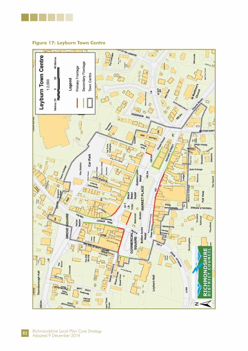
Richmondshire Local Plan Core StrategyAdopted 9 December 2014
Figure 17: Leyburn Town Centre
82

Richmondshire Local Plan Core StrategyAdopted 9 December 2014
Core Policy CP10: Developing Tourism
4.10.1 The NPPF (Policy 3) supports sustainable rural tourism, and recognises that it is vital to many rural economies. Encouragement is given to plans which support the provision and expansion of tourist and visitor facilities in appropriate locations, where the identified need is not met by existing facilities in rural service centres. It seeks to carefully balance the need, viability and environmental concerns, such as character of the countryside, with benefits to rural businesses, communities and visitors.
4.10.2 The local focus, through Core Policy CP10, is largely on supporting qualitative rather than quantitative improvements and on promoting sustainable tourism, drawing on the area’s countryside and heritage assets, provided it does not cause harm to the local environment and its essential character. The major local tourism assets lie in the high quality of the existing natural and built environment. It is therefore important that new developments build on these inherent strengths and character. They should be compatible in scale and type with the local environment, which is generally small scale, low key and with low impact, both environmentally and socially. There may also be the opportunity to provide more medium to large scale proposals, particularly relating to tourist accommodation. These types of proposals are most likely to be located within the main settlements of the District. Schemes should also be ecologically sound and likely to have a long term economic value.
Core Policy CP10: Developing Tourism
Tourist related activities will be encouraged where they make a sustainable contribution to the local economy, do not have a detrimental impact on and, where possible, enhance the local environment and landscape. Particular priority will be given to supporting improvements to the range and quality of facilities and to redevelopment and conversion schemes rather than new building.
Medium to large scale hotel accommodation within the larger settlements of the settlement hierarchy such as Richmond, Catterick Garrison and Leyburn will be supported where a need is identified and such a proposal does not adversely affect the character and appearance of the settlement.
In rural areas, new tourist accommodation, including the location of caravans (static and touring), chalet accommodation and camp sites, should be small scale, low key and low impact, and will only be supported in the countryside if it does not adversely affect the character and appearance of the area, taking account of the capacity of the site and local area to absorb the development.
83

Richmondshire Local Plan Core StrategyAdopted 9 December 2014
Core Policy CP11: Supporting Community, Cultural and Recreation Assets
4.11.1 The Government’s objective is to create strong, vibrant and healthy communities with accessible local services and places to meet, that reflect community needs and supports well-being. Community, cultural, amenity and recreational assets are all critically important resources for the District, in terms of promoting healthy lifestyles and supporting the well-being of sustainable communities. This policy aims to protect, maintain, strengthen and enhance community and recreation assets and to ensure that new development creates places to meet to interact, formally and informally, inside buildings and outdoors. The aim is to facilitate social interaction and create inclusive communities by maintaining and delivering the right community and recreation assets that meet and promote the needs and health and well-being of existing and growing or enlarged communities.
4.11.2 The Settlement Hierarchy established in Spatial Principle SP2 is based on a network of communities with access to a range of services and facilities throughout the hierarchy. A Settlement Facilities Study was conducted in 2011 which shows a network of services and facilities that supports the population and a great deal of community life, social interaction and well-being in our local communities. In general, resources available and accessible to residents throughout the plan area are limited. Over recent years the network has been under pressure with the loss of some facilities. Loss of facilities is particularly a problem for rural communities due to distance to other facilities, dispersal and isolation. Despite this a re-assessment of local sporting facilities (Settlement Facilities Sporting Supplement 2013) using established Sport England methods does not show a deficit in provision. The Settlement Facilities Study will be updated through the annual monitoring process in order to monitor the change in circumstances of all types of community assets and the extent to which they contribute to local needs.
4.11.3 Community Assets include village halls or meeting rooms, local shops and post offices, convenience stores, nurseries, care homes, places of worship, public houses, cultural buildings and other key local commercial facilities such as petrol filling stations, local services such as doctors surgeries, libraries and schools as well as sports and recreation facilities. A Register of Community Assets is also to be produced under the Localism Act 2011. All entries in the Study and Register are community assets and all applications affecting them and other assets of value to the community, are covered by this policy.
4.11.4 Open spaces, and access to them, for sport, play, recreation and amenity underpin people’s quality of life and well-being. They all have a vital role in promoting healthy living and preventing illness. There is a need to provide sufficient recreational and amenity open space to meet the needs of existing residents and those needs arising from future developments. Well planned facilities provide for social interaction and help build community cohesion. Open space should be taken to mean all open space of public value, including not just land, but also areas of water such as rivers and lakes which offer important opportunities for sport and recreation and can also act as a visual amenity. They include areas for formal sport or active recreational activities such as parks, allotments, play areas, playing pitches, tennis courts, bowling greens, golf courses and other areas for informal activities such as green corridors, spaces, active street frontages, village greens and verges.
84

Richmondshire Local Plan Core StrategyAdopted 9 December 2014
Core Policy CP11: Supporting Community, Cultural and Recreation Assets
1. Support will be given to proposals that help create, protect, retain or enhance community, cultural and recreational assets (land and/or buildings) that:a. improve access to assets by non-car modes of transportb. improve assetsc. provide additional assetsd. retain assets where there is scarcitye. improve community well-beingf. improve the safety and accessibility of assetsg. improve the mix of uses in a development which encourage social
interactionh. promote the role of settlements in the Settlement Hierarchy.
2. Proposals involving the loss or alternative development of existing community, cultural and recreational assets will only be supported where there is evidence that:a. the asset is no longer required and is redundantb. it is no longer, or cannot be made, viablec. satisfactory alternative provision can be made that outweighs the lossd. the proposal is for a new community, cultural or recreational asset,
the need for which outweighs the loss and has the support of the wider community.
3. All new development will be expected to:a. plan positively to ensure the provision and integration of sufficient quality
community, cultural and recreational assets for existing and future occupiers and recreational facilities, including formal and informal, equipped and unequipped areas for open space, sport and recreation and links to Public Rights of Way
b. make provision, or contribute towards the provision, of new or enhanced assets to meet identified needs of new development or expanded communities; and locate buildings and land for new community, cultural and recreation assets where they will be well served by public transport and accessible by walking and cycling.
4. Applications involving a loss or change of use of assets (and particularly those identified in a Register of Community Assets) and applications for new development generating additional needs and demands will be required to be accompanied by an assessment of provision and need.
85

Richmondshire Local Plan Core StrategyAdopted 9 December 2014
4.11.5 New housing must provide sufficient quantity and quality of accessible and safe open space within the site boundary for the enlarged community, unless the Council has approved offsite provision, enhancement or funding in lieu of provision. The Fields In Trust ‘Planning and Design for Outdoor Sport and Play’ (2008), formerly the National Playing Fields Association “Six Acre Standard”, provides minimum national standards for play and recreation space. Until the Council produces its Delivering Development Plan or guidance setting local standards for open space, the Council will use these documents, together with relevant local data available at the time of assessment, including Registers of Local Green Space produced by communities through Local or Neighbourhood Plans under the Localism Act 2011, to guide the assessment of the requirements for open space. New development must also provide safe and attractive areas for the Public Right of Way network, including new links where appropriate. The future Delivering Development Plan document will seek to allocate areas for open space, sports and recreation facilities where necessary. This will be informed by an updated quantitative and qualitative assessment of open space, sports and recreation facilities and will include the identification of surpluses and shortfalls in the supply of these facilities at settlement level.
4.11.6 The loss or change of use of assets (land or buildings) which provide community, cultural or recreation facilities must be fully justified. An assessment which demonstrates that a community, cultural or recreational asset has no viable future or that is redundant will be required for planning applications that involve loss of, or compromise the quality and quantity of land or buildings used for those purposes, or compromise a community’s ability to meet its day to day needs. Assessments may be required to include an up-to-date local needs survey and/or community consultation exercise to demonstrate the views of the wider community together with evidence of usage of facilities. It may also include, where appropriate, evidence demonstrating that the existing building or land cannot be used for another community, cultural or recreational use with an identified need in the area, or that suitable alternative provision is made in a timely way. Applications for new development generating additional needs and demands will be required to be accompanied by an assessment of provision and need to demonstrate that adequate provision will be provided for the new or expanded community and that the quality and quantity of the relevant assets will be adequate.
4.11.7 By designating land as Local Green Space local communities will be able to rule out new development other than in very special circumstances. Identifying land as Local Green Space should be consistent with Core Policy CP11.
Core Policy CP12: Conserving and Enhancing Environmental and Historic Assets
4.12.1 As the Strategic Objectives indicate, conserving and where possible enhancing the very high quality of the plan area’s environmental and historic assets must be major concerns of the plan. The quality and diversity of these assets - whether the landscape, rural heritage and culture, built heritage, green infrastructure or biodiversity - are what makes the plan area truly distinctive, and essential aspects help to determine the quality of life in this part of the country. Heritage assets are an irreplaceable resource and should be conserved in a manner appropriate to their significance so that they can be enjoyed for their contribution to the quality of life of this and future generations.
86

Richmondshire Local Plan Core StrategyAdopted 9 December 2014
4.12.2 The plan area’s environmental and historic assets are very diverse. The environmental assets are set out within Chapter 2 of this Local Plan Core Strategy document. The plan area contains a large number of archaeological sites - over 1,200 recorded sites being within the North Yorkshire Historic Environmental Record (HER). There are 41 designated Conservation Areas, and over 1,200 listed buildings and structures. In addition to formally recognised built heritage, there are many other undesignated buildings or features of genuine quality which enrich the urban and rural environments, contributing to the special character of the plan area, such as the archaeologically sensitive historic cores of both Richmond and Middleham.
4.12.3 There is a strong policy context for the development of the plan’s approach to these assets. Current national guidance provides the context for conserving and enhancing our environmental and historic assets. The role of the development plan is to provide local interpretation and definition of how our distinct local assets should be conserved and enhanced.
4.12.4 The NPPF requires the Council to set out within its Local Plan, a positive strategy for the conservation and enjoyment of the historic environment, including heritage assets most at risk through neglect, decay or other threats. Richmondshire’s strategy for the historic environment is to support development and measures which conserve and enhance our environmental and historic assets; to reject detrimental developments and activities; to secure mitigation or compensation/recording measures where appropriate; to provide support for green infrastructure; and to show how details of this approach are to be addressed in the future.
4.12.5 It is the intention of the Local Authority to produce a separate Heritage Strategy, which will set the priorities for management of the plan area’s historic environment. This will include the production of a ‘Buildings at Risk’ Register and a Local List of non-designated heritage assets as well as work with English Heritage to revise and update the National Heritage List for England.
4.12.6 Green infrastructure is an important element of sustainable communities and although in some ways more relevant to urban areas, it also relates to the rural environment. Establishing the strategic and locally important elements of the plan area’s rich green infrastructure will be an important responsibility of the plan, which will be defined in the Delivering Development Plan. Green infrastructure works at different levels so that in the wider countryside it is often viewed at a larger scale, encompassing large country estates or parks, extensive habitats, major landscape features such as river corridors and flood meadows, landscapes, along with the identification of wide green corridors and ecological networks.
4.12.7 The strategic green infrastructure corridors identified by Natural England within the plan area are along the River Ure; the Swale Valley; the Tees Valley; the Skeeby - Newsham corridor; the Ravensworth - Forcett - Cliffe corridor; the Scorton - Croft corridor and the Catterick Village - Leyburn corridor.
87

Richmondshire Local Plan Core StrategyAdopted 9 December 2014
4.12.8 Catterick Garrison is particularly notable for its green infrastructure, which is made up of corridors of open spaces, recreation areas and trees flowing through the urban area to compliment the regionally important corridors identified by Natural England. The agricultural countryside north of Catterick Road between Colburn Town, Colburn Village and Hipswell contributes to the overall openness of Catterick Garrison and acts as a buffer to the old village of Colburn and the landscape assets north of the River Swale. Detailed land use allocations and revised settlement development limits will formally define the extent of this area taking into account the impact of former military activity in this vicinity. Until the Delivering Development Plan is prepared, the Council will consider development proposals that are well related to the strategic site search area illustrated in Figure 9. Where such proposals impact on this area they should be designed to remediate areas of former military activity, and enhance the surrounding green infrastructure. In the urban area of Richmond, The Batts and Round Howe to the west of the town are particularly important.
4.12.9 Within the small areas of the Nidderdale and the North Pennines AONBs, development which would be inconsistent with the purpose of this policy will not be acceptable unless clear evidence is brought forward to show that it needs to be located in the AONB because of a lack of suitable sites elsewhere. Any new development will be expected to attain the highest standards of design in accordance with Core Policy CP13.
4.12.10 When considering matters affecting landscape assets, particular regard will be given to the following key landscapes:
gritstone high plateaus vale fringes vale farmland with dispersed settlements settled vale farmland limestone dales river floodplains
4.12.11 The approach will take account of Natural England’s Joint Character Areas; the North Yorkshire and York Landscape Characterisation Project; and more detailed local landscape character and enhancement. The Core Strategy is designed to provide a strategic policy framework with further detail and site specific matters to be addressed in the forthcoming Delivering Development Plan. That document will contain detailed policies and proposals maps for the various components of the local ecological network, including opportunities for habitat restoration and creation.
4.12.12 Prior to preparation of the Delivering Development Plan, when considering matters affecting biodiversity and geodiversity assets, particular regard will be given to the following key sites, habitats and species commensurate with their status and giving appropriate weight to their importance and the contribution that they make to wider ecological networks:
Internationally Designated Sites European Natura 2000 sites of the North Pennines Dales Meadows Special Area
of Conservation (SAC) and the North Pennine Moors Special Protection Area (SPA) and SAC
Nationally Designated Sites Sites of Special Scientific Interest (SSSI)
88

Richmondshire Local Plan Core StrategyAdopted 9 December 2014
Locally Designated Sites local Sites of Importance for Nature Conservation (SINC) the Foxglove Covert Local Nature Reserve
Locally Important Sites, Habitats and Species the Tees, Swale and Ure river corridors the upland areas of Kexwith Moor, Holgate Moor, Holgate Pasture, Hurst Moor,
Marrick Moor, Redmire Moor, Preston Moor, Stainton Moor and Bellerby Moor the network of nature conservation resources including ancient and broadleaved
woodland, semi-improved grassland, flushes and marshy grassland, ponds and open water, hedgerows, cliffs and rock faces
priority habitats - woodland, lowland wood pasture, parkland and veteran trees, upland hay meadow, flood plain grassland, upland calcareous grassland, species rich grassland, upland heathland and blanket bog, moorland edge, fen, reedbed, flowing water and standing water
priority species - otter, water vole, bats, black grouse and curlew.
4.12.13 The integrity of Natura 2000 sites shall be maintained and protected in accordance with their statutory protection. Development or other initiatives that have the potential to adversely affect the integrity of these sites, either in isolation or in combination with other development, plans or strategies, will not be supported unless it can be demonstrated that the legislative provisions to protect such sites can be fully met. This applies to proposed development and initiatives within and outside of the boundaries of the designated Natura 2000 sites. The impact of development and initiatives on the integrity of Natura 2000 sites outside of the plan area should be equally considered.
4.12.14 The Biodiversity Action Plan (BAP) for Richmondshire was prepared in 2005. It provides a great deal of detailed information which is important in terms of developing the plan’s approach to our environmental assets. In particular, it places an emphasis on ‘priority habitats’ such as lowland wood pasture and on ‘priority species’ such as the Curlew. Within the BAP there are individual action plans for twelve types of habitat and for five priority species. Reference should also be made to the regional Biodiversity Opportunity Areas Map when considering cross boundary issues of biodiversity importance.
4.12.15 There will be opportunity as part of new developments to enhance sustainable access to the towns and countryside in the form of walking, cycling and riding routes. Focussing on this can contribute to the health and wellbeing of residents, drive tourism through improved access to surrounding countryside and link people by sustainable means to important goods and services in principal towns.
4.12.16 When considering matters affecting historic assets, particular regard will be given to the following list and also to any SPD covering such issues:
those elements which contribute to the special architectural or historic interest of Richmondshire’s Conservation Areas and their settings as identified in the respective Conservation Area Appraisal
the pre-Roman heritage of the plan area such as Stanwick Fortifications and Scots Dyke
the Roman forts and civilian settlements at Cataractonium and along the line of Dere Street
89

Richmondshire Local Plan Core StrategyAdopted 9 December 2014
other recorded sites of archaeological importance across the plan area and the archaeologically sensitive areas in and around the historic cores of Richmond and Middleham
the medieval heritage including the network of impressive fortifications such as Middleham and Richmond Castles, monastic houses such as Jervaulx Abbey and abandoned settlements and field-systems including Walburn Hall
buildings and structures included on the National Heritage List for England opportunities to secure a sustainable future for assets on English Heritage’s
Heritage at Risk Register or which may be included on a Local At Risk Register undesignated heritage assets which contribute to the overall character of the area the character of Market Towns, including their grain, plot layouts and
passageways historic shop fronts in Richmond, Middleham and Leyburn as well as some villages locally important boundary walls, hedges or railings, historic passageways and
yards, important trees and tree groups, pinfolds, troughs, pumps, mounting blocks, pillar boxes, K6 telephone kiosks, orchards and historic plot layouts
historic public viewpoints from Richmond Castle Keep; Castle Walk, Richmond; Frenchgate Head, Richmond; Maison Dieu, Richmond; the Grandstand on Richmond’s former Racecourse; Sleegill, south of Richmond; Middleham Castle Keep; and The Shawl, Leyburn
sites designated by English Heritage as Registered Parks and Gardens at Aske Hall, Constable Burton Hall, Forcett Hall, St. Nicholas, the Temple Lodge Grounds and Middleton Lodge
the landscape, buildings and other structures associated with local country estates including Croft Hall and Halnaby, Barningham Estate, Cliffe Hall, Bolton Estate, East Witton Estate and Hornby Castle.
Core Policy CP12: Conserving and Enhancing Environmental and Historic Assets
Development or other initiatives will be supported where they conserve and enhance the significance of the plan area’s natural and man-made, designated or undesignated assets. Development will not be supported which:
a. has a detrimental impact upon the significance of a natural or man-made assetb. is inconsistent with the principles of an asset’s proper management.
Environmental AssetsWhere avoidance of adverse impacts is not possible, necessary mitigation must be provided to address any potential harmful implications of development. Where adequate mitigation measures are not possible, compensatory measures will be required. This approach will apply to specific assets as follows:
a. within the Nidderdale and the North Pennines Areas of Outstanding Natural Beauty which cover parts of East Witton and Muker Parishes respectively, priority will be given to the conservation and enhancement of the natural beauty of the landscape
90

Richmondshire Local Plan Core StrategyAdopted 9 December 2014
b. the landscape character of the plan area will be maintained, enhanced and, where appropriate, restored to ensure a sustainable future for the natural and historic environment
c. the biodiversity and geodiversity of the plan area will be maintained, enhanced and, where appropriate, restored to ensure a sustainable future for the natural environment in support of the Yorkshire and Humber Regional Biodiversity Strategy, the North Yorkshire Biodiversity Action Plan, the Richmondshire Biodiversity Action Plan and the Humber River Basin Management Plan. Particular support will be given to initiatives to improve the natural environment where it is poor and lacking in diversity
d. the green infrastructure network of the plan area will be protected and, where appropriate, enhanced to provide a high quality, accessible, diverse and well-connected network of green space to meet the needs of the community, businesses and visitors. The key green infrastructure network includes:i. playing fields, outdoor sports facilities, play parks and amenity green spaceii. the Coast to Coast walk and views from itiii. corridors of green space, recreation areas and trees which flow through
urban areas (particularly Catterick Garrison and Leyburn)iv. the gap between the settlements of Leyburn and Harmby, and the agricultural
countryside between Colburn Town, Colburn Village and Hipswellv. village greens and common landvi. allotments, cemeteries, churchyards and civic spacesvii. woodlands, scrubland, grassland, wetland, running water, wasteland,
open land and parks and gardens, river banks, cycleways and the Public Rights of Way network
viii. sites important for biodiversity and geodiversity referred to at Paragraph 4.12.12.
Historic Assets1. Those elements which contribute to the significance of the heritage assets
across the Plan area will be conserved and, where appropriate, enhanced. Particular attention will be paid to those assets referred to in Paragraph 4.12.16 which make a particularly important contribution to the character and sense of place of Richmondshire.
2. Where a proposal is likely to result in harm to the significance of a designated heritage asset and there are compelling reasons for allowing that development, opportunities will be sought to offset this harm by ensuring that other elements which contribute to the significance of that particular asset are enhanced or their significance better revealed.
3. Consideration of development proposals will also need to take into account the objective of securing the long term existence of the heritage asset. This is particularly the case for those assets which have been identified as being at risk. Enabling development may be considered acceptable in the particular location (site or buildings), where all other alternatives have been explored, and the development or use proposed is the only practical means of securing the future conservation of a heritage asset.
91
Richmondshire Local Plan Core StrategyAdopted 9 December 2014
Core Policy CP13: Promoting High Quality Design
4.13.1 Good design is a key element in sustainable development. Accordingly, reflected in the Strategic Objectives, the plan will promote high quality design, both in terms of built development, including the standard of architecture, and in securing the best environment through landscape design. It is an aspiration of the Council to raise the standard of design in all proposals. Supported by the strong commitment to apply the policies that protect historic and environmental assets, the plan will seek to ensure that development in the plan area enhances and protects its local distinctiveness, visual quality and quality of life. At the individual development level, the plan will promote buildings that are sustainable in construction and use. Good design is essential in achieving genuine sustainable development. It need not result in additional costs (it should not render housing unaffordable) and in the longer term will pay dividends. On a wider scale, the plan will encourage proposals that are designed to assist vitality and create a definable ’sense of place’ in communities and neighbourhoods.
4.13.2 All new buildings and spaces must enhance and respect their surroundings and contribute towards the local identity. Developments must be of the appropriate scale, density, massing, height and materials for their location as well as provide suitable access, landscaping and conform to the design principles set out in Core Policy CP13. Public art may also make a significant contribution in enhancing local character and identity and will be encouraged wherever appropriate.
4.13.3 Development proposals should consider prevailing national and local design guidance. This should include where relevant NPPF, Neighbourhood Plans, Supplementary Planning Documents, Village Design Statements and Conservation Area Appraisals. In line with national policy, the Council expects applicants to work closely with those directly affected by their proposals. The outcomes of this will be expected to be submitted within a Design Statement when making planning applications. This must also show how the proposal’s design has evolved and how it responds to the context of its surroundings.
4.13.4 Although Richmondshire is one of the safest areas in the country, there is no room for complacency. Crime and community safety - and as important - the fear of crime, remain amongst the public’s top concerns. This high priority is also reflected in the Local Plan Core Strategy and its importance is expressed within Core Policy CP13.
4.13.5 The design of buildings and spaces can make a major contribution towards reducing the scope for crime, and create reassuring living environments. Open amenity spaces used for walking, sport and children’s play must be designed to be as safe as possible and believed to be safe. The design and layout of new developments should follow national advice, such as ‘Secured By Design’ guidance. Good design takes account of the scope to provide for public spaces to be overlooked by neighbours, and for the incorporation of potential escape routes. Elements of designing out crime are possible to achieve in almost all public spaces - including housing estates, town centres and industrial areas. However, a wide range of factors need to be considered when creating new developments and spaces. Design solely to counter the risk of crime should not be the over-riding consideration in the design and layout of new developments and spaces. Core Policy CP13 is intended to strike a balance between these competing requirements whilst ensuring that high quality design is not sacrificed out of hand for functional
92

Richmondshire Local Plan Core StrategyAdopted 9 December 2014
needs. A further consideration is that high quality design can have a positive impact on minimising light pollution from new development, particularly in the more rural areas of the plan area. Core Policy CP13 also seeks to address this issue.
4.13.6 Core Policy CP13 provides a checklist for new proposals in order to deliver the high quality design of developments. The selected design approaches to form, function, materials, security and sustainable construction are all elements which can contribute to high quality design results, enhancing not only the visual appearance of proposals but also how they interact with existing development, surrounding landscapes and operate in their particular use or function. This policy seeks to encourage developers to balance all these needs in a well considered and clear design solution.
Core Policy CP13: Promoting High Quality Design High quality design of both buildings and landscaping is a priority in all
development proposals. Support will be given for proposals that:a. provide a visually attractive, functional, accessible and low maintenance
developmentb. respect and enhance the local context and its special qualities, including
its design features, landscape, social activities, historic environment and nationally and locally recognised designations
c. optimise the potential of the sited. minimise the use of scarce resourcese. adopt sustainable construction principlesf. facilitate access through sustainable forms of transportg. secure improvements to public spaces and incorporate public art, where
appropriate.
Design of all developments (including transport schemes) must take account of the need to promote safe living environments and reduce the opportunities for crime and the fear of crime, disorder and anti-social behaviour. A balance should be made to limit the impact of light pollution from artificial light on local amenity, intrinsically dark landscapes and areas of nature conservation.
Development proposals should be supported by a Design Statement.
93

Richmondshire Local Plan Core StrategyAdopted 9 December 2014
Core Policy CP14: Providing and Delivering Infrastructure
4.14.1 A good, working infrastructure is crucial to the well-being of any society. From the roads, railways, footpaths and cyclepaths that criss-cross the District to the pipes and cables below ground that provide water, gas and telecommunications, a fully operational, well-planned and well-maintained infrastructure network has to be at the heart of good planning, now and in the future.
4.14.2 The provision of this physical infrastructure will be a crucial element in achieving the implementation of the policies and proposals in the Local Plan Core Strategy. Any additional or necessary infrastructure must be phased to take into account the timing of development and must be funded in advance of its delivery, be fit for purpose (to adoptable standards for the responsible body) and be able to cater for not only the provision of existing and proposed development but also a level of future development beyond the plan period.
4.14.3 The provision of social and green infrastructure is also required to deliver the overall strategy. Social infrastructure is wide ranging and can include the many activities and facilities that support a community, such as community centres, and organisations like residents associations and mother and toddler groups. Green infrastructure encompasses the green network, everything from parks and open spaces to allotments.
Core Policy CP14: Providing and Delivering InfrastructureThe Council will work with statutory undertakers, utility companies and other agencies to develop an Infrastructure Delivery Plan (IDP) for the Local Plan Core Strategy so as to ensure delivery of adequate infrastructure to serve development and support the local economy.
Any adverse impacts arising from new infrastructure should be minimised. Decisions on the provision of infrastructure should be taken on the basis of environmental sustainability as well as cost.
Development should provide, or enable the provision of, the infrastructure made necessary by that development. Where it cannot be provided directly, developer contributions will be required to meet the reasonable costs of the provision of new infrastructure made necessary by the development. These requirements will be identified and detailed in the Infrastructure Delivery Plan (IDP) and contributions will be calculated through the associated Community Infrastructure Levy (CIL) Charging Schedule.
All infrastructure improvements and investments should be delivered by development, or through developer contributions, in a timely manner and to the required adoptable standards as specified by the relevant responsible organisation or authority.
4.14.4 The Infrastructure Delivery Plan (IDP) identifies the key strategic infrastructure which will be required within Richmondshire in order to deliver the specified level of development for the plan period up to 2028. Core Policy CP14 provides the policy link to these identified infrastructure schemes within the IDP and the requirement to seek contributions from developers through development via the Community Infrastructure Levy (CIL). Further details about the CIL will be provided in the Richmondshire CIL Charging Schedule, expected to be adopted by 2015.
94

Richmondshire Local Plan Core StrategyAdopted 9 December 2014
Chapter 5: Implementation and Delivery
Implementation
5.1 The preceding chapters have explained the challenges faced in the plan area, a future vision and the principles and policies designed to deliver it. This chapter explains how the Local Plan Core Strategy will be put into practice helping to deliver change in the plan area. It includes the Infrastructure Delivery Plan (IDP), which contains the necessary ingredients for delivery, their providers and feasibility. It explains the approach to monitoring and review helping to ensure that the plan remains on course.
5.2 The Local Plan Core Strategy does not simply express the District Council’s views. Its successful delivery requires it to be implemented in partnership with several organisations helping to co-ordinate investment and action. These include members of the Local Strategic Partnership, the County Council, the Ministry of Defence, other Government departments and agencies, public utility providers, and the private sector. The views and support of these partners have been actively sought to ensure that the Local Plan Core Strategy is the best approach, helps to deliver their own strategies and addresses challenges through joint action.
5.3 The Local Plan Core Strategy is designed to be resilient to external influences and the right approach for a variety of economic circumstances. The full range of such external circumstances cannot be gauged now, but Spatial Principle SP2 on the settlement hierarchy and the distribution of growth under Spatial Principles SP4 and SP5 provide flexibility whatever the actual scale of development. The Strategic Housing and Employment Land Availability Assessment (SHELAA, June 2010) provides evidence of a range of suitable development opportunities capable of providing for different scales of development to be brought forward according to the provisions of the plan.
5.4 The Local Plan Core Strategy’s implementation will require timely action to ensure it remains on track. The development management process can help to co-ordinate proposals to ensure achievement of plan objectives. Land in the ownership of key partners, and their investment programmes and service delivery strategies will be related to Local Plan delivery objectives. This will enable a joint response to stimulate needed development, or ensure that the scope for critically important, but perhaps scarce, pump-priming investment can be used to the best effect.
5.5 The plan or specific elements of it will be formally reviewed every five years from its start date of April 2012 to ensure that it stays on course and remains responsive to local and wider conditions. In these reviews adjustments to the scale and direction of development will be considered in the light of development progress, land availability assessment and market conditions. Contingency arrangements are considered to be unnecessary in most of this rural area, where significant change is not expected. The exception to this is Catterick Garrison where the scale and timing of future military-related development will be affected by successive national Defence and Security Reviews, but the timing of the five year review cycle means that the strategy will remain alert to military policy.
95

Richmondshire Local Plan Core StrategyAdopted 9 December 2014
The Infrastructure Delivery Plan
5.6 Infrastructure provision and delivery are key issues for the Local Plan Core Strategy to ensure that the amount, type and distribution of development envisaged in the plan area is supported by necessary physical, social and green infrastructure. The number of net dwellings required for the plan period up to 2028 across the plan area is 3,060. The Local Plan Core Strategy proposes sub areas and a hierarchy of settlements as the organising basis for the scale and distribution of development in the plan area (Spatial Principles SP1 and SP2). The Principal Towns of Richmond and Catterick Garrison will accommodate the majority of housing development (70%). Leyburn is also expected to accommodate a proportion of housing development (7%) to support the needs of the surrounding Lower Wensleydale sub area. The Primary and Secondary Service Villages are expected to accommodate a limited amount (13% and 5% respectively) and development elsewhere will be strictly constrained (5%) but spread over a wide area. The Local Plan Core Strategy also requires 12 hectares of land for employment development to be brought forward up to 2028. In addition, the Local Plan Core Strategy provides for military-related development for up to four extra military units and 500 more service families’ homes, if required by the Ministry of Defence.
5.7 Core Policy CP14 relates to the provision and delivery of infrastructure, the Infrastructure Delivery Plan (IDP) and the Community Infrastructure Levy (CIL). The IDP is an important supporting document which underpins the Local Plan Core Strategy and also covers the plan period up to 2028. The IDP ensures that there is the appropriate infrastructure to successfully accommodate and deliver the scale, type and distribution of development outlined above. Its main tasks are to:
identify the relevant infrastructure and the public and private bodies responsible for its provision
identify existing and future infrastructure capacities highlight current or future investment or improvement programmes and sources
of funding identify any existing or potential constraints (including gaps in funding) and
‘showstoppers’ with regards to the policies of the Local Plan Core Strategy including any potential solutions, and their estimated costs
provide a delivery plan clearly showing who is responsible for delivery, when and at what cost.
5.8 Infrastructure within the plan area is also influenced and affected by the policies, plans and strategies of other organisations and agencies, many of which have their own infrastructure-related priorities and budgets. For instance, North Yorkshire County Council (NYCC) is responsible for the local road network and the Highways Agency for the strategic road network in the plan area. The Local Plan Core Strategy’s infrastructure-related policies will need to take into account the strategies, policies and budget constraints of these other organisations. Effective partnerships will also be needed with stakeholders to ensure that delivery of the Local Plan Core Strategy is supported by them where they have an impact upon the plan area.
5.9 The IDP’s contents will be monitored annually and reviewed periodically to ensure that it, too, remains on track and identifies any action needed.
96

Richmondshire Local Plan Core StrategyAdopted 9 December 2014
Existing Infrastructure
5.10 This section looks at the current capacity of infrastructure in the plan area and identifies where improvements will be needed to provide for future development.
Highways
5.11 During consultation on the Local Plan Core Strategy and the continuing dialogue with the local highway authority (NYCC), no pre-existing, significant capacity issues on the road network were identified in the plan area. Concern was expressed about the capacity of the local road network in Catterick Garrison and the A6136 in particular to accommodate the proposed scale of development. The Catterick Garrison Strategic Transport Assessment (2011) investigated this in detail and identified a series of junction improvements to accommodate the growth. This work informs the IDP.
5.12 The A1 upgrade to motorway standard from Leeming Bar to Barton is expected to be complete by 2017. The design of the upgrade has been modelled to reflect the development growth contained within this Core Strategy. The creation of a new Catterick Central junction will significantly improve access not only to the main growth areas at Catterick Garrison but also to the wider district. This significantly improves local prospects for local economic growth, which is recognised by the Local Enterprise Partnership’s recognition that Catterick Garrison has great potential for growth.
5.13 Although there are no existing road capacity issues in Leyburn, the proposed amount of development could raise localised traffic issues on the local road network. These issues are likely to be mitigated through specific development proposals which directly impact on the local road network.
Water Supply and Waste Water Treatment 5.14 Yorkshire Water supplies water and waste water treatment facilities for most of the plan
area. Yorkshire Water has confirmed that overall there are no existing capacity issues and that the Yorkshire Grid System can accommodate and supply water for the level of development proposed within the Local Plan Core Strategy. The only exception to this would be in Catterick Garrison where improvements to the mains water infrastructure may be required to accommodate planned growth.
5.15 Yorkshire Water has also indicated that there is sufficient existing waste water treatment capacity to accommodate the scale of development expected over the first five years of the plan. Longer term development would be restricted due to limited existing capacity at the larger Waste Water Treatment Works (WWTW) at Richmond and Colburn in particular, and new investment is required. The development of specific sites will need to be managed in line with the resolution of these capacity issues. Yorkshire Water’s future Asset Management Plan 6 (AMP6) covering the period 2015-2020, to ensure funding for improvements is available is expected to address these issues. Leyburn WWTW has the capacity to accommodate the proposed level of growth, subject to some local improvements to mitigate any adverse impacts on existing development. Substantial growth in the smaller settlements could raise waste water treatment capacity issues in these settlements.
97

Richmondshire Local Plan Core StrategyAdopted 9 December 2014
5.16 Northumbrian Water supplies water and waste water treatment facilities for a substantial part of the North Richmondshire sub area. Northumbrian Water has confirmed that the proposed scale and distribution of development does not cause any concern in relation to its water supply and waste water treatment infrastructure capacities. Northumbrian Water’s existing infrastructure in the plan area is small in scale. It would be concerned if development in the North Richmondshire Area was focused on one particular area or settlement.
Schools5.17 North Yorkshire County Council’s Children and Young People’s Service confirmed
that there is generally adequate existing capacity of pupil places in Catterick Garrison schools. However, the proposed scale of housing in this area over the plan period would quickly lead to a shortage of spaces in all schools. NYCC believes that additional classrooms would address the need for greater capacity arising from development over the next 15 years. However, there may be a need to deliver a new primary school in the Catterick Garrison area.
5.18 Richmond schools currently have limited additional capacity, with the exception of Richmond School. Richmond School and St Francis Xavier pupil numbers are expected to drop over the plan period, but other schools in Richmond would not be able to accommodate the increase in pupil numbers forecast. Primary schools in Leyburn and Middleham currently have limited additional capacity, which will be exceeded by the scale of proposed housing development in the school’s catchment areas.
5.19 Schools in the smaller settlements, excluding Croft, Ravensworth and Middleton Tyas primaries, generally have small additional capacity. The limited amount of development proposed in these settlements over the plan period should mean that capacity issues in relation to most of these schools should not be a critical issue.
Electricity, Gas and Telecommunications5.20 Contact has been made with the relevant utility companies during Local Plan Core
Strategy consultation but no responses have been provided in relation to existing and future capacities (based on the proposed scale and distribution of development). Dialogue will continue with these providers.
Renewable Energy5.21 The rural nature and pattern of development in the plan area restricts local capacity
for renewable energy provision. Core Policy CP2 seeks to maximise the plan area’s renewable energy potential within its highly sensitive environmental constraints guided by the Richmondshire Low Carbon and Renewable Energy Capacity Study. Development within the Catterick Garrison and Leyburn strategic growth areas and on medium to large scale sites elsewhere is expected to provide infrastructure for combined heat and power or district heating networks where viable and feasible. Core Policy CP2 requires all new housing developments and also commercial developments exceeding 1000m² to minimise carbon emissions and incorporate on site renewable energy technologies.
98

Richmondshire Local Plan Core StrategyAdopted 9 December 2014
Healthcare5.22 Contact has been made with North Yorkshire Primary Care Trust and the emerging
GP Commissioning Body. This indicated existing and future capacities of healthcare resources relating to the proposed level of development. Discussions will continue throughout the plan period to ensure implementation of local requirements.
Wensleydale Railway5.23 The proposed extension of the Wensleydale Railway may have a beneficial impact on
tourism and accessibility to jobs and services in Leyburn, particularly if the planned extension between Leeming Bar and Northallerton goes ahead.
Green Infrastructure, Open Space and Recreation Facilities5.24 The rural character of the plan area provides an abundance of green infrastructure and
publicly accessible green spaces. The relationship of these resources to future development proposals needs to be considered, especially where major growth is planned. Significant open spaces and green corridors are identified in the Local Plan Core Strategy to ensure their maintenance and improvement. These include the extensive woodland areas of Catterick Garrison, Sour Beck, south of Colburn and Coronation Park in Hipswell. Core Policy CP11 is designed to ensure that valuable community assets, including open spaces and recreation facilities, continue to be provided.
Infrastructure Delivery - Risks
5.25 Infrastructure providers indicate that there is unlikely to be any ‘showstopping’ capacity or threshold problems and the proposed growth in the plan area, up to 2028, can be accommodated subject to identified mitigation measures. Infrastructure capacity in the smaller settlements is limited, but largely adequate to accommodate the proposed small proportion of growth in these settlements. Significant issues are recognised concerning the achievement of growth in Catterick Garrison, where infrastructure delivery issues are critical to the success of the entire plan. The Infrastructure Delivery Plan (IDP) (Table 6) provides deliverable solutions to issues such as the increased traffic flow expected on the A6136 and coordination with Yorkshire Water investment plans. The IDP also summarises the likely costs and funding regimes required to implement these necessary improvements.
5.26 The greatest risks facing the delivery of the Local Plan Core Strategy come from the Council’s ability to ensure that development proposals are fully coordinated with the major infrastructure providers and that charging mechanisms, such as the Community Infrastructure Levy (CIL), are sufficiently robust to deliver the necessary resources. A continuing problem with this is the uncertainty surrounding the future scale of military-related development. The Local Plan Core Strategy has provided for a maximum level of expansion for four military units, as advised by the Ministry of Defence, and this has been built into strategic infrastructure assessments to demonstrate the feasibility of delivery. However, in the absence of a firm commitment from the MoD that this will happen, it presents a problem for determining overall infrastructure requirements including military related development. It will be resolved through work on the CIL to ensure an equitable charging regime.
99

Richmondshire Local Plan Core StrategyAdopted 9 December 2014
Community Infrastructure Levy (CIL)
5.27 The Community Infrastructure Levy (CIL) was introduced in 2010 and can be charged by local planning authorities on new developments in their area. The money raised can be used to support development by funding infrastructure that the Councils, local community and neighbourhoods have identified through the Local Plan Core Strategy process - for example, new or safer road schemes, park improvements or a new health centre. Local authorities undertaking CIL need to have a Charging Schedule in place by April 2014. From this date, Section 106 Agreements will still be available but be very limited in nature for local authorities to gain financial contributions from developers. CIL will effectively be the only means of obtaining such contributions. The CIL Charging Schedule will provide developers with a transparent, fair and simple calculation which will be expected to contribute towards identified infrastructure requirements in the Infrastructure Delivery Plan. It is anticipated that a CIL Charging Schedule will be adopted for Richmondshire in 2015.
100

Richmondshire Local Plan Core StrategyAdopted 9 December 2014
Loca
tion
Sch
em
eP
urp
ose
Cost
Delive
ry
Ag
en
cies
Fun
din
g
Sou
rces
Tim
esc
ale
Com
men
ts
Roa
d N
etw
ork
/ T
ran
sport
Cen
tral
Rich
mon
dshi
reA6
136
Junc
tion
Impr
ovem
ents
To in
crea
se
capa
city
of
A613
6 to
ac
com
mod
ate
deve
lopm
ent
traffi
c in
crea
se
£2.4
MRD
C a
nd
NYC
CLo
cal G
row
th
Fund
and
D
evel
oper
co
ntrib
utio
ns
2015
-21
Junc
tion
impr
ovem
ents
id
entif
ied
to im
prov
e tra
ffic
flow
and
in
crea
se h
ighw
ay
capa
city
in C
atte
rick
Gar
rison
Wa
ter
Cen
tral
Rich
mon
dshi
reC
olbu
rn
WW
TWIm
prov
emen
ts to
th
e W
WTW
to
incr
ease
cap
acity
fo
r fu
ture
de
velo
pmen
t ne
ed
TBC
York
shire
W
ater
York
shire
W
ater
Asse
t M
anag
emen
t Pl
an 6
(201
5-20
)
2017
-18
Pote
ntia
l to
reus
e th
e ex
istin
g si
te fo
r de
velo
pmen
t
York
shire
Wat
er fu
ndin
g w
ill n
ot b
e av
aila
ble
until
201
5
Tow
n C
entre
W
ater
Mai
n Im
prov
emen
t
Wat
er m
ain
impr
ovem
ents
for
prop
osed
Gar
rison
To
wn
Cen
tre
deve
lopm
ent
TBC
2015
-16
York
shire
Wat
er
fund
ing
will
not
be
avai
labl
e un
til 2
015
Sch
ools
Cen
tral a
nd
Nor
th
Rich
mon
dshi
re
outs
ide
of
Cat
teric
k G
arris
on
Expa
nsio
n of
pr
imar
y an
d se
cond
ary
scho
ol
capa
citie
s
Acco
mm
odat
e in
crea
sed
scho
ol
rolls
follo
win
g de
velo
pmen
t
£4.8
5M(e
stim
ated
)N
YCC
C
hild
ren
and
Youn
g Pe
ople
s Se
rvic
es
Dev
elop
er
cont
ribut
ions
Cen
tral
Gov
ernm
ent
Fund
ing
for
scho
ol
deve
lopm
ent
Thro
ugho
ut
the
plan
pe
riod
Dep
ende
nt
on ti
min
g of
de
velo
pmen
t
New
dev
elop
men
t in
the
area
will
re
quire
furth
er s
choo
l ac
com
mod
atio
n to
ca
ter
for
the
pote
ntia
l ad
ditio
nal s
choo
l pl
aces
101
Table 6: Local Plan Infrastructure Delivery Plan Projects

Richmondshire Local Plan Core StrategyAdopted 9 December 2014
Loca
tion
Sch
em
eP
urp
ose
Cost
Delive
ry
Ag
en
cies
Fun
din
g
Sou
rces
Tim
esc
ale
Com
men
ts
Sch
ools
Cen
tral
Rich
mon
dshi
reC
atte
rick
Gar
rison
Expa
nsio
n of
pr
imar
y sc
hool
ca
paci
ty a
cros
s C
atte
rick
Gar
rison
, in
clud
ing
requ
irem
ent f
or
a ne
w s
choo
l
Acco
mm
odat
e in
crea
sed
scho
ol
rolls
follo
win
g de
velo
pmen
t
£8.2
M(e
stim
ated
)N
YCC
C
hild
ren
and
Youn
g Pe
ople
s Se
rvic
es
Dev
elop
er
cont
ribut
ions
Cen
tral
Gov
ernm
ent
Fund
ing
for
scho
ol
deve
lopm
ent
Thro
ugho
ut
the
plan
pe
riod
Dep
ende
nt
on ti
min
g of
de
velo
pmen
t
Ther
e is
insu
ffici
ent
prim
ary
scho
ol
capa
city
to d
eal w
ith
the
prop
osed
sca
le o
f de
velo
pmen
t acr
oss
Cat
teric
k G
arris
on
Low
er
Wen
sley
dale
(Ley
burn
)
Expa
nsio
n of
Ley
burn
C
E Pr
imar
y Sc
hool
Acco
mm
odat
e in
crea
sed
scho
ol
rolls
follo
win
g de
velo
pmen
t
£500
,000
(est
imat
ed)
Dep
ende
nt
on ti
min
g of
de
velo
pmen
t
Scho
ol is
clo
se
to c
apac
ity. N
ew
deve
lopm
ent i
n th
e ar
ea w
ill r
equi
re fu
rther
sc
hool
acc
omm
odat
ion
to c
ater
for
the
pote
ntia
l add
ition
al
scho
ol p
lace
s.
Energ
y
Stra
tegi
c gr
owth
are
as
in C
atte
rick
Gar
rison
and
Le
ybur
n
Com
bine
d H
eat a
nd
Pow
er o
r D
istri
ct
Hea
ting
Prov
isio
n of
re
new
able
hea
t in
frast
ruct
ure
for
new
dev
elop
men
t
TBC
Dev
elop
ers
and
Ener
gy
Serv
ice
Com
pani
es
(ESC
Os)
Dev
elop
er
Con
tribu
tions
Dep
ende
nt
on ti
min
g of
de
velo
pmen
t
Rich
mon
dshi
re
Rene
wab
le a
nd
Low
Car
bon
Ener
gy
Stud
y 20
12 id
entif
ies
the
pote
ntia
l for
de
cent
ralis
ed C
ore
Polic
y C
P2 re
quire
s de
velo
pers
to
inve
stiga
te th
is po
tent
ial f
or a
n en
ergy
sit
e an
d th
e pr
ovisi
on o
f se
cond
ary
infra
struc
ture
100
102
Richmondshire Local Plan Core StrategyAdopted 9 December 2014
Loca
tion
Sch
em
eP
urp
ose
Cost
Delive
ry
Ag
en
cies
Fun
din
g
Sou
rces
Tim
esc
ale
Com
men
ts
Sch
ools
Cen
tral
Rich
mon
dshi
reC
atte
rick
Gar
rison
Expa
nsio
n of
pr
imar
y sc
hool
ca
paci
ty a
cros
s C
atte
rick
Gar
rison
, in
clud
ing
requ
irem
ent f
or
a ne
w s
choo
l
Acco
mm
odat
e in
crea
sed
scho
ol
rolls
follo
win
g de
velo
pmen
t
£8.2
M(e
stim
ated
)N
YCC
C
hild
ren
and
Youn
g Pe
ople
s Se
rvic
es
Dev
elop
er
cont
ribut
ions
Cen
tral
Gov
ernm
ent
Fund
ing
for
scho
ol
deve
lopm
ent
Thro
ugho
ut
the
plan
pe
riod
Dep
ende
nt
on ti
min
g of
de
velo
pmen
t
Ther
e is
insu
ffici
ent
prim
ary
scho
ol
capa
city
to d
eal w
ith
the
prop
osed
sca
le o
f de
velo
pmen
t acr
oss
Cat
teric
k G
arris
on
Low
er
Wen
sley
dale
(Ley
burn
)
Expa
nsio
n of
Ley
burn
C
E Pr
imar
y Sc
hool
Acco
mm
odat
e in
crea
sed
scho
ol
rolls
follo
win
g de
velo
pmen
t
£500
,000
(est
imat
ed)
Dep
ende
nt
on ti
min
g of
de
velo
pmen
t
Scho
ol is
clo
se
to c
apac
ity. N
ew
deve
lopm
ent i
n th
e ar
ea w
ill r
equi
re fu
rther
sc
hool
acc
omm
odat
ion
to c
ater
for
the
pote
ntia
l add
ition
al
scho
ol p
lace
s.
Energ
y
Stra
tegi
c gr
owth
are
as
in C
atte
rick
Gar
rison
and
Le
ybur
n
Com
bine
d H
eat a
nd
Pow
er o
r D
istri
ct
Hea
ting
Prov
isio
n of
re
new
able
hea
t in
frast
ruct
ure
for
new
dev
elop
men
t
TBC
Dev
elop
ers
and
Ener
gy
Serv
ice
Com
pani
es
(ESC
Os)
Dev
elop
er
Con
tribu
tions
Dep
ende
nt
on ti
min
g of
de
velo
pmen
t
Rich
mon
dshi
re
Rene
wab
le a
nd
Low
Car
bon
Ener
gy
Stud
y 20
12 id
entif
ies
the
pote
ntia
l for
de
cent
ralis
ed C
ore
Polic
y C
P2 re
quire
s de
velo
pers
to
inve
stiga
te th
is po
tent
ial f
or a
n en
ergy
sit
e an
d th
e pr
ovisi
on o
f se
cond
ary
infra
struc
ture
Monitoring and Review
5.28 The Local Plan Core Strategy needs to recognise and respond to changing social, economic or environmental conditions. Performance monitoring is also a key requirement of the Planning and Compulsory Purchase Act (2004) which sees every local authority have to demonstrate the achievement of its policies. A monitoring process is used to tell whether the plan is on course and the capacity to review the plan’s policies when circumstances dictate. The results will be published in an Annual Monitoring Report (AMR) as the plan period progresses up to 2028. This will also include progress reports on the delivery of key infrastructure and the performance of the Community Infrastructure Levy (CIL) Charging Schedule. Table 7 outlines the targets and indicators needed to monitor the progress of each principle and policy - such as the percentage of affordable housing completions and form an overall picture of the Local Plan’s effectiveness.
5.29 The robustness of the Local Plan Core Strategy does not rely upon monitoring alone, but in its capacity for alternative courses of action if delivery departs from what was expected. There are a number of conditions where this could occur and where change could be expected to trigger a review of the strategy or some of its parts - perhaps if targets fail to be met for a sustained period or if defence strategy changes result in increased demand on local infrastructure or conversely the release of additional land currently “behind the wire”.
5.30 Failure to meet development targets can be caused by many reasons, some of which are beyond the control of the Council, particularly where development finance is affected by global economic conditions. However, it is important to ensure that it is not being caused by problems with land supply. In these circumstances alternatives need to be found which can maintain the integrity of the overall strategic approach. Strategic land availability reviews provide evidence that the potential supply of land is greater than required, enabling a series of options to be designed. The least radical would be to promote alternative sites within defined areas of strategic growth. Beyond this it may be necessary to reconfigure areas of growth using the same evidence. A final resort would be to reconsider the scale of growth in different settlements and to address alternate directions of growth, not previously available due to constraints or landowner decisions. These same options would also need to be considered if there was major change in military-related sites or accommodation policy. An alternative supply of sites in the centre of Catterick Garrison would enable an even stronger focus on the proposed town centre development. However, this would come at the cost of different traffic pressures along the length of the A6136.
103

Richmondshire Local Plan Core StrategyAdopted 9 December 2014
Table 7: Spatial Principles and Core Policies: Indicators and Targets
Spatial Principle /Core Policy Indicator Target or direction of travel
SP1Sub Areas
Percentage of additional dwellings provided in the North Richmondshire, Central and Lower Wensleydale sub-areas
Central Richmondshire: 79%Lower Wensleydale: 12%North Richmondshire: 9%
SP2Settlement Hierarchy
Percentage of additional dwellings provided in the Principal Towns; Local Service Centre; Primary Service Villages; Secondary Service Villages
Principal Towns: 70 %Local Service Centre: 7 % Primary Service Villages: 13 % Secondary Service Villages: 5 %Elsewhere: 5%
SP3Rural Sustainability
Amount of land or floor space developed for employment uses outside of settlement hierarchy
Net growth
Number of completed conversions of ‘traditional rural buildings’
Increase in buildings in use
SP4The Scale and Distribution of Housing Development
Number of houses built (net completions)
180 per year
SP5The Scale and Distribution of Economic Development
Amount of floor space developed for employment use
Increase in employment opportunity
Amount of Employment Land developed
12 hectares during the plan period
CP1 Planning Positively
Time taken to decide major applications
Improvement on current best practice
CP2Responding to Climate Change
Installed large scale renewable energy - Wind, Hydro, Solar
Maximise increase in generated capacity (NPPG, Ref 5-003-20140306)
Installed renewable energy CHP and District Heating
One CHP plant at Catterick Garrison; maximise District Heating in all medium to large scale housing developments
Carbon Emissions Decrease
Code for Sustainable Homes (or equivalent) standards
Increase proportion exceeding minimum standards
Sustainable low carbon and green industries
Maximise opportunities
104
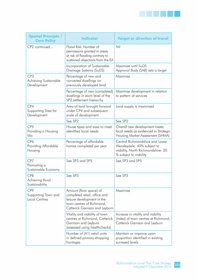
Richmondshire Local Plan Core StrategyAdopted 9 December 2014
Spatial Principle /Core Policy Indicator Target or direction of travel
CP2 continued... Flood Risk: Number of permissions granted in areas at risk of flooding contrary to sustained objections from the EA
Nil
Incorporation of Sustainable Drainage Systems (SuDS)
Maximise until SuDSApproval Body (SAB) sets a target
CP3Achieving Sustainable Development
Percentage of new and converted dwellings on previously developed land
Maximise
Percentage of new (completed) dwellings in each level of the SP2 settlement hierarchy
Maximise development in relation to pattern of services
CP4Supporting Sites for Development
Area of land brought forward under CP4 and subsequent scale of development
Land supply is maximised
See SP2 See SP2
CP5Providing a Housing Mix
House types and sizes to meet identified local needs
Overall new development meets local needs as evidenced in Strategic Housing Market Assessment (SHMA)
CP6Providing Affordable Housing
Percentage of affordable homes completed per year
Central Richmondshire and Lower Wensleydale: 40% subject to viability, North Richmondshire: 30 % subject to viability
CP7Promoting a Sustainable Economy
See SP3 and SP5 See SP3 and SP5
CP8Achieving Rural Sustainability
See SP3 See SP3
CP9Supporting Town and Local Centres
Amount (floor space) of completed retail, office and leisure development in the town centres of Richmond, Catterick Garrison and Leyburn
Maximise
Vitality and viability of town centres at Richmond, Catterick Garrison and Leyburn (assessed using healthchecks)
Increase in vitality and viability (index) of town centres at Richmond, Catterick Garrison and Leyburn
Number of (A1) retail units in defined primary shopping frontages
Maintain or improve upon proportion identified in existing surveyed levels
105

Richmondshire Local Plan Core StrategyAdopted 9 December 2014
Spatial Principle /Core Policy Indicator Target or direction of travel
CP10Developing Tourism
Number of new tourism related permissions(including change of use)
Maximise
CP11Supporting Community and Recreation Assets
Net change in availability of community facilities in each settlement
Maintain or improve upon existing surveyed levels
Number of planning applications and appeals affecting net change in availability of community facilities in each settlement
No applications/appeals result in loss of facility where need is proven
Recreational facilities provided in new developments
All new permissions for development generating need provide the required level and quality of facilities
CP12Conserving and Enhancing Environmental and Historic Assets
Change in priority habitats and species and areas designated for their environment value or geology
Minimise harmful change
Buildings At Risk Reduce number of Buildings At Risk
Production of Conservation Area Appraisals
Follow programme of appraisal production
Ability to deliver Humber RBMP actions
Maximise opportunities
CP13Promoting High Quality Design
No indicator No target
CP14Providing and Delivering Infrastructure
Additional Infrastructure provided
Infrastructure capacity maintained within identified thresholds
5.31 Sub Area Strategies monitoring will be achieved through the monitoring of the relevant Spatial Principles and Core Policies.
106

Richmondshire Local Plan Core StrategyAdopted 9 December 2014
Annex 1: Richmondshire Local Plan Superseded PoliciesThe policies in the following list were saved in 2007 under paragraph 1(3) of Schedule 8 to the Planning and Compulsory Purchase Act 2004. They were originally adopted in 2001 as part of The Richmondshire Local Plan. They have now been superseded and are no longer saved.
Richmondshire Local PlanPolicy No.
Richmondshire Local PlanPolicy Title
1 Basis for Development Control
2 Protection of the Countryside
3 Development in the Countryside
4 Hamlets and existing houses in the Countryside
5 Design in the Countryside
6 Areas of Outstanding Natural Beauty
7 Areas of Great Landscape Value
8 Landscape Zones
9 Brompton on Swale Riverside Protection Area
10 Structural Tree Belts
12 Traditional Barns and Barns Groups
14 Business in the Countryside
15 Agricultural Occupancy Conditions
19 Sites of Local Nature Conservation Interest
20 Habitats
24 Suburban Areas
25 Open Plan Estates
26 Land for Community Facilities
27 Open Land within Development Limits
28 Open Areas at Gatherley Road
29 Housing Allocations and Main Commitments
31 Housing Land Reserved for Later Development
34 Rural Areas Affordable Housing
35 Employment Land Allocations
38 Business Development
41 Archaeologically Sensitive Areas
42 Archaeological Interpretation
48 Alterations to Unlisted Historic Buildings
107

Richmondshire Local Plan Core StrategyAdopted 9 December 2014
Richmondshire Local PlanPolicy No.
Richmondshire Local PlanPolicy Title
51 Historic Shop Fronts
56 Open Land within Conservation Areas
57 Important Historic Vantage Points
58 Richmond: Residential Streets adjoining the Town Centre
59 Richmond: Improvements to Waterloo and Bank Yard
60 Richmond: Improvements to Gallowfields Trading Estate
62 Dual Use Facilities
63 Facilities in Villages
64 Recreational Open Space Standards
65 Open Space Allocations
67 Children’s Play
69 Scorton Lakes
71 Larger Scale Tourism Development
72 Areas for Leisure Based Development
73 Motorway Service Area
74 Camping, Caravanning and Chalet Development
75 The Coast to Coast Walk
77 The Wensleydale Railway
78 New Shopping Development in Richmond and Leyburn Town Centres
79 Shopping Facilities at Catterick Garrison and Colburn
80 Other New Shopping Developments
82 Richmond: Town Centre Shopping Area
83 Richmond: Primary and Secondary Shopping Frontages
84 Opportunity Area: Queens Road, Richmond
85 Community Facilities in Richmond Town Centre
87 Upper Floors and Underused Land in Town Centres and Shopping Areas
88 Signs and Advertisements in Town Centres and on Commercial Premises Elsewhere
91 Vehicle Parking Standards
93 Car Parking in Villages
95 Arrangements for Pedestrians in Richmond Market Place
96 Public Transport in Richmond Town Centre
99 Water and Sewerage Facilities
105 Individual Wind Turbines
106 Light Pollution
108

Richmondshire Local Plan Core StrategyAdopted 9 December 2014
Annex 2: Glossary and Acronyms
Glossary
Affordable Housing Social rented, affordable rented and intermediate housing, provided to eligible households whose needs are not met by the market. Eligibility is determined with regard to local incomes and local house prices. Affordable housing should include provisions to remain at an affordable price for future eligible households or for the subsidy to be recycled for alternative affordable housing provision.
Appropriate Assessment Assessment of plans and projects likely to have a significant effect on a European Site as required by Article 6(3) of the Habitats Directive.
Archaeological Interest An interest in carrying out an expert investigation at some point in the future into the evidence a heritage asset which may hold past human activity.
Asset Management Plan A strategic plan for managing an organisation’s infrastructure and other assets to deliver an agreed standard of service.
Baseline A description of the present and future state of an area, in the absence of any plan, including social, economic and environmental parameters.
Best and most versatile Land in grades 1, 2 and 3a of the Agricultural Land agricultural land Classification.
Biodiversity The variety and abundance of species, their genetic composition, and the natural communities, ecosystems and landscapes in which they occur.
Biodiversity Action Plan A strategy prepared for a local area aimed at conserving biological diversity.
Birds and Habitats Directives European Council Directive on the conservation of wild birds of 2 April 1979 (79/409/EEC) and 2009/147/EC, and Council Directive 92/43/EEC on the conservation of natural habitats and of wild fauna and flora of 21 May 1992.
Building Research Establishment A method of reviewing and improving theEnvironmental Assessment environmental performance of buildings.
Brownfield Opposite of Greenfield - same as Previously Developed Land.
109
Richmondshire Local Plan Core StrategyAdopted 9 December 2014
Climate Change Long term changes in temperature, precipitation, wind and all other aspects of the Earth’s climate. Often regarded as a result of human activity and fossil fuel consumption.
Conservation The process of maintaining and managing change to a heritage or natural asset in a way that sustains and, where appropriate, enhances its significance.
Conservation Area Areas of special architectural or historic interest, the character, appearance or setting of which it is desirable to preserve or enhance.
Contaminated Land Any land which appears to the Local Authority in whose area it is situated to be in such a condition by reason of substances in, or under the land, that (a) significant harm is being caused or there is significant possibility of such harm being caused or (b) pollution of controlled water is being, or is likely to be, caused.
Convenience Goods Widely distributed and relatively inexpensive goods which are purchased frequently and with minimum of effort, such as petrol, newspapers and most grocery items.
Core Strategy A Development Plan Document (DPD) setting out the spatial vision and strategic objectives of the planning framework for an area.
Communities and Local Central Government’s Communities and Local Government Government (CLG) department has a remit to promote
community cohesion and equality, as well as having responsibility for housing, urban regeneration, planning and local government.
Community Infrastructure Levy The Community Infrastructure Levy (CIL) was introduced by the Planning Act 2008. It came into force on 6 April 2010 through the Community Infrastructure Levy Regulations 2010. Development may be liable for a charge under the CIL, if the local planning authority has chosen to set a charge in its area.
Development Plan Document A DPD is a statutory spatial planning document that forms part of the Local Plan for a local authority area. It can be a Core Strategy, Area Action Plan as well as other key planning policy documents containing such things as generic development control policies.
English Heritage This Government body has responsibility for all aspects of protecting and promoting the historic environment.
Environment Agency The EA is the leading public body for protecting and improving the environment in England and Wales.
110

Richmondshire Local Plan Core StrategyAdopted 9 December 2014
Environmental Report This report is required by the SEA Directive as part of an environmental assessment which identifies, describes and evaluates the likely significant effects on the environment of implementing a plan or programme.
Equalities Impact Assessment A process designed to ensure that a policy, project or scheme does not disciminate against any disadvantaged or vulnerable people.
Floodplain Generally low lying areas adjacent to a watercourse, tidal lengths of a river or the sea, where water flows in times of flood or would flow but for the presence of flood defences.
Flood Risk Assessment An assessment of the likelihood of flooding in a particular area so that development needs and mitigation measures can be carefully considered.
Flood Risk Mitigation Managing and reducing the risk of flooding to communities and business.
Greenfield Opposite of Brownfield. It defines land (or a site) which has never been built on before or where the remains of any structure or activity have blended into the landscape over time.
Groundwater Water that is contained within underground rocks.
Habitat The place in which a species of animal or plant lives, providing a particular set of environmental conditions. Used in a wider sense to refer to major assemblages or communities of plants and animals found together.
Habitats Directive A European Union (EU) Directive which seeks to ensure the conservation and restoration of habitats.
Heritage Asset A building, monument, site, place, area or landscape positively identified as having a degree of significance meriting consideration in planning decisions. Heritage assets are the valued components of the historic environment. They include designated heritage assets and assets identified by the local planning authority during the process of decision-making or through the plan-making process (including local listing).
Historic Environment All aspects of the environment resulting from the interaction between people and places through time, including all surviving physical remains of past human activity, whether visible, buried or submerged, and landscaped and planted or managed flora.
Indicator A measure of variables over time, often used to measure achievement of objectives.
111

Richmondshire Local Plan Core StrategyAdopted 9 December 2014
Indices of Deprivation Measures of deprivation produced by CLG to identify areas of social and economic deprivation in England. They provide measurements of deprivation for Super Output Areas (SOA) and local authority areas in England.
Index of Multiple Deprivation An index made up from six indicators (income, employment, health deprivation and disability, education, skills and training, housing and geographical access to services) which can help identify areas for regeneration.
Indirect Effects Effects that are not a direct result of the strategic action but occur away from the original impact and/or as a result of a complex pathway.
Infrastructure The basic physical, social and economic structures and facilities (buildings, roads, power supplies, health facilities, green corridors) needed for the operation of a society or enterprise - the social and economic infrastructure of a country.
Infrastructure Delivery Plan Contains details of the infrastructure needed to support the delivery of the Core Strategy, who is responsible for providing it, how much it will cost and how it will be paid for.
Listed Building A building or other structure officially designated by the Secretary of State for Culture, Media and Sport as being of special architectural, historical or cultural significance.
Local Development Document LDDs include Development Plan Documents (which form part of the statutory development plan) and Supplementary Planning Documents (SPDs) (which do not form part of the statutory development plan). LDDs collectively deliver the spatial planning strategy for the local planning authority’s area.
Local Development Scheme Sets out the local planning authority’s programme for preparing Local Development Documents (LDDs).
Local Plan Local development plan produced by the local planning authority as required by the Localism Act 2011 and NPPF.
Mitigation Measures that can be taken to avoid, reduce or offset the significant adverse effects.
National Planning Policy Central Government policy statement which Framework replaced Planning Policy Statements and Guidance Notes (PPSs and PPGs).
National Planning Practice Guidance elaborating implementation of National Guidance Planning Policy Framework.
112

Richmondshire Local Plan Core StrategyAdopted 9 December 2014
Natura 2000 A Europe wide network of nature protection areas established under the 1992 Habits Directive.
Natural England The Government Agency established to conserve and enhance the natural environment, for its intrinsic value, the well being and enjoyment of people and the economic prosperity that it brings.
Nature Conservation The protection, management and enhancement of wildlife habitats, wild species, geological features and processes.
Objective A statement of what is intended, specifying the desired direction of change in trends.
Plan A set of co-ordinated and timed objectives for the implementation of a policy.
Policy The inspiration and guidance for action, setting a framework for subsequent plans and programmes.
Previously Developed Land Land which is or was occupied by a permanent structure, including the curtilage of the developed land and any associated fixed surface infrastructure. The definition makes exclusion for agricultural or forestry buildings, minerals or waste, residential gardens, parks, recreation grounds, allotments, pavilions and other buildings and land which has blended into the landscape over time.
Primary Retail Area Defined area where retail development is concentrated - generally comprising the primary and those secondary frontages which are contiguous and closely related to the primary shopping frontage.
Programmes A proposed set of linked projects or a series of similar or related projects proposed within a particular area.
Proposals Map An Ordnance Survey based map which identifies areas of protection, and sites for particular future uses.
Registered Provider Replaces the former Registered Social Landlord (RSL) as a provider of social housing, which can now be either a non-profit or a profit-making organisation.
Scheduled Monument A monument scheduled by the Secretary of State for Culture, Media and Sport protected under the Ancient Monuments and Archaeological Areas Act 1979.
Scoping The process of deciding the scope and level of detail of a SA/SEA, including the sustainability effects and options which need to be considered, the assessment methods to be used, and the structure and contents of the report.
113
Richmondshire Local Plan Core StrategyAdopted 9 December 2014
Strategic Housing and The primary role of the SHELAA is to identify sites withEmployment Land Availability potential for housing or employment uses, assess theirAssessment potential and when they are likely to be developed.
Strategic Housing Market A SHMA is a key part of the evidence base required to Assessment ensure the delivery of housing that meets the needs of communities now and in years to come.
Sites of Special Scientific The finest sites for wildlife and natural features in Interest England which support many characteristic rare and endangered species or habitats and are protected
under Section 28 of the Wildlife and Countryside Act 1981 as amended.
Special Area of Conservation A site designated under the European Community Habitats Directive to protect internationally important natural habitats and species. Part of the Natura 2000 Network.
Special Protection Area A site designated under the European Community Directive on the Conservation of Wild Birds, to protect
naturally occurring birds in the wild state. Part of the Natura 2000 Network.
Stakeholder An individual, group or organisation with an interest in a plan, policy or programme.
Statement of Community A statement setting out the consultation procedures Involvement procedures for a local planning authority.
Statutory Consultation Bodies Consultation bodies who must be consulted in the SEA/SA process. The statutory consultation bodies are the Environment Agency, English Heritage and Natural England.
Strategic Environmental A method or procedure of predicting the effects on theAssessment environment of a plan, with the aim of taking account
of these effects in decision making.
SEA Directive Strategic Environmental Assessment (European) Directive 2001/42/EC on the assessment of the effects of certain plans and programmes on the environment.
Super Output Areas Small areas within electoral wards used for statistical comparison of census data.
Supplementary Planning Non statutory planning documents that Document Document provide supplementary information in respect of the policies in DPDs.
114

Richmondshire Local Plan Core StrategyAdopted 9 December 2014
Sustainability Appraisal A form of assessment that considers social, economic and environmental effects of Local Development
Documents (LDDs) and appraises them in relation to the aims of sustainable development.
Sustainable Development A widely used definition drawn up by the World Commission on Environment and Development in 1987: “Development that meets the needs of the present without compromising the ability of future generations to meet their own needs.”
Sustainable Transport Modes Any means of transport with low impact on the environment, including walking and cycling, green or low emission vehicles, car sharing and public transport.
Target Detailed, quantitative objectives that can be monitored.
Travel Plan A general term for a package of measures aimed at promoting greener, cleaner, travel choices with a specific emphasis on reducing single-occupancy car journeys.
115

Richmondshire Local Plan Core StrategyAdopted 9 December 2014
AHVA Affordable Housing Viability Assessment
AONB Area of Outstanding Natural Beauty
AMP Asset Management Plan
AMR Annual Monitoring Report
BAP Biodiversity Action Plan
BREEAM Building Research Establishment, Environmental Assessment Method
CGLTDP Catterick Garrison Long Term Development Plan
CHP Combined Heat and Power
CIL Community Infrastructure Levy
CLG Department for Communities and Local Government
CRSS Central Richmondshire Spatial Strategy
CSH Code for Sustainable Homes
DPD Development Plan Document
EA Environment Agency
EC European Community
ELR Employment Land Review
EqIA Equalities Impact Assessment
ESCO Energy Service Company
EU European Union
GWh Gigawatt Hours
IDP Infrastructure Delivery Plan
IMD Index of Multiple Deprivation
LDD Local Development Document
LDS Local Development Scheme
LSS Local Strategy Statement
LPA Local Planning Authority
LTP Local Transport Plan
LWSS Lower Wensleydale Spatial Strategy
MAGIC Multi Agency Geographic Information for the Countryside
MoD Ministry of Defence
MW Megawatts
NOMIS National Online Manpower Information System
NPPF National Planning Policy Framework
NPPG National Planning Practice Guidance
NRSS North Richmondshire Spatial Strategy
NYCC North Yorkshire County Council
ONS Office of National Statistics
OS Ordnance Survey
RSS Regional Spatial Strategy
RSVCI Richmond and Swale Valley Community Initiative
SA Sustainability Appraisal
SAC Special Area of Conservation
SCI Statement of Community Involvement
SEA Strategic Environmental Assessment
SFA Service Families Accommodation
SFRA Strategic Flood Risk Assessment
SHMA Strategic Housing Market Assessment
SINC Site of Importance for Nature Conservation
SHELAA Strategic Housing and Employment Land Availability Assessment
SHMA Strategic Housing Market Assessment
SM Scheduled Monument
SOA Super Output Area
SPA Special Protection Area
SPD Supplementary Planning Document
SRN Strategic Road Network
SSSI Site of Special Scientific Interest
SuDS Sustainable Drainage Systems
WWTW Waste Water Treatment Works
Acronyms
116


Richmondshire District CouncilMercury House, Station Road, Richmond DL10 4JX
01748 829100
richmondshire.gov.uk
© Communications Unit HDC 2015
This information is available in alternative formats and languages