rio grande wild and scenic river - texas
TRANSCRIPT

National Park Service U.S. Department of the Interior
Rio Grande Wild and Scenic River
Rio Grande Wild and Scenic River
Final General Management Plan / Environmental Impact Statement
Texas

Original art by George Pettit used with permission of the artist.

__________________________________________________________________________________________
Final General Management Plan / Environmental Impact Statement
RIO GRANDE WILD AND SCENIC RIVER Brewster and Terrell Counties, Texas
August 2004
Congress designated a segment of the Rio Grande in Texas as the Rio Grande Wild and Scenic River in 1978 because of its “outstandingly remarkable” scenic, geologic, fish and wildlife, and recreational values. A 196-mile strip of land on the American side of the Rio Grande in the Chihuahuan Desert protects the river. The National Park Service (NPS) at Big Bend National Park is responsible for managing the wild and scenic river. This General Man-agement Plan / Environmental Impact Statement will define a direction for the management of the Rio Grande Wild and Scenic River for the next 15 to 20 years, specifying the resource conditions and visitor experiences that the National Park Service would like to achieve.
To establish the desired experiences and resource conditions for the wild and scenic river, a partnership team was established with representatives from Texas Parks and Wildlife, local counties, an international environmental organization, river user groups, and private landowners. On the basis of public comments and within the framework established by legislation and mandates, the planning team and partners developed a no-action alternative (continuation of current management) and an “action” alternative for managing the wild and scenic river.
Alternative A, the no-action alternative, would continue current management practices into the future. Its goal would be to retain the existing visitor experiences. No new management plan would be implemented. The National Park Service would respond to future needs and conditions associated with the existing wild and scenic river designation without major actions or changes in course. Compliance with the Wild and Scenic Rivers Act and associated guidelines requires a river management plan, which would not be prepared under this alternative. No agreements with landowners would be initiated, and there would be no changes in river access from federal land. Private and state landowners could open or close public access as they wished. The river boundary would remain at the default 0.25 mile from the ordinary high water mark on the United States side of the river.
The intent of Alternative B, the preferred alter-native, would be to enhance resource protection and offer high-quality visitor experiences. The protection of natural and cultural resources would be emphasized, as would the visitor experience. A permanent boundary for the wild and scenic river would be established to reflect the river’s outstandingly remarkable values. The National Park Service would negotiate individual agreements with each nonfederal landowner to specify the rights and responsibilities of the National Park Service and each landowner. The National Park Service would recommend to Congress that the upper segment of the Rio Grande in Big Bend National Park be designated a wild and scenic river, bringing the total federal and state ownership along the river to more than 50%.
Alternative A (which would continue the management pattern of the past 25 years) would not ensure the protection of outstandingly remarkable values on private lands. It would mean that no partnership for resource protection would be established between the National Park Service and private landowners. Resources could be damaged, and private lands now available to the public for recreational use at the sufferance of landowners could be closed off. The National Park Service would not assist private landowners in resource protection or law enforcement, and there could be continued mistrust of NPS intentions with respect to regulations and land acquisition.
Landowner agreements in alternative B would foster a cooperative relationship, allowing the National Park Service to play a role in protecting resources and values on nonfederal lands. NPS assistance would be available to landowners to protect outstandingly remarkable values on their land. An increase in Big Bend National Park staff would be included in this alternative. Beneficial effects on landowner relations, natural resources, cultural resources, scenic values, and recreational use would result from alternative B.
United States Department of the Interior • National Park Service

(blank)
ii

SUMMARY
Congress designated a segment of the Rio Grande in Texas as the Rio Grande Wild and Scenic River in 1978 because of its “outstandingly remarkable” scenic, geologic, fish and wildlife, and recreational values. A 196-mile strip of land on the American side of the Rio Grande in the Chihuahuan Desert protects the river. The responsibility for managing the wild and scenic river was given to the National Park Service at Big Bend National Park, but no management plan has been approved that would guide the long-term management of the wild and scenic river.
The purposes of this General Management Plan / Environmental Impact Statement are to define a direction for the management of the Rio Grande Wild and Scenic River and to specify the resource conditions and visitor experiences to be achieved on the wild and scenic river. The plan is intended to provide a framework to help guide management programs and set priorities for the next 15 to 20 years. The approved plan will provide a framework for making decisions about the future direction for the management and use of the wild and scenic river.
In this plan, the official boundary of the Rio Grande Wild and Scenic River is described. Within that boundary, the outstandingly remarkable scenic, geological, fish and wildlife, recreational, scientific, and cultural values would be protected and the rights and needs of private property owners respected.
The National Park Service (NPS) regards the public as an integral team member in establishing the desired experiences and conditions of resources that will guide the management of the Rio Grande Wild and Scenic River. A vital partnership team was established with representatives from Texas Parks and Wildlife, local counties, an international environmental organization, river user groups, and private landowners.
ALTERNATIVES
On the basis of public comments and within the framework established by legislation and mandates, the planning team and partners developed a no-action alternative (continuation of current management) and an “action” alternative for the management of the wild and scenic river.
Alternative A: Existing Management Direction (No Action)
The no-action alternative represents the existing conditions at the Rio Grande Wild and Scenic River and what would happen if the current management practices continued into the future. The goal in this alternative would be to maintain the existing visitor experiences and the river’s outstandingly remarkable values of scenery, recreation, geology, fish and wildlife, cultural resources, and scientific resources. No management plan would be implemented, and the Rio Grande Wild and Scenic River would be managed as at present.
“No action” does not imply or direct discontinuing the present uses or management actions or removing the existing designation. The National Park Service would respond to future needs and conditions associated with the existing wild and scenic river designation without major actions or changes in course. The river would continue to be managed without conflicting with the Wild and Scenic Rivers Act and associated guidelines, NPS management policies, and current park management and implementation plans. No agreements with landowners would be implemented; the National Park Service would not make any changes in river access; and private and state landowners could open or close public access as they wished. The river boundary would remain at the default 0.25 mile from the
iii

SUMMARY
ordinary high water mark on the United States side of the river.
Alternative B: Enhance Resource Protec-tion and Continue High-Quality Visitor Experiences (Preferred Alternative)
The concept of alternative B, the alternative preferred by the National Park Service, would be to emphasize the protection of natural and cultural resources and of the visitor experience in the Lower Canyons (outside of Big Bend National Park boundaries). This would be done by enlisting landowners as full partners in protecting resources and establishing a permanent boundary reflective of outstandingly remarkable values.
A cornerstone of the preferred alternative is the implementation of individual agreements that the National Park Service would negotiate with each nonfederal landowner. These binding landowner agreements would specify what rights and responsibilities the National Park Service and each landowner would have in regard to the property within the established boundary. The National Park Service would discuss with landowners the outstandingly remarkable values on the property and boundary appropriate to protect those values. The agreements also would foster a spirit of cooperation instead of confrontation.
As another component of this alternative, the upper segment of the Rio Grande in Big Bend National Park would be recommended for wild and scenic river designation by Congress. This additional designation would bring the total federal and state ownership along the river to more than 50%, thus prohibiting the acquisition of fee title through condemnation of nonfederal lands. This point is extremely important among private landowners in the area.
ENVIRONMENTAL CONSEQUENCES
The consequences to the environment, to the visitor experience, and to nonfederal landowners that could result from each alternative were evaluated.
Effects of Alternative A
With the existing default 0.25-mile boundary remaining in effect and no agreements being made between the National Park Service and private landowners under alternative A, the protection of outstandingly remarkable values on private lands would not be ensured. Partnerships would not be established between the National Park Service and landowners to protect the resources. Resources could be damaged, and private lands now available for public recreational use could be closed off. Without landowner agreements, the National Park Service would not be able to help landowners in resource protection or law enforcement, and there could be continued mistrust of NPS intentions with respect to regulations and land acquisition.
Effects of Alternative B
Implementing agreements with landowners would foster a cooperative relationship, allowing the National Park Service to play a role in the protection of resources and values on nonfederal lands along the wild and scenic river. Clauses in the agreements would allow the National Park Service to consult with and assist landowners in preserving outstandingly remarkable values and managing the use of their property by visitors. A recommendation to increase the staff of Big Bend National Park for river management would be included in this alternative. Beneficial effects on landowner relations, natural resources, cultural resources, scenic values, and recreational use would be realized from alternative B.
iv
CONTENTS
Purpose and Need
Purpose of and Need for the Plan 3Introduction 3Purpose 3Need 4
Background 5Description and Location 5
Location 5Outstandingly Remarkable Values 5
Legislation and Mandates 6Relationship to Other Planning Documents 11Definitions of Special Terms 11
Purpose, Significance, and Goals 13Mission Statement 13Purpose and Significance of the Rio Grande Wild and Scenic River 13Goals 13
Issues and Impact Topics 15Public Involvement 15Issues and Concerns 15
Recreation and Tourism 15Natural Resources 16Cultural Resources 16Water Resources 16Landowner Interests 17Legal Issues 17Partnerships and Administrative Relationships 17
Impact Topics 18Scenic Values 18Fish and Wildlife 18Special Status Species 18Archeological Resources 18Historic Structures 18Visitor Experience and Understanding (Recreational Use) 18Water Quality and Quantity 18Vegetation 19Nonfederal Lands within the River Boundary 19Socioeconomic Conditions 20Partnerships and International Cooperation 20
Impact Topics Dismissed from Further Consideration 20Soils 20Geology and Topography 20Selected Threatened, Endangered, and Candidate Species 21Cultural Landscapes 21Ethnographic Resources 21Museum Collections 22Night Sky 22Soundscapes 22Energy, Depletable Resource Requirements, and Conservation Potential 22Urban Quality and the Design of the Built Environment 22
v

CONTENTS
Air Quality 22Public Health and Safety 23Wilderness 23Floodplains and Wetlands 23Prime and Unique Farmlands 23Indian Trust Resources 24Environmental Justice 24
Alternatives, Including the Preferred Alternative
Introduction 27Alternative A: Existing Management Direction (No Action) 28
Introduction 28River Management 28
Boundary 28Management of Corridor on Nonfederal Lands 29
Land Acquisition and Rights-of-Way 29Natural Resources 29Cultural Resources 29Visitor Experience and Understanding 29Partnerships and International Cooperation 30Implementation 30
Alternative B: Enhance Resource Protection and Continue High-Quality Visitor Experiences (Preferred Alternative) 32Introduction 32Management Prescriptions 32
Management Prescriptions Common to All Zones 32Management in Specific Zones 33
River Management 33Additional Designation 34Boundary and Nonfederal Lands 38Land Acquisition and Rights-of-Way 39Cultural Resources 40Natural Resources 40Visitor Experience and Understanding 43
All Segments 43Segments in Big Bend National Park 44Segments Adjacent to Nonfederal Land 45
Interpretation and Education 46Partnerships and International Cooperation 46Implementation 47Mitigating Measures 47
Natural Resources 47Cultural Resources 48Visitors and Nonfederal Landowners 48New Structures 48
Alternatives Dismissed from Further Consideration 48Omit Landowner Agreements in the Lower Canyons 48Set the Management Boundary at the High Water Mark 48Deauthorize the Wild and Scenic River Designation 48
The Environmentally Preferable Alternative 49Cost Estimates 50Comparison of Alternatives and Consequences 51
vi
Contents
Affected Environment
Introduction and Description 55Access 55Ownership 55Existing Development 55Land Uses 55
Resources That Could Be Affected 56Natural Resources 56
Scenic Value 56Fish and Wildlife 56Special Status Species 56Water Quantity and Quality 57Vegetation 58
Cultural Resources 59Visitor Experience and Understanding 60
Recreation 60Historic Recreational Use on the Rio Grande, Lajitas to Val Verde County Line 62
Boundary and Nonfederal Lands 62Socioeconomic Conditions 64
Brewster County 64Terrell County 64Study Area Population Records 65Study Area Economic Conditions Since 1950 65Economic Impacts of Visitor Spending 65
Partnerships and International Cooperation 65
Environmental Consequences
Introduction and Methodology 69Introduction 69Methods of Assessing Effects 69
Duration 69Location 69
Cumulative Effects 69Projects That Make up the Cumulative Impact Scenario 70Assumptions 71
Impairment of Park Resources or Values 71Effects on Natural Resources 73
Scenic and Aesthetic Values 73Fish and Wildlife 74Special Status Species 76Water Quality and Quantity 79Vegetation 81
Effects on Cultural Resources 84Effects on Cultural Resources and Section 106 Analyses 84Archeological Resources 84Historic Structures 86
Visitor Experience and Understanding 89Methods of Assessing Effects 89Effects of Alternative A 89
Analysis — Segments in Big Bend National Park 89Analysis — Segments outside of Big Bend National Park 89
vii

CONTENTS
Cumulative Effects 89Conclusion 90
Effects of Alternative B 90Analysis — Segments in and outside of Big Bend National Park 90Cumulative Effects 90Conclusion 90
Effects on Social Conditions — Boundary and Nonfederal Lands 91Methods of Assessing Effects 91Effects of Alternative A 91
Analysis — Segments in Big Bend National Park 91Analysis — Segments outside of Big Bend National Park 91Cumulative Effects 91Conclusion 92
Effects of Alternative B 92Analysis — Segments in Big Bend National Park 92Analysis — Segments outside of Big Bend National Park 92Cumulative Effects 92Conclusion 92
Effects on Socioeconomic Conditions 93Methods of Assessing Effects 93Effects of Alternative A 93
Cumulative Effects 93Conclusion 93
Effects of Alternative B 94Analysis — Segments in and outside of Big Bend National Park 94Cumulative Effects 94Conclusion 94
Partnerships and International Cooperation 95Methods of Assessing Effects 95Effects of Alternative A 95
Analysis — Segments in Big Bend National Park 95Analysis — Segments outside of Big Bend National Park 95Analysis — Trans-boundary Issues 95Cumulative Effects 95Conclusion 95
Effects of Alternative B 96Analysis — Segments in and outside of Big Bend National Park 96Analysis — Trans-boundary Issues 96Cumulative Effects 96Conclusion 96
Required Analyses 97Relationships of Short-term Uses of the Environment and Long-term Productivity 97Irreversible and Irretrievable Commitment of Resources 97Unavoidable Adverse Impacts 97
Consultation and Coordination
The Planning Process 101Involvement of Other Agencies and the Public 102
How This Plan Was Developed 102The Partnership Team 102Preparing a Final Plan 103
Consultation 104
viii

Contents
Cultural Resources 104Endangered Species 104American Indian Involvement 104
Agencies and Organizations to Which Notification of the Draft and Final Documents Was Sent 106Comments Received on the Draft Document 108
Regulations for Handling Comments 108NPS Actions 108
Public Meetings 108Letters and Electronic Messages 109
Changes Resulting from Comments 109Responses to Comments 109
Appendixes / References / Preparers / Index
Appendixes A: Legislation 141B: Correspondence from U.S. Fish and Wildlife Service about Sensitive Species 143C: Sample Landowner Agreement 147
D: Texas Recreation Use Statute 156
Selected References 161
Preparers of Document 163
Index 164
Illustrations
Figure 1: Number of River Users by Canyon 63
Maps:
Location / Current Management 7 Alternative B 35 Proposed Boundary 41
ix

CONTENTS
Tables
1. Ownership of Land along Rio Grande Wild and Scenic River 28 2: Existing Recreational River Use Limits in Big Bend National Park 31 3: Ownership of Segments of Rio Grande Wild and Scenic River, as Proposed in Alternative B 34 4: Management Prescriptions 37 5. Proposed Classifications of Segments of Rio Grande Wild and Scenic River, Including Proposed
New Segment — Alternative B 38 6: Limits on Recreational Use by Segment — Alternative B 45 7: Cost Estimates for Alternative B (2002 dollars) 50 8: Comparison of Alternatives 51 9: Comparison of Environmental Consequences 52 10: 1998–2000 River Use, Lajitas to Val Verde County 6211: Visitation to the Lower Canyons of the Rio Grande, 1999–2001 6312: Selected Economic Information, Alpine and Sanderson, Texas 65 13: Population Trends, 1950–2000 66 14: Study Area Per Capita Income 1950–1999 66
x
Purpose and Need

PURPOSE AND NEED
(blank)
2
PURPOSE OF AND NEED FOR THE PLAN
INTRODUCTION
This General Management Plan / Environ-mental Impact Statement River presents and analyzes two alternative future directions for the management and use of the Rio Grande Wild and Scenic River. One of the alternatives, alternative B, has been identified as the alternative the National Park Service (NPS) prefers. The potential environmental impacts of both alternatives have been identified and assessed.
A general management plans is intended to be a long-term document that establishes and articulates a management philosophy and framework to guide decision-making for a period of 15 to 20 years. The plan will establish goals for desired future conditions of resources and visitor experiences, but it will not commit to specific actions to achieve these conditions. Such specific actions will be determined in lower-level planning documents. The purpose of a general management plan is to be a general programmatic-level document; therefore, the analysis of potential impacts in the environmental impact statement is also general.
This plan for the Rio Grande Wild and Scenic River contains several chapters. This chapter contains an explanation of why the plan is necessary and what it will accomplish, along with background information about the wild and scenic river. The river’s purpose and significance are explained, and the management goals for this area are described. The legislative commitments, mandates, and policies that have guided and continue to guide the management of the river are discussed, as are the major issues and concerns that are addressed in the plan. Special terms used in this document are defined on page 11.
The “Alternatives” chapter presents two alternatives for the management of the wild and scenic river. Alternative A, the no-action alter
native, would continue the current approach to managing the wild and scenic river. This is required as a baseline of comparison for other “action” alternatives. Alternative B would follow the management approach preferred by the National Park Service (NPS) and its key partners.
The “Affected Environment” chapter contains a description of selected natural and cultural resources, the available visitor experience, and the socioeconomic conditions in the Rio Grande region that might be affected by implementing this plan.
The “Environmental Consequences” chapter contains descriptions of the potential effects on the environment that could result from each alternative.
In the “Consultation and Coordination” chapter are descriptions of the processes used by the planning team to solicit public comments and to consult with other agencies. Comments that were received about the draft document also are addressed in this chapter, along with responses to those comments.
Further information about legislation and a sample landowner agreement are included in the appendixes.
PURPOSE
The primary purpose of this plan is to protect the free-flowing river and provide a foundation from which to protect natural and cultural resources while providing for meaningful visitor experiences. A secondary purpose is to encourage compatible activities on adjacent lands so as to minimize adverse effects on river values. Although this plan will provide overall direction for river management, subsequent action plans, such as a river use management plan, may be necessary to guide specific actions for implementing the plan. This plan fulfills the obligation for a comprehensive
3

PURPOSE AND NEED
river management plan required by the Wild and Scenic Rivers Act.
This plan will specify the desired future resource conditions and visitor experiences in the Rio Grande Wild and Scenic River and prescribe management strategies for achieving those conditions. This conceptual plan will provide the basic framework for decision-making for the next 15 to 20 years. It contains a map and a description of the proposed boundary of the wild and scenic river, within which the outstandingly remarkable scenic, recreational, geologic, fish and wildlife and cultural values would be protected and the needs of private property owners respected. (Also see appendix A, “Legislation.”)
Part 1 (b) of the Wild and Scenic Rivers Act (16 USC 1271-1287; Public Law 90-542 of October 2, 1968) designates that outstandingly remarkable values are to be protected, as follows:
It is hereby declared to be the policy of the United States that certain selected rivers of the Nation which, with their immediate environments, possess outstandingly remarkable scenic, recreational, geologic, fish and wildlife, historic, cultural, or other similar values, shall be preserved in free-flowing condition, and that they and their immediate environments shall be protected for the benefit and enjoyment of present and future generations.
The National Park Service has developed a series of management objectives to guide future decision-making (see “Goals” beginning on p. 13).
Actions directed by general management plans or in subsequent implementation plans are accomplished over time. Budget restrictions, requirements for additional data or regulatory compliance, and competing national park system priorities might prevent the immediate implementation of some actions. Major or especially costly actions could be implemented ten or more years into the future.
NEED
According to the Wild and Scenic Rivers Act, the boundaries and classification are to be completed within one year after designation. After the designation of a river, a comprehensive river management plan with official boundaries is to be completed within three years. The Rio Grande Wild and Scenic River was designated in 1978, and the National Park Service developed a general management plan / development concept plan for the river in 1981. According to that plan, the boundary of the wild and scenic river was to include only the area from the center of the river to the gradient boundary on the United States side. The National Park Service, in consultation with the Department of the Interior So-licitor’s Office, later determined that boundary to be inadequate to protect the outstandingly remarkable values, and hence legally deficient. The plan never was implemented. Later, congressional action specified that the boundaries on all wild and scenic rivers without approved management plans were, by default, 0.25 mile from the ordinary high-water mark.
Therefore, there never has been a plan to guide the long-term management of the Rio Grande Wild and Scenic River. A plan is needed to identify and protect specific outstandingly remarkable values and to comply with the law, NPS Management Policies 2001 and Director’s Order (DO) 2, Planning Process Guidelines.
In addition, preparing this plan presents an excellent opportunity to foster cooperative working relationships between the U.S. government, represented by the National Park Service, and state and local governments, river users, owners of adjacent property, and the government of Mexico.
4

BACKGROUND
DESCRIPTION AND LOCATION
In 1978 Congress designated a segment of the Rio Grande a national wild and scenic river under the Wild and Scenic Rivers Act (16 USC 28 §1274):
The segment on the United States side of the river from river mile 842.3 above Mariscal Canyon downstream to river mile 641.1 at the Terrell–Val Verde County line, to be administered by the Secretary of the Interior . . .
The International Boundary and Water Commission later revised the river miles on the Rio Grande, changing the beginning and ending points to 853.2 and 657.5, respectively. This component of the national wild and scenic river system is unique in that only half of the river is designated. The southern half of the river could not be included in the designation because it is owned by Mexico.
Location
The designated stretch of the Rio Grande begins in Big Bend National Park, opposite the boundary between the Mexican states of Chihuahua and Coahuila. It then flows through Mariscal and Boquillas canyons in the national park. Downstream from the park, it extends along the state-managed Black Gap Wildlife Management Area and several parcels of private land in the Lower Canyons. The wild and scenic river segment ends at the county line between Terrell and Val Verde counties, Texas (see the Location / Current Management map).
Outstandingly Remarkable Values
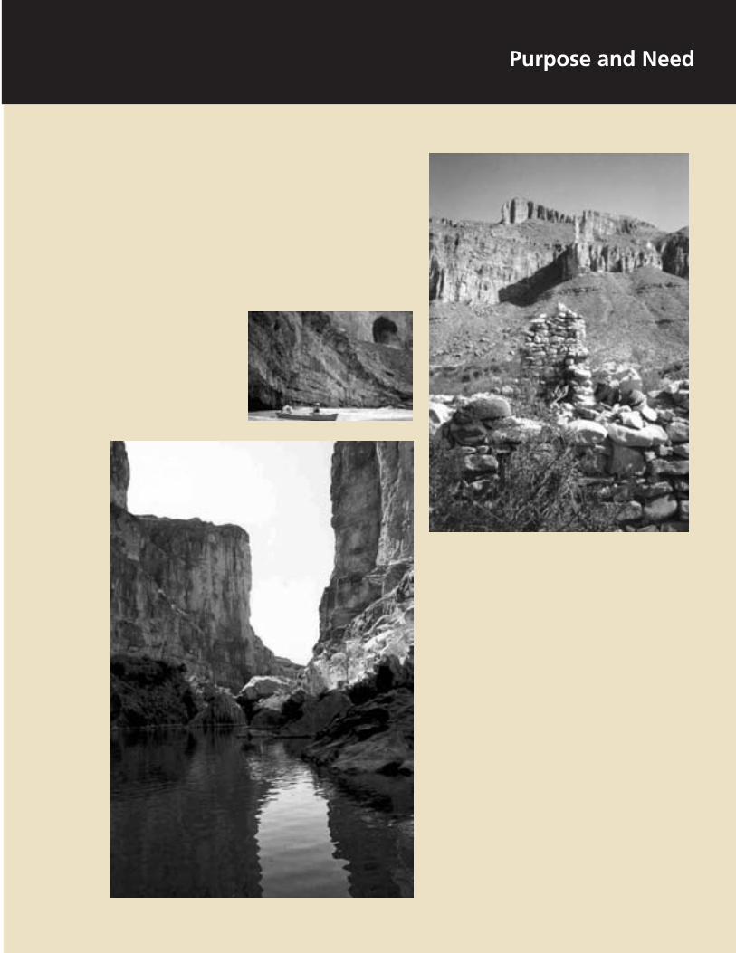
Congress designated the Rio Grande Wild and Scenic River because of its outstandingly remarkable scenic, geologic, fish and wildlife, recreational, and other similar values.
Scenic Values. Rugged canyons, verdant riparian areas, scenic rapids, and unspoiled views contribute to the scenic allure and outstanding visual quality of this area.
Geologic Features. Rock layers exposed by the Rio Grande were deposited about 100 million years ago. Subsequent uplifting, folding, faulting, and cutting of the river have produced the present topography. Near its upstream end, the Rio Grande has sliced through the surrounding rocks to form steep-walled, sometimes narrow canyons. Downstream from Boquillas Canyon, the river flows across a relatively broad and open floodplain, or vega. Near Reagan Canyon, the floodplain narrows abruptly, and the river flows in a continuous deeply cut canyon for almost 40 miles. In the Lower Canyons portion of this segment, the river and its tributaries lie 500 to 1,500 feet below the surrounding plateaus.
Fish and Wildlife. The Rio Grande Wild and Scenic River corridor represents an exceptional example of Chihuahuan Desert fauna in association with species that depend on the rare aquatic and riparian habitats of the river. It is an isolated outpost of rapidly dwindling and irreplaceable natural resources such as several fauna in association with species, including threatened and endangered species, that depend on the rare aquatic and riparian habitats of the river. A number of wildlife species (especially birds) use the Rio Grande as a travel corridor. Many species of animals depend on the riverine habitat for survival.
Recreational Opportunities. Spectacular river canyons, occasional rapids, the primitive character of the river, and its international flavor create a stimulating environment for a high-quality recreational experience. The river can be enjoyed from canyon rims, along the shore, or in a boat. The designated segment is long enough to offer several varied and meaningful recreational experiences lasting from a few hours to several days.
5

PURPOSE AND NEED
LEGISLATION AND MANDATES
The development of this plan has proceeded within a complex legal framework. It was developed pursuant to the National Environmental Policy Act of 1969 (NEPA), Public Law 91-190, and the regulations of the Council on Environmental Quality (CEQ) (40 CFR 1508.22). The plan must comply with the requirements of the Wild and Scenic Rivers Act, NPS policies, and other legal mandates, as summarized below. The policies and practices listed below would continue to guide the management of the Rio Grande Wild and Scenic River under either alternative. The intent of the laws and policies is to establish sustainable conservation and to avoid the impairment of designated rivers or NPS lands and resources.
Wild and Scenic Rivers Act — Congress created the national wild and scenic rivers system in 1968 (through Public Law (PL) 90-542; 16 USC 1271 et seq.) to protect water quality and to preserve in a free-flowing condition certain rivers with outstandingly remarkable natural, cultural, or recreational values for the enjoyment of present and future generations. An underlying principle of the act is to promote partnerships among landowners, river users, tribal nations, and all levels of government. As of December 2000, the national system had grown from its initial eight components to a 160-river system.
Rivers may be designated by Congress (usually following a study by a federal agency) or, under certain conditions, by the secretary of the interior. Each river is administered by a federal or state agency. The designation may not include the entire river, but it usually includes a segment within a corridor of about 0.25 mile (not to exceed 320 acres per river mile) on each side of the river so that related natural, cultural, and recreational values will be protected. In the case of the Rio Grande Wild and Scenic River, the corridor extends only on the United States side of the river and may not exceed 160 acres per river mile (a total of 31,312 acres).
Congress passed legislation in 1986 that set boundaries of 0.25 mile from the ordinary high water mark for any wild and scenic rivers for which no permanent boundaries had been established by a management plan.
Each designated river is managed with the goal of nondegradation and the enhancement of the values for which it was designated. Other uses (including recreation, a variety of agricultural practices, and residential development) may continue if not otherwise precluded. In most cases, not all land within the boundaries is publicly owned. In fact, there are limitations on how much land a federal agency is allowed to acquire. Designation does not affect existing water rights or existing jurisdiction of states and the United States over waters as determined by established principles of law.
Although the act provides numerous measures to protect and enhance a river’s values, the most significant restrictions are provided in section 7, in which the act specifically prohibits federally assisted or sponsored water resource projects that would impede a wild and scenic river’s free flow or cause direct and adverse effects on its outstandingly remarkable values.
The Wild and Scenic Rivers Act in section 6 authorizes the U.S. government to acquire land within a designated river’s corridor for river management purposes. Acquisition in fee title is limited to not more that 100 acres per river mile. Lands owned by a state may be acquired by donation only. If 50% or more of the entire acreage outside the ordinary high water mark is in federal, state, or local government ownership, the U.S. government cannot acquire fee title through condemnation. This section also grants the authority to acquire easements that are necessary to provide public access to and on the river.
6

385
285
BIG BEND National Park
118
170
Elephant Mtn. WMA
AlpineMarfa
Presidio Co.Presidio Co.
Presidio
Marathon
Brewster Co.Brewster Co. Terrell Co.Terrell Co. Val Verde Co.
Black Gap WMA
Canon de Santa Elena Protected Area
Santa Elena
Boquillas
Maderas del Carmen Protected Area
La LindaBig Bend Ranch State Park Study Butte
Rio
Grande Wild and Scenic River
Texas Big Bend National Park
0 3 6 9 12 18 Miles
North
T E X A S
UNITED STATES
CHIHUAHUA
COAHUILA
~
Access Points
Dirt Roads +
+
+
+ +
Rio Grande Wild and Scenic River
M E X I C O Location / CurrentManagement Rio Grande Wild and Scenic River National Park Service U.S. Department of InteriorDSC / Sept 03 / 192 / 20003

PURPOSE AND NEED
(blank back of map)
8

Background
Section 10(a) of the act says, “Each component of the national wild and scenic rivers system shall be administered in such a manner as to protect and enhance the values which caused it to be included in said system.” It also says, “Primary emphasis shall be given to protecting its esthetic, scenic, historic, archeological and scientific features.” The National Park Service interprets this section as declaring a nondegradation and enhancement policy for all designated rivers, regardless of classification.
Section 10(b) stipulates that when a wild and scenic river flows through designated wilderness, the river will be managed by the most restrictive provisions under either designation. This will apply if Congress designates the proposed wilderness in Big Bend National Park.
Section 10(e) of the act encourages cooperative agreements with state agencies in the planning and administration of wild and scenic rivers that include state lands, as in the case of the Rio Grande.
Section 13 says that the state retains the jurisdiction in regard to fish and wildlife management and navigable streams. That section also says that state jurisdiction over the waters of a wild and scenic river is unaffected by designation to the extent that such jurisdiction can be exercised without impairing the purposes of the act.
National Park System Mandates — The National Park Service is guided by a number of laws specific to the national park system, in particular the NPS Organic Act of August 25, 1916 (16 USC 1, 2-4) and the General Authorities Act (16 USC 1a-8). These acts direct the agency to conserve the scenery, the natural and historic objects, and the wildlife, and to provide for the enjoyment of those resources in such a manner as to leave them unimpaired for future generations. On March 27, 1978, Congress passed the Redwood Act (16 USC 1a-1), which reaffirmed the mandates of the Organic Act and provided additional guidance
for managing the national park system, as follows:
The authorization of activities shall be construed and the protection, management, and administration of these areas shall be conducted in light of the high public value and integrity of the National Park System and shall not be exercised in derogation of the values and purposes for which these various areas have been established.
The Organic Act and numerous other acts and legislation have been incorporated into the NPS Management Policies 2001, which sets the framework and provides direction for all management decisions in the National Park Service. Section 4.3.4 of the Policies says “No management actions may be taken that could adversely affect the values that qualify a river for inclusion in the Wild and Scenic Rivers System.”
Federal Statutes and NPS Policies Related to Biological Resources — Guidance for protecting biological resources is found in the Endangered Species Act of 1973, NPS Man-agement Policies 2001, and NPS-77, Natural Resource Management Guidelines. These mandates also require the examination of impacts during planning, as does the National Environmental Policy Act of 1969. In addition, a primary goal in the overall mission statement of the Department of the Interior is to protect plant and animal diversity (biodiversity) on public lands.
Under the Endangered Species Act, federal agencies, in consultation with the secretary of the interior, are required to use their authority to further the purposes of the act and to carry out programs for the conservation of listed endangered and threatened species (16 USC 1535 § 7(a)(1)). The National Park Service interprets that section as an affirmative restoration mandate and will comply through positive habitat protection and restoration programs that are integral to the proposed action.
9

PURPOSE AND NEED
The act also directs federal agencies, in consultation with the secretary of the interior, to ensure that any action authorized, funded, or carried out by the agency is not likely to jeopardize the continued existence of any endangered or threatened species or result in the destruction or adverse modification of designated critical habitat (16 USC 1535 § 7(a)(2)). Consultation with the U.S. Fish and Wildlife Service is required if the action might affect such a species to ensure that it would not jeopardize the species’ continued existence.
The primary objective in managing wild and scenic rivers is to protect free-flowing conditions, water quality, and outstandingly remarkable values. In the case of the Rio Grande, this includes scenery, geology, fish and wildlife, and recreation.
The National Park Service has a responsibility to protect air quality under the Clean Air Act of 1963, as amended. Accordingly, the agency will seek to perpetuate the best possible air quality in parks to preserve natural and cultural resources and sustain visitor enjoyment, human health, and scenic vistas.
The Clean Water Act of 1977 sets standards and protective guidelines for maintaining surface water quality. Wherever possible, the National Park Service will avoid the pollution of park waters by human activities occurring in and outside of parks.
Federal Statutes and NPS Policies Related to Cultural Resources — The National Park Service is mandated to preserve and protect its cultural resources through the Organic Act and through specific legislation such as the National Environmental Policy Act, the Archeological Resources Protection Act, the National Historic Preservation Act, and the implementing regulations of the Advisory Council on Historic Preservation regarding “Protection of Historic Properties” (36 CFR 800). The following laws, associated regulations, and NPS policies provide direction for developing alternatives, analyzing impacts, and formulating mitigation or avoidance measures:
• National Historic Preservation Act of 1966, as amended (16 USC 470 et seq.). The act establishes as federal policy that the historical and cultural foundations of the nation’s heritage be preserved. Section 106 requires that federal agencies that fund or have direct or indirect jurisdiction over undertakings take into account the effect of those undertakings on historic properties eligible for or included in the National Register of Historic Places.
• The Native American Graves Protection and Repatriation Act (NAGPRA, 25 USC § 3000-13) of 1994 provides for the repatriation, disposition, and protection of Native American human remains and other defined cultural items. It also prohibits the intentional excavation and removal of Native American human remains and defined cultural property from federal or tribal lands without a permit issued under the Archeological Resources Protection Act of 1979 (16 USC 5937) and without consultation with Indian tribes. In cases involving the inadvertent discovery of Native American human remains or defined cultural items, this act requires that the activity be halted temporarily, that the items be protected, and that the appropriate federal agency or tribal authority be notified of the discovery.
• NPS policies concerning cultural resource management are from NPS Management Policies 2001 and DO 28, Cultural Resource Management Guidelines. Other relevant policy directives and legislation are detailed in DO 28.
Big Bend National Park has management responsibility for the Rio Grande Wild and Scenic River. The park has consulted and will continue to consult with affiliated American Indian tribes to develop and accomplish its programs in a way that respects the beliefs, traditions, and other cultural values of the American Indian tribes that have ancestral ties to the lands encompassed by the park.
10

Background
Special Mandates — The 1978 designation of the Rio Grande Wild and Scenic River also stipulated that the Wild And Scenic Rivers Act would not conflict with the 1944 Water Treaty or the 1970 Boundary Treaty between the United States and Mexico. Under these treaties, either of the countries may construct flood control works or water diversion structures. The 1944 treaty specifies that at least one-third of the combined annual flow volume from the six Mexican rivers that feed the Rio Grande belongs to the United States. This treaty also requires that the discharge must total at least 350,000 acre-feet annually, based on a five-year moving mean average. The International Boundary and Water Commission is responsible for implementing these treaties.
Under a letter of intent, an agreement between the U.S. Department of the Interior and the Secretariat of Environment, Natural Resources and Fisheries of the United Mexican States for joint work in natural protected areas on the United States–Mexico border, the two agencies plan to expand cooperative activities in the conservation of contiguous natural protected areas in the border zone and to consider new opportunities for cooperation in the protection of natural protected areas along the international border. Nothing in this Gen-eral Management Plan would conflict with the letter of intent.
RELATIONSHIP TO OTHER PLANNING DOCUMENTS
This plan has been developed in coordination with the Big Bend National Park General Man-agement Plan. That plan leaves all planning decisions concerning the Rio Grande Wild and Scenic River to this plan. Nothing in this plan will conflict with the goals or objectives of the park’s General Management Plan, and nothing proposed in that plan conflicts with river management goals as described in this document. No proposal in the park’s plan would adversely affect any value or use of the river.
A Recreational River Use Management Plan prepared by the Big Bend National Park staff and approved in 1997 is an implementation plan describing specific actions for managing recreational uses on the Rio Grande in Big Bend National Park. That plan would be revised to implement actions specified in this General Management Plan.
Other plans of Big Bend National Park are as follows:
Water Resources Management Plan (1995) Backcountry Management Plan (1995) Wildland Fire Management Plan (1994) Castolon Long Range Interpretive Plan (1980) “Drought Contingency Plan” (draft in
preparation)“Water Conservation Plan” (draft in
preparation)
These park plans would complement the implementation of this General Management Plan.
DEFINITIONS OF SPECIAL TERMS
Some of the special terms used in this document are defined below:
Boundary, absolute—the legal private property boundary.
Boundary, wild and scenic river—A line located on the United States shore (as set forth in this plan), which includes only such land as is visible from the river and extends from the ordinary high water mark, inland not more than 0.25 mile, whichever is less. It could extend to the farthest sight distance (for example, a canyon rim) up to a maximum of 0.25 mile from ordinary high water mark, depending on the specific outstandingly remarkable values present. The boundary marks the area within which the manager will focus work with local communities and landowners in developing effective strategies for protecting river values.
Classification—A designated river (or segment of a river) must be classified as either
11

PURPOSE AND NEED
recreational, scenic, or wild according to the criteria listed under those terms, below.
Corridor/river area—The area between (1) the international boundary of the United States and Mexico and (2) the wild and scenic river boundary.
Free-flowing—a river or river segment existing or flowing in natural condition without impoundment, diversion, straightening, riprapping, or other modification of the waterway.
Ordinary high water mark—The line on the shore established by the fluctuations of water and indicated by physical characteristics such as a distinct natural line impressed on the bank, shelving, changes in the character of soil, the destruction of terrestrial vegetation, the presence of litter and debris, or other appropriate means that consider the characteristics of the surrounding areas.
Outstandingly remarkable value—A term used in the Wild and Scenic Rivers Act meaning a river-related value that may be unique, rare, or exemplary, based on professional judgment within a regional comparative scale.
Recreational river—A river or section of a river that is readily accessible by road or railroad, that may have some development along the shoreline, and that may have undergone some impoundment or diversion in the past. Recreational segments do not necessarily provide exceptional recreational opportunities.
Scenic river—A river or section of a river that is free of impoundment, with shorelines or watershed still largely primitive and shoreline largely undeveloped, but accessible in places by roads. Scenic segments do not necessarily possess outstanding scenery.
Wild river— A river or section of a river that is free of impoundment and generally inaccessible except by trail, with watershed or shoreline essentially primitive and water unpolluted. Wild rivers represent vestiges of primitive America. Wild segments are not necessarily fast-moving white water.
Wild and scenic river —A segment of river designated by Congress as a component of the national wild and scenic river system.
12

PURPOSE, SIGNIFICANCE, AND GOALS
MISSION STATEMENT
The National Park Service at the Rio Grande Wild and Scenic River, through cooperative management, preserves and protects the free-flowing state and the natural, cultural, and scenic conditions of the river and its immediate environment for the benefit and enjoyment of present and future generations.
PURPOSE AND SIGNIFICANCE OF THE RIO GRANDE WILD AND SCENIC RIVER
Purpose
The Rio Grande Wild and Scenic River was designated in 1978 for the following purposes:
O to preserve the free-flowing condition and essentially primitive character of the river (except as provided by treaties)
O to protect the outstanding scenic, geologic, fish and wildlife, recreational, scientific, and other similar values of the river and it immediate environment
O to provide opportunities for river-oriented recreation that is dependent upon the free-flowing condition of the river and consistent with the primitive character of the surroundings
Significance
The Rio Grande Wild and Scenic River is sig-nificant as part of a valuable and largely intact ecological system representing major riparian and aquatic habitat associated with the Chihuahuan Desert. Spectacular river canyons, the primitive character of the river, and its international flavor combine to form a stimu
lating environment for a high quality scenic and recreational experience. Protecting and managing this outstanding natural resource extends a valuable opportunity for international cooperation between the United States and Mexico.
GOALS
Resource Management Goals
The planning team and partners developed the following goals in response to issues and concerns presented by the public and park staff:.
• Preserve the river in its natural, free-flowing character and the purposes for which it was designated, and permit historical uses such as boating and fishing.
• Conserve or restore wildlife, scenery, natural sights and sounds, and other resources of the river corridor and its immediate environment.
• Prevent adverse impacts on natural and cultural resources through proactive visitor use management and on private lands through landowner agreements.
• Achieve cooperative protection of cultural resources in the river corridor.
• With regional and binational partners, strongly advocate for scientifically determined suitable instream flow levels to support fish and wildlife populations, riparian communities, and recreation opportunities.
• Maintain water quality at, or improve it to, levels consistent with the Clean Water Act and federal or federally approved state water quality standards.
Visitor Use Goals
• For visitors, afford opportunities for safe and enjoyable visits and for increasing
13

PURPOSE AND NEED
their understanding and appreciation of the Rio Grande.
• Afford opportunities for high quality visitor experiences by limiting public access to that now approved or commonly used and by establishing use limits based on historic levels.
• Retain opportunities for visitors to experience solitude.
• Require river users to respect adjacent private property and the lands and people of Mexico.
Cooperative Management Goals
• Manage the Rio Grande Wild and Scenic River as a cooperative venture with other federal agencies, state agencies, local governments, concerned citizens, and the government of Mexico.
• Ensure that the management of the wild and scenic river does not infringe on private property rights.
14
ISSUES AND IMPACT TOPICS
This General Management Plan / Environ-mental Impact Statement addresses major planning issues — the resources and values that may be at stake in choosing one course of action over another.
PUBLIC INVOLVEMENT
The public involvement that was arranged during the preparation of this document is detailed in the “Consultation and Coordination” chapter, beginning on page 99. The public was notified of scoping meetings through press releases and the first planning newsletter, and the planning team arranged public scoping meetings in May 2000 in Study Butte, Alpine, Sanderson, and Austin, Texas, to introduce the public to the planning process and solicit comments. A workshop for landowners was conducted in February 2001 in Sanderson to give private landowners an opportunity to present their concerns and to work on some important issues.
Public meetings in June 2001 in San Antonio, Alpine, and Study Butte informed participants about the status of the planning effort, and comments were received about planning issues and outstandingly remarkable values. A reply form encouraging people to submit comments about issues was included with the third newsletter, and 25 comments were received from that mailing.
ISSUES AND CONCERNS
As a part of the scoping mentioned above, many issues and concerns were identified by the park staff, other agencies, and the general public. These issues and concerns were then grouped and summarized by topic as follows.
Recreation and Tourism
Recreational Activities. Current recreational activities in the wild and scenic river area are
whitewater boating, camping, hiking, motorized boating, fishing, and public hunting in the Black Gap Wildlife Management Area. The public has expressed concern that the National Park Service might implement new regulations that could limit or restrict certain recreational activities.
Visitation Limits. Limited public access and the inaccessibility of the river have effectively limited the numbers of river users. Public comments have suggested that limiting visitation to the current estimate of 1,100–1,500 per year would be acceptable.
Rules and Regulations. The enforcement of state and federal rules and regulations has been questioned. Jurisdictional issues between Texas Parks and Wildlife and the National Park Service occasionally strain relationships between the agencies. Some people are uncertain about which rules and regulations are enforced by the National Park Service.
Access and Egress. Public access to the Lower Canyons is limited to Heath Canyon and possibly the Black Gap Wildlife Management Area. Egress from the river at Dryden Crossing is by the will of the landowner. No agreements exist between the National Park Service and this property owner to allow for public egress. Changes in ownership or abuse of the takeout privilege could result in floaters having to take out their boats 50 miles downstream at Langtry.
Weather and Safety Hazards. Isolated thunderstorms can cause flash floods in side canyons or on the main stem of the Rio Grande. This is a potential danger for river users, who could be trapped by rising floodwaters. Addressing the safety of boaters and other visitors from floods or other hazards is an identified concern.
Infrastructure. The Rio Grande is a regional tourist attraction. The infrastructure for adequate support of visitors is perceived to be
15
PURPOSE AND NEED
lacking, and comments have been received saying that the National Park Service does not do enough to encourage appropriate nature-based tourism and associated economic development in the surrounding gateway communities.
La Linda Bridge. The reopening of the La Linda bridge could affect visitor use and commercial traffic.
Development Threats to Natural Values. Increased pressure of residential development and fishing camps along the river and canyon rims threaten the scenic and rugged characteristics of the wild and scenic river corridor.
Natural Resources
Loss of Aquatic Species. The Rio Grande Wild and Scenic River has lost five species of fish and possibly could lose mussel species and a turtle. Inadequate river flows are compromising aquatic and terrestrial species and their associated habitat.
Threatened, Endangered, and Sensitive Species. The Rio Grande corridor serves as important habitat for several state-listed and federally listed threatened and endangered species. The river corridor also could provide sufficient habitat to reintroduce or strengthen critical species.
Visitor Effects on Resources. Increased visitor use in the Lower Canyons could adversely affect or endanger important natural resources such as springs, riparian areas, and nesting areas for wildlife.
Exotic Species. Invasive or introduced species such as tamarisk (salt cedar) and nutria have been observed along the river corridor. There is concern about ways to control these species and the impacts they could have on native plants and wildlife.
Cultural Resources
Cultural Sites on Private Land. Prehistoric and historic sites are abundant along the river corridor, mostly on private property in the United States or Mexico. Preserving these sites is important in understanding human use and development along the river. The National Park Service and other agencies need ways to work with private property owners to protect and/or stabilize significant cultural sites.
Artifact Disturbance and Unauthorized Collecting. The historical records of cultural and historic sites continually are threatened by river users who collect artifacts and otherwise disturb the sites.
Water Resources
Water Flow. Decreased water flow threatens fish and wildlife populations, riparian habitat, and recreational opportunities. River flow data that have been collected indicate that in-stream flows decreased by 50% in the past 20 years. Some people predict this trend will continue over the next 10 or more years.
Instream Flow. The National Park Service and other wild and scenic river partners need cooperation from upstream water users in the United States and from Mexico to be able to resolve the instream flow issue.
Contamination of Springs. Natural springs along the river could be adversely affected by public use. There is a possibility of contamination.
Water Quality. The quality of water in the Rio Grande through the Big Bend region is highly variable. Big Bend National Park employees sample the water for bacterial levels monthly at several locations in the park. An incubation period of 24 hours is required, delaying results and preventing timely notification about poor water quality conditions. Sample results have shown a correlation be
16

tween river flow levels and high bacteria counts.
Pollution and Contact Recreation. After rainstorms and when flow levels are rising, the bacterial counts of the water rise and may exceed the recommended levels for contact recreation such as swimming. This probably is caused by runoff from creeks and other tributaries carrying animal waste and other pollutants into the Rio Grande. This occurs primarily during the summer monsoon season, between June and October, but it can happen at any time of year.
Landowner Interests
Resolving boundary issues and landowner concerns has been a priority of the Rio Grande Partnership Team. Many innovative solutions to respect property rights and conserve the wild and scenic river have been considered.
Liability. Some landowners are concerned about personal liability if river users should injure themselves while hiking or camping along the river and side canyons.
Boundaries and Property Rights. Some landowners are opposed to having an administrative boundary placed on their property, saying that this would be an infringement of their property rights. They also have expressed concern about possible restrictions on developing their property if a wild and scenic river boundary is put into place. Some landowners resent what they see as U.S. government interference in their use of their private property.
Definitions of Values. The National Park Service needs to define clearly what outstandingly remarkable values need to be protected.
River Below Wildlife Area. A total of 127 miles of river below the Black Gap Wildlife Management Area is on private land. It is unclear how this area would be managed.
Issues and Impact Topics
River User Misbehavior. Landowners have complained about river user behavior: crossing private land without permission to reach the river, leaving trash at campgrounds, trespassing, and adversely affecting historic and cultural sites.
Legal Issues
Illegal Entry. River users who camp on the Mexican bank of the Rio Grande may be illegally reentering the United States because this is not at an authorized border crossing.
Jurisdiction. Law enforcement jurisdiction on the wild and scenic river needs to be clarified, and NPS authorities need to be defined.
Partnerships and Administrative Relationships
Funding. Big Bend National Park staff and the public have expressed opinions that available funding is inadequate to administer the wild and scenic river. Funds are used primarily for regularly scheduled river patrols.
Outfitters. Commenters have said that local outfitters are an excellent source of knowledge of the river’s resources and that the National Park Service should make use of this source to help manage the wild and scenic river. The appropriate roles and responsibilities for outfitters in river planning need to be determined.
International Commission. The National Park Service needs to ascertain if there is a role for the International Boundary and Water Commission in planning for the Rio Grande Wild and Scenic River.
Mexico as a Partner. Mexico cannot be left out of the river planning process. It is important to find out what levels of concurrence or agreement are needed for river planning. If the state of Texas, counties, and owners of private property are willing to conserve the Rio Grande corridor, having Mexico’s active
17

PURPOSE AND NEED
participation in planning for and protecting the river is critical.
IMPACT TOPICS
The issues and concerns described above were used to determine distinct impact topics. Each topic listed in this section is a resource or value at stake in the planning process. These topics are used throughout the document to facilitate the analysis of the environmental consequences. This allows for a comparison between alternatives on the basis of the most relevant information. When deciding on the impact topics, the planning team considered the requirements of federal laws, regulations, and orders; NPS Management Policies 2001; and the team members’ knowledge of sensitive resources. A brief rationale for the selection of each impact topic is given below.
Scenic Values
Scenery, or visual quality, is an outstandingly remarkable value of the Rio Grande. Scenic value might be affected by development along the shore; therefore, it is included as an impact topic.
Fish and Wildlife
The riparian corridor created by the Rio Grande supports diverse biotic communities that could be affected by the implementation of planning actions.
Special Status Species
Four federally listed species of plants and fish and wildlife are found in or near the river:
Big Bend gambusia black-capped vireo bunched cory cactus Chisos Mountains hedgehog cactus
The management actions prescribed by this plan would have the potential to affect listed
species; therefore, this topic is included for analysis.
Archeological Resources
Known archeological resources along the Rio Grande reveal a human presence in the region throughout a period of 12,000 years (NPS 1981). The alternatives presented in this plan could affect archeological resources.
Historic Structures
Four sites within the river corridor in Big Bend National Park are listed in the National Register of Historic Places, and others may be eligible. There are five known historic sites in the Lower Canyons. The actions of the alternatives presented in this document could affect historic resources.
Visitor Experience and Understanding (Recreational Use)
Typically, traditional uses are allowed to continue on a wild and scenic river once it has been designated. Some controversy arose during scoping regarding the use of motorized craft. Recreation is considered an outstandingly remarkable value, and this plan could place limits on recreational use. For these reasons, the topic of visitor experience and understanding is included for analysis.
Water Quality and Quantity
Most of the outstandingly remarkable values that led to the designation of the Rio Grande Wild and Scenic River depend on adequate amounts of flowing water. For this reason, water quality and quantity are included as impact topics.
There is general agreement that pursuing a management plan for the wild and scenic river would not make sense if there was not enough water flow to sustain such values as recreational use, fisheries, and riverside vegetation.
18

Water flow has been dropping over the past 20 years. River flows could be severely reduced by upstream impoundments and diversions, compounded by additional water needs for development and cultivated lands along the Mexican Rio Conchos, the Rio Grande, and their tributaries. These conditions, exacerbated by recurring droughts, could effectively eliminate river recreation for parts of the year. Although many river flow issues are beyond the scope of this document, the preferred alternative includes actions and the possibility of partnerships that could help to improve the flow conditions.
Vegetation
Vegetation along the river is part of the riverine ecosystem that is critical to many forms of life in the Chihuahuan Desert. One concern is that tamarisk, giant river cane, and other invasive nonnative plant species are spreading along the river. This plan has the potential to affect riverside vegetation; therefore, vegetation is analyzed as an impact topic.
Nonfederal Lands within the River Boundary
The Wild and Scenic Rivers Act requires that a boundary be legally established for each federally administered river in the national system. Where private lands are involved, the river boundary marks the area within which managers will focus work with local communities and landowners to develop effective strategies for protection. Existing landownership, whether federal or nonfederal, should not be a factor in determining boundaries.
The boundary of a designated river is established by a management plan. The enabling legislation for the Rio Grande Wild and Scenic River (PL 95-625) calls for “the establishment of a detailed boundary which shall include an average of not more than 160 acres per mile.” This maximum 160 acres per river mile equates to a corridor of land averaging 0.25 mile wide on the American side of the river.
Issues and Impact Topics
The Draft General Management Plan / Devel-opment Concept Plan for the Rio Grande Wild and Scenic River that was written in 1981 (NPS 1981) would have established a boundary from the international border in the center of the river to the gradient boundary on the United States side. The state of Texas defines the gradient boundary as midway between the lower level of flowing water that just reaches the lower cut bank and the higher level of flow that reaches the top but does not overflow the cut bank. That plan was not implemented because the gradient boundary was determined to be inadequate to protect the identified outstandingly remarkable values.
A 1986 amendment to the Wild and Scenic Rivers Act specifies that the boundaries for all wild and scenic rivers for which permanent boundaries have not been established “shall generally comprise that area measured within one-quarter mile from the ordinary high water mark on each side of the river.” Although this legislation has included private lands within the current default boundary of the Rio Grande Wild and Scenic River, management restrictions apply only to public lands. The federal government has no power to regulate or zone private lands, including those within the boundary.
Many private landowners along the Lower Canyons of the Rio Grande in Brewster and Terrell Counties, Texas, acquired their land before the designation of the Rio Grande Wild and Scenic River. Some of those landowners opposed the legislation designating the wild and scenic river. The National Park Service recognizes and understands landowner concerns about condemnation. Throughout this planning effort, the National Park Service and the landowners can recognize the common interest in preserving the Rio Grande as a wild and scenic river and the advantages of participation in its management.
Resolving boundary issues and landowner concerns has been a priority for the Rio Grande planning effort. This topic is included
19

PURPOSE AND NEED
because of past controversy and ongoing opportunities for cooperative partnerships.
Socioeconomic Conditions
The Big Bend region is rural, with an economic base of livestock, agriculture, and mineral extraction. Tourism plays a role in the economies of several local communities in Brewster and Terrell Counties. In addition, there are neighbors of the wild and scenic river that could be affected by the actions of the alternatives. The topics discussed are businesses and park neighbors, the impact of spending for recreation, river operators and hotel and motel operators, and the local and regional economy. The possible local and regional economic impacts that could result from implementing the alternatives are analyzed in this document.
Partnerships and International Cooperation
Early in the planning process, the National Park Service recognized that the plan could succeed only by fostering a spirit of cooperation among all entities affected by the designation of the Rio Grande Wild and Scenic River. A partnership team was created to act as liaison between the National Park Service, state and local governments, river users, and private landowners.
Congressional designation of the Rio Grande Wild and Scenic River specified that only the American side of the river is included. However, land uses and environmental practices on either side of the river affect the whole river. Maderas del Carmen and Cañon de Santa Elena are two Mexican federally protected areas adjacent to the Rio Grande. These areas preserve important wildlife habitat and migration corridors and provide unique opportunities for the United States and Mexico to work together toward common resource preservation goals.
Although the Mexican federal government owns and regulates Mexico’s half of the river and adjacent lands, boaters and anglers from the United States regularly use the Mexican shore. In addition, land uses in Mexico affect the quality and quantity of water in the river. Although the designation of this stretch of the Rio Grande does not include the Mexican side of the river, it would be important for future management to involve Mexican federal and state governments in cooperative partnerships. This opportunity for international cooperation is discussed in this document.
IMPACT TOPICS DISMISSED FROM FURTHER CONSIDERATION
Soils
Soils are an integral component of the ecosystem. The amount and diversity of plant life and associated animal life in a specific area can be directly related to the type and condition of the soil. Most soils in the river corridor are sediment and sand deposited by the river (alluvium). Upland slopes contain shallow soils that are derived from weathering of the exposed bedrock and colluviums. The topic of soils was dismissed from further consideration because neither alternative would call for ground-disturbing construction or cause an increase in use of the river that could affect soils. Most shoreline use by boaters would be in the first 150 feet, where natural high water periods and other river dynamics might affect soils more than would visitor use.
Geology and Topography
The rocks exposed by the erosive action of the Rio Grande and its tributaries are sedimentary, having been deposited about 100 million years ago. Subsequent uplifting, folding, faulting, and erosion have produced the present topography. Near its upstream end, the Rio Grande Wild and Scenic River has cut through the surrounding rock to form the steep-walled Mariscal and Boquillas Canyons. Downstream from Boquillas Canyon, the river flows across
20

Issues and Impact Topics
a relatively broad and open floodplain. Near Reagan Canyon, the floodplain narrows abruptly, and the river flows in a continuous deeply cut canyon for almost 40 miles. In the Lower Canyons portion of this segment, the river and its tributaries lie 500 to 1,500 feet below the surrounding plateaus.
Geologic value contributes to scenery and is listed as an outstandingly remarkable value of the Rio Grande; however, it is not included as an impact topic because neither of the alternatives would affect the geology or topography of the Rio Grande region.
Selected Threatened, Endangered, and Candidate Species
In a letter dated July 6, 2000, the U.S. Fish and Wildlife Service listed several species as occurring in Brewster or Terrell County (see appendix B). These species have been dismissed as an impact topic because they are not found in the river corridor. None of the actions proposed in the alternatives of this plan would be likely to affect them. The National Park Service would work with state and federal agencies to monitor populations and ensure that none of these species would be affected in the future.
The bald eagle, a threatened species, is occasionally seen in Big Bend National Park and along the river, but it does not nest in the park. Because its presence in the area is only occasional, the bald eagle would be affected only negligibly, if at all, by actions taken to implement either alternative of this plan. Therefore, effects on the bald eagle will not be analyzed in this document.
Impacts on the endangered Mexican long-nosed bat, the threatened Lloyd’s Mariposa cactus, and candidate species tall paintbrush and Guadalupe fescue have not been analyzed in this document because, although found in the area, they would not be affected by the actions of either alternative of this plan.
The endangered Mexican long-nosed bat primarily occupies mid to high elevations (1,550–9,330 feet) of desert scrub, open conifer-oak woodlands, and pine forest habitats. It is known to occupy only one roost site in the United States, a cave in the Chisos Mountains of Big Bend National Park. No actions in either alternative would affect this roost site or other habitat for this species.
Candidate plant species Guadalupe fescue is found in scattered patches in the understory of pine-oak-juniper woodlands around 5,000 feet in elevation, well above the river. Lloyd’s mariposa cactus is found on arid, gravelly, limestone-derived soils on gentle slopes, not typically in the area used by river visitors; therefore, it would not be affected.
The Texas Parks and Wildlife Department, Endangered Resource Branch, provided a special species list for Brewster County. Some species from the state list, other than those already described, are found in the general area. However, they all would be unlikely to be affected because they are not in the immediate vicinity of the proposed actions. Therefore, these species have been dismissed from further consideration.
Cultural Landscapes
No cultural landscapes have been officially identified and designated on the river either in or outside of Big Bend National Park.
Ethnographic Resources
The National Park Service defines ethnographic resources as any “site, structure, object, landscape, or natural resource feature assigned traditional, legendary, religious, subsistence, or other significance in the cultural system of a group traditionally associated with it” (DO-28, 181). The Mescalero Apache and Comanche maintain strong cultural connections with Big Bend National Park and the Rio Grande. These groups may make traditional use of cactus and other plants. The only tribal
21
PURPOSE AND NEED
group to request specific use of such resources was the Crow Chapter of the Native American Church, which asked for permission to gather peyote cactus for ritual use.
No traditional cultural properties or other ethnographic resources eligible for the National Register of Historic Places have been identified in the river corridor. Big Bend National Park would continue to consult with tribal representatives in the interest of providing access to traditional use areas. The park also would attempt to ascertain and address potential concerns about impacts on vegetation or other resource issues related to project undertakings. In addition, copies of this document will be forwarded to each affiliated tribe or group for review and comment. If subsequent issues or concerns should be identified, appropriate consultation would be undertaken. Any ethnographic resources identified in the future would be protected according to existing laws and policies
Museum Collections
All museum and archival collections related to the Rio Grande Wild and Scenic River are stored with those from Big Bend National Park, in a facility in the park. This topic is addressed in the General Management Plan for Big Bend National Park (NPS 2004a); therefore, it does not need to be addressed in this plan.
Night Sky
The National Park Service recognizes that the night sky over the Rio Grande contributes significantly to the visitor experience. NPS policy states that the Park Service will seek to minimize the intrusion of artificial light into the night scene. At present, artificial light sources in and outside of Big Bend National Park do not diminish night sky viewing opportunities on the river. This condition will be maintained. No action or condition described in the management prescriptions or alternatives would result in an increase in light pollution
because no development requiring outdoor lighting is proposed.
Soundscapes
Under NPS Management Policies 2001, park managers are required to “strive to preserve the natural quiet and natural sounds associated with the physical and biological resources of parks.” An example would be the sound of flowing water. Natural sounds predominate along most of the river. Allowing motorboats on some river segments would disturb the natural quiet, but visitors have opportunities to experience undisturbed natural sounds in other segments. The sounds of civilization generally are confined to developed areas such as Rio Grande Village.
Energy, Depletable Resource Requirements, and Conservation Potential
Consideration of energy, depletable resource requirements, and conservation potential is required by 40 CFR 1502.16. Both of the alternatives analyzed in this document would include the conservation of natural resources, and implementing either alternative would not require a significant expenditure of energy.
Urban Quality and the Design of the Built Environment
The regulations in 40 CFR 1502.16 require consideration of urban quality and the design of the built environment. Urban areas and vernacular designs are not considerations in this exceptionally rural environment.
Air Quality
Big Bend National Park is designated a class I air quality area under the provisions of the Clean Air Act, as amended in 1977. The section of the river downstream of the park is in a class II area. Air quality in the entire Big Bend region has deteriorated dramatically over the
22
past 20 years, and at times Big Bend has the worst air quality of any national park in the western United States. Windblown dust, natural aerosols, and long-range transport of sulfates all threaten visibility and air quality.
Coal-fired power plants in both Mexico and the United States are suspected of being the primary sources of the haze that increasingly blankets the region, particularly during the summer months. A definitive ongoing air quality study, the Big Bend Regional Atmospheric and Observational Study (BRAVO), should help determine the exact sources of this pollution. It is recognized that poor air quality affects such issues as scenery and the quality of the recreational experience. If severe enough, poor air quality could affect vegetation, fish, and wildlife.
None of the actions in either alternative would affect air quality.
Public Health and Safety
River running (boating) and other outdoor recreational activities pose some inherent risks. The actions proposed in the alternatives in this document would not result in any change to existing human health or safety concerns. Public information and education efforts include safety messages, and these would continue under either alternative.
Wilderness
Some parts of the Rio Grande in Big Bend National Park are adjacent to areas proposed for designation as wilderness. These areas were identified as having a primitive and largely untrammeled character. According to the Final Environmental Statement: Proposed Wilderness Classification for Big Bend National Park (NPS 1984), “In the three major river canyons of the Rio Grande, the wilderness boundaries include all of the cliffs down to the waterline of the Rio Grande.” The river itself is not included in the wilderness pro-
Issues and Impact Topics
posal, but the river management area would overlap areas proposed for wilderness.
Segments of the Rio Grande that are classified as wild align with adjacent proposed wilderness areas, and the management goals of the wild segments are compatible with wilderness management goals. If Congress designated those proposed areas as wilderness, that designation would complement the wild and scenic river designation. Any part of a wild and scenic river that is within a designated wilderness is subject to the provisions of both the Wilderness Act and the Wild and Scenic Rivers Act. In case of conflict between the provisions of the two acts, the more restrictive provisions would apply. The management of the wild and scenic river through either of the alternatives would not affect wilderness values or possible designation.
Floodplains and Wetlands
Neither alternative of this plan would involve additional construction in, or disruption of, the Rio Grande or adjacent floodplains, and neither would entail filling in or disturbing any wetland. There are some floodplain issues at Rio Grande Village, but they have been addressed in the 2004 General Management Plan for Big Bend National Park. Management prescriptions in the preferred alternative of that plan will protect the river’s natural resources, including water quality and quantity. Therefore, the topics of floodplains and wetlands have been dismissed from further consideration in this document.
Prime and Unique Farmlands
The Council on Environmental Quality directed in August 1980 that federal agencies must assess the effects of their actions on farmland soils classified as prime or unique by the Natural Resources Conservation Service, U.S. Department of Agriculture (NRCS).Prime or unique farmland is defined as soil that particularly produces general crops such as common foods, forage, fiber, and oil seed;
23

PURPOSE AND NEED
unique farmland produces specialty crops such as fruits, vegetables, and nuts. Neither Brewster nor Terrell County contains soils with properties that would classify them as prime or unique farmlands.
Indian Trust Resources
No lands in the Rio Grande Wild and Scenic River are held in trust by the secretary of the interior for the benefit of American Indians due solely to their status as American Indians.
Environmental Justice
Executive Order 12898, General Actions to Ad-dress Environmental Justice in Minority Popu-lations and Low-Income Populations, requires
all federal agencies to incorporate environmental justice into their missions by identifying and addressing disproportionately high and adverse human health or environmental effects of their programs and policies on minorities and low-income populations and communities. Neither alternative of this document would result in adverse health or environmental effects on socially or economically disadvantaged populations or communities as defined in the Environmental Protection Agency’s Environmental Justice Guidance (1998).
24

Alternatives, Including the Preferred Alternative

ALTERNATIVES, INCLUDING THE PREFERRED ALTERNATIVE
(blank back of divider)
26

INTRODUCTION
The alternatives for managing Rio Grande Wild and Scenic River are described in this chapter. Alternative A, Existing Management Direction, the no-action alternative, would continue the current management. Alternative B, Enhance Resource Protection and Continue High-Quality Visitor Experiences, is the alternative preferred by the National Park Service. In this alternative, emphasis would be placed on protecting natural and cultural resources and the visitor experience in the Lower Canyons (outside Big Bend National Park boundaries) and on establishing a more meaningful and mutually agreed-upon boundary of the wild and scenic river.
Although it is unusual for NPS planning documents, only one action alternative was retained through the planning process for the following reasons:
a. Almost everyone submitting a comment had similar concerns and ideas for the long-term protection of the river, and there was a common vision for the future of the river among local governments, landowners, environmental groups, and the public.
b. Most of the river is adjacent to private or state lands. Successful management of the river corridor will rely on the implementation of individual landowner agreements
that call for specific boundaries and detail the specific responsibilities of the parties involved. The National Park Service and the landowners would be legally bound by these agreements, and there can be only one management approach to entering into these agreements.
c. A strict regulatory alternative could adversely affect public recreation opportunities and would not reflect the spirit of communication and collaboration that has been fostered with private landowners.
d. An earlier NPS river management plan was rejected because agreements with private landowners were not implemented, and it had a proposed boundary that was at the water’s edge, which was deemed inadequate to protect the outstandingly remarkable values.
Therefore, the planning team and partners agreed that any other alternative would be unreasonable and have no real merit.
The alternatives are compared in table 8 (p. 51), in which the key differences between them are displayed. The potential environmental consequences of the alternatives are compared in table 9, page 52.
27

ALTERNATIVE A: EXISTING MANAGEMENT DIRECTION (NO ACTION)
INTRODUCTION
In this alternative, no management plan for Rio Grande Wild and Scenic River would be implemented; the wild and scenic river would be managed according to the Wild and Scenic Rivers Act and Big Bend National Park plans. “No action” does not imply discontinuing the present uses or management actions or removing the existing designation. The no-action alternative does not include any park zone prescriptions because zoning is not a part of the current management practices. (Current management is indicated on the Location / Current Management map, p. 7) This refers to management zones applied to National Park lands and not to zoning regulations on private lands.)
The National Park Service would respond to future needs and conditions associated with the existing wild and scenic river designation without major actions or changes in course. The management of the river would continue to comply with the Wild and Scenic Rivers Act and associated guidelines, NPS Management Policies 2001, and current management and implementation plans.
In cases where the management actions for the river in Big Bend National Park would differ from those pertaining to wild and scenic river segments outside the park, the alternative description clearly identifies the actions that would apply to segments of the Rio Grande through the national park and those that would apply to segments of the Rio Grande through state and private lands downstream from the park.
RIVER MANAGEMENT
Section 10(a) of the Wild and Scenic Rivers Act says the following:
Each component of the national wild and scenic rivers system shall be administered in such a manner as to protect and enhance the
values which caused it to be included in said system. . . . Primary emphasis shall be given to protecting its esthetic, scenic, historic, archeological and scientific features. Management plans of any such component may establish varying degrees of intensity for its protection and development, based on special attributes of the area.
The National Park Service interprets this to mean a nondegradation and enhancement policy for all designated rivers, regardless of classification. This requirement, as well as others from the act, would be followed. However, in this alternative, management decisions would not be subject to a uniform and comprehensive set of criteria, considerations, or management prescriptions.
The National Park Service would continue the existing access to the river, enforcing the current rules and regulations to protect river values and respond to emergencies in the river corridor. The degree to which this would be carried out would depend on the available funding. The National Park Service would continue to have authority and jurisdiction to manage activities on the river as granted by the Wild and Scenic Rivers Act.
Management responsibility for the Rio Grande Wild and Scenic River would remain as it is at present, as shown in table 1.
TABLE 1: OWNERSHIP OF LAND
ALONG RIO GRANDE WILD AND SCENIC RIVER
Ownership River Miles % of Total
Private 101.1 51 Federal (Big Bend NP) 71.4 36 State of Texas 26.7 13 Total 199.2 100
Boundary
The official management boundary of the Rio Grande Wild and Scenic River would remain the default boundary of 0.25 mile from the ordinary high water mark on the United States side.
28

Alternative A: Existing Management Direction (No Action)
Management of Corridor on Nonfederal Lands
The existing default 0.25-mile management boundary also would remain in effect on segments outside of Big Bend National Park. However, the wild and scenic river designation does not affect nonfederal lands, and the National Park Service has no authority to enforce its rules or regulations on state or private land along the river. Developments and other land uses on nonfederal lands in the river corridor would continue without NPS input. No agreements would be made with landowners for cooperative management and the protection of resources.
LAND ACQUISITION AND RIGHTS-OF-WAY
The U.S. federal government could acquire, including through the use of eminent domain, lands and interests in land under the Wild and Scenic Rivers Act.
NATURAL RESOURCES
The Wild and Scenic Rivers Act clearly states that the jurisdiction and responsibility of the state to manage fish and wildlife is not affected by the federal designation. Under this no-action alternative, the National Park Service would adhere to existing laws and policies for managing natural resources on park land according to the Big Bend General Man-agement Plan. The National Park Service would continue to cooperate with the U.S. Fish and Wildlife Service and the state of Texas in managing sensitive species in Big Bend National Park and on the river.
The National Park Service has no authority to manage nonfederal lands adjacent to the river outside of Big Bend National Park, or the flora and fauna on those lands. No actions would be taken regarding these resources on nonfederal lands without landowner permission.
CULTURAL RESOURCES
The National Park Service would observe existing laws and policies for protecting cultural resources on federal land (wild and scenic river segments in Big Bend National Park) including historic structures, archeological resources, and ethnographic resources. The management of cultural and ethnographic resources has been prescribed in the Big Bend General Management Plan.
The National Park Service does not have the authority to manage nonfederal lands adjacent to the river segments outside of Big Bend National Park or the cultural resources on those lands; therefore, no action would be taken regarding cultural resources on nonfederal lands without landowner permission.
VISITOR EXPERIENCE AND UNDERSTANDING
Historic and traditional uses of the river such as fishing, sightseeing, nature watching, swimming or wading, and boating would continue in this alternative. Rafts, canoes, kayaks, and motorized watercraft would be allowed on the river as at present. The established practice of private and commercial boaters spending a number of days to float through the Lower Canyons would not be affected.
There would be no change to existing recreational access points in Big Bend National Park under this alternative. River access outside the park would continue to be at the discretion of landowners. It is possible that private landowners or the state of Texas could develop new river access points or close existing points at any time. The default 0.25-mile boundary would remain in effect and could lead landowners to close their lands to public use.
The Recreational River Use Management Plan for Big Bend National Park (NPS 1997) would remain in effect, and the National Park Service would continue to require a permit to float the
29
ALTERNATIVES, INCLUDING THE PREFERRED ALTERNATIVE
river. Existing recreational use limits on segments of the wild and scenic river in the park would continue to be in effect as shown in table 2, but those regulations would be subject to change if the plan was revised.
The following restrictions on motorized watercraft would continue according to the 1997 Recreation River Use Management Plan:
• Mariscal Canyon (classified wild) would continue to be closed to all motorized watercraft except during October (to provide a diversity of experience). Motors up to 60 horsepower could be used in October only.
• Motorized watercraft would continue to be prohibited in the wild segment that includes Boquillas Canyon to provide a wilderness experience.
The National Park Service would continue to require permits for floating the river. Commercial boaters would have to get the appropriate business permit/contract and pay the required fees. Private boaters would have to obtain a permit. This would allow the National Park Service to deliver important safety and emergency information and monitor recreational use.
Fishing would continue to be allowed according to established policy. Hunting on state and private lands would continue to be allowed according to state regulations. Hunting is not
allowed in Big Bend National Park. NPS management responsibilities would be limited by the lack of administrative access to private lands.
PARTNERSHIPS AND INTERNATIONAL COOPERATION
The National Park Service would continue to support and implement the letter of intent between the U.S. Department of the Interior and the Secretariat of Environment, Natural Resources and Fisheries of the United Mexican States, for joint work in natural protected areas on the United States-Mexico border.
Because the Rio Grande Partnership Team’s primary function is involvement in the planning effort, it would be disbanded after a decision was made to accept the no-action alternative. No formal relationship with government entities in Mexico regarding river management would be initiated.
IMPLEMENTATION
The managers of Big Bend National Park would continue to manage the designated segments as at present, according to existing laws and policies. Management emphasis and related staffing allocations would be retained as identified in other approved documents such as the Recreational River Use Manage-ment Plan: Big Bend National Park (NPS 1997).
30

Alternative A: Existing Management Direction (No Action)
TABLE 2: EXISTING RECREATIONAL RIVER USE LIMITS IN BIG BEND NATIONAL PARK
Segment Private Party Limits
(Maximums)
Other Limits Persons
per Launch Launches per Day
Western park boundary to Santa Elena Canyon takeout, Santa Elena takeout to Cottonwood Campground 30 11
6 commercial companies may each launch a combination of day or multi-day trips per day, and
1 special use group launch per day Cottonwood Campground to Reed Camp, Reed Camp to Talley 30 11
3 commercial companies may each launch a combination of day or multi-day trips per day, and
1 special use group launch per day Talley to Solis
20 10
1 commercial company may launch 1 day trip or multi-day trip per day;
1 other commercial company may launch a 1-day trip;
3 special use groups may launch per week Solis to La Clocha, La Clocha to Boquillas 30 11
3 commercial companies may each launch a combination of trips per day, and
1 special use group launch per day Boquillas Canyon entrance to eastern park boundary
20 10
3 commercial companies may each launch a combination of -day trips per day, (if 3 launches occur, at least one must be after noon)
3 special use groups may launch per week On the Rio Grande downstream from Big Bend National Park, 20 persons, not including guides, may launch per trip. No annual limits.
31
ALTERNATIVE B: ENHANCE RESOURCE PROTECTION AND CONTINUE HIGH-QUALITY VISITOR EXPERIENCES (PREFERRED ALTERNATIVE)
INTRODUCTION
The planning team developed the preferred alternative on the basis of comments from the public, the park staff, and the Rio Grande Partnership Team and by considering the riv-er’s purposes and significance. This alternative includes a long-term framework for protecting and managing resources, managing use by visitors, and other factors. All actions described in the preferred alternative are consistent with NPS policies and would not conflict with the Big Bend General Management Plan (see the Alternative B map).
In cases where the management actions for the river in Big Bend National Park would differ from those pertaining to wild and scenic river segments outside the park, the description of the preferred alternative clearly defines the actions that would apply to segments of the Rio Grande through Big Bend National Park and those that would apply to segments of the Rio Grande through state and private lands downstream from the park.
MANAGEMENT PRESCRIPTIONS
A management prescription is an approach for managing a specified area based on desired future conditions. Prescriptions include target goals or objectives for resource conditions and visitor experience within the prescription area (zone). Different environmental and social conditions are emphasized in each zone.
Management Prescriptions Common to All Zones
The following prescriptions would apply to all the management zones:
Biological Resources. NPS goals would be to preserve the natural abundance and diversity of native plant and animal populations, to re
store native plant and animal populations that have been extirpated by past human-caused actions, and to minimize human impacts on native plant and animal populations and habitats. The health and sustainability of native wildlife and plant populations and their related habitat and natural landscapes would be maintained within natural fluctuations. NPS policy is to restore native populations whenever there is adequate habitat and the species does not pose a serious threat to people in the park, park resources, or persons or property outside park boundaries and when the genetic type of introduced individuals most nearly approximates the extirpated type and the species’ disappearance resulted from human-induced actions.
It is also NPS policy that exotic species be managed — up to and including eradication — if (1) control is prudent and feasible and (2) the exotic species does any of the following:
interferes with natural processes and the perpetuation of natural features, native species, or natural habitats
disrupts the genetic integrity of native species
disrupts the accurate presentation of a cultural landscape
damages cultural resources
significantly hampers the management of park or adjacent lands
poses a public health hazard
creates a hazard to public safety
NPS policy also mandates encouraging scientific research to inventory natural and cultural resources, monitor resource change, understand natural processes, and inform management decisions about protecting the resources.
Water Resources. The National Park Service would perpetuate surface water and groundwater as integral components of natural ecosystems. to protect unimpeded such
32

Alternative B: Enhance Resource Protection and Continue High-Quality Visitor Experiences (Preferred Alternative)
natural fluvial processes as stream meanders and functioning floodplains. By law, rivers designated as wild and scenic are to be managed to maintain their outstandingly remarkable values and characteristics. The National Park Service would seek partnerships to protect parts of the Rio Grande watershed outside the park boundaries.
Cultural Resources. NPS policy is to evaluate and protect cultural resources on park property that are eligible for listing in the National Register of Historic Places. Research, evaluation, inventories, categorization, consultation, planning, and stewardship are included in program management. The long-term preservation of resources includes public access to and appreciation of the features, materials, qualities, and significance of the resources. Treatment methods such as preservation, rehabilitation, or restoration could be used on structures in the river area on lands in the park or on nonfederal land with the owner’s permission and as funding allowed.
Geologic Resources. Natural geologic processes such as exfoliation, erosion, sedimentation, and springs would proceed unimpeded. New developments would not be placed in areas subject to dynamic river processes (for example, in the floodplain).
Air Quality. The National Park Service would make an effort to perpetuate the best possible air quality so as to preserve natural and cultural resources and sustain visitor enjoyment, human health, and scenic vistas.
Soundscapes. The National Park Service would preserve to greatest extent possible the natural soundscape such as animal sounds, wind in the canyons, and flowing water. The agency also would seek to protect natural soundscapes from degradation.
Lightscapes. The National Park Service would seek to preserve natural lightscapes by protecting natural darkness. Natural processes would not be disrupted by artificial
lighting, and the intrusion of artificial light would be minimized.
Other Prescriptions for All Zones. Commercial operators could offer appropriate recreational activities that would be compatible with goals for the management and protection of resources and the desired visitor experience. Information and education in the form of brochures, information about permits, and other useful data would be available to the public offsite. Public safety information would be made available where appropriate.
The identification and protection of site-specific outstandingly remarkable values would be accomplished through individual landowner agreements. Boundaries, which would be established to protect those values, would be an integral part of the landowner agreements. Patrols and monitoring by NPS law enforcement and resource management personnel would continue. Members of the public and commercial operators would be required to have permits for all watercraft.
Management in Specific Zones
Three management prescriptions (zones) would be assigned to the Rio Grande Wild and Scenic River under this alternative: the wild, scenic, and recreational zones. These zones would be identical to the proposed river classifications shown on the Alternative B map. The management prescriptions for the zones are shown in table 4, page 37.
RIVER MANAGEMENT
All Segments
The National Park Service would manage the wild and scenic river in compliance with existing laws and policies, including the Wild and Scenic Rivers Act. Its management would be guided by the passage quoted on page 28, [§10(a)], as well as by all other parts of the act.
33

ALTERNATIVES, INCLUDING THE PREFERRED ALTERNATIVE
The National Park Service would continue to permit access to the river in Big Bend National Park and to make and enforce the rules and regulations necessary to protect river values. NPS staff also would continue to respond to emergencies in the river corridor and would try to enhance the management of river resources through greater emphasis and specific actions outlined in implementation plans.
Under alternative B, NPS rangers would continue to enforce county, state, and federal laws and regulations in cooperation with their counterparts in local, state, and federal agencies — county sheriffs, Texas Parks and Wildlife, Texas Rangers, the Drug Enforcement Agency, the Immigration and Naturalization Service, and the Federal Bureau of Investigation.
The National Park Service would maintain full jurisdiction and authority to enforce applicable federal rules and regulations on the surface water of the designated segments of the river as granted by the Wild and Scenic Rivers Act. A unit manager and sufficient NPS and partner staff would be assigned to fulfill these responsibilities.
Big Bend National Park enforces Texas fishing regulations as the basic guideline for the wild and scenic river to maintain consistency with the state; however, it is not limited to those regulations in the river stretches in the park.
The Rio Grande would be managed according to the segment classifications shown in table 4 (p. 37. Segments classified wild would be managed to maintain primitive shorelines and outstandingly remarkable values. Segments classified scenic are accessible in places by roads and may contain more development than wild segments. Scenic segments would be managed to maintain river values and the largely primitive and natural-appearing shorelines. More development would be allowed in segments classified as recreational, but those segments would be managed to offer high-quality recreational opportunities while preserving the outstandingly remarkable values.
Segments Adjacent to Nonfederal Land
The actions described above would be applied to all segments of the Rio Grande Wild and Scenic River. The National Park Service has no jurisdiction over state or private lands but would work with landowners to meet the conditions in the prescriptions and would help landowners protect the resources on their lands. NPS rangers would continue to cooperate with their counterparts at other agencies.
ADDITIONAL DESIGNATION
If this alternative was selected for implementation, the National Park Service would recommend that the remaining segment of the river in Big Bend National Park be included in the national wild and scenic rivers system. That segment already has been studied and found eligible and suitable for inclusion in the system. The Mexican state of Chihuahua no longer opposes the designation of that stretch of river. Adding 48.6 miles would make the Rio Grande Wild and Scenic River 241 miles long. Access points for the newly designated segment would be the existing access points at Lajitas (Santa Elena Canyon put-in) and the Santa Elena Canyon takeout.
Congressional action would be needed to designate the proposed addition to the wild and scenic river system. This recommendation would go through the director of the National Park Service to the secretary of the interior and on to Congress. The ownership of the riverfront property along the 241-mile wild and scenic river that would result from designation of the additional segment is shown in table 3.
TABLE 3: OWNERSHIP OF SEGMENTS OF RIO GRANDE WILD AND SCENIC RIVER AS PROPOSED IN
ALTERNATIVE B Owner Miles1 % of Total
Federal Government (Big Bend National Park) 115.7 48 Private 98.6 41 State of Texas 26.7 11 Total 241.0 100 1. Length is approximate (taken from Geographic Information System data).
34

385
285
�
Brewster Co.
Terrell Co. Val Verde Co.
Black GapWildlife Management Area
BIG BENDNational Park
Santa ElenaBoquillas
Maderas del CarmenProtected Area
La Linda
Study Butte
Rio
Grande Wild and Scenic River
Rio Grande Wild and Scenic River National Park ServiceU.S. Department of Interior
0 20 40 60 Miles
North
M E X I C O
T E X A S
UNITED STATES
118
170
2627
COAHUILA
AlternativeBPreferredAlternative
Rio Grande Wild and Scenic River
Recreational
Scenic
Wild
Big Bend National Park
Non-Wilderness
Private Inholdings
Proposed Wilderness
Access Points
Dirt Roads
ProposedAddition
Canon de Santa ElenaProtected Area
~
�
�
�
�CHIHUAHUA
DSC / Sept 03 / 192 / 20004

4?G8EA4G<I8±5±~±CE898EE87±4?G8EA4G<I8±±&T^S`]±*±TSU]±aX±V[h[VWd'±±±±±±±±±±±±±±±±±±±±±±±±±±±±±±±±±±±±±±±±±±±±±
±±±
±±±±āĄ±
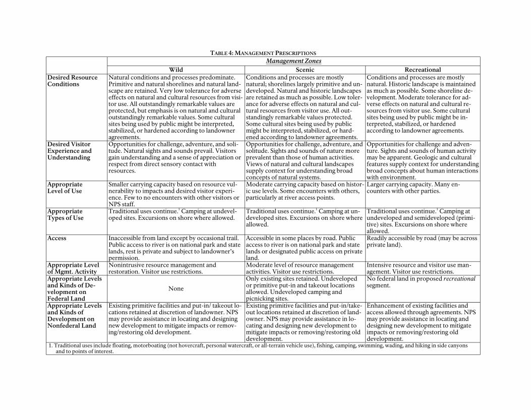
TABLE 4: MANAGEMENT PRESCRIPTIONS
Management Zones Wild Scenic Recreational
Desired Resource Conditions
Natural conditions and processes predominate. Primitive and natural shorelines and natural landscape are retained. Very low tolerance for adverse effects on natural and cultural resources from visitor use. All outstandingly remarkable values are protected, but emphasis is on natural and cultural outstandingly remarkable values. Some cultural sites being used by public might be interpreted, stabilized, or hardened according to landowner agreements.
Conditions and processes are mostly natural; shorelines largely primitive and undeveloped. Natural and historic landscapes are retained as much as possible. Low tolerance for adverse effects on natural and cultural resources from visitor use. All outstandingly remarkable values protected. Some cultural sites being used by public might be interpreted, stabilized, or hardened according to landowner agreements.
Conditions and processes are mostly natural. Historic landscape is maintained as much as possible. Some shoreline development. Moderate tolerance for adverse effects on natural and cultural resources from visitor use. Some cultural sites being used by public might be interpreted, stabilized, or hardened according to landowner agreements.
Desired Visitor Experience and Understanding
Opportunities for challenge, adventure, and solitude. Natural sights and sounds prevail. Visitors gain understanding and a sense of appreciation or respect from direct sensory contact with resources.
Opportunities for challenge, adventure, and solitude. Sights and sounds of nature more prevalent than those of human activities. Views of natural and cultural landscapes supply context for understanding broad concepts of natural systems.
Opportunities for challenge and adventure. Sights and sounds of human activity may be apparent. Geologic and cultural features supply context for understanding broad concepts about human interactions with environment.
Appropriate Level of Use
Smaller carrying capacity based on resource vulnerability to impacts and desired visitor experience. Few to no encounters with other visitors or NPS staff.
Moderate carrying capacity based on historic use levels. Some encounters with others, particularly at river access points.
Larger carrying capacity. Many encounters with other parties.
Appropriate Types of Use
Traditional uses continue.1 Camping at undeveloped sites. Excursions on shore where allowed.
Traditional uses continue.1 Camping at undeveloped sites. Excursions on shore where allowed.
Traditional uses continue.1 Camping at undeveloped and semideveloped (primitive) sites. Excursions on shore where allowed.
Access Inaccessible from land except by occasional trail. Public access to river is on national park and state lands, rest is private and subject to landowner’s permission.
Accessible in some places by road. Public access to river is on national park and state lands or designated public access on private land.
Readily accessible by road (may be across private land).
Appropriate Level of Mgmt. Activity
Nonintrusive resource management and restoration. Visitor use restrictions.
Moderate level of resource management activities. Visitor use restrictions.
Intensive resource and visitor use management. Visitor use restrictions.
Appropriate Levels and Kinds of De-velopment on Federal Land
None
Only existing sites retained. Undeveloped or primitive put-in and takeout locations allowed. Undeveloped camping and picnicking sites.
No federal land in proposed recreational segment.
Appropriate Levels and Kinds of Development on Nonfederal Land
Existing primitive facilities and put-in/ takeout locations retained at discretion of landowner. NPS may provide assistance in locating and designing new development to mitigate impacts or remov-ing/restoring old development.
Existing primitive facilities and put-in/take-out locations retained at discretion of landowner. NPS may provide assistance in locating and designing new development to mitigate impacts or removing/restoring old development.
Enhancement of existing facilities and access allowed through agreements. NPS may provide assistance in locating and designing new development to mitigate impacts or removing/restoring old development.
1. Traditional uses include floating, motorboating (not hovercraft, personal watercraft, or all-terrain vehicle use), fishing, camping, swimming, wading, and hiking in side canyons and to points of interest.

ALTERNATIVES, INCLUDING THE PREFERRED ALTERNATIVE
If the additional segment was designated, the management emphasis would shift toward protecting the identified outstandingly remarkable values, and it might involve additional use restrictions to reduce the effects on those values.
The segments of the Rio Grande Wild and Scenic River would be classified as shown in table 5. The newly designated portion would be classified as scenic.
BOUNDARY AND NONFEDERAL LANDS
For proper and effective management of the river, the National Park Service believes it is imperative to develop close working relationships with the state, local counties, and private landowners. The issue of wild and scenic river boundaries on private land has proven contentious as some landowners have disputed NPS authority or control on private lands. In this alternative, the National Park Service would work cooperatively with individual landowners to develop binding agreements that would identify the specific outstandingly remarkable values that exist on each property
within the boundary and set a mutually agreed-upon boundary and that would protect the values and also protect landowners from unwanted federal acquisition and regulation. (See appendix C for a sample landowner agreement.)
The Wild and Scenic Rivers Act requires that the management boundary of a wild and scenic river encompass the outstandingly remarkable values for which the river was designated within limitations imposed by the act. Of the river’s identified outstandingly remarkable values — fish and wildlife, geology, scenery, and recreation — scenery potentially requires the largest boundary. The Rio Grande Wild and Scenic River boundary would be line of sight, or 0.25 mile beyond the ordinary high water mark, whichever is less. This applies to the segments classified wild and scenic. A 150-foot public use corridor would exist along the river’s edge. On the segment classified recreational (Dryden Crossing to the county line between Terrell and Val Verde counties), the wild and scenic river boundary would be 150 feet from the river’s edge.
TABLE 5: PROPOSED CLASSIFICATIONS OF SEGMENTS OF RIO GRANDE WILD AND SCENIC RIVER, INCLUDING PROPOSED NEW SEGMENT — ALTERNATIVE B
Segment Description Classification Length (miles)1
9 (recommended new designation)
Beginning at western boundary of Big Bend National Park to line between Mexican states of Chihuahua and Coahuila Scenic 48.6
1 The Mexican state line between Chihuahua and Coahuila, to Talley Scenic 13.5 2 Talley to Solis Wild 9.7 3 Solis to entrance of Boquillas Canyon Scenic 23.3 4 Entrance of Boquillas Canyon to exit from Boquillas Canyon
(national park boundary) Wild 20.5
5 Boquillas Canyon to Reagan Canyon Scenic 35.2 6 Reagan Canyon to San Francisco Canyon Wild 37.8 7 San Francisco Canyon to just above Dryden Crossing takeout Scenic 16.3 8 Dryden Crossing to county line between Terrell and Val Verde
counties, Texas Recreational 36.1
Total Miles 241.0 1. Length is approximate (taken from Geographic Information System data).
38
Alternative B: Enhance Resource Protection and Continue High-Quality Visitor Experiences (Preferred Alternative)
The official boundary would be the one illustrated on the Proposed Boundary map, p. 41. The area within the management boundary would not exceed an average of 160 acres per river mile on the United States side, as mandated by the designating legislation (see appendix A).
The landowner agreements also would provide for continued traditional uses and/or access to the river while protecting property rights. The locations of access points and roads, campsites, side canyons, and other sites could be identified, and restrictions on use or other management actions could be specified. The landowner may also agree to stop activities (such as road building) that adversely affect river values.
Nonfederal lands are not directly affected by wild and scenic river designation. As has been mentioned previously, the National Park Service does not have the authority to enforce its rules or regulations on private land away from the river. Land uses and developments on private and state lands in the river area that existed before the wild and scenic river was designated may continue. Proposed land uses and developments would be evaluated for their compatibility with the purposes of the Wild and Scenic Rivers Act in conformance with provisions established in the landowner agreements. The National Park Service would offer technical assistance to help landowners find ways to alleviate or mitigate any potential adverse impacts on the river’s outstandingly remarkable values.
The Texas Recreational Use Statute protects private landowners from trespass liability (see appendix D). The “Acknowledgement of Risk” form on the river permits offers additional protection to private landowners. Private land access information provided to river runners would encourage respect for private property.
The boundary for the river corridor in Black Gap Wildlife Management Area, which is
managed by the Texas Parks and Wildlife Department, would follow the description for river segments classified as scenic. The National Park Service and the Texas Parks and Wildlife Department would manage this corridor cooperatively according to an agreement between the two agencies.
Recreationists regularly use the Mexican shore. Through permit stipulations, the National Park Service would require compliance with Mexican laws and encourage respect for the lands and people of Mexico.
LAND ACQUISITION AND RIGHTS-OF-WAY
Section 6(b) of the Wild and Scenic Rivers Act prohibits the federal government from acquiring lands through condemnation if 50% or more of the entire acreage within the boundary and outside the ordinary high water mark is in public ownership. Under this alternative, 59% of the shoreline would be owned by the U.S. government and the state of Texas, as shown in table 3, page 34. As stated in this document and in the binding landowner agreements, no nonfederal lands would be acquired for the management of the Rio Grande Wild and Scenic River except in the following circumstances:
• if a landowner approached the U.S. government with an offer to sell or donate land
• if a third party (such as the National Parks Conservation Association) offered land that party had purchased from a willing seller
• if the state of Texas offered to donate land along the river or riverbed
Any land being acquired would have to be completely or partially within the established boundary of the Rio Grande Wild and Scenic River. The ability of the National Park Service to purchase land or interest in land would be
39

ALTERNATIVES, INCLUDING THE PREFERRED ALTERNATIVE
subject to congressional appropriation of funds for this purpose.
In addition to the acquisition of fee title, the National Park Service could purchase rights-of-way or easements on private lands from a willing seller only if such access would be advantageous for river management or public use. The federal government would not initiate condemnation proceedings to acquire land.
CULTURAL RESOURCES
Segments in Big Bend National Park
Under this alternative (or any alternative) the National Park Service would be required to continue to comply with existing laws and policies for protecting cultural resources, including cultural landscapes, historic structures, archeological resources, and ethnographic resources. The General Management Plan for Big Bend also specifies actions for managing cultural and ethnographic resources.
Segments Adjacent to Nonfederal Land
Although the National Park Service has no authority to manage cultural resources on nonfederal land, the agency would seek agreements with landowners on both sides of the river to cooperatively perform resource studies and evaluations and to develop appropriate strategies for protecting resources. The NPS Southwest Cultural Resources Center might be asked to help with the inventories and possibly with a resource management plan for the river, or other agencies such as the Texas state historic preservation office or cultural resource agencies in Mexico might be asked to help the National Park Service.
Inventories and monitoring of cultural sites would be carried out on nonfederal land only with the landowner‘s permission or as specified in landowner agreements. Archeological and historic sites discovered on nonfederal
land that were found to be eligible for the National Register of Historic Places would be recorded and made known to the landowner.
If cultural resources were being vandalized, the National Park Service might provide technical assistance to help landowners protect them. Landowner agreements and recreational leases might permit the public to visit some cultural sites on nonfederal land if such use would not cause undue degradation or infringe on private property rights.
NATURAL RESOURCES
Segments in Big Bend National Park
Under alternative B (or any alternative) the National Park Service would be required to continue to comply with existing laws and policies for managing natural resources, including vegetation, wildlife, and water. Big Bend National Park’s General Management Plan also specifies actions for managing natural resources, as would a subsequent resource management plan.
The National Park Service would conduct regularly scheduled monitoring, assessment, and evaluation to determine if visitation was causing undue degradation of natural resources. If so, actions would be taken to reduce or eliminate the impacts. Regularly scheduled inventory and monitoring of special status species (that is, threatened or endangered species or species of concern) by NPS personnel or others would determine information about the species such as population trends and general health. These schedules would be established by a resource management plan to be prepared by the park staff. If monitoring indicated undue impacts from visitor use, additional limits on visitation might be established. The National Park Service would cooperate with state and federal wildlife agencies to reintroduce or maintain sensitive fish and wildlife species.
40
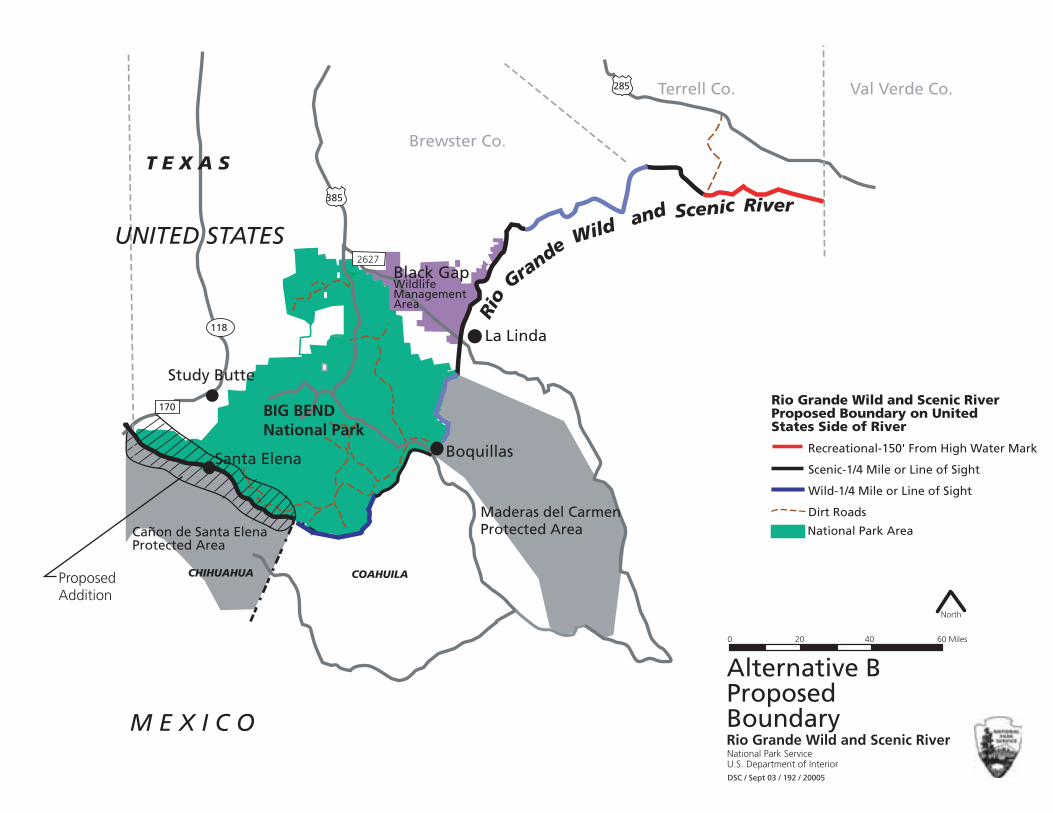
385
285
Brewster Co.
Black GapWildlife ManagementArea
BIG BEND National Park
Santa Elena Boquillas
Maderas del Carmen Protected Area
La Linda
Study Butte
Rio
Grande Wild and Scenic River
0 20 40 60 Miles
North
T E X A S
118
170
2627
COAHUILA
Alternative B
Rio Grande Wild and Scenic River
States Side of River
Scenic-1/4 Mile or Line of Sight
Wild-1/4 Mile or Line of Sight
Dirt Roads
Addition
Canon de Santa Elena Protected Area
~ National Park Area
CHIHUAHUA
Terrell Co. Val Verde Co.
UNITED STATES
Proposed Boundary on United
Recreational-150' From High Water Mark
Proposed
Proposed M E X I C O Boundary
Rio Grande Wild and Scenic River National Park Service U.S. Department of InteriorDSC / Sept 03 / 192 / 20005

4?G8EA4G<I8±5±~±CEBCBF87±5BHA74EL±±&T^S`]±*±TSU]±aX±V[h[VWd'±±±±±±±±±±±±±±±±±±±±±±±±±±±±±±±±±±±±±±±±±±±±±
±±±
±±±±ĂĀ±

Alternative B: Enhance Resource Protection and Continue High-Quality Visitor Experiences (Preferred Alternative)
Interpretation and education media would be used to encourage visitors to participate in protecting listed species. The National Park Service would continue to cooperate with the U.S. Fish and Wildlife Service and the state of Texas in managing special status species. According to the Wild and Scenic Rivers Act, the jurisdiction or responsibility of the state to manage fish and wildlife is not affected by wild and scenic river designation.
With regional and binational partners, the National Park Service would strongly advocate for scientifically determined suitable instream flow levels to support fish and wildlife populations, riparian communities, and recreational opportunities. The Park Service also would initiate cooperation with other federal agencies such as the Bureau of Reclamation, the International Boundary and Water Commission, and the Mexican government to maintain or enhance the quality and quantity of Rio Grande water.
Big Bend National Park would develop a plan to inventory and eradicate invasive nonnative species in the river corridor. The park would act in conjunction with any state or local invasive species programs.
The scenic resources in Big Bend National Park would be protected by measures prescribed in the park’s general management plan. Nothing in this alternative would result in an increase in light pollution that would affect opportunities to view the night sky.
Segments Adjacent to Nonfederal Land
The management of flora and fauna on non-federal lands is subject to the permission of the landowner. However, the National Park Service does not need landowner permission to work on fisheries or other work that would take place in the river.
Landowners’ permission would be required for the National Park Service to inventory or monitor natural resources on private or state
lands and the impacts on those resources. If monitoring indicated undue impacts from visitor use, additional limits might be called for. The National Park Service could recommend measures to mitigate potential impacts. Exotic invasive species in the river corridor would be inventoried, and eradication programs would be implemented on private lands only with the landowners’ permission.
In this alternative, the National Park Service would try to develop a fishery management plan in conjunction with Texas Parks and Wildlife to ensure sustainable fish populations for ecosystem management and sport fishing opportunities.
Maderas del Carmen and Cañon de Santa Elena are two Mexican federally protected areas adjacent to the Rio Grande. Together with Big Bend National Park, these areas preserve more than 2 million acres of important wildlife habitat and migration corridors. The areas offer unique opportunities for the United States and Mexico to work together toward common resource preservation goals. The letter of intent between the U.S. Department of the Interior and the Secretariat of Environment, Natural Resources and Fisheries of the United Mexican States, for joint work in natural protected areas on the United States–Mexico border, would be implemented to the fullest extent possible. Under this agreement, the two agencies would expand cooperative activities in the conservation of contiguous natural protected areas in the border zone and consider new opportunities for cooperation in protecting natural protected areas along the border.
VISITOR EXPERIENCE AND UNDERSTANDING
All Segments
Historic and traditional uses of the river (as of 1978, the year of its designation as a wild and scenic river) such as sightseeing, floating, fishing, hiking on the shore, swimming, and wad
43

ALTERNATIVES, INCLUDING THE PREFERRED ALTERNATIVE
ing would be allowed to continue under this alternative. Motorboats, nonmotorized boats, canoes, and kayaks would be allowed on the river. The established use by private and commercial boaters spending a number of days to float through the Lower Canyons would continue.
Unless otherwise mentioned in this document, the management guidelines in the Recre-ational River Use Management Plan (NPS 1997) would remain in effect for the river segments in Big Bend National Park. A river use plan for the entire wild and scenic river would be developed to implement the actions prescribed in this alternative.
Permits for private boaters on the river still would be required under this alternative. Commercial boaters still would have to obtain an appropriate business permit/contract and pay the fees. These requirements would let the National Park Service monitor recreational use, deliver important safety information, and inform users of private property issues and special regulations in the Lower Canyons. To protect landowners, the permit would include an “Acknowledgement of Risk” form and a waiver of liability. A permit would not be required for landowners or their guests boating on the river adjacent to their own property.
Fishing would be permitted according to existing policy. No state fishing license is required in Big Bend National Park. Hunting on state and private lands would be allowed according to state regulations, but hunting is not allowed in Big Bend National Park. No hunting would be permitted from the river surface by boat or other means.
To protect natural and aquatic resources, the use of motorized wheeled vehicles would be prohibited on all segments. Exceptions might be made for emergency use.
On designated wild and scenic rivers, the National Park Service is required by Management Policies 2001 and the Wild and Scenic Rivers Act to prevent unacceptable impacts on
resource-related and recreation-related outstandingly remarkable values. In establishing limits on recreational use, the National Park Service considered the historic variety of experiences available, recent use, and the physical characteristics of each river segment. The goal of these limits is to continue the variety of historic or traditional visitor experiences and to protect natural and cultural resources in the future.
The limits on recreational use for segments of the Rio Grande Wild and Scenic River are sum marized in table 6, page 45. User-days are the number of users multiplied by the number of days spent on the river (two users on a six-day trip equal 12 user days). Limits would be implemented through a permit allocation process.
Segments in Big Bend National Park
The following restrictions on motorized watercraft would be enforced in this alternative. Personal hovercraft are prohibited on all segments by federal regulation [36 CFR 2.17(e)]. Personal watercraft are also prohibited.
Boats using motors up to 60 horsepower are allowed on river segments except in the following two areas:
• Santa Elena Canyon, from the western park boundary to the Santa Elena Canyon takeout.
• Mariscal Canyon, from Talley to Solis (Wild and scenic River segment classified as wild), is closed to all motorized watercraft except during the month of October. Motors up to 60 horsepower may be used in October only.
To offer a wilderness experience, motorized watercraft are prohibited in some segments of the Rio Grande Wild and Scenic river that are classified as wild, including. Boquillas Canyon and on other segments of the Rio Grande Wild and Scenic River that are classified as wild.
44

Alternative B: Enhance Resource Protection and Continue High-Quality Visitor Experiences (Preferred Alternative)
TABLE 6: LIMITS ON RECREATIONAL USE BY SEGMENT — ALTERNATIVE B
Segment Private Party Limits (Maximums)
Other LimitsPersons per Launch Launches per Day Western park boundary to 6 commercial companies may each Santa Elena Canyon takeout, Santa Elena takeout to Cot 30 11 launch a combination of day or
multi-day trips per day, and tonwood Campground 1 special use group launch per day Cottonwood Campground to 3 commercial companies may each Reed Camp, Reed Camp to Talley 30 11 launch a combination of -day trips
per day, and 1 special use group launch per day
Talley to Solis 1 commercial company may launch 1
20 10
day trip or multi-day trip per day; 1 other commercial company may
launch a 1-day trip; 3 special use groups may launch per
week Solis to La Clocha, La Clocha to Boquillas 30 11
3 commercial companies may each launch a combination of trips per day, and
1 special use group launch per day Boquillas Canyon entrance to eastern park boundary
3 commercial companies may each launch a combination of -day trips
20 10 per day, (if 3 launches occur, at least one must be after noon)
3 special use groups may launch per week
Lower Canyons Park boundary to end of wild and scenic river segment
20
10, 2 per launch site
(maximum of 1,000 persons per year;
3 commercial companies may each launch no more than 1 trip per day within maximum
1 special use group launch per day 7,000 user-days per year.)
Segments Adjacent to Nonfederal Land
As is indicated in table 6, the total recreation use levels in the Lower Canyons segments would be held to a maximum of 1,000 persons, or 7,000 user-days per year. Because social conflicts have not been a problem and resource impacts have not occurred either recently or historically, the limits have been set at slightly higher levels than recent use in the Lower Canyons. Experience and professional judgment indicate that these limits would not cause undue impacts on the resources and would maintain a high-quality visitor experience. Personal hovercraft are prohibited on all segments by federal regulation (36 CFR 2.17 (e)).
The recreational use of the wild and scenic river outside the park would be monitored to determine if any unacceptable adverse
impacts on outstandingly remarkable values were occurring. If so, additional management actions such as party size limits, fewer permits, or restrictions on motorized craft might be imposed to reduce impacts. Monitoring would include a visitor study to determine the level of experience versus expectations. The reason for these restrictions would be to perpetuate the previous variety of visitor experiences and to prevent conflicts from occurring in the future.
In general, river users would be allowed to pull their boats out and camp on the United States shore up to 150 feet from the water’s edge. Exceptions to this would be posted on the ground or indicated on maps available to boaters. The use of watercraft by landowners who launch and take out on their own property (and their guests) would not be affected by this plan.
45

ALTERNATIVES, INCLUDING THE PREFERRED ALTERNATIVE
A recreational river use plan for the entire Rio Grande Wild and Scenic River would be prepared to specify monitoring and implementation actions.
INTERPRETATION AND EDUCATION
All Segments
The current interpretation and education programs offered at Big Bend would be expanded to include the entire Rio Grande Wild and Scenic River. The emphasis in the programs would be on instilling an understanding of the natural and cultural history of the Rio Grande, West Texas, and the Chihuahuan Desert for boaters and other river users. Visitors could gain understanding and a sense of appreciation or respect from views of geologic and cultural landscapes and direct sensory contact with resources. In addition, visitor understanding would be enhanced through a variety of interpretive media conveyed through existing contact stations. Improved visitor understanding would lead to more appreciation of the inherent values of the river and could promote a good land stewardship ethic in river visitors.
Interpretive Themes
Interpretive themes are ideas or stories that are central to the purpose, identity, and desired visitor experience of the unit of the national park system — in this case, the Rio Grande Wild and Scenic River. Interpretive themes form a framework for interpretation and educational programs. The following themes have been adapted from the primary interpretive themes for Big Bend National Park that are applicable to the river.
• The Rio Grande’s ecosystem supports an extraordinary richness of plants and animals.
9 The Rio Grande and adjacent shores provide valuable habitat for communities of plant and animal species, including several endangered and
threatened species. The river’s protected status helps in the preservation, study, and recovery of many of these species.
9 Surface water is highly important to a desert ecosystem. Nowhere does the Chihuahuan Desert exhibit more biodiversity than along a waterway such as the Rio Grande.
• One hundred million years of geologic history is exposed along the river; this allows visitors, students, and scientists to study and learn about the geologic processes that formed the current landscape.
• An important part of the NPS mission is to preserve or restore natural resources, including natural soundscapes. Intrusive sounds are also a matter of concern to visitors. The Rio Grande is relatively free of intrusive or unnatural sounds, and management strives to preserve this value.
• Exotic (nonnative) plants and animals are extremely disruptive to river-related ecosystems. Natural resource managers work with riverside landowners and river users to detect, monitor, and remove exotic species and to prevent the spread of exotic species.
• Water constitutes the most important resource in the Chihuahuan Desert.
• Maderas del Carmen and Cañon de Santa Elena are two Mexican federally protected areas adjacent to the Rio Grande. Together with Big Bend National Park, these areas preserve more than 2 million acres of important wildlife habitat and migration corridors. The areas offer unique opportunities for the United States and Mexico to work together toward common resource preservation goals.
PARTNERSHIPS AND INTERNATIONAL COOPERATION
The Rio Grande Partnership Team would remain in effect to give the National Park Ser
46

Alternative B: Enhance Resource Protection and Continue High-Quality Visitor Experiences (Preferred Alternative)
vice information regarding river management, with the understanding that individual team members will come and go. The NPS river management staff would continue to establish and foster cooperative relationships with owners of adjacent property, surrounding counties, tribal entities, and private and public groups that affect or are affected by the river. Additional partnerships would be sought for resource protection, research, education, and visitor enjoyment.
The National Park Service would work closely with local, state, federal, and tribal governments whose programs affect or are affected by activities on the river. Cooperative regional planning opportunities would be encouraged whenever possible to integrate the river into issues of regional concern.
Common resource management issues would be identified and a cooperative relationship with various government entities in Mexico, especially managers of the adjacent protected areas, would be maintained. A memorandum of agreement between the U.S. Department of the Interior and Mexico’s National Commission for Natural Protected Areas, signed in 2000, serves as an “umbrella” for all natural resource activities carried out jointly between the National Park Service and Mexico.
IMPLEMENTATION
The National Park Service would begin implementing the new management actions proposed under this alternative as soon as the plan is approved. The implementation would continue over the next 15 to 20 years as funding became available. Partnerships with other agencies and organizations would be established to implement several actions of this alternative. If this alternative was selected, the management emphasis of the wild and scenic river would shift, and a reallocation of staff might be required.
Given adequate funding, the highest priority would be given to implement actions that would serve the following functions:
• protecting important resources
• managing visitor use
• providing more interpretation and visitor services
After the final version of this plan is approved, park managers may need to develop several lower level implementation plans. These more detailed plans would describe specific actions that the park managers would take to achieve the desired conditions and management objectives. The National Park Service would seek public input for these plans and would prepare environmental documentation as needed to comply with existing environmental protection laws. Such implementation plans might include a revised river use management plan and a resource management plan.
MITIGATING MEASURES
The following mitigating measures, which would be applied as part of the preferred alternative, would avert or minimize the potential impacts on natural and cultural resources from visitor use and river management actions.
Natural Resources
The NPS staff would use inventories, regular monitoring, research, the best scientific information, and proven ecosystem management methods to maintain or enhance natural resource conditions, including water quality. The National Park Service would work with other land managing agencies and organizations to manage the entire set of resources and ecosystems that encompass and affect the Rio Grande.
Best management practices would be employed to reduce soil erosion resulting from any action caused by this alternative. On non
47

ALTERNATIVES, INCLUDING THE PREFERRED ALTERNATIVE
federal lands, these actions would be carried out only with the landowner‘s permission.
The treatment of exotic (nonnative) species in the river corridor would be undertaken according to NPS Management Policies 2001 and other applicable state and federal laws and guidance.
Big Bend National Park‘s resource management plan would be revised to include the Rio Grande Wild and Scenic River.
Cultural Resources
Cultural resource surveys would be conducted according to NPS management policies and existing guidelines. To minimize adverse impacts caused by visitor use, the staffs of the park and the wild and scenic river would consult with the Texas state historic preservation officer about management strategies for historic structures and prehistoric sites. On nonfederal lands, these actions would be carried out only with landowners permission.
Visitors and Nonfederal Landowners
The park staff would collect and use visitation data, communication with landowners, and other information to identify user conflicts and landowner concerns related to public use. Actions would then be implemented to reduce or eliminate conflicts according to a revised river use management plan.
New Structures
Although the preferred alternative does not call for new structures, it does not eliminate the possibility of building NPS-initiated structures (such as a visitor information kiosk or an emergency equipment cache) along river segments classified as scenic or recreational where a clear need is identified by park staff or partners. Such structures would be small, inconspicuous, and temporary (that is, with no permanent foundation), and previously disturbed sites would be preferred.
ALTERNATIVES DISMISSED FROM FURTHER CONSIDERATION
During the planning effort, the planning team considered other alternatives that were proposed by members of the planning team or the public, as follows.
Omit Landowner Agreements in the Lower Canyons
The team considered trying to implement the resource monitoring and protection strategies in the Lower Canyons without landowner agreements . This concept would not have met the plan’s objectives and needs. Without landowner agreements, the National Park Service would have been technically unable to conduct resource management on private land within the river corridor. Therefore, this concept was dismissed.
Set the Management Boundary at the High Water Mark
Setting the management boundary in the Lower Canyons at the high water mark (the private property line) was considered, but it was dismissed because this action would not have complied with federal law, and it would not have met the plan’s objectives for protecting the outstandingly remarkable values that led to the river’s designation. Setting the boundary at the water’s edge was a major reason that the 1981 management plan was rejected.
Deauthorize the Wild and Scenic River Designation
The National Park Service was asked to consider deauthorizing the wild and scenic river designation. That concept was dismissed because Congress mandated that the National Park Service protect and manage the Rio Grande Wild and Scenic River, and only Congress can revoke a wild and scenic river designation.
48

THE ENVIRONMENTALLY PREFERABLE ALTERNATIVE
Environmentally preferable is defined as “the alternative that will promote the national environmental policy as expressed in the National Environmental Policy Act, §101,” which establishes the following environmental goals.
1. to fulfill the responsibilities of each generation as trustee of the environment for succeeding generations
2. to ensure for all generations safe, healthful, productive, and esthetically and culturally pleasing surroundings
3. to attain the widest range of beneficial uses of the environment without degradation, risk of health or safety, or other undesirable and unintended consequences
4. to preserve important historic, cultural, and natural aspects of our national heritage and maintain, wherever possible, an environment that supports diversity and variety of individual choice
5. to achieve a balance between population and resource use that will permit high standards of living and a wide sharing of life’s amenities
6. to enhance the quality of renewable resources and approach the maximum attainable recycling of depletable resources
Alternative A, the no-action alternative represents the current management direction for Rio Grande Wild and Scenic River. It would continue a lack of long-term planning; therefore, resource management under that alternative would be limited. The existing use of the river is based on planning initiated when the river was designated, but no plan has ever been implemented to guide the long-term management of the Rio Grande Wild and Scenic River. Visitor and resource protection
patrols are sporadic at present. The protection of cultural and natural resources would be less enhanced under the no-action alternative than under the preferred alternative (B). The no-action alternative would not fully realize goals 1, 3, 4, and 5.
Alternative B, the preferred alternative, would lead to increased management attention to and emphasis on preserving wild and scenic river objectives, including recreational values. It would protect and enhance natural and cultural resources (goals 1, 4, and 5). It also would create opportunities for high-quality, resource-dependent visitor experiences through traditional recreational uses (goals 2 and 3).
After careful review of the potential resource and visitor impacts, and after considering the proposed mitigation for the potential impacts on natural and cultural resources, the planning team has concluded that the preferred alternative (alternative B) also is the environmentally preferable alternative. Alternative B would enhance the ability of the National Park Service to protect natural and cultural resources while allowing visitors to enjoy a wide range of traditional river-related recreational activities.
Alternative B would (a) provide a high level of protection for natural and cultural resources while attaining the widest range of neutral and beneficial uses of the environment without degradation; (b) maintain an environment that supports diversity and variety of individual choice; and (c) integrate resource protection with opportunities for an appropriate range of visitor uses. Thus, this alternative would surpass the other alternative by best realizing the fullest range of national environmental policy goals as stated in §101 of the National Environmental Policy Act.
49

COST ESTIMATES
The cost figures shown in table 7 are intended to give only a rough idea of the relative cost of alternative B. These estimates are general and should not be used for budgeting purposes. The actual costs to the National Park Service will vary, depending on if and when the actions are implemented and on contributions by partners and volunteers.
Implementing alternative A, the no-action alternative, would not result in any additional operating or development costs above the current level other than annual cost-of-living
salary increases and price increases for goods and services due to general inflation.
Alternative B, the preferred alternative, would necessitate an increase in staff to improve river management and interpretation. Resource monitoring would be increased, and that could result in additional costs for materials or contracts. In alternative B, the National Park Service might help private landowners to manage river access points or stabilize historic sites in the river corridor that people might visit. No capital development costs would be incurred.
TABLE 7: COST ESTIMATES FOR ALTERNATIVE B (2002 DOLLARS) Element Operating Costs (per year) Potential for Cost Sharing
Staff (3 permanent employees) $165,0001 — Increased interpretation (additional first year, $15,000–$45,000
— brochures or interpretive panels) thereafter, $5,000 Resource monitoring (supplies, $40,000–$80,000 Other agencies, colleges, or environ-materials, and/or contracts) mental organizations could conduct
monitoring or provide assistance Assistance to landowners in man- $0–$50,000 Cost-sharing agreements with aging resources or visitor use (would depend on number landowners
and scope of projects) 1. Staff costs include salary, benefits, training, equipment, and supplies.
50

COMPARISON OF ALTERNATIVES AND CONSEQUENCES
TABLE 8: COMPARISON OF ALTERNATIVES
Alternative A: Existing Alternative B: Enhance Resource Protection Management Direction and Continue High-Quality Visitor
Topic (No Action) Experiences (Preferred Alternative) Meeting Purpose and Does not meet purpose and need Fully meets purpose and need as described in this Need of This Plan as described in this document. document. Scenic Resources Development on nonfederal lands Development on nonfederal lands would be sub-
would proceed without NPS advice about mitigating impacts on
ject to agreements (where in effect) requiring consultation with NPS to mitigate potential
scenery. adverse effects on scenery. Managing Resources on Federal Land
Natural and cultural resources managed according to Big Bend
Natural and cultural resources managed according to Big Bend NP General Management Plan and
NP General Management Plan and subsequent resource management
subsequent resource management plans.
plans. Managing Resources No NPS involvement in resource NPS might do inventories and monitoring of on Nonfederal Land management activities on non natural and cultural resources on nonfederal land
federal lands. with landowners’ permission; if requested, NPS might help protect resources.
Managing River Use Current management would con- Management guided by this General Management on Federal Land tinue, guided by Recreational River Plan and a revised Recreational River Use Man-
Use Management Plan (NPS 1997). agement Plan; limits on visitors’ use of river would be imposed.
Managing River Use Adjacent to Nonfederal Land
Current management actions and use restrictions would continue.
Management guided by this General Management Plan, a revised Recreational River Use Manage-ment Plan, and landowner agreements; limits on visitors’ use of Lower Canyons imposed and prescribed in landowner agreements; boat use by landowners who launch and take out on their own property (and their guests) not affected.
51

ALTERNATIVES, INCLUDING THE PREFERRED ALTERNATIVE
TABLE 9: COMPARISON OF ENVIRONMENTAL CONSEQUENCES
Alternative A: Existing Alternative B: Enhance Resource Protection Management Direction and Continue High-Quality Visitor
Topic (No Action) Experiences (Preferred Alternative) Scenic and Could cause continuing long-term Would result in long-term beneficial effects on Aesthetic Values minor adverse impacts on scenic scenic and aesthetic values of the wild and scenic
and aesthetic values on lands river. outside Big Bend National Park.
Fish and Wildlife No effect on fish and wildlife. Minor long-term beneficial effects on fish and wildlife.
Threatened and Endangered Species
No effect on special status species. No effect on Big Bend gambusia, black-capped vireo, bunched cory cactus, or Chisos Mountain hedgehog cactus; possible long-term minor beneficial effects from increased monitoring and protective actions.
Water Quality No effect on quality or quantity of Long-term beneficial effects on Rio Grande and Quantity water in the Rio Grande. water quality and quantity from cooperative
efforts to maintain a minimum flow and reduce contaminants.
Vegetation No effect on vegetation along river Minor long-term beneficial effect on native corridor. vegetation in the river corridor.
Archeological No effect on archeological resour- No adverse effects on archeological resources; Resources ces listed in National Register of possible long-term beneficial effects from
Historic Places or known to be additional protective measures. eligible for listing.
Historic Structures No adverse effects on historic No adverse effects on historic structures; structures listed in National possible long-term beneficial effects from Register of Historic Places. additional protective measures.
Visitor Experience Possible long-term moderate ad- Long-term minor beneficial effect on visitor and Understanding verse effects on visitor experience experience and understanding. (Recreation) and understanding if private lands
were closed to public use. Boundary and Possible long-term minor adverse Long-term beneficial effects on nonfederal Nonfederal Lands effects on nonfederal landowners. owners of land along river from establishment of
more meaningful boundaries. Socioeconomic No beneficial or adverse effects on Long-term minor beneficial effects on local and Conditions socioeconomic conditions. regional economy. Partnerships and Long-term moderate adverse effect Long-term moderate beneficial effect on inter-International on cooperative river management agency and international cooperative river man-Cooperation efforts. agement efforts; minor beneficial effects on
transboundary issues.
52

Affected Environment

AFFECTED ENVIRONMENT
(blank)
54

INTRODUCTION AND DESCRIPTION
This chapter contains background information about the resources that could be affected by the actions of the alternatives.
Near its upstream end, the Rio Grande Wild and Scenic River flows through the steep-walled Mariscal and Boquillas Canyons. Downstream from Boquillas Canyon, the river travels through a relatively broad, open floodplain, or vega. Near Reagan Canyon, the floodplain narrows abruptly, and the river flows in a continuous deeply cut canyon for almost 40 miles. In the Lower Canyons part of this segment, the river and its tributaries lie 500 to 1,500 feet below the surrounding plateaus. The original Rio Grande Wild and Scenic River Study identified the outstandingly remarkable values as scenic, recreational, geological, biological, and cultural (Bur. of Outdoor Recr. 1975).
ACCESS
Access to the river is available at various locations in and outside of Big Bend National Park. Primitive access points (access to the riverbank but not the water) are available at Talley, Solis, and Cottonwood Campground. Undeveloped access points exist at other locations where the river is accessible to carry-in boating, such as Jewels Camp, Woodsons, Black Dike, Hot Springs, and La Clocha. There are developed access points (access to water’s edge) at the Santa Elena takeout and Rio Grande Village. Access points outside the park are on state or private land: Stillwell Crossing, Heath Canyon, Black Gap Wildlife Management Area, Dryden Crossing, and Foster’s Weir. Private access points are subject to closure and restriction by the landowners.
OWNERSHIP
The ownership of riverfront property along the designated wild and scenic river is shown in table 1, p. 28. Texas state land is in the Black Gap Wildlife Management Area, northwest of the park. Along the river are 17 parcels of private land, all in the Lower Canyons section.
EXISTING DEVELOPMENT
In the Lower Canyons, some owners of private land have constructed facilities such as primitive campsites and buildings. Because the wild and scenic designation does not allow the river manager to regulate the use of private land, the potential exists for additional development along the river shores. Two developed campgrounds, 11 primitive campsites, a concession store, and other amenities are available in or near the river corridor in Big Bend National Park. In Black Gap Wildlife Management Area are 25 small fishing and picnicking shelters near the river. Commercial river running outfitters do not provide facilities but do offer shuttle services to and from put-in and takeout sites.
The southern half of the Rio Grande and adjacent lands belong to Mexico. Small communities on the Mexican side are San Vicente, Boquillas del Carmen, and La Linda. Although the mineral processing plant at La Linda has been closed for 10 years, there has been renewed interest in development in or near La Linda in conjunction with preliminary plans to encourage ecotourism activities in the area.
LAND USES
Recreation, livestock grazing, and residential development are some of the current land uses along the river. Ranching had been the predominant land use for more than 100 years, and it continues on both sides of the river outside of Big Bend National Park. On the U.S. side, livestock graze on private land. Livestock often cross the river during periods of low flow.
Land use patterns have been changing in the past decade, and now some uses take place on small parcels of land that may or may not be developed, with utilities and a residence or other structures. Large blocks of private land have been subdivided and sold as ranchettes of a few acres to several hundred acres.
55

RESOURCES THAT COULD BE AFFECTED
NATURAL RESOURCES
Scenic Value
The area encompassing the designated Rio Grande Wild and Scenic River contains views of the river and surrounding canyons with outstanding visual quality. Rugged, steep-walled canyons, scenic rapids, and unspoiled views contribute to the scenic allure. These attributes, due largely to the primitive and undeveloped nature of the river and its surroundings, are important values for river visitors.
Fish and Wildlife
The area is an outstanding example of Chihuahuan Desert wildlife in Texas. This isolated area represents a rapidly dwindling, irreplaceable natural resource. The riparian corridor, containing more vegetative growth and a reliable water supply, attracts many wildlife species.
Forty-six known species of fish inhabit the Big Bend area; 34 of these are native. Shiners and daces are the most abundant fishes in the Rio Grande. Larger fish found here are the long-nose gar, channel catfish, blue catfish, and European carp. Six native fish species have been extirpated in recent decades because of the effects of dams, habitat modification, and competition from introduced species.
Numerous wildlife species are residents of the river corridor, and many others, especially birds, use the Rio Grande as a travel corridor. Mammals include skunks, rodents, squirrels, rabbits, raccoons, and ringtails. Mountain lions (locally called panthers) occupy the area, and black bears and desert bighorn sheep occasionally can be seen.
Birds are the most frequently seen animals along the river. Common resident species seen or heard along the river include yellow-
breasted chat, black phoebe, white-winged dove, canyon wren, and roadrunner. Ravens, turkey vultures, and various raptors regularly soar overhead. Peregrine falcons (Falco pere-grinus) use high cliff faces for nesting in Santa Elena, Mariscal, and Boquillas canyons. Reptiles include lizards, snakes, and both terrestrial and aquatic turtles. Several amphibian species also are present.
Native freshwater mussels have virtually disappeared from this area. Some historic species no longer can be found, and the more persistent Texas hornshell and Salina Mucket have not been found alive in recent years. Other aquatic species may be in danger of extirpation. Reductions in water quality and quantity adversely affect these and other aquatic species.
Many exotic or nonnative species are found in the Rio Grande. Twelve nonnative fish species compete with the remaining native species. Nutria, a large nonnative rodent, is now common, and the exotic Asian clam is abundant. At present there is insufficient information about the distribution and spread of exotic species.
Special Status Species
The following federally listed species may be found in the river corridor.
Fishes. The endangered Big Bend gambusia (Gambusia gaigeii) is known only from spring habitats near Boquillas Crossing and Rio Grande Village in Big Bend National Park, within the management area of the river. The population of this fish species at Boquillas Spring died when the spring stopped flowing in 1954. The population near Rio Grande Village drastically declined between 1954 and 1956, after the spring flow was altered to provide a fishing pool. By 1960, the Big Bend gambusia no longer could be found at the Rio Grande Village location. The loss of this
56
population probably was due to competition with the western mosquitofish and predation by the introduced green sunfish. All the present populations of the Big Bend gambusia are descendants of two males and one female taken from the declining Rio Grande Village population in 1956. The only known wild population exists in a protected pond in Big Bend National Park (Texas Parks and Wildlife Department Web site). A recovery plan is in effect for this species that calls for its reintroduction (USFWS 1984).
Other fish species of concern are as follows: Chihuahua shiners are known in the United States only in the park, where they inhabit the lower reaches of Tornillo and Terlingua Creeks. The Mexican stoneroller fish, the blue sucker, and the Conchos pupfish also are found in the area.
Black-Capped Vireos. Endangered black-capped vireos (Vireo atricapillus) nest in Texas during April through July and spend the winter on the western coast of Mexico. Their habitat is primarily rangelands with scattered clumps of shrubs separated by open grassland. They nest in shrubs such as shinnery oak or sumac. They may occasionally use the river corridor. This species’ listing as endangered is due to the dwindling population numbers from nesting habitat loss and cowbird parasitism.
Cactus Species. The threatened bunched cory cactus (Coryphantha ramillosa) is found on slopes and ledges of sparsely vegetated limestone rock outcrops (most commonly of the Boquillas or Santa Elena Formations) in the lechuguilla shrublands in Big Bend National Park and on large private ranches. This species is known from about 25 sites in southern Brewster County, many in Big Bend National Park. It also can be found in northern Coahuila, Mexico.
The Chisos Mountains hedgehog cactus (Echinocereus chisoensis var. chisoensis), also a threatened species, is known to occur in the river corridor. These cacti are found in low
Resources That Could Be Affected
elevation desert grasslands or sparsely vegetated shrublands on gravelly flats and terraces in the Chihuahuan Desert. This species is known from about a dozen sites, all in Big Bend National Park. No federally designated critical habitat for this species exists in Terrell or Brewster County.
Water Quantity and Quality
The Rio Grande, one of the longest rivers in the United States, is no longer a naturally flowing river along its entire length. Extensive diversion networks and dams control flows on the river to provide water for a variety of human needs. The condition of the Rio Grande was discussed in an Associated Press item in The Daily Grist of June 28, 2001, as follows:
Nine years of drought, a proliferation of choking river weeds and the drawing off of water by farms and municipalities have taken their toll on the river, which serves as the boundary between Mexico and the United States. Once a navigable waterway that swelled under bridges and made fertile an otherwise dry coastal plain, the river becomes a mere trickle before it gets to the Gulf of Mexico, disappearing about 300 feet short of its destination in a big expanse of sand.
At the time of the original Draft General Man-agement Plan / Development Concept Plan (NPS 1981), the average annual streamflow in the upper reaches of the Rio Grande Wild and Scenic River was 925 cubic feet per second (cfs). The current annual flows are considerably less. From March 2000 through March 2001, the average flow was 571 cfs as recorded near Castolon, according to the International Boundary and Water Commission’s web page.
The proportion of the annual flow from the Rio Conchos in Mexico has declined from approximately 80% to 57% since 1993. Population growth and increasing industrial and agricultural uses have contributed to a growing demand for Rio Conchos water in Mexico. The high flows and periodic floods necessary to maintain the river channels have been reduced by 75% in the Rio Grande below El
57
AFFECTED ENVIRONMENT
Paso and by 50% on the Rio Conchos over the years by added dams and more water use.
Reduced flows in the Rio Grande below Fort Quitman have resulted in a long stretch of river with no defined channel, and the river in that area has become a continuous tamarisk thicket. The amount of water that reaches Big Bend National Park and the Rio Grande Wild and Scenic River has been reduced by more than half the historic flows levels.
Spring inflows and unregulated tributaries increase the average annual streamflow in the lower reaches of the wild and scenic river. Peak flows and flooding most often occur between May and October as the result of intense rainstorms in the watershed.
Other factors that affect the water quality of the Rio Grande, its tributaries, and Amistad Reservoir are untreated sewage from Presid-io/Ojinaga and border villages, livestock grazing in riparian areas, limited agricultural runoff, mining activities, and atmospheric deposition.
The available database reveals the presence of toxic contaminants and elevated densities of fecal-coliform bacteria in the river. This information represents a compilation of water quality data for stream sites sampled by the Texas Natural Resources Conservation Commission, the U.S. portion of the International Boundary and Water Commission, and the U.S. Geological Survey. The Texas Natural Resources Conservation Commission periodically assesses the available data and has identified several areas of concern, including the presence of the following:
arsenic cadmium chromium copper dichlorodiphenyl dichlorethane (DDD) dichlorodiphenyl ethylene (DDE) dichlorodiphenyl trichlorethane (DDT) dieldrin endrin hexachlorobenzene
lead mercury nitrogen phosphorous polychlorinated biphenyls (PCBs) selenium silver zinc
At present, sulfates and nitrates make up the largest contributors of contaminants in the river.
The National Park Service has little control over the quality or quantity of the water in the Rio Grande because most of the water comes from tributaries on the Mexican side, and all the tributaries on the U.S. side are in private or state ownership. The character and values that the wild and scenic river was originally established to protect cannot be maintained without adequate water flows. Therefore, it is vital that the quantity of water be increased, or in the near future some sections of the Rio Grande Wild and Scenic River may run dry during certain times of the year.
The treaty of 1944 between the United States and Mexico established that at least one-third of the combined annual flow volume from the six Mexican rivers that feed the Rio Grande belongs to the United States. This treaty also states that the flows must total at least 350,000 acre-feet annually, based on a five-year moving mean average. The treaty does not establish release schedules for the tributaries, so flows passing through the park can vary considerably over time. The International Boundary and Water Commission enforces this treaty and manages the water in the Rio Grande from Fort Quitman to the Gulf of Mexico.
Vegetation
The Chihuahuan Desert, through which the Rio Grande Wild and Scenic River flows, exhibits a great diversity of vegetation types, which have been categorized according to topography. The vegetation adjacent to the river is adapted to flooding and wet soils. Wil
58

Resources That Could Be Affected
lows, canes, reeds, seepwillows, acacias, and grasses are the major components of this association. Upslope, the vegetation becomes more desertlike, with lechugilla, blackbrush, catclaw acacia, candelilla, saltbush, mesquite, creosote bush, chino grama, and a variety of cacti predominating. Cracks in the cliff walls harbor a distinctive plant community of candelilla, rock nettle, and poison ivy.
The riparian zone varies from narrow intra-canyon banks to floodplains more than 0.5 mile wide. Early reports indicated that lance-leaf cottonwoods and willows were common, but by the early 1900s most of the trees had been harvested for use in mining operations, and their seedlings rarely survived grazing.
Tamarisk, giant river cane, Bermuda grass, and other invasive plant species have become established along the Rio Grande. In some places these exotic species have forced out native vegetation and form an impassable thicket.
CULTURAL RESOURCES
The canyons and valleys of the Rio Grande have been a homeland to people for many centuries. The area contains a number of prehistoric and historic cultural resources that supply limited views into the lifestyle of various cultures over the last 10,500 years. Many sites along the wild and scenic river are undisturbed, which enhances their scientific value. Reconnaissance surveys have located a significant number of prehistoric sites on both sides of the river. These sites, which represent occupation and exploration activities by the prehistoric inhabitants, are found in caves, rock shelters, terraces, talus slopes, and canyon rims.
Throughout the prehistoric period, people found shelter and maintained open campsites throughout what is now Big Bend National Park. Archeological records reveal an Archaic-period desert culture whose inhabitants developed a nomadic hunting and gathering life
style that remained virtually unchanged for several thousand years. American Indian cultures represented are the Chisos, Mescalero Apache, Kickapoo, and Comanche. Sites containing ceramic artifacts suggest that some later indigenous peoples had a semisedentary lifestyle and practiced limited agriculture along the river.
The historic period began in 1535 with the explorations of Alvar Nuñez Cabeza de Vaca in the Texas Trans-Pecos region. During the late 1700s, Spanish presidios were established along the Rio Grande at San Vicente, Coahuila, and along the San Carlos River at San Carlos, Chihuahua.
Control of the area was passed to the United States after the Mexican-American War (1846–1848). A series of army posts was established along the Rio Grande in an attempt to stop Comanche and Apache raids. The first accurate maps of the Rio Grande canyon areas were completed by Army topographic engineers and the United States–Mexico Boundary Commission in the 1850s. Around that time, a wagon road was established to link San Antonio and El Paso. The road tied the region into the trade network that stretched from California to the Gulf of Mexico.
Grazing history along the Rio Grande dates back to the early Spanish missions established between 1670 and 1690. These missions had become major centers of livestock concentration by 1700.
Hispanic settlements existed near the Rio Grande in 1805. Mexicans farmed and ranched the area throughout the 1800s. Beginning in the 1880s, Anglo-Americans established ranches throughout the area and began farming in the early 20th century. Some farmers and ranchers left the area for a short hiatus during the Mexican Revolution. Cotton and food crops were grown around Castolon and what is now Rio Grande Village even after Big Bend National Park was established in 1944.
59

AFFECTED ENVIRONMENT
Quicksilver (mercury) was discovered in the area in the late 19th century, and later finds of silver and fluorite attracted hundreds of miners and prospectors. A unique facet of the continuing Rio Grande history is the use of the candelilla plant to produce high-quality wax. This wax has been used in the manufacture of candles, waxes, gum, and phonograph records.
Sites of historical interest in the Lower Canyons are an abandoned candelilla operation, the Asa Jones Waterworks, Dryden Crossing, and Burro Bluff, the site of an old trail built by cattlemen for access to the Texas side of the river.
A review of the National Register of Historic Places reveals that four sites that are listed in the national register are in the river corridor in Big Bend National Park: Sublett Farm, Daniels Farm, the Castolon Historic District, and the Hot Springs District.
The Texas Historical Commission conducted a reconnaissance survey of the river corridor from La Linda to Dryden Crossing in the 1970s (Mallouf and Tunnel 1977). The researchers recorded 83 prehistoric sites and 5 historic sites on that survey. Some of those are on the Mexican side of the river. The sites represented human occupation and use of the river area throughout the last 12,000 years. The potential for evidence of Paleo-Indian occupation exists in some of the more protected cave and rock shelter sites. Because they are on nonfederal land, no determination has been made about the eligibility of the prehistoric or historic sites in the Lower Canyons for the National Register of Historic Places .
VISITOR EXPERIENCE AND UNDERSTANDING
Recreation
Spectacular river canyons, occasional rapids, the primitive character of the Rio Grande, and its international flavor form a stimulating en
vironment for high-quality recreational experiences. In Big Bend National Park, the river can be enjoyed from canyon rims, along the shore, or from a boat. Downstream from the park, the river can be accessed only by boat or from a few privately-owned access points.
Recreational activities one can enjoy on the river are floating, motorboating, camping, fishing, hunting, photography, swimming or wading, and relaxing on the shore. Swimming in the river is not encouraged because strong currents and dropoffs can be dangerous. A warning is printed in the park brochure.
There are 13 camping areas along the river in the park — 2 developed campgrounds (Cottonwood and Rio Grande Village) and 11 primitive campsites. The primitive campsites are in the Lower Canyons where there is enough of a break in the riverside vegetation to get through.
Expectations of a visit and experiencing solitude are primary motivational factors for people who participate in a river trip, according to the Recreational River Use Management Plan (NPS 1997). Typically, traditional uses are allowed to continue on a wild and scenic river after it has been designated. People use motorized and nonmotorized boats on the Rio Grande both inside and outside of Big Bend National Park. However, the use of motorboats is an issue that was mentioned in several public comments. Conflicts between motorized and nonmotorized recreationists can occur in some stretches.
The following restrictions are from the 1997 Recreation River Use Management Plan (which does not cover the Lower Canyons section of the river):
• Mariscal Canyon (classified wild) is closed to all motorized watercraft except during October. Motors up to 60 horsepower may be used in October only.
• To provide a wilderness experience, motorized watercraft are prohibited in the wild zone that includes Boquillas Canyon.
60

Resources That Could Be Affected
A permit is required for boating on the wild and scenic river. Statistics show that a small percentage of permittees use motorized watercraft. Motorized traffic has decreased in recent years. This can be attributed to low water levels and new restrictions on motorized uses in the canyons of Big Bend National Park. None of the commercial companies offer river trips with motorized craft. In past years, most of the motorized boats were used above Santa Elena Canyon and in the lower end of the Boquillas Canyon stretch. Almost all these users were accessing the river from private lands outside the park boundary. During periods of low water, exposed rocks make the use of motorized craft impossible on many stretches of the river.
Most motorized boating takes place along private lands and in the state park, upriver from the park and outside the wild and scenic river. In addition, there is much motorboat use in the area above Heath Canyon and on down through Black Gap. The Big Bend National Park staff indicates that it is rare to see a motorboat downstream from the Black Gap Wildlife Management Area that has launched from there. Most motorboat traffic between Reagan Canyon and San Francisco Canyon is launched from private property and limited to running short reaches of the river, between rapids. Sources familiar with the river say there is little motor use in this section, which is classified as wild.
Personal hovercraft are being used on some stretches of the river, but this is not considered a traditional use. There are concerns that hovercraft would be able to travel upriver to Big Bend National Park while other motorized craft are confined to segments of the river between rapids. Federal regulation 36 CFR 2.17 (e) prohibits hovercraft on all segments.
The designated segments of Rio Grande Wild and Scenic River are long enough to accommodate a variety of meaningful recreational experiences lasting from a few hours to several days. Most of the river is an easy float trip. Occasional rapids intersperse the calm
stretches. These rapids are in the class II to class III difficulty range, with one in the class IV range, depending on the flow level. As part of the boating experience, parties will pull out on the shore for picnicking, overnight camping, short hikes, or sightseeing. Most private users plan their trips around a particular river segment, and only a small percentage travel through two or more river segments on the same trip (NPS 1997).
A journey through the Lower Canyons offers a true wilderness experience requiring five to ten days. Most boaters begin the trip at La Linda and take out at either Dryden Crossing (83 miles) or Foster’s Ranch (119 miles), which is at the end of the Rio Grande Wild and Scenic River. A few river runners may continue to Langtry (137 miles). Visitation to the Lower Canyons section is primarily by boat. Remoteness, rugged terrain, and a lack of public access limit visitation from off the river.
A recreational user study conducted by Texas A&M University in 1993 indicated that users said that the most important reason they came to the Rio Grande was “getting away from the everyday routine.” Experiencing solitude was also a primary motivational factor for participating in a river trip. Many boaters take day hikes in side canyons. River use peaks during the spring, but some recreational use occurs throughout the year.
NPS regulations require that commercial boaters obtain an incidental business permit and pay a fee. A free backcountry use permit is required for private day and overnight use of floating craft on all parts of the Rio Grande administered by the National Park Service, except for persons day-fishing downstream from the national park boundary. This allows the park to deliver important safety information and monitor use. Boaters deposit used permits in boxes at takeout points, where park personnel collect them.
61

AFFECTED ENVIRONMENT
Historic Recreational Use on the Rio Grande, Lajitas to Val Verde County Line
The recreational use of the Rio Grande discussed in this section is between Lajitas and the Terrell/ Val Verde County line. The area includes both the Upper Canyons (within Big Bend National Park) and the Lower Canyons (downstream from La Linda). It does not include the Colorado Canyon or other areas upstream from Lajitas. The Upper Canyons in the park are primarily the canyons of Santa Elena, Mariscal, and Boquillas.
Permit data from 1998 show that 3,980 people took float trips on the Rio Grande in Big Bend National Park (downstream of Lajitas), and 352 more people were permitted to float through the Lower Canyons to various takeout points (see table 10). Therefore, according to park records, the combined 1998 total was 4,332 persons and 789 trips on the river at some point between Lajitas and near Val Verde County. In 1999, the total number of river users in the same area increased to 5,840 persons and 1,069 trips. The National Park Service reports that river use increased abruptly in 1999 because of higher water levels compared to 1998.
TABLE 10: 1998–2000 RIVER USE, LAJITAS TO VAL VERDE COUNTY
Location Trips Persons 1998
Big Bend NP 743 3,980 Lower Canyons 46 352 Total 789 4,332
1999 Big Bend NP 981 1,562 Lower Canyons 88 678 Total 1,069 5,840
2000 Big Bend NP 1,006 5,700 Lower Canyons 98 909 Total 1,104 6,609
The number of river users increased again in 2000, with 6,609 users and 1,104 trips Thus, the average use for 1998–2000 was 5,594 persons. In the Lower Canyons section, the three-year average use was 646 persons;
however, the growth rate in that period was 158.2%, as compared to 40.6% in the Big Bend section.
About 50%–60% of the people with permits who float the river in Big Bend National Park are typically on guided trips, but only about 10% of the people floating the river in the Lower Canyons are on guided trips. Outfitters provide a variety of services in the Lower Canyons other than guiding, including dropoff and pickup, vehicle shuttles, rentals of rafts, canoes, and other equipment, and paddling lessons.
A study conducted by Texas A&M University in 1993 examined the total use on the Rio Grande from 1983 through 1992. The study focused on the Upper Canyons of Santa Elena, Mariscal, and Boquillas. The data were obtained from river use permits. River use peaked in 1985, when the total number of permits issued exceeded 2,500. In that year there were about 1,700 permits for private use and more than 800 permits for commercial use.
From 1983 to 1996 the total river use in the Upper Canyons decreased to about 900 permits (a drop of about 64%, which included a total of 600 private and 300 commercial trips). That study also showed that while private river users usually had more boats per permit, commercial users had more individuals per boat than did private rafters (NPS 1997). The historic river use (total number of people) is shown in figure 1.
Five years of visitation to the Rio Grande Wild and Scenic River are shown in table 11. From 1990 through 1996, Santa Elena Canyon had approximately four times as many permits as either Mariscal or Boquillas Canyon. During that period, Santa Elena received five times as much commercial use as private use.
BOUNDARY AND NONFEDERAL LANDS
As was mentioned previously (p. 38), the issue of wild and scenic river boundaries on private
62

FIGURE 1
1983-1992
0 1000 2000 3000 4000 5000 6000 7000 8000
1983
1984
1985
1986
1987
1988
1989
1990
1991
1992
Num
ber o
f Peo
ple
lena Canyon l Canyon
Number of River Users By Canyon
Santa E Boquillas Canyon Marisca
land has proven contentious. Some riverside landowners have expressed concern about how federal wild and scenic river boundaries affect their property and how the National Park Service will manage the corridor. For proper and effective management of the river, the National Park Service believes it is imperative to develop close working relationships with the state, local counties, and private landowners.
About 36% of the Rio Grande Wild and Scenic River flows through federal lands in Big Bend National Park. As was discussed on page 55 and shown in table 10 (p. 62), riverside lands are owned by 17 private landowners and
Resources That Could Be Affected
the state of Texas at Black Gap Wildlife Management Area. The Rio Grande Partnership Team includes representatives of federal, state, and county governments, commercial outfitters, private paddlers, environmental groups, and private landowners. The team was established to identify and work through issues associated with nonfederal ownership and public use.
In comparison with other Western states, Texas has little land in public ownership, and private property rights are taken seriously. There is a widespread fear among landowners that the federal government will “take” their property. Big Bend National Park and other parks and forests in Texas were purchased from private landowners by the federal or state government.
Section 6(b) of the Wild and Scenic Rivers Act contains the following provision:
If 50 per centum or more of the entire acreage outside the ordinary high water mark on both sides of the river within a federally administered wild, scenic, or recreational river area is owned in fee title by the United States, by the State or States within which it lies, or by political subdivisions of those States, neither Secretary shall acquire fee title to any lands by condemnation under authority of this Act. Nothing contained in this section, however, shall preclude the use
TABLE 11: VISITATION TO THE LOWER CANYONS
OF THE RIO GRANDE, 1992–2001 User-Days
Year Visitors Commercial Private Total 1992 962 1,230 5,632 6,862 1993 470 725 2,570 3,295 1994 693 1,054 4,591 5,645 1995 493 957 2,990 3,947 1996 498 1,047 3,022 4,069 1997 489 128 3,326 3,454 1998 352 73 2,386 2,459 1999 678 1,983 3,429 5,412 2000 909 1,094 2,984 4,078 2001 1,086 2,456 3,195 5,651
AVERAGE 663 1,075 3,413 4,487
63
AFFECTED ENVIRONMENT
of condemnation when necessary to clear title or to acquire scenic easements or such other easements as are reasonably necessary to give the public access to the river and to permit its members to traverse the length of the area or of selected segments thereof.
The current frontage of the Rio Grande Wild and Scenic River is 51% in private ownership and 49% in federal and state lands. Nothing in the Wild and Scenic Rivers Act gives or implies government control of nonfederal lands in the river corridor. Although Congress has included private lands within the boundaries of this wild and scenic river, management restrictions apply only to public lands. The federal government has no power to regulate or zone private lands. The boundary contains the values for which the river was designated. This, in turn, is the area in which the National Park Service will focus work with local communities and landowners to develop effective strategies for protection.
Within the state of Texas, the Rio Grande is considered a navigable waterway; therefore, the U.S. half of the riverbed is the property of the state of Texas, and the public may use it for recreation.
The liability of landowners for the public recreating on their land also must be considered. The Texas Recreation Use Statute (appendix D) includes a broad definition of trespasser, which reduces the liability of landowners for people recreating on their lands. The “Acknowledgement of Risk” form on the river permits offers additional protection to private landowners.
SOCIOECONOMIC CONDITIONS
The study area for this plan is Brewster and Terrell Counties, Texas. In addition, the affected environment is also described for the Mexican states of Chihuahua and Coahuila (south of the Rio Grande). Economic conditions throughout the study area are described,
with particular emphasis on river use and tourism.
Brewster County
In 2000, the household population of Brewster County was 8,466, and about 43% of the county residents were of hispanic descent. County public school enrollment in 1995 was 1,520 pupils. The median household income was about $18,000 (U.S. Bureau of the Census 1998). The 1999 per capita income of $20,110 ranked Brewster County 148th in the state. This was 75% of the statewide average and 70% of the national average. Since 1989, the average annual growth rate in per capita income has been about 5.9% (by comparison, the statewide growth rate for per capita income was 5.1%).
The total earnings of persons employed in Brewster County were $176.8 million in 1999. During the preceding 10 years, earnings increased by 5.6% per year, and about 22.7% of all residents had 1997 incomes below the poverty line. About 16% of all hispanic individuals were below the poverty line (U.S. Bureau of the Census 1998 and 2000).
An average of 5,440 persons from this county were in the 2000 civilian labor force, and an average of 5,320 were employed (an unemployment rate of 2.2%). Most employment was associated with retail trade and services. Alpine is the largest community in Brewster County, with a 2000 population of 5,672. There were 2,772 persons of hispanic origin in that year. Brewster County had total of 4,614 housing units in 2000, 3,669 of which were occupied. About 60% of the occupied units were owner-occupied. The 1997 median rent in town was $294 per month, and the median home value was $46,900 (U.S. Bureau of the Census 1998 and 2000).
Terrell County
Terrell County had a population of 1,081 in 2000, which was a decline of 23.3% from the
64

Resources That Could Be Affected
1990 population (2000 census). About 51.5% of the county’s residents in 2000 were of hispanic descent. County public school enrollment in 1995 totaled 284 students. In 1990, 216 people older than 25 had completed less than the 9th grade (1990 census).
The 1999 per capita income of $21,887 ranked Terrell County 97th in the state. This was 82% of the statewide average and 77% of the national average. Over the past 10 years, the county per capita income increased by about 4.4% per year, compared to a statewide increase of 5.1%. The total earnings of persons employed in Terrell County were $26.3 million in 1999 (Bur. of Econ. Anal. 1999). Over the preceding 10 years the earnings growth rate was 1.9% per year. Approximately 21% of all residents had 1997 incomes below the poverty line (2000 census). In 1990, about 40% of the hispanic people in Terrell County were below the poverty line (U.S. Bureau of the Census 1990 and 1998). The 2000 average civilian unemployment rate was 2.6%. Most employment in the county is associated with retail trade and services.
Demographic information for the communities of Alpine and Sanderson is summarized in table 12.
TABLE 12: SELECTED ECONOMIC INFORMATION, ALPINE AND SANDERSON, TEXAS
Alpine Sanderson Population in 2000 5,786 861
Households in 2000 2,429 356 Median 1990 household income $17,479 $22,639 Total housing units in 2000 2,852 635 Average 1990 monthly rental $ 294 $ 255 SOURCE: U.S. Bureau of the Census 1990 and 2000.
population changes over the period 1950– 2000 are illustrated in table 13. While the population of Brewster County increased by 15.8%, the population of Presidio County decreased by 2%, and the population of Terrell County decreased by two-thirds.
Study Area Economic Conditions Since 1950
For this assessment, economic conditions in the study area are generally represented by the change in per capita income. Between 1960 and 1999 (the most recent year for which data are available), the average per capita income for study area residents grew by an average of about 2.6% per year, as shown in table 14 (U.S. Census, 1960–1990 and 1999). The Census Bureau was unable to provide data for 1950. Although income has risen rapidly since 1990, the income for study area residents still is considerably lower than the statewide average.
Economic Impacts of Visitor Spending
The NPS Public Use Statistics Office calculates that visitors to the Rio Grande contributed approximately $30,000 to the local economy in 2001 (most recent data available). This amount supported $30,000 in sales, $10,000 in personal income, 1 full-time job, and $20,000 in secondary, value added contributions (NPS 2004b). Visitors to both Big Bend and the Rio Grande are not included in this analysis (information about the socioeconomic effects of park visitors can be found in the Big Bend National Park General Manage-ment Plan — NPS 2004a).
PARTNERSHIPS AND
Study Area Population Records
The 2000 study area population is estimated to be 16,755. This represents a decrease of about 1,100 persons (–6%) compared to the 1950 population (1950–2000 census). Individual
INTERNATIONAL COOPERATION
The National Park Service is ultimately responsible for managing the Rio Grande Wild and Scenic River, but the agency cannot effectively manage almost 200 miles of the river without the participation and support of indi
65

AFFECTED ENVIRONMENT
viduals, organizations, the state government, and local governments. Thus, the Rio Grande Partnership Team was formed to gather information for use in developing alternatives and actions for managing the wild and scenic river. Partnership approaches to river planning and management have been successfully implemented for wild and scenic rivers on private lands across the United States.
As was described on page 63, the Rio Grande Partnership Team, which includes representatives of federal, state, and county governments, commercial outfitters, private paddlers, environmental groups, and private landowners, was established to identify and work through issues associated with nonfederal ownership and public use. To resolve boundary issues and landowner concerns, which has been a top priority of the team, landowner agreements have been initiated.
The congressional designation of the Rio Grande as a wild and scenic river specifically indicated that only the American side of the river is included. The international boundary between the United States and Mexico, and
the southern park boundary, is described as the center of the deepest channel of the Rio Grande. The Mexican government owns and regulates the south half of the river and 50 meters up the shore. Boaters and anglers regularly use the Mexican shore. In addition, land uses in Mexico affect the quality and quantity of water in the river.
Mexico has established two protected areas that are adjacent to the river, known in Mexico as Rio Bravo. Cañon de Santa Elena and Maderas del Carmen were set aside in 1994 to protect wildlife and natural features. The creation of these protected areas raises possibilities for developing joint river management strategies. Although the wild and scenic river designation does not include the Mexican side of the river, it would be important for future management to involve Mexican state and federal governments in cooperative partnerships. Because binational cooperation is important to the future of the Rio Grande Wild and Scenic River, this plan contains discussion of possible cooperation between the United States government and its counterparts in Mexico.
TABLE 13: POPULATION TRENDS, 1950–2000 County 1950 1960 1970 1980 1990 2000 % Change, 1950–2000
Brewster 7,309 6,434 7,780 7,573 8,681 8,466 15.8% Presidio 7,354 5.460 4,842 5,188 6,637 7,208 – 2.0% Terrell 3,189 2.600 1,940 1,595 1,410 1,081 – 66.0% Total 17,852 14.494 14,562 14,356 16.728 16,755 – 6.0% SOURCE: U.S. Bureau of the Census 1950–2000.
TABLE 14: STUDY AREA PER CAPITA INCOME 1950–1999 County 1960 1970 1980 1990 1999 Change, 1960–1999
Brewster $5,035 $6,279 $ 8,105 $10,730 $20,111 299% Terrell $7,055 $6,826 $11,845 $10,146 $21,887 210% SOURCE: U.S. Bureau of the Census 1960–1999.
66

Environmental Consequences

ENVIRONMENTAL CONSEQUENCES
(blank)
68
INTRODUCTION AND METHODOLOGY
INTRODUCTION
The National Environmental Policy Act requires that environmental impact statements disclose the environmental impacts of a proposed action (implementation of the plan). This chapter contains the analyses of the effects the alternatives could cause on resources, the visitor experience, and the socioeconomic environment of the river. Considering these effects provides a basis for comparing the advantages and disadvantages of each alternative.
The alternatives presented in this document would give broad management direction. Because their potential consequences are sometimes broad and conceptual, they can be analyzed only in general terms. Before undertaking specific action as a result of this plan, park managers would determine whether or not more detailed environmental documents would need to be prepared.
For each impact topic, there is a description of the potential positive and negative effects that could result from the actions of each alternative, a discussion of the cumulative effects, if any, and a conclusion statement. At the end of this chapter there is a brief discussion of unavoidable adverse effects, a comparison of short-term uses and long-term productivity, and any irreversible and irretrievable commitments of resources.
METHODS OF ASSESSING EFFECTS
The potential effects are described in terms of type (beneficial or adverse effects), location (site-specific, local, or regional effects), duration (short-term effects, lasting less than a year, or long-term effects, lasting more than a year), and intensity (negligible, minor, moderate, or major effects). Because definitions of intensity vary by type of resource, intensities are defined separately for each impact topic analyzed in this document. The impact analy
ses were derived through professional judgment, from research, and from the study of previous projects that had similar effects.
The following definitions apply to all impact topics.
Duration
A long-term effect would last one year or longer; a short-term effect would last less than one year.
Location
If the locations of effects would differ, they are described separately for segments of the river within Big Bend National Park and segments outside of the park such as in the Lower Canyons (also see “Management of Corridor on Nonfederal Lands,” p. 29).
CUMULATIVE EFFECTS
The regulations of the Council on Environmental Quality, which implement the National Environmental Policy Act, require that cumulative effects be assessed in the decision-making process for federal projects. Cumulative effects are defined in 40 CFR 1508.7 as follows:
the impact on the environment which results from the incremental impact of the action when added to other past, present, and reasonably foreseeable future actions, regardless of what agency (federal or non-federal) or person undertakes such other actions.
In this document the cumulative impacts have been considered for all impact topics and both alternatives. Resource-specific discussions of cumulative impacts are presented for each impact topic.
69

ENVIRONMENTAL CONSEQUENCES
Projects That Make up the Cumulative Impact Scenario
To determine the potential cumulative impacts, the planning team identified projects in the area surrounding the Rio Grande. The area includes Study Butte / Terlingua, Mexican villages adjacent to the river, Big Bend National Park, and nearby lands administered by the state (Black Gap Wildlife Management Area and Big Bend Ranch State Park). Planning team members met with or talked by telephone with people from county and town governments and state land managers. A lack of formal planning in counties and gateway communities made specific development proposals unavailable.
Current and Reasonably Foreseeable Actions. Any planning or development activity now being implemented or that would be implemented in the reasonably foreseeable future was considered in identifying cumulative actions. Such actions are considered in conjunction with the effects of each alternative to determine if they would have any additive effects on a particular natural resource, cultural resource, visitor use, or the socioeconomic environment. Most such actions are in the early planning stages, so the evaluation of cumulative effects was based on a general description of the project. Because the specific effects of some actions cannot be determined at this time, the cumulative impact analysis is qualitative and general.
Increased development in the gateway communities west of the park, the establishment and proposed joint activities with Big Bend Ranch State Park, and the continued operation of the state’s Black Gap Wildlife Management Area may be impacting local aquifers.
Several new construction projects are planned for various places in Big Bend National Park. The park also plans to upgrade the water and wastewater treatment systems that do not meet state standards or are in a deteriorated condition. The General Management Plan for Big Bend National Park (NPS 2004a) calls for
moving fuel storage tanks at Rio Grande Village out of the 500-year floodplain and reducing the amount of irrigation water drawn from the river.
Illegal activities such as drug smuggling, cattle trespass, and illegal immigration are occurring along the Rio Grande. These activities contribute to adverse impacts on vegetation and wildlife habitat.
Past Actions. The following past actions have contributed to cumulative effects.
Agriculture and Ranching. — Agriculture and ranching in the region have greatly reduced native plants in favor of vegetation that cattle and sheep prefer for food, which in turn has led to the alteration of soil and the loss of soil through erosion. In addition, fences have been built to limit the movement of grazing animals, and natural hydrology and landforms have been modified to create dams and livestock tanks to provide water for livestock. Along with ranching has come the use of herbicides to kill unwanted plant species and the introduction of exotic species of plants. The park’s use of herbicides to control exotics contributes to the effects of herbicide use in the area.
Besides agriculture and ranching, a variety of development actions have occurred in the region over time. Roads, trails, houses, outbuildings, and utilities were built. In Big Bend National Park, housing, office building, visitor centers, parking lots, campgrounds, and other infrastructure items have been constructed since the park was established.
Making the area a park changed its use from agriculture and ranching to visitor use and park operations. All the areas used for support of visitors and park operations have altered soils, vegetation and water regimes. In an environment where water is scarce, water is used that would otherwise be available to native plants and wildlife. The developments at Panther Junction, Rio Grande Village, and Cottonwood Campground occupy flood
70

Introduction and Methodology
plains. The latter two (which together occupy less than 1 mile of 118 miles of riverfront in the park) occupy former riparian areas, precluding the restoration of riparian areas.
Upstream Use of the Rio Grande. Despite numerous treaties and agreements among international and domestic agencies, the water in the Rio Grande is so overused that the riverbed between El Paso and Presidio, Texas, is frequently nearly dry. Water flows recorded at the Candelaria gaging station from 1977 to the present ranged from 0 to 535 cubic meters per second (cms), with an average flow of 7.59 cms. Flows of 0 cms occurred 6% of the time, and flows less than one cms occurred 20% of the time (information from International Boundary Water Commission at <www.ibwc. state.gov/ wad/histflo1.htm.>, 9/15/03). This low flow reduces opportunities for activities such as irrigating crops and recreational use of the river. Even when there is water in the river, it has a high salt and silt content that is unhealthy for irrigated plants and people.
Assumptions
Several assumptions must be made about past, present, and future uses of the region so that the cumulative effects can be analyzed, particularly in regard to future actions. The following assumptions apply to this plan:
• The International Boundary and Water Commission could negotiate for changes in water allocations between the United States and Mexico, and that could affect the flow regime of the Rio Grande.
• The types of river use that are occurring now will continue, and in addition there may be new, different future uses.
• Commercial and residential development, tourism, recreation, agriculture, and road construction have occurred, are occurring, and are expected to continue.
• Several ranches along the river have been or are going to be subdivided into small parcels and sold as ranchettes.
• Other types of development have occurred and will continue on private lands in the United States and on the Mexican side of the river.
Developments could affect several resources.
Implementing the Big Bend General Manage-ment Plan will affect the future management and decision-making in the park. Any actions that also would affect river management are discussed in this chapter.
IMPAIRMENT OF PARK RESOURCES OR VALUES
In addition to determining the environmental consequences of the alternatives, the potential effects must be analyzed to determine if any actions would impair the resources, as directed by NPS Management Policies 2001 (NPS 2001b) and DO 12, Conservation Planning and Environmental Impact Analysis (NPS 2001a).
The fundamental purpose of the national park system, established by the Organic Act and reaffirmed by the General Authorities Act, begins with a mandate to conserve park resources and values. NPS managers always must seek ways to avoid or minimize, to the greatest degree practicable, any adverse effects on the resources and values of a unit of the national park system. However, the laws do give the National Park Service the management discretion to allow impacts on resources and values when necessary and appropriate to fulfill the purposes of a park system unit, as long as the impact does not constitute impairment of the affected resources and values.
Although Congress has given the National Park Service the management discretion to allow certain impacts, that discretion is limited by the statutory requirement that a park’s resources and values must be left unimpaired unless a particular law directly and specifically provides otherwise. The prohibited impairment is an impact that, in the professional judgment of the responsible NPS manager,
71

ENVIRONMENTAL CONSEQUENCES
would harm the integrity of the resources and values, including the opportunities that otherwise would be present for the enjoyment of those resources or values.
Any effect on a resource or value may be an impairment, but an action would be most likely to constitute impairment if it would result in a major effect on a resource or value whose conservation is (a) necessary to fulfill specific purposes identified in the park unit’s establishing legislation or proclamation, (b) key to the natural or cultural integrity of the park system unit or opportunities to enjoy it, or (c) identified as a goal in the general management plan of the park system unit or other
relevant NPS planning documents. Impairment applies only to resources and values on federally owned lands. It could result from NPS management activities, from visitor activities, or from activities undertaken by concessioners, contractors, and others operating in the park.
A determination about impairment has been made for each impact topic on NPS lands analyzed in this document. If there would be beneficial effects on a resource, or no effect, it can be assumed that there would be no impairment.
72

EFFECTS ON NATURAL RESOURCES
SCENIC AND AESTHETIC VALUES
Methods of Assessing Effects
The intensity of effects on scenic and aesthetic values was rated as follows:
Negligible: Natural sights and sounds might be affected, but the effects would be at or below the level of detection, or the changes would be so slight that they would result in no measurable or perceptible effect on wildlife or visitor experiences.
Minor: A change in the natural sights and sounds would be detectable, although small and local, and the action would cause little effect on wildlife or the visitor experience.
Moderate: A change in the natural sights and sounds would be readily detectable, affecting the behavior of wildlife or visitors in a large area.
Major :An obvious change in the natural sights and sounds would be severely adverse or exceptionally beneficial, and the action would affect the health of wildlife or visitors or cause a substantial, highly noticeable change in the behavior of wildlife or visitors in a local or regional area.
Effects of Alternative A
Analysis — Segments in Big Bend National Park. Scenic and aesthetic values such as natural landscapes, soundscapes, and views of the night sky would not be affected by the actions of this alternative.
Analysis — Segments outside of Big Bend National Park. Although the no-action alternative would not directly affect scenic values, it would allow potentially affecting actions to be carried out on lands adjacent to the river without NPS consultation. Landowners
would not be required to work with the National Park Service to mitigate possible impacts from riverside development. This could lead to adverse effects on scenic quality and aesthetic values from incompatible development or land uses.
Cumulative Effects. Scenic and other natural aesthetic values in the river corridor could be negatively affected by certain types of land uses, including commercial or residential development, agriculture, road construction, or debris piles. Several ranches along the river have been or are going to be subdivided into small parcels and sold as ranchettes. The new owners of these parcels might construct houses or other structures in sight of the river, which could affect the scenic quality of the corridor.
Other types of development have occurred and will continue to occur on private lands and on the Mexican side of the river. These actions would contribute negligible to moderate long-term adverse impacts. Although the wild and scenic river designation does not include the Mexican side of the river, scenic values do not stop in the middle of the river. This no-action alternative would not directly contribute to cumulative effects on the scenery, but continuing the existing conditions and land use traditions means that actions that could affect the scenic value would continue.
Conclusion. Implementing alternative A would not directly affect scenic values, but it could result in continuing long-term minor adverse effects on these values outside of Big Bend National Park.
Impairment. There would be no major adverse impact on a resource or value whose conservation is: (a) necessary to fulfill specific purposes identified in the establishing legislation or proclamation of the river, (b) key to the natural or cultural integrity of the river or to opportunities for its enjoyment, or (c) identified as a goal in this General Manage-
73
ENVIRONMENTAL CONSEQUENCES
ment Plan or any other relevant NPS planning documents. Therefore, the National Park Service has determined that no impairment of scenic and aesthetic values would result from alternative A.
Effects of Alternative B
Analysis — Segments in Big Bend National Park. Implementing the preferred alternative would increase management emphasis on scenic and aesthetic values in the river corridor. This would strengthen the protection and enhance these values, a minor long-term beneficial effect.
Analysis — Segments outside of Big Bend National Park. In alternative B, the inclusion of a clause in landowner agreements requiring landowners to notify and consult with the National Park Service before beginning any proposed development would improve the protection of scenic values in the river corridor. The National Park Service then would work with landowners by recommending mitigation to reduce visual impacts (for example, by relocating developments or using alternate construction methods). Cooperative management efforts with Mexican authorities would emphasize the protection of scenic quality on the southern bank.
Natural sounds would continue to predominate in most segments of the river. Nothing in alternative B would increase light pollution, affecting night sky viewing opportunities.
Cumulative Effects. Scenic and other natural aesthetic values in the river corridor could be adversely affected by land uses such as commercial or residential development, agriculture, road construction, or debris piles. Several ranches along the river have been and are going to be subdivided into small parcels and sold as ranchettes, and the new owners could construct houses or other structures in sight of the river, affecting scenic values.
Other types of development have occurred and will continue to occur on private U.S. lands and on the Mexican side of the river. These actions would cause long-term negligible to moderate adverse impacts. Although the wild and scenic river designation does not include the Mexican side of the river, scenic values do not stop in the middle of the river. The Big Bend General Management Plan does not propose any new development in the river corridor. Alternative B would reduce the cumulative effects on the scenery through its protective measures and emphasis on cooperative management.
Conclusion. Alternative B would result in long-term minor to moderate beneficial effects on the scenic and aesthetic values of the Rio Grande Wild and Scenic River.
Impairment. There would be no major adverse impact on a resource or value whose conservation is: (a) necessary to fulfill specific purposes identified in the establishing legislation or proclamation of the river, (b) key to the natural or cultural integrity of the river or to opportunities for its enjoyment, or (c) identified as a goal in this General Manage-ment Plan or any other relevant NPS planning documents. Therefore, the National Park Service has determined that no impairment of scenic and aesthetic values would result from alternative B.
FISH AND WILDLIFE
Methods of Assessing Effects
All available information on known resources was compiled. Predictions about short-term and long-term site impacts were based on previous studies of the effects of visitors on fish and wildlife and recent monitoring data from Big Bend National Park.
The intensity of effects on fish and wildlife was rated as follows:
74

Negligible: A change to a population or individuals of a species could occur, but it would be so small that its effect would not be measurable or perceptible.
Minor: A small, localized change to a population or individuals of a species could occur, but it would have little effect.
Moderate: A measurable change to a population or individuals of a species could occur and would be of consequence to the species, but it would be localized.
Major: There would be a noticeable, measurable change in a population or individuals of a species, resulting in a severely adverse or major beneficial and possibly permanent effect on the species.
Effects of Alternative A
Analysis — Segments in and outside of Big Bend National Park. Alternative A would not include any action that would cause effects, adverse or beneficial, on fish or wildlife in the river corridor. The existing regulations on fishing would continue. No project-related ground disturbance is proposed under this alternative, and there would be no potential to affect fish and wildlife habitat.
Cumulative Effects. Fish and wildlife in and along the Rio Grande are being adversely affected by human activities in the region. Commercial and residential development could displace animals and fragment habitat. Human presence near the river could prevent wildlife from getting needed water. Fish could be affected by the reduction of river water for agricultural, industrial, and domestic uses. Aquatic life could be adversely affected by degraded water quality from land uses such as livestock grazing, agriculture, and development. These actions would result in long-term negligible to moderate adverse impacts. This no-action alternative would not result in any additional impacts; thus, it would not con-
Effects on Natural Resources
tribute to cumulative effects on the region’s fish and wildlife resources.
Conclusion. Implementing alternative A would not affect fish or wildlife.
Impairment. There would be no major adverse impact on a resource or value whose conservation is: (a) necessary to fulfill specific purposes identified in the establishing legislation or proclamation of the river, (b) key to the natural or cultural integrity of the river or to opportunities for its enjoyment, or (c) identified as a goal in this General Manage-ment Plan or any other relevant NPS planning documents. Therefore, the National Park Service has determined that fish and wildlife resources or values would not be impaired by alternative A.
Effects of Alternative B
Analysis — Segments in Big Bend National Park. The continued monitoring and management of fish and wildlife populations under alternative B would result in the quick identification of potential threats to diversity or species population numbers. Timely remedial actions would be implemented as outlined in resource management plans, resulting in long-term minor beneficial effects on fish and wildlife.
Analysis — Segments outside of Big Bend National Park. The increased monitoring of fish and wildlife populations in the Lower Canyons under alternative B would reveal whether populations were increasing or declining. If declining populations or other impacts (such as the harassment of wildlife or the degradation of aquatic habitat) were discovered, where feasible, the National Park Service would take actions — with landowner cooperation — to reduce or eliminate the cause of the problem. Landowners would help with habitat restoration along the river. Protecting and monitoring fish and wildlife would be easier under this alternative with land
75

ENVIRONMENTAL CONSEQUENCES
owner agreements in place and an atmosphere of cooperation.
Continuing NPS cooperation with federal and state wildlife agencies to implement conservation measures would result in long-term minor beneficial effects on fish and wildlife populations. Initiating cooperative management efforts to maintain or enhance the quality and quantity of Rio Grande water for the benefit of aquatic species also would result in long-term minor beneficial effects on fish and wildlife, as would the additional conservation, monitoring, and remedial actions of alternative B.
Human presence near the river could prevent wildlife from obtaining needed water. This alternative would not increase the number of visitors to the river over the historic maximums.
Cumulative Effects. Fish and wildlife in and along the Rio Grande are being adversely affected by human activities in the region. Commercial and residential development could displace animals and fragment habitat. Human presence near the river could prevent wildlife from obtaining needed water. Fish could be affected by the reduction of river water for agricultural, industrial, and domestic uses. Aquatic life could be adversely affected by degraded water quality from land uses such as livestock grazing, agriculture, and development. These actions would contribute to long-term negligible to moderate adverse impacts. Implementing alternative B would result in beneficial effects and would not contribute to cumulative adverse effects on the region’s fish and wildlife resources.
Conclusion. Alternative B would result in long-term minor beneficial effects on fish and wildlife.
Impairment. There would be no major adverse impact on a resource or value whose conservation is: (a) necessary to fulfill specific purposes identified in the establishing legislation or proclamation of the river, (b) key to
the natural or cultural integrity of the river or to opportunities for its enjoyment, or (c) identified as a goal in this General Manage-ment Plan or any other relevant NPS planning documents. Therefore, the National Park Service has determined that fish and wildlife resources or values would not be impaired by alternative B.
SPECIAL STATUS SPECIES
Methods of Assessing Effects
Information about possible threatened, endangered, or candidate species and species of special concern was gathered from research and specialists. Known locations of habitat associated with threatened, endangered, and candidate species and species of special concern were compared with the locations of proposed developments and modifications of existing facilities. Known impacts caused by visitor use also were considered.
The intensity of effects on special status species was rated as follows:
Negligible: A change to a population or individuals of a species or designated critical habitat could occur, but it would be so small that its effect would not be measurable or perceptible. The change would result in a no effect opinion from the U.S. Fish and Wildlife Service.
Minor: A small, localized change to a population or individuals of a species or designated critical habitat could occur, and it would be measurable. It would result in a not likely to adversely effect opinion from the U.S. Fish and Wildlife Service.
Moderate: A measurable change to a population or individuals of a species or designated critical habitat could occur, and it would be of consequence to the species, but it probably would result in a not likely to adversely effect opinion from the U.S. Fish and Wildlife Service.
76

Major : A noticeable, measurable change could occur in a population or individuals of a species or on a resource or designated critical habitat, resulting in a severely adverse or major beneficial and possibly permanent effect on the species. It would result in a likely to adversely effect opinion from the U.S. Fish and Wildlife Service.
Effects of Alternative A
Analysis — Segments in and outside of Big Bend National Park. None of the actions of alternative A would adversely affect special status species in the management area. Terrestrial or aquatic habitat would not be disturbed, and the current status of listed fish and wildlife species would not be affected; therefore, alternative A would not affect special status species. The National Park Service would continue to monitor and protect special status species in compliance with federal laws and mandates and with NPS Management Policies 2001.
Cumulative Effects. Special status species in and along the Rio Grande are being adversely affected by human activities in the region. Commercial and residential development have displaced animals and fragmented habitat. Human presence near the river could prevent wildlife from obtaining needed water. Fish have been affected by the dewatering of the river for agricultural, industrial, and domestic uses. Aquatic life is adversely affected by degraded water quality from land uses such as livestock grazing, agriculture, and development. Sensitive plants could be adversely affected by collection or inadvertent trampling by humans. These actions contribute to long-term negligible to moderate adverse impacts. Implementing alternative A would not contribute to cumulative effects on the region’s sensitive species of fish and wildlife or plants.
Conclusion. Alternative A would have no effect on special status species in the river corridor.
Effects on Natural Resources
Impairment. There would be no major adverse impact on a resource or value whose conservation is: (a) necessary to fulfill specific purposes identified in the establishing legislation or proclamation of the river, (b) key to the natural or cultural integrity of the river or to opportunities for its enjoyment, or (c) identified as a goal in this General Manage-ment Plan or any other relevant NPS planning documents. Therefore, the National Park Service has determined that no impairment of resources or values related to special status species would result from alternative A.
Effects of Alternative B
Analysis — Segments in and outside of Big Bend National Park. The continued monitoring and management of fish and wildlife populations under alternative B would result in long-term minor beneficial effects on fish and wildlife.
The emphasis on protection in this alternative would allow the National Park Service to increase its efforts in inventory and monitoring studies for listed species and other species of concern, as well as monitoring to determine if visitation was affecting fish and wildlife (such as trampling of vegetation, harassment of wildlife, or degradation of aquatic habitat). This would result in long-term minor beneficial effects on fish and wildlife. Other monitoring would assess air and water pollution and dewatering, and actions would be taken to reduce or eliminate such impacts.
Human presence near the river could adversely affect wildlife by preventing them from getting needed water; however, alternative B would not cause more visitors to come to the river. If research showed that nesting birds or other wildlife were being disturbed, restrictions on visitation would be applied to minimize the disturbance. Reducing disturbances would result in long-term minor beneficial effects on fish and wildlife.
77

ENVIRONMENTAL CONSEQUENCES
Interpretation and information media would be used to encourage the protection of listed species. Continued cooperation between the National Park Service and federal and state wildlife agencies to implement recovery plans or other conservation efforts would maintain or enhance the quality and quantity of Rio Grande water, a long-term beneficial effect on aquatic species.
Protecting and monitoring fish and wildlife would be easier under this alternative with landowner agreements in place and an atmosphere of cooperation.
Alternative B does not contain any actions that would affect the Big Bend gambusia, which lives only in a protected pond in the park, or its habitat. NPS management goals include supplementing spring flows with well water in the dry season, restoring habitat to approximate predevelopment conditions, eradicating mosquitofish from springs and streams in the campground area, and eventually establishing Big Bend gambusia in other suitable locations. Nothing in alternative B would conflict with any recovery efforts planned for the species.
Alternative B does not include any actions that would affect the black-capped vireo or its habitat. Shrubs that comprise its preferred nest sites (shinnery oak or sumac) grow primarily away from the river and would not be affected.
The cactus species bunched cory cactus and Chisos Mountains hedgehog cactus typically are found on upland sites away from the river, although individual plants may be in the river corridor. The preferred alternative does not include any actions that would directly affect these plants. To reduce the potential of future impacts, NPS education efforts would make visitors aware of sensitive species and discourage plant collection.
Cumulative Effects. Fish and wildlife in and along the Rio Grande are being adversely affected by human activities in the region. Com
mercial and residential development and mineral extraction could displace animals and fragment habitat. Fish could be affected by the reduction of river water for agricultural, industrial, and domestic uses. Aquatic life could be adversely affected by degraded water quality from land uses such as livestock grazing, agriculture, and development. Sensitive plants could be affected by collection or by inadvertent trampling by visitors and livestock. These actions, viewed together, would cause adverse impacts varying from negligible to moderate, depending on the species and circumstance.
Implementing alternative B would result in beneficial effects and would not contribute to cumulative adverse effects on the region’s fish and wildlife resources.
The Big Bend General Management Plan (NPS 2004a) calls for involve relocating some campsites at Rio Grande Village, and the park staff would seek a separate water source so that the fish and people no longer would have to share one source. These actions would reduce impacts on the endangered Big Bend gambusia. Alternative B would include monitoring and beneficial actions to protect listed species, adding a positive increment and reducing the magnitude of the impact of other actions on the region’s special status species.
Conclusion. Alternative B would not affect the Big Bend gambusia, the black-capped vireo, the bunched cory cactus, or the Chisos Mountain hedgehog cactus, and its increased protective actions would result in minor long-term beneficial effects on these species.
Impairment. There would be no major adverse impact on a resource or value whose conservation is: (a) necessary to fulfill specific purposes identified in the establishing legislation or proclamation of the river, (b) key to the natural or cultural integrity of the river or to opportunities for its enjoyment, or (c) identified as a goal in this General Manage-ment Plan or any other relevant NPS planning documents. Therefore, the National Park Service has determined that no impairment of
78

Effects on Natural Resources
resources or values related to special status species would result from alternative B.
WATER QUALITY AND QUANTITY
Methods of Assessing Effects
All available information on known natural resources was compiled. Predictions about short-term and long-term site impacts were based on previous studies of the impacts on natural resources caused by visitors and on recent monitoring data from the Big Bend area.
The intensity of effects on water quality and quantity was rated as follows:
Negligible: A small change to a water resource would occur that would not be of any measurable or perceptible consequence.
Minor: There would be a small, localized change to a water resource that would be of little consequence.
Moderate: A measurable change to a water resource would occur that would be of consequence to the resource, but it would be local.
Major : A noticeable, measurable change in a water resource would result in a severely adverse or major beneficial and possibly permanent effect on the resource.
Effects of Alternative A
Analysis — Segments in and outside of Big Bend National Park. None of the actions of alternative A would adversely or beneficially affect the quality or quantity of water in the Rio Grande. Existing conditions and situations would continue, and no water would be diverted from the river. No actions would be taken that would affect water quality. Conservation methods would be initiated according
to the Big Bend General Management Plan (NPS 2004a).
Cumulative Effects. Water has been and is being removed throughout the length of the Rio Grande for agricultural, industrial, and domestic uses. Occasionally in recent times there has been no surface water flow in long stretches of the river upriver from Big Bend National Park and at the mouth of the river in the Gulf of Mexico.
The water quality has been degraded from land uses such as livestock grazing, agriculture, and development. Livestock grazing can introduce animal excrement (with associated pathogens), which can disrupt natural cycles. Sedimentation can occur from the erosion of overgrazed lands. The National Park Service cannot control cattle on the Mexican side of the river.
Runoff or irrigation return from agricultural land carries pesticides and increased mineral content from soil leaching. Riverside industry might introduce various substances, depending on the type of operation. Improper treatment of sewage could introduce bacteria and unnatural levels of organic material. These actions would result in long-term negligible to moderate adverse effects on water resources.
The General Management Plan for Big Bend National Park proposes actions that could protect or enhance water quality and conservation. Alternative A would not result in any actions that would add to the impacts from other actions; therefore, it would not contribute to the cumulative effects on the quality or quantity of water in the Rio Grande.
Conclusion. Alternative A would not have any adverse or beneficial effect on the quality or quantity of water in the Rio Grande.
Impairment. There would be no major adverse impact on a resource or value whose conservation is: (a) necessary to fulfill specific purposes identified in the establishing legislation or proclamation of the river, (b) key to
79

ENVIRONMENTAL CONSEQUENCES
the natural or cultural integrity of the river or to opportunities for its enjoyment, or (c) identified as a goal in this General Manage-ment Plan or any other relevant NPS planning documents. Therefore, the National Park Service has determined that no impairment of resources or values related to water quality and quantity would result from alternative A.
Effects of Alternative B
Analysis — Segments in and outside of Big Bend National Park. Cooperation under this alternative between the National Park Service and other entities (such as the Bureau of Reclamation, the International Boundary and Water Commission, and the Mexican Government) could lead to agreements that would maintain a minimum flow of water through the segments of the Rio Grande Wild and Scenic River. It also might lead to better education of water users, which could reduce the amount of harmful chemicals introduced into the river. In addition, removing exotic plants along the shores could increase the amount of water available for native vegetation. The park staff would explore the feasibility of acquiring additional water rights along the Rio Grande for the purpose of increasing flows in the river. These actions would provide long-term minor to moderate beneficial effects.
Cumulative Effects. Water has been and is being removed throughout the length of the Rio Grande for agricultural, industrial, and domestic uses. Occasionally in recent times there has been no surface water flow in long stretches of the river upriver from Big Bend National Park and at the mouth of the river in the Gulf of Mexico.
The water quality has been degraded from land uses such as livestock grazing, agriculture, and development. Livestock grazing can introduce animal excrement (with associated pathogens), which can disrupt natural cycles. Sedimentation can occur from erosion of overgrazed lands.
Runoff or irrigation return from agricultural land carries pesticides and increased mineral content from soil leaching. Riverside industry can introduce various substances, depending on the type of operation. Improper treatment of raw residential sewage can introduce bacteria and unnatural levels of organic material. These actions have resulted in long-term moderate adverse impacts on water resources.
The General Management Plan for Big Bend National Park (NPS 2004a)proposes actions that could protect or enhance water quality and conservation, resulting in long-term beneficial effects. Irrigation needs at Rio Grande Village would be reduced by 50%. Trees and plants that are heavy water users would be phased out to reduce the need for irrigation. Water quality would be protected by upgrading sewage treatment systems. The park would explore acquiring more water rights on the Rio Grande in the park to increase the flows in the river.
The General Management Plan for Big Bend National Park (NPS 2004a) calls for moving fuel storage tanks at Rio Grande Village out of the 500-year floodplain and reducing the amount of irrigation water drawn from the river by 50%. This would result in long-term beneficial effects.
Alternative B would contribute a minor beneficial component to the cumulative effects on the quality and quantity of water in the Rio Grande. However, the overall cumulative effects on this resource would be minor to moderate and adverse.
Conclusion. Through cooperative efforts to maintain a minimum flow and reduce water contaminants, alternative B would result in long-term minor to moderate beneficial effects on Rio Grande water quality and quantity. This alternative would benefit water resources.
Impairment. There would be no major adverse impact on a resource or value whose conservation is: (a) necessary to fulfill specific
80

Effects on Natural Resources
purposes identified in the establishing legislation or proclamation of the river, (b) key to the natural or cultural integrity of the river or to opportunities for its enjoyment, or (c) identified as a goal in this General Manage-ment Plan or any other relevant NPS planning documents. Therefore, the National Park Service has determined that no impairment of resources or values related to water quality and quantity would result from alternative B.
VEGETATION
Methods of Assessing Effects
The effects on vegetation were assessed qualitatively. The intensity of effects on vegetation was rated as follows:
Negligible: The effect on vegetation (individuals or communities) would not be measurable. The abundance or distribution of individuals would not be affected or would be only slightly affected. Ecological processes and biological productivity would not be affected.
Minor: An action would not necessarily decrease or increase the area’s overall biological productivity. The action would affect the abundance or distribution of individuals in a local area but would not affect the viability of local or regional populations or communities.
Moderate: An action would result in a change in the overall biological productivity in a small area. The action would affect a local population sufficiently to cause a change in abundance or distribution, but it would not affect the viability of the regional population or communities. Changes to ecological processes would be limited.
Major : An action would result in overall biological productivity in a relatively large area. The action would affect a regional or local population of a species sufficiently to cause a change in abundance or in distribu
tion to the extent that the population or communities would not be likely to return to its/their former level (adverse), or it/they would return to a sustainable level (beneficial). Significant ecological processes would be altered.
Effects of Alternative A
Analysis — Segments in Big Bend National Park. Implementing alternative A would not affect vegetation in the river corridor. No project-related ground disturbance that could affect vegetation is proposed under this alternative. Existing efforts to control exotic species would continue. Therefore, implementing alternative A would result in no effect on vegetation.
Analysis — Segments outside of Big Bend National Park. Alternative A would not result in any change in existing vegetation on non-federal lands in the river corridor. No project-related ground disturbance that could affect vegetation is proposed under this alternative. Invasive exotic plants would continue to encroach on native vegetation. The adverse effects on vegetation that occur from visitation at heavily used sites would continue. Most of this use occurs near the river, where natural high water events and river movement affect riverside vegetation to a greater degree than visitation.
Although Alternative A would not result in any direct effects on native vegetation, it would allow the continuation of long-term, moderate adverse effects in river segments outside the park from the presence of exotic species.
Cumulative Effects. Native vegetation in the region has been and continues to be adversely affected by agriculture, development, and other land use practices on federal, state, and private lands. Livestock grazing affects species composition and vegetative health. This activity no longer occurs in the park, but livestock from Mexico often cross the river during low water to graze on the American side. Live
81

ENVIRONMENTAL CONSEQUENCES
stock grazing is occurring on both sides of the river in the Lower Canyons.
Commercial and residential development destroys native vegetation and often introduces or spreads invasive nonnative species. Exotic species such as tamarisk and giant river cane are prevalent along the river and have forced out native plants. Visitor activity at heavily used areas on the riverbanks has damaged or destroyed vegetation. These actions have resulted in long-term, moderate adverse impacts on native vegetation in the river corridor. Alternative A would not contribute to these effects, but it would allow some adverse conditions to continue. When the actions of alternative A were combined with the results of outside actions, the cumulative effects would be moderate and adverse.
Conclusion. Implementing alternative A, the no-action alternative, would not result in any additional impacts on vegetation along the river corridor. However, it would allow the continuation of long-term moderate adverse impacts.
Impairment. There would be no major adverse impact on a resource or value whose conservation is: (a) necessary to fulfill specific purposes identified in the establishing legislation or proclamation of the river, (b) key to the natural or cultural integrity of the river or to opportunities for its enjoyment, or (c) identified as a goal in this General Manage-ment Plan or any other relevant NPS planning documents. Therefore, the National Park Service has determined that vegetative resources and values would not be impaired by alternative A.
Effects of Alternative B
Analysis — Segments in Big Bend National Park. No construction would be proposed in alternative B that would affect vegetative resources. Efforts to control exotic species would continue. In rare instances, some cutting or trimming of riverside vegetation might be necessary to allow access to campsites on
the shore or to create new sites. This would take place primarily in nonnative vegetation; therefore, the long-term adverse effects on native vegetation would be none to negligible.
Recreational use would be managed to reduce undue effects on natural vegetation. For example, new campsites on federal land could be created to disperse use. Removing exotic plants would allow native vegetation to thrive. Overall, alternative B would result in long-term beneficial effects on native vegetation in the river corridor because native vegetation would be protected and competing exotics removed.
Analysis — Segments outside of Big Bend National Park. No construction would be proposed in alternative B that would affect vegetative resources. In rare instances, some cutting or trimming of riverside vegetation might be necessary to allow access to campsites on the shore or to create new sites. This would take place primarily in nonnative vegetation; therefore, the adverse effects on native vegetation would be none to negligible.
Efforts to control exotic species would be carried out on nonfederal lands with the agreement of the landowners. Alternative B would result in long-term minor beneficial effects on native vegetation in the river corridor because native vegetation would receive additional protection, and competing exotics would be removed.
Cumulative Effects. Native vegetation in the region has been and continues to be adversely affected by development and other land use practices on federal, state, and private lands. Livestock grazing affects species composition and vegetative health. This activity no longer occurs in the park, but livestock from Mexico often cross the river during low water to graze on the American side. Livestock grazing is occurring on both sides of the river in the Lower Canyons.
Commercial and residential development destroys native vegetation and often introduces
82
Effects on Natural Resources
or spreads invasive nonnative species. Exotic species such as tamarisk and giant river cane are prevalent along the river and have forced out native plants. Visitor activities in heavily used areas such as campsites have damaged or destroyed vegetation.
All the above actions have resulted in long-term, moderate adverse impacts to native vegetation in the river corridor. This alternative would contribute a minor beneficial increment to these effects. When the results of the above actions were combined with the results of implementing this alternative, the cumulative effects would be minor and adverse.
Conclusion. Alternative B would result in a long-term minor beneficial effect on native vegetation in the river corridor.
Impairment. There would be no major adverse impact on a resource or value whose conservation is: (a) necessary to fulfill specific purposes identified in the establishing legislation or proclamation of the river, (b) key to the natural or cultural integrity of the river or to opportunities for its enjoyment, or (c) identified as a goal in this General Manage-ment Plan or any other relevant NPS planning documents. Therefore, the National Park Service has determined that vegetative resources and values would not be impaired by alternative B.
83

EFFECTS ON CULTURAL RESOURCES
EFFECTS ON CULTURAL RESOURCES AND SECTION 106 ANALYSES
The description of the potential effects on cultural resources in this document as to type, context, duration, and intensity is consistent with the regulations of the Council on Environmental Quality (CEQ) (40 CFR 1508.22), which implement the National Environmental Policy Act (NEPA). The analyses also are intended to comply with the requirements of section 106 of the National Historic Preservation Act.
In accordance with the regulations of the Advisory Council on Historic Preservation for implementing section 106 of the National Historic Preservation Act (36 CFR 800, Protection of Historic Properties), the potential effects on cultural resources were identified and evaluated by (a) determining the area of potential effects; (b) identifying the cultural resources present in the area of potential effects that were either listed in or eligible to be listed in the National Register of Historic Places; (c) applying the criteria of adverse effect to affected cultural resources either listed in or eligible to be listed in the National Register; and (d) considering ways to avoid, minimize or mitigate adverse effects.
Under the Advisory Council’s regulations, a determination of either adverse effect or no ad-verse effect also must be made for affected cultural resources. An adverse effect occurs whenever an action would directly or indirectly alter any characteristic of a cultural resource that qualifies it for inclusion in the national register. For example, an action might diminish the integrity of the resource’s location, design, setting, materials, workmanship, feeling, or association. Adverse effects also include reasonably foreseeable effects that would be caused by the actions of an alternative that would occur later in time, be farther removed in distance, or be cumulative (36 CFR 800.5, Assessment of Adverse Effects).
A determination of no adverse effect means there would be an effect, but the effect would not diminish in any way the characteristics of the cultural resource that qualify it for inclusion in the national register
The CEQ regulations and the National Park Service’s DO-12, Conservation Planning, Envi-ronmental Impact Analysis and Decision-making also require a discussion of the appropriateness of mitigation, as well as an analysis of how effective the mitigation would be in reducing the intensity of a potential impact (for example, reducing the intensity of an impact from major to moderate or minor). However, any resultant reduction in the intensity of an impact by mitigation is an estimate of the effectiveness of the mitigation under the National Environmental Policy Act only. It does not suggest that the level of the effect as defined by section 106 would be similarly reduced. Although adverse effects under section 106 may be mitigated, the effect remains adverse.
A “Section 106 Summary” is included in the impact analysis sections for cultural resources under the preferred alternative. The section 106 summary, which is intended to meet the requirements of section 106 of the National Historic Preservation Act, is an assessment of the effect of the undertaking (implementing the alternative) on cultural resources, based on the criteria of effect and adverse effect found in the regulations of the Advisory Council on Historic Preservation.
ARCHEOLOGICAL RESOURCES
Methods of Assessing Effects
Certain important research questions about human history can be answered only by the actual physical material of cultural resources. Archeological resources have the potential to answer, in whole or in part, such research questions. An archeological site can be eligible
84

for listing in the National Register of Historic Places if the site has yielded, or may be likely to yield, information important in prehistory or history. Information was complied from research, subject experts and NPS staff.
The intensity of effects on archeological resources was rated as follows:
Negligible: The effect would be at the lowest levels of detection — barely measurable, with no perceptible adverse or beneficial consequences on archeological resources. For section 106 purposes, the determination would be no adverse effect.
Minor: Adverse Effect — any disturbance of site(s) would be confined to a small area with little, if any, loss of important information potential. For section 106 purposes, the determination would be no adverse effect. Beneficial Effect — site(s) would be preserved in a natural state. For section 106 purposes, the determination would be no adverse effect.
Moderate: Adverse Effect — any disturbance of site(s) would not result in a substantial loss of important information. For section 106 purposes, the determination would be adverse effect. Beneficial Ef-fect — site(s) would be stabilized. For section 106 purposes, the determination would be no adverse effect.
Major: Adverse Effect — any disturbance of site(s) would be substantial and would result in the loss of most or all of the site and its potential to yield important information. For section 106 purposes, the determination would be adverse effect. Bene-ficial Effect — active intervention to preserve site(s). For section 106 purposes, the determination would be no adverse effect.
Effects of Alternative A
Analysis — Segments in Big Bend National Park. Implementing the no-action alternative
Effects on Cultural Resources
would have no effect, either beneficial or adverse, on archeological resources along the Rio Grande. The existing conditions and situations would continue. The protection of archeological resources in the park according to existing laws and policies would continue. There would be no project-related ground disturbance with the potential to affect archeological resources.
Analysis — Segments outside of Big Bend National Park. Implementing alternative A would not result in any beneficial or adverse effect on archeological resources along the Rio Grande. Such resources not inside the park would not be protected, and any current impacts, both human-caused and natural, would continue.
Cumulative Effects. Some archeological resources along the Lower Canyons have been adversely affected by previous disturbance. Visitation, vandalism, and natural erosional processes have contributed to past archeological impacts. Current and foreseeable construction projects have the potential to affect archeological resources through ground disturbance. These adverse impacts would be long term and minor. Because alternative A would not contribute to the impacts caused by other past, present, and reasonably foreseeable future actions, it would not contribute any project-related cumulative effects on archeological resources.
Conclusion. Alternative A would not affect archeological resources listed in the national register or those that are known to be eligible for listing.
Impairment. There would be no major adverse impact on a resource or value whose conservation is: (a) necessary to fulfill specific purposes identified in the establishing legislation or proclamation of the river, (b) key to the natural or cultural integrity of the river or to opportunities for its enjoyment, or (c) identified as a goal in this General Manage-ment Plan or any other relevant NPS planning documents. Therefore, the National Park Ser
85

ENVIRONMENTAL CONSEQUENCES
vice has determined that archeological resources and values would not be impaired by alternative A.
Section 106 Summary. In accordance with the regulations of the Advisory Council on Historic Preservation implementing section 106 of the National Historic Preservation Act, the no-action alternative would result in a determination of no effect. This is based on the fact that there are no known properties listed in or eligible for listing in the national register.
Effects of Alternative B
Analysis — Segments in Big Bend National Park. The archeological resources in the park would continue to be protected according to existing laws and policies. The Big Bend Gen-eral Management Plan prescribes preservation measures for the Daniels Ranch in the Rio Grande Village area and for the Castolon Historic District.
Cooperating with individual landowners to identify and protect significant cultural resources in the Lower Canyons, which would be emphasized in alternative B, could result in landowner agreements encouraging the stabilization of archeological sites that are well known among river users to prevent additional damage. Such stabilization, which would be based on the landowners’ permission and available funding, would result in a long-term minor beneficial effect and no adverse effect on the resource.
Cumulative Effects. Some cultural resources in the Lower Canyons have been disturbed previously. Visitation, vandalism, and natural erosional processes also have contributed to adverse effects on archeological resources. Ground disturbance from current and foreseeable construction projects could adversely affect archeological resources. These long-term adverse effects would be minor to moderate. Alternative B would not contribute to the impacts of other past, present, and reason
ably foreseeable future actions, and it would not include any project-related contribution to cumulative effects on cultural resources in the region.
Conclusion. Implementing alternative B would not adversely affect archeological resources, which would benefit from additional protective measures.
Impairment. There would be no major adverse impact on a resource or value whose conservation is: (a) necessary to fulfill specific purposes identified in the establishing legislation or proclamation of the river, (b) key to the natural or cultural integrity of the river or to opportunities for its enjoyment, or (c) identified as a goal in this General Manage-ment Plan or any other relevant NPS planning documents. Therefore, the National Park Service has determined that archeological resources and values would not be impaired by alternative B.
Section 106 Summary. In accordance with the regulations of the Advisory Council on Historic Preservation on implementing section 106 of the National Historic Preservation Act, the preferred alternative would result in a determination of no adverse effect.
HISTORIC STRUCTURES
Methods of Assessing Effects
The intensity of effects on historic structures was rated as follows:
Negligible: The effect would be at the lowest levels of detection — barely perceptible and not measurable. For purposes of section 106, the determination would be no adverse effect.
Minor: Adverse Effect — the action would not affect the character-defining features of a structure listed in or eligible for listing in the National Register of Historic Places. For section 106 purposes, the determina
86
tion would be no adverse effect. Beneficial Effect — there would be stabilization/pres-ervation of character-defining features in accordance with the Secretary of the Interi-or’s Standards for the Treatment of Historic Properties to maintain the existing integrity of a structure. For section 106 purposes, the determination would be no adverse effect.
Moderate: Adverse Effect — the action would alter a character-defining feature(s) of the structure or building but would not diminish the integrity of the resource to the extent that its eligibility for the National Register of Historic Places would be jeopardized. For section 106 purposes, the determination would be adverse effect. Bene-ficial Effect — the structure or building would be rehabilitated in accordance with the Secretary of the Interior’s Standards for the Treatment of Historic Properties to make possible a compatible use of the property while preserving its character-defining features. For section 106 purposes, the determination would be no adverse effect.
Major : Adverse Effect — the action would alter a character-defining feature of the structure or building, diminishing its integrity to the extent that it no longer would be eligible for listing in the national register. For section 106 purposes, the determination would be adverse effect. Bene-ficial Effect — the structure would be restored in accordance with the Secretary of the Interior’s Standards for the Treatment of Historic Properties to accurately depict its form, features, and character as it appeared during its period of significance. For section 106 purposes, the determination would be no adverse effect.
Effects of Alternative A
Analysis — Segments in Big Bend National Park. This alternative would not adversely or beneficially affect historic structures along the Rio Grande. Existing conditions and situa-
Effects on Cultural Resources
tions would continue, and there would be no project-related ground disturbance with the potential to affect historic structures. The protection of historic resources in the park according to existing laws and policies would continue.
Analysis — Segments outside of Big Bend National Park. Implementing alternative A would have no effect, either adverse or beneficial, on historic structures on nonfederal land along the Rio Grande. Historic structures on nonfederal land would not be stabilized or protected, and the current long-term minor to moderate adverse impacts from visitation, vandalism, or natural processes would continue.
Cumulative Effects. Some historic structures along the Lower Canyons have been disturbed previously; possibly the disturbance occurred before the wild and scenic river was designated. Visitation, vandalism, and natural erosional processes also contributed to earlier impacts. Other current and foreseeable construction projects have the potential to cause adverse effects on historic resources through ground disturbance. These long-term adverse impacts would be minor to moderate. Implementing this alternative would not contribute directly to the cumulative impacts of other past, present, and reasonably foreseeable future actions, but the National Park Service would not take any action to reduce the effects already occurring on nonfederal land. There would be no additional project-related cumulative impacts on historic resources.
Conclusion. Alternative A would not result in any adverse effects on historic resources listed in or known to be eligible for listing in the national register. The existing effects on nonfederal land would continue. The no-action alternative would not contribute to cumulative impacts on identified historic structures.
Impairment. There would be no major adverse impact on a resource or value whose conservation is: (a) necessary to fulfill specific purposes identified in the establishing legisla
87

ENVIRONMENTAL CONSEQUENCES
tion or proclamation of the river, (b) key to the natural or cultural integrity of the river or to opportunities for its enjoyment, or (c) identified as a goal in this General Manage-ment Plan or any other relevant NPS planning documents. Therefore, the National Park Service has determined that no impairment of resources or values related to historic structures would result from alternative A.
Section 106 Summary. In accordance with the regulations of the Advisory Council on Historic Preservation on implementing section 106 of the National Historic Preservation Act, the no-action alternative would result in a determination of no adverse effect.
Effects of Alternative B
Analysis — Segments in Big Bend National Park. The protection of historic structures in the park according to existing laws and policies would continue under alternative B.
Analysis — Segments outside of Big Bend National Park. Implementing alternative B would involve NPS cooperation with individual landowners to identify and protect significant historic structures in the Lower Canyons. Landowner agreements could require NPS assistance with the stabilization or “hardening” of historic structures that are well known among river users so that visitors could enter the structures without additional damage, based on the landowner’s permission and available funding. The agreements also could involve NPS assistance with constructing trails and fences or rebuilding structures. Additional planning and compliance would be necessary for such projects. These actions would benefit the resources through long-term protection, and the actions of alternative B would result in no adverse effect on historic properties.
Cumulative Effects. Some historic structures along the Lower Canyons have been disturbed previously; possibly the disturbance occurred before the wild and scenic river was designated. Visitation, vandalism, and natural erosional processes also contributed to earlier impacts. Other current and foreseeable construction projects have the potential to affect historic resources adversely through ground disturbance. These long-term adverse impacts would be minor to moderate. Alternative B would include actions intended to reduce the impacts already occurring, a beneficial contribution to the cumulative effects on historic resources.
Conclusion. Implementing alternative B would not adversely affect historic resources; rather, the resources could benefit from additional protective measures.
Impairment. There would be no major adverse impact on a resource or value whose conservation is: (a) necessary to fulfill specific purposes identified in the establishing legislation or proclamation of the river, (b) key to the natural or cultural integrity of the river or to opportunities for its enjoyment, or (c) identified as a goal in this General Manage-ment Plan or any other relevant NPS planning documents. Therefore, the National Park Service has determined that no impairment of resources or values related to historic structures would result from alternative B.
Section 106 Summary. In accordance with the regulations of the Advisory Council on Historic Preservation on implementing section 106 of the National Historic Preservation Act, alternative B would result in a determination of no adverse effect.
88
VISITOR EXPERIENCE AND UNDERSTANDING
METHODS OF ASSESSING EFFECTS
To estimate the effects of the actions in the alternatives on visitor experience and understanding, visitor surveys and personal observation of visitation patterns were used, combined with the assessment of what is available to visitors under current management. The effects on visitors’ ability to experience a full range of resources were analyzed by examining resources mentioned in the river’s significance statement.
The intensity of effects on the visitor experience and visitor understanding was rated as follows:
Negligible: The effect would be barely detectable, or the action would affect few visitors.
Minor: The effect would be slight but detectable, and/or the action would affect some visitors.
Moderate: The effect would be readily apparent, and/or the action would affect many visitors.
Major : The effect would be severely adverse or exceptionally beneficial, and/or the action would affect the majority of the visitors.
EFFECTS OF ALTERNATIVE A
Analysis — Segments in Big Bend National Park
Under this no-action alternative, traditional uses of the wild and scenic river would not be affected, and the existing limits and regulations on river use would continue. NPS efforts toward visitor understanding (interpretation and education) would continue, but the National Park Service would not make any pro
visions for visitors’ understanding of river resources. The effects on the visitor experience would be the continuation of minor short-term adverse impacts from overcrowding during periods of high river use. There would be no effect on visitor understanding.
Analysis — Segments outside of Big Bend National Park
The existing limits on commercial river services and on private boaters in the Lower Canyons would continue. This could result in large numbers of people affecting the quality of visitors’ experience on popular weekends. At the same time, boaters arriving at the river “on the spur of the moment” would be allowed to put in. Visitors engaging in other traditional uses would not be affected.
The default 0.25-mile boundary remaining in effect could influence landowners to close their lands to any public use. This would result in a long-term moderate adverse impact on the visitor experience.
Cumulative Effects
The location of Big Bend in a remote region of the United States leads to the park and the river being primary destinations for visitors, because visitors do not stop there on their way to somewhere else. Reduced water levels have caused some stretches of the river to be inaccessible for certain craft or have made it necessary to portage around exposed rocks. This adversely affects some visitors’ experience. The forthcoming Big Bend General Management Plan is not likely to necessitate any changes in the management of visitor use that would affect river use patterns or opportunities. State and county tourism bureaus have been promoting the Big Bend region and probably would continue to do so, which would attract more visitors. Visitors to the
89
ENVIRONMENTAL CONSEQUENCES
river can be divided into river runners and others. This alternative would not affect the numbers of either type of visitor and so would not contribute to past, present, or future cumulative effects on visitation in the region.
Conclusion
Alternative A could result in long-term moderate adverse effects on the visitor experience and visitor understanding if Lower Canyons landowners closed their land to public use.
EFFECTS OF ALTERNATIVE B
Analysis — Segments in and outside of Big Bend National Park
Alternative B would include limits and restrictions on commercial river operators and private boaters all along the river. This would preserve a high-quality experience, but river visitors might have to plan ahead and obtain a permit early during peak use periods. This could result in an adverse impact on boaters arriving on the spur of the moment during peak times, who would not be allowed to put in. Visitors engaging in other traditional uses would not be affected. Future public access to the Lower Canyons would be virtually guaranteed by this alternative.
The quality of experience for boaters on the river would be continued or enhanced by preventing overcrowding during peak times. Improved interpretation would increase the likelihood of river visitors understanding the resource, a long-term beneficial effect.
Cumulative Effects
As was mentioned above, the location of Big Bend in a remote region of the United States
causes the park and the river to be primary destinations for visitors, because visitors do not stop there on their way to other attractions. Reduced water levels have made some stretches of the Rio Grande inaccessible for certain craft or have caused visitors to portage around exposed rocks, adversely affecting some visitors’ experience.
The Big Bend General Management Plan (NPS 2004a) is not likely to necessitate any changes in the management of visitor use that would affect river use patterns or opportunities. Development along the shores and river use by landowners (which is not regulated) could adversely affect the visitor experience. State and county tourism bureaus have been promoting the Big Bend region and probably would continue to do so. This would attract more visitors.
Alternative B would affect the potential number of future river runners; this effect could be adverse to some visitors and beneficial to others. It would make a negligible contribution to past, present, or future cumulative effects on visitation in the region.
Conclusion
Alternative B would result in a long-term minor beneficial effect on visitor understanding and the visitor experience because visitors would have opportunities for a high-quality recreational experience and increased understanding of the river ecosystem.
90

EFFECTS ON SOCIAL CONDITIONS — BOUNDARY AND NONFEDERAL LANDS
METHODS OF ASSESSING EFFECTS
Some of the issues and concerns covered by this impact topic are the effects on nonfederal landowners, traditional land uses outside park boundaries, and possible conflicts between the preferred alternative and local, state, or Indian tribal land use plans, policies, or controls.
The intensity of effects on the boundary and nonfederal lands was rated as follows:
Negligible: The effect would be barely detectable, or the action would not affect private landowners or agencies that own adjacent lands.
Minor: The effect would be slight but detectable. and/or the action would affect a minority of private landowners or agencies that own adjacent lands.
Moderate: The effect would be readily apparent, and/or the action would affect many private landowners or agencies that own adjacent lands.
Major : The effect would be severely adverse or exceptionally beneficial, and/or the action would affect the majority of private landowners or agencies that own adjacent lands.
EFFECTS OF ALTERNATIVE A
Analysis — Segments in Big Bend National Park
The boundary of the Rio Grande Wild and Scenic River would not change under the no-action alternative from the current default boundary of 0.25-mile from the ordinary high-water mark on the U.S. side. This equates to 160 acres per river mile. Alternative A would not affect the current management of the river
or of federally owned lands within the river corridor.
Analysis — Segments outside of Big Bend National Park
The interim boundary for the Rio Grande Wild and Scenic River sometimes exceeds what is necessary to protect the identified outstandingly remarkable values. Landowners may perceive this to be an adverse effect, but since the National Park Service would not use eminent domain to acquire land and has no regulatory authority over these lands, there would be no effect on landowners. This has been demonstrated over the past 25 years since designation. Alternative A would result in long-term minor adverse impacts on nonfederal landowners.
Existing Texas state law (the Recreation Use Statute; see appendix D) significantly reduces the liability of landowners for people recreating on their lands; this benefits landowners.
Cumulative Effects
The state of Texas has little public land compared with other Western states. Big Bend National Park and other parks and forests were purchased from private landowners by the state or federal government, and a fear of the federal government “taking” private land is widespread.
There has been local resistance and some animosity to the designation of the Rio Grande Wild and Scenic River since the 1970s. This no-action alternative would not encourage dialog between the National Park Service and riverside landowners. Therefore, it would be a component in the cumulative perceived and real long-term adverse impacts on nonfederal landowners.
91
ENVIRONMENTAL CONSEQUENCES
Conclusion
Implementing alternative A would result in long-term minor adverse effects on the interests of nonfederal landowners .
EFFECTS OF ALTERNATIVE B
Analysis — Segments in Big Bend National Park
Under alternative B the boundary would be located on the United States shore, extending to from the ordinary high water mark, and it could extend to the farthest sight distance (for example, a canyon rim) up to a maximum of 0.25 mile from ordinary high water mark, depending on the specific outstandingly remarkable values present.
Analysis — Segments outside of Big Bend National Park
NPS consultation with landowners about the appropriate location of boundaries to protect outstandingly remarkable values would help landowners to understand the reasons for the boundary location. Landowners could influence the boundary location by giving site-specific information that might not be available to the National Park Service.
Accepting the boundary on their lands would encourage landowners to enter into cooperative agreements with the National Park Service. Such agreements would protect resources and relieve landowner concerns that the federal government might acquire their lands against their wishes or that regulations might be imposed upon them. A clause in each agreement would prohibit the government from using condemnation to acquire additional property so long as the agreement remained in place. Having such agreements would result in long-term moderate beneficial effects on private landowners, and the federal
government would receive long-term moderate benefits from establishing a trustful and cooperative relationship with the landowners.
The designation of the additional upstream segment would curtail the potential for condemnation of nonfederal property by placing more than 50% of the river in state and federal ownership. This would give nonfederal landowners more peace of mind, a long-term beneficial effect. At the same time, the alternative would result in long-term beneficial effects for the government from the trust and cooperation of landowners.
In addition to the waiver that would be included in the mandatory boating permits, existing Texas state law (the Recreation Use Statute — see appendix D) would significantly reduce landowners’ liability for people recreating on their lands. This would be a long-term beneficial effect.
Cumulative Effects
As was mentioned in alternative A, the state of Texas has little public land compared with other Western states, and there has been local resistance and some animosity to the designation of the Rio Grande Wild and Scenic River since the 1970s. Through emphasis on benefits from the landowner agreements, alternative B would reduce the perceived cumulative adverse impacts on nonfederal landowners, which have resulted in mistrust and misunderstandings.
Conclusion
Implementing alternative B, the preferred alternative, would result in long-term moderate beneficial effects on private landowners and would improve the protection of the outstandingly remarkable values for which the river was designated a wild and scenic river.
92

EFFECTS ON SOCIOECONOMIC CONDITIONS
METHODS OF ASSESSING EFFECTS
Issues were identified through the scoping process. Concerns covered by this section are the effects on nearby towns or agencies and the economic contribution of the river to local and regional economies.
The intensity of effects on socioeconomic conditions was rated as follows:
Negligible: The effect would be barely detectable, or the action would not affect the local economy.
Minor: The effect would be slight but detectable, and/or the action would slightly affect the local economy.
Moderate: The effect would be readily apparent, and the action would have a pronounced effect on the local economy and a slight effect on the regional economy.
Major : The effect would be severely adverse or exceptionally beneficial, and the action would affect the local and regional economy.
EFFECTS OF ALTERNATIVE A
Analysis — Segments in Big Bend National Park
The no-action alternative would not change the current management of the Rio Grande Wild and Scenic River; it would continue to be managed as at present. There would be continuing recreational access and use, along with continued protection of the river values and resources. The effects are described following the “outside of the park” segment.
Analysis — Segments outside of Big Bend National Park
Whether the current recreational access would continue would be up to individual landowners. Opportunities for landowners to charge fees for river access (takeouts on private land) would continue.
The selection of this alternative would not result in the generation of new socioeconomic benefits or costs such as changes in direct government employment or indirect private sector employment. No additional revenue would result from increased visitor spending beyond that already anticipated in the baseline. There would be no significant changes other than those in the annual budget process. Implementing this alternative would result in the loss of opportunities for local and regional economic enhancement.
Cumulative Effects
If alternative A was selected, there would be no change in socioeconomic benefits or costs at either the local or regional cumulative level. Implementing this alternative for the management of the Rio Grande Wild and Scenic River would be a separate action from any changes in the future management at Big Bend National Park. Adopting the no-action alternative would not contribute to any cumulative effects.
Conclusion
No adverse or beneficial socioeconomic effects would result from implementing alternative A.
93

ENVIRONMENTAL CONSEQUENCES
EFFECTS OF ALTERNATIVE B
Analysis — Segments in and outside of Big Bend National Park
River recreation and the protection of river resources would continue under alternative B. More river miles would be added to the Rio Grande Wild and Scenic River. Although no land acquisition is included in this preferred alternative, lands could be acquired from willing sellers if they met certain criteria, and the National Park Service would pursue agreements with private landowners about protecting outstandingly remarkable values.
Three full-time federal employees would be added to the local workforce to manage the added responsibilities under this alternative. This would result in a beneficial effect on the local economy through increased spending by these individuals and their families.
River visitation levels would be expected to remain at approximately the same level as now, but the local economy would continue to benefit from visitors’ purchases of lodging, fuel, food, and guide services. As visitor spending circulated through the local and regional economy, secondary effects would continue to create benefits through additional revenue and income.
The local and regional economy would receive minor long-term benefits from improvements in both permanent and temporary
employment opportunities and revenues as the planned management programs were implemented. For both the local and regional economy, there would be long-term beneficial effects, as well as international benefits from indirect enhanced economic activity in the Mexican state of Chihuahua.
Cumulative Effects
The economy in the Big Bend region is primarily affected by actions and influences beyond the control of the National Park Service, including land values, cattle prices, and the job market. Implementing the preferred alternative is considered with changes in the future management, if any, of Big Bend National Park. Thus, the actions prescribed in this plan would have cumulative effects with the decisions made in the Big Bend General Manage-ment Plan and other regional and local planning efforts. Those other planning efforts might result in benefits to the local economy. Adopting this alternative would contribute beneficial cumulative effects to the local and regional economy.
Conclusion
Alternative B would result in long-term minor beneficial effects on the local and regional economy.
94

PARTNERSHIPS AND INTERNATIONAL COOPERATION
METHODS OF ASSESSING EFFECTS
In this impact topic, the effects that could be expected for private organizations are analyzed, as are the effects on federal and state agencies and Mexican agencies that would cooperate in managing the Rio Grande Wild and Scenic River.
The intensity of effects on partnerships and international cooperation was rated as follows:
Negligible: The effect would be barely detectable, or the action would not affect cooperating governments and agencies.
Minor: The effect would be slight but detectable, and/or the action would affect a minority of cooperating governments and agencies.
Moderate: The effect would be readily apparent, and/or the action would affect many cooperating governments and agencies.
Major : The effect would be severely adverse or exceptionally beneficial, and/or the action would affect the majority of cooperating governments and agencies.
EFFECTS OF ALTERNATIVE A
Analysis — Segments in Big Bend National Park
Alternative A would not involve any cooperative relationships with other agencies or the government of Mexico. This would result in a long-term moderate adverse effect on partnerships.
Analysis — Segments outside of Big Bend National Park
If the no-action alternative was selected, the Rio Grande Partnership Team would be disbanded, and there would be no formal consultation or coordination with the owners or managers of adjacent property. This would result in long-term moderate adverse effects on partnerships
Analysis — Trans-boundary Issues
The centerline of the main channel of the Rio Grande is the international boundary with Mexico. This alternative would not affect any aspect of the North American Free Trade Agreement (NAFTA) of 1993, and there would be no breach of the environmental protection regulations and guidelines that were added as a result of supplemental agreements signed in 1993.
Cumulative Effects
The need for cooperative management of the river, adjacent land uses, and natural resources has been recognized for many years. This need to cooperate has been identified at several levels between U.S. federal agencies, local governments and organizations, and the government of Mexico. Formal international cooperation exists through the boundary and water treaties. Recent periods of drought and low river flow have brought to the forefront the need for continued cooperation. In general, cooperation provides long-term benefits. This alternative would contribute adversely to the cumulative effects on interagency and international cooperation.
Conclusion
The fact that alternative A would not entail formal coordination with river users, local
95

ENVIRONMENTAL CONSEQUENCES
governments, or owners of adjacent land would cause a moderate long-term adverse effect on cooperative river management efforts. This alternative would not affect trans-boundary issues.
EFFECTS OF ALTERNATIVE B
Analysis — Segments in and outside of Big Bend National Park
In the preferred alternative, working relationships with nonfederal landowners, local governments, state agencies, and river users would be expanded or enhanced. The purpose of these relationships would be to work toward achieving common river management goals, to build a sense of trust and cooperation, and to share information. This would benefit all parties involved and, ultimately, the river.
Current treaties and agreements with the Mexican government would not be affected by alternative B. New agreements would be encouraged for the purposes of joint management and protection of the river ecosystem.
Cooperative management of the river would benefit from the continuation of the Rio Grande Partnership Team and from partnerships with individual landowners through the landowner agreements.
Analysis — Trans-boundary Issues
The centerline of the Rio Grande is the international boundary with Mexico. The trans- boundary effects of alternative B would be beneficial because binational cooperation and consultation would be encouraged under this alternative. There would be no effect on any aspect of the North American Free Trade Agreement of 1993, and there would be no breach of the environmental protection regulations and guidelines that were added by supplemental agreements to the 1993 agreement.
Cumulative Effects
The actions of alternative B would support the need for cooperative management mentioned in the discussion of alternative A. This need has been identified by local governments, federal agencies, and the Mexican government, and it exists on an international level through treaties. This alternative would contribute a beneficial cumulative effect on interagency and international cooperation.
Conclusion
Alternative B, the preferred alternative, would result in moderate long-term beneficial effects on interagency and international cooperative river management. It would create minor beneficial effects on trans-boundary issues.
96

REQUIRED ANALYSES
RELATIONSHIPS OF SHORT-TERM USES OF THE ENVIRONMENT AND LONG-TERM PRODUCTIVITY
Current federal wild and scenic river management activities would continue under alternative A, the no-action alternative. The management of federally owned land would be governed by federal mandates, but alternative A would involve no cooperation with private landowners to protect scenic, natural, and cultural resources along the river. Short-term economic activity would remain as at present, but long-term productivity would be negligibly affected.
Alternative B would enhance the management and preservation programs, resulting in short-term and long-term beneficial effects on natural and cultural resources, the visitor experience, and scenic values. Restoring natural processes along parts of the Rio Grande would enhance the long-term productivity of the river’s biological resources. Alternative B also would result in increased employment in the area.
IRREVERSIBLE AND IRRETRIEVABLE COMMITMENT OF RESOURCES
Because alternative A would not change the current management of the wild and scenic
river, it would not create any new irreversible and irretrievable commitments of resources. Alternative B would result in irreversible and irretrievable commitments of funds expended for river management and salaries. This expenditure would be about $250,000 per year. No other commitments of resources are planned. However, if nonfederal land was acquired from a willing seller at some point during the life of the plan, an unknown amount of funds could be committed for that action.
UNAVOIDABLE ADVERSE IMPACTS
No unavoidable or major adverse effects on natural or cultural resources would be expected under either the no-action alternative or the preferred alternative. Some visitors might consider the imposition of use restrictions in the Lower Canyons an unavoidable adverse effect.
97

ENVIRONMENTAL CONSEQUENCES
(blank)
98

Consultation and Coordination

CONSULTATION AND COORDINATION
(blank back of divider)
100

THE PLANNING PROCESS
This General Management Plan / Environ-mental Impact Statement was developed according to the NPS general management planning process as described in Director’s Order 2 (DO-2), Park Planning. By following this process, four fundamental values are ensured:
• A logical, trackable rationale — De-cision-making can be tracked from broad conceptual goals to specific actions.
• Analysis — Decisions are based on scientific and scholarly data and analyses and take into account the surrounding region.
• Public involvement — Decisions are based on consideration of the interest among members of the public in their national parks as part of their national heritage, cultural traditions, and community surroundings.
• Accountability — Managers are held accountable for achieving the goals agreed to in plans.
A general management plan constitutes the highest level of park planning. It focuses on why the park unit was established and what resource conditions and visitor experiences
should be achieved and maintained over time. This process is made up of the following key steps:
a. Reconfirm park purpose, significance and mission goals.
b. Acknowledge special mandates and commitments.
c. Acknowledge servicewide laws and policies.
d. Identify needs for management prescriptions.
e. Analyze resources.
f. Describe the range of potential management prescriptions.
g. Define alternative concepts.
h. Use management zoning to apply alternative concepts to park resources.
i. Describe the environmental impacts of the alternatives.
j. Estimate the relative costs of the alternatives.
k. Select a preferred alternative.
101

INVOLVEMENT OF OTHER AGENCIES AND THE PUBLIC
HOW THIS PLAN WAS DEVELOPED
A notice of intent to prepare an environmental impact statement was published in the Federal Register on May 3, 2000, to officially announce the planning process. After that, an amended notice of intent was published on April 9, 2001.
The first opportunity for the public to become involved in planning for the General Manage-ment Plan for Big Bend National Park and this General Management Plan / Environmental Impact Statement for the Rio Grande Wild and Scenic River was in May 2000. The public was notified of scoping meetings through press releases and the first planning newsletter. The meetings gave the National Park Service an opportunity to introduce the public to the planning process and solicit comments.
Sixty-three people signed in at the meetings in Study Butte, Alpine, Sanderson, and Austin, Texas. Several other people attended the meetings but did not sign in. Proposals to establish a citizen-based partnership team to ensure broader public participation in the planning garnered tremendous support from the public.
Besides establishing the Rio Grande Wild and Scenic River Partnership Team to represent stakeholders, the National Park Service offered many opportunities for public involvement. Newsletters were distributed in the spring of 2000 and in February and May 2001. Each offered opportunities for feedback on issues, concerns, and alternatives. In addition, notes from meetings of the partnership team were posted on the Rio Grande Wild and Scenic River Web site.
The newsletters were mailed to people who expressed an interest in the planning effort. The National Park Service received 25 comments on the comment forms included in these mailings, as well as comments sent by
telephone and e-mail. All comments received during the scoping process have been considered and will remain in the administrative record throughout the planning process. A summary and list of the public comments are available to the public and can be obtained from the superintendent of Big Bend National Park.
The National Park Service arranged a “landowners’ workshop” for February 2001 so that owners of private land could present their concerns and work on some common issues. More than 80 people attended that meeting.
Public meetings were conducted in June 2001 in San Antonio, Alpine, and Study Butte to inform the public of the status of the planning effort and to receive comments on planning issues and outstandingly remarkable values.
THE PARTNERSHIP TEAM
The heart of this planning effort has been the Rio Grande Wild and Scenic River Partnership Team. The team is composed of federal, state, and county officials, as well as representatives from private landowners, commercial outfitters, recreational users, and conservation organizations. The team’s goal is to ensure that all interested parties will have a voice in the National Park Service’s efforts, to help write and implement a general management plan for the Rio Grande Wild and Scenic River, and to explore cooperative management opportunities. Partnership team meetings, which are held several times a year, are open to the public. A chronology of previous meetings follows:
August 2000 — The first meeting helped establish a working relationship among the team members. Issues discussed included designation history, public involvement strategies, the boundary, and river-related issues.

October 2000 — Information was presented about the 1981 “Final General Management Plan / Development Concept Plan” (never implemented). Also discussed were general river management principles, outstandingly remarkable values, and public outreach. Agreements were reached on the need for a landowners‘ workshop and the process for determining the river’s outstandingly remarkable values.
December 2000 — Topics discussed were the boundary of the wild and scenic river and its effects on private lands, plans for a landowners’ workshop, determining outstandingly remarkable values, and revising the project work plan.
February 2001 — A landowners’ workshop attended by more than 70 people gave private landowners an opportunity to present their concerns and to work on some common issues. The expectations of the National Park Service and private landowners were discussed. The agency, the landowners, and Rio Grande Partnership Team representatives agreed to the concepts for the desired future conditions for the Rio Grande Wild and Scenic River. The workshop also laid the foundation for a cooperative relationship for the rest of the river planning process.
June 2001 — Public meetings sponsored by the Rio Grande Partnership Team and the National Park Service were conducted in San Antonio, Alpine, and Study Butte, Texas, to inform the public about the status of the planning effort and to receive comments on planning issues and outstandingly remarkable values.
Involvement of Other Agencies and the Public
Later in June, at a partnership team meeting, representatives reviewed comments from the public meetings and discussed concepts for landowner agreements and for extending wild and scenic river designation through the rest of Big Bend National Park.
February 2002 — Topics discussed were recreational liability, mapping, boundaries, the La Linda Bridge initiative, landowners‘ agreements, and Presidio water rights.
September 2002 — The team discussed the content of the landowner agreements, liability waivers, the content of the preliminary draft document, off-highway vehicles in rivers, the La Linda Bridge, and water rights on the river at Presidio, Texas.
June 2003 — The team met to discuss the public involvement strategy for the draft plan. The team received a “Shoulder-to-Shoulder” award from Karen Wade, director of the Intermountain Region, National Park Service.
PREPARING A FINAL PLAN
The comment period ended May 25, 2004. Thereafter, the planning team reviewed all the comments that were received and determined which were substantive (more information about substantive comments is available in “Comments Received on the Draft Document,” p. 108). In several instances the text was revised in response to comments. A minimum of 30 days after this final plan is released, the National Park Service will publish a record of decision in the Federal Register, and the plan can then be implemented.
103
CONSULTATION
CULTURAL RESOURCES
In accordance with section IV of the 1995 programmatic agreement among the National Park Service, the Advisory Council on Historic Preservation, and the National Conference of State Historic Preservation Officers, certain undertakings require only internal NPS review for section 106 of the National Historic Preservation Act, as shown below.
Actions that are programmatically excluded from section 106 review outside the National Park Service
Exclusion IV.B.1
Preservation or maintenance actions intended to protect and stabilize historic and prehistoric structures within the river corridor
Exclusion IV.B.4
Actions involving inventorying, monitoring, researching, interpreting, and protecting cultural resources
Other undertakings require standard section 106 review in accordance with 36 CFR 800, and in those instances the National Park Service consults as necessary with the state historic preservation officer, the Advisory Council on Historic Preservation, tribal officials, and other interested parties.
The Texas state historic preservation office concurred that the alternative preferred by the National Park Service would provide an opportunity to identify and protect cultural resources along the Rio Grande Wild and Scenic River. That office further concluded that this plan should be considered along with the cultural resource preservation measures found in the General Management Plan for Big Bend National Park (NPS 2004a)
ENDANGERED SPECIES
In accordance with section 7 of the Endangered Species Act, consultation with the U.S. Fish and Wildlife Service was initiated at the beginning of this planning effort. The response from the Fish and Wildlife Service is reproduce in appendix B.
AMERICAN INDIAN INVOLVEMENT
Throughout the planning process, the team has consulted with American Indian interests. All the newsletters were sent to tribes identified as being affiliated with the park, along with a letter inviting them to participate in the planning process. Tribal leaders also were contacted personally during the process.
Letters were sent to the following American Indian groups on May 15, 2000, and on July 25, 2000, to invite their participation in the planning process:
Apache Tribe of Oklahoma Blackfeet Tribe Caddo Indian Tribe of Oklahoma Cheyenne-Arapaho Tribe of Oklahoma Comanche Indian Tribe, Oklahoma Fort Sill Apache Tribe of Oklahoma Jicarilla Apache Tribe Kickapoo Traditional Tribe of Texas Kiowa Indian Tribe of Oklahoma Mescalero Apache Tribe
These tribes were briefed on the scope of the planning project by newsletter, and followup telephone calls were made to solicit comments. Oral comments by some tribes included recommendations to maintain the area as it is; other tribes had no comment. The Mescalero Apache commented that traditional cultural properties should be identified and protected. That tribe also said that interpretation should include the Native American viewpoint.

Consultation
Conversations have been ongoing throughout involved. A copy of the draft plan was sent to the planning process to inform the tribes the tribes listed above. This was followed by about the progress of the plan and identify telephone calls to the tribes. No further how and to what extent they would like to be comments were received from the tribes.
105

AGENCIES AND ORGANIZATIONS TO WHICH NOTIFICATION OF THE DRAFT AND FINAL DOCUMENTS WAS SENT
Federal Agencies Advisory Council on Historic Preservation International Boundary and Water Commission U.S. Army Corps of Engineers U.S. Department of Agriculture Forest Service
Natural Resources Conservation Service U.S. Department of the Interior
U.S. Fish and Wildlife Service U.S. Geological Survey
U.S. Environmental Protection Agency
Mexican Government Patricio Martinez Palacio de Gobierno Chihuahua, Chihuahua 25000 Mexico
Rogelio Montemayor Palacio de Gobierno Saltillo, Cohuila 25000 Mexico
Mexican Protected Areas Julio Carrera, Maderas del Carmen Apdo. Postal 486 Saltillo, Coahuila 2500 Mexico
Pablo Dominguez, Canon de Santa Elena Col. San Felipe Chihuahua, Chihuahua 31240 Mexico
U.S. Senators and Representatives Senator Phil Gramm Senator Kay Bailey Hutchison Senator Feinstein U.S. Representative Henry Bonilla U.S. Representative Gene Green U.S. Representative Silvestre Reyes
Texas State Agencies Texas Natural Resources Conservation
Commission
Texas Parks and Wildlife Black Gap Wildlife Management Area Endangered Species Branch Texas Historical Commission Texas State Historic Preservation Office
Texas State Officials Governor Rick Perry State Representative Pete Gallego State Senator Frank Madla
Local Governments Brewster County Commission Terrell County Commission City of Amarillo City of Brownsville City of Pecos
Organizations and Businesses Abilene Reporter-News Alpine Commerce The Alpine Avalanche Alpine Observer American Whitewater Association Andy White Ranches Associated Press Audubon Texas Austin American-Statesman Balmorhea Commerce Barton Warnock Center The Battalion Big Bend Motor Inn/Mission Lodge Big Bend Natural History Association Big Bend River Tours The Big Bend Sentinel Big Spring Commerce Big Spring Herald Brownsville Brownwood Bulletin Bullis Gap Ranch and Paradise Valley Ranch Center for Environmental Resource
Management Chevron USA Chisos Mountain Lodge The Conservation Fund The Conservationists’ Wilderness and Wild
River Committee

Agencies and Organizations to Which Notification of the Draft and Final Documents Was Sent
Organizations and Businesses (continued) Conservationists’ Wild River Committee Continental Divide Trail Society Crane Chamber of Commerce The Crane News Dallas Morning News
Davis Mountains Trans Pecos Heritage Association
Del Rio Commerce Del Rio News Herald The Desert Candle Newspaper Desert Sports Eagle Pass News-Guide El Paso Times Far Flung Adventures Forever Resorts, LCC Fort Davis Chamber of Commerce Fort Stockton Chamber of Commerce Fort Stockton Pioneer Fort Worth Newsletter Fort Worth Star Telegram The Gage Hotel Galveston Daily News Houston Chronicle Indian Creek Landowners Association The International Presidio Isleta del Sur Pueblo Jeff Davis County Mountain Dispatch Judge Roy Bean Center Kent State University KFST Radio KLKE and KDLK Radio KMID-TV Channel 2 KVLF Radio KOSA-TV KVLF Radio KWES-News West 9 KWES-TV KWMC Radio The Lajitas Sun Lajitas Trading Post Laredo Morning Times Lubbock Avalanche -Journal Marathon Commerce Maria Chamber of Commerce Midland Chamber of Commerce Midland Reporter-Telegram Mission Chamber of Commerce
National Parks and Conservation Association National Park Concessions, Inc. Northern Arizona University Northwestern University Odessa American Odessa Convention & Visitors Bureau Paradise Valley Pecos Chamber of Commerce Pecos Enterprise Pitcock Ranch Presidio Chamber of Commerce Randolph Company Rio Grande Adventures Rio Grande Sun Riskind Natural Resources Rhodes Welding San Angelo Commerce San Angelo Standard-Times San Antonio Express-News Sanderson Chamber of Commerce San Marcos Record Sanderson River Ranch Santa Fe New Mexican Sierra Club Standard/Radio Post Study Butte Store Sul Ross University The Sweetwater Reporter Terlingua Moon Terlingua Ranch Lodge Terrell County News Leader Terrell Visitor Bureau Texas Audubon Society Texas Explorers Club Texas River Adventures Texas Rivers Protection Association TOCNR University of Northern Colorado University of Texas-El Paso Uvalde Commerce Valley Star The Van Horn Advocate Voyageur Outward Bound Waco Tribune-Herald World Wildlife Fund
107

COMMENTS RECEIVED ON THE DRAFT DOCUMENT
REGULATIONS FOR HANDLING COMMENTS
This section contains a summary of comments received through public meetings, letters, and email messages s after the publication of the Draft General Management Plan / Environ-mental Impact Statement for Big Bend National Park on March 25, 2004.
In preparing a final environmental impact statement, the National Park Service is required to respond to all substantive written and oral comments from the public or from agencies. The agency also is required to make every reasonable attempt to consider the issues or alternatives suggested by the public or by other agencies.
Substantive comments are defined as those that do one or more of the following:
a. question, with reasonable basis, the accuracy of information in the document
b. question, with reasonable basis, the adequacy of the environmental analysis
c. present reasonable alternatives other than those presented in the draft document
d. cause changes or revisions in the proposal
In other words, substantive comments raise, debate, or question a point of fact or a policy. Comments in favor of or against the proposed action or alternatives, or comments that only agree or disagree with NPS policy, are not considered substantive.
The CEQ regulations, which implement the National Environmental Policy Act, provide guidance on how an agency is to respond to public comments (40 CFR 1503.4.1–5). Such responses can include the following:
a. modify the alternatives as requested
b. develop and evaluate suggested alternatives
c. supplement, improve, or modify the analysis
d. make factual corrections
e. explain why the comments do not warrant further agency response, citing sources, authorities, or reasons that support the agency’s position
NPS ACTIONS
The National Park Service considered all the comments received on the Rio Grande Wild and Scenic River draft document according to the requirements described above.
A notice of availability of the draft document was published in the Federal Register on March 25, 2004 (Federal Register 69: 58). Copies of the document were distributed to government agencies, organizations, public interest groups, and individuals. In addition, the complete text of the Draft General Man-agement Plan / Environmental Impact State-ment was posted on the NPS Planning Web site. Comments were accepted through the week of May 25, 2004.
Public Meetings
In May 2004 the National Park Service conducted public meetings in El Paso, Study Butte, and Dallas, Texas. The meetings were announced in local media, and notices were sent to the entire mailing list. A total of 46 people attended the meetings. Most commenters at the public meetings indicated that they approved of the preferred alternative. Others sought clarification of the alternatives. Questions were asked about how and when the park would receive funding to implement

the alternative that eventually would be approved.
Letters and Electronic Messages
The National Park Service received 27 comment forms, letters, and electronic messages commenting about the draft document. Of these, 17 were nearly identical. Six comment letters were received from governing bodies, government agencies, organizations, and organized interest groups during the comment period. Comments received included questions about the decision to have only one “action” alternative, the use of motorized boats, and the cumulative impact analysis.
All letters from governing bodies, government agencies, and organizations and substantive letters from individuals are reproduced in the following pages.
CHANGES RESULTING FROM COMMENTS
In response to public comments, the National Park Service has revised the text that appeared
Comments Received on the Draft Document
in the Draft General Management Plan / Envi-ronmental Impact Statement. Changes were made to describe the cumulative effects scenario more fully, to give additional justification for presenting only one “action” alternative, and to correct some minor errors. This did not result in any changes in the findings of environmental impacts.
RESPONSES TO COMMENTS
In the following pages are reproductions of the letters from that contain substantive comments. The substantive comments are marked and numbered, and there is a response from the National Park Service to each marked comment. Following those comments and responses are reproductions of the letters received from all agencies.
109

Comments and Responses
110
1
2
3
4
5
Comment letter 1 - Nearly identical letter from several individuals
1. The segment of river from Dryden Crossing downstream to the end of the designated wild and scenic river (W&SR) has been classified as recreational in the preferred alternative (the term recreational is defined on page 12) because of the existing level of development and road access in the river corridor. It still will receive all protections granted by the Wild and Scenic Rivers Act.
2. The designation of a wild and scenic river does not give the U.S. government any control over private lands. Landowner agreements implemented under the preferred alternative would require landowners to notify and consult with the National Park Service before constructing a structure that would be in view of the river. The National Park Service would then work with the landowner to prevent or reduce the visual impacts of riverside structures.
3. By their nature, scenic overlooks would have to be placed on the canyon rim above the river. Outside of Big Bend National Park, this would be out of NPS jurisdiction because it is outside the river management corridor. If a private landowner wants to create a public overlook, that is up to him or her.
4. The La Linda Bridge is not under NPS control; therefore, it is beyond the scope of this plan. The National Park Service has examined the issue of a new bridge at Boquillas during the park management planning process. The National Park Service is strongly opposed to adding any new bridges in Big Bend National Park. The National Park Service would work with the La Linda bridge owner and other local interests as part of the overall management strategy for the region.
5. The preferred alternative recommends the additional designation of the upstream segment in Big Bend National Park. If Congress designates this segment, then more than 50% of the river would be in federal or state ownership, and condemnation would be prohibited by the Wild and Scenic Rivers Act (see "Land Acquisition and Rights-of-Way" under alternative B, p. 38 in draft plan, p. 39 in this final plan).
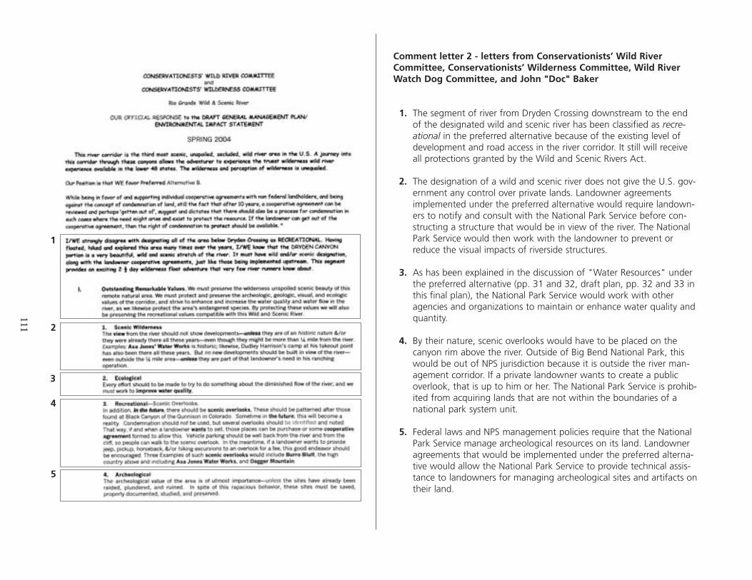
111
1
2
3
4
5
Comment letter 2 - letters from Conservationists’ Wild River Committee, Conservationists’ Wilderness Committee, Wild River Watch Dog Committee, and John "Doc" Baker
1. The segment of river from Dryden Crossing downstream to the end of the designated wild and scenic river has been classified as recreational in the preferred alternative because of the existing level of development and road access in the river corridor. It still will receive all protections granted by the Wild and Scenic Rivers Act.
2. The designation of a wild and scenic river does not give the U.S. government any control over private lands. Landowner agreements implemented under the preferred alternative would require landowners to notify and consult with the National Park Service before constructing a structure that would be in view of the river. The National Park Service would then work with the landowner to prevent or reduce the visual impacts of riverside structures.
3. As has been explained in the discussion of "Water Resources" under the preferred alternative (pp. 31 and 32, draft plan, pp. 32 and 33 in this final plan), the National Park Service would work with other agencies and organizations to maintain or enhance water quality and quantity.
4. By their nature, scenic overlooks would have to be placed on the canyon rim above the river. Outside of Big Bend National Park, this would be out of NPS jurisdiction because it is outside the river management corridor. If a private landowner wants to create a public overlook, that is up to him or her. The National Park Service is prohibited from acquiring lands that are not within the boundaries of a national park system unit.
5. Federal laws and NPS management policies require that the National Park Service manage archeological resources on its land. Landowner agreements that would be implemented under the preferred alternative would allow the National Park Service to provide technical assistance to landowners for managing archeological sites and artifacts on their land.

112
6
7
8
9
10
11
12
6. Hunting from the river is prohibited, but the National Park Service has no authority or jurisdiction to prohibit hunting on state or private lands. A lack of public access has resulted in there being little private motorized boating at present. Under the preferred alternative, boating would be limited, and it would be monitored (see "Visitor Experience and Understanding," pp. 42-44 in the draft plan, pp. 4245 in this final plan).
7. The La Linda Bridge is not under NPS control; therefore, IT is beyond the scope of this plan. The National Park Service has examined the issue of a new bridge at Boquillas during the park management planning process. The National Park Service is strongly opposed to adding any new bridges in Big Bend National Park. The National Park Service would work with the La Linda bridge owner and other local interests as part of the overall management strategy for the region.
8. See response 2, above.
9. Under the preferred alternative, recreational use would be limited, and it would be monitored (see "Visitor Experience and Understanding," pp. 42-44 in the draft plan, pp. 42-45 in this final plan).
10. Federal laws protecting cultural resources would apply in Big Bend National Park and on the river. Texas state laws regarding trespassing and archeological protection would apply on private lands.
11. See response 10, above.
12. See response 2, above. In addition, many of the subdivisions or ranchette developments have covenants that prohibit construction on the canyon rims or adjacent to the river.

1
2
3
4
5
113
Comment letter 3 - from Jeff Renfrow
1. The National Park Service believes that designation as a wild and scenic river places additional protection on a river, even when the river is on NPS land. The additional segment recommended for designation was included as part of the original study and was always intended to be part of the wild and scenic river. Because more than half of the designated river is not on NPS land, the cooperation of private and state landowners is essential in developing and implementing any meaningful long-range plan. Any other approach would not be feasible. The National Park Service would retain the ability to acquire rights-of-way or easements in the management corridor from willing sellers if that was necessary to protect resources or for public access.
2. The planning team had several discussions about navigable rivers on private lands. This General Management Plan does not attempt to override state or federal laws covering this issue. All actions prescribed in the plan are to be considered within the bounds of current state and federal statutes.
3. Under the preferred alternative, boaters could pull out and camp on the American shore up to 150 feet above the high water mark. This limit provides more room than the ordinary high water mark.
4. The Draft General Management Plan contained a sample landowner agreement (appendix C). Some actual landowner agreements mention the specific locations of sensitive resources such as archeological sites. The confidentiality of this information is protected by the Archeological Resources Protection Act of 1979.
5. All landowners are asked to sign a standard agreement, with some individual tailoring concerning site-specific resources. Although the Rio Grande Wild and Scenic River designation covers only the American half of the river, the agreements contain language saying, "The NPS shall . . . [e]ndeavor in every appropriate way to encourage Mexico to adopt the NPS's management plan."

1
114
Comment letter 4 - from Mark Peterson, National Parks Conservation Association
1. The National Environmental Policy Act requires that agencies consider a reasonable range of alternatives, but it does not indicate how many alternatives must be considered. Two alternatives have been considered in this General Management Plan: alternative A, the no-action alternative and alternative B, the alternative preferred by the National Park Service. Although it is unusual for the National Park Service to consider only one action alternative in a general management plan, there were extenuating circumstances — more than half of the designated river is not on NPS land. To gain the cooperation and support of the non-NPS landowners, agreements were originated that are necessary for the development and implementation of long-range management strategies. This cooperative approach was the only one deemed reasonable for a successful plan. Also see "Alternatives Dismissed from Further Consideration" on page 48.

2
3
115
2. All museum and archival collections related to the Rio Grande are preserved with those from Big Bend National Park. This topic was addressed in the Big Bend National Park General Management Plan (NPS 2004a); therefore, it has been dismissed from this document.
3. On page 43 of the draft plan, and in this final plan on page 44, limits on recreational use have been established (in the preferred alternative) "to continue the variety of historic or traditional visitor experiences and to protect natural and cultural resources in the future." The limits in the plan were set by river management professionals at a level that, in their judgment, would not cause harm to the resources or adversely affect visitor experiences. The Lower Canyons segments offer more opportunities for solitude. Most of the year, river runners can experience solitude because visitation numbers are comparatively low. Solitude is easily found on the river 85% of the year. To preserve the visitor experience, this plan establishes launch numbers and carrying capacities that are based on historic use levels.
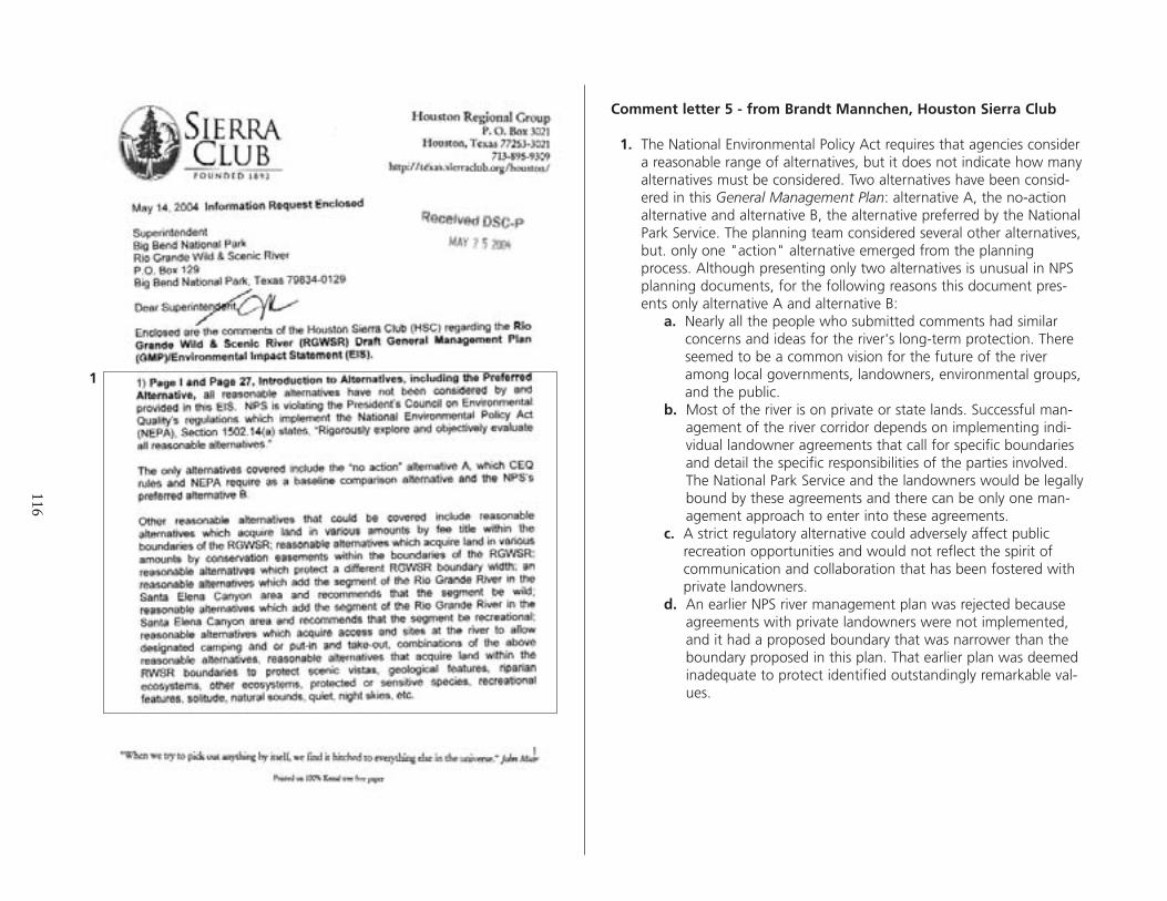
1
116
Comment letter 5 - from Brandt Mannchen, Houston Sierra Club
1. The National Environmental Policy Act requires that agencies consider a reasonable range of alternatives, but it does not indicate how many alternatives must be considered. Two alternatives have been considered in this General Management Plan: alternative A, the no-action alternative and alternative B, the alternative preferred by the National Park Service. The planning team considered several other alternatives, but. only one "action" alternative emerged from the planning process. Although presenting only two alternatives is unusual in NPS planning documents, for the following reasons this document presents only alternative A and alternative B:
a. Nearly all the people who submitted comments had similar concerns and ideas for the river's long-term protection. There seemed to be a common vision for the future of the river among local governments, landowners, environmental groups, and the public.
b. Most of the river is on private or state lands. Successful management of the river corridor depends on implementing individual landowner agreements that call for specific boundaries and detail the specific responsibilities of the parties involved. The National Park Service and the landowners would be legally bound by these agreements and there can be only one management approach to enter into these agreements.
c. A strict regulatory alternative could adversely affect public recreation opportunities and would not reflect the spirit of communication and collaboration that has been fostered with private landowners.
d. An earlier NPS river management plan was rejected because agreements with private landowners were not implemented, and it had a proposed boundary that was narrower than the boundary proposed in this plan. That earlier plan was deemed inadequate to protect identified outstandingly remarkable values.
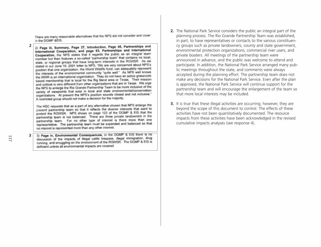
2
3
2. The National Park Service considers the public an integral part of the planning process. The Rio Grande Partnership Team was established, in part, to have representatives or contacts to the various constituency groups such as private landowners, county and state government, environmental protection organizations, commercial river users, and private boaters. All meetings of the partnership team were announced in advance, and the public was welcome to attend and participate. In addition, the National Park Service arranged many public meetings throughout the state, and comments were always accepted during the planning effort. The partnership team does not make any decisions for the National Park Service. Even after the plan is approved, the National Park Service will continue support for the partnership team and will encourage the enlargement of the team so that more local interests may be included.
3. It is true that these illegal activities are occurring; however, they are beyond the scope of this document to control. The effects of these activities have not been quantitatively documented. The resource impacts from these activities have been acknowledged in the revised cumulative impacts analyses (see response 4).
117

4
4. The National Park Service has added more information in the "cumulative effects scenario" and more analysis to the "Environmental Consequences" chapter. This analysis is qualitative. A quantitative analysis is not appropriate for a programmatic level document such as a general management plan.
4 continues next page
118
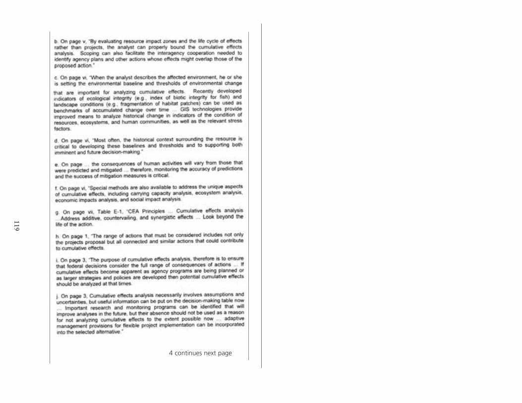
119
4 continues next page

4 continues next page
120

121

5
122
6
7
8
9
10
11
5. Under alternative A, the National Park Service would cooperate with Mexico and with other United States agencies to control exotic species and restore riparian areas in the limited fashion that it is being done at present. Under alternative B, this cooperation would be enhanced and coordinated with other resource management activities.
6. It is true that the National Park Service, representing the U.S. government, could enter into agreements with Mexico, U.S. agencies, and private landowners under alternative A (the no-action), but to what purpose? Without a plan in place to provide long-range management goals, any agreements could be ineffective or at cross purposes with other agreements. No formal agreements with nonfederal landowners exist at present, and this would continue under the no-action alternative.
7. Under alternative A, the National Park Service would not be legally restricted from obtaining administrative access across private land through agreement with individual landowners. In alternative B, the preferred alternative, this access need would be identified as part of an overall management strategy, and it would be implemented as part of the broader scope of landowner agreements.
8. See response 6, above.
9. In managing and protecting natural and cultural resources, the National Park Service must abide by federal laws and mandates, as well as by NPS management policies. This is a "given" under any alternative, as was described under "Legislation and Mandates" in both the draft plan and this final plan (pp. 6-11). Under alternative B, the preferred alternative, more actions to meet these requirements would be carried out in the Lower Canyons portion of the river than under alternative A, the no-action alternative. This is because alternative A does not include segment-specific river corridor (management boundary) and long-range management direction.
10. See response 6, above.
11. See response 6, above.

12
123
13
14
15
16
17
12. See response 9, above.
13. Although it is not mentioned in NPS Management Policies 2001, under alternative A this letter of intent would continue to be implemented in the same manner and level it is now. The text has been revised in this final plan to clarify this.
14. See response 9, above.
15. Under alternative B, the preferred alternative, landowner agreements would be implemented that would require private landowners to notify and consult with the National Park Service when proposing a structure that would be within view of the river. The National Park Service would work with each landowner to mitigate any adverse effects on scenery or other values from the proposal. (This provision is discussed under "Analysis, Segments outside of Big Bend National Park" on p. 70 of the draft plan, p. 74 of this document.).
16. Both statements are correct. The statement in the "Conclusion" takes into account the combined effect on river segments in the park and segments outside the park. The determination that there would be a "minor long-term beneficial effect" is correct for river segments in the park.
17. See response 6, above.
18
18. In establishing limits on recreational use, the National Park Service considered "the historic variety of experiences available, recent use, and the physical characteristics of each river segment" with the goal to "continue the variety of historic or traditional visitor experiences and to protect natural and cultural resources in the future." This intention is described under "Visitor Experience and Understanding" on page 43 of the draft document and page 44 of this document. The limits in the plan were set by river management professionals, who considered the number of river users from the past 20 years at a level that, in their judgment, has not harmed the resources or adversely affected the visitor experience and would not do so in the future. As is shown in figure 1 (p. 60 in the draft plan, p. 63 in this document), the highest number of users came to the river in 1985. The Lower Canyons segments would continue to offer the most opportunities for solitude.
124

19
20
125
19. The topic of soils was dismissed from further consideration for the following reasons: Implementing the General Management Plan would not cause an increase in use of the river, and shoreline use by boaters is limited to the first 150 feet, where natural high water periods and other river dynamics may affect soils more than they would be affected by visitor use.
20. Guadalupe fescue is found in scattered patches in the understory of pine/oak/juniper woodlands around 5,000 ft. in elevation, well above the river. Lloyd's mariposa cactus is found on arid, gravelly, limestone-derived soils on gentle slopes — not typically in the corridor used by river visitors. The plan is correct when its says these species would not be affected by either alternative; dismissal is justified.

126
21
22
23
21. The National Park Service agrees that poor air quality can affect viewsheds. The air quality in Big Bend National Park and the Rio Grande Wild and Scenic River is often poor, as is discussed under "Air Quality" (p. 22 in the draft plan, pp. 22-23 in this document). However, the source of this air quality degradation is outside NPS boundaries and therefore beyond the scope of this plan. The Big Bend General Management Plan describes the park's air quality monitoring program, its ongoing negotiations with Mexico, and the ongoing cooperation with the Texas Commission on Environmental Quality, the NPS Air Resources Division, and the U.S. Environmental Protection Agency to address air quality issues.
22. This topic was dismissed because "Neither alternative of this plan would involve additional construction in, or disruption of, the Rio Grande or adjacent floodplains, and neither would entail filling in or disturbing any wetland" (p. 22 in the draft plan, p. 23 in this document). The National Park Service is not proposing a 50% increase in visitor use. The preferred alternative would allow a number within 15% of the historical high in 1985. Low water levels in the river probably will affect the number of recreational users more than any NPS-imposed restrictions. Shoreline use by boaters typically is concentrated in the first 150 feet, where natural high water periods and other river dynamics may affect floodplains and riverside wetlands more than they would be affected by visitor use. If this plan is approved, the National Park Service would monitor sensitive resources and impose restrictions if necessary to prevent them from being degraded (p. 41 in the draft plan, p. 40 in this document).
23. The Wild and Scenic Rivers Act does not prohibit or limit motorized boating on a designated river under any of the three classifications. Motorized boats are allowed on some river segments in Big Bend National Park and in the Lower Canyons. This allowance is made to provide a variety of resource-dependent recreational experiences for visitors. Even so, little motorized use occurs on these river segments now, and no increase is expected. None of the commercial river guides uses motorized craft. Actions would be taken to limit recreational use further if it was shown to be causing an adverse effect on resources or values. These future actions might include limiting the allowable segments, speed, or horsepower of motorized boats. The new river use management plan called for in the preferred alternative would include a monitoring program and specific management actions.
127
24
25
26
24. Implementing the preferred alternative would necessitate an increase in staff for river management. As is indicated in table 7 (p. 48 in the draft plan, p. 50 in this document), the National Park Service estimates that three more people would be needed: one manager and two resource management / protection rangers. As was mentioned in response 18, above, this plan does not propose to increase visitor use by 50% or 100% or 200%. The preferred alternative allows a number that is within 15% of the historical high in 1985 (see table 6, p. 43 in the draft document, p. 45 in this document).
25. The preferred alternative would include recommending the additional designation of the upstream segment in Big Bend National Park. If Congress does designate this segment, then more than 50% of the river will be in federal and state ownership, and condemnation would be prohibited by section 6(b) of the Wild and Scenic Rivers Act. The National Park Service still could acquire lands or easements from willing sellers to provide access or protect resources.
26. No action or condition described in the management prescriptions or alternatives would result in an increase in light pollution because no development requiring outdoor lighting is proposed.
27. As was mentioned in responses 22 and 24, the National Park Service is not proposing an increase in visitor use. There were errors in the text of the draft document. The passage on draft page 44 has been changed (see the same passage beginning on p. 40 of this document), and the passage on draft page 88 also has been changed (see p. 94 of this document). Table 6 is correct in both documents (p. 43 draft, p. 45 this document). The preferred alternative would allow a maximum of 1,000 persons or 7,000 user days per year — a number that is within 15% of the historical high in 1985 (see fig. 1, p. 60 draft, p. 63 this document)). Given the current low water trends, this number may never be reached. As we described in response 18, the limits in the plan were set by river management professionals, who considered the number of river users from the past 20 years at a level that, in their judgment, has not harmed the resources or adversely affected the visitor experience and would not do so in the future.
27

128
28
29
30
31
32
28. Neither alternative would include new structures. The paragraph on page 46 of the draft document (pp. 47-48 this document) describes mitigating measures that would be applied to reduce the impacts if a need for a small, temporary structure such as a kiosk or storage container should arise in the future. If a new structure was proposed, site-specific environmental analysis would be conducted at that time.
29. This matter is beyond the scope of this plan because it is a law enforcement issue for which direction is not needed. Resource protection personnel simply need to continue to work with Mexican village people to educate them about the consequences of allowing their cattle to cross the border, enlist their cooperation, and enforce existing park rules and regulations when and if cattle do cross the border. The effects of illegal cattle grazing have been addressed in the cumulative impacts discussion for applicable impact topics.
30. The treaty between the United States and Mexico, which has been in effect since 1944, requires that a specified amount of water be released into the Rio Grande from the six tributaries on the Mexican side. If Mexico fails to fulfill its obligation for water flow, then the water level in the Rio Grande is reduced through Big Bend National Park (downstream segments are fed by springs). The National Park Service has no means or authority to enforce this treaty; therefore, it is beyond the scope of this General Management Plan.
31. The designation of a wild and scenic river does not give the U.S. government any control over private lands. Private landowners can legally do what they want on their own land. However, signed landowner agreements implemented under the preferred alternative would require landowners to notify and consult with the National Park Service before constructing a structure that would be in view of the river. The National Park Service would then work with the landowner to prevent or reduce the visual impacts of riverside structures.
32. Opportunities to experience solitude would continue to be present in the Lower Canyons most of the year. The National Park Service is not mandated to protect solitude outside of a designated wilderness area.

129
33
34
35
36
37
38
33. Standard dictionary definitions are adequate for understanding what is meant by these terms. Impacts in a general management plan / environmental impact statement are necessarily general and conceptual because of the nature of this level of planning. These terms are meant to help readers understand and compare the relative intensities of the impacts.
34. Cost estimates for all alternatives are included in a general management plan. This does not guarantee that additional funding will be available, but it does provide a justification for requesting additional funds. The National Park Service would manage the river in conformance with the approved general management plan as much as funding allowed.
35. See response 18, 22, 24, and, 27, above.
36. It is known that visitor use could affect wildlife species or habitat through the trampling of vegetation, the harassment of wildlife, or the degradation of aquatic habitat (p. 73 draft plan; p. 77 this document).
37. These actions or effects are listed in the sections of the document that analyze the cumulative effects from past, present, and future actions occurring on federal, state, and private lands in the region. These actions have occurred or are occurring somewhere in the region but outside of NPS land; therefore, they are out of our jurisdiction. The exception to this is residential development in the river corridor under a signed landowner agreement. In this circumstance, the National Park Service would work with the landowner to reduce the impacts of a structure in view of the river.
38. The effects on vegetation caused by visitors are discussed in the "Cumulative Effects" analyses on pages 76 and 77 in the draft document (pp. 81 and 82, this document). Alternative A would not result in any additional impacts, and alternative B would reduce the impacts. Also see responses 22, 24, and 27, above.

130
39
40
41
42
39. Both statements are correct. The statement in the conclusion takes into account the overall or combined effect on river segments in the park and segments outside the park.
40. As was explained in response 33, above, the National Park Service uses standard dictionary definitions, and we believe these are adequate for understanding what is meant by these terms. Impacts discussed in a general management plan / environmental impact statement are necessarily general and conceptual because of the nature of this level of planning. These terms are meant to help readers understand and compare the relative intensities of the impacts.
41. Because the identified outstandingly remarkable values for which the river was designated are in the river canyon, and because the 0.25-mile default boundary often extends beyond the canyon rim, the default boundary "sometimes exceeds what is necessary to protect the identified outstandingly remarkable values." The National Park Service believes that most landowners would object to the fact that the U.S. government could use condemnation at any time to acquire part or all of a private landowner's property.
42. The National Park Service believes that the potential to acquire a piece of property from an unwilling seller would result in an adverse impact to that landowner.

131
43
44
45
43. Please see response 40, above.
44. The economic impact analysis on page 88 was prepared with the use of obsolete visitor use information and predictions. This section has been revised for this final plan (see p. 94).
45. Please see response 40, above.
46
132
47
48
49
46. Please see responses 5, above.
47. Alternative A, the no-action alternative, represents the continuation of current management. There are no agreements with landowners now, nor are any proposed under current management. The National Park Service could enter into agreements with private landowners under alternative A, but without a plan in place to establish long-range management goals, any agreement could be ineffective or at cross purposes with other agreements.
48. The National Park Service recognizes that visitor use can cause impacts, but these impacts are neither major nor unavoidable. The impacts are occurring at a few places along the near shore of an active and dynamic river, which will periodically erase the temporary impacts of humans. Natural resources and cultural resources would be monitored. Actions would be taken to move or limit recreational use if it was shown to be causing an adverse effect on resources; therefore, these impacts are not unavoidable. The new river use management plan called for in the preferred alternative would include a monitoring program and specific management actions. (Also see responses 18, 22, 24, and 27, above.)
49. The Santa Elena segment extends from the western boundary of Big Bend National Park downstream to the beginning of the currently designated segment, across from the state line between the Mexican states of Chihuahua and Coahuila (see the Alternative B map, p. 39 draft; p.35 this document). That segment contains seven road access points, which makes it ineligible for wild classification. Most of these access points are on primitive dirt roads; therefore, the National Park Service believes that scenic classification is most appropriate.
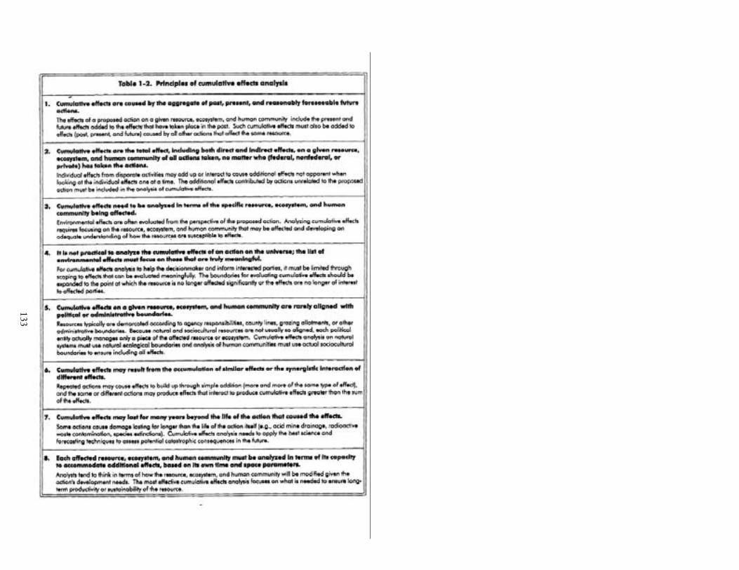
133

1
2
3
134
Comment letter 6 - from Dr. Glenn Haas, Colorado State University
1. 1. The National Environmental Policy Act requires that agencies consider a reasonable range of alternatives, but it does not indicate how many alternatives must be considered. Two alternatives have been considered in this General Management Plan / Environmental Impact Statement: alternative A, the no-action alternative and alternative B, the alternative preferred by the National Park Service. Although it is unusual for the National Park Service to consider only one action alternative, there were extenuating circumstances, as follows:
a. Nearly all the people who submitted comments had similar concerns and ideas for the river's long-term protection. There seemed to be a common vision for the future of the river among local governments, landowners, environmental groups, and the public.
b. Most of the river is on private or state lands. Successful management of the river corridor depends on implementing individual landowner agreements that call for specific boundaries and detail the specific responsibilities of the parties involved. The National Park Service and the landowners would be legally bound by these agreements, and there can be only one management approach to enter into these agreements.
c. A strict regulatory alternative could adversely affect public recreation opportunities and would not reflect the spirit of communication and collaboration that has been fostered with private landowners.
2. On page 43 of the draft plan, and in this final plan on page 44, limits on recreational use have been established (in the preferred alternative) "to continue the variety of historic or traditional visitor experiences and to protect natural and cultural resources in the future." The limits in the plan were set by river management professionals at a level that, in their judgment, would not cause harm to the resources or adversely affect visitor experiences. Monitoring of the condition of the outstandingly remarkable values (including recreation) is required by the Wild and Scenic Rivers Act. Actions would be taken to further limit recreation use if it was shown to cause more than a negligible adverse effect on resources. Commercial trips must abide by the same persons-per-launch limits as private parties.
3. The Wild and Scenic Rivers Act does not prohibit or limit motorized boating on a designated river. Motorized boats are allowed on some river segments in Big Bend National Park and in the Lower Canyons. This allowance is made to provide a variety of resource-dependent recreational experiences for visitors. Even so, little motorized use occurs on these river segments now, and no increase is expected. None of the commercial river guides uses motorized craft. Actions would be taken to limit recreational use further if it was shown to be causing an adverse effect on resources or values. These future actions might include limiting the speed or horsepower of motorized boats. The new river use management plan called for in the preferred alternative would include a monitoring program and specific management actions.
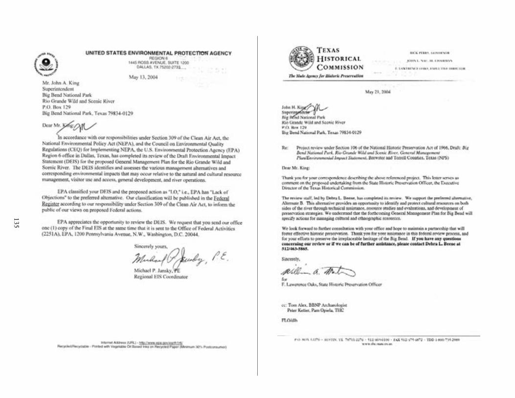
135

136

Comment letter 7 - from Texas Historical Commission
137

138

Appendixes/References/Preparers/Index

4CC8A7<K8F,E898E8A68F,CE8C4E8EF,<A78K±±&T^S`]±*±TSU]±aX±V[h[VWd'±±±±±±±±±±±±±±±±±±±±±±±±±±±±±±±±±±±±±±±±±±±±±
±±±
±±±±ÿĂþ±

APPENDIX A: LEGISLATION
The National Parks and Recreation Act Public Law 95-625 November 10, 1978
provides for the addition of the Rio Grande segment
ADDITION OF RIO GRANDE SEGMENT
SEC. 702. Section 3(a) of the Wild and Scenic Rivers Act is amended by adding the following new paragraph at the end thereof:
“(17) RIO GRANDE, TEXAS.—The segment on the United States side of the river from river mile 842.3 above Mariscal Canyon downstream to river mile 651.1 at the Terrell-Val Verde County line; to be administered by the Secretary of the Interior. The Secretary shall, within two years after the date of enactment of this paragraph, take such action with respect to the segment referred to in this paragraph as is provided for under subsection (b). The action required by such subsection (b) shall be undertaken by the Secretary, after consultation with the United States Commissioner, International Boundary and Water Commission, United States and Mexico, and appropriate officials of the State of Texas and its political subdivisions. The development plan required by subsection (b) shall be construed to be a general management plan only for the United States side of the river and such plan shall include, but not be limited to, the establishment of a detailed boundary which shall include an average of not more than 160 acres per mile. Nothing in this Act shall be construed to be in conflict with—
“(A) the commitments or agreements of the United States made by or in pursuance of the treaty between the United States and Mexico regarding the utilization of the Colorado and Tijuana Rivers and of the Rio Grande, signed at Washington, February 1944 (59 Stat. 1219), or
“(B) the treaty between the United States and Mexico regarding maintenance of the Rio Grande and Colorado River as the international boundary between the United States and Mexico, signed November 23, 1970.
For purposes of carrying out the provisions of this Act with respect to the river designated by this paragraph, there are authorized to be appropriated such sums as may be necessary, but not more than $1,650,000 for the acquisition of lands and interests in lands and not more than $1,800,000 for development.”.
141

APPENDIXES
(blank)
142

APPENDIX B: CORRESPONDENCE FROM U.S. FISH AND WILDLIFE SERVICE ABOUT SENSITIVE SPECIES
FISH AND WILDLIFE SERVICE Ecological Services Field Office 10711 Burnet Road, Suite 200
Austin, Texas 78758
JUL - 6 2000 2-15-00-I-868
Mary Magee (DSC-PDS-RP) National Park Service, Denver Service Center Box 25287Denver, Colorado 80225
Dear Ms. Magee:
This responds to your June 5, 2000 letter, requesting a current list of federally listed or proposed threatened and endangered species and mapped locations of known populations and Critical Habitat that may occur in Terrell and Brewster counties, Texas. It is our understanding this information will assist in the development of a general management, river management planning, and wilderness study to prescribe resource conditions and visitor experiences to be achieved and maintained at Big Bend National Park and Rio Grande Wild and Scenic River over time.
Enclosed is the list of species you requested and a copy of “Threatened and Endangered Species of Texas (Revised June 1995),” a publication that contains general information about the life histories, habitats, and distribution of the federally listed species in Texas. No federally designated Critical Habitat currently exists in Terrell or Brewster counties and, although we are unable to provide you with mapped locations of known listed species’ populations, we look forward to working with you to determine when species surveys would be appropriate in an effort to avoid adverse impacts to federally listed or proposed species and their habitats.
We appreciate the opportunity to comment on the proposed management plans and your concern for endangered species and fish and wildlife resources. We look forward to assisting you with this effort and reviewing the Draft Environmental Impact Statement. If we can be of further assistance, please contact Dianne Lee at 512/490-0057, extension 231.
Sincerely,
David C. Frederick Supervisor
Enclosures
Federally Listed as Threatened and Endangered Species of Texas
143

APPENDIXES
March 28, 2000
DISCLAIMER
This County list is based on information available to the U.S. Fish and Wildlife Service at the time of preparation, date on page 1. This list is subject to change, without notice, as new biological information is gathered and should not be used as the sole source for identifying species that may be impacted by a project.
Edwards Aquifer species: (Edwards Aquifer County) refers to those six counties within the Edwards Aquifer region. The Edwards Aquifer underlies portions of Kinney, Uvalde, Medina, Bexar, Hays, and Comal Counties (Texas). The Service has expressed concern that the combined current level of water withdrawal for all consumers from the Edwards Aquifer adversely affects aquifer-dependent species located at Comal and San Marcos springs during, low flows. Deterioration of water quality and/or water withdrawal from the Edwards Aquifer may adversely affect eight federally-listed species.
Comal Springs riffle beetle (E) Heterelmis comalensis Comal Springs thyopid beetle (E) Stygoparnus comalensis Fountain darter (E w/CH) Etheostoma fonti cola Peck’s cave amphipod (E) Stygobromus (=Stygonectes) pecki San Marcos gambusia (E w/CH) Gambusia georgei Texas wild-rice (E w/CH) Zizania texana Texas blind salamander (E) Typhlomolge rathbuni San Marcos salamander (T □w/CH) Eurycea nana
*The Barton Springs salamander is found in Travis County but may be affected by activities within the Barton Springs Segment of the Edwards Aquifer, which includes portions of Northern Hays County.
Migratory Species Common to many or all Counties: Species listed specifically in a county have confirmed sightings. If a species is not listed they may occur as migrants in those counties.
Least tern (E) Sterna antillarum Whooping crane (E w/CH) Grus americana Bald eagle (T) Haliaeetus leucocephalus Piping plover (T) Charadrius melodus Loggerhead shrike (SOC) Lanius ludovicianus White-faced ibis (SOC) Plegadis chihi Brewster County Black-capped vireo (E) Vireo atricapillus Golden-cheeked warbler (E) Dendroica chrysoparia Northern aplomado falcon (E) Falcofemoralis septentrionalis Southwestern willow flycatcher (Et) Empidonax traillii extimus Whooping crane (E w/CH) Grus americana Mexican long-nosed bat (E) Leptonycteris nivalis Big Bend gambusia (E) Gambusia gaigei Davis’ green pitaya (E) Echinocereus viridiflorus var. davisii Nellie cory cactus (E) Coryphantha (=Mammillaria) minima Terlingua Creek cats-eye (E) Cryptantha crassipes Bunched cory cactus (E) Coryphantha ramillosa Chisos Mountain cactus (T) Echinocereus chisoensis var. chisoensis Hinckley’s oak (T) Quercus hinckleyi Lloyd’s Mariposa cactus (T) Echinomastusmariposensis Mountain plover (T) Charadrius montanus
144
Appendix B: Correspondence from U.S. Fish and Wildlife Service about Sensitive Species
Tall paintbrush (P/T) Castilleja elongata Guadalupe fescue (C) Festuca ligulata Shinner’s tickle-tongue (C) Zanthoxylum parvum Leoncita false foxglove (C) Agalinis calycina Texas false saltgrass (SOC) Allolepsis texana Ferruginous hawk (SOC) Buteo regalis Baird’s sparrow (SOC) Ammodramus bairdii Loggerhead shrike (SOC) Lanius ludovicianus Northern goshawk (SOC) Accipiter gentilis Northern gray hawk (SOC) Buteo nitidus maximus Texas olive sparrow (SOC) Arremonops rufivirgatus rufivirgatus Western burrowing owl (SOC) Athene cunicularia hypugea White-faced ibis (SOC) Plegadis chihi Davis Mountain cottontail rabbit (SOC) Sylvilagusfioridanus robustus Greater western mastiff bat (SOC) Scalopus aquaticus texanus Presidio mole (SOC) Eumops perotis caljfornicus Spotted bat (SOC) Eudenna maculatum Texas horned lizard (SOC) Phrynosoma cornutum Blotched gambusia (SOC) Ganthusia senilis Blue sucker (SOC) Cyclepsus elongatus Chihuahua shiner (SOC) Notropis chihuahua Conchos pupfish (SOC) Cyprinodon eximius Mexican stoneroller (SOC) Campostoma ornatum Proserpine shiner (SOC) Cyprinella proserpina Rio Grande darter (SOC) Etheostoma grahami Rio Grande shiner (SOC) Notropisjemezanus Blanchards’ sphinx moth (SOC) Adhemarius blanchardorum Bonita diving beetle (SOC) Deronectes neomexicana Subtropical tiger beetle (SOC) Cicindela nigrocoerula subtropica Big Bend (Desert Mts.) bluegrass (SOC) Poa strictiramea Big Bend hop hornbeam (SOC) Ostrya chisosensis Bigpod bonamia (SOC) Bonamia ovalifolia Bush-pea (SOC) Genistidium dumosum White column cory cactus (SOC) Coryphantha albicolumnaria Chaffey’s cory cactus (SOC) Coryphantha chaffeyi Chisos agave (SOC) Agave glomeruljflora Chisos coral-root (SOC) Hexalectris revoluta Chisos pinweed (SOC) Lechea mensalis Cliff bedstraw (SOC) Galium correllii Cox’s dalea (SOC) Dalea banonii Cutler’s twistflower (SOC) Streptanthus cutleri Dense cory cactus (SOC) Coryphantha dasyacantha var. dasyacantha Desert night-blooming cereus (SOC) Cereus greggii var. greggii Duncan’s cory cactus (SOC) Coryphantha duncanii Glass Mountain coral-root (SOC) Hexalectris nitida Glass Mountain rock-daisy (SOC) Perityle vitreomontana Golden-spine hedgehog cactus (SOC) Echinocereus chloranthus var. neocapillus Golden-spined prickly-pear (SOC) Opuntia aureispina Heather leaf-flower (SOC) Phyllanthus ericoides Hester’s cory cactus (SOC) Coryphantha hesteri Hinckley’s brickelbush (SOC) Brickellia brachyphylla var. hinckleyi Lateleaf oak (SOC) Quercus tardifolia Little-leaf brongniartia (SOC) Brongniartia minutifolia
145

C
APPENDIXES
Long spur columbine (SOC) Aquilegia longissima Many-flowered unicorn plant (SOC) Proboscidea spicata Maravillas milkwort (SOC) Polygala maravillasensis Mary’s bluet (SOC) Hedyotis butterwickiae Old blue mock pennyroyal (SOC) Hedeoma pilosum Pale phacelia (SOC) Phacelia pallida Perennial caltrop (SOC) Kallstroemia perennans Purple gay-mallow (SOC) Batesimalva violacea Ripley’s senna (SOC) Senna ripleyana Roberts’ stonecrop (SOC) Sedum robertsianum Silver cholla (SOC) Opuntia inthricata var, argentea Slender oak (SOC) Quercus graciljformis Sonora fleabane (SOC) Erigeron mimegletes Stairstep two-bristle rock-daisy (SOC) Perityle bisetosa var. scalaris Straw-spine glory of Texas (SOC) Thelocactus bicolor var. flavidispinus Swallow spurge (SOC) Chamaesyce golondrina Terlingua brickelbush (SOC) Brickellia brachyphylla var. terlinguensis Texas milkvine (SOC) Matelea texensis Texas woltberry (SOC) Lycium texanum Three-tongued spurge (SOC) Chamaesyce chaetocalyx var. triligulata Trans-Pecos maidenbush (SOC) Andrachne arida Two-bristle rock-daisy (SOC) Perityle bisetosa var. bisetosa Texas purple spike (SOC) Hexalectris warnockii Wilkinson’s whitlow-wort (SOC) Paronychia wilkinsonii Wright’s water-willow (SOC) Justicia wrightii
Statewide or areawide migrants are not included by county, except where they breed or occur in concentrations. The whooping crane is an exception; an attempt is made to include all confirmed sightings on this list:
E = Species in danger of extinction throughout all or a significant portion of its range. T = Species which is likely to become endangered within the foreseeable future throughout all or a
significant portion of its range. = Species for which the Service has on file enough substantial information to warrant listing as threatened
or endangered. CH = Critical Habitat (in Texas unless annotated ‡) P/ = Proposed P/E = Species proposed to be listed as endangered. P/T = Species proposed to be listed as threatened. TSA = Threatened due to similarity of appearance. SOC = Species for which there is some information showing evidence of vulnerability, but not enough data
to support listing at this time. □ = with special rule ‡ = CH designated (or proposed) outside Texas ~ = protection restricted to populations found in the “interior” of the United States. In Texas, the least tern
receives full protection, except within 50 miles (80 km) of the Gulf Coast.
County Name Code Designations: examples Anderson = Arlington Ecological Services (ES) office (Bee) = Corpus Christi ES office Galvestoni =Clear Lake ES office Gillespie = Austin ES office
146

APPENDIX C: SAMPLE LANDOWNER AGREEMENT
RIO GRANDE WILD AND SCENIC RIVER AGREEMENT
Between the
NATIONAL PARK SERVICE, UNITED STATES DEPARTMENT OF THE INTERIOR
and
______________________________, AN OWNER OF PRIVATE LAND
ALONG THE LOWER CANYONS OF THE RIO GRANDE IN BREWSTER COUNTY, TEXAS
THIS AGREEMENT is entered into by and between the National Park Service (hereinafter “NPS”), United States Department of the Interior, an agency of the United States of America, acting through the Superintendent of the Rio Grande Wild and Scenic River, Texas (hereinafter “RGWSR”), and Trustee for Bullis Gap Ranch Associates (hereinafter “Landowner”), an owner of private land located along the Lower Canyons of the Rio Grande in Brewster County, Texas.
I. BACKGROUND AND OBJECTIVES:
WHEREAS, in title VII, § 702 of the National Parks and Recreation Act of 1978, Pub. L. No. 95-625, 92 Stat. 3467, 3522, Congress designated the segment of the Rio Grande in Texas on the United States side of the river from river mile 842.3 above Mariscal Canyon downstream to river mile 651.1 at the Terrell-Val Verde County line as a wild and scenic river (WSR) under the Wild and Scenic Rivers Act, codified at 16 USC § 1271-87 (2000); and
WHEREAS, in that act Congress directed that the RGWSR be administered by the Secretary of the Interior; and
WHEREAS, the Secretary of the Interior has delegated the authority to administer RGWSR to the NPS; and
WHEREAS, prior to this agreement, the NPS had not adopted a management plan for RGWSR; and
WHEREAS, many of the owners of private land along the Rio Grande’s Lower Canyons in Brewster and Terrell Counties, Texas, acquired their land prior to the Rio Grande’s designation as a wild and scenic river, opposed the legislation designating the Rio Grande as a wild and scenic river, lobbied against that legislation, and believe that the limits of RGWSR were set in part to authorize condemnation of private lands along the Rio Grande’s Lower Canyons; and
WHEREAS, those owners acquired their private lands along the Rio Grande’s Lower Canyons because of the area’s scenic beauty, wildness, isolation, and restricted access and over the past twenty-three years have acted as good stewards to maintain and protect the Rio Grande as a wild and scenic river without an NPS management plan; and
WHEREAS, the Landowner owns private property along the Rio Grande’s Lower Canyons as more particularly described in the SPECIAL PROVISIONS in Article IV below; and
147
APPENDIXES
WHEREAS, the scenery and resources along the reach of the Rio Grande on the Landowner’s property have outstandingly remarkable values; and the monetary value of the riverfront land exceeds the value of the adjoining ranch; and
WHEREAS, the NPS and the Landowner now recognize the commonality of their interest in preserving the Rio Grande as a wild and scenic river, and the necessity of the NPS, the State of Texas, and the Landowner in participating as partners in the management of the river; and
WHEREAS, the management plan developed by the NPS shall help to maintain the Rio Grande as a wild and scenic river in its current state, without interfering with the Landowner’s property rights; and
WHEREAS, the Landowner would not grant the NPS the right to use and manage the Landowner’s property if the NPS acquired the right to manage or otherwise interfere with the Landowner’s use of the Landowner’s property;
NOW, THEREFORE, THE NPS AND THE LANDOWNER AGREE AS FOLLOWS:
II. DEFINITIONS:
In this agreement the following terms shall have the following definitions:
Absolute Boundary — The landowner‘s property line along the reaches of the river, as determined by Texas State law.
Access — Locations that provide legal Public access to the river.
Categories of Use — Categories of Use are the following: commercial users and their customers utilizing any form of non-motorized watercraft; noncommercial users utilizing any form of motorized watercraft (as defined in management plan); noncommercial users utilizing any form of non-motorized watercraft.
Historic Use — The utilization of the reaches of the Lower Canyons by the Public between 1978 and 2000, measured in user-days per year.
Landowner — The fee simple owner of the Property, whether as an individual or participants in a partnership, corporation, joint venture, or other legal entity, a legal relative, employee, assign, agent, or guest of the Landowner. The payment of fees or other consideration by a person in order to enter, use or to be on the property eliminates them from inclusion under this definition.
Management Area — The area between (1) the international boundary between the United States and Mexico and (2) the Management Boundary.
Management Boundary — A line located on the land owned by the Landowner and illustrated on the WSR map (1) that demarcates the portion of the Landowner’s land visible from the River or (2) that lies 1/4-mile from the River, whichever is closer to the River, unless otherwise provided under the SPECIAL PROVISIONS in article IV below.
Management Plan or General Management Plan — A comprehensive river management plan developed by the NPS in compliance with the National Environmental Policy Act of 1969, the Wild and Scenic Rivers Act, and other applicable federal laws, that (1) describes the existing resource conditions and the outstandingly remarkable values of the River, (2) defines the goals and desired future conditions for protecting river values, (3) addresses water quality issues and stream flow
148

Appendix C: Sample Landowner Agreement
requirements, (4) reflects a collaborative approach, recognizing the opportunities for partnership with all stakeholders, (5) includes a monitoring strategy to maintain desired future conditions, and (6) establishes a wild and scenic river boundary.
Mile Marker (MM) — An approximate point on the River measured in miles from the Gulf of Mexico. Mileage as maintained by the International Boundary and Water Commission.
Permit — A written authorization issued by the NPS to a member of the Public for river use.
Property — All land owned by the Landowner within the Management Area, as more particularly described in the SPECIAL PROVISIONS in Article IV below.
Public — All persons who are not (1) the Landowner or a legal relative, employee, assign, agent, or guest of the Landowner, as long as that person is accessing or utilizing the River at a location adjoining the Property, or (2) employees or agents of the NPS or the State of Texas.
Ranch — All contiguous land under the same ownership, any portion of which adjoins the River.
Reach — A segment of the River.
River — The reaches of the Rio Grande within Brewster and Terrell Counties, Texas.
River Bed- The area between the International Boundary and the Absolute Boundary.
Traffic — All activities of the Public on and along the River.
III. SPECIFIC TERMS OF AGREEMENT:
A. LIMITATIONS:
The NPS, in order to obtain those privileges of use and management with sole regard to the Public, ACKNOWLEDGES AND AGREES that the Landowner’s unrestricted use of the Property shall be absolute and unabridged except as provided in this agreement. Under this Agreement, the Management Plan and all NPS rules and regulations do not apply to the Landowner unless specifically provided in the Agreement.
B. THE NPS SHALL:
1 .Adopt and enforce such rules and regulations applicable to the Public as are necessary to maintain and preserve the Rio Grande as a wild and scenic river, in its current state, while protecting the Landowner’s property rights.
2 Implement the NPS’s General Management Plan within the Management Area.
3. Limit use of the river by the Public to less than 115% of Historic Use in each Category of Use.
4. Procure and maintain in force and effect during the term of this agreement general public liability insurance for the Property from a reputable company or companies licensed in the State of Texas with a minimum limitation of One Million Dollars ($1,000,000.00) per person and One Million Dollars ($1,000,000.00) per incident, naming the United States of America and the Landowner as co
149

APPENDIXES
insureds and insuring against any liability for property damage, personal injury, or death arising out of or resulting from the Public’s use of the Property pursuant to or as a result of this agreement.
5. Not initiate or prosecute any condemnation or eminent domain proceedings against all or any part of the Property
6. By appropriate and effectively located signs and printed information on the Permit, notify commercial users and other persons entering the River through public access points that the land adjoining the United States side of the River is private property and that their presence on the Property without the Landowner’s permission constitutes criminal trespass under the laws of the State of Texas, unless the Property may, by virtue of this agreement, be utilized by the Public.
7. Endeavor in every appropriate way to encourage Mexico to adopt the NPS’s Management Plan.
8. Endeavor in every appropriate way to enforce the NPS’s rules and regulations and Management Plan with regard to the Public entering the River, regardless of where they enter the River.
9. Not conduct or allow others to conduct surveys, studies, assessments, investigations, and evaluations of the environment, archeology, biology, geology, or any other facet of the Property without the Landowner’s express written consent, except as provided for in SPECIAL PROVISIONS.
10. Not interfere with the Landowner’s use of the Property and access to the river.
11. Not regulate the possession and use of firearms by the Landowner in the Management Area.
12. Beyond the Big Bend National Park boundary, only utilize the traditional access areas at Stillwell Crossing, Heath Canyon, Black Gap WMA, Dryden Crossing, and Foster’s Weir for Public access to the River. Provide appropriate signage at these access areas as required notifying the Public that all land beyond the shore of the River is private property, that trespassing is prohibited, and this sign constitutes legal notice.
13. Permit the Landowner to use motorized watercraft of appropriate size, power, and type as required for safe and upstream operation on the River.
14, Prohibit and endeavor to prevent the collection of and/or damage to artifacts, archeological sites, historical sites, geological specimens, and vegetation within the Management Area.
15. Prohibit and endeavor to prevent hunting by the Public within the Management Area.
16. May remove and/or control the spread of exotic plants and animals along the shores and waters within the Management Area.
17. Prohibit the use of wheeled vehicles within the riverbed including but not limited to ATV’s, SUV’s, and motor bikes.
B. THE LANDOWNER SHALL:
1. Provide the NPS with one hundred and eighty (180) days advance written notice of any plan or proposal to subdivide or change the use of all or any portion of the Property or to build, alter, renovate, or demolish any structure located in the Management Area. Within sixty (60) days after providing any such notice, the Landowner shall meet with the NPS, at the NPS’s request, to discuss the effects on the RGWSR of the Landowner’s planned or proposed activity and the possibility of mitigating any adverse effects.
150

Appendix C: Sample Landowner Agreement
2. Allow the NPS to enter onto the Property for the purpose of monitoring the RGWSR’s outstandingly remarkable values that are site-specific and identified in the SPECIAL PROVISIONS in Article IV below.
3. Allow the NPS to enter onto the Property from the River for the purpose of enforcing NPS rules and regulations and the provisions of the NPS’s Management Plan as applicable to the Public. For purposes of interpreting this provision, “enforcing” shall include, but not be limited to, investigating possible violations, issuing citations, and making arrests.
4. Allow the NPS access to the Property through the Ranch in order to respond to emergencies on the Property and along the River.
5. Grant the NPS and the Public any authorities or privileges conferred by the SPECIAL PROVISIONS in Article IV below.
6. Make the sale of any part of the Property subject to this Agreement. Inform prospective buyers of this Agreement along with the benefits, responsibilities, and restrictions associated with the designation of the Rio Grande as a wild and scenic river.
7. Endeavor to assist in habitat improvement along the River and within the Management Area.
C. THE NPS AND THE LANDOWNER FURTHER AGREE AS FOLLOWS:
1. The parties shall communicate to discuss the implementation of this agreement and other river management concerns.
2. To reflect their evolving relationship, the parties may, but shall have no obligation to, execute other agreements and legal instruments, including, but not limited to, leases, easements, and licenses.
3. This agreement shall not be construed as to obligate the NPS to expend in any one fiscal year any sum in excess of monies appropriated by the United States Congress and allocated by the NPS for the purposes of this agreement.
4. Within the Management Area, the NPS has the authority to purchase land or property rights for the United States from a willing seller.
5. Camping, resting, and stopping, regulated by the NPS to prevent environmental damage, may be allowed within one hundred and fifty (150) feet of the water's edge except as provided by SPECIAL PROVISIONS in Article IV.
IV. SPECIAL PROVISIONS:
A. LEGAL DESCRIPTIONS:
1. Property: That area of Bullis Gap Ranch along the reaches of the River within the Management Area
2. Management Boundary: The Management Boundary and Management Area shall be expanded to include those specific areas of Bullis Gap Ranch where the NPS may, under this agreement, permit limited public use as illustrated on the WSR map.
151

APPENDIXES
B. OUTSTANDINGLY REMARKABLE VALUES:
[To protect the integrity of archeological sites, the descriptions and specific locations are not released for general public information.]
Including, but not limited to, the following: 1. MM 731.7-740.5. The geology, scenery, river recreation, solitude, and natural quiet.
C. SPECIFIC AUTHORITIES, PERMISSIONS, AND GRANTS TO THE NPS:
1. General: Public, having executed waivers of liability with indemnification and hold-harmless provisions in a form whereby the Public will hold harmless and indemnify the Landowner from any and all liability without limitation and having obtained permits from the NPS, may enter onto and use the Property in accordance with the provisions of the permit and the limitations provided by this Agreement. Public access and use shall be limited to the specific areas and activities identified in this agreement. Unrestricted access and use by the Public is strictly prohibited.
2. Trespass: The presence of the Public on the Property without having executed waivers of liability with indemnification and hold harmless provisions as provided under paragraph: C, 1. shall constitute criminal trespass and a violation of permit conditions. The offending Public shall be prosecuted by the NPS for violation of the conditions of the permit. The NPS and/or Landowner may take appropriate legal action to recover damages.
3. Camping: Camping shall not be permitted at sensitive locations:
4. Asa Jones Water Works: The NPS may permit Public visits to the Asa Jones Water Works, provided the NPS protects the water works and associated wax facilities from damage by the public and maintains the route to the facilities in a safe condition. NPS may stabilize from further deterioration, maintain, and/or restore Asa Jones Water Works. NPS may provide informational and educational signage about the water works and the candelilla wax operations. NPS may solicit donations for the restoration of the water works. Safety for the visiting Public shall be the sole responsibility of the NPS.
D. LEASES:(None)
E. RESTRICTIONS:
1. Archeological Sites: The NPS shall not permit Public access and/or visitation to Archeological Sites without written permission from the Landowner. The NPS shall monitor and protect Archeological sites from trespass and vandalism. The Landowner retains the right to explore, excavate and develop Archeological sites in accordance with accepted archeological practices and consultation with the NPS.
2. Rim Top Development: Landowner development and construction on the canyon rim top shall be out view from the River except as specifically reserved by the Landowner in this Agreement.
3. Construction: Within the Management Area, construction of any new or rebuilt structures shall be compatible with the historic building styles of the region. Landowner shall notify and consult with NPS prior to construction.
152

Appendix C: Sample Landowner Agreement
F. LANDOWNER RESERVATIONS:
1. The Landowner reserves all rights not expressly granted to the NPS by this Agreement.
2. The Landowner reserves the right to construct a private road to the river in the vicinity of either Silber, Jackson, or Palmas Canyon. The Landowner shall solicit NPS recommendations regarding the route and construction.
3. The Landowner reserves the right to build a structure near the river in the vicinity of the private road at the river.
4. The Landowner reserves the right to rebuild the wax camp structure at the river near Asa Jones water works for Landowner’s exclusive use unless the NPS elects to rebuild the facility for NPS and Public use.
5. The Landowner reserves the right to commercially exploit the property in conflict with the purpose, objective, and provisions of this Agreement if the river’s wild and scenic condition and experience changes due to the commercial development and/or exploitation of other properties along the River.
6. The Landowner retains and reserves all property or riparian rights to the spring flows from the property into the River.
7. The Landowner reserves the right to inter family members on funeral frames discreetly on the rim of side canyons with a limited view of the River.
V. TERM:
This agreement shall remain in force and effect for a term of ten (10) years after its effective date, which shall be the date of final approval of the NPS’s General Management Plan for the RGWSR (i.e., the signing of the NPS’s Record of Decision), if such approval occurs within one year after the date of last signature on this agreement. If such approval does not occur within one year after the date of last signature on this agreement, then this agreement shall be null and void unless the parties agree in writing to an extension of time.
At the conclusion of the initial ten-year term, this agreement shall be automatically extended for an additional ten-year term, and thereafter for additional ten-year terms, unless either party has declared it terminated pursuant to article VI.
VI. MODIFICATION AND TERMINATION:
Only a written instrument executed by the parties may modify this agreement.
This agreement may be terminated at any time by written agreement of the parties. Furthermore, if either party breaches, violates, or fails to fulfill a material term or provision of this agreement, then the other party may elect to provide the breaching party with a written notice of the breach, violation, or failure. Upon receiving such written notice, the breaching party shall take prompt action to try to remedy the alleged breach, violation, or failure. If such action does not satisfy the non-breaching party, then the non-breaching party, in its sole discretion, may declare the agreement terminated at any time
153
APPENDIXES
beginning sixty (60) days after the date when the breaching party receives the written notice of the breach, violation, or failure.
The parties believe that this agreement benefits both parties and hereby commit to using every reasonable means available, including the use of a neutral mediator if necessary, to avoid terminating this agreement.
If this Agreement is terminated as a result of a breach, violation, or failure, then the non-breaching party shall have the right to seek any and all remedies provided by law in state or federal court.
VII. SEVERABILITY:
If a court of competent jurisdiction declares any part of this Agreement invalid, then either party may declare the entire Agreement terminated within sixty (60) days after such event. If neither party declares the entire agreement terminated within sixty (60) days after such event, then the remaining provisions of this Agreement shall remain in full force and effect.
VIII. COVENANTS:
The agreements described in Article III above constitute covenants that benefit the United States of America and the Landowner that burden and run with the Property, and that bind the parties’ heirs, successors, and assigns.
IX. AUTHORIZED REPRESENTATIVES:
All notices and correspondence concerning this Agreement shall be directed to the following authorized representatives of the parties:
1. For the National Park Service, United States Department of Interior:
Superintendent Big Bend National Park/Rio Grande Wild and Scenic River P.O. Box 129 Big Bend National Park, TX 79834-0129
2. For the Landowner:
Trustee Bullis Gap Ranch Associates
154

_____________________________________
_____________________________________
_____________________________________
_____________________________________
_______________________
Appendix C: Sample Landowner Agreement
IX. AUTHORIZING SIGNATURES:
IN WITNESS HEREOF, the following persons, as authorized representatives, have signed this agreement on the dates indicated, thereby executing this agreement.
For the National Park Service, For the Landowner: United States Department of Interior:
Name (signature) Name (signature)
Name (printed) Name (printed) John H. King Superintendent, Rio Grande Wild and Scenic Trustee, Bullis Gap Ranch Association River
Date: Date:
155

APPENDIX D: TEXAS RECREATION USE STATUTE
TEXAS STATUTE CIVIL PRACTICES AND REMEDIES, CHAPTER 75, LIMITATION OF LANDOWNERS’ LIABILITY
§ 75.001. Definitions
In this chapter:
(1) “Agricultural land” means land that is located in this state and that issuitable for:
(A) use in production of plants and fruits grown for human or animalconsumption, or plants grown for the production of fibers, floriculture,viticulture, horticulture, or planting seed;
(B) forestry and the growing of trees for the purpose of rendering thosetrees into lumber, fiber, or other items used for industrial, commercial, orpersonal consumption; or
(C) domestic or native farm or ranch animals kept for use or profit.
(2) “Premises” includes land, roads, water, watercourse, private ways, andbuildings, structures, machinery, and equipment attached to or located on the land,road, water, watercourse, or private way.
(3) “Recreation” means an activity such as:
(A) hunting;
(B) fishing;
(C) swimming;
(D) boating;
(E) camping;
(F) picnicking;
(G) hiking;
(H) pleasure driving;
(I) nature study, including bird-watching;
(J) cave exploration;
(K) waterskiing and other water sports; or
(L) any other activity associated with enjoying nature or the outdoors.
(4) “Governmental unit” has the meaning assigned by Section 101.001.
Acts 1985, 69th Leg., ch. 959, § 1, eff. Sept. 1, 1985. Amended by Acts 1989,71st Leg., ch. 62, § 1, eff. Sept. 1, 1989; Acts 1989, 71st Leg., ch. 736, § 1,eff. Sept. 1, 1989; Acts 1995, 74th Leg., ch. 520, § 1, eff. Aug. 28, 1995.
Amended by Acts 1997, 75th Leg., ch. 56, § 1, eff. Sept. 1, 1997.
156

Appendix D: Texas Recreation Use Statute
§ 75.002. Liability Limited
(a) An owner, lessee, or occupant of agricultural land:
(1) does not owe a duty of care to a trespasser on the land; and
(2) is not liable for any injury to a trespasser on the land, exceptfor willful or wanton acts or gross negligence by the owner, lessee, orother occupant of agricultural land.
(b) If an owner, lessee, or occupant of agricultural land gives permissionto another or invites another to enter the premises for recreation, theowner, lessee, or occupant, by giving the permission, does not:
(1) assure that the premises are safe for that purpose;
(2) owe to the person to whom permission is granted or to whom theinvitation is extended a greater degree of care than is owed to atrespasser on the premises; or
(3) assume responsibility or incur liability for any injury to anyindividual or property caused by any act of the person to whom permissionis granted or to whom the invitation is extended.
(c) If an owner, lessee, or occupant of real property other thanagricultural land gives permission to another to enter the premises forrecreation, the owner, lessee, or occupant, by giving the permission, doesnot:
(1) assure that the premises are safe for that purpose;
(2) owe to the person to whom permission is granted a greater degreeof care than is owed to a trespasser on the premises; or
(3) assume responsibility or incur liability for any injury to anyindividual or property caused by any act of the person to whom permissionis granted.
(d) Subsections (a), (b), and (c) shall not limit the liability of anowner, lessee, or occupant of real property who has been grossly negligentor has acted with malicious intent or in bad faith.
(e) In this section, “recreation“ means, in addition to its meaning underSection 75.001, the following activities only if the activities take placeinside a facility owned, operated, or maintained by a municipality:
(1) hockey and in-line hockey; and
(2) skating, in-line skating, roller-skating, skateboarding, androller-blading.
(f) Subsection (e) limits the liability of a municipality only for those damagesarising directly from a recreational activity described in Subsection (e) but doesnot limit the liability of a municipality for gross negligence or acts conducted inbad faith or with malicious intent.
157

APPENDIXES
(g) Any municipality that owns, operates, or maintains a facility in which therecreational activities described in Subsection (e) are conducted shall post andmaintain a clearly readable sign in a clearly visible location on or near thebuilding. The sign shall contain the following warning language:
WARNING TEXAS LAW (CHAPTER 75, CIVIL PRACTICE AND REMEDIES CODE) LIMITS THE LIABILITY OF AMUNICIPALITY THAT OWNS, OPERATES, OR MAINTAINS A FACILITY IN WHICH HOCKEY, IN-LINEHOCKEY, SKATING, IN-LINE SKATING, ROLLER-SKATING, SKATEBOARDING, OR ROLLER-BLADINGARE CONDUCTED FOR DAMAGES ARISING DIRECTLY FROM SUCH RECREATIONAL ACTIVITIES.
Acts 1985, 69th Leg., ch. 959, § 1, eff. Sept. 1, 1985. Amended by Acts 1989,71st Leg., ch. 62, § 2, eff. Sept. 1, 1989.
Amended by Acts 1997, 75th Leg., ch. 56, § 2, eff. Sept. 1, 1997; Acts 1999,76th Leg., ch. 734, § 1, eff. Sept. 1, 1999.
§ 75.003. Application and Effect of Chapter
(a) This chapter does not relieve any owner, lessee, or occupant of real propertyof any liability that would otherwise exist for deliberate, willful, or maliciousinjury to a person or to property.
(b) This chapter does not affect the doctrine of attractive nuisance, except thatthe doctrine may not be the basis for liability of an owner, lessee, or occupant ofagricultural land for any injury to a trespasser over the age of 16 years.
(c) Except for a governmental unit, this chapter applies only to an owner, lessee,or occupant of real property who:
(1) does not charge for entry to the premises;
(2) charges for entry to the premises, but whose total charges collected inthe previous calendar year for all recreational use of the entire premises of theowner, lessee, or occupant are not more than:
(A) twice the total amount of ad valorem taxes imposed on the premises forthe previous calendar year; or
(B) four times the total amount of ad valorem taxes imposed on the premisesfor the previous calendar year, in the case of agricultural land; or
(3) has liability insurance coverage in effect on an act or omissiondescribed by Section 75.004(a) and in the amounts equal to or greater than thoseprovided by that section.
(d) This chapter does not create any liability.
(e) Except as otherwise provided, this chapter applies to a governmental unit.
(f) This chapter does not waive sovereign immunity.
(g) To the extent that this chapter limits the liability of a governmental unitunder circumstances in which the governmental unit would be liable under Chapter101, this chapter controls.
(h) In the case of agricultural land, an owner, lessee, or occupant of realproperty who does not charge for entry to the premises because the individualsentering the premises for recreation are invited social guests satisfies therequirement of Subsection (c)(1).
158

Appendix D: Texas Recreation Use Statute
Acts 1985, 69th Leg., ch. 959, § 1, eff. Sept. 1, 1985. Amended by Acts 1987, 70thLeg., ch. 832, § 5, eff. Sept. 1, 1987; Acts 1989, 71st Leg., ch. 62, § 3, eff.Sept. 1, 1989; Acts 1995, 74th Leg., ch. 520, § 2, eff. Aug. 28, 1995.
Amended by Acts 1997, 75th Leg., ch. 56, § 3, eff. Sept. 1, 1997.
§ 75.004. Limitation on Monetary Damages for Private Landowners
(a) Subject to Subsection (b), the liability of an owner, lessee, or occupant ofagricultural land used for recreational purposes for an act or omission by theowner, lessee, or occupant relating to the premises that results in damages to aperson who has entered the premises is limited to a maximum amount of $500,000 foreach person and $1 million for each single occurrence of bodily injury or death and$100,000 for each single occurrence for injury to or destruction of property. Inthe case of agricultural land, the total liability of an owner, lessee, or occupantfor a single occurrence is limited to $1 million, and the liability also is subjectto the limits for each single occurrence of bodily injury or death and each singleoccurrence for injury to or destruction of property stated in this subsection.
(b) This section applies only to an owner, lessee, or occupant of agricultural landused for recreational purposes who has liability insurance coverage in effect on anact or omission described by Subsection (a) and in the amounts equal to or greaterthan those provided by Subsection (a). The coverage may be provided under acontract of insurance or other plan of insurance authorized by statute. The limitof liability insurance coverage applicable with respect to agricultural land may bea combined single limit in the amount of $1 million for each single occurrence.
(c) This section does not affect the liability of an insurer or insurance plan inan action under Article 21.21, Insurance Code, or an action for bad faith conduct,breach of fiduciary duty, or negligent failure to settle a claim.
(d) This section does not apply to a governmental unit.
Added by Acts 1995, 74th Leg., ch. 520, § 3, eff. Aug. 28, 1995.
Amended by Acts 1997, 75th Leg., ch. 56, § 4, eff. Sept. 1, 1997.
159

APPENDIXES
(blank)
160

SELECTED REFERENCES
Bureau of the Census, U.S. Department of Commerce various Current Population Survey Program, Annual Demographic Survey. From the Internet
dates at <www.census.gov>, accessed in 2002.
2001 Decennial Census Data, years 1950-2000. From the Internet at <www.census.gov>, accessed May 13, 2002.
Bureau of Economic Analysis, U.S. Department of Commerce various Various information about the economy. From the Internet at <www.bea.doc.gov>, dates accessed May 13, 2002.
Bureau of Outdoor Recreation, U.S. Department of the Interior 1975 Rio Grande Wild and Scenic River Study. Washington, DC.
Council on Environmental Quality, Executive Office of the President 1978 “Regulations for Implementing the Procedural Provisions of the National
Environmental Policy Act.” Code of Federal Regulations Title 40, Parts 1500–1508. Washington, D.C.
Mallouf, Robert, and Curtis Tunnel 1977 An Archeological Report of the Lower Canyons of the Rio Grande. Austin, TX: Office
of the State Archeologist, Texas Historical Commission. Archeological Survey Report 22.
National Park Service, U.S. Department of the Interior N.d. “Director’s Order 13: Environmental Leadership.” (draft in preparation)
N.d. NPS-77: Natural Resource Management Guidelines.
1980 Environmental Assessment / General Development Plan: Rio Grande Wild and Scenic River, Texas. Denver, CO.
1981 Draft General Management Plan / Development Concept Plan: Rio Grande Wild and Scenic River, Texas. Denver, CO.
1982 National Wild and Scenic Rivers System: Final Revised Guidelines for Eligibility, Classification, and Management of River Areas. Washington, DC: Federal Register, vol. 41, no. 173: 39454–39461.
1984 Final Environmental Impact Statement: Proposed Wilderness Classification. Big Bend National Park, Texas.
1997 Recreational River Use Management Plan: Big Bend National Park. Big Bend, TX.
1998a Director’s Order 28, Cultural Resource Management Guideline. Washington, D.C.
1998b Director’s Order 2, Park Planning. Washington, D.C.
161
REFERENCES
National Park Service, U.S. Department of the Interior (continued) 1998c Director’s Order 77.1, Wetland Protection. Washington, D.C.
2000 Director’s Order 47, Soundscape Preservation and Noise Management. Washington, D.C.
2001a Director’s Order 12, Conservation Planning and Environmental Impact Analysis. Washington, D.C.
2001b Management Policies 2001. Washington. D. C.
2004a General Management Plan: Big Bend National Park. Denver.
2004b Money Generation Model for Parks. Denver : NPS Public Use Statistics Office.
Terrell County, Texas 2002 Economic Profile. From the Internet at <www.sandersontx.org>.
Texas 2002 Civilian Labor Force Estimates. From the Internet at <www.twc.state.tx.us>.
U.S. Department of the Interior 1996 The Secretary of the Interior’s Standards for the Treatment of Historic Properties, with
Guidelines for the Treatment of Cultural Landscapes.
2002 Money Generation Model. N.p.
U.S. Environmental Protection Agency 1998 Environmental Justice Guidance .An Archeological Report of the Lower Canyons of the
Rio Grande. Austin, TX: Office of the State Archeologist, Texas Historical Commission. Archeological Survey Report 22.
U.S. Fish and Wildlife Service, U.S. Department of the Interior. 1984 Recovery plan for Big Bend Gambusia (Gambusia gaigei, Hubbs 1929). Prepared by
Rio Grande Fishes Recovery Team. N.p.
162

PREPARERS OF DOCUMENT
NATIONAL PARK SERVICE PREPARERS
Denver Service Center Matthew Safford, Natural Resource Specialist — Primary Author Ken Franc, Program Manager
Big Bend National Park Frank Deckert, Superintendent Lou Good, Management Assistant Marcos Paredes, Rio District Ranger
NPS Rivers and Trails Program Attila Baily, Outdoor Recreation Planner
CONTRACT PREPARER
Brian Farris, Parsons Engineering, — Socioeconomic and historic river use sections
RIO GRANDE PARTNERSHIP TEAM
Jennifer Atchley, World Wildlife Fund Barry Crumrine, Private landowner Dudley Harrison, Landowner, Terrell County Mike Long, Commercial outfitter Marcos Paredes, Big Bend National Park David Reichert, Private boaters Paul Silber, Private landowner Robert Spain, Texas Parks & Wildlife Department Tom Williams, Brewster County
PUBLICATION SERVICES, DENVER SERVICE CENTER, NATIONAL PARK SERVICE
Lou Layman, Writer-Editor Linda Ray, Visual Information Specialist Anne Shewell, Visual Information Specialist
163

C
INDEX
A access, accessibility, 6, 14, 15, 22, 28, 29, 30, 33, 34, 37, 39, 40, 50, 55, 60, 61, 64, 82, 90, 93 Advisory Council on Historic Preservation, 10, 84, 86, 88, 104, 106 agreements, 9, 13, 15, 27, 29, 33, 37–40, 43, 50, 51, 66, 74, 76, 78, 80, 86, 88, 92, 94–96, 103 air quality, 10, 22, 23, 33 American Indians, 10, 22–24, 59, 60, 91, 104, 107 archeological resources, 9, 18, 28, 29, 40, 52, 84, 85, 86 Archeological Resources Protection Act of 1979, 10
B Big Bend National Park, 5, 9, 10, 11, 16–18, 21–23, 27–32, 34, 38, 40, 43, 44, 46, 48, 55–63, 69, 73–75, 77,
79, 80–82, 85–96, 102, 103 birds, 5, 56, 77, 156 Black Gap Wildlife Management Area, 5, 15, 17, 39, 55, 61, 63, 106 boats, boating, 5, 13, 15, 20, 23, 29, 30, 44–46, 51, 55, 60–62, 89, 90, 92 Boquillas Canyon, 5, 20, 30, 31, 38, 44, 45, 55, 60–62 boundaries, 5, 6, 11, 12, 17, 19, 23, 27–29, 31–33, 38, 39, 44, 45, 52, 57, 61, 62, 64, 66, 89, 91, 92, 95, 96,
102, 103 boundary issues, 17, 19, 66, 96 Boundary Treaty of 1970 (U.S.–Mexico), 11 Brewster County, 19, 20, 21, 23, 57, 64, 65, 66, 106
camping, 15, 17, 31, 37, 39, 45, 55, 59, 60, 61, 78, 82, 83 carrying capacity, 37 comments, 3, 15–17, 22, 27, 32, 60, 102–105, 108, 109 construction, 11, 23, 71, 73, 74, 82, 85–88 consultation, 3, 4, 9, 10, 22, 33, 48, 51, 73, 74, 92, 95, 96, 104 Council on Environmental Quality (CEQ), 6, 23, 69, 84, 161 counties, 5, 17, 21, 23, 34, 38, 47, 57, 62, 63, 64, 65, 66, 89, 90, 102, 106, 107 cultural resources (also see archeological resources; historic resources), 3, 4, 6, 10, 13, 16, 17, 21, 22, 29,
32, 33, 37, 40, 44, 46, 47, 49, 51, 55, 59, 72–77, 78, 80–88, 97, 101, 104
D
E employment, 16,50,64, 65,93,94,97 endangered species (see threatened, endangered, or sensitive species) environment, 3, 5, 13, 18, 20, 22, 24, 27, 32, 37, 47, 49, 50, 60, 64, 66, 69, 71, 95, 96, 101, 102 environmental justice, 24 environmentally preferable alternative, 49 erosion, 20, 33, 47, 79, 80, 85–88 ethnographic resources, 21, 22, 29, 40 exotic species (see nonnative species)
F fishes, fishing, 4, 5, 9, 10, 13, 15, 16, 18, 23, 29, 34, 37, 38, 40, 43, 44, 52, 55–57, 60, 61, 74–78 floodplains, 5, 21, 23, 33, 55, 59 Forest Service (U.S. Department of Agriculture), 106
164

forests, 63, 91
G goals, 6, 9, 11, 13, 20, 23, 32, 33, 43, 44, 46, 49, 72–78, 80–83, 85, 86, 88, 96, 101, 102
H health and safety, 10, 15, 23, 24, 30, 32, 33, 40, 44, 49, 61, 73, 81, 82 Heath Canyon, 15, 55, 61 hikers, hiking, 15, 17, 37, 43, 61 historic resources, 16, 18, 29, 40, 48, 50, 52, 60, 86–88
I impairment, 6, 71, 72, 74–78, 80–83, 86, 88 International Boundary and Water Commission, 5, 11, 17, 43, 57, 58, 71, 80, 106 interpretation, 46, 47, 50, 89, 90 interpretive themes, 46 issues, 3, 13, 15–19, 22, 23, 38, 44, 47, 52, 60, 62, 63, 66, 91, 96, 102, 103
J
K
L landowner agreements, 3, 13, 27, 33, 37–40, 51, 66, 74, 76, 78, 86, 92, 96, 103 landowners, 3, 6, 11, 13, 15, 17, 19, 20, 27, 29, 33, 34, 37–40, 43–45, 46, 48, 50–52, 55, 63, 64, 66, 74, 75,
86, 88–94, 96, 97, 102, 103 livestock, 20, 55, 58, 59, 75, 76, 77, 78, 79, 80 Lower Canyons, 5, 15, 16, 18, 19, 21, 27, 29, 44, 45, 51, 55, 60–63, 69, 75, 85–90, 97
M management prescriptions, 28, 32, 33, 101 Mexico, 4, 5, 11–14, 16, 17, 19–22, 30, 34, 38–40, 43, 46, 47, 55, 57–60, 64, 66, 71, 73, 74, 79, 80, 94–96,
106, 107 museum collections, 22
N National Environmental Policy Act (NEPA), 6, 9, 10, 49, 69, 84 National Historic Preservation Act, 10, 84, 86, 88, 104 National Register of Historic Places, 10, 18, 22, 33, 40, 52, 60, 84, 85, 86, 87 Native American Graves Protection and Repatriation Act (NAGPRA), 10 Native Americans (see American Indians) natural resources, 5, 11, 16, 22, 23, 29, 40, 43, 46, 47, 49, 56, 58, 73, 79, 95, 106, 107 nonnative species, 19, 43, 46, 48, 56, 82, 83 North American Free Trade Agreement of 1993 (NAFTA), 95, 96
O outstandingly remarkable values, 5, 6, 10, 11, 15, 17–19, 21, 33, 34, 37–39, 44, 45, 55, 91, 92, 94, 102, 103
P partnerships, 3, 13, 16, 20, 27, 34, 43, 48, 50, 102, 103 pollution, 10, 17, 23, 43, 74, 77 property rights, 14, 17, 39, 40, 63, 92
165
V
INDEX
public involvement, 15, 102 purpose statement of Rio Grande Wild and Scenic River, 13
Q
R ranches, ranching, 57, 59, 61, 71, 73, 74, 86, 106, 107 ranchettes, 55, 71, 73, 74 Reagan Canyon, 5, 21, 38, 55, 61 recreation, 5, 6, 10–13, 15–18, 20, 23, 29, 30, 33, 34, 37, 38, 40, 43, 44, 45, 46, 48, 49, 55, 60, 61–64, 71, 90,
93, 94, 102, 103 river boundary, 12, 17, 19
S scoping, 15, 18, 93, 102 sensitive species (see threatened, endangered, or sensitive species) section 106 of the National Historic Preservation Act, 84–88, 104 shrubs, shrublands, 57 significance statement (see purpose and significance statements of Rio Grande Wild and Scenic River) socioeconomic conditions, 16, 20, 52, 65, 93, 94, 97 soils, 12, 20, 23, 47, 58, 79, 80 soundscapes, 33, 46, 73
T Terrell County, 5, 19, 20, 21, 23, 38, 57, 62, 64–66, 106, 107 Texas, 5, 15, 17, 19, 21, 28, 29, 34, 38–40, 43, 46, 48, 55–65, 91, 92, 102, 103, 104, 106, 107 Texas Parks and Wildlife, 21, 34, 39, 43, 57, 106 threatened, endangered, or sensitive species, 5, 9, 10, 16, 18, 21, 29, 40, 46, 56, 57, 76, 77, 78 trails, 12, 37, 60, 88 tribes (also see American Indians), 6, 10, 21, 22, 47, 91, 104
U
Val Verde County, 5, 38, 62 vegetation, 12, 18, 19, 22, 23, 40, 52, 58, 59, 60, 77, 80–83 visibility, 22 visitor experiences, 3, 4, 14, 18, 22, 27, 32, 33, 37, 44–46, 49, 52, 69, 73, 89, 90, 97, 101 visitors, visitor understanding, 46, 89, 90
W water quality, 6, 10, 13, 16, 18, 23, 47, 52, 56, 58, 75–81 water resources, 79, 80 wetlands, 23 Wild and Scenic Rivers Act, 4, 5, 6, 12, 19, 23, 28, 29, 33, 34, 38, 39, 43, 44, 63, 64 wilderness, 9, 23, 30, 44, 60, 61, 143 wildlife, 4, 5, 9, 10, 13, 16–18, 20, 23, 29, 32, 33, 38, 40, 43, 46, 52, 56, 66, 73–80
166
As the nation’s principal conservation agency, the Department of the Interior has responsibility for most of our nationally owned public lands and natural resources. This includes fostering sound use of our land and water resources; protecting our fish, wildlife, and biological diversity; preserving the environmental and cultural values of our national parks and historical places; and providing for the enjoyment of life through outdoor recreation. The department assesses our energy and mineral resources and works to ensure that their development is in the best interests of all our people by encouraging stewardship and citizen participation in their care. The department also has a major responsibility for American Indian reservation communities and for people who live in island territories under U.S. administration.
Publication services were provided by Planning and Design Services, Denver Service Center. NPS D-5, August 2004.

United States Department of the Interior