rio tinto alcan weipa capital · pdf filemanagement plan . rio tinto alcan weipa . capital...
TRANSCRIPT
Rio Tinto Alcan Weipa
Capital Dredge Management Plan – River Facilities
16 September 2015

Capital Dredge Management Plan – River Facilities
Page 2
DOCUMENT CONTROL Version Purpose Approval Submission Date Draft Review by Independent Peer
Reviewer Review
submitted to RTAW
28 October 2014
Final Draft Review and approval by Project team
Approved 5 December 2014
Final Draft 5 December 2014
For approval by DoE Submitted 8 December 2014
Final Draft 5 December 2014
For approval by EHP Approved 26 February 2015
Draft 1 July 2015
For approval by DoE Submitted 2 July 2015
Final 10 July 2015
Submitted 10 July 2015
Final Approved by DoE Approved 16 September 2015
Cover photo: Approximate location of the Hey River Facility - RTA
Capital Dredge Management Plan – River Facilities
Page 3
TABLE OF CONTENTS
1 INTRODUCTION ........................................................................................... 5
1.1 COMMONWEALTH AND STATE APPROVALS .............................................................................. 7
2 DREDGING AND DISPOSAL DESCRIPTION ................................................... 19
2.1 DISPOSAL SITE ................................................................................................................ 20
3 SEDIMENT CHARACTERISATION ................................................................. 24
4 EXISTING ENVIRONMENT .......................................................................... 25
4.1 EMBLEY AND HEY RIVERS PAST AND CURRENT USES ................................................................ 25 4.2 EMBLEY AND HEY RIVERS HABITATS ..................................................................................... 25 4.3 EMBLEY AND HEY RIVERS FAUNA ........................................................................................ 28 4.4 ALBATROSS BAY SPOIL GROUND ......................................................................................... 29
5 POTENTIAL IMPACTS ................................................................................. 30
5.1 MACROBENTHIC INFAUNA IMPACTS ..................................................................................... 30 5.2 SEAGRASS HABITAT IMPACTS ............................................................................................. 30 5.3 MARINE FAUNA IMPACTS .................................................................................................. 32 5.4 WATER QUALITY IMPACTS ................................................................................................. 33 5.5 OTHER POTENTIAL MARINE IMPACTS ................................................................................... 33
6 MANAGEMENT AND MONITORING ........................................................... 35
6.1 WATER QUALITY ............................................................................................................. 36 6.1.1 BACKGROUND ................................................................................................................ 36 6.1.2 MANAGEMENT MEASURES ................................................................................................ 36 6.1.3 WATER QUALITY MONITORING .......................................................................................... 37 6.2 THREATENED MARINE MAMMALS AND MARINE TURTLES ......................................................... 43 6.2.1 BACKGROUND ................................................................................................................ 43 6.2.2 MANAGEMENT MEASURES ................................................................................................ 44 6.2.3 DISTURBANCE FROM VESSEL ACTIVITIES (VESSEL STRIKES) .......................................................... 44 6.2.4 WATER QUALITY ............................................................................................................. 45 6.2.5 IMPACTS FROM ARTIFICIAL LIGHTING ................................................................................... 45 6.2.6 ADAPTIVE MANAGEMENT ................................................................................................. 45 6.3 BENTHIC HABITATS ........................................................................................................... 48 6.4 MARINE PEST PREVENTION AND RESPONSE ........................................................................... 49 6.4.1 BALLAST WATER MANAGEMENT ......................................................................................... 49 6.4.2 BIOFOULING MANAGEMENT .............................................................................................. 50 6.4.3 MARINE PEST SURVEYS AND MONITORING ............................................................................ 52 6.5 UNDERWATER NOISE ....................................................................................................... 53 6.6 WASTE MANAGEMENT ..................................................................................................... 53 6.6.1 VESSEL DISCHARGES & WASTE MANAGEMENT ........................................................................ 53 6.6.2 ANTI-FOULING EMISSIONS ................................................................................................. 55 6.7 SPILL MANAGEMENT AND RESPONSE ................................................................................... 56 6.7.1 SPILL MANAGEMENT CONTROLS ......................................................................................... 56 6.7.2 SPILL RESPONSE .............................................................................................................. 57 6.7.3 SPILL RESPONSE IN THE PORT OF WEIPA ................................................................................ 60 6.7.4 SHIPBOARD OIL POLLUTION EMERGENCY PLAN (SOPEP) .......................................................... 60 6.7.5 MARINE POLLUTION REPORTING (POLREP) .......................................................................... 60
Capital Dredge Management Plan – River Facilities
Page 4
6.8 SUMMARY OF ENVIRONMENTAL ISSUES, POTENTIAL IMPACTS MANAGEMENT AND MONITORING METHODS ..................................................................................................................... 60
7 MANAGEMENT STRUCTURE ....................................................................... 65
8 TRADITIONAL OWNER EMPLOYMENT OPPORTUNITIES ............................. 67
9 INDIGENOUS CONSULTATION .................................................................... 68
10 REPORTING ................................................................................................ 69
11 INDEPENDENT PEER REVIEW ..................................................................... 71
12 REFERENCES .............................................................................................. 72
APPENDIX 1 – DEPARTMENT OF ENVIRONMENT APPROVAL NOTICE ................... 75
LIST OF TABLES Table 1 Commonwealth and Queensland Governments Approval Conditions ......................8 Table 2 “Control” and impact sites at each of the proposed dredge sites on and out-going tide .............................................................................................................................. 43 Table 3 Roles and Responsibilities in the Event of an Oil Spill ........................................... 59 Table 4 Activities, Environmental Issues/Potential Impacts and Mitigation, Management and Monitoring Measures ................................................................................................................... 61 LIST OF FIGURES Figure 1: Port, Spoil Ground and Mooring Locations ......................................................................6 Figure 2: Humbug Barge Terminal ............................................................................................... 21 Figure 3: Hornibrook Ferry Terminal and Tug Berths ................................................................... 22 Figure 4: Hey River Barge/Ferry Terminal .................................................................................... 23 Figure 5: Seagrass in Embley and Hey River Estuaries ............................................................... 27 Figure 6: Light (PAR) and temperature logger locations (black flags) in Embley River seagrass meadows A2 and A7 .................................................................................................................... 39 Figure 7: Turbidity monitoring sites at Humbug Wharf (HB1 and HB2) and Hornibrook Point (HO1 and HO2) with continuous PAR and temperature logger site. ...................................................... 41 Figure 8: Turbidity monitoring sites up (HR2) and down (HR1) stream of the Hey River site. Note: Continuous PAR sites in the seagrass meadows north west of Hey River site. ............................ 41 Figure 9: Turbidity management procedure................................................................................. 42 Figure 10: Marine Turtle and Marine Mammal Management Procedure – Dredging ..................... 47 Figure 11: Marine Turtle and Marine Mammal Management Procedure – Spoil Disposal............. 48 Figure 12: Marine pest risk assessment procedure ...................................................................... 52 Figure 13: Hierarchy of oil spill response planning ....................................................................... 57 Figure 14: Roles and responsibilities in the event of an oil spill in the Port of Weipa: identifying line of communication ......................................................................................................................... 59 Figure 15: Overall management structure for the SoE Project ..................................................... 65
Capital Dredge Management Plan – River Facilities
Page 5
1 INTRODUCTION The South of Embley (SoE) Project involves the construction and operation of a bauxite mine and associated processing and port facilities to be located near Boyd Point on the western side of Cape York Peninsula. The SoE Project would be developed and operated by RTA Weipa Pty Ltd, which is a wholly-owned subsidiary of Rio Tinto Aluminium Limited. A detailed description of the Project is provided in the Queensland EIS (RTA 2011), the Queensland SEIS (RTA 2012), and the Commonwealth Environmental Impact Statement (RTA 2013).
The SoE Project requires the construction and operation of a new ferry terminal and tug berths at Hornibrook Point, a roll on/roll off (RORO) barge facility at Humbug Wharf, and a new barge/ferry terminal on the western bank of the Hey River. These would be used to transport workforce, materials and equipment between Weipa and the Project. Minor capital dredging would be required in each of these areas to accommodate tug, barge and/or ferry access to the proposed terminals.
Dredged material derived from the construction of these facilities would be disposed of at the existing Albatross Bay spoil ground utilised by North Queensland Bulk Ports (NQBP) (refer Figure 1). The volumes of dredged material to be placed at the Albatross Bay spoil ground from capital dredging for the ferry and barge terminals are small compared to the approximately 1,000,000m3 being deposited annually by NQBP for routine maintenance dredging at the Port of Weipa.
This Dredge Management Plan (DMP) describes monitoring and management response arrangements for capital dredging and dredged material disposal associated with the development of the barge/ferry terminals and tug berths to be undertaken by RTA as part of the SoE Project.

Capital Dredge Management Plan – River Facilities
Page 6
Figure 1: Port, Spoil Ground and Mooring Locations
Capital Dredge Management Plan – River Facilities
Page 7
1.1 Commonwealth and State Approvals The Project was declared a controlled action under the Environment Protection and Biodiversity Conservation Act 1999 (Cth) (EPBC Act) on 29 October 2010. This decision was revoked and substituted on 16 March 2012 and new Tailored Guidelines for the preparation of the Draft Environmental Impact Statement (the ‘Tailored EIS Guidelines’) were issued in July 2012.
The Commonwealth Environment Protection (Sea Dumping) Act 1981 (Sea Dumping Act) regulates the loading and dumping of spoil from dredging operations in Australian waters.
In accordance with Section 160 of the EPBC Act, the Minister has determined that an assessment under Part 8 of the EPBC Act is required in relation to the issuing of a permit under the Sea Dumping Act. DSEWPaC has advised that, for the purposes of efficiency, the Commonwealth EIS be scoped such that it meets the requirements of the Sea Dumping Act, such that one assessment is required.
RTA submitted information for the sea dumping permit application for the barge/ ferry terminals to DSEWPaC in February 2011. The application was amended with a request for exemption from further sediment sampling on 31 October 2011 and again on 27 June 2012, and exemptions were granted on 20 January 2012 and 20 July 2012 respectively.
Detailed sediment characterisation reports have been provided separately to DSEWPaC. Future maintenance dredging and spoil disposal associated with the ferry, barge and tug terminals would be subject to obtaining subsequent sea dumping permits.
Development Approval is required for dredging under the Coastal Protection and Management Act 1995 and Sustainable Planning Act 2009 (Qld) at the Humbug barge terminal and Hornibrook ferry terminal which are outside the mining lease. An Environmental Authority is also required under the Environmental Protection Act 1994 for dredging on the mining lease at the Hey River terminal. The Queensland Coordinator General stated conditions for these approvals requiring a Dredge Management Plan to be developed.
The SoE bauxite mine and port development (EPBC Act referral (2010/562)) was approved on 14 May 2013. The Commonwealth Sea Dumping Permit, under the Environment Protection (Sea Dumping Act) 1981, or the SoE project was approved on 14 May 2013 for a period of 3 years. This DMP addresses the conditions stated by the Queensland Coordinator General, the EPBC Act approval and Sea Dumping Permit approval, Sea Dumping Permit No SD2010/1762 for RTA Weipa Pty Ltd.
The Commonwealth and Queensland Governments approval conditions relating to dredging and disposal management and where they are addressed in the Plan are outlined in Table 1.
Capital Dredge Management Plan – River Facilities
Page 8
Table 1 Commonwealth and Queensland Governments Approval Conditions
Conditions Where addressed in this Plan
Commonwealth EPBC Act (EPBC 2010/5642)
14. The approval holder must submit to the Minister for approval a Capital Dredge Management Plan/s for capital dredging activities associated with the south of Embley Project. The Capital Dredge Management Plan must be prepared in accordance with the Australia Government National Assessment Guidelines for Dredging (2009), or their most current versions, to avoid and mitigate impacts on:
i. Commonwealth Marine Area
ii. Listed turtle species
iii. Listed dolphin species; and
iv. Dugong (Dugong dugon) and Bryde’s Whale (Balaenoptera edeni)
Sections 6.2, 6.4, 6.5, 6.6, 6.7 and 6.8; and Figures 10 and 11.
41. The approval holder must consult with Indigenous people in accordance with the process under the Indigenous Land use Agreement (known as the Western Cape Communities Coexistence Agreement) during preparation of management plans and strategies specified in this approval.
Section 9
42. The approval holder must identify employment opportunities (e.g. under an Indigenous Land and Sea Program or seed collection associated with rehabilitation activities) for Indigenous persons to facilitate the implementation of the conditions specified in this approval.
Section 8
59. Unless otherwise agreed in writing by the Minister the approval holder must publish, for the life of the project including decommissioning, all current approved program/s, plan/s, review/s (including Independent Peer Reviews) or strategies referred to in these conditions of approval on their website. Each of the approved program/s. plan/s or strategies (including revised versions) must be published on the approval holder’s website within one (1) month of approval.
Section 10
60. Unless otherwise agreed in writing by the Minister program/s, plan/s, or strategies specified in the conditions must be independently peer reviewed prior to submission to the Minister for approval. The approval holder must nominate an Independent Peer reviewer to the Minister. The person/organisation/technical committee conducting the independent peer review must be approved by the Minister, prior to the commencement of the review. The independent peer review criteria must be agreed to by the Minister and any reviews undertaken must
Section 11

Capital Dredge Management Plan – River Facilities
Page 9
Conditions Where addressed in this Plan
address the criteria to the satisfaction of the Minister.
68. Within (3) months of every 12 month anniversary of commencement of the action the approval holder must publish a report on their website, for the duration of the project including decommissioning, addressing compliance with the conditions of this approval over the previous 12 months, including implementation of any management plan/s or strategies as specified in the conditions. Non-compliance with any of the conditions of this approval must be reported to the department at the same time as the compliance report is published. Within five (5) days after publication, the person taking the action must provide the Minister with a copy of the report/s.
Section 10
Sea Dumping Permit (SD2010/1762)
3. RTAW must submit for the Minister's approval dredge management plans for dumping activities for the new port and river facilities, which are to be based on the Draft DMP-Port and Draft DMP-River. Dumping activities must not commence until the dredge management plans are approved by the Minister.
This Plan
9. Prior to submission of a revised DMP– River, RTAW must seek comment on the revised DMP-River from the Port of Weipa TACC. Where applicable, RTAW must provide to the Minister a copy of all comments made by the Port of Weipa TACC and an explanation of how the comments have been addressed in the revised DMP–River or an explanation of why RTAW does not propose to address certain comments.
Section 6
10. RTAW must ensure that dredge material from the Port of Weipa which is loaded and dumped comprises only up to 111,000 cubic metres of capital seabed material as specified in Part E of the Application, and is dumped at the disposal site specified at Condition 12.
Section 2
12. RTAW must only dump capital dredge material from the Port of Weipa within the Albatross Bay spoil ground which is defined by a 2000 metre radius, centred on the WGS84 coordinates: S12° 39’ 34.7’’ E141° 39’ 24.1”.
Section 2.1
14. RTAW must ensure that each load of dredge material is dumped so that the dumped material is distributed evenly over the area of the disposal site defined in Condition 12.
Section 2.1

Capital Dredge Management Plan – River Facilities
Page 10
Conditions Where addressed in this Plan
15. RTAW must establish by GPS that, prior to dumping, the vessel is within the appropriate disposal site defined in Condition 12.
Section 2.1
17. Before beginning dredging and dumping activities, RTAW must check, using binoculars from a high observation platform on the vessel, for marine mammals and/or marine turtles within the monitoring zone.
Section 6.2.3 and Figures 10 and 11
18. If any marine mammals and/or marine turtles as specified in Condition 17 are sighted in the monitoring zone:
(a) dredging/dumping activities must not commence in the monitoring zone until twenty minutes after the last marine mammal and/or marine turtle is observed to leave the monitoring zone; or
(b) the vessel is to move to another area of the dredge/disposal site to maintain a minimum distance of 300 metres between the vessel and any marine mammals and/or marine turtles identified in Condition 17.
Section 6.2.3 and Figures 10 and 11
19. If, at any time during the course of the dumping activities, an environmental incident occurs or an environmental risk is identified, all measures must be taken immediately by RTAW to mitigate the risk or the impact. The situation is to be reported in writing within 24 hours to the Department, with details of the incident or risk, the measures taken, the success of those measures in addressing the incident or risk and any additional measures proposed to be taken.
Section 6.2.6 and 10
20. RTAW must document any environmental incidents which occur in the course of the dumping activities that result in injury or death to any marine mammals, marine turtles or EPBC Act listed species. The time and nature of each incident and the species involved, if known, must be recorded.
Section 6.2.3 and 10
22. RTAW will keep records comprising of weekly plotting sheets or a certified extract of the vessel’s log which detail:
a) The times and dates of when each dumping run is commenced and finished;
b) The position (as determined by GPS) of the vessel at the beginning and end of each dumping run, with the inclusion of the path of each dumping run; and
c) The volume of dredge material (in cubic metres) dumped and quantity in dry tonnes for the specified operational period, with a comparison of these quantities with the total amount permitted under the permit on a daily basis.
These records will be retained by RTAW for verification and audit
Section 10

Capital Dredge Management Plan – River Facilities
Page 11
Conditions Where addressed in this Plan
purposes.
23. A bathymetric survey of the disposal site referred to in Condition 12 must be undertaken by RTAW:
(a) prior to the commencement of dumping activities under this permit at the disposal site; and
(b) within one month of the completion of all dumping activities authorised under this permit at that disposal site, unless otherwise agreed with the Department.
Section 2.1
24. Within two months of the final bathymetric survey being undertaken RTAW will provide a digital copy of the bathymetric survey to the Royal Australian Navy Hydrographer, Locked Bag 8801, South Coast Mail Centre, NSW 2521.
Section 10
25. RTAW will provide a report on the bathymetry to the Department of Environment within two months of the final bathymetric survey being undertaken. The report will include a chart showing the change in sea floor bathymetry as a result of dumping and include written commentary on the volumes of dumped material that appear to have been retained within the disposal site.
Section 10
26. RTAW will provide a report to the Department of Environment on the Form “Sea Dumping Permit International Report Requirements” or in a format as approved by the Department of Environment from time to time:
a) Following commencement of dumping activities, by 31 January each year until expiry of the sea dumping permit or completion of the dumping activities (whichever is earlier); and
b) Upon expiry of the sea dumping permit or completion of dumping activities (whichever is earlier).
Section 10
Queensland Government Environmental Authority Conditions (EPML00725113): Hey River (on mining lease).
(J5) The administering authority must be advised in writing at least (5) business days prior to the date of commencement of a capital or maintenance dredging campaigns.
Section 6
(J6) The administering authority must be advised in writing within ten (10) days following completion of the capital or maintenance dredging campaigns.
Section 6
(J7) All persons engaged in the conduct of dredging activities including but not limited to employees and contract staff must
Section 6
Capital Dredge Management Plan – River Facilities
Page 12
Conditions Where addressed in this Plan
be:
(a) trained in the procedures and practices necessary to:
(i) comply with the conditions of this environmental authority; and
(ii) prevent environmental harm during normal operation and emergencies, or
(b) under the close supervision of a trained person.
(J8) Any dredging activities must be conducted using equipment that is in survey and registered and, in relation to environmental performance, is equal to or superior to the following equipment:
(a) Trailing Suction Hopper Dredge that is equipped, at a minimum, with:
(i) below keel discharge of tail waters via an anti-turbidity control valve;
(ii) on-board systems for determining solids to water ratio or density of dredged material;
(iii) electronic positioning and depth control system for defining the location and depth of
dredging activities; and
(iv) dredge heads capable of, and where appropriate, depth control and fitted with marine wildlife protection or fauna exclusion devices (e.g. turtle deflector, deflector plates, tickler chains or drag heads) prior to and during operation.
(b) Cutter Suction Dredge that is equipped, at a minimum, with:
(i) electronic positioning and depth control system for defining the location and depth of
dredging activities;
(ii) a system or process to ensure the delivery system integrity is maintained at all times; and
(iii) systems for determining solids to water ratio or density of dredged material during
operations.
(v) dredge heads capable of, and where appropriate,
Section 6

Capital Dredge Management Plan – River Facilities
Page 13
Conditions Where addressed in this Plan
depth control and fitted with marine wildlife protection or fauna exclusion devices (e.g. turtle deflector, deflector plates, tickler chains or drag heads prior to and during operation.
(c) Grab Dredge that is equipped, as a minimum, with:
(i) electronic positioning system for defining the location and depth of dredge activities.
(J11) Dredging activities can only be carried out when the final dredge management plans are approved by the administering authority.
This Plan, Approved 26 February 2015.
(J14) The final Capital and Maintenance Dredge Management Plans for the Hey River facilities must be consistent with the conditions of this environmental authority and must include details of:
(a) water quality or PAR monitoring programs to be implemented or utilised;
(b) adaptive management measures; and
(c) reporting and review by the NQBP TACC in accordance with condition (J33).
Section 6.1.3
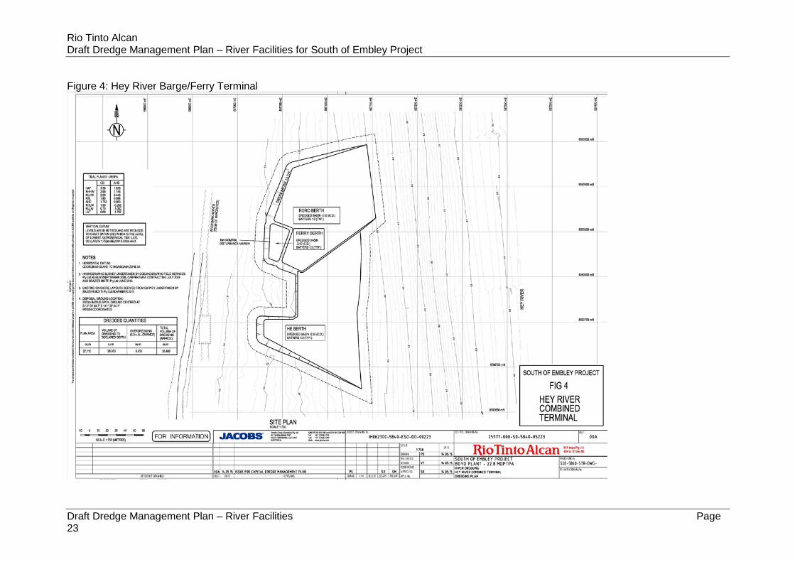
(J23) The maximum volume of material to be removed as a result of Hey River capital dredging activities are identified in Table J3 - Volumes of Capital Dredged Material. 37,380m3.
Figure 4
(J24) Unless otherwise authorised, dredge spoil must not be disposed of on the mining lease.
Section 2.1
(J26) Dredging activities must not start until provision has been made to lawfully place or dispose of the dredge spoil material. Evidence of applicable approvals must be made available to the administering authority on request.
Section 6
(J27) The transportation of dredge material must be carried out such that the dredge material is kept wet at all times.
Section 6.1.2
(J28) Prior to the commencement of the capital or maintenance dredging and prior to commissioning of the Port, hydrographic surveys of the bed levels of the area dredged must be completed.
Section 6
(J29) A monthly monitoring report must be prepared and submitted Section 10

Capital Dredge Management Plan – River Facilities
Page 14
Conditions Where addressed in this Plan
to the administering authority throughout the period that initial capital dredging and spoil disposal works are being undertaken. This report must include:
(a) a summary of results of all monitoring required by the environmental authority and dredge management plan, with raw data provided in and electronic format appendix (i.e. spreadsheet);
(b) an evaluation and explanation of the data from these monitoring programs;
(c) a daily summary of dredge movements (specifying the boundaries of the dredged area by GPS coordinates and disposal activity;
(d) details of turtle captures by the dredge and species involved;
(e) details of any complaints received including investigations undertaken, conclusions formed and action taken;
(f) a summary of significant equipment failures or events that have potential environmental management consequences;
(g) an outline of corrective actions that will or have been taken to minimise or reduce environmental harm, and
(h) the quantity (volume in cubic metres) and location of dredging material removed and disposed of; or
(i) different details and frequency of reporting as agreed to by the administering authority.
(J33) The holder of this environmental authority must report on the implementation of the final Dredge Management Plan for the Hey River to the North Queensland Bulk Ports Technical Advisory and Consultative Committee for the Port of Weipa.
Section 6
(J34) All reasonable and practicable measures must be taken to minimise the potential for turbidity plumes to cause environmental harm to seagrass meadows adjacent to the dredge site at the Hey River barge/ferry terminal.
Section 6.1.2
(J35) The dredging campaign at the Hey River barge/ferry terminal must not occur for a period longer than fourteen (14) consecutive days. Dredging may extend over a longer time period, provided:
Sections 6.1.2 and 6.1.3 and Figure 6

Capital Dredge Management Plan – River Facilities
Page 15
Conditions Where addressed in this Plan
(a) there is a pause in dredging of at least three (3) days between periods of dredging at each dredging site in the river; or
(b) where turbidity monitoring is employed, turbidity levels have not increased significantly above background levels as defined in the final Dredge Management Plan.
(J36) Mobile dredging operations:
(a) must not commence if dugongs, turtles or cetaceans are observed within 300 meters of the dredge;
(b) where underway, must alter the course if dugongs, turtles or cetaceans are likely to be struck or captured.
Section 6.2.3
(J37) Stationary dredging operations:
(a) must not commence if dugongs, turtles or cetaceans are observed within 300 metres of the dredge;
(b) must cease if dugongs, turtles or cetaceans are observed within 50 metres of the dredge head.
Section 6.2.3
(J38) Daily monitoring for impacted turtles must be undertaken at the dredge and at the shoreline down-current from the dredging operation. If monitoring indicates that more than two (2) turtles are killed within a 24 hour period as a result of dredging, the dredge must relocate from the area until an incident investigation has been carried out and relevant preventative actions implemented.
Section 6.2.3
(J39) Operating procedures must be developed prior to the commencement of dredging activities that minimise the risk of turtle capture by the dredge head and the risk from all activities of injury to marine species of conservation significance.
Section 6.2.3
(J40) The administering authority must be immediately notified of any turtle captures by the dredge or injury to any marine species of conservation significance.
Section 6.2.3
(J41) All reasonable and practicable measures must be taken to minimise the impact of dredging activities on marine fauna.
Section 6.2.3 and Figures 10 and 11
Queensland Coordinator General’s Stated Conditions: Appendix 3 Part A Schedule 1: Humbug and Hornibrook terminals (off mining lease)
G2 The maximum quantity of material to be removed during the capital RTAW has applied

Capital Dredge Management Plan – River Facilities
Page 16
Conditions Where addressed in this Plan
dredge activities at Humbug barge terminal is 15,600 cubic metres, Hornibrook ferry terminal is 18,700 cubic metres, and tug berths up to 71,300 cubic metres.
Operations must meet the following restrictions:
(a) the removal of dredge material is confined to the locations shown on the approved plan attached to the permit
(b) dredge spoil must not be disposed of into Queensland waters that are within the limits of the State, or are coastal waters of the State unless otherwise authorised.
to amend this Condition to be consistent with approved plans at Figures 2 and 3 and the Sea Dumping Permit.
G5 Any dredging must be conducted using equipment that is in survey and registered and, in relation to environmental performance, is equal to or better than the following equipment:
(a) Trailing Suction Hopper Dredge that is equipped, as a minimum, with:
(i) below keel discharge of tail waters via an anti-turbidity control valve
(ii) on-board systems for determining solids to water ratio or density of dredged material
(iii) electronic positioning and depth control system for defining the location and depth of dredging activities
(iv) dredge heads and depth control capable of, and where appropriate, fitted with fauna exclusion devices (e.g. turtle deflectors).
(b) Cutter Suction Dredge that is equipped, as a minimum, with:
(i) electronic positioning and depth control system for defining the location and depth of dredging activities
(ii) a system or process to ensure the delivery system integrity is maintained at all times
(iii) systems for determining solids to water ratio or density of dredged material during operations.
(c) Grab Dredge that is equipped, as a minimum, with:
(i) electronic positioning system for defining the location and depth of dredging activities.
Section 6
W1 In carrying out the ERA dredging activity, the release of contaminants (including any release caused by extraction of material from the bed of waters) must:
(a) only occur from the permitted areas specified on approved plans
Sections 3 and 6.1.2

Capital Dredge Management Plan – River Facilities
Page 17
Conditions Where addressed in this Plan
(b) be suitable for unconfined ocean disposal when assessed in accordance with the National Assessment Guidelines for Dredging
(c) not produce any slick or other visible evidence of oil or grease, nor contain visible floating oil, grease, scum, litter or other objectionable matter
(d) be carried out taking all practicable measures necessary to minimise the concentration of suspended solids released during the loading and pumpout of the vessel.
W2 Dredging must not start until provision has been made to lawfully place or dispose of the dredge material. Evidence of applicable approvals must be made available to the administering authority when requested.
Section 6
W3 All reasonable and practicable measures shall be taken to limit the potential turbidity.
Section 2
W5 Mobile dredging operations:
(a) must not commence if dugongs, turtles, or cetaceans are observed within 300 metres of the dredge
(b) where underway, must alter course if dugongs, turtles, or cetaceans are likely to be struck or captured.
Section 6.2.3
W6 Stationary dredging operations:
(a) must not commence if dugongs, turtles, or cetaceans are observed within 300 metres of the dredge
(b) must cease if dugongs, turtles or cetaceans are observed within 50 metres of the dredge head.
Section 6.2.3
W7 Operating procedures that minimise the risk of turtle capture by the dredge head, and the risk from all activities of injury to marine species of conservation significance, must be developed prior to the commencement of dredging activities.
Section 6.2.3 and Figures 10 and 11
W8 The administering authority is to be immediately notified of any turtle captures by the dredge or of injury to any marine species of conservation significance.
Section 6.2.3
W9 Turtle monitoring
(a) daily monitoring for impacted turtles must be undertaken at the dredge and at the shoreline down-current from the dredging operation
Section 6.2.3

Capital Dredge Management Plan – River Facilities
Page 18
Conditions Where addressed in this Plan
(b) if monitoring indicates that more than two turtles are killed within a 24 hour period as a result of dredging, the dredge must relocate from the area until an incident investigation has been carried out and relevant preventative actions implemented.
(c) a trailing suction hopper dredge must be fitted with marine wildlife protection or exclusion devices such as deflector plates, tickler chains or drag heads prior to and during operation.
Queensland Coordinator General’s Stated Conditions: Appendix 3 Part A Schedule 3: Humbug and Hornibrook terminals (off mining lease)
Condition 1 Dredging and marine works
(e) The Embley River DMP/s shall provide details of water quality monitoring or Photosynthetically Available Radiation (PAR) programs proposed to be implemented.
Section 6.1.3
(f) Dredging campaigns at the Humbug and Hornibrook ferry/tug berth sites must not occur for longer than 14 consecutive days at each site. Dredging at any one of these sites may extend over a longer time period, provided:
(i) there is a pause in dredging of at least three days between periods of dredging at each site or
(ii) Where turbidity monitoring is employed, turbidity levels have not increased significantly above background levels as defined in the River DMP.
Section 6.1.3 and Figure 6

Capital Dredge Management Plan – River Facilities
Page 19
2 DREDGING AND DISPOSAL DESCRIPTION Dredging and spoil disposal for the barge and ferry terminals is described in Section 6.5.2 of the Queensland EIS (RTA 2011), Section 2.7.3 of the Supplementary Report to the Queensland EIS (RTA 2012), and Section 3.8.2 of the Commonwealth EIS (RTA 2013).
The dredge material which is loaded and dumped will only comprise up to 111,000 m3 of capital seabed material (Condition 10 of Sea Dumping Permit).
Respective dredge volumes and dredge footprint areas for the barge/ferry/tug terminals are:
• approximately 19,480m3 to be removed from the Humbug barge terminal over an area of 8,630m2 (refer Figure 2);
• approximately 55,120m3 – 21,390 m3 (ferry) and 33,730 m3 (tugs) – to be removed from the Hornibrook ferry / tug terminal over an area of 26,460m2 (refer Figure 3); and,
• approximately 36,400m3 to be removed from the Hey River barge / ferry terminal over an area of 27,110m2 (refer Figure 4).
Dredging is anticipated to be undertaken using either a barge-mounted backhoe/dipper dredge, or a Cutter Suction Dredger (CSD). The anticipated production rate of the backhoe depending on size chosen will be between 800 - 1200m3 per day and the CSD approximately 2000m3 per day. Dredge spoil would be transferred to a Split Hopper Barge (SHB) for transport to the Albatross Bay spoil ground. The method cannot be confirmed until engagement of the dredging contractor, and the availability of equipment at time of commencement has been determined. This DMP is intended to be valid for either method. RTA will notify the Port of Weipa Technical Advisory and Consultative Committee (TACC) prior to commencement.
Current Project schedule has dredging being carried out in the dry season (Q2/Q3) of 2015. The timing for commencement of dredge activities is subject to RTAW obtaining necessary approvals and availability of appropriate dredging plant. RTAW will notify through the TACC once commencement dates are confirmed.
Dredging excavation will be by either:
• a CSD, which utilises a rotating cutter head on the end of the cutter ladder that is lowered to the seabed to loosen the material that is then lifted by centrifugal pumps through the suction pipe. The dredge is fixed in position at the rear using a spud. The dredge is swept back and forth on an arc by port and starboard anchors and winches; or
• a backhoe dredge which is either an excavator on a barge or backhoe arm mounted on a pontoon. This dredge uses a bucket on the end of a dipper arm that uses hydraulic crowd force to load the bucket and raise to the surface. The excavation area is limited to the reach of the dipper arm. The dredge is held in position either by spuds or anchors.

Capital Dredge Management Plan – River Facilities
Page 20
Both methods the spoil will be loaded into a split hopper barge or the hopper of a trailing suction hopper dredge (no use of the suction pipe) via the CSD pumps through a discharge pipe or directly emptied from the bucket of the backhoe. Loading of barges will be undertaken with overflow below the keel (Green Valve).The hopper will then sail to the dump ground for disposal. Disposal will be via bottom dumping of the hopper as the barge traverses over the spoil ground.
Alternative options for disposal of dredged material from the Embley and Hey River barge/ferry/tug terminals are presented in Section 1.6.11 of the Queensland EIS (RTA 2011) and Section 3.12 of the Commonwealth EIS (RTA 2013).
2.1 Disposal Site Capital dredge material will be dumped within the Albatross Bay spoil ground is defined by a 2,000m radius, centred on the following coordinates:
• S12° 39’ 34.7’’ E141° 39’ 24.1” (WGS84). (Condition 12 of Sea Dumping Permit)
A bathymetric survey of the disposal site will be undertaken by RTAW: a) prior to the commencement of dumping activities at the disposal site; and b) within one month of the completion of all dumping activities as authorised under
the sea dumping permit at the disposal site, unless otherwise agreed with the Department of Environment. (Condition 23 of Sea dumping Permit)
Each load of dredged material will be dumped so that the dumped material is distributed evenly over the area of the disposal site (Condition 14 of Sea Dumping Permit). Prior to dumping the vessel must establish by GPS that it is inside the disposal site before commencing dumping (Condition 15 of Sea Dumping Permit).

Capital Dredge Management Plan – River Facilities
Page 21
Figure 2: Humbug Barge Terminal

Rio Tinto Alcan Draft Dredge Management Plan – River Facilities for South of Embley Project
Draft Dredge Management Plan – River Facilities Page 22
Figure 3: Hornibrook Ferry Terminal and Tug Berths
Rio Tinto Alcan Draft Dredge Management Plan – River Facilities for South of Embley Project
Draft Dredge Management Plan – River Facilities Page 23
Figure 4: Hey River Barge/Ferry Terminal

Capital Dredge Management Plan River Facilities
Page 24
3 SEDIMENT CHARACTERISATION Sediment sampling and analyses have been completed at the river facilities locations (Worley Parsons 2012). The assessment of dredged material is consistent with the assessment guidance described in the National Assessment Guidelines for Dredging (NAGD) (Commonwealth of Australia 2009), Annex 2 of the London Protocol, and the Waste Specific Guidelines for Assessment of Dredged Material (IMO 2000).
Sampling was undertaken at seven locations at the Hornibrook terminal, seven locations at the Hey River terminal, and six locations at the Humbug terminal. Samples were collected using a boat-deployed piston corer to dredge depth or until stiff clays were met. Cores were split into up to three horizons (0 – 0.5m; 0.5 – 1m; and >1m). Collected samples were transported under refrigerated conditions to the primary analytical laboratory (Advanced Analytical Australia - AAA) and the secondary analytical laboratory (Australian Laboratory Services-ALS) within relevant holding times. Samples were analysed for strong acid extractable metals and metalloids, polycyclic aromatic hydrocarbons, organotins, acid sulphate soils and particle size distribution.
The characterisation of sediments within the three dredge areas was completed in accordance with the approved (16 June 2009) sediment sampling and analysis plan (SAP). Subsequent to the finalisation of these sediment studies and submission of this report to DSEWPaC for approval, changes were made to the alignment of the Hornibrook ferry terminal and dredge volumes for the Humbug and Hey River terminals. An application for exemption from further sediment characterisation was submitted to DSEWPaC on 12 January 2012 for the Humbug and Hey River terminals and approved on 20 January 2012.
Interpretation of analytical results was made according to the National Assessment Guidelines for Dredging (NAGD) (Commonwealth of Australia, 2009). Based on the assessment, all contaminant means and 95% upper confidence level of the mean (95% UCL) at the Hornibrook terminal and Humbug terminal were below the relevant NAGD screening levels.
At the Hey River terminal, all contaminant means and 95% UCLs were below relevant NAGD screening levels, except for arsenic. Further testing for arsenic was undertaken using elutriate and dilute acid extraction (DAE) analysis in accordance with the contaminant assessment framework requirements of the NAGD. Results of elutriate analysis identified that arsenic would not impact water quality during disposal and required minimal dilution to achieve concentrations less than the ‘low reliability’ ANZECC/ARMCANZ (2000) arsenic water quality guideline levels (for AsIII and AsV). DAE results were well below screening levels and indicated that arsenic is strongly bound in sediments and therefore likely of geological origin.
An acid sulphate soils assessment was completed at each of the three proposed dredge areas. The results of the assessment, analysed using the Suspension Peroxide Oxidation-Combined Acidity and Sulfate (SPOCAS) method, identified that sulphur oxidation had not taken place in the sediment. Sediments have the potential to generate sulphuric acid but also have the capacity to neutralise some acid generation.
Capital Dredge Management Plan River Facilities
Page 25
Therefore they would not require the addition of lime to manage acid generation, if material was to be placed on land.
The results of chemical analyses identify that the material to be dredged in each of the three dredge areas is suitable for unconfined disposal at sea at the approved Albatross Bay spoil ground.
4 EXISTING ENVIRONMENT
4.1 Embley and Hey Rivers Past and Current Uses The Port of Weipa and its approach channel were developed through capital dredging from 1961 through to 1975 (PCQ 1995). The most recent capital dredging program occurred in 2006 to widen the existing channel and maintenance dredging generally occurs on an annual basis, typically during the dry season (PCQ 2009). Currently within the Port of Weipa there are four wharves located at Lorim Point East, Lorim Point West, Humbug Wharf and Evans Landing. These wharves require maintenance dredging on a regular basis.
Hornibrook Point is an area of land adjacent to Lorim Point and was reclaimed in the 1960s using dredge spoil from the Embley River, including dredge spoil from the original capital dredging of the Lorim Point Wharf. Hornibrook Point has remained as vacant parkland. Humbug Wharf is located approximately 1.25km downstream from Hornibrook Point and is a general cargo wharf currently managed by RTA.
The proposed Hey River terminal site, south of Hey Point in the Hey River is an undeveloped area approximately 8km south of Hornibrook Point and within the boundaries of ML6024. No dredging has previously occurred within this area.
4.2 Embley and Hey Rivers Habitats Benthic habitat surveys of estuarine areas within the Project area have been undertaken to identify and map benthic habitats. The results of the surveys are described in Section 6.3 of the Queensland EIS (RTA 2011) and Section 6.5 of the Supplementary Report (RTA 2012) with most recent information presented in Section 7.2 of the Commonwealth EIS (RTA 2013) and summarised below.
The development footprints for the Hornibrook ferry terminal and tug berths, Humbug barge terminal and Hey River barge/ferry terminal consist primarily of soft sediment habitats that contain sparse epifauna typical of soft sediments, such as seapens and tube dwelling anemones, soft corals or sponges (refer to Section 6.3.5 of the Queensland EIS (RTA 2011) and Section 1.2.9 of the Commonwealth EIS (RTA 2013)).
Seagrass beds are typically present in the more sheltered areas of Albatross Bay, including the lower reaches of the Embley and Mission Rivers and Pine River Bay (refer to Section 6.3.4 of the Queensland EIS (RTA 2011) and Section 7.2.7 of the Commonwealth EIS (RTA 2013)). The Department of Agriculture, Fisheries and Forestry (DAFF) (formerly the Department of Primary Industries and Fisheries) has been undertaking annual seagrass monitoring within the Port of Weipa since 2000. In
Capital Dredge Management Plan River Facilities
Page 26
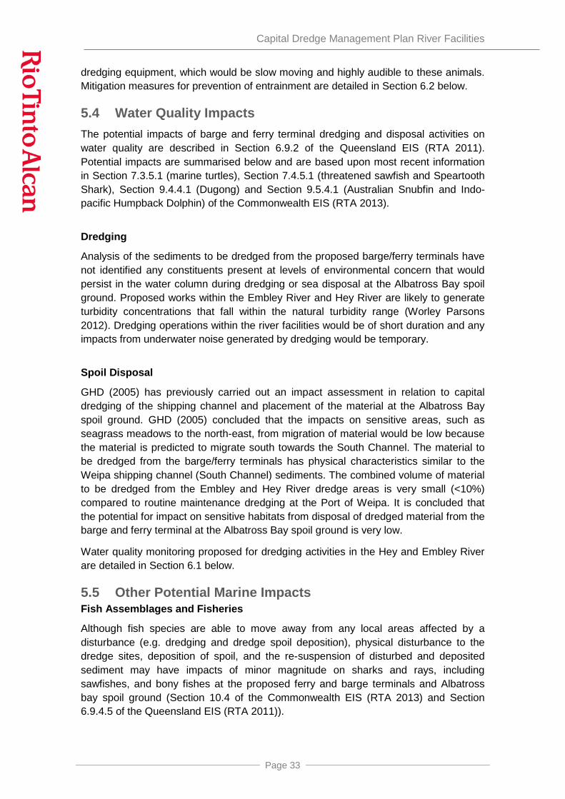
August 2011, it was estimated there were approximately 1,031ha of seagrass in 14 meadows within the bounds of the Intensive Monitoring Area within the Embley and Hey Rivers (DAFF and NQBP 2011). There has been a steady increase in seagrass area within the IMA since the lowest recorded levels in 2008 and is the largest area recorded since 2004, although it is still significantly lower than the peak recorded in 2001. Seagrass meadows in the IMA continue to be dominated by Enhalus acoroides. The distribution and condition of seagrass in the Hey and Embley Rivers is described further in Section 6.3.4.2 of the Queensland EIS (RTA 2011), Section 6.5 of the Supplementary Report (RTA 2012), and Section 7.2.7.2 of the Commonwealth EIS (RTA 2013). Figure 5 shows the seagrass meadow type and cover (aggregated patches, continuous cover or isolated patches) within the IMA during the September 2009 survey. The figure also identifies the position of the proposed barge and ferry terminal infrastructure.
Habitat surveys during July 2009 and February 2012 did not find the presence of seagrass within the footprints of the Humbug terminal. However, visual inspection during early May 2010 coinciding with peak spring tides, did reveal isolated patches of E. acoroides in good condition within and adjacent to the proposed dredge footprint of the Humbug terminal at low tide. This observation is consistent with recent survey data prepared by DAFF (DAFF and NQBP 2011) (refer Figure 5).
Drop camera video surveys undertaken of the sub-tidal banks at Hornibrook Point in 2009 and grab sampling conducted February 2012 indicate that the Hornibrook terminal dredge footprint does not contain seagrass, however, aggregated patches of E. acoroides seagrass may be located adjacent to it. This is consistent with most recent mapping prepared by DAFF (DAFF and NQBP 2011) (refer Figure 5).
Seagrass monitoring between 2000 and 2009 (Chartrand and Rasheed 2009; McKenna and Rasheed 2010) in the vicinity of the Hey River terminal location occasionally reports a very thin patch of isolated seagrass. Drop camera surveys undertaken over the Hey River terminal dredge footprint in October 2007, November 2008 and June 2009 did not record any seagrass. Grab surveys conducted in February 2012 also did not find any seagrass within, or adjacent to, the Hey River terminal dredge area. However, it is possible that seasonally variable seagrasses were absent (e.g. Halophila ovalis). Overall though, it is considered that if any seagrasses do occur at the proposed terminal site from time to time, they are likely to contribute minimally to primary productivity in the area.

Capital Dredge Management Plan River Facilities
Page 27
Figure 5: Seagrass in Embley and Hey River Estuaries

Capital Dredge Management Plan River Facilities
Page 28
4.3 Embley and Hey Rivers Fauna Threatened and migratory marine species that occur or potentially occur in the Project area are described in Section 6.6.1 of the Queensland EIS (RTA 2011). In the Commonwealth EIS (RTA 2013) Section 7.1.1 describes threatened estuarine and marine species, Section 9.1.1 describes migratory marine species, and Section 10.4.3 addresses other marine species in the Commonwealth Marine Area.
Threatened marine turtle species assessed as likely to occur in the Hey and Embley Rivers include:
• Loggerhead Turtle (Caretta caretta) (EPBC Act Endangered and Migratory and Nature Conservation Act 1992 (Qld) (NC Act) Endangered);
• Olive Ridley Turtle (Lepidochelys olivacea) (EPBC Act Endangered and Migratory and NC Act Endangered);
• Flatback Turtle (Natator depressus) (EPBC Act Vulnerable and Migratory and NC Act Vulnerable); and,
• Green Turtle (Chelonia mydas) (EPBC Act Vulnerable and Migratory and NC Act Vulnerable).
No marine turtles were observed in the Embley and Hey Rivers during field studies for the Project. However foraging areas for the above marine turtle species can include seagrass meadows and unvegetated sand or mud areas, and these species of marine turtle are considered likely to occur in the Hey and Embley Rivers.
Migratory marine fauna species that are assessed as likely or known to occur in the Embley and Hey Rivers include:
• Indo-Pacific Humpback Dolphin (Sousa chinensis) (EPBC Migratory and NC Act Near Threatened);
• Australian Snubfin Dolphin (Orcaella heinsohni) (EPBC Migratory and NC Act Near Threatened); and,
• Dugong (Dugong dugon) (EPBC Migratory and NC Act Vulnerable).
Indo-pacific Humpback Dolphins were observed in the Embley and Hey Rivers during field studies, however, the other species outlined above are considered likely to occur in this area because they are often associated with tidal riverine and estuarine systems. The Indo-pacific Humpback Dolphins sightings were not within seagrass beds.
Dugongs are known to occur in low densities in Albatross Bay and are closely associated with the seagrass beds in the Embley River estuary. However, no Dugongs were incidentally observed associating with these seagrass beds during marine field surveys for the Project. Dugongs prefer seagrasses that are early or 'pioneer' species, particularly species of the genera Halophila and Halodule (DEWHA 2010). The long, strap-like seagrass E. acoroides, which dominates the seagrass beds of the Embley and Hey Rivers, is not a preferred species in Dugong’s diet.

Capital Dredge Management Plan River Facilities
Page 29
Sea snakes are known to occur in the Embley and Hey Rivers. No species of sea snake are listed as threatened under the EPBC Act or the NC Act. However, all species of sea snake are listed as marine species under the EPBC Act. The North Marine Bioregional Plan identifies sea snakes as a conservation value and a priority for conservation effort in the North Marine Region (DSEWPaC 2012).
4.4 Albatross Bay Spoil Ground The approved Albatross Bay spoil ground was commissioned in 1998 and since that time has received capital and maintenance dredging material from operations within the Port of Weipa. Before any material is placed at the Albatross Bay spoil ground, the spoil must be proven to be suitable for placement at sea using the NAGD assessment framework.
The footprint for the Albatross Bay spoil ground has been confirmed as consisting primarily of soft sediment habitats that contain sparse epifauna typical of soft sediments, such as seapens and tube dwelling anemones, soft corals or sponges (refer Section 7.2.7 of the Commonwealth EIS (RTA 2013) and Section 6.3.5 of the Queensland EIS (RTA 2011)). The Albatross Bay spoil ground does not contain, and is not close to any, reef communities, and also contains no seagrass beds, and is not shallow in nature.
The Indo-Pacific Humpback Dolphin and Australian Snubfin Dolphin are possibly transient in the footprint of the Albatross Bay spoil ground, however, this spoil ground does not represent preferred habitat. The Albatross Bay spoil ground does not contain preferred habitat for Bryde’s Whale (Balaenoptera edeni) (EPBC Act Migratory), however, the recording of the species from tropical inshore waters suggests it is possible the species may occur sporadically in the vicinity of the spoil ground footprint. Dugong may migrate through the Albatross spoil ground area between feeding grounds, however it is more likely that the species would migrate through shallower waters.
It is unlikely that the Green Turtle, Hawksbill Turtle, Flatback Turtle and Olive Ridley Turtle would occur in the Albatross Bay spoil ground area, due to lack of preferred habitat. However, they may transit the site.
The Leatherback Turtle (Dermochelys coriacea) is likely to occur sporadically in the vicinity of the Albatross Bay spoil ground, using it for foraging. However, Leatherback Turtles are rarely found in Queensland, so any presence would be sporadic. The Loggerhead Turtle species is also likely to be transient in the vicinity of the Albatross Bay spoil ground and use it for foraging or resting.
Sea snakes are known to occur in Albatross Bay and may be transient in the area of the Albatross Bay spoil ground.
Capital Dredge Management Plan River Facilities
Page 30
5 POTENTIAL IMPACTS
5.1 Macrobenthic Infauna Impacts Impacts on Macrobenthic infaunal assemblages are described in Section 10.4.2 of the Commonwealth EIS (RTA 2013) and Section 6.9.4.4 of the Queensland EIS (RTA 2011) and summarised below.
Macrobenthic infaunal assemblages are likely to be affected at the Hey and Embley River dredging sites and the Albatross Bay spoil ground as a result of physical disturbance of sedimentary habitats from dredging, creation of a turbidity plume, and subsequent deposition and re-suspension of fine sediments. However, macrobenthic infaunal assemblages can recover over time from the impacts of dredging and spoil disposal. Recovery of the macrobenthic assemblage from spoil deposition at the Albatross Bay spoil ground is considered to be rapid (GHD 2005).
Despite the potentially significant local impact on the infaunal assemblage, impacts pose a low risk on a regional scale. Therefore, no macrobenthic infauna monitoring is proposed.
5.2 Seagrass Habitat Impacts The potential impacts of dredging on seagrass habitat at the barge and ferry terminals is described in Section 6.9.3.3 of the Queensland EIS (RTA 2011) and Section 6.5 of the Supplementary Report (RTA 2012). Potential impacts of dredging on seagrass habitat are summarised below and are based upon most recent information in Section 7.3.5.1 of the Commonwealth EIS (RTA 2013) in relation to marine turtles, Section 9.4.4.1 in relation to Dugong, and Section 10.4.3.1 in relation to sea snakes.
Seagrasses persist in the naturally turbid environment in the Port of Weipa (Carter et al 2012). Maintenance and capital dredging has occurred in the Port of Weipa for many years with current maintenance volumes 10 times the proposed total capital dredging program for the Project in the river.
In an assessment of the changes in seagrass meadows in the Port of Weipa, McKenna and Rasheed (2010) concluded: “The most likely drivers of seagrass change in Weipa are related to regional and local climate conditions rather than anthropogenic or port related factors. Low rainfall and a reduction in associated runoff, high air temperatures and greater exposure to more intense solar irradiation were all likely to have contributed to the low densities recorded in the past and may have contributed to a loss of natural resilience in these meadows”.
Erftemeijer and Lewis (2006) have reviewed the available literature on the impacts of dredging on seagrasses, including, peer-reviewed scientific literature, grey literature in the form of EIA, consultancy and technical reports and additional information obtained from internet sources. The review highlights a number of important factors in relation to duration, frequency and magnitude of turbidity impacts that are relevant to the seagrass meadows in the Embley River.

Capital Dredge Management Plan River Facilities
Page 31
1. For seagrasses, the critical threshold for turbidity and sedimentation, as well as the duration that seagrasses can survive periods of high turbidity or excessive sedimentation vary greatly among species.
2. Larger, slow-growing climax species with substantial carbohydrate reserves, such as E. acoroides which is the dominant species in the seagrass meadows of the Embley River (McKeena and Rasheed, 2010) show greater resilience to such events than smaller opportunistic species.
3. Turbidity changes induced by dredging will only result in adverse environmental effects when the turbidity generated is significantly larger than the natural variation of turbidity and sedimentation rates in the area. The seagrass meadows in the Port of Weipa (including the Embley and Hey Rivers) are continually exposed to naturally high and variable turbidity (Carter et al, 2012).
4. Erftemeijer and Lewis (2006) state that “Laboratory experiments have shown that some seagrasses can survive in light intensities below their minimum requirements for periods ranging from a few weeks to several months. The survival period of seagrass below its minimum light requirement is shorter in smaller species with low carbohydrate storage capacity than in larger species. It is clear that species with larger below-ground biomass are better adapted to longer periods of sub-minimal light.”
The results of the 2012 Port of Weipa long term seagrass monitoring program confirmed previous conclusions that Annual fluctuations in meadow biomass and area in Weipa have been associated with regional and local climate conditions rather than anthropogenic or port-related factors during the life of the monitoring program (Carter et al, 2013). The survey followed the 2012 combined dredge campaign which commenced mid-July and was completed in 47 days, with 598,658 m3 of maintenance dredge material and 328,399 m3 capital dredge material removed. Carter et al (2013) also reported that light data collected at Weipa was generally indicative of the naturally turbid environment in which seagrasses grow in the Port of Weipa.
The dredging duration at each site for a backhoe dredge and (CSD) is 16-24 (10) days at the Humbug terminal, 31-47 (19) days at the Hey River terminal, 18-27 (11) days at the Hornibrook ferry terminal and 29-44 (17) days at the Hornibrook tug berth, and involve only minor dredge volumes. The minor scale and short duration of dredging, may cause a very short-term and transient above average elevation of turbidity over seagrass meadows in the Hey/Embley River, however, it is expected that these elevations will be within the long term background range for the area and short-lived when compared to the frequent and naturally occurring elevated turbidity in the Embley and Hey Rivers and estuary. It is unlikely that sediment loads would be generated over the aggregated E. acoroides patches adjacent to the proposed infrastructure at concentrations that would approach critical levels. Further, any reduction in light levels would be short-term and the structurally large E. acoroides, with large below ground biomass, would have the capacity to store substantial carbohydrate reserves to provide resilience to the predicted low impact.
The short duration, small volume dredging campaign is expected to have a negligible impact on seagrass. Despite this assessment, the Queensland Coordinator General

Capital Dredge Management Plan River Facilities
Page 32
has provided stated conditions requiring a three day pause in dredging after 14 consecutive days dredging at each terminal or if extending for longer than 14 consecutive days at a site, implementation of turbidity monitoring.
RTA have entered into a data sharing agreement with NQBP to enable access to the PAR monitoring data in seagrass meadows during the dredging campaign as detailed in Section 6.1.
5.3 Marine Fauna Impacts Marine fauna impacts are described in Section 6.9.4 of the Queensland EIS (RTA 2011), Section 6.3 of the Supplementary Report (RTA 2012) and Sections 7, 9 and 10 of the Commonwealth EIS (RTA 2013). Marine fauna impacts are summarised below and are based upon most recent information in Section 7.3.5.1 (marine turtles), Section 7.4.5.1 (threatened sawfish and Speartooth Shark), Section 9.3.5.1 (Estuarine Crocodile), Section 9.4.4.1 (Dugong), Section 9.5.4.1 (Australian Snubfin and Indo-pacific Humpback Dolphin) and Section 10.4.3.1 (sea snakes) of the Commonwealth EIS (RTA 2013).
Given the minor scale and short duration of dredging at each of the Embley and Hey River dredge sites, it is unlikely that Dugong and marine turtle foraging areas would be significantly affected by turbidity plumes from barge/ferry terminal dredging. Therefore no additional seagrass or water quality monitoring is proposed.
The proposed dredging activities within the Hey and Embley Rivers would result in negligible impacts on fisheries values or habitat essential to the Estuarine Crocodile, threatened sawfish or the Speartooth Shark.
It is considered unlikely that sea snakes that may inhabit the Embley and Hey Rivers and estuary would be impacted by dredging for the river facilities. It is expected that turbidity will remain within the background range and the small area of dredging will not result in the removal of any significant habitat of potential sea snake prey species. Additionally, the capital dredging campaign will be of short duration with no dredging in seagrass meadows, resulting in negligible entrainment compared to the ongoing impact of the trawl fishery in the North Marine Region. Bucket type dredges, such as those to be potentially used for Embley and Hey River dredging activities, do not pose an entrainment hazard to marine mammals or marine turtles. Slow moving displacement vessels like barges are not considered a vessel strike risk to marine mammals or marine turtles during dredging and spoil disposal activities. The potential for vessel strike on dolphins would be less than for Dugongs and whales overall due to their greater mobility and ability to quicker respond to disturbances.
Entrainment by CSDs is also not likely due to the slow rate of movement during dredging.
Important foraging habitat for Dugongs and marine turtles is not present within the proposed dredge footprints, minimising the risk that the species would be in the path of the dredge. However, in the event of entrainment, serious injury or mortality to the animal would be likely. The high mobility and manoeuvrability of Australian Snubfin and Indo-Pacific Humpback Dolphins means the species are not at risk of entrainment in
Capital Dredge Management Plan River Facilities
Page 33
dredging equipment, which would be slow moving and highly audible to these animals. Mitigation measures for prevention of entrainment are detailed in Section 6.2 below.
5.4 Water Quality Impacts The potential impacts of barge and ferry terminal dredging and disposal activities on water quality are described in Section 6.9.2 of the Queensland EIS (RTA 2011). Potential impacts are summarised below and are based upon most recent information in Section 7.3.5.1 (marine turtles), Section 7.4.5.1 (threatened sawfish and Speartooth Shark), Section 9.4.4.1 (Dugong) and Section 9.5.4.1 (Australian Snubfin and Indo-pacific Humpback Dolphin) of the Commonwealth EIS (RTA 2013).
Dredging
Analysis of the sediments to be dredged from the proposed barge/ferry terminals have not identified any constituents present at levels of environmental concern that would persist in the water column during dredging or sea disposal at the Albatross Bay spoil ground. Proposed works within the Embley River and Hey River are likely to generate turbidity concentrations that fall within the natural turbidity range (Worley Parsons 2012). Dredging operations within the river facilities would be of short duration and any impacts from underwater noise generated by dredging would be temporary.
Spoil Disposal
GHD (2005) has previously carried out an impact assessment in relation to capital dredging of the shipping channel and placement of the material at the Albatross Bay spoil ground. GHD (2005) concluded that the impacts on sensitive areas, such as seagrass meadows to the north-east, from migration of material would be low because the material is predicted to migrate south towards the South Channel. The material to be dredged from the barge/ferry terminals has physical characteristics similar to the Weipa shipping channel (South Channel) sediments. The combined volume of material to be dredged from the Embley and Hey River dredge areas is very small (<10%) compared to routine maintenance dredging at the Port of Weipa. It is concluded that the potential for impact on sensitive habitats from disposal of dredged material from the barge and ferry terminal at the Albatross Bay spoil ground is very low.
Water quality monitoring proposed for dredging activities in the Hey and Embley River are detailed in Section 6.1 below.
5.5 Other Potential Marine Impacts Fish Assemblages and Fisheries
Although fish species are able to move away from any local areas affected by a disturbance (e.g. dredging and dredge spoil deposition), physical disturbance to the dredge sites, deposition of spoil, and the re-suspension of disturbed and deposited sediment may have impacts of minor magnitude on sharks and rays, including sawfishes, and bony fishes at the proposed ferry and barge terminals and Albatross bay spoil ground (Section 10.4 of the Commonwealth EIS (RTA 2013) and Section 6.9.4.5 of the Queensland EIS (RTA 2011)).

Capital Dredge Management Plan River Facilities
Page 34
Marine Pests
Under the Port of Weipa Long Term Environment Management Plan for Dredging and Dumping Activities (SKM 2009), which has been approved by DSEWPaC, the Port of Weipa is considered a low risk port for marine pests.
Marine pest species may be introduced through the following mechanisms:
• use of dredgers at the river facilities as a result of hull fouling; and/or,
• disposal of spoil material from capital dredging through pests originating in-situ or introduced by the dredger.
Capital dredging for the proposed river facilities may require the services of internationally sourced dredgers.
NQBP currently manages the Port of Weipa and carries out maintenance dredging and spoil disposal at the existing Albatross Bay spoil ground. Surveys for introduced marine pests have been undertaken since 1999 in accordance with methodologies established by the Centre for Research on Introduced Marine Pest Species (NQBP 2011). Surveys have been modified to also target the Black-striped Mussel since its detection at the Port of Darwin in 1999 and 2000 and also the Asian Green Mussel in 2006. No introduced marine pests have been recorded to date at the Port of Weipa (NQBP 2011).
Underwater Noise
Dredging is at the lower end of the scale with regards to emitted sound pressure levels in aquatic environments (CEDA 2011 in Section 15.3.2 of RTA 2012b). The main noise anticipated during dredging operations will be the noise from CSD, which are reported to create higher underwater noise than the noise associated with grab dredgers (CEDA 2011, Nedwell and Howell 2004).
It is unlikely that underwater noise from dredging operations would cause injury to cetaceans, based on the assessment of continuous noise impacts from Southall et al. (2007) (CEDA 2011). Comparison between species hearing thresholds indicates that injury to other listed threatened estuarine and marine fauna and non-avian migratory species from dredging operations would be unlikely.
Underwater noise has the potential to impact listed threatened estuarine and marine fauna and non-avian migratory species feeding, transiting, or nesting (marine turtles) in the vicinity of dredging operations. There may be some behavioural responses for some species to avoid the area of dredging operations although this is expected only at close range to the source (Nedwell et al. 2003). There is also a possibility that many species may become habituated to the noise and remain within the vicinity (Smolowitz and Weeks 2006).
As behavioural impacts from underwater noise would be temporary and only occur at close range to the dredge operations the potential unmitigated impacts to listed threatened estuarine and marine fauna and non-avian migratory species would be negligible from dredging operations in the Hey and Embley River estuaries.

Capital Dredge Management Plan River Facilities
Page 35
6 MANAGEMENT AND MONITORING Dredging and disposal will be undertaken in accordance with the conditions of the Queensland Coordinator General’s report (and any subsequent conditions imposed through the Environmental Authority and Development Approval), the Commonwealth Sea Dumping Permit and EPPBC Act Approval.
RTA provided a copy of the draft dredge management plan to the NQBP Technical Advisory and Consultative Committee (TACC) for the Port of Weipa for review 22 October 2014. In addition RTA presented the draft dredge management plan to the TACC meeting on 30 October 2014 to provide opportunities for further discussion and comment. The TACC asked for any comments to be submitted by 31 October 2014. No comments, of direct relevance to the Dredge Management Plan, were received from members of the TACC.
RTA will report on implementation of the Dredge Management Plan(s) for the river facilities to the NQBP TACC for the Port of Weipa.
RTA will submit plans for dredging activities, certified by a Registered Professional Engineer of Queensland, to the TACC prior to commencement of dredging. Dredging activities will be confined to the removal of capital dredge material at the location shown on the plan(s). Prior to the commencement of capital dredging, hydrographic surveys of the bed levels of the area to be dredged will be completed. Dredge spoil must not be disposed of into Queensland waters that are within the limits of the State unless otherwise authorised. Dredge spoil material will not be disposed of into Australian waters, the sea or on land unless otherwise authorised.
Dredging activities will not start until provision has been made to lawfully place or dispose of the dredge spoil material. Evidence of applicable approvals will be made available to the relevant regulatory authority on request.
EHP will be advised in writing at least (5) business days prior to the date of commencement of a capital dredging campaign and within ten (10) days following completion of the capital campaign.
Dredging activities will be conducted using equipment that is in survey and registered and, in relation to environmental performance, is equal to or superior to the following equipment:
• Cutter Suction Dredger that is equipped, at a minimum, with:
Electronic positioning and depth control system for defining the location and depth of dredging activities;
A system or process to ensure the delivery system integrity is maintained at all times;
Systems for determining solids to water ratio or density of dredged material during operations; and,
Cutter heads with depth control.

Capital Dredge Management Plan River Facilities
Page 36
• Grab Dredger that is equipped, as a minimum, with electronic positioning system for defining the location and depth of dredging activities;
• split hoppers that discharge overflow water below keel (“green valve”); and,
• split hoppers that are equipped with electronic positioning (GPS) to ensure dumping within the disposal site.
RTA will:
• install all measures, plant and equipment necessary to ensure compliance with the conditions of relevant approvals;
• maintain and calibrate such measures, plant and equipment in an efficient condition and keep records of the maintenance; and,
• operate such measures, plant and equipment in an efficient manner.
All persons engaged in the conduct of dredging activities including but not limited to employees and contract staff will be:
• trained in the procedures and practices necessary to:
comply with the conditions of the relevant regulatory approvals; and,
prevent environmental harm during normal operation and emergencies, or,
• under the close supervision of a trained person.
6.1 Water Quality
6.1.1 Background The generation of dredge-induced turbidity plumes generally results from the suspension of fine sedimentary material during construction, dredging and spoil disposal activities. These impacts have the potential to impact the benthic foraging habitats and foraging behaviour of threatened and migratory marine species.
6.1.2 Management Measures A range of measures can be implemented to manage water quality impacts.
General Management Measures
In carrying out the activity, dredging would:
• only occur from the permitted areas specified on approved plans;
• only dredge sediment suitable for unconfined ocean disposal when assessed in accordance with the National Assessment Guidelines for Dredging;
• not produce any slick or other visible evidence of oil or grease, nor contain visible floating oil, grease, scum, litter or other objectionable matter; and,

Capital Dredge Management Plan River Facilities
Page 37
• be carried out taking all practical measures necessary to minimise the concentration of suspended solids released during the loading and pump-out of the vessel.
The following mitigation measures would be implemented, if the applicable methods are used, to reduce the impacts on water quality related to the creation of a turbidity plume from dredging and offshore spoil disposal activities:
• hopper doors would be kept in good condition to minimise loss of sediment during transport;
• accurate GPS positioning systems would be used on dredges to ensure direct impacts are restricted to the approved dredging areas;
• accurate GPS positioning and track plots of vessels to ensure disposal of spoil is within and evenly distributed over the footprint of the spoil disposal ground;
• safest and shortest sailing routes to and from the relevant spoil disposal ground would be selected to minimise the impact of propeller wash; and,
• current and forecasted meteorological and oceanographic information, would be considered in the daily work plan.
The transportation of dredge material will be carried out such that the dredge material is kept wet at all times.
Dredge-specific Management Measures
Dredging campaigns at the Hey River terminal, Humbug terminal and Hornibrook ferry/tug berth sites may extend for longer than 14 consecutive days at each site, provided there is a pause in dredging of at least three days between periods of dredging at each site, or, where turbidity monitoring is employed, turbidity levels have not increased significantly above background levels. Humbug terminal and Hornibrook ferry/tug site are considered as a single site in considering the 14 consecutive days dredging.
The three day pause in dredging after 14 consecutive days dredging is a Queensland Coordinator General’s Condition recommended by the Queensland Government seagrass monitoring group responsible for the long term seagrass monitoring programs at Weipa and other sites around the Queensland coast.
6.1.3 Water Quality Monitoring Photosynthetically Active Radiation (PAR)
The current water quality monitoring program implemented by NQBP within the Embley and Hey River estuaries will be utilised to monitor water quality in the vicinity of capital dredging activities in the Hey and Embley Rivers. The NQBP program utilises Photosynthetically Active Radiation (PAR) in monitoring impacts on seagrass meadows.
The NQBP seagrass monitoring program includes continuous temperature and PAR monitoring, every 15 mins, at three sites within seagrass meadows in the Embley and Hey Rivers (Figure 6 from Carter et al. 2012). There are no trigger values or control

Capital Dredge Management Plan River Facilities
Page 38
sites as such as there is long term seagrass monitoring data (annual since 2000) which allows a before and after approach using seagrass species composition, areas and biomass.
Monitoring results will be maintained by NQBP. RTA will obtain results (under a data sharing agreement) prior to dredging and again at completion. The results will be used to inform future maintenance dredging activities . Results will be made available to the TACC upon request.
In situ Physicochemical monitoring
If dredging is planned to extend for more than 14 consecutive days at any of the proposed three sites a turbidity monitoring program will be implemented. In addition to turbidity, pH, temperature, conductivity/salinity and dissolved oxygen will be measured as described for turbidity monitoring.
Capital Dredge Management Plan River Facilities
Page 39
Figure 6: Light (PAR) and temperature logger locations (black flags) in Embley River seagrass meadows A2 and A7

Capital Dredge Management Plan River Facilities
Page 40
Turbidity monitoring
Turbidity is naturally highly variable as a result of hydrological and meteorological conditions and therefore data must be interpreted in relation to these conditions. In order to assist this interpretation paired turbidity monitoring sites will be established prior to commencement of dredging and spoil disposal activities, up and down current of each dredge site (Figure 7 and Figure 8). The monitoring program will provide a measure of turbidity in the Embley and Hey Rivers but does not provide causal links between turbidity and level of impact, in particular, there is no cause and effect relationship that has been established between turbidity and seagrass impacts.
The Program will be based on a control vs impact approach where the “control” site will be a site established up current of the dredging operation and not impacted by any previous or current disturbance and the “impact” site will be a site established down current of the dredging operation.
Background (turbidity) levels = 14 day average at the “control” site (up-current of the dredging) prior to commencement of dredging.
Significant increase (in turbidity) = 14 day rolling average turbidity at the down current (impact) site >1.5 x 14 day rolling average at the “control” site for three consecutive days.
Turbidity will be monitored daily, during daylight hours, 50m from the dredge (within the immediate area of the dredge and within any observed sediment plume, for comparison to up and down current monitoring sites) and at the monitoring sites up and down current of the dredging activity on the mid-point of outgoing (ebb) tide (Figure 7 and Figure 8). Table 2 shows the “control” and impact sites at each of the proposed dredge sites, on an out-going (ebb) tide.
Turbidity will be measured in situ at 1m intervals from surface to 1m from the bottom at each site by logging five sets of readings at 3 minute intervals. The readings will be averaged at each site and a 14 day rolling average calculated. The turbidity data is assessed as shown in the Decision Tree (Figure 9).
Adaptive management
An observer will undertake visual inspection of the dredge plume during dredging, in daylight hours.
If any visible increase in turbidity and/ or plume extends to within 50m of mapped seagrass areas turbidity monitoring will be conducted at that location and assessed against the 14 day rolling average at the monitoring sites and the monitoring site 50m from the dredge.
Any seagrass beds in the vicinity of the dredge site will be inspected visually daily during the turbidity monitoring.
RTA will assess the situation with the contractor and determine if further action is required. Assessment will include:
• location of the dredge in relation to the plume;
• extent of the plume;

Capital Dredge Management Plan River Facilities
Page 41
• meteorological and tidal conditions at the time;
• comparison of the turbidity up and down stream of the dredging operation.
Figure 7: Turbidity monitoring sites at Humbug Wharf (HB1 and HB2) and Hornibrook Point (HO1 and HO2) with continuous PAR and temperature logger site.
Figure 8: Turbidity monitoring sites up (HR2) and down (HR1) stream of the Hey River site. Note: Continuous PAR sites in the seagrass meadows north west of Hey River site.

Capital Dredge Management Plan River Facilities
Page 42
Figure 9: Turbidity management procedure
Turbidity monitoring Measure daily in situ turbidity on mid- point of each outgoing tide.
1 Collect 5 readings @ 3 minute intervals from each of the monitoring locations 2 Average readings for each site 3 Calculate rolling 14 day average for each site
Compare rolling 14 day average turbidity at “control” and impact sites.
Has rolling 14 day average at impact site been > 1.5 x rolling average at “control” site for 3 consecutive days?
Yes No
Investigate cause of exceedance:
• Assess location of dredging activities in relation to affected site(s);
• Compare turbidity measured at the dredge;
• Extent of visible dredge plume in relation to affected site(s);
• Review continuous PAR data from seagrass beds
• Review all physicochemical parameters
• Meteorological conditions preceding and during the exceedance (i.e. weather and tidal conditions);
• Any shipping or other dredging activity within the monitoring site
Continue dredging operations. Continue observation of any dredge plume
Is Exceedance due to SoE dredging activities?
No Yes
Take all practical management measures to reduce turbidity levels.
• Relocate dredge • Reduce dredge activities from 24 hours to a period timed to
reduce impacts (e.g. 12 hours/day or night) • Reduce or cease overflow • Temporary cessation in dredging activities • Installation of silt curtains.

Capital Dredge Management Plan River Facilities
Page 43
If required, the following management measures may be implemented, in consultation with the dredging contractor:
• installation of silt curtains;
• relocation of the dredge;
• reducing or ceasing overflow;
• reducing dredging activities from 24 hours to a period timed to reduce impacts (for example, dredging 12 hours per day or night or only dredging on ebb or flood tide); or
• temporary cessation in dredging activities.
Table 2 “Control” and impact sites at each of the proposed dredge sites on and out-going tide
Humbug Hornibrook Hey River
“Control” HB2 HO2 HR2
Impact HB1 HO1 HR1
6.2 Threatened Marine Mammals and Marine Turtles
6.2.1 Background The marine fauna of potential concern during dredging and spoil disposal activities at the river facilities are marine turtles and migratory species including the Indo-pacific Humpback Dolphin, Australian Snubfin Dolphin, Bryde’s Whale and Dugong. An assessment of “significance of impact” from dredging activities to threatened and migratory fauna likely or known to occur in the Project area is detailed in Section 6.9.5 of Queensland EIS (RTA 2011) and, based upon most recent information, in the Commonwealth EIS (RTA 2013) in Section 7.3.6.5 in relation to marine turtles, Section 9.4.5.4 in relation to Dugong and Section 9.5.5.4 in relation to the Australian Snubfin and Indo-pacific Humpback Dolphins.
The objective of the marine mammal and marine turtle management program is to detect and minimise any avoidable impacts on marine mammals and marine turtles resulting from the dredging and spoil disposal activities.
All reasonable and practicable measures will be taken to minimise the impact of dredging activities on marine fauna.

Capital Dredge Management Plan River Facilities
Page 44
6.2.2 Management Measures Section 6.9.4 of the Queensland EIS (RTA 2011) and Sections 7 and 9 of the Commonwealth EIS (RTA 2013) provides details of potential impacts on marine fauna and proposed management measures. The following are the range of management measures for identified potential impacts on marine mammals and marine turtles which would be implemented for dredging and spoil disposal, if applicable methods are utilised, following the processes shown in Figure 10 and Figure 11 respectively.
6.2.3 Disturbance from Vessel Activities (vessel strikes) • prior to the commencement of dredging and spoil disposal activities, selected
crew from the dredge vessel will be trained as Marine Fauna Observers (MFOs) in marine turtle and marine mammal behaviour and the actions to be taken in the event of marine fauna sightings, injury or mortality.
• during daylight hours, operators of specified vessels will be required to maintain a MFO on watch during marine operations and vessel movements. If marine fauna are spotted, the vessel will adjust speed and direction to avoid impacting the animal, if this is possible.
• vessels will be required to maintain a lookout for marine fauna when underway, and when these species or other marine fauna are sighted to consider reducing the vessel’s speed or making safe course corrections consistent with Division 8.1 of the EPBC Regulations 2000.
in accordance with Condition 6f of the EPBC approval, vessel speed will be restricted to a maximum of 6 knots in water depths less than 2.5m.
transit lanes will be established in the Hey and Embley Rivers that follow the greatest water depths.
• a log will be maintained on all vessels detailing marine mammal and marine turtle sightings.
• stationary dredging operations:
must not commence if Dugongs, marine turtles, or cetaceans are observed within 300 metres of the dredge; or,
must cease if Dugongs, marine turtles or cetaceans are observed within 50 metres of the dredge head.
• marine turtle monitoring will be carried out as follows:
daily monitoring for impacted turtles will be undertaken at the dredge and at the shoreline down-current from the dredging operation; and,
if monitoring indicates that more than two marine turtles are killed within a 24 hour period as a result of dredging, the dredge will relocate from the area until an incident investigation has been carried out and relevant preventative actions implemented.

Capital Dredge Management Plan River Facilities
Page 45
• the suction pipe of the CSD will be minimised in the water column and the pumps only activated when the cutter head is at or near the seabed.
• any injury or death of marine turtle, dugong, dolphin or whale will be reported to the DEHP-designated marine stranding hotline through the RSPCA Queensland on 1300 ANIMAL. A Queensland Parks and Wildlife Service officer will then be contacted to determine the relevant response. Any stranding or incident that may be attributable to dredging activities will be investigated in cooperation with the relevant authorities to determine appropriate corrective action as part of adaptive management.
• the dredging and spoil disposal marine turtle and marine mammal management procedures flowcharts are shown in Figure 10 and Figure 11 respectively.
6.2.4 Water Quality Water quality (and therefore its potential impacts on marine turtles and mammals) will be managed through the water quality management process presented in Section 6.1.
6.2.5 Impacts from Artificial Lighting Light levels from the dredging works will be minimised to those lights that are necessary for the safe operation of the vessels.
6.2.6 Adaptive Management Background
This section details the incident response strategy to be implemented during dredging and spoil disposal activities. Adaptive management responses that relate to marine turtle incidents (injury or mortality) associated with dredging and spoil disposal activities will follow an incident investigation and action process aligned with a series of tiered response principles.
In the event of marine turtle injury or mortality, attributed to the dredging and/or spoil disposal activities, RTA will undertake an investigation. The investigation will inform the implementation of three trigger levels to guide the management response.
Management Trigger Levels Level 1
An injured or dead marine turtle is found and is attributable to dredging and/or spoil disposal activities:
Should it be determined that current management measures were not being followed, appropriate action will be taken to correct this deficiency. If management measures were being followed, an increased level of “off dredge” observation for further injured or dead marine turtles will be implemented over the following week. For example, additional monitoring of beaches as appropriate.
Level 2
Three injured or dead marine turtles attributable to dredging and/or spoil disposal activities are found per seven day period, or six per 28 day period.

Capital Dredge Management Plan River Facilities
Page 46
RTA will undertake a review of current management measures to identify alternative or additional practicable management measures that could be undertaken. At the same time interim management measures will be implemented to prevent possible sources of harm, where practicable, to reduce the risks of further marine turtle injury or mortality.
Level 3
Four injured or dead marine turtles attributable to dredging and/or spoil disposal activities are found per seven day period, or nine per 28 day period.
Immediate action will be taken to implement alternative and/or additional management measures to prevent likely sources of harm, including temporary relocation or suspension of activities. A review of management measures will be undertaken by RTA to identify longer-term alternative or additional management measures to reduce the risks of further marine turtle injury or mortality.

Capital Dredge Management Plan River Facilities
Page 47
Figure 10: Marine Turtle and Marine Mammal Management Procedure – Dredging
Arrival at Dredging Area Marine fauna observer ensures there are no turtles or marine mammals within the monitoring
zone (300m radius from dredge).
Turtle or marine mammal sighted within Monitoring zone?
Yes No
No
Record sighting
Do NOT begin dredging.
Start Dredging Maintain watch for turtles and marine mammals Turtle or marine mammal sighted in Monitoring zone?
No
Continue dredging
operations
Yes
Record sighting
Respond Monitor the sighted turtle or marine mammal. Stop dredging if within 50m of dredge head.
Yes No
Respond Where underway alter course. Continue to monitor the sighted turtle or marine mammal.
Stationary or Mobile
Dredging?
Stationary
Mobile

Capital Dredge Management Plan River Facilities
Page 48
Figure 11: Marine Turtle and Marine Mammal Management Procedure – Spoil Disposal
Following the implementation of management action or actions associated with an event, the effectiveness of the process and actions taken shall be reviewed periodically. The results of the review will guide adaptive management decisions and further actions as required.
6.3 Benthic habitats For any dredging works requiring the removal or damage of marine plants as defined under the Fisheries Act 1994 (Fisheries Act), RTAW must gain the approval of DAF (FQ) prior to those marine works commencing. Surveys identifying the extent of seagrass that will be disturbed, both temporarily and permanently will be lodged with DAF (FQ).
RTAW shall enter into a Deed of Agreement with the chief executive, managing the Fisheries Act, or his/her delegate, within three months of the final investment decision, to ensure that all impacts to marine plants and tidal lands on the mining lease are offset in a way that is mutually acceptable to DAFF (FQ) and the proponent.
Arrival at Spoil Disposal Site Marine fauna observer ensures there are no turtles or marine mammals within the Monitoring
zone (300m radius of spoil barge at disposal site). Turtles or marine mammals sighted within the Monitoring zone?
No
Yes
Record sighting
Do not commence spoil disposal
Dispose of spoil Yes
No
Turtle or marine mammal moved out of monitoring zone.

Capital Dredge Management Plan River Facilities
Page 49
Any dredging works that are not on the mining leases will require Development Approval, which must include the relevant Coordinator General’s Stated conditions (May 2012), and address relevant aspects of the State Development Assessment Provisions: Module 5.3 : Removal, destruction or damage of marine plants state code and address offsets, if required.
6.4 Marine Pest Prevention and Response Marine pests have the potential to impact the marine ecosystem of the Project area and then spread to other areas if they are translocated and successfully establish. Marine pests may be transported in a variety of ways including biofouling or in ballast water on a vessel. Introduction of marine pests through ballast water to the project area is unlikely, because larger vessels coming to site are likely to be laden. Many construction vessels such as tugs, barges, and support vessels will not have ballast water tanks or will have fresh water tanks only. The biofouling vector is of higher concern as vessel types used during construction are generally considered high risk due to the type of activities and locations in which they operate (eg stationary in ports).
A number of marine pests have established in Australia, the majority in temperate waters (New South Wales, Victoria, Tasmania and South Australia). An incursion of the Asian green mussel (Perna viridis) and Asian bag mussel (Musculista senhousia) was recorded in Cairns in 2007. The biosecurity response eradicated the species, with vessel quarantine lifted in 2008 and the area declared free of the species in 2009 (NIMPIS 2015a). An incursion of the black-striped mussel (Mytilopsis sallei) was recorded in the locked gate marina in Darwin in 1999. Due to the locked gate nature of the marina an aggressive approach was taken, with chemical treatment of each marina area. The biosecurity response eradicated the species, with vessel quarantine lifted in 1999 (NIMPIS 2015b).
6.4.1 Ballast Water Management IMO has produced guidelines for ballast water (IMO, 2005) to support the Ballast Water Convention. Although the Ballast Water Convention has not come into force internationally because signatory nations do not represent the required percentage of global shipping tonnage, Australia implements the ballast water guidelines through the Quarantine Act 1908.Ballast water management in Australia is detailed in Seaports Program: Australian Ballast Water Management Requirements (Commonwealth of Australia, 2013 or latest version).
Mandatory ballast water management requirements are enforced by AQIS and require exchange of ballast water at sea. All vessels entering Australian waters are required to submit a ballast water management summary with their quarantine pre-arrival form to AQIS. Approval to discharge ballast water in Australian waters will not be given unless the vessel demonstrates ballast water exchange at sea. There are no Queensland requirements for management of ballast water taken up in Australian waters in other states.
Management requirements for ballast water
• comply with the ballast water exchange requirements of the Quarantine Act (1908); or
Capital Dredge Management Plan River Facilities
Page 50
• if the vessel has an on-board ballast water treatment system, with the treatment requirements of the IMO BWM Convention, where approved by the Quarantine Act (1908). .
6.4.2 Biofouling Management IMO has produced guidelines for biofouling management (IMO, 2011). IMO’s biofouling management guidelines are voluntary. Australia’s National Biofouling Management Guidelines/Guidance for commercial vessels, non-trading vessels and the petroleum industry (NSPIMP 2009a, 2009b, 2009c) under the National System for the Prevention and Management of Marine Pest Incursions (National System) are also voluntary. The guidelines recommend the application of antifouling coatings (including in niche areas), internal seawater system treatment and cleaning of all submersible surfaces to remove biofouling.
Marine pest management measures will include the following:
• application, maintenance and certification of antifouling coatings on all wet surfaces (including in niche areas);
• prior to mobilisation to site all vessels (including dredgers, barges and support vessels) and submersible equipment (eg moorings, piping), excluding new submersible equipment, will have a marine pest risk assessment completed by a marine biologist who has experience is marine pests. The assessment will consider:
vessel type;
cleaning and marine pest inspection history;
the presence, age and suitability of antifouling coating;
the type and treatment history of internal seawater systems;
previous areas of operation (including climatic region, and the presence of marine pests of concern) since the last documented cleaning and/or marine pest inspection, and the duration the vessel spent in those areas;
activities in areas with known records of marine pests;
residual sediment;
the nature of previous vessel operations;
time to be spent on site (less than 48 hours)/vessel stand-off; and,
any periods spent out of water immediately prior to mobilisation.
• all vessels rated above a low risk will be required to implement risk mitigation measures such as:
hull and niche space cleaning;
internal seawater systems treatment;

Capital Dredge Management Plan River Facilities
Page 51
physical marine pest inspection by personnel with qualifications and experience in marine pest management; and,
additional management methods must be detailed and the vessel must be cleared as free of biofouling or low risk prior to mobilisation to site.
• vessel contractors will be contractually required to provide the documentation and information necessary to conduct the risk assessment.
• in-water cleaning of construction vessels will be prohibited while the vessel is under contract, in accordance with the Australian Anti-fouling and In-water Cleaning Guidelines (DAFF and SEWPaC, 2013). This reduces the risk that marine pests will be physically released from the vessel into the environment in the event that the vessel does harbour undetected marine pests.
If marine pests are recorded in an area the project will implement the management measures recommended by responding government departments (eg DAF) and Emergency Response Teams (eg investigation and eradication). Marine pest risk assessments will consider all components of the marine pest risk assessment (as detailed above) and determine the individual level of risk for the vessel or submersible equipment. For example a vessel that comes from a high risk area such as south-east Asia where marine pests are known to occur is potentially a high risk. The risk associated with that vessel would reduce if it had recently spent two weeks out of water, underwent recent cleaning, antifouling application, appropriate internal seawater system treatment and left waters within seven days of refloating and would potentially be low risk. The process for marine pest risk assessment is shown in Figure 12.
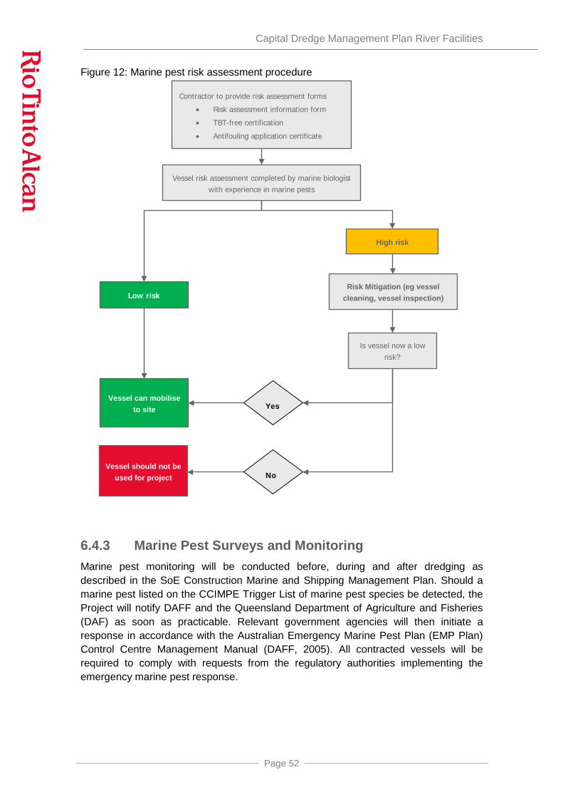
Capital Dredge Management Plan River Facilities
Page 52
Figure 12: Marine pest risk assessment procedure
6.4.3 Marine Pest Surveys and Monitoring Marine pest monitoring will be conducted before, during and after dredging as described in the SoE Construction Marine and Shipping Management Plan. Should a marine pest listed on the CCIMPE Trigger List of marine pest species be detected, the Project will notify DAFF and the Queensland Department of Agriculture and Fisheries (DAF) as soon as practicable. Relevant government agencies will then initiate a response in accordance with the Australian Emergency Marine Pest Plan (EMP Plan) Control Centre Management Manual (DAFF, 2005). All contracted vessels will be required to comply with requests from the regulatory authorities implementing the emergency marine pest response.
Contractor to provide risk assessment forms
• Risk assessment information form
• TBT-free certification
• Antifouling application certificate
High risk
Risk Mitigation (eg vessel cleaning, vessel inspection)
Vessel can mobilise to site
Vessel should not be used for project
Is vessel now a low risk?
Vessel risk assessment completed by marine biologist with experience in marine pests
Low risk
Yes
No
Capital Dredge Management Plan River Facilities
Page 53
6.5 Underwater Noise The following mitigation measures will be implemented to reduce the impacts on listed threatened estuarine and marine fauna and non-avian migratory species related to underwater noise associated with dredging activities and offshore spoil disposal:
• all vessels would operate in accordance with appropriate industry and equipment noise and vibration standards;
• regular maintenance of vessels would be conducted to the manufacturers’ specifications; and,
• where possible, leaving engines, thrusters and auxiliary plants in stand-by or running mode unnecessarily would be avoided.
With the implementation of these mitigation measures, residual impacts to listed threatened estuarine and marine fauna and non-avian migratory species in the vicinity of the Project from underwater noise associated with dredging activities and offshore spoil disposal will be negligible.
6.6 Waste Management All dredging and support vessels shall operate in strict accordance with international and domestic regulations relating to marine discharges. No discharges from vessels (including sewage, garbage or oily water from machinery spaces) shall occur while vessels are in port limits. All garbage will be disposed of through the RTA Weipa waste management as detailed.
6.6.1 Vessel discharges & waste management MARPOL is the main international convention that regulates the prevention of pollution from ships, given effect in Australia through the Protection of the Sea (Prevention of Pollution from Ships) Act (PS(PPS) Act) and related Marine Orders, administered by AMSA, and in Queensland through the Transport Operations (Marine Pollution) Act 1995 (TOMP Act) and Regulation administered by MSQ. MARPOL is divided into six Annexes dealing with different pollutants.
All vessel contractors that will be involved in dredging activities, whether at the dredge site or transiting other areas, are legally obligated to comply with all relevant Commonwealth and State legislation. Compliance will also be a contractual requirement for all contractors and will be monitored by RTA.
Waste reception services will be provided by the project for reception of vessel wastes, excluding quarantine waste. Waste will be segregated on board the vessel in accordance with “Guide to Best Practice for Port Reception Facility Providers and Users” (MEPC.1/Circ.671/Rev.1), where appropriate. Waste will be transferred to a vessel or directly to wharf facilities for holding or disposal at Evans Landing Waste Facility. Waste that cannot be disposed of at the local facility will be placed in appropriate containers or tanks and transported (eg barged) to appropriate recycling, reuse or waste facilities as per the facilities management practices.

Capital Dredge Management Plan River Facilities
Page 54
Quarantine waste cannot be accepted with the existing waste management facilities at Port of Weipa (NQBP 2012). International vessels that arrive directly at Weipa or Boyd Port will undergo an AQIS inspection where all international waste will be bagged and marked appropriately. Vessels will be contractually required to keep waste on-board the vessel until it can be disposed of in accordance with methods approved by AQIS.
Sewage will be delivered or transferred to a barge or tug for delivery to Humbug where waste will be transferred by an appropriate waste management company for disposal at Lorim Point sewage treatment plant or an appropriate sewage treatment facility.
Some specific provisions that will be applied to dredging vessels with regard to the MARPOL pollution categories are as follows:
MARPOL Annex I: Oil
• all discharges of oil, oil residues and oily mixtures from vessels will be contractually banned within the Weipa Port Limits;
• outside of these limits any discharge of oil from vessels must be in strict compliance with MARPOL, the PS(PPS) Act and the TOMP Act and Regulation (i.e. <15ppm oil content in any discharge of oily water from machinery spaces only);
• all vessels will be contractually required to comply in full with the construction, equipment and operational requirements of MARPOL Annex I and to have the relevant MARPOL-mandated documentation such as Oil Record Book, IOPP Certificate and SOPEP, as applicable to the vessel type and size Waste oil will be held in segregated waste containers on each vessel;
• all waste oil received from vessels will be managed in accordance with relevant legislation (Queensland Environment Protection Act & Environment Protection (Waste Management) Regulation); and,
• all bunkering of vessels will be conducted in accordance with the Project’s Bunkering Management Plan.
MARPOL Annex IV: Sewage
• all discharges of sewage from vessels will be contractually banned within the Weipa Port Limits;
• outside of these limits any discharge of sewage from construction vessels must be in strict compliance with MARPOL, the PS(PPS) Act and the TOMP Act and Regulation;
• all vessels will be vetted to confirm they have adequate sewage treatment, management and/or holding facilities prior to contracting;
• sewage will be pumped from the vessel to a waste management tug or direct to vacuum truck at Evans Landing or Humbug Point to be disposed of by a waste management company at Lorim Point Sewage Treatment Plant or a suitable Sewage Treatment Facility; and,

Capital Dredge Management Plan River Facilities
Page 55
• any sewage not treated on board or received by the waste reception services in Weipa will be retained on board until it can be disposed of in accordance with MARPOL, Australian and Queensland legislation.
MARPOL Annex V: Garbage
• all discharges of MARPOL-defined garbage from vessels will be contractually banned within the Weipa Port Limits;
• outside of these limits any discharge of garbage from vessels must be in strict compliance with MARPOL, the PS(PPS) Act and the TOMP Act and Regulation (i.e. zero discharges <3nm from nearest land, only food waste ground to <25mm >3nm from nearest land and only food waste (not ground) >12nm from nearest land);
• all vessels will be contractually required to have the relevant MARPOL-mandated documentation such as Garbage Management Plan and Garbage Record Book as applicable to the vessel type and size;
• waste will be held in segregated waste bins on board the vessel. The waste will then be transported to a barge, tug or waste management area for transport to Humbug or Evans Landing wharves for disposal by a waste management company at Evans Landing Landfill;
• all garbage received from vessels will be managed in strict accordance with relevant legislation (Queensland Environment Protection Act & Environment Protection (Waste Management) Regulation); and,
• all garbage received from international vessels will be treated as quarantine waste and will be managed in strict accordance with the Quarantine Act under the project’s Biosecurity Management Plan.
MARPOL Annex VI: Air Emissions
All vessels will be contractually required to comply in full with the requirements of MARPOL Annex VI as applicable to the vessel type and size.
Training and Awareness
All employees and contractors involved in the handling, transfer, storage, and disposal of oil and hazardous substances will be trained in the relevant regulatory requirements, the Project’s management plans, systems, processes, and procedures, and their responsibilities.
6.6.2 Anti-fouling emissions Anti-fouling emissions are regulated through the AFS Convention and the Australian Protection of the Sea (Harmful Anti-fouling Systems) Act 2006. All vessels will be contractually required to comply with these, in particular a ban on the use of anti-fouling paints containing organo-tin compounds and the provision of a TBT Free Certificate or AFS Declaration, as relevant to the vessel type and size, prior to mobilisation to site. In addition:

Capital Dredge Management Plan River Facilities
Page 56
• as part of the marine pest risk assessment process (Section 6.4), vessels will be required to provide a certificate showing date and location of the most recent application of an antifouling coating. Antifouling coatings older than their working life are likely to result in a marine pest risk rating that requires the application of new antifouling. This will reduce the risk of emissions because aging antifouling coatings have a higher risk of flaking or chipping into the environment;
• all domestic vessels will be required to use an antifouling coating registered for use in Australia in the Public Chemical Registration Information System (PubCRIS; https://portal.apvma.gov.au/pubcris);
• in-water cleaning of vessels will be prohibited while the vessel is under contract, in accordance with the Australian anti-fouling and in-water cleaning guidelines (DAFF and SEWPaC, 2012). This eliminates the risk of particles of antifouling coating being released from the vessel to the environment during cleaning; and
• any re-application of antifouling coating needed while the vessel is under contract will be done at a shore-based maintenance facility. There are no such facilities at the Port of Weipa.
6.7 Spill Management and Response
6.7.1 Spill Management Controls Operational spill management controls to prevent oil and other spills into the marine environment during dredging include:
• complying with vessel traffic management controls;
• bunkering in accordance with the Bunkering Management Plan;
• compliance with AMSA Marine Order 32 (Cargo handling equipment 2011) or current version with clearly identified roles and responsibilities;
• regular and documented maintenance of all vessels and equipment;
• vetting of vessels for condition, maintenance and survey history prior to contracting;
• relevant employees and contractors involved in the storage, handling, transfer and disposal of fuel and other materials will be trained to ensure they are aware of their responsibilities and the Project systems, processes and procedures;
• relevant contractors will be required to undertake spill response training and appropriate training exercises in accordance with their plans;
• properly trained and certified crew;
• bridge management and fatigue management systems; and
• ship security plan.

Capital Dredge Management Plan River Facilities
Page 57
6.7.2 Spill Response While the measures outlined in Section 6.6 are designed to prevent marine pollution from vessels, while unlikely, there is always the potential for incidents to occur resulting in accidental discharges and spills. It is therefore also necessary to have a spill management and response plan, which identifies management methods, procedures, roles and responsibilities for rapidly responding to, containing and cleaning up any such spills to ensure the marine environment remains protected.
The Spill Management and Response Plan for the SoE Project has been developed in accordance with Australia’s National Plan for Maritime Environmental Emergencies (NATPLAN), the Queensland Coastal Contingency Action Pan (QCCAP) and the Port of Weipa First-strike Oil Spill Response Plan. The hierarchy of spill management plans at national, state, local and site levels is summarised in Figure 13.
Figure 13: Hierarchy of oil spill response planning
The NATPLAN arrangements provide for a “tiered’ response to marine oil and chemical spills:
• individual ports, terminals and marine facilities: Relevant operator is responsible for maintaining a “first strike” response capability and site-specific plan;
• State (spills within 3nm): Relevant State authority is responsible for coordinating the response. In Queensland this is MSQ through the QCCAP; and,
• National (spills beyond 3nm or within 3nm that are too large for State to manage): AMSA is responsible for coordinating the response with support from other parties under the NATPLAN.
The NATPLAN (AMSA, ND) and QCCAP (DTMR, 2014a) and local plans identify the following key roles in the event of a spill in Queensland waters:
• Statutory Agency: In Queensland, MSQ is the designated government agency with responsibility to verify that ports have adequate spill response plans, capability and enforce other requirements. In the event of a spill, MSQ is responsible to verify that a satisfactory response is implemented. MSQ is also responsible for prosecutions and recovery of clean-up costs on behalf of all
National Planning
•National Plan for Maritime Environmental Emergencies (NATPLAN) •National Marine Oil Spill Contingency Plan
State Planning
•All Queensland - Queensland Coastal Contingency Action Plan (QCCAP)
Local Planning •Port of Weipa - First-strike Oil Spill Response Plan
Site Planning
•RTAW Emergency Response Plan - Port of Weipa •SoE Emergency Response Plan •SoE Project Spill Prevention and Response Plan

Capital Dredge Management Plan River Facilities
Page 58
participating agencies. MSQ also assumes the Combat Agency role in coastal waters outside port limits to 3 nautical miles offshore, including in the GBRMP.
• Combat Agency: the agency that directs and manages the spill response, with response assistance able to be provided by other parties under Combat Agency direction. Combat Agencies have the operational responsibility to take action to respond to an oil spill in the environment in accordance with the relevant contingency plan. Combat Agencies within Port Limits are generally port authorities.
• First Strike Response Agent: local spill-response plans designate the appropriate first-strike response agent who is responsible for initiating and carrying out first-strike response operations. The first-strike agent assesses the time and resources required to effectively manage an incident and requests assistance as necessary if the response is likely to be prolonged or outside the first-strike response capability.
• Vessel Masters are responsible for taking prompt and effective action to ensure the safety of the vessel and cargo and notifying MSQ of the situation.
• Environmental and Scientific Coordinator: Nominated by the Queensland Government to provide environmental input to planning and decision-making, and providing advice regarding the likely environmental effects of a spill event.
RTA already maintains a “first strike” response capability at the Port of Weipa and this will be used to respond to any spills from SoE vessels within the port. The RTA spill response resources at Weipa will also be available to supplement the dredge contractors’ plan if required.
The roles and responsibilities of different parties are summarised in Figure 14 and
Table 3.
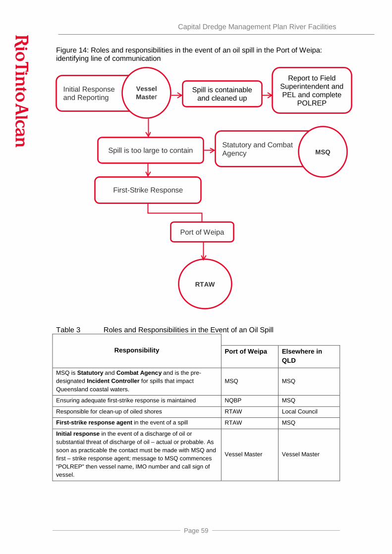
Capital Dredge Management Plan River Facilities
Page 59
Figure 14: Roles and responsibilities in the event of an oil spill in the Port of Weipa: identifying line of communication
Table 3 Roles and Responsibilities in the Event of an Oil Spill
Responsibility Port of Weipa Elsewhere in QLD
MSQ is Statutory and Combat Agency and is the pre-designated Incident Controller for spills that impact Queensland coastal waters.
MSQ MSQ
Ensuring adequate first-strike response is maintained NQBP MSQ
Responsible for clean-up of oiled shores RTAW Local Council
First-strike response agent in the event of a spill RTAW MSQ
Initial response in the event of a discharge of oil or substantial threat of discharge of oil – actual or probable. As soon as practicable the contact must be made with MSQ and first – strike response agent; message to MSQ commences “POLREP” then vessel name, IMO number and call sign of vessel.
Vessel Master Vessel Master
Initial Response and Reporting
Statutory and Combat Agency MSQ
Vessel Master
First-Strike Response
Port of Weipa
RTAW
Spill is too large to contain
Spill is containable and cleaned up
Report to Field Superintendent and PEL and complete
POLREP

Capital Dredge Management Plan River Facilities
Page 60
6.7.3 Spill Response in the Port of Weipa Oil spill response in the Port of Weipa is outlined in the Port of Weipa First Strike Oil Spill Response Plan, a supplement to the QCCAP (DTMR 2014a). MSQ is both the Statutory and Combat Agency. RTAW is the first-strike response agent. Further details are provided in the following documents:
• Port of Weipa First-strike Oil Spill Response Plan (DTMR, 2014b);and
• RTAW Emergency Response Plan - Port of Weipa (RTAW 2015, or most current version).
6.7.4 Shipboard Oil Pollution Emergency Plan (SOPEP) In addition to the site-specific plans, vessels will have SOPEPS as required by Annex I of MARPOL and implement Australian and Queensland legislation.
6.7.5 Marine Pollution Reporting (POLREP) POLREPs are required for any illegal vessel discharge to the marine environment. Discharges will be reported to the relevant authority which may be MSQ or AMSA, depending on the location. Any vessel discharges in Queensland of any size to the marine environment will be reported to MSQ using Marine Pollution Report form (POLREP). This can be accessed online http://www.msq.qld.gov.au/Marine-pollution/Contingency-plans.aspx and will be submitted by email to MSQ. Discharges outside Queensland waters will be reported to AMSA.
6.8 Summary of Environmental Issues, Potential Impacts Management and Monitoring Methods
Table 4 summarises the potential impacts and associated mitigation, monitoring and management measures to be implemented.

Capital Dredge Management Plan River Facilities
Page 61
Table 4 Activities, Environmental Issues/Potential Impacts and Mitigation, Management and Monitoring Measures
Potential Impact
Avoidance, Mitigation and Management Measures
Monitoring Benchmark/ Baseline/ Goals
Performance Indicators Timeframe implemented
Corrective Actions Responsibility
Turbidity Plume Generation – dredging reducing water quality
Management measures are detailed in Sections 6.1.2and 6.1.3 and Figure 9
Water quality monitoring will be conducted in accordance with Section 6.1.3 and Figure 9 Note: Monitoring only if dredging extends for more than 14 consecutive days at any of the proposed sites
Control sites water quality. No significant impacts to water quality from dredging activities.
Number of water quality exceedance through duration of the dredging program
Two weeks prior and during dredging activities .
Implementation of the management process identified in Figure 9 to be implemented.
Breaches to be investigated and appropriate corrective actions implemented.
Dredging Contractor SoE Project Team Project Manager Environmental Specialists
Turbidity Plume Generation impacting seagrass
Management measures are detailed in Section 6.1.3
Water quality, PAR and annual seagrass health monitoring will be conducted in accordance with Section 6.1.3
Existing environment (NQBP baseline data)
No significant seagrass loss due to dredging activities
Decrease in seagrass cover related to dredging activities
WQ prior to and, during dredging. PAR prior, during and after dredging.
NQBP Seagrass monitoring annually
Implementation of management process identified in Figure 9to be implemented.
Breaches to be investigated and appropriate corrective actions implemented.
Dredging Contractor SoE Project Team Project Manager Environmental Specialists
Marine Pest Management methods as outlined in Section 6.4 including the completion of vessel risk assessments and inspections as necessary as per Figure 12.
Marine pest monitoring including baseline, during and completion monitoring, Section 6.4.3.
No marine pests established in the Port of Weipa as a result of dredging activities. No marine pest incursions during the dredging phase of the SoE Project.
Number of marine pests species established in the Port of Weipa as a result of dredging activities
Prior, during and after dredging activities
Any incidents to be reported and appropriate corrective actions implemented as per Section 6.4.2 Review current marine pest assessment practices and amend as necessary.
Dredging Contractor SoE Project Team Project Manager Environmental Specialists

Capital Dredge Management Plan River Facilities
Page 62
Potential Impact
Avoidance, Mitigation and Management Measures
Monitoring Benchmark/ Baseline/ Goals
Performance Indicators Timeframe implemented
Corrective Actions Responsibility
Increase training and awareness if required.
Noise - Underwater Noise – Vessel
Management methods are detailed in Section 6.5 and include: Vessels contracted will have service and maintenance histories to meet MSQ requirements, regular vessel maintenance, vessel engines, thrusters and auxiliary plant will not be left in standby where possible, vessel speeds restrictions, use of transit lanes
Random inspections by HSE team.
Contracts requirements. All dredging-related shipping has the appropriate mitigation measures applied to reduce underwater noise. Contracted dredging-related shipping has appropriate underwater noise mitigation measures included in their contract.
Number of dredging-related shipping that has the appropriate mitigation measures applied to reduce underwater noise. Number of contracted dredging-related shipping that are appropriately vetted for appropriate underwater noise mitigation and measures included in their contract
During dredging activities
Check regular maintenance is being conducted on dredging-related shipping. Breaches to be investigated and appropriate corrective actions implemented.
Dredging Contractor Vessel Master SoE Project Team Project Manager
Waste Implement management measures in Section 6.6
Daily inspection completed by supervisor. Weekly inspections by HSE Advisor.
All waste disposed of in accordance with national and international regulations
Number of non-conformances
No visible waste washed from site
During dredging activities
Any breaches identified are to be investigated and appropriate corrective actions implemented
Team Members Dredging Contractor SoE Project Team
Waste - Vessels
Implement management measure outline in Section 6.6.1
Daily inspection completed by supervisor. Weekly inspections by HSE Advisor.
All waste management and disposal in accordance with project management plan, MARPOL, Commonwealth and State regulations
No waste disposed
Number of non-conformances Areas disturbed due to waste
During dredging activities
Any breaches identified are to be investigated and appropriate corrective actions implemented
Team Members Dredging Contractor SoE Project Team

Capital Dredge Management Plan River Facilities
Page 63
Potential Impact
Avoidance, Mitigation and Management Measures
Monitoring Benchmark/ Baseline/ Goals
Performance Indicators Timeframe implemented
Corrective Actions Responsibility
of incorrectly and any spilled debris removed
Waste – antifouling emissions
TBT-free certification for all vessels, within their working life to prevent flaking, domestic vessels antifouling must be registered for use in Australia, in water cleaning prohibited as per Section 6.6.2
Antifouling certifications reviewed by HSE Team
Baseline environment All antifouls TBT free and within working life, no in-water cleaning and antifoul registered for use in Australia
Number of vessels that meet goals
During dredging activities
Any breaches identified are to be investigated and appropriate corrective actions implemented (eg removal from project)
Dredging Contractor SoE Project Team Project Manager
Spills Implementation of measure identified in Section 6.7
Inspections of work area and equipment occurring during working hours. Daily inspection completed by supervisor. Weekly inspections by HSE Advisor.
No spills Zero non-compliance with waste regulations If a spill occurs, all oil spills are contained and are responded to and cleaned up in a timely manner.
Number and quantity of vessel discharges from dredging-related shipping. Number and quantities of incidents Number of non-compliances with national and international regulations
During dredging activities
Implement appropriate spill response measures and comply with agency requests Any spills or discharges of wastes to be reported and appropriate corrective actions implemented. Breaches to be investigated and appropriate corrective actions implemented. Increase training and awareness if required.
Vessel Master Dredging Contractor SoE Project Team Project Manager
Marine turtle and marine mammal impacts including Vessel
Implementation of measures identified in Section 6.2.2 and 6.2.3
Monitoring of marine fauna by crew when vessel underway
Monitoring of marine turtle and marine mammals as
Vessel Speed Requirements Specified Transit Lanes IMO Guidance document for
Zero marine fauna vessel strikes associated with dredging-related shipping. Number of non-compliances with vessel speed requirements (including ferries
During dredging activities
Implementation of Adaptive Management Process as identified in Section 6.2.6 Any injured or dead listed species will be
Vessel master Dredging Contractor SoE Project Team Project Manager

Capital Dredge Management Plan River Facilities
Page 64
Potential Impact
Avoidance, Mitigation and Management Measures
Monitoring Benchmark/ Baseline/ Goals
Performance Indicators Timeframe implemented
Corrective Actions Responsibility
Strike identified in Section 6.2.3 and Figures 10 and 11and implementation of the adaptive management process in Section 6.2.6
minimising the risk of ship strikes with cetaceans, MEPC.1/Circ.674, dated 31 July 2009. Zero marine fauna vessel strikes associated with dredging activities
No records of marine turtles capture by dredging activities
and barges not slowing to 6 knots in water depths of 2.5m or less). Number of times ferries and barges do not follow specified transit lanes. Number of non-compliances of management process Figure 15 and 16
reported to marine stranding hotline through RSPCA Queensland on 1300 ANIMAL as in Section 6.2.3 Any incidents to be reported and appropriate corrective actions implemented. Increased training and awareness if required.
Impacts from Artificial Lighting
Light levels from the initial capital dredging works would be minimised to those lights that are necessary for the safe operation of the vessels where practicable as in Section 6.2.5.
Visual monitoring of light levels from dredge associated vessels
Visual identification of marine turtle congregation around dredging associated vessels
No records of marine turtles aggregating around dredging-related shipping.
Incidence of marine turtles aggregating around dredging-related shipping.
During dredging activities
Breaches to be investigated and appropriate corrective actions implemented. Increase training and awareness if required.
Vessel Master
Dredging Contractor
Physical Disturbance
Physical disturbance restricted to dredge footprint and approved dredge quantity. Disposal restricted to the approved spoil ground.
Area to be surveyed to ensure compliance with designated footprint.
Vessel logs (including date, time, dump paths and volumes for dredging)
Dredging and disposal as per that identified in this DMP.
Dredging remains within designated footprint
Disposal restricted to approved spoil ground
During dredging activities
Any breaches identified are to be investigated, reported and appropriate corrective actions implemented
Dredging Contractor
SoE Project Team

Capital Dredge Management Plan River Facilities
Page 65
7 MANAGEMENT STRUCTURE The SoE Project will be managed by both RTAW and the EPCM Contractor as a team, with tasks including managing subcontractors delegated among the team. A dredging contractor will be appointed for dredging of the river facilities. The Contractor will have operational responsibility for managing smaller sub-contractors, including vessel operators. Management for the project is clearly defined, with identified lines of authority and reporting. The overall management structure is outlined in Figure 15.
Figure 15: Overall management structure for the SoE Project
A number of key management roles have been identified for the Project, as summarised below. The role names are subject to change but the basic structure will remain the same.
SoE Project Team, Project Manager
• Manages the Project and its execution, including providing adequate resources for environmental management requirements.
• Liaises with Regulatory Authorities, in coordination with the SoE Project Team Environmental Manager.
SoE Project Team Line Managers
• Report to the SoE Project Team Project Manager.
• Day-to-day management of the Project, ensuring employees including subcontractors report to the Project Manager.
• Monitor implementation of management plans including the Dredge Management Plan, refining procedures as necessary to ensure relevant management measures are implemented effectively and adaptive management/corrective action is taken in a timely manner.
Sub-contactors
SoE Project Team (RTAW/EPCM
Contractor)
River Facilities Dredging Contractor
Regulatory Authorities
Marine Services Contractor
Boyd Port Marine Contractor
Sub-contactors Sub-contactors

Capital Dredge Management Plan River Facilities
Page 66
• Review and report on environmental incidents.
SoE Project Team Environmental Manager
• Reports to the SoE Project Team Project Manager.
• Supports the SoE Project Team Line Managers in day-to-day management of environmental performance.
• Monitors environmental performance.
• Reviews compliance with permits and management plans.
• Monitors, investigates and reports on complaints, incidents of environmental non-compliance and environmental incidents.
• Liaises with relevant regulatory authorities including providing monitoring results and reporting non-compliance and environmental incidents.
• Ensures non-compliances and environmental incidents are followed up and corrective actions are implemented within reasonable timeframes
• Ensures environmental monitoring is completed in accordance with approved management and monitoring plans.
• Arranges regular environmental audits.
• Reviews contractor environmental management plans.
• Ensures all contractors are trained in environmental awareness, site issues and the requirements of environmental management plans.
• Ensures environmental management plans and procedures are updated as necessary.
Marine Contractor Project Managers
• Responsible for day-to-day management of construction activities under the direction of the SoE Project Team Project Manager and Environmental Manager.
• Ensure all staff are trained in environmental awareness, site issues and the requirements of environmental management plans.
• Monitor environmental compliance and reports non-compliance to the SoE Project Team Environmental Manager.
• Assist in developing corrective actions for complaints, non-compliances and environmental incidents and ensures they are implemented.
• Facilitate regular environmental audits by the SoE Project Team Environmental Manager to monitor compliance.
• On-site monitoring as provided for in management plans and procedures.
Employees, contractors and sub-contractors

Capital Dredge Management Plan River Facilities
Page 67
• Conduct all activities in accordance with the River Dredge Management Plan, including water quality monitoring and marine mammal and marine turtle monitoring.
• Regularly report on the dredging works to RTAW
• Report any non-compliances to their line manager.
8 TRADITIONAL OWNER EMPLOYMENT OPPORTUNITIES
RTA has committed to working collaboratively with Traditional Owners, through the relevant Western Cape Communities Co-existence Agreement (WCCCA) Sub-Committees and the WCCCA Coordinating Committee to further increase representation of local Aboriginal people, and in particular, the Wik & Wik Waya Traditional Owners across the workforce. For this reason, focussed work, in collaboration with Traditional Owners and the Members of the WCCCA Employment, Training, Environment and Heritage Sub-Committee will be undertaken, to understand the current challenges, the outcomes achieved to date and the development of strategies specific to the needs of this community.
In addition, RTA Weipa as a signatory to the Western Cape Regional Partnership Agreement (RPA) is actively working with the RPA working group on employment and training to identify opportunities where industry, Governments and local Aboriginal people can strategically partner to develop relevant skills and employment pathways prior to and during the construction phase of the SoE Project.
Traditional Owner employment opportunities associated with capital dredging in the Hey and Embley Rivers will be available in the following Land and Sea Management Programmes, which are part of the Communities, Heritage and Environmental Management Plan (SoE Communities, Heritage and Environment Working Group, 2014):
• Marine Mammal Observations.
In addition, through the existing Indigenous Land Use Agreement, opportunities for employment of Traditional Owners are identified through and employment and training plan. This plan identifies work opportunities and roles within these work opportunities that may be filled by Traditional Owners. Traditional Owners that may be capable of filling these roles are then identified with RTAW supporting identified candidates to become appropriately skilled to fill the identified roles. RTAW supports the employment of Traditional Owners if they are appropriately skilled and qualified in all areas of the business.
As part of RTAW’s reporting obligations under the Indigenous Land Use Agreement, quarterly review reports on Indigenous employment and training obligations are made to Traditional Owners.

Capital Dredge Management Plan River Facilities
Page 68
9 INDIGENOUS CONSULTATION Indigenous people were consulted in accordance with the process under the Indigenous Land Use Agreement during the preparation of this Plan. This consultation involved the following:
• the Plan was lodged with the Western Cape Communities Coexistence Agreement (WCCCA) Coordinating Committee in November 2014;
• the Plan was subsequently presented to a meeting of the Communities, Heritage and Environment Management Plan (CHEMP) Working Group. No queries about the Plan were raised at the meeting. Members of the CHEMP Working Group were asked to provide any comments on the Plan within a few weeks. No comments were received;
• the presentation to the Working Group was then lodged with the WCCCA Coordinating Committee and which formally noted that the management plans had been presented to the Working Group.

Capital Dredge Management Plan River Facilities
Page 69
10 REPORTING RTAW will report on the implementation of the final DMP for the River Facilities to the NQBP Technical Advisory and Consultative Committee for the Port of Weipa.
RTAW will provide reports to Department of Environment as required by the Conditions in the Sea Dumping Permit:
Condition No.
Condition
19 If at any time during the course of the dumping activities an environmental incident occurs or environmental risk is identified, all measures will be taken immediately by RTAW to mitigate the risk or the impact. The situation will be reported in writing within 24 hours to the Department of Environment with details of the incident or risk, the measures taken, the success of those measures in addressing the incident or risk and any additional measures proposed to be taken.
20 RTAW will document any environmental incidents which occur in the course of the dumping activities that result in injury or death to any marine mammals, marine turtles or EPBC Act listed species. The time and nature of each incident and the species involved, if known, will be recorded.
22 RTAW will keep records comprising of weekly plotting sheets or a certified extract of the vessel’s log which detail:
d) The times and dates of when each dumping run is commenced and finished;
e) The position (as determined by GPS) of the vessel at the beginning and end of each dumping run, with the inclusion of the path of each dumping run; and
f) The volume of dredge material (in cubic metres) dumped and quantity in dry tonnes for the specified operational period, with a comparison of these quantities with the total amount permitted under the permit on a daily basis.
These records will be retained by RTAW for verification and audit purposes.
24 Within two months of the final bathymetric survey being undertaken RTAW will provide a digital copy of the bathymetric survey to the Royal Australian Navy Hydrographer, Locked Bag 8801, South Coast Mail Centre, NSW 2521.

Capital Dredge Management Plan River Facilities
Page 70
Condition No.
Condition
25 RTAW will provide a report on the bathymetry to the Department of Environment within two months of the final bathymetric survey being undertaken. The report will include a chart showing the change in sea floor bathymetry as a result of dumping and include written commentary on the volumes of dumped material that appear to have been retained within the disposal site.
26 RTAW will provide a report to the Department of Environment on the Form “Sea Dumping Permit International Report Requirements” or in a format as approved by the Department of Environment from time to time:
c) Following commencement of dumping activities, by 31 January each year until expiry of the sea dumping permit or completion of the dumping activities (whichever is earlier); and
d) Upon expiry of the sea dumping permit or completion of dumping activities (whichever is earlier).
A monthly monitoring report will be prepared by RTAW and submitted to Queensland Department of Environment and Heritage Protection throughout the period that initial capital dredging and spoil disposal works are being undertaken. This report will include:
• a summary of results of all monitoring required by the environmental authority and dredge management plan, with raw data provided in an electronic format appendix (i.e. spreadsheet);
• an evaluation and explanation of the data from these monitoring programs;
• a daily summary of dredge movements (specifying the boundaries of the dredged area by GPS coordinates and disposal activity);
• details of marine turtle or other marine fauna captures by the dredge and species involved;
• details of any complaints received including investigations undertaken, conclusions formed and action taken;
• a summary of significant equipment failures or events that have potential environmental management consequences;
• an outline of corrective actions that will or have been taken to minimise or reduce environmental harm;
• the quantity (volume in cubic metres) and location of dredging material removed and disposed of; and,

Capital Dredge Management Plan River Facilities
Page 71
• different details and frequency of reporting as agreed to by Department of Environment and Heritage Protection.
The DMP will be published on the RTA website in accordance with Condition 59 of the EPBC Act approval. The RTA website address is:
http://www.riotintoalcan.com/ENG/ourproducts/1818_south_of_embley_project_reports_and_publications.asp
In accordance with Condition 68 of the EPBC Act approval RTA will publish a report on this web site addressing compliance with the Dredge Management Plan over the previous 12 months within (3) months of every 12 month anniversary of commencement of the action.
11 INDEPENDENT PEER REVIEW Consistent with Condition 60 of the EPBC Act Approval an independent peer review of the DMP has been performed by an independent marine scientist with recognised expertise in dredge management plans and an understanding of matters of national environmental significance in the marine environment.

Capital Dredge Management Plan River Facilities
Page 72
12 REFERENCES AMSA: Australian Maritime Safety Authority. (no date). National Plan for Maritime Environmental Emergencies. Australian Government. Canberra.
ANZECC/ARMCANZ (2000). Australian and New Zealand Guidelines for Fresh and Marine Water Quality. National Water Quality Strategy. Australian and New Zealand Environment Conservation Council and Agricultural Resource Management Council of Australia and New Zealand, Canberra.
Carter, AB, McKenna, SA & Rasheed, MA, 2013. Port of Weipa Long-Term Seagrass Monitoring: August 2012. JCU Publication, Centre for Tropical Water & Aquatic Ecosystem Research (TropWATER) Publication, Cairns, 26pp.
Carter, A.B., McKenna, S.A. and Rasheed, M.A. (2012). Port of Weipa Long-term seagrass monitoring 2000 -2011. DEEDI Publication, Fisheries North, Cairns. 32pp.
CEDA (2011). Underwater Sound In Relation to Dredging. CEDA Position Paper, 7 November 2011
Chartrand, K.M. and Rasheed, M. A. (2009). Port of Weipa Long term seagrass monitoring, 2000 - 2008. DPI&F Publication PR09-4201 (DPI&F, Cairns), 26 pp.
Commonwealth of Australia (2009). National Assessment Guidelines for Dredging. Commonwealth of Australia, Canberra, 2009.
Commonwealth of Australia (2013) Seaports Program: Australian Ballast Water Management Requirements. Version 5. Department of Agriculture, Canberra.
DAFF. (2005). Australian Emergency Marine Pest Plan (EMPPlan) Version 2.0. Control Centre Management Manual, 100 pp. Department of Agriculture, Fisheries and Forestry.
DAFF (2011) Australian Ballast Water Management Requirements. Department of Agriculture, Fisheries and Forestry.
DAFF and NQBP (2011). Monitoring data from Port of Weipa seagrass monitoring. Data source: North Queensland Bulk Ports and State of Queensland through the Department of Agriculture, Fisheries and Forestry.
DAFF & SEWPaC, (2013) Australian Anti-fouling and In-water Cleaning Guidelines http://www.agriculture.gov.au/Style%20Library/Images/DAFF/__data/assets/pdffile/0020/2330570/antifouling-guidelines-june-2013.pdf
DSEWPaC. (2012). Marine bioregional plan for the North Marine Region. Prepared under the Environment Protection and Biodiversity Conservation Act 1999.
Department of Transport and Main Roads (DTMR). (2014a). Queensland Coastal Contingency Action Plan. State Government. Queensland.
Department of Transport and Main Roads (DTMR). (2014b). Port of Weipa – First-strike Oil Spill Response Plan (A supplement to the Queensland Coastal Contingency Action Plan). Maritime Services Branch. Maritime Safety Queensland. State Government. Queensland.

Capital Dredge Management Plan River Facilities
Page 73
Erftemeijer, P.L.A. and Lewis III, R.R.R. (2006). Environmental impacts of dredging on seagrasses: A review. Marine Pollution Bulletin, 52, 1553 -1572.GHD (2005). Port of Weipa Capital Dredging: Draft Environmental Impact Statement. Report prepared by GHD for Ports Corporation Queensland. March 2005.
IMO (2000). Specific Guidelines for Assessment of Dredged Material. Adopted by the 22nd Consultative Meeting of Contracting Parties to the London Convention 1972 by resolution LC.22/5 (2000)18-22 September 2000. International Maritime Organisation.
IMO (2004). International Convention for the Control and Management of Ships' Ballast Water and Sediments. International Maritime Organisation.
IMO. (2005). Guidelines for ballast water management, equivalent compliance (G3), MEPC.123(53), dated 22 July 2005.
IMO. (2011). 2011 guidelines for the control and management of ship's biofouling to minimize the transfer of invasive aquatic species, MEPC.207(62), dated 15 July 2011.
McKenna, S.A. and Rasheed, M.A. (2010). Port of Weipa Long Term Seagrass Monitoring, September 2009. DEEDI Publication. Fisheries Queensland. Cairns, 25 pp.
NSPIMP: National System for the Prevention and Management of Marine Pest Incursions. (2009a). National biofouling management guidance for non-trading vessels. Department of Agriculture, Fisheries and Forestry.
NSPIMP: National System for the Prevention and Management of Marine Pest Incursions. (2009b) National biofouling management guidance for commercial vessels. Department of Agriculture, Fisheries and Forestry.
NSPIMP: National System for the Prevention and Management of Marine Pest Incursions. (2009c) National biofouling management guidance for the petroleum production and exploration industry. Department of Agriculture, Fisheries and Forestry.
Nedwell, J., Langworthy, J., and Howell, D. (2003) Assessment of sub-sea acoustic noise and vibration from offshore wind turbines and its impact on marine wildlife; initial measurements of underwater noise during construction of offshore windfarms, and comparison with background noise. Report for COWRIE, Southampton, UK
Nedwell, J., and Howell, D. (2004). A review of offshore windfarm related underwater noise sources. Report No. 544 R 0308 Oct 2004.
NIMPIS. (2015a). Asian Green mussel outbreak in Cairns - 2007 http://www.marinepests.gov.au/pest_outbreaks/Pages/Asian-green-mussel-outbreak-in-Cairns.aspx
NIMPIS. (2015b). Black-striped mussel outbreak in Darwin – 1999 http://www.marinepests.gov.au/pest_outbreaks/Pages/Black-striped-mussel-outbreak-in-Darwin.aspx
NQBP (2011). Port of Weipa – Long Term Environmental Management Plan. Maintenance Dredging. 8 July 2011. O’Hara, J. and J.R. Wilcox, 1990. Avoidance responses of Loggerhead turtles, Caretta caretta, to low frequency sound. Copeia 2: 564 – 567.

Capital Dredge Management Plan River Facilities
Page 74
NQBP (2012) Port Handbook Port of Weipa
PCQ (1995). Port of Weipa Strategic Plan. Ports Corporation of Queensland, Brisbane.
PCQ (2009). Port of Weipa - Environmental Management Plan. Draft for Public Comment. Ports Corporation of Queensland. February 2009.
RTA (2011). Environmental Impact Statement for South of Embley Project. Rio Tinto Alcan.
RTA (2012). South of Embley Project Supplementary Report to the Environmental Impact Statement.
RTA (2013). South of Embley Project Commonwealth Environmental Impact Statement.
RTAW. (2015) Section 2 – Emergency Response Plan. Version 3.5 09/03/2015.
SKM (2009). Port of Weipa Long Term Environment Management Plan for Dredging and Dumping Activities. Report prepared by Sinclair Knight Merz for North Queensland Bulk Ports. 31 August 2009.
Smolowitz, R. and Weeks, M. (2006). Turtle-Scallop Dredge Interaction Study 2005 Field Season. Coonamessett Farm, East Falmouth, Massachusetts, USA 02536Spotila, J.R., R.D. Reina.
Worley Parsons (2012). Sediment Characterisation Report – South of Embley Project Barge/Ferry Terminals. Report for Rio Tinto Alcan.

Capital Dredge Management Plan River Facilities
Page 75
Appendix 1 – Department of Environment Approval Notice Letter of approval for management plan from Minister