road corridor investment program · road corridor investment program kobuleti bypass road,...
TRANSCRIPT

MINISTRY OF REGIONAL DEVELOPMENT AND INFRASTRUCTURE OF GEORGIA
ROADS DEPARTMENT
Road Corridor Investment Program
Kobuleti Bypass Road, Kobuleti-Batumi Section and Batumi Bypass Road Design Project
ENVIRONMENTAL IMPACT ASSESSMENT
Section 2 : Kobuleti Bypass Road (km 12+400 ~ km 31+259)
FEBRUARY 2012

i
Table of Contents
LIST OF ABBREVIATIONS AND ACRONYMS V
1 Executive Summary 1
1.1 Introduction 1
1.2 Project Description 2
1.3 Baseline Environment 4
1.4 Anticipated Environmental Impacts and Mitigation Measures 6
1.5 Alternatives 7
1.6 Public Consultation and Information Disclosure 9
1.6.1 Consultations to Date 9
1.6.2 Disclosure of Documents 9
1.7 Environmental Management Plan 10
1.8 Conclusions and Recommendations 11
2 POLICY, LEGAL, AND ADMINISTRATIVE FRAMEWORK 13
2.1 The Necessity and Purpose of Environmental Impact Assessment 13
2.2 Government Environmental Policy and Legal Framework 13
2.2.1 The Constitution of Georgia, 1995 13
2.2.2 Law on Environmental Protection, 1996 13
2.2.3 Current Legislations Related to Environmental Permitting 14
2.2.3.1 Law on Licenses and Permits, 2005 14
2.2.3.2 Laws on Environmental Impact Permits (EIP) and Ecological
Examination (EE) 14
2.2.3.2.1 Regulation on EIA 15
2.2.3.2.2 Legislation on Public Consultation 15
2.2.3.2.3 Legislation on Submission of EIA to MOEP 15
2.2.3.2.4 Issuance of Environmental Impact Permit 15
2.2.4 Other National Environmental Regulations Relevant to the Project 16
2.2.4.1 Waste Management 16
2.2.4.2 Georgian Law on Ambient Air Protection 16
2.2.4.3 Law of Minerals, 1996 16
2.2.4.4 Wildlife Law, 1996 16
2.2.4.5 Law of Georgia on the System of the Protected Areas, 1996 16
2.2.4.6 Law of Georgia „On the Red List and Red Book‟, 2003 17
2.2.4.7 Law of Georgia on Cultural Heritage, 2007 17
2.2.4.8 The Forest Code 17
2.2.4.9 The Law of Georgia on Water (1997) 17
2.2.4.10 the Law on Soil Protection (1994) 17
2.2.4.11 the Sanitary Code of Georgia 17
2.2.4.12 Environmental Standards and Norms 17
2.3 Administrative Framework 18
2.3.1 Ministry of Environmental Protection and Natural Resources (MOEP) 18
2.3.2 Ministry of Economy and Sustainable Development 19
2.3.3 The Roads Department (RD or RDMRDI) 19
2.3.4 Environmental and Natural Resources Directorate of Adjara 19
2.3.5 Other Responsible Governmental Institutions 19
2.4 International Treaties and Conventions 19
2.4.1 The Convention on Biological Diversity, 1994 19
2.4.2 The Convention on the Conservation of Migratory Species of Wild Animals 20

ii
2.4.3 Convention on Wetlands of International Importance 20
2.4.4 Convention on International Trade in Endangered Species of Wild Fauna
And Flora (CITES) 20
2.5 Environmental Safeguards of ADB 20
2.5.1 Harmonization of ADB and Government Safeguard Requirements 21
3 DESCRIPTION OF THE PROJECT 24
3.1 Overview 24
3.2 Purpose of the Study 24
3.3 Location 26
3.4 Key Project Components 26
3.5 Description of Road Alignment 29
3.6 Project Designs 30
3.6.1 Traffic Volume 30
3.6.2 Road Design 31
3.6.3 Bridges and Overpasses 33
3.6.4 Tunnels 34
3.6.5 Interchanges 35
3.6.6 Culverts 36
3.7 Volume of Civil Works 37
3.8 Quarries and Borrow Sites 38
3.9 Construction Camps 40
3.10 Construction Process 40
3.11 Project Costs 41
3.12 Implementation Schedule 41
4 DESCRIPTION OF THE ENVIRONMENT 42
4.1 Physical Resources 43
4.1.1 Climate 43
4.1.2 Topography and Landscape 45
4.1.3 Geomorphology 46
4.1.4 Geodynamic process along the Project Road 49
4.1.5 Geological Hazards of the Project Area 50
4.1.6 Hydrology 53
4.1.7 Hydrogeology 57
4.2 Ecological Resources 58
4.2.1 Flora 61
4.2.2 Fauna 61
4.2.3 Bird migration routes across project area 66
4.2.4 Protected Areas 68
4.3 Environmental Quality 69
4.3.1 Surface Water Quality 71
4.3.2 Groundwater Quality 71
4.3.3 Noise Quality 72
4.3.4 Air Quality 75
4.3.5 Soil Quality 76
4.4 Social, Economic and Cultural Resources 77
4.4.1 Population and Communities 77
4.4.2 Industries and Infrastructure 77
4.4.3 Transportation 80
4.4.4 Cultural Resources and Archaeological Sites 82
4.4.5 Land Use 82
4.4.6 Socioeconomic Conditions 83

iii
5 ANTICIPATED ENVIRONMENTAL IMPACTS AND MITIGATION MEASURES 87
5.1 Approach to Screening of Environmental Impacts 87
5.2 Project Related Significant Impacts 89
5.2.1 Pre-construction Stage 89
5.2.1.1 Loss of Land 89
5.2.1.2 Loss of Households 90
5.2.1.3 Loss of Trees 91
5.2.1.4 Loss of Crops 93
5.2.1.5 Loss of Buildings and Structures 93
5.2.1.6 Loss of Business and Employment 94
5.2.1.7 Comparison of Resettlement Framework 94
5.2.2 Construction Stage 97
5.2.2.1 Geo-hazards 97
5.2.2.2 Soils and Materials 99
5.2.2.3 Spoils and Wastes 101
5.2.2.4 Fuel and Hazardous Materials Storage Sites 102
5.2.2.5 Water 103
5.2.2.6 Air Quality 103
5.2.2.7 Noise and Vibration 104
5.2.2.8 Impact associated with bridge and Tunnel Construction 104
5.2.2.9 Construction Camps 104
5.2.2.10 Community Impacts 105
5.2.2.11 Health, Safety and Hygiene 106
5.2.2.12 Cultural and Archeological Sites 106
5.2.2.13 Utilities 107
5.2.2.14 Ecological Environment 107
5.2.3 Operation Stage 109
5.2.3.1 Water 109
5.2.3.2 Air Quality 109
5.2.3.3 Noise and Vibration 110
5.2.3.4 Impacts on Ecological Environment 110
5.2.3.5 Tunnel Facilities 111
5.2.3.6 Impacts on Community 112
5.3 Spill Contingency Plan 112
5.4 Road Safety Measures 112
5.5 Preliminary assessment of Impact of Climate Change 113
5.6 Induced and Cumulative Impacts 115
6 ANALYSIS OF ALTERNATIVES 117
6.1 Overview 117
6.2 „Without Project‟ Alternative 117
6.3 Alternate Analysis in Feasibility Study 117
6.4 Alternative Analysis during Detailed Design 117
6.4.1 Improvement of Project Route of Feasibility Study Stage 117
6.4.2 Study of Alternative Alignment 118
6.5 Selection of Design and Construction Standards 119
7 INFORMATION DISCLOSURE, CONSULTATION AND PARTICIPATION 120
7.1 Consultations during Feasibility Study 120
7.2 Consultations during Detailed Design Stage – Kobuleti Bypass Road 123
7.3 Proposed Consultation and Disclosure Plan 127
7.3.1 Disclosure of documents 127
7.3.2 Public consultation meetings 127

iv
7.3.3 Information about the planned meetings 128
8 GRIEVANCE REDRESS MECHANISM 129
8.1 Objective 129
8.2 Grievance Mechanism for Environmental Issues 129
8.2.1 Type of Grievance 129
8.2.2 Composition of GRC 129
8.2.3 Procedures for Filing GRC Cases 130
8.2.4 Grievance Review Process 131
8.3 Grievance Mechanism for Social Issues 132
9 ENVIRONMENTAL MANAGEMENT PLAN 135
9.1 Guiding Principles of EMP 135
9.1.1 Methodology 135
9.2 Mitigation Measures 136
9.3 Monitoring Mechanism 136
9.3.1 Monitoring Schedule and Performance Indicator 137
9.4 Budget Estimates 138
9.5 Institutional Framework for Implementation of EMP 139
9.6 Management of Project Related Impacts 139
9.7 Environmental Code of Practice (ECP) 140
9.8 Resettlement Action Plan 158
9.9 Landscaping and tree Planting 158
9.10 Emergency Response Plan 159
9.11 Reporting and Feedback Mechanism 159
9.12 Adaptation of EMP during Implementation 160
9.13 Institutional Strengthening and Capacity Building 161
10 Conclusions and Recommendations 162
Conclusions and Recommendations 174

v
List of Abbreviations and Acronyms
AADT Annual Average Daily Traffic IUCN International Union of
Conservation of Nature
ACCOBAMS Agreement on Conservation of
Cetaceans of the Mediterranean Sea,
Black Sea and Contiguous Atlantic
Area
Kg Kilogram
ADB Asian Development Bank KIMS Institute of Raw Materials
of Caucasus
ADB Asian Development Bank Km/km Kilometer
AEWA African-Eurasian Migratory Waterbirds Km2 Square kilometer
AHs Affected Households KNP Kolkheti National Park
AIDS Acquired Immune Deficiency
Syndrome
KNR Kobuleti Nature Reserve
APs Affected Persons LARP Land Acquisition and
Resettlement Plan
BOD Biological Oxygen Demand m Meter
Ca Calcium m2 Square meter
CEAP Construction Environmental Action
Plan
m3 Cubic meter
CH4 Methane MAC Maximum Allowable
Concentrations
CH4 Methane MFF Multittranche Financing
Facility
CITES Convention on International Trade in
Endangered Species of Wild Fauna and
Flora
MFF Multi Tranche Financing
Facility
Cl Chloride mg/l Milligram per Liter
cm Centimeter MIS Management Information
System
CMS Conservation of Migratory Species MM Man Month
CO Carbon Monoxide MOESD Ministry of Economic
Sustainable Development
CO Carbon Monoxide MOEP Ministry of Environment
Protection
CO2 Carbon Dioxide MRDI Ministry of Regional
Development and
Infrastructure
COD Chemical Oxygen Demand mS/cm Milli Siemens per
centimeter
CR Critical Endangered N2O Nitrous Oxide
CSC Construction Supervision Consultant Na Sodium
CSC Construction Supervision Consultant NGO Non-governmental
Agency
CSCES Construction Supervision
Environmental Specialist
NGOs Non-governmental
Organisations
cumec Cubic meter per second NMVOC Non-methane Volatile
Organic compounds
dBA A' decibel NO2 Nitrogen Dioxide

vi
DC Design Consultant NOAA National Oceanic and
Atmosphere
Administration, USA
DDC Detailed Design Consultant NOx Nitrogen Oxides
DHs Displaced Households NOX Nitrogen Oxide
DO Dissolved Oxygen O&M Operation and
Management
DO Dissolved Oxygen OC Organic Carbon
DPs displaced persons OH Occupation and Health
EA Environmental Assessment OM Operations Manual
EE Ecological Examination Pb Lead
EE Ecological Expertise PM Particulate Matter
EEC Ecological Expertise Conclusion PMU Project Management Unit
EHSM Environment, Health, and Safety
Manager
PPE Personal Protection
Equipment
EI Environmental Inspection ppm parts per million
EIA Environmental Impact Assessment RAMSAR Ramsar Convention on
Wetlands
EIA Environmental Impact Assessment RD Roads Department
EIP Environmental Impact Permits RDMRDI Roads Department
EIP Environmental Impact Permit REA Rapid Environmental
Assessment
EIRR Economical Internal Rate of Return RMS root mean square
EMP Environmental Management Plan ROW Right of Way
EMS Environmental Management System SEIA Summary Environmental
Impact Assessment
EN Endangered SEL Sound Exposure Level
EUROBATS Agreement on Conservation of
Population of European Bats
SO2 Sulfur Dioxide
FHWA Federal Highway Administrators
Traffic Noise Model
STD Sexually Transmitted
Disease
FS Feasibility Study STI Sexually Transmitted
Infections
GHG Greenhouse Gases TA Technical Assistance
GIS Geographical Information System TDS Total Dissolved Solids
GOG Government of Georgia TN Total Nitrate
GRC Grievance Redress Committee TN Total Nitrogen
ha Hectares TP Polyphosphate
HC Hydrocarbon TPH total petroleum
hydrocarbon
HCO3 Bicarbonate TSP Total Suspended Particles
hr Hour TSS Total suspended
Sediments
ICZM Integrated Coastal Zone Management USEPA United States
Environmental Protection
Agency
IEE initial environmental examination VU Vulnerable
IES Illuminating Engineering Society µg/m3 Microgram per cubic
meter
IMCG International Mire Conservation Group 0C Degree Celsius
IPCC Intergovernmental Panel on Climate
Change

1
1. EXECUTIVE SUMMARY
1.1 Introduction
The 121 km existing Senaki-Poti–Sarpi road (S-2) along the western coast of Georgia is a key
highway and international transit route in Georgia. It is connected to the major Black Sea ports of
Georgia, viz. Batumi and Poti, and a number of holiday resorts, particularly, Kobuleti and Batumi.
The road runs through heavily built up tourist and residential areas and provides poor road and travel
conditions, especially for international transit traffic which has to mix with the dense urban traffic
passing through narrow streets. At present a significant volume of international transportation is
carried on the Batumi-Poti section of the road amounting to 1.0 million tons annually (2005), with 0.5
million tons on the Batumi-Sarpi section. This mix of heavy traffic on the existing road combined
with poor road conditions leads to traffic congestion, dangerous driving situations and frequent traffic
accidents, particularly in Batumi and Kobuleti and especially during the tourist season in summer.
Hence the government is planning to construct bypass roads to Kobuleti and Batumi (the Project) with
finance of Asian Development Bank (ADB). Ministry of Regional Development and Infrastructure
(MORDI) is the executing agency of the Project and Roads Department (RD) under the ministry is the
implementing agency. A pre-feasibility and feasibility study were carried out for the Project in 2005
and 2009. The proposed bypass roads will reduce the traffic congestion and accidents, increase the
generated traffic in the existing road, and reduce travel time and vehicle operating costs.
Georgia enjoys a strategic location it has yet to fully capitalize on. It is on the shortest route between
Europe and Azerbaijan, Armenia and the Central Asian Republics, through its Black Sea ports, Poti
and Batumi. It also can link Russia and Turkey. The physical location ensures that it is a key transport
link on the most direct route between the Black Sea and the Caspian Sea and Central Asia. Trade
with neighboring countries, both transit and bilateral, is thus an important feature of the economy.
Poor infrastructure and cumbersome processes inhibit the full exploitation of transit economy
potential. Georgia‟s road network is crucial in facilitating sub-regional transport and trade. Thus the
Project road has a significant potential for increase of sub-regional and regional trade, agriculture and
tourism revenue and reducing poverty. The road is expected to (i) Increase in sub-regional trade
through the Turkish border by 4% for 5 years
Map-1: Project Location
after completion, (ii) 30% increase in cross-border freight traffic by 2015 from 1.0 million ton in 2008
to 1.3 million ton, and (ii) Increase in registered visitors to Adjara region by 10% per annum for 5
years after completion from 285,000 in 2008.
Location. The Project road is located along the Black Sea in Adjara region. The entire project road,
bypassing the resort town of Kobuleti from the East, is located within the administrative boundaries of
Kobuleti region. The Project starts at Ispani village and ends at North portal of the existing tunnel.
Full Adjara by pass Project is packaged into 4 contracts as follows for preparation of detailed designs
and implementation.
Contract 1 – Km 0 to Km 12.4 bypassing Kobuleti Town – a new alignment
Contract 2 – Km 12.4 to Km 31.3 bypassing Kobuleti Town – a new alignment
Contract 3 – Km 31.3 to Km 32.3 along the existing road near Makhinjauri tunnel to
make the full use of existing and recently constructed 4 lane road tunnel
Contract 4 – Km 32.3 to Km 48.470 bypassing Batumi Town – a new alignment
The scope of the present document is to prepare Environmental Impact Assessment for 18.9 km
Kobuleti bypass road section 2, Contract 2 under tranche 1.

2
Environmental Impact Assessment. The environmental impacts of the project will be considerable
given that the Project area is located in a complex geological terrain and has significant ecological
value. The impact assessment addresses the impacts and mitigation measures on the physical, the
biological and the human environment. The EIA has been prepared to ensure that the Project is
environmentally sound and sustainable as well as in compliance with the safeguard requirements of
the ADB (Safeguard Policy Statement, 2009) and Government of Georgia (The Laws on Licenses and
Permits, 2005; Environmental Impact Permits and Ecological Examination, 2008) and will be
submitted to the Ministry of Environment Protection (MOEP) to obtain Environmental Impact Permit.
1.2 Project Description
The present project is financed by the loan ADB 2560-GEO, Road Corridor Investment Program
(Tranche 1) for Preparation of Detailed Design and Preparation of Bidding Documents for Kobuleti
Bypass Road, Kobuleti-Batumi Section and Kobuleti Bypass Road.
The project road, bypassing the Kobuleti from East, is entirely located in Kobuleti District and the
most part of the road follows the new alignment and will cross mostly the agricultural and household
plots.
The object of the present project, Kobuleti bypass, starts from the end of the section designed by the
former consultants‟ consortium, at km 12+400, at village Ispani.
The length of the design road is 18.858 m.
Generally, the aim of the project was to lay the road along the route recommended by the Feasibility
Study Report; however, rerouting of some sections turned out to be necessary, in particular:
At the 17-th km of the design route, due to the construction of a new landfill, the Client (the
Road Department) decided to bypass the latter. Accordingly, the design route recommended
by the feasibility report in the adjacent areas before and after the given section was changed.
The design route starts with an up to 300-meter-long straight section across the plain terrain covered
with old tea plantations and joins the two-level overpass junction (No. 1) at the liquid gas filling
station, crosses the river Achkva and in the river floodplain. By running through the forest, Brushes
and agricultural plots in the floodplains, the design road, through the bridge crossings, crosses the
rivers Kintrishi and Kinkisha. By crossing the road of a local designation to village Bobokvati with a
design bridge, the design road follows it and right bank of the river Dekhva upstream. Prior to
entering the gorge of the river Shuagele, the design road crosses the river Dekhva with a highway
bridge crossing. Approximately 3.5-km-long section of the design road follows up the gorge of the
river Shuagele and crosses its bed at several points. At the watershed of the river Shuagele, the road
enters a 295-meter-long design tunnel, which is planned to arrange by closed drilling. The next
section runs across an old landslide section, where, aiming at avoiding the sections, a roadbed is
planned to arrange on high embankments. By bypassing Chakvi the design road crosses the road
connecting to village Khala, river Chakvistskali and road connecting to village Chaisubani.
The road reenters the section in the settled area, where several residential houses are to be demolished
and a road of a local designation is to be laid over the design road. The existing Batumi-Tbilisi road
and some roads of a local designation and gullies are crossed by the design road with a 230-meter-
long design overpass. Then the design road penetrates the section where several existing high-voltage
transmission towers are to be relocated. The design road ends with a complete overpass junction (No.
4) allowing the two-lane design road to merge with the four-lane design section and allow the passage
of traffic flows to the city of Batumi, settlement Chakvi and Batumi Botanical Garden.

3
This section is in mountainous terrain. It includes two tunnels, fourteen bridges and two overpass
bridges including four interchanges.
Traffic Volume. The traffic volume of existing Poti-Sarpi road is 6,667 in 2009 and expected to
increase to 20,478 by 2033. 50% of the future traffic is estimated to use the project bypass roads.
Implementation Schedule. Tentative commencement date of the contract is August 2012 and the
expected time to complete the construction works is 2015.
1.3 Baseline Environment
Climate. The climate of the region is moderately warm and humid. The region is characterized by hot
summer with high amount of precipitation throughout the year. The average annual temperatures for
Kobuleti and Chakvi are 13.40C and 14.1
0C, respectively. January is the coldest month with the
average temperature 4.80C in Kobuleti. August is the hottest month with the average temperature
22.60C in Kobuleti and Chakvi. The average annual precipitation for Kobuleti and Chakvi is 2514 mm
and 2788 mm, respectively. The project area is generally humid throughout the year with an average
monthly humidity levels ranges from 73-84%. The average annual humidity level for Kobuleti and
Chakvi are 78% - 81%, respectively.
Geology. Main part of the design corridor is located in complex geomorphologic conditions
represented with hilly terrain of intensive erosive disintegration. The design alignment goes through
the two tectonically distinguished areas: western termination of the Adjara-Trialeti mountain system
and dive zone of the Kolkheti valley. Quarter age layers here show existence of heavy and strong
volcanogenic rocks of middle Eocene age (tuff, sandstones, tuff-brachia‟s and tuff conglomerates);
Study area is built with different composition, structure and texture formations of Mid-Eocene
volcanogenic-sedimentary rocks which are overlapped with the stream and marine, terrace and shelf
quaternary sediments.
Soils. As the entire design corridor is located in the zone of warm and humid subtropical climate, the
above rock soils undergo intensive chemical weathering and disintegrations (lateralization)
represented utmost in higher cuts of the layers (10-30 meters in power) in hilly terrain. Due to the
above processes the area has acquired high rate of geodynamic sensitivity.
Mostly at river terraces of the project area are presented mountain and forest podzolized and loamy
soils.
Topography. The starting, 8.5-km-long section of the design route is located on a quite flat plain
relief, on the terraces of the rivers Achkva, Kintrishi, Kinkisha and Dekhva. The next section of km
8+500 – km 12+300 follows the trough-like gorge of the river Shuagele at the river level, with the
width of 50-80 m. The relief of the gorge is strongly dissectioned with numerous shallow and dry
gullies. In the section at km 12+300-km14+100, the tunnel and overpass are to be constructed, the
section at km 14+100-15+000, crosses the right nameless tributary of the river Chakvistskali. The
section at km15+430-km16+350 is the crossing point with the river Chakvistskali. At this point, the
river has developed an open gorge. Along the section of km16+350-km18+858, the design road
crosses the left slope of the river Chakvistskali and then a hilly relief where there are mostly clay
lateritic spreads,
Hydrology. The project area has significant surface water resources. Kobuleti bypass is crossed by 34
rivers and nameless brooks. Of them, the river Shuagele is crossed at several points, as the
modernization road is planned to lie through the bed of this river. Three main rivers will be crossed by
the project alignment Achkva, Kintrishi and Chakvistskali. All bridges in the Project area are
designed for the design discharge of 100 years return period. The characteristics of the Rivers are
stipulated by rather difficult geological constitution and features of relief and climate. All the rivers

4
belong to mountain river types and do not have big basins and hence river lengths are short. None of
these rivers take their head from the glaciers or permanent snow mountains. Mainly they are fed from
rain water, snow melt water and groundwater and hence they are characterized by spring and autumn
floods. Most of the rivers are characterized by big fall, fast flow, in some sections rivers flow in
narrow and deep gorges and create canyon shapes and waterfalls. In some sections the rivers causes
the bank erosion causing damage to roads, bridges, crops, and residential houses.
Water Quality The quality of the water in all the rivers is generally very good. The rivers all have
potable water with total dissolved solids ranging from 74 to 159 milligrams per liter. All the rivers are
excellent sources of water for drinking and construction. No petroleum hydrocarbon or agriculture
pollution was identified in the river water.
Noise Quality. Baseline noise level has been measured by device -.”Шум – 1”. 4 test points were
selected near villages Makhinjauri (p.1), Salibauri (p.2), Makhvilauri (p.4) and in Khelvachauri
Background noise levels ranges from 50-64dBA.
Baseline and predicted noise level in the area alongside the highway is not significant. In fact without
applying any abatement measures, the noise level is in compliance with the standard requirements for
the apartment houses at the distance of – 40-50m from the highway.
Air Quality. Air quality is within the national standards except near Khelvachauri. Concentrations of
dust (PM) ranges from 0.025 to 0.89 mg/m3, CO ranges from 0.11 to 2.04 mg/m
3, NO2 ranges from
0.03 to 0.042 mg/m3.
Ecosystems. Main types of the ecosystems along the Project can be classified as follows:
• Pasturelands with maize (corn) fields and pasturelands on drained lands on Colchic Lowland
(from Natanebi River to Ochkhamuri village from 0 till 12 km) are important as the feeding
place of the migrating birds, especially, of soaring raptor birds during spring and autumn
migration.
• Rolling lands of foothills occupied by old, tea-bush gardens, covered with ferns, and by the
renovate tea-bush plantations, as well as used as citrus and filbert-tree gardens, mainly on
homestead lands. Small sites of semi-natural biotopes – wetlands, forests and meadows are
embedded within the anthropogenic and residential area.
• Wetlands are important for many species as shelters, feeding places, stopover sites during
migration and wintering. The most important site of wetland ecosystem is the peat bog Ispani
II, only wild area near the Project alignment. This area supports specific complex of terrestrial
vertebrate and invertebrate animals and serves as a feeding area and stop-over-site during
passage for many birds‟ species. Especially it is important for breeding colony of Grey heron
(Ardea cinerea).
Mammals. 55 species of mammals can be found in the Project area. However, there are no key-
habitats of the endangered mammals within the Project area. Bats are most important and vulnerable
terrestrial mammals of the Project area. 16 species of bats are recorded in the project area and two of
them are red listed. Commonly distributed species in the project area are mole, wolf, jackal, fox,
badger and wild cat.
Birds. The south-eastern coast of the Black Sea is one of the most important sites of Western
Palaearctic birds' migration. Area includes the south-western part of the Colchic Lowland, seacoast,
coastal lowland from Paliastomi Lake and left bank of Rioni River, in north, to Chorokhi River
Valley, in south, foothills and pre-mountain area of the western slopes of the Meskheti Ridge. This

5
route will cross the Project Road. This area is of importance for a variety species as a stop-over site on
passage and wintering habitat, but especially – for birds-of-prey. Hundreds of thousands of individual
migratory raptors is concentrating here in autumn. This area including "Arkhavi-Borchka" in north-
eastern Turkey is well-known "International Bird Area" for raptors.
None of important areas from the point of view of bird protection is located along the proposed
alignment. RoW is crossing highly populated areas.
Reptiles. About 13-16 reptiles occur along the Project alignment. Commonly noted species are rock
lizards and two of these species are endemic and found exclusively in the Caucasus. These lizards are
very much depended on specific places of dwelling - rocks rich with insects. Dice snakes and marsh
turtles are other types of reptiles noticed in the Project area. .
Amphibians. There are 12 species of amphibians found in Georgia and 10 of them are distributed in
the Project area. Commonly noticed species and endemic to the region are marsh frog, toad,
salamanders, and newts.
Fish. 47 freshwater and anadromous fish species occur in rivers, channels and mires. 16 fish species
are known from the river Korolistskali, only two of them are redlisted. The least amount of species –
11 (with one redlisted) is known from river Bartskhana. The most number of fish species occurs in the
river Chorokhi – 43, and seven of them are included in the Red Data List of Georgia.
The Black Sea salmon (Salmo fario labrax) is an endemic and anadromus species (fish that live in
ocean and breed in fresh water) that migrates in to rivers Kintrishi, Chakvistskali, and in its inflow for
spawning. Spawning areas are situated upstream the Construction Corridor. The salmon migration in
the river lasts from March till July, with peak during April-June.
Land Use. The project area includes swamps, badlands, temporal dwellings, perennial plantations
(e.g., tea, citrus), an industrial area, agricultural lands, arable lands, and forest. The road mostly passes
through arable land comprising pastures, agricultural lands, and tea and citrus plantations. Corn, the
major agricultural product, is widely grown on all agricultural land. Vegetables are the second major
product.
Population. Adjara has a population of 382, 000 (2009 estimates). Its ethnic groups include Georgian,
Russians, Armenians, Greeks, Abkhaz, etc. The Project Road is located in Kobuleti. It passes 8
villages/towns in Kobuleti district.
Economic Resources. Tourism is the major industry in the project area; extensive resort
infrastructure is located along the existing road to Batumi. Other industrial activities are manly of
light industries. In addition, several stone-crushing factories and an asphalt plant are located near
Kobuleti. Industries and municipal infrastructure along the project road include electrical substations.
Agriculture, including tea and citrus plantations, is the major economic activity in the project area.
1.4 Anticipated Environmental Impacts and Mitigation Measures
Anticipated environmental impacts of the Project, on the basis of the EIA study, are broadly classified
into three categories: preconstruction, construction, and operation.
(i) Preconstruction. Anticipated impacts include:
a. pedestrian and high-speed traffic
b. land acquisition issues for new right of way areas, and
c. compensation issues for other fixed assets from acquired right of way

6
(ii) Construction. Environmental impacts could include
a. increased soil erosion, landslides, and/or siltation, including increased risks to
downstream rivers and coastal resources as a result of cut and fill operations;
b. impacts of clearing right-of-way, removing vegetation (trees and shrubs), and
disposing of spoil;
c. impacts of extracting and transporting construction material from existing quarry
sites;
d. impacts of temporary use of land immediately adjacent to the road for sitting of
contractor‟s yard, asphalt plant, and construction camps;
e. reduced air quality and visibility (air quality impacts and/or noise pollution from
construction activities, quarry sites, material storage sites, temporary diversion
roads, excavations, vehicle and equipment use, and asphalt mixing plant);
f. water and soil pollution at bridge end sites from improper handling and disposal
of wastes and materials;
g. drainage from construction camps, material stockpiles, excavations, and quarry
activities;
h. interruption to smooth traffic flow, increased traffic congestion, and public safety
problems; and
i. social conflicts due to project activities
(iii) Operation. Possible environmental impacts include
a. increased traffic volume and related air, noise and public safety concerns; and
b. possible spills from the transport of hazardous cargo
Perceived from the project include
1. reduction of traffic congestion on Kobuleti and Chakvi and hence improved air
and noise quality, and road safety;
2. reduced soil erosion and landslides due to slope stabilization measures;
3. improved access in the project area and resulting economic development;
4. faster route for international traffic between Poti and Sarpi; and
5. Improved access to tourist facilities.
Usually implementation of civil works does not have major or long-term impacts, but localized, short-
term impacts can be addressed in detailed designs and through application of site-specific
environmental management plans (EMPs). These construction-related impacts can be mitigated by (i)
the contractors‟ work practices, especially those related to the storage of construction materials and
cleanliness of work sites; (ii) cooperation of local authorities with the contractor for traffic
management and use of public space and utilities; (iii) project management‟s strict enforcement of
adequate construction practices and standards; and (iv) the incorporation of mitigation measures
identified in the EIA. An environmental management and monitoring plan (including cost estimates)
was prepared to mitigate the negative environmental impacts of the Project (Chapter 9)
1.5 Alternatives
Alternative analysis has been carried out for the alignment proposed in the feasibility study alignment
considering environmental, social and technical issues.
Without Project Alternative. The present pattern of trade and the available transport links in the
central Caucasus region, the bypass Project has a clear role, that of reducing the costs of trade with
Georgia‟s major trading partners. It has other important benefits: it will reduce congestion and

7
accidents in Batumi and Kobuleti, and facilitate further development of these cities. High standard
road access to Kobuleti will also encourage further investment in and around Kobuleti. Hence „do
nothing‟ or „without Project‟ will deprive benefits of the Project and continue to increase the negative
impacts generated by increased traffic loads on insufficient capacity of the existing road (traffic
congestion, noise, low speed, higher emissions, accidents, etc).
Alternative Analysis during detail design:
In general the design aimed to follow the alignment recommended by the feasibility study report. The
followings have been reviewed in detailed design stage
- The minimum curve of R=700 was applied in order to improve drivability where the
comparatively small radius of curve was applied on the project alignment with design speed of
100km/hr
- In the Feasibility Study, two interchanges were planned. In detail design, 2 interchanges (N2
and N3) are added in order to secure the accessibility to local area.
- The final alignment is determined for detouring main obstacles such as a gas station, landfill area
of Adjara Solid Waste and etc.
The Bypass road alignment starts with 200 m long transition section from 4 lane highway (designed
earlier) towards 2 lane design road by the mean of grade separation.
The proposed Bypass road is in mountainous terrain. It includes two tunnels, fourteen bridges and two
overpass bridges including four interchanges.
1.6 Public Consultation and Information Disclosure
1.6.1 Consultations to Date
Consultations with local communities and other stakeholders took place largely in conjunction with
LARP preparation. Consultations are being conducted by the EIA team with the various stakeholders
of the project. During Consultation, a wide range of questions were asked to prompt discussion on
concerns or wishes relating to the project, expected effects on road safety, presence of sites of cultural
or religious significance, presence or absence of wildlife, concerns about construction phase impacts,
suggestions for the project.
From the discussions it was found that Participants were keen for road construction. They welcome
the project itself and see construction work as a possible source of earning opportunity. Participants
have some concerns over safety and property and wish to see safety issues addressed by sound
engineering design, the use of signage and inclusion of pedestrian crossings at sites where pedestrians
are most vulnerable. A detailed summary of attendance and discussions is included with the EIA.
During the stakeholder consultation at the Detailed Design stage, Expert consultations were also
conducted both at Tbilisi and Kobuleti. This involved professionals who have specialized knowledge
in wildlife, River ecology, morphology etc. and NGOs, who are reputed individuals and are
responsible for reviewing the EIA report. The consultations offered the opportunity to collect
available secondary data and information on environmental parameters. Also these consultations
facilitated in identifying the parameters for baseline environmental monitoring survey.
Focus group discussions were held with community groups, local Government officials, community
leaders and teachers. They were made aware of the proposed project and its intended scope.
Construction impacts in this road section would be generation of noise and dust from civil works
which are temporary and of short duration. Qualitatively, the beneficial impacts from the project will

8
outweigh the temporary disturbance during construction. Nonetheless, these impacts were considered
in the Traffic Management Plan during construction including the mitigation measures such as in
construction work schedule, spraying of water to minimize dust, etc.
1.6.2 Disclosure of Documents
The electronic versions of the draft EIA will be placed on the RD and Adjara Government web-sites.
The hard copies of Georgian version of draft EIA report will be placed in:
- the RD office
- MoEP Department of Licenses and Permits
- Environment and Natural Resources Directorate of Adjara
- Municipalities of Batumi
- Gamgeoba of all Project villages
Public consultation meetings will be conducted following 50 days after the disclosure of EIA
documentation in Kobuleti.
Information about the public consultation process will be made available for public through:
- publication in central mass media
- publication in regional newspapers
- distribution of information via the Aarhus Center internet resources
- placing information on the RD web-site
1.7 Environmental Management Plan
An EMP was prepared to address all the anticipated impacts of the Project. Locations of the impacts,
mitigation measures, costs, institute responsible and monitoring measures are listed (Chapter 9). The
following institutes are responsible for implementing and monitoring the mitigation measures:
MRDI is responsible for planning, constructing, operating and maintaining regional,
national and provincial infrastructures in Georgia and RD is responsible for overall
management of roads.
Environmental Division of the RD will undertake routine and random monitoring of the
specific environmental management plans (EMP) addressed in this EIA.
The supervision consultants under RD are responsible for environmental monitoring and
management of project implementation and to help ensure the implementation of
environmental management practices at each stage of the construction.
MOEP will be consulted if complicated issues arise during construction and operation
stages.
External Monitor will be responsible for independent monitoring and implementation of
EMP, and external monitoring and evaluation
Contractor is responsible for implementation of EMP during construction works and Construction
Supervision Consultant (CSC) is primarily responsible for supervision of monitoring of the
implementation of the EMMP. RD will hire „external monitoring consultant‟ to monitor
implementation and supervision of EMMP.
The EMP will be included in all the bid documents of the Project and will become a part of the civil
works contract. The strict implementation of the EMP and project management‟s strict enforcement of
the adequate construction practices and standards will greatly reduce the negative impacts of the

9
Project. The estimated cost of implementation of EMP is US$ 2.1 million. The EMP is divided into
following sections for ease of implementation.
Waste Management
Fuels and Hazardous Goods Management
Water Resource Management
Drainage Management
Soil Quality Management
Erosion and Sediment Control
Top Soil Management
Topography and Landscaping
Borrow Areas Development and Operation
Air Quality Management
Noise and Vibration Management
Protection of Flora
Protection of Fauna
Protection of Fisheries
Road Transport and Road Traffic Management
Construction Camp Management
Cultural and Religious Issues
Workers Health and Safety
Monitoring Plan. The environmental parameters that may be qualitatively and quantitatively
measured and compared are selected as „performance indicators‟ and recommended for monitoring
during project implementation and operation and maintenance (O&M) stages. These monitoring
indicators will be continuously monitored to ensure compliance with the national or other applicable
standards and comparison with the baseline conditions established during design stage. The
monitoring also continues during post construction to assess the actual environmental impacts of the
project over the years following completion of the Project. The monitoring during construction stage
will be implemented by the contractor and supervised by the Construction Supervision Consultant
(CSC). The monitoring during O&M will be carried out by local organizations/consultants with
sufficient experience in geological and ecological monitoring. Monitoring will be continued for a
period of 3 years. Results of monitoring of impacts will have to be reviewed and evaluated from time
to time by the External Monitoring consultants for any recommendations.
Institutional Strengthening and Capacity Building: Environmental Division in RD is responsible
for overall implementation of EMP of all projects carried out by RD. It is recommended that RD
should hire all the positions before starting the Project. To further strengthen the monitoring and
compliance to environmental issues recommended in the EMMP, the following specialists are
recommended for Contractors and CSC to be hired under the Project.
Construction Supervision Consultant:
o Environmental Specialist – International
o Occupational Health and Safety Engineer - International
o Environmental Specialist – National
o Occupational Health and Safety Engineer - national
o Social and Resettlement Specialist – International
o Social and Resettlement Specialist – National
Contractor:
o Environmental Specialist
o Occupational Health and Safety Specialist

10
External Monitoring Consultants:
o Environmental Specialist
o Social and Resettlement Specialist
It is also recommended that the Each Contractor procured under this Project will be a compliant of
ISO 14001, 2004 Environmental Management System (EMS) certification.
A series of capacity building programs are proposed for both the social and environmental division
through continuous and oriented trainings.
1.8 Conclusions and Recommendations
The general conclusion prevails that the benefits and gains justify the project implementation. This
project will result in a number of expected benefits and beneficial impacts which will far outweigh the
few anticipated negative environmental impacts. This investment program will generate (i) faster and
more reliable transport conditions, (ii) improved regional and supra-regional connectivity, and (iii)
sustainable economic development as a result of the expected outcome of an efficient and safe
transport system in Kobuleti as well as Adjara autonomous republic.
It is presumed that the provisions made in the draft EIA sufficiently address, minimize or offset or
compensate identified adverse impacts and that they will make the overall environmental performance
of this project acceptable. The project is therefore unlikely to result in significant additional negative
impacts on the natural environment.
It is further concluded that the RD‟s assurance that the mitigation and monitoring measures as defined
in the EMP will be implemented and duly incorporated in the Technical Specifications of the
Contracts, and that the contractors will be held liable to implement the environmental safeguard
actions, the project maintains a good chance to remain environmentally benign and will not cause
major issues and conflicts.

11
2. POLICY, LEGAL, AND ADMINISTRATIVE FRAMEWORK
2.1 The Necessity and Purpose of Environmental Impact Assessment
According to the Law of Georgia on Environmental Impact Permits, activities to be financed under
the proposed project are subject to the State ecological expertise and environmental permitting
(Chapter II, Article 4). For this purpose RD is obligated to carry out an Environmental Impact
Assessment (EIA).
The EIA report must include environmental monitoring and management plans. The purpose of the
EIA process is to identify and analyze all project related adverse impacts on natural and social
environment at each phase of the project (design, construction and operating) and develop/provide
mitigation and compensation measures to avoid or minimize the likely impacts to acceptable levels.
Prior to commencement of activity, the contractor is required to prepare a site plan with a detailed
information on the location of work camps; arrangements for water supply, sanitation, vehicle and
machinery servicing, storage of construction materials and waste, final disposal of waste; location of
quarries and arrangements for mitigating impacts from gravel/sand extraction. During the whole
process of implementing the works the contractor will be responsible for ensuring the compliance of
works with environmental management and monitoring plans through application of internal
environmental supervision and quality control systems.
According to the Georgian legislation, the Ministry of Environment Protection of Georgia (MEP) is
responsible for monitoring project implementation and compliance with the standards and
commitments provided in the EIA, as well as with the conditions stated in the conclusion of the
Ecological Examination (basis for issuing the Environmental Permit by the MEP).
2.2 Government Environmental Policy and Legal Framework
2.2.1 The Constitution of Georgia 1995 (amended in 1999, 2000-2006, 2008) is the supreme legal
document establishing general principles concerning environmental protection. Article 37 states:
“Everyone shall have the right to live in a healthy environment and enjoy natural and cultural
surroundings. Everyone shall be obliged to care for the natural and cultural environment.” In
Constitution are formed the basic requirements about the need of environmental protection and
information accessibility for people about environmental conditions. The articles related to
environmental protection:
According to article 37, chapter 4, the state should provide protection of environment and
rational use of the nature with keeping interest of a society, present and new generation to
provide safe environment.
According to article 37, chapter 5 “all have the rights to receive the full, impartial and suitable
information on the work and a living place.
Article 41, chapter 1 of the lawful states: “according to the rules of law, all Georgian
inhabitants - the plenipotentiary to receive the information and to acquaint the official
documents existing in state structures, in case of this document does not cover (include) the
state essential confidential information, or professional and commercial notes.
2.2.2 The Law on Environmental Protection 1996 (amended in 2000, 2003, 2007) is the main legal
document of the Georgian environmental legislation. This law regulates relations between the state
institutions, between physical and legal entities and delegates responsibilities between different
administrative bodies in relation to environment and natural resource protection. A number of
principles and notions are declared in the law including “sustainable development”, “integrated
pollution prevention and control”, “best available technology”, “cleaner production”, “polluter pays
principle”, and alike.
12
2.2.3 Current Legislations Related to Environmental Permitting
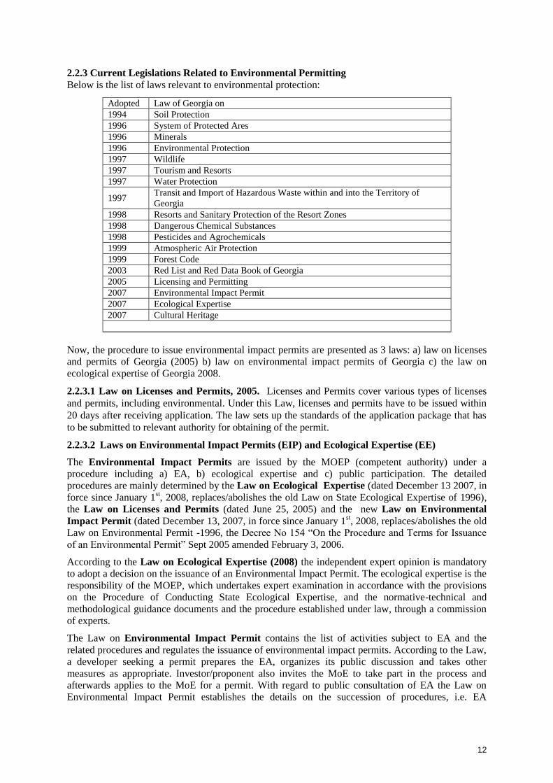
Below is the list of laws relevant to environmental protection:
Now, the procedure to issue environmental impact permits are presented as 3 laws: a) law on licenses
and permits of Georgia (2005) b) law on environmental impact permits of Georgia c) the law on
ecological expertise of Georgia 2008.
2.2.3.1 Law on Licenses and Permits, 2005. Licenses and Permits cover various types of licenses
and permits, including environmental. Under this Law, licenses and permits have to be issued within
20 days after receiving application. The law sets up the standards of the application package that has
to be submitted to relevant authority for obtaining of the permit.
2.2.3.2 Laws on Environmental Impact Permits (EIP) and Ecological Expertise (EE)
The Environmental Impact Permits are issued by the MOEP (competent authority) under a
procedure including a) EA, b) ecological expertise and c) public participation. The detailed
procedures are mainly determined by the Law on Ecological Expertise (dated December 13 2007, in
force since January 1st, 2008, replaces/abolishes the old Law on State Ecological Expertise of 1996),
the Law on Licenses and Permits (dated June 25, 2005) and the new Law on Environmental
Impact Permit (dated December 13, 2007, in force since January 1st, 2008, replaces/abolishes the old
Law on Environmental Permit -1996, the Decree No 154 “On the Procedure and Terms for Issuance
of an Environmental Permit” Sept 2005 amended February 3, 2006.
According to the Law on Ecological Expertise (2008) the independent expert opinion is mandatory
to adopt a decision on the issuance of an Environmental Impact Permit. The ecological expertise is the
responsibility of the MOEP, which undertakes expert examination in accordance with the provisions
on the Procedure of Conducting State Ecological Expertise, and the normative-technical and
methodological guidance documents and the procedure established under law, through a commission
of experts.
The Law on Environmental Impact Permit contains the list of activities subject to EA and the
related procedures and regulates the issuance of environmental impact permits. According to the Law,
a developer seeking a permit prepares the EA, organizes its public discussion and takes other
measures as appropriate. Investor/proponent also invites the MoE to take part in the process and
afterwards applies to the MoE for a permit. With regard to public consultation of EA the Law on
Environmental Impact Permit establishes the details on the succession of procedures, i.e. EA
Adopted Law of Georgia on
1994 Soil Protection
1996 System of Protected Ares
1996 Minerals
1996 Environmental Protection
1997 Wildlife
1997 Tourism and Resorts
1997 Water Protection
1997 Transit and Import of Hazardous Waste within and into the Territory of
Georgia
1998 Resorts and Sanitary Protection of the Resort Zones
1998 Dangerous Chemical Substances
1998 Pesticides and Agrochemicals
1999 Atmospheric Air Protection
1999 Forest Code
2003 Red List and Red Data Book of Georgia
2005 Licensing and Permitting
2007 Environmental Impact Permit
2007 Ecological Expertise
2007 Cultural Heritage

13
coordination, timeframes for information disclosure and public discussion. Moreover, the Law
determines how the outcomes of public discussions shall be documented. It also specifies documents
to be submitted for obtaining permits, and provides the details on the procedure of permit issuance
and the role of the MoE and the developer in this process.
“On the permission to influence to environment” the law of Georgia defines a package of the actions
obliged at ecological examination within territory of Georgia (article 4, chapter 1) and the problem of
the permission to influence on environment for their realization to execute make ecological
examination during the edition of the permission, participation of a society in the course of decision-
making on an influence estimation on environment and in the edition of the permission and a basis
equal in rights about informing by it”.
If the actions submitted (article 4, the head one) the law, requires permissions to construction, the
administrative body responsible for the edition of the building permission, provide, involving (MOE)
in administrative manufacture in the purpose has begun to let out the building permission, as other
administrative body, with the established rule according to the law of Georgia “on the license and the
permission.”
2.2.3.2.1 Regulation on EIA “on environmental impact assessment “ the problem consists in studying
direct and indirect influence on health of people and safety; make the optimum design decision as to
protection of environment and rational, steady use of natural resources; provide society participation;
to expect interests of the state and a society to process of acceptance of the important decision
connected, to understand the planned activity; this regulation establishes a rule to spend an influence
estimation on environment, process, and these are stages; the problems presented to an estimation; the
maintenance (EIA) considers, and these are problems (business) to present them.
2.2.3.2.2 Legislation on Public Consultation
The Law on Environmental Impact Permit establishes detailed procedures including EA
coordination and establishment of the timeframes for information disclosure and discussion. The
procedures identified by the Law are as follows:
1. Developer conducts public disclosure of the EA before submitting of the documentation to the
administrative body for issuance of the Environmental Impact Permit.
2. Developer has to publish information relevant to its activities in central and regional
newspapers (the latter in the regional newspaper where the activity is conducted);
3. The advertisement shall contain the following information related to the title, location, place,
deadline of the activities.
2.2.3.2.3 Legislation on Submission of EIA to MOE
After publishing of the information in the newspaper within one week developer has to submit EA (in
hard copy and electronic copy) to administrative structures. Within 45 days since the publishing of the
information developer should review comments from public. After publishing of the information the
developer should organize public consultation on a planned activity not earlier than 50 and not later
than 60 days from the publication of information. Developer should provide written invitation on
public consultation meeting to local governments; MoE and MoESD and other relevant authorities;
the meeting shall be conducted within the administrative centre of the municipality (formerly
rayon/district) where the activity is planned. The developer is authorized to provide minutes of the
public consultations within the 5 days. Minutes have to be signed by relevant authorities present at the
consultation meetings. If any objections are reflected in the meeting developer should consider them
and develop relevant justifications.
2.2.3.2.4 Issuance of Environmental Impact Permit
The MoE carries out the ecological expertise of the project (for which the EA hearing has already
been conducted) and issues a permit within a timeframe of 20 days. In this context, the approval of the
other Ministries / Departments relevant to the Project is a prerequisite for issuing the environmental
permit (see below). It should be considered that the Conclusions of the ecological expertise are the

14
prerequisites to the Environmental Impact Permit and the Construction Permit. If an activity requires a
Construction Permit the administrative body issuing a permit (the Ministry of Economic and
Sustainable Development) ensures the involvement of the other Ministries including MoE. The
ecological expertise is an essential element of the Construction Permit and is thus mandatory for
developer. Therefore Construction Permit shall incorporate elements of environmental impact permit
and/or ecological expertise conclusions. In the event when activity does not require a Construction
Permit, an Environmental Impact Permit shall be issued by MoE based on conclusion of ecological
expertise and procedures determined by legislation.
2.2.4 Other National Environmental Regulations Relevant to the Project
2.2.4.1 Waste Management
Currently Georgia has no law on waste management it is still pending to adoption. The legislation
pertaining to the waste issues are listed below: law that could be pertaining to the project is listed
below: The Law on Compensation for Damage Arisen from the Use of Hazardous Materials
(1999) specifies how charges for the use of and/or harmful impact on the environment are to be
calculated and levied by the Ministry of Environment. The Law on Hazardous Chemical
Substances (1998) - Regulated the problems connected with dangerous chemical substances, but it
has been stopped by the law of Georgia “on the control technical danger” which regulates processes
when activity contains possibility of issue of explosion and intoxication which appears (represents)
the increased risk for health of people and environment
2.2.4.2 Georgian Law on Ambient Air Protection (1999). The scope of the Law is protection of
atmospheric air from harmful human impact on the whole territory of Georgia (Part I, Chapter I, and
Article 1.1). Harmful human impact is an impact on atmospheric air caused by human activity, which
may adversely affect on human health and natural environment (Part II, Chapter IV, and Article 11.1).
The power of state structures on protection of atmospheric air first of all covers: a) to solve ecological
system of monitoring. b) To manage and execute a policy and strategy in this case. c) To solve the
incorporated (full) monitoring system atmospheric air pollution
2.2.4.3 The Law on Minerals of 1996 establishes the requirement to obtain a license according to the
procedures established under this law and the Law on Licensing and Permits (June 25, 2005).
According to the current system all quarries and borrow pits require to obtain a license.
2.2.4.4 The Wildlife Law of 1996 mandates the MoE to regulate wildlife use and protection overall
territory of the country, including existing protected areas. For now, the Ministry of Energy and
Natural Resources is responsible for this function also. This law also determines activities on
protected areas by the corresponding structural units. At present, this is (MOE)
2.2.4.5 The Law on the System of Protected Areas of 1996 provides definitions of protected areas
and outlines the limits for activities in these areas. Permitted activities are defined according to the
area designation; territorial regulations, individual charters and area management plans; as well as the
requirements of international agreements and conventions to which Georgia is a signatory.
The following activities are generally restricted within protected territories:
• damaging or changing in any way natural ecosystems;
• destroying natural resources for exploitation or any other purpose;
• catching, disturbing, damaging natural ecosystems and species;
• environmental pollution;
• introducing new and exotic species of living organisms;
• bringing explosive materials or poisoning substances; and
• Any other activities specifically prohibited by the management plan for a protected area.

15
2.2.4.6 The Law on Red List and Red Book of Georgia (adopted in May 8, 2003) establishes the
legal basis for the preparation and approval of the Red List and Red Data Book to provide these
instruments for the protection and restoration of threatened species of flora and fauna. The new
Georgian Red List (GRL) has been approved in May 2006 and is as such legally enforceable. The
new GRL has been organized in accordance with the guidelines and principles of the International
Union for the Conservation of Nature (IUCN). According to article 4 of the law: any type of activity
is forbidden, including, hunt, cutting and others, besides special occasions (events) fixed by law.
2.2.4.7 Law of Georgia on Cultural Heritage, 2007 (in force since June 2007, replaces/abolishes
the old Law on Cultural Heritage dated June 25, 1999). In its article 14 the Law specifies the
requirements for „large-scale‟ construction works. According to these provisions, any extraction of
natural resources (e.g. at a quarry or borrow pit), as well as construction of certain facilities
determined by the Law, require clearance through the Ministry of Culture prior to commencement of
works. The same article specifies the direction of the required research and the issues to be considered
in the frame of desktop studies and fieldwork. Also, according to article 10.1 of this law, “if physical
or legal person discovers any cultural heritage, during works, continuing this work may cause damage
of this heritage or some kind of danger, physical or legal person is obliged to stop immediately these
works and inform the ministry on cessation of work and the found out cultural heritage, within 7 days.
2.2.4.8. The Forest Code (June 22, 1999) establishes legal grounds for protection, restoration, and for
the use of the Georgian Forest Fund and its resources. The Law defines property rights to the forests
of Georgia, the principles for the protection and use of forest resources and establishes the procedures
for their use and the requirement to obtain a license. Currently, the process of reviewing is underway.
2.2.4.9. The Law of Georgia on Water (1997). The Law regulates the use of water resources,
determines the rights and responsibilities of water users, and regulates water abstraction and
discharges.
2.2.4.10. The Law on Soil Protection (1994). The law sets general basis for the protection of soil
from erosion, contamination, sedimentation, sanitization, secondary swamping, etc., regulation of the
open extraction of natural resources and construction materials, impact from human economic
activity. The Law sets up norms and standards for allowable concentration limits of pollutants in the
soil to ensure human health and better environment.
2.2.4.11 To 2007 “the sanitary code of Georgia“regulates legal relations for the sake of maintenance
of healthy environment, also management rules a carrying out sanitary code. Now it is cancelled by
the law of Georgia “on public health services” which aspires to provide health of the population and
introduction a healthy way of life, to provide safe environment for health of the person.
2.2.4.12 Environmental Standards and Norms
Qualitative norms of the atmosphere air: According to the Chapter VI, paragraph 22 of Social
Health Security Rule of Georgia (27.06.2007) According to the aim of social health protection The
Georgian Ministry of Health, Labor and Social Defense creates and establishes the safe environment
qualitative norms for the mankind that includes the admissible concentrations and unhealthy influence
norms. According to the mentioned rule, the rules of air pollution protections and the norms of
unhealthy influence concentrations are given in the decree about ”Affirmation of the environment
qualitative condition norms and their affirmations” issued on August 16, 2001 Decree # 297/N by the
Minister of Georgian Ministry of Health, Labor and Social Protection. (Georgian Law Herald # 90
24.08.2001) with some changes and additions that have been placed in the decree of the same ministry
#38/N (24.02.2003). The norms of the atmosphere pollution are given also in the decree # 89 (October
23, 2001). This is a decree about calculation of the air pollution index.

16
Maximum permissible cocentration of the Pollutants over the Above-Ground Layer of the
Atmosphere
Substance Maximum permissible cocentration (MAC) mg/m3/average time
Azote dioxide 0,085/30 minutes
0,04/24 hours
Sulphur dioxide 0,5/ 30 minutes
0,05/24 hours
Carbon Oxide 5,0/30 minutes
3,0/24 hours
Inorganic dust 0,3
Noise standards: The standards about the noise are allowed according to the Decree # 297/N of
Georgian Ministry of Health, Labor and Social Defense about ”affirmation the norms over the
qualitative norms of the environment” issued on August 16, 2001. There are defined as the admissible
norms of noise as the maximum of the admissible norms for several zones of the territories
Time The average allowed size of noise
(DCB)
The maximum allowed norms of noise
(DCB)
7am – 11 pm 55 70
11pm – 7am 45 60
2.3 Administrative Framework
2.3.1 Ministry of Environmental Protection (MOE)
The Ministry of Environment Protection is responsible for all environmental protection issues in
Georgia except natural resources which under the recent changes in 2011 are subject of regulation by
Ministry of Energy and Natural Resources of Georgia (MoEP). The responsibilities of the Ministry
as the competent authority are:
To intermit, limit, or stop any activity having or likely to have adverse impact on the environment.
To issue a series of licenses and permits (including for environmental impact).
To control the execution of mitigation measures by the developer.
To receive free and unrestricted information from the developer monitoring systems, waste
management etc.
Connected with projects of the actions presented to ecological examination, department of the
mentioned ministry of ecological examination and, examine, organizes discussion of an estimation of
influence on environment and prepares the documentation (the project of the order of the minister) to
let out the permission to influence to environment. This department is obliged to control realization
also.
Agency of Protected Areas. This Agency is responsible for state reserves, national parks, natural
monuments, managed reserves, protected landscapes, biosphere reserves, world heritage districts and
wetlands of international importance. The main tasks of the agency are to control territories of
multilateral usage, to implement activities of looking after protected areas, to supervise, preserve,
rehabilitate and protect them.
National Environmental Agency (established 29 August 2008) is responsible for preparing
informational documents, forecasts and warnings regarding to existing and expected hydro-
meteorological and geodynamic processes, also environment pollution conditions in order to provide
state security, existing and expected hydro meteorological forecasting of rivers, water reserves and the
Black Sea territorial waters, to provide civil aviation with meteorological inform

17
2.3.2 Ministry of Economy and Sustainable Development (MoESD)
MoESD is responsible for carrying out the review of technical documentation (including conclusion
of independent experts) and issuing Permits on Construction for projects, as well as for supervision
over constructing activities and for arranging Acceptance Commission after completion of
construction.
State supervision of construction and compliance monitoring is provided by the Main Architecture
and Construction Inspection (MACI), which is operating under the Ministry of Economy and
Sustainable Development of Georgia.
2.3.3 The Roads Department (RD or RDMRDI)
The Roads Department of Ministry of Regional Development and Infrastructure (RD or RDMRDI) is
responsible for elaboration of policy and strategic plans related to developing motor roads,
management of road and traffic related issues and construction, rehabilitation, reconstruction and
maintenance of the roads of public use of international and national significance, utilizing funds from
the state budget, lawns, grants and other financial sources.
Thus, the RDMRDI is responsible for the procurement of design and EIA studies, as well as works on
construction and rehabilitation of roads and is responsible for ensuring compliance with the Georgian
legislation and environmental and social requirements of the relevant donor organizations. Control of
implementation of the Environmental Management Plan (EMP) is direct responsibility of the Roads
Department.
Within the RD there is special unit dealing with the environmental issues. The name of the unit is
Environmental Division. This division is supposed to review the EIAs and EMPs related to the Roads
Department projects and perform monitoring of compliance of the contractor‟s performance with the
approved EMPs, EIAs, environmental standards and other environmental commitments of the
contractor.
2.3.4 Environment and Natural Resources Directorate of Adjara
The Directorate of Environment and Natural Resources of the of Autonomous Republic of Adjara is
responsible on establishing policy of sustainable development of the autonomous republic of Adjara
and monitoring in a field of natural resource management and environmental protection. Compliance
of developing industrial projects with the environmental requirements set forth in legal documents,
standards and norms is conducted by the department at all stages of the project development:
preparation of development plans and programs, preparation of EIAs, design of particular projects,
construction and rehabilitation activities and operation of facilities.
2.3.5 Other Responsible Governmental Institutions
The Ministry of Culture, Monument Protection and Sports is responsible on supervision of the
construction activities in order to protect archaeological heritage. In case if construction is to be
carried out in a historic sites or zones of cultural heritage, consent of the Ministry of Culture,
Monument Protection and Sport is also required for issuing construction permit.
The “National Service for the Foodstuffs Safety, Veterinary and Plant Protection” of the Ministry of
the Agriculture is responsible for implementation of complex sanitary protection measures in case of
identification burial sites during earthworks. Information about suspicious burial sites should be
delivered to the “National Service for the Foodstuffs Safety, Veterinary and Plant Protection” of the
Ministry of the Agriculture by the Construction Contactor (field environmental officer) and RDMRDI
field officer.
2.4 International Treaties and Conventions
2.4.1 The Convention on Biological Diversity, 1994
International cooperation is a dominant feature and driving force for environmental reforms in
Georgia. Setting the goal to preserve its biological diversity and realising the importance of

18
international cooperation, Georgia signed the Convention on Biological Diversity in 1994. Thus,
accepting responsibility to safeguard the nation‟s rich diversity of plant, animal, and microbial life to
begin using biological resources in a sustainable way and to ensure equitable sharing of benefits from
biodiversity.
The Convention on Biological Diversity is the first global agreement, which, along with biodiversity
conservation, necessitates the sustainable use of biological resources. Georgia has been recognised as
holding an important reservoir of biodiversity, which is very important in the global context –
according to the surveys and assessments conducted at an international level, Georgia as a part of the
Caucasus, is recognized as:
One out of 34 biologically richest and endangered land ecosystems (Conservation International);
One out of 200 vulnerable ecoregions (WWF);
One out of 221 endemic bird habitats (Bird Life International);
One of the World Agrobiodiversity Centres.
2.4.2 The Convention on the Conservation of Migratory Species of Wild Animals
The Convention on the Conservation of Migratory Species of Wild Animals (also known as CMS or
Bonn Convention) aims to conserve terrestrial, marine and avian migratory species throughout their
range. It was signed in 1979 in Bonn (Germany.) Georgia ratified the treaty in 2000 together with its
three agreements:
Agreement on “Protection of Populations of European Bats” (EUROBATS);
Agreement on “Conservation of Cetaceans of the Mediterranean Sea, Black Sea and
Contiguous Atlantic Area “ (ACCOBAMS );
Agreement on “Conservation of African-Eurasian Migratory Waterbirds” (AEWA).
Taking into account, that the Agreements have been initially designed as an instrument for facilitating
the implementation of the CMS, the compliance with and enforcement of CMS in Georgia is mostly
reflected in implementation of the Agreements.
2.4.3 Convention on Wetlands of International Importance
The Convention on Wetlands of International Importance, also called the Ramsar Convention aims to
provide the framework for national action and international cooperation for the conservation and
sustainable use of wetlands and their resources, especially as waterfowl. The convention was
developed and adopted by participating nations at a meeting in Ramsar on February 2, 1971, and
came into force on December 21, 1975. It entered into force on July 06, 1997 in Georgia.
2.4.4 Convention on International Trade in Endangered Species of Wild Fauna and Flora
(CITES)
CITES is one of the largest conservation agreements in existence, it is an international agreement
between governments. The conventions aim is to ensure that international trade in specimens of wild
animals and plants does not threaten their survival and it accords varying degrees of protection to
more than 33,000 different species of animals and plants. The text of the convention was agreed upon
in 1973, and CITES entered into force on 1 July 1975. The date of accession for Georgia was
September 13th, 1996 and the agreement entered into force on December 12, 1996 in Georgia.
2.5 Environmental Safeguards of ADB
According to ADB Safeguard Policy Statement (2009) and Operational Manual F1 (2010), the Project
is classified as category “A” and therefore an EIA is required for the Project. The process of
determining a project‟s environment category is to prepare a Rapid Environmental Assessment
(REA). REA requires the completion of the environmental categorization form prior to the project
initiation. REA uses sector-specific screening checklist, taking into account the type, size, and
location of the proposed project; sensitivity and vulnerability of environmental resources in project
area; and the potential for the project to cause significant adverse environmental impacts. A project is

19
classified as one of the four environmental categories (A, B, C, or FI) based on the most
environmentally sensitive component. Categories are as follows:
Category A: A proposed project is classified as category A if it is likely to have significant adverse
environmental impacts that are irreversible, diverse, or unprecedented. These impacts may affect an
area larger than the sites or facilities subject to physical works. An environmental impact assessment
(EIA), including an environmental management plan (EMP), is required.
Category B: A proposed project is classified as category B if its potential adverse environmental
impacts are less adverse than those of 'category A' projects. These impacts are site-specific, few if any
of them are irreversible, and in most cases mitigation measures can be designed more readily than for
category A projects. An initial environmental examination (IEE), including an EMP, is required.
Category C: A proposed project is classified as category C if it is likely to have minimal or no adverse
environmental impacts. An EIA or IEE is not required, although environmental implications need to
be reviewed.
Category F: A proposed project is classified as category FI if it involves the investment of ADB funds
to, or through, a financial intermediary.
For Category „A‟ projects, the EIA (including EMP), is reviewed by ADB‟s Operations Department
and the executing agency. Depending on the scope of public consultation activities, additional
comments would be sought from the project affected people and other stakeholders. When the
borrower/client submits the EIA and/or IEE, the operations department reviews them to confirm that
(i) relevant information on potential project impacts and mitigation measures, including information
from the EIA and/or IEE, has been made available, in a timely manner and before project appraisal, in
an accessible place, and in a form and language(s) understandable to project-affected people and other
stakeholders; and (ii) information disclosure requirements during project implementation are
appropriately specified.
The operations department ensures that the following safeguard documents are posted on ADB‟s
website: (i) draft EIA report at least 120 days before Board consideration for an environment
category A project; (ii) the final or updated EIA or IEE, upon receipt.
2.5.1 Harmonization of ADB and Government Safeguard Requirements
The environmental assessment of the Project will need to satisfy the requirement of both the
government and ADB. A harmonized safeguard framework is developed for conducting EIA study of
the Project. The framework is given in Table 2-1.
Table 2-1: Comparison of Georgian Legislation and ADB Requirements
Aspect Asian Development Bank Government of Georgia Harmonized
Framework
Environmental
Policy and
Regulations
ADB‟s SPS (2009) sets out
the policy objectives, scope
and triggers, and principles
for three key safeguard areas:
(i)Environmental safeguards,
(ii)Involuntary resettlement
safeguards, and
(iii) Indigenous peoples
safeguards
Environmental assessment
and permitting procedure in
Georgia is set out in three
laws:
(i) The Law on Licenses
and Permits (2005);
(ii) The Law on
Environmental Impact
Permits (EIP), and
(iii) The Law on Ecological
Examination (EE) 2008
Screening ADB carry out project
screening and categorization
at the earliest stage of project
preparation when sufficient
Project Proponent in
consultation with MOEP
The Project is
Categorized in to
„Category A‟

20
Aspect Asian Development Bank Government of Georgia Harmonized
Framework
information is available for
this purpose using REA
checklist. Categorization into
Category A, B, C, FI
Scoping Avoid, minimize, mitigate
and/or offset for adverse
impacts and enhancement of
positive impacts through
environmental planning and
management
EA takes into account
potential impacts (direct,
indirect and cumulative) and
risks on physical, biological,
resettlement, socio-economic
(including health and safety),
and physical cultural
resources
The impact assessment
shall include components
such as Air, Noise, Land,
Water, Biological and
health and safety.
Involuntary resettlement is
not a component of
assessment
Scoping is however not a
requirement under the law.
Conduct a process of
Environmental
Assessment that will
consider in an integrated
manner the potential
environmental (including
labor, health, and safety)
risks and impacts of the
project.
The Environmental
Assessment will take into
account natural
environment (air, water,
and land); human health
and safety; social aspects
(involuntary resettlement,
indigenous peoples, and
physical cultural
resources
Alternatives Examination of financially
and technically feasible
alternatives to the project
location, design, technology
and components, their
potential environmental and
social impacts
Consider no project
alternative.
Alternative assessments are
to be carried out for the
project location and design
Assessment of
alternatives will include
the location and design,
and also no project
alternative
EIA Report Guidelines and Table of
Contents are provided for EIA
report in SPS (2009).
EMP will include proposed
mitigation measures,
monitoring and reporting
requirements, institutional
arrangements, schedules, cost
estimates and performance
indicators
No guideline or Table of
Contents are available for
EMP reports. Only
guidelines (Regulation) on
EIA is available, which
includes required content of
the EIA.
The EIA and EMP
reports will follow the
table of contents
proposed n ADB‟s SPS
(2009).
Public
Consultations Carry out meaningful
consultation with affected
people and facilitate their
informed participation
Ensuring women‟s
Publication of information
in national and regional
mass-media. Arrange
consultation not later than
60 days from the date of
Consultations will be
carried out with the
stakeholders, affected
people, NGOs throughout
the project cycle and

21
Aspect Asian Development Bank Government of Georgia Harmonized
Framework
participation in
consultation. Involving
stakeholders, project-
affected people and
concerned NGOs early in
the project preparation and
ensure that their views and
concerns are made known
and understood by decision
makers and taken into
account
Continue consultations with
stakeholders throughout
project implementation as
necessary to address
environmental assessment-
related issues.
publication. All
stakeholders are to be
invited for the meetings.
consider their views in
project design and
safeguard plan. Questions
and concerns raised
during public
consultations held in
Feasibility stage will be
considered.
Village level
consultations will be held
with the affected people.
Conduct a public
consultation meeting in
accordance with
Georgian Guidelines at
Kobuleti and Batumi.
Public
Disclosure
Draft EIA will be published
in ADB website for 120 days
before Project approval by the
Board
The draft EIA should be
available for public review
for 45 days before public
consultations.
Draft EIA report (English
and Georgian) will be
published in ADB and
Roads Department
Websites. The copies of
the draft EIA report will
be made available with
the municipal offices.

22
3. DESCRIPTION OF THE PROJECT
3.1 Overview
The 121 km existing Senaki-Poti–Sarpi road (S-2) along the western coast of Georgia is a key
highway and international transit route in Georgia. It is connected to the major Black Sea ports of
Georgia, viz. Batumi and Poti, and a number of holiday resorts, particularly, Kobuleti and Batumi.
The road runs through heavily built up tourist and residential areas and provides poor road and travel
conditions, especially for international transit traffic which has to mix with the dense urban traffic
passing through narrow streets. At present a significant volume of international transportation is
carried on the Batumi-Poti section of the road amounting to 1.0 million tons annually (2005), with 0.5
million tons on the Batumi-Sarpi section. This mix of heavy traffic on the existing road combined
with poor road conditions leads to traffic congestion, dangerous driving situations and frequent traffic
accidents, particularly in Batumi and Kobuleti and especially during the tourist season in summer.
Hence the government is planning to construct bypass roads to Kobuleti and Batumi (the Project) with
finance of Asian Development Bank (ADB). Ministry of Regional Development and Infrastructure
(MORDI) is the executing agency of the Project and Roads Department (RD) under the ministry is the
implementing agency. A pre-feasibility and feasibility study were carried out for the Project in 2005
and 2009. The study, (TA-7059-GEO), has identified a 48.4 km alignment between Choloki River
north of Kobuleti to Chorokhi River south of Batumi, to bypass Kobuleti, Makhinjauri and Batumi
The proposed bypass roads will reduce the traffic congestion and accidents, increase the generated
traffic in the existing road, and reduce travel time and vehicle operating costs.
Georgia enjoys a strategic location it has yet to fully capitalize on. It is on the shortest route between
Europe and Azerbaijan, Armenia and the Central Asian Republics, through its Black Sea ports, Poti
and Batumi. It also can link Russia and Turkey. The physical location ensures that it is a key transport
link on the most direct route between the Black Sea and the Caspian Sea and Central Asia. Trade
with neighboring countries, both transit and bilateral, is thus an important feature of the economy.
Poor infrastructure and cumbersome processes inhibit the full exploitation of transit economy
potential. Georgia‟s road network is crucial in facilitating sub regional transport and trade. Thus the
Project road has a significant potential for increase of sub regional and regional trade, agriculture and
tourism revenue and reducing poverty. The Project is immediately expected to (i) Increase in sub
regional trade through the Turkish border by 4% for 5 years after completion, (ii) 30% increase in
cross-border freight traffic by 2015 from 1.0 million ton in 2008 to 1.3 million ton, and (iii) Increase
in registered visitors to Adjara region by 10% per annum for 5 years after completion from 285,000 in
2008.
3.2 Purpose of the Study
The Project road is located along the Black Sea in Adjara region. Full Adjara by pass Project is
packaged into 4 contracts as follows for preparation of detailed designs and implementation.
Contract 1 – Km 0 to Km 12.4 bypassing Kobuleti Town – a new alignment
Contract 2 – Km 12.4 to Km 28 bypassing Kobuleti Town – a new alignment
Contract 3 – Km 28 to Km 31 along the existing road near Makhinjauri tunnel to make the
full use of existing and recently constructed 4 lane road tunnel
Contract 4 – Km 31 to Km 48 bypassing Batumi Town – a new alignment
The present project is financed by the loan ADB 2560-GEO, Road Corridor Investment Program
(Tranche 1) for Preparation of Detailed Design and Preparation of Bidding Documents for Kobuleti
Bypass Road, Kobuleti-Batumi Section and Kobuleti Bypass Road.
The Project will be designed as two contract packages and will be implemented in two tranches. The
first tranche comprises 16.2km of new road (Kobuleti Bypass-Section 1); the second tranche
comprises 18km of new road (Kobuleti Bypass- Section 2).

23
An Environmental Impact Assessment (EIA) was prepared in August 2009 as part of the feasibility
study (TA 7059- GEO) to fulfill the Georgian Government Regulations and ADB criteria for
environmental safeguard. EIA report was also prepared in July 2010 by GC-EAL-SAMBO
consortium for the entire alignment of the road and it was approved by the MOEP.
Environmental Impact Assessment (EIA)
The environmental impacts of the project will be considerable given that the Project area is located in
mountainous terrain and has significant ecological value.
The purpose of the updated EIA report is to define possible direct and indirect impacts of the
proposed Kobuleti Bypass Road project on the physical, the biological and the human environment
and to develop corrective measures to minimize, mitigate and/or compensate for the potential adverse
effects. Mitigation measures and monitoring requirements are included in the Environmental
Management Plan (EMP) to be attached to the bidding documents and in the Technical Specifications
of the Work Contracts.
The EIA for Kobuleti Bypass Road has been prepared to ensure that the Project is environmentally
sound and sustainable as well as in compliance with the safeguard requirements of the ADB
(Safeguard Policy Statement, 2009) and Government of Georgia (The Laws on Licenses and Permits,
2005; Environmental Impact Permits and Ecological Examination, 2008) and will be submitted to
the Ministry of Environment Protection (MOEP) to obtain Environmental Impact Permit.
Extent of the EIA
Pursuant to the recommendations of SPS (2009), the description of the potentially affected
environment is divided into four sub-sections as follows:

24
i. Physical Resources - including a description of existing conditions in regard to climate, air
quality, noise, topography, geomorphology and soil types, geology and seismology and water
resources.
ii. Ecological Resources - including flora and fauna, aquatic resources and fisheries, wildlife, rare
or endangered species, sensitive habitats and protected areas
iii. Economic Development - including natural resources and industries, infrastructure facilities,
transportation, power supply prevailing land-uses and production, mineral development quarries,
borrow pits) and tourism facilities
iv. Social and Cultural Conditions - including demography, administration, ethnic groups and
indigenous people, and professional status and employment conditions. It also provides data in
regard to local health facilities and public health, local education facilities and amenities, cultural
heritage and religion, social well-being and public safety, gender Issues, human settlement in the
RoW, and archaeological and historical resources
SPS, 2009 defines Project Area of Influence (PAI) (commonly referred to as the Project Area) as "The
primary project site(s) and related facilities that the borrower/client (including its contractors)
develops or controls such as access roads, borrow pits and disposal areas, and construction camps;
associated facilities such as quarries and asphalt plants; areas and communities potentially affected by
cumulative impacts...and; areas and communities potentially impacted by impacts from unplanned but
predictable developments".
This updated EIA describes relevant physical, biological and socioeconomic condition of the
environment within the PAI.
The Consultant prepared this EIA as part of detailed design stage of the project on the basis of
detailed review of proposed engineering works, field investigations, stakeholder consultation, primary
and secondary data collection, screening of all baseline environmental parameters, environmental
quality baseline monitoring, and review of other road project reports in Georgia.
3.3 Location
The Project road is located along the Black Sea in Adjara region. The entire project road, bypassing
the resort town of Kobuleti from the East, is located within the administrative boundaries of Kobuleti
region. The Project starts at Ispani village and ends at North portal of the existing tunnel. The Project
road is located in Kobuleti districts of the Adjara Autonomous Region. This road will pass Kobuleti
city and 10 villages/towns in the district. Location of the Project road shown in Figure 3.1.
3.4 Key Project Components
The Project involves construction of new road (18,858 km). In addition, the project will construct
bridges (16 nos.), culverts (64 nos.) and other drainage structures, retaining walls, tunnels (2 nos.),
interchanges (4 nos.), land acquisition and resettlement; protection of landslide, geohazard and
rockfall areas; excavation and operation of borrow pits; operation of boulder quarry; earth works; and
operation of asphalt and concrete plants. The main components of Project are provided in Table 3-1 to
Table 3-3.
Table 3-1: Details of Bridges
Bridge
ID #
Station
Bridge Name Superstructure
Type
Overall Geometry
Beginning End Length Span
Arrangement Width Skew
Br 01 0+520.00 0+637.50 Kobuleti Interchange
Bridge
Precast composite
I-girder, 12 nos 117.50
27+31.6+27+
31.6 17.00
Br 02 1+682.00 1+808.70 Achkva river Bridge Precast composite
I-girder, 11 nos 126.70 [email protected] 15.00 20°
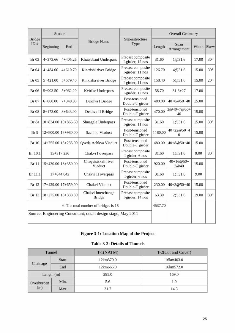
25
Bridge
ID #
Station
Bridge Name Superstructure
Type
Overall Geometry
Beginning End Length Span
Arrangement Width Skew
Br 03 4+373.66 4+405.26 Khutsubani Underpass Precast composite
I-girder, 12 nos 31.60 [email protected] 17.00 30°
Br 04 4+484.00 4+610.70 Kintrishi river Bridge Precast composite
I-girder, 11 nos 126.70 [email protected] 15.00 30°
Br 05 5+421.00 5+579.40 Kinkisha river Bridge Precast composite
I-girder, 11 nos 158.40 [email protected] 15.00 20°
Br 06 5+903.50 5+962.20 Kvirike Underpass Precast composite
I-girder, 12 nos 58.70 31.6+27 17.00
Br 07 6+860.00 7+340.00 Dekhva I Bridge Post-tensioned
Double-T girder 480.00 40+8@50+40 15.00
Br 08 8+173.00 8+643.00 Dekhva II Bridge Post-tensioned
Double-T girder 470.00
2@40+7@50+
40 15.00
Br 8a 10+834.00 10+865.60 Shuagele Underpass Precast composite
I-girder, 11 nos 31.60 [email protected] 15.00 30°
Br 9 12+800.00 13+980.00 Sachino Viaduct Post-tensioned
Double-T girder 1180.00
40+22@50+4
0 15.00
Br 10 14+755.00 15+235.00 Qveda Achkva Viaduct Post-tensioned
Double-T girder 480.00 40+8@50+40 15.00
Br 10.1 15+317.236 Chakvi I overpass Precast composite
I-girder, 6 nos 31.60 [email protected] 9.00 30°
Br 11 15+430.00 16+350.00 Chaqvistskali river
Viaduct
Post-tensioned
Double-T girder 920.00
40+16@50+
2@40 15.00
Br 11.1 17+044.042 Chakvi II overpass Precast composite
I-girder, 6 nos 31.60 [email protected] 9.00
Br 12 17+429.00 17+659.00 Chakvi Viaduct Post-tensioned
Double-T girder 230.00 40+3@50+40 15.00
Br 13 18+275.00 18+338.30 Chakvi Interchange
Bridge
Precast composite
I-girder, 14 nos 63.30 [email protected] 19.00 30°
※ The total number of bridges is 16 4537.70
Source: Engineering Consultant, detail design stage, May 2011
Figure 3-1: Location Map of the Project
Table 3-2: Details of Tunnels
Tunnel T-1(NATM) T-2(Cut and Cover)
Chainage Start 12km370.0 16km403.0
End 12km665.0 16km572.0
Length (m) 295.0 169.0
Overburden
(m)
Min. 5.6 1.0
Max. 31.7 14.5

26
Source: Engineering Consultant, detail design stage, May 2011
Table 3-3: Summary of Interchanges
No. of IC Chainage Type of IC Cross Road
Name Width Speed
1 0+500 Kobuleti
2 4+300 Khutsubani
3 5+800 Kvirike
4 13+000 Chakvi
Source: Engineering Consultant, detail design stage, May 2011
3.5 Description of Road Alignment
The starting, 8,5-km-long section of the design route is located on a quite flat plain relief, on the
terraces of the rivers Achkva, Kintrishi, Kinkisha and Dekhva, which in a geological respect, is
mostly presented by alluvial shingle, with boulder admixtures at some places, and the grounds along
these sections beyond the river terraces are presented by brownish Middle Quaternary soft-plastic
high-humid clays and there are high-compressive weak clays with organic admixtures spread in the
individual bogged areas (km 0+280-0+540, km 1+900-2+160, km 3+760-4+040, km 5+600-5+880).
Shore-type landslide and erosive processes of a minor scale are fixed along the given section, which
do not pose a major geo-hazard to the construction of the road.
The next section of km 8+500 – km 12+300 follows the trough-like gorge of the river Shuagele at the
river level, with the width of 50-80 m. The relief of the gorge is strongly dissectioned with numerous
shallow and dry gullies. The river meanders intensely and there are over-floodplain terraces
developed on its two sides. At some places, the river washes its banks, and at some places, the
existing alluvial terraces on the both banks of the river form plain surfaces. The terrace steps are built
with alluvial shingle with boulder admixtures and sandy-loam and clay-loamy fillers, and the geology
of the slope is participated by Paleogenic deposits, in particular, those of „Chidila stratum‟ (lava
breccias, tufa-breccias), which outcrop at some places, but are mostly covered with a laterite stratum
of a great thickness. It should be noted that the hayfields are irrigated resulting in bogged areas at
some places and in artificially deteriorated physical-mechanical properties of the grounds. No
increased geological hazards are identified along the given section.
The section at km 12+300-km14+100, where the tunnel and overpass are to be constructed, is
presented by landslide-like creeps developed in a lateritized layer here and there, which are worth
attention in the construction process to reduce the risk of origination and activation of landslide
processes due to cutting the slopes.
Along the section at km 14+100-15+000, which crosses the right nameless tributary of the river
Chakvistskali, the right slope of the tributary, in a geological respect, is presented by a lateritized
layer of quite a great thickness formed over the greatly inclined slopes and poses the hazard of
activation of the landslide processes during the building, particularly in case of using large sections.
The left slope of the given tributary is less prone to landslide.
The section at km15+430-km16+350 is the crossing point with the river Chakvistskali. At this point,
the river has developed an open gorge. It is structured with alluvial shingle with boulder admixtures
and gravely and clay filler. The depth of the river local washout is worth attention. No other
geological hazards are fixed along the given section.

27
Along the section of km16+350-km18+858, the design road crosses the left slope of the river
Chakvistskali and then a hilly relief where there are mostly clay laterites spread, which are formed as
a result of intense weathering of volcanogenic deposits of Chidila stratum. The grounds have weak
physical-mechanical properties evidenced by gravitational talus of different strengths at the artificially
made sections; however, the given surroundings do not pose any significant problem to the road
construction.
The detail layout of the road alignment is shown in Annex 3-5
3.6 Project Designs
Before 2009, the geometric road design standards in Georgia were those which were used throughout
the former Soviet Union. Since the last edition of the SNIP for road design was introduced in 1984,
modern developments and practices were not considered. Therefore, a new design standard,
“Geometric and Structural requirement for highways in Georgia”, was developed and adopted under a
World Bank financed project.
The present design has applied guidelines of the above standard. In case of need for covering any of
shortcomings in the national standard, along with the SNIP standards, references has been made to
relevant clauses of AASHTO standard for design specifications of highways and highway bridges
3.6.1 Traffic Volume
The pavement has been design using the following forecasted traffic data. Future traffic has to be
expressed in Equivalent Standard Axles (ESA)/year and over the design life. The design life is 20
years and construction has been assumed to be completed in 2014.These estimates are based on the
manual traffic counts carried out in the detailed design study on the existing road during January,
2011
Table 3-4: Forecasted daily traffic (Annual Average Daily Traffic/AADT) data
Year Car
Bus Truck
Total Mini
Mediu
m Large Light
Mediu
m Heavy
Traile
r
2014 2999 1244 34 29 216 62 38 183 4805
2015 3138 1302 36 30 226 65 40 191 5028
2016 3282 1362 37 32 237 68 42 200 5260
2017 3435 1425 39 33 248 71 44 209 5504
2018 3593 1491 41 35 259 75 46 219 5759
2019 3761 1560 43 36 271 78 48 229 6026
2020 3934 1632 45 38 284 82 50 240 6305
2021 4117 1708 47 39 297 86 53 250 6597
2022 4307 1787 49 41 311 90 55 262 6902
2023 4507 1870 51 43 325 94 58 274 7222
2024 4665 1935 53 45 336 97 60 284 7475
2025 4828 2003 54 46 348 101 62 294 7736
2026 4998 2073 56 48 360 104 64 304 8007
2027 5172 2146 58 49 373 108 66 315 8287
2028 5353 2221 60 51 386 111 69 326 8577
2029 5542 2299 62 53 399 115 71 337 8878

28
2030 5736 2379 64 55 413 119 73 349 9188
2031 5936 2463 66 57 428 123 76 361 9510
2032 6143 2549 69 59 443 128 78 374 9843
2033 6359 2638 71 61 458 132 81 387 10187
Source: Consultant‟s survey, January 2011
The pavement has been design using the following forecasted traffic data. Future traffic has For the
purpose of estimating the Equivalent Single Axle Loads (“ESALs”), Table 3-5 provided annual traffic
volumes by vehicle categories for 20-year long period, which are calculated from the data given in
Table 3-4.
Table 3-5: Traffic Volumes by years
Year Car Bus Truck
Total Mini Medium Large Light Medium Heavy Trailer
2014 1094635 454060 12410 10585 78840 22630 13870 66795 1753825
2015 1145370 475230 13140 10950 82490 23725 14600 69715 1835220
2016 1197930 497130 13505 11680 86505 24820 15330 73000 1919900
2017 1253775 520125 14235 12045 90520 25915 16060 76285 2008960
2018 1311445 544215 14965 12775 94535 27375 16790 79935 2102035
2019 1372765 569400 15695 13140 98915 28470 17520 83585 2199490
2020 1435910 595680 16425 13870 103660 29930 18250 87600 2301325
2021 1502705 623420 17155 14235 108405 31390 19345 91250 2407905
2022 1572055 652255 17885 14965 113515 32850 20075 95630 2519230
2023 1645055 682550 18615 15695 118625 34310 21170 100010 2636030
2024 1702725 706275 19345 16425 122640 35405 21900 103660 2728375
2025 1762220 731095 19710 16790 127020 36865 22630 107310 2823640
2026 1824270 756645 20440 17520 131400 37960 23360 110960 2922555
2027 1887780 783290 21170 17885 136145 39420 24090 114975 3024755
2028 1953845 810665 21900 18615 140890 40515 25185 118990 3130605
2029 2022830 839135 22630 19345 145635 41975 25915 123005 3240470
2030 2093640 868335 23360 20075 150745 43435 26645 127385 3353620
2031 2166640 898995 24090 20805 156220 44895 27740 131765 3471150
2032 2242195 930385 25185 21535 161695 46720 28470 136510 3592695
2033 2321035 962870 25915 22265 167170 48180 29565 141255 3718255
Source: Consultant‟s survey, January 2011
3.6.2 Road Design
The road will be designed as a freeway by over passing or under passing all the existing roads. The
design speed of the Project road is 100 km/hr for main road and 60 km/hr for ramps. The width of the
road is 14.0m.The right of way (RoW) extends 7m outside the toe of the embankment to
accommodate space for 2 m wide drainage ditch and 1 m space from the toe of the ditch and 3 m
reserve zone outside of the ditch. The embankments consist of rocky soil. Asphalt concrete
pavement is designed for all sections of the road including bridges and tunnels.
The road standards adopted for the Project design are shown below:
29
Road Class International Highway
Design Speed 100 km/hr
Width of roadbed 14.0 m
Width of Carriage way 7.0 m
Width of traffic lane 3.5m
Width of paved shoulders 2.5 m
Width of unpaved shoulders 1.0 m
Pavement type asphalt concrete
Typical cross section of a 2-lane road is shown in Figure 3-3 and in Figure 3-4.
Figure 3-3: Cross Section of Road Pavement (Type I) for General Section
Figure 3-4: Cross Section of Road Pavement (Type II) for Acceleration –Deceleration Section
Pavement
According to Georgian standards with 11 ton axle loads based on traffic load and sub-grade strength.
Typical asphalt concrete and cement concrete pavements are shown in Figure 3-5 and Figure 3-6
(these are indicative only).
Figure 3-5: Section of Asphalt Pavement Structure
Figure 3-6: Section of Cement Concrete Pavement Structure
3.6.3 Bridges and Overpasses
The project involves 16 bridges with total length of 4538 m, which is about 25 % of the total
alignment. There are seven long bridges that are 200 meters or more in length
Total bridges consist of 14 main bridges and 2 overpass bridges. Especially there are 6 long bridges
that are 200 meters or more in length. Listed in the table below are general features of bridges in the
2nd
section.
As the following table shows, apart from bridge # 5, 10 and 11, all the bridges are furnished with a
superstructure of precast girder type.
Being different to the detail design of 1st stage, the typical width and superstructure type of bridge
were changed due to several reasons as described below.
First, the typical width of bridge was changed from 14 m to 15 m in accordance with the minimum
width of sidewalk and wayside for maintenance specified in Georgian standards.
Second, the superstructure type of bridge was changed from the type used in the 1st stage based on
Road Department‟s opinion that the cast-in-situ concrete between top flanges of girders frequently
cracked. Thus cross section without the cast-in-situ concrete between top flanges was applied. In this
type, although the number of girders increases from 8 to 11, the lower construction cost and higher
construction speed are its strength.

30
Typical cross section of bridges are shown in Figure 3-7.
The superstructure of bridges was designed in accordance with HL-93 loading and the others were
designed based on AASHTO Standards Specification for highway bridges (2002) and AASHTO
LRFD Bridge Design Specifications (2007)
Cross Section applied to 1st Stage Proposed Cross Section
Figure 3-7: Typical cross section of Bridges

31
Table 3-6: Lists of bridges of Section 1 (Kobuleti Bypass)
Bridge
ID #
Station
Bridge Name Superstructure
Type
Overall Geometry
Beginning End Length Span
Arrangement Width Skew
Br 01 0+520.00 0+637.50 Kobuleti Interchange
Bridge
Precast composite
I-girder, 12 nos 117.50
27+31.6+27+
31.6 17.00
Br 02 1+682.00 1+808.70 Achkva river Bridge Precast composite
I-girder, 11 nos 126.70 [email protected] 15.00 20°
Br 03 4+373.66 4+405.26 Khutsubani Underpass Precast composite
I-girder, 12 nos 31.60 [email protected] 17.00 30°
Br 04 4+484.00 4+610.70 Kintrishi river Bridge Precast composite
I-girder, 11 nos 126.70 [email protected] 15.00 30°
Br 05 5+421.00 5+579.40 Kinkisha river Bridge Precast composite
I-girder, 11 nos 158.40 [email protected] 15.00 20°
Br 06 5+903.50 5+962.20 Kvirike Underpass Precast composite
I-girder, 12 nos 58.70 31.6+27 17.00
Br 07 6+860.00 7+340.00 Dekhva I Bridge Post-tensioned
Double-T girder 480.00 40+8@50+40 15.00
Br 08 8+173.00 8+643.00 Dekhva II Bridge Post-tensioned
Double-T girder 470.00
2@40+7@50+
40 15.00
Br 8a 10+834.00 10+865.60 Shuagele Underpass Precast composite
I-girder, 11 nos 31.60 [email protected] 15.00 30°
Br 9 12+800.00 13+980.00 Sachino Viaduct Post-tensioned
Double-T girder 1180.00
40+22@50+4
0 15.00
Br 10 14+755.00 15+235.00 Qveda Achkva Viaduct Post-tensioned
Double-T girder 480.00 40+8@50+40 15.00
Br 10.1 15+317.236 Chakvi I overpass Precast composite
I-girder, 6 nos 31.60 [email protected] 9.00 30°
Br 11 15+430.00 16+350.00 Chaqvistskali river
Viaduct
Post-tensioned
Double-T girder 920.00
40+16@50+
2@40 15.00
Br 11.1 17+044.042 Chakvi II overpass Precast composite
I-girder, 6 nos 31.60 [email protected] 9.00
Br 12 17+429.00 17+659.00 Chakvi Viaduct Post-tensioned
Double-T girder 230.00 40+3@50+40 15.00
Br 13 18+275.00 18+338.30 Chakvi Interchange
Bridge
Precast composite
I-girder, 14 nos 63.30 [email protected] 19.00 30°
※ The total number of bridges is 16 4537.70
Source: Engineering Consultant, detail design stage, May 2011
3.6.4 Tunnels
The design of the Kobuleti-Batumi Section (Km 12+400~31+259) tunnel #1 is based on the principles
of NATM (New Austrian Tunneling Method). Tunnel #1 is to be excavated through very weak
weathered soil layer which consists of lean, reddish-brown clay, gravel and crushed stone and tuff
breccias of extremely weathered and highly fractured andesite-basalt. Consequently the support
selection criteria based on ground condition and stability of tunnel during construction and operation
period are the key design factors.

32
The tunnel status of Kobuleti-Batumi section (Km 12+400~31+259) is given on the Table 3-7. Total 2
tunnels are planned to be constructed. The length of tunnel No.1 is 295.0m and that of tunnel No. 2 is
169.0m so total length of 2 tunnels is 464.0m including portal and cut & cover area. Overburdens of
two tunnels are ranged from 5.6m to 31.7m, which means two tunnels exist in relatively lower depth.
Since overburden of tunnel No. 2 is too shallow, cut and cover method with maximum 7m backfill is
used.
The anticipated subsurface conditions and the strength of soil layers create difficult conditions for the
design and construction of tunnels. The soft and weak deposits at the project site with lower shear
strength will be able to induce large deformation during tunneling. Therefore application of various
pre-support techniques ahead of advancing tunnel face is recommended to limit the ground
deformation.
The type of ground in which most of the tunnels will be mined is classified as weak lean clay with
eluvial tuff-breccia and weathered breccia with low strength. Effective ground improvement and
various pre-support methods are to be considered in this phase of design such as pipe roof umbrella,
horizontal / vertical jet grout arch and invert micro pile with grouting.
Table 3-7: Lists of Tunnels
Tunnel T-1(NATM) T-2(Cut and Cover)
Chainage Start 12km370.0 16km403.0
End 12km665.0 16km572.0
Length (m) 295.0 169.0
Overburden
(m)
Min. 5.6 1.0
Max. 31.7 14.5
Source: Engineering Consultant, detail design stage, May 2011
Figure 3-8: Typical Tunnel Cross Section (Straight Section)
3.6.5 Interchanges
There are 4 interchanges designed along the road. These junctions are designed as of deferent type in
accordance with standard requirements.
Functional assignment each of the interchanges is provided bellow:
Interchange N1, km 0+500
Construction of grade separated full interchange N1 shall be carried out at the existing gas station in
order to allow the traffic from the town of Kobuleti, and vice versa, interchange into the traffic of the
bypass highway.
Interchange N2, km 4+300; Interchange N3, km 5+800
Grage separated junctions are constructed at the intersections of the local roat to villages of
Khutsubani and Kvirike respatively in aim of allowing the traffic from the surrounding villages
connect to the bypass highway.
Interchange N4, km 18+300

33
Full interchange N4 will be constructed at the end of the design road in order to connect the traffic
from the town Chaqvi, and vice versa, to the design bypass. The intechange will accommodate the
traffic from the adjuscent sections to turn arround and also, connect to the Botanic Graden of Batumi
city.
Figure: 3.9: Typical cross section of Interchanges
3.6.6 Culverts
In total 64 culverts are located along the project roads. For design life of rectangular and circular
culverts AASHTO and SNiP-84 design standards are used. The application of the SNIP Standard
considers the utilization of locally produced prefabricated culvert elements.
New pipe culverts under the main road should have a minimum diameter of 1.50 m for ease of
maintenance. However, at some places the desired minimum diameter for pipe culverts could not be
implemented, because existing ditches are not deep enough, the adjacent ground is flat, and the
existing road embankment could not be raised. Therefore lesser diameter, 1.0 m, for certain pipe
culverts were accepted for the ramps and existing roads.
In aim of accommodating the local connectivity 5 box culverts with cross section size of 5.0X6.0 m,
are provided to underpass the secondary roads.

34
3.7 Volume of Civil Works
Total volume of civil works in the Project based on the estimates of the detailed design is given in
Table 3-8.
Table 3-8. Total volume of civil works
No. Details Unit Quantity
A. Subgrade Works
1 General site clearance Ha 82.5
2 Tree felling and removal No 1844
3 Clearing and Grubbing m3 92944
4 Earth Excavation- Common Soil m3 351566
-Soft Rock m3 NA
- Hard Rock m3 NA
5 Embankment Filling – Common Soil m3 1456066
6 Removal of Unsuitable Materials m3 150143
7 Dismantle Existing Structures No N/A
8 Roadside Drain – Masonry Lined M 405
9 Concrete Lined M 7316
10 Unlined M N/A
11 Catch Drains M 880
12 Sub-Surface Drains M NA
Chute and Scour Protection m2 NA
13 River Training Works M 680
14 B. Pavement
15 Preparation of Subgrade m2 228539
16 Sub Base m2 197920
17 Upper Base m2 185725
18 Asphalt Concrete surface course m3 14720
C. Structures
Circular Culverts, 500 mm No 4
Circular Culverts, 1000 mm No 7
19 Circular Culverts, 1500 mm No 38
Box Culverts, 1,5X1,5 m No 1
20 Box Culverts, 1,3X1,8 m No 1
Box Culverts, 2,5X2,5 m No 3
Box Culverts, 1,0X4,0 m No 1
21 Box Culverts, 5,0X6,0 m No 12
22 Small Bridges RC < 50m M 574
23 Large Bridges RC Box Girder M 2058
24 Large Bridges RC Prestressed M 1947
25 Interchanges No 5
26 Separated Intersections No 1
27 Over/Under passes No 5
28 Pedestrian crossings (Over/under) No NA
29 Retaining Walls M 290
D. Tunnel Works
30 Civil Works Type DI M NA
31 Type DII M NA
32 Type DIII M NA
33 Extra Support M NA
34 Long Span Pipe Roof M NA
35 Tunnel Portals No NA
36 Tunnel Illumination M NA
37 Emergency Generator LS NA
38 Provision of Power Supply LS NA

35
No. Details Unit Quantity
E. Slope Stabilization
39 Dry Stone Masonry Walls M/m3 2479/27596
40 Landscaping M2 4576
F. Roadside Facilities
41 Service/weighbridge Area No NO
42 Signing and Road Marking KM 27027
43 Steel Guardrails M 17320
44 New Jersey Barriers M 10381
45 Boundary Fencing M NA
3.8 Quarries and Borrow Sites
During construction of the road, locations of quarry and borrow sites, access roads, spoils disposal
sites for wastes and other facilities will be determined by contractors. Project will not implement any
exploration activities from illegal sources.
Borrow pits location will be proposed by the engineering team at the final design stage. The
exploitation of the borrow pits and quarries will be conducted by the licensed companies or the
Constructing Contractor will obtain its own licenses. There will be potential impact of quarrying
activities at various locations including river bed and floodplain locations. So, necessary
environmental permits of suppliers from relevant authority will be obtained by the contractors if used
any illegal source.
The following quarries are selected for the supply of aggregate used in road construction during detail
design.
Table 3-9: Potential Sites for Borrow Materials
Name of
Deposit
Resources Region Proximity Reserves
Kheghru Diorite-
Porphyry
Khelvacha
uri
9km south-east of
Batumi
Category A – 213000 m3,
Category B – 258000 m3
Category C1 – 626000 m3
A+B+C1 – 1097000 m3
Abanostskali Andesite and
Tuff-breccia
Kobuleti Adjacent to
village of Khala
Category C2 – 470,300 m3
Achi Porphyry Ozurgeti 8-9 km south of
district centre
Ozurgeti
P – 8.0 million m3
Akhalsheni Tuff-Breccia Khelvacha
uri
4 km south of city
of Batumi
Category B – 2.2million m3,
Categories A+B+C – 10994
thousand m3
Category C1 – 8720.3 thousand
m3, Category C2 – 9895 thousand
m3
Bezonisthkali Andesite and
Lava Breccia
Kobuleti the confluence of
Bezonistskali and
Chaqvistavi
Rivers
Category C1 – 89.3 thousandm3
Dagvi Andesite-
Basalt
Kobuleti 1.5 km north-east
of village of
Zeda-Dagvi
Category B – 226,000 m3
Category C1 – 875,000 m3
Total: B+C1 – 1,101,000 m3
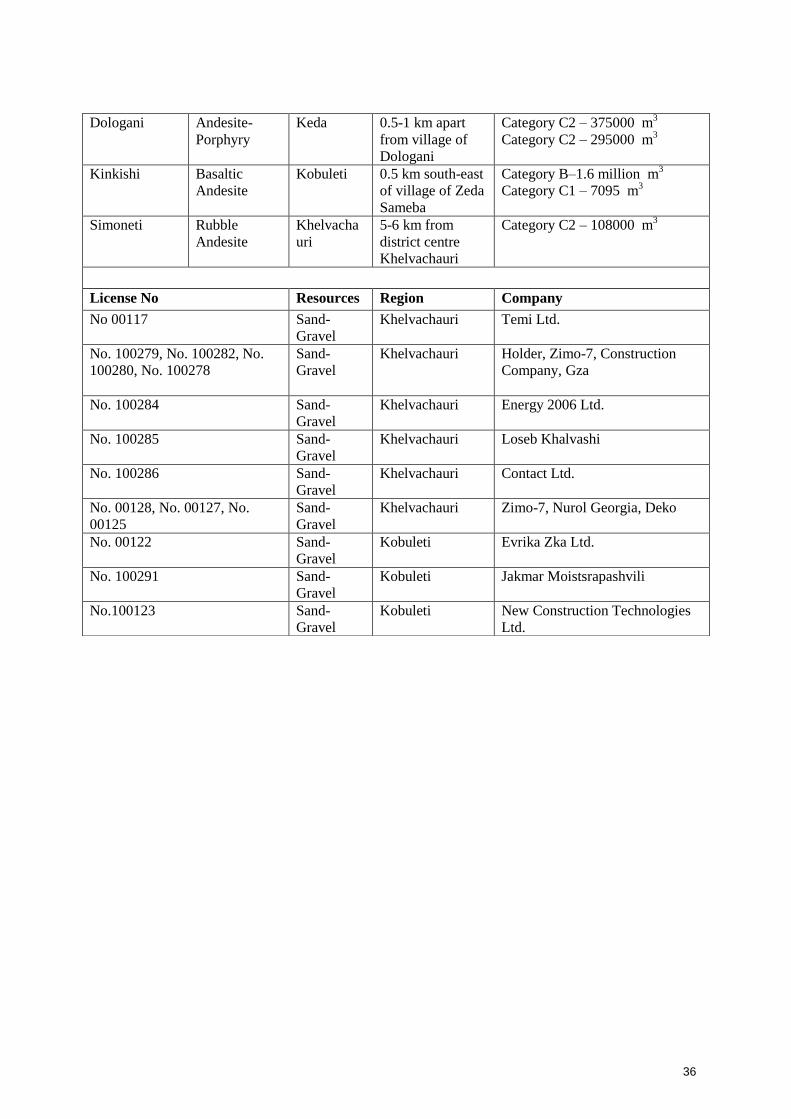
36
Dologani Andesite-
Porphyry
Keda 0.5-1 km apart
from village of
Dologani
Category C2 – 375000 m3
Category C2 – 295000 m3
Kinkishi Basaltic
Andesite
Kobuleti 0.5 km south-east
of village of Zeda
Sameba
Category B–1.6 million m3
Category C1 – 7095 m3
Simoneti Rubble
Andesite
Khelvacha
uri
5-6 km from
district centre
Khelvachauri
Category C2 – 108000 m3
License No Resources Region Company
No 00117 Sand-
Gravel
Khelvachauri Temi Ltd.
No. 100279, No. 100282, No.
100280, No. 100278
Sand-
Gravel
Khelvachauri Holder, Zimo-7, Construction
Company, Gza
No. 100284 Sand-
Gravel
Khelvachauri Energy 2006 Ltd.
No. 100285 Sand-
Gravel
Khelvachauri Loseb Khalvashi
No. 100286 Sand-
Gravel
Khelvachauri Contact Ltd.
No. 00128, No. 00127, No.
00125
Sand-
Gravel
Khelvachauri Zimo-7, Nurol Georgia, Deko
No. 00122 Sand-
Gravel
Kobuleti Evrika Zka Ltd.
No. 100291 Sand-
Gravel
Kobuleti Jakmar Moistsrapashvili
No.100123 Sand-
Gravel
Kobuleti New Construction Technologies
Ltd.
37
3.9 Construction Camps
Camp sites will be selected keeping in view the availability of an adequate area for establishing camp
sites, including parking areas for machinery, stores and workshops, access to communication and
local markets, and an appropriate distance from sensitive areas in the vicinity. Final locations will be
selected by the contractor after the approval from RD.
The area requirement for construction camps will depend upon the workforce deployed and the type
and quantity of machinery mobilized. In view of the area required, it will not be possible to locate
camp sites within the ROW and the contractors will have to acquire land on lease from private
landowners.
The construction camp will have facilities for site offices, workshop and storage yard, and other
related facilities including fuel storage. The site selection for the construction camp is not yet
finalized.
The contractor will provide the following basic facilities in the construction camps. Detailed criteria
for siting of construction camps and establishment of facilities are given in the Environmental
Management Plan of Chapter 9 under „Construction Camp Management‟
Adequate ventilation facilities
Safe and reliable water supply. Hygienic sanitary facilities and sewerage system. Treatment
facilities for sewerage of toilet and domestic wastes
Storm water drainage facilities.
Sick bay and first aid facilities
Since there have not been yet chosen the location for the construction camp or the routes of the
temporary access roads, the evaluation of the removed soil storage shall be carried out by the local
authorities and The Directorate of Environment and Natural Resources of the of Autonomous
Republic of Adjara.
3.10 Construction Process
I. Preparation Works
Preparation works include the following activities
- Site Preparation: relocating power line, water supply pipe, fiber optic cable, the site
will be handed over to Contractor
- Site Clearance: Removing existing building, structure, trees in construction site;
- Manpower, equipment preparation: mobilizing manpower, mustering construction
equipment, getting construction licenses
- Set up auxiliary works: material transfer sites, temporary road, temporary drain, site
leveling. Construct camp, site office. Connect power line, install water supply system
for domestic and construction, set up concrete mixing plant and asphalt plant
II. Construction Works
Construction works include the activities below
- Soft soil improvement and road sub base works: to be conducted immediately after
completing the road base construction;

38
- Building bridges and viaducts: it will be carried out in parallel with the soft soil
improvement and road base construction
- Execute road pavement, slope protection
- Install lighting system and security/safety signal system for land and waterway
transportation
III. Completion Works
Completion works include the following activities. After completing the above construction works,
the road should be carried out the completed works for going to operate. Complete work will be
implemented at the end of construction time. The work includes
Repair of small defects
Clean up the construction site, warehouses
Collecting waste and superfluous materials
Construction waste will be transported to licensed disposal site
Return of the status of drainage system affected temporarily during construction phase
Cleaning the whole structure
Repair to return of status of local roads effected during construction phase.
3.11 Project Costs
The estimated total construction cost including VAT is confidential and will be provided from Road
Department of Georgia.
3.12 Implementation Schedule
Tentative commencement date of the contract is spring 2012 and the expected time to complete the
construction works is 30 month from the beginning.

39
4 DESCRIPTION OF THE ENVIRONMENT
The primary objective of the study of existing environmental parameters is to provide an
environmental baseline against which potential impacts from the construction and operation phases of
the proposed 18.859 km Kobuleti Bypass road can be compared. Baseline data includes an inventory
of physical, ecological and socio-economic parameters. Covering these aspects, data has been
compiled for:
Land Environment (topography, geology, seismology and soils);
Water Environment (water resources, water quality);
Air Environment (meteorology, air quality);
Noise Environment (noise levels);
Ecological Environment
Socio-economic Environment
Baseline data for the study area were collected using the following methods:
Gathered data from previous EIA report prepared by GC-EAL-SAMBO (July 2010) for the
whole alignment
Field Visits
Geological and Hydrological study Report of kobuleti Bypass section
Primary data collection on water quality, soil quality, noise quality
Desk Top Research
Public Consultation
Preparation of maps
The influence area (impact zone) for the EIA covers ½ km on either side of the road alignment in
order to include sufficient coverage of the receiving environment of the impacts of the present.
Annex 4-1 represents Environmental Study Area showing the general alignment of the road (within
½ km on either side of the alignment) including major land use, settlements, water ways, roads and
other major infrastructures in the area considered to be possibly affected by the proposed road project.
A summary Table of the project area is given in Table 4-1.
Table 4-1: Summary of Important Features of the Project Road
Si No. Parameter Description
1 Climate Seaside damp subtropical climatic zone
2 Ecologically Sensitive Area Chorokhi River
Wild Life Sanctuaries N/A
National Parks N/A
Reserve/Protected Forests N/A
3 Geomorphology Its geomorphological nature was totally
formed on the general background of the
alternating-sign tectonic movements of
the Late Apline orogenetic cycle and
active course of erosive-denudation
processes.
4 Major Soil Type well-developed red-soils, loamy soil
5 Principal Crops Corn, beans, vegetable, citrus

40
6 Predominant Geological
Formations
The geology of the region is presented
by tufogenes, clay-slates and young
andesite-basalt lavas. The bedrocks are
covered with strong layers of loamy soil.
7 Hydrogeology The main drainage channels and their
distribution network were deemed
inappropriate to consider, as their
parameters, the values of maximum
annual discharge, corresponding levels
and safe velocity were calculated at the
design stage and no hazardous
hydrogeological events are expected.
8 Major Water Bodies 3 River
9 Environmental Hotspots River crossings
10 Major Industries/Business
Entrepreneurs
Hotels in Kobuleti
4.1 Physical Resources
4.1.1 Climate
The project area is classified as a seaside damp subtropical climatic zone. A climate zone of this type
is formed under the influence of subtropical and moderate latitudes, circulation processes in the
atmosphere and orographic patterns. Due to the influence of mountain ridges bordering from three
sides, damp unstable air masses coming from the west (from the Black Sea), undergo convergence
and form ascending flow up the west slopes of mountains. This causes the formation of a damp
climate, with a large amount of precipitation almost any time of the year, against the background of a
high thermal regime. A generalized climate map of Adjara is shown in Figure 4-1.
The project area, located on west coast of the Adjara, has an average rainfall of 2000 to 2800mm;
average monthly temperature ranging from 5 0C in winter to 22.5
0C in summer, and dominant wind
direction towards north east. A detailed note on the hydrometerological data of the 4 weather stations
(Kobuleti, Chakvi, Makhinjauri and Batumi) located close to the project road is given in summary
presented below.
Figure 4-1: Climate Map of Adjara
Average monthly temperatures of the 4 weather monitoring stations located close to the Project is
shown in Figure 4-2. The average annual temperatures for Batumi, Makhinjauri, Chakvi and Kobuleti
are 14.4 0C, 13.8
0C, 14.1
0C and 13.4
0C, respectively. January is the coldest month with the average
temperature ranging from 4.8 0C in Kobuleti to 6.7
0C in Batumi. August is the hottest month with the
average temperature ranging from 23.10C in Batumi to 22.6
0C in all three of the other areas.
Average monthly rainfall in Batumi, Makhinjauri, Chakvi and Kobuleti are shown in Figure 4-3. The
average annual precipitation for Batumi, Makhinjauri and Kobuleti is 2531 mm, 2610 mm and 2320
mm, respectively. For all four areas, September is generally the wettest month with an average
precipitation of 321 mm and May the driest month with an average precipitation of 93.8 mm.
Source: Government of Adjara
Figure 4-2: Average Monthly Temperature in the Project Area

41
Source: Government of Adjara
Figure 4-3: Average Monthly Precipitation in the Project Area
Source: Government of Adjara
Figure 4-4: Average Monthly Humidity in Project Area
The project area is generally humid throughout the year with an average monthly humidity levels
ranges from 73-84% (Figure 4-4). The average annual humidity level for Batumi, Makhinjauri,
Chakvi and Kobuleti are 79%, 80%, 78% and 81%, respectively.
The annual average and monthly wind speeds are shown in Table 4-2 and a breakdown of the wind
direction is given in Table 4-3 for 2 weather stations. The average annual wind speed in Chakvi is 6.1
Km/hr with February being the windiest month with a wind speed of 9.7 km/hr and the most prevalent
wind direction being from the south-west (24%). For Chakvi, the most prevalent wind direction is
from the south-east (33%). Kobuleti has the highest average annual wind speed at 9.4 Km/hr, with
winds reaching 11.2 Km/hr in February. For Kobuleti, wind direction is mostly from the south-west
(30%) and north-east (23%).
Table 4-2: Average Monthly Wind Speed (Km/hr)
Meteorological
Station
Months
Average
Annual Jan Feb Mar Apr May Jun Jul
Au
g Sep Oct Nov Dec
Chakvi 6.8 7.6 6.8 5.8 5.4 5.8 6.1 5.8 6.5 6.5 6.1 6.1 6.1
Kobuleti 9.7 11.2 10.8 10.1 9.4 9.0 9.4 8.6 8.3 8.6 9.0 9.0 9.4
Table 4-3: Average Wind Direction (%)
Meteorological
Station
Direction
N NE E. SE S SW W. NW Chakvi 3 4 13 33 7 18 15 7
Kobuleti 2 23 13 8 7 30 11 6
4.1.2 Topography and Landscape
The terrain map of the project area is shown in Figure 4-5. The last 4 km of the proposed project road
pass through a flat terrain of coastal plain with elevations ranging from 0 to 30 m. The rest of the
project road passes through a rolling and hilly terrain with elevations ranging from 20 to 192m.
The elevation profile of the project road is also shown in Figure 4-5.
Figure 4-5 : Elevation Map of the Project Area
4.1.3 Geomorphology
Geotechnical investigation team of BT Design and Consulting Company conducted assessment and
geological surface survey of the design road corridor during the summer 2011. The design corridor
starts from the village Ispani and ends at the 4th interchange at the end of village Chakvi. As a result of
the study and analysis, the team has identified the following:

42
Landscape and Geographical Condition
The area in question with its landscape-geographical peculiarities, is included in the region of Ajara
piedmont of the southern-western part of Kolkheti region characterized by the clearly expressed
subtropical landscape with typical climatic, soil and geo-botanic conditions. There is one-story hilly
and lowland landscape with typical wet subtropical climate, well-developed red-soils here and if not
considering Batumi Botanical Garden, all the territory is intensely anthropogenized and cultivated.
This is the area, which, of other regions of Georgia, is most densely populated with the population
density of over 500 men on 1 sq.m. and the population mostly occupies the slopes of a hilly relief with
significant gradients (Photo 4.1).
Photo 4.1
Geomorphological Peculiarity of the study area
In a geomorphological respect, the study area is included in the region of Ajara-Trialeti mountain
system of the Lesser Caucasioni occupying hilly and seaside zones of so called Ajara-Guria piedmont
in the south-western area of the region. Its geomorphological nature was totally formed on the general
background of the alternating-sign tectonic movements of the Late Apline orogenetic cycle and active
course of erosive-denudation processes. The morphometric ridges of different hypsomeric heights and
directions with numerous branches, deep narrow gorges, basins, hills, denudation and marine-
accumulative plains developed here form a multispectral mosaic landscape. It should be noted that the
alternating-sign tectonic movements of the Late orogenetic stage continue to present. This is clearly
evidenced by the morphological structures with flattened denudation surfaces located at different
hypsometric levels, terrace steps and thick accumulative plains (Kobuleti, Kakhaberi Plains, etc.).
This is also proved by the alluvial deposits with the thickness of over 40-60 m deposited in the beds of
the rivers Ajaristskali and Chorokhi. The rate of elevation for the piedmont zone in Ajara-Trialeti
western part measured with instruments on average amounts to 2 mm a year and increases gradually
as the hypsometric altitude increases. At the same time, it is worth mentioning that the process of
elevation and subsidence takes place on its own in the morphological-structural blocks isolated with
tectonic faults, such as Supsa-Natanebi structural and Tsikhisdziri-Makhinjauri blocks where the rate
of elevation is 2 mm annually on average; Kobuleti structural block, which is located between the
river Natanebi and Tsikhisdziri mountain ridge, subsides by 1 mm a year, and the elevation process in
Sarpi-Kalgandeti structural block takes place at the speed of 2 mm a year and so on.
So, the formation of the primary morphological structures in the region is caused by active
differentiated processes at the Neotectonic stage and different erosion and denudation properties of
the bedrocks, with a clear layering of the relief on their general background, with the relief-forming
exogenic factors typical to them.
In this connection, there are three sharply different morphological levels identified within the limits of
the study area:
1) a plain-accumulative relief of Kolkheti Lowland presented by Kobuleti seaside area and Kakhaberi
Plain; 2) a hilly piedmont zone of Ajara-Trialeti western segment, and 3) a zone of a low-mountainous
erosive relief.
1. The morphological zone of Kobuleti and Kakhaberi plain-accumulative seaside zone of Kolkheti
Lowland is developed by a joint action of river and marine processes and is structured with thick
deposits of delta facies with the thickness of 140 m in Kobuleti zone and up to 300 mm in Kakhaberi
area.

43
The plain lowland of Kobuleti is bordered by Tsikhisdziri mountain ridge built with volcanogenic
rocks from the south and by the river Natanebi from the north and is the block bent in the modern
epoch, which is subject to subsidence at present of up to 2 mm a year. On its hand, in a morphological
respect, there are lagoon-boggy zone, a narrow shelf and old seaside bund identified in the area of
Kolkheti Lowland, which represent a relict of a Phanagoria (Egrisi phase) regress and runs along the
edge for 10 km.
Kakhaberi accumulative plain belongs to Chorokhi-Batumi structural block, which during the whole
Quaternary period was subject to subsidence, with the present rate of 0,8-1,3 mm a year. Kakhaberi
Lowland is divided by the river Chorokhi in two unequal parts, with its wide right plain occupied by
the city of Batumi with more than one relict lakes. A left narrow strip of Kakhaberi Lowland is
presented by the low floodplain and above-floodplain terraces of the river Chorokhi.
Kakhaberi Lowland, which in a mopho-genetic respect is a delta-like formation of the river Chorokhi,
has a form of a triangle in the plan with its vertex resting against the city of Batumi and villages
Gonio and Makho. In the west, in the seaside zone, the absolute altitudes of the plain vary between
1.7 and 3.5 m; in the east (in the environs of villages Makho and Khelvachauri) its indicators increase
to 28.3-34.7 m. In the extreme part of the flat surface of Kakhaberi plain there are bogged areas. The
direction of the general inclination of the accumulative plain is from east to west. Within Kakhaberi
plain-accumulative unit, there are the following elements identified in a morphological respect: 1) a
floodplain accumulative plain with an unfinished cycle of development, which is stretched as a
narrow strip along the river Chorokhi to village Erge and is totally covered with water during the
floods; 2) a slightly inclined alluvial-marine delta-like plain with the finished cycle of development.
Its maximum width is fixed in the western part and it gradually gets narrow eastwards decreasing to
0.5 km in the environs of village Erge (Photo 4.2).
Photo 4.2. Kakhaberi plain relief
2. The low-mountainous hilly morphological zone of the piedmont of Ajara-Trialeti ridge penetrating
the study area with the western end of Meskheti ridge and its secondary branches - western ends of
Kobuleti and Chakvi ridges. There are also short meridian branches running from the main watershed
of Meskheti ridge in the south, which abruptly descend to the gorge of the river Ajaristskali.
Chakvi ridge and its small branches, which occupy the northern-western part of the area, are a
watershed. The main watershed crest of the rivers Ajaristskali and Chakvistskali is directed
sublaterally south-west with the absolute altitudes of 1553 m (mountain Chakvistskali), 1450 m
(mountain Agaristavi), 1436 m (mountain Tsoniarisistavi), 1389 m (mountain Makhuntseti) and 896
m (mountain Erge).
The morphological peculiarity of the relief of the given zone is the result of the geology of the given
area, tectonic faults of the rocks and deep weathering crust. In the zone of the seaside hilly relief,
there are marine terrace steps from Chaudi through the Black Sea age survived as fragments, and there
are denudation surfaces survived in the zone of the crests of the watersheds as fragments (Photo 4.3).
Photo 4.3: Typical Morphological Features of the Project Area

44
4.1.4 Geodynamic process along the Project Road
The most complex part of this road section is the section from the left bank of the river Dekhva till the
village Sachino. Morphologically the road section is situated within the margins of hilly zone of
Ajara-Trialeti mountain range foothills. The section is heavily disrupted by deep erosive processes
and typical hilly-waved relief with steep slopes. In the geological composition of the study section
Mid Eocene volcanic-sedimentary rocks prevail which are represented by black mica tuffs, tuff
sandstones, tuff breccias, andesites and porphyrites. The upper part of these deposits is severely
modified and disintegrated due to processes translated into the Upper Quaternary age laterites,
outcome of which is powerful (more than 20 m thick) clay-gravel layers. On slopes the lateritic layers
there are dealluvial clay beddings.
Floodplains of the rivers and gorges are mainly structured with variable weathered layers. It is worth
to mention that the Mid Eocene deposits belong to high strength rocky deposits while their
modification – the lateritic horizon belongs to deposits having low bearing properties and no
resistance to erosion and landslide processes.
The most part of the Project road section passes the narrow gorge of the river Shua Gele being the left
tributary of the river Dekhva. The gorge is characterized with tectonic disruptions and complex
engineering-geology conditions. First of all the existing situation is conditioned by geo-morphologic
and hydrologic conditions and by the low bearing characteristics of gorge constituent deposits,
naturally resulted in development of erosive and landslide-gravity processes.
Morphology of the river Shua Gele (gorge fall depth, narrowness, river course meandering etc.) gives
no possibility to use the wide area for road construction. Complex engineering measures (river
training, bank strengthening, overpasses, high fills) would be necessary. Cut of slopes definitely will
be followed with activation of landslides and gravity loads, so it should be ruled out. In extremis,
where slope cutting is difficult to realize, measures against landslide activities are needed.
Photo 4.4: Landslide in lateritic slope at km 0+500.
4.1.5 Geological Hazards of the Project Area
Due to complex morphological relief, unstable geological formations and for climatic process, the
mountainous region of Adjara contains sensitive geological environmental and exhibits active
geological processes. Landslides are the major outcome of this geological process and are a major
geological hazard in the Project area (Annex 4.2 Geological hazards Map).
According to the data of the state Department of Geology of Georgia, by 2000, there were 374 newly
formed and active landslide bodies, 18 mudflow-transformable erosive water flows and over 57-km-
long river bank erosion areas were identified. Nearly about populated areas are at the risk of these
process. The degree of activation of these processes was comparatively higher in last 15 years and is
evident almost every year. Only in 2004-2009, there were about 200 landslide sites were activated and
approximately 1600 residential houses were destroyed to different degrees. In 2008, about 40
populated areas were found in the high risk area of landslide events. The landslides took the lives of
10 people.
Large-scale formation of landslides and other hazardous geological processes in the region has been
the result of the following factors:
(1) Changes in the hydrometeorological patterns as a result of global climatic changes (mainly
changes atmospheric precipitations and humidity).

45
Total annual precipitation is a key factor for provoking landslides. Changes in annual rainfall patterns
thus have a direct influence on the formation and activation of landslides. Water infusion rate to the
aeration zone of slope deposits is directly related to the mechanism of dynamics of landslides since it
reduces the shear resistance of the strata. Therefore, the degree of activation and dynamic mode of the
climatogenic landslides depends on the deviation of the normal rainfall pattern. It has been already
noted that when the total annual precipitation exceeds the average long-term value by about 300 mm,
the activation of landslide processes is greater than the background activation and there occurs so
called stressed state. When the deviation is more than 300-500 mm, the landslide processes start to
activate extremely.
Note: A graph of years versus deviation of precipitation for Kobuleti and Chakvi.
Figure 4-6: Standard deviation analysis of historical precipitation
(2) The dynamics of the slopes prone to landslides is greatly provoked by seismic effect – the
earthquakes formed in the local morphological structure and those of a transitive nature.
For instance, in 1986, the 4-5 point earthquakes occurring in Adjara sea water area destructed the
slopes of the hilly relief in Kobuleti and Khelvachauri municipalities, which were in the state of
homeostasis and the landslides activated by the earthquakes caused the deformation of different
degrees and ruined about 400 residential houses, and in 1998, the transit effect of the earthquakes in
Spitak caused a grand rockfall in Skhvalta gorge, burying of a great area of village Tsablani and
human loss.
(3) Anthrogenic factor through intense development and urbanization of the area through
construction of heavy buildings, local roads, cutting the slopes in geologically hazardous areas
without evaluating their stability, irregular cutting of forest massifs, digging out tea plantations, etc
– caused the extreme pressure on the slopes. This is well evidenced by the extreme activation of the
landslide processes in autumn of 2008 near that affected nearly 45 populated areas resulting in to the
destruction of 382 residential houses and death of 11 people in the villages of Ortabatumi and
Akhalsopeli.
Generally, the landslides formed over the slopes covered with laterites of hilly relief and risky areas
occupy large areas, but their majority not associated with the zones with tectonical faults are
characterized by not deep deformations (mostly 3-5 m deep) and small areas (from tens of square
meters to 1.0-1.5 ha). The given type of landslides is mostly block-and-flow and plastic landslides
with their sliding surfaces in the laterite grounds usually coinciding with the lower border of the
active weathering zone of bedrocks or the aeration zone of ground water levels. In addition, the slopes
of the relief covered with laterite deposits, notwithstanding the significant inclination, mostly tend to
preserve stability with the limit balance in natural conditions. However, if anthropogenic factor is
activated (cutting the slopes, first of all) or the impact of seismic effect takes place, the slopes rapidly
loose the state of homeostasis and landslides start to form and activate. As for the delluvial-clay rocks,
the situation is slightly different here. The landslides developed in them are directly linked with the
factor caused by the humidity effect and totally cover the zone of full humidification, whose
thicknesses are much greater (up to 5-10 m, on average) than those of the slopes covered with
laterites.
A geological hazard map of the Project road is prepared and shown in Figure 4.7. The map is
prepared according to the engineering-geological conditions (degree of geological hazards), with three
categories, I (simple), II (average) and III (complex) categories. The areas are categorized by
considering different factors, in particular, by geomorphologic conditions; geological and
hydrogeological , and geological processes.
Kobuleti
Chakvi
Batumi

46
Figure 4-7: Geological Hazard of the Project Road
Category 1 (Low): The category 1 has low geological hazard and located in a single
geomorphological zone, with its surface being horizontal and not dissectioned. In a geological respect,
the zone is presented by no more than two lithological layers with their location being horizontal (or
slightly inclined), or by rocky rocks, which may be covered with non-rocky rocks of a little strength,
outcropping onto the surface. Groundwater in this zone generally occurs in unconfined conditions. No
hazardous geological processes or specific grounds (settling, swelling, etc.) are found here.
Category 2 (Medium Hazard): The category 2 (medium) category includes the areas, which are
spread within the limits of several geomorphologic elements of a similar genesis, with their surfaces
slightly inclined and dissectioned. In a geological respect, they are presented by no more than four
lithological layers. The rocky rocks have uneven surfaces and are covered with non-rocky deposits.
The groundwater occurs in two or more formed aquifers and has different chemical composition.
Hazardous geological processes are limited.
Category 3(Complex): The category 3 (complex) category includes the areas, which are spread
within the limits of several geomorphologic elements of different genesis, with their surfaces strongly
dissectioned. In a geological respect, the areas are presented by more than four lithological layers with
their strengths sharply varying. The rocky rocks are very much weathered and fissured. They are
covered with non-rocky rocks. The groundwater aquifers are not sharply distinct. Some areas are
structured with alternating water-bearing and water-resistant rocks. Hazardous geological processes
are widely spread, or the territory is potentially dangerous in respect of origination and activation of
hazardous geological processes. Project design and construction in this zone should consider the
complex geological processes.
4.1.6 Hydrology
The construction of Kobuleti bypass road is to be conducted under very fierce physical-geographic
conditions. This design road is being crossed by 34 water drains. All bridges in the Project area are
designed for design discharge of 100 years return period. Culverts in the Project area are designed for
a design discharge of 50 years to allow the flood water to freely flow.
The characteristics of the Project Rivers are stipulated by rather difficult geological constitution and
features of relief and climate. All the rivers belong to mountain river types and do not have big basins
and hence river lengths are short. None of these rivers take their head from the glaciers or permanent
snow mountains. Mainly they are fed from rain water, snow melt water and groundwater and hence
they are characterized by spring and autumn floods. Most of the rivers are characterized by big fall,
fast flow, in some sections rivers flow in narrow and deep gorges and create canyon shapes and
waterfalls. In some sections the rivers causes the bank erosion causing damage to roads, bridges,
crops, and residential houses. River training structures will be designed for the rivers that exhibit
bank erosion near the project road crossings to protect the project infrastructure.
Photo 4.5: Bank erosion of Korolistskali River at the Project site
Among those Achkva, Kintrishi and Chakvistskali are relatively large rivers. The short hydrological
characterization of these rivers is given below.
The river Achkva heads at 1000 m altitude where several springs join on the north-western slope of
mountain Ilia Tsikhe and flows into the Black Sea at Kobuleti. The length of the river is 19 km, its

47
total fall is 999 m, its mean slope is 52.6‰; the area of the catch basin is 37 km2 and the average
altitude of the basin is 156 m. The river is flown by 79 rivers of different ranges with the total length
of 80 km.
The upper part of the basin, which is located on the north-western slope of Ajara-Imeretei Ridge, is
dissectioned with the gorges of tributaries and dry gullies. The middle part of the basin is hilly and its
lower part is located on the seaside lowland. The geology of the basin is mostly presented by the
Tertiary and Quaternary deposits. There are mostly mountain and forest podzolized soils spread over
the bedrocks. The vegetation cover of the basin is presented by a Kolkhetian type forest.
The riverbed is moderately winding. The width of the current varies between 2 and 12 m, its depth is
0.2-1.5 m and its velocity is 1.1-0.2 m/sec.
The water regime of the river is characterized by flashfloods during the year. There is relatively non-
stable low-water period of the river observed in summer. There are no icy events taking place on the
river.
At the crossing point with the design motorway, the width of the river current is 10-12 m and its
maximum depth is 0,6-0,8 m. The banks of the river are slightly eroded.
The river Kintrishi heads at the altitude of 2320 m near mountain Khino (2598.9 m), on the south-
western slopes of Ajara-Imereti Ridge and flows into the Black Sea 1 km south of Kobuleti. The
length of the river is 45 km, its mean slope is 52‰; the area of the catch basin is 254 km2 and the
average altitude of the basin is 835 m. The principal tributaries of the river are the Magalahevisghele
(with the length of 12 km) and Kinkisha (15 km).
The river basin presents a mountainous relief with its geology participated by tufogenes, andesites,
basalts and alluvial, delluvial and elluvial deposits. The bedrocks are covered with loamy soils. 70%
of the basin is covered with dense mixed forest.
The riverbed is winding and is branched past village Khutsubani. The branching forms low islands
with the length of 50-1000 m and width of 50-200 m. The width of the river current varies between 1
and 50 m, its depth varies from 0.2 m to 2 m and its velocity is 1.8-0.7 m/sec.
The water regime of the river is characterized by spring floods and flashfloods during the year. At the
same time, the levels of the flashfloods caused by rains much exceed those of flashfloods caused by
snow-melting in spring. There is relatively non-stable low-water period of the river observed in
summer. The within-year distribution of the river in different months varies in a great range from year
to year. There are no icy events taking place on the river.
At the crossing point with the design road, the width of the river varies between 20 and 25 m, its
maximum depth is 0,6-0,8 m. The banks of the river, with their height of 3,5-4,0 m are covered with
vegetation.
The river Chakvistskali heads at the altitude of 1300 m on the southern slope of mountain Tirati
(1379,4 m) on Kobuleti ridge and flows into the Black Sea south of village Chakvi.
The length of the river is 23 km, its total fall is 1300 m, its mean slope is 56,5‰; the area of the catch
basin is 176 km2. The river is flown by 496 tributaries of different ranges with the total length of 337
km.

48
The mountainous relief of the river basin past village Khala changes for the hilly relief. The river
current is moderately winding and is not branched up to village Giorgadzeebi. Past village
Giorgadzeebi, the river forms several islands, which, during the floods and flashfloods, are covered
with an approximately 1-meter-high water layer.
The water regime of the river is characterized by spring floods and flashfloods during the year caused
by rains. At the same time, the levels of the flashfloods caused by rains much exceed those of the
flashfloods caused by snow-melting in spring. There is relatively non-stable low-water period of the
river observed in summer. The within-year distribution of the river in different months varies in a
great range from year to year. There are no icy events taking place in the lower reaches of the river.
At the crossing point with the design road, the river has a wide plain. The width of the current is 20-
25 m and its maximum depth is 0,8-1,0 m. The river banks with their height of 1,5-3,0 m are
collapsed. At the crossing point with the design road, the river is crossed by a gas pipeline, and a
1000-mm-diameter Batumi water pipe follows its left bank. On the crossing site, the river Chaisubani
flows into the river from its left side.
Most of other small rivers and nameless brooks are the tributaries of large rivers and are characterized
by the same water regime as the large rivers are.
The main drainage channels and their distribution network were deemed inappropriate to review, as
their parameters, the values of maximum annual discharge, corresponding levels and safe velocity
were calculated at the design stage and no hazardous hydrological events are expected for them.
The morphometric elements of the rivers and brooks crossing the design road in the design sections
are given below, in the chapter of water peak discharges.
Maximum River Expenses
The rivers and gorges crossing Makhinjauri-Batumi design road are not hydrologically researched.
Therefore their maximum water expense amounts are defined with the method presented in
“Technical instruction for calculating maximum river expenses of Caucasian rivers”.
According to the method the amounts of maximum river expenses for the rivers, the water catchment
area of which does not exceed 400m2, is calculated by the following equation:
44,0
125,038,035,13/2
10L
iKFRQ m
3/sec
Where R is rayon parameter. Its value is estimated as 1.35 according to the conditions of Western
Georgia.
F is the volume of water catchment are in the design zone in km2;
K is climate coefficient of the rayon the value of which is taken from a special map and in our case
equals 9.
_ the repetitiveness in waters.
i _ is the balanced slope of the river current in units from the start to the design cross;
L – is river length from the start to the design cross;
ᴨ - is coefficient of soil cover in the river basin. Its value is taken from the special map and relevant
table and in our case is estimated 1.50.
ʎ - is forest coefficient of the basin, and is calculated by the following equation

49
F
Ft
2,01
1
here Ft is the volume of forest covered basin in %
- is the coefficient of the. It is calculated by the equation
75,025,0 max sasB
B
where Bmax is maximum width of the basin in km;
Bsas – is average width of the basin in km. It‟s value is calculated from the equation L
FBsas
During calculation of maximum water expenses of rivers and gorges, the water catchment volume is
less than 5km2, are also included in the above equation with the relevant and special coefficients
presented below
F km2 <1 1 2 3 4 5
K 0.70 0.80 0.83 0.87 0.93 1.00
The values of morphological elements necessary for calculating maximum water catchment expenses
for rivers and gorges crossing the design road estimated from the 1:2500 scale map and also values of
maximum water expenses of the 100, 50 and 10 year repetitiveness calculated from the above
equation are given in the table below, Table 4-4.
Morphological elements and maximum water expenses of rivers and brooks crossing design road in
m3/sec
Table 4-4
Brook # and
River name
CH F km
2
L km
i
Cal.
Peak discharges
100
years
50
years
10
years
Brook #1 0+435* 0.28 0.85 0.015 1.09 0.85 1.50 12.5 9.60 5.20
Brook #2 1+160 0.32 1.28 0.012 1.15 0.87 1.50 14.5 11.1 6.05
#3 Achkva 1+730 30.0 13.5 0.058 1.20 0.86 1.19 305 235 130
Brook #4 2+055 1.50 2.60 0.021 1.16 0.90 1.50 50.0 38.5 21.0
Brook #5 3+460 This is the channel heading from Brook #6
Brook #6 3+700 1.32 2.35 0.017 1.11 0.92 1.50 43.5 33.5 18.1
Brook #7 4+300 0.08 0.27 0.022 1.00 0.89 1.50 5.60 4.30 2.35
#8 Kintrishi 4+600 208 42.8 0.054 1.02 0.87 1.19 670 515 280
Brook #9 5+010 0.39 0.80 0.029 1.03 0.92 1.50 17.5 13.5 7.25
#10 Kinkisha 5+560 36.0 14.0 0.089 1.00 0.88 1.50 390 300 165
Brook #11 6+000 0.13 0.55 0.100 1.04 0.84 1.50 9.05 7.00 3.80
Brook #12 6+210 0.10 0.50 0.126 1.06 0.86 1.50 8.20 6.30 3.40
Brook #13 7+020 0.30 0.65 0.097 1.09 0.87 1.50 17.0 13.0 7.15
#14 Dekhva ____ 40.0 15.0 0.076 1.00 0.88 1.50 405 315 170
Brook #15 7+420 0.66 1.70 0.068 1.07 0.85 1.50 25.5 20.0 11.0
#16 Dekhva 8+460 39.0 13.7 0.083 1.00 0.88 1.50 405 315 170
#17 Shuagele 8+500 11.2 5.50 0.028 1.06 0.89 1.50 200 155 83.0
#18 Shuagele 9+230 10.4 4.40 0.033 1.01 0.89 1.50 190 145 79.5
#19 Kazarisgele 9+460 4.40 5.75 0.102 1.24 0.88 1.50 140 105 58.0
#20 Shuagele 9+635 5.61 3.78 0.036 1.00 0.90 1.50 130 100 54.5
#21 Shuagele 11+150 3.97 2.75 0.047 1.01 0.90 1.50 105 79.5 43.5
#22 Shuagele 11+900 0.79 1.10 0.091 1.00 0.90 1.50 30.5 23.5 12.5
Brook #23 12+960 0.21 0.75 0.087 1.12 0.89 1.50 14.0 11.0 5.80
Brook #24 13+280 0.24 1.00 0.092 1.09 0.84 1.50 14.0 11.0 5.80

50
Brook #25 13+525 4.45 4.30 0.135 1.11 0.85 1.50 130 100 54.5
Brook #26 13+720 0.21 1.00 0.120 1.05 0.84 1.50 13.0 9.75 5.30
Brook #27 14+000 0.08 0.47 0.211 1.08 0.85 1.50 7.60 5.80 3.15
Brook #28 15+050 0.75 1.05 0.122 1.01 0.89 1.50 30.5 23.5 13.0
Brook #29 15+550 1.95 2.15 0.144 1.16 0.85 1.50 73.0 56.0 30.5
#30 Chakvistskali ____ 165 18.2 0.071 1.02 0.87 1.19 775 595 325
#31 Chakvistskali 16+000 144 18.0 0.071 1.02 0.87 1.19 710 545 300
#32 Mechkheristksali 16+320 21.1 10.6 0.120 1.18 0.88 1.50 355 275 150
Brook #33 16+850 0.33 0.75 0.076 1.04 0.85 1.50 16.5 12.5 6.85
Brook #34 17+500 0.54 0.98 0.060 1.00 0.92 1.50 23.0 17.5 9.55
Brook #35 17+550 2.24 3.05 0.098 1.17 0.87 1.50 77.5 59.5 32.5
Brook #36 18+400 1.2 2.10 0.134 1.06 0.84 1.50 47.5 36.5 20.0
* - pickets are taken from the topological map of 1:10000 scale
Special attention should be paid to the fact that during the bridge structure construction on the rivers
the increase in solid deposits and suspended solids in water current is expected, which will have
negative effect on ichtyo-fauna and its migration. Therefore it is necessary that bridge construction be
planned taking into account the fish spawning period.
The territory for machinery disposal near the rivers must be covered with asphalt and fenced with
concrete low fences, in order to avoid entering of spilled fuel and lubricants in the water.
The domestic waste disposal areas of the construction camps must be selected in the territories
distanced from rivers no less than 50 meters, in order to avoid their entering the water.
4.1.7 Hydrogeology
According to the hydrogeological zoning of Georgia (Buachidze I. (1970), the Project area is located
in the region of the water-pressure fissure waters of Adjara-Imereti of the water-pressure system of
Adjara-Imereti folded zone. The hydrogeological conditions of the project are grouped in five
principal hydrogeological complexes:
1. Aquifers of volcanogenic stratum of the Middle Eocene.
2. Aquifers of the Flysch rocks of the Upper Eocene.
3. Aquifers of the continental-volcanogenic rocks of the Upper Miocene- ower Pliocene.
4. Aquifers in the slope deposits of the Quaternary Period.
5. Aquifers in the alluvial deposits of the Quaternary Period.
Aquifers of the volcanogenic stratum of the Middle Eocene are in full associated with the crust of
weathering, and the atmospheric precipitations and their depths of location vary between 10 and 50
m. These waters discharge on the surface as springs with their flow varying between 0.1 and 10.0
l/sec. The latter is associated with the tectonic faults. By their chemical composition, the waters are of
hydrocarbon-calcium-sodium and sodium-calcium types, with their general mineralization of 0.2-0,.5
gm/l. They belong to fresh drinking waters, with general hardness of 0.5-2.4 mg/equivalent; PH=5.5-
7.4.
In the Flysch rocks of the Upper Eocene, its weathered-fissured zone is sporadically water -
encroached. As usual, their flows are not great and constitute 0.05-0.3 l/sec. By their chemical
composition, the waters are mainly hydrocarbon-sulphate-calcium-sodium, or sulphate-hydrocarbon-
calcium-sodium, with their general mineralization of 0.1-0.3 g/l. Sulphate-hydrocarbon waters are of
the greatest mineralization. The waters of deep circulation in the hydrothermally changed rocks have
great flows. For instance, at 100-150 m depth in the boreholes bored in Meris complex ore, a strong
water stream with the flow of 10-12 l/sec was gained. The mineralization of these waters was 1.1 g/l,
and according to their chemical composition, they are sulphate-calcium or sulphate-hydrocarbon-
calcium-sodium. The complex is mainly fed with atmospheric precipitations and river waters.

51
The water-bearing horizon of the Upper Miocene-Lower Pliocene continental-volcanogenic deposits
is quite abundantly water-encroached, as its majority is located in Alpine zone, where the surface
streams are mostly formed. The waters of a non-deep circulation are mainly associated with fissure
zones and their penetration depths in rocks are up to 50-60 m. The flows of the springs vary between
0.1 and 0.6 l/sec, sometimes more. According to their chemical composition, the waters are mostly
hydrocarbon-calcium-sodium. The ground waters are fed with atmospheric precipitations and
condensate waters.
Aquifers in the slope deposits of the Quaternary Period are mainly associated with clay loams. The
flow of the springs is 0.01-0.4 l/sec. The temperatures of the waters vary between 70 and 15
0C. The
waters are mostly fresh (with dry residue of 0,038-0,520 g/l). According to their chemical
composition, they are of carbonate-calcium and sulphate-sodium types. The waters are mostly fed
with atmospheric precipitations.
Aquifers in the alluvial deposits of the Quaternary Period are of no-deep and deep circulations and are
distinguished for quite great flows. In the wells of Kakhaberi Valley located on the low terraces of the
floodplain of the river Chorokhi, the water flow is 10-15 l/sec. The waters are fresh; they are of a
good quality and of weak mineralization of 0.2-0.4 g/l. According to their chemical composition, they
are mostly hydrocarbon-calcium or hydrocarbon-calcium-magnesium.
Groundwater supplies in the hilly areas (tuffs and volcanic formations) are mostly from fractured and
weathered aquifers. In the zone of weathering, in particular in the pivotal parts of anticlines,
volcanogenic layers are characterized by intensive fracture and erosion, due to which this zone is rich
in ground water resources. Deeply penetrating fracture is observed in the zones of tectonic break-ups
and fault zones and groundwater in these zones is in artesian condition. Due to these artesian
conditions, the water level in the bore wells is generally located about 5 m depth.
Springs are also located in the hilly areas and are especially located in tuffo-breccias, gravel and
bedding andesine. Some of these springs are also ejects water above ground level due to high artesian
conditions. Average discharge from spring varies from 0.2 to1.5 l/sec. Springs are characterized with
bicarbonate and, rarely with bicarbonate-sulfate chemical content and low mineralization (100 mg/l).
4.2 Ecological Resources
Ecological surveys covering flora and fauna were carried out along the project road by local
ecological experts and a comprehensive report on the surveys is given in Annex 4-4 to Annex 4-5. A
summary of these reports are presented in the following sections. Locations of the ecological survey
sites are given in Figure 4-8 and summary observations in these locations are given in Table 4-5.
Figure 4-8: Locations of Ecological Survey Sites
Table 4-5: Flora and Fauna of the Project Area
Site
Number
Description Flora Birds Other Animals
043 Crossing with Construction
Corridor. New road after the
exit out of the existing tunnel
on distance about 1 -1.2 km.
Terrain needs to be reclaimed.
Territories severely
modified by
anthropogenic factors.
5 common bird species
No other animals.
044 Crossing with Construction
Corridor. Rural residential
area - Chaisubani village.
Residential areas. Nine bird species were
recorded during visit at
site – all common
No other animals.

52
Site
Number
Description Flora Birds Other Animals
Slope covered by ferns and
weed bushes; common
anthropogenic landscape,
typical for the area.
garden species.
045 The left bank of the river
Chakvistskali on opposite side
of Village Gorgadzeebi,
upstream from the river-
crossing site.
Riverine alder fragments
and residential
territories.
12 bird species were
recorded, nothing
extraordinary –
association of forest
birds
Marsh frogs not
numerous
046 Crossing with Construction
Corridor. Residential area –
Chakvi; common
anthropogenic landscape,
typical for the area. The right
bank of the river
Chakvistskali, exactly on
river-crossing site. The
projected highway runs along
the floodplain on this site.
Shrubs, sparse trees, low
grass.
Pastures (secondary
meadows) and bamboo
plantations.
Three bird species were
identified by typical
voices - Blackcap
(Sylvia atricapilla),
Common Nightingale
(Luscinia
megarhynchos) and
Eurasian Blackbird
(Turdus merula).
Marsh frogs not
numerous; more than
10 species of fish –
locals say.
050 Zeda Ulianovka village,
Bamboo grove on the border
of Construction Corridor.
Residential and agro
landscapes occur.
At least 15 birds were
observed. Noteworthy –
migration of the
European Honey-
buzzard (Pernis
apivorus) – 12 migrating
at height 100-120 m in
NW directions were
observed
No other animals.
051 Rural residential area - Kveda
Ulianovka village. Out of
Construction Corridor. Citrus
gardens, orchards, tea
plantations, etc.
Residential and agro
landscapes occur.
6 common synanthropic
bird species were
watched.
No other animals
052 Crossing with Construction
Corridor. Rural residential
area - Kveda Ulianovka
village. Citrus and fruits
gardens, orchards, tea
plantation, partly abandoned;
bamboo grove on private land.
Agro landscapes with
citrus, tea, technical
crop plantations and
orchards
At least 29 bird species
were presented in site - a
good developed forest
birds association.
No other animals
053, 054 Crossing with Construction
Corridor. Area between
Shuagele village and
Tsikhisdziri village. Shua-
Gele stream valley. Pastures
and haymaking area, kitchen
gardens; in the villages –
citrus gardens and orchards.
Agricultural land. During survey by foot
from site No 53 to site
No 54 at least 19 bird
species were recorded,
mostly common species
widely distributed in the
area.
No tracks of wild
mammals. Marsh frog
and small fish seen in
the stream.
055, 056 Crossing with Construction
Corridor. Shua-Gele stream at
the village Tsikhisdziri,
conjunction of streams Shua-
Gele and Deki. Wet
haymaking sites and grazing
sites along the valley.
Evidence of overgrazing.
Banks of streams covered with
litter.
Agricultural land. At least 18 bird species
were observed in site –
mostly common species
widely distributed in the
area.
No tracks of wild
mammals. Marsh frog.
Local fisher man
caught a few small fry
and riffle minnow
(Alburnoides
bipunctatus fasciatus).
They say that in the
stream occurs cry-fish
– that should be
Colchis crayfish
(Astacus colchicus)
listed in the Red Data
List of Georgia.

53
Site
Number
Description Flora Birds Other Animals
057 Rural residential area -
environs of Bobokvati village,
grazing site in the floodplain
with evidences of overgrazing,
bridge. View on Construction
Corridor and on the river
crossing area from left bank of
the river Dekhva (or Degva);
Agricultural land 8 bird species were
recorded in site
No other animals
recorded
059 Road Kobuleti-Kvirike
crossing with Construction
Corridor; Old abandoned tea-
bush plantations; old trees of
Eucalyptus along the road,
small stream and riparian
vegetation along them.
Eucalyptus plantation. Seven bird species were
observed in site – mainly
common synanthropic
species; nest of bird-of-
prey but could be
suspected in the site.
No other animals
recorded.
067 Road Kobuleti-Khutsubani
crossing with Construction
Corridor and River Kintrishi
crossing. Residential area -
easternmost edge of the
Kobuleti town. On the river
banks - shrubs, sparse trees,
low grass.
Cut alder seedling with
the occurrence of braken
fern in the grass cover
(Alnus barbata,
Pteridium tauricum).
Frogs
4.2.1 Flora
A detailed report on Flora of the Project area is presented in Annex 4-4. Communities and species
(included in Georgian Red List, Red Book, endemic, rare) of various conservation value are abundant
in the Adjara as well as plants of economic value (medicinal, odorous, wild fruit, fiber, tubers,
decorative, drinking, raw material and firewood forests, forage, hay meadow-pasture, wild relative of
crops, etc).
Adjara vegetation is fairly diverse, which is determined by the different natural conditions of the area
as well as quite complex history of flora and vegetation development. Adjara, as many researchers
have indicated, is the richest province of Kolkheti relict flora. The majority of the elements typical for
Kolkheti flora are found in the region. Moreover, there are such relict species, which grow only within
Adjara, i.e. – Medvedev‟s birch, ground laurel – Epigaea gaulterioides, etc. The elements of
European forest flora are abundantly mixed with Kolkheti vegetation.
The list of the species of Georgian Red List of Red Book that are observed in the project corridor is
given in Table 4-6.
Table 4-6: Red List Flora Species in Project Area
№ Latin Name Common Name Protection Status
1 Buxus colchica Pojark. Colchic boxwood Vulnerable
2 Castanea sativa Mill. Common chestnut Vulnerable
3 Juglans regia L. Nut tree Vulnerable
4 Pterocarya pterocarpa (Michx.) Kunth. Caucasian wingnut Vulnerable
5 Quercus hartwissiana Stev. Colchic oak Vulnerable
6 Quercus imeretina Stev. Ex Malleev Imeretian oak Vulnerable
7 Staphylea colchica Stev. Colchic bladder nut Vulnerable

54
4.2.2 Fauna
Biogeographically, the Project area falls into the Colchic region of the Caucasus district. A note on
the zoogeographical aspects of the study area is presented in Annex 4.4 and a detailed report on fish
observations are given in Annexes 4.5.
Ecosystems of the Project Area
Main types of the ecosystems along the Project can be classified as follows:
Industrial and Urban Areas: Sometimes, nests of birds or significant associations of bats can be
found in old industrial buildings - mainly abandoned storehouses, cellars, attics etc. Two of the bat
species are included in the Red Data List. During short field survey such associations or nesting
places of protected species were not found in buildings close to the ROW of future highway.
Rural Landscapes: Rural landscapes cover largest part of the Project area crossed by the Project
alignment. Cultivated lands are feeding place for many animals, especially for birds - nesting in a
forest and the visitors on flyway. But their composition is not diverse and numerous. Wild animal
complexes once established on pastures and meadows, now have reduced population and limited to
forests.
• From the Ochkhamuri till the Kobuleti the Project alignment runs through old, tea-bush
gardens, covered with ferns. These plantations are partly abandoned, partly in process of
renovation. The process of the renovation starts as a plantation burning-off, which is followed
by deep cultivation of soil. Therefore, animal populations on such sites are scarce. No
significant populations of the protected by law species are known on this grounds.
• from Kobuleti to Zeda Ulianovka, the alignment passes through homestead lands covered
with orchards, filbert-tree plantations and citrus gardens. Dense human population and regular
works in yards and gardens reduced number of rare and endangered species in this area. No
protected by law species observed during the field trip.
River bank ecosystems: River bank ecosystems, usually differs from surrounding landscapes by the
higher humidity, less developed soil layer, more developed bushes and less covered with agricultural
landscapes. These ecosystems usually form narrow belts along rivers up to several hundred meters
wide. Generally, they are quite diverse in regard of species composition of plants and animals. They
are important for many species as shelter and feeding place.
Foothill deciduous forests: Generally, the mountain forest is richest ecosystem with high diversity,
large number of endemic, game and endangered species. At the same time, animal communities of
these ecosystems are very sensitive for human impact. The Project Corridor is situated within such
kind of landscape from Bobokvati village till Makhvilauri. Actually, along the whole route the natural
vegetation is changed. Only small plots with semi-natural coverage are scattered there. Most part of
alignment was covered by homestead area and different plantations (citrus, tea-bush etc). No
protected by law species were found during survey. It is possible, that some of protected species can
find shelter within the construction corridor, but number of individual animals will be not high.
In summary, all the above ecosystems in the Project can be united as the following categories:
• Rolling lands of foothills occupied by old, tea-bush gardens, covered with ferns, and by the
renovate tea-bush plantations, as well as used as citrus and filbert-tree gardens, mainly on
homestead lands. Small sites of semi-natural biotopes – wetlands, forests and meadows are
embedded within the anthropogenic and residential area. The complex of common garden

55
(synanthropic) species of birds, mammals, reptiles, and invertebrates is spread from environs
of Ochkhamuri village to southern outskirts of Batumi.
General Characteristics of Animal Species` Composition
Mammals
108 species of mammals occur in Georgia of which 55 species can be found in the Project corridor.
However, these areas are not any key-habitats of the endangered mammals. Bats (Chiroptera) are
most important and vulnerable terrestrial mammals of the Project area. Bats are extremely restricted in
finding shelters for breeding colonies. They frequently form large colonies in manmade structures
and/or tree holes along the roads. 16 species of bats are recorded in the project area, of which two
species are included in the Georgian Red Data list and in the IUCN Red List under the category
vulnerable (The Atlas of European Mammals, 1999; The Red List of Threatened Animals IUCN,
1994, 2003).
Birds
There are approximately 390 bird species recorded in Georgian avifauna and more than 220 of these
species breed regularly or incidentally in Georgia, while others appear in the country during
migrations or in winter time. Based on all available data and taking into account the viewpoint of bird
conservation, it can be concluded that breeding avifauna of the project area can be classified as a poor
by breeding species and is presented in general by common, widely distributed and numerous bird
species. The dominate group of breeding birds are small passerines.
The south-eastern coast of the Black Sea is one of the most important sites of Western Palaearctic
birds' migration. Area includes the south-western part of the Colchic Lowland, seacoast, coastal
lowland from Paliastomi Lake and left bank of Rioni River, in north, to Chorokhi River Valley, in
south, foothills and pre-mountain area of the western slopes of the Meskheti Ridge. This route will
cross the Project Road. This area is of importance for a variety species as a stop-over site on passage
and wintering habitat, but especially – for birds-of-prey. Hundreds of thousands of individual
migratory raptors is concentrate here in autumn. This area including "Arkhavi-Borchka" in north-
eastern Turkey is well-known "International Bird Area" for raptors.
None of important areas from the point of view of bird protection is located along the proposed
alignment. RoW is crossing highly populated areas.
Reptiles
54 species of reptiles were ever recorded for Georgia and about 13-16 reptiles occur along the Project
alignment. Commonly noted species are rock lizards and two of these species are endemic and found
exclusively in the Caucasus (Darevskia derjugini, Darevskia Darevskia parvula). These lizards are
very much depended on specific places of dwelling - rocks rich with insects.
Amphibians
There are 12 species of amphibians found in Georgia and 10 of them are distributed in the Project
area. Commonly noticed species and endemic to the region are marsh frog (Rana macrocnemis,
Pelodytes caucasicus), toad (Bufo verrucosissimus), salamanders (Mertensiella caucasica), and newts
(Triturus vittatus)

56
Fish
The present ichthyofauna of Georgia comprises 167 species, 109 genera, 57 families, 25 orders and 3
classes. Among them 61 are freshwater inhabitants, 76 species occurs in marine water and 30 species
are anadromous. Ichthyofauna of Adjara is not rich. 47 freshwater and anadromous fish species occur
in rivers, channels and mires. In Kintrishi River are recorded 25 species and five of them are in the
Red Data List. There are 23 fish species in Dhekva river, two of them are red listed. 21 species are
known from the river Chakvistskali, with four included in the Red Data List.
Fish are sensitive towards impacts caused by the construction and exploitation of Kobuleti bypass.
The fish might fall under impact during civil works, as a result of fuel drainage and during
construction works in the river grove, also as a result of trucks crossing the river, especially in the
spawning and migration period. Besides during civil works access to spawning and wintering places
will be limited for fish in certain areas of the river and the marsh.
Invertebrates
Invertebrates, and in particular insects, a new group included in the Red Data Books in last decades.
Thousands of invertebrates species occurs in Georgia and most of them are very poorly studied. There
is only fragmentary bibliography on most of them. Even taxons like a class or orders are entirely not
investigated in Georgia. Among poorly studied taxons we have to enumerate free-living flat-worms
(Plathelminthes), other aquatic free-living worms, Miriapoda (Myriapoda), aquatic snails.
Conservation status of the most of species can be characterized as DD (Data deficient).
Red List of Georgia
41 red listed terrestrial species can be noticed within the Project area (Table 4-7). According to
Criteria of Georgian Red List four mammals are Vulnerable (VU), among 24 birds two are Critical
Endangered (CR), eight - Endangered (EN) and 15 - Vulnerable (VU), one reptile is Endangered and
one amphibian – Vulnerable. The amphibian - Caucasian Salamander, very narrow-ranged endemic of
Georgia, is recorded at Mtsvane Kontskh. Ten invertebrates, among which are four Endangered and
six - Vulnerable species. 11 fish are among redlisted animals. Important mammals in the Black Sea
are two dolphin species, an endangered Common bottlenose dolphin (Tursiops truncatus ) and one
vulnerable Harbour Porpoise (Phocoena phocoena) - EN and one VU).
Table 4-7: Red Listed Animals that can be found within the Project area
# Latin name English name qarTuli dasaxeleba
Georgian name
National
status
Mammals ZuZumwovrebi
1 Rhinolophus mehelyi Mehely's Horseshoe Bat mehelis cxvirnala VU
2 Rhinolophus Euryale Mediterranean Horseshoe
Bat
samxreTuli cxvirnala VU
3 Sciurus anomalus Persian Squirrel kavkasiuri ciyvi VU
4 Lutra lutra Otter Wavi VU
Birds Frinvelebi
1 Podiceps grisegaena Red-necked Grebe ruxloyela murtala VU
2 Pelecanus
onocrotalus
Great White Pelican vardisferi varxvi VU
3 Pelecanus crispus Dalmatian Pelican qoCora EN
4 Ciconia ciconia White Stork laklaki VU
5 Ciconia nigra Black Stork yaryati VU
6 Tadorna ferruginea Rudy Duck Witeli ixvi VU
7 Melanitta fusca White-winged Scoter garieli EN
8 Haliaeetus albicilla White-tailed Eagle Tetrkuda fsovi EN
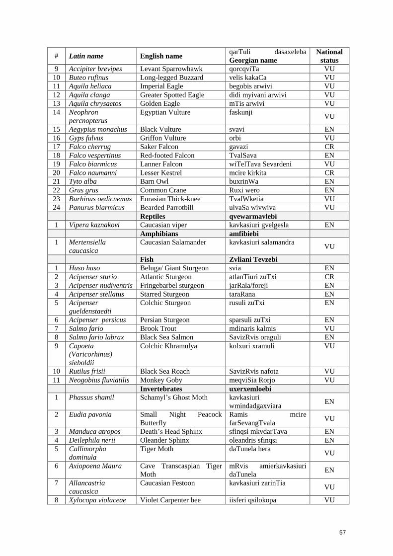
57
# Latin name English name qarTuli dasaxeleba
Georgian name
National
status
9 Accipiter brevipes Levant Sparrowhawk qorcqviTa VU
10 Buteo rufinus Long-legged Buzzard velis kakaCa VU
11 Aquila heliaca Imperial Eagle begobis arwivi VU
12 Aquila clanga Greater Spotted Eagle didi myivani arwivi VU
13 Aquila chrysaetos Golden Eagle mTis arwivi VU
14 Neophron
percnopterus
Egyptian Vulture faskunji VU
15 Aegypius monachus Black Vulture svavi EN
16 Gyps fulvus Griffon Vulture orbi VU
17 Falco cherrug Saker Falcon gavazi CR
18 Falco vespertinus Red-footed Falcon TvalSava EN
19 Falco biarmicus Lanner Falcon wiTelTava Sevardeni VU
20 Falco naumanni Lesser Kestrel mcire kirkita CR
21 Tyto alba Barn Owl buxrinWa EN
22 Grus grus Common Crane Ruxi wero EN
23 Burhinus oedicnemus Eurasian Thick-knee TvalWketia VU
24 Panurus biarmicus Bearded Parrotbill ulvaSa wivwiva VU
Reptiles qvewarmavlebi
1 Vipera kaznakovi Caucasian viper kavkasiuri gvelgesla EN
Amphibians amfibiebi
1 Mertensiella
caucasica
Caucasian Salamander kavkasiuri salamandra VU
Fish Zvliani Tevzebi
1 Huso huso Beluga/ Giant Sturgeon svia EN
2 Acipenser sturio Atlantic Sturgeon atlanTiuri zuTxi CR
3 Acipenser nudiventris Fringebarbel sturgeon jarRala/foreji EN
4 Acipenser stellatus Starred Sturgeon taraRana EN
5 Acipenser
gueldenstaedti
Colchic Sturgeon rusuli zuTxi EN
6 Acipenser persicus Persian Sturgeon sparsuli zuTxi EN
7 Salmo fario Brook Trout mdinaris kalmis VU
8 Salmo fario labrax Black Sea Salmon SavizRvis oraguli EN
9 Capoeta
(Varicorhinus)
sieboldii
Colchic Khramulya kolxuri xramuli VU
10 Rutilus frisii Black Sea Roach SavizRvis nafota VU
11 Neogobius fluviatilis Monkey Goby meqviSia Rorjo VU
Invertebrates uxerxemloebi
1 Phassus shamil Schamyl‟s Ghost Moth kavkasiuri
wmindadgaxviara EN
2 Eudia pavonia Small Night Peacock
Butterfly
Ramis mcire
farSevangTvala VU
3 Manduca atropos Death‟s Head Sphinx sfinqsi mkvdarTava EN
4 Deilephila nerii Oleander Sphinx oleandris sfinqsi EN
5 Callimorpha
dominula
Tiger Moth daTunela hera VU
6 Axiopoena Maura Cave Transcaspian Tiger
Moth
mRvis amierkavkasiuri
daTunela EN
7 Allancastria
caucasica
Caucasian Festoon kavkasiuri zarinTia VU
8 Xylocopa violaceae Violet Carpenter bee iisferi qsilokopa VU

58
# Latin name English name qarTuli dasaxeleba
Georgian name
National
status
9 Calopteryx
mingrelica
Banded Agrion samegrelos turfa VU
10 Astacus colchicus Colchis crayfish kolxuri farTofexa kibo VU

59
11 Dolomedes
plantarius
Fen raft spider tivis oboba VU
12 Helix buchi Beech Snail buxis lokokina VU
National status according to the Criteria of Red Data List of Georgia: CR - Critical Endangered, EN -
Endangered and VU - Vulnerable
4.2.3 Bird migration routes across project area
Bird migration and nomadic movements take place in Georgia during the whole year. However, there
are sharply seen two migratory periods – spring and autumn passage. The important Euro-African and
Euro-Asian migratory fly-ways of many bird species cross the territory of Georgia, from their nesting
sites to the wintering areas and back. Not less than 215 species, or more than half of bird species of
Georgia, are migratory birds, which are absent in the winter. Not less than 230 species are regularly
noted at the period of seasonal migrations in the spring and autumn. Also, about 40 species are
irregular migrants. The fly-ways of migratory birds‟ on the territory of Georgia are linked with natural
“guiding” lines – with the outlines of the Black Sea coast line, valleys of the large rivers (Rioni,
Mtkvari and with their tributaries), mountain ranges, mainly with the Greater Caucasus Chain and its
spurs, and less with the Surami ridge and with ranges of the Lesser Caucasus. There are known
primary, secondary and additional flyways, as well as concentration places of migratory flocks, so-
called “migratory bottle-necks” and stop-over sites (places of their stay for the resting). The “bottle-
necks” are situated on the passes in mountains (especially passes of the Great Caucasus) and in
valleys of large rivers – Mtkvari, Rioni, Tergi (Terek), Alazani, and in valleys of some tributaries of
them. The most important bottle-neck is located in south-western part of Kolkheti Lowland on the
coastal lowlands of Adjara.
The general flyway within the project area lies along the whole of the Project Road. It follows the
Black Sea coastline.
Spring Migration (March – first half of May).
General direction of the migration is from the South to the North. They use all suitable valleys of the
rivers and the coast of the Black Sea. Part of the flock fly above the sea surface few kilometers away
from the coastline. Transit migrants are dominating. Their species composition and numbers vary to a
great extent, sometimes in a very short time.
There are four waves of the birds‟ migration in the spring - (i) beginning of March till the middle of
March, (ii) during second half of March, (iii) from the first week of April till the third week of April,
and (iv) from the end of April till the second week of May.
In the first (1-20 March) and second (second part of March) waves of migration, many cranes, birds-
of-prey, waterfowls and crovids (Corvidae) are migrating. Third wave – (7-10 April till 1 May) is the
most intensive migration wave. More than half of the spring migrants migrate in this time. The last
fourth wave (May) includes small birds (cuckoo, oriole, swift and some species of small passerines).
Arrivals of the migrant birds, which are nesting in Georgia, continue from 5-10 May to 20-25 May,
with peak between 10 and 20 May.
The most important factors of intensification of spring migration are the meteorological conditions on
the plains of the North Caucasus and the existence in Transcaucasia. The soaring birds (e.g. large
birds of prey) are in need of the good warmed grounds and places with the ascending flows of air.
The migration of some species of ducks, geese, waders, and cranes occur at night.

60
Main flight altitude for most of the migrants is around 20-50 m.; some of the small bird species
(Passeriformes) prefer the 5-20 m. The large bird species (waterfowl, birds of prey, cranes, gulls, etc)
on the contrary usually fly higher (100-250 m).
Autumn Migration (September – end of October).
General direction of the migration is from the South to the North. The birds‟ flock cross the Main
Caucasus Ridge through the passes in the gorges of the main rivers and go down to the intermountain
plains. They do not follow to the bends of these riverbeds. The main part of the birds flies along the
coastline of the Black Sea and above the sea. Birds gather in large flocks in the Kolkhida/Colkhic
Lowlands.
Transit migrants are dominating, their species composition and numbers vary to a great extent,
sometimes in a very short time.
Autumn passage is longer and more active than the spring passage. The first autumn migrants appear
even at the beginning of August. The autumn passage ends at the beginning of November. There are
shown three waves of the autumn migration - at the beginning of September, from the second week of
September till the first week of October, at the end of October. The most common migrants are
passerines (Passeriformes), waders (Charadriformes), birds-of-prey (Falconiformes), geese
(Anseriformes), pigeons (Columbiformes).
The cold snaps on Russia territory, as well as also weather conditions (direction and force of winds,
intensity and character of precipitation, height and density of the cloudiness) in some regions of
Georgia and in adjacent regions of Russia and Turkey influence the intensity of the autumn passage.
The migration occurs both during day and night - dusk migration includes some species of the
waterfowls and birds-of-prey, and night migration includes some species of ducks, geese, and cranes.
Main flight altitude for most of the migrants is around 20-50 m.
Winter Migration (December - February)
This period is characterized by poor species structure with limited territorial distribution of large
aggregations of birds, by high numbers of some wintering species. At the later period of the winter
(the last weeks of February) it is noted increasing of the diurnal activity of all species and some
revival of activity in the movements of both flocks of wintering species and resident breeders. The
territory of Georgia is of important significance for wintering birds. More than 130 species are
wintering there and more than 40 of them are gathered in numerous flocks. Birds are distributed
irregularly in the places of wintering. Mostly, they prefer the open and semi-open areas on the plains
in the regions with generally warm and snowless winters. The most important wintering area is
Colchic Lowland, at coastal lowlands, in flood-plains of large rivers of Black Sea basin and of their
inflows.
Number of birds changes during the wintering season, reaching maximum usually in the middle of 1st
– the beginning of 2nd half of February. The greatest aggregation of wintering birds occurs on
Colchic Lowland, where up to 60 % of birds from the total of those wintering in Georgia are recorded
during the some years. Seaside lowlands also play the important role as wintering habitat, here are
recorded up to 10-25% of the birds wintering in Georgia in different years. Up to 15-20 % of birds,
wintering in Georgia, are recorded in open landscape of Eastern Georgia.
Number of the migrants varies noticeably from year to year. Unfortunately, the available data, does
not allow defining an exact number of the birds, which are flying during the seasonal migrations
through the territory of Georgia. General estimations of the number of the migratory and wintering

61
birds: about 250 bird species - from 25 up to 40 millions of individuals, (depends of the weather
conditions) migrate along the Black Sea coast.
4.2.4 Protected Areas
Ispani Mire (Kobuleti Protected Areas)
The Ispani mire, a protected area and RAMSAR wetland site (number 894), is located 350 meters
away from the project road between Km 6 to 12 section one. The location of the mire and the project
alignment near the mire is shown in Figure9. The mire consists of 770 ha and contains two parts –
Kobuleti State Nature Reserve (Ispani II, the northern area – 331.25 ha) and Kobuleti Managed
Reserve (Ispani I, the south west area- 438.75 ha). Between mire and the project road there is main
railway and agricultural lands. The road will not pose any serious risk to this site since there are no
drains to the direction of the mire. In addition there is also artificial barrier as a railway embankment
before the mire. The aerial photograph of the mire and Project road is shown in Figure 4-9.
Figure 4-9: Distance to the Ispani Mire
Photo 4.6: Photograph of the Ispani Mire from the Observation Tower
The mire is a part of the Kolkheti low land system of wetlands. The rationale for including the mire in
the RAMSAR list is: (i) Ispani II mire is one of the two percolation bogs which are discovered
worldwide (another one is Imnati, which also occurs in the Kolkheti lowland, located about 20km
from north of the Ispani mire) and (ii) Vegetative cover of the Ispani I and Ispani II peatland complex
contains plant communities of relict (e.g. Carex lasiocarpa, Molinia litoralis), northern Palaearctic
species (e.g. Drosera rotundifolia, Sphagnum imbricatum, S. palustre, S. papillosum, S. rubellum, S.
auriculatum), Kolkheti elements (e.g. Rhododendron luteum, Rhododendron ponticum, Rhynchospora
caucasica Vaccinium arctostaphyllus) as well as species like Frangula alnus, Rubus spec. or Alnus
barbata at the margin of the peatlands. The Ispani I and Ispani II peatland complex has many ancient
relic species of vegetation that are found nowhere else in the world. A photograph of the Ispani mire
from the observation tower in the mire is shown in Photo 4.6.
Percolation bogs have no acrotelm with horizontal water flow like other raised bogs, but a
predominantly vertical water flow through the entire peat body. The Ispani 2 bog is an extraordinary
bog (Krebs et al 2009) and is the type locality of percolation bogs (Kaffke et al. 2000), i.e. it was the
first mire in the world identified as a „percolation bog‟ (Couwenberg & Joosten 1999, 2005, Kaffke et
al. 2000, Haberl et al. 2006). Only two well-developed bogs of this type are known to exist
worldwide, both in the Kolkheti Lowlands, the other one is Imnati. Ispani 2 It shares many
characteristics with „normal‟ raised bogs, including its dome shape, its ombrotrophic (solely rain-fed)
water and nutrient supply, and its acid and nutrient poor site conditions (Kaffke 2008, De Klerk et al.
2009). In contrast to all other bogs, however, Ispani 2 does not show surficial water flow and – as a
consequence - no explicit microtope patterning (Couwenberg & Joosten 2005).
The project road is close to Ispani Mire also it does not cross the territory. Other sensitive areas can be
considered river crossing such as river Achkva, Kintrishi, Dexva and Chakvis Tskhali.
4.3 Environmental Quality
Environmental investigations were carried out during feasibility study to establish baseline conditions
for air, surface water and noise quality. Further environmental investigations were carried out during
detailed design stage to establish baseline indicators for water, soil and noise quality. Locations of
these investigations are given in Table 4.8 and shown in Figure 4-10.

62
Table 4-8: Locations of Baseline Environmental Quality Monitoring
Location Northing Easting
Surface Water 1 Otschakumri river (downstream of railway and road) 41
o52.294 41
o49.765
2 Tagoni (downstream of railway track) 41o50.912 41
o49.392
Groundwater 1 Well in Otshkmuri village 41
o51.279 41
o50.152
2 Well in downstream of Chakiv Landfill site 41o42.262 41
o44.173
Air Quality
1 Kobuleti town near Ispani mire 41o51.790 41
o46.784
2 Otschakmuri 41o51.319 41
o50.145
3 Near Chakvi Landfill site 41o42.262 41
o44.173
Soil Quality
1 Near Otschakumuri River 41o52.169 41
o50.067
2 Otschakmuri 41o51.319 41
o50.145
3 Near Chakvi Landfill site 41o42.262 41
o44.173
Figure 4-10: Location of Environmental Quality Investigation Sites
4.3.1 Surface Water Quality
Water quality investigations have been carried out during feasibility study stage in April 2009, to
assess the background water quality. The analysis of water samples also includes estimation of total
nitrate (TN), polyphosphate (TP), and total petroleum hydrocarbon (TPH) to assess the pollutions
levels from agriculture and industrial flows. Physical properties, such as temperature, pH, turbidity
and electricity conductivity, of three river waters are given in Table 4-9, while major cations and
anions of these waters are given in Table 4-10. Water quality of all the rivers in general is very good
except Waters of the all rivers are potable and contain total dissolved solids ranging from 74 to 159
mg/l. All the rivers are excellent sources of drinking and can be used for construction purposes. The
pH level of the rivers ranges from 7.66 to 7.81.
Table 4-9: Physical Properties of River Waters
No River Temp, oC pH Turbidity, FTU EC mS/cm
1 Achva
7.9
0.268
2 Kintrishi 20.5 7.9 0.29 0.085
3 Chaqvistskali 20.4 7.89 0.43 0.079
Source: Institute of Mineral Raw Materials of Caucasus
Table 4-10: Chemical Properties (Major Ions) of River Waters
No River mg/l Cl HCO3 SO4 Ca Mg Na K DO TDS
1 Achva 8.34 112.8 47.0 38.0 7.3 8.7 1.5 - 237.1
2 Kintrishi 5.0 37.8 14.4 9.0 4.1 7.9 0.4 9.8 79
3 Chaqvistskali 5.0 41.5 14.4 8.8 3.8 5.6 0.4 10.0 79
Source: Institute of Mineral Raw Materials of Caucasus
4.3.2 Groundwater Quality
Groundwater samples in the Project area are collected from wells and springs and the results of
analysis are given in Table 4-11. The total dissolved solids (TDS) of the groundwater are below 300
mg/l. All the elements are within the standards. Presence of coliforms is noticed in all groundwater
samples.

63
Table 4-11: Groundwater Quality of Project Area
# Name Standard Well at vil.
Ochkhamuri
Well below
proposed Chakvi
landfill site
1 pH 6.04 8.24
2 TDS, mg/l 88.5 94.0
3 Sulphate, mg/l 250 0.372 0.614
4 Chlorides, mg/l 250 6.224 0.138
5 Bicarbonate, mg/l 36.6 39.0
6 Sodium, mg/l 200 6.5 5.5
7 Calcium, mg/l 140 5.25 12.7
8 Magnesium, mg/l 85 1.7 6.9
9 Total Coliforms, in 250 ml 1 500 1 200
Source: Consultant‟s Water Quality Baseline Monitoring
4.3.3 Noise Quality
Baseline Noise Measurement Data
Sampling Session 1
Baseline noise level has been measured by device -.”Шум – 1”. 4 test points were selected near
villages Makhinjauri (p.1), Salibauri (p.2), Makhvilauri (p.4) and in Khelavachauri. One device have
been located at 5m distance from the edge of the existing road. Each minute one measurement has
been carried out. The average of 30 measurements during 30 min is provided in the table below.
Results are provided in the Table 4-12
Table 4-12 Measured Levels of Baseline Noise
# Time of Noise Measurement Average Noise Level dBA 5m from the Road
Kobuleti (East of Kobuleti)
Average Maximum
1 12.10 – 12.40 57 78
2 14.50 – 15. 20 65 83
3 17.30 – 18.00 52 65
Chakvi
Average Maximum
4 10.30 – 11.00 63 74
5 15.30 – 16.00 59 65
6 17.30 – 18.00 56 67
Sampling Session 2
1. Noise
The baseline noise was measured using device produced in UK “PCE-EM882”. Measurements were
undertaken in all identified points using the following methodology: data was taken from the device at
each point in every 5 minutes during half an hour (total of 6 data) and average calculated for each
point of noise (Table 4-13).
Table 4-13 Measured Levels of Baseline Noise
Location of
measurement
After 5
minutes
After 10
minutes
After 15
minutes
After 20
minutes
After 25
minutes
After 30
minutes
Average
I point 46.7 45.8 45.2 48.3 48.5 46.8 46.8

64
II point 50.2 47.6 48.0 48.3 48.7 47.9 48.45
III point 47.3 46.9 46.8 49.4 45.8 48.6 47.46
IV point 48.4 47.3 47.8 48.4 48.3 49.1 48.2
V point 57.4 59.4 61.3 45.2 64.8 63.3 58.56
VI point 46.4 48.5 45.5 47.5 47.7 47.7 47.22
As the obtained data shows the baseline noise level is fairly low. Only at №5 point, in the vicinity of
an automobile road, the noise level is relatively high in comparison with other locations, although it
does not exceed the standard (see Photo 4.7 – 4.10).
Photo 4.7 Sampling point I Photo 4.8 Sampling point II
Photo 4.9 Sampling point IV Photo 4.10 Sampling V point
Modeling of Traffic Related Noise
Point-source propagation can be defined as follows: Sound level1 – Sound level2 = 20 log r2/r1. This
means that for every doubling of distance, the sound level decreases by 6dBA (“inverse square law”).
Line-source propagation occurs when there is a continuous stream of noise sources. The
reinforcement by the line of point sources makes the propagation field either cylinder shaped or a
half-cylinder shaped area. The line source propagation prediction model is as follows: Sound level1 –
Sound level2 = 10 log r2/r1; The decrease in sound level for each doubling of distance from a line
source is 3 dBA. When noise levels from a busy highway are considered, it is appropriate to utilize
the highway as an infinite line source and consider a 3-dBA doubling of the distance-propagation rate.
In order to carry out semi-quantitative estimation of noise impacts related to existing and projected
traffic, we used measured noise data – average and maximum values provided in the Table 4-12.
Based on comparison of the maximum and average levels of noise and existing traffic volume data,
we can consider that current traffic is not high enough to apply linear source propogation (3-dBA law)
but the attenuation figures are between the point source and linear source (between 3-dBA and 6-
dBA values). Increase of the traffic volume will lead to reduction of intervals between the vehicles
crossing the given crossection of the highway. Therefore, we assumed that according to the traffic
volumes projected for the 2030, the traffic will be “dense enough” to apply 3-dBA law for the noise
attenuation and maximum of currently observed average figures (68 dBA) could be taken as
indicative figure for noise at a 5m distance from the road side. Table 4-14 provides noise levels at
different distances from the edge of the road as predicted by “3dBA-law”.
Table 4-14 Predicted level of Baseline Noise
Distance from the Edge of
the Road m
Predicted Noise Level
Average Value - dBa
Predicted Noise Level
Maximum Value - dBa
5 68 85
10 65 82
20 62 79
40 59 76
80 56 73
160 53 70
320 50 67

65
Modeling of Noise Related to Construction Activities
Evaluation of construction related noise relies upon known information on the noise produced by
various equipment and activities at individual stages of construction. For example noise levels
produced at 50 ft (15.24m) as provided by the U.S. Department of Transportation, FHWA, CADOT,
and SBAG 1993; and Country Sanitation Districts of Los Angeles County 1994 are about:
Table 4-15
Source of Noise Equivalent noise level, dBA
1. Construction machinery and mechanisms
Backhoes 84 – 85
Bulldozers 84 – 85
Graders 91 – 92
Compressors 80 – 88
Jackhammers 85 – 98
pile drivers 96 – 107
According to other sources (U.S. Environmental Protection Agency, 1972,):
Table 4-16
Source of Noise Equivalent noise level, dBA
Construction machinery and mechanisms
Compacters (rollers) 72 – 75
Front loaders 72 – 83
Backhoes 72 – 92
Tractors 78 – 95
Scrapers, graders 80 – 95
Pavers 85 – 88
Trucks 83 – 93
Compressors 75 – 88
crane, movable 75 – 85
Jackhammers and rock drills 82 – 98
Vibrator 70 – 82
Saws 72 – 82
Noise generated by mobile sources naturally attenuates at a certain distance. Attenuation follows
logarithmic pattern. In case of construction related noise, point source propagation model should be
applied. Point-source propagation can be defined as follows: Sound level1 – Sound level2 = 20 log
r2/r1. This means that for every doubling of distance, the sound level decreases by 6dBA (“inverse
square law”).
Table 4-17
Distance from the Edge of
the Road m
Predicted Noise Level
Average Value - dBa
Predicted Noise Level
Maximum Value - dBa
5 80 90
10 74 84
20 68 78
40 62 72
80 56 66
160 50 60

66
320 44 54
Resume
Baseline Conditions
Baseline and predicted noise level in the area alongside the highway is not significant. In fact without
applying any abatement measures, the noise level is in compliance with the standard requirements for
the apartment houses at the distance of – 40-50m from the highway.
Project Impact and Mitigation (Construction Phase).
As a result of rough estimation of construction related noise, we can assume that the noise impact will
not exceed radius of 320m. This means that settlements will not be affected. Neither ecologically
sensitive areas will be disturbed by the noise nuisance. Temporary and slight increase of the noise
level near the construction ground within the 300m radius is acceptable impact. However, mitigation
of this impact is possible by engine maintenance practice and avoidance of engine work in non-
operational mode. The only limitation that could be recommended is to minimize the night-time
works near villages. The night-works at other sites could be carried out without limitation.
Project Impact and Mitigation (Operation Phase).
Traffic related noise will not affect area out of 40-50m from the highway. The impact is not expected
to be high even in 2030, when the traffic intensity is expected to increase significantly as compared
with the current situation. The abatement measures (installation of noise barriers and speed
restriction) applied for the specific sections of the highway, enable to reduce the noise level up to
12dBA.
4.3.4 Air Quality
Until 1991, air quality monitoring was carried out regularly and systematically in Georgia in 11 cities,
including Batumi. Dust, CO, NO2 and SO2 were measured continuously for 3 times in a day. The
available latest air quality monitoring data for Batumi is from 1995 to 2004 and is shown in Figure
4.11. The average yearly concentrations of dust, sulfur dioxide and nitrogen dioxide in Batumi
slightly exceeded norms. The maximal dust concentration exceeded MPL 1.2 times. In the later years
of the data, the concentration of nitrogen dioxide increased substantially, while the level of hydrogen
sulfide pollution decreased. Air quality monitoring in the Project area was carried out at 5 locations
and the results are given in Table 4.18 and all concentrations are within the national standards. The
equipment used for air quality monitoring are Microdust Pro Particulate Monito r(Casella, USA) for
PM, Gas Alert Micro 5 Multigas Detector (BW Technologies, Canada) for SO2, and Elan (Russia) for
CO and NO2. The average yearly concentrations of dust, sulfur dioxide and nitrogen dioxide in
Batumi slightly exceeded norms. The maximal dust concentration exceeded MPL 1.2 times. In the
later years of the data, the concentration of nitrogen dioxide increased substantially, while the level of
hydrogen sulfide pollution decreased.
Source: Environmental Pollution Monitoring Centre, MOEP, 2005
Figure 4.11: Air Quality Monitoring Data of Batumi
Table 4-18: Air Quality Data in the Project Area
No Parameter Unit Standard
Near Proposed
Chakvi
Landfill site
Kobuleti, near
Ispani mire Ochkhamuri
1 PM mg/m3 0.5 0.354 0.046 0.04
2 CO mg/m3 3.0 0.48 1.75 0.65
3 NO2 mg/m3 0.04 0.042 0.03 0.003

67
No Parameter Unit Standard
Near Proposed
Chakvi
Landfill site
Kobuleti, near
Ispani mire Ochkhamuri
4 SO2, mg/m3 0.5 0 0 0
Source: Consultant‟s air quality monitoring, 2010
4.3.5 Soil Quality
Soil quality analysis was carried out with „Atomic Absorption Spectrophotometer (Analist-200) and
the results are shown in Table 4-19. Dutch and other international standards for the heavy metal
concentrations in soils are shown in Table 4-20. The concentrations of heavy metals in soils are
generally less than international standards except for copper and the reasons for these high
concentrations can be attributed to natural background concentrations.
Table 4-19: Soil Quality of the Project Areas
# Name Ochkhamuri planned disposal
area near Chaqvi
1 Lead Pb, mg/kg 15.33 19.25
2 Zinc Zn, mg/kg 58.28 67.11
3 Cobalt Co, mg/kg 10.77 21.48
4 Copper Cu,mg/kg 42.64 13.97
5 Nickel Ni, mg/kg 17.82 53.80
Table 4-20: Standards Heavy Metal Concentrations in Soils (mg/kg)
Element Dutch Standards, 1985 International Standards, 1985
Cu 36 2-50
Zn 140 10-300
Pb 85 0.1-20
Ni 35 1-100
Co 20 1-50
Source: Environmental Assessment and Management Report of E60 Highway, 2007
Road Department, Georgia
4.4 Social, Economic and Cultural Resources
4.4.1 Population and Communities
Population of Adjara as of 2009 statistics is 382 thousands (Table 4-21). Approximately, 43.6% of the
population lives in urban areas and 56.4% lives in rural areas. The Autonomous Republic of Adjara
consists of seven administrative-territorial units: 2 cities and 5 rayons. From 2003 to 2005, the
population growth rate has remanded stable, at around 0.5%. Batumi is the most populated city, with
a population of 122 thousands. Ethnic groups of Adjara include Georgian, Russians, Armenians,
Greeks, Abkhaz, etc. In the Project affected households, about 97% are of Georgian ethnicity.
Armenians comprises only 2.0% and Russians, 0.25% (Table 4-22).
Table 4-21: Population of Adjara Region (thousands)
2002 2009
Adjara Autonomous Republic 376.016 382.4
Batumi 121.806 122.5
Kobuleti Municipality 88.063 89.9
Khelvachauri Municipality 90.843 92.8
Keda Municipality 20.024 20.0
Shuakhevi Municipality 21.850 22.3
Khulo Municipality 33.430 35.0

68
Source: National Statistics Service of Georgia
Table 4-22: Ethnicity of Households
No. Ethnicity AH %
1 Georgian 101 99
2 Other 1 1
Total 102 100
Source:DMS/AP Census (Detail Design Consultant)
Source: Socioeconomic survey, Feasibility Study (2009)
The Project Road measuring 18.9 km in length and located east of Kobuleti. It passes 8 villages/towns
in Khelvachauri district. The names of the villages along the Project road are given in Table 4-23.
Table 4-23: List of Villages in the Project Impact Zone
Name of Village Legal Status District/Rayon
Khutsubani Village Kobuleti
Bobokvati Village Kobuleti
Sachino Village Kobuleti
Gvara Village Kobuleti
Ochkhamuri Village Kobuleti
Mukhaestate Village Kobuleti
Kobuleti Urban Village Kobuleti
Kvirike Village Kobuleti
Chakvi Village Kobuleti
Tsikhisjvari Village Kobuleti
4.4.2 Industries and Infrastructure
In 2004, the Gross Domestic Product of the Autonomous Republic of Adjara was GEL 490 million,
which is 5% of the GDP of Georgia. The main industries in Adjara are manufacturing, agriculture
and tourism. The manufacturing sector is dominated by food, tobacco, and woodworking industries
and accounted for 5.9% of Adjara‟s GDP. As of 2005 there were 515 industrial enterprises in Adjara,
34 state enterprises and 117 non-governmental enterprises. Some of the major industrial enterprises
in Adjara are listed in Table 4-24. The agricultural sector is dominated by tobacco, citrus plants,
potatoes, tea, and livestock farming. The share of agriculture in the GDP of Adjara is 18.7% (GEL
91.52 million). Private farms occupy 63.8% of the agricultural lands. State and non-governmental
agricultural farms occupy the rest, 46.2%.
Table 4-24: Major Industrial Enterprises in Adjara
Industrial Enterprise
1 Batumi Sea Port
2 Batumi Oil Terminal LTD
3 Batumi Oil Refinery Plant LTD
4 Adjara Energo Company LTD
5 Adjarautotrans LTD
6 Batumi Mechanical Plant LTD
7 Transformer and Electric Equipment (JSC)
8 Batumi Locomotive Depot of Georgian Railway LTD
9 Batumi Carriage Depot of Georgian Railway LTD

69
10 Adjargas JSC
11 Batumi Ship Building Plant LTD
12 Transport Administration
13 Beer and non-akcoholic drinks enterprise LTD
14 Batumi Wood Refinery Furniture Enterprise JSC
15 Zenauri and Geladze LTD
16 Khelvachauri Bread Enterprise LTD
Source: Adjara Solid Waste management Feasibility Study and Project Preparation report, 2009
Figure 4-12: Locations of the villages and their population
Tourism is one of the major industry in the Project area and extensive resort infrastructure is located
all along the existing road in Batumi and Kobuleti. In 2004, the total cost of services rendered in the
sphere of tourism was GEL 16.7 million, which is 3.4% if the Adjara GDP. The tourist season lasts
about 3 months, from late June till the end of September. On average, according to 2004 estimates,
about 65-70 thousand people visited Adjara during the tourist season.
Citrus and Vegetables are the major crops being cultivated in the project area. Details of major
cropping pattern in the project area obtained from the affected households are given in Table 4-25.
Corn, Vegetables and citrus are the major crops being cultivated in the project area. About 22% of the
households cultivate citrus in average area 0.19 Ha each. Other crops like vegetables by 20% in
average area of 0.08 Ha, corn by 21% in average area of 0.08 Ha
Table 4-25: Major Cropping Pattern
No. Type of Crops HH %of HH
Average
cultivated Area
(Ha)
1 Corn 35 20.1 0.09
2 Bean 22 15.1 0.07
3 Vegetables 33 19.1 0.01
4 Grape 20 11.3 0.01
5 Fruit 3 0.9 0.01
6 Citrus 36 24.5 0.23
7 Others 17 9.3 0.01
Source:DMS/AP Census (Detail Design Consultant).
Details of health care facilities in Adjara are given in Table 4-26, which includes 19 hospitals and 248
first aid network facilities. 1252 medical professionals are working in these facilities. Among them 78
are physicians, 42 are surgeons, 122 are gynecologists, 115 are village doctors, and 93 are
paramedics.
Table 4-26: Health Care Facilities in Adjara
No
In 2008 In 2009
1 Number of Hospitals 18 19
2 Neurological Centre (with Hospital) 1 1
3 Blood transfusion station 1 1
4 Ambulance Service 6 6
5 First Aid Network in Total 245 248
Among them

70
Centre for Family Medicine 2 2
Independent poly clinics 11 11
Medical Centre for Polyclinic Profile 5 5
Private Polyclinic Institutions 3 4
Health entre 3 3
Centre for Primary Health Care 46 45
Community Medical Centre 175 177
4.4.3 Transportation
The road network in the Project areas is poor with several rural areas which are not connected to the
road network. Only national and regional highways are asphalted and all other rural roads are
graveled, and these graveled rural roads are difficult to drive on, during the rainy season. Transport
network in the Project area is shown in Figure 4-13.
Figure 4-13: Transport Network in the Project Area
Georgia has two main ports and both lie on this section of the Black Sea coast, Poti, 30 km to the
north of the project area, and Batumi. Although some of the goods and materials leave the ports by
rail, much of it also transported by road. In addition heavy commercial road traffic from Turkey enters
Georgia through the Sarpi border post and up to Kobuleti, some destined for other areas of Georgia
and some transiting through Georgia along the existing road and then along the main E-W highway to
Azerbaijan, Armenia and beyond. Except for oil, transit trade mostly comprises agricultural products,
building materials, and machinery.
This mix of international and local traffic combined with poor road conditions leads to dangerous
driving situations and frequent traffic accidents. At present a significant volume of international
transportation is carried on the Batumi-Poti section of road amounting to 1.0 million tons annually
(2005), with 0.5 million tons on the Batumi-Sarpi section.
4.4.4 Cultural Resources and Archaeological Sites
Though the Project area has rich historical and archaeological heritage, no historical and
archaeological sites and monuments are located along the Project road.
Figure 4-14: Location of Archaeological Sites
4.4.5 Land Use
Land use of the Project area is classified into swamps, badlands, temporal dwellings, perennial
plantations (tea, citrus, etc), industrial area, agricultural lands, arable lands and forest. Project area
mostly passes through arable land consisting of pastures, agriculture lands, tea and citrus plantations.
Corn is the major agriculture product in the project area and is widely grown in all agriculture lands,
and vegetables are the second major product.
4.4.6 Socioeconomic Conditions
This impacts assessment details loss of land, structures and other assets for the Kobuleti Bypass 18.9
km Section-2 road. Compensation and rehabilitation measures have been worked out based on these
impacts. A detailed inventory of all the impacts has been done following the final alignment as per
detailed engineering design for the Kobuleti Bypass 18.9 km Section-2 road under Contract-4 Tranche
1.

71
Digitized cadastral maps were collected from Registration Offices of NAPR. The final road alignment
was superimposed on the digitized cadastral maps and land survey using DGPS was conducted on site
to identify the affected land parcels, demarcation of land parcels including correction in geometric
details and quantification of land parcels including affected part. With the cadastral details from land
survey, detail measurement survey (DMS) and census was started 25 March 2011 and terminated on
11 April 2011 for correction in geometric details of road alignment. Detail measurement survey
(DMS) and census was concluded on 31 May 2011 and 31 May 2011 is considered as the cut-off date
for compensation eligibility of this project. Additionally, a socioeconomic survey (SES) of more then
20% sample from the affected households was carried out in the project affected areas in order to
understand the socio-economic condition of the affected population.
In all land impacts amount to some 1,173,922 sq.m of land from 700 plots (see table 2.1 for details).
Figures on Land impacts are provided in accordance to the land classification and legal categories that
are relevant to determine compensation modalities and compensation amounts due to their
owners/users. Land has been classified in three main types:
Type 1: Private land that is compensable because it is titled or legalizable according to the
law. Legalizable land is land occupied by a house or close to a house that is currently untitled
but is occupied by users who were legitimate land leasers under the old Soviet land
administration system. This land includes 158 plots measuring in all 216,628 sqm.
Type 2: Public land that is compensable because used continuously by users who were
legitimate land leasers under the old Soviet land administration system but is not legalizable
because it is not occupied by houses or bordering houses. No Type 2 plots are affected.
Type 3: Land that is not compensable because not regularly used or used extemporaneously by users
who were not legitimate leasers under the old Soviet land administration system. This land is also
non-legalizable as it is not occupied by houses or close to houses. This land type includes 542 public
land plots measuring in all 957,294 sqm.
A census of 100% of the AHs available on site was conducted to enumerate the APs. A sample socio-
economic survey was included in the project area covering 102 households which more than 20% of
the total AHs covered in census. The objective of the socioeconomic survey was to gather general
information on socioeconomic condition of the affected people. The socioeconomic information of the
affected population as per census and socioeconomic survey is presented hereunder
The Census identifies that about 53% of the APs (APs) are female. The average family size is 5.1.
members per household.
The project road is mostly located in rural areas except Kobuleti. Survey shows that 99% of the AHs
reside in rural areas.
20% of the population have university level education, 74% have primary and secondary level
education, 6% have pre-school level education
Education of Households
About 20% of the population have university level education, 74% have primary and secondary level
education, 6% have pre-school level education (Table 4-27).
Table 4-27: Education of Households
No. Category
Male Female Total
AP % AP % AP %
1 Pre-School 22 9 12 4 34 6

72
2 Primary & Secondary 165 68 218 79 383 74
3 University 57 23 46 17 103 20
4 Illiterate 0 0 0 0 0 0
Total 244 100 276 100 520 100
Source:DMS/AP Census (Detail Design Consultant).
Source: DMS/AP Census 25 March–11 April 2011 (Detail Design Consultant)
Major Economic Activities
Agriculture as the primary economic activity reported 65% households.. The details are given in
Table 4-28 below.
Table 4-28 Economic Activity of the Households
No. Type of Activities Primary Secondary
HH % HH %
1 Agriculture 66 65 27 27
2 Agricultural Labourer 6 6 13 13
3 Small enterprise 5 5 11 11
4 Government Service 19 18 7 7
5 Business and trading 19 19 10 10
6 Daily Wage 8 8 19 19
7 Others 8 8 8 8
Source:DMS/AP (Detail Design Consultant).
Source: DMS/AP Census 25 March–11 April 2011 (Detail Design Consultant)
Employment Status
About 15% working age APs are wage employed, 24% are self-employed and about 15% are
economically inactive (Table 4-29). About 46% of the APs reported that are unemployed including
44% among males and 47% among the females. Details are given in Table 4-29.
Table 4-29: Economic Activity of the Households Members
No.
Gender
Economically Wage employed Selfemployed Unemployed Total
inactive
AP % AP % AP % AP % AP %
1 Male 19 10 29 15 55 29 88 46 191 100
2 Female 42 18 28 12 47 20 118 50 235 100
Total 61 14 57 13 102 25 206 45 426 100
Source: DMS/AP (Detail Design Consultant).
Source: DMS/AP Census 25 March–11 April 2011 (Detail Design Consultant)
Annual Income of AHs
Agriculture, service and wage employment are major contributors to income of the AHs. The survey
found that 14% of the AHs get income from one single sources, 38% from double sources and 48%
from three or more sources.
Table 4-30: Average Monthly Household Income against Number of Sources
Number of sources of Income AH % of AHs Average annual
income (GEL)
Single source 14 14 9567

73
Double Source 39 38 13568
Three + sources 49 48 16920
Total 102 100
Source:DMS/AP Census (Detail Design Consultant).
Source: DMS/AP Census 25 March–11 April 2011 (Detail Design Consultant)
Table 4-31: Annual Household Income distribution by Sources
Sources
%
Average annual income from the source
(GEL per HH)
Wage employment 40 39 6423
Agriculture 31 30 4905
Business/Service 13 13 2153
Property 2 2 378
Pension 4 4 706
Remittance 6 6 1034
Other 5 5 795
Total 102 100 16394
Source:DMS/AP Census (Detail Design Consultant).
Source: DMS/AP Census 25 March–11 April 2011 (Detail Design Consultant)
Source of Drinking Water
The major source of drinking water is dug-well and piped water supply - 29% of households use water from
dug-well and 63% of households use water from piped supply, 8% of households reported other sources
Details are given in Table 4-32.
Table 4-32 Source of Drinking Water
No. Sources HH %
1 Piped water supply 66 65
2 Well 32 31
3 Others 4 4
Total 102 100
Source:DMS/AP Census (Detail Design Consultant).
Source: DMS/AP Census 25 March–11 April 2011 (Detail Design Consultant)
Sanitation Facilities
54% of surveyed households use flush toilet and 46% use latrine Details are given below.
Table 4-33: Types of Toilet
No. Toilet HH %
1 Flush toilet 63 62
2 Latrine 39 38
Total 102 100
Source:DMS/AP Census (Detail Design Consultant).

74
Source: DMS/AP Census 25 March–11 April 2011 (Detail Design Consultant)
Usage Pattern of Fuel for Heating
Wood is the major source of fuel being used by the households (89%) for heating. Details are given in
Table 4-34
Table 4-34: Type of Fuel Used for Heating
No. Types of Fuel HH %
1 Electricity 2 2
2 Wood 87 85
3 Gas 8 8
4 Other 5 5
Total 102 100
Source:DMS/AP Census (Detail Design Consultant).
Source: DMS/AP Census 25 March–11 April 2011 (Detail Design Consultant)

75
5 ANTICIPATED ENVIRONMENTAL IMPACTS AND MITIGATION MEASURES
5.1 Approach to Screening of Environmental Impacts
The approach to screening of environmental impacts for the Project follows the guidance contained in
a range of documents relevant to environmental assessment of road projects including the following
key documents
(i) ADB's Safeguard Policy Statement (SPS), 2009
(ii) IFC Environmental, Health and Safety Guidelines, Toll Roads, April, 2007
(ii) Environmental Guidelines for Selected Infrastructure Projects (Highways and Roads, ADB,
1993)
(iii) Environmental Impact Assessment of Road Corridor Investment Program (ADB Loan No.
2560-GEO), June 2010
(i) World Bank (WB) Environmental Assessment Sourcebook, Vol.2, Guideline for
Environmental Assessment for Roads and Highways Projects,1991
Potential impacts on various environmental components due to different project activities during pre-
construction, construction and O/M stages have been identified. The following detailed investigations
are being carried out to assess the impacts:
Detailed review and analysis of available spatial databases for all environmental parameters
in project areas such as terrain, soils, geology, rivers, forests, protected areas, land use, and
population
Geotechnical investigations through boreholes and soil analysis
Environmental quality baseline monitoring of air, noise, surface water, and groundwater,
Ecological surveys comprising vegetation, wildlife, and fisheries,
Review of engineering designs
Hydrological calculations.
Census survey to assess the extent of land acquisition and resettlement, loss of vegetation,
occupation, income and poverty levels of the affected households, etc.
Review of archeological reports
Stakeholder, focus group discussions and public consultations
Issues for inclusion in the environmental screening were identified through the EIA scoping process.
Based on knowledge of the existing environment, the project characteristics and experience with the
typical potential impacts of road and highway development, those issues for which environmental
impacts were likely to occur were identified.
A range of technical investigations was carried out for each of the identified environmental issues to
determine the effect that the project may have on a particular characteristics of the surrounding
environment. Potential impacts were categorized according to the project phases, i.e. pre-construction,
construction or operation, in which they occurred. Impacts with the potential to occur during
decommissioning or as a result of accidents or unforeseen conditions were also identified. This
process was carried out to ensure mitigation measures could be developed which were appropriate to
each project phases.
For those identified impacts for which it was possible and/or necessary, mitigation measures were
developed. The following hierarchy of mitigation strategies (from highest priority to lowest priority)
was implemented:
IMPACT AVOIDANCE: Changing project location, design and construction methods to
avoid impacts;

76
IMPACT MINIMIZATION: Where impacts cannot be avoided, implementing mitigation
measures to reduce the impact to acceptable levels;
COMPENSATION: Arranging compensation where impacts cannot be avoided or sufficiently
mitigated;
ENHANCEMENT: Measures, which, at insignificant cost to the project, give appreciable
social or developmental benefits
Cumulative impacts of the project were considered separately. Cumulative impacts are complex
impacts that arise from the Project acting in combination with other past, present and future activities
and development. Cumulative impacts can be:
Additive: impacts that result from the combined effect of a number of smaller impacts
Compensatory: impacts that occur when the effects of one project or activity act to offset the
effects of another
Synergistic: impacts that result when smaller impacts combine to create different or more
significant impacts – the overall impact is greater than the sum of the individual impacts
Masking: impacts of multiple projects overlap in a way that there is no perceived additional
impact, usually for an initial period of time after which impacts become one of the other types
of cumulative impacts
Classification of Environmental Impacts of the Project
In this EIA report, (negative) environmental impacts of the Project are classified into 5 levels in
accordance with international classifications with specific conditions of the project site taken into
account.
No impact: means unapparent and negligible influence on the natural and socio-economic
environments at the project site and its surroundings.
Minor impact (or small impact): means slight influence on a small portion of population (in
this projects: some households at each commune) or a small area of natural ecosystems (for
example, less than 1.0 ha at each site).
Intermediate (or medium impact): means influence on a portion of population or a relatively
large area of natural ecosystems (for example 1.0 – 10.0 ha of forest at each sites).
Major impact: means significant influence on a large portion of population (various
communes inside and around the project ROW) or a large area of natural ecosystems (more
than 10.0 ha each site in this project).
Unknown impact: means influence that is unpredictable as lacking information or data (for
instance, impacts due to sea level rise, earthquake, heavy flood, etc in this project area).
Each impact is also determined as short-term or long-term, recoverable or irrecoverable,
unmitigatable or mitigatable.
A detailed environmental management and monitoring plan has been prepared for all the identified
impacts and is presented in Chapter 9.

77
5.2 Project Related Significant Impacts
5.2.1 Pre-construction Stage
In the Pre-Construction Stage the main activities of the project are:
(i) Study to select best alignment of the bypass.
(ii) Further investigation on geo-engineering to detailed design the road and bridge.
(iii) Design roads, bridges and other technical facilities.
(iv) Acquire land, relocate houses and infrastructural facilities; remove vegetation covers
within the project ROW for construction of road, bridges and other technical facilities.
(v) Implement resettlement action plan (RAP).
(vi) Land clearing for preparation of « clean area » for road and bridge
5.2.1.1 Loss of Land
This road alignment will entail acquisition of 50 registered private plots measuring 104,813 sqm and
108 legalizeable plots measuring 111,815 sqm which in total 158 private plots with area of 216,628
sqm. Although 542 public plots measuring 957,294 sqm will be used by alignment from which 87
plots (282,393 sq m) are temporarily used by illegal users/squatters and 455 plots (674,901 sq m) will
not require for any compensation or other assistance as it is totally free land. Land impacts by land
type are detailed in Table 5-1 below.
Table 5-1: Impact on Land
Area (sq. m.) Number of plots
Type 1 Land (compensable)
Agriculture land Used as agriculture 191717 131
Used as Residential 24911 27
Sub Total 216628 158
Type 3 Land (non compensable)
Temporarily used 282393 87
Non used 674901 455
Sub Total 957294 542
Total 1173922 700
The current status of ownership of acquired land is provided in Table 5-2. The owners/users will be
compensated for land according to the Government Decree of March 1, 2011.
Table 5-2: Land Impacts by Type of Land Ownership
No. Legal Status No. of Plots Area (sq. m/)
Type 1 Land (compensable)
1 Private Land
Registered 50 104813
2 Legalizable 108 111815
Total Private Land 158 216628
Type 3 Land (non compensable)
3 State owned Land
Temporary used 87 282393
4 Uncultivated 455 674901
Total State Land 542 957294
Total land 700 1173922

78
5.2.1.2 Loss of Households
In all land impacts amount to some 1,173,922 sq.m of land from 700 plots (see table 2.1 for details).
Figures on Land impacts are provided in accordance to the land classification and legal categories that
are relevant to determine compensation modalities and compensation amounts due to their
owners/users. Land has been classified in three main types:
Type 1: Private land that is compensable because it is titled or legalizable according to the
law. Legalizable land is land occupied by a house or close to a house that is currently untitled
but is occupied by users who were legitimate land leasers under the old Soviet land
administration system. This land includes 158 plots measuring in all 216,628 sqm.
Type 2: Public land that is compensable because used continuously by users who were
legitimate land leasers under the old Soviet land administration system but is not legalizable
because it is not occupied by houses or bordering houses. No Type 2 plots are affected.
Type 3: Land that is not compensable because not regularly used or used extemporaneously
by users who were not legitimate leasers under the old Soviet land administration system.
This land is also non-legalizable as it is not occupied by houses or close to houses. This land
type includes 542 public land plots measuring in all 957,294 sqm.
Table 5-3 below provides details about the impacts on Landowner/user‟s households
Table 5-3: Affected Households
Impact Category
No. of Ahs Net No.
Of APs
Remarks
No. in
Category
Absolute (without
double counting)
A. Land A1. Agricultural Private
Land Used for Agriculture
purpose 131 131 668
A2. Agricultural Private
Land Used for non-
agriculture purpose
(rersidential)
27 27 137
A3. Agricultural State
Land Temporary used 87 87 443
Total (A) 245 245 1248
B. Crops /Trees
B1. Only Cops Losses 0 0 0
B2. Crops and Tree
Losses 114 114
579
B3. Only Tree Losses 1 1 4
Total (B) 115 115 583
C. Permanent Structure
C1. Only Residential
Structure 13 13 65
C2. Residential and
Auxiliary Structure 6 6 31
C3. Only Auxiliary
Structure 6 2 9
Total (C) 25 25 105
D. Relocated AH
D1. Relocated AH 19 19 96
Total (D) 19 19 96

79
5.2.1.3 Loss of trees
The right of way will affect 8728 fruit trees and 37138 sq. m tee plant under private ownership. Also
all timber trees are state owned and do not require payment of compensation.
Table 5-4: Affected Trees
Age group Number of Trees
Mandarin
5- 10
5-9 55
10-14 107
15-19 568
20+ 2446
Sub-total 3186
Orange 15-19 4
20+ 92
Sub-total 96
Lemon
5-9 8
10-14 30
15-19 3
20+ 23
Sub-total 64
Fig
5- 4
5-9 7
10-14 9
15-19 15
20+ 6
Sub-total 41
Persimmon
5- 6
5-9 19
10-14 16
15-19 21
20+ 93
Sub-total 155
Medlar
5- 4
5-9 18
10-14 7
15-19 10
20+ 23
Sub-total 62
Apple
5- 7
5-9 23
10-14 29
15-19 18
20+ 42

80
Sub-total 119
Pear
5- 4
5-9 19
10-14 34
15-19 25
20+ 64
Sub-total 146
Plum
5- 5
5-9 37
10-14 46
15-19 29
20+ 14
Sub-total 131
Walnut
5- 7
5-9 43
10-14 160
15-19 146
20+ 350
Sub-total 706
Hazelnut
5- 173
5-9 853
10-14 485
15-19 609
20+ 1120
Sub-total 3240
Grape
5- 2
5-9 26
10-14 58
15-19 16
20+ 42
Sub-total 144
Kiwi
5- 10
5-9 5
10-14 13
15-19 2
20+ 10
Sub-total 40
Faioja
5- 3
5-9 2
10-14 20
15-19 18
20+ 22
Sub-total 65

81
Other Fruit
Trees
5- 0
5-9 15
10-14 137
15-19 296
20+ 85
Sub-total 533
Sub-total Trees 8728
Sub-Total Tee
(sq m) 20+ 37138
Tree felling should be performed upon preliminary notification to the relevant authority (MOEP and
Forestry Department of MOENR). New plantation is proposed within 3 m reserve space is available
within ROW on both sides of the road.
5.2.1.4 Loss of Crops
The total crop area 256770 sqm from 161 plots which are totally private plots (see Table 5-5).
Table 5-5: Impact on Crops
Type Area (sq. m) Number of Parcel
Corn 97911 42
Beans 242 10
Vegetables 28349 26
Hay/Grass 128068 83
Total 256770 161
5.2.1.5 Loss of Building/Structures
Table 5-6 and Table 5-7 below provides details about the impacts on Buildings/Structures and Wall /
Fences respectively
Table 5-6: Impacts on Buildings/Structures
Type
Characteristic No of
Buildings/structure
Number of
Stories
Area in Plan
(sq m)
Total Area of Building/structure
(sq m) Materials Grade Sub
Grade
Residential
Block (B)
A B 7 1.8 1111 1985
B
B 4 2.0 595 1192
C 3 1.7 382 664
C C 2 1.6 326 524
Block-Wood (BW) B B 1 2.0 106 212
C 1 2.0 100 200
Wood (W) C C 1 1.0 85 85
Sub Total 19 1.8 2705 4862

82
Supplementary Facility
Storege Block (B) C 3 1.0 118 118
Wood (W) B 6 1.0 102 102
Cattle Hous Block (B) C 2 1.0 130 130
Garage Block (B) C 1 1.0 24 24
Sub total 12 1.0 374 374
Grant Total 31 1.7 3079 5236
Table 5-7: Impacts on Wall / Fences
Grade Affected Number of Parcel
Fence/Wall
Concrete-Steel (m)
A 110 3
B 585 7
C 4200 36
Block-Cement (m^3) B 118 2
Total 48
5.2.1.6 Loss of Business and Employment
The right of way has affected only agricultural land and with crops and trees. There is no any impact
on business and employees.
5.2.1.7 Compensation and Resettlement Framework
The following Table summarizes impact of Land Acquisition and Resettlement.
Table 5-9: Summary Impact on Land Acquisition and Resettlement No. Impacts Unit Quantity (sqm)
Type 1 Type 2 Type 3 Total Land Tenure Patterns
1 Total Land parcels affected No. 158 542 700 2 Total Land area affected Sqm 216628 957294 1173922
3 Total Land parcels to be acquired No. 158 87 245 4 Total land Area to be acquired Sqm 216628 282393 499021 5 Private legal Plots No. 50 50
sq.m 104813 104813 6 Private Legalizable plots No. 108 108
sq.m 111815 111815 7 Non cultivated state plots No. 455 455
sq.m 674901 674901 8 Private agricultural land used for agriculture purposes No. 131 131
sq.m 191717 191717 9 Private agricultural land used as residential No. 27 27
sq.m 24911 24911 Agricultural Patterns
10 Area under Corn Cultivation Sqm 97911
11 Area under Beans Sqm 2442
12 Area under Vegetables Sqm 28349
13 Area under Hay/Grass Sqm. 128068
14 Affected Trees No. 8728

83
Affected Structures
15 Residential Structures /Houses No. 19
16 Supplementary facility No. 12
17 Indusial & Commercial structures No. 0
18 Wall/Fenc No. 48
Affected Households
19 Severely affected Households No. 190 20 Vulnerable Households No. 5 21 AH with legal plots No. 50 50 22 AH with legalizable plots No. 108 108 24 Total AH No. 158 87 245
25 Total Affected Persons No. 805 443 1248
A resettlement framework for the Project was prepared in compliance with the national laws and
legislation related to land Acquisition and resettlement and ADB‟s Safeguard Policy Statement, 2009.
Land Acquisition and Resettlement Plan (LARP) are prepared for Kobuleti Bypass Road Section 2,
Contract 2) and presented in separate reports.
The legal and policy framework of the project on land acquisition and resettlement has been adopted
to assist the APs and/or households for their lost land and assets, income and livelihood resources.
Expropriation of land through eminent domain will not be applied unless approach for acquisition
through negotiated settlement fails. Compensation eligibility is limited by a cut-off date as set for this
project on the day of concluding of the AP Census which is 31 May 2011. APs will be entitled for
compensation or at least rehabilitation assistance under the Project are (i) all persons losing land
irrespective of their title, (ii) tenants and sharecroppers irrespective of formal registration, (iii) owners
of buildings, crops, plants, or other objects attached to the land; and (iv) persons losing business,
income, and salaries. A summary entitlements matrix is included in Table 5-10.
Table 5-10: Compensation of Entitlement Matrix
Type of Loss Application Definition of AH/APs Compensation Entitlements
Land Permanent loss of
agricultural land
AP losing productive
land regardless of
impact severity
Owner with full registration
Cash compensation at full replacement cost.
If the residual plot becomes unviable for
cultivation, the project will acquire it if the
owner so desire.
Legalizable Owner
(APs with title formalization
pending and APs who are not
registered but have residential
land or agricultural plots
adjacent to the residential land)
The ownership rights of these APs will be
recognized, the land registered in NAPR
and the APs provided with cash
compensation at full replacement cost.
APs who are not registered but
legitimately use agricultural land
not adjacent to residential plots
These will not be registered in NAPR.
However the APs will be provided with
cash compensation at full replacement cost,
according to the Decree of the Government
of 01.03.2011.
APs that are not legitimate land
users or squatters (these are APs
who were not land leasers under
the old system or occupy a plot
illegally)
One time self-relocation allowance in cash
equal to 12 months at minimum salary
(@311 GEL per month x 12 months=3732
GEL / AH).
Agricultural Tenant
A one time self-relocation allowance in
cash equal to 1 year at minimum salary
(@311 GEL per month x 12 months=3721
GEL / AH)

84
Non-Agricultural Land AP losing their
commercial/
residential land
Owner with full registration
Cash compensation at replacement rate or
through replacement land equal in value to
plot lost and at location acceptable to APs.
The cash option has been selected for this
project.
Legalizable Owner
(The owners legalizable
according to active legislation)
The ownership rights of these APs will be
recognized, the land registered in NAPR
and the APs provided with cash
compensation at full replacement cost.
Non-legalizable land users (without
registration/valid documents using land
permanently.
A one time self-relocation allowance in
cash equal to 1 year at minimum salary
(@311GEL per month x 12 months=3721
GEL / AH)
Buildings and Structures
Residential and non
residential
structures/assets
All AHs regardless of their legal
ownership/ registration status
(including legalizable and
Informal Settlers)
Full impact: Cash compensation for
building/structures losses at full
replacement costs free of depreciation and
transaction costs
Partial impact: repairs compensation .
Loss Of Community Infrastructure/Common Property Resources
Loss of common
property resources
Community/Public
Assets
Community/Government Reconstruction of the lost structure in
consultation with community and
restoration of their functions
Loss of Income and Livelihood
Crops Standing crops affected
or affected agricultural
land, used permanently for
crop cultivation.
All APs regardless of legal status
(including legalizable and
Informal Settlers)
Crop compensation in cash at market rate
by default at to gross crop value of expected
harvest.
Trees Trees affected All APs regardless of legal status
(including legalizable and
Informal Settlers)
Cash compensation at market rate on the
basis of type, age and productive value of
the trees.
Business/Employment Business/employment
loss
All APs regardless of legal status
(including legalizable and
Informal Settlers)
Owner: (i). (permanent impact) cash
indemnity of 1 year net income; (ii)
(temporary impact) cash indemnity of net
income for months of business stoppage.
Assessment to be based on tax declaration
or, in its absence, minimum salary.
Permanent worker/employees: indemnity
for lost wages equal to 3 months of
minimum salary. (@311 GEL per month x
3 months=933 GEL / AH)
Allowances
Severe Impacts >10% income loss All severely affected AHs
including informal settlers
Agricultural income: 1 additional crop
compensation for 1 year‟s yield of affected
land or an allowance covering 3 months of
minimum salary for cases when crop
compensation is not applicable (@311
GEL per month x 3 months=933 GEL /
AH)
Relocation/Shifting
Transport/transition
costs
All AHs to be relocated An allowance covering transport and
livelihood expenses for the transitional
period. (@ 200 GEL as vehicle hire charge
+ 311 GEL per month x 3 months
=1133GEL/AH)

85
Vulnerable People
Allowances
AHs below poverty line, headed
by Women
Allowance equivalent to 3 months of
minimum salary and employment priority
in project-related jobs
(@311 GEL per month x 3
months=933GEL / AH)
Temporary impacts
during construction
All APs Due compensation to be assessed and paid
when the impacts are identified based on
the above provisions.
5.2.2 Construction Stage
Generally, construction impacts are expected to last for a relatively short time period and are expected
to cease soon after the completion of construction. Construction impacts are considered to be minimal
as all the construction works will be carried out within the site boundary on the acquired land and will
be controlled via the mitigation measures defined in this EIA. If Contractor does not comply with the
environmental specifications, serious long term environmental problems could emerge.
5.2.2.1 Geo-hazards
Project road passes through sensitive geological formation and construction activities may trigger
landslides, rock falls, and soil erosion. A geological hazard map of the Project road is prepared with
three categories of and shown in Figure 5-1. The areas are categorized by considering various factors
such as geological, hydrological and geomorphologic conditions. Category 1 is low hazardous zone
with no active geological process, Category 2 is medium hazard zone with limited geological process,
and Category 3 with complex hazardous zone with active geological process and the construction
activities in these sections may trigger landslides, rock falls and soil erosion.
Km 6+500 – 14 is Category 3 zone, which runs across the gorge complicated by narrow tectonic
faults of so called “Shua Ghele”, the left tributary of the river Dekhva, whose tectonic-geological
peculiarity and nature of the relief result in the active development of landslide and erosive processes.
Cutting the slopes for earth works in this narrow gorge will activate landslide-gravitational processes.
Km 14 to 16 runs through a landslide body in a stable state, but construction activities in this section
may activate this stable landslide body.
Km 16- 18, a section is located in hazardous geological terrain, especially near area adjacent to the
northern entrance of the tunnel (Photo 5-1.1).
Figure 5-1.1: Existing road cut slopes (Km 16-18) that will be widened towards these slopes.
Source: Environmental Impact Assessment of Road Corridor Investment Program (ADB
Loan No. 2560-GEO), June 2010
Figure 5-1: Geological Hazard of the Project Road
Therefore, to avoid the above impacts, necessary mitigation measures, such as retaining walls,
realignments or overpasses, are to be provided in the designs. During the design and construction of
the road, particular attention should be paid to cutting the slopes only in the last resort by taking
proper protection measures.
For proper planning preventive and mitigation measures, the nature and leading mechanisms of
geohazard development in the area should be clearly understood. According to the review provided in
the chapter 4, the problem is mainly associated not with the active landslides in particular locations

86
but with existence of unstable landscape (“weak soil”) and landslide prone areas expended along the
40% of the road alignment. The leading mechanism of landslide formation is related to the water
infusion degree of the slope deposits and correlation with the intensity of precipitations is clearly
defined. Accordingly, following conclusions could be made in this regard:
Surface water management is considered as a major mitigation factor for prevention of
landslides during construction activities, as well as during operation phase. Temporary
drainage systems should be installed to prevent landsliding during construction (cutting slopes,
deep trenches etc.). Permanent drainage systems for the surface water management and slope
stabilization should be installed and adequate monitoring and maintenance should be ensured.
This may require also installation of drainage pipes at a deeper level than for temporary
drainage system. Seasonal aspects should be considered during planning the monitoring
activities: snow-melting and flooding periods are of great importance.
Slope stabilization techniques to prevent erosion, and further triggering of landslides is
extremely important. Mechanical means, like berms, geogrids, biomats, as well as anti-
erosion and re-vegetation of slopes should be applied.
At very particular locations, revetment structures or reshapement of relief may be required
Near tunnel areas to ensure stability of the tunnel entrance areas, prior to starting any works
on concrete entrances, preliminary protective measures are necessary to undertake
The design for landslide prevention structures should be based on the borehole data and slope
stability analysis.
As a long term mitigation measure, it is crucial that land degradation is stopped. Maintaining
a vegetative cover in the cut and mountainous areas will reduce erosion through run-offs, land
and mud slides.
Geo-hazards associated with project shall be O&M by the Road Department Environmental Division
and in case of the necessity National Environmental Agency of the Ministry of Environment more
details about RD Environmental Division is referenced in section 9.13 of this document.
5.2.2.2 Soils and Materials
The main impacts on the soil during construction are from (i) loss of topsoil from the construction
sites; (ii) conversion of the existing land uses such as agriculture and plantations to stockpiles of
materials, and damage to the temporarily acquired land; (iii) cut and fill operations, (iv) extraction of
fill materials from cut section, and/or borrow pits, (v) soil erosion in mountainous slope, side slope,
borrow pits and uncompacted embankments and siltation, and (vi) contamination of the land from
hazardous and toxic chemicals and construction material spillage. In addition site preparation
activities generate spoils consisting of crop residue, grasses, trees and earth.
Top Soils
Topsoil of cultivated land used for temporary work areas will be stripped off and stockpiled, to be
replaced when the construction is completed and the cultivated land rehabilitated. The top soil along
the Project road will also be stripped, preserved for reuse. There may potentially be some topsoil
washout due to improper storage and reinstatement. Contractors will be encouraged to minimize
usage of productive agricultural land and convert them to their original state after completion of civil
works. Embankments should be monitored during construction for signs of erosion; long-term
material stockpiles will be covered to prevent wind erosion.
The storage of topsoil in stockpiles, no more than 2m high with side slopes at a maximum angle of
450, will take into consideration the following:
• Segregation of the topsoil from the subsoil stockpiles

87
• Dedicated storage locations that prevent the stockpiles being compacted by vehicle
movements or contaminated by other materials;
• Segregation from subsoil stockpiles;
• No storage where there is a potential for flooding;
• No storage at less than 100 m from river/streams, subject to site specific topography.
Contractor will protect the stockpiles from flooding and run-off by placing berms or equivalent
around the outside where necessary. Topsoil stockpiles will be monitored and should any adverse
conditions be identified corrective actions will include: (i) anaerobic conditions - turning the stockpile
or creating ventilation holes through the stockpile; and (ii) erosion - temporary protective silt fencing
will be erected;
Topsoil removed from the construction sites will be used for reinstatement of the topsoil on the
embankments or in the adjacent construction corridor affected by the project activities. Topsoil will be
reinstated separately from subsoil, with care taken to avoid mixing of the materials. The topsoil
reinstatement will be sufficient to restore the fertile depth to the initial conditions as judged by the
topsoil strip during visual observation and comparison of the reinstated site and adjacent land. When
replacing the topsoil Contractor will program the works such that the areas farthest away from the
stockpiles are reinstated first with reinstatement getting progressively closer to the stockpiles, thus
reducing the number of vehicle movements over the reinstated topsoil. The reinstated topsoil will then
be harrowed, where practical, to protect the stability and promote vegetative growth
Borrow Material
During construction, the volume of cut and fill are estimated to be approximately 2.16 million m3
respectively. Table 5-11 provides the estimated quantity of materials to be used/ generated during
construction for the Project road. However, the Project will source more than 2 million m3 of borrow
material to fill deep section and prepare road embankment.
Table 5-11: Cut and fill volumes
Unit Quantity
General site clearance and removal of obstructions, including bush and
undergrowth and trees less than 0.08 m in girth
Ha 82.5
Tree felling and removal No 1844
Clearing and Grubbing m3 92944
Earth Excavation- Common Soil m3 351576
-Soft Rock m3 N/A
- Hard Rock m3 N/A
Embankment Filling – Common Soil m3 1456066
Removal of Unsuitable Materials m3 150153
Quarry and Borrow Sites
During detail design, location of potential borrow and quarry area was selected which is presented in
Table 3-9 of Chapter 3. However, the Contractor is responsible for selection of suitable borrow pits.
The exploration of the borrow pits should be conducted by the licensed companies. In case if the
constructing company intend to perform quarrying activities, the company has to obtain related
license. Validity of licenses for the abovementioned companies is a main mechanism to guarantee
that most of impacts related to quarrying will be mitigated. License is provided by the MOEP only on
a basis of preliminary assessment (including limits and conditions for reinstatement). The
Environmental Department of Adjara AR and Environmental Inspectorate of MOEP are in charge to
88
control compliance of the quarrying company‟s performance. The role of the RD within this plan
should be to ensure timely and permanent involvement of the MOEP in construction supervision.
Generally quarry sites are the major sources of environmental impact due to dust and noise pollution,
loss of biodiversity, and generation of spills. Operation of the quarries above the approved limits may
cause change of floodplain hydrology and trigger erosion and landscape degradation. The operating
procedure for borrow pits shall consider following principles: (i) maximize the amount of fill that can
be effectively used from the pit, (ii) minimize erosion and sedimentation, (iii) preserve the water
quality of the rivers, (iv) protect air quality during excavation, (v) prevent wildlife from falling into
the pit, and (vi) reinstatement of the site after construction. Only approved borrow and quarry sites
will be used by the contractors and produce copy of necessary government licenses to the client
before procurement.
The mitigation plan to be followed by the Contractor at the borrow sites is: (i) only borrow areas
approved by the environmental authority will be used for the project; (ii) pits management, (including
restoration if it will follow the completion of certain works) shall be in full compliance with all
applicable environmental standards and specifications; (iii) the excavation and restoration of borrow
areas and their surroundings, in an environmentally sound manner to the satisfaction of the MOEP
and RD; (iv) borrow pit areas will be graded to ensure drainage and visual uniformity or to create
permanent tanks/dams. Additional borrow pits, if necessary, will not be opened without the
restoration of those areas no longer in use, and without the approval of MOEP. Topsoil from the
opening of borrow pits will be saved and reused to revegetate the pits to the satisfaction of the MOEP.
Crushing plants are to be installed with scrubbers and filters to cleanse the dust in crushing plant.
Local roads will be damaged during transportation of borrow materials and by the construction
equipment. In order to reduce impact on all borrow sites and local roads, contractors will water the
local roads close to the settlements used by the borrow trucks and rehabilitate the local roads to their
original conditions.
5.2.2.3 Spoils and Wastes
Spoils
The Project will generate about 2.16 million m3 of spoils due to excess cuts or unsuitable cuts for fill.
Environment Department of Adjara AR proposed the following sites for disposal of spoils
• unused landfill site in Kobuleti for reclamation purposes
• Landfill site in Batumi for temporary storage and use for further reclamation purposes
(after closure of the landfill, which is planned for the year 2011)
• coastal protection works if rock contains rock material
Contractors in consultation with the Environment Department of Adjara AR will submit a spoil plan
to RD and MOE for approval. The spoil plan should show the location of proposed sites (landfill or
borrow pits) to be used and the measures to be taken to rehabilitate these pits upon finalization of the
Project. Costs of the spoil disposal will be included into cost break-down provided by contractor
within bidding proposal and should be reflected in the contract It is also recommended to allow local
communities to utilize any excess rock, which may be left following reuse. Suitable access to the
materials will be agreed with the local authorities in consultation with the community.
Wastes
Construction works are expected to generate wastes from including garbage, recyclable waste, food
waste, and construction debris. In addition small quantities of hazardous waste will also be generated
mainly from the vehicle maintenance activities (liquid fuels; lubricants, hydraulic oils; chemicals,

89
such as anti-freeze; contaminated soil; spillage control materials used to absorb oil and chemical
spillages; machine/engine filter cartridges; oily rags, spent filters, contaminated soil, etc).
The contractor in consultation with RD and MOE will identify suitable sites for both hazardous and
non hazardous waste disposal sites. Further the contractor, (i) provide refuse containers at each
worksite, (ii) maintain all construction sites in a cleaner, tidy and safe condition and provide and
maintain appropriate facilities as temporary storage of all wastes before transportation and final
disposal, (iii) train and instruct all personnel in waste management practices and procedures as a
component of the environmental induction process, and (iv) Collect and transport hazardous and non-
hazardous wastes separately to all the approved disposal sites. Vehicles transporting solid waste shall
be covered with tarps or nets to prevent spilling waste along the route. The sites for waste disposal
shall be agreed with the local municipal authorities. The specialized company (like Sandasuptaveba”)
will be contracted to ensure collection of domestic and general waste from camps and temporary
storage areas and transportation to the landfills.
The hazardous waste is expected to constitute in average about 0.1% of total amount of the wastes.
Taking into account lack of specific hazardous waste treatment facilities in Georgia, the common
construction practice accepted by the authorities is to dispose certain types of wastes at the municipal
landfills. According to local legislation (Order #36/N of the Minister of Labour, Health and Social
Protection of 24.02.2003) small amounts of listed types of hazardous wastes could be disposed on
municipal landfills. Disposal of the most part of hazardous wastes should be agreed with the MOEP
and local authorities. Constructing Contractor shall collect hydrocarbon wastes, including lube oils,
for safe transport off-site for reuse, recycling, treatment or disposal at the temporary storage sites and
further at the locations approved by MOEP or pass it to the licensed operator (e.g. Sanitari Ltd),
having environmental permit on operation of the hazardous wastes.
5.2.2.4 Fuel and Hazardous Material Storage Sites
Fuel and hazardous material storage sites and their handling are the potential sites for soil and water
pollution. Improper sitting, storage and handling of fuels, lubricants, chemicals and hazardous
materials, and potential spills from these will severely impact the soil, water and groundwater quality
and cause safety and health hazards.
The following sites are restricted for siting of any fuel and hazardous material storage sites, including
refuelling operations, asphalt plants and construction camps
• within 100m from the banks of any streams
• within 500m from any residential areas, cultural or archaeological sites
• in swampy soils, forests and protected areas
These sites are to be designed such way that any spills from these goods will not pollute the soils and
water. As a minimum, these sites are to be bunded on all sides on top of an impermeable layer (e.g.
concrete lined) by providing absorbent and containment material (e.g. absorbent matting) and without
any drainage provision. The bunds are to be designed to hold at least 110% of the container capacity.
If more than one container is stored within the bund, the bund must be capable of storing 110% of the
biggest container‟s capacity or 25% of their total capacity, whichever is greater. Accumulated
rainwater in bunds will be pumped out of the bund to either drains or the ground if uncontaminated. In
case of fuel spillage the spilled fuel should be recollected and contaminated bund treated by the
absorbents: sawdust, sand or straw.
All the personnel involved in the handling of these sites are to be properly trained. All fuel /
hydrocarbon dispensing nozzles are to be of a drip control design and securely locked when not in
use. Refueling will always be carried out with the correct equipment (i.e. nozzles of the appropriate

90
size), and only by suitably trained and experienced Refueling Operators. Fuel supply equipments will
be regularly revised to prevent leakage due to inappropriate condition of refueling equipments.
Vehicles will not be left without supervision during refueling process. Ground water and surface
water pollution risk will be reduced or eliminated in case of immediate removal of polluted ground.
Soiled ground and absorbents will be removed, stored and treated as hazardous waste. In case of
significant spill authorized and responsible person will be informed, works will be stopped till the
elimination of pollution risk.
All the mobile construction equipment such as cranes, compressors, generators, bulldozers, excavators
etc. will be maintained and operated such that all leaks and spills of materials will be minimized.
Daily plant checks (Vehicle Maintenance Procedure) will be undertaken to ensure no leaks or other
problems are apparent. Vehicle maintenance, cleaning, degreasing etc will be undertaken only in
designated areas of hard-standing.
5.2.2.5 Water
Project road crosses 3 major rivers and streams and could affect the surface runoff flow pattern.
During design, all drainage works are designed based on the historical flood data and flood
forecasting. A design discharge of 50 years return period is considered for culverts, and 100 years of
bridges. Embankments of the Project road will obstruct surface runoff and culverts are proposed for
all small drains including agricultural drains.
The potential sources of impact on the water quality are the: (i) bridge construction which will
increase silt load in the river during construction at bridge sites and accidental spillage of concrete
into the river, (ii) embankments and construction materials (fill, sand, and gravel) are subject to wash
out with rainwater, (iii) hydrocarbon leakage and spills from storage, mixing plants and washing of
vehicles and equipment. It is therefore vital that prompt action is taken in the event of any potential
water pollution incident, and (iv) discharge of sewerage from work sites and construction camps to
the water resources; or percolation through seepage and contamination of the local water table.
The key mitigation measures are, (i) divert the water flow near the bridge piers. In sections streams
earths and stones will be stored properly so that they do not block rivers and streams. Coffer dams, silt
fences, sediment barriers or other devices will be provided to prevent migration of silt during
construction within streams. Dewatering and cleaning of cofferdams will be performed to prevent
siltation by pumping from cofferdams to a settling basin or a containment unit; (ii) open surface will
be covered by grasses and creepers to reduce wash-away material; (iii) hydrocarbons will be stored
minimum 100 m away from rivers and dry gorges within the bunded areas; (iv) construction and work
sites will be equipped with sanitary latrines that do not pollute surface waters and contractors will
submit a simple sewage management plan; (v) discharge of sediment-laden construction water
directly into surface watercourses will be forbidden. Sediment laden construction water will be
discharged into settling lagoons or tanks prior to final discharge; and (vii) drainage system will be
periodically cleared so as to ensure adequate storm water flow.
Water quality monitoring will be taken up during construction works at all major bridge site quarterly
to assess the impact of bridge construction on water quality and implementation of necessary
mitigation measures. Stream crossings that are dry during the work period will be kept unobstructed at
all times and the channels will not be altered. Bridge construction will be scheduled in dry season to
avoid adverse impact on fishery and river water quality.
5.2.2.6 Air Quality
During construction, air quality is likely to be degraded by exhaust emissions from the operation of
construction machinery; fugitive emissions from asphalt plants; and dust generated from haul roads,
91
unpaved roads, exposed soils and material stock piles. The dust will settle on trees and crops, and may
cause some degree of respiratory stress for nearby residents.
The key mitigation measures include: (i) Construction equipment will be maintained to a high
standard to ensure emissions are minimized, for example by cleaning fuel injectors. Machinery
causing excessive pollution (e.g., visible smoke) will be banned from construction sites. Vehicle
refueling will be undertaken through the use of fuel nozzles and pumps so as to avoid fugitive
emissions of volatile organic compounds. (ii) The contractor will submit a dust suppression program
prior to construction. The plan will detail action to be taken to minimize dust generation (e.g.,
spraying of roads with water, vegetation cover in borrow sites), and will identify equipment to be
used. (iii) Construction materials will be stored away from the residential areas and will be properly
covered. Use of defined haulage routes and reductions in vehicle speed where required. Materials will
be transported to site in off peak hours and will be covered/wetted down to reduce dust. (iv) In case if
the Contractor will use own asphalt plants, the asphalt plants will be located at a distance far away
from the settlements to avoid direct impact of emissions on local settlements. it is also recommend
that the concrete production plants are to be located more than 300m and borrow sites are to be
located more than 100 m from settlements. The construction and road machinery used during the
construction process shall comply with national environmental requirements with respect to emission
and noise pollution.
If contractor wish to establish asphalt plant, he shall prepare related plant-specific EIA and obtain a
valid operating permit (Environmental Impact Permit) for the asphalt plant. He shall submit a layout
plan of the site of the mixing plant and a method statement on handling of bitumen spills prior to the
commencement of works.
5.2.2.7 Noise and Vibration
During construction, the potential sources of noise are due to operation of construction related
vehicular traffic, earth moving equipment, heavy machinery, and pile driving activities can generate
high noise and vibration levels. Noise and vibration will have impact on people, fauna, live stock and
natural environment.
Acoustic enclosures around the pile drivers will reduce the noise levels by 60 decibels and are
strongly recommended. Regular maintenance of construction equipment and vehicles in accordance
with manufacturers‟ maintenance procedures will greatly reduce the noise levels. Contractors are
recommended to monitor the noise levels regularly at the construction sites and take necessary
measures to comply with the national standards. High efficiency mufflers are to be fitted to the noise
generating equipment. The construction related activities will be restricted between 0600 to 2100
hours within 150m of settlements and 500m from sensitive receptors (hospitals and schools).
5.2.2.8 Impacts associated with Tunnel construction
The main effect of any tunnel should be expected to be positive, since it allows the roadway to avoid
encroachment upon mountain scenery areas or other environmentally sensitive areas.
There is a possibility of soil erosion and adverse aesthetic impact if spoils from tunnel excavation are
not properly placed and rehabilitated. An estimate of soil and rock to be excavated, and thus disposed
of properly, should be completed.
5.2.2.9 Construction Camps
The Contractor shall take his best effort to employ local people including women and disadvantaged.
A special clause in this regard was included in the contract document. Gamgeoba of all Project
villages are requested to prepare a list of skilled and unskilled people willing to work in the

92
construction works. RD will provide the list to the contractor and ensure its compliance. However,
some of the workforce (especially the skilled) is expected to be recruited from outstation areas and
hence temporary accommodation shall be provided at adjacent areas. Campsites for construction
workers are the important locations that have significant impacts such as health and safety hazards on
local resources and infrastructures of nearby communities.
The potential implications associated with housing of immigrant workforce include generation of
solid waste, adverse water quality impacts arising from discharge of partially treated sewage and
refuse, public health impacts through the possible introduction of diseases not prevalent in the
surrounding areas and promotion of disease vector habitats within the temporary housing areas,
social-cultural conflicts arising from religious, cultural and behavioral discords between immigrants
and local residents, and promotion of un-aesthetic practices. Such impacts, if they materialize, will
generally be short term and tolerable. However, long-term adverse impacts on individuals and
communities as a whole cannot be discounted. Hence, specific safeguards are required to be taken to
quell potential adverse environmental, public health and socio-cultural impacts.
It is strongly recommended that the contractor should hire local workers as many as available.
Contractor has to prepare a detailed layout plan of the construction camp with the design of sewerage
facilities and locations of relative locations of all temporary buildings and facilities that are to be
constructed together with the location of site roads, fuel storage areas (for use in power supply
generators), solid waste management and dumping locations, and drainage facilities, and submit
RD for approval prior to the development of the construction camps. Local authorities responsible for
health, religious and security shall be duly informed on the set up of temporary accommodation
facilities so as to maintain effective surveillance over public health, social and security matters.
The camps should have adequate housing for all workers, safe and reliable water supply, fuel supply,
waste disposal facilities, hygienic sanitary facilities and sewerage system, treatment facilities for
sewerage of toilet and domestic wastes, storm water drainage facilities, adequate health care facilities,
and in-house community/common entertainment facilities.
The Contractor shall conduct ongoing training programs to all construction workers on basic
sanitation and health care issues and safety matters, and on the specific hazards of their work and HIV
awareness programming, including STI (sexually transmitted infections) and HIV information,
education and communication. Complement educational interventions with easy access to condoms at
campsites as well as voluntary counseling and testing.
The contractor shall restore all the construction camps to original condition after completion of civil
works.
5.2.2.10 Community Impacts
Construction worksites may place stresses on resources and infrastructure of nearby communities.
This may lead to antagonism between residents and workers. To prevent such problems, the
contractor will provide temporary worksite facilities such as health care, eating space. In addition, a
grievance redress mechanism will be established that allows local people to raise grievances arising
from the construction process. Labor intensive construction and the use of local labor during the
construction will increase benefits to the local community and resolve such conflicts. Contractors will
communicate to the public through community consultation and public announcements regarding the
scope and schedule of construction, as well as certain construction activities causing disruptions or
access restrictions.
The Project will have significant impacts on both urban economics and rural poverty in the project
area. The road construction will create lot of job opportunities to the local community. It is expected
that about 70,000 man months of employment during construction. The construction of the new

93
bypass road constitutes the long-term improvement of economic conditions in the project area due to
better traffic access. The greatest beneficiaries from a monetary standpoint will be the current road
users, who will experience greater efficiency, higher safety, time and operational cost reduction, and
less wear and damage to their vehicles. From a numerical standpoint, the largest group of
beneficiaries will be all kind of people around Batumi city and the periphery by getting rid of traffic
congestion and huge traffic flow. Second group will the local people, who will have improved access
to markets and cheaper transport costs for their commercial produce.
Local residents will also be benefitted from expanded opportunities for seasonal employment
elsewhere to earn supplemental incomes. Rural villages will also have improved delivery of health,
education, and other social services by virtue of all weather feeder and rural road connections to the
bypass interchanges. With the year-round access to new markets provided by the Project, the village
level enterprises will also prosper, promoting local economic growth.
5.2.2.11 Health, Safety and Hygiene
Construction sites are likely to have health and safety impacts. There will be a potential for diseases to
be transmitted, exacerbated by inadequate health and safety practices. There will be an increased risk
of work crews spreading socially transmitted diseases such as HIV/AIDS. Mitigation measures
include: (i) provision of adequate health care facilities within construction sites; (ii) an health and
safety manager, appointed by the contractor for each site, and first aid facilities will be made readily
available; (iii) training of all construction workers in basic sanitation and health care issues (e.g., how
to avoid transmission of sexually transmitted diseases such as HIV/AIDS), general health and safety
matters, and on the specific hazards of their work; (iv) personal protection equipment for workers,
such as safety boots, helmets, gloves, protective clothing, goggles, and ear protection; (v) clean
drinking water and safe sanitation for all workers; (vi) adequate protection to the general public,
including safety barriers and marking of hazardous areas; (vii) safe access across the construction site
to people whose settlements and access are temporarily severed by road construction; (viii) adequate
drainage throughout the work sites to ensure that disease vectors such as stagnant water bodies and
puddles do not form; and (ix) Septic tank and garbage box will be set up in construction site, which
will be periodically cleared by the contractors to prevent outbreak of diseases. Where feasible the
contractor will arrange the temporary integration of waste collection from work sites into existing
waste collection systems and disposal facilities of nearby communities.
Intensive movement of heavy trucks is required to deliver required amount of materials to the needed
sites within the construction corridor. The impacts anticipated in this regards are noise and vibration,
traffic congestion, air pollution, dust and risks associated with refueling and vehicle cleaning. The
construction sites impose certain safety risks for the population and, therefore, compliance with safety
rules is important. The contractor is responsible for ensuring that all construction vehicles observe
speed limits on the construction sites and on public roads and to provide adequate signage, barriers,
and flag persons for traffic control. All vehicles should be fitted with audible warning devices when
reversing.
Recontamination by infectious biological materials (e.g. Anthrax) is a potential threat during earth
works near the pest holes (i.e. not registered Anthrax sites). The risks are related to the fact that a
large amount of the spontaneous burial sites is not registered by the relevant authorities.
The Consultant proposed a road safety campaign to upgrade skills and knowledge of drivers and
school students by introducing safety courses in drivers‟ training and school curriculum.
5.2.2.12 Cultural and Archaeological Sites

94
The Adjara is rich with archeological findings and the list of the identified archeological sites located
near the Project road is given in Chapter 4. Though no known archeological sites are located within
the construction corridor of the Project alignment, there is a potential that these works may damage
the unidentified underground archaeological remnants.
Preliminary detailed studies including field survey, required according to the law of Georgia on
Cultural Heritage, should be carried out for obtaining Construction Permit.
5.2.2.13 Utilities
Some overhead telephone and power cables will need to be moved and will be vulnerable to
accidental damage by construction plant and will need to be moved. Where necessary, utilities will be
relocated. Effects of severance during relocation can be mitigated by providing information to the
affected public stating when services will be disrupted, and minimizing to the extent practicable, the
duration of severance of services in each case. Risks of accidental disruption can be reduced by
ensuring that plant such as excavators are operated by trained personnel, and that operations are
adequately supervised.
The contractor has to take special care during demolition of the installments in aim of keeping the
existing materials sound for further reinstallation. Prior to any realignment works the contractor is in
charge of providing detail design in strict adherence to the national standard specification and
instructions of the owner.
5.2.2.14 Ecological Environment
Flora and Fauna
The road does not pass through any forests, grassland or significant wildlife habitats. All land either
side of the road is residential or used for agriculture or orchards. However, roadside trees, grasses and
shrubs and the habitats formed by them are potentially vulnerable to toxins that may be released
during construction operations.
In addition vegetation clearance is required is required at the ancillary sites such as stock piling areas
and borrow sites. Vegetative cover stripped from the locations described above will be kept for
landslide and slope protection. Contractors will be responsible for putting new vegetation in removal
sites. Compaction around trees will be performed carefully to avoid the damage of tree “drip-line”.
In order to minimize disturbance to plants and animals, any toxic and hazardous materials required for
construction, including asphalt will be properly stored and secured, and sited in approved locations.
Vehicles and equipment shall be maintained in good operable condition, ensuring no leakage of oil or
fuel and the fitting of proper exhaust baffles.
Ecology and Wildlife
The roads do not pass through any protected areas or ecologically sensitive areas. During field survey
it confirms that there are no known populations of threatened species in the immediate vicinity of the
road. Impacts on ecology and wildlife due to road construction will not be significant
Fish, Fisheries and Aquatic Biology

95
The main potential impact to fish and other aquatic species in the watercourses is the noise and water
pollution from construction activities. The sources of such impacts are pile driving activities;
construction activities in water such as construction of pier and river training works; erosion from
earth works; discharges from construction sites and camps; and hydrocarbon spills. The increased
turbidity will affect all groups of hydrobiontes, especially fish iires (freshwater and anadromous),
during spawning time, and endemics protected by law - Colchis crayfish, larva of dragonflies.
A number of important fish species annually swim back up the rivers from the Black Sea for
spawning. However, the Project road does not cross the spawning areas of any species of any
conservation importance. The Black Sea Salmon migrates from the Sea up the rivers for spawning and
spawns in the upper course of the rivers. The Black Sea Salmon migrates into the rivers Kintrishi,
Chakvistskali, Chorokhi and its tributaries. The proposed Kobuleti Bypass road (Section 1) crosses
such type of rivers. So, the project road construction may have a significant impact on the Black Sea
Salmon if all proposed mitigation measures will not be met.
Generally mitigation measures proposed in other management plans such as water resources
management plan, drainage management plan and waste management plan will protect the water
quality and thereby fisheries and aquatic biology. Contractor is recommended to schedule the bridge
construction activities during low flow season to avoid any impacts on fisheries, and always allow
some channel flows in the river without completely obstructing the river flow.
Piling is recommended for all bridges for Kobuleti Bypass road. Pile driving activities generate very
high under water noise levels. These noise levels are expressed in (i) peak sound pressure level
(peak), which is maximum pressure level generated by a single strike, (ii) accumulated sound
exposure level (SEL), which is a sum of cumulative squared over the time of entire single pile driving
event, and (iii) root mean square level (RMS), which is the square root of the mean square of the
single pile driving event. Units of the sound levels are expressed in decibels (dB) over a range of
frequencies which the level is measured (1 μP a2 /Hz).
The noise criteria of pile driving on the impact of fish as given by NOAA (National Oceanic and
Atmosphere Administration, USA) are given in Table 5-12.
Table 5-12: NOAA Criteria for Pile Driving and its Impact on Fish
Effect Metric Fish Mass Threshold
Onset of physical
injury
Peak Pressure N/A 206 dB (re: 1 µPa)
Accumulated Sound Exposure
Level (SEL)
> 2 g 187 dB (re:
1µPa2*sec)
< 2 g 183 dB (re:
1µPa2•sec)
Adverse behavioural
effects
Root Mean Square Pressure
(RMS)
N/A 150 dB (re: 1 µPa)
Source: NOAA (National Oceanic and Atmosphere Administration), USA
Pile driving produces intense, sharp spikes of sound which can easily reach levels that injure fish.
Typical noise levels from 48 inch pile drivers that will be used in the Project are given in Table 5-13.
Generally two types of hammers impact hammers and vibratory hammers are in use. The impact
hammers may be more harmful than vibratory hammers for two reasons: first they produce more
intense pressure waves, and second, the sounds produced do not elicit an avoidance response in fishes,
which will expose them for longer periods to those harmful pressures.
Table 5-13: Typical Noise Levels for 48-inch Pile Drivers
Distance, m Peak RMS SEL
10 205 195 185
20 202 190 180
96
45 195 185 175
65 185 175
Source: California Department of Transportation, 2007
The Contractor is recommended to follow the following mitigation measures1 to reduce the impact on
fish during pile driving activities:
1. Use a vibratory hammer. Under those conditions where impact hammers are required for
reasons of seismic stability or substrate type, it is recommended that the pile be driven as deep
as possible with a vibratory hammer prior to the use of the impact hammer.
2. Monitor sound levels during pile driving to ensure that they do not exceed the NOAA or any
other international recognized criteria.
3. Implement measures to attenuate the sound should sound pressure levels exceed the NOAA or
any other international recognized criteria. If sound pressure levels exceed acceptable limits,
implement measures to reduce sound pressure levels. Methods to reduce the sound pressure
levels include, but are not limited to:
a. Installation of underwater enclosures to minimize sound
b. Surround the pile with an air bubble curtain system or air-filled coffer dam.
c. Use a smaller hammer to reduce the sound pressure. The sound produced in pile driving
has a direct relationship to the force used to drive the pile. A smaller hammer will have
less force on the pile therefore, producing less sound.
d. Use a hydraulic hammer if impact driving cannot be avoided. The force of the hammer
blow can be controlled with hydraulic hammers, and reducing the impact force will
reduce the intensity of the resulting sound.
5.2.3 Operation Stage
5.2.3.1 Water
During operation of the Project, the water quality could be affected by accidents near streams
involving vehicles carrying mineral or hazardous substances and clogging of drainage system by
grass, shrubs, and earth block due to storm water flow.
5.2.3.2 Air Quality
During the operational phase, emission of particulate matter (PM) as well as Hydrocarbon (HC),
Carbon Monoxide (CO), Nitrogen Oxides (NOx), Sulfur Dioxide (SO2) from the diesel and gasoline
engines on the highway will increase. The air quality in tunnel sections will also be deteriorated.
However, all tunnels will be of limited access and will prevent pedestrians to walk through.
Therefore, pollutant concentration will be localized in nature and does not pose any threat to the
population.
The annual emissions along the project roads are estimated for future traffic data using USEPA
guidelines2 and presented in Table 5-14. Table 5-14 shows annual emission estimates for the years
2010, 2014, 2025 and 2033 for both „with‟ and „without‟ project scenario. Pollutant concentration in
the bypass roads will be localized in nature and will not pose any threat to the population and by
implementing the Project, emission on the existing Poti-Sarpi road will be reduced considerably.
Table 5-14: Estimated Air Emissions
Year Estimated Annual Emission (ton)
TSP NOx PM CO HC
1 The National Marine Fisheries Service, NOAA - Summary of Potential Impacts To Fish From Pile Driving -
http://www.fakr.noaa.gov/habitat/letters/2003/dec/valdezharbordredge.pdf 2 USEPA, 1995. Compilation of Air Pollutant Emission Factors, AP-42, Vol. 1, Fifth Edition

97
Year Estimated Annual Emission (ton)
TSP NOx PM CO HC
Without Project (existing road) = 45 km
2014 48.70 208.46 209.67 1,670.44 226.01
2025 82.50 353.11 355.15 2,829.53 382.83
2033 114.30 489.24 492.08 3,920.43 530.43
With Project
Existing road = 45km
2014 28.44 122.32 123.71 1,002.18 134.03
2025 44.13 189.80 191.96 1,555.11 207.97
2033 60.80 261.50 261.50 2,142.60 286.54
By-pass road = 48 km
2014 21.59 91.71 91.67 713.44 98.06
2025 39.94 169.67 169.58 1,319.86 181.40
2033 57.21 243.03 242.92 1,890.61 259.85
Source: EIA Report, Subregional Road Corridors Development Program, August 2009
Emission of greenhouse gases (GHG) such as Carbon Dioxide (CO2), Methane (CH4), Nitrous Oxide
(N2O) and NMVOCs generated by the future traffic is also estimated and using IPCC guidelines3 and
presented in Table 5-15. GHG on the existing road will also be considerably reduced after
construction of the Project road.
Table 5-15: Estimated Annual Greenhouse Gas Emissions
Year Estimated Annual Greenhouse Gas Emission (ton)
CO2 CH4 N2O NMVOCs
Without Project (existing road) = 45km
2010 7,.52 2.87 0.17 183.51
2014 8,459.69 3.43 0.20 219.31
2025 14,329.69 5.82 0.34 371.49
2033 19,854.38 8.06 0.47 514.71
With Project (Existing road)= 45km
2014 5,004.33 2.05 0.12 131.78
2025 7,765.34 3.18 0.18 204.48
2033 10,698.91 4.39 0.25 281.73
With Project (Bypass road) = 48km
2014 2,741.02 1.08 0.22 67.86
2025 5,070.90 2.00 0.41 125.54
2033 7,263.72 2.86 0.18 179.82
Source: EIA Report, Subregional Road Corridors Development Program, August 2009
Increased traffic emissions during O&M could be reduced by taking strict national regulatory/policy
measures on fuel quality and engine maintenances.
5.2.3.3 Noise and Vibration
Due to increase in traffic volume, noise is expected to increase. This impact is permanent and
negative, particularly when new settlements will develop in close vicinity to the existing road.
Adequate mitigation solutions are twofold, and include: (i) establishment of noise reducing barriers
made of hedges and indigenous tree species; (ii) further improvement of the traffic-related noise
climate can be achieved by enforcing traffic laws and regulations to curb speeding, particularly in the
vicinity of human settlement areas; and (iii) enforcing a compulsory vehicle testing on standard
3 Revised 1996 IPCC Guidelines for National Greenhouse Gas Inventories.

98
permissible noise emission, followed by a technical clearance certificate that needs to be clearly
visible at each vehicle's window shield.
5.2.3.4 Impacts on Ecological Environment
No impact on floral resources is anticipated during operational stage of the project. During operation
of the project, the water quality could be affected by accidents near streams involving vehicles
carrying mineral or hazardous substances and clogging of drainage system by grass, shrubs, and earth
block due to storm water flow. A spill contingency plan will be prepared by the RD.
5.2.3.5 Tunnel Facilities
Tunnel Ventilation
The purpose of ventilation is to reduce the concentration of harmful gasses and particles such as CO,
HC, NOx etc. When ventilation to reduce CO concentration is carried out to the designed target level,
other harmful gases and particles also decrease to a safe level. On the other hand, soot generated by
heavy vehicles creates visibility problems and ventilation design should also satisfy visibility
requirements.
A transverse or semi-transverse system for ventilation is normally recommended when the length of
bi-directional traffic tunnel exceeds 500m. However longitudinal ventilation system is more
economical and safer according to the risk analysis of tunnel. Therefore, the longitudinal ventilation
system is decided to be used for the tunnel ventilation.
The list below should be considered in design, construction and operation of the ventilation system:
To control pollutants emitted by vehicles on the road under normal and peak traffic flow
To control pollutants emitted by vehicles on the road where traffic is stopped due to any
incidents such as to an accident
To control heat and smoke in the event of fire
Tunnel ventilation shall be designed in accordance with TEM, PIARC, Directive 2004/54/EC. The
detail has been discussed in the Engineering Report.
According to the result of calculation for fresh air requirement, the fresh air requirements of T-1 has
less capacity with 110 m3/sec of minimum air, where. T-2,T-3,T-4 and T-5 have slightly higher
capacity.
However, those capacities rates are much less than smoke control capacities. Therefore, smoke
control capacities are mainly considered to choose a Jet fan.
Longitudinal ventilation system with jet fans is installed on the top two in parallel in the tunnel.
Standby jet-fans are installed to consider fire loss of jet-fan in longitudinal ventilation. The capacity
for tunnels ventilation is calculated in accordance to PIARC solutions.
In addition smoke pressurization equipment will be installed in evacuation passage to prevent the
intrusion of fire smoke. The small diameter jet-fans are installed at upper exiting tunnels to prevent
smoke.
Tunnel Illumination

99
The lighting requirements of a tunnel are very different every day and every night. At night, the
problem is relatively simple. It is simply solved by providing luminance levels to light the routes
inside the tunnel as equal to outside the tunnel. The design of the lighting during daytime is
particularly critical because of the human visual system. The driver outside the tunnel cannot
simultaneously perceive details on the road under a highly illuminated lighting outside of the tunnel
and the relatively dark one inside. Therefore, an illumination system in tunnel is required to reduce
differences in luminance between inside and outside
For the safety of the traffic, tunnel illumination (lighting) is designed and installed along the tunnel
side walls at about 10 m interval. Transitional illuminations at both tunnel portals are designed too.
Illumination is generally required for the tunnels longer than 50 m. Tunnel illumination shall be
designed in accordance with CIE 88 ; 2004, 2nd edition. The detail are described in the Engineering
report.
Emergency Exits
In accordance with the Directive 2004/54/EC, the emergency exit to outside shall be installed at the
interval of 500 m, if the length of tunnel exceeds 500 m.
In accordance with the result of Quantitative Risk Analysis (QRA), it shall be determined whether
emergency exit will be installed or not. If it is determined to be installed, the space of emergency exit
is also decided based on the result of Quantitative Risk Analysis (QRA).
5.2.3.6 Impacts on Community
The Bypass road may create a physical barrier isolating villages, fields and residential sites along the
road into two sides. This may obstruct local residents to get their fields, to visit their neighbours, to go
to local administrative offices, and markets etc. This impact is expected as medium if the project does
not implement suitable measures for mitigation. The obstruction by the bypass road to the normal
daily pattern of local residents will create strong complaints from communes‟ authorities and residents.
This physical barrier may also obstruct animal crossing.
To avoid the division of community by the bypass road, the project has planned and will design and
construct interchanges, underpass and overpasses. These facilities were planned at the high populated
areas and at the suitable sites for local residents to pass across the bypass road.
5.3 Spill Contingency Plan
Oils and lubricants stored near the Project site for construction activities are sensitive sites and any
spills from these materials will damage the environment. Further, the Project road will be used for
transport of Hazardous and Toxic materials from Poti and Batumi ports and there might be potential
chances for spills from these vehicles during accidents. Hence, to address both the issues, before
operation of the Project, RD will prepare a spill contingency plan or emergency plan with a set of
measures to be followed to minimize the potential adverse effects of a spill of harmful substances that
pollute the environmental resources such as soil and water.
In order to rapidly and successfully respond to such spill, personnel responsible for containing and
cleaning up the spill must know the steps that need to be followed during and after such event.
Contingency plans or emergency response plans describe information and processes for containing
and cleaning up of any spill of harmful substances that occur in a defined geographic area. Well-
designed contingency plans assist response personnel in their efforts to contain and clean up spills by
outlining the steps that should be taken before, during, and after an emergency. When used properly
by trained personnel, a well-designed contingency plan enables spill response efforts to proceed

100
smoothly and effectively, minimizes danger to cleanup personnel, reduces the overall costs of cleanup
by avoiding unnecessary effort, and ensures that sensitive habitats are protected.
5.4 Road Safety Measures
Road safety under the Project will be improved by proper traffic engineering design (appropriate
vertical and horizontal alignment) and traffic control facilities, including roadside concrete barriers,
sidewalks, road signs, and street lights within settlements. Provision of safe pedestrian facilities e.g.
shoulders, foot paths and bus bays. During construction, the contractor is responsible for ensuring that
all construction vehicles observe speed limits on the construction sites and on public roads and to
provide adequate signage, barriers, and flag persons for traffic control. All vehicles should be fitted
with audible warning devices when reversing. The Consultant proposed a road safety campaign to
upgrade skills and knowledge of drivers and school students by introducing safety courses in drivers‟
training and school curriculum.
5.5 Preliminary assessment of Impact of Climate Change
The Black Sea coastal zone has a humid subtropical climate. The average annual temperature there is
14-150C, with extremes ranging from -15
0C to +45
0C, and annual amounts of precipitation vary
between 1,500 mm and 2,500 mm. The Black Sea influences the climate of West Georgia, resulting in
mild winters, hot summers and abundant precipitation. Here in the mountainous and high
mountainous areas, the annual air temperature ranges from 2-40C to 6-10
0C with an absolute
minimum between -300C and -35
0C, and annual amounts of precipitation range between 1,200 mm
and 2,000 mm.
Despite the fact that Georgia‟s sea coastal zone is recognised as the calmest region of the Black Sea,
nevertheless about once every 20 years a hurricane here accrues with a wind speed exceeding 47 m/s
(Supsa meteorological station). Such gale-force winds predominantly (in 70% of cases) blow in from
the sea and initiate powerful storm surges and rough seas.
One of the climatic parameters important for the development of tourism here is the relative air
humidity assessed for this region as well. Evaluations have shown that conditions tend to be better in
Adjara, though according to Poti weather station data, the relative humidity is increasing even more.
Calculations carried out using the PRECIS regional climate model have shown that up to 2050 in the
Black Sea coastal zone (Poti area), an increase in air temperature by 1.20C is anticipated to have a
background precipitation decrease of 8-10%.
Table 5-16 Numerical and relative change on heavy storms
Years
Force of storms
4 Force 5 Force 6 Force 7 Force
Number % Number % Number % Number %
1961-
1971 326 79,7 77 18,8 6 1,5
_
1987-
1988 713 86,2 112 13,5 2 0,2
_
1997-
2007 254 51,8 210 42,9 23 4,7 3 0,6
These projected changes in climatic elements would affect the development of different branches of
the economy of the Black Sea coastal zone, of which one of the most important is the tourist and
recreational sector. At the same time, on the same sections of the coastal zone, e.g., at the Kobuleti,
Batumi, and Sokhumi portions, an important role is given to agriculture, which is driven by the
possibility of growing profitable crops.

101
From this standpoint, the Kobuleti region is the most desired area of the coastal zone, where citrus
plants are successfully grown (60% of Adjara‟s overall harvest), in addition to tea, tungtrees, bamboo,
etc. Among the annual crops, maize and vegetables are grown here. In the last several years, hazelnut
has been intensively developed in the region.
Given the predicted climate changes for this region due to global warming, the creation of better
conditions for the production of oranges and lemons is anticipated, in view of their preference for
warmer climates than the present environment. It should be expected that these plants will gradually
supplant the less profitable tangerine tree. This substitution of plants would provide a doubling of
income from citrus growing. The increase of the vegetation period for vegetables from the current
average of 224 days to 290 days could make it possible to supply the coastal resorts with fresh
vegetables all year round.
At the same time, accounting for the anticipated decrease in precipitation, the application of modern
irrigation systems would be required in April–May and partially even in the summer months as well.
Oceanographic conditions. During western gale-force winds a rise in sea level of 0.8 m is possible
along Georgia‟s Black Sea coastal zone, causing an increase in the level of water in the river mouths
by 1.5-2.5 m, due to the blocking up of river run-off. During spring floods, the sea level is higher by
0.20-0.25 m compared to autumn, and in the case of storm surge super positioning, its increment
exceeds 1.0-1.2 m. One of the most powerful and unpredictable events in the coastal zone is the
seiche – causing a rapid variation of sea level generated by changes in atmospheric pressure, during
which the sea level alters by 0.5-0.7 m in only one or a few hours.
Assessment of the Black Sea coastal zone’s vulnerability to climate change. Georgia‟s Black Sea
coastal zone has a special importance for the country‟s economy: it is the main foreign cargo turnover
locale along this route. Special loading comes to the ports (Batumi, and especially Poti).
Along the whole length (330 km) this zone is characterised by a dense population, a great number of
industrial enterprises, and accordingly, by a developed infrastructure. Any variation of the marine
ecosystem parameters caused by climate change seriously affects the infrastructure as well. Taking
into account these circumstances, the Black Sea coastal zone‟s vulnerability to climate change has
been assessed, not only considering ecological, but social and economic factors as well, on the level
of the whole infrastructure of the region.
The Chorokhi River Delta includes the coastal territory from the state border of Georgia, with the
Republic of Turkey, to the mouth of the Korolistskali River. Its area occupies 85 km2, of which 40%
is land. Its marine border passes over the limit of the Chorokhi River sediment spread, at a distance of
5.5-6.0 km from the coast. About 70% of the Delta land is occupied by the city of Batumi with its
suburbs and the Adlia Airport, 15% by cropland and beaches, and the remaining part is covered by the
bushes and marshes of the Kakhaberi Plain. The territory of the Delta is built from the alluvium of the
Chorokhi River.
The eustasy of the Chorokhi River Delta has been measured since 1924-1925. Here, its relative value
reaches 0.15-0.20 m/century, seriously accelerating the process of coastal erosion. In 1970- 2006, or
in the period of acute activation of anthropogenic components of climate warming, the degradation
process intensified markedly, causing the growth of the sea intrusion rate onto the land, from 2-3 m to
8-10 m annually. In 2005-2007, the sea washed away the internal motorway in Adlia, and directly
threatened the Batumi Airport runway. In the near future, a further intensification of this process is
anticipated. Despite the eustasy and anthropogenic mistakes (erroneous orientation of a concrete wall
protecting the right bank of the Chorokhi River), such a forecast is based upon the construction of a
cascade of reservoirs on the Chorokhi River, as a result of which the coast will not be able to get the
Chorokhi alluvium for 450-500 years. In spite of the above-mentioned circumstances, the
vulnerability caused by eustasy is much smaller here than in the Rioni River Delta, and hence the
value of this indicator for the examined segment has been evaluated as 3 marks.

102
The increase in the power and frequency of storm surges is the direct result of an intensification of
atmospheric circulation processes that were forcefully expressed during the 1960s-1970s. According
to recent records, the frequency of storms in the cold period of the year, on this section of the Adlia-
Batumi coast, has almost doubled. Due to the fact that the wave impact line has been progressing onto
the land due to eustasy, the destructive action of storms has been increasing, proportionally to the rate
of this line invasion. According to observations going on in this segment, during 2003-2006, or after
the cessation of the Chorokhi River alluvium transit to the coast, the width of the land washed away
by storms increased from 6-7 m, to 8-10 m annually. This second indicator has been observed here
against a background of eustasy, as well as being significantly reinforced by it. Therefore, taking into
account intensified storms and the washing off of this coastline; this indicator has been estimated as 5
marks.
Sedimentation in the glacier-fed rivers in this segment has not been expressed, as there are no glaciers
or centennial stocks of snow in the Chorokhi River basin. Hence its action has been assessed as a zero
mark.
Alterations of aquatic environment thermal indices are urgent and numerous in the Chorokhi Delta.
In line with the changes in sea surface temperatures, the recreational features of the segment have also
changed. In 1924-1990, the sea temperature here decreased by 1.00C, and in 1924-2006 by 0.80C. As
for the Rioni River Delta, this fact is explained by an extraordinary warming of the climate throughout
1995-2006, exceeding by 0.6-0.90C temperature variations in other time periods. In this period, the air
temperature in the area of breeze circulation rose, causing a prolongation of the recreational season
and the vegetation period by 7 and 4 days respectively. This means an increase in positive temperature
sums took place, which determined the quality of crop yields and dates of harvesting. At the same
time, as a part of the shelf near Adlia is narrower and steeper, the impact of these thermal indices
alterations were more pronounced there than on the Batumi coast, which has a relatively wider shelf.
According to these alterations of the aquatic environment thermal indices, the habitat of living
organisms is changing here as well. The value of this indicator and its anticipated impact in this
segment are sufficiently high, resulting in an evaluation of 5 marks.
5.6 Induced and Cumulative Impacts
Georgia is located south of the Caucasus mountain range, with Russia to the north, Armenia and
Turkey to the south, Azerbaijan to the east, and the Black Sea to the west. It has a population of 4.5
million. Georgia, due to its geographic location, provides the shortest transit link between Central
Asia and Europe. Hence, transport plays a pivotal role in supporting the national economy, and
development of the transport sector is vital to increasing economy of the region through reduced
transport costs and increased transit revenues.
Kobuleti Bypass road will create favorable conditions for the fast development of cities, industrial
parks, seaports, airports, commercial sectors and tourism in the western coast of the country and
Adjara Autonomus Republic. As discussed above, those are major positive impacts of the project
with the socio-economic points of view.
The Project road will improve the tourism industry in the area and provide easier access to the various
tourist attraction sites in the Project area such as nature reserves, cultural and
historical heritage sites, and picturesque beaches. The Project will improve the tourism industry in the
area and provide easier access to these tourist sites.
Increased tourism may also be beneficial by encouraging local officials to preserve the aesthetic value
of the entire region (e.g. to promote the collection of rubbish and debris and to construct wastewater
collection and treatment systems). However, increased tourism has the potential to over

103
commercialize and negatively impact natural tourist locations. This should be carefully monitored by
local officials.
Closure of the Batumi noncompliant landfills have synergic effects with the project, which may be
considered as positive cumulative impacts. One of the significant problems of the project is the need
for disposing significant amount of generated spoil. Coverage of the closed landfills requires also
significant amount of filling materials. Therefore, major part of the spoil generated during the road
construction could be used for the coverage of the closed landfills and landscaping.
Development of the modern highway and increase of cargo traffic through the highway will have
some impact on the Batumi sea port operations. This impact is considered not to be significant, so far
as most part of freight shipped from the Batumi port is delivered by railway transport and the share of
highway transport is minor. Increase of highway traffic will not increase significantly cargo flow
through the sea port, but mainly will increase overland transportation flows from/to turkey.
However, construction of the Kobuleti bypass may have tangible indirect impact on the sea port
development. Currently, the space of sea port is limited and further expansion is constrained by the
existing highway. The section of the highway adjacent to the sea port will lose its role after
construction of the Kobuleti bypass. This will create a prerequisite for expansion of the sea port to the
territories currently occupied by the highway. Preliminary negotiation of the Sea Port administration
with the Batumi City Hall has been initiated.

104
6. ANALYSIS OF ALTERNATIVES
6.1 Overview
Alternative analysis for selection of project alignment has been carried out during both the
prefeasibility study (2005-2006) and feasibility study (2009). The prefeasibility study has studied
three different alignments between River Choloki and Sarpi to recommend a final alignment for
Kobuleti and Kobuleti Bypass roads. The feasibility study reviewed all those alignments and made
modifications to the prefeasibility recommended alignment. The present detailed design study carried
out further alternative analysis for alignment and design aspects of the project considering
environmental, engineering and social issues.
6.2 Without Project’ Alternative
The project road has a significant potential for increase of subregional trade with Georgia‟s major
trading partners and tourism revenue. Other important benefits of the project are reduction of
congestion and accidents in Batumi and Kobuleti, and favorable atmosphere for further investment in
Batumi and Kobuleti. A detailed study on the benefits of the Project has been carried out during
feasibility.
The „do nothing‟ or „without Project‟ option is not really an alternative since the objective of the
Project is to construct bypass roads to divert the traffic from already congested roads in Kobuleti and
Batumi. There has been significant increase in congestion and accidents on the existing road
especially during the tourist season in summer. The without project scenario will continue to increase
the negative impacts generated by increased traffic loads on insufficient capacity of the existing road
(traffic congestion, noise, low speed, higher emissions, accidents, etc). Continuous growth of tourist
and residential infrastructure along the existing road will further deteriorate the movement of
international and transit traffic, smooth access of the local population, and tourists.
6.3 Alternate Analysis in Feasibility Study
A summary of alternative analysis conducted in the feasibility study is presented in this section to
understand the rationale for the selection of the project alignment during feasibility study stage. In the
Feasibility study, the project was considered to construct a 2 lane new road (45km) except along 3 km
(Km28-31) near Makhinjauri tunnel on the existing road. In addition, the Project will construct a
number of bridges, culverts, retaining walls, and tunnels.
6.4 Alternative Analysis during Detailed Design
6.4.1 Improvement of Project Route of Feasibility Study Stage
In 2009, the total length of the project was determined as 48.4km in Feasibility Study Stage. As a
result of reviewing the Feasibility Study, the problems such as the poor drivability and obstacles on
the project alignment have been arisen
The followings have been reviewed in detailed design stage
The minimum curve of R=720 was applied in order to improve drivability where the
comparatively small radius of curve was applied on the project alignment with design speed
of 100km/hr
Main obstacles such as school and cemeteries on the project alignment
Additional section of 3km has been designed in consideration of continuity of alignment since
the 3km section of the beginning area has been excepted out of the previous works.

105
Furthermore, in case of planning with alignment in Feasibility Study, several problems would be
arisen such as extreme difficulty of construction of the interchange which is nearby railway passing
along the seashore, difficulty in traffic control under construction, especially in peak season for
tourism as well as the function of the motor roads of international importance will be lost due to
linking access road into the villages.
Therefore alternative alignment passing though the mountainous area that is about 500m away from
costal road was selected in order to settle down these problems.
The following section presents the alternative alignment has been studies during detailed design of
Kobuleti Bypass road.
6.4.2 Study of Alternative Alignment
Km 0+000 to 8+500
The section from km 0+000 to 8+500 exists in agricultural land and small village.
Km 8+500 to ending point
The section from km 8+500 to ending point in the Feasibility Study exists in hilly territory. The
alignment in the Feasibility Study comprised 2 short reverse curves to pass the agricultural land as
possible as it can.
Figure 6-1. Kobuleti bypass alignment
Conclusion
In general the design aimed to follow the alignment recommended by the feasibility study report;
The Bypass road alignment starts with 300 m long straight section across the plain terrain covered
with old tea plantations and joins the two-level overpass junction (No. 1) at the liquid gas filling
station. The overpass will serve the function of connecting the traffic flows from Kobuleti and
adjacent villages to the design mains.
The proposed Bypass road is in mountainous terrain. It includes 2 tunnels, 16 bridges and 3
interchanges.
6.5 Selection of Design and Construction Standards
Designs should be justified economically, and the optimum choice will vary with regard to
construction and road user costs. Construction costs will be related to terrain type and choice of
pavement construction, whereas road user costs will be related to level and composition of traffic,
journey time, vehicle operation and road accident costs.
Major findings and recommendation with regard to selection of design and construction standards can
be summarised as described below.
Before 2009, the geometric road design standards in Georgia were those which were used throughout
the former Soviet Union. Since the last edition of the SNIP for road design was introduced in 1984,
modern developments and practices were not considered. Therefore, a new design standard,

106
“Geometric and Structural requirement for highways in Georgia”, was developed and adopted under a
World Bank financed project.
The present design has applied guidelines of the above standard. In case of need for covering any of
shortcomings in the national standard, along with the SNIP standards, references has been made to
relevant clauses of AASHTO standard for design specifications of highways and highway bridges.

107
7 INFORMATION DISCLOSURE, CONSULTATION AND PARTICIPATION
The EA process included public participation, consultation and focus group discussions to help RD
achieve public acceptance of the Project. The consultation process followed the harmonized
environmental safeguard requirements developed for the Project. The following are the principles for
the consultations:
Free, prior and informed consultation with affected people and informed participation as early
as possible and throughout the project implementation.
Consideration of the consultations carried out during feasibility study stage of the Project
Disclosure of draft EIA in Georgian language (no earlier than 50 and no later than 60 days)
prior to public consultation.
Community engagement free of external manipulation, interference, or coercion, and
intimidation, and conducted on the basis of timely, relevant, understandable and accessible
information.
A grievance mechanism to receive and facilitate resolution of the affected communities‟
concerns and grievances about the borrower‟s environmental performance.
Expert consultation, focus group discussion and a formal public consultation.
7.1 Consultations during Feasibility Study
Two public consultations were conducted during feasibility study for the whole alignment4, first
public consultation was held in Batumi on April 28, 2009 and the second public consultation was held
on June 25, 2009. The information of the Public Consultations was published in national and
provincial newspapers before the Consultation. Results of both these consultation were positive;
participants consider that the bypass roads would bring significant economic benefits to the region
and advised to take cautious measures in preserving the protected nature reserve. Details of these
consultations are presented in Table 7-1 and Table 7-2. Those comments were considered during
updating environmental assessment, alternative analysis and detail engineering designs for Kobuleti
Bypass road project.
Table 7-1: Details of the First Public Consultations
Issues Participants’ Opinion,
Comments and Suggestions
Response to Questions and
Concerns
Action Points
during Detail
Design of
Kobuleti Bypass
Road
General perception about
the project and the
awareness about the
proposed project.
Most of the participants are in
favor of the project and are
aware about the proposed
project.
Support of local people for
the proposed project?
Almost everybody said that
they will support the project
and advised the Consultant to
take precautions in the
environmental mitigation to
avoid Kobuleti Nature
Reserve and religiously
sensitive locations.
The Consultant made
realignments to avoid the
buffer zone of the Kobuleti
Nature Reserve and
cemeteries along the road
corridor. EMP covered
specific measures to follow
during construction in
religiously sensitive
locations
The alignment
were further
revised to avoid
any impacts.
4 Subregional Road Corridors Development Program, August 2009

108
Any critical issue or
concern by the local people
regarding the project?
Any criteria you would like
to see considered during
project design, construction
and operation stage?
Protection of Kobuleti nature
reserve, dust suppression,
landslide, rockfall and noise
mitigation should be
considered.
Engineers should design the
bridges and culverts in
accordance with good
engineering practices so as to
improve water flow. Most
people believed that
Consultants and Contractors
from the past use smaller
culverts and that had resulted
in the damage of structures.
Road has been realigned to
avoid impacts on the nature
reserve, dust suppression
measures and noise barriers
are considered in the EMP.
Retaining walls has been
considered to protect
landslide and rock fence is
also considered in the
engineering design.
Proper hydrological analysis
has been done to design the
drainage structures.
Mitigation
measures are
followed to
prevent or
mitigate
geohazards,
noise.
Hydrological
design
considered 50
year design
discharge for
culverts and 100
year design
discharge for
bridges.
Are you aware of any
information that is vital for
the proposed project
(economic development,
savings in travel time, easy
access to social
infrastructure)?
The Project will enhance
economic development of the
Adjara region by constructing
bypass roads.
Are there other criteria you
would like to see
considered during project
design, construction and
operation stage (access
road, bridge or culverts,
village market etc)?
Soil erosion and geohazards
should be considered while
designing the roads in
mountainous areas.
Land acquisition should be
minimized and proper
compensation should be
considered.
Slope protection by design
retaining structures,
vegetation in unstable
batters, and rock fence are
considered in the
engineering design.
A Land Acquisition and
Resettlement Plan is
prepared in compliance with
ADB guidelines. Proper
compensation is designed in
the resettlement plan and
land acquisition and
resettlement framework.
Slope protection
measures such
as ‘soil nailing’
and retaining
structures are
designed for
geohazards,
Alternatives are
considered for
Km 0+000 to
3+500 to reduce
the land
acquisition
Do you support proposed
road project?
Support the development of
the project for tourism
development.
By constructing the bypass
roads, the traffic congestion
and traffic safety of the
existing road will be
improved by diverting
transit traffic to the bypass
roads.
Any Other Issues you may
feel to share
All the participants agreed
that the project should start as
soon as possible. Local
people and local contractor
should be employed during
construction. In order to
comply with environmental
requirements, the road should
be constructed bypassing the
Ochkhamuri railway.
EMP recommended in the
employment of the local
people during construction.
The road has been realigned
along the railway line close
to Ochkamuri.

109
Is this consultation useful?
Comments
Everybody was of the opinion
that the consultation is very
useful and they expect the
continued consultation in the
future also.
Second consultation will be
organized in June and
further consultation has
been recommended in the
EIA during detailed design
and construction phases.
Source: EIA Report, Subregional Road Corridors Development Program, August 2009
Table 7-2: Details of the Second Public Consultations
Issues
Participants’ Opinion,
Comments and
Suggestions
Response to Questions
and Concerns
Action Points during
Design of Kobuleti
Bypass Road
any impact on the
protected area (Ispani
nature reserve,
religiously sensitive
sites, historical or
archaeological sites)?
A protection wall is to
be constructed to
separate Ispani mire
from the road.
Cultural sites should not
be disturbed due to
construction activities
A fence wall around Ispani
mire is proposed in the
engineering design.
EMP covered specific
measures to follow during
construction in religiously
sensitive locations
EMP is further updated
with the cultural and
archeological sites
Does the proposed
project create any
problems with water
courses (by blocking
water ways) dust or
noise?
The Project may
increase noise pollution.
Noise levels along the
Project during operation
are assessed and noise
barriers of length 341 m is
proposed in the
engineering design at
places where noise levels
exceed the standards.
Noise barriers will be
considered based on the
results of the noise
monitoring
Have you any
concern about the
effect of construction
on water courses,
slope stability, air,
dust, noise and
vibration
55 percent of
participants have
expressed that the
construction activities
will generate air, noise
and water pollution.
EMP covered specific
mitigation measures to
implemented for reduction
of air, noise and air
pollution during
construction activities.
EMP is further updated
considering air, noise,
and water pollution
impacts
Any critical issue or
concern regarding the
proposed road project
(e.g., flooding,
landslide, rockfall,
drainage, critical side
slope, damaged
culvert etc.)?
22 percent of the
participants have
expressed that the
construction activities
may trigger landslide
and rock fall in the hilly
areas.
Landslide and rockfall
protection measures are
considered in the
engineering design
through retaining
structures, vegetation in
unstable batters, and rock
fences.
Landslide and rock fall
protection measures such
as ‘soil nails’ and
retaining structures are
designed.
Are you aware of any
information that is
vital for the proposed
project (economic
development, savings
in travel time, easy
access to social
infrastructure)? If yes,
what are they?
The Project will
improve traffic flow in
Kobuleti and Batumi,
decrease travel time and
improve the economy of
the region.
In village Makhvilauri It
would be nice to build
shops along the road, so
local people could have
trade points
Two roadside service
stations are recommended
along the bypass roads to
promote income-
generating businesses for
local settlers along the
road project. These
stations will provide
vehicle and food services
to tourists and travelers
and thus, will increase the
income opportunities
especially for poor

110
Issues
Participants’ Opinion,
Comments and
Suggestions
Response to Questions
and Concerns
Action Points during
Design of Kobuleti
Bypass Road
families.
Do you support
proposed road
project?
All participants
supported the Project.
However proper
compensation for land
and structures to be
paid.
A Land Acquisition and
Resettlement Plan is
prepared in compliance
with ADB guidelines.
Proper compensation is
designed in the
resettlement plan and land
acquisition and
resettlement framework.
Is this consultation
useful? Comments
All participants have
expressed that the
consultations are very
useful and
recommended continued
consultation in the
future also.
Continued consultations
are recommended during
detailed design and
construction phases.
Village wise consultations
with affected communities
are planned during
detailed design stage.
Continued consultations
are recommended during
construction stage.
Would you like to be
involved in the
implementation of the
project (e.g.,
construction worker,
local contractor, road
maintenance etc.)?
45 percent of
participants are
interested to involve in
the project as
construction workers or
local contractors.
Contractor shall hire the
local people during
construction works. A
special clause is included
in the contract documents
in this regard.
Source: EIA Report, Subregional Road Corridors Development Program, August 2009
7.2 Consultations during Detailed Design Stage- Kobuleti Bypass Road
Consultations are being conducted by the EIA team with the various stakeholders of the project. The
details are given in the Table 7-3. These consultations were very useful in conducting alternative
assessment of the Project and environmental assessment of the Project.
Table 7-3: Details of Consultations carried out by the Environmental Team
Date Place Names of the Persons and
Organisation
Points raised by the Participants
March
23, 2011
Tbilisi Lika Bubashvili, Environmental
Specialist, Roads Department
The Road Department urged the need
of updating EIA instead of EMP
March
29, 2011
Batumi Nodar Kontselidze, head of the Service
Biodiversity and Integrated Control of
the Environment
Locations of quarry and borrow sites
will be decided by the government if
the consultant provide section wise
requirements of borrow and quarry
material.
Landfills proposed to be closed near
Kobuleti and Batumi are the suitable
places for spoil disposal.
March
29, 2011
Batumi Mr. Elguja, Director, RD, Adjara
Discussions were held on construction
materials, quarries and
sources, transport of construction
materials ; impact of noise, vibration,
dust and road crossings, roadside
tree plantations and road safety;

111
March,
30, 2011
Batumi
Mr. Teimuraz Dumbadze, the Governor
of Khelvachauri Municipality
Land acquisition and compensation
issues. Questions were raised on
employment during construction and
geometry of the road
April 16,
2011
Tbilisi Irakli Litanishvili, Vice Chairman, RD
A proposal for realignment was
discussed the alternatives in terms of
environmental, social, technical and
time lines
Expert Consultations
During the stakeholder consultation at the Detailed Design stage, Expert consultations were conducted
both at Tbilisi and Batumi. This involved professionals who have specialized knowledge in wildlife,
River ecology, morphology etc. and NGOs, who are reputed individuals and are responsible for
reviewing the EIA report. The consultations offered the opportunity to collect available secondary
data and information on environmental parameters. Also these consultations facilitated in identifying
the parameters for baseline environmental monitoring survey.
During the consultations, guidance was obtained on various aspects of the EIA study, with particular
emphasis on the need to carefully choose the project boundary for impact analysis, consider climate
change in project design, conduct wildlife and ecological study, assess impact of future traffic on
Batumi City‟s traffic management
The major issues raised were:
- Impacts (including from induced development) on coastal and mountain landscapes,
habitats as well as protected areas and related mitigation, minimization, avoidance and
compensation measures to be addressed comprehensively.
- The project should contribute into comprehensive improvement of the RD/MRDI
organizational structure, mechanisms, systems, plans and capacity for managing
environmental, social, health and safety issues, including enforcement mechanisms and
monitoring systems. Related institutional strengthening should be provided with adequate
budget and human resources.
- Adequate set of environmental and related management plans should be developed or
clearly outlined, whenever impossible to elaborate details. All these plans should be
clearly bound into construction and supervision contracts.
- Quarries and spoil disposal are the major environmental issues related to the highway
construction projects. These aspects should be described in details and related detailed
quantities and costs (including site-specific details) included in the project design and
reflected in the EMP structure and implementation budget as well. Comprehensive
mitigation and restoration measures to be specified.
- EIA should be comprehensive but also very site specific in assessing and mitigating
impacts. Engineers should provide details of proposed alignments so that environmental
baseline, impacts and mitigations can be analyzed in sufficient spatial detail.
Environmentally sensitive locations, geo-hazards and crossings to be addressed in detail.
- Comprehensive environmental quality monitoring standards should be applied and
modeling employed, including best international practices whenever Georgian legislation
does not provide for adequate standards (noise and air pollution, for instance) and
modeling tools.
- Strict avoidance of conflict of interest between those in charge of design engineering and
those dealing with environmental assessment should be safeguarded at all staged and
strictly in line with ADB consultants guidelines.
112
- Climate change/sea level rise impact on the project should be considered in the design;
- Other comments and suggestions provided earlier in relation to Adjara bypass road
project in response to environmental analysis contained under FS remain valid and
pertinent as well.
Consultants responded that updated EIA is being prepared at the design stage and will be disclosed
later. The documents will address all the raised issues.
Community Consultations
Focus group discussions were held with community groups, local Government officials, community
leaders and teachers. They were made aware of the proposed project and its intended scope.
Construction impacts in this road section would be generation of noise and dust from civil works
which are temporary and of short duration. Qualitatively, the beneficial impacts from the project will
outweigh the temporary disturbance during construction. Nonetheless, these impacts were considered
in the Traffic Management Plan during construction including the mitigation measures such as in
construction work schedule, spraying of water to minimize dust, etc.
In each case, a wide range of questions were asked to prompt discussion on concerns or wishes
relating to the project, expected effects on road safety, presence of sites of cultural or religious
significance, presence or absence of wildlife, concerns about construction phase. impacts, suggestions
for the project. Summary of discussions and suggestions are listed in Table 7-4.
From the discussions it was found that Participants were keen for road improvements and they will
support the project. Participants have some concerns over safety and property and wish to see safety
issues addressed by sound engineering design, the use of signage and inclusion of pedestrian crossings
at sites where pedestrians are most vulnerable. They also advised the Detailed Design Team to take
precautions in the environmental mitigation to avoid impacts anticipated during the preconstruction,
construction and operation stage (land loss, resettlement issue, noise pollution, traffic management,
road safety etc.) of the project and to ensure protection of the sensitive locations of the areas.
In addition to the above consultation meetings, a total of 6 consultative meetings with the APs were
conducted during LARP III preparation.
Table 7-5: Summary of Community Consultations
Issues Discussed Participant’s Opinion ,
Comments and Suggestions Significance
General perception about the
project and the awareness about the proposed
project.
Most of the participants are in
favor of the project and have
been made aware of the
proposed project through the
various surveys that have
taken place
Acceptance of the project
Support of local people for the proposed
project?
The vast majority support the
project. Some participants
mentioned that they are ready
to work on the project as
unskilled laborers
Acceptance of the project
Availability and willingness
to work on the project

113
Any critical issue or concern by
the local people regarding the
project? Or Any criteria you would like to see
considered during project design, construction
and operation stage?
Preference to identify suitable
alignment that avoids as
many structures as possible is
the major concern.
Respondents
requested that environmental
hotspots (like school,
hospital, cemeteries etc. ) are
avoided as much as possible
Wish to minimize effects on
property and cemeteries
Do you have any problem with the existing
road?
Long journey times for travel Dissatisfaction with existing
condition of the road
Is the proposed project going to reduce
accidents and provide better traffic system?
All the participants felt that
the proposed road
development project will
facilitate a better traffic
system. However, it was felt
that accidents might increase
in number if a high standard
of engineering design is not
followed. Participants
mentioned that safety
measures are especially
important for social
institutions like schools,
hospitals
Some concerns over safety,
supporting design measures
such as increased signage
Protected areas (national parks
protected forest, religiously sensitive sites,
historical or archaeological sites), if any
Mtirala National Park is
about 3 km away from the
alignment. From Chainage
km 4to 9 km is heavily built
up area and with several
commercial, industrial and
residential areas
No concerns over the park,
the nearest sites with terms of
cultural or religious
significance are far from the
road. Tunnels/bridges are
designed to avoid most of
those structures
Employment Status: Percentage of
employment/unemployment/underemployment
Unemployment is common in
the project area
Currently concerned
about levels of earning
opportunities
Perceived losses from the project Land acquisition and
resettlement will be the major
issue. According to the
participants, this can be
mitigated through proper
compensation and assistance
to the affected persons
No major concerns provided
adequate compensation is
provided
Is this consultation useful?
Comments
All respondents were of the
opinion that the consultation
is very useful and they expect
continued consultation in the
future.
Keen to continue to be
consulted on road
construction
Are there birds and animals of interest in the
area?
Kobuleti Protected areas
(Ispani) is far from the
present road alignment.
Animals of interest are
therefore mostly concentrated
in that area
No concerns over nature
conservation, the nearest
sites of interest are far
from the road

114
If this road is improved, there may be large
groups of workers living temporarily in the
area, and construction operations that
generate noise and dust. Are there any other
issues about construction, including noise and
dust that might worry you?
The respondents strongly
welcome the road
construction activities. Many
observed that the measures
are temporary and besides
there will be more chances
for local communities to be
employed during
construction, providing both
skilled and unskilled labor.
Participants did not mention
any other problems which
might bother them other then
following basic safety rules.
Residents understand that
construction impacts can be
expected and do not have an
issue with these, provided
safety measures are taken.
Given that the new road will be wider and
smoother, enabling higher driving speeds,
what Road Safety Issues/measures would
you propose?
Participants suggested
signage (speed limits,
warnings etc.), pedestrian
crossings in front of social
institutions and to ensure that
there are footpaths along the
road
Pedestrian crossings as
well as signage
7.3 Proposed Consultation and Disclosure Plan
In accordance with the harmonization of Government legislation and ADB requirements presented in
Table 2-3, the consultations requirement of the Project is
Consultations will be carried out with the stakeholders, affected people, NGOs throughout the
project cycle and consider their views in project design and safeguard plan. Questions and
concerns raised during public consultations held in Feasibility stage will be considered.
Village level (Community) consultations will be held with the affected people.
Conduct a public consultation meeting in accordance with Georgian Guidelines at Batumi.
In order to comply with the above requirements, the following actions are planned
7.3.1 Disclosure of documents
The electronic versions of the draft EIA will be placed on the RD and Adjara Government web-sites.
The hard copies of Georgian version of draft EIA report will be placed in:
- the RD office
- MoE Department of Licenses and Permits
- Environment and Natural Resources Directorate of Adjara
- Municipalities of Batumi
7.3.2 Public consultation meetings
Public consultation meetings will be conducted following 50 days after the disclosure of EIA
documentation at Batumi.

115
7.3.3 Information about the planned meetings
Information about the public consultation process will be made available for public through:
- publication in central mass media
- publication in regional newspapers
- distribution of information via the Aarhus Center internet resources
- placing information on the RD web-site
The disseminated announcement will contain information on:
- where the interested parties can find the electronic versions and hard copies of the
disclosed documents
- place and schedule of the planned public consultation meetings
- the deadlines for providing comments
- details of contact persons for submitting comments
In addition the following stakeholders to be invited for the Consultation meetings:
Representative of Adjara Governments
Mayors of Batumi and Khelvachauri
Representative of the Ministry of Regional Development and Infrastructure
Head, Department of Roads, Batumi
Representative of the Ministry of Environment Protection, Tbilisi
Representatives of Affected Communities
representatives of NGOs familiar with social, economic and cultural conditions in the area
affected

116
8 GRIEVANCE REDRESS MECHANISM
8.1 Objective
Current grievance redress mechanism pertains to the contact 2, tranche 1 of the project road. During
implementation of the Project, there might be several issues related to environmental hazards and
disputes on entitlement processes will occur due to the Project activities. For example, intensive
schedule of construction activities; inappropriate timing of construction vehicle flow; waste; noise and
air pollution from construction activities; ecological disturbances; cultural conflicts between migrant
workers, are some of the environmental issues that are likely to arise from the Project activities. A
Grievance Redress mechanism will be set up for the Project to deal with both the environmental and
social issues of the Project.
In order to provide an accessible mechanism to all the affected persons to raise their issues and
grievances related to social and environmental issues, a Grievance Redress Committee (GRC) will be
established. The GRC will be officially recognized „non-judicial community based body that will seek
to resolved non-judicial disputes arising out of various matters related to the implementation of EMP
and LARP. The fundamental objective of GRC is to resolve any environmental and resettlement
related grievances locally in consultation with the aggrieved party to facilitate smooth implementation
of the EMP and LARP.
8.2 Grievance Mechanism for Environmental Issues
8.2.1 Type of Grievance
The following are some of the environmental issues could be subject for grievances from the affected
people, concerned public and NGOs
Dust, noise and air pollution from construction activities
Nuisance
Intensive schedule of construction activities
Inappropriate timing of construction vehicle flow
Traffic movement
Water pollution
Waste disposal
Disturbances to flora and fauna
Impacts on protected areas and cultural sites
Health and safety
Criminal activities
Failure to comply with standards or legal obligations
8.2.2 Composition of GRC
The following members are recommended to form a GRC to look into the environmental matters.
Representative of RD, Adjara – Convener
Environmental Specialist of RD – Secretary
Environmental Specialist of Construction Supervision Consultant – Member
Environmental Specialist of the Contractor - Member
Head of the Environment and Natural Resources Directorate of Adjara - Convener
Representative of Concerned Rayon Municipalities – Member
Representative of APs – Member

117
The scope of work and the Terms of Reference for GRC are:
(i) The GRC shall review, consider and resolve grievances related to environmental issues during
implementation received by the RD
(ii) Environmental Specialist of CSC is responsible for conducting investigations on these
grievances
(iii) Any grievance presented to the GRC should ideally be resolved on the first day of hearing or
within a period of three weeks, in case of complicated issues requiring additional
investigations
(iv) GRC is empowered to take a decision which is binding on RD and considered final.
(v) A minimum three (3) members shall form the quorum for the meeting of the GRC
GRC meeting will be held in the RD‟s regional office or other locations agreed by the committee. If
needed GRC members may undertake field visits to verify and review the issues at dispute.
8.2.3 Procedures for Filing GRC Cases
Any concerned person can raise a grievance with the GRC. There are several ways one can report a
grievance:
Send a completed Grievance Form (which is available in Gamgeoba of Project villages) to the
Secretary of GRC to address in the form;
Contact the Secretary of GRC over the phone. The contact details are also provided in the
form;
Send an email to the address provided in the form;
The grievance will be reviewed and will be decided whether it will be taken into further consideration.
In case the grievance is not connected to the Project related activity or in case the Project authority
finds that they are working within the applicable Georgian and international standards, the grievance
will not be further processed. In these cases this will be explained in writing to the grievant.
In all other cases the GRC will investigate whether they have failed to work to the intended standard
and, if they have, identify measures which might be taken to protect against the incident occurring
again.
The grievance mechanism will be made public through the public consultations and information
leaflets during implementation.

118
Table 8-1: Claims and Comments Submission Form
Reference #
Name, Last name
Contact Information
Please indicate the
preferable means of
communication (Mail,
Telephone, E-mail)
Mail: Please indicate the postal address:
_________________________________________________________
_________________________________________________________
______________________________________________________
Telephone: ___________________________________________
E-mail:____________________________________________
The language desirable
for the communication Georgian
English
Russian
Describe the incident or the claim: What happened? Where it happened? To whom it
happened? What is the result of the problem?
Date of Incident or Claim:
Single incident/claim (Date _____________________)
Took place several times (how many times: _______)
Current (the existing problem)
To your opinion how this problem should be solved?
Signature: _____________________________
Date: _______________________________
Please return this form to Roads Department of Roads Department of MRDI: Head of the
Environmental Division, 12 Alexandre Kazbegi str, Tbilisi, Phone: 822-370508 or email:
Or
Directorate for Environment and Natural Resources Autonomous Republic of Adjara
Address: # 6 Rustaveli Str., Batumi Tel: 877 232227, or e-mail: [email protected]
8.2.4 Grievance Review Process
In some instances it may be possible to resolve a grievance straight away. Where this is not possible
the GRC will work through the steps shown below:
Step 1: Receive Complaint
Once the GRC receives a completed form or get notification of a problem, it will assign someone to
be responsible for resolving the grievance.

119
Step 2: Acknowledgement
Secretary of GRC will acknowledge receipt of a grievance by letter within 10 working days of having
received the grievance. The acknowledgement will specify a contact person, their reference indicator
and an anticipated target date for resolution.
Step 3: Investigation
GRC will work to understand the cause of every grievance. GRC may need to contact the claimant
during this time.
Step 4: Resolution
Once GRC have investigated a grievance, GRC will write to the claimant the results of the
investigation and of GRC proposed course of action, should GRC believe any to be necessary.
If the claimant considers the grievance to be satisfactorily resolved GRC would appreciate sharing
that with him/her by signing a Statement of Satisfaction. If the grievance remains unresolved it will
be reassessed and GRC will have further dialogue with the claimant to discuss if there are any further
steps which may be taken.
Step 5: Follow Up
The GRC may contact the claimant at a later stage to ensure that our activities continue to pose no
further problems.
All grievances shall be monitored by the GRC, who will be responsible for ensuring that a plan is
developed and internally approved by the GRC (and if appropriate discussed with the claimant) for
any unresolved grievances. The plan‟s objective will be to bring unresolved grievances to a swift and
fair resolution.
Confidentiality and Anonymity
The claimant may wish to raise a concern in confidence under this procedure. If claimant asks the
GRC to protect his/her identity, it will not be disclosed without his/her consent. Details of
submissions and allegations will remain secure within the team responsible for investigating the
concerns. However, the situation may arise where it will not be possible to resolve the matter without
revealing claimant‟s identity (for instance where it is required to give evidence in court). The
investigative team will discuss with the claimant whether and how best to proceed.
In case the claimant does not disclose his identity to the GRC it may make it more difficult to look
into the matter, to protect claimant‟s position or to give feedback.
Accordingly, while GRC will consider anonymous reports, they are not encouraged. If the claimant
does insist on raising a concern anonymously, he will need to provide sufficient facts and data to
enable the investigative team to look into the matter without his assistance.
8.3 Grievance Mechanism for Social Issues
The member secretary of GRCs and Rayon level LAR Team will be regularly available and accessible
for APs to address concerns and grievances. The LAR Team will assist the aggrieved APs in formally
lodging their claims to the GRC and where applicable to the Working Group of RU at RDMRDI in
Tbilisi. The complaints and grievances from the APs will be addressed through the process described

120
below in Table 8-2. The grievance resolution and acquisition processes are presented the flow
diagram shown at Figure 8-1.
RU of RDMRDI headquarters will keep record of complaints received for its use as well as for review
by ADB during regular supervisions.
Table 8-2: Grievance Resolution Process
Steps Action level Process
Step 1 Contract
agreement
When during the contract discussion any grievances arise, solutions acceptable to both
Rayon‟s LAR Team and the APs will be sought. If any aggrieved AP is not satisfied
with the solutions, the next option will be to lodge grievances to the GRC.
Step 2 GRC
Resolution
If the grievance is not solved at the previous level, the LAR Team will assist the
aggrieved APs to formally lodge the grievances with the respective GRC.The aggrieved
APs must lodge the complaint within 1 week of failure of negotiation at village level
and produce documents supporting his/her claim.
The GRC member secretary will review the complaint and prepare a Case File for
GRC hearing and resolution. A formal hearing will be held with the GRC at a date
fixed by the GRC member secretary in consultation with Convenor and the aggrieved
APs.
On the date of hearing, the aggrieved AP will appear before the GRC at the Gamgeoba
office and produce proof in support of his/her claim. The member secretary will note
down the statements of the complainant and document all proof.
The decisions from majority of the members will be considered final from the GRC and
will be issued by the Convenor and signed by other members of the GRC. The case
record will be updated and the decision will be communicated to the complainant AP
by the LAR Team at the village level.
Step 3 Decision from
central
RDMRDI
If any aggrieved AP is unsatisfied with the GRC decision, the next option will be to
lodge grievances to the Working Group of RU at RDMRDI at the national level within
2 weeks after receiving the decision from GRC. The complainants, must produce
documents supporting his/her claim. The Working Group will review the GRC hearing
records and convey its decisions to the aggrieved APs within 2 weeks after receiving
the complaint.
Step 4 Decision from
court
If the grievance redress system fails to satisfy the aggrieved APs, they can pursue
further action by submitting their case to the appropriate court of law (Rayon Court).
In case, if the ruling by the court is below the market price assessed through the open
market survey earlier, RDMRDI will provide additional funds to ensure that
compensation provided reflects full replacement cost.

121
Source: LARP II, Kobuleti Bypass Road, June , 2011
Figure 8-1: Grievance Resolution and Acquisition Process
AH (AP)
Negotiation LAR Team/AP
Agreement Signed
Payment
Land Transferred to RDMRDI
Possession Taken Over by RDMRDI
Rayon Court
Negotiation Successful
Grievance Resolved
Negotiation
Fails
Grievance Unresolved
Grievance
Unresolved
Expropriation
Grievance Resolution in GRC
Grievance Resolution Working Group

122
9 ENVIRONMENTAL MANAGEMENT PLAN
The ADB Safeguard Policy Statement (SPS, 2009) states that "This section [of the EIA Report, the
Environmental Management Plan, EMP] deals with a set of migration and management measures to
be taken during the project implementation to: Avoid, Reduce, Mitigate, or Compensate for adverse
environmental impacts (in that order of priority).
Efforts have been made to avoid and reduce adverse environmental impacts in the Project Design and
additional recommendations to further avoid or reduce impacts are provided in Chapter 5 and
reflected in the proposed EMP. The SPS goes on to state that in regard to mitigation and
compensation, the EMP should address "the following key components: Mitigation, Monitoring,
Implementation, and Performance Indicators.”
9.1 Guiding Principles of EMP
9.1.1 Methodology
Environmental Management and Monitoring Plan (EMMP) is prepared for all the identified
environmental impacts during pre-construction, construction and O&M stages due to implementation
of various Project activities. The methodology followed for preparing the EMMP is given in Figure 9-
1 and consists of the following steps:
Figure 9-1: Framework for Preparation of EMMP during Construction and O&M
Deriving mitigation/protection measures for identified impacts for each of the Project activity
and environmental component;
Recommend mitigation, compensation and enhancement measures for each identified
impacts and risks;
Developing a mechanism for monitoring the proposed mitigation measures,
Estimating budget requirements for implementation mitigation and monitoring measures, and
Identifying responsibilities of various agencies involved in the Project for implementation and
monitoring of mitigation measures
The EMMP prepared in accordance with the above framework is given in Table 9-1 and Table 9-2
and each of the components in the framework is discussed in the following sections. The EMMP will
be included in all the bid documents of the Project and will become a part of the civil works contract.
The strict implementation of the EMMP and project management‟s strict enforcement of the adequate
construction practices and standards will greatly reduce the negative impacts of the Project.
9.2 Mitigation Measures
This section includes the principles, procedures and mitigation measures that are necessary for
ensuring the most appropriate environmental mitigation and enhancement plans applicable during
different stages of project implementation. To avoid and minimize the impacts resulting from the
activities of the project, measures/management plans are based on appropriate technological design,
improvements or adjustments, good site operational practices etc.
The mitigation plan has been recommended to highlight the action to avoid/minimize/ control the
impacts arising out of different project phases i.e. pre-construction, construction and operation, for
each of the anticipated impact as described in EIA Report.
123
Mitigation measures have been identified to avoid or ameliorate potential negative impacts.
9.3 Monitoring Mechanism
Monitoring of environmental components and mitigation measures during construction and operation
stages is a key component of the EMP to safeguard the protection of environment. The objectives of
the monitoring are to (i) monitor changes in the environment during various stages of the project life
cycle with respect to baseline conditions; and (ii) manage environmental issues arising from
construction works through closely monitoring the environmental compliances. A monitoring
mechanism is developed for each identified impact and it includes:
Location of the monitoring (near the Project activity, sensitive receptors or within the Project
influence area)
Means of monitoring, i.e. parameters of monitoring and methods of monitoring (visual
inspection, consultations, interviews, surveys, field measurements, or sampling and analysis)
Frequency of monitoring (daily, weekly, monthly, seasonally, annually or during
implementation of a particular activity)
The monitoring program will also include regular monitoring of construction activities for their
compliance with the environmental requirements as per relevant standards, specifications and EMP;
The purpose of such monitoring is to assess the performance of the undertaken mitigation measures
and to immediately formulate additional mitigation measures and/or modify the existing ones aimed at
meeting the environmental compliance as appropriate during construction.
The environmental parameters that may be qualitatively and quantitatively measured and compared
are selected as „performance indicators‟ and recommended for monitoring during project
implementation and O&M stages. These monitoring indicators will be continuously monitored to
ensure compliance with the national or other applicable standards and comparison with the baseline
conditions established during design stage. The list of indicators and their applicable standards to
ensure compliance are given below:
Air quality (PM), SO2, NO2, and CO) – Georgian National Standards (Order #297N,
dated 16.08.2001 of the Ministry of Labour, Health and Social Protection and as amended
by the Order No 38/n, dated 24.02.2003)
Noise levels – Georgian National Standards (Decree of the Minister for Health, Labour
and Social Affairs, 297n of August 16, 2001, on the „Approval of Environmental Quality
Standards‟)
Surface Water Quality (TN, TP & TPH - TDS, Cl-, HCO3, DO, Turbidity, pH) –
Standards from the Environmental, Health, and Safety (EHS) Guidelines of the World
Bank Group (April 2007) are used.
Groundwater Quality (pH, TDS, Cl, HCO3, SO4, Ca, Mg, Na, Coliform) – Standards from
the Environmental, Health, and Safety (EHS) Guidelines of the World Bank Group (April
2007) are used.
Number of identified critical wildlife species and migratory birds – Comparison with
Baseline Environment
During the preconstruction period, the monitoring activities will focus on (i) checking the contractor‟s
bidding documents, particularly to ensure that all necessary environmental requirements have been
included; and (ii) checking that the contract documents‟ references to environmental mitigation
measures requirements have been incorporated as part of contractor‟s assignment and making sure
that any advance works are carried out in good time.

124
Construction environmental monitoring is a function of supervision, and the essential purpose is to
ensure adherence to the EMP. The monitoring is a day to day process, which ensures that departures
from the EMP are avoided or quickly rectified, or that any unforeseen impacts are quickly discovered
and remedied. Specific actions in the EMP that are to be monitored are included in the Monitoring
Plan. During construction, environmental monitoring will ensure the protection of landslide, side
slopes, and embankment from potential soil erosion, borrow pits restoration, quarry activities, siting
of work sites and material storages, siting of batch, concrete and asphalt plants especially close to the
nature reserve, preservation of religiously sensitive locations, community relations, and safety
provisions.
Post monitoring evaluation will be carried to evaluate the impacts of the Project during first 3 years of
operation of the Project. Regular monitoring of the condition of the road surface, bridges, culverts,
drainage structures and slope protection structures is important from an environmental management
point of view, but takes place as part of regular road maintenance. In addition to this activity,
information on the locations, type and consequences of traffic or traffic related accidents is required,
in co-operation with traffic police. Recommended air, noise and water quality monitoring, greening
and landscaping and community feedback are also included in the Monitoring Plan
The monitoring plan and details of monitoring locations for environmental condition indicators of the
project during the construction and operation stage are presented in Table 9.2.
9.3.1 Monitoring Schedule and Performance Indicator
The monitoring schedule has been developed based on the possible occurrence of adverse impacts and
required mitigation actions. However, this schedule is subject to change depending on the analysis
results obtained. The performance indicators and protocol for changing the monitoring schedule is
given below.
Tree Plantation
The 75% survival rate of re-plantation shall be monitored on the first year of the operation phase. If
the survival rate is found below 75%, necessary measures will be taken to increase the survival rate
and monitoring shall be again taken up on the third year of operation. This cycle should continue until
the 75% survival rate is achieved.
Soil Erosion and Drainage Congestion
No significant soil erosion problem is anticipated due to the project either in the construction phase or
in the operation phase. However, in the construction phase, some localised soil erosion may be
noticed owing to construction activities. However, if soil erosion is noticed during construction and
operation phase, the corrective action shall be initiated and frequency of check be increased to assess
the tendency of occurrence.
The cross drainage structure shall be free from siltation. Visual check shall be made periodically to
identify any drainage congestion or water logging along the road. Appropriate corrective action shall
be taken to clear the congestion and prevent reoccurrence.
Air and Noise Quality
Due to the variability of the construction activities, namely changes in batch composition, type of
construction activity and other anthropogenic influences, the ambient air quality of the project area
may change. If the air quality with respect to any parameter exceeds by more than 25% of its last
monitored value, the monitoring frequency shall be doubled and cause of the increase investigated. If
the construction activities are found to be the reason for this increase, suitable measures should be

125
adopted.
Similarly, due to the variability in traffic movement, namely changes in traffic volume, traffic
compositions and other anthropogenic influences, the noise quality in the project area is likely to
change. If the noise quality exceeds by 20% of the applicable ambient noise quality standard or 5% of
its last monitored value, the monitoring frequency shall be increased and the cause of the increase
investigated. If the construction activities are found to be the reason for this increase, suitable
measures should be adopted.
Water Quality
No significant change in water quality is perceived due to the project in the operation phase.
However, in the construction phase, the monitored values for pH, BOD, COD, TDS, DO and Oil &
Grease might change owing to construction activities. Hence, it is suggested that if the monitored
value for any water quality parameter exceeds by more than 20% of its last monitored status the
monitoring frequency shall be increased
9.4 Budget Estimates
Cost estimates are prepared for all the mitigation and monitoring measures proposed in the EMMP.
The details of the cost estimates and the budget during construction stage and first three years of
operation stage for the mitigation measures are given in Table 9-3 and for monitoring measures are
given in Table 9-4. The cost estimates for some of the mitigation measures that were already part of
civil works contract or resettlement plans are not included in the EMMP. The cost estimates also
includes the budget for environmental monitoring, consultants for EMMP implementation,
institutional strengthening and capacity building of Environmental Division of RD and environmental
enhancement/compensation measures. The total budget for EMMP implementation is estimated to be
about US$ 2.1 million.
9.5 Institutional Framework for Implementation of EMMP
Institutions responsible for executing and monitoring the environmental aspects of this Project are:
MRDI is responsible for planning, constructing, operating and maintaining regional,
national and provincial infrastructures in Georgia and RD is responsible for overall
management of roads.
Environmental Division of the RD will undertake routine and random monitoring of the
specific environmental management plans (EMP) addressed in this EIA.
The supervision consultants under RD are responsible for environmental monitoring and
management of project implementation and to help ensure the implementation of
environmental management practices at each stage of the construction.
MOEP will be consulted if complicated issues arise during construction and operation
stages.
External Monitor will be responsible for independent monitoring and implementation of
EMP, and external monitoring and evaluation
Contractor is responsible for implementation of EMP during construction works and Construction
Supervision Consultant (CSC) is primarily responsible for supervision of monitoring of the
implementation of the EMMP. RD will hire „external monitoring consultant‟ to monitor
implementation and supervision of EMMP.
Each Contractor procured under this Project will be recommended to be a compliant of ISO 14001,

126
2004 Environmental Management System (EMS) certification. Further conditions of compliancy for
OHSAS 18000 (2007) related Occupational Health and Safety (OHS) could also be imposed on the
Contractors. Each contractor will be recommended to have one Environmental Specialist and one
Occupational, Health and Safety (OH) Specialist, who will be working in close coordination with the
environmental staff of CSC and RD.
CSC will be responsible to monitor all activities of all contractors procured under the Project. As
several contractors will be working simultaneously for timely and speedy implementation of the
project, it is important that CSC has an environmental unit to effectively supervise and monitor the
environmental activities being implemented in the field. The CSC is also responsible to update or
make necessary changes to the EMMP if required based on the revised designs and locations.
9.6 Management of Project related Impacts
An EMP has been prepared for each identified impact and presented in Table 9-1. This EMP is
divided into three sections, pre-construction, construction, and O/M. Again each section is further
divided into Project activity to address activitywise impacts. Each impact in the EMP is addressed by
the following steps
Activity
Impact
Mitigation measures
Implementation agency
Supervision agency
The contractor also has to refer to the corresponding ECPs proposed in the next section for
additional and specific measures to be adopted while implementing the EMP.
9.7 Environmental Code of Practices (ECP)
A Standard Environmental Code of Practice (ECP) has been prepared to address all general
construction related and environmental impacts of the project. The ECPs will provide guidelines for
best operating practices and environmental management guidelines to be followed by the contractors
for sustainable management of all environmental issues. This ECP could be annexed in the general
conditions of all the contracts carried out under the project.
The list of ECPs prepared for the project is given below and the ECPs are given in Annex 9-1.
ECP 1: Waste Management
ECP 2: Fuels and Hazardous Goods Management
ECP 3: Water Resource Management
ECP 4: Drainage Management
ECP 5: Soil Quality Management
ECP 6: Erosion and Sediment Control
ECP 7: Top Soil Management
ECP 8: Topography and Landscaping
ECP9: Borrow Areas Development and Operation
ECP 10: Air Quality Management
ECP 11: Noise and Vibration Management
ECP 12: Protection of Flora
ECP 13: Protection of Fauna
ECP 14: Protection of Fisheries

127
ECP 15: Road Transport and Road Traffic Management
ECP 16: Construction Camp Management
ECP 17: Cultural and Religious Issues
ECP 18: Community and Worker‟s Health and Safety
It is recommended that all major contractors to be procured under the Project will be a compliant of
ISO 14001. This will be done by RD imposing the requirements of ISO certification during
prequalification of contractors. These Contractors can also prepare a „Construction Environmental
Action Plan‟ (CEAP) demonstrating the manner in which they will comply with the requirements of
ECPs and the mitigation measures proposed in the EMMP of the EIA Report. The CEAP will form
the part of the contract documents and will be used as monitoring tool for compliance. Violation of
the compliance requirements will be treated as non-compliance leading to the corrections or otherwise
imposing penalty on the contractors.

128
Table 9-1: Environmental Management Plan
Project Activities Environmental Impacts Mitigation/Compensation Measures Institutional Responsibilities
Implementation Supervision
A. Design Phase/Preconstruction
Land acquisition
and Resettlement
Acquisition of 117.3 ha of land,
700 plots. (Ref: LARP –III,
January 2012)
Alternatives are proposed to reduce the land
acquisition. A land acquisition and resettlement
plan is prepared, outlining who is entitled to
compensation, what will be the compensation
mechanisms, how much the compensation will
be paid according to the type of damages
Provide compensation in accordance with LARP
Design
Consultant/RD
RD/External Monitor
Detailed Design Potential impacts caused by
drilling wells for geotechnical
investigation
Properly cover and seal drilled wells after
completion of investigation to avoid potential
contamination of ground water
Design
Consultant
RD
Preparation of
CEMP
Contractual Requirements Prior to commencement of any site works, each
contractor shall prepare a site specific or
construction EMP (CEMP) which specifies the
responsibilities, location associated costs,
schedule/time frame and other relevant
information for implementing its provisions
which will include the following: (i) selection of
sites for material exploitation and storing, as
well as sites for concrete, crushing and asphalt
plants, (ii) plans for material transportation
routes and timing, (iii) identification of specific
disposal sites for unsuitable soils, (iv) soil
erosion control measures including soil
stabilization measures at disposal sites, (v)
construction camp management, (vi)
quarry/aggregate/borrow site management and
restoration, (vii) traffic management, (viii) noise
reduction measures including construction of
temporary noise barriers, (ix) dust suppression
measures, (x) handling and storage of hazardous
substances such as fuel, etc. (xi) occupational
Contractor CSC, RD

129
Project Activities Environmental Impacts Mitigation/Compensation Measures Institutional Responsibilities
Implementation Supervision
and community health and safety, (xii)
emergency response plan in case of spills and
other accidents involving workers and the
community, (xiii) chance find procedures
measures and other applicable mitigation
measures indicated in the Project EMP included
in the EIA approved by RD and ADB. The
CEMP should be fully consistent with the
Project EMP. Before civil works begin, the
CEMP shall be reviewed by the CSC and
endorsed to ADB.

130
Project Activities Environmental Impacts Mitigation/Compensation Measures Institutional Responsibilities
Implementation Supervision
Geohazards Project road passes through
sensitive geological formation
and may trigger landslides,
rock falls, and soil erosion.
Km 6+500 - 14 the gorge “Shua
Ghele”, the left tributary of the
riv. Dekhva, active
development of landslide and
erosive processes. Landslide
prone area. High risks of
triggering landslides.
Zone Km –14-16
The road section adjacent to the
settlement Chakvi (near the
design landfill). Stabilized
landslide body. Landslide
activation can be easily
triggered by construction
activities.
Km 16-18.9
The area of weak soil adjacent
to the northern entrance of the
tunnel, v. Sakhalvasho.
Landslide activation can be
easily triggered by construction
activities.
The Project road is divided into three geohazards
categories (simple, medium and complex
categories) and engineering design structures for
slope protections such as soil nails, retaining
walls, drainages are designed.
Following mitigation measures are planned:
Avoidance of expended landslide prone
areas is not possible without major
rerouting.
In most critical zones it is proposed to
construct overpasses
Surface water management is
considered as a major mitigation factor
for prevention of landslides during
construction activities, as well as during
operation phase. Temporary drainage
systems should be installed to prevent
land sliding during construction (cutting
slopes, deep trenches etc.). Permanent
drainage systems for the surface water
management and slope stabilization
should be installed and adequate
monitoring and maintenance should be
ensured. Seasonal aspects should be
considered during planning the
monitoring activities: snow-melting and
flooding periods are of great
importance.
Slope stabilization techniques to
prevent erosion and further triggering
landslides are extremely important. In
most cases, mechanical means, like
berms, geogrids, biomats, as well as
anti-erosion revegetation of slopes shall
be applied. “Soil nailing” also could be
Design
Consultant
RD

131
Project Activities Environmental Impacts Mitigation/Compensation Measures Institutional Responsibilities
Implementation Supervision
used for particular sites.
At very particular locations, revetment
structures or reshaping of relief may be
required
Detailed Design for the landslide prone areas
will provide site specific specifications for the
soil stabilization works required for the complex
zones. The design of potential landslide zones in
Kobuleti Bypass section includes soil nails.
The project design considered 7-8 point
seismicity of the region (Decree No. 1-1/2284 of
October 7, 2009 of the Minister of Economic
Development of Georgia about approving the
Building Norms and Rules „Anti Seismic
Construction)
Hydrology Project road crosses rivers and
several streams, rivers and
drains and will affect the
natural hydrological and flood
water flow.
Hydrological analysis was carried out for all the
rivers and streams in the Project area. A design
discharge of 100 year return flood is considered
for design of bridges and 50 year for culverts.
Design
Consultant
RD
Severance Severance of communities and
villages
The project road is designed as access restricted
highway (freeway) and overpasses are
recommended for all local roads with
interchanges with all major regional roads.
Hence the project road will not interference with
Design
Consultant
RD

132
Project Activities Environmental Impacts Mitigation/Compensation Measures Institutional Responsibilities
Implementation Supervision
the local traffic
Archaeology The project area is rich with
archaeological findings and
potential risk of damaging
some artifacts during the
earthworks is significant.
Preliminary detailed studies including field
survey, required according to the law of Georgia
on Cultural Heritage, should be carried out for
obtaining Construction Permit.
RD Ministry of Culture,
Monument Protection
and Sport
B. Construction Phase
Clearing of sites Striping of top soils (20 cm
depth) Collect/strip top soil before earth filling and
store and reuse it for final surfacing of road
embankment and tree plantation
Implement ECP 7 on Top Soil Management
Contractor CSC, RD
Excess soil, rock Most part of cut spoil will be used for filling
the embankments. However, the rest should
be disposed together with the demolished
engineering structures (concrete, etc.) Two
major spoil disposal sites have been
recommended by the Directorate of
Environmental Protection and Natural
Resources of Adjara Government. These are
the existing landfills in Batumi and Kobuleti,
which are planned to be closed and covered.
Spoil from the road construction could be
used for coverage needs. The other sites also
may be recommended by the Directorate
upon the request of the Contractor.
Cutting of 20469 nos. trees Tree plantation along road side open spaces
within ROW
Follow ECP 12 and 13 on Protection of
Flora and Fauna while tree cutting
Contractor RD,MOE
Establishment of
camps
Lack of proper services in
camps such as safe drinking
water and sanitation
Provision of necessary facilities in
construction camps as given in ECP 16 on
Construction Camp Management
Contractor CSC, RD, External
Monitor
Maintenance of
camps
Contamination from solid
waste Implement waste management activities as
given in ECP 16 on Construction Camp
Management
All construction materials will be reused,
Contractor CSC, RD, External
Monitor

133
Project Activities Environmental Impacts Mitigation/Compensation Measures Institutional Responsibilities
Implementation Supervision
recycled and properly disposed off, All worn
out parts, equipment and empty containers
must be removed from the site to a proper
storage location designated by RD
There will be no site specific landfills
established by the contractors. All solid
waste will be collected and removed from
the work camps and disposed in local waste
disposal sites
STI and HIV
trainings
Conduct for all construction workers
induction training on STI and HIV issues as
well as basic sanitation and health issues
Contractor CSC, RD, External
Monitor
Large quantities of
material import
Exploration of illegal source Environmental permits of suppliers from
relevant authority
Contractor RD
Mobilization of
equipment and
materials through
road
Road safety and Traffic
Management Implement ECP 15 on Road Transport and
Road safety Management
Ensure that all construction vehicles observe
speed limits on the construction sites and on
public roads
Provide adequate signage, barriers and flag
persons for traffic control
Contractor CSC, RD, Local
Government, Police
Damage of local roads due to
movement of heavy axle loads Maintain all existing roads in traffic worthy
condition ensuring maintenance of
uninterrupted movement of traffic.
Temporary bypasses to be constructed and
maintained (including dust control) during
the construction period at bridge/tunnel
crossings.
Repair the damaged local roads to their
original condition after project
Contractor CSC, RD
Grievance redress Form a grievance redress committee in
association with affected population before
starting the civil work and advance notice
must be given to the community about the
construction schedule.
Contractor CSC

134
Project Activities Environmental Impacts Mitigation/Compensation Measures Institutional Responsibilities
Implementation Supervision
Dust and emissions from
construction vehicles and
equipment may cause health
problems or accidents and
injuries to construction workers
and nearby community
Implement ECP 10 on „Air Quality
Management‟
Each vehicle related to the construction has
to have valid “Emission Permit for motor
vehicle” during construction
Vehicular traffic through communities will
be avoided as far as possible. Vehicle speeds
will be kept low if they should pass through
communities.
Cover haul vehicles carrying dusty materials
Watering of the un paved roads
Contractor CSC, RD, Local
Government
Operations at
Construction Yards
and Construction
Sites
Air pollution from material
storage sites and mixing sites Implement ECP 10 on Air Quality
Management
Water to be sprayed during the construction
phase in all mixing areas where dry
materials are handled and / or crushed.
Temporary access roads to aggregate sites
must be included in the dust suppression
program. A spraying schedule will be
prepared by the contractor and will serve as
the basis of a dust control program. The
Project authorities will regularly monitor this
schedule.
Materials to be covered in vehicles going to
and from the construction sites to reduce
spills.
Contractor CSC, RD
Noise pollution from operation
of construction yard and
construction activities
Implement ECP 11 on Nose and Vibration
Management
Use of vehicles, machineries and equipments
that are of good quality and generates noise
as per their specifications
Contractor CSC,RD
Pollution risk from fuel and
other hazardous material
storage sites
Implement ECP 2 on „Fuels and Hazardous
Goods Management‟
Contractor to develop and undertake
construction waste management strategy for
Contractor CSC, RD

135
Project Activities Environmental Impacts Mitigation/Compensation Measures Institutional Responsibilities
Implementation Supervision
both hazardous and non-hazardous wastes
separately.
Contractor to confine the contaminants
immediately after such accidental spillage
Contractor to collect contaminated soils,
treat and dispose them in environment
friendly manner
All areas intended for storage of hazardous
materials to be quarantined and provided
with adequate facilities to combat
emergency situations complying all the
applicable statutory stipulation
Train the personnel in-charge of these sites
to control access to these areas and entry to
be allowed only under authorization
Air and noise pollution from
Operation of generators for
electricity generation
Routine maintenance and regular inspection
of these generators.
Use of canopy for diesel/gas generators for
noise control/reduction
Contractor CSC, RD
Surface water pollution Implement ECP 3 on „Water Resources
Management‟
Discharge sediment laden construction water
into settling lagoons or tanks prior to final
discharge
Contractor CSC, RD
Solid Waste, excess materials Implement ECP 1 on „Waste Management‟.
Develop appropriate construction waste
management strategy along with its strict
adaptation
Develop waste handling training material
and conduct monthly waste management
induction trainings
Organize proper collection and transport of
wastes
Contractor CSC, RD
Occupational health
and safety issues
Construction works may pose
health and safety risks to the
Included in civil works Contract
Implement ECP 18 on Community and
Contractor CSC, RD

136
Project Activities Environmental Impacts Mitigation/Compensation Measures Institutional Responsibilities
Implementation Supervision
surrounding communities,
construction workers and site
visitors leading to severe
injuries and deaths.
Worker‟s Health and Safety
Ensure construction related safety measures
as an integral part of the construction works
Provision of adequate on site First Aid
Boxes and treatment facilities
Construction of
Bridge Substructure
(pile driving and
concreting)
Pollution of the river from pile
driving and concrete works Use a smaller hammer to reduce the sound
pressure. The sound produced in pile driving
has a direct relationship to the force used to
drive the pile. A smaller hammer will have
less force on the pile therefore, producing
less sound.
Reduce noise levels by 60 decibels
Regular maintenance procedures with
manufacturer requirements
Comply with national standards
Activities will be restricted between 0600
and 2100 hours within the distance of 150, of
settlements and 500m from sensitive
receptors hospitals and schools
Use a hydraulic hammer if impact driving
cannot be avoided. The force of the hammer
blow can be controlled with hydraulic
hammers, and reducing the impact force will
reduce the intensity of the resulting sound.
Contractor CSC, RD, External
Monitor
Risk of water contamination
with concrete Unused concrete should not be disposed into
the river water
Unused concrete should be collected
properly and disposed in the designated
waste dumping site
Contractor CSC, RD
Construction of
Superstructure
Occupational, health and safety Implement ECP 18 on Workers Health and
Safety
Provision of adequate lighting along the
bridge and tunnel alignment and in the area
particularly where construction works will
take place
Proper safety training for all participating in
Contractor CSC, RD

137
Project Activities Environmental Impacts Mitigation/Compensation Measures Institutional Responsibilities
Implementation Supervision
the construction works and distribution of
PPE ( such as helmets, masks, safety shoes
and goggles, rain coats, ear plugs etc.) to the
construction labors, engineers
Air pollution from welding Proper safety training for all participating in
the welding works and distribution of
personal protective equipments (such as
helmets, masks, safety shoes and goggles,
rain coats, ear plugs etc.) to the construction
labors, engineers
Contractor CSC, RD
Operation of hot
mix plants, etc
Transportation of
construction
materials and
carrying out
construction
activities
Air pollution and dust
generation Undertake precautionary measures for
reducing dust emissions from DG sets, hot
mix plants, crushers and batching plants;
Provide adequate stack height and dust
extraction systems for the hot mix plants
Ensure water spreading to suppress dusts
particularly during dry and windy weather
Monitor ambient air quality and comply with
the standards by reducing the emission levels
of air pollutants
Contractor CSC, RD
Asphalting Spills from Bitumen plants may
contaminate surface water
quality during
- Thinning of bitumen
- Leaks in drums
- Handling of bitumen
Disposal of Bitumen will not be allowed to
enter running or dry streambeds and nor will
be disposed of in ditches or small waste
disposal sites prepared by the contractor
Bitumen storage and mixing areas must be
protected against spills
As a minimum, these areas must be
contained, as to allow immediate collection
and clean up
Careful management of any petroleum
products used in the preparation of the
bitumen mixture to avoid spills and
contamination of the local water table
Contractor CSC, RD
Impact on Traffic safety Implement ECP 15 on Traffic Management
and Road Safety
Control speed of construction vehicles
Contractor CSC, RD

138
Project Activities Environmental Impacts Mitigation/Compensation Measures Institutional Responsibilities
Implementation Supervision
through road safety education and fines
Allow adequate traffic flow around
construction areas
Provide adequate signage, barriers and flag
persons for traffic control
Traffic jams and congestion Communicate to the public through
community consultation and newspaper
announcements regarding the scope of
schedule of construction, as well as certain
construction activities causing disruptions or
access restrictions
Implement ECP 15 on Traffic Management
and Road Safety
Contractor CSC, RD
C. Operation and Maintenance Phase
Vehicular
movement
Increase noise level because of
enhanced traffic volume Put signage for noise regulations at sensitive
locations (school, hospitals, health care
units) with clear instructions of not using
horns and running vehicles with
limited/allowable speeds
Monitoring of noise quality are
recommended during O& M near the
densely populated areas and based on the
noise monitoring results, additional
mitigation measures are to be designed
Maintain tree plantation on both sides of the
roads
RD MOE
Drainage leading to water
logging and impacting on
surrounding lands
Monitor drainage pattern after high down
pouring and recession flood
Connect water pockets to the nearest
drainage structures/canals by constructing
roadside drainage canal
RD MOE
Soil and water contamination
from accidental spillage of
oils/fuels
Emergency Response plan is prepared to
address the accidental spillage of fuels and
hazardous goods
Immediate collection of spilled
oils/fuels/lubricants through collection of
Ministry of
Interior, RD,
Ministry of Interior,
RD

139
Project Activities Environmental Impacts Mitigation/Compensation Measures Institutional Responsibilities
Implementation Supervision
contaminated soils and sucking oils from
surface water through appropriate
technologies
Landscape and
Erosion Protection
Long term degradation of
natural landscape at land strips
and slopes;
Visual impacts
Change of drainage patterns,
erosion, degradation of
vegetation, fragmentation of
habitats
Restoration of the landscape to the natural
shape (at the sites not occupied permanently
by the carriageways and road facilities, and
where reinstatement is possible).
Reinstatement of landscape. Restore topsoil
and vegetation cover, bio-restoration,
landscaping, mitigation of visual impacts;
eco-compensation program.
RD in long term
perspective
through
Contractors
RD
MOEP
Erosion from road cuts and fills
and sedimentation of natural
drainage ways.
Erosion of lands below the road
bed receiving concentrated
outflow from covered or open
drains.
Reinstatement of relief and landscape;
Installation of long-term drainage
systems and anti-erosion structures.
reinstatement of relief, soil and
vegetation cover
RD in long term
perspective
through
Contractors
RD
MOEP
Construction of the road can
trigger development of the
landslides in the landslide
prone areas
Permanent monitoring using markers,
where applicable
Maintenance of surface water drainage
systems, revetments, berms and terrace
structures installed for minimizing
geohazard development risks
Constructing
contractor
RD in long-term
perspective
through
contractors
RD
Regional services of
MOEP
Protection of Flora
and Fauna
Mortality of animals during
road crossing and collision due
to street lighting
Flora and fauna monitoring will be carried
out during first 3 years of operation
including monitoring of mortality of fauna
due to project roads
Within 6 month of the project start develop
monitoring plan with indicating possible
impacts on the migratory species etc
Lower wattage flat lens fixtures are
recommended for street lights
Animals deaths are expected due to road
RD in long term
perspective
through
contractors
Contractor
RD, MOEP, External
Monitor
RD, MOEP, External
Monitor
140
Project Activities Environmental Impacts Mitigation/Compensation Measures Institutional Responsibilities
Implementation Supervision
crossing to due to provision of several
underpasses, bridges and culverts
Reflective signs are recommended for
pavement
Consequence of
Climate Change
Increased rainfall and flood
Design and construct road embankment and
bridges that could withstands predicted flood
levels
Design and construct culverts and drainage
systems to ensure that storm water in
drainage preventing inundation of areas
along the road embankments
Design
Consultants
Contractor
RD, MOE, External
monitor
Note; RD- Road Department, MOE- Ministry of Environment protection, CSC-Construction Supervision Consultants

141
Table 9-2: Environmental Monitoring Plan during Construction and Operation
Parameter Location Means of Monitoring Frequency Responsible Agency
Implemented By Supervised By
During Construction
Material Supply Work Sites Possession of official approval or valid
operating license of suppliers materials
(asphalt, cement, quarry and borrow
material)
Before an
agreement for
the supply of
material is
finalized.
Contractor CSC, RD, External
Monitor
Operation of borrow
and quarry sites
Quarry Sites Visual inspection of quarry sites Monthly Contractor CSC, RD, External
Monitor
Top Soil Construction
Corridor
Top soil of 0.15 m depth should be
excavated and stored properly
Beginning of
earth works
Contractor CSC, RD
-do- The stored top soils should be used as
cladding material over the filled lands
Immediately
after filling and
compaction of
dredge materials
Contractor CSC, RD
Erosion Side slopes of the
embankments and
material storage
sites
Visual inspection of erosion prevention
measures and occurrence of erosion
At the end of
filling activity
Contractor CSC, RD
Landslide/Rock fall
control
Active rock fall
sections and steep
mountainous slopes
Visual Inspection, monitoring the
construction of rock fence
Monthly Contractor CSC, RD
Hydrocarbon and
chemical storage
Construction
camps
Visual Inspection of storage facilities Monthly Contractor CSC
Local Roads Approach Roads Visual inspection to ensure local roads are
not damaged
Monthly Contractor CSC
Traffic Safety Haul Roads Visual inspection to see whether proper
traffic signs are placed and flagmen for
traffic management are engaged
Monthly Contractor CSC
Air Quality (dust,
smoke)
Construction sites Visual inspection to ensure good standard
equipment is in use and dust suppression
measures (spraying of waters) are in
Daily Contractor CSC

142
Parameter Location Means of Monitoring Frequency Responsible Agency
Implemented By Supervised By
place.
Asphalt Plant Visual inspection to ensure asphalt plant
is located >500 m from residential areas
Monthly Contractor CSC
Material storage
sites
Visual inspection to ensure dust
suppression work plan is being
implemented
Monthly Contractor CSC
Air Quality (PM,
NO2, SO2, CO)
Near the sensitive
sites and
settlements (as
directed by CSC)
Air quality monitoring Quarterly Contractor through a
nationally recognized
laboratory
CSC
External Monitor
Noise Construction sites Visual inspection to ensure good standard
equipment are in use
Weekly Contractor CSC
Construction sites Ensure work restriction between 21:00-
06:00 close to the sensitive locations
Weekly Contractor CSC
Near the sensitive
sites and
settlements (as
directed by CSC)
Hourly, day and night time noise levels
(dB) monitoring using noise meters
Quarterly Contractor through a
nationally recognized
laboratory
CSC
External Monitor
Surface water
quality
At all streams near
the bridge
construction sites
near down stream
Sampling and analysis of surface water
quality (TN, TP & TPH - TDS, Cl, HCO3,
DO, Turbidity, pH )
Weekly Contractor through a
nationally recognized
laboratory
CSC
External Monitor
Groundwater quality Drinking water
quality of workers
and at the baseline
monitoring stations
Sampling and analysis of groundwater
quality ((pH, TDS, Cl, HCO3, SO4, Ca,
Mg, Na, Coliform)
During well
establishment
and quarterly
Contractor through a
nationally recognized
laboratory
CSC
External Monitor
Waste Management Construction
camps and
construction sites
Visual inspection that solid waste is
disposed at designated site
Monthly Contractor CSC, RD, External
Monitor
Drinking water and
sanitation
In construction
sites and
construction camps
Ensure the construction workers are
provided with safe water and sanitation
facilities in the site
Weekly Contractor CSC, RD

143
Parameter Location Means of Monitoring Frequency Responsible Agency
Implemented By Supervised By
Floral and faunal
Monitoring
Project area Survey and comparison with baseline
environment
Yearly RD through nationally
recognized institute
CSC, External
Monitor
Cultural and
archeological Sites
At al l work sties Visual observation for chance finding Daily Contractor CSC, External
Monitor
Reinstatement of
Work Sites
All Work Sites Visual Inspection After
completion of all
works
Contractor CSC, RD, External
Monitor
Safety of workers At work sites Usage of Personal Protective equipment
Monitoring and reporting accidents
Monthly
Contractor CSC, RD, External
Monitor
During Operation and Maintenance
Surface Water
Quality
At all major river
sites
Sampling and laboratory analysis Yearly RD through nationally
recognized laboratory
External Monitor
Groundwater At the Baseline
Monitoring Sites
Sampling and Laboratory analysis
Yearly RD through nationally
recognized laboratory
External Monitor
Air quality At the baseline
monitoring sites
24 hours air quality monitoring of PM,
SO2, NO2 and CO
Yearly RD through nationally
recognized laboratory
External Monitor
Noise Quality At random
selection along the
approach roads
Hourly, day and night time noise levels
(dB) monitoring using noise meters
Yearly RD through nationally
recognized laboratory
External Monitor
Floral and faunal
Monitoring
In the Project area Detailed monitoring plan developed on
species assessment.
Yearly Contractor and RD External Monitor
Landscape Along Project
alignment
Visual inspection of long-term
degradation of natural landscape at land
strips and slopes adjacent to road.
Development of landslides, rockfalls and
other natural hazardous process. Visual
Impacts. Change of drainage patterns,
erosion and degradation of vegetation
Quarterly RD MOE

Table 9-3: Summary of Costs of EMP during Construction and Operation
Item Unit
Unit Cost,
US$ Quantity Total Cost, US$
A) During Construction Stage (4 Years)
I. EMP Budget - Contractors Budget
1 Dust Suppression Measures LS
100,000
2
Seeding and Sodding of
Embankments and Slopes LS
100,000
3 Plantation development within ROW LS
100,000
4
Environmental Specialists of the
Contractor
Included in civil
works
5
Protection of
Slopes/Landslides/Rockfall
Included in civil
works
Subtotal of Contractor's Budget (I)
300,000
II) EMP Budget - RD Budget
1 Archaeological Studies LS
200,000
2 Land Acquisition and Resettlement included in LARP
3
Income and Livelihood Restoration
Plan
included in LARP
4
Environmental Consultants of CSC
( national & international)
included in CSC
Budget
5
Training Programs to Environmental
Division LS 200,000
6
Training to Construction Workers,
supervisors, contractors
Quarterl
y 2,000 16 32,000
7
Equipment for Environmental
Division LS 50,000
8 Flora and Fauna Monitoring Yearly 25000 4 100,000
9
Buffer zoning near nature reserve/
plantation development
LS
1,000,000
Subtotal of RD Budget (II)
1,582,000
Subtotal (A) - Budget During
Construction
1,910,000
B) During Operation and Maintenance - 3 Years
1 Maintenance of Vegetation Yearly 35000 3 140,000
2 Road Safety Campaign LS 50,000
Subtotal (B) - Budget During O &M
190,000
Grand Total (A+B) 2,100,000

145
Table 9-4: Summary of Costs for Monitoring during Construction and Operation
Item Unit
Unit Cost,
US$ Quantity Total Cost, US$
A) During Construction Stage
1. Environmental Quality Monitoring -
Contractors Budget
1
Air Quality Monitoring (5 sites@ 3
times/yr over 4 years) Site 500 60 30,000
2
Surface Water Quality Monitoring (8
bridges @ 3 times/yr over 4 years ) Site 500 51 25,500
3
Groundwater Quality Monitoring (5
sites@ 3times/yr over 4 years) Site 500 60 30,000
4
Noise Monitoring (5 sites @ 3 times/yr
over 4 years) Site 100 60 6,000
5 Vibration Monitoring LS 25,000
Subtotal '1' - Contractors Budget 115,000
B) Environmental Monitoring - RD
Budget
1 Wildlife Monitoring Budget Yearly 10000 1 10000
Subtotal '2' - RD Budget 10,000
Sub Total (A) - Budget During
Construction 125,000
B) During Operation and Maintenance Stage (3
Years) - RD Budget
1
Air Quality Monitoring (5 sites@ yearly
over 3 years) Site 500 15 7,500
2
Surface Water Quality Monitoring (5
sites@ yearly over 3 years) Site 500 15 7,500
3
Groundwater Quality Monitoring((5
sites@ 3 yearly over 3 years) Site 500 15 7,500
4
Noise Monitoring(5 sites@ 3 yearly
over 3 years) Site 100 15 1,500
5 Flora and Fauna Monitoring Yearly 25000 3 75000
6 Monitoring for degradation of landscape
Quarte
rly 1000 12 12000
Sub Total (B) -Budget during O&M 111,000
Grand Total (A+B) 237,500
9.8 Resettlement Action Plan
The road alignment will entail acquisition of 50 registered private plots measuring 104,813 sqm and
108 legalizeable plots measuring 111,815 sqm which in total 158 private plots with area of 216,628
sqm. Although 542 public plots measuring 957,294 sqm will be used by alignment from which 87
plots (282,393 sq m) are temporarily used by illegal users/ squatters and 455 plots (674,901 sq m)
will not require for any compensation or other assistance as it is totally free land. Out of the total 158
affected private plots with 216628 sqm land, 131 plots with 191717 sqm land is agriculture/arable; 27
plots with 24911 sqm is residential.
9.9 Landscaping and tree plantation
In the long-term greenery planting and the development of roadside zone will be the responsibility of
RDMRDI for the whole length of the Highway.
a) Protection of existing greenery. Clearing the proposed road alignment does not result in
extensive loss of trees. Certain sections will result in some tree lose as with the last western
interchange where there are a number of oak trees in the alignment which must be removed.

146
No red data species are represented in the affected area and the trees are not from the State
Forestry Fund. The felled trees will be registered and compensated in accordance with the
relevant regulations (in particular – “The law Protection of the State Forest Deposits and
Greenery Plantation”). Tree felling will be performed only upon preliminary notification to
the relevant authority (Regional Services of MoE or Municipal Services).
b) Planting of Trees. Replacement planting of trees will be undertaken as well as being a
measure to absorb traffic emissions. Planting will take place along proposed carriageways and
interchange access roads.
Tree greenery planting along the road is proposed in three layers: a) The closest to the drainage trench
layer consisting of undersized bushes, like dog-rose, barberry, juniper etc. b) The second row (1m
from the first one) will include higher-sized bushes and undersized trees, e.g. pomegranate, mulberry,
cherry-plum, almond-trees, Japonise sophora (Sophora japonica) etc. c) Third row will be planted at
1,5m distance from the second layer. The third row should be formed by tall trees, like horse-chestnut,
platan, acacia, gleditschia, ash-tree, pine-tree, cedar and in some cases – cypress. The seedlings
should be 5 years old and height of the tree-plants not less than 1.5 – 2m. Precise estimate of tall trees
should be planted, as well as bushes will be done after the exact alignment will be defined.
Implementation of the mentioned program will be a good compensation for felled trees and will carry
additional protection function (against emissions).
Community health and safety issues should be considered during selection of the three species along
the ROW. This should avoid species that will drop branches in storms, obstruct power lines, drains
etc.
Tree greenery planting along the road is proposed in three layers: a) The closest to the Planting of
greenery should take place after completion of construction activities – at the stage of site
reinstatement. A Project for Planting Greenery should be elaborated and implemented by a special
contractor. The aforementioned contractor will be subcontracted by Constructing Contractor or
directly by RDMRDI. Accordingly the RDMRDI should reflect this requirement in the bidding
documentation and the contracts and the cost should be set for this purpose.
9.10 Emergency Response Plan
RDMRDI in conjunction with the Ministry of Interior (Department for Managing Emergency
Situations) should put in place emergency response plans and procedures to restrict and contain
damages from accidental spills, heavy floods or other hazardous materials. It requires establishing and
developing a communication and response system to minimize the impacts of these situations and also
minimize the time required to respond to these situations in order to safeguard people, property and
environmental resources. Contractor shall submit approved Accident Safety and Hazardous Chemical
Spill Management Plan. The plan should also have details of detours in case of emergency.
9.11 Reporting and Feedback Mechanism
Contractor, through the environmental specialist on the team, shall prepare monthly status reports on
the EMP implementation. Such reports must carry information on the main types of activities carried
out within the reporting period, status of any clearances/permits/licenses which are required for
carrying out such activities, mitigation measures applied, and any environmental issues emerged in
relations with suppliers, local authorities, affected communities, etc. Contractor‟s monthly status
reports shall be submitted to the CSC and RD.
CSC prepares monthly reports on the status of EMP implementation and environmental performance
of the contractor. These reports shall be based on the contractor‟s reports and their supervision. CSC
shall assess how accurate is the factual information provided in the contractor‟s reports, fill any gaps
identified in them, and evaluate adequacy of mitigation measures applied by contractor. CSC must

147
highlight any cases of incompliance with EMPs, inform on any acute issues brought up by contractor
or revealed by supervisor himself, and propose corrective actions.
RD must ensure that monthly reports from the contractor and from the CSC are made available for the
Environmental Division of the RD promptly upon their receipt. The RD, through its environmental
specialists, shall report annually to the ADB on the status of environmental compliance of
construction works. Such reporting shall contain information on all violations identified and the
actions taken for fixing of such cases. RD shall inform the ADB on any major environmental issues
at any time, independently from the schedule of regular reporting.
After project completion, RD will be in charge of the operation and maintenance of the Project.
Environmental Divison of RD is responsible for compliance with the monitoring plan during O&M
(Table 9-2).
The RD shall submit the following environmental reporting documentation to the ADB:
EIA and EMP Reports. The reports prepared by the design consultants are to be
submitted to ADB for their review and approval.
Initial Report shall be submitted within max 6 month after project start.
Annual Reports on EMP Implementation: The annual reports will include
environmental mitigation measures and monitoring activities undertaken, details of
monitoring data collected, analysis of monitoring results, recommended mitigation
measures, environmental training conducted, and environmental regulatory
violations.
Project Completion Environmental Monitoring Report: Three years after completion
of construction, the RD shall submit a Project Completion Environmental Monitoring
Report to ADB which will summarize the overall environmental impacts from the
Project.
The effectiveness of mitigation measures and monitoring plans will be evaluated through a feedback
reporting system. Measures required in the EMP will be adjusted, if necessary. The MOEP will play a
critical role in this feedback and adjustment mechanism. In particular, the Environmental Inspection
(EI) of the MOEP will be responsible for monitoring compliance of the construction activities with
the Conditions of Environmental Impact Permit, existence of licenses on quarrying activities, permits
on operation of asphalt plants, permits on tree felling etc. The EI may identify and estimate damages
imposed by the activities and charge appropriate fines in accordance with the legislation (e.g. damage
of topsoil; impact on ichtyofauna etc.).
Feedback and adjustment will be carried out in two tiers. Upon request for EMP modification by the
Contractor and RD will review the proposals in detail and consider their acceptance or rejection. Only
those modifications will be considered, which do not contradict to the Conditions of the
Environmental Impact Permit. RD will consider comments and suggestions from CSC and ADB.
Appropriate responses and revisions in the EMP will be implemented, if necessary. The contractor
and RD will then implement the modifications.
RD will be responsible for enforcing compliance of contractor with the terms of the contract,
including adherence to the EMP. For minor infringements, an incident which causes temporary but
reversible damage, the contractor will be given 48 hours to remedy the problem and to restore the
environment. If restoration is done satisfactorily during this period, no further actions will be taken.
If it is not done during this period, RD will arrange for another contractor to do the restoration, and
deduct the cost from the offending contractor‟s next payment. For major infringements, causing a
long-term or irreversible damage, there will be a financial penalty up to 1% of the contract value in
addition to the cost for restoration activities.
9.12 Adaptation of EMMP during Implementation
Though EMMP developed for the Project in this EIA report by providing key preventive, mitigatory
measures and processes to ensure compliance with safeguards - for a complex Project of present
nature, some adaptation/changes are possible during implementation. These changes may not be

148
known at this stage. In such instances, modifications in the EMMP will be carried out by the CSC or
Environmental Division of RD.
9.13 Institutional Strengthening and Capacity Building
Environmental Division in RD is under the Management of Technical Policy of Road Department
/Designing. The Resettlement Division is located under the Division of Road Development and
Resettlement. The staff positions and name of the staff in the both these divisions are
Environment
o Head of the Division – to be recruited Zurab Lebanidze
o Chief Specialist in Project Analysis field - Luiza Bubashvili
o Chief Specialist- Maia Jagashvili
o Chief Specialist/in monitoring field - Gia Sofadze
o Specialist – to be recruited
It is recommended that RD should hire all the positions before starting the Project. To further
strengthen the monitoring and compliance to environmental issues recommended in the EMMP, the
following specialists are recommended for Contractors and CSC to be hired under the Project.
Construction Supervision Consultant:
o Environmental Specialist – International
o Occupational Health and Safety Engineer - International
o Environmental Specialist – National
o Occupational Health and Safety Engineer - national
o Social and Resettlement Specialist – International
o Social and Resettlement Specialist – National
Contractor:
o Environmental Specialist
o Occupational Health and Safety Specialist
External Monitoring Consultants:
o Environmental Specialist
o Social and Resettlement Specialist
A series of capacity building programs are proposed for both the social and environmental division
through continuous and oriented trainings on
Social &Environmental issues of the Project
Social &Environmental laws & regulations, norms, procedures and guidelines of
Government and ADB
Environmental &Social safeguards, their importance and benefits
Preparation of EIA such as screening and/or scoping and adequacy of impact assessment,
EMP provisions, Costing etc.
Preparation of LARP.
Preparation of ToR, and other documentation
Preparation of Environmental and Social covenants in loan agreement
GIS, MIS, database management Methods of sampling and testing various environmental
parameters (all test procedures),
Disciplines like Environmental Management, Sustainable development, Environment
Economics, Environment Auditing etc.
Behavioural Sciences

149
Some of the senior representatives should receive environmental and social safeguard
training under a recognized program (national and/or overseas).
Roles and responsibilities of various agencies for implementation of EMMP are given in Annex 9-2

150
10. CONCLUSIONS AND RECOMMENDATIONS
The updated EIA for Kobuleti Bypass Road has been prepared to ensure that the Project is
environmentally sound and sustainable as well as in compliance with the safeguard requirements of
the ADB (Safeguard Policy Statement, 2009) and Government of Georgia (The Laws on Licenses and
Permits, 2005; Environmental Impact Permits and Ecological Examination, 2008) and will be
submitted to the Ministry of Environment Protection (MOE) to obtain Environmental Impact Permit.
The present EIA reveals that there will be both negative and positive impacts due to the construction
activities and normal operations of the bypass roads. Recommendations are made to mitigate expected
negative environmental impacts with adequate funds provided to cover environmental monitoring and
mitigation cost.
The major positive impact of the Project will be less air pollution and dust, less congestion, and
improved traffic safety in the existing road, and better accessibility. Additional positive impacts are
the increased growth in the economy of the region, substantial income and employment opportunities,
improved living conditions, reduced poverty, and better access to village produce.
Potential negative impacts are 28.3 ha of land acquisition and relocation of 179 nos. households,
affected of 3 nos. commercial structures/shops, loss of crops in 26.6 ha of agriculture land, loss of
12985 nos. productive and 256 non productive fruit trees, impacts on flora and fauna, changes in land
use and resulting damage potential of geohazards, borrow pits and quarry sites. Construction related
activities will have impact on the natural drainages, generation of excess materials, noise and air
pollution and road safety.
Road safety will be improved by stabilizing unstable batters and installing road safety barriers
including proper traffic engineering signs and display boards. Soil erosion and rock falls will be
minimized after Project completion. Landslide, critical side slope and unstable batters will be
protected by retaining structures. The contractor will prepare a spoil and waste disposal plan in
consultation with MOE and submit to RD for approval. Quarries and borrow materials will be
collected from the pre-approved sites and will be properly restored after the extraction of materials. A
land acquisition and resettlement plan was developed to compensate the affected population.
Construction works will generate a number of short time negative impacts on the environment. The
temporary construction works could create more impacts than the activities related to the permanent
works. For this reason, environmental management and monitoring program is developed for both
temporary and permanent works covering construction and operation stages and is estimated to cost
US$ 2.1 million.
Proper and timely implementation of various provisions of the EMP in terms of mitigation measures,
monitoring and capacity building will minimize adverse environmental impacts due project
construction and operation. To ensure that adverse impacts due to project implementation will be
adequately addressed, the tender and contract documents for civil works for the entire project (ADB
and JICA sections) shall include the EMP. Regular monitoring and reporting on the status of EMP
implementation shall be undertaken to ensure that mitigation measures are implemented as required
and to allow for formulation and implementation of corrective actions, as necessary.
Environmental Consultants of Construction Supervision Consultants are responsible for monitoring of
implementation of EMP and ensure compliance. Environmental Division of RD is also responsible for
supervision of construction works and compliance to EMP in coordination with supervision
consultants and hiring of external/independent monitoring consultants. Capacity building programs
are proposed to strengthen the capacity of the Environmental Division.
The Project will have overall beneficial impact as well as some negative impacts that will be carefully
monitored and adequately mitigated. Therefore, the completion of this EIA fully meets the MOE and
ADB requirements and submitted to MOE to obtain EIP.