road safety audit · pdf fileappendix b. rsa audit team contact list ... evaluated and...
TRANSCRIPT

Road Safety Audit—Walpole - Route 1 at Coney Street Jacobs Engineering Group FINAL
ROAD SAFETY AUDIT
Providence Highway (Route 1) at Coney Street
Town of Walpole
September 2017
Prepared For: MassDOT
On Behalf Of:
Prepared By:
34 3 Congress Street Boston, MA 02210
Road Safety Audit—Walpole - Route 1 at Coney Street Jacobs Engineering Group FINAL
Table of Contents
Contents Background ................................................................................................................................. 1
Project Data ................................................................................................................................. 1
Project Location and Description .............................................................................................. 3
Audit Observations/Potential Safety Enhancements ............................................................... 6
Summary of Road Safety Audit ............................................................................................... 13
List of Figures
Figure 1: Locus Map ..................................................................................................................... 5
List of Tables
Table 1: Participating Audit Team Members................................................................................ 2 Table 2: Estimated Time Frame and Costs Breakdown .............................................................. 13 Table 3: Potential Safety Enhancement Summary ...................................................................... 14
List of Appendices
Appendix A. RSA Meeting Agenda ....................................................................................... 17 Appendix B. RSA Audit Team Contact List .......................................................................... 19 Appendix C. Detailed Crash Data .......................................................................................... 21 Appendix D. Additional Information ...................................................................................... 26 Appendix E. Road Safety Audit References .......................................................................... 29
Road Safety Audit—Walpole - Route 1 at Coney Street Jacobs Engineering Group FINAL
1
Background The Federal Highway Administration defines a Road Safety Audit (RSA) as the formal safety examination of an existing or future road or intersection by an independent, multidisciplinary team. The purpose of an RSA is to identify potential safety issues and possible opportunities for safety improvements considering all roadway users. The intersection of Providence Highway (Route 1) and Coney Street forms the western limit of work referred to Siemens Healthcare Expansion Mitigation Improvements Project. A Road Safety Audit was scheduled for the intersection of Providence Highway (Route 1) and Coney Street because it was identified as a high crash location on the HSIP crash cluster list for 2012-2014 prepared by the Massachusetts Department of Transportation (MassDOT Highway Division). MassDOT maintains an automated procedure for processing, standardizing, matching and aggregating the crash data in Massachusetts by geographical location using a GIS tool. Using these tools, MassDOT is able to identify locations that are eligible for Highway Safety Improvement Program (HSIP) funding. An HSIP eligible location is a crash cluster that ranks within the top 5% of each regional Planning agency based on a combination of crash incidence and severity.
The purpose of the RSA is to identify short-term, mid-term and long-term safety improvements that can be made at the subject intersection. The potential safety improvements identified during this RSA can be evaluated and included as part of the current Siemens Healthcare Expansion Mitigation Improvements Project design process (as applicable) or can be considered as part of future improvement efforts at the intersection.
Project Data A Road Safety Audit was completed for the intersection of Providence Highway (Route 1) and Coney Street in the Town of Walpole on March 30, 2017. The agenda for the RSA meeting at the Siemens Healthcare facility on Coney Street is provided in Appendix A of this report. As shown below in Table 1, the audit team consisted of multidisciplinary representatives from state, regional and local agencies providing expertise in the engineering, maintenance and emergency response fields.
Contact information for the RSA attendees is provided in Appendix B of this report.
Road Safety Audit—Walpole - Route 1 at Coney Street Jacobs Engineering Group FINAL
2
Table 1: Participating Audit Team Members Audit Team Member Agency/Affiliation Lisa Schletzbaum MassDOT Highway Safety Elsa Chan MassDOT Highway Safety Kush Bhagat MassDOT Highway Safety Thomas Rebello MassDOT District 5 Traffic Jason Walters MassDOT District 5 Projects Chris Johnson Walpole Town Engineer Jim Thomas Walpole DPW Andrew Hand Walpole DPW Luke Parlow Walpole Police John White Walpole Police Rod Emery Jacobs Engineering Group Peter Vasiliou Jacobs Engineering Group
Within the email invitation to each participant, the RSA background material was provided. This information included a project location map, collision diagram, MassDOT crash data summary, speed regulations, and crash-trend charts. During the RSA field visit, various safety issues were observed and identified. Following the RSA field visit, the team discussed additional safety issues identified during the field visit as well as potential countermeasures for these issues.
Road Safety Audit—Walpole - Route 1 at Coney Street Jacobs Engineering Group FINAL
3
Project Location and Description As shown in Figure 1, the intersection of Providence Highway (Route 1) and Coney Street is located just west of Interstate 95 in Walpole, MA. Providence Highway (Route 1) generally runs in a north-south direction through the Town of Walpole and provides access to commercial and retail land uses. Providence Highway (Route 1) is classified as an urban principal arterial, is under MassDOT jurisdiction, and has a posted speed limit of 55 miles per hour south of the intersection. According to the MassDOT speed regulation the 55 mile per hour speed limit starts 0.5 miles from the Walpole Town line. In the vicinity of the study area, Providence Highway is a four-lane divided roadway and widens with auxiliary lanes at Coney Street. North of Coney Street, Providence Highway has a speed limit of 45 miles per hour north of the intersection and 55 miles per hour south of the intersection. Coney Street generally runs in an east-west direction through the Town of Walpole and primarily serves residential, limited manufacturing and commercial land uses. Coney Street is classified as urban collector and has a posted speed limit of 30 mph in the vicinity of the intersection of Providence Highway under the jurisdiction of the Town of Walpole.
The intersection of Providence Highway (Route 1) and Coney Street is a signalized intersection which is not coordinated with any other intersection in the area. The Providence Highway (Route 1) and Coney Street signal operates with signal phasing which has differing levels of protection for left turns at the intersection. Northbound and southbound traffic on Route1 feature protected left turn phases; Coney Street westbound provides protected/permissive left turn phasing and Coney Street eastbound provides only permissive left turn phasing.
At the subject intersection, the northbound and southbound Providence Highway (Route 1) approaches consist of four travel lanes in each direction including an exclusive left-turn lane, two thru lanes and an exclusive right turn lane. The eastbound Coney Street approach consists of two general purpose lanes, a shared left/thru and shared thru/right. The westbound Coney Street approach consists of an exclusive left turn lane, a thru lane and an exclusive right turn lane. The pavement markings on all approaches have faded and are in poor condition, resulting in poor delineation between the lanes. One crosswalk across Providence Highway (Route 1) is provided on the northern leg of the intersection. Sidewalks are only provided on the northeast and northwest corners of the intersection along Coney Street.
The area surrounding the intersection of Providence Highway (Route 1) and Coney Street consists primarily of commercial, residential and retail land uses. Directly adjacent to the intersection is a Daycare/Preschool facility, the Walpole Mall and a car dealership. Each of these land uses has a driveway in close proximity to the intersection. On the northwest corner is a single family residence with the driveway access from Coney Street. The intersection sees pedestrian activity related to both the mall and the bus stop on Washington Street.
Crash data were received from MassDOT and the Walpole Police Department. While there are no fatalities reported, 23% of the crashes resulted in injuries. This intersection has a crash rate of 0.96 crashes per million entering vehicles (MEV). This rate is higher than the State and District 5 average and is also listed on the HSIP crash cluster list for 2012-2014. The Walpole Police Department provided crash

Road Safety Audit—Walpole - Route 1 at Coney Street Jacobs Engineering Group FINAL
4
reports for the years 2013, 2014 and 2015. According to the data provided by MassDOT and the Walpole Police Department, the most common type of crash was rear-end crashes.
The intersection of Providence Highway (Route 1) and Coney Street was listed as a high crash location, top 5% in the Metropolitan Area Planning Council (MAPC) region for the years 2012-2014. The ranking is based on a weighted system which calculates the Equivalent Property Damage Only (EPDO) rating of the intersection. The potential causes of these crashes as observed during the RSA are documented in the later sections of this report. Manual turning movement counts were conducted at this intersection in late April and early May of 2016 during weekday morning and weekday evening peak hours. Traffic volume diagrams are based on the turning movement counts which are provided in the Appendix.

Road Safety Audit—Walpole - Route 1 at Coney Street Jacobs Engineering Group FINAL
5
Figure 1. Locus Map 1 Figure 1: Locus Map

Road Safety Audit—Walpole - Route 1 at Coney Street Jacobs Engineering Group FINAL
6
Audit Observations/Potential Safety Enhancements During the RSA meeting, prior to the field visit, a brief introduction of the RSA process and a summary of traffic volumes and crash information were presented to the audit participants. Following this brief presentation, the members of the audit team were asked to discuss the existing issues that may affect safety at the intersection of Providence Highway (Route 1) and Coney Street. The audit team then visited the site as a group, at which time observations of various safety concerns and deficiencies were identified and documented. Provided below is a list of the safety concerns that were identified during the RSA prior to the field visit:
Pavement Markings, Signs and Sight Distance Restrictions • Pavement Markings are in poor condition. Within the study area, pavement markings are
worn, making the location of the double yellow centerline and lane delineation unclear and consequently, potentially more difficult for vehicles to choose the correct travel lane to stay in the proper lane. Although no crashes appeared to be specifically caused by worn pavement markings, worn pavement markings can be a safety issue as pavement markings provided visual cues to drivers so that drivers can make appropriate driving decisions to stay in their appropriate lanes. Lack of pavement markings can lead to sideswipe/angle collisions.
• Lack of advance lane use signs. The Coney Street westbound approach features three lanes, an exclusive left turn lane, a through lane, and an exclusive right turn lane. The lack of clear pavement markings and advance lane use signs to confirm the proper lane for drivers tends to lead to some driver confusion. No crashes could be specifically linked to the lack of pavement markers or advance lane use signs.
• Trees blocking signs/signals on Route 1 southbound and Coney Street westbound. Several large trees align the southbound side of Route 1 potentially limiting signal visibility for drivers in the southbound right turn lane and the ability to read signs in advance of the intersection. It also results in the potential for pedestrians to be forced to walk in the roadway. None of the reported crashes cited lack of visibility as a reason for the crash.
• “No Turn on Red” conflicts between U-turn and right-turning vehicles. Drivers on Coney Street westbound making a right turn on red maneuvers were observed stopping suddenly to yield to drivers on Route1 in the southbound direction making U-turns at the same time. Westbound drivers making a right turn on red maneuver are generally looking to the left for on-coming traffic and not at the Route 1 southbound traffic making a U-turn. An angle collision would be the result of this situation. No specific crashes were identified with this safety issue.
Image 1: Existing Crosswalk
Road Safety Audit—Walpole - Route 1 at Coney Street Jacobs Engineering Group FINAL
7
Route 27 Guide sign. For southbound drivers turning left at Coney Street, a guide sign directs driver to Route 27 even though Route 27 is located at the next intersection south of Coney Street.
Enhancements
• Consider re-striping pavement markings at the intersection. Visible pavement markings can provide clear direction to road user to determine the proper lane assignments can reduce potential for sideswipe/angle collisions.
• Evaluate advance lane use signs and guide signs along Route1to provide more positive navigation information to drivers. For example, the Route 27 Guide sign which direct drivers on Route 1to turn at Coney Street instead of the next signal at Route 27 maybe confusing. The sign may have been placed at the Coney Street intersection to encourage a portion of Route 27 destined traffic to use Coney Street as an alternate route. Consider installing advance lane use signs on all approaches. Advance lane use signs placed appropriately will allow turning vehicles to position themselves to the appropriate lane in advance of the intersection which will likely reduce sideswipe crashes.
• Consider trimming vegetation along Route 1 southbound and at the northwest corner to improve visibility of signs and traffic signals. There are several tall evergreen trees within the state highway layout that obstructs visibility on Route 1 southbound which is under MassDOT jurisdiction.
• Consider the installation of “No Turn on Red” Signs for Coney Street. The intersection currently allows both U-turns and right turn on red. A driver approaching Route 1 from Coney Street to make a right turn on red maneuver is looking to their left for gaps in traffic and may not be aware of a U-turning vehicle on Route 1.
• Evaluate the removal of the Route 27 guide sign.
Signal Phasing and Timing • Northbound left turn green times appears to be too short. The time assigned to the Route 1
northbound left turn phase appears to be too short resulting in drivers proceeding thru the clearance intervals. Drivers that are not given enough green time for their left turn maneuver may result in red light running or indecision on whether to stop or proceed with the left turn during the red light display. Crashes 4 and 13 involve angle collisions with left turning vehicles headed in the northbound direction and could be the result of these timing issues.
• Walpole Mall exit at Coney Street signal timing for left and right turns appears to be too short. The green time for the Walpole Mall exit onto Coney Street appears to be too short and results in drivers either speeding up to try to make the turn onto Coney Street during the yellow phase or running the red light to avoid waiting for the next cycle. Generally this type of driver behavior is attributable to a traffic signal equipment malfunction rather than operation problems.
Road Safety Audit—Walpole - Route 1 at Coney Street Jacobs Engineering Group FINAL
8
This type of behavior can lead to drivers indecision, which can result in rear-end crashes or angle collisions from drivers running the red light from the Walpole mall in direct conflict with drivers approaching the intersection on Coney Street.
• Protected/Permissive left turn yielding issues on the Coney Street Westbound approach. The existing traffic signal operation allows for protected permissive phasing for the westbound approach of Coney Street which can lead to drivers to hesitate during permissive operation or assume they have the right-of-way, don’t yield to on-coming traffic and end up in an angle or rear-end collision. Coney street eastbound approach has permissive phasing only for left turners. Historically traffic signal operations that feature protected/permissive operation have a poorer safety record than intersections that operate in a protected mode only. Drivers that must make decisions on available gaps for left turn maneuvers can misjudge the size of the gap or the speed on an approaching vehicle which can lead to crashes during the permissive period at the intersection. Crashes 6, 9 and 10 could be the related to this issue.
• Drivers running yellow and all red clearance intervals. Yellow and All Red Clearance intervals appear too short for the approach speeds and geometry of Route 1 potentially resulting in drivers running the yellow and all red clearance phase. Rear-end crashes 3,7,11,15,16,18,19,21,22,24,25,27,28, 31 and 32 could be related to this issue.
• Eliminate the drivers trapped in the eastbound through/left turn lane. Heading in the eastbound direction vehicles share a thru/left lane. Drivers traveling straight thru the intersection sometimes are trapped behind a left turner making a last minute decision to turn left, creating potential for a rear-end or sideswipe collision.
Enhancements
• Consider reevaluating green times for left turn movements based on field observations.
• Consider investigating loop detector failures at the intersection and green extension times for the Walpole Mall Driveway approach to Coney Street.
• Consideration should be given to retiming clearance intervals in accordance with MassDOT latest policy for the Route1 Coney Street intersection.
• Consider installing flashing yellow left turn arrow on the Coney Street westbound approach to replace the existing 5 section dog house signal head to improve driver comprehension of permissive stage of the intersection’s operation. The flashing yellow left turn arrow provides the driver a more intuitive indication to determine when a left turn phase is protected and when it is permissive.
• Evaluate the left turn volumes and consider revising the lane use on Coney Street eastbound to include an exclusive left-turn lane if warranted and a general purpose through/right lane. The current configuration of the approach consists of two general purpose lanes which creates delay for through moving vehicles when a vehicle in the left lane decides to turn left. Also evaluate the
Road Safety Audit—Walpole - Route 1 at Coney Street Jacobs Engineering Group FINAL
9
need for a protected left turn phase. The traffic signal does not provide a protected left-turn phase; therefore left-turning vehicles have to yield to on-coming traffic
Signal Visibility • Signal visibility is reduced due to the lack of back plates. Signal heads in the intersection lack
back plates. Back plates can enhance visibility of a signal to drivers, since it provides a contrasting background to signal head. (Approximately half of the crashes occurred during daylight hours where back plates are more effective in providing a contrasting background.) No crashes were reported with visibility problems.
• Signal confusion between the Walpole Mall and Route 1 traffic signal displays. The signal displays on Coney Street at Route 1 and the Walpole Mall driveway are not coordinated which results in conflicting displays of red and green signal indications between intersections. A green indication at the Route 1/Coney Street signal for eastbound drivers could result in driver confusion resulting from the simultaneous display of red and green indications at two closely spaced intersections. Drivers can potentially look at the wrong signal due to the close proximity between the two signals. Crashes 2, 23, 29 and 33 could be related to this issue.
Enhancements
• Consider installing back plates with retro-reflective borders to improve signal visibility. If there are long term plans to replace the span wire, consider including retro-reflective back plates for all signal housings. An evaluation of the span wire’s structural capability to handle the additional weight and wind loads will be required. Improved signal visibility could help reduce rear-end crashes.
• Evaluate the need for programmed signal heads or louvers are warranted for the traffic signals on the Coney street westbound approach at Route 1. Improved signal visibility will help reduce rear-end crashes.
• Evaluate the need for coordinating traffic signal at Coney Street intersection and the Walpole Mall Driveway intersection. Consider limited coordination on Coney Street for both the Walpole Mall driveway intersection and Route 1. Coordination of these two intersections would help reduce the conflicting red/green signal displays between intersections. This is a short-term low cost improvement but would require a multijurisdictional agreement between MassDOT and the Town of Walpole.

Road Safety Audit—Walpole - Route 1 at Coney Street Jacobs Engineering Group FINAL
10
Intersection Geometry • Southbound left turn lane queue extends into thru lanes. During peak hours, the Providence
Highway (Route 1) southbound left queues exceed available storage length and spills into the through lanes potentially causing some drivers to make unexpected lane changes to avoid or stop suddenly. The presence of stopped vehicles, spilling over from the left turn lane, into a through lane where vehicles are traveling at highway speeds, is a potential safety concern. No specific crashes were related to this safety issue.
• Excess pavement width exists due to the U-turn movements on Route 1which creates driver confusion and extra pavement for pedestrians to cross.
• The median barrier tapered end section does not meet current safety standards.
• Police use the U-turn areas for cruisers to park in for enforcement activities.
• A catch basin on the Coney Street east approach to the intersection is blocked by debris, creating water ponding on the roadway.
Enhancements
• Consider extending the Providence Highway (Route 1) southbound left turn lane which currently backs up into the southbound through lane during peak hours. The extension of the left turn storage lane can likely reduce the potential for left turning vehicles to spill back into thru lanes avoiding potential rear end crashes and late lane change maneuvers.
• Consider reconstructing the curb radius on the northeast and southwest corners and widen the adjacent sidewalk. As with many intersections on this stretch of the Route 1 corridor, this intersection was designed to accommodate U-Turns by large vehicles. The concern is that excess pavement makes the intersection very wide which increases the crossing distance for pedestrians and provides a poor turning alignment for Coney Street right-turning vehicles. Vehicle turning templates will be reviewed for design vehicle U-turns to determine the feasibility of reducing the pavement width. The extra pavement could be used to extend the curb line to provide a wider sidewalk.
• Consider replacing the concrete median barrier tapered-end sections with attenuators. The concrete tapered end sections do not meet the criteria in the Roadside Design Guide as an acceptable end treatment and should be replaced with crash attenuators that are on the MassDOT approved traffic control device list. This improvement would be considered a long term, medium cost improvement.
• Coordinate with the Walpole Police to evaluate locations where it may be easily accessed for them to conduct enforcement at the intersection. Currently Walpole Police park within the limits
Road Safety Audit—Walpole - Route 1 at Coney Street Jacobs Engineering Group FINAL
11
of the wider portions of the intersection on a limited basis which reduces sight distance for turning traffic.
• Regular cleaning maintenance was suggested for a catch basin on the east approach where ponding occurs frequently on the departure side of the east approach on Coney Street. Evaluate the existing topography in this area to determine if any grading changes should be recommended to improve drainage.
Substandard Pedestrian Accommodations* • Lack of pedestrian access to signal push buttons after snow storms. It was reported by
members of the RSA that snow removal around pedestrian push buttons was a problem. Pedestrians crossing Route 1, under recent snowfalls conditions, would not be able to access a pedestrian push button to cross Route 1, potentially forcing pedestrians to cross Route1 without the aid of a protected pedestrian phase.
• Pedestrian crossing time appears to be short. The exclusive pedestrian phase is not long enough for pedestrians to cross the entire length of Route 1. The substandard pedestrian timing coupled with the lack of pedestrian push buttons on the median, results in a potentially dangerous pedestrians crossing. Pedestrians that become trapped in the median island are forced to complete the crossing during the green time during one of the phases not displaying a green indication for Route 1 through traffic or gaps in the Route 1traffic. Crash #5 involved a vehicle stopping suddenly to avoid a pedestrian and being rear-ended by another vehicle.
• Pedestrian signal head not working. It was noted that one of the pedestrian indications in the median had bulbs burned out and should be replaced.
*(Please note no pedestrian crashes were reported at this intersection, although crash #5 was attributed to pedestrian behavior as contributing to the crash.)
Enhancements
• Evaluate pedestrian intervals and clearance intervals and implement an improved timing and phasing plan to meet current standards and to avoid short phase times. It was also suggested that short phase times could be a source of angle type crashes as vehicles pass other vehicles to make a turn before the signal turns red. Pedestrian clearance intervals should be provided that meet current MUTCD standards
• Repair existing pedestrian signal on the Route 1 median.
• Consider replacing all existing pedestrian signals with countdown LED pedestrian signals and replace all pedestrian push-buttons with accessible pedestrian push-buttons. Countdown signals and accessible push buttons would bring the pedestrian crossing signal equipment current with

Road Safety Audit—Walpole - Route 1 at Coney Street Jacobs Engineering Group FINAL
12
MassDOT standards and will provide better information on available time left for pedestrians crossing Route1.
• Evaluate the feasibility of adding crosswalks and pedestrian signals to the three approaches that currently do not have crosswalks and pedestrian signals. This would require adding additional sidewalks in at the intersection as well. These improvements would provide a safe crossing on all approaches of the intersection.
• Consider better snow maintenance for access to pedestrian push-buttons after snow storms. While snow removal from the sidewalk is handled by the Town of Walpole, consider coordination between the Town and the Walpole Mall owner to clear out snow at the pedestrian signal push-buttons since many of the pedestrian trips are destined to the mall.
Lighting • Intersection street lighting is deficient. The corridor lacks pedestrian scale lighting, which
would provide additional illumination for pedestrians using the sidewalks. As a result of the lack of pedestrian lighting, pedestrians may be less visible to drivers.
Enhancements
• While parts of the intersection receives ambient lighting from the shopping mall, there is a perception that insufficient street lighting is provided by the street lights mounted on the utility poles at the intersection. Consider conducting a lighting evaluation to determine if additional lighting is needed. If deemed necessary, coordinate between the Town and the electric utility company to add additional utility poles with street lights at the intersection to improve lighting conditions, particularly for pedestrian crossings.
Traffic Control • Detector placement is deficient. The detector placement along Route 1 does not meet current
design standards for current design speed. This poor detector spacing could result in rear-end collisions in which vehicles are caught in the dilemma zone.
Enhancements
• Consider installing dilemma zone detection. Advanced detection provides the opportunity for the traffic signal to react to vehicles that are travelling in the dilemma zone by extending the green phase to vehicles traveling at the design speed to avoid running a red light. Dilemma zone detection may be accomplished by loop detector, video, radar or other technologies. These improvements could be included as part of the Route 1/Coney Street improvements project

Road Safety Audit—Walpole - Route 1 at Coney Street Jacobs Engineering Group FINAL
13
Summary of Road Safety Audit After the site visit, audit participants returned to the Siemens conference room to discuss the safety issues and consider various improvements. The audit participants were encouraged to consider both short and long-term improvements for each of the existing safety issues. Each improvement considered has been categorized as short-term, mid-term, or long-term based on the definitions shown in Table 2. Additionally, a cost category has been assigned to each improvement based on the parameters set forth in Table 2.
Table 2: Estimated Time Frame and Costs Breakdown
A summary of the potential recommendations discussed the by the RSA audit team are summarized in Tables 3, 4 & 5 below. Each of the recommendations is summarized based on the potential safety payoff, time frame, approximate cost and responsible agency. (Safety payoff estimates are subjective and based on engineering judgement.) Where Siemens is noted as the responsible agency in Tables 3, 4 &5, the corresponding improvements are to be completed as part of the mitigation improvements for the expansion of the Siemens Healthcare facility on Coney Street. Inclusion of these improvements was not thoroughly discussed but may subsequently be included with the project. The mitigation project is being completed by a private entity through a permitting process which may be completed within the 1-3 Year time frames.
Time Frame Costs Short-Term <1 Year Low <$10,000 Mid-Term 1-3 Years Medium $10,001-$50,000
Long-Term >3 Years High >$50,000
Image 2: Improve Signal Visibility

Road Safety Audit—Walpole - Route 1 at Coney Street Jacobs Engineering Group FINAL
14
Table 3: Potential Safety Enhancement Summary Safety Issue Potential Safety Enhancement Safety Payoff Time Frame Cost Jurisdiction Pavement Markings & Signs
Consider Installation of advance lane use signs on all approaches. Low Short Term Low MassDOT
Pavement Markings & Signs
Consider Installation No Turn On Red signs on both approaches of Coney Street
Low Short Term Low MassDOT
Pavement Markings & Signs
Trim vegetation along Route 1 southbound and at the northwest corner.
Low Short Term Low MassDOT
Pavement Markings & Signs Re-Stripe entire intersection Medium Short Term Low MassDOT
Pavement Markings & Signs
Evaluate the removal of potentially confusing guide sign(RT.27 guide sign)
Low Short term Low MassDOT
Signal Phasing and Timing Evaluate retiming of the northbound left turn phase Low Short term Low MassDOT
Signal Timing and phasing
Investigate possible loop detector failures and green extension times for Walpole Mall Driveway approach to Coney Street
Low Short Term Low MassDOT
Signal Timing and Phasing
Consider retiming vehicle clearance intervals throughout the intersection of Route 1 and Coney street
Low
Short Term Low MassDOT
Signal Phasing and Timing Consider installing Flashing Yellow Arrow on Coney Street Westbound Approach.
Low Medium Term Low MassDOT
Signal Phasing and Timing Evaluate left turn volumes and consider revising lane use on the Coney Street eastbound approach
Low Short Term Low MassDOT

Road Safety Audit—Walpole - Route 1 at Coney Street Jacobs Engineering Group FINAL
15
Table 3: Potential Safety Enhancement Summary (Continued) Safety Issue Potential Safety Enhancement Safety Payoff Time Frame Cost Jurisdiction
Signal Visibility
Consider installing back plates with retro-reflective borders. Evaluation will be needed to ensure existing span wires can carry additional wind loads and weight.
Low Medium Term Medium MassDOT
Signal Visibility
Evaluate the need for programmed signal heads or louvers are warranted for the signals between the Walpole Mall and Route 1
Low Medium Term Medium MassDOT
Signal Visibility Evaluate the need to coordinate traffic signals at Coney Street and the Mall Driveway with Route 1.
Low Medium Term Low MassDOT Town of Walpole
Intersection Geometry
Coordinate police enforcement with the Town of Walpole to evaluate locations where it may be easily accessed for conducting enforcement measures.
Low Long Term Low MassDOT
Highway Geometry
Consider extending the length of the Route 1 southbound left turn storage lane.
Medium Medium Term Medium MassDOT Siemens
Intersection Geometry Investigate ponding on Coney Street to see if grading needs to be revised.
Low Short Term Low Town of Walpole MassDOT
Highway Geometry Consider reconstructing the curb radius on the northeast and southwest corners.
Low Medium Term Medium MassDOT
Highway Geometry
Consider replacing the concrete tapered end with attenuators that are on the MassDOT approved TCD list.
Medium Medium Term Medium MassDOT

Road Safety Audit—Walpole - Route 1 at Coney Street Jacobs Engineering Group FINAL
16
Table 3: Potential Safety Enhancement Summary (Continued) Safety Issue Potential Safety Enhancement Safety Payoff Time Frame Cost Jurisdiction
Substandard Pedestrian Accommodation
Evaluate pedestrian and clearance intervals and implement an improved timing plan to meet MUTCD standards.
Medium Medium Term Low MassDOT
Substandard Pedestrian Accommodation
Consider snow maintenance for access to pedestrian push buttons after snow storms.
Low Short Term Low Town of Walpole
Lighting
Consider conducting a lighting evaluation to determine if additional lighting is needed. If necessary coordinate between Town and electric utility company to install additional street lighting at the intersection.
Medium Medium Term Low Town of Walpole
Traffic Control Consider installing dilemma zone detection along Route 1 Medium Medium Term Medium MassDOT
Siemens
Substandard Pedestrian Accommodation
Repair or replace pedestrian signal head that is not currently working. Medium Short Term Low MassDOT
Substandard Pedestrian Accommodation
Consider replacing existing pedestrian signal heads and push buttons with LED countdown signal head and APS push buttons.
Medium Short Term Medium MassDOT
Substandard Pedestrian Accommodation
Evaluate the feasibility of adding crosswalks and pedestrian signals to the other 3 approaches if additional sidewalks are provided.
Low Long Term Low MassDOT

Road Safety Audit—Walpole - Route 1 at Coney Street Jacobs Engineering Group FINAL
17
Appendix A. RSA Meeting Agenda

Road Safety Audit—Walpole - Route 1 at Coney Street Jacobs Engineering Group FINAL
18
Road Safety Audit—Walpole - Route 1 at Coney Street Jacobs Engineering Group FINAL
19
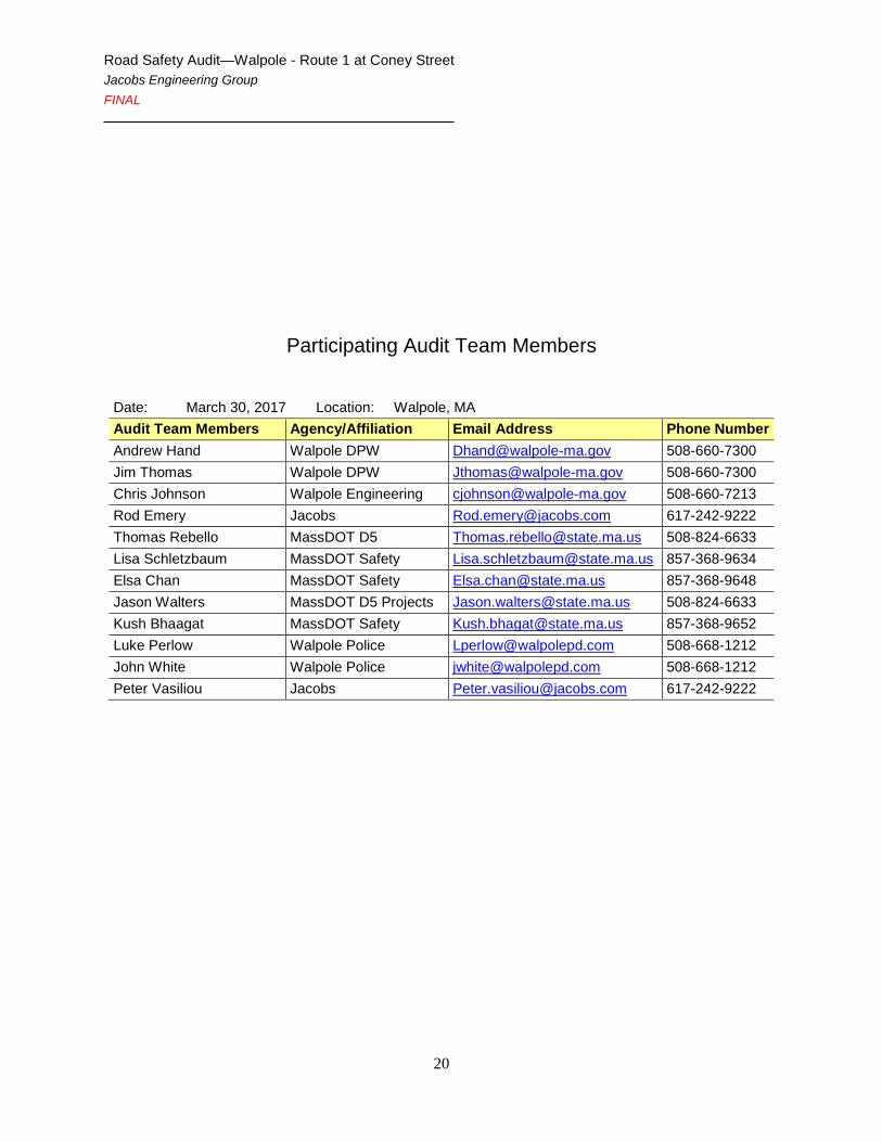
Appendix B. RSA Audit Team Contact List
Road Safety Audit—Walpole - Route 1 at Coney Street Jacobs Engineering Group FINAL
20
Participating Audit Team Members
Date: March 30, 2017 Location: Walpole, MA Audit Team Members Agency/Affiliation Email Address Phone Number Andrew Hand Walpole DPW [email protected] 508-660-7300 Jim Thomas Walpole DPW [email protected] 508-660-7300 Chris Johnson Walpole Engineering [email protected] 508-660-7213 Rod Emery Jacobs [email protected] 617-242-9222 Thomas Rebello MassDOT D5 [email protected] 508-824-6633 Lisa Schletzbaum MassDOT Safety [email protected] 857-368-9634 Elsa Chan MassDOT Safety [email protected] 857-368-9648 Jason Walters MassDOT D5 Projects [email protected] 508-824-6633 Kush Bhaagat MassDOT Safety [email protected] 857-368-9652 Luke Perlow Walpole Police [email protected] 508-668-1212 John White Walpole Police [email protected] 508-668-1212 Peter Vasiliou Jacobs [email protected] 617-242-9222

Road Safety Audit—Walpole - Route 1 at Coney Street Jacobs Engineering Group FINAL
21
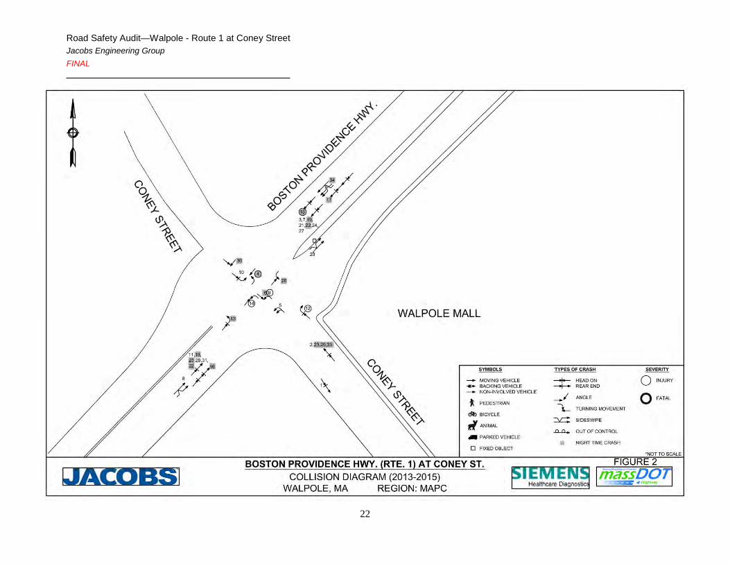
Appendix C. Detailed Crash Data
Road Safety Audit—Walpole - Route 1 at Coney Street Jacobs Engineering Group FINAL
22

Road Safety Audit—Walpole - Route 1 at Coney Street Jacobs Engineering Group FINAL
23
Road Safety Audit—Walpole - Route 1 at Coney Street Jacobs Engineering Group FINAL
24
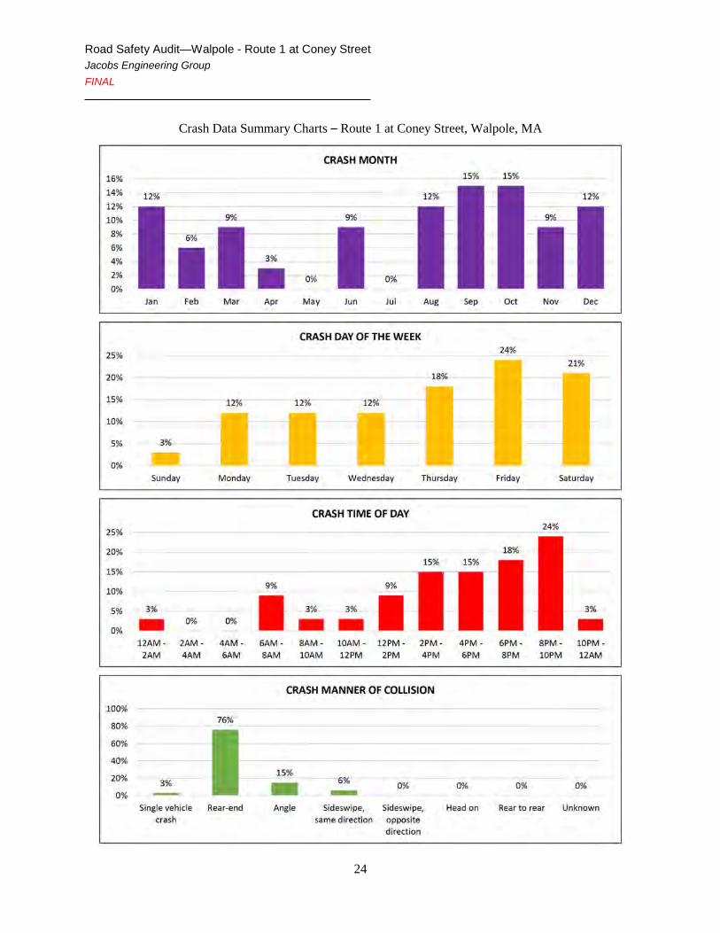
Crash Data Summary Charts – Route 1 at Coney Street, Walpole, MA

Road Safety Audit—Walpole - Route 1 at Coney Street Jacobs Engineering Group FINAL
25
Crash Data Summary Charts – Route 1 at Coney Street, Walpole, MA

Road Safety Audit—Walpole - Route 1 at Coney Street Jacobs Engineering Group FINAL
26
Appendix D. Additional Information

Road Safety Audit—Walpole - Route 1 at Coney Street Jacobs Engineering Group FINAL
27

Road Safety Audit—Walpole - Route 1 at Coney Street Jacobs Engineering Group FINAL
28

Road Safety Audit—Walpole - Route 1 at Coney Street Jacobs Engineering Group FINAL
29
Appendix E. Road Safety Audit References

Road Safety Audit—Walpole - Route 1 at Coney Street Jacobs Engineering Group FINAL
30
Road Safety Audit References
Massachusetts Traffic Safety Toolbox, Massachusetts Highway Department, www.mhd.state.ma.us/safetytoolbox.
Road Safety Audits, A Synthesis of Highway Practice. NCHRP Synthesis 336. Transportation Research Board, National Cooperative Highway Research Program, 2004.
Road Safety Audits. Institute of Transportation Engineers and U.S. Department of Transportation, Federal Highway Administration, www.roadwaysafetyaudits.org.
FHWA Road Safety Audit Guidelines. U.S. Department of Transportation, Federal Highway Administration, 2006.
Road Safety Audit, 2nd edition. Austroads, 2000.
Road Safety Audits. ITE Technical Council Committee 4S-7. Institute of Transportation Engineers, February 1995.