road safety audit - welcome to massdot of road safety audit ... jim coogan cdr maguire traffic...
TRANSCRIPT

ROAD SAFETY AUDIT
East Main Street (Route 16) at Medway Road (Route 109), East Main Street (Route 16) at Quarry Square Driveways,
East Main Street (Route 16) at Beaver Street/ Fortune Boulevard
Town of Milford
May 18, 2017
Prepared For:
MassDOT
On Behalf Of: Town of Milford
Prepared By: CDR Maguire Inc.
2 Granite Avenue, Suite 150 Milton, MA

Road Safety Audit—Route 16 (East Main Street), Milford, MA Prepared by CDR Maguire Inc. FINAL
Table of Contents Background ................................................................................................................................. 1
Project Data ................................................................................................................................. 1
Project Location and Description .............................................................................................. 2 Medway Road (Route 109)/Prairie Street at East Main Street (Route 16) .......................................... 4 Quarry Square Driveways at East Main Street (Route 16) .................................................................. 6 Beaver Street/Fortune Boulevard at East Main Street (Route 16) ....................................................... 8
Audit Observations and Potential Safety Enhancements...................................................... 10 Medway Road (Route 109)/Prairie Street at East Main Street (Route 16) ........................................ 10
Safety Issue 1: Left-Turn Lane Trap .......................................................................................... 10 Safety Issue 2: Access Management .......................................................................................... 11 Safety Issue 3: Truck Turning Movements ................................................................................ 12 Safety Issue 4: Bicycle Accommodations .................................................................................. 13 Safety Issue 5: Pedestrian Accommodations ............................................................................. 13 Safety Issue 6: Signing and Pavement Marking ........................................................................ 14 Safety Issue 7: Signal Visibility ................................................................................................. 15
Quarry Square Driveways at East Main Street (Route 16) ................................................................ 15 Safety Issue 1: Access Management .......................................................................................... 15 Safety Issue 2: Sight Line Obstruction ...................................................................................... 16 Safety Issue 3: Speed Limits ...................................................................................................... 17 Safety Issue 4: Roadway Geometry ........................................................................................... 17 Safety Issue 5: Bicycle Accommodations .................................................................................. 18 Safety Issue 6: Pedestrian Accommodations ............................................................................. 18 Safety Issue 7: Signing and Pavement Marking ........................................................................ 18
Beaver Street/Fortune Boulevard at East Main Street (Route 16) ..................................................... 19 Safety Issue 1: Mismatched Approach and Receiving Lanes .................................................... 19 Safety Issue 2: Truck Turning Movements ................................................................................ 20 Safety Issue 3: Drainage ............................................................................................................ 21 Safety Issue 4: Bicycle Accommodations .................................................................................. 21 Safety Issue 5: Pedestrian Accommodations ............................................................................. 22 Safety Issue 6: Signing and Pavement Marking ........................................................................ 22 Safety Issue 7: Signal Phasing and Timing ................................................................................ 23 Safety Issue 8: Signal Visibility ................................................................................................. 23
Summary of Road Safety Audit ............................................................................................... 24

Road Safety Audit—Route 16 (East Main Street), Milford, MA Prepared by CDR Maguire Inc. FINAL
List of Appendices
Appendix A. RSA Meeting Agenda Appendix B. RSA Audit Team Contact List Appendix C. Detailed Crash Data Appendix D. Road Safety Audit References
List of Figures
Figure 1: Locus Map .................................................................................................................................. 3 Figure 2: Intersection of Medway Road (Route 109)/Prairie Street at East Main Street (Route 16) ......... 5 Figure 3: Driveways on Medway Road (Route 109) Near East Main Street (Route 16) ........................... 6 Figure 4: Quarry Square Driveways at East Main Street (Route 16) ......................................................... 7 Figure 5: Intersection of Beaver Street/Fortune Boulevard at East Main Street (Route 16) ...................... 8
List of Tables
Table 1: Participating Audit Team Members ............................................................................................. 2 Table 2: Estimated Safety Payoff, Time Frame, and Costs Breakdown .................................................. 25 Table 3: Potential Safety Enhancement Summary ................................................................................... 26

Road Safety Audit—Route 16 (East Main Street), Milford, MA Prepared by CDR Maguire Inc. FINAL
Page 1
Background In an effort to reduce the number of crash-related fatalities and serious injuries throughout the Commonwealth, the Massachusetts Department of Transportation (MassDOT) has developed a Strategic Highway Safety Plan (SHSP). The mission of the original SHSP (2006) was to “Develop, promote, implement, and evaluate data-driven, multidisciplinary strategies to maximize safety for users of the roadway system.” One of the many strategies noted in the current (2013) SHSP’s Emphasis Area Action Plans is to conduct Road Safety Audits (RSAs) at high-crash locations. A Road Safety Audit, as defined by the Federal Highway Administration (FHWA) is “a formal safety performance examination of an existing or future road or intersection by an independent, multidisciplinary team.” Simply stated, an RSA is a relatively quick process that identifies opportunities for safety improvements focused on decreasing the number and severity of roadway crashes. The safety improvements yielded from the process can vary from low cost measures to significant improvement projects.
MassDOT’s Highway Safety Improvement Program (HSIP) has identified several HSIP-eligible “clusters” of crashes in the town of Milford, Massachusetts. This RSA focuses on three of these clusters: Medway Road (Route 109) near the intersection with East Main Street (Route 16) and Prairie Street, East Main Street (Route 16) just east of the intersection with Medway Road (Route 109) and Prairie Street, and the intersection of East Main Street (Route 16) with Beaver Street and Fortune Boulevard. The first two clusters were identified in the most recent three-year period of crash data available (2012-2014), while all three clusters appear in the previous (2011-2013) data set.
Project Data The RSA meeting for East Main Street (Route 16) was held on Tuesday, March 21, 2017 at Milford Town Hall, 52 Main Street in Milford, Massachusetts, and included a field visit to the study area.
The agenda for the RSA meeting is provided in Appendix A of this report. As shown in Table 1, the audit team was multidisciplinary with representatives from state and local agencies, providing expertise in engineering, planning, and public safety. Contact information for the RSA attendees is provided in Appendix B.
Detailed crash data for the three-year period from 2013 to 2015, including collision diagrams and crash data summaries for the study area, were provided as background material within the email invitation sent on March 15, 2017 to each participant in the RSA, and they are provided in Appendix C of this report. During the RSA meeting, these materials were reviewed as a group prior to the field visit to the study area sites. During the RSA field visit, various safety issues were observed and identified. Following the RSA field visit, the team returned to the meeting location to discuss opportunities to eliminate or mitigate the identified safety issues and to finalize the list of potential safety enhancements.

Road Safety Audit—Route 16 (East Main Street), Milford, MA Prepared by CDR Maguire Inc. FINAL
Page 2
Table 1: Participating Audit Team Members Audit Team Member Agency/Affiliation Elsa Chan MassDOT Traffic Safety Kevin Fitzgerald MassDOT Traffic Safety Adam Prichard MassDOT Traffic Safety Erin Kinahan MassDOT District Traffic Engineer Rick Villani Milford Town Administrator Michael Dean Milford Town Engineer Larry Dunkin Milford Town Planner Scott Crisafulli Milford Highway Surveyor Lt. James Falvey Milford Police Department Bill Touhey Milford Fire Department Jim Coogan CDR Maguire Traffic Engineer Adina Alpert CDR Maguire Traffic Engineer
Project Location and Description The design project associated with this RSA addresses a 0.8-mile segment of East Main Street (Route 16) extending from just west of the intersection with Medway Road (Route 109) and Prairie Street east to the intersection with Beaver Street and Fortune Boulevard, as well as a short section of the Medway Road approach to the East Main Street (Route 16) intersection.
Three sites within this design corridor were identified as crash “clusters” and are thus the subject of this Road Safety Audit:
• Medway Road (Route 109)/Prairie Street at East Main Street (Route 16): Intersection of East Main Street (Route 16) at Medway Road (Route 109) and Prairie Street, including about 500 feet of Medway Road
• Quarry Square Driveways at East Main Street (Route 16): Segment of East Main Street (Route 16) in the vicinity of the two driveways leading to Quarry Square Plaza
• Beaver Street/Fortune Boulevard at East Main Street (Route 16): Intersection of East Main Street (Route 16) at Beaver Street and Fortune Boulevard
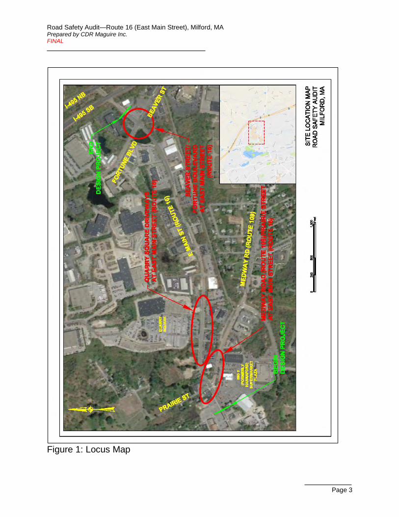
A locus map of the study area is provided in Figure 1.
Road Safety Audit—Route 16 (East Main Street), Milford, MA Prepared by CDR Maguire Inc. FINAL
Page 3
Figure 1: Locus Map

Road Safety Audit—Route 16 (East Main Street), Milford, MA Prepared by CDR Maguire Inc. FINAL
Page 4
Route 16 is a 60-mile long east-west highway running from the Town of Webster near the Connecticut border in the west to the City of Revere in the east. Along the 0.8-mile segment of this roadway included in the design project, Route 16 is locally named East Main Street, and it is classified as an urban principal arterial. The segment begins just west of the intersection with Medway Road (Route 109) and Prairie Street, and it continues east to the intersection with Beaver Street and Fortune Boulevard. East Main Street (Route 16) is an undivided roadway varying between a four-lane and a two-lane section within this segment. It is under MassDOT jurisdiction throughout this segment, with the exception of the west leg of the Medway Road (Route 109) intersection, which is under Town jurisdiction. The posted speed limit on the west end is 30 miles per hour (MPH). On the east end of the segment, it is posted as 45 MPH for eastbound and presumed to be the same for westbound. The speed-limit change occurs for eastbound between the two driveways for the Quarry Square retail plaza, and the westbound change occurs approximately 550 feet farther east, where the roadway transitions from a two-lane to a four-lane roadway.
Route 109 is a 21-mile long east-west highway beginning at the intersection with Route 16 in Milford in the west and continuing to the VFW Parkway in Boston in the east. The RSA study area includes the first 500 feet on the west end. Along this segment, Route 109 is locally named Medway Road, and it is classified as an urban principal arterial under Town jurisdiction. Medway Road (Route 109) is an undivided roadway with one lane eastbound and two lanes westbound within the study area segment. The speed limit is not posted but is assumed to be 30 MPH as is typical for a roadway such as this in a thickly settled area.
The Road Safety Audit sites are further described for evaluation purposes as follows:
Medway Road (Route 109)/Prairie Street at East Main Street (Route 16) This site is located at the west end of the study area and includes the signalized intersection of East Main Street (Route 16) at Medway Road (Route 109) and Prairie Street, plus about 500 feet of Medway Road.
The intersection, shown in Figure 2, has four approaches: eastbound and westbound East Main Street (Route 16), westbound Medway Road (Route 109), and southbound Prairie Street. Westbound Medway Road (Route 109) serves as the northbound approach to the intersection. Both East Main Street (Route 16) and Medway Road (Route 109) are classified as urban principal arterials, and Prairie Street is a local roadway. The east leg of East Main Street (Route 16) is under MassDOT jurisdiction, and the other three legs of the intersection, including the west leg of East Main Street (Route 16), are under Town jurisdiction. The speed limit on East Main Street (Route 16) and Medway Road (Route 109) is 30 MPH. The speed limit on Prairie Street is 20 MPH.

Road Safety Audit—Route 16 (East Main Street), Milford, MA Prepared by CDR Maguire Inc. FINAL
Page 5
Figure 2: Intersection of Medway Road (Route 109)/Prairie Street at East Main Street (Route 16)
The eastbound approach of East Main Street (Route 16) consists of a 12-foot shared left-turn/through lane that is 70 feet in length, a 12-foot through lane, and a 17-foot channelized right-turn lane. The channelized right-turn lane is under yield control. The East Main Street (Route 16) westbound approach consists of a 12-foot exclusive left-turn lane that is 75 feet in length and an 11-foot shared through/right-turn lane. The Medway Road (Route 109) northbound approach is slightly skewed relative to the other legs. It consists of a 12-foot shared left-turn/through lane and a 13-foot exclusive right-turn lane. A raised center median is provided on the final 60 feet of the northbound approach. The Prairie Street north leg is approximately 27 feet wide with no lane striping; as such, the southbound approach consists of a single shared lane for left-turn, through, and right-turn movements.
The traffic signal at this intersection operates in 4 phases, with an advanced left-turn phase for the westbound approach, split phases for the southbound Prairie Street and northbound Medway Road (Route 109) approaches, and concurrent pedestrian phasing. Sidewalks are provided on both sides of East Main Street (Route 16) and on the south (west) side of Medway Road (Route 109). Crosswalks, pedestrian signal heads, and pushbuttons are provided across the north, south, and west legs. The median island on the south leg provides a newly-constructed pedestrian refuge but provides no additional pushbuttons.
This site includes the 500-foot segment of Medway Road (Route 109) adjacent to the intersection which is, in fact, the location of the crash cluster at this site, shown in Figure 3. Located along this segment are

Road Safety Audit—Route 16 (East Main Street), Milford, MA Prepared by CDR Maguire Inc. FINAL
Page 6
two unsignalized driveways situated across from each other: the driveway to the E-Z Way Car Wash located on the north (east) side of the roadway at a distance of 250-400 feet in advance of the signalized intersection, and the driveway by Five Guys (that leads into the Big Y supermarket plaza) located on the south (west) side approximately 300 feet before the signalized intersection.
Figure 3: Driveways on Medway Road (Route 109) Near East Main Street (Route 16) The Upper Charles Trail multi-use path crosses Medway Road approximately 1200 feet east (south) of the intersection with East Main Street (Route 16).
The 50 crashes at this site over the three-year period from 2013 to 2015 yield a crash rate of 2.04 crashes per million entering vehicles (MEV), more than twice the average rate for signalized intersections in MassDOT District 3 of 0.90 crashes per MEV. Twenty-two of those crashes were related to the driveways on Medway Road (Route 109) for Five Guys and the E-Z Way Car Wash, and at least 16 of those were angle crashes specifically involving left turns. Eight of the 50 crashes were rear-end crashes on the northbound (westbound) Medway Road (Route 109) approach to the intersection.
Quarry Square Driveways at East Main Street (Route 16) This site is located slightly east of the Medway Road (Route 109)/Prairie Street intersection, near the west end of the study area. It covers a segment of East Main Street (Route 16), from Medway Road (Route 109)/Prairie Street to where the roadway cross-section changes from four lanes to two, approximately one

Road Safety Audit—Route 16 (East Main Street), Milford, MA Prepared by CDR Maguire Inc. FINAL
Page 7
quarter mile east of that signalized intersection. This roadway segment includes several unsignalized driveway intersections, primarily serving retail/commercial land uses. Most notably, there are two driveway access points to the Quarry Square retail plaza on the north side of East Main Street (Route 16) located approximately 300 feet apart. The majority of crashes at this site occur at these two driveways. The site is shown in Figure 4.
Figure 4: Quarry Square Driveways at East Main Street (Route 16) Throughout this segment, East Main Street (Route 16) is classified as an urban principal arterial, and it is under MassDOT jurisdiction. It has two travel lanes in each direction, separated by a double-yellow line. The speed limit for westbound traffic reduces from 45 MPH to 30 MPH just before entering the segment. The speed limit for eastbound traffic increases from 30 MPH to 45 MPH in between the Quarry Square driveways.
There are retail/commercial driveways located opposite the Quarry Square driveways on the south side of East Main Street (Route 16), so each of the Quarry Square driveways forms a four-legged, unsignalized intersection with the main roadway. The west Quarry Square driveway is unstriped and measures 30 feet in width prior to the curb returns. It is stop-controlled, and left turns are prohibited out of this driveway. The driveway on the opposite side of the roadway, serving the D’Angelo sandwich shop, Pepperoncini’s restaurant, and other businesses, is unstriped and measures approximately 22 feet wide. It has no stop sign or other traffic control signage. It is offset to the west of the opposing Quarry Square driveway by approximately 50 feet, measured center-on-center.
The east Quarry Square driveway has a raised median separating inbound and outbound traffic. The driveway approach to the main roadway is unstriped and measures 24 feet in width, wide enough for

Road Safety Audit—Route 16 (East Main Street), Milford, MA Prepared by CDR Maguire Inc. FINAL
Page 8
vehicles to form two lanes of traffic, which they tend to do: one lane for left-turning and through traffic, and one lane for right-turning traffic. The approach is stop sign-controlled. The driveway on the opposite side of the roadway, serving Bank of America and other businesses, with a connection to the CVS located behind on Medway Road (Route 109), is unstriped and measures 30 feet wide prior to the curb returns. It has no stop sign or other traffic control signage.
The 38 crashes at this site yield a crash rate of 11.63 crashes per million vehicle miles traveled (MVMT), more than three times the average rate for roadway segments in MassDOT District 3 of 3.34 crashes per MVMT. Twenty-eight of those crashes were related to the Quarry Square driveways or the driveways opposite them.
Beaver Street/Fortune Boulevard at East Main Street (Route 16) This site is located at the east end of the study area and consists of the signalized intersection of East Main Street (Route 16) at Beaver Street and Fortune Boulevard, as shown in Figure 5.
Figure 5: Intersection of Beaver Street/Fortune Boulevard at East Main Street (Route 16) The intersection has four approaches: eastbound and westbound East Main Street (Route 16), northbound Beaver Street, and southbound Fortune Boulevard. East Main Street (Route 16) is classified as an urban principal arterial and is under MassDOT jurisdiction. Beaver Street is classified as an urban minor arterial

Road Safety Audit—Route 16 (East Main Street), Milford, MA Prepared by CDR Maguire Inc. FINAL
Page 9
under Town jurisdiction. Fortune Boulevard is classified as a local roadway under Town jurisdiction, but it is functionally characteristic of a collector or urban minor arterial. The speed limit on East Main Street (Route 16) is 45 MPH. The speed limits on Beaver Street and Fortune Boulevard are not posted but are assumed to be 30 MPH as is typical for roadways such as these in a thickly settled area.
The eastbound approach of East Main Street (Route 16) consists of a 12-foot shared left-turn/through lane and a 12-foot shared through/right-turn lane. The East Main Street (Route 16) westbound approach consists of an 11-foot shared left-turn/through lane that is 175 feet in length, an 11-foot through lane, and an 11-foot exclusive right-turn lane that is 90 feet in length. The Beaver Street northbound approach consists of a 10-foot shared left-turn/through lane and an 11-foot shared through/right-turn lane. The Fortune Boulevard southbound approach consists of an 11-foot exclusive left-turn lane 285 feet in length and a 15-foot shared through/right-turn lane.
The traffic signal at this intersection operates in 4 phases, with an advanced left-turn phase for the southbound approach and an exclusive pedestrian phase. MassDOT has recently equipped the system with a flashing yellow left arrow indication for the southbound left-turn’s permissive movement. Sidewalks are provided on both sides of Fortune Boulevard, on the south side of East Main Street (Route 16)’s east leg, and for approximately 200 feet from the intersection on the east side of Beaver Street. Crosswalks, pedestrian signal heads, and pushbuttons are provided across the north and east legs. The Upper Charles Trail multi-use trail crosses Beaver Street approximately 600 feet south of the intersection.
The 29 crashes at this site over the three-year period from 2013 to 2015 yield a crash rate of 0.91 crashes per MEV, just above of the average rate for signalized intersections in MassDOT District 3 of 0.90 crashes per MEV. (The HSIP-eligible crash cluster was identified using data from 2011 to 2013.) Fourteen of those crashes (48%) were angle crashes, six (21%) were rear-end crashes, and five (17%) were same-direction sideswipe crashes.

Road Safety Audit—Route 16 (East Main Street), Milford, MA Prepared by CDR Maguire Inc. FINAL
Page 10
Audit Observations and Potential Safety Enhancements The audit identified a number of safety issues at each of the three sites, and team members discussed possible improvement opportunities to mitigate these issues. These issues and their potential safety enhancements are detailed in this section. The benefits of some of these countermeasures may be best realized in combination with each other, but for the most part they are listed here as separate improvements that may be implemented individually. In some cases, implementation of one improvement would render other identified improvements unnecessary or impractical.
Medway Road (Route 109)/Prairie Street at East Main Street (Route 16)
Safety Issue 1: Left-Turn Lane Trap To the east of the intersection, East Main Street (Route 16) consists of two travel lanes in each direction. On the approach to the intersection, the left westbound lane becomes an exclusive left-turn lane, approximately 75 feet in advance of the stop line, as shown in Figure 2 and Image 1. This lane-drop configuration is often called a left-turn lane trap. The transition from a general-purpose travel lane to an exclusive turn lane at this location is abrupt with no advanced warning. This configuration creates a situation where vehicles attempt to make last-moment lane changes, particularly from the left lane to the right lane in order to continue going straight. As observed in the field, vehicles sometimes make a through movement from the left lane, probably having not noticed the change in lane configuration in time to merge before the intersection, which results in a merge situation within or just beyond the intersection that is unexpected for drivers in the other lane. Two sideswipe crashes identified in the crash history analysis are likely attributed to this issue, where a vehicle in the left lane attempted a sudden lane change to the right on the approach to or within the intersection, striking a vehicle to its right.
Image 1: Westbound Approach to Medway Road (Route 109) Intersection with Left-Turn Lane Trap
Enhancements:
Advanced warning signage and associated pavement markings could be installed on the intersection’s westbound approach to warn of the lane drop and/or indicate that the left travel lane becomes an exclusive left-turn lane. Signage could include a “Left Lane Must Turn Left” sign (R3-7L) or a graphical advance intersection lane control sign (R3-8). Supplementally, a left-turn only sign (R3-5L) could be posted on the signal mast arm over the projection of the left lane to emphasize the lane use designation. Pavement markings could include a wide dotted white lane line in advance of the turning lane bay (MUTCD Figure 3B-11A).

Road Safety Audit—Route 16 (East Main Street), Milford, MA Prepared by CDR Maguire Inc. FINAL
Page 11
Alternatively, this issue could be addressed by converting the left lane into a shared lane to include through movements. It could be evaluated whether this lane use change would be operationally beneficial and geometrically feasible.
This issue could also be addressed by the road diet discussed below for the Quarry Square Driveways location, wherein the number of westbound travel lanes in advance of the intersection would be reduced from two to one, eliminating the left-turn trap situation.
Safety Issue 2: Access Management Another issue identified at this site is the access control at the two driveways located across from each other on Medway Road (Route 109) a few hundred feet east (south) of the intersection: the E-Z Way Car Wash driveway on the north side of the road and the Five Guys driveway on the south side, shown in Figure 3 and Image 2. This roadway segment experienced 22 crashes in the three-year period specifically related to access of those driveways, eight resulting in injuries. Of those 22 crashes, at least 16 involved vehicles attempting left turns into or out of those driveways or attempting to cross Medway Road (Route 109) from one driveway to the other. Nine of them in particular involved angle crashes of eastbound vehicles attempting to turn left into the car wash driveway and colliding with westbound vehicles, and at
least four of those crashes were courtesy crashes. (The term “courtesy crash” is used to describe a crash that occurs subsequent to a non-involved mainline driver giving the right-of-way, contrary to the rules of the road, to another driver. In all of the courtesy crashes at this location, a driver in the westbound left lane stopped to allow an eastbound left-turning vehicle through, and the turning vehicle then collided with a vehicle in the westbound right lane.)
Image 2: E-Z Way Carwash Driveway (left) and Five Guys Driveway (right) on Medway Road (Route 109)
Another contributing factor to the high crash rate at this location may be that the car wash driveway is 160 feet wide, which could be causing driver confusion in the delineation of movements.
Enhancements:
Crashes involving left turns and crossing movements could be mitigated with turn restrictions, which would reduce the number of conflict points. One method to implement turn restrictions would be to install signage: No Left Turn signs (R3-2) at the driveways for both directions of Medway Road (Route 109) and Right Turn Only signs (R3-5) for the driveway exits. The effectiveness of this measure would be subject to driver compliance. An alternative method that would better ensure compliance would be to install a raised center median, or perhaps flexible posts, on Medway Road (Route 109) in the vicinity of those driveways, physically preventing those turning movements. This median could be an extension of the existing median at the intersection on this leg. Installation of a median might involve right-of-way considerations for the added roadway width needed. Implementing turn restrictions would involve coordination with the property owners.

Road Safety Audit—Route 16 (East Main Street), Milford, MA Prepared by CDR Maguire Inc. FINAL
Page 12
The driveway in front of Five Guys is one of many driveways into the Big Y retail plaza, so that even with turn restrictions at this particular driveway, vehicles would still have full access to the plaza. Conversely, turn restrictions at the car wash driveway would prevent all but westbound (northbound) traffic on Medway Road (Route 109) from entering, and they would prevent exiting vehicles from accessing Medway Road (Route 109) to the east (south). There are no designated U-turns or turn-around opportunities within the public way in the vicinity to assist in maintaining the current level of access. A possible remedy would be to designate the existing loop road in front of CVS, located 220-570 feet east (south) of the car wash driveway on the north (east) side of the road, as a turn-around point for eastbound (southbound) traffic to access the car wash. The feasibility of incorporating this loop road would need to be evaluated, and implementation would involve signage and pavement marking additions.
In coordination with the property owner, the oversized car wash driveway could be modified using access management techniques, such as narrowing it or dividing it, to better delineate movements within the driveway area.
Safety Issue 3: Truck Turning Movements During the field visit, it was noted that there are tire tracks in the mud outside the curb on the southeast corner of the intersection (Image 3), which indicates that larger vehicles may be having difficulty making the right turn from northbound Medway Road (Route 109) to eastbound East Main Street (Route 16). If the curb radius is insufficient at that corner, not only would some trucks climb the curb to make the turn, but others may be breaching the adjacent lane by steering wide on the turn. In fact, one crash at this site occurred when a truck attempted a wide right turn and collided with a vehicle in the adjacent lane. This issue could be mitigated by increasing the curb radius on this corner to facilitate truck turning movements.
Image 3: Tire Tracks on Southeast Corner of Intersection
It was further observed that large trucks turning left from westbound East Main Street (Route 16) onto Medway Road (Route 109) are just barely able to fit between the islands on the Medway Road receiving bay.
Enhancements:
These issues could be mitigated by increasing the curb radius on the southeast corner to facilitate northbound truck turning movements, and possibly reducing island sizes on Medway Road (Route 109) to provide a wider receiving bay for the westbound left-turning trucks. Furthermore, the locations of the existing signal poles on those islands could be adjusted away from the receiving bay, which would reduce the potential for the poles being struck by turning trucks.
Road Safety Audit—Route 16 (East Main Street), Milford, MA Prepared by CDR Maguire Inc. FINAL
Page 13
Safety Issue 4: Bicycle Accommodations The three-year crash data included no bicycle-related incidents at this site. However, the audit identified a few issues with bicycle accommodations at the site that could be improved.
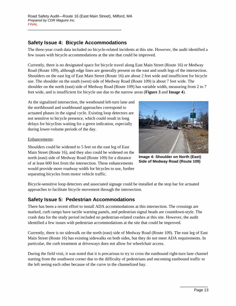
Currently, there is no designated space for bicycle travel along East Main Street (Route 16) or Medway Road (Route 109), although edge lines are generally present on the east and south legs of the intersection. Shoulders on the east leg of East Main Street (Route 16) are about 2 feet wide and insufficient for bicycle use. The shoulder on the south (west) side of Medway Road (Route 109) is about 7 feet wide. The shoulder on the north (east) side of Medway Road (Route 109) has variable width, measuring from 2 to 7 feet wide, and is insufficient for bicycle use due to the narrow areas (Figure 3 and Image 4).
Image 4: Shoulder on North (East) Side of Medway Road (Route 109)
At the signalized intersection, the westbound left-turn lane and the northbound and southbound approaches correspond to actuated phases in the signal cycle. Existing loop detectors are not sensitive to bicycle presence, which could result in long delays for bicyclists waiting for a green indication, especially during lower-volume periods of the day.
Enhancements:
Shoulders could be widened to 5 feet on the east leg of East Main Street (Route 16), and they also could be widened on the north (east) side of Medway Road (Route 109) for a distance of at least 600 feet from the intersection. These enhancements would provide more roadway width for bicycles to use, further separating bicycles from motor vehicle traffic.
Bicycle-sensitive loop detectors and associated signage could be installed at the stop bar for actuated approaches to facilitate bicycle movement through the intersection.
Safety Issue 5: Pedestrian Accommodations There has been a recent effort to install ADA accommodations at this intersection. The crossings are marked, curb ramps have tactile warning panels, and pedestrian signal heads are countdown-style. The crash data for the study period included no pedestrian-related crashes at this site. However, the audit identified a few issues with pedestrian accommodations at the site that could be improved.
Currently, there is no sidewalk on the north (east) side of Medway Road (Route 109). The east leg of East Main Street (Route 16) has existing sidewalks on both sides, but they do not meet ADA requirements. In particular, the curb treatment at driveways does not allow for wheelchair access.
During the field visit, it was noted that it is precarious to try to cross the eastbound right-turn lane channel starting from the southwest corner due to the difficulty of pedestrians and oncoming eastbound traffic to the left seeing each other because of the curve in the channelized bay.

Road Safety Audit—Route 16 (East Main Street), Milford, MA Prepared by CDR Maguire Inc. FINAL
Page 14
The existing median on the south leg of the intersection encroaches upon the crosswalk, and ramps on the median do not align with the crosswalk, as shown in Image 5. It appears that the median ramp was designed with the intention of the median providing pedestrian refuge. However, there is no pedestrian pushbutton located on that median, which makes pedestrian refuge problematic. Further, the existing phase split and pedestrian clearance time for the crossing of that leg appear to be insufficient for a pedestrian to complete the full crossing without the need for pedestrian refuge.
Image 5: Median on South Leg of Intersection During the field visit, it was noted that the pedestrian clearance time for the west leg crossing also may be insufficient, and the existing pedestrian pushbuttons are not Accessible Pedestrian Signals (APS) pushbuttons.
Enhancements:
A sidewalk could be installed on the north (east) side of Medway Road, and the sidewalks on the east leg of East Main Street (Route 16) could be rebuilt to comply with current standards.
As a safety enhancement for the crosswalk across the right-turn channel, signage to mark the pedestrian crossing (W11-2 supplemented with W16-7P arrow) could be installed for eastbound right-turning traffic, ideally on both sides. A Yield Here To Pedestrians sign (R1-5 or R1-5a) could be installed in advance of the crossing. A yield line (triangles) could be installed in advance of the crosswalk, though its placement would need to consider the merge-condition yield at the end of the turn bay. These measures would serve to alert to drivers to be aware of possible pedestrians crossing.
To address the crosswalk issues across the south leg of the intersection, the crosswalk could be restriped to align with the existing median ramps and a pedestrian pushbutton could be installed on the median to provide pedestrian refuge. Alternatively, the signal timing could be updated in the signal controller to provide the minimum phase split and pedestrian clearance time needed for the full crossing without median refuge, and the median terminus could be pulled back so that is clears the crosswalk. The existing signal pole on the median would need to be relocated to accommodate the new median configuration. Either of these measures would provide appropriate pedestrian crossing times and a more consistent pedestrian crossing of the intersection’s south leg.
Pedestrian timings could be updated to meet MUTCD requirements and provide pedestrians sufficient crossing time for the crossing of the west leg of East Main Street (Route 16). APS pushbuttons could be installed for all crossings to improve accessibility and pedestrian mobility.
Safety Issue 6: Signing and Pavement Marking In addition to signing and pavement marking enhancements discussed previously as part of potential countermeasures for identified issues, another issue was identified that is specific to signing and pavement markings. Eastbound right-turning traffic has a yield condition at the end of the turn bay where traffic merges with southbound traffic. At present, there is a yield sign on either side of the turn bay

Road Safety Audit—Route 16 (East Main Street), Milford, MA Prepared by CDR Maguire Inc. FINAL
Page 15
located well in advance of the yield point for the merge. The position of the left yield sign is near the nose of the channelizing island (Image 6), which creates ambiguity as to which traffic stream the sign refers to, since it could be construed as applying to eastbound through traffic. Also, the sign is small and is mounted on a short post.
Image 6: Yield Sign for Channelized Right-Turn Lane
Enhancements:
The position of both Yield signs for the eastbound channelized right turn could be adjusted so they are located closer to the yield point, emphasizing the yield point location and improving compliance, and the small sign could be replaced with a larger sign panel and mounted at the proper height. Due to the curve of the turn bay, the sign on the right might be more difficult to see on the approach if it is moved downstream. However, the presence of the sign on the left plus an existing advanced warning “Yield Ahead” sign should be sufficient. Placement of these signs would need to take into account placement of any signs related to the pedestrian crossing, as discussed previously. Installation of a yield line (triangles) could be considered, in coordination with those pedestrian crossing improvements.
Safety Issue 7: Signal Visibility Traffic signal equipment at this site is generally in good condition. Beyond the signal improvements discussed previously as countermeasures to other specific issues, the audit also revealed two issues related to signal visibility. None of the signal heads have backplates. Also, signal visibility is limited by horizontal curves on the westbound and northbound approaches.
Enhancements:
Backplates with retroreflective borders could be installed for mast-arm mounted signal heads on the eastbound and westbound approaches to mitigate sun glare effects. Adding Signal Ahead (W3-3) warning signs on the westbound and northbound approaches could assist in reducing the potential for rear-end crashes and red-light running.
Quarry Square Driveways at East Main Street (Route 16)
Safety Issue 1: Access Management A number of issues at this site emerged from the audit process specifically related to crash frequency and particular patterns of crashes. Many of the crashes along this roadway segment were angle crashes involving vehicles turning into or out of the two Quarry Square driveways or the opposing driveways on the south side of the road. The driveway intersections are currently unsignalized, as shown in Figure 4 and Image 7 through Image 10.
The west driveway approach to the main road has a left-turn prohibition, indicated by a faded No Left Turn (R3-2) sign posted atop the Stop sign on the approach. Nevertheless, field observations during the audit and turning movement counts recorded in January 2017 both indicate that drivers regularly ignore

Road Safety Audit—Route 16 (East Main Street), Milford, MA Prepared by CDR Maguire Inc. FINAL
Page 16
that sign and make an illegal left turn out of that driveway. Those illegal left turns pose both safety and operational issues by introducing additional conflict points and adding to the delay experienced by vehicles queued behind a left-turning vehicle.
Image 7: Looking East on Route 16 with Quarry Square West Driveway on Left
Enhancements:
At this location, the patterns of angle crashes involving these driveways suggest that installing traffic signals could reduce crash frequency. These driveway intersections could be evaluated for whether they meet the traffic signal warrants specified in the Manual on Uniform Traffic Control Devices (MUTCD), and then potential installation of traffic signals at one or both of these intersections could be assessed. As these driveways are located approximately 300 feet apart, the assessment should consider the operational effects at both driveways of applying signalization to one, the other, or both locations. If both driveways were to be signalized, the signals could either operate off a single traffic signal controller or be coordinated with each other. A traffic signal advanced warning sign could be installed for westbound traffic due to a hill and horizontal curve on the approach limiting visibility, especially for a signal at the east driveway location.
Audit team members recalled there used to be a median island on the west driveway that channeled exiting traffic into the right-turn movement, and there even may have been a permit requirement mandating its presence. The permit requirement could not be confirmed. Independent of the permit requirement, that median island could be reinstalled, which would help deter left-turn movements. The faded No Left Turn sign could be replaced, and additional No Left Turn signs could be installed in view of exiting traffic on the south side of the road and/or in the new median island for improved compliance.
As a related improvement, prohibiting left turns out of the driveways on the south side of the road opposite the Quarry Square driveways could be a safety enhancement. However, the seemingly marginal safety benefits of this prohibition would have to be balanced with the potential retail impacts to abutting business owners.
Safety Issue 2: Sight Line Obstruction Another issue observed for southbound vehicles exiting the west driveway is that the sight line to the left is obstructed by vegetation growing on the northeast corner, as shown in Image 8. Insufficient sight lines could contribute to angle crashes between vehicles exiting that driveway and westbound traffic.
Image 8: Vegetation Obstructing Sight Lines on Northeast Corner of Quarry Square West Driveway Intersection (Looking West Towards Driveway)

Road Safety Audit—Route 16 (East Main Street), Milford, MA Prepared by CDR Maguire Inc. FINAL
Page 17
Enhancements:
The vegetation could be removed, or at least trimmed, to improve visibility for exiting vehicles of oncoming traffic on the main roadway.
Safety Issue 3: Speed Limits The crash history indicates that excessive speed was a contributing factor in at least one of the crashes at this site. It was observed that vehicle speeds on East Main Street (Route 16) may be excessive due to the presence and location of speed limit changes for both directions in the vicinity of this site. The eastbound speed limit increases from 30 MPH to 45 MPH between the Quarry Square driveways (Image 9), and the westbound speed limit decreases from 45 MPH to 30 MPH where the roadway cross-section changes from two lanes to four, approximately 350 feet in advance of the east Quarry Square driveway. Eastbound vehicles may begin to increase their speed hundreds of feet in advance of the sign, resulting in higher speeds across this entire roadway section. And although westbound traffic has undergone a speed limit reduction immediately before entering this section, many vehicles may still be making the speed adjustment as they pass both Quarry Square driveways and traveling well above the 30 MPH speed limit.
Image 9: Looking East on Route 16 with Quarry Square East Driveway on Left and Eastbound 45 MPH Speed Limit Sign on Right
Enhancements:
Speed limits in the corridor could be evaluated to see if the 45 MPH limit is appropriate in the vicinity, and adjustments could be implemented as necessary, including moving the speed transition farther to the east for both directions of travel, in order to reduce travel speeds through the area.
Safety Issue 4: Roadway Geometry Currently, East Main Street (Route 16) is a four-lane roadway in this section (two travel lanes in each direction). The crash history includes many crashes related to vehicles crossing multiple lanes of opposing traffic. For example, six crashes involved vehicles attempting to turn left into driveways and colliding with vehicles in the right lane of opposing traffic that were blocked from view by stopped vehicles in the left lane of opposing traffic (five of the six were specifically courtesy crashes), and seven crashes occurred when vehicles attempted to cross all four lanes of the main roadway from one driveway to the opposing driveway and collided with through vehicles on the main roadway. Furthermore, missing or faded lane markings were a factor in at least six crashes where drivers were unclear on the number of lanes present, but field observations confirm that the lane markings have been refreshed since. There were also three crashes involving vehicles stopped in the left travel lane waiting to turn left: two rear-end crashes, and one angle crash that occurred when a vehicle suddenly changed lanes to get around a stopped left-turning vehicle.

Road Safety Audit—Route 16 (East Main Street), Milford, MA Prepared by CDR Maguire Inc. FINAL
Page 18
Enhancements:
Reducing the number of travel lanes in each direction from two to one would address the particular crash patterns related to multiple travel lanes. Furthermore, removing travel lanes opens the opportunity to add a center two-way left-turn lane (TWLTL) without widening the roadway. A TWLTL would remove left-turning traffic from the travel lanes, which is expected to reduce rear-end and other related crashes.
Therefore, a road diet could be evaluated for implementation through this segment, from the Medway Road (Route 109) intersection on the west end to the transition to the existing two-lane section on the east end. The new lane configuration could be a three-lane section, consisting of a single travel lane in each direction plus a center TWLTL, as well as bike lanes and sidewalks on both sides. The TWLTL could transition to exclusive left-turn lanes at the Quarry Square driveways. It could also transition into the exclusive left-turn lane for the westbound approach to the Medway Road (Route 109) intersection, and, as such, this potential improvement would also address the left-turn trap issue at that site.
Safety Issue 5: Bicycle Accommodations The three-year crash history included two bicycle-related crashes at this site. It was observed during the audit that the existing shoulders on both sides of East Main Street (Route 16) across this site are very narrow and are insufficient for bicycle use.
Enhancements:
Bicycle lanes could be installed on both sides of the roadway, preferably extending well beyond this site to provide connectivity for bicyclists. Adding bicycle lanes could be done in conjunction with the road diet discussed above, or it could be done independently subject to space availability in the roadway cross-section. This improvement would provide more roadway width for bicycles to use, further separating bicycles from motor vehicle traffic.
Safety Issue 6: Pedestrian Accommodations The three-year crash data did not include any pedestrian-related crashes at this site. However, the audit identified an issue with pedestrian accommodations at the site that could be improved. Marked crosswalks are not currently provided across either Quarry Square driveway, and the wheelchair ramps for those driveway crossings are not ADA-compliant.
Enhancements:
Crosswalks and ADA-compliant ramps could be installed across both driveways to assist in pedestrian visibility and mobility.
Safety Issue 7: Signing and Pavement Marking The two driveway approaches currently have no pavement markings, such as stop bars or lane lines.
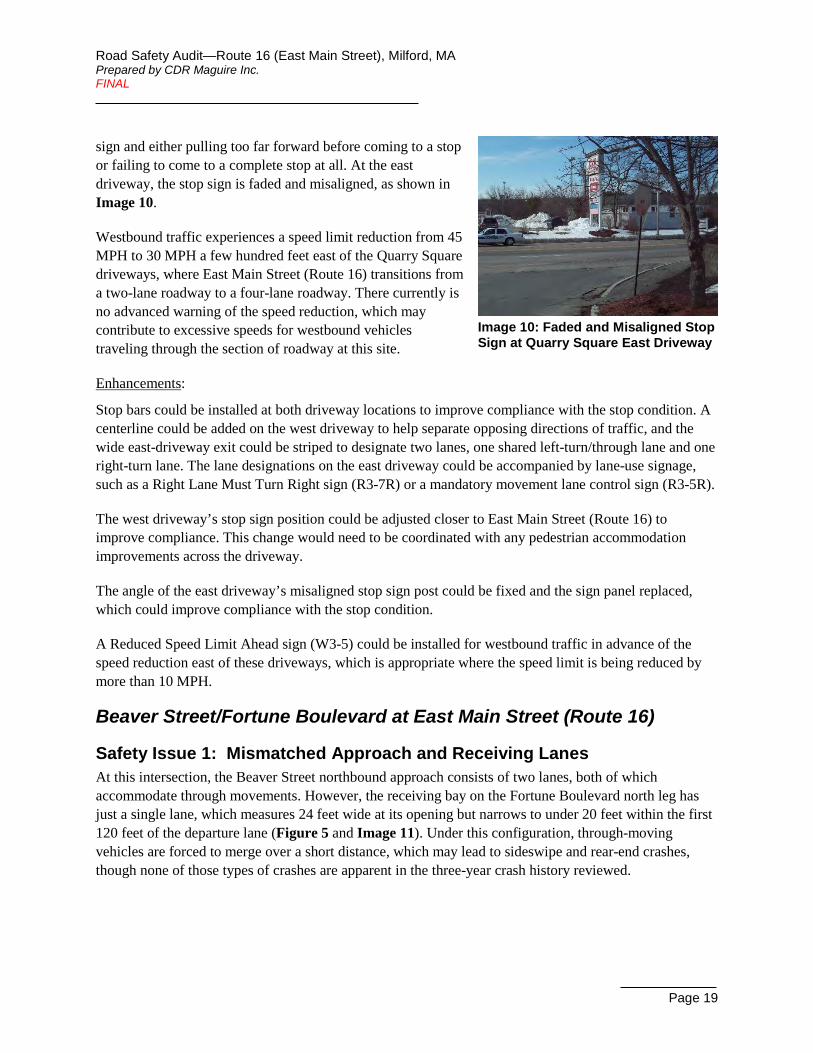
Stop sign positioning at both driveways was noted to be potentially an issue. At the west driveway, the stop sign may be positioned too far in advance of the cross street, resulting in many vehicles ignoring the
Road Safety Audit—Route 16 (East Main Street), Milford, MA Prepared by CDR Maguire Inc. FINAL
Page 19
sign and either pulling too far forward before coming to a stop or failing to come to a complete stop at all. At the east driveway, the stop sign is faded and misaligned, as shown in Image 10.
Image 10: Faded and Misaligned Stop Sign at Quarry Square East Driveway
Westbound traffic experiences a speed limit reduction from 45 MPH to 30 MPH a few hundred feet east of the Quarry Square driveways, where East Main Street (Route 16) transitions from a two-lane roadway to a four-lane roadway. There currently is no advanced warning of the speed reduction, which may contribute to excessive speeds for westbound vehicles traveling through the section of roadway at this site.
Enhancements:
Stop bars could be installed at both driveway locations to improve compliance with the stop condition. A centerline could be added on the west driveway to help separate opposing directions of traffic, and the wide east-driveway exit could be striped to designate two lanes, one shared left-turn/through lane and one right-turn lane. The lane designations on the east driveway could be accompanied by lane-use signage, such as a Right Lane Must Turn Right sign (R3-7R) or a mandatory movement lane control sign (R3-5R).
The west driveway’s stop sign position could be adjusted closer to East Main Street (Route 16) to improve compliance. This change would need to be coordinated with any pedestrian accommodation improvements across the driveway.
The angle of the east driveway’s misaligned stop sign post could be fixed and the sign panel replaced, which could improve compliance with the stop condition.
A Reduced Speed Limit Ahead sign (W3-5) could be installed for westbound traffic in advance of the speed reduction east of these driveways, which is appropriate where the speed limit is being reduced by more than 10 MPH.
Beaver Street/Fortune Boulevard at East Main Street (Route 16)
Safety Issue 1: Mismatched Approach and Receiving Lanes At this intersection, the Beaver Street northbound approach consists of two lanes, both of which accommodate through movements. However, the receiving bay on the Fortune Boulevard north leg has just a single lane, which measures 24 feet wide at its opening but narrows to under 20 feet within the first 120 feet of the departure lane (Figure 5 and Image 11). Under this configuration, through-moving vehicles are forced to merge over a short distance, which may lead to sideswipe and rear-end crashes, though none of those types of crashes are apparent in the three-year crash history reviewed.

Road Safety Audit—Route 16 (East Main Street), Milford, MA Prepared by CDR Maguire Inc. FINAL
Page 20
Image 11: Northbound Approach of Beaver Street at Intersection with East Main Street (Route 109)
Enhancements:
A potential short-term countermeasure would be to install advanced warning signage for the lane reduction on the northbound departure, as currently there is no advanced warning information provided. This improvement would better alert drivers to the impending merge condition.
Another enhancement could be to widen the northbound departure for a few hundred feet and stripe it as two receiving lanes with the lane reduction occurring a little farther downstream of the intersection, with appropriate warning signage, giving drivers more distance to prepare for the merge. Subject to further evaluation, the widening could be
accomplished either by taking some width from the southbound Fortune Boulevard approach lanes or by physically widening Fortune Boulevard to the east.
As an alternative to providing a full second receiving lane on the north leg, a matching number of through lanes on the approach and receiving lanes on the departure could be achieved by converting the left lane of the approach into an exclusive left-turn lane. The left lane is already an auxiliary lane added only on the approach to the intersection, so converting it to a left-turn lane would not introduce a lane drop (left-lane trap) situation. This potential improvement would be subject to an operational evaluation, but it would remove the merge condition entirely, thereby eliminating the safety issue from merging. If an exclusive left-turn lane is provided, the addition of a flashing yellow left arrow indication for that lane should be considered for consistency with the southbound approach.
Safety Issue 2: Truck Turning Movements Two features were noted at the intersection indicating that trucks have difficulty making right turns on the eastbound East Main Street (Route 16) and northbound Beaver Street approaches to the intersection. The guardrail on the southwest corner has severe damage (Image 12), likely due to trucks colliding with it while making the right turn from eastbound to southbound. Similarly, trucks turning right from northbound to eastbound were observed to make wide turns, fully breaching the left lane of the northbound approach in order to make the turn (Image 13), which may lead to sideswipe crashes and other types of crashes. The three-year
Image 12: Guardrail Damage on the Southwest Corner of the Intersection with Beaver Street and Fortune Boulevard
Image 13: Northbound Truck on Beaver Street Turning Right from Left Lane
Road Safety Audit—Route 16 (East Main Street), Milford, MA Prepared by CDR Maguire Inc. FINAL
Page 21
crash history included one crash involving a northbound right-turning truck that may be indicative of this issue.
Enhancements:
On both of the subject corners, the possibility of increasing the curb radii could be evaluated, enabling larger vehicles to stay on the paved roadway and reduce encroachment upon adjacent travel lanes.
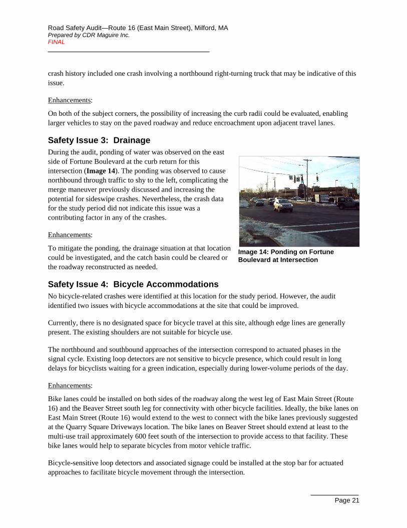
Safety Issue 3: Drainage During the audit, ponding of water was observed on the east side of Fortune Boulevard at the curb return for this intersection (Image 14). The ponding was observed to cause northbound through traffic to shy to the left, complicating the merge maneuver previously discussed and increasing the potential for sideswipe crashes. Nevertheless, the crash data for the study period did not indicate this issue was a contributing factor in any of the crashes.
Image 14: Ponding on Fortune Boulevard at Intersection
Enhancements:
To mitigate the ponding, the drainage situation at that location could be investigated, and the catch basin could be cleared or the roadway reconstructed as needed.
Safety Issue 4: Bicycle Accommodations No bicycle-related crashes were identified at this location for the study period. However, the audit identified two issues with bicycle accommodations at the site that could be improved.
Currently, there is no designated space for bicycle travel at this site, although edge lines are generally present. The existing shoulders are not suitable for bicycle use.
The northbound and southbound approaches of the intersection correspond to actuated phases in the signal cycle. Existing loop detectors are not sensitive to bicycle presence, which could result in long delays for bicyclists waiting for a green indication, especially during lower-volume periods of the day.
Enhancements:
Bike lanes could be installed on both sides of the roadway along the west leg of East Main Street (Route 16) and the Beaver Street south leg for connectivity with other bicycle facilities. Ideally, the bike lanes on East Main Street (Route 16) would extend to the west to connect with the bike lanes previously suggested at the Quarry Square Driveways location. The bike lanes on Beaver Street should extend at least to the multi-use trail approximately 600 feet south of the intersection to provide access to that facility. These bike lanes would help to separate bicycles from motor vehicle traffic.
Bicycle-sensitive loop detectors and associated signage could be installed at the stop bar for actuated approaches to facilitate bicycle movement through the intersection.
Road Safety Audit—Route 16 (East Main Street), Milford, MA Prepared by CDR Maguire Inc. FINAL
Page 22
Safety Issue 5: Pedestrian Accommodations The crash data did not include any pedestrian-related crashes at this location for the study period. However, the audit identified a few issues with bicycle accommodations at the site that could be improved.
The intersection’s pedestrian accommodations currently include marked crosswalks across the north and east legs, accompanied by ADA-compliant ramps with tactile warning panels, APS-style pedestrian pushbuttons, and pedestrian signal heads. Sidewalks are present on both sides of Fortune Boulevard, the south side of East Main Street (Route 16) on just its east leg, and on the east side of Beaver Street for just the first 200 feet, approximately. Existing sidewalks, where present, lack connectivity to likely trip origins or destinations.
Some of the pedestrian signal equipment appeared to be in disrepair or not up to current standards. Multiple pedestrian signal heads were observed to be in poor condition, and they are not countdown-style (Image 15). Also, the audible function of the APS-style pedestrian pushbuttons appeared to be nonfunctional on at least one corner.
Enhancements:
Pedestrian accommodations could be improved by installing sidewalks on both sides of the west leg of East Main Street (Route 16) and on the west side of Beaver Street, extending the sidewalk on the east side of Beaver Street, and installing crosswalks across the west and south legs with associated ramps and signal equipment. Ideally, the sidewalks on East Main Street (Route 16) would extend to the west to connect with the existing or reconstructed sidewalks at the Quarry Square Driveways location. The sidewalks on Beaver Street should extend at least to the multi-use trail approximately 600 feet south of the intersection to provide access between facilities.
Potential signal system improvements include upgrading the existing pedestrian signal heads to countdown-style to provide pedestrians valuable information on how much time they have to cross, and evaluating the pushbuttons for repair or replacement. These enhancements would improve pedestrian safety and mobility.
Safety Issue 6: Signing and Pavement Marking Similar to another issue discussed previously for this site, the eastbound departure has a lane reduction about 150 feet downstream of the intersection with no advanced warning signage. (Note that the aerial imagery in Figure 5 predates the addition of lane striping on the east leg that now designates two eastbound lanes for the first 150 feet.)
It was observed in the field that the Stop Here On Red sign for the southbound Fortune Boulevard approach to the intersection is misaligned, aimed more towards westbound traffic than southbound, as shown in Image 15.

Road Safety Audit—Route 16 (East Main Street), Milford, MA Prepared by CDR Maguire Inc. FINAL
Page 23
Image 15: Pedestrian Signal Head with Some LEDs Nonfunctional and Misaligned Stop Here On Red Sign on Northwest Corner of Intersection
Enhancements:
To assist drivers in preparing for the eastbound merge, advanced warning signage could be installed, which could reduce the potential for sideswipe and rear-end crashes.
To make the Stop Here On Red sign on the southbound approach more visible for the intended traffic stream, the angle of the sign post could be fixed, which could improve compliance for stopping at the proper location.
Safety Issue 7: Signal Phasing and Timing Currently, phasing for the southbound through movement was observed not to activate automatically in concurrence with compatible phases: the southbound exclusive left-turn phase and the general northbound phase. If that phase stays red when it could be green, it increases the potential for rear-end crashes.
The crash history indicates that there is a pattern of red-light running at this intersection. Five crashes in the crash history data occurred when a vehicle ran a red light.
Enhancements:
Signal phasing should be evaluated for the southbound movement, and the recall mode for the phase could be adjusted if needed.
Existing vehicular clearance times should be evaluated for compliance with minimum requirements and should be updated as needed.
Safety Issue 8: Signal Visibility The view of the vehicular signal heads for the northbound approach appears to be partially obscured by utility lines crossing the north leg of the intersection in front of the signal heads (Image 16). This
increases the potential for angle crashes from red-light running and rear-end crashes due to drivers not seeing the signal phase change.
Image 16: Utility Lines Obstructing View of Northbound Signal Heads
It was also observed that none of the signal heads have backplates at this intersection.
Enhancements:
The utility lines crossing in front of the northbound signal heads could be evaluated for adjustment or relocation so that they do not obscure signal head visibility.

Road Safety Audit—Route 16 (East Main Street), Milford, MA Prepared by CDR Maguire Inc. FINAL
Page 24
Backplates with retroreflective borders could be installed for overhead signal heads on the eastbound, westbound, and southbound approaches to mitigate sun glare effects. Evaluation would be needed to determine whether the existing signals, which are mounted on span wires, can carry and withstand the additional weight and wind loads from the backplates.
Summary of Road Safety Audit Following the site walk, participants returned to the meeting room to review the safety issues identified on the walk and to recommend potential countermeasures. Observations were reviewed and in some cases given context by those familiar with specific aspects of the project.
Key improvements recommended for consideration include the following:
• Medway Road (Route 109)/Prairie Street at East Main Street (Route 16)
o Providing advanced warning signage and pavement markings for the lane drop (left-turn trap) on the westbound approach of the Medway Road (Route 109) intersection
o Evaluating potential access-control measures for the E-Z Way Car Wash and Five Guys driveways on Medway Road (Route 109)
• Quarry Square Driveways at East Main Street (Route 16)
o Potential traffic signal installations at one or both of the plaza driveways
o Evaluating and implementing a road diet through this section of roadway, consisting of one travel lane in each direction plus a center TWLTL, as well as bike lanes and sidewalks
• Beaver Street/Fortune Boulevard at East Main Street (Route 16)
o Addressing the mismatched number of lanes between the northbound approach and departure legs by using signage, adjusting lane widths, widening the road bed, and/or changing lane usage
• Throughout RSA Study Area
o Providing sidewalks and wider shoulders or bike lanes on several roadway segments, ideally connected up with each other, to provide consistency and bicycle connectivity as well as pedestrian connectivity
Generally speaking, the improvements range from the easy-to-implement such as adding, replacing, or adjusting signs, adding supplemental pavement markings, and making minor signal system adjustments or repairs, to the more comprehensive improvements such as signalizing the Quarry Square driveways and modifying the roadway cross-section throughout that segment of roadway. All potential improvements have been assigned categories for safety payoff, time frame for completion, and estimated construction cost, as defined in Table 2.

Road Safety Audit—Route 16 (East Main Street), Milford, MA Prepared by CDR Maguire Inc. FINAL
Page 25
Table 2: Estimated Safety Payoff, Time Frame, and Costs Breakdown Safety Payoff Time Frame Costs
Low May Reduce Crashes Short-Term <1 Year Low <$10,000
Medium Will Probably Reduce Crashes Mid-Term 1-3 Years Medium $10,001-$50,000
High Certain to Reduce Crashes Long-Term >3 Years High >$50,000
A complete listing of all the issues and enhancements identified in this audit are provided in Table 3.
It is understood that some of these potential improvements conflict with one another. Further evaluation is required during the Functional Design Report phase to focus on the best courses of action.

Road Safety Audit— Route 16 (East Main Street), Milford, MA Prepared by CDR Maguire Inc. FINAL
Page 26
Table 3: Potential Safety Enhancement Summary ID # Safety Issue Potential Safety Enhancement Safety
Payoff Time
Frame Cost Responsible Agency
Medway Road (Route 109)/Prairie Street at East Main Street (Route 16) – Roadway Segment & Intersection
1 Left-Turn Lane Trap: The left lane on the westbound approach becomes an exclusive left-turn lane with no advanced warning
Install advanced warning signage and associated pavement markings on westbound approach indicating left travel lane becomes exclusive left-turn lane, such as a “Left Lane Must Turn Left” or a graphical advance intersection lane control sign, a left-turn only sign on the signal mast arm, and a wide dotted white lane line in advance of the turning lane bay
High Short-Term Low MassDOT
Evaluate converting the left lane into a shared lane to include through movements
Medium Mid-Term Medium MassDOT
2
Access Management: Crash history shows a pattern of crashes associated with access to the E-Z Way Car Wash and Five Guys driveways, particularly left turns in and out
Install signage to prohibit left turns into and out of the E-Z Way Car Wash and Five Guys driveways
Medium Mid-Term Low Town of Milford
& Property Owners
Install flexible posts to prohibit left turns into and out of the E-Z Way Car Wash and Five Guys driveways
High Mid-Term Medium Town of Milford
& Property Owners
Install raised center median to prohibit left turns into and out of the E-Z Way Car Wash and Five Guys driveways
High Long-Term Medium Town of Milford
& Property Owners
Evaluate designating existing loop road as a turn-around point for eastbound (southbound) traffic if left turns into/out of the business driveways are prohibited
Low Mid-Term Low Town of Milford
Modify E-Z Way Car Wash driveway by either narrowing or dividing it High Long-Term Medium Property
Owners

Road Safety Audit— Route 16 (East Main Street), Milford, MA Prepared by CDR Maguire Inc. FINAL
Page 27
ID # Safety Issue Potential Safety Enhancement Safety
Payoff Time
Frame Cost Responsible Agency
3
Truck Turning Movements: Trucks have difficulty turning right from Rt 109 to eastbound Rt 16 as evidenced by tire tracks outside of the pavement on the corner, and left turns from westbound Rt 16 to Rt 109 have a tight receiving bay
To facilitate truck turning movements, increase curb radius on southeast corner, reduce the islands around the Rt 109 receiving bay, and adjust the location of the signal poles on those islands
Medium Long-Term High MassDOT
4 Bicycle Accommodations: Shoulders on the east leg of Rt 16 are insufficient for bicycle use
Widen shoulder on the east leg of Rt 16 Medium Mid-Term Medium MassDOT
5 Bicycle Accommodations: Shoulder on the north (east) side of Rt 109 is insufficient for bicycle use
Widen shoulder on north (east) side of Rt 109 for at least 600 feet from intersection
Medium Mid-Term Medium Town of Milford
6 Bicycle Accommodations: Current vehicle detection is insufficient to detect bicycles
Install bicycle detection and associated signage on actuated approaches Low Mid-Term Medium Town of Milford
7 Pedestrian Accommodations: There is no sidewalk on the north (east) side of Rt 109
Install sidewalk on north (east) side of Rt 109 Medium Long-Term Medium Town of Milford
8 Pedestrian Accommodations: Sidewalks on both sides of Rt 16 on the east leg of the intersection do not meet ADA requirements
Rebuild sidewalks on the east leg of Rt 16 to ADA compliance Medium Long-Term Medium MassDOT
9
Pedestrian Accommodations: The pedestrian crossing of the eastbound channelized right-turn lane has visibility issues with pedestrians and vehicles seeing each other
Install pedestrian-crossing warning signage for eastbound channelized right-turn lane and add yield line (triangles) in advance of crosswalk
Medium Short-Term Low Town of Milford
10
Pedestrian Accommodations: Median on south leg of intersection encroaches upon crosswalk, median ramps do not align with crosswalk, pedestrian clearance time for that crossing appears too short without providing pedestrian refuge, and there is no pedestrian pushbutton in the median to provide adequate pedestrian refuge
Restripe crosswalks to align with median ramps and install pedestrian pushbutton in the median
Low Short-Term Low Town of Milford
Remove ramps and pull back the median so that it is clear of the crosswalk, and update signal timing to meet minimum pedestrian crossing requirements without median refuge
Low Mid-Term Low Town of Milford

Road Safety Audit— Route 16 (East Main Street), Milford, MA Prepared by CDR Maguire Inc. FINAL
Page 28
ID # Safety Issue Potential Safety Enhancement Safety
Payoff Time
Frame Cost Responsible Agency
11 Pedestrian Accommodations: Pedestrian clearance time for west leg crossing appears too short
Update signal timing to meet MUTCD pedestrian crossing requirements Medium Short-Term Low Town of Milford
12 Pedestrian Accommodations: Pedestrian pushbuttons are not APS-style
Upgrade pedestrian pushbuttons to APS-style Low Mid-Term Medium Town of Milford
13
Signing and Pavement Marking: Existing placement of the yield sign on the channelizing island for the eastbound right-turn lane causes ambiguity, and the sign is too small and mounted too low
Adjust yield sign position so it is closer to yield point on the channelizing island for the eastbound right-turn lane, replace sign panel, and mount at proper height
Medium Short-Term Low Town of Milford
14 Signal Visibility: Backplates are absent from signal heads
Install backplates with retroreflective borders on mast-arm mounted signal heads for eastbound and westbound approaches, subject to loading evaluation
Low Mid-Term Medium Town of Milford
15 Signal Visibility: Signal visibility is limited by horizontal curves on the westbound and northbound approaches
Add Signal Ahead warning signs on the westbound and northbound approaches Medium Short-Term Low Town of Milford
Quarry Square Driveways at East Main Street (Route 16) – Roadway Segment
16
Access Management: A high number of crashes involve vehicles turning into or out of these driveways, which are currently unsignalized
Evaluate whether these driveways warrant a traffic signal, and signalize one or both driveway intersections
High Long-Term High MassDOT
Evaluate prohibiting left turns out of south-side driveways opposite Quarry Square driveways
Low Mid-Term Low MassDOT

Road Safety Audit— Route 16 (East Main Street), Milford, MA Prepared by CDR Maguire Inc. FINAL
Page 29
ID # Safety Issue Potential Safety Enhancement Safety
Payoff Time
Frame Cost Responsible Agency
17
Access Management: The No Left Turn sign is faded and many vehicles ignore the left-turn prohibition for the west driveway exit
Evaluate permit requirement for a median island that used to exist on the west driveway that helped direct traffic into the right-turn movement exiting the driveway
Medium Short-Term Medium MassDOT
Re-install median island on west driveway to help discourage left-turn movements exiting the driveway
Medium Mid-Term Low Property Owners
Replace existing No Left Turn sign and install additional No Left Turn signs on the west driveway exit, either on the south side of the road or in the new median island
Medium Short-Term Low MassDOT
18 Sight Line Obstruction: Vegetation on northeast corner of west driveway obstructs sight lines for traffic exiting the driveway
Remove or trim vegetation on northeast corner of west driveway Medium Short-Term Low
MassDOT & Property Owners
19
Speed Limits: Eastbound experiences a speed limit increase from 30 MPH to 45 MPH in this segment, and westbound experiences a speed limit decrease just before entering this segment; vehicle speeds on Rt 16 may contribute to the high crash rate
Evaluate speed limits in corridor and adjust as necessary, including moving the speed transition farther to the east for both directions of travel, in order to reduce travel speeds through the area
Medium Mid-Term Low MassDOT
20
Roadway Geometry: Multiple travel lanes in each direction on Rt 16 combined with no left-turn refuge may contribute to the high crash rate on this road segment
Subject to evaluation, implement road diet through this segment (from Rt 109 intersection, east to the transition to 2-lane section), providing new lane configuration: one travel lane in each direction, a center two-way left-turn lane (TWLTL), bike lanes, and sidewalks
High Long-Term High MassDOT
21 Bicycle Accommodations: Existing shoulders are narrow and insufficient for bicycle use
Install bike lanes along Rt 16, preferably extending well beyond this site to achieve connectivity
Medium Long-Term High MassDOT

Road Safety Audit— Route 16 (East Main Street), Milford, MA Prepared by CDR Maguire Inc. FINAL
Page 30
ID # Safety Issue Potential Safety Enhancement Safety
Payoff Time
Frame Cost Responsible Agency
22 Pedestrian Accommodations: There are no crosswalks across the plaza driveways, and Ramps are not ADA-compliant
Install crosswalks across both driveways and install ADA-compliant ramps for both driveway crossings
Medium Long-Term Medium MassDOT
23 Signing and Pavement Marking: The driveway approaches to Rt 16 are missing stop bars and lane lines/designations
Install stop bars at both driveways, a centerline at the west driveway, and pavement markings/signage to designate a left-turn/thru lane and a right-turn lane at the east driveway
Medium Short-Term Low Property Owners
24 Signing and Pavement Marking: Stop sign position at the west driveway may be too far in advance
Adjust Stop sign position at west driveway Medium Short-Term Low Property
Owners
25 Signing and Pavement Marking: Stop sign at east driveway is misaligned and faded
Fix angle of misaligned Stop sign and replace sign panel at east driveway Medium Short-Term Low Property
Owners
26
Signing and Pavement Marking: There is no advanced warning that the speed limit decreases from 45 MPH to 30 MPH for westbound traffic at the eastern edge of this site
Install Reduced Speed Limit Ahead warning sign east of the site for westbound traffic
Medium Short-Term Low MassDOT
Beaver Street/Fortune Boulevard at East Main Street (Route 16) – Intersection
27
Mismatched Approach and Receiving Lanes: Northbound approach has two lanes that accommodate through movements, but the northbound departure is a single lane
Install advanced warning signage for lane reduction on northbound departure Medium Short-Term Low MassDOT
Widen northbound departure and stripe as two lanes with a lane reduction beyond intersection and appropriate warning signage
Medium Long-Term Medium MassDOT
Evaluate conversion of left lane of northbound approach to exclusive left-turn lane
Low Short-Term Low MassDOT
Convert left lane of northbound approach to exclusive left-turn lane Medium Mid-Term Medium MassDOT

Road Safety Audit— Route 16 (East Main Street), Milford, MA Prepared by CDR Maguire Inc. FINAL
Page 31
ID # Safety Issue Potential Safety Enhancement Safety
Payoff Time
Frame Cost Responsible Agency
28
Truck Turning Movements: Trucks have difficulty making right turns on the eastbound approach as evidenced by severe guardrail damage on the southwest corner
Evaluate increasing curb radius on southwest corner to facilitate truck turning movements
Medium Long-Term High MassDOT
29
Truck Turning Movements: Trucks have difficulty making right turns on the northbound approach as evidenced by observations of trucks fully breaching the left lane on the northbound approach
Evaluate increasing curb radius on southeast corner to facilitate truck turning movements
Medium Long-Term High MassDOT
30 Drainage: Ponding was observed on the east side of Fortune Boulevard at the intersection
Investigate drainage to determine cause of ponding, and clear catch basin or reconstruct roadway as needed
Low Short-Term/ Long-Term Low Town of Milford
31 Bicycle Accommodations: Shoulders on the west leg of Rt 16 are not suitable for bicycle use
Install bike lanes along the west leg of Rt 16, preferably extending well beyond this site to achieve connectivity
Medium Long-Term High MassDOT
32 Bicycle Accommodations: Shoulders on Beaver Street are not suitable for bicycle use
Install bike lanes along Beaver Street, providing access to multi-use trail Medium Long-Term High Town of Milford
33 Bicycle Accommodations: Current detection loops on actuated signal phases are not sensitive enough to detect bicycles
Install bicycle detection and associated signage on actuated approaches Low Mid-Term Medium MassDOT
34 Pedestrian Accommodations: There are no sidewalks on the west leg of Rt 16
Install sidewalks on both sides of Rt 16's west leg Medium Long-Term High MassDOT
35
Pedestrian Accommodations: Sidewalk on east side of Beaver Street extends less than 200 feet from the intersection, and sidewalk is absent from the west side, so there is no pedestrian access provided to the multi-use trail that crosses Beaver Street ~600 feet to the south
Install/extend sidewalks on both sides of Beaver Street, providing access to multi-use trail
Medium Long-Term Medium Town of Milford

Road Safety Audit— Route 16 (East Main Street), Milford, MA Prepared by CDR Maguire Inc. FINAL
Page 32
ID # Safety Issue Potential Safety Enhancement Safety
Payoff Time
Frame Cost Responsible Agency
36 Pedestrian Accommodations: Crosswalks are absent across the west and south legs
Install crosswalks, ramps, and pedestrian signal equipment across the west and south legs
Medium Long-Term High MassDOT
37 Pedestrian Accommodations: Pedestrian signal heads are in poor condition and are not countdown-style
Upgrade pedestrian signal heads to countdown-style Low Short-Term Medium MassDOT
38
Pedestrian Accommodations: APS-style pedestrian pushbuttons are present, but the audible function did not appear to be working on some corners
Evaluate signal equipment for function and compliance Low Short-Term Low MassDOT
Repair or replace signal equipment as needed Low Long-Term High MassDOT
39
Signing and Pavement Marking: Eastbound departure has a lane reduction about 150 feet downstream with no advanced warning signage
Install advanced warning signage for lane reduction on eastbound departure Medium Short-Term Low MassDOT &
Town of Milford
40 Signing and Pavement Marking: Stop Here On Red sign for southbound approach is misaligned
Fix angle of misaligned Stop Here on Red sign on southbound approach Medium Short-Term Low MassDOT
41
Signal Phasing and Timing: Phase for southbound through movement does not activate automatically in concurrence with compatible phases
Evaluate phasing for southbound through movement and adjust phase recall if needed
Low Short-Term Low MassDOT
42 Signal Phasing and Timing: Crash history indicates a pattern of red-light running
Update vehicular clearance times to meet minimum requirements Medium Short-Term Low MassDOT
43 Signal Visibility: Utility lines crossing north leg of intersection obstruct northbound signal indications
Adjust or relocate utility lines Medium Long-Term Medium MassDOT
44 Signal Visibility: Backplates are absent from signal heads
Install backplates with retroreflective borders on overhead signal heads for eastbound, westbound, and southbound approaches
Low Mid-Term Medium MassDOT

Appendix A. RSA Meeting Agenda

Agenda
Road Safety Audit Route 16 (East Main Street) from Medway Road to Beaver Street
Meeting Location: Milford Town Hall – Conference Room TBD 52 Main Street, Milford MA (about 1 mile west of project area)
March 21st, 2017 9:00 AM – 12:00 noon
Type of meeting: High Crash Location – Road Safety Audit Attendees: Invited Participants to Comprise a Multidisciplinary Team Please bring: Safety Gear, Vest, as agency may require. 9:00 – 9:15 AM Welcome and Introductions 9:15 - 9:30 AM Review of Site Specific Material
• Project History • Crash, Speed & Volume Summaries– provided in advance • Existing Geometries and Conditions
9:45 - 11:15 AM Visit the Site
• Car pool or drive to site. Three locations: o East Main Street at Beaver Street o East Main Street at two driveways leading to Quarry Square Plaza o East Main Street at Medway Road
• As a group, identify areas for improvement
11:30 AM - Noon Post Visit Discussion / Completion of RSA • Discuss observations and finalize findings • Discuss potential improvements and finalize recommendations
12:00 Noon Adjourn for the Day – but the RSA has not ended INSTRUCTIONS FOR PARTICIPANTS:
• Before the March 21st Meeting Participants are encouraged to drive through these three sites and complete/consider elements on the RSA Prompt List with a focus on safety.
• At the March 21st Meeting All participants will be actively involved in the process throughout. Participants are encouraged to come with thoughts and ideas, but are reminded that the synergy that develops and respect for others’ opinions are key elements to the success of the overall RSA process.
• After the March 21st Meeting Participants will be asked to comment and respond to the document materials

Appendix B. RSA Audit Team Contact List
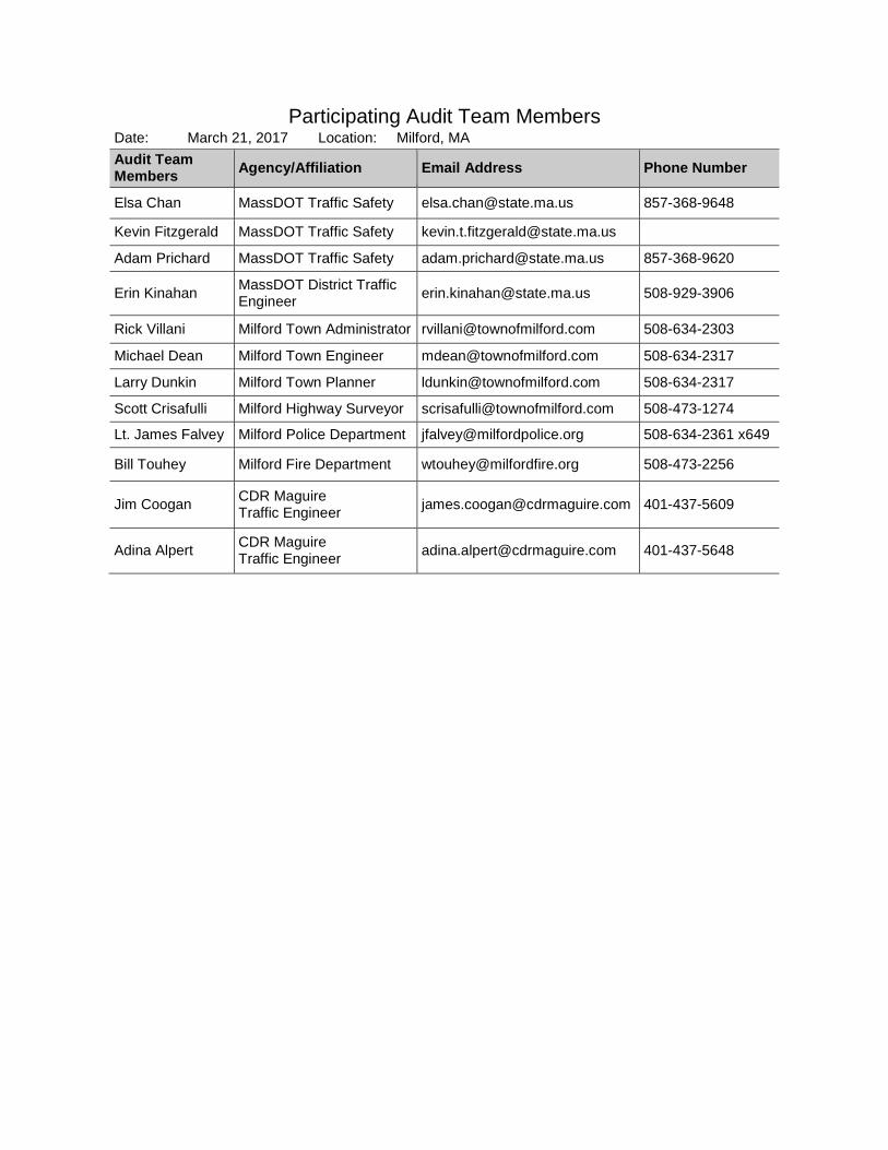
Participating Audit Team Members Date: March 21, 2017 Location: Milford, MA Audit Team Members Agency/Affiliation Email Address Phone Number
Elsa Chan MassDOT Traffic Safety [email protected] 857-368-9648
Kevin Fitzgerald MassDOT Traffic Safety [email protected]
Adam Prichard MassDOT Traffic Safety [email protected] 857-368-9620
Erin Kinahan MassDOT District Traffic Engineer [email protected] 508-929-3906
Rick Villani Milford Town Administrator [email protected] 508-634-2303
Michael Dean Milford Town Engineer [email protected] 508-634-2317
Larry Dunkin Milford Town Planner [email protected] 508-634-2317
Scott Crisafulli Milford Highway Surveyor [email protected] 508-473-1274
Lt. James Falvey Milford Police Department [email protected] 508-634-2361 x649
Bill Touhey Milford Fire Department [email protected] 508-473-2256
Jim Coogan CDR Maguire Traffic Engineer [email protected] 401-437-5609
Adina Alpert CDR Maguire Traffic Engineer [email protected] 401-437-5648

Appendix C. Detailed Crash Data

SUMMARY OF CRASH DATA Milford: Route 16 Rehab from Route 109 to Beaver St
Project 608045
Distribution ‐ Location and Manner of Collision
Site 1 Site 2 Site 3 Site 4 Site 5 Site 6 TotalNumber of Crashes (2013‐15) 10 50 38 11 5 29 143 Property‐Damage‐Only Equivalent Crashes 26 94 90 27 5 57 299 Crash Rate, Intersection (crashes per MEV) 0.46 2.04 0.91Crash Rate, Road Segment (crashes per MVMT) 11.63 2.50 2.61 District Average Rate 0.65 0.90 3.34 3.34 3.34 0.90 Manner of Collision
Angle 3 (30%) 28 (56%) 27 (71%) 5 (45%) 2 (40%) 14 (48%) 79 (55%) Head on 1 (3%) 1 (1%) Rear‐end 4 (40%) 16 (32%) 4 (11%) 4 (36%) 6 (21%) 34 (24%) Sideswipe, opposite direction 2 (7%) 2 (1%) Sideswipe, same direction 2 (20%) 4 (8%) 4 (11%) 2 (40%) 5 (17%) 17 (12%) Single Vehicle Crash 1 (10%) 1 (2%) 2 (5%) 2 (18%) 1 (20%) 1 (3%) 8 (6%) Unknown 1 (3%) 1 (1%) Other 1 (2%) 1 (1%)


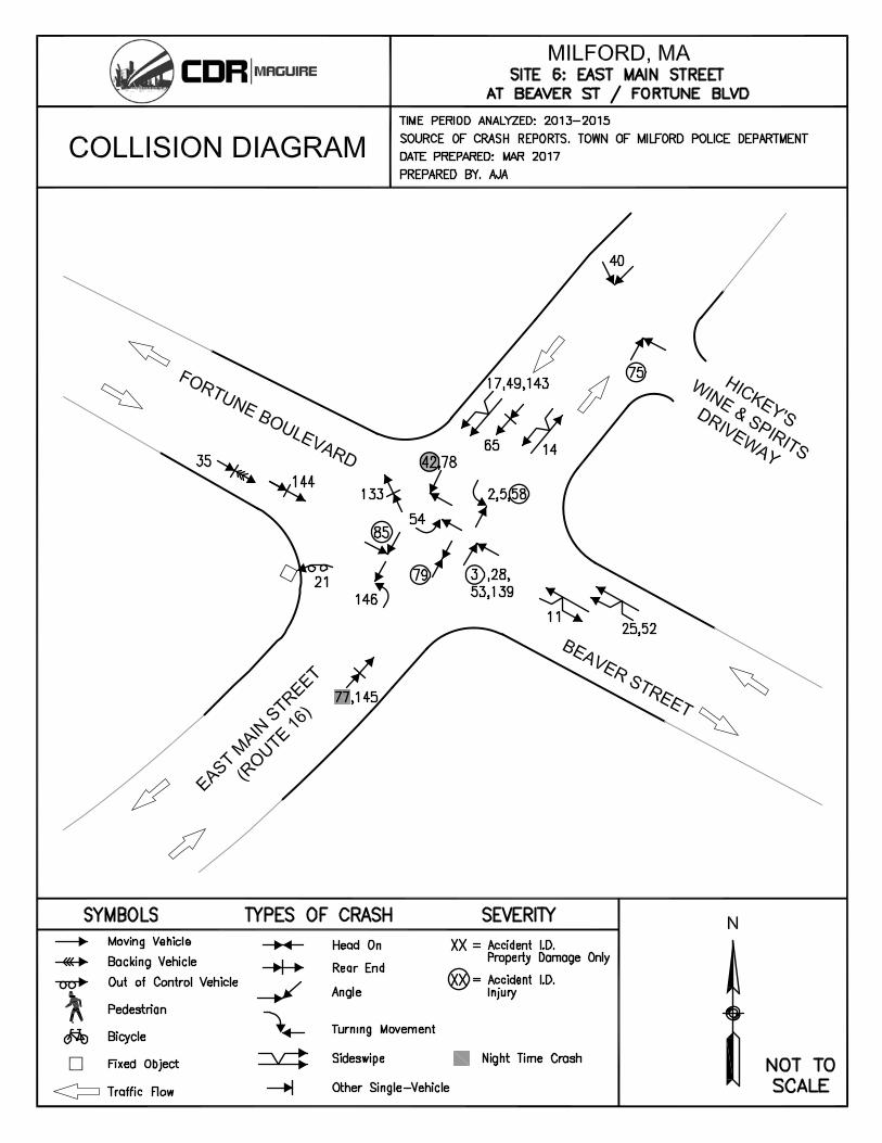

Milford: Route 16 Rehab from Route 109 to Beaver Street ‐ Crash Summary Collision Diagram Ref #
Location (Site #)
Crash Date
Day of Week
Crash Time
Manner of Collision
Road Surface
Ambient Light
Weather Condition
Ages Comments
2013 6 1 2/7/13 Thursday 1:29 PM Angle Dry Daylight Clear 31 43
Vehicle turning left out of Hannaford driveway collided with EB vehicle, having thought the oncoming vehicle was signaling to turn right
27 1 10/31/13 Thursday 4:49 PM Rear‐end Wet Dark ‐ lighted roadway Rain 23 27 52 EB vehicle was waiting to turn right into driveway (pedestrian was crossing) and another vehicle was waiting behind it, when a third vehicle rear‐ended the second vehicle, then the second vehicle rear‐ended the first vehicle
30 1 11/30/13 Saturday 1:58 AM Single Vehicle Crash Dry Dark ‐ lighted roadway Clear 28 EB vehicle attempted to turn right onto Medway Rd too early, jumped curb on southeast corner of Hannaford driveway and damaged buried electrical box
149 2 2/6/13 Wednesday 11:56 AM Angle Dry Daylight Clear 51 77 Vehicle traveling EB (SB) on Medway Rd attempted right turn into Five Guys driveway and was struck on the side by the vehicle traveling behind
7 2 2/11/13 Monday 2:24 PM Other Wet Daylight Rain 29 Tractor‐trailer traveling WB struck overhead traffic signal head with snow‐covered trailer, leaving signal head hanging by its wires
150 2 2/14/13 Thursday 8:16 AM Angle Dry Daylight Clear 34 21 Vehicle traveling WB (NB) on Medway Road attempted left turn into KFC driveway, was struck by vehicle traveling EB (SB)
12 2 2/26/13 Tuesday 4:25 PM Sideswipe, same direction Dry Daylight Clear 31 47 WB vehicle attempted lane change from left‐turn lane to thru lane and struck vehicle traveling in thru lane
151 2 4/9/13 Tuesday 6:15 PM Angle Dry Daylight Clear 44 49 Vehicle traveling EB (SB) on Medway Rd attempted left turn into E‐Z Way Car Wash driveway and collided with vehicle traveling WB (NB)
152 2 5/23/13 Thursday 4:56 PM Angle Dry Daylight Cloudy 59 60 Vehicle exiting Five Guys driveway onto Medway Rd struck the side of vehicle traveling EB (SB)
153 2 6/7/13 Friday 5:10 PM Angle Wet Daylight Rain 44 59 Vehicle traveling WB (NB) on Medway Rd struck a vehicle turning left out of Five Guys driveway then fled the scene (Hit & run)
155 2 6/19/13 Wednesday 5:56 PM Angle Dry Daylight Clear 40 20 Vehicle traveling EB (SB) on Medway Rd failed to yield to oncoming traffic while attempting left turn into E‐Z Way Car Wash driveway and struck vehicle traveling WB (NB)
156 2 6/20/13 Thursday 3:23 PM Angle Dry Daylight Clear 53 63
Vehicle attempting left turn out of Five Guys driveway onto WB (NB) Medway Rd pulled in front of vehicle that had just turned right from EB E Main St to EB (SB) Medway Rd and still had right‐turn signal on, and the vehicles collided; Driver of first vehicle thought the other vehicle was turning and that it was safe to proceed
129 2 8/9/13 Friday 2:11 PM Angle Wet Daylight Rain / Cloudy 17 46 WB vehicle attempted to turn left onto Medway and struck vehicle traveling EB
158 2 9/22/13 Sunday 5:45 PM Angle Dry Daylight Clear 64 64 Vehicle attempting left turn out of Five Guys driveway struck the side of a vehicle traveling EB (SB) on Medway Rd; Sun glare was a factor
26 2 10/27/13 Sunday 9:00 AM Single Vehicle Crash Wet Daylight Clear 42 Vehicle traveling EB spun out of control while traversing intersection and struck north curb east of the intersection
160 2 11/11/13 Monday 11:25 AM Angle Dry Daylight Clear 60 70 Vehicle traveling EB (SB) on Medway Rd attempted left turn into E‐Z Way Car Wash driveway and collided with vehicle traveling WB (NB)
31 2 12/10/13 Tuesday 9:17 AM Rear‐end Snow Daylight Snow / Cloudy 27 24 EB vehicle turning right in the channelized lane struck the vehicle in front of it which was yielding to another vehicle
130 2 12/14/13 Saturday 1:44 PM Rear‐end Dry Daylight Cloudy 71 27 Vehicle traveling NB rear‐ended the vehicle in front of it, which had stopped suddenly in heavy traffic 161 2 12/20/13 Friday 6:12 PM Rear‐end Wet Dark ‐ lighted roadway Cloudy 26 59 Vehicle traveling WB (NB) on Medway Rd was struck from behind near the E‐Z Way Car Wash driveway
162 2 12/21/13 Saturday 5:44 PM Angle Wet Dark ‐ lighted roadway Clear 49 47 Vehicle traveling EB (SB) on Medway Rd failed to yield to oncoming traffic while attempting left turn into E‐Z Way Car Wash driveway and struck vehicle traveling WB (NB)
8 3 2/12/13 Tuesday 4:05 PM Sideswipe, same direction Dry Daylight Clear 51 31 WB vehicle made an unsafe lane change from right to left near 182 E Main St and collided with a vehicle in the left lane
10 3 2/19/13 Tuesday 6:05 PM Angle Wet Dark ‐ lighted roadway Rain 59 69 Vehicle attempted to exit Quarry Square main driveway and struck vehicle traveling WB; Snow banks at plaza entrance impeded visability
13 3 3/10/13 Sunday 2:59 PM Angle Dry Daylight Clear 54 22 Vehicle attempted prohibited left turn out of Quarry Square west driveway and struck vehicle traveling WB
128 3 4/6/13 Saturday 7:56 AM Unknown Dry Daylight Clear 30 51 A box in the bed of a pickup truck traveling WB in the left lane had shifted prior and struck the driver's side mirror of a vehicle traveling EB in left lane near Quarry Square

Milford: Route 16 Rehab from Route 109 to Beaver Street ‐ Crash Summary Collision Diagram Ref #
Location (Site #)
Crash Date
Day of Week
Crash Time
Manner of Collision
Road Surface
Ambient Light
Weather Condition
Ages Comments
15 3 5/3/13 Friday 5:57 PM Angle Dry Daylight Clear 17 54 42 Vehicle traveling EB in left lane saw vehicle stopped ahead waiting to turn left into Quarry Square west driveway and changed lanes to the right striking vehicle traveling in that lane, then debris struck a third vehicle which was driving behind the first vehicle in the left lane
18 3 7/7/13 Sunday 2:16 PM Angle Dry Daylight Clear 52 58 WB vehicle attempted to turn right into Quarry Square main driveway from left lane and collided with vehicle traveling WB in right lane
20 3 7/16/13 Tuesday 4:08 PM Rear‐end Dry Daylight Clear 63 34 EB vehicle rear‐ended the vehicle stopped ahead of it that was waiting to turn left into Quarry Square main driveway; Driver stated failure of braking system, which officer confirmed
22 3 8/6/13 Tuesday 2:42 PM Single Vehicle Crash Dry Daylight Clear 45 51 Vehicle exited parking lot at 178 E Main St in front of WB motorcycle, so the motorcycle operator applied the brakes and the motorcycle went down (No collision)
23 3 9/21/13 Saturday 11:52 AM Angle Dry Daylight Cloudy 18 23 38
WB vehicle attempted right turn into Quarry Square west driveway and collided with vehicle attempting to pass on the right, then second vehicle lost control and collided with a third vehicle that was waiting to exit the driveway; Driver of the first vehicle thought it was a single travel lane (Lane markings not visible due to prior construction)
32 3 12/16/13 Monday 11:01 AM Angle Dry Daylight Clear 82 72 Vehicle attempted to cross from Bank of America driveway on south side to Quarry Square main driveway on north side and collided with EB vehicle
131 3 12/20/13 Friday 5:43 PM Angle Dry Dark ‐ roadway not lighted Clear 45 53
Two vehicles turned right in succession out of the Quarry Square west driveway, then the second vehicle attempted to pass to the left the first vehicle on WB E Main St when the first vehicle struck the second; Driver of the first vehicle thought it was a single travel lane (Lane markings not visible due to prior construction)
132 3 12/21/13 Saturday 5:14 PM Angle Wet Daylight Cloudy 73 21 Vehicle pulled along side a stopped vehicle to exit the Truffles driveway when the stopped vehicle initiated a move to turn right and the vehicles collided
34 3 12/30/13 Monday 6:05 AM Sideswipe, same direction Wet Dark ‐ lighted roadway Clear 71 25 Vehicle traveling EB in left lane collided with EB vehicle in right lane near 182 E Main St
1 4 1/2/13 Wednesday 2:25 PM Angle Dry Daylight Clear 18 49 Vehicle turning left out of Aldi driveway struck vehicle traveling EB, then the second vehicle exited roadway and knocked over a tree
19 4 7/15/13 Monday 5:06 PM Rear‐end Dry Daylight Clear 33 46 EB vehicle rear‐ended another vehicle that was slowing in traffic near 229 1/2 E Main St
24 4 10/2/13 Wednesday 7:00 AM Angle Dry Daylight Clear 21 33 EB vehicle attemted left turn into Spectrum driveway and struck WB vehicle; Driver stated bright sun was a factor
29 4 11/19/13 Tuesday 11:03 AM Angle Dry Daylight Clear 58 34 Vehicle attempted to turn right out of Spectrum driveway and collided with EB vehicle attempting to turn left into driveway
33 4 12/27/13 Friday 9:38 AM Single Vehicle Crash Dry Daylight Clear 59 Vehicle exiting Berardi Automotive driveway attempted to avoid oncoming vehicle and struck utility pole on north side of roadway
4 5 1/26/13 Saturday 2:26 PM Sideswipe, same direction Dry Daylight Clear 55 58 Vehicle traveling EB in left lane wanted to turn around using Northeast Electrical driveway and entered the right lane striking a vehicle that was in that lane
9 5 2/15/13 Friday 7:36 AM Angle Dry Daylight Clear 36 21 EB Vehicle attempted right turn into Northeast Electrical driveway from the left lane and was struck by a vehicle traveling in the right lane
16 5 6/7/13 Friday 12:40 PM Sideswipe, same direction Wet Daylight Rain / Cloudy 22 49 EB vehicle attempted to change lanes from left to right near 235 E Main St and struck a vehicle traveling in right lane
2 6 1/21/13 Monday 7:52 AM Angle Dry Daylight Clear 63 42 WB vehicle attempted to turn left onto Beaver St and struck vehicle traveling EB 3 6 1/22/13 Tuesday 9:13 AM Angle Dry Daylight Clear 68 60 NB vehicle ran red light in attempt to turn left and collided with EB vehicle 5 6 1/31/13 Thursday 6:44 AM Angle Wet Dawn Rain 60 55 WB vehicle attempted to turn left but failed to yield to oncoming traffic and was struck by an EB vehicle 11 6 2/25/13 Monday 4:12 PM Sideswipe, opposite direction Wet Daylight Clear 53 51 EB vehicle failed to stay in lane while attempting a right turn and collided with a NB vehicle turning left

Milford: Route 16 Rehab from Route 109 to Beaver Street ‐ Crash Summary Collision Diagram Ref #
Location (Site #)
Crash Date
Day of Week
Crash Time
Manner of Collision
Road Surface
Ambient Light
Weather Condition
Ages Comments
14 6 4/22/13 Monday 4:13 PM Sideswipe, opposite direction Dry Daylight Clear 38 58 30 WB vehicle crossed double‐yellow line and struck vehicle traveling EB, then a bucket from the first vehicle struck and damaged a third vehicle that was traveling WB in the right lane
17 6 6/13/13 Thursday 9:41 AM Sideswipe, same direction Wet Daylight Rain 56 45 WB vehicle attempted to change from center lane to left‐turn lane on approach to intersection and struck a vehicle that was in the left‐turn lane
21 6 7/22/13 Monday 3:45 PM Single Vehicle Crash Dry Daylight Clear 70 Operator of NB vehicle passed out due to apparent heart attack, then vehicle veered to the left and went over the embankment on northwest corner of intersection and caught fire (Medical emergency)
25 6 10/11/13 Friday 12:38 PM Sideswipe, same direction Dry Daylight Cloudy 17 36 Vehicle traveling NB in left lane on approach to intersection attempted to change lanes to the right and struck a vehicle traveling in the right lane
28 6 11/18/13 Monday 10:09 AM Angle Dry Daylight Clear 54 78 NB vehicle ran red light and struck EB vehicle
Site 1 = E Main St (Rt 16) at Big Y (formerly Hannaford) Supermarket Plaza driveway (unsignalized intersection) Site 2 = E Main St (Rt 16) at Medway Rd (Rt 109)/Prairie St (signalized intersection) Site 3 = E Main St (Rt 16) from Medway Rd (Rt 109)/Prairie St to #221 E Main St (4-lane roadway segment) Site 4 = E Main St (Rt 16) #221 E Main St to #233 E Main St (2-lane roadway segment) Site 5 = E Main St (Rt 16) from #233 E Main St to Beaver St/Fortune Blvd (4-lane roadway segment) Site 6 = E Main St (Rt 16) at Beaver St/Fortune Blvd (signalized intersection)

Milford: Route 16 Rehab from Route 109 to Beaver Street ‐ Crash Summary Collision Diagram Ref #
Location (Site #)
Crash Date
Day of Week
Crash Time
Manner of Collision
Road Surface
Ambient Light
Weather Condition
Ages Comments
2014 50 1 6/7/14 Saturday 4:45 PM Angle Dry Daylight Clear 30 19
Vehicle turning left out of Hannaford driveway collided with EB vehicle, having thought the oncoming vehicle was signaling to turn right
37 2 1/24/14 Friday 11:47 AM Rear‐end Dry Daylight Clear 52 68 NB vehicle rear‐ended a vehicle that was stopped in traffic
163 2 1/31/14 Friday 3:23 PM Angle Dry Daylight Clear 47 39 Vehicle attempted to cross from the E‐Z Way Car Wash driveway on the north side of Medway Rd to the Five Guys driveway on the south side and was struck by a vehicle traveling WB (NB)
164 2 2/14/14 Friday 4:14 PM Angle Wet Daylight Clear 55 31 Vehicle traveling EB (SB) on Medway Rd attempted left turn into E‐Z Way Car Wash driveway and was struck by vehicle traveling WB (NB); Sun glare and snow banks were factors
134 2 4/16/14 Wednesday 1:17 PM Angle Dry Daylight Clear 53 81 EB vehicle using the channelized right‐turn lane collided with vehicle traveling SB 46 2 5/9/14 Friday 11:20 AM Rear‐end Wet Daylight Cloudy / Rain 24 48 WB vehicle rear‐ended a tractor trailer that was waiting to turn left onto Medway Rd
165 2 5/29/14 Thursday 10:21 AM Angle Dry Daylight Clear 74 56 Vehicle traveling WB (NB) in left lane on Medway Rd stopped to allow an EB (SB) vehicle to turn left into E‐Z Way Car Wash driveway, and the left‐turning vehicle collided with a vehicle traveling WB (NB) in the right lane
135 2 5/29/14 Thursday 4:09 PM Rear‐end Dry Daylight Clear 45 66 NB vehicle rear‐ended a vehicle that was slowing in traffic 48 2 5/31/14 Saturday 2:27 PM Angle Dry Daylight Clear 81 29 WB vehicle attempted to turn left starting from the thru lane and struck vehicle in the left‐turn lane
136 2 7/14/14 Monday 9:30 AM Angle Dry Daylight Clear 57 36 EB vehicle traveling in left lane made unsafe lane change and improper right turn trying to get onto Medway Rd past the channelized turn lane and was struck by vehicle traveling in the right lane
167 2 7/23/14 Wednesday 5:44 PM Angle Dry Daylight Clear 53 19 Vehicle attempting right turn out of KFC driveway onto EB (SB) Medway Rd was looking to the left and did not see the cyclist traveling WB (NB) on the wrong side of the roadway, and the vehicle collided with the cyclist
55 2 8/14/14 Thursday 10:46 AM Rear‐end Dry Daylight Clear 22 26 WB vehicle rear‐ended vehicle stopped at red signal 56 2 8/24/14 Sunday 8:02 AM Rear‐end Dry Daylight Clear 31 37 EB vehicle rear‐ended vehicle stopped at red signal; Driver stated failure of braking system
168 2 9/1/14 Monday 1:23 PM Rear‐end Dry Daylight Clear 55 34 Vehicle traveling WB (NB) on Medway Rd slowed to a stop to turn left into Five Guys driveway and was struck from behind
170 2 10/28/14 Tuesday 5:30 PM Angle Dry Daylight Clear 45 29 Vehicle attempted to exit Five Guys driveway onto Medway Rd was struck by vehicle traveling EB (SB)
59 2 11/1/14 Saturday 3:16 PM Rear‐end Wet Daylight Cloudy / Rain 21 47 EB vehicle rear‐ended another vehicle that was stopped in traffic from the signal at Medway Rd, near Hannaford driveway
60 2 11/25/14 Tuesday 5:14 PM Sideswipe, same direction Dry Dark ‐ lighted roadway Clear unk 59 EB vehicle changed lanes from left to right, presumably to get around a stopped vehicle ahead waiting to turn left, and struck vehicle in right lane then fled (Hit & run)
64 2 12/18/14 Thursday 4:21 PM Angle Dry Dark ‐ lighted roadway Clear 57 40 WB vehicle entered intersection on green and collided with the passenger‐side mirror of a vehicle traveling northbound and possibly turning left that had either failed to clear the right of way or ran a red light
140 2 12/21/14 Sunday 7:04 PM Rear‐end Wet Dark ‐ lighted roadway Snow 20 81 Operator of NB vehicle hit gas instead of brake and rear‐ended another vehicle
171 2 12/24/14 Wednesday 11:43 AM Rear‐end Wet Daylight Rain 33 27 Vehicle traveling EB (SB) on Medway Rd stopped to allow another vehicle to exit the Five Guys driveway and was struck from behind
39 3 2/6/14 Thursday 4:55 PM Angle Dry Daylight Clear 17 57 Vehicle attempted to exit Quarry Square and struck vehicle traveling WB
43 3 3/18/14 Tuesday 5:26 PM Angle Dry Daylight Clear 39 32 Vehicle attempted to cross from Quarry Square west driveway on the north side to the retail driveway on south side and collided with WB vehicle
44 3 4/2/14 Wednesday 3:17 PM Angle Dry Daylight Clear 41 50 Vehicle traveling WB in right lane stopped to let a vehicle turn left out of the driveway at 178 E Main St and a vehicle traveling WB in the left lane struck the turning vehicle (Lane markings not visible due to prior construction)
45 3 4/30/14 Wednesday 11:58 AM Rear‐end Dry Daylight Cloudy 72 31 WB vehicle rear‐ended a vehicle that had stopped to make a left turn into the 195 E Main St driveway 137 3 8/22/14 Friday 7:18 PM Rear‐end Dry Daylight Clear 27 52 Vehicle exiting Quarry Square driveway rear‐ended another vehicle
138 3 9/14/14 Sunday 1:01 PM Angle Dry Daylight Clear 34 63 Vehicle traveling WB in left lane stopped to let EB vehicle turn left into Quarry Square driveway, when a WB vehicle in the right lane struck the turning vehicle (Lane markings not visible due to prior construction)
61 3 12/6/14 Saturday 9:38 PM Sideswipe, same direction Wet Dark ‐ lighted roadway Clear 25 18 WB vehicle traveling in left lane drifted into right lane and struck a vehicle traveling in that lane east of the Quarry Square main driveway
62 3 12/10/14 Wednesday 3:49 PM Angle Wet Dusk Cloudy / Rain 84 22 72 Vehicle attempted to cross from Quarry Square main driveway on the north side to the Bank of America driveway on south side and collided with EB vehicle, then those vehicles struck another vehicle which was wating to turn from the bank driveway
63 3 12/15/14 Monday 4:56 PM Angle Dry Dark ‐ lighted roadway Clear 39 36 Bicycle traveling EB crossed 2 lanes of traffic and collided with vehicle traveling EB in right lane near 193 E Main St

Milford: Route 16 Rehab from Route 109 to Beaver Street ‐ Crash Summary Collision Diagram Ref #
Location (Site #)
Crash Date
Day of Week
Crash Time
Manner of Collision
Road Surface
Ambient Light
Weather Condition
Ages Comments
66 3 12/24/14 Wednesday 11:56 AM Angle Wet Daylight Cloudy 75 46 Vehicle attempted to cross from Quarry Square main driveway on the north side to the Bank of America driveway on south side and collided with WB vehicle
67 3 12/26/14 Friday 6:29 PM Angle Dry Dark ‐ lighted roadway Clear 49 20 Vehicle traveling EB in left lane stopped to allow a WB vehicle to turn left into the 195 E Main St driveway and the turning vehicle struck EB vehicle traveling in right lane
36 4 1/15/14 Wednesday 1:14 PM Rear‐end Dry Daylight Clear 55 71 WB vehicle was stopped behind another vehicle waiting to turn left into 231 E Main St driveway and was struck from behind
38 4 2/3/14 Monday 2:13 PM Angle Snow Daylight Snow 22 27 Vehicle attempted to turn left out of Nathaniel Plaza driveway and struck EB vehicle 51 4 6/10/14 Tuesday 12:53 PM Angle Dry Daylight Clear 44 50 Motorcycle traveling EB struck vehicle turning left out of 231 E Main St driveway 57 4 9/6/14 Saturday 12:04 PM Rear‐end Dry Daylight Clear 53 28 WB vehicle was waiting to turn left into Aldi driveway and was struck from behind
41 5 3/1/14 Saturday 6:34 PM Angle Dry Dark ‐ lighted roadway Clear 44 40 EB vehicle traveling in right lane a few hundred feet west of Beaver St attempted to turn left at the pond and struck vehicle traveling in the left lane; Driver thought there was an entrance to 340 E Main St there but couldn't see in the dark
47 5 5/28/14 Wednesday 8:54 PM Single Vehicle Crash Wet Dark ‐ lighted roadway Rain / Cloudy 25 Pedestrian who was fleeing from Imperial Buffet after not paying bill ran into WB vehicle then fled EB into woods
35 6 1/2/14 Thursday 1:25 PM Rear‐end Snow Daylight Snow 39 42 SB vehicle was stopped in traffic then backed up to change lanes and struck the vehicle behind it
40 6 2/28/14 Friday 3:32 PM Angle Dry Daylight Clear 21 66 WB vehicle attempted to turn left into Hickey Liquors driveway from the center lane and turned into a vehicle that had just entered the left‐turn lane
42 6 3/1/14 Saturday 9:16 PM Angle Dry Dark ‐ lighted roadway Clear 33 21 NB vehicle ran red light and struck WB vehicle, which went airborn and landed partially submerged in pond on northwest corner of intersection (OUI ‐ Liquor)
133 6 3/12/14 Wednesday 5:56 PM Rear‐end Wet Daylight Rain 37 28 EB vehicle turning left onto Fortune Blvd rear‐ended the vehicle in front of it as they were both completing the turn
49 6 5/31/14 Saturday 7:45 PM Sideswipe, same direction Dry Daylight Clear 36 46 Passenger‐side mirror of WB vehicle traveling in center lane struck driver‐side mirror of WB vehicle traveling in right‐turn lane
52 6 6/18/14 Wednesday 5:08 PM Sideswipe, same direction Dry Daylight Clear 44 61 NB vehicle attempted to turn right starting from left lane and going around a tractor trailer in the right lane, and the vehicle made contact with the tractor trailer
53 6 7/5/14 Saturday 12:18 PM Angle Dry Daylight Clear 39 53 EB vehicle ran red light and was struck by NB vehicle 54 6 7/21/14 Monday 6:07 PM Angle Dry Daylight Clear 22 31 NB vehicle attempted to turn left in front of a NB vehicle traveling straight and was struck 58 6 9/21/14 Sunday 8:32 AM Angle Wet Daylight Clear 23 36 EB vehicle that had just changed lanes from right to left collided with WB vehicle that was turning left
139 6 11/26/14 Wednesday 2:52 PM Angle Slush Daylight Cloudy / Snow 62 55 NB vehicle exiting barricaded Beaver St (after having entered it accidentally and turning around) struck EB vehicle while traffic signal was out of operation due to a previous crash
65 6 12/21/14 Sunday 9:13 AM Rear‐end Dry Daylight Cloudy 31 48 WB vehicle was stopped at red signal waiting to turn left and was struck from behind
Site 1 = E Main St (Rt 16) at Big Y (formerly Hannaford) Supermarket Plaza driveway (unsignalized intersection) Site 2 = E Main St (Rt 16) at Medway Rd (Rt 109)/Prairie St (signalized intersection) Site 3 = E Main St (Rt 16) from Medway Rd (Rt 109)/Prairie St to #221 E Main St (4-lane roadway segment) Site 4 = E Main St (Rt 16) #221 E Main St to #233 E Main St (2-lane roadway segment) Site 5 = E Main St (Rt 16) from #233 E Main St to Beaver St/Fortune Blvd (4-lane roadway segment) Site 6 = E Main St (Rt 16) at Beaver St/Fortune Blvd (signalized intersection)

Milford: Route 16 Rehab from Route 109 to Beaver Street ‐ Crash Summary Collision Diagram Ref #
Location (Site #)
Crash Date
Day of Week
Crash Time
Manner of Collision
Road Surface
Ambient Light
Weather Condition
Ages Comments
2015 74 1 3/30/15 Monday 7:27 PM Angle Dry Dark ‐ lighted roadway Clear 67 24
Vehicle attempted to turn left out of Hannaford driveway and struck WB vehicle turning left into driveway
86 1 10/7/15 Wednesday 6:54 PM Rear‐end Dry Dark ‐ lighted roadway Clear 22 43 26 WB vehicle was struck from behind and then struck the vehicle in front of it, in front of the Hannaford driveway
91 1 11/3/15 Tuesday 10:00 AM Sideswipe, same direction Dry Daylight Clear 56 68 WB vehicle attempted to change lanes from left‐turn lane into Hannaford driveway to thru lane to the right and struck vehicle traveling in right lane
96 1 12/12/15 Saturday 1:45 PM Sideswipe, same direction Dry Daylight Clear 60 21 Vehicle passed another after lane drops from 2 to 1 and vehicles collided 141 1 12/23/15 Wednesday 6:32 PM Rear‐end Wet Dark ‐ lighted roadway Rain 56 24 EB vehicle slowed to a stop in heavy traffic and was struck from behind near Hannaford driveway 142 1 12/23/15 Wednesday 6:44 PM Rear‐end Wet Dark ‐ lighted roadway Rain 58 62 WB vehicle slowed to a stop in heavy traffic and was struck from behind near Hannaford driveway
172 2 2/5/15 Thursday 5:42 PM Angle Dry Dark ‐ roadway not lighted Cloudy 23 44 22 Vehicle traveling WB (NB) on Medway Rd in the left lane stopped to let vehicle turn left from Five Guys driveway to WB (NB) Medway Rd, the turning vehicle struck a vehicle that was traveling WB (NB) in the right lane, and then the turning vehicle struck another vehicle downstream
72 2 2/26/15 Thursday 3:49 PM Rear‐end Wet Daylight Cloudy / Snow 26 57 NB vehicle began to enter intersection when signal turned green but stopped to allow WB vehicle to finish moving through and was struck from behind
174 2 3/13/15 Friday 2:45 PM Angle Dry Daylight Clear 30 63 Vehicle attempted to exit E‐Z Way Car Wash driveway and struck vehicle traveling WB (NB) on Medway Rd
175 2 4/7/15 Tuesday 6:33 PM Angle Wet Daylight Cloudy / Rain 56 24 Vehicle traveling EB (SB) on Medway Rd abruptly drove around to the left of another vehicle and attempted a right turn in front of it into the Five Guys driveway, and the vehicles collided
176 2 5/9/15 Saturday 3:44 PM Angle Dry Daylight Clear 35 23 Vehicle traveling EB (SB) on Medway Rd attempted left turn into E‐Z Way Car Wash driveway and collided with vehicle traveling WB (NB)
76 2 5/22/15 Friday 3:50 PM Sideswipe, same direction Dry Daylight Clear 83 56 NB vehicle attempted to pass or cut ahead of a NB tractor trailer attempting wide left turn and the vehicle collided with the trailer
180 2 8/7/15 Friday 12:37 PM Angle Dry Daylight Clear 27 57 Vehicle traveling WB (NB) in left lane on Medway Rd stopped to allow an EB (SB) vehicle to turn left into E‐Z Way Car Wash driveway, and the left‐turning vehicle collided with a vehicle traveling WB (NB) in the right lane
181 2 8/21/15 Friday 3:27 PM Angle Dry Daylight Clear 23 28 Vehicle attempted to cross from Five Guys driveway on south side of Medway Rd to E‐Z Way Car Wash driveway on north side and collided with vehicle traveling WB (NB)
84 2 9/23/15 Wednesday 7:48 PM Angle Dry Dark ‐ lighted roadway Clear 16 43 WB vehicle failed to yield to oncoming traffic while attempting to turn left and struck EB vehicle
90 2 10/31/15 Saturday 6:08 PM Sideswipe, same direction Dry Dusk Clear 35 35 WB vehicle went straight through the intersection from the left‐turn lane and struck a vehicle in the thru lane
147 2 11/5/15 Thursday 10:25 AM Rear‐end Dry Daylight Clear 42 22 Vehicle was stopped in traffic on NB Medway Rd at the E Main St intersection and was struck from behind
182 2 12/4/15 Friday 5:13 PM Angle Dry Dark ‐ lighted roadway Clear 18 18 Vehicle traveling WB (NB) in left lane on Medway Rd stopped to allow an EB (SB) vehicle to turn left into E‐Z Way Car Wash driveway, and the left‐turning vehicle collided with a vehicle traveling WB (NB) in the right lane
148 2 12/10/15 Thursday 5:40 PM Rear‐end Dry Dark ‐ lighted roadway Clear 55 68 Vehicle turned left from WB E Main St to SB Medway Rd, entered the receiving lane, and struck a vehicle that had stopped while trying to get into a lane of traffic
97 2 12/16/15 Wednesday 9:10 PM Rear‐end Dry Dark ‐ unknown roadway lighting Clear 17 unk Vehicle was stopped at the westbound approach to the intersection then backed into the vehicle behind it, went forward, turned right, and fled (Hit & run)
68 3 1/26/15 Monday 11:43 AM Angle Dry Daylight Cloudy 32 65 WB vehicle attempted left turn into retail driveway at 195 E Main St and collided with EB vehicle
69 3 2/12/15 Thursday 7:52 PM Rear‐end Snow Dark ‐ lighted roadway Snow 24 34 EB vehicle was turning right into retail driveway at 195 E Main St and was struck from behind; Road is usually 2 lanes but recent snow reduced right lane to less than 50% of original surface creating a single wide lane
70 3 2/18/15 Wednesday 2:10 PM Angle Snow Daylight Cloudy 46 62 Vehicle traveling WB in left lane stopped to allow EB vehicle to turn left into the Quarry Square west driveway and a WB vehicle traveling in right lane struck the turning vehicle
73 3 3/7/15 Saturday 6:15 PM Angle Dry Dark ‐ lighted roadway Clear 41 21 Vehicle attempting to turn left out of Quarry Square driveway was struck by speeding WB vehicle
80 3 7/21/15 Tuesday 10:27 AM Angle Dry Daylight Clear 65 29 Vehicle exiting Quarry Square west driveway attempting right turn collided with wrong‐way bicycle traveling EB along the north curb
81 3 7/24/15 Friday 9:24 AM Single Vehicle Crash Dry Daylight Clear 22 WB vehicle operator suffered medical emergency, lost control of vehicle, and struck utility pole on north side approx 150 feet east of Medway Rd (Medical emergency)

Milford: Route 16 Rehab from Route 109 to Beaver Street ‐ Crash Summary Collision Diagram Ref #
Location (Site #)
Crash Date
Day of Week
Crash Time
Manner of Collision
Road Surface
Ambient Light
Weather Condition
Ages Comments
82 3 8/10/15 Monday 10:11 AM Angle Dry Daylight Clear 70 28 Vehicle traveling EB in left lane stopped to allow a WB vehicle to turn left into the Bank of America driveway and an EB vehicle traveling in right lane struck the turning vehicle (Lane markings not visible due to prior construction)
83 3 9/10/15 Thursday 6:17 PM Angle Wet Daylight Cloudy / Rain 29 27 WB vehicle struck vehicle turning left from 178 E Main St driveway
87 3 10/9/15 Friday 6:10 PM Angle Wet Dark ‐ lighted roadway Rain 37 46 17
WB vehicle attempted left turn into retail driveway at 195 E Main St and was struck by EB vehicle traveling in the right lane that the driver couldn't see behind an EB vehicle turning left into the Quarry Square west driveway, then the WB vehicle struck another vehicle in the retail driveway that was waiting to turn
88 3 10/9/15 Friday 7:31 PM Angle Wet Dark ‐ lighted roadway Rain 56 39 Vehicle attempted to cross from Quarry Square main driveway on the north side to the Bank of America driveway on south side and collided with EB vehicle
89 3 10/16/15 Friday 9:56 AM Angle Dry Daylight Clear 60 56 Vehicle attempted to cross from Quarry Square west driveway on the north side to the retail driveway on south side and collided with WB vehicle
92 3 11/15/15 Sunday 3:10 PM Sideswipe, same direction Dry Daylight Cloudy 37 33 WB vehcile attempted lane change from left lane to right lane to turn right into Quarry Square driveway and collided with vehicle traveling in right lane (Lane markings not visible due to prior construction)
93 3 11/25/15 Wednesday 4:08 PM Angle Dry Daylight Clear 24 46 Vehicle attempted to cross from Quarry Square main driveway on the north side to the Bank of America driveway on south side and collided with EB vehicle
95 3 12/2/15 Wednesday 1:23 PM Angle Wet Daylight Cloudy / Rain 27 19 Vehicle traveling EB in left lane stopped to allow a WB vehicle to turn left into the retail driveway at 195 E Main St and an EB vehicle traveling in right lane struck the turning vehicle
71 4 2/18/15 Wednesday 5:42 PM Rear‐end Snow Dark ‐ lighted roadway Snow 49 46 WB vehicle stopped to turn left into Aldi driveway and was struck from behind
94 4 11/29/15 Sunday 1:57 PM Single Vehicle Crash Dry Daylight Clear 59 EB motorcycle operator applied brakes in advance of stopped traffic ahead near the Aldi driveway and dropped the bike (No collision)
143 6 2/24/15 Tuesday 4:34 PM Sideswipe, same direction Dry Daylight Clear unk 25 Vehicle traveling WB in right‐turn lane made contact with WB vehicle stopped at red light in thru lane, then turned right and fled (Hit & run)
75 6 4/9/15 Thursday 6:57 PM Angle Wet Dusk Cloudy / Rain 50 46 Vehicle attempting to exit Hickey Liquors driveway was struck by an EB vehicle hauling a utility trailer 77 6 5/27/15 Wednesday 9:10 PM Rear‐end Dry Dark ‐ lighted roadway Cloudy 19 33 EB vehicle was stopped at red signal and was struck from behind
78 6 6/7/15 Sunday 5:53 PM Angle Dry Dusk Clear 18 71 WB vehicle entered intersection on green light and struck vehicle that had failed to clear the right of way to the north
79 6 7/6/15 Monday 11:18 PM Head on Dry Dark ‐ unknown roadway lighting Clear 61 29 WB vehicle attempted left turn onto Beaver St and struck EB vehicle head‐on
85 6 9/25/15 Friday 9:57 AM Angle Dry Daylight Clear 54 68 33 WB vehicle ran red light at high rate of speed after passing several queued vehicles and struck SB vehicle in intersection then struck vehicle queued on EB approach
144 6 11/3/15 Tuesday 9:12 AM Rear‐end Dry Daylight Clear 60 54 SB vehicle was stopped at red signal in left lane and was struck from behind 145 6 11/16/15 Monday 11:30 AM Rear‐end Dry Daylight Clear 54 90 EB vehicle was stopped at red signal in left lane and was struck from behind 146 6 12/9/15 Wednesday 11:48 AM Angle Dry Daylight Clear 25 23 EB vehicle failed to yield on left turn onto Fortune Blvd and struck WB vehicle traveling straight
Site 1 = E Main St (Rt 16) at Big Y (formerly Hannaford) Supermarket Plaza driveway (unsignalized intersection) Site 2 = E Main St (Rt 16) at Medway Rd (Rt 109)/Prairie St (signalized intersection) Site 3 = E Main St (Rt 16) from Medway Rd (Rt 109)/Prairie St to #221 E Main St (4-lane roadway segment) Site 4 = E Main St (Rt 16) #221 E Main St to #233 E Main St (2-lane roadway segment) Site 5 = E Main St (Rt 16) from #233 E Main St to Beaver St/Fortune Blvd (4-lane roadway segment) Site 6 = E Main St (Rt 16) at Beaver St/Fortune Blvd (signalized intersection)

4%
6% 6%
10%
2%
6%
8%
14%
10%
20%
8%
4%
2%
0%
5%
10%
15%
20%
25%
12:00 AM
1:00
AM
2:00
AM
3:00
AM
4:00
AM
5:00
AM
6:00
AM
7:00
AM
8:00
AM
9:00
AM
10:00 AM
11:00 AM
12:00 PM
1:00
PM
2:00
PM
3:00
PM
4:00
PM
5:00
PM
6:00
PM
7:00
PM
8:00
PM
9:00
PM
10:00 PM
11:00 PM
Num
ber o
f Crashes
Hour of the Day
SITE 2 ‐ CRASHES BY HOUR OF THE DAY
0%
78%
2%
16%
2% 2%
0%
10%
20%
30%
40%
50%
60%
70%
80%
90%
Dawn Daylight Dusk Dark ‐ lighted roadway
Dark ‐ roadway not lighted
Dark ‐ unknown roadway lighting
Num
ber o
f Crashes
SITE 2 ‐ CRASHES BY LIGHT CONDITIONS

72%
26%
2% 0%
0%
10%
20%
30%
40%
50%
60%
70%
80%
Dry Wet Snow Slush
Num
ber o
f Crashes
SITE 2 ‐ CRASHES BY ROAD CONDITIONS
56%
0%
32%
0%
8%
2% 0%
2%
0%
10%
20%
30%
40%
50%
60%
Angle Head on Rear‐end Sideswipe, opposite direction
Sideswipe, same direction
Single Vehicle Crash
Unknown Other
Percen
t of C
rashes
SITE 2 ‐ CRASHES BY MANNER OF COLLISION

8% 8%
12%
14%
22%
24%
12%
0%
5%
10%
15%
20%
25%
30%
Sunday Monday Tuesday Wednesday Thursday Friday Saturday
Percen
t of C
rashes
SITE 2 ‐ CRASHES BY DAY OF THE WEEK

3% 3%
5% 5%
13%
5%
11%
8%
13%
11%
13%
8%
3%
0%
2%
4%
6%
8%
10%
12%
14%
12:00 AM
1:00
AM
2:00
AM
3:00
AM
4:00
AM
5:00
AM
6:00
AM
7:00
AM
8:00
AM
9:00
AM
10:00 AM
11:00 AM
12:00 PM
1:00
PM
2:00
PM
3:00
PM
4:00
PM
5:00
PM
6:00
PM
7:00
PM
8:00
PM
9:00
PM
10:00 PM
11:00 PM
Num
ber o
f Crashes
Hour of the Day
SITE 3 ‐ CRASHES BY HOUR OF THE DAY
0%
71%
3%
24%
3% 0%
0%
10%
20%
30%
40%
50%
60%
70%
80%
Dawn Daylight Dusk Dark ‐ lighted roadway
Dark ‐ roadway not lighted
Dark ‐ unknown roadway lighting
Num
ber o
f Crashes
SITE 3 ‐ CRASHES BY LIGHT CONDITIONS

68%
26%
5%
0% 0%
10%
20%
30%
40%
50%
60%
70%
80%
Dry Wet Snow Slush
Num
ber o
f Crashes
SITE 3 ‐ CRASHES BY ROAD CONDITIONS
71%
0%
11%
0%
11%
5% 3%
0% 0%
10%
20%
30%
40%
50%
60%
70%
80%
Angle Head on Rear‐end Sideswipe, opposite direction
Sideswipe, same direction
Single Vehicle Crash
Unknown Other
Percen
t of C
rashes
SITE 3 ‐ CRASHES BY MANNER OF COLLISION

11%
13%
16%
18%
8%
21%
13%
0%
5%
10%
15%
20%
25%
Sunday Monday Tuesday Wednesday Thursday Friday Saturday
Percen
t of C
rashes
SITE 3 ‐ CRASHES BY DAY OF THE WEEK

3.4% 3.4%
3.4%
17.2%
3.4%
6.9%6.9%
3.4%3.4%
6.9%
10.3% 10.3%
6.9%
3.4%
6.9%
3.4%
0.0%
2.0%
4.0%
6.0%
8.0%
10.0%
12.0%
14.0%
16.0%
18.0%
20.0%
12:00 AM
1:00
AM
2:00
AM
3:00
AM
4:00
AM
5:00
AM
6:00
AM
7:00
AM
8:00
AM
9:00
AM
10:00 AM
11:00 AM
12:00 PM
1:00
PM
2:00
PM
3:00
PM
4:00
PM
5:00
PM
6:00
PM
7:00
PM
8:00
PM
9:00
PM
10:00 PM
11:00 PM
Num
ber o
f Crashes
Hour of the Day
SITE 6 ‐ CRASHES BY HOUR OF THE DAY
3%
79%
7% 7%
0% 3%
0%
10%
20%
30%
40%
50%
60%
70%
80%
90%
Dawn Daylight Dusk Dark ‐ lighted roadway
Dark ‐ roadway not lighted
Dark ‐ unknown roadway lighting
Num
ber o
f Crashes
SITE 6 ‐ CRASHES BY LIGHT CONDITIONS

72%
21%
3% 3%
0%
10%
20%
30%
40%
50%
60%
70%
80%
Dry Wet Snow Slush
Num
ber o
f Crashes
SITE 6 ‐ CRASHES BY ROAD CONDITIONS
48%
3%
21%
7%
17%
3% 0% 0%
0%
10%
20%
30%
40%
50%
60%
Angle Head on Rear‐end Sideswipe, opposite direction
Sideswipe, same direction
Single Vehicle Crash
Unknown Other
Percen
t of C
rashes
SITE 6 ‐ CRASHES BY MANNER OF COLLISION

10%
28%
10%
17%
14%
10% 10%
0%
5%
10%
15%
20%
25%
30%
Sunday Monday Tuesday Wednesday Thursday Friday Saturday
Percen
t of C
rashes
SITE 6 ‐ CRASHES BY DAY OF THE WEEK

Appendix D. Road Safety Audit References

Road Safety Audit References Massachusetts Traffic Safety Toolbox, Massachusetts Highway Department, 2008.
Road Safety Audits, A Synthesis of Highway Practice. NCHRP Synthesis 336. Transportation Research Board, National Cooperative Highway Research Program, 2004.
Road Safety Audits. Institute of Transportation Engineers and U.S. Department of Transportation, Federal Highway Administration, 2004.
FHWA Road Safety Audit Guidelines. U.S. Department of Transportation, Federal Highway Administration, 2006.
Road Safety Audit, 2nd edition. Austroads, 2000.
Road Safety Audits. ITE Technical Council Committee 4S-7. Institute of Transportation Engineers, February 1995.