roadway applications of vegetation and … · 200 hawthorne se, suite b-240 salem, or 97301-5192...
TRANSCRIPT

ROADWAY APPLICATIONS OFVEGETATION AND RIPRAP FOR
STREAMBANK PROTECTION
Synthesis Report
SPR 324
ROADWAY APPLICATIONS OF VEGETATION AND RIPRAP FOR STREAMBANK PROTECTION
SYNTHESIS REPORT
SPR PROJECT #324
by
Peter Klingeman, Water Resources Engineer; Civil Engineering DepartmentMarvin Pyles, Geotechnical Engineer; Forest/Civil Engineering Departments
David Hibbs, Forest Ecologist; Forest Science DepartmentBoone Kauffman, Stream Ecologist, Fisheries & Wildlife Department
of
Oregon State University, Corvallis, Oregon
for
Oregon Department of TransportationResearch Group
200 Hawthorne SE, Suite B-240Salem, OR 97301-5192
and
Federal Highway AdministrationWashington, D.C. 20590
January 2002

Technical Report Documentation Page
1. Report No.
FHWA-OR-RD-02-08
2. Government Accession No. 3. Recipient’s Catalog No.
4. Title and Subtitle
Roadway Applications of Vegetation and Riprap for Streambank Protection Synthesis Report
5. Report Date
January 2002 6. Performing Organization Code
7. Author(s)
Peter Klingeman, Marvin Pyles, David Hibbs and Boone Kauffman
8. Performing Organization Report No.
9. Performing Organization Name and Address
Oregon State University Oregon Department of Transportation Civil Engineering and Research Group 202 Apperson Hall 200 Hawthorne SE, Suite B-240 Corvallis, Oregon 97331 Salem, Oregon 97301-5192
10. Work Unit No. (TRAIS)
11. Contract or Grant No.
SPR 324
12. Sponsoring Agency Name and Address
Oregon Department of Transportation Federal Highway Administration Research Group and Washington, D.C. 20590 200 Hawthorne SE, Suite B-240 Salem, Oregon 97301-5192
13. Type of Report and Period Covered
Synthesis Report August 1999 to December 2001
14. Sponsoring Agency Code
15. Supplementary Notes
16. Abstract
Riprap is commonly used for roadway protection at streams. However, vegetation is generally not a component of such protection. Environmental impacts such as increased water temperature and decreased quality of stream habitat may result from the removal of riparian vegetation during riprap construction. Near waterways containing threatened or endangered species, regulatory agencies require that remedial measures be taken if riparian vegetation is removed.
This study considered issues and options for streambank protection. An overview and analysis of the literature is provided. Roles for vegetation as part of streambank protection are considered. Techniques are given for use of vegetation with riprap and potential project opportunities are described. A comprehensive list of suitable species for streamside stabilization and riparian enhancement is included.
17. Key Words
Vegetated Riprap, Riprap, Riparian Vegetation, Streambank Erosion, Embankments
18. Distribution Statement
Copies available from NTIS
19. Security Classif. (of this report)
Unclassified
20. Security Classif. (of this page)
Unclassified
21. No. of Pages
40 + appendix
22. Price
Technical Report Form DOT F 1700.7 (8-72) Reproduction of completed page authorized
i

ii
SI* (MODERN METRIC) CONVERSION FACTORS APPROXIMATE CONVERSIONS TO SI UNITS APPROXIMATE CONVERSIONS FROM SI UNITS
Symbol When You Know Multiply By To Find Symbol Symbol When You Know Multiply By To Find Symbol
LENGTH LENGTH in Inches 25.4 Millimeters Mm Mm millimeters 0.039 inches in ft Feet 0.305 Meters M M meters 3.28 feet ft yd Yards 0.914 Meters M M meters 1.09 yards yd mi Miles 1.61 Kilometers Km Km kilometers 0.621 miles mi
AREA AREA in2 square inches 645.2 Millimeters squared mm2 Mm2 millimeters squared 0.0016 square inches in2
ft2 square feet 0.093 meters squared m2 M2 meters squared 10.764 square feet ft2
yd2 square yards 0.836 meters squared m2 Ha hectares 2.47 acres ac ac Acres 0.405 Hectares Ha Km2 kilometers squared 0.386 square miles mi2
mi2 square miles 2.59 kilometers squared km2 VOLUME VOLUME ML milliliters 0.034 fluid ounces fl oz
fl oz fluid ounces 29.57 Milliliters ML L liters 0.264 gallons gal gal Gallons 3.785 Liters L M3 meters cubed 35.315 cubic feet ft3
ft3 cubic feet 0.028 meters cubed m3 M3 meters cubed 1.308 cubic yards yd3
yd3 cubic yards 0.765 meters cubed m3 MASS NOTE: Volumes greater than 1000 L shall be shown in m3 . G grams 0.035 ounces oz
MASS Kg kilograms 2.205 pounds lb oz Ounces 28.35 Grams G Mg megagrams 1.102 short tons (2000 lb) T lb Pounds 0.454 Kilograms Kg TEMPERATURE (exact) T short tons (2000 lb) 0.907 Megagrams Mg °C Celsius temperature 1.8 + 32 Fahrenheit °F
TEMPERATURE (exact) °F Fahrenheit
temperature 5(F-32)/9 Celsius temperature °C
* SI is the symbol for the International System of Measurement (4-7-94 jbp)

ACKNOWLEDGEMENTS
Thank you to the Technical Advisory Committee for their efforts, assistance and guidance:
� Dave Bryson, ODOT GeoHydro� William Fletcher, ODOT Environmental Services� Mark Joerger, ODOT Research� Bruce Johnson, FHWA� Mike Long, ODOT GeoHydro Section Manager� Nancy Munn, National Marine Fisheries Service� Steve Narkiewicz, ODOT GeoHydro� Rose Owens, ODOT Environmental Services� Brett Sposito, ODOT Research� Larry Swenson, National Marine Fisheries Service
Thank you to John Wilson, OSU, for assistance in collecting and collating vegetationinformation.
Thank you also to Joni Reid, ODOT Research, for assistance in reviewing and editing this report.
DISCLAIMER
This document is disseminated under the sponsorship of the Oregon Department of Transportation and the United States Department of Transportation in the interest of information exchange. The State of Oregon and the United States Government assume no liability of its contents or use thereof.
The contents of this report reflect the views of the authors, who are responsible for the facts and accuracy of the data presented herein. The contents do not necessarily reflect the official policies of the Oregon Department of Transportation or the United States Department of Transportation.
The State of Oregon and the United States Government do not endorse products of manufacturers. Trademarks or manufacturers’ names appear herein only because they are considered essential to the object of this document.
This report does not constitute a standard, specification, or regulation.
iii


ROADWAY APPLICATIONS OF VEGETATION AND RIPRAP FOR STREAMBANK PROTECTION
SYNTHESIS REPORT
TABLE OF CONTENTS
1.0 INTRODUCTION............................................................................................................. 11.1 PROJECT OBJECTIVES........................................................................................................... 11.2 INVESTIGATION APPROACH.................................................................................................. 11.3 PROJECT OUTCOME.............................................................................................................. 2
2.0 BACKGROUND ............................................................................................................... 32.1 RIPRAP IS A COMMON EROSION CONTROL TOOL.................................................................. 32.2 FINDING A BALANCE BETWEEN HIGHWAYS AND STREAMS .................................................. 4
3.0 STRUCTURAL ASPECTS OF HIGHWAYS AND THEIR FOUNDATIONS ......... 53.1 STRUCTURAL INFLUENCE OF STREAMS ON HIGHWAYS......................................................... 63.2 CONVENTIONAL RIPRAP APPLICATIONS ............................................................................... 6
4.0 THE NATURE AND EXTENT OF A STREAM........................................................... 74.1 STREAM CONDITIONS RESPOND TO CHANGING DISCHARGES............................................... 84.2 RIVERS ARE DYNAMIC ......................................................................................................... 84.3 STREAM STABILITY............................................................................................................ 104.4 NATURAL EROSION PROTECTION AT STREAMBANKS ......................................................... 104.5 LIMITATIONS TO NATURAL VEGETATIVE PROTECTION....................................................... 11
5.0 THE HIGHWAY / RIVER INTERFACE.................................................................... 135.1 EROSION THREATS CHANGE OVER TIME ............................................................................ 135.2 KEEPING THE RIPARIAN ZONE INTACT ............................................................................... 135.3 POTENTIAL CLASSES OF PROJECT OPPORTUNITIES ............................................................. 175.4 DESIGN APPLICATIONS....................................................................................................... 185.5 THE TIME FUNCTION IN EROSION CONTROL....................................................................... 20
6.0 CHOICES IN ROADWAY BANK PROTECTION.................................................... 216.1 IDENTIFICATION OF CANDIDATE VEGETATION SPECIES ...................................................... 216.2 VEGETATION SELECTION STRATEGY.................................................................................. 226.3 USE OF VEGETATED RIPRAP............................................................................................... 236.4 FIELD OBSERVATIONS........................................................................................................ 24
7.0 CONCLUSIONS AND RECOMMENDATIONS........................................................ 257.1 SUGGESTED TOPICS FOR FURTHER INVESTIGATION............................................................ 257.2 DEVELOPMENT OF DESIGN GUIDELINES ............................................................................. 26
8.0 REFERENCES................................................................................................................ 27
APPENDIX: SUITABLE SPECIES FOR STREAMSIDE STABILIZATION
v
LIST OF TABLES
Table 5.1: Design Applications to Address Highway and Stream Structural Zones and Functions............................19
LIST OF FIGURES
Figure 3.1: Highway Fill Cross Section with Soft Foundation that Extends the Structural Zone Beyond the Toe of the Fill ...............................................................................................................................................5
Figure 4.1: Illustration of Stream and Riparian Zones, Showing some Components of Each........................................7Figure 5.1: Opportunity for Riparian Vegetation Zone as Function of Space Between Highway Structural Zone and
Streambank Structural Zone............................................................................................................14Figure 5.2: Sectional Views of Five Techniques to Keep Riparian Zones Intact (Does not show vegetation pockets)
........................................................................................................................................................15Figure 5.3: Plan Views of Six Techniques to Keep Riparian Zones Intact ..................................................................16
vi

1.0 INTRODUCTION
Riprap (angular quarry rock) is commonly used to protect bridge abutments and roadways from stream erosion. Removal of riparian vegetation (located on the bank of a natural watercourse) in preparation for riprap construction may have environmental impacts such as increased water temperature and decreased quality of stream habitat. Consequently, for construction and maintenance work near waterways containing threatened and endangered species, the National Marine Fisheries Service requires that measures be taken to account for removed riparian vegetation.
A commonly recommended mitigation measure is to plant native vegetation, such as willows, in the riprap. On the other hand, there are engineering concerns that vegetation growing within riprap could either displace the riprap as it grows or be pulled out during floods, in either case damaging the integrity of the riprap for protecting roadways and bridges. Such displacement- or pullout-induced damage may provide initiation sites for local scour; if left unrepaired, the scour damage zone could expand and degrade the riprap until it failed. Riprap scour may also cause further loss of fish habitat.
1.1 PROJECT OBJECTIVES
Oregon Department of Transportation (ODOT) initiated a study with faculty at Oregon State University (OSU) to investigate the stability of vegetated riprap. Objectives of the study were to:
1. Quantify the factors critical to the potential for damage, pullout, and other problems that may occur for vegetation growing in riprap, including factors critical to specific plant species, and
2. Provide guidance for the proper design of vegetated riprap.
The most likely vegetative species for use in each geographic region of the state were to be identified and analyzed. The study would evaluate the assumption that plants to be used in association with riprap should be short, bushy, and flexible and that they should grow back readily after any die-off condition occurs. The initial phase of the study extended from August 1999 through July 2000.
1.2 INVESTIGATION APPROACH
A multidisciplinary team of faculty specialists addressed the issues of vegetated riprap, its use, and its stability. The work tasks were divided into two phases: (1) a problem analysis and (2) the development of design guidelines. The problem analysis was based in part on the available literature and in part on the past experience of the faculty investigators in dealing with erosion problems and vegetative species.
1
1.3 PROJECT OUTCOME
This report consists of an overview and analysis of the literature reviewed during the course of the first phase, which appears to be representative of the total literature on the subject of vegetated riprap. Direct literature is quite limited but related literature is extensive.
The report also reviews the ways in which vegetation may be integrated with riprap and used as an alternative to riprap, both for streambank protection and riparian habitat enhancement. A comprehensive list of suitable species for streamside stabilization and riparian enhancement is provided in the appendix of this report.
Based on the first phase results, the Technical Advisory Committee decided to cancel the second phase of the project. The committee felt that the approach was too broad from the start and the project objectives were only partly addressed in the first phase.
2

2.0 BACKGROUND
Highways near streams pose particular difficulties and require compromises between transportation and environmental factors. This situation largely stems from the historical use of rivers as exploration and migration routes and as highways of commerce, and the associated development of communities, towns and cities in river floodplains. With the advent of the automobile, trails connecting such settlements became roads and later highways. Thus, much of today’s transportation network is based on and historically rooted in the proximity to water. Bridging of streams became commonplace, replacing ferries and fords. Floods may have caused some communities to move higher on floodplains, but floodplain occupancy remained, both for agricultural and industrial societies. Similarly, trails along narrow stream corridors in hilly areas became roads; these roads were widened to accommodate changing vehicle characteristics and traffic loads. Hence, the basis for much highway “conflict” with streams has deep roots that go back one or more centuries in the U.S. and much longer in Europe and Asia.
Despite the importance of federal and state highway systems and the even more extensive systems of county roads, it has always been a challenge to provide funding adequate for the full serviceability of these systems. The chronically limited resources provided for construction and maintenance of modern transportation systems have led to compromises in some aspects of highway design and maintenance. In particular, environmental factors have typically been viewed as constraints rather than design objectives, because of the added costs of their full inclusion in design. Although some aspects of designs can easily accommodate environmental objectives, other aspects clearly require trade-offs when costs are an issue. This produces individual sub-optimal results in order to obtain an overall optimal result, based on the direct and tangible costs.
For example, selection of a new highway alignment that maximizes the full functioning of the ecosystem of an adjacent floodplain could require that the roadway bench be excavated along the adjacent hillside above the floodplain. The likely results of this alternative, from a highway viewpoint, are substantially increased construction cost and sub-optimal roadway alignment. Similarly, an alignment that is placed entirely on fill in the floodplain may produce the least cost and best alignment for the highway, but have the result of greatly reduced ecological and hydrologic functioning of the floodplain, especially during floods. A compromise design (between highway and environmental factors) that balances the section at the base of the hillside and has only limited encroachment on the floodplain may be viewed as sub-optimal for both the highway and the stream, but may be considered optimal on the whole.
2.1 RIPRAP IS A COMMON EROSION CONTROL TOOL
The protection of roadways against damage from running water has been a classic struggle involving engineering design techniques, field maintenance measures, and emergency actions. Inevitably, use of dumped or placed material has been one of the standard methods for erosion
3
control. Dumped material (e.g., rubble) is usually not “designed” but instead consists of whatever matter is conveniently available; it typically ranges in composition from dirt to used concrete to industrial waste products (e.g., car bodies and tires). Dumping is usually the consequence of an emergency action or occurs through thoughtless landowner or maintenance actions. The intention is to halt active erosion as quickly as possible and with the least possible cost. Placed material (as contrasted with dumped material) is often “designed” for a specific site or is based on similar past design applications and on standards of practice for particular erosion control techniques. Riprap is one of the most common types of placed materials. Its use is widespread wherever erosion is a threat or may be regarded as a future threat. There are places where riprap has been used indiscriminately, often with the idea that “if a little is good, more is better!”
Today, riprap is often a necessary component of structural design for highways and other waterfront uses. It may be found at bridge piers, at bridge abutments, at the bases of retaining walls, along banks of streams that border roads, and at other locations where steep slopes may threaten a future bank failure. Riprap is commonly part of the original design for a roadway project, not just a later maintenance add-on feature.
From an environmental perspective, a particular concern about riprap is its impact on the character of a streambank and the broader effects that such impact may have on stream and riparian ecosystems. Direct effects at the site are the most apparent – change of bank character, loss of vegetation, associated loss of shade and nutrients, potential shifts in the types of plant and animal species present, etc. The indirect and off-site effects are more difficult to identify and quantify. Nevertheless, there is an ecological concern over any excessive and indiscriminate use of riprap as an erosion control measure. Furthermore, past poor use of riprap has alienated many people to the use of riprap for any application.
2.2 FINDING A BALANCE BETWEEN HIGHWAYS AND STREAMS
One way to reduce the amount of required riprap as a part of original design may be to select alignments that have the least interface with streams. This may be practical for new highways, but is difficult to apply to the existing road system. An overlay of Oregon’s stream system on a map showing cities and towns will show the near impossibility of avoidance of streams, particularly in the broadest sense, which includes their corridors and floodplains. Instead, what can be done is to select and design the interface between the highway and stream in such a way as to limit undesirable outcomes. The balance of this paper discusses ideas and concepts about the interface between highways and streams, with the intention of proposing ways to limit undesirable outcomes. In the following discussion, the words “stream” and “river” are used interchangeably to mean a significant watercourse.
4
3.0 STRUCTURAL ASPECTS OF HIGHWAYS AND THEIR FOUNDATIONS
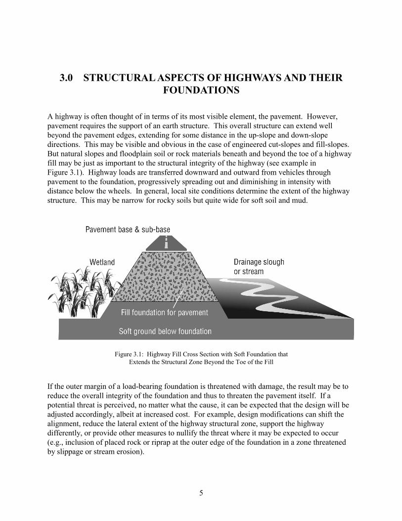
A highway is often thought of in terms of its most visible element, the pavement. However, pavement requires the support of an earth structure. This overall structure can extend well beyond the pavement edges, extending for some distance in the up-slope and down-slope directions. This may be visible and obvious in the case of engineered cut-slopes and fill-slopes. But natural slopes and floodplain soil or rock materials beneath and beyond the toe of a highway fill may be just as important to the structural integrity of the highway (see example in Figure 3.1). Highway loads are transferred downward and outward from vehicles through pavement to the foundation, progressively spreading out and diminishing in intensity with distance below the wheels. In general, local site conditions determine the extent of the highway structure. This may be narrow for rocky soils but quite wide for soft soil and mud.
Figure 3.1: Highway Fill Cross Section with Soft Foundation that Extends the Structural Zone Beyond the Toe of the Fill
If the outer margin of a load-bearing foundation is threatened with damage, the result may be to reduce the overall integrity of the foundation and thus to threaten the pavement itself. If a potential threat is perceived, no matter what the cause, it can be expected that the design will be adjusted accordingly, albeit at increased cost. For example, design modifications can shift the alignment, reduce the lateral extent of the highway structural zone, support the highway differently, or provide other measures to nullify the threat where it may be expected to occur (e.g., inclusion of placed rock or riprap at the outer edge of the foundation in a zone threatened by slippage or stream erosion).
5
Highway crossings of streams require some form of bridge to span the water. The simplest, a culvert, is discussed in other work (Klingeman 1998). For conventional bridges, abutments and piers are the structural elements that interact with streams. Such interaction must be addressed through design. Abutments support the ends of a bridge, whereas piers offer intermediate structural support at one or more points along the span. Bridges may be designed to “free-span” the water or may have one or more sets of piers. In considering bridge type, the location and spacing of the abutments is an important cost consideration. When the design focus is on the structure and control of its cost, rather than on the stream environment, abutments are likely to be close together and may encroach on both streambanks or even on the water’s edge. Fill sections may also be required across adjacent floodplain approaches to elevate the bridge above floodwaters and allow for vertical adjustments in roadbed elevation between the bridge deck and main highway. The extent of lateral encroachment of bridge abutments into the stream is usually limited by the need to provide an ample waterway under the bridge to pass the design flood. The amount of approach fill is usually limited by cost and by the requirement to not aggravate flooding upstream of the highway route.
3.1 STRUCTURAL INFLUENCE OF STREAMS ON HIGHWAYS
Streams dictate many highway features. The design of a new highway or bridge is affected in such ways as highway alignment, roadbed cut-and-fill sections, erosion protection, drainage discharge, bridge type, pier and abutment size and spacing, and associated structural elements. Streams continue to influence highways and bridges long after these structures are built. This influence is primarily structural (since alignment issues were resolved during the original design). Bridge abutments and piers must be protected from local scour that could otherwise undermine and weaken the needed structural support. The foundations of roadways along streams must be protected from local damage that could otherwise lead to movement of the foundation and damage to or loss of pavement.
3.2 CONVENTIONAL RIPRAP APPLICATIONS
The conventional technique to deal with all of these stream influences on highways is to design or add zones of riprap with quarry rock that is large enough and sufficiently abundant to nullify any erosion risks from stream current. Rock size is determined by the nature of the stream and its velocities and debris load. The volume of rock is more subjective and depends greatly on how the stream’s stability or instability is assessed. If the stream is assumed to be stable, riprap may be used in limited amounts to address only immediate problems; then, if the stream becomes less stable, additional riprap must be added as channel conditions change (e.g., stream meandering). If the stream is assumed to be changeable, large amounts of riprap may be used to address present or potential changes of stream course – much of this riprap may not serve an active purpose of protecting the roadway from stream attack. For changeable streams, a spot inspection provides only a “snapshot in time” of stream-roadway interaction, which may give the observer a sense that there is more riprap than needed. A photographic history of the site may reveal that riprap was needed at some time at the locations where it is placed. It is just such locations where vegetated riprap may be both desirable and successful.
6

4.0 THE NATURE AND EXTENT OF A STREAM
A river is not just the channel in which the dry-season base-level streamflow occurs. Nor is it only the physical zone of moving water and the immediate banks and bed that contain such flow. Rather, a stream has both aquatic and riparian zones (extending beyond the tops of the banks) that interact in a normally functioning river setting. When common floods are considered, the stream corridor becomes a widely inclusive zone of space beyond the low-flow stream that includes adjacent low floodplains. Thus, from a broad perspective (illustrated in Figure 4.1), streams consist of many elements that depend on flowing water at some time. These include: (a) the various segments of banks that contain low, intermediate and high flows, (b) the bed with its varying morphological features, (c) the low over-bank floodplain terraces that frequently are inundated by common floods, (d) the rock and soil materials present at and within these physical boundaries, (e) the various species and sizes of vegetation that grow along and within these physical boundaries, and (f) the biological ecosystem of plant and animal species present. Important hydraulic and habitat aspects of streams are determined in terms of the variable water depths, velocities, flow directions, and flow patterns that occur over space and time.
Figure 4.1: Illustration of Stream and Riparian Zones, Showing some Components of Each
7
These stream components can be viewed as structural in the same way as a highway. The stream bed and banks are as structurally important to the stream as are fill slopes and foundations to a highway. Beyond the streambanks, the vegetation, including forbs and sedges, woody brush species, and trees, is key to both the riparian zone and the stream. The importance of the structural interaction of the riparian zone with the stream cannot be overemphasized. Brush and trees in riparian zones provide the primary roughness to resist stream currents at the margins of the main channel. Lower flow velocities in riparian zones allow sediment to deposit, both during high flows and on the falling limbs of flood hydrographs. In this way, a well-vegetated riparian zone works to provide limited resistance to the normal erosive forces of a river, while maintaining soil for plant growth, and providing stability to the overall system.
4.1 STREAM CONDITIONS RESPOND TO CHANGING DISCHARGES
Streams change greatly in response to changes in water discharge. Highway protection planning should reflect awareness of such change. At each location within the channel and along the banks, the water depths and velocities change over time, affecting local flow strengths, shear stresses, and flow directions. In turn, these affect overall water flow patterns, bank erosion, bed scour, sediment transport, sediment deposition, debris transport, and debris stranding. At high flows, riparian and bar vegetation are stressed by moving water, sediment, and debris. At low flows, this vegetation may instead be stressed by insufficient root-zone moisture. Wet seasons and dry seasons create different conditions that affect the overall stability and behavior of a stream. Sustained storm runoff lengthens erosion and channel-shaping processes and may increase the overall changes. Sustained periods with adequate water but without stressful floods may give time for plant species to grow and reinforce the stability of banks and bars.
4.2 RIVERS ARE DYNAMIC
Erosion and deposition are normal processes in the dynamic systems of a river. From a highway perspective, the best time to recognize and deal with this is in project planning and design. If not considered early, the subsequent maintenance and emergency measures may be quite costly. Erosion and deposition occur irregularly over time and are local in extent. Erosion is mainly associated with wet season flows and snowmelt floods, but may also occur locally as steep banks dry out and unravel. Erosion and deposition lead to the movement of bank lines and channels. Over centuries, these processes have formed wide floodplains for many rivers. In the short term (decades or less), they have led to startling changes in local conditions at places such as bridges and water intakes.
Meandering occurs where a floodplain exists with widespread erosion and deposition, due to the accumulation and interaction of many local erosion events. Elsewhere, lateral changes may be restricted by bedrock, cemented gravel, and hardpan soils. Meander changes are likely to be most evident during the larger, less common floods. Avulsive changes (abrupt, extreme, and often unpredictable events that typically involve the cut-off of a meander loop) are most likely to occur with major floods. Meandering and avulsive changes are probably the greatest concerns for highway maintenance, causing new and unexpected threats as well as emergencies for roadways and bridges.
8

Dynamic streams typically change their lateral position (i.e., changes seen on a map) over time, but may also change vertical features (i.e., changes seen in cross-section and profile views). Lateral changes are usually associated with erosion and deposition, with cumulative effects that lead to meandering in floodplains or to shifts from side to side between restraining banks and hillsides in narrower zones such as canyons or mountain gaps. Vertical changes involve local down-cutting through erosion and scour processes and local buildup through deposition and sedimentation processes. Sustained down-cutting and buildup lead, respectively, to bed elevation degradation or bed elevation aggradation.
Because highways and bridges are static in position, they are quite vulnerable to many of these channel changes. Direct erosive attack may occur due to changing channel flow directions or by deflected flows from new bars and debris. Sharper channel bends may result in deeper local scour that undermines banks, piers, and abutments. Widened channels may become less efficient in transporting sediment, leading to bar formation, local bed aggradation, accumulated debris, and the deflection of flows toward banks that support a roadway or bridge abutment.
Analysis of river processes and associated data allows estimates to be made of the types of stream changes to be anticipated, at least for short periods into the future. However, streams are subject to many unpredictable events along their lengths and within their drainage basins. Changes at one location set up influences elsewhere, while changes elsewhere are doing the same thing. The result is a highly “non-linear” (almost chaotic) system with multiple, overlapping, and cumulative impacts. Major floods in different years may have triggered changes that partially cancel or partially reinforce each other. These make it virtually impossible to predict when a specific event may occur or whether a specific event will occur during a particular interval of years. Hindcasting methods may be used (but for the reasons just given are often not reliable) to estimate when a future change might be expected if all conditions remain the same – quite an assumption! Instead, major occurrences like big floods and extended droughts are likely to be “triggering” mechanisms, setting in motion new trends of events, such as aggravated erosion that leads to meandering and bed aggradation; or loss of vegetative cover that affects bank erodibility until plants recover or recolonize a damaged zone. A large flood or landslide may initiate processes that last for a decade or more. Given this lack of predictability, highway design and maintenance are perhaps best served through preventative measures that focus on the most likely kinds of changes, based on review of historical maps and photographs and on field investigations that extend well beyond highway right-of-ways.
Several specific consequences of channel change are important at streambank zones. These include the flow alignment along the bank (whether parallel to or attacking the bank) and the shear strength related to flow velocity and flow depth. If the plan-view features of a channel change over time due to various events, the flow patterns at banks will also change. Some banks will become subject to greater erosive forces, whereas others will become depositional zones. Over additional years, these circumstances may reverse one or several times. Such variable changes must be considered as part of preventative highway management.
9

4.3 STREAM STABILITY
Stream stability must be defined in terms of the inherently dynamic nature of streams, rather than in terms of absolute stability, which requires a lack of change and implies that bank lines remain fixed in location over time. Stream stability is commonly defined as a condition wherein processes (rather than boundaries) are stable. It is also defined in terms of dynamic equilibrium, whereby conditions “balance” about some average condition over time but change during shorter periods. For example, with dynamic equilibrium the sediment moves through a river reach in long-term balance of inputs and outputs, but the transport rates change as water discharge changes and the “sources” and “sinks” within the reach become altered through bank erosion and bar formation.
Furthermore, major disturbances like meander cutoffs may place the system out of balance for several years – but over a longer period of years these events balance, if the system is in dynamic equilibrium. Such a system may be thought of as stable over the long period but subject to shorter-term instabilities. Large floods, debris jams, hillslope failures, large-scale gravel extraction, bank revetting, channel meandering, and significant changes of watershed condition all may affect stream stability.
Many streams seek to adjust back toward former states; but others adjust to the newly imposed conditions or constraints and seek a new dynamic equilibrium. Thus, depending on the extent of the boundary involved, riprapping the banks of a stream for highway protection may impose a modest boundary-forcing condition that affects nearby stream dynamics. This is more likely to occur at constricting bridge crossings than along streamside roadways.
4.4 NATURAL EROSION PROTECTION AT STREAMBANKS
Since erosion protection will be required in many highway situations, it is appropriate to comment briefly on the ability of natural elements of stream riparian zones to provide erosion protection. As has been indicated, the lateral movement of streams is clear from geologic features and vegetation patterns. Natural features such as rock outcrops, cemented gravel or soil deposits, and erratic boulders provide durable lateral erosion resistance, akin to that provided by riprap. Natural vegetation also limits the rate of lateral channel movement, but does not eliminate it.
Evidence of this can be seen in many eroding streambanks that are fully within riparian zones that have significant components of forb, woody shrub, and tree vegetation. The structural integrity provided by tree and shrub root systems commonly limits the attack of flowing water to that of undermining the root systems (this also creates a number of positive components of fish habitat). The exact character of the interaction of the stream with riparian tree and shrub root systems is quite varied. Together, the local riparian soil, the rooting habit of the trees and shrubs, and the flood regime of the stream make for an extensive array of possibilities.
The erosion resistance provided by tree and shrub root systems produces only a temporary delay in lateral movement of the stream channel. Undermining ultimately results in collapse of the streambank. These dynamics of water, soil and vegetation are part of the proper functioning
10
condition of a stream. Ultimately, this may become incompatible with the structural integrity of an adjacent highway. However, when tree growth has become substantial, the root structure may be adequate to maintain the bank line against further retreat. Such stable bank-lines that are steep and even overhanging, may provide significant habitat benefits for aquatic species.
4.5 LIMITATIONS TO NATURAL VEGETATIVE PROTECTION
The success of vegetation in protecting streambanks is a question of the scale and nature of disturbances, as well as the alignment of the flows to the bank. Riparian vegetation is likely to have the most “permanence” for small streams, diminishing in longevity as streams become larger and carry bigger floods. Even in large rivers, vegetative protection may be appreciable when the flows are aligned parallel to the banks. But when large flows are directed toward a vegetated bank due to changes of channel alignment or flow deflection (e.g., from bar growth or debris accumulation), there is increased risk that the base of the bank may be undercut or scoured. At such points in time, the vegetative protection is likely to become reduced or eventually lost. Once the bank-slope vegetation is lost, together with its root system, further bank erosion of weak soils may begin to undercut bank-top vegetation and perhaps affect the structural zone of an adjacent highway.
11

5.0 THE HIGHWAY / RIVER INTERFACE
As described in detail earlier, stability of a stream system means stability of processes, not a static stream channel. Streams are dynamic, shifting positions within their floodplains over time. It is exactly this natural lateral migration, which occurs through the process of bank erosion, that highway erosion protection seeks to prevent.
5.1 EROSION THREATS CHANGE OVER TIME
Lateral stream changes that occur over time affect the relative alignment between a stream and adjacent roadway or crossing bridge. This may increase bank erosion near the highway embankment or bridge abutment, if changing flow directions cause increased angles of attack on the banks. Lateral stream changes may be accompanied by vertical stream changes, such as local down-cutting or deposition. In turn, these may alter the nature of scour threats at the bases of abutments and piers, along the bases of streambanks, and at the toes of road fills. Such conditions provide a critical reminder that stream conditions observed at the time of design survey work are not necessarily going to remain the same over the service life of the roadway or bridge.
To maintain the structural integrity of the highway, normal streambank erosion that threatens or encroaches on the structural influence zone of the highway must be prevented. If encroachment occurs, the choices for taking effective action are diminished. There is a need to provide critical protection to meet existing conditions during design and a further need to provide initiation of long-term protection to address likely future changes.
The moment when a highway structural zone and a river structural zone first intersect is not likely to be known. The reason: both structural zones are much wider than the casual observer realizes. When the structural zones first intersect, the greatest flexibility exists to prevent encroachment of the river on the highway and yet preserve important elements of the river structural zone. Is it possible to preserve all elements of both systems? Quite simply, No! But an interface can be designed that preserves much of the values of both structural zones.
5.2 KEEPING THE RIPARIAN ZONE INTACT
Having a healthy growth of riparian vegetation present acts as a natural means of erosion protection, slowing down the erosion process even if not stopping it. This allows highway protection and habitat benefit to occur simultaneously. A key element in the design of a highway/river interface is to stop lateral movement of the stream when there is still a riparian zone between the two. In this way, the positive functions of the riparian zone – exclusive of those involving erosion – can continue.
13
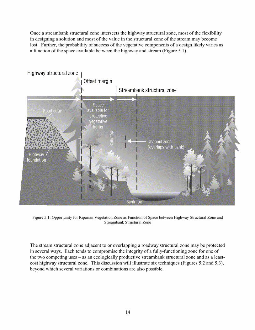
Once a streambank structural zone intersects the highway structural zone, most of the flexibility in designing a solution and most of the value in the structural zone of the stream may become lost. Further, the probability of success of the vegetative components of a design likely varies as a function of the space available between the highway and stream (Figure 5.1).
Figure 5.1: Opportunity for Riparian Vegetation Zone as Function of Space between Highway Structural Zone and Streambank Structural Zone
The stream structural zone adjacent to or overlapping a roadway structural zone may be protected in several ways. Each tends to compromise the integrity of a fully-functioning zone for one of the two competing uses – as an ecologically productive streambank structural zone and as a least-cost highway structural zone. This discussion will illustrate six techniques (Figures 5.2 and 5.3), beyond which several variations or combinations are also possible.
14
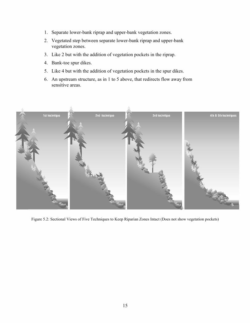
1. Separate lower-bank riprap and upper-bank vegetation zones.
2. Vegetated step between separate lower-bank riprap and upper-bankvegetation zones.
3. Like 2 but with the addition of vegetation pockets in the riprap.
4. Bank-toe spur dikes.
5. Like 4 but with the addition of vegetation pockets in the spur dikes.
6. An upstream structure, as in 1 to 5 above, that redirects flow away fromsensitive areas.
Figure 5.2: Sectional Views of Five Techniques to Keep Riparian Zones Intact (Does not show vegetation pockets)
15

Figure 5.3: Plan Views of Six Techniques to Keep Riparian Zones Intact
16

The first technique limits riprap to only the lower bank, protects the toe of the highway structural zone with riprap, and relies on vegetation to protect much of the slope. The second adds a horizontal step or bench where vegetation may be able to thrive as dense protection to retard velocities against the upper vegetated bank slope. The third adds pockets of planted or retained vegetation within the riprap zone, closer to the low-flow water table.
The fourth and fifth techniques change the method of protection from a “hardened continuous toe line” of riprap protection to a “spaced, hardened toe deflector” set of short spurs (groins) extending outward from the bank, either without or with pockets of vegetation. A single deflector may suffice to realign flows in a small stream, but multiple deflectors are more effective and are needed for general protection on large streams. Flow patterns develop along banks with eddies that could allow some near-shore deposition but may also cause local bank scour unless closely spaced. Controlled scour may be useful for maintaining aquatic habitat features while protecting a highway from further channel changes. Spur dike techniques may also be supplemented with stepped banks (not listed above).
The sixth technique provides a small upstream modification to reduce or eliminate the need for larger modifications at sensitive locations. Upstream features may influence flow patterns in positive ways to protect a given bank while maintaining general habitat diversity.
5.3 POTENTIAL CLASSES OF PROJECT OPPORTUNITIES
Given these concepts, one can begin to look at potential project opportunity categories. Three classifications can be made.
Case 1: Emergency Situations where Erosion of the Toe of the Highway Fill has Occurred
These cases, which include most of the riprap work currently done by ODOT, leave little flexibility or opportunity for establishing a riparian zone. During emergencies, riprap must be placed quickly to avoid further damage, leaving little time for planning any inclusion of vegetation. Opportunities exist for establishment of vegetation within conventional riprap, but the likelihood of establishing a sustaining natural riparian shrub and tree community is probably low in the absence of adequate soil, unless special care is taken to maintain a natural zone above or within the riprap.
Moving the highway or the stream may have appeal, but moving either does not come without significant cost and moving a stream, albeit within the bounds of its formerly occupied channel, does not come without significant uncertainty. Preparation of “generic” plans for emergency work, that include vegetation re-establishment and that represent several “typical” high-risk sites, may be effective at less cost and with less uncertainty.
17

Case 2: Distressed Situations where Lateral Migration of the Stream has Reduced the Effective Width of the Riparian Zone and/or where the Stream has Encroached on the Highway Structural Zone
Two possibilities define the range of options in these cases, (1) the highway structure can be modified to reduce the lateral extent of the highway structural zone, or (2) the geometry or the erosion resistance of the eroding bank of the stream can be modified. In either case, the design can range from a delaying tactic to a relatively permanent solution to the erosion problem. Cost as well as environmental and ecological factors can be considered in arriving at a solution.
Case 3: Opportunities where Highway Protection Can Work to the Maximum Extent in Harmony with the Stream
These cases are truly opportunities where the maximum benefit to the riparian and aquatic zones can be obtained. Note however, that some means of erosion protection will be required to keep a case 3 opportunity from becoming a case 2 distressed situation.
5.4 DESIGN APPLICATIONS
The three classes of highway/stream interaction outlined above, combined with the likely result that ODOT will want to develop a design to stabilize lateral erosion, give rise to a range in riparian/aquatic function outcomes. As indicated above, all functions of riparian and aquatic zones cannot be preserved. Table 5.1 on the following page outlines the functions that can be designed into a project related to these three classes, as well as additional highway considerations to address bridge crossings. Individual projects will vary, of course, but the listing in Table 5.1 illustrates the general trend in function that is likely to result from the range in project types.
18
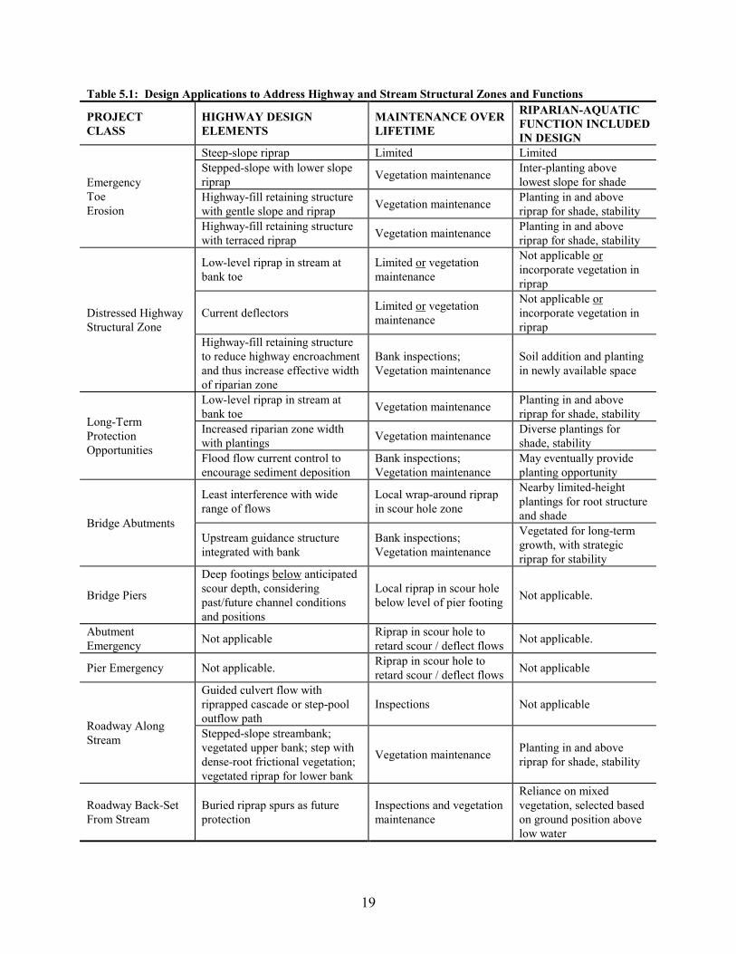
Table 5.1: Design Applications to Address Highway and Stream Structural Zones and Functions
PROJECT CLASS
HIGHWAY DESIGN ELEMENTS
MAINTENANCE OVER LIFETIME
RIPARIAN-AQUATIC FUNCTION INCLUDED IN DESIGN
Steep-slope riprap Limited Limited Stepped-slope with lower slope riprap Vegetation maintenance Inter-planting above
lowest slope for shade Highway-fill retaining structure with gentle slope and riprap Vegetation maintenance Planting in and above
riprap for shade, stability
Emergency Toe Erosion
Highway-fill retaining structure with terraced riprap Vegetation maintenance Planting in and above
riprap for shade, stability
Low-level riprap in stream at bank toe
Limited or vegetation maintenance
Not applicable or incorporate vegetation in riprap
Current deflectors Limited or vegetation maintenance
Not applicable or incorporate vegetation in riprap
Distressed Highway Structural Zone
Highway-fill retaining structure to reduce highway encroachment and thus increase effective width of riparian zone
Bank inspections; Vegetation maintenance
Soil addition and planting in newly available space
Low-level riprap in stream at bank toe Vegetation maintenance Planting in and above
riprap for shade, stability Increased riparian zone width with plantings Vegetation maintenance Diverse plantings for
shade, stability
Long-Term Protection Opportunities
Flood flow current control to encourage sediment deposition
Bank inspections; Vegetation maintenance
May eventually provide planting opportunity
Least interference with wide range of flows
Local wrap-around riprap in scour hole zone
Nearby limited-height plantings for root structure and shadeBridge Abutments
Upstream guidance structure integrated with bank
Bank inspections; Vegetation maintenance
Vegetated for long-term growth, with strategic riprap for stability
Bridge Piers
Deep footings below anticipated scour depth, considering past/future channel conditions and positions
Local riprap in scour hole below level of pier footing Not applicable.
Abutment Emergency Not applicable Riprap in scour hole to
retard scour / deflect flows Not applicable.
Pier Emergency Not applicable. Riprap in scour hole to retard scour / deflect flows Not applicable
Guided culvert flow with riprapped cascade or step-pool outflow path
Inspections Not applicable
Roadway Along Stream Stepped-slope streambank;
vegetated upper bank; step with dense-root frictional vegetation; vegetated riprap for lower bank
Vegetation maintenance Planting in and above riprap for shade, stability
Roadway Back-Set From Stream
Buried riprap spurs as future protection
Inspections and vegetation maintenance
Reliance on mixed vegetation, selected based on ground position above low water
19

5.5 THE TIME FUNCTION IN EROSION CONTROL
Addressing the time function in erosion problems is clearly a significant and new challenge. To design an erosion protection scheme that either slows or stops lateral channel movement while a significant riparian zone still exists requires understanding of which sites will experience the greatest lateral channel movement over the current highway’s service life. Given that evaluation, then the necessary projects can be undertaken. In some cases, anticipating channel migration may be relatively easy, while in others it will no doubt be quite difficult.
In general, re-evaluation and new decisions will be required periodically. These evaluations are further complicated because the location of an existing highway (and perhaps its use) will often remain fixed well beyond the physical service life cycle determined from economic analysis. Channel changes will continue indefinitely into the future. The problem is compounded even further by the present legal mandate to protect endangered species without regard for cost.
20

6.0 CHOICES IN ROADWAY BANK PROTECTION
Roadway bank protection is not an “all or nothing” choice. At the one extreme of protection, one may opt to use riprap exclusively and extensively. At the other extreme, one may consider the need to move the road away from the stream. As example of the latter, a highway in a narrow stream corridor may be damaged many times by repeated floods or debris flows and extensive riprap may not be sufficient to protect against loss of local roadway segments. Ultimately, it may be prudent to relocate portions of such routes out of the stream corridor. Yet in contrast to such tight stream-corridor highway routes, there are many places where only local riprap protection may be needed. A bridge crossing usually involves only localized interaction and protection needs. If the bridge span is adequate, the technical measures (and their impacts) should be quite local. They may be of two types: scour/erosion protection for abutments and approach-flow alignment control to prevent channel changes from leading to greater future protection needs.
Similarly, at a streambank roadway or bridge crossing, the decision on whether or not to use vegetated riprap is not a clear and decisive yes or no. Riprap with living vegetation may be found in many places where both the rock and the vegetation appear to be sound. In the normal range of stream conditions, there are many possibilities between the extremes of no-use and extensive-use. The difficult problem is to determine the guidelines for such choices.
Highway protection from stream erosion must be determined based on sound judgment and careful risk assessment. Such protection cannot take a back seat to other objectives, such as aquatic/riparian habitat. However, this protection takes the form of excessive use of riprap at times. Some may speculate that often decisions on how much riprap to use are not made during design, where there is the opportunity for careful planning, but rather during field operations with less thought to overall implications. The exclusive use of riprap may be criticized at many specific locations.
6.1 IDENTIFICATION OF CANDIDATE VEGETATION SPECIES
Riverine riparian zones are three-dimensional ecological transition zones between aquatic and upland ecosystems. They have distinct vegetation and soil characteristics and may encompass sharp gradients of environmental factors, ecological processes and plant communities. Western Oregon gradients are generally not as sharp, producing broader riparian zones compared with streams of similar size east of the Cascades.
A literature review was used to identify and characterize those common tree and shrub species that would be suitable candidates for riparian plantings in ODOT streamside stabilization projects. A table was produced for each ODOT management region that describes the riparian species found in that region (Appendix). The species lists are not exhaustive; also, the less common species are not included.
21
Eco-regions selected to match the five ODOT management regions were used for identifying and grouping suitable riparian vegetation: 1) Portland Metro Area; 2) Northwest Oregon; 3) Southwest Oregon; 4) Central Oregon and 5) Eastern Oregon. The boundary between eco-region 4 and the three eco-regions lying to the west approximately follows the crest of the high Cascades. At the northern and particularly the southern ends, this boundary deviates from the Cascade crest. For the purpose of matching vegetation to eco-region, this boundary was assumed to follow the Cascade crest through its length.
Each of ODOT’s five eco-regions encompasses several natural vegetation zones. These zones are characterized by different combinations of dominant tree and shrub species. Vegetation zones in the literature provided a suitable scale for the research, identification, and compilation of the dominant riparian trees and shrubs, which were then reduced to suitable candidates for each eco-region. In grouping species from different vegetation zones into a single, large-scale ODOT eco-region, invariably some species are grouped together which do not naturally occur together. These vegetation classification tables by ODOT management region were designed to present information useful in determining plant associations appropriate to different riparian sites. The common riparian woody vegetation was listed in table-form for each ODOT eco-region. Ecological characteristics were provided for each species to assist in matching species to specific project sites. Physiological characteristics pertinent to establishment and streambank stabilization were also evaluated.
6.2 VEGETATION SELECTION STRATEGY
For a highway project intended to include riparian vegetation, the first step is determining the site elevation and identifying the species normally occurring at that elevation found in that eco-region. In addition to elevation range, the natural range of a species may be further restricted geographically within an eco-region. The Ecology-Associations category of the vegetation report broadly describes geographic distribution within an eco-region for each species.
It should be noted that riparian interfaces produce complex and varied ecosystems. Hence guidance in vegetation selection requires field verification of nearby riparian zones at each project site to assess local ecological conditions and associated plant communities. Since the tables in the vegetation report characterize only common woody species for generalized ecological conditions, a field survey is necessary for two reasons. First, the research sites from available literature represent only a sampling of the range of riparian communities found across the state. Second, in compiling the tables at the eco-region level, local community (site specific) detail was necessarily generalized.
Riparian zones are also complex at the site scale, with different plant communities suitable for different locations within the zone. For any project, the riparian zone needs to be delineated and subdivided into lateral levels (defined under Riparian Zone Levels in the appendix) as necessary for the specific site. At this point, plant species can be evaluated for use in respective Riparian Zone Levels. First, the Riparian Zone Level category provides a general guide for each species. Further information relevant to matching species to locations within the riparian zone are provided in the Wetland Indicator Status, Shade Tolerance, Flood Tolerance and Drought Tolerance categories of the vegetation report. Additional ecological requirements and common
22

plant associations may be described in the Ecology-Associations category of the vegetation document. Site-specific variables that influence riparian communities include hydrology, substrate, microclimate, aspect, slope and valley constraint.
For any specific streambank location, the appendix tables indicate that many plant species can grow at the site. Not all of these species can be grown successfully together; some will out-compete others. An inspection of nearby riparian plant communities will indicate which combinations are most likely to work.
Since a main purpose of vegetation plantings is streambank stabilization, a category describing rooting characteristics pertinent to plant stability and soil binding is provided in the appendix. Furthermore, riparian zones are dynamic, subjecting plants to stresses affecting survivability. Growth response to damage and disturbance is described in the appendix for each species. Since reproduction is important to long-term community function, key sexual and vegetative reproduction characteristics are also described.
6.3 USE OF VEGETATED RIPRAP
It appears that vegetation may be safely incorporated into riprap projects at the time of project construction. By doing this as part of original design, the riprap and vegetation can be planned for joint service and appropriate measures can be taken to protect the riprap so as to accommodate vegetation growth.
Allowing vegetation to grow in existing riprap requires caution. Because the riprap system was not designed with this in mind, more uncertainty is involved and there is a possibility that damage may result. Inspections are needed to determine the condition of riprap as trunk growth occurs and diameters exceed 2-4 inches. In particular, rock displacements must be determined and any potential of such displacements to cause loss of riprap integrity must be assessed. The initial assessment is to decide if trunk and root growth are considered to be acceptable risks. The next assessment should address the potential for vegetation pull-out from water flow forces or wind forces.
Vegetation should be addressed at the time that emergency protection work is being undertaken. Some emergencies result from expected-but-overlooked situations, such as channel meandering. Preventative measures in advance could give ample opportunity to integrate vegetation with “hard fixes.” Unexpected emergencies may also provide opportunities to incorporate vegetation in riprap. It may be most beneficial to have a set of off-the-shelf solutions available for various circumstances because the work must be done quickly under the stress of an emergency. These could then be considered at a given emergency site at the time when engineers, biologists, maintenance personnel, and environmental staff first meet to discuss the emergency and its resolution.
23

6.4 FIELD OBSERVATIONS
Examination of some revetments that have growing vegetation suggests that:
• Riprap rock displacement does occur. Adjacent rocks are pushed up along the trunk. • Rock displacement does not diminish the riprap integrity when the tree is part of an
extensive mass of vegetation growing in the riprap. The flow resistance provided appears to diminish the local velocities at the vegetated riprap. This observation is supported by literature.
• Isolated trees in riprap have not yet been observed, so judgment is reserved on such conditions.
24
7.0 CONCLUSIONS AND RECOMMENDATIONS
To accommodate concerns about streambank management and effects on aquatic habitat quality, many new and diverse approaches are being tried in various parts of the country. These approaches are sometimes based on science and sometimes only on common beliefs. Many of the observations that form the bases for these approaches were made in different locations (sometimes in different eco-regions) than the location of the application site. It becomes very uncertain, therefore, if the sought-after habitat management goals were really achieved. Thus, there is a pressing need to assess the actual outputs of these expensive projects.
Erosion protection to effectively prevent lateral channel migration at the roadway structural zone is a necessary part of protecting Oregon’s roadways. The means of providing erosion protection and at the same time maintaining a component of riparian function has not received the investigation that would be beneficial to meeting today’s objectives. This report suggests a number of study areas that should be helpful in expanding ODOT’s ability to tailor erosion protection schemes to today’s broader project requirements. In some cases, formal fundamental research may be necessary, while in other cases carefully controlled field trials may be in order.
7.1 SUGGESTED TOPICS FOR FURTHER INVESTIGATION
The following list of suggestions can serve as a guide in directing future work, either for ODOT research or for operational projects.
1. Incorporate rootable and water-holding fines in conventional riprap to improve vegetation survival and growth.
2. Plant vegetation in conventional riprap at those zones where sedimentation now occurs.
3. Study comparatively the survival of different candidate plant species for planting riprap.
4. Research further along several fronts regarding riparian vegetation: (a) under-represented riparian communities and those in areas of most concern to ODOT should be adequately studied; (b) comparisons of community response to ecological processes and variables between project sites and natural systems should also be evaluated for developing future standards for measuring project success.
5. Study of the necessary “top elevation” for conventional riprap as a function of velocity, turbulence, and flow duration.
6. Study comparatively of terraced versus sloping riprap in terms of hydraulic performance and planted vegetation success.
7. Study comparatively of current deflectors that have a lesser effect on aquatic habitat than riprap, but are effective in preventing bank erosion.
25
8. Conduct more-detailed inspection of riprap where vegetation is now growing or has grown, to better understand its impacts, such as by looking for: a) downed trees, if any can be found, b) snapped trees, and c) for toppled trees with root wads and any hole that is formed in the riprap.
9. Examine riprap failures where vegetation is not a causative factor, to better characterize riprap failures.
10. Examine bank failures at solid banks where vegetation is present (omitting flow undercutting), to characterize bank failures when riprap is not present but vegetation may have a stabilizing or destabilizing role.
11. Develop generic plans for inclusion of vegetation in emergency work at a variety of sites.
12. Conduct pull tests on vegetation, by pulling trees in the downstream direction to simulate drag from water flow, with comparison of results for brittle and flexible trunks.
7.2 DEVELOPMENT OF DESIGN GUIDELINES
Regarding design guidelines, the next step is to develop an outline of the design approach to follow, together with recognition of limitations and potential-risk methods that might be tried experimentally. Further, it is necessary to identify questions that should be asked in the field by maintenance personnel working with design/inspection teams. Procedures should be developed or suggestions made on ways to resolve the remaining unanswered questions. Biological guidance needs to be developed on how to integrate rock riprap and vegetation. At the onset, these may be educated guesses that lead to ideas for experimentation.
26
8.0 REFERENCES
Abt, S.R., Dudley, S.J. & Fischenich, J.C. 1998. Woody Debris Influence on Flow Resistance. Engineering Approaches to Ecosystem Restoration: 1998 Wetlands Engineering & River Restoration Conference. ASCE. Denver, CO. CD Proceedings format. 6 pp.
Adams, R.M., P.C. Klingeman and H.W. Li. 1990. A Bioeconomic Analysis of Water Allocations and Fish Habitat Enhancements, John Day Basin, Oregon. Oregon State University. Corvallis, OR. August 1990. 168 pp.
Altpeter, L.S. 1944. Use of Vegetation in Control of Streambank Erosion in Northern New England. Journal of Forestry. 42: 99-107.
Anderson, B.W. & R.D. Ohmart. 1985. Riparian Vegetation as a Mitigating Process in Stream and River Restoration. In: J.A. Gore, ed. The Restoration of Rivers and Streams: Theories and Experiences. Butterworth, Boston. 280 pp. pp 41-49.
Anderson, E. 1948. Gravel bars evolve their own flood control. Missouri Botanical Garden Bulletin. 37: 54-57.
Anonymous. 1957. New Riprap Idea at Ice Harbor Dam. Western Construction. 32: 114.
Anonymous. 1962. Heavy Jute Mats Aid Erosion Control. Engineering News-Record. 169: 57-58.
ASCE. 1975. Sedimentation Engineering. American Society of Civil Engineers Task Committee for Preparation of Manual on Sedimentation, V.A. Vanoni, ed. ASCE Manual 54. pp 518-545.
Bair, J.H. 1998. Limiting Riparian Hardwood Encroachment Along the Trinity River, California. Engineering Approaches to Ecosystem Restoration: 1998 Wetlands Engineering & River Restoration Conference. ASCE. Denver, CO. CD Proceedings format. 6 pp.
Barnes, R.C. Jr. 1968. Streambank Erosion. Soil Conservation. 33: 126-128.
Bates, K. 1998. Integrated Bank Protection; Ecological Concepts for Streambank Protection. Engineering Approaches to Ecosystem Restoration: 1998 Wetlands Engineering & River Restoration Conference. ASCE. Denver, CO. CD Proceedings format. 6 pp.
27
Beamer, E.M. & R.A. Henderson. 1998. Juvenile Salmonid Use of Natural and Hydromodified Stream Bank Habitat in the Mainstem Skagit River, Northwest Washington. Report prepared by Skagit System Cooperative, La Conner, WA, for Seattle District, U.S. Army Corps of Engineers. Sept. 1998. 51 pp.
Bedinger, M.S. 1979. Forests and Flooding with Special Reference to the White River and Ouachita River Basins, Arkansas. U.S. Geological Survey Open-File Report 79-68. 24 pp.
Bella, D.A., P.C. Klingeman and H.W. Li. 1996. River Meander Zones and Floodplain Reconnection. Proceedings of the North American Water and Environment Congress '96, ASCE, Anaheim, CA. June 22-28, 1996. 6 pp.
Bellah, R.G. & L.C. Hulbert. 1974. Forest Succession on the Republican River Floodplain in Clay County, KS. The Southwestern Naturalist. 19: 155-166.
Benner, P.A. and J.R. Sedell. in press. Upper Willamette River Landscape: an Historical Perspective. River Quality: Dynamics and Restoration. Proceedings of the Poland-USA International Water Quality Symposium, March 21-25, 1994, Portland, OR.
Bierly & Associates. 1980. Willamette Riverbank Stabilization Program; Vegetation Maintenance Demonstration Program. Vegetation Study Program. Portland District, U.S. Army Corps of Engineers. January 1980. 35 pp.
Bjork, J., Johnson, A., Laird, J. & Hummel, S. 1999. Madsen Creek Pipeline Protection and Stream Restoration. Water Resources into the New Millennium: Past Accomplishments, New challenges. ASCE 1999 International Water Resources Engineering Conference. Seattle, WA. CD Proceedings format. 10 pp.
Bowie, A.J. 1982. Investigations of Vegetation for Stabilizing Eroding Streambanks. Trans. ASAE. 25(6): 1601-1606, 1611.
Boyd, K.F.; Fotherby, L.; Pollard, B. & Hart, J. 1999. Geomorphically Based, Standard Bioengineered Bank Treatments. Water Resources into the New Millennium: Past Accomplishments, New challenges. ASCE 1999 International Water Resources Engineering Conference. Seattle, WA. CD Proceedings format. 10 pp.
Brink, V.C. 1974. Survival of plants under flood in the Lower Fraser River Valley, British Columbia. Ecology. 35: 94-95.
Bulkley, R.V. et al. 1976. Warmwater Stream Alteration in Iowa: Extent, Effects on Habitat, Fish, and Fish Food, and Evaluation of Stream Improvement Structures. Summary Report. U.S. Fish & Wildlife Service. OBS-76/16. 39 pp.
California Resources Agency. 1973. Sacramento River Levee Revegetation Study: Final Report 1968-1973. Unpublished Paper. 19 pp.

Clary, W.P. and B.F. Webster. 1989. Managing Grazing and Riparian Areas in the Intermountain Region. General Technical Report INT-263. USDA Forest Service, Intermountain Research Station. Ogden, UT. 1989.
Crews, J.E. 1970. Bank Stabilization in Susquehanna River Basin. Proc. ASCE, J. Waterways and Harbors Division. 96: 87-95.
Crites, R.W. & J.E. Ebinger. 1970. Vegetation Survey of Floodplain Forests in East-Central Illinois. Transactions of the Illinois State Academy of Science. 62: 631-641.
Cummins, K.W. 1974/75. Structure and Function of Stream Ecosystems. BioScience. 24: 631-641.
D’Aoust, S.G. & Millar, R.G. 1999. Ballast Requirements for Constructed LWD Root Wad Structures. Water Resources into the New Millennium: Past Accomplishments, New Challenges. ASCE 1999 International Water Resources Engineering Conference. Seattle, WA. CD Proceedings format. 10 pp.
Darby, S.E. 1999. Effect of Riparian Vegetation on Flow Resistance and Flood Potential. Journal of Hydraulic Engineering. ASCE. 125 (5): 443-454.
Darnell, R.M. 1976. Impacts of Construction Activities in Wetlands of the United States. Report EPA-600/3-76-045. U.S. Environmental Protection Agency. Corvallis Environmental Research Laboratory. Corvallis, OR. April 1976. 392 pp.
Davis, P. 1999. Composite Turf Reinforcement Matting: A Value Engineering Alternative to Riprap Lined Channels. Water Resources into the New Millennium: Past Accomplishments, New challenges. ASCE 1999 International Water Resources Engineering Conference. Seattle, WA. CD Proceedings format. 10 pp.
Densmore, R. & J.C. Zasada. 1978. Rooting Potential of Alaskan Willow Cuttings. Canadian Journal of Forest Science. 8: 477-479.
Derrick, D.L. 1998. Two Cost-Effective Bioengineering Techniques, Willow Curtains and Willow Poles. Engineering Approaches to Ecosystem Restoration: 1998 Wetlands Engineering & River Restoration Conference. ASCE. Denver, CO. CD Proceedings format. 6 pp.
Dewberry, C. 1994. Why are Streambanks Degrading? A Functional Reply. Streambank Protection and Restoration Conference Course Notebook. Oregon State University. Water Resources Research Institute. Corvallis, OR. September 1994. Loose-leaf notebook.
Dillon, J.F. & Littleton, T.M. 1998. Literature Review of Rock Revetment and Channelization Impacts on Pacific Northwest Aquatic Resources. Engineering Approaches to Ecosystem Restoration: 1998 Wetlands Engineering & River Restoration Conference. ASCE. Denver, CO. CD Proceedings format. 6 pp.

Dodge, W.E. et al. 1976. Channelization Assessment, White River, Vermont: Remote Sensing, Benthos and Wildlife. U.S. Fish & Wildlife Service. OBS-76/7. 73 pp.
Drake, L. and Langel, R. 1998. Deep-Planting Willow Cuttings via Water Jetting. Engineering Approaches to Ecosystem Restoration: 1998 Wetlands Engineering & River Restoration Conference. ASCE. Denver, CO. CD Proceedings format. 6 pp.
Drury, T.A., Petroff, C., Abbe, T.B., Montgomery, D.R. & Pess, G.R. Evaluation of Engineered Log Jams as a Soft Bank Stabilization Technique: North Fork Stillaguamish River, Washington. Water Resources into the New Millennium: Past Accomplishments, New challenges. ASCE 1999 International Water Resources Engineering Conference. Seattle, WA. CD Proceedings format. 11 pp.
Edminster, F.C., W.S. Atkinson & A.C. McIntyre. 1949. Streambank Erosion Control on the Winooski River, Vermont. USDA SCS Circular 837. 54 pp.
Environmental Lab. 1986. Field Guide for Low-Maintenance Vegetation Establishment and Management. U.S. Army Engineer Waterways Experiment Station. Instruction Rept. R-86-2. 111 pp.
Fairbanks, J.D. & P. Diplas. 1998. Turbulence Characteristics of Flows Through Partially and Fully Submerged Vegetation. Engineering Approaches to Ecosystem Restoration: 1998 Wetlands Engineering & River Restoration Conference. ASCE. Denver, CO. CD Proceedings format. 6 pp.
Felker, R.H. 1946. Streambank Control. Soil Conservation. 12: 114-117.
Fenwick, G.B. 1969. State of Knowledge of Channel Stabilization in Major Alluvial Rivers. U.S. Army Corps of Engineers Committee on Channel Stabilization. Tech. Rept. 7. October 1969. 261 pp.
Franklin, J.F. & C.T. Dyrness. 1973. Natural Vegetation of Oregon and Washington. USDA Forest Service General Technical Report PNW-8. 417 pp.
Franz, E.H. & F.A. Bazzaz. 1977. Simulation of Vegetation Response to Modified Hydrological Regimes: A Probabilistic Model on Niche Differentiation in a Floodplain Forest. Ecology. 58: 176-183.
Freeman, G.E., Copeland, R.R., Rahmeyer, W. & Derrick, D.L. 1998. Field Determination of Manning’s n Value for Shrubs and Woody Vegetation. Engineering Approaches to Ecosystem Restoration: 1998 Wetlands Engineering & River Restoration Conference. ASCE. Denver, CO. CD Proceedings format. 6 pp.

Frissell, C.A., W.J. Liss, C.E. Warren and M.D. Hurley. 1986. A Hierarchical Framework for Stream Habitat Classification: Viewing Streams in a Watershed Context. Environmental Management. Vol. 10. pp. 199-214.
Gill, C.J. 1970. The Flooding Tolerance of Woody Species -- A Review. Forestry Abstracts. 31: 671-688.
Gill, C.J. 1974. Studies of Radial Stem Growth in Salix cierea L. on a Reservoir Margin. Journal of Applied Ecology. 11: 215-221.
Gill, C.J. 1975. The Ecological Significance of Adventitious Rooting as a Response to Flooding in Woody Species, with Special Reference to Alnus glutinosa (L.) Gaertn. Flora, Ed. 164, S. 85-97.
Gill, Don. 1972. The Point Bar Environment in the McKenzie River Delta. Canadian Journal of Earth Sciences. 9: 1382-1393.
Goldsmith, W. 1991. Working with Nature to Stabilize Land. Women in Natural Resources. University of Idaho. Moscow, ID. Vol. 12, No. 4. June 1991.
Goldsmith, W. 1998. Soil Reinforcement by River Plants: Progress Results. Engineering Approaches to Ecosystem Restoration: 1998 Wetlands Engineering & River Restoration Conference. ASCE. Denver, CO. CD Proceedings format. 6 pp.
Hall, B.R., MacArthur, R.C., Howard, L.J., Murray, L.E., & Wang, J. 1999. Sedimentation Engineering Analysis of the Lower Guadalupe River for Flood Control and Riparian Floodplain Design. Water Resources into the New Millennium: Past Accomplishments, New challenges. ASCE 1999 International Water Resources Engineering Conference. Seattle, WA. CD Proceedings format. 10 pp.
Hansen, E.A. 1968. Stabilizing Eroding Streambanks in Sand Drift Areas of the Lake States. USDA Forest Service. Research Paper NC-21. 12 pp.
Haugen, G. & D. Duff (eds). 1982. Best Management Practices for the Management and Protection of Western Riparian Stream Ecosystems. American Fisheries Society, Western Div.
Hawk, G.M. & D.B. Zobel. 1974. Forest Succession on Alluvial Landforms of the McKenzie River Valley, Oregon. Northwest Science. 48: 245-265.
Hempel, C.E., Avery, K.R., Fischenich, J.C. & Redican, J.H. 1999. Comparing Traditional Stream Bank Protection to Bioengineered Stream Bank Stabilization Methods to Reduce Costs and Provide Improved Riparian and Aquatic Habitat. Water Resources into the New Millennium: Past Accomplishments, New challenges. ASCE 1999 International Water Resources Engineering Conference. Seattle, WA. CD Proceedings format. 10 pp.

Henderson, J.E. Environmental Designs for Streambank Protection Projects. Water Resources Bulletin. 22(4): 549-558.
Henderson, J.E. & F.D. Shields, Jr. 1984. Environmental Features for Streambank Protection Projects. U.S. Army Engineer Waterways Experiment Station. Tech. Rept. E-84-11. 150 pp.
Hodges, C. & Diplas, P. 1998. Velocity Profiles in Riparian Wetlands. Engineering Approaches to Ecosystem Restoration: 1998 Wetlands Engineering & River Restoration Conference. ASCE. Denver, CO. CD Proceedings format. 6 pp.
Hoitsma, T.R. & Payson, E.M. 1998. The Use of Vegetation in Bioengineered Streambanks: Shear Stress Resistance of Vegetal Treatments. Engineering Approaches to Ecosystem Restoration: 1998 Wetlands Engineering & River Restoration Conference. ASCE. Denver, CO. CD Proceedings format. 6 pp.
Huffman, R.T. 1976. The Relation of Flood Duration Patterns to Dominant Forest Species Associations Occurring on Selection (Selected?) Firstbottom Sites of the Ouachita River. Univ. of Arkansas Ph.D. Thesis. 50 pp.
Hunt, R.L. 1975. Use of Terrestrial Invertebrates as Food by Salmonids. Coupling of Land and Water Systems. Springer-Verlag. pp 137-151.
Hynes, H.B.N. 1970. The Ecology of Running Waters. University of Toronto Press. 555 pp.
Johnson, R.R. & D.A. Jones, editors. 1977. Importance, Preservation and Management of Riparian Habitat: A Symposium. USDA Forest Service. General Technical Report RM-43.
Johnson, R.R. & J.F. McCormick, editors. 1978. Strategies for Protection and Management of Floodplain Wetlands and Other Riparian Ecosystems. USDA Forest Service. General Technical Report WO-12.
Juleson, T.C. Suggestions for Streambank Revegetation in Western Washington. Wash. Dept. of Game, Olympia. Appl. Research Informational Rept. 13.
Karr, J.R. 1994. Changing Courses: Stream as Living Resources. Streambank Protection and Restoration Conference Course Notebook. Oregon State University. Water Resources Research Institute. Corvallis, OR. September 1994. Loose-leaf notebook.
Karr, J.R. & I.J. Schlosser. 1978. Water Resources and the Land-Water Interface. Science. 201: 229-234.
Kennedy, D. & R. Mohlenbrock. 1963. Botanical Observations and Collections on a Sandbar in the Ohio River. Castanea. 28: 58-62.

Keown, M.P. 1983. Streambank Protection Guidelines for Landowners and Local Governments. U.S. Army Engineer Waterways Experiment Station. 60 pp.
Kern, K. 1994. Grundlagen naturnaher Gewassergestaltung -- Geomorphologishe Entwicklung von Fliessgewassern. Springer-Verlag. Berlin. 256 pp.
Kern, K., R. Bostelmann, and G. Hinsenkamp. 1992. Naturnahe Umgestaltung von Fliessgewassern -- Leitfaden und Dokumentation ausgefuhrter Projekte. Handbuch Wasserbau 2. Ministerium fur Umwelt Baden-Wurttemberg. Stuttgart, Germany. 228 pp.
Kline, W.M., R.H. Daley & J. Wedum. 1975. Environmental Inventory and Assessment of Navigation Pools 24, 25 and 26, Upper Mississippi and Lower Illinois Rivers: A Vegetational Study. Missouri Botanical Garden. 114 pp.
Klingeman, P.C. 1971. Prediction of Pier Scour in Western Oregon. Report to Federal Highway Administration, U.S. Department of Transportation, Region 8 Vancouver, WA. 52 pp + 10 appendices.
Klingeman, P.C. 1973. Indications of Streambed Degradation in the Willamette Valley. Report WRRI-21. Oregon State University. Water Resources Research Institute. Corvallis, OR. December 1973. 99 pp.
Klingeman, P.C. 1975. Literature Search on Natural Means of Streambank Stabilization. Peter. C. Klingeman Consulting Services, Corvallis, OR. January 1975. 186 pp.
Klingeman, P.C. 1996. Environmental Trends in River Engineering in the U.S. Pacific Northwest. Text book for River Front Symposium 1996. Technology Research Center for Riverfront Development. Tokyo, Japan. May 1996. 161 pp.
Klingeman, P.C. 1996. River Engineering to Restore and ReNaturalize Rivers. English Draft for Technical Publication by Technology Research Center for Riverfront Development. Tokyo, Japan. July 1996. 146 pp.
Klingeman, P.C. & J.B. Bradley. 1976. Willamette River Basin Streambank Stabilization by Natural Means. Water Resources Research Institute, Oregon State University, Corvallis, OR. 238 pp.
Klingeman, P.C., et al. 1997. Draft material prepared as chair of Department of Environmental Quality task force on erosion control at small construction sites. Unpublished draft document.
Klingeman, P.C., H. Matin, and C-C. Huang. 1990. Investigation of Motorboat-Induced Streambank Erosion on the Lower Deschutes River. Report WRRI-104. Oregon State University. Water Resources Research Institute. Corvallis, OR. February 1990. 67 pp. + appendices.
Klingeman, P.C., L. Cordes, and I. Nam. 1993. Rogue River Erosion/Deposition Study. Oregon State University. Civil Engineering Department. Corvallis, OR. December 1993. 111pp. + appendices.
Klingeman, P.C., M.R. Pyles, S.A. Wright, M-A Allen, A. Mirati, and R.N. Reeve. 1998. Culvert Fish Passage Improvement Training: How to Retrofit/Remediate Existing Culverts that Don’t Pass Fish. Course Notebook used in 1998 (revised for 1999). Oregon State University. Civil Engineering Department. Corvallis, OR. January 1998.
Klingeman, P.C., S.M. Kehe, and Y.A. Owusu. 1984. Streambank Erosion Protection and Channel Scour Manipulation using Rockfill Dikes and Gabions. Report WRRI-98. Oregon State University. Water Resources Research Institute. Corvallis, OR. September 1984. 169 pp.
Kuchler, A.W. 1946. The Broadleaf Deciduous Forest of the Pacific Northwest. Annuals, Association of American Geographers. 36: 122-147.
Leep, R.W. 1965. California Soil Conservation District Streambank Stabilization Program. J. Soil & Water Conservation. 20: 29-30.
Lester, H.H. 1946. Streambank Erosion Control. Agric. Engineering. 27: 407-410.
Li, R.M. & H.W. Shen. 1973. Effect of Tall Vegetation on Flow and Sediment. Proc. ASCE, J. Hydraulics Div. 99: 793-814.
Lund, J.A. 1976. Evaluation of Stream Channelization and Mitigation on the Fisheries Resources of the St. Regis River, Montana. U.S. Fish & Wildlife Service. OBS-76/06. 49 pp.
Mannering, J.V. & R.E. Burwell. 1968. Tillage Methods to Reduce Runoff and Erosion in the Corn Belt. USDA ARS Agricultural Information Bulletin 330. 14 pp.
McKenzie, G.K. 1948. Low Cost Slope Protection for Levees and RiverBanks. Proceedings 2nd International Conference on Soil Mechanics. Rotterdam. 7: 112-116.
Millar, R.G. & D’Aoust, S.G. 1998. Ballast Requirements for LWD Habitat Structures. Engineering Approaches to Ecosystem Restoration: 1998 Wetlands Engineering & River Restoration Conference. ASCE. Denver, CO. CD Proceedings format. 6 pp.
Miller, R. & G.E. Pope. 1984. An Effective Technique for Planting Trees in Riparian Habitats. Wildlife Resource Notes. 2(4): 1-2.
Miller, R.C. & W.M. Borland. 1963. Stabilization of Fivemile and Muddy Creeks. Proceedings ASCE, J. Hydraulics Div. 89: 67-98.

Moir, W. & P. Mika. 1972. Prairie Vegetation of the Willamette Valley, Benton County, Oregon. Unpublished Report. USDA Forest Service, Forestry Sciences Laboratory, Corvallis, OR.
Moses, T. & Gorman, D. 1998. Brookwide Channel and Floodplain Improvements. Engineering Approaches to Ecosystem Restoration: 1998 Wetlands Engineering & River Restoration Conference. ASCE. Denver, CO. CD Proceedings format. 6 pp.
Nam, I. 1995. Modeling Sediment Transport, Channel Morphology and Gravel Mining in River Bends. PhD Thesis. Oregon State University. Civil Engineering Department. Corvallis, OR. October 1995. 348 pp.
Nepf, H.M. & Vivoni, E.R. 1998. Drag and Diffusivity Within Emergent Vegetation. Engineering Approaches to Ecosystem Restoration: 1998 Wetlands Engineering & River Restoration Conference. ASCE. Denver, CO. CD Proceedings format. 6 pp.
NRCS, 1996. Streambank and Shoreline Protection. Chap. 16 in Engineering Field Handbook. U.S. Dept. of Agriculture, Natural Resources Conservation Service. December 1996. 88 pp + appendices.
O’Neal, J., Watts, A., Bolton, S. & Sibley, T. 1999. A Comparison of the Hydraulic and Biological Effects of Large Woody Debris and an Engineered Alternative. Water Resources into the New Millennium: Past Accomplishments, New challenges. ASCE 1999 International Water Resources Engineering Conference. Seattle, WA. CD Proceedings format. 12 pp.
Oberwager, D. 1967. Teamwork Approach Used in Streambank Stabilization. Soil Stabilization. 32: 226-227.
ODSL. Oregon Division of State Lands. 1995. Wetlands Update. Semi-annual publication of Oregon Division of State Lands. Salem, OR. V. 6, Nos. 1&2. 1995. 16 pp.
Osmundson, T. & Associates. 1972. Recommendations for Planting in the Beautification Program for the Alameda Creek Flood Control Project, Alameda County, California. 19 pp.
OWIC, 1998. Riparian Areas, their Benefits and Uses. Brochure sponsored by Oregon Watershed Improvement Coalition (9 groups supported by USDA Forest Service, USDA Fish and Wildlife Service, USDI Bureau of Land Management, and Oregon Governor’s Watershed Enhancement Board). Undated (circa 1998).
Parsons, D.A. 1963. Vegetative Control of Streambank Erosion. Proc. Federal Interagency Sedimentation Conference. USDA ARS Misc. Publ. 970. pp 130-136.
Parsons, D.A. & R.P. Apmann. 1965. Cellular Concrete Block Revetment. Proc. ASCE, J. Waterways & Harbors Div. 91: 27-37.

Perala-Gardiner, N.C. 1998. Current Research Topics in the UK; Use of Woody Vegetation for River Bank Stabilization with Special Reference to Willows. Engineering Approaches to Ecosystem Restoration: 1998 Wetlands Engineering & River Restoration Conference. ASCE. Denver, CO. CD Proceedings format. 6 pp.
Petersen, M.S. 1984. Water Resource Planning and Development. Prentice Hall, Inc. Englewood Cliffs, New Jersey. 316 pp.
Pickett, E.B. & B.J. Brown. 1977. Guidelines for Monitoring and Reporting Demonstration Projects: Section 32 Program, Streambank Erosion Control Evaluation and Demonstration Act of 1974. U.S. Army Engineer Waterways Experiment Station. Instruction Rept. H-77-1. 40 pp.
Pickett, S.T.A. and P.S. White (editors). 1985. The Ecology of Natural Disturbance and Patch Dynamics. Academic Press. Orlando, FL.
Reeves, G.H. & T.D. Roeloffs. 1982. Rehabilitating and Enhancing Stream Habitat: 2. Field Applications. USDA Forest Service, Pacific Northwest Forest & Range Experiment Station, Portland. 38 pp.
Saveson, I.L. & V. Overholt. 1937. Streambank Protection. Agric. Engineering. 18: 489-491.
Sedell, J.R. and J.L. Froggatt. 1984. Importance of Streamside Forests to Large Rivers: The Isolation of the Willamette River, Oregon, U.S.A., from its Floodplain by Snagging and Streamside Forest Removal. Verhandlungen Internat. Verein. Limnol. V. 22. pp 1828-1834.
Sharp, W.C. & J. Vaden. 1970. 10-Year Report on Sloping Techniques Used to Stabilize Eroding Tidal River Banks. Shore & Beach. 38: 31-35.
Shields, F.D. Jr. 1991. Woody Vegetation and Riprap Stability Along the Sacramento River Mile 84.5-119. Water Resources Bulletin. 27 (3) 527-536.
Shields, F.D. Jr., Pezeshki, S.R. & Anderson, P.H. 1998. Probable Causes for Willow Post Mortality. Engineering Approaches to Ecosystem Restoration: 1998 Wetlands Engineering & River Restoration Conference. ASCE. Denver, CO. CD Proceedings format. 6 pp.
Sigafoos. 1964. Botanical Evidence of Floods and Floodplain Deposition. U.S. Geological Survey Professional Paper 485-A. 35 pp.
Silberberger, L.F. 1959. Streambank Stabilization. Agric. Engineering. 40: 214-217.
Sotir, R.B. 1994. History and Overview of Soil Bioengineering. Streambank Protection and Restoration Conference Course Notebook. Oregon State University. Water Resources Research Institute. Corvallis, OR. September 1994. looseleaf notebook.
Sotir, R.B. 1995. Personal communication accompanying literature.
Sotir, R.B. 1998. Criteria for Woody Vegetation Placement in Streambank Protection. Engineering Approaches to Ecosystem Restoration: 1998 Wetlands Engineering & River Restoration Conference. ASCE. Denver, CO. CD Proceedings format. 7 pp.
Sotir, R.B. & Stulgis, R.P. 1999. Slope Stabilization Using Soil Bioengineering Case Studies. Water Resources into the New Millennium: Past Accomplishments, New challenges. ASCE 1999 International Water Resources Engineering Conference. Seattle, WA. CD Proceedings format. 10 pp.
Sotir, R.B. et al. 1994. Guidelines for Streambank Restoration. Georgia Soil and Water Conservation Commission and others. Atlanta, GA. September 1994. 52 pp.
SRSRT. 1994. Snake River Salmon Recovery Team: Final Recommendations to the National Marine Fisheries Service. NOAA, National Marine Fisheries Service. Portland, OR. May 1994. Summary Report. 31 pp. Main Report 383+ pp.
State SWCC. 1973. Streambank Erosion in Oregon. State Soil & Water Conservation Commission, Salem. 149 pp.
Task Committee on Channel Stabilization Works. 1965. Channel Stabilization of Alluvial Rivers. Proc. ASCE, J. Waterways & Harbors Div. 91: 7-37.
Thorne, C., Amarasinghe, I., Gardiner, J., Perala-Gardiner, C. & Sellin, R. 1998. Riverbank Protection Using Willows. Environment Agency, R&D Technical Report W154. Bristol. 54 pp + appendices.
Tsujimoto, Tetsuro. 1999. Fluvial Processes in Streams with Vegetation. J. of Hydraulic Research; Intl. Assoc. for Hydraulic Research. 37: 789-803.
Turner, L.M. 1936. Ecological Studies in the Lower Illinois River Valley. Botanical Gazette. 97: 689-727.
USACE (U.S. Army Corps of Engineers). 1970. Hydraulic Design of Flood Control Channels. U.S. Army Corps of Engineers Manual EM 1110-2-1601. Washington, D.C. 66 pp.
USACE (U.S. Army Corps of Engineers). 1975. Final Environmental Statement: Corps of Engineers Actions Affecting Riverbanks and Channels in Willamette River Basin, Oregon. U.S. Army Engineer District, Portland, OR. April 1975. 50 pp. + appendices.
USACE (U.S. Army Corps of Engineers). 1978. Interim Report to Congress: The Streambank Erosion Control Evaluation and Demonstration Act of 1974. U.S. Army Corps of Engineers. 12 pp + appendices.

USACE (U.S. Army Corps of Engineers). 1981. Final Report to Congress: The Streambank Erosion Control Evaluation and Demonstration Act of 1974, Section 32, Public Law 93-251. U.S. Army Corps of Engineers. Main report + 8 separate appendices.
USACE (U.S. Army Corps of Engineers). 1981b. IR Aerial Photography: Willamette River, Oregon, Portland to Springfield, April and June 1981. U.S. Army Engineer District, Portland, OR.
USACE (U.S. Army Corps of Engineers). 1986. Aerial Photography: Willamette River, Oregon, Portland to Springfield, March, April and May 1986. U.S. Army Engineer District, Portland, OR.
USBLM (U.S. Bureau of Land Management). 1998. Riparian Area Management; a User Guide to Assessing Proper Functioning Condition and the Supporting Science for Lotic Areas. TR 1737-15 1998. USDI Bureau of Land Management, USDA Forest Service, USDA Natural Resources Conservation Service. USBLM National Applied Resources Center, Denver. 126 pp.
USDA (U.S. Department of Agriculture). 1965. Silvics of Forest Trees of the United States. Agriculture Handbook No. 271. 762 pp.
USDA (U.S. Department of Agriculture). 1983. Dormant Stock Planting for Channel Stabilization. USDA SCS, Arizona. Tech. Note 22. 14 pp.
USDA (U.S. Department of Agriculture). 1992. Soil Bioengineering for Upland Slope Protection and Erosion Reduction. Chapter 18, Field Engineering Handbook. U.S. Department of Agriculture, Soil Conservation Service. October 1992. 53 pp.
USDA (U.S. Department of Agriculture). 1996. Streambank and Shoreline Protection. Chapter 16, Field Engineering Handbook. U.S. Department of Agriculture, Soil Conservation Service. December 1996. 88 pp + 2 appendices (45 pp).
USDA. undated. Oregon Standard and Specification Guide for Streambank Protection. USDA Soil Conservation Service, Portland.
USFWS (U.S. Fish & Wildlife Service). 1976. Fish and Wildlife Management Plan for Sacramento River Bank Protection Project, California. U.S. Fish & Wildlife Service, Portland OR. 44 pp.
USFWS (U.S. Fish & Wildlife Service). 1978. Western Reservoir and Stream Habitat Improvements Handbook. U.S. Fish & Wildlife Service. OBS-78/56.
Vanicek, V. 1973. The Soil-Protective Role of Specially Shaped Plant Roots. Biological Conserv. 5: 175-180.

Vannote, R.L., G.W. Minshall, K.W. Cummins, J.R. Sedell and C.E. Chsuing. 1980. The River Continuum Concept. Canadian Journal of Fisheries and Aquatic Sciences. 37: 103-137.
Verdi, D.A. 1998. Stream Restoration and Streambank Protection Using Soil Bioengineering Measures in Massachusetts. Engineering Approaches to Ecosystem Restoration: 1998 Wetlands Engineering & River Restoration Conference. ASCE. Denver, CO. CD Proceedings format. 6 pp.
Watson, C.C., Thornton, C.I. & Kozinski, P. Brush Creek Rehabilitation Review. Water Resources into the New Millennium: Past Accomplishments, New challenges. ASCE 1999 International Water Resources Engineering Conference. Seattle, WA. CD Proceedings format. 7 pp.
White, D. & Kammereck, A. 1999. Design and Installation of Alternative Bank Stabilization and Fish Enhancement Structures on the Nooksack River, Washington. Water Resources into the New Millennium: Past Accomplishments, New challenges. ASCE 1999 International Water Resources Engineering Conference. Seattle, WA. CD Proceedings format. 9 pp.
Williamson, A.D. & E.R. Simmons. 1962. Old Plants Play New Role. Soil Conserv. 28: 42-43.
Williamson, K.J., D.A. Bella, R.L. Beschta, G. Grant, P.C. Klingeman, H.W. Li, P.O. Nelson, and others. 1995. Gravel Disturbance Impacts on Salmon Habitat and Stream Health. Volume I: Summary Report. Volume II: Technical Background Report. Oregon State University. Water Resources Research Institute. Corvallis, OR. 1995. 51 pp. and 227 pp.
Wittler, R.J. & Andrews, M. 1998. Restoration and Historic Preservation: Protecting Cultural Resources along a Meandering Stream. Engineering Approaches to Ecosystem Restoration: 1998 Wetlands Engineering & River Restoration Conference. ASCE. Denver, CO. CD Proceedings format. 6 pp.