robocops: study of coordination algorithms for autonomous ... · department of electrical and...
TRANSCRIPT

Department of Electrical and Computer Engineering
Faculty of Science and Technology
University of Coimbra
RoboCops: A Study of CoordinationAlgorithms for Autonomous Mobile
Robots in Patrolling Missions
David Bina Siassipour Portugal
A Dissertation presented for the degree of
Master of Science in Electrical and Computer Engineering
September, 2009


Department of Electrical and Computer Engineering
Faculty of Science and Technology
University of Coimbra
RoboCops: A Study of CoordinationAlgorithms for Autonomous Mobile
Robots in Patrolling Missions
Supervisor:
Prof. Doutor Rui Rocha
Juries:
Prof. Doutor Manuel Crisostomo
Prof. Doutor Rui Cortesao
Project report written for the dissertation subject, included in the
Electrical and Computer Engineering Course, submitted in partial fulfillment
for the degree of Master of Science in Electrical and Computer Engineering
September, 2009


Acknowledgements
Several people have been instrumental for the construction, development and conclusion
of this project. I would like to thank them for their important and gracious support.
These people include not only the academics and colleagues, but also friends and family
who have assisted me in different ways during this last year.
First of all, I would like to thank my supervisor, Prof. Rui Rocha, for his invaluable
guidance, with whom, I have discussed this thesis in detail ever since the planning phase
of the study. Due to his methods in monitoring, organization and support, I can honestly
say that I never felt adrift during the development of the project. I would also like
to remark the great motivation he has given to me when things did not go as well as
expected. It was a great pleasure to work with him and I hopefully expect that we have
the opportunity to work again in the near future.
Special thanks to my closest family: My parents, my sister Sara, who moved to Australia
recently, and whom is already missed a lot, also my grandmother from Iran, who has
been staying with us for the last three months; and also my beautiful girlfriend Vanessa.
These are the people, whom by their merely existence, allow me to go on, because of their
unconditional love, care and encouragement throughout my life.
My appreciation goes, as well, to my undergraduate and closest friends from Coimbra
for their support, friendship and listening skills, even when they had no idea what I was
speaking about.
I further would like to mention my laboratory mates, Joao Pacheco, Joao Quintas, Manuel
Oliveira, Miguel Ferreira, Paulo Freitas and Ricardo Faustino for the pleasant working
environment that subsisted during last year and also for their comments and suggestions.
Many thanks to my colleagues Jose Manuel Marinho and David Delgado, for fruitful
discussions and appreciated company for snack breaks. I am also greatly indebted to
v

vi
many other close colleagues during the five years of the course. Being all in the same
boat, we formed a team that helped each one of us to find the path to finish our studies.
I would like also to express my deepest gratitude to Joao Monteiro and Jose Rui Simoes,
who have helped me resetting the laboratory desktop, which drastically reduced my stress
levels. In addition, I acknowledge the contribution of Richard Szabo from Eotvos Lorand
University, in Budapest, Hungary for sending me his work in the “Topological navigation
of simulated robots using occupancy grid” project.
Along with the above people, I am grateful to my english aunt Julie for the proofread of
this document.
Resumo
Hoje em dia, a evolucao na area de robotica ja permite libertar os seres humanos em bas-
tantes tarefas, principalmente as mais monotonas e repetitivas ou, eventualmente, com
caracter de perigosidade. Uma destas tarefas e o patrulhamento de infra-estruturas. O
desenvolvimento e concepcao de metodos de patrulha atraves de robos moveis e uma area
cientıfica cujo interesse continua em crescimento.
Esta dissertacao foca-se em algoritmos de patrulhamento para equipas de robos moveis
dotados de um mapa do ambiente e da capacidade de se localizarem e de navegarem no
mesmo. O principal objectivo e desenvolver e validar um algoritmo inovador, escalavel
para ambientes de grandes dimensoes, patrulhados por um numero elevado de agentes,
tornando eficiente a sua cooperacao, obtendo o maximo desempenho na execucao da
missao e possuindo robustez face a inoperacionalidade de um subconjunto dos agentes
inicialmente disponıveis para a realizacao da missao.
O algoritmo apresentado baseia-se em particao multi-nıvel do mapa do ambiente, atribuindo
diferentes regioes a cada agente movel. Cada regiao corresponde a um sub-grafo extraıdo
da representacao topologica existente. O algoritmo lida com a tarefa de patrulhamento
local de cada robo, tendo sido designado por Multilevel Subgraph Patrolling (MSP) Al-
gorithm.
De forma a assistir no desenvolvimento do algoritmo e a analisar o seu desempenho,
construiu-se um simulador que serviu como uma ferramenta essencial do projecto. As
suas caracterısticas sao apresentadas ao longo deste documento.
Palavras-Chave: Patrulhamento; coordenacao de robos moveis; mapas topologicos;
particionamento; teoria de grafos.


Abstract
Nowadays, the evolution in the robotics field allows to free human beings in a set of tasks,
mainly the most monotonous and repetitive or, eventually, with dangerous concerns. One
of these tasks is the patrolling task in infrastructures. The development and conception
of patrolling methods using mobile robots is a scientific area which has a growing interest.
This work focuses on patrolling algorithms for teams of mobile robots endowed with the
environment map and the ability for self-location and navigation. The main objective
is to develop and validate an original algorithm, scalable to large dimension environ-
ments, patrolled by a large number of agents with efficient cooperation, resulting in a
high-performance execution of the mission and robustness in the case a fault occurs in a
subset of the initially available agents.
The presented algorithm is based on multilevel partitioning of the environment map, as-
signing different regions to each mobile agent. Each region corresponds to a subgraph
extracted from the existing topological representation. The algorithm deals with the lo-
cal patrolling task assigned for each robot, being named Multilevel Subgraph Patrolling
(MSP) Algorithm.
In order to support the algorithm’s development and evaluate its performance, a simula-
tor was built, which represented an essential tool during the project. Its properties are
presented throughout this document.
Key Words: Patrolling; Mobile Robots Coordination; Topological maps; Partition-
ing; Graph Theory.


Declaration
The work in this dissertation is based on research carried out at the Mobile Robots
Laboratory of ISR (Institute of Systems and Robotics) in Coimbra, Portugal. No part of
this thesis has been submitted elsewhere for any other degree or qualification and it is all
my own work unless referenced to the contrary in the text.
Copyright c⃝ 2009 by David Bina Siassipour Portugal.
“The copyright of this thesis rests with the author. No quotations from it should be
published without the author’s prior written consent and information derived from it
should be acknowledged”.
xi


Contents
Acknowledgements v
Resumo vii
Abstract ix
Declaration xi
Contents xiii
List of Figures xvii
List of Tables xviii
Notation xx
1 Introduction 1
1.1 Context and Motivation . . . . . . . . . . . . . . . . . . . . . . . . . . . . 2
1.2 Multi-Robot Systems . . . . . . . . . . . . . . . . . . . . . . . . . . . . . . 2
1.3 The approach followed in this dissertation . . . . . . . . . . . . . . . . . . 4
1.4 Outline of the document . . . . . . . . . . . . . . . . . . . . . . . . . . . . 4
2 Mapping and Obstacle Avoidance Overview 6
2.1 Mapping . . . . . . . . . . . . . . . . . . . . . . . . . . . . . . . . . . . . . 6
2.1.1 Representations . . . . . . . . . . . . . . . . . . . . . . . . . . . . . 6
2.1.2 Applications using topological maps . . . . . . . . . . . . . . . . . . 8
2.1.3 Map Building . . . . . . . . . . . . . . . . . . . . . . . . . . . . . . 8
xiii

Contents xiv
2.2 Obstacle Avoidance . . . . . . . . . . . . . . . . . . . . . . . . . . . . . . . 10
2.3 Summary . . . . . . . . . . . . . . . . . . . . . . . . . . . . . . . . . . . . 11
3 Patrolling Algorithms Background 12
3.1 Cyclic Strategies . . . . . . . . . . . . . . . . . . . . . . . . . . . . . . . . 12
3.2 Partitioning Strategies . . . . . . . . . . . . . . . . . . . . . . . . . . . . . 13
3.3 Contamination-Based Strategies . . . . . . . . . . . . . . . . . . . . . . . . 14
3.4 Markers-Based Strategies . . . . . . . . . . . . . . . . . . . . . . . . . . . . 16
3.5 Communication-Based Decentralized Strategies . . . . . . . . . . . . . . . 17
3.6 Centralized Cooperation-Based Strategies . . . . . . . . . . . . . . . . . . . 18
3.7 Other Related Works . . . . . . . . . . . . . . . . . . . . . . . . . . . . . 20
3.8 Analysis and comparative studies between different strategies . . . . . . . . 22
3.9 The MSP approach . . . . . . . . . . . . . . . . . . . . . . . . . . . . . . . 26
3.10 Summary . . . . . . . . . . . . . . . . . . . . . . . . . . . . . . . . . . . . 26
4 Acquiring the Topological Map 27
4.1 EVG-THIN: Obtaining the Skeleton . . . . . . . . . . . . . . . . . . . . . . 27
4.2 Graph and Topological Information . . . . . . . . . . . . . . . . . . . . . . 29
4.3 Simulator: Incorporation of methods to extract topological maps . . . . . . 29
4.4 Summary . . . . . . . . . . . . . . . . . . . . . . . . . . . . . . . . . . . . 31
5 MSP Algorithm – Partitioning Phase 32
5.1 Multilevel Graph Partitioning . . . . . . . . . . . . . . . . . . . . . . . . . 32
5.2 Generalized Partitioning . . . . . . . . . . . . . . . . . . . . . . . . . . . . 33
5.3 Summary . . . . . . . . . . . . . . . . . . . . . . . . . . . . . . . . . . . . 34
6 MSP Algorithm – Local Patrolling Phase 36
6.1 Euler and Hamilton Circuits and Paths . . . . . . . . . . . . . . . . . . . . 36
6.2 Longest Path . . . . . . . . . . . . . . . . . . . . . . . . . . . . . . . . . . 38
6.3 Non-Hamiltonian Cycles . . . . . . . . . . . . . . . . . . . . . . . . . . . . 39
6.4 Detours . . . . . . . . . . . . . . . . . . . . . . . . . . . . . . . . . . . . . 40
6.5 Returning to the route’s initial vertex . . . . . . . . . . . . . . . . . . . . . 42
6.6 MSP Simulation Environment . . . . . . . . . . . . . . . . . . . . . . . . . 42

Contents xv
6.7 Summary . . . . . . . . . . . . . . . . . . . . . . . . . . . . . . . . . . . . 44
7 Results and Discussion 45
7.1 Implemented Algorithm for comparisons . . . . . . . . . . . . . . . . . . . 45
7.2 Results of the comparison with cyclic algorithm . . . . . . . . . . . . . . . 46
7.3 Discussion . . . . . . . . . . . . . . . . . . . . . . . . . . . . . . . . . . . . 48
7.4 Summary . . . . . . . . . . . . . . . . . . . . . . . . . . . . . . . . . . . . 49
8 Conclusions 50
8.1 MSP Overview . . . . . . . . . . . . . . . . . . . . . . . . . . . . . . . . . 50
8.2 Future Work . . . . . . . . . . . . . . . . . . . . . . . . . . . . . . . . . . . 51
Bibliography 52


List of Figures
3.1 Examples of a Hamilton Cycle and Path. . . . . . . . . . . . . . . . . . . . 13
3.2 Required phases to obtain a patrolling scheme from an initial metric rep-
resentation of the environment. . . . . . . . . . . . . . . . . . . . . . . . . 26
4.1 Skeleton obtained with the EVG-THIN application. . . . . . . . . . . . . . 28
4.2 Cluster detection and correction. . . . . . . . . . . . . . . . . . . . . . . . 29
4.3 EVG-THIN incorporated in the simulator. . . . . . . . . . . . . . . . . . . 30
4.4 Obtaining the Graph from the Skeleton using the simulator. . . . . . . . . 31
5.1 Example of a coarsened graph. . . . . . . . . . . . . . . . . . . . . . . . . . 34
5.2 Example of a partition in 8 regions. . . . . . . . . . . . . . . . . . . . . . . 34
6.1 Examples of Euler Cycle and Path. . . . . . . . . . . . . . . . . . . . . . . 38
6.2 Longest Path and Non-Hamiltonian Cycle. . . . . . . . . . . . . . . . . . . 40
6.3 Simulation input parameters. . . . . . . . . . . . . . . . . . . . . . . . . . 42
6.4 Simulation Environment. . . . . . . . . . . . . . . . . . . . . . . . . . . . . 43
7.1 Results for map A. . . . . . . . . . . . . . . . . . . . . . . . . . . . . . . . 46
7.2 Results for map B. . . . . . . . . . . . . . . . . . . . . . . . . . . . . . . . 46
7.3 Results for map C. . . . . . . . . . . . . . . . . . . . . . . . . . . . . . . . 47
7.4 Results for map D. . . . . . . . . . . . . . . . . . . . . . . . . . . . . . . . 47
7.5 Results for map E. . . . . . . . . . . . . . . . . . . . . . . . . . . . . . . . 47
7.6 Results for map F. . . . . . . . . . . . . . . . . . . . . . . . . . . . . . . . 47
7.7 Results for the six different maps. . . . . . . . . . . . . . . . . . . . . . . . 48
xvii


List of Tables
3.1 Pros and Cons of the considered strategies. . . . . . . . . . . . . . . . . . . 23
4.1 EVG-THIN parameters. . . . . . . . . . . . . . . . . . . . . . . . . . . . . 28
5.1 Generalized Partitioning. . . . . . . . . . . . . . . . . . . . . . . . . . . . . 35
xix


Notation
nr Number of patrolling robots.
� Standard Deviation (×10−3s−1).
∑dT Total patrolling distance travelled (m).
[C] Cyclic Algorithm.
[MSP] MSP Algorithm.
F Average point frequency of passage (×10−3s−1).
xxi

Chapter 1
Introduction
This report describes the work that has been done in the “RoboCops: Study of Au-
tonomous Mobile Robots Coordination Algorithms for Patrol Mission” project, which
took place in the Mobile Robots Laboratory of ISR (Institute of Systems and Robotics)
in Coimbra last year. The main goals of this master degree project is the study of coor-
dination algorithms for teams of cooperative mobile robots in patrolling missions and the
corroboration of an innovative, scalable and fault-tolerant algorithm by means of concep-
tion and testing an algorithms’ simulator, which represents one of the final deliverables
of the project.
There were four main work phases. In the beginning, graph theory and its relationship to
different patrolling strategies with multi-agents systems, implemented in previous works,
was studied in detail. The second phase consisted of the conception of the simulation
environment to provide the topological information extracted from the environment map,
which is essential for correct robot navigation. Afterwards, the new patrolling strategy,
named Multilevel Subgraph Patrolling (MSP) Algorithm, was developed, refined, and
validated and, finally, using also the simulator, the algorithm was compared to a classic
algorithm from the literature and the results were collected.
In this chapter, an overview of the document is given and the context of the research is
specified as well as some outlines for the usage of multi-agents systems.
1

1.1. Context and Motivation 2
1.1 Context and Motivation
Advances in the field of robotics have been massive in the last decades. Issues like pa-
trolling, map learning, autonomous navigation, self-location, graph-exploration, coop-
erative dynamics, obstacle avoidance, pursuit-evasion, surveillance and inspection have
become very popular in recent years and represent interesting challenges in many scien-
tific areas like mobile robotics, computer vision, control, real-time systems, networking or
artificial intelligence.
In the particular case of infrastructure patrol, which has high utility and impact on so-
ciety, every position in the environment (or at least the ones that require surveillance)
must be regularly visited, assuring a minimum frequency for verifying the existence of
intruders or other anomalies. As well as being monotonous and repetitive, this task may
also be dangerous, hence an alternative approach for prevention of human beings is to
allow technology to assist through the use of multiple mobile robots to pursue the mission,
collaborating to guard the grounds from intrusion.
Most of the proposed patrolling algorithms, using teams of mobile robots are normally
based on the environment abstraction by using undirected graphs whose vertices rep-
resent places in the environment and whose edges represent the connectivity between
places. Usually, these algorithms are not generally scalable to large dimension environ-
ments or patrolled by a large number of agents. In this context, to develop a scalable and
fault-tolerant algorithm with efficient cooperation and high-performance execution of the
patrolling task, an extensive study of these techniques and the effort made in the area
must take place. Note that it is assumed in this work that the environment is known and
robots have the ability to self-locate and navigate within the boundaries of the structures.
1.2 Multi-Robot Systems
There are several advantages of using multi-robot systems in patrolling missions as well
as in other applications. In some cases, due to the need of combining multiple tasks and
the dynamics of the environment it is only viable to achieve the mission with a multiple
distributed autonomous robotic system.
A fully-equipped autonomous mobile robot with sensors of different types may adequately

1.2. Multi-Robot Systems 3
fulfil the assignment, but it may also prove to be costly and have diminutive fault-
tolerance. On the other hand, according to [Roc05], “Cooperative multi-robot systems
(MRS) have received significant attention by the robotics community for the past two
decades, because their successful deployment have unquestionable social and economi-
cal relevance in many application domains”. Multi-robot systems are characterized by
distributed control, autonomy, greater fault tolerance, and communication. A team of
cooperative agents may accomplish the task with better performance than a single robot.
Without the help from other robots, a single robot may be vulnerable to hostile environ-
ment or enemies, for example in some military actions. In many other applications, an
agent may get assistance from other nearby agents during emergencies, such as failures
or malfunctions.
Multi-robot systems include the advantage of having many robots being in many places
and carrying out diverse tasks at the same time, i.e. space distribution.
When the problem denotes more complexity, sometimes it is useful to divide it in simpler
subtasks and assign them to different robots of the team. The decomposition of complex
problems linked with effective cooperation is a major advantage of these systems. This
feature can be used, for example, in exploration of unknown environments. To increase re-
liability and robustness, in comparison to a single autonomous mobile robot incorporated
with all kind of sensors and abilities, a team of multiple robots may be heterogeneous
by having spread resources. For that reason, each unit becomes simpler and, as a con-
sequence, its cost may be reduced. Furthermore, these systems enable redundancy and
graceful degradation, remaining functional if some of the agents fail.
Another main motivation for adopting robots is the possibility of reducing the risk to
human operators in the face of dangerous exploration missions. Multi-robot systems can
ease arduous, tiring and time-consuming tasks like surveillance, infrastructure security or
monitoring. In addition, one or more robots could replace humans in dangerous situa-
tions like search and rescue operations, which require strong effort by rescuers in a very
dangerous scenario that poses many threats to human rescue teams. Replacing people
with autonomous robots in these environments provides inestimable benefits.
Also, as reported before, these systems may offer the possibility to relieve human beings
from monotonous or repetitive tasks enabling them to be occupied in nobler tasks.

1.3. The approach followed in this dissertation 4
1.3 The approach followed in this dissertation
This work mainly addresses the multi-robot systems’ problem of efficiently patrolling a
given infrastructure environment. Usually, a blueprint of the environment is available.
Based on this representation, we are able to produce a graph-like topological map. More-
over, having this map enables us to establish important places and their connectivity as
well as planning routes for the robots.
Clearly, the need to develop a simulator to obtain the topological representation from the
initial map and to replicate the robots’ motion within the environment arose. Using the
same inputs, simulations can provide fast and approximate notions of real-life situations.
By analysing simulation results using different environments, it is possible to improve the
routing algorithms for robots as well as understanding in which environments the algo-
rithm is better suited. Only when it was felt that the MSP algorithm was complete, a
comparison with a previously proposed approach took place.
With the aim of relevantly contributing to the scientific community, the new patrolling
algorithm was fully developed and it will be shown that the results prove its efficiency, also
that it scales well with large environments and arbitrary high team sizes. On the other
hand, it is also confirmed that there is no need of having exaggeratedly equipped agents
with sensors or other capabilities to finish the mission and that fact does not diminish
the robots’ autonomy.
In this dissertation, the followed approach is based on balanced graph partitioning, as-
signing a patrolling region for each robot. The main purpose of the patrolling strategy is
to maximize the frequency of visiting every point of the environment.
The MSP algorithm will be presented in much more detail later on.
1.4 Outline of the document
This document is organized in different sections, each referring to distinct issues related
to this dissertation. The first chapter introduces the context and motivation, important
advantages of multi-robot systems and some important aspects of the work done through-
out the project.
Chapters 2 and 3 review the most relevant research work previously carried out in the

1.4. Outline of the document 5
areas of mapping, representations, obstacle avoidance, patrolling, exploration, navigation,
surveillance, coordination mechanisms using multi-robot teams and associated problems.
One of the aims of this study was to point out advantages and disadvantages of the meth-
ods considered to assist the choice of an approach for the developed algorithm.
Chapter 4 deals with acquiring the topological map of the environment using metric rep-
resentation. The extraction of the graph is crucial for robot navigation.
Chapters 5 and 6 provide detailed information about the MSP algorithm conception. The
partitioning phase of the MSP algorithm is presented in chapter 5 and chapter 6 describes
the local patrolling phase.
In chapter 7, the simulation results are revealed and the advantages, potential application
and properties of the MSP approach are discussed.
To finish, a final chapter sums up the work, provides final conclusions and prospects in-
teresting future directions for this research. The work contributions for this document
are presented in a separate references section.

Chapter 2
Mapping and Obstacle Avoidance
Overview
In this chapter, a study of important introductory issues is presented. Some preliminary
concepts are established to set up the framework to the problems being discussed at a
later stage. Firstly, It addresses mapping and environment representation issues and then
obstacle avoidance. In [Por09] a more extended state of the art is presented, which also
analyses the problem of dealing with intruders. This report is available on the project’s
CD release.
2.1 Mapping
In navigation tasks, it is normally assumed that the environment is known. On the other
hand, exploration is generally related to completely or partially unknown environments.
For both cases, obtaining or building representations is one of the key issues to successful
completion of the task. In this context, it is indeed very important for autonomous mobile
robots to learn and maintain models of the environment.
2.1.1 Representations
According to [Thr98], the two major distinct paradigms produced for mapping indoor
environments are grid-based maps and topological maps. Grid-based methods produce
accurate metric maps, they are easy to build, represent and maintain, but they often suf-
6

2.1. Mapping 7
fer from huge space and time complexity, because of its fine resolution restrictions, which
results in memory problems and also harder efficient planning, as well as navigation in
large scale infrastructures.
Topological maps, on the other hand, produce graph-like maps that can be used much
more efficiently. They are simpler, permit efficient planning and do not require accurate
determination of the robot’s position. In these maps, vertices correspond to important
places or landmarks, which are connected by edges that represent the paths between them.
However, the inaccuracy of the method makes it harder for recognition and maintaining
consistency in large scale environments, particularly if sensory information is ambiguous,
which may result in perceptual aliasing, i.e., difficulties in recognizing similar places that
look alike.
In [Thr98], the author presents a hybrid approach that gains advantage from both meth-
ods. This method is based on partitioning grid-based metric maps into coherent regions
and generation of compact topological maps on top of the grid representation. The num-
ber of topological entities is significantly smaller than the number of cells in the grid
representation. This approach has exclusive advantages such as accuracy, consistency
and efficiency that cannot be found for each approach alone.
Another important work in this area is [Sza04] which presents a method for building a
topological navigation graph on the top of an occupancy grid.
An occupancy grid consists of a metric representation method wherein each cell of the
grid contains a probability value which indicates whether the related location is free space
or part of an obstacle. It is relatively simple to implement and has an iterative nature.
To obtain the topological navigation graph from the occupancy grid, a process of skele-
tonization (creating vertices), followed by chaining the skeleton to form edges, graph
optimization and navigation using the graph, is conducted.
In this project, a topological representation of the map is assumed, given that the devel-
oped patrolling algorithm was assigned to be based on a graph-based representation of
the environment.

2.1. Mapping 8
2.1.2 Applications using topological maps
A set of works deal with mobile robots navigation using topological maps like [ZFV94]
that focuses on constraints on navigation by mobile robots when using topological repre-
sentations. The main limitations found were: “handling of very inaccurate position (and
orientation) information as well as implicit modelling of complex kinematics during an
adaptation phase”. Since there were no distance measuring sensors, it was only possible
to detect neighbour vertices in the topological graph by transversing their connections
and not simply by sensing or recognizing them. Despite all these constraints, the path
planning methods used in the work produced adequate results. Also, topological maps
have the advantage of being often very flexible and offer a lot of alternative routes, allow-
ing navigation replanning to be done more quickly.
As well as navigation, map validation and self-location using topological maps is an im-
portant issue extensively studied in [DJM+93] and [DJM+97]. In these works, the robot
is given an input map and its current position and orientation with respect to the map,
and by exploring the world systematically, using distinct markers that can be dropped and
picked up for recognition motives, determine whether the map is correct. An exploration
algorithm that works by building up a known subgraph of the environment and incre-
mentally adding unknown edges and vertices is also involved. The outgoing edges lead to
unknown places that must be explored. The self-location problem consists of giving only
the map of the environment and determining the position and orientation of the robot.
2.1.3 Map Building
Vast work has already been made on mapping unknown environments using autonomous
mobile robots or multi-robot teams. The progressive accumulation of positional errors
makes the building of maps based on metric systems much more complex. Therefore,
map building is often based on the topological approach.
In [Alt03], a system was built to send information to a mobile robot about the existence of
corridors and rooms. This enables appropriate navigation of the robot on the environment
and the possibility of building its own topological map of the area with simple algorithms
and low computational complexity in order to autonomously navigate throughout the

2.1. Mapping 9
whole environment. This mechanism establishes the bridge between two main geometrical
representations used by mobile robot navigation systems: the representation of individual
objects close to the robot and maps reflecting the large-scale structure of the area. The
topological maps are represented by vertices and edges. For this case (indoor navigation),
the vertices are placed in the centre of corridors and between the door posts. Vertices in
rooms are positioned in places that are important for the navigational task. As usual,
the edges define how the vertices are connected. The author endorses that these types
of maps are very compact representations and are usually easy to construct due to their
low complexity. Another advantage is that they only include information which barely
changes over time (rooms or corridors). Hence, they are still valid after, for example,
refurnishing an office space. Remarkably, motivated by the general structure of an indoor
environment, five navigation behaviours were defined: go to, obstacle avoidance, corridor
following, wall avoidance and door passing.
In [DJM+98], the problem of exploring and building topological maps of unknown envi-
ronments using mobile-robot teams is investigated and it was demonstrated that a group
of identical robots, each equipped with its identity marker, can explore and map an un-
known graph-like environment. This was possible by coordinating the robots that depart
from a common vertex to simultaneously explore different regions of the environment,
and by meeting in a commonly known location, after an agreed time interval, to merge
their individual partial world models, creating a shared merged map and re-partioning
the unknown portions of the common map to repeat the process until the environment is
fully explored.
This approach has to deal with several problems like the rendezvous and the merging
problem. The first one consists of formalizing the characteristics of the meeting between
robots considering their limited communication over long distances. The second problem
is consistently merging different portions of the global environment map, because it re-
quires a mechanism to avoid ambiguities in the representations collected by each robot.
Note that markers are used to avoid redundancies in the exploration task. Markers solve
position uncertainties, enabling the robots to identify already explored areas.
A very similar work is described in [SUP+07], in which there is also merging of maps
but, in this case, this method is not based on features, but rather on occupancy grids.

2.2. Obstacle Avoidance 10
The maps built are very precise and the exploration strategy is to move to the closest
location where the robot can gather information about a cell that has not been sufficiently
explored. Firstly, the robot explores the area around itself and then seeks a minimum
distance to the next point. The merging task is simpler than in the previous work, be-
cause it is easier to identify overlaps between maps using grids and the produced maps
are more accurate. On the other hand, this approach involves much more computational
complexity.
2.2 Obstacle Avoidance
Another important issue related to adequate motion of mobile robots within an area is
obstacle avoidance. To overcome this problem, robots are normally equipped with sensors
that can be based on computer vision, distance measures or other types. The main goal is
to avoid hitting walls and objects of the structure and collisions with other mobile robots.
[BK91] produced a new method that detects unknown obstacles and avoids collisions in
real-time while simultaneously steering the mobile robot toward the target. It was called
the vector field histogram (VFH). This method has significant advantages when compared
to earlier obstacle methods.
Basically, the VFH method uses a two-dimensional Cartesian histogram grid as a world
model, whose values are updated continuously according to information from on-board
range sensors. Subsequently, the histogram grid is transformed into a one-dimensional
polar histogram constructed around the robot’s momentary location, whose sections con-
tain a value representing the polar obstacle density in that direction. Next, the algorithm
selects the most suitable sector with a low polar obstacle density to steer the robot to
the corresponding direction. The authors conclude that the algorithm is computationally
efficient, robust and insensitive to misreading, allowing continuous and fast motion of
the mobile robot without stopping for obstacles. Also, the robot is able to pass through
narrow openings or traverse narrow corridors without oscillations.
On the other hand, [DK07] centres its research on decentralized agents’ navigation with
proper mechanisms to avoid collisions between them, using limited sensing capabilities.
The goal is to derive a set of control laws that drives the team of agents from any initial

2.3. Summary 11
configuration to a desired goal configuration avoiding collisions at the same time. In this
work, each agent is aware of the existence of all agents in the workspace. However, in
order to avoid collisions, they only have to know the precise positions of agents within its
sensing circle at each time instant. It is unnecessary to know the desired destinations of
the other agents. According to the positions of other agents in each robot sensing zone,
the algorithm chooses a specified direction for the robot, taking into account not only
collision avoidance but also the goal target of the robot.
2.3 Summary
Now that the issues of mapping, representations and obstacle avoidance were stated,
different patrolling strategies that implicitly incorporate these subjects can be studied in
more detail in the next chapter.
In the case of the MSP strategy presented later on in this dissertation, the environment
is known and maps often result from robots sensor data. As for representation, the
topological approach is used. Finally, an obstacle avoidance mechanism was also computed
for simulations and will be presented at a later stage.

Chapter 3
Patrolling Algorithms Background
This chapter presents a survey of patrolling, surveillance, navigation and exploration
strategies already implemented in the literature.
In the last decades, related algorithms for multiple robot teams have piqued the interest
of the robotics community, becoming a remarkable growing area. One of the main reasons
contributing to this fact is the variety of approaches that these algorithms can comprise.
Many authors contributed with studies that involve many different strategies to solve
these problems.
In this section, some of the background work related to different strategies is presented.
The reader will note that it is not imperative to follow just one of these strategies. In fact,
most of them result from mixed strategies, though more evident characteristics related to
the strategy being discussed are focused in each section.
3.1 Cyclic Strategies
Description: Deterministic approaches that aim to maximize visiting frequency of all
the points in a known workspace. Robots normally follow the same path over and over
again.
The problem of generating patrolling paths for a team of mobile robots within a cer-
tain environment following a frequency optimization criterion is considered in [EAK07].
The area patrol algorithm developed guarantees that each point in the target area is cov-
12

3.2. Partitioning Strategies 13
Figure 3.1: Examples of a Hamilton Cycle and Path.
ered at the same optimal frequency. This is possible by computing cyclic patrol paths that
visit all points in the target area, i.e. Hamilton cycles. Agents are uniformly distributed
along this path and they follow the same patrol route. One of the key aspects of this
strategy is that it is totally decentralized and robust in the sense that it is independent
of the number of robots. Uniform frequency of the patrolling task is achieved as long as
there is, at least, one robot working properly. Logically, the visit frequency grows when
the number of robots rises. A possible disadvantage of this approach is its deterministic
nature. An intelligent intruder that apprehends the patrolling scheme may take advantage
of the idle time between passages of robots in some points of the area.
As seen before, one of the main concerns of the previously proposed strategy, possibly
the most important one, is the computation of Hamilton cycles. These consist of closed
paths that contain every vertex of a graph, accordingly to [BM76]. Figure 3.1 shows an
example of a Hamilton cycle and also a Hamilton path.
An extensive study of procedures to determine if there are Hamilton cycles (or Hamilton
circuits) in a given graph and situate them is presented in [Rub74]. In this work, partial
paths are created and some deductions are made in order to determine if these paths
correspond to sections of a Hamilton circuit. The process is iterative and it starts with
short paths, testing its admissibility, adding vertices and repeating it until every vertex
is included in the path.
3.2 Partitioning Strategies
Description: Approaches that use segmentation of the environment and assign regions
to each agent in order to navigate or explore.

3.3. Contamination-Based Strategies 14
In [WSB08], the problem of distributing a team of mobile agents in a partial unknown area
and assign them destination targets, minimizing the overall exploration time is studied.
A way of distributing the agents in the environment, taking into account its structure, is
proposed.
The already explored space is partitioned into segments. Each of the segments is assigned
to a different agent. Instead of only considering as target locations frontiers between un-
known and explored areas (which is a usual approach for the exploring task), robots are
sent to the individual segments with the task of exploring the corresponding areas. Based
on this segmentation, the robots are distributed over the environment more effectively,
which leads to a reduction of redundant work and the avoidance of interference between
robots. It is proved that the overall time of exploration is significantly reduced, accord-
ingly to experiments in a simulator and real world experiments.
A slightly different approach is presented in [AKK08] for perimeter patrolling around a
closed area using multiple robots. The existence of an adversary attempting to penetrate
into the area is assumed. Unlike cyclic strategies, the main goal here is to build a non-
deterministic patrolling algorithm. In this sense, the perimeter is divided into segments,
assigning an agent for each region per time cycle. The robots’ motion is characterized
by a given probability and the enemy knowledge/prediction of the patrolling scheme is
limited. Three distinct robotic motion models are considered and tested. It is assumed
that the intruder observes the patrolling scheme and decides to infiltrate through a place
with the lowest probability for its detection. An optimal polynomial-time algorithm that
maximizes that probability is described and its efficiency is proved when using the three
considered motion models.
3.3 Contamination-Based Strategies
Description: A graph is associated with the given environment. Robots are equipped
with range sensors. Edges and vertices can be cleared or contaminated. In the event of
being cleared, they have no possible intruders. If contaminated, they can potentially host
one or more intruders. Mobile robots must cooperate in order to clear the entire graph.

3.3. Contamination-Based Strategies 15
An important contribution based on this strategy is the GRAPH-CLEAR problem de-
scribed in [KC07]. In this paper, vertices are associated with rooms, and edges to connec-
tions between different rooms. A strategy is defined to enable mobile robots to gradually
clear the graph. Note that a clear vertex can become contaminated again if there is an
edge connecting it to another contaminated vertex. Edge recontamination is also possible.
Two fundamental operations are defined and must be used by mobile robots to finish the
task: blocking and clearing. Blocking disallows recontamination by applying actions on
edges, consequently clearing the edges. Clearing ensures that all intruders are detected
in a vertex and when it is applied the vertex becomes clear.
GRAPH-CLEAR deals with the problem of determining a strategy to clear a given graph
with minimal cost, assuming weighted vertices (number of agents needed to perform a
clearing action on those vertices) and weighted edges (number of agents necessary to per-
form a blocking action on that edges). Consequently, it is necessary to ask the minimum
number of robots needed to detect all possible intruders, given that weighted graphs are
being used. Also, it is assumed that the robots have limited sensory capabilities.
The nature of the problem was deeply investigated and an algorithm for a special case, in
which the graph consists of a tree, is also presented. The method was correctly tested in
simple simulations and in some practical scenarios, though the results of this paper serve
essentially as theoretical foundation.
An extension of this work is [KC08] wherein the authors propose an improved algorithm
for the same problem, by presenting criteria for optimal graph partition, subsequently
decreasing the number or robots necessary for the surveillance task. In a real robotic
application, this fact means the reduction of costs in implementing the proposed solution.
Moreover, in [KC08a] the authors aim to take “a first step to close the loop between
the problem’s graph-based theoretical formulation and practical scenarios” by algorithmi-
cally extracting surveillance graphs from occupancy grid maps. The approach is based on
Voronoi Diagrams of the environment obtained through the occupancy grid maps. The
proposed algorithm is fast, robust and includes certain opportunistic operations that mod-
ify the graph, reducing the navigation strategy complexity and enable solutions requiring
fewer robots.

3.4. Markers-Based Strategies 16
3.4 Markers-Based Strategies
Description: Mobile-robot team strategies that involve tags or indicators, using the en-
vironment itself as a way of communicating in order to accomplish the exploration task.
A multi-robot dynamic coverage problem is considered in [BS02], which requires all areas
of free space in the environment to be covered in the shortest possible time. A metric
based on frequency of every-point coverage and a decentralized algorithm that uses avail-
able local information about the workspace are proposed to solve this problem.
Robots explore the environment with lack of global information. Neither maps nor lo-
calization in a shared frame of reference are used. However, based on local criteria, they
drop communication beacons to identify earlier visited areas. These are equipped with a
small processor, a radio of limited range and a compass and proceed as local semaphores
that allow or block the progression of other robots to the corresponding area. Using this
method, robots can decide their motion strategy locally and improve dynamic coverage.
The frequency coverage metric calculates how often points in the environment are visited
and the essential intent of the decentralized exploration algorithm is: “A robot explores
as long as there are open regions left. If all the regions are explored, then the robot picks
the direction which was least recently explored.”
Furthermore, a pattern of patrolling behaviour becomes evident as robots tend to revisit
points over time, because they are not allowed to settle.
This paper does not address target tracking. Instead, it focuses on displacing multiple
robots in a planar circumscribed workspace and maximizing their sensor coverage over
time.
[Mia07] employs a similar strategy. In this work, the problem of controlling a group of
robots in order to cooperatively solve exploration tasks using algorithms inspired on ant
colonies is studied. Robots must address these tasks using simple and individual control
strategies. The system is based on the utilization of markers that can be placed by robots
to identify certain positions in the environment inspired by ants’ behaviour that deposit
and follow trails of pheromone to solve optimization problems.
The presented algorithm chooses the direction to follow by analyzing first if there are ob-
stacles in front of the agent and then investigating pheromone quantity in each antenna.

3.5. Communication-Based Decentralized Strategies 17
After making the decision, agents drop a marker and follow that direction.
The global behaviour that emerges is one where as more ants follow a trail, the more it
becomes attractive to chase. There is a positive feedback, in which the probability of an
ant choosing a path increases with the number of those that have already chosen the same
path.
For robotics, the most attractive characteristic in ant colonies is the interaction capacity
of simple individuals towards executing complex tasks without global leadership and with
local communication. Robots employ some of these relevant behavioural characteristics
and include other characteristics that do not exist in biological ants. This approach has
clear advantages like its decentralized nature, being scalable and fault-tolerant.
The deposited markers are virtual. Each agent contains in its internal memory a table with
the localization of markers placed by every agent, which is updated continuously. There
is no explicit communication between the individuals; they only communicate indirectly
using markers.
3.5 Communication-Based Decentralized Strategies
Description: Strategies that involve, at least, limited direct communication between
agents while performing a specified multi-robot mission. This is usually used when the
environment is partially or totally unknown.
Navigation strategies for cooperative multi-robot teams with local communication ca-
pabilities in unknown environments are discussed in [SA03]. Robots share information
locally related to their explored areas and mutually assist each other to achieve their
goals. Since they have partial knowledge (or perhaps no knowledge at all) about the en-
vironment, they must rely on local navigation algorithms to find their way to the target.
In this work, instead of establishing motion strategies or spatial distributions to allow
robots to help each other, two very interesting strategies are formulated, which enable
them to do their best in helping each other whenever they have the chance.
The first strategy is called “Goal-Sharing”. Robots share their targets with each other
and mark them with a unique identifier. Each robot needs not only to move in the envi-

3.6. Centralized Cooperation-Based Strategies 18
ronment towards its goal but also to remember many different goals from other robots.
When a robot communicates its goal to another one, the second robot estimates its best-
know distance to that target and informs the first one. That path is compared to the one
that it has on its local memory and it is replaced in the case of being shorter. Also, two
robots share information about other robots and their targets, attending only to the new
information in case it guarantees a shorter path to the goal than the value they possess
in their memory.
The second strategy is called “State-Sharing” and is much simpler. If they are taking
too much time to find their goals, robots switch their state from ‘not in trouble’ to ‘in
trouble’ and share it with others. When this happens, a robot ‘in trouble’ is attracted to
a close team mate that is ‘not in trouble’ and heads towards him until it realizes that it
is no longer ‘in trouble’ or it is eventually able to perceive its own goal.
A simulation system with distributed autonomous robots for search and rescue operations
is described in [DA99]. The system is used to test different team control schemes and or-
ganization. Simulated robots are capable of navigating independently and communicating
with a simple message protocol, that is based on three possible states, related to the ex-
ploration assignment. This process involves sending and capturing each other’s messages
with the assistance of limited range sensors. Also, the simulator provides sensory infor-
mation, tracks the visited regions and plans robots’ actions, evaluating its performance
afterwards by measuring the percentage of rooms entered in the environment or, in case
robots entered in all rooms, the time it took to complete the total coverage.
Experiments show that, generally, robot team performance improves as team size in-
creases. However, it tends to stabilize after team sizes reach certain threshold values
that depend strongly on the environment’s complexity. Also, as team size increases, team
interaction becomes more evident by presenting dispersion behaviour among team mem-
bers.
3.6 Centralized Cooperation-Based Strategies
Description: Strategies that involve previous centralized motion planning in order to
correctly complete a cooperative multi-robot team assignment.

3.6. Centralized Cooperation-Based Strategies 19
Utilization techniques of collaborative teams of robots for infrastructure security applica-
tions are described in [GPM07]. A distributed sensors algorithm for robots’ localization
and 3D mapping is presented and, also, a motion planning algorithm for multi-robots
considering the patrol scenario and response to invasive scenarios is discussed.
The proposed approaches overcome positioning systems, map-building and human robots’
trajectory planning limitations.
In order to map the environment, a first stage is started by testing the navigation of robots
in the area using the distributed sensors approach. After capturing all the required data
from the environment, robots may operate in two different modes: Patrol Mode or Threat
Response Scenario Mode.
The motion planning algorithm is executed to select efficient patrol patterns taking the
environment into account and each robot becomes responsible for its patrol region. Also,
during patrolling, robots may update their 3D maps to incorporate possible changes in the
environment. If an intruder is detected, some robots will switch their operation mode to
Threat Response Scenario and the algorithm is run to successfully respond to the threat,
guaranteeing that robots reach the evader in the quickest possible way.
While some robots respond to threats, others will carry on with the patrol task and replan
their trajectories to compensate for those that switched their operation mode.
[LS08] presents an approach for the Path Clearance problem also using a centralized plan-
ning strategy. In this problem, a robot tries to reach a given destination goal as quick as
possible without being detected by enemies, which are localized in distinct points of the
environment. The robot does not know the precise location of the enemies, it just has
a list of possible locations, and can go through them if it does not sense the presence of
enemy units, otherwise it should take a detour.
The problem is investigated by using auxiliary robots endowed with range sensors to help
the main robot. A scalable and efficient approach for the centralized planning problem is
proposed. The outline of the approach is sending the scouts to possible enemy locations
to sense enemies and avoid as much as possible deviations on the main robot planned
trajectory. The plan aims to minimize the expected time for the robot to reach its goal,
however the planning problem is hard due to the environments’ uncertainties and needs to

3.7. Other Related Works 20
reason about possible outcomes of sensing and generate an alternative policy that dictates
which path the robot should take as a function of the outcome of each sensing.
Whilst it requires centralized planning, the proposed approach is simple, efficient, compu-
tationally cheap, scales very well to large environments and large number of scout robots
and it also can be used with heterogeneous teams of scouts.
3.7 Other Related Works
Description: Approaches that, in addition to complete multi-robot team missions, use
somewhat different strategies or approaches from those previously considered.
A very interesting work which presents an approach that is concerned with robots’ safety
is discussed in [SYX04]. A distributed model using multiple robots for exploration in un-
known environments is discussed, where the concept of risk is introduced and its impact
on the efficiency and behaviour of robots is observed.
The main objective is to maximize the exploration efficiency and reduce security risks
for robots by designing a robust, efficient, exploration strategy for each robot to achieve
a certain degree of safety during the exploration process. Different risk tolerances are
attributed to different robots.
New coordination strategies may be created in order to increase the safety of the explo-
ration team. Each robot is equipped with sensing, localization, mapping and communi-
cation capabilities and they work asynchronously. At any time, a robot is in one of the
following three states: sensing and mapping, bidding or travelling.
This is considered to be an innovative work, since the safety of robots does not normally
receive much attention from the research community.
Results show that the robots exhibit certain clustering behaviour when safety is concerned
and tend to move apart when no safety is concerned. Also, by introducing the safety, or
the risk concept, reliability and robustness can be improved from a protective point of
view.
Another distinct work is presented in [Kon03], where the coordination of large scale teams
of robots (typically over 100) for indoor environment exploration, map and surveillance

3.7. Other Related Works 21
is examined. Each robot is able to self-locate in a map and communicate with nearby
fellows. They must work as a team and accomplish a patrolling mission with the possi-
bility of confrontation. Limited autonomy, size, energetic power and complexity in small
robots may prove to be difficult restrictions to tackle in terms of communication and
coordination levels.
This paper offers one contribution by discussing distributed robot architecture with adap-
tive collaborative behaviour, scalable, fault-tolerant and efficient which incorporates op-
timal distribution, by means of map building, communication, monitoring, robot data
updates and behaviour prediction.
In terms of communication, messages are exchanged directly between pair members of
the team or may be forwarded through other members to extend the range. Also, the
approach dynamically assigns tasks and roles to robots, avoiding dependency on a cen-
tral server. Pair-wise relations between robots enable efficient coordination. Each pair
of robots can have four different interactions: none, hypothesis generation (they can
communicate without knowing their relative positions), hypothesis verification (they can
communicate and verify a relative location hypothesis) and coordination (share maps and
perform coordinated exploration).
[Min07] describes a survey on swarm robotics, which represents a group of autonomous
robots that interact directly or indirectly with each other to cooperatively fulfill an as-
signment. These robots are assumed to be homogeneous and very simple. Research
and comparison of six different swarm robotics algorithms intended for controlling of
large-scale multi-robot systems is discussed. These algorithms are used in two different
projects: “The iRobot Swarm” housed at the Massachusetts Institute of Technology and
“Swarm-bots” based out of the Universite Libre de Bruxelles and are based on the idea
that complex macro-level behaviours can emerge from simple local interactions between
agents.
Swarm robotics algorithms are typically scalable, fault-tolerant, robust and efficient. Also,
the author concludes that markers-based algorithms for swarm robotics research, like Ant
Colony Optimization (ACO), are highly unfavourable and should be avoided.
The paper describes the swarm robotics algorithms used in both projects and specifies
which characteristics should be incorporated in these kinds of algorithms, like simple

3.8. Analysis and comparative studies between different strategies 22
and elegant individual behaviour of each model, scalability, decentralization and local
interaction.
3.8 Analysis and comparative studies between differ-
ent strategies
Description: Works or papers that present comparison of patrolling strategies, pointing
out advantages, disadvantages, properties and applications of each one.
[ARS+04] studies and compares existent patrolling approaches using multiple robots:
heuristic agents, negotiation mechanisms, reinforcement learning techniques, graph-theory
based techniques and others. The work’s objective is to serve as a benchmark and guide-
line for new multi-agent patrolling approaches and improving the current ones.
The authors mention that “Patrolling is a complex multi-agent task, which usually re-
quires agents to coordinate their decision-making, in order to achieve optimal performance
of the group as a whole” and they believe multi-agent patrolling approaches are based on
three techniques: Operations Research Algorithms, Non-Learning Multi-Agent Systems
and Multi-Agent Learning. Comparisons are made by evaluating the approaches’ perfor-
mance using different topological maps, where vertices correspond to specific locations
and edges to possible paths. Benefits and disadvantages of each one are specified. We
observe that the best strategy depends on the structure of the environment modelled as
a graph and the agents’ population size.
Generally, it was concluded that the single-cycle approach, based on the Travelling Sales-
man Problem, has the best performance for most cases. This can be explained by its
disciplined coordination scheme, which is very effective. However, this architecture will
have problems in dynamic environments, enormous graphs and patrolling priorities as-
signed regions, due to its predefined and fixed nature. On the other hand, pioneer agents
approaches studied generally have the worst performances. These approaches are based
on several multi-agent architectures varying parameters. Firstly, agents moving randomly
achieved very bad results. Secondly, agents with no communication ability, whose strate-
gies consisted of moving towards the vertex with the highest idleness, performed nearly
3.8. Analysis and comparative studies between different strategies 23
as well as the most complex pioneer algorithm implemented. In general, the Heuristic
Agents and Reinforcement Learning techniques considered have the second best perfor-
mance, followed by the considered Negotiation Mechanisms techniques.
Another study is carried in [Che04], wherein diverse patrolling strategy classes are de-
scribed and compared, focusing mostly on cyclic strategies and partitioning strategies.
A good strategy is considered to be the one that minimizes the time lag between two
passages to the same place and for all places. The author makes reference to the fact
that very simple strategies with nearly no communication ability can achieve impressive
results and also, an approach that is based on partitioning the patrolling area into regions,
assigning for each region a patrolling agent, can also work well.
This paper aims to answer some main questions, such as whether the existing algorithms
generate optimal strategies, whether there are efficient algorithms generating near-optimal
strategies, and how good partitioning and cyclic algorithms are, having agents following
the same fixed path with uniform distribution.
Both strategies are proposed and examined in this paper. The main conclusion presented
is that cyclic and partitioning strategies have generally good performance; the first one
is better suited for graphs that are highly connected or have large closed paths and the
second one is better when graphs have long corridors separating regions.
In order to conclude and sum up the most relevant properties of the strategies considered
in this chapter, the following table was built.
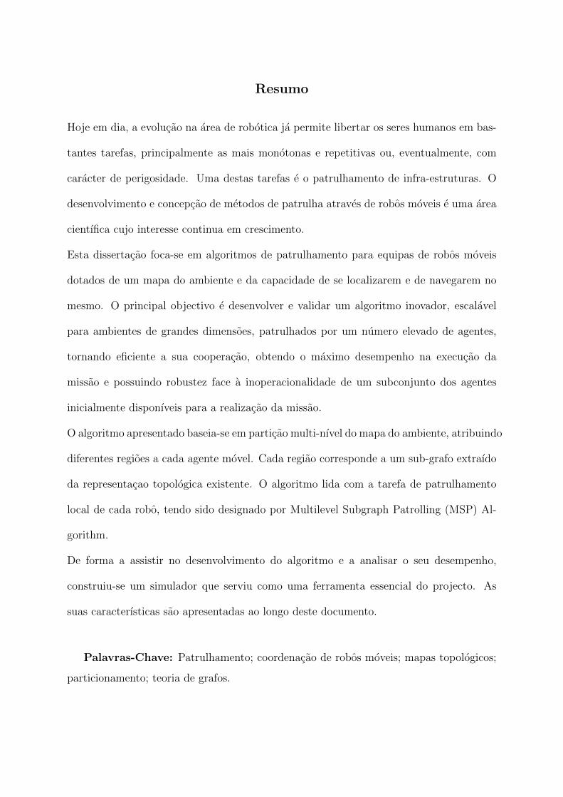
Table 3.1: Pros and Cons of the considered strategies.
Strategies Advantages Disadvantages
Cyclic + Simple, effective, scalable, decentralized,
fault-tolerant and robust
+ Optimizes visit frequency of all points for
any number of robots
+ No communication or sensing other agents
needed
+ Appropriate for patrolling operations
- Predefined: easier for intrusions
- Problems with dynamic environments,
enormous graphs, regions priority schemes
and task allocation

3.8. Analysis and comparative studies between different strategies 24
Partitioning + Reduces redundant work and interference
between robots
+ Better for larger graphs and intrusion
prevention (when the robot path is not
deterministic in its region) than cyclic
strategies
+ Achieves effective and balanced
distribution
+ No communication or sensing other agents
needed
+ Facilitates topological localization
+ Appropriate for patrolling and exploration
in partially known environments
- Not optimal nor as robust as cyclic
strategies
- Less fault-tolerant: needs redefinition of
paths when agents fail
Contamination-
Based
+ Highly effective for intrusion detection
+ Robots’ number can be minimized using
these strategies
+ Only needs limited sensorial capability for
effective detection of intruders
+ Can cope with dynamic, large
environments and heterogeneous agents
+ Possible to merge with partitioning
approaches
+ Appropriate for high security building
surveillance.
- Complex: e.g. GRAPH CLEAR is
NP-complete. Solutions are based on
restrictions of the problem
- The minimum number of robots needed
depends exclusively on the complexity of the
environment
- No fault-tolerance and limited robustness

3.8. Analysis and comparative studies between different strategies 25
Markers-
Based
+ Decentralized, scalable and fault-tolerant
+ Unnecessary to map the environment:
decisions are local
+ No direct communication between agents is
involved
+ Highly effective: distributed coverage
behaviour emerges from local interactions
+ Appropriate for exploration operations and
dynamic environments
- Difficult to implement in real world, due to
its interaction with the environment
- Poor performance when using small number
of robots
- Depends too much on equipment like
sensors and markers
- Expensive (uses varied sensors and may use
complex markers)
Communication-
Based
+ Often decentralized, scalable and
fault-tolerant
+ Robots may help each other by sharing the
information they have obtained
+ Copes with dynamic and complex
environments with good overall performance
+ Enables task allocation and provides team
organization and coordination
+ Appropriate for search, rescue and
exploration operations
- Depends too much on communication, local
memory, sensing and mapping
- Expensive (because of complexity of each
robot)
- Poor performance when using small number
of robots
Centralized
Cooperation-
Based
+ Effective and scalable
+ Enables efficient agents’ navigation
according to the specified environment
+ Cooperative robots may compensate each
other in different situations
+ Can cope with dynamic, large
environments and heterogeneous agents
+ Appropriate for exploration and high
security applications
- Centralized planning nature (depends on a
central entity)
- Cooperation mechanisms are not normally
simple, especially when they involve large
number of robots
- Replanning is necessary when faults occur

3.9. The MSP approach 26
3.9 The MSP approach
After studying distinct approaches for the patrolling problem and considering their ad-
vantages and disadvantages, a hybrid strategy based on graph partitioning and cyclic
algorithms began to grow. The idea of the new approach is to obtain multiple subgraphs
by partitioning the graph, and assign them to each mobile agent for local patrolling. The
local patrolling task will be mostly based on cyclic strategies. In this context, the new ap-
proach will benefit from the advantages of both strategies, namely simplicity, effectiveness,
scalability, robustness, distribution, with good overall visiting frequency, non-redundant,
without the need for communication between agents, with good performance in larger
graphs and intrusion prevention and with the ability to allow fault-tolerance mechanisms.
3.10 Summary
To be able to develop the proposed approach, it is necessary to obtain the representative
graph of the environment from the metric map available. This process is described in
the next chapter. Also, the two subsequent chapters explain the MSP approach. Figure
3.2 sums up all the required phases to obtain a patrolling route from an initial metric
representation of the environment.
Figure 3.2: Required phases to obtain a patrolling scheme from an initial metric rep-resentation of the environment.

Chapter 4
Acquiring the Topological Map
The first stage of this project consisted of extracting the global environment graph and
relevant topological information from the available metric representation.
The method used to extract the topological representation of the environment is similar
to the one used by [Sza04], mentioned on chapter 2. The method’s input is a greyscale
occupancy grid, which is a metric representation of the environment. Then, the skeleton
computation takes place. After that, all vertices are identified and the topological infor-
mation is extracted. The final desired output is a navigation graph built on top of the
original occupancy grid.
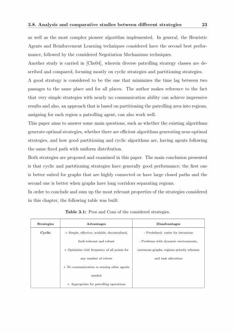
4.1 EVG-THIN: Obtaining the Skeleton
A tool named EVG-THIN developed by Patrick Beeson [BJK05] was used to acquire skele-
tons from occupancy grids, in this project. EVG stands for Extended Voronoi Graph and
THIN accounts for the pixel-based ”thinning” algorithm that finds skeletons of bitmaps.
The thinning approach is a fast approximation of the Voronoi diagram. Its code was writ-
ten to be applied in real-time to occupancy grids, where cells are either occupied, free, or
unknown, but it also works on greyscale bitmap images for other domains, which means
that any greyscale representation will be treated like a standard occupancy grid. The
application runs in any Linux console with some important parameters that are described
in table 4.1. Also, a skeleton generation is presented in figure 4.1.
Note that this program is released under the GNU General Public License (GPL), which
27
4.1. EVG-THIN: Obtaining the Skeleton 28
is intended to guarantee your freedom to share and change free software.
Command Description
min-unknown [N] The minimum greyscale value (1-254) of unknown cells. Occupied cells are
0-(N-1).
max-unknown [M] The maximum greyscale value (1-254) of unknown cells. Free cells are
(M+1)-255.
pruning [0∣1] Turns pruning on or off. Pruning removes all ”branches” of the skeleton except
those that meet one of these conditions:
1) The branch touches the edge of the grid.
2) The branch touches unknown cells.
min-distance [R] Bleeds obstacles by R cells before calculating skeleton. This removes branches
that come too close to obstacles.
max-distance [S] If the skeleton exceeds the S cells from the nearest occupied cells, it switches to
following the occupied cells S away.
robot loc [X Y] This location is used to select which skeleton is valid, given complex images
with multiple, disjoint skeletons. By default, the ”robot” is located at the centre
of the image.
robot-close [0∣1] The robot location (see above) is used to choose which skeleton is valid (if
multiple exist). This is done by Euclidean distance between the robot’s location
at the skeletal points. This option turns off the checking mechanism except for
points where the robot’s distance is within the distance of the skeletal point to
its closest obstacle.
Table 4.1: EVG-THIN parameters.
Figure 4.1: Skeleton obtained with the EVG-THIN application.

4.2. Graph and Topological Information 29
Figure 4.2: Cluster detection and correction.
4.2 Graph and Topological Information
Having the skeleton, the graph is obtained by extracting all vertices and computing the
topological information (edges, connectivity, etc.). The identification of vertices was done
by image processing on top of the previously generated skeleton. Vertices result from the
intersection of skeleton lines and also dead-ends. Additionally, sometimes the skeleton
representation given by the EVG-THIN algorithm produces clusters. A protective func-
tion was developed to detect these clusters and correct them by using a pixel shifting
strategy, avoiding future graph data corruption. An example of a cluster and its correc-
tion is shown in figure 4.2. Note that the vertices are displayed with blue pixels on the
right side image.
At this time, having identified each vertex and its coordinates, it is necessary to compute
the rest of the topological information: their number of neighbour vertices, their cost to
each neighbour (computed by evaluating the distance between them in pixel units) and
their neighbour directions. With this information, edges can be defined and graphs are
created, establishing the framework for agents’ navigation.
4.3 Simulator: Incorporation of methods to extract
topological maps
As previously mentioned, a patrolling simulator was created. The programming language
used was C++ and the Graphical User Interface (GUI) was generated using QT Open
Source Edition 4.4.3, which is also based on C++ Language. Both the simulator source

4.3. Simulator: Incorporation of methods to extract topological maps 30
Figure 4.3: EVG-THIN incorporated in the simulator.
code and the reference manual with the main data structures, functions and variables
used in the progress of the simulator are included in the project’s CD release.
The produced simulator in this work has a very important role in developing and testing
the patrolling algorithm. However, it is assumed that a topological representation of
the environment is available, which is modelled as an undirected graph whose vertices
represent places and whose edges represent connectivity between places. So, the methods
described previously to obtain the skeleton and the topological information had to be
incorporated in the simulator.
For the EVG-THIN, which is a command line application, a graphical interface was created
to generate map skeletons, as seen in figure 4.3. The method described in the previous
section to obtain the graph from the skeleton was also successfully incorporated as figure
4.4 portrays.

4.4. Summary 31
Figure 4.4: Obtaining the Graph from the Skeleton using the simulator.
Note that the skeleton was correctly computed even though the map does not represent a
conventional occupancy grid.
4.4 Summary
Once the topological maps are obtained, the necessary conditions for the algorithm assem-
bly are met. The next two chapters present the two main phases of the MSP approach:
the partitioning phase and the local patrolling phase.

Chapter 5
MSP Algorithm – Partitioning Phase
The MSP Algorithm consists mainly of partitioning the global environment graph in
several regions (or subgraphs) and, in a second phase, assigning a region to each mobile
agent for efficient local patrolling. Therefore, after building the navigation graph on top
of the original occupancy grid, the partitioning phase of the algorithm may begin. In this
chapter, the process of partitioning a graph in a balanced way is described, as well as
the generalization of partitions to create up to eight different regions. Note that graph
partitioning is an early problem in graph theory.
5.1 Multilevel Graph Partitioning
In [KK98], a high quality multilevel approach for partitioning irregular graphs was pre-
sented. There are three main phases in this method: coarsening, partitioning and un-
coarsening.
Basically, in the coarsening phase, a sequence of smaller and less complex graphs, each
with fewer vertices, is obtained by collapsing vertices and edges into single vertices of the
next level, which are called multinodes. An example of a coarsened graph with multin-
odes is presented in figure 5.1. Then, in the partitioning phase, the coarse graph obtained
is bisectioned and lastly, in the uncoarsening phase, the partitioning is refined while the
original graph is being restored. Diverse methods for all the three phases of the scheme are
described in the document and comparisons were made between these methods. Analysing
the results and their properties, some methods were selected for this work with some mi-
32

5.2. Generalized Partitioning 33
nor changes in a few cases.
For the coarsening method, the Heavy-Edge Matching was used. Vertices of the graph
are visited in random order. To form multinodes, a vertex is matched with a neighbour
vertex, such that the weight of the edge between them is maximum over all valid incident
edges (heavier edge). Careful observation of the final multinodes generated shows that
vertices which are highly related tend to be included in the same multinode. This method
was chosen mainly due to its good results and simple approach.
In the partitioning phase, the approach used was based on the KL Algorithm1, which
starts with an initial bipartition of the graph and, in each iteration, it searches for a
subset of vertices, from each part of the graph such that swapping them leads to a parti-
tion with smaller edge-cut. In our case, the edges are not cut. Every edge belongs to a
unique region and the graph is partitioned in frontier vertices, as shown in figure 5.2. The
green lines show where the graph partitioning was done. The frontier vertices define the
boundaries of each subgraph. Basically, the difference in the approach used is that the
initial bipartition starts by separating the largest multinode from the rest, evaluating an
equilibrium condition (cost of all edges in both regions) and swapping multinodes from
one side to the other only if the equilibrium condition improves.
As for the uncoarsening system, the KL(1) Refinement algorithm is used. The projected
partition of the coarsened graph is assumed as a good initial partition for the upper level
graph and vertices are swapped during the first uncoarsening phase, to improve the global
equilibrium condition.
Please refer to [KK98] for further details on these methods and others.
5.2 Generalized Partitioning
As was previously seen, the Multilevel Graph Partitioning method creates a bisection
of the graph, resulting in two smaller subgraphs. To be able to create more than two
balanced regions, subgraph partitioning was developed based on the same methods and
unbalanced partition conditions were also produced. For instance, a three region balanced
partitioning is done by firstly dividing the main graph into two regions with an unbalanced
1named after Kernighan and Lin.

5.3. Summary 34
Figure 5.1: Example of a coarsenedgraph.
Figure 5.2: Example of a partition in 8regions.
partition condition of 33.33% and 66.66% of its dimensions. Then, the largest subgraph
obtained is divided into two regions with a 50% - 50% balanced condition. Three regions
with 33.33% of the graphs dimension is the aim for the final result.
The patrolling simulator developed provides partitions from two up to eight balanced
graph regions. Note that eight is the maximum partition number obtained with three
stages, as shown in Table 5.1, which also presents the conditions used for generalized
partitioning.
The number of regions created is defined according to the number of robots defined for
simulation. Logically, if the input is only one robot, then no partition is needed and a
patrolling scheme for the whole graph is implemented.
5.3 Summary
The partitioning phase is now complete. The generated partitions aim to be as balanced
as possible. However, this is not always possible, due to graph complexity and connec-
tivity limitations. The not so-balanced partitioning will affect global performance of the
algorithm as shown later in the results chapter. Therefore, this is one of the most impor-
tant phases of the project and also because local patrolling hugely depends on subgraph
topology.
In the next chapter, the second phase of the MSP algorithm – the local subgraph patrolling
phase – is studied.

5.3. Summary 35
# Stage 1 Partition Stage 2 Partition Stage 3 Partition
2
3
4
5
6
7
8
Table 5.1: Generalized Partitioning.

Chapter 6
MSP Algorithm – Local Patrolling
Phase
After the partitioning phase, the second phase takes place, which is the local patrolling
scheme definition. Each mobile robot patrols one of the regions/subgraphs that were
previously created. In order to do so, a staged search for a main patrolling path for every
agent is done. After defining a main path, the patrolling route is completed by visiting
the edges that are not included in the main path. Finally, if the main path is not cyclic
then a return path to the route’s initial vertex is computed.
Note that the main path is a non-repetitive sequence of edges that is intended to cover as
much of the subgraph as possible, ideally the whole graph. Thus, the definition of each
robot’s main path is the most important factor for local patrolling performance. There
are three key stages for defining a main path: firstly, searching for Euler and Hamilton
circuits and paths, then the longest paths and finally, non-Hamiltonian cycles. All of
them focus on classic graph theory problems, as we will discuss shortly.
6.1 Euler and Hamilton Circuits and Paths
The first stage of finding a main path is to search for Euler circuits and paths, these are
paths that visit all edges of the graph once only. Euler circuits, which are also called Euler
cycles, start and end on the same vertex whereas Euler paths do not. These paths are
extremely appealing for patrolling purposes, because the whole subgraph is immediately
36

6.1. Euler and Hamilton Circuits and Paths 37
covered just by following them. Figure 6.1 shows an example of an Euler cycle and an
Euler path.
There are necessary conditions for the existence of Eulerian circuits and Eulerian paths.
According to [Hie73], all vertices in the graph must have an even degree, i.e. even number
of neighbour vertices, to recognize the existence of an Euler cycle. For the Euler path
case, all but two vertices must have an even degree. Those two vertices represent the
endpoints.
These circuits and paths can be easily computed using Fleury’s Algorithm [Fle83]. How-
ever, even though testing and finding Eulerian circuits and paths in a graph is relatively
simple, most of the graphs, especially the ones that represent topological maps do not
have these paths, because there are normally a high number of vertices that only have
one neighbour (a dead-end) or have an odd number of neighbours.
After checking the non-existence of Euler cycles and paths, a search procedure for Hamil-
ton circuits and paths takes place. Hamilton circuits and paths visit all vertices of the
graph once only, the difference being that Hamilton circuits, or Hamilton cycles, start
and end on the same vertex. Logically, these also represent very appealing main path
choices for the local patrolling missions. Nevertheless, note that visiting all vertices does
not imply visiting all edges of the graph.
There is no necessary condition to acknowledge the existence of Hamilton circuits and
paths. Determining if they exist is NP-complete and represents a classic graph theory
problem. Known solutions are normally based on heuristics.
In this work, the chosen detection method was the UHC, a fast algorithm proposed
in [AV79] for finding Hamiltonian Paths and Circuits in undirected graphs. Again, most of
the graphs do not have these paths, because there are normally a high number of vertices
that only have one neighbour (a dead-end), which means that, when the edge connecting
those vertices is visited, there is no edge connecting to a different vertex to be visited
next. In these cases, further solutions for a main path must be computed as alternatives
of Euler and Hamilton Circuits and Paths.

6.2. Longest Path 38
Figure 6.1: Examples of Euler Cycle and Path.
6.2 Longest Path
If Euler and Hamilton Circuits and Paths do not exist for the graph being considered (a
common case), a longest path search procedure is done. The reason for this procedure is
based on the fact that the longest path in a graph visits the maximum number of edges
without repeating any; which, for patrolling purposes, is very attractive.
Like Hamilton paths, determining the longest path in a graph is also NP-complete. There
is no optimal solution for this problem; therefore an approximate and simplified search
procedure was created, in order to find the longest path from any vertex to another in
the considered graph.
Firstly, from analysis of all the graphs formed after the Voronoi Diagram computation and
consequent processing (Chapter 4), it was evident that it is frequent to have a substantial
number of dead-ends in graphs, i.e. vertices with only one neighbour (degree one), also
called leaf vertices. For this reason, the longest path search procedure was simplified
to start and end in one degree vertices, leaving the vertices with higher degree for the
Non-Hamiltonian cycle procedure, which will be analysed in the next section.
The created algorithm for searching and approximating the longest path is presented in
pseudo-code (Algorithm 6.1). Note that its simplifications and its own nature makes it
possible to find an appropriate solution relatively fast for our case, and, although it does
not guarantee finding the longest existing path, it will always return a valid option for
main path.
The first step is to build a list of all the vertices with degree one, then go through them
and choose a source vertex and a destination vertex, run the algorithm in the pseudo-code
and save the final path. The algorithm is run with different sources and destinations and

6.3. Non-Hamiltonian Cycles 39
Algorithm 6.1 Longest-Path Approximation Algorithm
every time a larger path in length is found, it should be kept. There is a tag on each edge
to check if it was visited or not, and the find dest variable allows us to delay the arrival
at the final destination from the source vertex. In the end, the best path found by the
algorithm is selected, for example, the one on the left in Figure 6.2.
6.3 Non-Hamiltonian Cycles
Sometimes graphs include cycles that are non-Hamiltonian. These cycles may or may not
represent good main paths, depending on the number of elements and overall algorithm

6.4. Detours 40
Figure 6.2: Longest Path and Non-Hamiltonian Cycle.
Obtained for a patrolling scheme of one robot in a graph.
performance when compared to the longest path found for the same graph. Small cycles
with few elements are common but not desirable. On the other hand large cycles are
very appealing. Since they have the advantage of returning to the starting point without
needing to compute a return path, a cycle with an inferior number of edges may be a
better choice for main path than the longest path.
When there is no cycle in the graph, the longest path is assumed as the main path, and
when there are one or more cycles, they are only considered if they include at least half
of the vertices of the graph. This measure was determined by undertaking simulation
performance comparisons between cycles and longest paths for the some graphs.
The simplified method used to find cycles is also original and is very similar to the one
used for longest paths, the differences being that a list of vertex with degree higher than
one is computed and the while loop stops when we reach the source vertex again (a cycle
was found or no cycle exists).
The algorithm should be run with distinct vertices and if a longer cycle is found, it
should be saved. Finding the same cycle more than once, with different starting points,
is expected. As an example, on the right side of Figure 6.2, the best cycle found for a
given graph is shown.
6.4 Detours
Now that the main path is defined, it is necessary to complete the patrolling route by
visiting the edges that are not included in the main path, except for the Euler circuits

6.4. Detours 41
and paths case, which already cover every edge of the graph.
All of the main path vertices will be visited in order and detours will be computed and
included in the final patrolling route. This is done by inspecting whether the vertex has
neighbours that are still not visited. If so, a detour is started with a maximum allowed
number of edges to visit. Edges are added to the detour route, the ones linking vertices
with inferior degree first, because they have less probability of being visited later by other
detour routes. Also, it returns, when it arrives at a vertex that is already in the main
path. The detour route should include all the edges accessible from the original vertex of
the main path as long as it does not reach the maximum allowed number of edges to be
visited. When it does, it checks if there is a direct edge linked to the original vertex and
if not, it returns to the original vertex by a returning path that is computed and updated
for every vertex that is visited in the detour. When the detour route(s) for this vertex
is done, we move on to the next vertex of the main path until we reach the final vertex.
Finally, when this process ends, if all of the edges in the subgraph were not visited, the
maximum number of edges allowed in the detour route is increased and the process is
repeated.
The idea, in the end, is to have a patrolling route that covers all edges and vertices with
the least possible maximum number of edges allowed to visit by the detour route. The
algorithm described is adaptive and the number of times required to repeat this process
can be minimized establishing lower quotas and upper quotas. For instance, check if all
edges are not covered when a maximum of one edge detour is allowed (in fact, this is
generally enough when an Hamilton circuit or path is detected). This will be the starting
lower quota. Afterwards, check an upper quota of half the number of edges in the graph,
which is a pessimistic value. If all vertices were covered, than the next test number
of edges should be between the lower and upper quota interval, if not, the previously
considered upper quota should become a lower quota and a new upper quota should be
established. This procedure should be done until the least possible maximum number of
edges allowed to visit is identified. Using this approach, the correct value is found much
faster than a pure incremental approach.

6.5. Returning to the route’s initial vertex 42
6.5 Returning to the route’s initial vertex
If the main path is not an Euler, Hamiltonian or non-Hamiltonian circuit/cycle, it is
necessary to compute a path to return to the route’s initial vertex. Two ways were con-
sidered to do so: Inverse Path and Shortest Path. The first one is done by inversing the
patrolling route back to the first vertex and the second one simply computes the shortest
path, using Dijkstra’s Algorithm [Dij59], from the last vertex to the initial one.
Both were compared and the decision to use the first one was justified by better results,
in terms of overall patrolling frequencies for every point, in 96% of all studied cases.
Figure 6.3: Simulation input parameters.
6.6 MSP Simulation Environment
The current and previous chapter presents the two phases of the MSP algorithm. The
procedures described were developed in the Patrolling simulator tool that was created for
this project. To simulate the Multilevel Subgraph Patrolling Algorithm, the user must
fill the input parameters necessary for simulation (implying that the topological map is
already acquired) as seen in Figure 6.3. Note that a collision avoidance mechanism was
also developed. It basically prevents agents from being on the shared border vertices of

6.6. MSP Simulation Environment 43
Figure 6.4: Simulation Environment.
the subgraphs at the same moment by making the one(s) which is/are furthest away from
the vertex wait for the closer one. When the Start button is pressed on the Graphical
User Interface, the environment graph is immediately partitioned in the same number of
regions as inserted by the user for the robots’ number. Later on, each local patrolling
route is computed and the simulation then starts. The user will watch as the robots cover
the entire graph, each in its own confined region. There is also the possibility of displaying
a table, which outputs timing data, during simulation, for each vertex as illustrated in
figure 6.4. This data can be exported in pure text format (txt), as well as in Excel
Worksheet format (xls).
Also, a cyclic-based strategy (Section 3.1) was developed to allow comparisons between
the two approaches. Details on this strategy and the comparison results will be presented
in the next chapter.

6.7. Summary 44
6.7 Summary
In this chapter, the local patrolling phase of the MSP Algorithm has been explained.
A good choice for the main path of the subgraph patrolling route is crucial in terms of
performance of the algorithm and the steps that were taken to define it aim precisely
to endorse good performance results. Logically, this deeply relies on the topology of the
subgraph.
Simulation results were collected and will be discussed shortly in the next chapter. An al-
ternative patrolling strategy was also computed and results for both schemes are presented
and compared.

Chapter 7
Results and Discussion
After developing and testing the MSP algorithm, it is time to evaluate its performance.
In this chapter, various simulation results are presented and its inference is discussed.
7.1 Implemented Algorithm for comparisons
A so-called cyclic algorithm was computed to have a comparison measure to contrast with
the proposed approach. This algorithm searches for Hamiltonian cycles in a graph and
places the robots along the path [EAK07]. Since there is no defined behaviour when no
Hamilton cycles exist, the same methods as ours were used, in these cases, for computing
the best possible path in the entire graph. As a result, both approaches are usually
equivalent when only one agent is used. Note, however, that, with the cyclic approach,
all mobile robots follow the same exact route, through the whole graph, uniformly lagged
in time.
This algorithm was chosen for comparison because it is designed for maximizing the
visiting frequency of all points of the graph and is known to have good overall results
when compared to different approaches [ARS+04]. Also, its fixed and predetermined
nature, makes it relatively simple to compute.
45

7.2. Results of the comparison with cyclic algorithm 46
7.2 Results of the comparison with cyclic algorithm
A large set of maps were used to compare average point frequency performance for both
approaches. Due to space limitations, only six representative environments are presented
in this chapter. They were denoted as maps A to F and are illustrated in figures 7.1 to
7.6.
Map A has a very simple graph with 12 vertices and due to minimum size dimension
constraints, for each subgraph, there is a maximum number of partitions according to the
graph complexity, in this case four. Map B, C and E are medium graphs with relatively
defined paths. B has 70 vertices, C has 41 and E has 74. Map D represents a more
complex graph with 268 vertices and Map F is a completely different case, due to the
existence of a main Hamilton cycle in the graph and Hamilton paths in the generated
subgraphs. This is a much simpler graph with 12 vertices and very good connectivity
between vertices. Again, there is a partition number limitation like the one mentioned
for map A.
Now that the six samples are identified, we are able to analyse the results.
nr∑dT [C]
∑dT [MSP] F[C] F[MSP] �[C] �[MSP]
1 2564 2564 0.84 0.84 0.49 0.492 2564 1995 1.68 1.77 0.98 1.033 2564 1725 2.51 2.71 1.48 1.554 2564 1881 3.35 3.68 1.97 2.09
Figure 7.1: Results for map A.
nr∑dT [C]
∑dT [MSP] F[C] F[MSP] �[C] �[MSP]
1 8017 8017 0.34 0.34 0.16 0.162 8017 7536 0.67 0.68 0.33 0.353 8017 7608 1.01 0.96 0.49 0.554 8017 7029 1.35 1.34 0.65 0.795 8017 6692 1.68 1.68 0.82 0.996 8017 6451 2.02 1.92 0.99 1.247 8017 6454 2.36 2.34 1.14 1.428 8017 6073 2.70 2.76 1.30 1.80
Figure 7.2: Results for map B.

7.2. Results of the comparison with cyclic algorithm 47
nr∑dT [C]
∑dT [MSP] F[C] F[MSP] �[C] �[MSP]
1 15666 15666 0.16 0.16 0.08 0.082 15666 14383 0.33 0.32 0.16 0.193 15666 13432 0.49 0.47 0.25 0.294 15666 13048 0.65 0.61 0.33 0.425 15666 12658 0.81 0.79 0.41 0.496 15666 12023 0.98 0.94 0.49 0.647 15666 11538 1.14 1.11 0.57 0.828 15666 11246 1.30 1.21 0.66 0.97
Figure 7.3: Results for map C.
nr∑dT [C]
∑dT [MSP] F[C] F[MSP] �[C] �[MSP]
1 21949 21949 0.13 0.13 0.06 0.062 21949 20923 0.26 0.27 0.13 0.133 21949 20039 0.39 0.41 0.19 0.214 21949 20037 0.52 0.55 0.25 0.295 21949 19375 0.66 0.68 0.32 0.386 21949 18951 0.79 0.80 0.38 0.447 21949 18403 0.92 0.94 0.44 0.518 21949 18269 1.05 1.08 0.51 0.64
Figure 7.4: Results for map D.
nr∑dT [C]
∑dT [MSP] F[C] F[MSP] �[C] �[MSP]
1 13485 13485 0.20 0.20 0.10 0.102 13485 13136 0.40 0.40 0.20 0.223 13485 12498 0.60 0.56 0.30 0.354 13485 11668 0.81 0.73 0.40 0.455 13485 11402 1.01 0.99 0.50 0.626 13485 10839 1.21 1.24 0.60 0.747 13485 10768 1.41 1.27 0.70 0.848 13485 10479 1.61 1.49 0.80 0.96
Figure 7.5: Results for map E.
nr∑dT [C]
∑dT [MSP] F[C] F[MSP] �[C] �[MSP]
1 3931 3931 0.57 0.57 0.10 0.102 3931 3985 1.14 1.16 0.20 0.173 3931 3697 1.72 1.67 0.30 0.304 3931 3641 2.29 2.34 0.40 0.34
Figure 7.6: Results for map F.

7.3. Discussion 48
Figure 7.7: Results for the six different maps.
7.3 Discussion
The MSP Algorithm got better performance results with an arbitrary number of robots
for map A and D, as seen by the correspondent curves in figure 7.7. The cyclic algorithm
got higher visiting frequencies in the case of map C. For map B, the MSP was only better
in the case of two, five and eight robots, being overly very close to the cyclic strategy
in the other tests. Similarly to map B, in map E’s case, the MSP Algorithm got close
results to the Cyclic Algorithm up to six robots (being actually better for the six robots’
case). For seven and eight robots, the results were not so good, mostly due to low quality
partitions as a consequence of graph limitations. As for the special case of map F, the
MSP was globally better, having only lower frequency in the case of three robots.
As seen by their representations Maps B, C and E are medium graphs with relatively
defined paths. Despite this, note that each map has distinct frequency intervals due to
their different Euclidean dimensions.
Maps A, B, D and F had overall good partitioning results. For map C, the partitioning

7.4. Summary 49
quality was overly better for odd number of regions and not so good for even numbers. In
the map E’s case, better partitioning is coincident with the cases where there were better
results, namely, for two, five and six regions.
General results show that visiting frequencies with the MSP Algorithm are better in
graphs where there are high-quality partitions and/or the global cyclic path has too many
edge repetitions, while the addition of the local patrolling paths in each region is globally
less repetitive.
Note that the presented results are normalized and constant speed for each robot of 1m/s
is considered, also each pixel in the Voronoi Graph is considered equivalent to a meter.
Assuming this, results show that in 97,2% of cases, the MSP approach point frequencies
are within the interval[
nr∑dT, 4nr∑
dT
]×10−3, with
∑dT being the sum of all the distances
travelled by robots in the MSP approach in meters, which is equivalent to the time (in
seconds) that the robots would take to cover all the map, in separated time schedules,
with a 1m/s constant speed and nr being the number of robots patrolling the graph.
Note that∑dT hugely depends on graph complexity and vertices number. Frequencies
not within the interval occurred only in some cases where the global complexity of the
graph resulted in unbalanced partitions (generally with high number of regions) or not so
satisfactory main paths.
The distance travelled by the mobile agents to cover the whole graph (∑dT ) is almost
always shorter for the MSP approach. This is mainly due to the non-redundant work as
opposed to the cyclic strategy. On the other hand, the standard deviation (�) is generally
lower for the cyclic approach because the MSP has global frequency values less close to
average values, mostly because of the inversed path followed when no representative cycles
exist in the subgraph. Inverting the path results in better frequencies for points in the
middle and worse for points near the path extremities.
7.4 Summary
In this chapter, results were presented and discussed. In the subsequent chapter, an
overview of the algorithm is done. Its benefits and weaknesses are debated and finally
this dissertation ends with conclusions and future work.

Chapter 8
Conclusions
The area of patrolling with autonomous mobile robots still has vast research possibilities
and the work presented in this dissertation addresses one of the core subjects in this
context: The multi-robot systems’ problem of efficiently patrolling a given infrastructure
environment.
In this last chapter, a global and self-critical overview of the proposed approach takes
place in order to sum up the work. Also, final conclusions and possible related future
work directions are discussed.
8.1 MSP Overview
In this document, a new multi-robot patrolling algorithm based on balanced graph parti-
tion was proposed. This approach decreases redundant work and consequent robot detri-
tions when compared to a cyclic approach. It is also relatively simple, effective, scalable,
distributed and robust. Fault-tolerance can be easily implemented, when a robot fails,
by just rerunning the algorithm with fewer robots and send them to their new starting
positions. Simulation results prove its good scalability and agents distribution in larger
environments. Also, there is no need for a communication system or expensive sensors.
The interference between robots is minimal; they may only be near to each other in the
vertices of the boundaries of their regions. A collision avoidance mechanism to forbid two
or more robots from being in the same border vertex at the same time was also devel-
oped. On the other hand, for a cyclic approach when there are no main cycles, it is much
50

8.2. Future Work 51
harder to employ such a mechanism, since robots may be coming and going through the
same path. Also, for an intelligent intruder, it is easier to attack an environment, which
is patrolled using a cyclic approach because robots follow the same route over and over
again, whereas in our approach, although being deterministic, each robot follows its own
patrolling cycle and completes it in different periods of time, so it is much more difficult
to track every robot’s path and predict which areas of the environment are better for
intrusion, because the global robot disposition is continuously changing. Possible dis-
advantages of this approach are the longer time that robots take to cover points on the
extremities of the patrolling route when there are no cycles, the need to redefine the paths
when an agent fails and, even though it is a difficult task for an observer, its deterministic
nature makes it possible to calculate and predict the robots disposition in a given point
in time. Also, the performance decreases in graphs, in which the partitions are not so
balanced, when compared to the cyclic approach.
As a result of the developed work, a paper [PR09] was written and submitted to the 25th
ACM Symposium on Applied Computing (SAC 2010), which will take place in Sierre,
Switzerland during March 2010. The referred paper is available in the project’s CD.
8.2 Future Work
Some issues are still left open and correspond to future guidelines that can be followed
to improve current work. An even more thorough study with more maps, considering the
graphs complexity and comparisons can lead to a criterion to define the more efficient
main path, either a non-Hamiltonian cycle or the longest path. Also the fault-tolerance
approach mentioned before can be implemented as well as simulating an intruder attack
and calculate the time necessary to detect it and the best possible location for attacks.
An alarm system could also be discussed when an anomaly is detected by any robot.
An interesting feature would also be an automatic method of adequate agents’ team size
estimation considering the given environment. Finally, it would be interesting to take this
approach further than simulation and test it with mobile robots in real world scenarios.
It is the author’s opinion that the work done represented a very interesting challenge and
it is his intention to proceed with academic studies (Ph.D.) in this research area.

Bibliography
[AKK08] N. Agmon, S. Kraus, G. Kaminka, Multi-Robot Perimeter Patrol in Adversarial
Settings, IEEE International Conference on Robotics and Automation (ICRA
08), 2339-2345, Passadena, California, U.S.A., May 19-23, 2008. ISBN 978-1-
4244-1646-2.
[Alt03] P. Althaus, Indoor Navigation for Mobile Robots: Control and Representations,
Doctoral Dissertation, Royal Institute of Technology, Universitet Stockholms,
Universitetsservice US-AB, Stockholm, Sweden, October, 2003. ISBN 91-7283-
605-9.
[ARS+02] M. Adler, H. Racke, N. Sivadasan, C. Sohler, B. Vocking, Randomized Pursuit-
Evasion in Graphs, Proceedings of the 29th International Colloquium on Au-
tomata, 901-912, Languages and Programming, Malaga, Spain, July 8-13, 2002.
ISBN 3-540-43864-5.
[ARS+04] A. Almeida, G. Ramalho, H. Sanana, Y. Chaveleyre et al, Recent Advances on
Multi-Agent Patrolling, Brazilian Symposium on Artificial Intelligence (SBIA
2004), 474-483, Vol. 3171, Sao Luıs, Brazil, September 29 - October 1, 2004.
ISBN 3-540-23237-0.
[AV79] D. Angluin, L. Valiant. Fast Probabilistic Algorithms for Hamiltonian Circuits
and Matchings. Journal of Computer and System Sciences, 155-193, 18(2), April
1979.
[BJK05] P. Beeson, N. Jong, B. Kuipers. Towards Autonomous Topological Place Detec-
tion Using the Extended Voronoi Graph. International Conf. on Robotics and
Automation, 4373-4379, Barcelona, Spain, April 18-22, 2005.
52

Bibliography 53
[BK91] J. Borenstein, Y. Koren, The Vector Field Histogram - Fast Obstacle Avoidance
for Mobile Robots, IEEE Journal of Robotics and Automation, 278-288, 7(3),
June, 1991.
[BM76] J. Bondy, U. Monty, Graph Theory with Applications, The Macmillan Press
Ltd., 5th Edition, Elsevier Science Publishing Co. Inc, U.S.A., 1976. ISBN 0-
444-19451-7.
[BS02] M. Batalin, G. Sukhatme, Multi-Robot Dynamic Coverage of a Planar Bounded
Environment, Technical Report, Robotic Embedded Systems Laboratory, Uni-
versity of Southern California, 2002. Available: http://www.cens.ucla.edu/
˜maxim/Publications/papers/331.pdf
[Che04] Y. Chevaleyre, Theoretical Analysis of the Multi-agent Patrolling Problem, Pro-
ceedings of the Intelligent Agent Technology: IAT ’04, IEEE/WIC/ACM In-
ternational Conference, 302-308, Beijing, China, September 20-24, 2004. ISBN
0-7695-2101-0.
[Chv75] V. Chvatal, A combinatorial theorem in plane geometry. Journal of Combinato-
rial Theory Series B, 39-41, Vol. 18, 1975.
[DA99] R. Dollarhide, A. Agah, Simulation and Control of Distributed Robot Search
Teams, Computers & Electrical Engineering, 625-642, 29(5), Elsevier Science
Ltd., 1999.
[Dij59] E. W. Dijkstra. A Note on Two Problems in Connection with Graphs. Nu-
merische Math, 269-271, Vol. 1, 1959.
[DK07] D. Dimarogonas, K. Kyriakopoulos, Decentralized Navigation Functions for Mul-
tiple Robotic Agents with Limited Sensing Capabilities, Journal of Intelligent
and Robotic Systems, 411-433, 48(3), Springer Netherlands, March, 2007, ISSN
0921-0296.
[DJM+93] G. Dudek, M. Jenkin, E. Milios, D. Wilkes, Map Validation and Robot Self-
Location in a Graph-Like World, Thirteenth International Conference on Arti-
ficial Intelligence, 1648-1653, Chamberry, France, August, 1993.

Bibliography 54
[DJM+97] G. Dudek, M. Jenkin, E. Milios, D. Wilkes, Map Validation and Robot Self-
Location in a Graph-Like World, Robotics and Autonomous Systems, 159-178,
22(2), Elsevier Ltd., November, 1997.
[DJM+98] G. Dudek, M. Jenkin, E. Milios, D. Wilkes, Topological Exploration with Mul-
tiple Robots, Proceedings of the 7th International Symposium on Robotics with
Applications (ISORA’98), Anchorage, Alaska, May 10-14, 1998.
[EAK07] Y. Elmaliach, N. Agmon, G. Kaminka, Multi-Robot Area Patrol under Frequency
Constraints, IEEE International Conference on Robotics and Automation (ICRA
07), 385-390, Rome, Italy, April 10-14, 2007. ISBN 1-4244-0601-3.
[Fle83] Fleury. Deux problemes de geometrie de situation. Journal de mathematiques
elementaires, 257-261, 1883.
[Ger03] V. Gervasi, Robotic Cops: The Intruder Problem, IEEE Conference on Systems,
Man and Cybernetics (SMC 2003), 2284-2289, Vol. 3, Washington D.C., U.S.A.,
October 5-8, 2003. ISBN 0-7803-7952-7.
[GLL+97] L. Guibas, J. Latombe, S. Lavalle, D. Lin, R. Motwani, Visibility-Based
Pursuit-Evasion in a Polygonal Environment, Algorithms and Data Structures,
5th International Workshop, WADS ’97, 17-30, Vol. 1272, Halifax, Canada, Au-
gust 6-8, 1997. ISBN 3-540-63307-3.
[GPM07] Y. Guo, L. Parker, R. Madhavan, 9 Collaborative Robots for Infrastructure
Security Applications, Studies in Computational Intelligence (SCI), Springer-
Verlag Berlin Heidelberg, 185-200, Vol. 50, April 22, 2007. ISSN 1860-9503.
[GTG04] B. Gerkey, S. Thrun, G. Gordon, Visibility-Based Pursuit-Evasion with Limited
Field of View, Proceedings of the National Conference on Artificial Intelligence
(AAAI), 20-27, San Jose, California, U.S.A., July 25-29, 2004.
[Hie73] C. Hierholzer. Uber die Moglichkeit, einen Linienzug ohne Wiederholung und
ohne Unterbrechnung zu umfahren. Mathematische Annalen 6, 30-32, 1873.

Bibliography 55
[HKS09] G. Hollinger, A. Kehagias, S. Singh. Efficient, Guaranteed search with multi-
agent teams. In Proceedings of Robotics: Science and Systems V, Seattle, Wash-
ington, USA., Jun. 28 - Jul. 1, 2009.
[KC07] A. Kolling, S. Carpin, The GRAPH-CLEAR Problem: Definition, Theoretical
Properties and its Connections to Multirobot Aided Surveillance, IEEE/RSJ In-
ternational Conference on Intelligent Robots and Systems (IROS 2007), 1003-
1008, San Diego, California, U.S.A., October 29 - November 2, 2007. ISBN
978-1-4244-0912-9.
[KC08] A. Kolling, S. Carpin, Multi-robot Surveillance: an Improved Algorithm for the
GRAPH-CLEAR Problem, IEEE International Conference on Robotics and Au-
tomation, 2008 (ICRA 2008), 2360-2365, Pasadena, California, U.S.A., May
19-23, 2008. ISBN 978-1-4244-1646-2.
[KC08a] A. Kolling, S. Carpin, Extracting Surveillance Graphs from Robot Maps,
IEEE/RSJ International Conference on Intelligent Robots and Systems (IROS
2008), 2323-2328, Nice, France, September 22-26, 2008. ISBN 978-1-4244-2057-5.
[KK98] G. Karypis and V. Kumar. A Fast and High Quality Multilevel Scheme for Parti-
tioning Irregular Graphs. Society for Industrial and Applied Mathematics, Jour-
nal of Scientific Computing, 359-392, 20(1), 1998.
[Kon03] K. Konolige et al, Centibots: Large Scale Robot Teams, Multi-Robot Systems:
From Swarms to Intelligent Automata, Vol. 2, Kluwer, 2003.
[LGB+97] S. Lavalle, H. Gonzalez-banos, C. Becker, J. Latombe, Motion Strategies for
Maintaining Visibility of a Moving Target, IEEE International Conference on
Robotics & Automation (ICRA’97), 731-736, Vol. 1, Albuquerque, New Mexico,
U.S.A., April 10-25, 1997. ISBN 0-7803-3612-7.
[LS08] M. Likhachev, A. Stentz, Information Value-Driven Approach to Path Clearance
with Multiple Scout Robots, IEEE International Conference on Robotics and
Automation (ICRA’08), 2651-2656, Pasadena, California, U.S.A., May 19-23,
2008. ISBN 978-1-4244-1646-2.

Bibliography 56
[Mia07] M. Miazaki, Sistema de controle multi-robo baseado em colonia de formigas ar-
tificiais, Master Thesis, Instituto de Ciencias Matematicas e de Computacao -
USP, Brazil, February, 2007.
[Min07] D. Miner, Swarm Robotics Algorithms: A Survey, May 17, 2007, Available:
http://www.coral-lab.org/˜don/projects/swarmrobotics.pdf
[Por09] D. Portugal, Multiple Autonomous Mobile Robots Patrolling Related Issues,
Report, Faculty of Science and Technology, University of Coimbra, Portugal,
September, 2009.
[PR09] D. Portugal and R. Rocha. MSP Algorithm: Multi-Robot Patrolling based on
Territory Allocation using Balanced Graph Partitioning. Submitted to the 25th
ACM Symp. on Applied Computing (SAC 2010), special track on Intelligent
Robotic Systems (ROBOT), Sierre, Switzerland, Mar. 22-26. 2010.
[Roc05] R. Rocha, Building Volumetric Maps with Cooperative Mobile Robots and Useful
Information Sharing: a Distributed Control Approach based on Entropy, Ph.D.
Thesis, Faculty of Engineering of University of Porto, Portugal, October, 2005.
[Rub74] F. Rubin, A Search Procedure for Hamilton Paths and Circuits, Journal of the
Association for Computing Machinery, 576-580, 21(4), ACM, New York, U.S.A.,
October, 1974. ISSN 0004-5411.
[SA03] A. Sgorbissa, R. Arkin, Local Navigation Strategies for a Team of Robots, Robot-
ica, 461-473, 21(5), Cambridge University Press, October, 2003. ISSN 0263-5747.
[She92] T. Shermer, Recent Results In Art Galleries, Proceedings of the IEEE, 1384-
1399, 80(9), IEEE Press, New York, NY, USA, September, 1992. ISSN 0018-
9219.
[SRL04] S. Sachs, S. Rajko, S. Lavalle, Visibility Based Pursuit-Evasion in an Unknown
Planar Environment, The International Journal of Robotics Research, 3-26,
23(1), MIT Press - Massachusetts Institute Of Technology, ISSN 0278-3649,
January, 2004.

Bibliography 57
[SUP+07] D. Saitov, U. Umirov, J. Park, J. Choi, S. Lee, Effective Map Building Using
a Wave Algorithm in a Multi-Robot System, International Journal of Precision
Engineering and Manufacturing, 69-74, 9(2), KSPE, 2007.
[SYX04] W. Sheng, Q. Yang, N. Xi, A Distributed Bidding Algorithm for Multi-Robot
Exploration with Safety Concerns, International Conference on Complex Systems
2004 (ICCS2004), 633-640, Boston, MA, U.S.A., May 16-21, 2004.
[Sza04] R. Szabo, Topological Navigation of Simulated Robots using Occupancy Grid,
International Journal of Advanced Robotic Systems, 201-206, 1(3), 1729-8806,
September, 2004.
[Thr98] S. Thrun, Learning Maps for Indoor Mobile Robot Navigation, Artificial Intelli-
gence, 21-71, Vol. 99, Elsevier Science Ltd., 1998.
[WSB08] K. Wurm, C. Stachniss, W. Burgard, Coordinated Multi-Robot Exploration using
a Segmentation of the Environment, IEEE/RSJ International Conference on In-
telligent Robots and Systems (IROS 2008), 1160-1165, Nice, France, September
22-26, 2008. ISBN 978-1-4244-2057-5.
[ZFV94] U. Zimmer, C. Fischer, E. Von Puttkamer, Navigation on Topologic Feature-
Maps, 3rd International Conference on Fuzzy Logic, Neural Nets and Soft Com-
puting, 131-132, Iizuka, Fukuoka, Japan, August 1-7, 1994.