rock pile sampling program - trelawney mining and
TRANSCRIPT
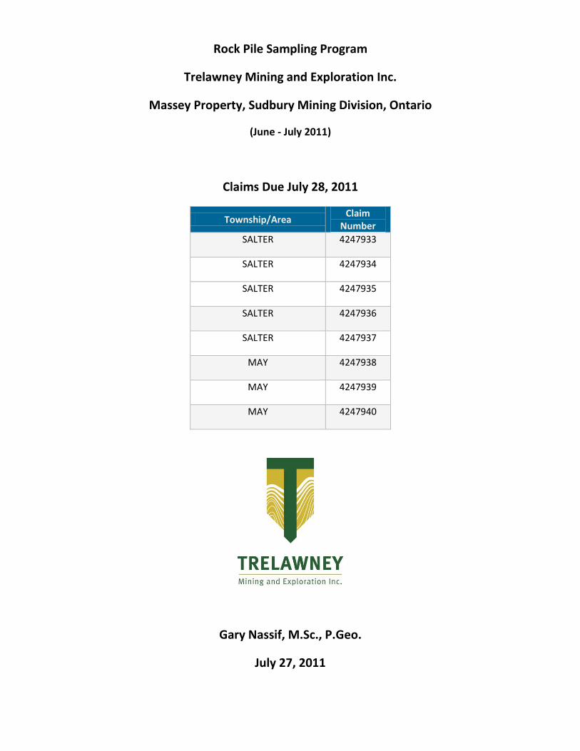
Rock Pile Sampling Program
Trelawney Mining and Exploration Inc.
Massey Property, Sudbury Mining Division, Ontario
(June - July 2011)
Claims Due July 28, 2011
Township/Area Claim
Number
SALTER 4247933
SALTER 4247934
SALTER 4247935
SALTER 4247936
SALTER 4247937
MAY 4247938
MAY 4247939
MAY 4247940
Gary Nassif, M.Sc., P.Geo.
July 27, 2011
Trelawney Mining and Exploration Inc. Massey Property Assessment Work
i
Table of Contents
Summary ......................................................................................................................................... 1
Introduction .................................................................................................................................... 1
Location and Access ........................................................................................................................ 1
Property Description ....................................................................................................................... 2
Regional Geology ............................................................................................................................ 4
Property Geology ............................................................................................................................ 5
Economic Geology........................................................................................................................... 5
Work Performed ............................................................................................................................. 6
Results ............................................................................................................................................. 6
Recommendations for Further Exploration .................................................................................... 7
Work Performed By ........................................................................................................................ 7
List of Tables
Table 1a. Massey Property – Unpatented Claims ........................................................................... 3
Table 1b. Massey Property – Patented Claims ............................................................................... 3
List of Figures
Figure 1. Massey Property – Location Map .................................................................................... 2
Figure 2. Massey Property – Claim Map ......................................................................................... 4
Appendices
Appendix A. Assay Certificates .........................................................................................................i
Appendix B. Claim Map. .................................................................................................................. ii
Trelawney Mining and Exploration Inc. Massey Property Assessment Work
1
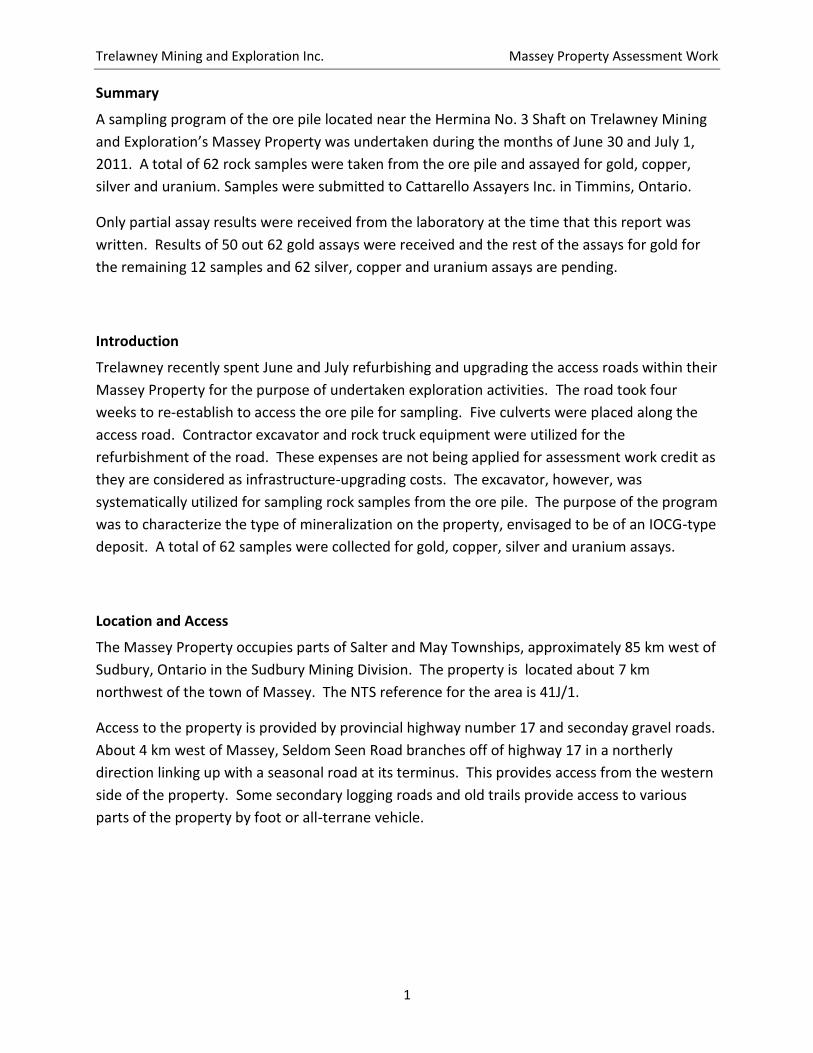
Summary
A sampling program of the ore pile located near the Hermina No. 3 Shaft on Trelawney Mining
and Exploration’s Massey Property was undertaken during the months of June 30 and July 1,
2011. A total of 62 rock samples were taken from the ore pile and assayed for gold, copper,
silver and uranium. Samples were submitted to Cattarello Assayers Inc. in Timmins, Ontario.
Only partial assay results were received from the laboratory at the time that this report was
written. Results of 50 out 62 gold assays were received and the rest of the assays for gold for
the remaining 12 samples and 62 silver, copper and uranium assays are pending.
Introduction
Trelawney recently spent June and July refurbishing and upgrading the access roads within their
Massey Property for the purpose of undertaken exploration activities. The road took four
weeks to re-establish to access the ore pile for sampling. Five culverts were placed along the
access road. Contractor excavator and rock truck equipment were utilized for the
refurbishment of the road. These expenses are not being applied for assessment work credit as
they are considered as infrastructure-upgrading costs. The excavator, however, was
systematically utilized for sampling rock samples from the ore pile. The purpose of the program
was to characterize the type of mineralization on the property, envisaged to be of an IOCG-type
deposit. A total of 62 samples were collected for gold, copper, silver and uranium assays.
Location and Access
The Massey Property occupies parts of Salter and May Townships, approximately 85 km west of
Sudbury, Ontario in the Sudbury Mining Division. The property is located about 7 km
northwest of the town of Massey. The NTS reference for the area is 41J/1.
Access to the property is provided by provincial highway number 17 and seconday gravel roads.
About 4 km west of Massey, Seldom Seen Road branches off of highway 17 in a northerly
direction linking up with a seasonal road at its terminus. This provides access from the western
side of the property. Some secondary logging roads and old trails provide access to various
parts of the property by foot or all-terrane vehicle.

Trelawney Mining and Exploration Inc. Massey Property Assessment Work
2
Figure 1. Massey Property –Location Map
Property Description
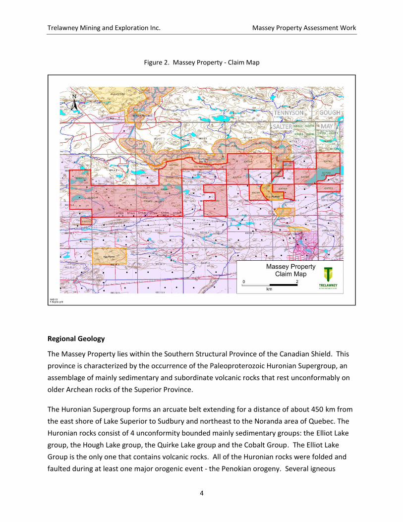
Trelawney Mining and Exploration Inc. holds 100% interest in 20 unpatented mining claims (88
claim units – 1,377 hectares) and 5 patented mining claims (6 claim units - 97 hectares) on its
Massey Property. The contiguous claim group occupies a total of 1,474 hectares. The property
is located 85 kilometres west of Sudbury, Ontario
Trelawney Mining and Exploration Inc. Massey Property Assessment Work
3
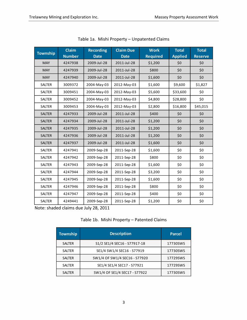
Table 1a. Mishi Property – Unpatented Claims
TownshipClaim
Number
Recording
Date
Claim Due
Date
Work
Required
Total
Applied
Total
Reserve
MAY 4247938 2009-Jul-28 2011-Jul-28 $1,200 $0 $0
MAY 4247939 2009-Jul-28 2011-Jul-28 $800 $0 $0
MAY 4247940 2009-Jul-28 2011-Jul-28 $1,600 $0 $0
SALTER 3009372 2004-May-03 2012-May-03 $1,600 $9,600 $1,827
SALTER 3009451 2004-May-03 2012-May-03 $5,600 $33,600 $0
SALTER 3009452 2004-May-03 2012-May-03 $4,800 $28,800 $0
SALTER 3009453 2004-May-03 2012-May-03 $2,800 $16,800 $45,015
SALTER 4247933 2009-Jul-28 2011-Jul-28 $400 $0 $0
SALTER 4247934 2009-Jul-28 2011-Jul-28 $1,200 $0 $0
SALTER 4247935 2009-Jul-28 2011-Jul-28 $1,200 $0 $0
SALTER 4247936 2009-Jul-28 2011-Jul-28 $1,200 $0 $0
SALTER 4247937 2009-Jul-28 2011-Jul-28 $1,600 $0 $0
SALTER 4247941 2009-Sep-28 2011-Sep-28 $1,600 $0 $0
SALTER 4247942 2009-Sep-28 2011-Sep-28 $800 $0 $0
SALTER 4247943 2009-Sep-28 2011-Sep-28 $1,600 $0 $0
SALTER 4247944 2009-Sep-28 2011-Sep-28 $3,200 $0 $0
SALTER 4247945 2009-Sep-28 2011-Sep-28 $1,600 $0 $0
SALTER 4247946 2009-Sep-28 2011-Sep-28 $800 $0 $0
SALTER 4247947 2009-Sep-28 2011-Sep-28 $400 $0 $0
SALTER 4249441 2009-Sep-28 2011-Sep-28 $1,200 $0 $0
Note: shaded claims due July 28, 2011
Table 1b. Mishi Property – Patented Claims
Township Parcel
SALTER 17730SWS
SALTER 17730SWS
SALTER 17729SWS
SALTER 17729SWS
SALTER 17730SWS
Description
S1/2 SE1/4 SEC16 - S77917-18
SE1/4 SW1/4 SEC16 - S77919
SW1/4 OF SW1/4 SEC16 - S77920
SE1/4 SE1/4 SEC17 - S77921
SW1/4 OF SE1/4 SEC17 - S77922
Trelawney Mining and Exploration Inc. Massey Property Assessment Work
4
Figure 2. Massey Property - Claim Map
Regional Geology
The Massey Property lies within the Southern Structural Province of the Canadian Shield. This
province is characterized by the occurrence of the Paleoproterozoic Huronian Supergroup, an
assemblage of mainly sedimentary and subordinate volcanic rocks that rest unconformably on
older Archean rocks of the Superior Province.
The Huronian Supergroup forms an arcuate belt extending for a distance of about 450 km from
the east shore of Lake Superior to Sudbury and northeast to the Noranda area of Quebec. The
Huronian rocks consist of 4 unconformity bounded mainly sedimentary groups: the Elliot Lake
group, the Hough Lake group, the Quirke Lake group and the Cobalt Group. The Elliot Lake
Group is the only one that contains volcanic rocks. All of the Huronian rocks were folded and
faulted during at least one major orogenic event - the Penokian orogeny. Several igneous
Trelawney Mining and Exploration Inc. Massey Property Assessment Work
5
intrusions are spatially associated with rocks of the Huronian Supergroup. Layered gabbro -
Anorthosite intrusions known as the East Bull Lake Suite are localized along the base of the
sedimentary pile. Examples are the East Bull Lake Intrusion and the May Township anorthosite.
Nipissing gabbro bodies form dikes and sills that are widespread throughout the Huronian
Supergroup. Several granitic to syenitic bodies intrude the Huronian sediments. Rocks in the
Southern Province have been folded and faulted during the Penokian orogeny. However a
major structure associated with these rocks is the Murray fault. This fault is thought to have
been active for about 1 billion years and it has in part controlled the location and distribution of
the sedimentary and volcanic rocks. Dip slip movements of 10 to 15 kilometres have been
estimated for the Murray fault. This fault crosses the southern portion of the Massey Property.
Property Geology
The oldest rocks exposed on the property are the Archean granite and mafic metavolcanics
underlying the northern part of the property. These rocks have been intruded by a gabbro -
anorthosite body. Along the southern edge of the property, units composed of quartzite or
argillite of quartzite and/or argillite are present. These rocks have been assigned to the Pecors
and Matinenda formations, respectively. Deformation is most evident in the argillites where a
prominent foliation increases in intensity towards the south likely due to the effects of the
Murray fault. Nipissing gabbro intrudes all other rock types on the property.
Economic Geology
This Massey Property covers three former producing Cu mines, the Massey mine, the Hermina
number 1 mine and the Hermina number 3 mine. The deposits on the property exhibit many
characteristics in common with an important class of giant ore deposits referred to as iron
oxide – copper – gold (IOCG) deposits. One of the most well-known of these deposits is the
huge Olympic Dam deposit in Austrailia. This deposit contains 2.3 billion tonnes grading 1.3 %
Cu, 0.5 g/t Au and 0.4 kg/t U3O8.
The Massey mine consists of three workings over a strike length of about 1.6 km and the claims
cover two of these. It was discovered around 1900 and it produced during the periods 1901-
1906, 1915-1917 and 1968-1970. An estimated 18,535 tonnes of ore grading 2.82 % Cu were
mined from the deposit. A 1956 report on the area indicated that only 600 metres of an
estimated 2400 metres of known strike length were ever drill tested.

Trelawney Mining and Exploration Inc. Massey Property Assessment Work
6
The Hermina mine consists of two shafts about 1700 metres apart. The main shaft (#3) is 500
feet deep with development on four levels. It was reportedly sunk on a quartz “vein” up to 9
metres wide mineralized with chalcopyrite. The “vein” contains many wallrock clasts and is
associated with hematite, chlorite and silica alteration of the enclosing granite. A total of
11,900 tonnes of ore were mined at a grade of 4.21 % Cu. The number 1 shaft is 312 feet deep
with development on three levels. Past sampling of the dumps at the #3 and # 1 shaft areas
returned values of up to 1.88 g/t Au and 9.56 g/t Au respectively. Although the Hermina does
not entirely fit the classic IOCG model it appears to be located on a splay of the Murray fault
with its confluence near the Massey mine and it may be related to geological events in this
area.
Work Performed
Trelawney Mining and Exploration personnel undertook a sampling program of the Hermina no.
3 rock pile located on claim 3009372 on June 30 and July 1, 2011. The purpose of the sampling
program was to determine the metal content of the rock pile.
The work was completed by Neil Gauthier (supervisor) of Trelawney with the assistance of two
employees. One contracted excavator was used for the sampling. Samples were taken at two
depths, at 2 feet and 6 feet below the surface of the ore pile.
A total of 20 hours over 2 days was required for the sampling program. The samples were
tagged and bagged and sent via pickup by Trelawney personnel to Cattarello Assayers Inc.
Results of 50 out 62 gold assays were received and the balance of the assays for gold for the
remaining 12 samples and 62 silver, copper and uranium assays are pending.
Results
The assay certificates for gold for 50 of the 62 rock samples submitted have been received.
Samples numbers are in sequence from 07701 to 07750. Samples were assayed for gold using
Fire Assay techniques at Cattarello Assayers Inc. in Timmins, Ontario.
Assays returned gold values ranging from below detection limits of 5 ppb (0.005 g/t Au) to a
high of 86 ppb (0.086 g/t Au.). The average grade of the rocks sampled was 21 ppb or 0.021 g/t
Au.
Trelawney Mining and Exploration Inc. Massey Property Assessment Work
7
Recommendations for Further Exploration
It appears that the preliminary results for the rock pile at the Hermina #3 Mine indicate that
this pile is most likely waste rock from Hermina. Final assay results for the remaining gold
assays as well as copper, silver and uranium will provide a more definite picture on the pile’s
metal content.
Work Performed By
The field sampling program was supervised by Neil Gauthier of Trelawney Mining and
Exploration. This report was written and completed on July 27, 2011 by Gary Nassif of
Trelawney.
(signed July 27, 2011)
Trelawney Mining and Exploration Inc. Massey Property Assessment Work
i
Appendix A – Assay Certificates

Certificate Of Analysis
Cattarello Assayers Inc.
Number Of Samples: 50
Client: Massey
Received Date: 2011-07-04
Job: 858
Processed Date: 2011-07-05
Type Of Sample: Rock
Report Date: 2011-07-07
Test Method: FAAA
Au Au-Dup
FA-GEO FA-GEO
gr/mt gr/mt
0.005 0.005
Sample ID ======== ========
07701 0.086
07702 <0.005
07703 0.013
07704 <0.005
07705 0.030
07706 0.026
07707 <0.005
07708 <0.005
07709 <0.005
07710 <0.005
07711 0.021
07712 0.047 0.046
07713 0.033
07714 0.025
07715 <0.005
07716 0.006
07717 <0.005
07718 <0.005
07719 <0.005
07720 0.027
07721 0.009
07722 <0.005
07723 0.040
07724 0.036
07725 0.019
07726 0.013
07727 0.069
07728 0.021
07729 <0.005
07730 0.014
Approved By Chief Analyst:
Issue Date Revision Date Rev # Owner Form ID Page
2/18/2010 2/18/2010 1 Chris Hacquard ANAL-002 1 Of 2

Certificate Of Analysis
Cattarello Assayers Inc.
Number Of Samples: 50
Client: Massey
Received Date: 2011-07-04
Job: 858
Processed Date: 2011-07-05
Type Of Sample: Rock
Report Date: 2011-07-07
Test Method: FAAA
Au Au-Dup
FA-GEO FA-GEO
gr/mt gr/mt
0.005 0.005
Sample ID ======== ========
07731 0.022
07732 <0.005
07733 0.027 0.024
07734 0.009
07735 0.006
07736 0.008
07737 0.038
07738 0.042
07739 0.011
07740 0.012
07741 0.015
07742 0.022
07743 0.010
07744 0.014
07745 0.036
07746 0.067
07747 0.018
07748 0.009
07749 0.084 0.098
07750 0.046
Approved By Chief Analyst:
Issue Date Revision Date Rev # Owner Form ID Page
2/18/2010 2/18/2010 1 Chris Hacquard ANAL-002 2 Of 2
Trelawney Mining and Exploration Inc. Massey Property Assessment Work
ii
Appendix B – Claim Map
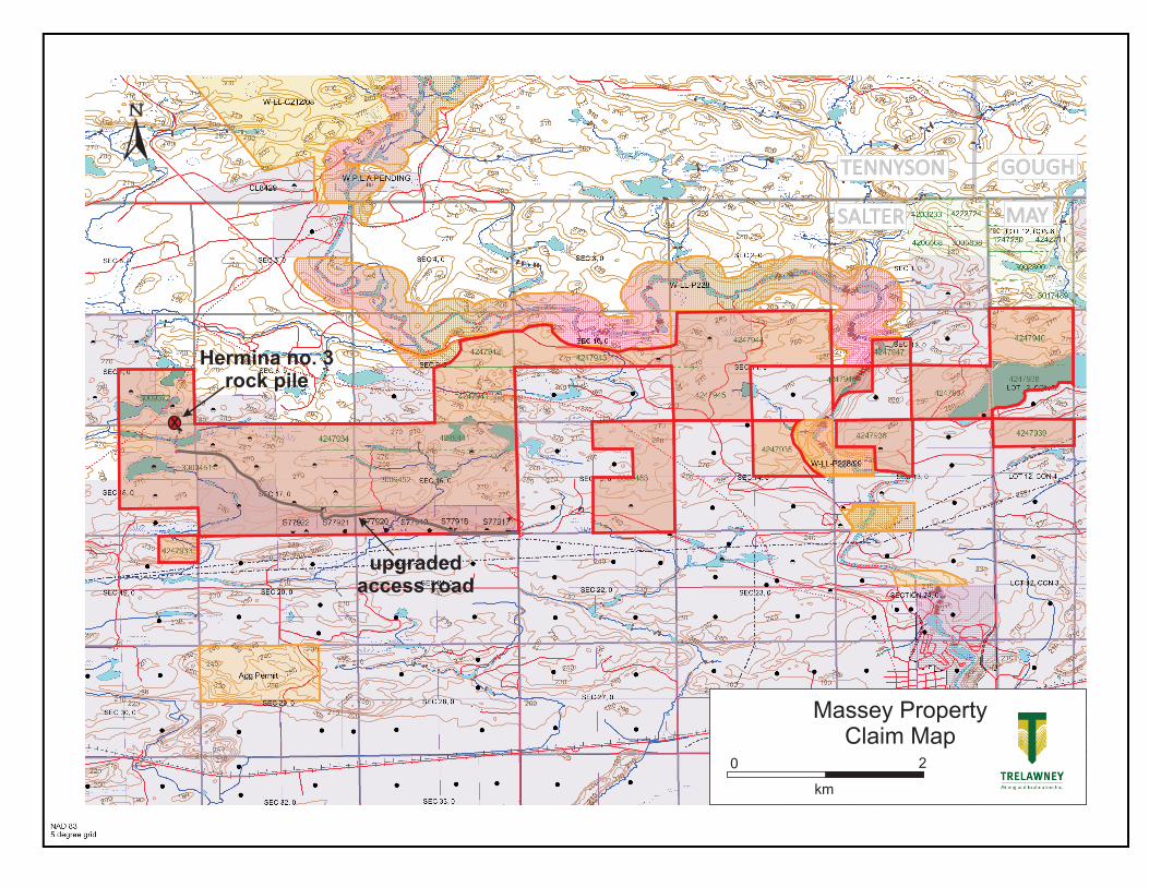
SALTER MAY
GOUGHTENNYSON
Massey PropertyClaim Map
0 2
km
X
Hermina no. 3rock pile
upgradedaccess road
0241E (04/2006) © Queen’s Printer for Ontario, 2006
Ministry of Northern Development and Mines
Assessment Work Performed
on Mining Lands
Folder Identification Number (office use)
Transaction Number (office use)
W -
Mining Act, Subsections 65(2) and 66(3), R.S.O. 1990 Submission Number (office use)
2.
Personal information collected on this form is obtained under the authority of subsections 65(2) and 66(3) of the Mining Act. Under section 8 of the Mining Act, this information is used to maintain a public record. This information will be also used to review the assessment work and correspond with the mining land holder. Questions about this collection should be directed to the Senior Manager, Mining Lands Section, Ministry of Northern Development and Mines, 3
rd Floor, 933 Ramsey Lake Road, Sudbury ON P3E 6B5. Telephone 1 888 415-9845.
Instructions: - For work performed on Crown Lands before recording a claim, use form Assessment Work Performed Before Recording Claim(s)
- Please type or print in ink. - Submit to Geoscience Assessment Office, 933 Ramsey Lake Road,
Sudbury ON P3E 6B5. Telephone 1 888 415-9845.
Note: All correspondence will be sent to the address on record in the Provincial Recording Office, as required under the
Mining Act, subsections 19(6) and (8).
1. Submitter I am an authorized agent or the recorded holder (if a company, enter name of person submitting)
Name (last)
NASSIF
(first)
GARY
(initial)
J
Client number (optional)
402664 Address – Unit number, Street number, Street name
SUITE 2700 - 130 ADELAIDE STREET WEST
City, Town or Village
TORONTO
Province or State
ON
Country
CANADA
Postal Code
M5X1A6
Telephone number
( 416 ) 363-8567 ext 103
Fax number
( 416 ) 216-8535
E-mail address (optional)
2. Provide
where there is a surface rights holder, before starting ground exploration work for the first time on a staked claim you must provide notice to the surface rights holder(s) as required by the Mining Act and provide proof of notification to the Ministry
your technical report and maps in paper or on a compact disc
a current legible map showing how the contiguous mining lands are linked for assigning work
proof of beneficial interest (if assigning amongst different recorded holders)
3. Work Performed This includes the date you traveled to the field or mobilized equipment to the date the technical report was completed.
From: DD/MMMM/YYYY (enter the month in full in this box e.g. 12/July/2008)
30/June/2011
To: DD/MMMM/YYYY (enter the month in full in this box e.g. 28/July/2008)
27/July/2011
Regulations: Calculate the time-adjusted credit column, in the tables below, as follows:
1. Work filed within 2 years of performance is claimed at 100%. (Enter 100% of actual costs in both of the last 2 columns).
2. Work filed after 2 years and up to 5 years after performance is credited at 50%. (Enter 100% of actual costs in the 2nd
last column and 50% in the last column.)
3. Work older than 5 years is not eligible for credit.
3(A) Dates and Costs of Work Performed
From date DD/MM/YYYY
To date DD/MM/YYYY
Work Type Unit of Work (example: hours/day,
metres of drilling, km of grid lines)
Cost per
Unit of
Work
Actual Costs
($)
Time-Adjusted
Credit ($) (See notes 1 and 2
above)
30/06/2011 01/07/2011 supervisor 20 hours 60 1,200 1200
30/06/2011 01/07/2011 labour 20 hours 25 500 500
30/06/2011 01/07/2011 labour 20 hours 20 400 400
30/06/2011 01/07/2011 operator 20 hours 80 1,600 1,600
30/06/2011 01/07/2011 assaying 62 samples 40 2,480 2,480
3(B) Associated Costs
From date DD/MM/YYYY
To date DD/MM/YYYY
Associated Costs (example: supplies, mobilization, demobilization)
Actual Costs
($)
Time-Adjusted
Credit ($) (See notes 1 and 2
above)
30/06/2011 01/07/2011 excavator rental (20 hrs at $165/hr) 3,300 3,300
30/06/2011 01/07/2011 mobilization,demobilization 3,500 3,500
27/07/2011 27/07/2011 Nassif - Report writing, drafting 500 500
0241E (04/2006) © Queen’s Printer for Ontario, 2006
3(C) Transportation Costs
From date DD/MM/YYYY
To date DD/MM/YYYY
Transportation Costs Actual Costs
($)
Time-Adjusted
Credit ($) (See notes 1 and 2
above)
30/06/2011 01/07/2011 240 km x 3 trips x $0.40/km 288 288
04/07/2011 04/07/2011 sample shipping: 6 hrs x $20/hr labour 120 120
30/06/2011 01/07/2011 fuel 400 400
3(D) Food and Lodging Costs
From date DD/MM/YYYY
To date DD/MM/YYYY
Food and Lodging Costs Actual Costs
($)
Time-Adjusted
Credit ($) (See notes 1 and 2
above)
30/06/2011 01/07/2011 320 320 320
Total of Time Adjusted Credit Columns (3A through 3D) = Total Value of Assessment Work 14608
4. Type of Work Performed – please check off the type of survey performed (optional)
Work Type Survey Type Work Type Survey Type
Airborne geophysical
AEM
AMAG
AVLF
other airborne geophysical
Geophysical EM
GRAV
IP
MAG
VLF
other geophysical
Assays assay
beneficiation
geochemical
Physical manual work re-cutting claim lines
mechanical work trenching
overburden stripping other physical
Drilling diamond drilling
drill core submission to MNDM
overburden drilling
boring other than core
Prospecting Prospecting
Rehabilitation Rehabilitation
Other – Please print
examples: microscopic studies, bulk sampling, downhole geophysics
Line cutting line cutting
Geochemical geochemical
Geological geological
5. Commodities Explored for - please list (optional)
Gold, Copper, Silver, Uranium
6. Work Performed, Assigned, Banked
6(A) If you performed work on mining lands other than a staked mining claim, fill in the table below. Lease or Patented
Land or Licence of Occupation (LO) or Other Mining Lands: Work performed, assigned or banked
Lease # or Parcel # or G # or LO #
GAO-Approved Identifier
(office use only)
Hectares Amount of Work Performed on this
Land ($)
Amount of Credits Assigned to Mining
Claim(s) ($)
Bank (Amount of credits to be assigned at a future date)
Column Totals for 6(A)
Schedule attached (if you have more entries attach a schedule)

0241E (04/2006) © Queen’s Printer for Ontario, 2006
6(B) Mining Claims: Work performed, applied, assigned, banked or assigned from table 6(A) above
Mining Claim Number Number of Claim Units
Amount of Work Performed on this
Claim ($)
Amount of Credits Applied to this
Claim ($)
Amount of Credits Assigned to Other Mining Claims ($)
Bank (Amount of credits
to be applied or assigned at a future date)
3009372 4 14,608 9,200 5,408
4247933 1 400
4247934 3 1,200
4247935 3 1,200
4247936 3 1,200
4247937 4 1,600
4247938 3 1,200
4247939 2 800
4247940 4 1,600
Column Total for 6(B) 14,608 9,200 9,200 5,408
Column Totals of 6(A) + 6(B) 14,608
9,200 5,408
Note: Work performed on mining claims = credits applied + credits banked
Schedule attached (if you have more entries attach a schedule)
7. Some of the credits claimed in this Assessment Work form may be reduced. Please indicate below how you want your
credits reduced if they are not approved. Check ( ) in the boxes below. If you have not indicated how your remaining
credits are to be allocated, credits will be reduced from the Bank first, followed by option number 2 if necessary.
Credits are to be cutback:
1. Credits are to be cut back from the Bank first, followed by option 2 or 3 or 4 as indicated; or
2. Credits are to be cut back starting with the claims listed last, working backwards; or
3. Credits are to be cut back equally over all claims listed in this Assessment Work form; or
4. Credits are to be cut back as shown below:
List the claim numbers in the order you want the credits to be cut back (setting your priority list).
Priority Claim Number Priority Claim Number
1. 6.
2. 7.
3. 8.
4. 9.
5. 10.
Schedule attached (if you have more entries attach a schedule)
8. Certification by Recorded Holder or Authorized Agent
I, , do hereby certify on 27/07/2011 that I have personal (Signature) (DD/MM/YYYY)
knowledge of the facts set forth in this Assessment Work form having caused the work to be performed or witnessed the same during or after its completion and, to the best of my knowledge, the annexed report is true.
“Mining Lands Website: http://www.ontario.ca/mininglands”