role of environment in shaping early farming communities ... · role of environment in shaping...
TRANSCRIPT

Role of Environment in Shaping Early Farming Communities in the Chautang Basin
Tejas Garge1 1. Archaeological Survey of India, Aurangabad Circle, Bibi ka Makbara, Aurangabad,
Maharashtra – 431004, India (Email: [email protected])
Received: 07 August 2014; Accepted: 02 September 2014; Revised: 14 October 2014 Heritage: Journal of Multidisciplinary Studies in Archaeology 2 (2014): 184‐197
Abstract: The Chautang, at present a dry river once flowing from Haryana and eastern Rajasthan was populated with 377 Protohistoric settlements including 95 Early, 56 Mature and 226 to Late Harappan period. The present paper highlights association of dynamic environmental factors namely soil types and availability of water in form of rainfall and drainage patterns with dispersal of sites. The fluctuations/ changes within environmental variables led to rise of agro‐pastoral economy during the early stage, which laid foundations of urban economy during Bronze Age and ultimately assumed shape of rural culture based on pastoral‐agro economy in late Harappan stage.
Keywords: Harappan Settlements, Chautang, Environmental Changes, Soils, Agriculture, Protohistoric India, Economy
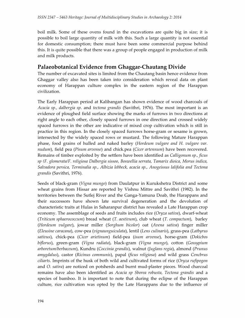
Introduction The Ghaggar River system emerging from lesser Himalayas and piedmonts passing through Haryana, Rajasthan enters into Bahawalpur region of Pakistan. The Chautang was a major feeder to the Ghaggar during the Harappan period. The Harappan settlements along Ghaggar‐Hakra are concentrated in three major clusters‐first along the Upper reaches of Ghaggar, second‐ along the Chautang and third cluster located along the mighty flow of Ghaggar after Upper Ghaggar and Chautang meet at Suratgarh in Rajasthan. The Chautang river basin dominates the eastern domain of the Harappan Civilization as almost 400 sites are situated along with it. Besides number, presence of one of the largest Harappan sites‐ Rakhiagrhi is ample evidence to state that this area played vital role in Harappan period.
The Chautang rises in Siwaliks, turns west, passes Hissar and the well‐known archaeological sites of Siswal, Sothi, Nohar and Rakhigarhi. It joins the Ghaggar near Suratgarh with the sites of Kalibangan and Rang Mahal occupying places of prominence at this strategic junction. In terms of modern political division the Chautang starts from Yamunanagar district of Haryana passes through Kurukshetra, Karnal, Kaithal, Jind and Hisar all districts of Haryana state in India. After Hisar it

Garge 2014: 184‐197
185
enters in Rajasthan and united with Ghaggar near Suratgarh in Hanumangarh district (Fig.1). At present it is a dry river; its old channel is filled with silt and sediments; covered by aeolian sand at many places.
Figure 1: Modern Political division of the Chautang Basin
History of Archaeological Research in the Chautang Basin L.P. Tessitori was the first scholar to visit sites of archaeological interest in this region in the first decade of the 20th century. His unpublished reports give vivid descriptions of archaeological sites like Sothi, Nohar, Kalibanaga and Pilibanga. (Lahiri, 2005:153). In the early part of the twentieth century Sir Aurel Stein, another great explorer had visited Kalibangan and some other mounds in Ghaggar‐Hakra. A. Ghosh was the first
RAJASTHAN
HARYANA
PUNJAB
DELHIBhivani
Hissar
Jind
KarnalKaithal
Kurukshetra
Panipat
Sonipat
Rohatak
Jajjhar
Mah
endr
aga r
h
RewariGurgoan
Farid
ab
ad
FatehbadSirsa
Hanumangarh
Churu
UTTARPRADESH
CHAUTANG
GHAGGAR
YAM
UNA
INDEXState BoundaryDistric t BoundaryExisting RiverDried River Channel
N
Yam
unan
agar
Ambala
PanchkulaChandigarh
ISSN 2347 – 5463 Heritage: Journal of Multidisciplinary Studies in Archaeology 2: 2014
186
scholar who realized the archaeological potential of the Chautang or Drishadvati, as “…the valleys of the Saraswati and Drishadvati must be regarded as very rich indeed in archaeological remains... comprise relics of several millennia of Indian history right from the Harappa period to comparatively recent historical times” (Ghosh, 1987:101). Following his explorations in 1951‐52, the Archaeological Survey of India carried out excavations at Kalibangan for nine field seasons (1960‐1969) under B.B. Lal, B.K. Thapar and J.P. Joshi.
Besides archaeological Survey of India there were several other individuals pursuing their doctoral research on the Ghaggar valley. Between 1967‐70 Katy Frenchman surveyed the Ghaggar valley. A major breakthrough in Harappan studies of this region was work of Suraj Bhan between 1967 to 1970 along the dry channels of Ghaggar and Chautang. He was able to place 97 Prehistoric sites on the map and also conducted small scale excavations at Mitathal, Daulatpur and Siswal. Silak Ram in 1972 reported about 144 settlements ranging from Early Harappan to Medieval period (1972:77‐8). Manmohan Kumar added valuable information from the Siwalik piedmont zone (Kumar 1978). Further, Amar Singh’s enriched more information on antiquarian remains of the Chautang area by reporting 236 new sites ranging from Pre‐Harappan to medieval period (Sing 1981). Yogeshawar Kumar’s explored Panchkula, Ambala and Kurukshetra districts most falling in piedmont plain area and reported sites reported range from Stone Age, Late Harappan, PGW, NBPW to Early Historical period (Kumar 2003).
The excavations at Balu, District‐ Kaithal were carried out from 1978‐79 to 1989‐90, 1992‐93 to 1994‐95 and 1996‐97, first under the direction of U.V. Singh and Suraj Bhan and later by S.P. Shukla of Kurukshetra University. These excavations remained important for revelling continuous cultural sequence from Early to Late Harappan period and evidence of fortified town settlement (Kesarvani 2001:140‐52). Recently, excavations were carried out at Rakhigarhi (1997‐2000); the most important site in the Chautang basin and one among the five largest settlements of the Harappan civilization. The excavator, Amarendra Nath has divided cultural occupation in the following periods‐ Period I: Early Harappan; Period II: Mature Harappa and Period III: Late medieval (Nath, 1998: 39‐45). He also numbered the seven localities or mounds as RGR‐1 to RGR‐7. Recent explorations by Vivek Dangi, Singh, R.N., C.A. Petri and others has added further to existing knowledge about the expanse of the Harappans in Haryana (Dangi 2009, Singh et al. 2010).
A review of published literature indicates that the Harappans were the first settlers of the Chautang basin followed by PGW, Rangmahal cultures and those belonging to Kushan, Gupta and post Gupta period are located. Though evidence for late historical or early medieval sites is scarce there are continuous mediaeval settlements of Sultanate period onwards. While looking for evidence of antecedents of human culture prior to the Harappans in the Ghaggar‐ Chautang divide archaeological record is silent so far. Either there were no human settlements belonging to Palaeolithic / Mesolithic
Garge 2014: 184‐197
187
period or evidence is deep buried below heavy depositions of alluvium. The closest evidence of this kind comes from piedmont of Shiwaliks and Arawalis and eastern Rajasthan. For now sites of Hakra and Sothi culture which later evolved into early Harappan are considered as the first settlers of the Chautang basin. The evidence from mature Harappan levels shows that they survived on economy comprising preliminary subsistence activities like agriculture, pastoral activities and hunting, secondary economic activities like mining, manufacturing etc. and tertiary activities like exchange and trade networks. Possehl (1997) has called Ghaggar‐ Hakra region as “bread‐butter” region of the Harappan Civilization. The present paper highlights role of environment in economic contribution of the Chautang basin in the Harappan economy.
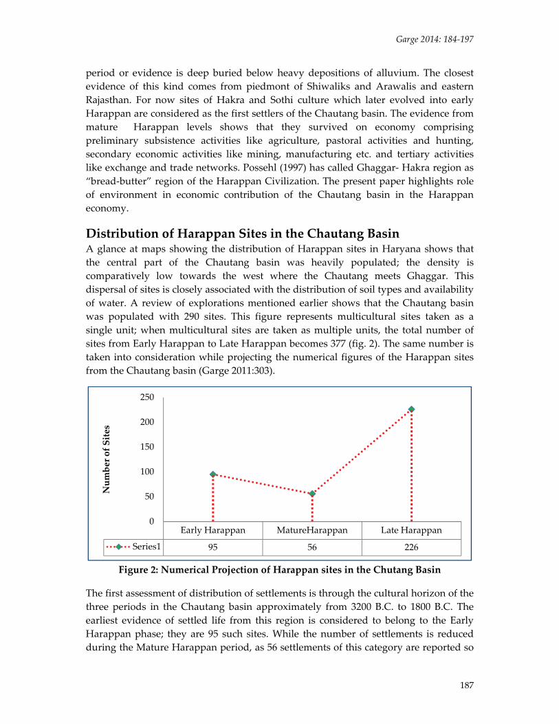
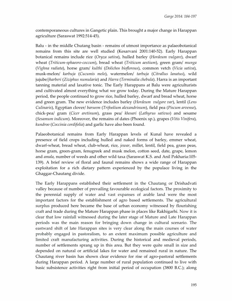
Distribution of Harappan Sites in the Chautang Basin A glance at maps showing the distribution of Harappan sites in Haryana shows that the central part of the Chautang basin was heavily populated; the density is comparatively low towards the west where the Chautang meets Ghaggar. This dispersal of sites is closely associated with the distribution of soil types and availability of water. A review of explorations mentioned earlier shows that the Chautang basin was populated with 290 sites. This figure represents multicultural sites taken as a single unit; when multicultural sites are taken as multiple units, the total number of sites from Early Harappan to Late Harappan becomes 377 (fig. 2). The same number is taken into consideration while projecting the numerical figures of the Harappan sites from the Chautang basin (Garge 2011:303).
Figure 2: Numerical Projection of Harappan sites in the Chutang Basin
The first assessment of distribution of settlements is through the cultural horizon of the three periods in the Chautang basin approximately from 3200 B.C. to 1800 B.C. The earliest evidence of settled life from this region is considered to belong to the Early Harappan phase; they are 95 such sites. While the number of settlements is reduced during the Mature Harappan period, as 56 settlements of this category are reported so
Early Harappan MatureHarappan Late Harappan
Series1 95 56 226
0
50
100
150
200
250
Number of Sites
ISSN 2347 – 5463 Heritage: Journal of Multidisciplinary Studies in Archaeology 2: 2014
188
far. Finally, the Protohistoric cultural scenario of this area was dominated by 226 Late Harappan sites (fig. 2). Furthermore, this study underscores that the Early, Mature and Late Harappan periods are not watertight chronological compartments but cultural stages which may have co‐existed at the same time at different places. Further, out of 377 Harappan sites from the Chautang basin, sizes of 251 sites are known today; the remaining 126 sites are either reported without mentioning size of the settlement or estimating size of some of these settlements is not possible due to site destruction.
Role of Environment The regional settlement pattern of the Harappan sites in the Chautang basin is primarily affected by availability of water in form of drainage and rainfall, physiography of the area including different soil types and other resources.
Drainage of the Chautang Basin A look at a distribution map showing Harappan sites in relation to the drainage of the Chautang basin will give a clear representation of the settlement pattern. Oldham (1874: 2) associated the Chitrang (Chautang) with the Drishadwati of the Rigveda and Mahabharata, which ultimately joined the Ghaggar. According to Pal (1984), the Yamuna River was a major contributing factor to the Ghaggar river system. The channel Y1 close to the channel of upper Ghaggar, as shown in the map, was its earliest course, then it flowed through two channels named as Y2 (represents the Chautang basin), to meet the Ghaggar near Suratgarh and finally it took a southerly course, flowing almost parallel to the present channel of the Yamuna to join the Ganga. The Chautang was considered as the living river even during the Late Harappan times. The Y2 channel as identified by Pal is considered as a main flow of the Chautang river during the Harappan period. The Y1 channel, though it flows to the north of the Y2 channel is considered as part of Chautang system. This is major visible distributary of the Chautang, beside this there are several other offshoots or shifting channels on which Harappan settlements flourished. This immense network of channels created several alluvial fans leading to thick clustering of agricultural communities all along the Ghaggar‐Chautang divide. The reported/ explored sites were plotted on Google Earth and the relict channels of drainage were drawn and sites were superimposed over relict channels. Geologically it is not possible to date palaeochannels, but existence of the archaeological sites indicates probable relative date of a particular flow of the Chautang basin. Besides Y1, Y2 and Y3 channels between Ghaggar and Yamuna, there are several flows which were either tributaries or offshoots of the main river flow. They either co‐existed or flowed in different time segments.
Rainfall Pattern While dealing with the distribution of archaeological sites in the Chautang basin in relation to the drainage pattern, it should be noted that the drainage system herewas largely depended upon rainwater. A review of published literature on the effect of rainfall on the origin, growth and decline of the Harappan Civilization on a larger scale is also reflected in the Chautang basin. A group of scholars (Oldham, 1874; Oldham,
Garge 2014: 184‐197
189
1886; Raikes 1968; Yash Pal 1984; Misra 1984 and 1991; Puri 1998; Valdiya 2002) suggest perennial, glacier‐fed status of the Ghaggar and Chautang rivers in protohistoric period. Existing data on rainfall (Singh 1971 and 1974; Enzel 1999; Kajale 2002; Shinde 2002) and comparison of the Nile flood data with Indian rainfall (Dhavalikar 2002 and 2003) clearly demonstrate fluctuations in the Holocene rainfall pattern. Study on oxygen isotope record by Yama Dikshit and others shows that the drought event 4.1 ka on the northwestern Indian plains is within the radiocarbon age range for the beginning of Harappan de‐urbanization, suggests climate may have played a role in the cultural transformation (Dixit et. al. 2014).
Though growth and decline of the Harappan Civilization certainly did not solely depend on rainfall, it appears to have been one of the important factors for the population based on an agrarian economy. Work carried out by the French Archaeological Mission during 1984‐86 clearly shows that Chautang was a rain‐fed river during the Protohistoric period. Thus, rainfall fluctuations were directly related to growth or decline of the Harappans. The Early Harappan settlements spread along almost all channels indicating that these drainages were active as it was a phase (4000 B.C. to 2800 BC.) of good rainfall. The existing settlements of the Early Harappan period continued and some of them transformed into Mature Harappan stage. But besides the main drainages, Y1 and Y2 water from some of small drainages disappeared due to decreased rainfall. The process of deserting the lower Chautang basin was already set in motion during the Mature Harappan period. When rainfall became erratic it was no longer possible to maintain a surplus producing agrarian economy, large villages, towns or cities. Most possibly, large settlements split into smaller sites and settled as per the availability of water. With reduced rainfall there was not enough force of water to push through desert lands. Probably no channel flowed beyond modern Jind and the eastern part of Hissar districts. All the Late Harappan settlements were confined to the eastern part or the upper and middle Chautang basin. Beside channels, old meanders of water channels became lakes and again affecting displacement of the human habitations.
Distribution of Soils The existing complexities in the sediments and soil types resulted due to various factors in relation to the protohistoric human population in the Ghaggar‐ Chautang divide, It is the least studied aspect affecting distribution of the settlements. Studies on sediments carried out by an Indo‐French Mission during 1984‐86 in the Ghaggar region demonstrate that sediments of Himalayan origin are deeply buried in the geological sections of the Ghaggar and Chautang rivers. The geological deposits contemporary to the protohistoric archaeological sites are alternate layers of alluvium of Siwalik origin and aeolian sand indicating short wet and dry phases. In other words, protohistoric human habitations in the Chautang basin basically depended upon rain‐fed rivers and streams. The suitability of soil for agriculture seems to have been an important factor when the Harappans selected the location of their settlements. The present work also indicates that most ancient mounds were situated on the edge of the Chautang river
ISSN 2347 – 5463 Heritage: Journal of Multidisciplinary Studies in Archaeology 2: 2014
190
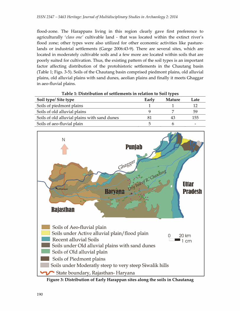
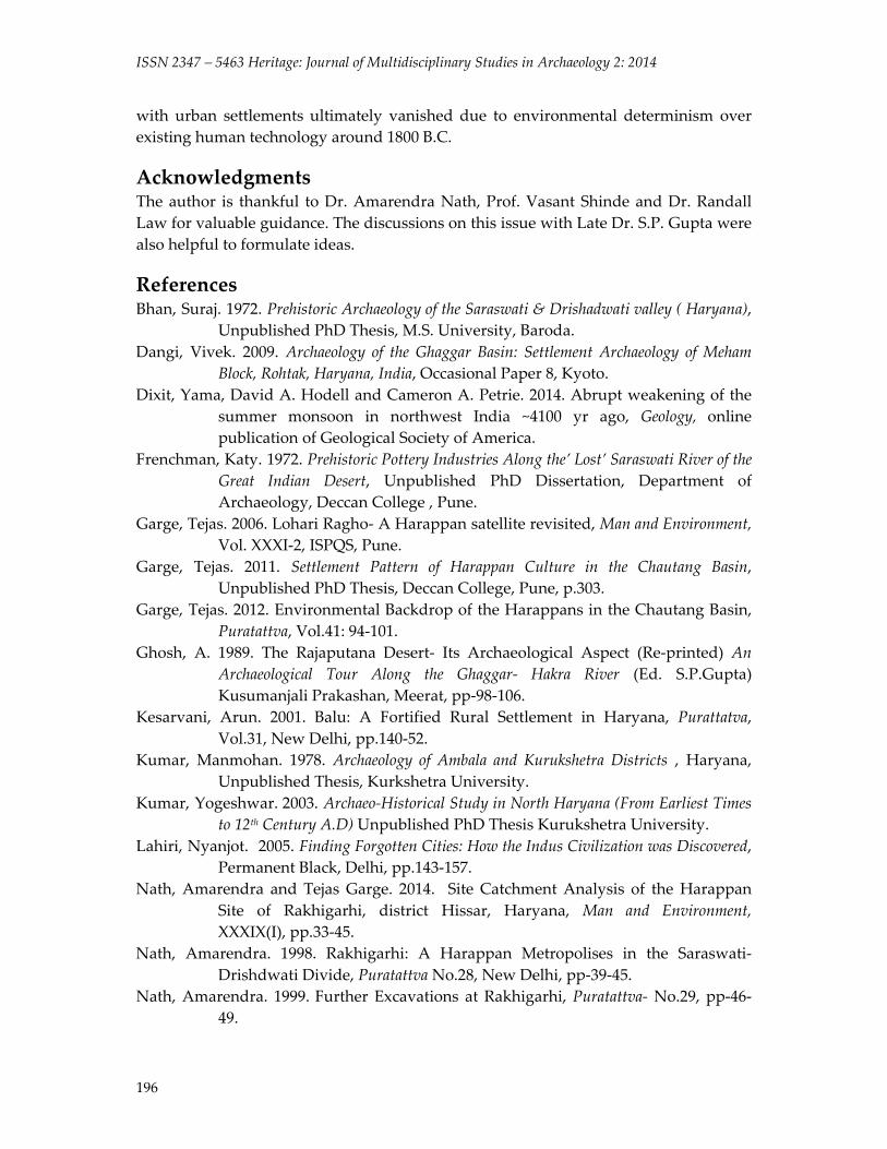
flood‐zone. The Harappans living in this region clearly gave first preference to agriculturally ‘class one’ cultivable land ‐ that was located within the extinct river’s flood zone; other types were also utilized for other economic activities like pasture‐lands or industrial settlements (Garge 2006:43‐9). There are several sites, which are located in moderately cultivable soils and a few more are located within soils that are poorly suited for cultivation. Thus, the existing pattern of the soil types is an important factor affecting distribution of the protohistoric settlements in the Chautang basin (Table 1; Figs. 3‐5). Soils of the Chautang basin comprised piedmont plains, old alluvial plains, old alluvial plains with sand dunes, aeolian plains and finally it meets Ghaggar in aeo‐fluvial plains.
Table 1: Distribution of settlements in relation to Soil types Soil type/ Site type Early Mature LateSoils of piedmont plains 1 1 12 Soils of old alluvial plains 9 7 59 Soils of old alluvial plains with sand dunes 81 43 155 Soils of aeo‐fluvial plain 5 6 ‐
Figure 3: Distribution of Early Harappan sites along the soils in Chautanag
Garge 2014: 184‐197
191
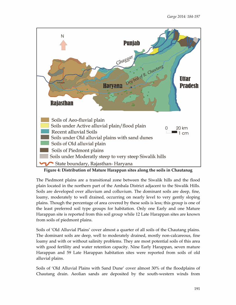
Figure 4: Distribution of Mature Harappan sites along the soils in Chautanag
The Piedmont plains are a transitional zone between the Siwalik hills and the flood plain located in the northern part of the Ambala District adjacent to the Siwalik Hills. Soils are developed over alluvium and colluvium. The dominant soils are deep, fine, loamy, moderately to well drained, occurring on nearly level to very gently sloping plains. Though the percentage of area covered by these soils is less; this group is one of the least preferred soil type groups for habitation. Only one Early and one Mature Harappan site is reported from this soil group while 12 Late Harappan sites are known from soils of piedmont plains.
Soils of ‘Old Alluvial Plains’ cover almost a quarter of all soils of the Chautang plains. The dominant soils are deep, well to moderately drained, mostly non‐calcareous, fine loamy and with or without salinity problems. They are most potential soils of this area with good fertility and water retention capacity. Nine Early Harappan, seven mature Harappan and 59 Late Harappan habitation sites were reported from soils of old alluvial plains.
Soils of ‘Old Alluvial Plains with Sand Dune’ cover almost 30% of the floodplains of Chautang drain. Aeolian sands are deposited by the south‐western winds from
ISSN 2347 – 5463 Heritage: Journal of Multidisciplinary Studies in Archaeology 2: 2014
192
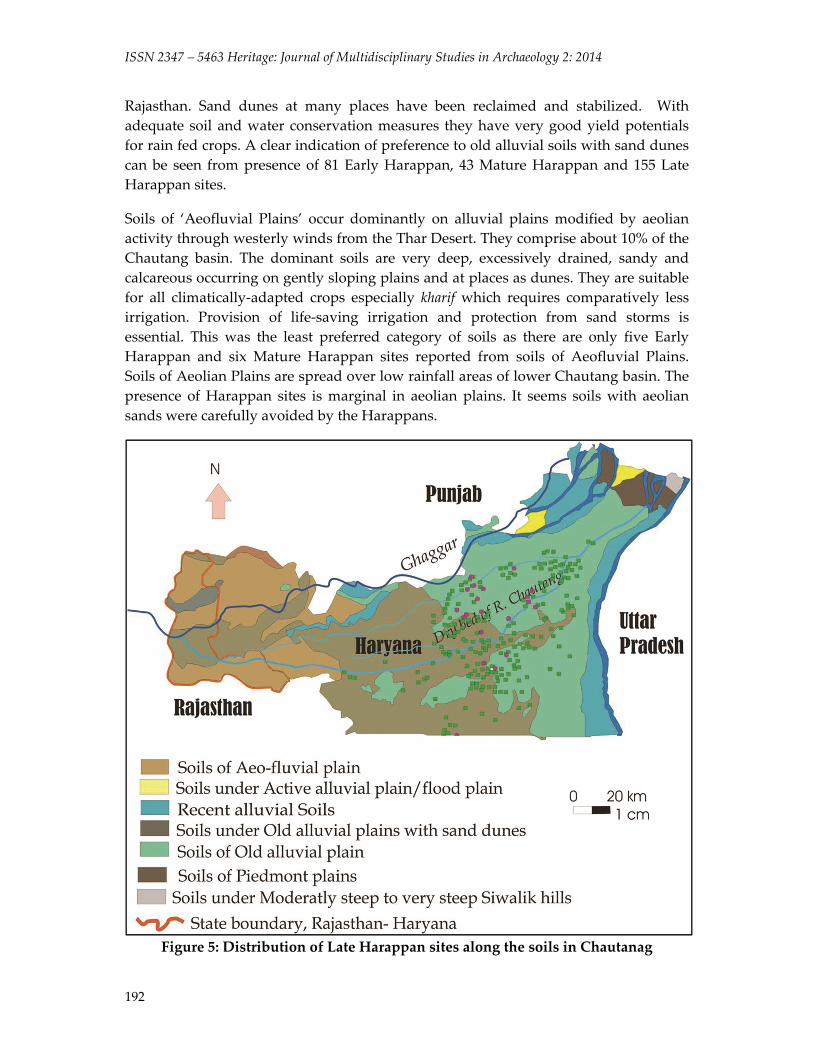
Rajasthan. Sand dunes at many places have been reclaimed and stabilized. With adequate soil and water conservation measures they have very good yield potentials for rain fed crops. A clear indication of preference to old alluvial soils with sand dunes can be seen from presence of 81 Early Harappan, 43 Mature Harappan and 155 Late Harappan sites.
Soils of ‘Aeofluvial Plains’ occur dominantly on alluvial plains modified by aeolian activity through westerly winds from the Thar Desert. They comprise about 10% of the Chautang basin. The dominant soils are very deep, excessively drained, sandy and calcareous occurring on gently sloping plains and at places as dunes. They are suitable for all climatically‐adapted crops especially kharif which requires comparatively less irrigation. Provision of life‐saving irrigation and protection from sand storms is essential. This was the least preferred category of soils as there are only five Early Harappan and six Mature Harappan sites reported from soils of Aeofluvial Plains. Soils of Aeolian Plains are spread over low rainfall areas of lower Chautang basin. The presence of Harappan sites is marginal in aeolian plains. It seems soils with aeolian sands were carefully avoided by the Harappans.
Figure 5: Distribution of Late Harappan sites along the soils in Chautanag
Garge 2014: 184‐197
193
Agro‐pastoral Character of the Harappans in the Chautang Basin The above statistics and discussion clearly demonstrates that first occupants of the Chautang bsin gave clear preference to availability of water which was primary factor for survival. The second criterion for selection of location of site was availability of cultivable land. Soils of old alluvial plains seems to have been most preferred land as it could be cultivated even with primitive tools. The data from largest excavated site from this region suggests that agriculture was basic economic activity in and around Rakhigarhi. “…overwhelmingly rich surface features together with volume and size of the mound amidst vast arable land plains suggests primarily agriculture based subsistence pattern since the days of first occupation at the site” (Nath 1999). Secondly, excavations have also revealed the presence of wheat, barley, cotton and bathua. Early Harappan levels have also yielded model plough showing the importance of agricultural activity. The site catchment analysis of the Harappan Rakhigarhi (Nath and Garge, 2014) suggests that almost 78% of the land within the catchment area of Rakhigarhi is class I agricultural land. This agricultural land was sufficient to support not only population but also surplus agriculture enabled craft trade activities to flourish. Some scholars have moved forward to call Hakra‐ Cholistan region as ‘bread‐basket region of the Harappan Civilization (Posshel, 1980: 425‐72), It seems to be true in case of Rakhigarhi and eastern domain.
Pastoralisum played secondary role in the economy of Rakhigarhi. According to the excavator, “... the agricultural waste and vast grazing land around the site must have given rise to animal husbandry. The agro‐pastoral character of the site never got marginalised, other traits of subsistence remained subordinate.ʺ Almost 12% of the total land of catchment area around Rakhigarhi is good pastureland. The analysis of the faunal remains would have provided more accurate picture, about the percentage of domesticated and hunted animals, but unfortunately, it is not available. The primary analysis of bone remains from first season shows that cattle bones were dominant especially of domesticated variety; percentage of the animal bones, which were hunted, is quite low. The terracotta animal figurines found from excavations provided us a rough picture in this regard. Bull, buffalo, sheep, goat and dogs must have been among the domesticated animals. Elephant, Rhino, wild variety of buffalo must have been among those who were hunted. The absence of cow in terracotta depictions also gives clue about the nature of pastoralism at Rakhigarhi. Cow is important for those people who are completely engaged in nomadic pastoralism like Rabaries in Gujarat. However, buffalo is more important in settled animal husbandry. This fact is evident from the ethnographic survey of Rakhigarhi; as dominant numbers of buffalos are seen here.( Semi‐nomadic pastoralism could have been part of economy of ancient Rakhigarhi in form of sheep‐goat grazing. However, otherwise it was mainly animal husbandry or settled pastoralism. It is clear that milk and milk products were part of subsistence of Harappans at Rakhigarhi; but was there a special class or group of people behind it? The complete circular ovens found in excavations, combined with their modem ethnographic parallel arha, suggest that probably function of this was to
ISSN 2347 – 5463 Heritage: Journal of Multidisciplinary Studies in Archaeology 2: 2014
194
boil milk. Some of these ovens found in the excavations are quite big in size; it is possible to boil large quantity of milk with this. Such a large quantity is not essential for domestic consumption; there must have been some commercial purpose behind this. It is quite possible that there was a group of people engaged in production of milk and milk products.
Palaeobotanical Evidence from Ghaggar‐Chautang Divide The number of excavated sites is limited from the Chautang basin hence evidence from Ghaggar valley also has been taken into consideration which reveal data on plant economy of Harappan culture complex in the eastern region of the Harappan civilization.
The Early Harappan period at Kalibangan has shown evidence of wood charcoals of Acacia sp., dalbergia sp. and tectona grandis (Savithri, 1976). The most important is an evidence of ploughed field surface showing the marks of furrows in two directions at right angle to each other, closely spaced furrows in one direction and crossed widely spaced furrows in the other are indicative of mixed crop cultivation which is still in practice in this region. In the closely spaced furrows horse‐gram or sesame is grown, intersected by the widely spaced rows or mustard. The following Mature Harappan phase, food grains of hulled and naked barley (Hordeum vulgare and H. vulgare var. nudum), field pea (Pisum arvense) and chick.pea (Cicer artennum) have been recovered. Remains of timber exploited by the settlers have been identified as Calligonum sp., ficus sp (F. glomerata/F. religiosa Dalbergia sissoo, Boswellia serrata, Tamarix dioica, Morus indica, Salvadora persica, Terminalia sp., Albizia lebbeck, acacia sp., Anogeissus lalifolia and Tectona grandis (Savithri, 1976).
Seeds of black‐gram (Vigna mungo) from Daulatpur in Kurukshetra District and some wheat grains from Hissar are reported by Vishnu Mittre and Savithri (1982). In the territories between the Sutlej River and the Ganga‐Yamuna Doab, the Harappans and their successors have shown late survival degeneration and the devolution of characteristic traits at Hulas in Saharanpur district has revealed a Late Harappan crop economy. The assemblage of seeds and fruits includes rice (Oryza sativa), dwarf‐wheat (Triticum sphaerococcum) bread wheat (T. aestivum), club wheat (T. compactum), barley (Hordeum vulgare), jowar miller (Sorghum bicolor) oat (Avena sativa) finger miller (Eleusine caracana), cow‐pea (vignaunguiculata), lentil (Lens culinaris), grass‐pea (Latbyrus sativus), chick‐pea (Cicer arietinum) field‐pea (isum arvense), horse‐gram (Dokicbos biflorus), green‐gram (Vigna radiata), black‐gram (Vigna mungo), cotton (Gossypium arboretum/berbaceum), Kundru (Coccinia grandis), walnut (Juglans regia), almond (Prunus amygdalus), castor (Ricinus communis), papal (ficus religiosa) and wild grass Cencbrus ciliarts. Imprints of the husk of both wild and cultivated forms of rice (Oryza rufipogon and O. satira) are noticed on potsherds and burnt mud‐plaster pieces. Wood charcoal remains have also been identified as Acacia sp Sborea robusta, Tectona grandis and a species of bamboo. It is important to note that during the eclipse of the Harappan culture, rice cultivation was opted by the Late Harappans due to the influence of
Garge 2014: 184‐197
195
contemporaneous cultures in Gangetic plain. This brought a major change in Harappan agriculture (Saraswat 1992:514‐45).
Balu ‐ in the middle Chutang basin ‐ remains of utmost importance as palaeobotanical remains from this site are well studied (Kesarvani 2001:140‐52). Early Harappan botanical remains include rice (Oryza sativa), hulled barley (Hordeum vulgare), dwarf wheat (Triticum‐sphaeoro‐coccum), bread wheat (Triticum aestium), green gram/ munga (Vighna radiata), horse gram/ kulthi (Dolichos bioflorous), common vetch (Vicia sativa), musk‐melon/ karbuja (Cucumis melo), watermelon/ tarbuja (Citrallus lanatus), wild jujube/jharberi (Ziziphus numularia) and Harra (Terminalia chebula). Harra is an important tanning material and laxative tonic. The Early Harappans at Balu were agriculturists and cultivated almost everything what we grow today. During the Mature Harappan period, the people continued to grow rice, hulled barley, dwarf and bread wheat, horse and green gram. The new evidence includes barley (Hordeum vulgare var), lentil (Lens Culinaris), Egyptian clover/ barseem (Trifoolium alexandrinum), field pea (Piscum arvense), chick‐pea/ gram (Cicer aretinum), grass pea/ khesari (Lathyrus sativus) and sesame (Sesamum indicum). Moreover, the remains of dates (Phoenix sp.), grapes (Vitis Vinifera), kundroo (Coccinia cordifolia) and garlic have also been found.
Palaeobotanical remains from Early Harappan levels of Kunal have revealed a presence of field crops including hulled and naked forms of barley, emmer wheat, dwarf‐wheat, bread wheat, club‐wheat, rice, jowar, millet, lentil, field pea, grass peas, horse gram, green‐gram, fenugreek and musk melon, cotton seed, date, grape, lemon and amala, number of weeds and other wild taxa (Saraswat K.S. and Anil Pokharia:105‐139). A brief review of floral and faunal remains shows a wide range of Harappan exploitation for a rich dietary pattern experienced by the populace living in the Ghaggar‐Chautang divide.
The Early Harappans established their settlement in the Chautang or Drishadvati valley because of number of prevailing favourable ecological factors. The proximity to the perennial supply of water and vast expanses of arable land were the most important factors for the establishment of agro based settlements. The agricultural surplus produced here became the base of urban economy witnessed by flourishing craft and trade during the Mature Harappan phase in places like Rakhigarhi. Now it is clear that low rainfall witnessed during the later stage of Mature and Late Harappan periods was the main reason for bringing down change in cultural scenario. The eastward shift of late Harappan sites is very clear along the main courses of water probably engaged in pastoralism, to an extent maximum possible agriculture and limited craft manufacturing activities. During the historical and medieval periods, number of settlements sprang up in this area. But they were quite small in size and depended on natural or artificial lakes for water and remained rural in nature. The Chautang river basin has shown clear evidence for rise of agro‐pastoral settlements during Harappan period. A large number of rural population continued to live with basic subsistence activities right from initial period of occupation (3800 B.C.); along
ISSN 2347 – 5463 Heritage: Journal of Multidisciplinary Studies in Archaeology 2: 2014
196
with urban settlements ultimately vanished due to environmental determinism over existing human technology around 1800 B.C.
Acknowledgments The author is thankful to Dr. Amarendra Nath, Prof. Vasant Shinde and Dr. Randall Law for valuable guidance. The discussions on this issue with Late Dr. S.P. Gupta were also helpful to formulate ideas.
References Bhan, Suraj. 1972. Prehistoric Archaeology of the Saraswati & Drishadwati valley ( Haryana),
Unpublished PhD Thesis, M.S. University, Baroda. Dangi, Vivek. 2009. Archaeology of the Ghaggar Basin: Settlement Archaeology of Meham
Block, Rohtak, Haryana, India, Occasional Paper 8, Kyoto. Dixit, Yama, David A. Hodell and Cameron A. Petrie. 2014. Abrupt weakening of the
summer monsoon in northwest India ~4100 yr ago, Geology, online publication of Geological Society of America.
Frenchman, Katy. 1972. Prehistoric Pottery Industries Along the’ Lost’ Saraswati River of the Great Indian Desert, Unpublished PhD Dissertation, Department of Archaeology, Deccan College , Pune.
Garge, Tejas. 2006. Lohari Ragho‐ A Harappan satellite revisited, Man and Environment, Vol. XXXI‐2, ISPQS, Pune.
Garge, Tejas. 2011. Settlement Pattern of Harappan Culture in the Chautang Basin, Unpublished PhD Thesis, Deccan College, Pune, p.303.
Garge, Tejas. 2012. Environmental Backdrop of the Harappans in the Chautang Basin, Puratattva, Vol.41: 94‐101.
Ghosh, A. 1989. The Rajaputana Desert‐ Its Archaeological Aspect (Re‐printed) An Archaeological Tour Along the Ghaggar‐ Hakra River (Ed. S.P.Gupta) Kusumanjali Prakashan, Meerat, pp‐98‐106.
Kesarvani, Arun. 2001. Balu: A Fortified Rural Settlement in Haryana, Purattatva, Vol.31, New Delhi, pp.140‐52.
Kumar, Manmohan. 1978. Archaeology of Ambala and Kurukshetra Districts , Haryana, Unpublished Thesis, Kurkshetra University.
Kumar, Yogeshwar. 2003. Archaeo‐Historical Study in North Haryana (From Earliest Times to 12th Century A.D) Unpublished PhD Thesis Kurukshetra University.
Lahiri, Nyanjot. 2005. Finding Forgotten Cities: How the Indus Civilization was Discovered, Permanent Black, Delhi, pp.143‐157.
Nath, Amarendra and Tejas Garge. 2014. Site Catchment Analysis of the Harappan Site of Rakhigarhi, district Hissar, Haryana, Man and Environment, XXXIX(I), pp.33‐45.
Nath, Amarendra. 1998. Rakhigarhi: A Harappan Metropolises in the Saraswati‐ Drishdwati Divide, Puratattva No.28, New Delhi, pp‐39‐45.
Nath, Amarendra. 1999. Further Excavations at Rakhigarhi, Puratattva‐ No.29, pp‐46‐49.

Garge 2014: 184‐197
197
Possehl, G. L. 1980. The Transformation of the Indus Civilization, Journal of World Prehistory, Volume 11, No.4, pp.‐425‐72.
Saraswat, K. S. and Anil Pokharia. 2003. Palaethnobotanical Investigations of Early Harappan Kunal, Pragdhara No.13, pp.105‐139.
Savithri, R. 1976. Studies in archaeobotony together with its bearings upon social economy and environment of Indian Proto historic Cultures, Unpublished PhD Thesis, Lucknow University.
Silak, Ram. 1972. Archaeology of Rohtak and Hissar Districts [Haryana], Unpublished PhD Thesis, Kurukshetra University, Kurukshetra, pp‐77‐8.
Sing, Ama.r 1981. Archaeology of Karnal and Jjind Districts (Haryana), Kurukshetra University Unpublished PhD Thesis, pp‐80, 89.
Singh, R.N., C.A. Petri, A.K. Singh and M. Singh. 2009. Excavations at Masudpur (Hissar, District Haryana)‐ A Preliminary Report, Bharati 33: 35‐49.
Singh, R.N., C.A. Petri, C.A.I. French, A. Gaudie, S. Gupta, R. Tiwari, A. Singh, R. Sinha, R. Shivastava, S. Yadav, and V. Singh. 2008. Settlments in Context: Reconnasissance in Western Uttar Pradesh and Haryana, Man and Environment 33 (2): 71‐87.
Singh, R.N., C.A. Petri, V. Pawar, A.K. Pandey, S. Neogi, M. Singh, D. Parikh and C. Lancelotti. 2010. Changing Patterns of Settlements in the Rise and Fall of the Harappan Urbanism, Man and Environment 35 (1): 37‐53.
Stain, M.A. 1989. Along the Ghaggar in Bikaner (Re‐printed in) An Archaeological Tour Along the Ghaggar‐ Hakra River (Ed. S.P.Gupta) Kusumanjali Prakashan, Meerat, pp‐1‐55.
Vishnu‐Mittre and Savithri, R.1982. Food economy of the Harappans in Harappan Civilization, Ed. G.L. Possehl, Oxford & IBH Pub. company, New Delhi, pp. 205‐21.