rondout-west branch tunnel bypass tunnel - new … branch tunnel bypass tunnel ... this connection...
TRANSCRIPT


Rondout-West Branch Tunnel Bypass Tunnel Utility Easements
Technical Memorandum
Supplementary Documentation
for
Water for the Future Program: First Environmental Impact Statement (EIS 1)
Delaware Aqueduct RWBT Repair
Prepared for:
New York City Department of Environmental Protection
Prepared by:
Henningson, Durham & Richardson
Architecture and Engineering, P.C.
December 10, 2013

RWBT Bypass Tunnel i December 10, 2013 Utility Easements Technical Memorandum
TABLE OF CONTENTS
1.0 OVERVIEW AND PURPOSE OF THIS TECHNICAL MEMORANDUM ............... 1
1.1 PURPOSE AND NEED .......................................................................................................... 4
1.2 PROJECT DESCRIPTION ...................................................................................................... 4
1.3 PROJECT AREA SUMMARY ................................................................................................ 9
1.4 PERMITS AND APPROVALS ................................................................................................ 9
2.0 STATE ENVIRONMENTAL QUALITY REVIEW ACT AND CITY ENVIRONMENTAL QUALITY REVIEW REQUIREMENTS .................................. 9
3.0 PROPOSED UTILITY EASEMENTS IMPACT ASSESSMENT .............................. 10
3.1 LAND USE, ZONING AND PUBLIC POLICY ........................................................................ 11
3.1.1 Land Use ................................................................................................................. 12
3.1.2 Zoning ..................................................................................................................... 17
3.1.3 Public Policy ........................................................................................................... 21
3.1.4 Development Potential ............................................................................................ 22
3.1.4.1 Buildable Envelope.......................................................................................... 24 3.1.4.2 Vacant Parcels ................................................................................................. 28 3.1.4.3 Mining Envelope ............................................................................................. 28
3.1.5 Coastal Zone Consistency ....................................................................................... 31
3.2 SOCIOECONOMIC CONDITIONS ........................................................................................ 31
3.2.1 Water Supply .......................................................................................................... 32
3.2.2 Commercial Development ...................................................................................... 33
3.2.3 Residential Development ........................................................................................ 33
3.2.4 Industrial Development ........................................................................................... 34
3.2.5 Tax Revenues .......................................................................................................... 35
3.2.6 Mining ..................................................................................................................... 37
3.2.7 Socioeconomic Summary ....................................................................................... 40
4.0 ALTERNATIVES ............................................................................................................ 40
Appendices
Appendix A: Proposed Model Easement Appendix B: Parcels with Water Supply Wells Appendix C: FOIL Request Appendix D: Existing Building Height Restrictions

RWBT Bypass Tunnel ii December 10, 2013 Utility Easements Technical Memorandum
List of Tables
Table 1: Overall Distribution of Parcels and Water Supply Wells within the Proposed Easements
Corridor ......................................................................................................................................... 11
Table 2: Existing Land Use within the Proposed Easements Corridor ........................................ 13
Table 3: Parcels Screened out of Further Land Use Analysis ..................................................... 15
Table 4: Parcels Selected for Further Land Use Analysis ........................................................... 16
Table 5: Existing Zoning Districts within the Proposed Easements Corridor ............................. 17
Table 6: Parcels Screened out of Further Zoning Analysis ......................................................... 18
Table 7: Parcels Selected for Further Zoning Analysis ............................................................... 19
Table 8: Parcels for Development Potential Analysis ................................................................. 23
Table 9: Existing Estimated Buildable Envelope of the Parcels within the Proposed Easements
Corridor ......................................................................................................................................... 25
Table 10: Maximum Potential Building Coverage of Parcels within the Proposed Easements
Corridor ......................................................................................................................................... 26
Table 11: Approximate Existing Building Footprint within the Proposed Easements Corridor .. 27
Table 12: Vacant Parcels within the Proposed Easements Corridor with the Potential for
Redevelopment ............................................................................................................................. 28
Table 13: Developed Properties within the Proposed Easements Corridor with the Potential for
Redevelopment ............................................................................................................................ 30
Table 14: Estimated Area and Existing Land Use Potentially Affected by the Proposed
Easements Corridor ....................................................................................................................... 34
Table 15: Town Tax Levy ............................................................................................................ 36
Table 16: Orange County Mined Land Reclamation Summary Report ...................................... 38
Table 17: Town Tax Levy of potential Eminent Domain parcels ............................................... 41
List of Figures
Figure 1: Delaware Aqueduct Rondout-West Branch Tunnel ....................................................... 1
Figure 2: Project 1 Shaft and Bypass Tunnel Construction ........................................................... 3
Figure 3: Proposed Easements Corridor Diagram ......................................................................... 5
Figure 4: Properties within the Bypass Tunnel Route .................................................................. 8
Figure 5: Town of Newburgh Tax Map with Proposed Easements Corridor Overlay ................ 39

RWBT Bypass Tunnel 1 December 10, 2013 Utility Easements Technical Memorandum
1.0 OVERVIEW AND PURPOSE OF THIS TECHNICAL MEMORANDUM
As part of its overall mission, the New York City Department of Environmental Protection (DEP) is responsible for supplying clean drinking water to over eight million New York City (City) residents and one million upstate consumers in sufficient quantity to meet all present and future water demands. In furtherance of that mission, DEP is undertaking the “Water for the Future” (WFF) program which includes, among other things, constructing a bypass tunnel around a section of the City’s Rondout-West Branch Tunnel (RWBT) which is currently leaking (see Figure 1).
Figure 1: Delaware Aqueduct Rondout-West Branch Tunnel

RWBT Bypass Tunnel 2 December 10, 2013 Utility Easements Technical Memorandum
DEP is undertaking a two-part approach to the environmental review for the proposed WFF program. The first Environmental Impact Statement (EIS 1) provided a detailed analysis of the RWBT Shaft and Bypass Tunnel Construction project (Project 1). EIS 1 was scoped in August 31, 2011, with the Final Environmental Impact Statement (FEIS) Notice of Completion filed on May 18, 2012, and the Statement of Findings issued on June 28, 2012. Project 1 is expected to take several years to complete. EIS 1 evaluated construction of the bypass tunnel commencing in 2013 with completion in 2020. The current schedule for completion of the bypass tunnel is 2021 or 2022.
As described in EIS 1, the bypass tunnel will be constructed approximately 600 to 900 feet below grade (see Figure 2). To the west, the bypass tunnel will connect to the RWBT west of the Hudson River at a location in the vicinity (directly east of) DEP’s existing Shaft 5A in the Town of Newburgh. This connection site (West Connection Site) is located west of New York State Route 9W, approximately 1,100 feet north of Old Post Road. The tunnel will extend eastward beneath the Hudson River to a location east of the Hudson River in the Town of Wappinger, Dutchess County, NY. This connection site (East Connection Site) is located on DEP’s existing Shaft 6 property adjacent to River Road. In order to complete this work, the City, acting through DEP, needs to acquire utility easements from property owners along the bypass tunnel route (Easements).
The City’s acquisition of the utility Easements is also needed to ensure protection of the bypass tunnel once it is constructed. If certain development activities were to be undertaken in the future on lands above and surrounding the bypass tunnel, such as construction of new or modified water supply wells, or certain work required to complete development activities (e.g. drilling or blasting), there would be the potential to adversely affect the bypass tunnel. The proposed utility Easements would, therefore, also include certain measures designed to protect the bypass tunnel from any potential damage due to landowners’ activities at or below the ground surface.
At the time that DEP undertook preparation of EIS 1, design of the bypass tunnel was in its preliminary stage and the precise route of the bypass tunnel was not yet determined. Thus, DEP did not have sufficient information to design a plan to manage and protect such yet-to-be determined land. Since the specific route of the bypass tunnel has now been determined, DEP can now identify the rights it needs to acquire in order to construct, operate and maintain the bypass tunnel. To this end, DEP is proposing to acquire utility Easements that follow a proposed model Easement; the model Easement may be adjusted in minor respects based upon the specific property and project requirements. Appendix A includes the complete text of the proposed model Easement, other than the specific metes and bounds description for each parcel and language specific to two parcels that include existing wells. As described below, certain activities would be restricted within the proposed model Easement. This memorandum thus supplements the analysis in EIS 1, evaluating the potential for significant adverse impacts to the environment that may occur as a result of the proposed utility Easements. As set forth below, this analysis concludes that there are no potential significant adverse environmental impacts from the proposed utility Easements that have not previously been addressed in EIS 1.

RWBT Bypass Tunnel 3 December 10, 2013 Utility Easements Technical Memorandum
Figure 2: Project 1 Shaft and Bypass Tunnel Construction

RWBT Bypass Tunnel 4 December 10, 2013 Utility Easements Technical Memorandum
1.1 Purpose and Need
The City’s Water Supply System is one of the largest surface water storage and supply utilities in the world, with watersheds covering a total of 1,971 square miles. It is the primary drinking water source for over eight million residents of the City and one million upstate users. To ensure the continued safe and reliable transmission of drinking water from the watershed to consumers in sufficient quantity to meet present and future water demands, DEP will construct a bypass tunnel around the leaking portions of the Delaware Aqueduct in Roseton, NY. The bypass tunnel will allow continued conveyance of up to 900 million gallons per day (MGD) and an average of 600 MGD of the City’s Delaware System water supply, or approximately 50 percent of the City’s water supply. The bypass tunnel will be integral to DEP’s WFF program that will improve the reliability of the City’s Water Supply System by repairing the Delaware Aqueduct while continuing to provide uninterrupted, high quality water to DEP’s customers. The proposed utility Easements are required to construct, operate, and maintain the bypass tunnel, and also to protect this critical piece of infrastructure from future development activities by landowners that might affect the integrity of the bypass tunnel once it is in service and/or interfere with its operations.
A utility easement provides the beneficiary agency with the right to use and access a particular part of a property. Utilities commonly have associated easements that follow a path through which the utility’s transmission mains or lines pass above and/or below ground (e.g. water, sewer, gas, electrical, telephone or cable lines). The City owns many easements related to its approximately 7,000 miles of water mains, tunnels and aqueducts, 7,500 miles of sewer lines, 96 pump stations, and 14 in-City wastewater treatment plants. DEP is currently pursuing a willing-buyer, willing-seller approach to acquisition of utility Easements from landowners with properties in the bypass tunnel route in advance of bypass tunnel construction. For some property acquisitions, DEP may alternately require the use of eminent domain (N.Y. Eminent Domain Procedure Law; N.Y. Public Authorities Law §§1266, 1267) related to the subsurface easements needed for the bypass tunnel route. Protection of the bypass tunnel using utility Easements would help ensure DEP’s investment, and the long term viability of the City’s Delaware System water supply to its millions of customers.
1.2 Project Description
The bypass tunnel will be approximately 13,543-feet long and 22-feet wide, and will extend from the Town of Newburgh in Orange County eastward to the Town of Wappinger in Dutchess County at depths between approximately 600 to 900 feet below the current ground surface. Shafts will be constructed on City-owned land at the connection points at each end of the bypass tunnel. The shaft in the Town of Newburgh will extend to a depth of approximately 900 feet below grade, while the shaft in the Town of Wappinger will extend to a depth of approximately 600 feet below grade. Refer to EIS 1, Chapter 2 for a description of the anticipated construction activities and phases of the shaft and bypass tunnel construction, as well as construction practices.
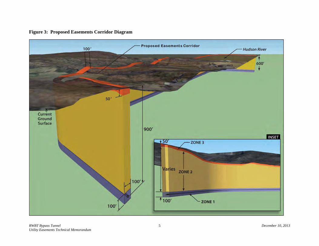
The proposed model Easement – and each proposed utility Easement that comprises the proposed Easements corridor – would extend 50 feet horizontally on either side of the center line of the tunnel, for a total width of 100 feet. Within that 100-foot wide corridor, the easement would consist of three distinct, vertically-defined “zones” between the bypass tunnel and the
RWBT Bypass Tunnel 5 December 10, 2013 Utility Easements Technical Memorandum
Figure 3: Proposed Easements Corridor Diagram

RWBT Bypass Tunnel 6 December 10, 2013 Utility Easements Technical Memorandum
existing ground surface, each with provisions that would restrict certain development activities. The proposed zones within the proposed Easements corridor – from deepest to most shallow relative to the current ground surface – are described below (See Figure 3 and Appendix A).
Zone 1 – the 100-foot zone centered on the bypass tunnel (e.g. 50 feet above and 50 feet below the center of the bypass tunnel). The bypass tunnel will be built at approximately 600 feet below sea level based on DEP’s Bureau of Water Supply datum for the RWBT. Due to topography variations, the depth of the bypass tunnel along its route will vary from approximately 900 feet to 600 feet below the current ground surface, so the actual distance from ground surface to the top of Zone 1 would vary accordingly.
Zone 2 – the zone that encompasses the vertical extent from the top of Zone 1 to 50 feet below current ground surface. The total vertical extent of Zone 2 would vary along the bypass tunnel route depending on the surface elevation at a given tunnel location. The vertical extent of Zone 2 would be from between approximately 850 feet to 550 feet below the current ground surface – depending on the surface elevation at a given location along the bypass tunnel route – to 50 feet below the current ground surface.
Zone 3 – the zone that encompasses the vertical extent of the 50 feet that lies between the top of Zone 2 and the current ground surface.
The proposed utility Easements would not result in any physical change to the current ground surface, subsurface structures or land features. As described below, with the exception of prohibiting future well drilling within each proposed utility Easement, and prohibiting modifications to existing wells (of which only two are known), the proposed utility Easements would not restrict future expansion or modification of existing structures, or development of parcels above or at grade, or to a depth of (or shallower than) 50 feet below current ground surface, provided that such activities do not harm the bypass tunnel. Proposed restrictions and allowable activities that could occur in each zone are described below.
Activities in Zone 1 – Within this deepest zone, the proposed utility Easements would: prohibit owners of the parcels from conducting any activities; provide DEP full rights to construct, operate, inspect, monitor, maintain, and repair the bypass tunnel for conveyance of water as part of the DEP water supply; and make all structures, materials, and facilities installed within the proposed Easements corridor the property of the City.
Activities in Zone 2 – Within Zone 2, the proposed utility Easements would prohibit landowners from well drilling, blasting, mining, and high pressure well improvement activities (e.g. air or water injection) to existing wells.
Activities in Zone 3 – Within this shallowest zone, the proposed utility Easements would prohibit landowners from well drilling, or high pressure well improvement activities (e.g. air or water injection) to existing wells. However, landowners would retain the right to blast, mine, and excavate to a maximum depth of 50 feet below the current ground surface within the proposed Easements corridor, provided that such activities do not harm the tunnel.

RWBT Bypass Tunnel 7 December 10, 2013 Utility Easements Technical Memorandum
The bypass tunnel route will extend beneath a total of 28 properties (see Figure 4). Two of these parcels are DEP properties not subject to easement requirements or approvals, and are therefore excluded from the analysis herein. Utility Easements or approvals are needed on the remaining 26 parcels, and are evaluated in this document since they have portions of land within the bypass tunnel route (Easements corridor).
Twenty-three parcels within the proposed Easements corridor are located west of the Hudson River in the Town of Newburgh (Orange County), one parcel is located in open water (the Hudson River), and two parcels are located east of the Hudson River in the Town of Wappinger (Duchess County). As described further in Section 3.1, land uses in these parcels include residential (most with single family homes, some vacant), utilities (electric transmission and power generation), recreational (a nine-hole golf course with an associated club restaurant), public right-of-way (roads), public service/transportation (railroads), and open water.
Of the 26 parcels within the proposed Easements corridor, ten of the parcels, all located west of the Hudson River, are currently documented to have water supply wells according to the Town of Newburgh Building Department and Orange County Real Property Tax Agency. Many of these wells were constructed in the 1980s and their depths are understood to be shallower than the depth of the planned bypass tunnel (e.g. all are believed to be less than approximately 500 feet below grade). All but two of the ten wells are located outside the proposed Easements corridor.
The two wells within the proposed Easements corridor are located on two parcels (with the same landowner) and are believed to be less than 250 feet deep. As described above, the proposed utility Easements would prohibit future well drilling and modifications to existing wells within the proposed Easements corridor. For the two parcels within the proposed Easements corridor, there would be no restrictions on the continued use of the two wells at their existing depths. However, the proposed utility Easements for these two parcels would allow the City to permanently restrict future well improvements, including, but not limited to; installation of metal plugs preventing future deepening of the wells and caps identifying that the wells may not be deepened or improved. If either well ever fails, the landowner would be required to abandon the well(s) once a new water supply is developed outside the proposed Easements corridor. At the time of conveying the proposed Easements, this landowner would be paid for the full expected cost of developing such new water supplies, even though the existing wells might remain in service for decades.
According to the Dutchess County Real Property Tax Agency, owners of the two parcels within the proposed Easements corridor on the east side of the Hudson River in the Town of Wappinger do not rely on groundwater wells for water supply. Based on the existing use and configuration of these two properties, these parcels are unlikely to be redeveloped in the future. Should such redevelopment be proposed in future, the proposed utility Easements would prohibit future well drilling within the proposed Easements corridor on these two parcels. However, the landowners may have the opportunity to connect to an expansion of the water supply distribution system currently under development by the Town of Wappinger, provided connection pipes remain within 50 feet of current ground surface (Zone 3). Furthermore, the proposed utility Easements would allow these landowners to construct wells within portions of their properties located outside the proposed Easements corridor. See Appendix B for a listing of all parcels that would be affected by the proposed utility Easements and their current sources of potable water.

RWBT Bypass Tunnel 8 December 10, 2013 Utility Easements Technical Memorandum
Figure 4: Properties within the Bypass Tunnel Route

RWBT Bypass Tunnel 9 December 10, 2013 Utility Easements Technical Memorandum
1.3 Project Area Summary
The bypass tunnel will be approximately 13,543-feet long and 22-feet wide. The proposed utility Easements would encompass a 100-foot wide corridor centered on the tunnel, total approximately 27.09 acres, and extend below the surface as described herein. The proposed utility Easements would cover approximately 19.73 acres across 25 land parcels (excluding the two DEP parcels) and approximately 7.36 acres through the single open water property. Twenty- three properties (comprised of 19 developed parcels located outside the rights-of-way of mapped streets1, two vacant parcels, and two rights-of-way) are located west of the Hudson River in the Town of Newburgh in Orange County, and two parcels are located east of the Hudson River in the Town of Wappinger in Dutchess County (see Figure 4). Shafts will be constructed on City-owned land at the connection points at each end of the bypass tunnel. The shaft in the Town of Newburgh will extend to a depth of approximately 900 feet below grade, while the shaft in the Town of Wappinger will extend to a depth of approximately 600 feet below grade.
1.4 Permits and Approvals
DEP is actively obtaining, tracking and maintaining required federal, State, county and town permits and approvals required for construction and operation of the bypass tunnel and Shafts under Project 1, as discussed in EIS 1. In addition to acquiring the proposed utility Easements, DEP will be seeking authorization from the New York State Office of General Services (OGS) and New York State Department of Transportation (NYSDOT) for construction of the bypass tunnel under their respective properties. There are no federal, State, county, or town permits or approvals required for the proposed utility Easements beyond those required as part of the City’s land acquisition process. For some property acquisitions, DEP may alternately require the use of eminent domain (N.Y. Eminent Domain Procedure Law; N.Y. Public Authorities Law §§1266, 1267) related to the subsurface easements needed for the bypass tunnel route.
2.0 STATE ENVIRONMENTAL QUALITY REVIEW ACT AND CITY ENVIRONMENTAL QUALITY REVIEW REQUIREMENTS
Any proposed easement funded by a State agency or directly undertaken by a State or local agency must comply with the provisions of the New York State Environmental Quality Review Act (SEQRA) and its implementing regulations (6 NYCRR 617). As a consequence, the proposed utility Easements are subject to review under SEQRA. In addition, since the proposed utility Easements are being undertaken by a City agency, they are also subject to review under the City Environmental Quality Review (CEQR) requirements, as set forth in Executive Order 91 of 1977 and its amendments.
Review of the proposed utility Easements under SEQRA and CEQR is being undertaken through the completion of this Technical Memorandum and appended documentation to supplement the evaluation included in EIS 1 for the RWBT Shaft and Bypass Tunnel Construction project.
1 Two of these parcels, 8-1-31.12 Central Hudson and 8-1-75-42 Helios Power Capital, cross a road and are labeled on each side
of the road in Figure 4.

RWBT Bypass Tunnel 10 December 10, 2013 Utility Easements Technical Memorandum
3.0 PROPOSED UTILITY EASEMENTS IMPACT ASSESSMENT
This section includes an assessment of potential significant adverse impacts that could result from implementation of the proposed utility Easements on the properties subject to the proposed utility Easements. The assessment in this Technical Memorandum is limited to the following impact categories: land use, zoning, public policy, development potential, coastal zone consistency, and socioeconomic conditions. Assessment of the potential significant adverse impacts resulting from implementation of the proposed utility Easements on the remaining SEQRA and CEQR impact categories (land, natural resources, air, agricultural land resources, aesthetic resources, historic and archaeological resources, open space and recreation, shadows, critical environmental areas, transportation, energy, noise and odor, public health, and growth and character of community or neighborhood) is not required since the proposed utility Easements would not cause any physical changes that would result in any related impacts. This Technical Memorandum also includes an evaluation of alternatives (e.g. DEP’s potential use of eminent domain)2.
An impact of the proposed utility Easements on land use, zoning, public policy, and socioeconomic conditions could potentially result from restrictions on the ability of a landowner to drill a new water supply well, modify an existing well, or excavate deeper than 50 feet below the current ground surface within the proposed utility Easements. The proposed utility Easements would also apply to other types of wells, such as geothermal wells. Geothermal wells consist of heat pump systems where water is circulated between the building and an underground pipe loop within the earth’s crust’s constant temperature, generally located deep below ground (e.g. 300 feet or more). Due to the required depth of geothermal wells, development of geothermal wells would not be permitted within the proposed utility Easements. However, as described in this document, development of both water supply wells and geothermal wells could occur in the portions of parcels outside of the proposed utility Easements. An impact on land use, zoning, public policy, and socioeconomic conditions could also potentially result from the proposed utility Easements’ restrictions on the ability of landowners to mine or blast within certain zones of the proposed utility Easements. This document includes an evaluation of the potential for the above-noted restrictions that would be imposed by the proposed utility Easements to: limit landowners abilities to develop land; and/or limit related real estate-related tax revenues to the Towns of Newburgh and Wappinger compared to what might otherwise be realized.
Of the 28 parcels that that overlap with the proposed bypass tunnel route and would potentially be subject to the proposed utility Easements, two are City (DEP) owned properties and not subject to the proposed utility Easements. Therefore, these two parcels are not included in the analysis herein. The remaining 26 parcels include one parcel beneath the Hudson River, and two public right-of-way parcels in the Town of Newburgh, through which the subject utility Easements are authorized by New York State and the Town of Newburgh and do not require further analysis as noted in the below screening assessments. Therefore, there are 23 parcels with either existing development or the potential to be developed (development parcels) within the
2 N.Y. Eminent Domain Procedure Law; N.Y. Public Authorities Law §§1266, 1267

RWBT Bypass Tunnel 11 December 10, 2013 Utility Easements Technical Memorandum
proposed Easements corridor; 21 are in the Town of Newburgh, and two are in the Town of Wappinger (see Table 1).
According to the Town of Newburgh Building Department and Orange County Real Property Tax Agency, of the 23 parcels located west of the Hudson River, ten are currently documented to have water supply wells, only two of which are within the proposed Easements corridor. As for the two properties on the east side of the Hudson River, according to the Dutchess County Real Property Tax Agency neither of the two parcels in the Town of Wappinger has existing water supply wells (see Table 1 and Appendix B).
Table 1: Overall Distribution of Parcels and Water Supply Wells within the Proposed Easements Corridor
Location
Number of Parcels that Require an
Easement or Approval
Number of Parcels with Documented
Water Supply Wells1
Documented Water Supply Wells with the Proposed Easements
Corridor
Hudson River 1 0 0
Orange County (Town of Newburgh)
23 10 2
Dutchess County (Town of Wappinger)
2 0 0
Total 26 10 2 Notes: 1 Town of Newburgh Building Department and Orange County Real Property Tax Agency records.
As previously noted, the proposed utility Easements would only affect two parcels (with one landowner) that are known to contain existing wells. The proposed utility Easements would not restrict the continued use of these wells at their existing depths. However, if either well fails, the landowner would be required to abandon the well(s) once a new water supply is developed outside the proposed Easements corridor on their parcel. Although the existing wells might remain in service for decades, at the time of conveying the proposed Easements, this landowner would be paid for the expected cost of such new water supplies.
The proposed utility Easements would not restrict any landowner from drilling new water supply or other types of wells within portions of their parcels outside of the 100-foot wide proposed Easements corridor. Furthermore, as previously noted, where parcels are located in the Town of Wappinger, there could be a potential to be connected to the Town water supply distribution systems, if required, provided connection pipes remain within 50 feet of current ground surface (Zone 3).
3.1 Land Use, Zoning and Public Policy
Sections 3.1.1 through 3.1.3 present the land use, zoning and public policy assessment, respectively, of the properties potentially affected by the proposed utility Easements. Sections 3.1.4 and 3.1.5 present an analysis of the development potential and coastal zone consistency

RWBT Bypass Tunnel 12 December 10, 2013 Utility Easements Technical Memorandum
assessment of the properties. Each section presents an explanation of specific parcels that were screened from further analysis, followed by an assessment of the remaining parcels.
3.1.1 Land Use
The proposed Easements corridor would not displace any known existing land uses or alter known development trends. A variety of land uses exist on the 26 parcels within the proposed Easements corridor including: residential uses on seven parcels; vacant land uses on two parcels; utility/transmission uses on four parcels, public utility land use on one parcel; utility/power generation uses (currently an unused power generation site use) on five parcels; transportation uses (railroads) on two parcels; recreational uses on two parcels; public right-of-way on two parcels (Route 9W and Danskammer Road), and; one parcel of open water (the Hudson River) (see Table 2).
Parcels with residential uses are generally located along the western end of the proposed Easements corridor along Route 9W and Old Post Road in the Town of Newburgh. Two parcels with vacant uses are located along the westernmost end of the proposed Easements corridor. Public utility uses within the proposed Easements corridor include: power generation uses comprised of a closed power generation facility (currently an unused power generation site use, as noted above) owned by Helios Power Capital located on five parcels between Old Post Road and the Hudson River; properties and built structures associated with a transmission line maintained by Central Hudson Gas and Electric (CHG&E), which extends from the western portion of the proposed Easements corridor east towards the Hudson River; and a public utility parcel owned by the Power Authority of the State of New York (PAS NY) and located on the eastern portion of the proposed Easements corridor in the Town of Wappinger. Other utilities within the proposed Easements corridor include railroad lines located along both banks of the Hudson River. Namely, CSX maintains a freight rail line on the west bank of the Hudson River, while Midtown Trackage Ventures owns a passenger and freight rail line on the east bank which is under long-term lease to the Metropolitan Transportation Authority (MTA).
As described in Section 1.2, “Project Description”, the proposed utility Easements would enable the construction, operation and maintenance of the bypass tunnel, and would introduce certain measures designed to protect the bypass tunnel from any potential damage due to landowners’ development activities (e.g. drilling or blasting) at or below the ground surface. As described below in Section 3.1.2, “Zoning”, the proposed utility Easement’s restrictions on certain activities would not inhibit any development allowed under existing zoning regulations on any parcel within the proposed Easements corridor in either the Town of Newburgh or the Town of Wappinger.

RWBT Bypass Tunnel 13 December 10, 2013 Utility Easements Technical Memorandum
Table 2: Existing Land Use within the Proposed Easements Corridor
Tax Map ID Landowner(s) Town/County Land Use Classification1,2
NY State Land Use
Classification3 Town, County
8-1-22.2 Bell, William E. & Robert Jr. &
Pelella, Charles A. Vacant Land Vacant Land
Town of Newburgh,
Orange County
8-1-18.1 Smith, Robert J. Vacant Land Vacant Land
8-1-21.12 Sternitzke, Joan M. and Joyce Residential Residential
8-1-21.22 Sternitzke, Joan M. and Joyce Residential Residential
N/A (Route 9W) New York State Department of
Transportation Public Right-of-Way -
8-1-31.32 Mill Creek Golf Corporation Recreation/Golf
Course Entertainment and Recreation
8-1-31.12 Central Hudson Gas and Electric Utility/Transmission Public Service
8-1-95.1 Mill Creek Golf Corporation Recreation/Golf
Course Entertainment and Recreation
8-1-90 Hussain, Zahid and Zahid,
Amina Residential Residential
8-1-89 Hitzel, Paul S. Residential Residential
8-1-40.22 Quinones, Augustine and Maria Residential Residential
8-1-40.23 Townes, Michael J. and Jessica
A. Residential Residential
8-1-65 Wood-Hellmuth, Jeanna &
Hellmuth, Walter Residential Residential
8-1-66.1 Helios Power Capital Utility/Power Generation
Public Service
8-1-79 Central Hudson Gas and Electric Utility/Transmission Public Service
8-1-67.1 Central Hudson Gas and Electric Utility/Transmission Public Service
8-1-69 Central Hudson Gas and Electric Utility/Transmission Public Service
8-1-75.42 Helios Power Capital Utility/Power Generation
Public Service
N/A (Danskammer Rd) Town of Newburgh Public Right-of-way -
8-1-75.3 Helios Power Capital Utility/Power Generation
Public Service
8-1-76 Helios Power Capital Utility/Power Generation
Public Service
8-1-77 CSX Corp. Public
Service/Transportation Public Service
8-1-78.2 Helios Power Capital Utility/ Power
Generation Public Service
N/A (Hudson River) New York State Office of
General Services Open Water - New York State
6056-01-032728-0000 Midtown Trackage
Ventures/MTA Public
Service/Transportation Public Service Town of
Wappinger, Dutchess County
6057-03-355051-0000 New York State Power Authority Public Utility Public Service
Notes: 1 Dutchess County Department of Real Property Tax Service Agency 2 Orange County Department of Real Property Tax Service Agency 3 http://www.tax.ny.gov/research/property/assess/manuals/vol6/ref/prclas.htm

RWBT Bypass Tunnel 14 December 10, 2013 Utility Easements Technical Memorandum
Based on correspondence with the Town of Newburgh (see Appendix C), there are no known proposals for redevelopment actions that have been submitted to the Town of Newburgh for any of the parcels that are within the proposed Easements corridor. As previously noted, the proposed utility Easements would restrict the ability of a landowner to develop a new or modified water supply well or other type of well (e.g. geothermal) within the proposed Easements corridor. The parcels with existing uses that include rights-of-way, open water, transportation, and utility transmission lines, do not currently include a local water supply component and are not anticipated to require local water supply in future. Additionally, new or expanded wells could be developed by landowners within portions of their properties located outside the proposed Easements corridor. Furthermore, there is a low likelihood of these parcels undergoing a change in land use designation, as they are anticipated to maintain their current uses in serving the public. Therefore, the restriction of the proposed utility Easements that prohibits the installation of new wells or modification of existing wells within the proposed Easements corridor is not anticipated to affect the parcels with these land use designations due to their current and reasonably anticipated land uses.
In addition to water supply well development restrictions, the proposed utility Easements would restrict blasting within Zone 1 and Zone 2, as described in Section 1.2, “Project Description”. Similar to the proposed utility Easement’s water supply well development restrictions, the proposed utility Easements’ restrictions on blasting are not anticipated to affect a number of parcels due to their current and reasonably projected land uses. The potential for blasting is generally associated with work in bedrock. Depths to bedrock range from exposure at grade to depths approximately equal to or greater than seven feet below the current ground surface along the full length of the proposed Easements corridor. However, the need for blasting to accommodate construction within the proposed Easements corridor would typically be within the proposed utility Easement zone that allows blasting (Zone 3). Additionally, if bedrock exists within Zone 3, structures would likely be built directly on bedrock.
The parcels with rights-of-way are not anticipated to require construction that would entail blasting. The proposed utility Easements’ blasting restrictions are not anticipated to affect the expansion of existing structures or the construction of new structures on the remaining parcels within the aforementioned land use designations. As a result, ten parcels with utility/transmission uses (power transmission lines), transportation uses (railroads), public right-of-way (roads), and public electric utility, were screened from further analysis (see Table 3).

RWBT Bypass Tunnel 15 December 10, 2013 Utility Easements Technical Memorandum
Table 3: Parcels Screened out of Further Land Use Analysis
Tax Map ID Landowner(s) Land Use3,4 Town, County N/A (Route 9W) NYSDOT Right-of-Way
Town of Newburgh, Orange County
8-1-31.12 Central Hudson Gas and
Electric Utility/Transmission
8-1-79 Central Hudson Gas and
Electric Utility/Transmission
8-1-67.1 Central Hudson Gas and
Electric Utility/Transmission
8-1-69 Central Hudson Gas and
Electric Utility/Transmission
N/A (Danskammer Rd) Town of Newburgh Right-of-Way
8-1-77 CSX Corp. Public
Service/Transportation
N/A (Hudson River) New York State Office of
General Services (NYSOGS) Open Water New York State
6056-01-032728-0001 Midtown Trackage
Ventures/MTA Public
Service/Transportation Town of Wappinger,
Dutchess County 6057-03-355051-0000 Power Authority of the State of
New York (NYPA) Public Utility
Fourteen of the remaining 16 parcels selected for further analysis (Table 4) are developed and include residential uses, utility uses (power generation), or recreational uses. The remaining two parcels are vacant.
The proposed utility Easements would not displace any existing land uses, nor disrupt ongoing development trends of these parcels, as the proposed utility Easements would not restrict the development of any potential future surface land uses on these sites, such as the construction of new buildings or expansion of existing structures. While blasting is not anticipated should such expansions occur, the need for blasting to accommodate construction within the proposed Easements corridor would typically be within the proposed utility Easement zone that allows blasting (e.g. Zone 3). Additionally, if bedrock exists shallower than 50 feet below the current ground surface, structures would likely be built directly on bedrock.
The ability of a landowner to expand an existing water supply well or develop a new water supply well on these parcels would be restricted only within the proposed Easements corridor. As shown in Table 4, new or modified water supply wells in 11 of the 14 parcels (Helios Power Capital parcels 8-1-75.42, 8-1-75.3 and 8-1-76 are contiguous and transferred as a single parcel under the deed, and are therefore analyzed as a single parcel) would be prohibited in a relatively small percentage of the overall parcel (ranging from 0.3% to 9.5%). New or modified water supply wells would be prohibited within approximately 35.1%, 39.7%, and 67.7% of the total area of each of the remaining three of the 14 parcels, respectively.
In addition to restrictions on blasting and well development within the proposed Easements corridor, there would be a restriction on mining. There are currently no mining operations within
3 http://geoaccess.co.dutchess.ny.us/parcelaccess/parcelaccess_map.htm 4 Orange County Department of Real Property Tax Service Agency

RWBT Bypass Tunnel 16 December 10, 2013 Utility Easements Technical Memorandum
the 16 parcels selected for further land use analysis. The parcels owned by CHG&E for power transmission lines and the parcels owned by Helios Power Capital within the Town of Newburgh Industrial (I) Zoning District are the only parcels where subsurface land uses, such as a quarry, are currently permitted (subject to Planning Board approval). In addition to the above-noted reasons for screening out the CHG&E properties from further land use analyses, although mining uses are permitted, future mining activities are not anticipated within these parcels, as it is not currently anticipated that the current site use will change to include mining or quarry operations (see Section 3.2.6). Similarly, it is not currently anticipated that use of the parcels owned by Helios Power Capital, currently the site of a closed power generation facility, will change to include mining or quarry operations (see Section 3.2.6).
Consequently, the proposed utility Easements would not result in a significant adverse impacts on land use for any parcels within the proposed Easements corridor.
Table 4: Parcels Selected for Further Land Use Analysis
Tax Map ID Landowner(s)
% of Parcel within the Proposed
Easements corridor Land Use5,6 Town, County
8-1-22.2 Bell , William E. & Robert Jr. &
Pelella, Charles A. 0.3% Vacant Land
Town of Newburgh,
Orange County
8-1-18.1 Smith, Robert J. 6.0% Vacant Land
8-1-21.12 Sternitzke, Joan M. and Joyce 39.7% Residential
8-1-21.22 Sternitzke, Joan M. and Joyce 9.5% Residential
8-1-31.32 Mill Creek Golf Corporation 6.7% Recreation/Golf
Course
8-1-95.1 Mill Creek Golf Corporation 2.9% Recreation/Golf
Course 8-1-90 Hussain, Zahid and Zahid, Amina 35.1% Residential
8-1-89 Hitzel, Paul S. 67.7% Residential
8-1-40.22 Quinones, Augustine and Maria 1.9% Residential
8-1-40.23 Townes, Michael J. and Jessica A. 1.9% Residential
8-1-65 Wood-Hellmuth, Jeanna and
Hellmuth, Walter 1.4% Residential
8-1-66.1 Helios Power Capital 0.5% Utility/Power
Generation
8-1-75.42 Helios Power Capital
9.5%
Utility/Power Generation
8-1-75.3 Helios Power Capital Utility/Power
Generation
8-1-76 Helios Power Capital Utility/Power
Generation
8-1-78.2-1 Helios Power Capital 3.1% Utility/Power
Generation
5 http://geoaccess.co.dutchess.ny.us/parcelaccess/parcelaccess_map.htm 6 Orange County Department of Real Property Tax Service Agency

RWBT Bypass Tunnel 17 December 10, 2013 Utility Easements Technical Memorandum
3.1.2 Zoning
Both the Town of Newburgh and the Town of Wappinger have adopted zoning regulations that have been incorporated as part of their municipal codes. Chapter 185-Zoning of the Town of Newburgh Town Code was adopted by the Town of Newburgh Town Board with Local Law No. 4 on December 16, 1991. Chapter 240–Zoning of the Town of Wappinger Town Code was last adopted by the Town of Wappinger Town Board with Local Law No. 6 on November 25, 1996. The proposed utility Easements would not conflict with either of these zoning regulations, or require any change to any existing zoning classification or zoning regulation in either jurisdiction.
Existing zoning districts include residential, business and industrial districts. Table 5 summarizes the Tax Map Identification Number (ID) and Zoning District for each parcel within the proposed Easements corridor.
Table 5: Existing Zoning Districts within the Proposed Easements Corridor
Tax Map ID Landowner(s) Zoning District Town, County
8-1-22.2 Bell , William E. & Robert Jr. & Pelella, Charles A. AR
Town of Newburgh,
Orange County
8-1-18.1 Smith, Robert J. B
8-1-21.12 Sternitzke, Joan M. and Joyce B/AR
8-1-21.22 Sternitzke, Joan M. and Joyce AR
N/A (Route 9W) NYSDOT N/A
8-1-31.32 Mill Creek Golf Corporation B
8-1-31.12 Central Hudson Gas and Electric AR/B
8-1-95.1 Mill Creek Golf Corporation B
8-1-90 Hussain, Zahid and Zahid, Amina AR
8-1-89 Hitzel, Paul S. AR
8-1-40.22 Quinones, Augustine and Maria AR
8-1-40.23 Townes, Michael J. and Jessica A. AR
8-1-65 Wood-Hellmuth, Jeanna and Hellmuth, Walter AR
8-1-66.1 Helios Power Capital AR/I
8-1-79 Central Hudson Gas and Electric AR
8-1-67.1 Central Hudson Gas and Electric I/AR
8-1-69 Central Hudson Gas and Electric I
8-1-75.42 Helios Power Capital I
N/A (Danskammer Rd) Town of Newburgh N/A
8-1-75.3 Helios Power Capital I
8-1-76 Helios Power Capital I
8-1-77 CSX Corp. I
8-1-78.2-1 Helios Power Capital I
N/A (Hudson River) New York State Office of General Services N/A N/A (New York
State)
RWBT Bypass Tunnel 18 December 10, 2013 Utility Easements Technical Memorandum
Tax Map ID Landowner(s) Zoning District Town, County
6056-01-032728-0000 Midtown Trackage Ventures/MTA R80 Town of Wappinger,
Dutchess County 6057-03-355051-0000 Power Authority of the State of New York R80
Notes: Town of Newburgh AR= Agricultural, Minimum lot area 40,000 sf Town of Newburgh B= business, Minimum lot area 15,000 sf Town of Newburgh I= Industrial, Minimum lot area 87,120 sf Town of Wappinger R= residential, R80= Minimum lot area 80,000 sf
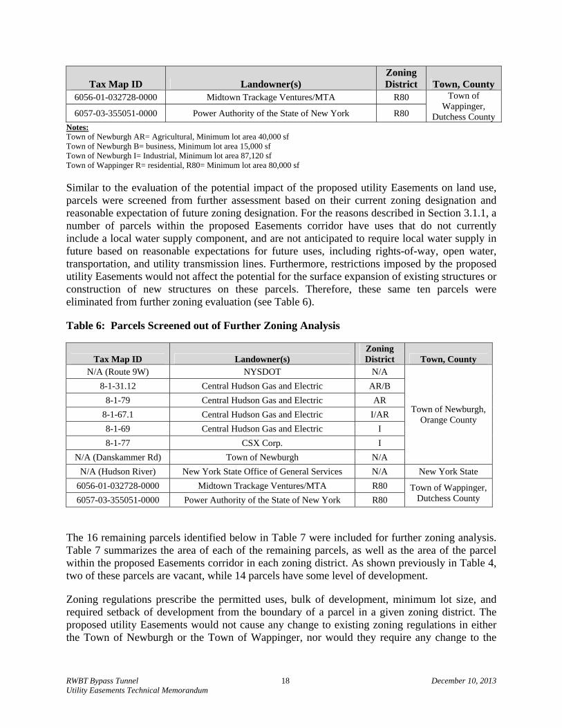
Similar to the evaluation of the potential impact of the proposed utility Easements on land use, parcels were screened from further assessment based on their current zoning designation and reasonable expectation of future zoning designation. For the reasons described in Section 3.1.1, a number of parcels within the proposed Easements corridor have uses that do not currently include a local water supply component, and are not anticipated to require local water supply in future based on reasonable expectations for future uses, including rights-of-way, open water, transportation, and utility transmission lines. Furthermore, restrictions imposed by the proposed utility Easements would not affect the potential for the surface expansion of existing structures or construction of new structures on these parcels. Therefore, these same ten parcels were eliminated from further zoning evaluation (see Table 6).
Table 6: Parcels Screened out of Further Zoning Analysis
Tax Map ID Landowner(s) Zoning District Town, County
N/A (Route 9W) NYSDOT N/A
Town of Newburgh, Orange County
8-1-31.12 Central Hudson Gas and Electric AR/B
8-1-79 Central Hudson Gas and Electric AR
8-1-67.1 Central Hudson Gas and Electric I/AR
8-1-69 Central Hudson Gas and Electric I
8-1-77 CSX Corp. I
N/A (Danskammer Rd) Town of Newburgh N/A
N/A (Hudson River) New York State Office of General Services N/A New York State
6056-01-032728-0000 Midtown Trackage Ventures/MTA R80 Town of Wappinger, Dutchess County 6057-03-355051-0000 Power Authority of the State of New York R80
The 16 remaining parcels identified below in Table 7 were included for further zoning analysis. Table 7 summarizes the area of each of the remaining parcels, as well as the area of the parcel within the proposed Easements corridor in each zoning district. As shown previously in Table 4, two of these parcels are vacant, while 14 parcels have some level of development.
Zoning regulations prescribe the permitted uses, bulk of development, minimum lot size, and required setback of development from the boundary of a parcel in a given zoning district. The proposed utility Easements would not cause any change to existing zoning regulations in either the Town of Newburgh or the Town of Wappinger, nor would they require any change to the

RWBT Bypass Tunnel 19 December 10, 2013 Utility Easements Technical Memorandum
existing zoning designation of any development parcel in either town, or restrict any potential future change in zoning designations.
Table 7: Parcels Selected for Further Zoning Analysis
Tax Map ID Landowner(s)
Total Estimated
Parcel Size (sf)7
Existing Estimated Zoning District Area within the Proposed Easements Corridor % of
Parcel within the Proposed
Easements Corridor
AR (sf)
B (sf)
I
(sf)
Total Area of Parcel within the
Proposed Easements
Corridor (sf)8 8-1-22.2 Bell & Pelella 1,344,790 4,607 4,607 0.3%
8-1-18.1 Smith 71,697 4,337 4,337 6.0%
8-1-21.12 Sternitzke 100,255 31,108 8,701 39,809 39.7%
8-1-21.22 Sternitzke 278,107 26,368 26,368 9.5%
8-1-31.32 Mill Creek Golf 666,667 44,629 44,629 6.7%
8-1-95.1 Mill Creek Golf 879,654 25,095 25,095 2.9%
8-1-90 Hussain & Zahid 66,127 23,224 23,224 35.1%
8-1-89 Hitzel 40,154 27,165 27,165 67.7%
8-1-40.22 Quinones 40,834 789 789 1.9%
8-1-40.23 Townes 55,589 1,038 1,038 1.9%
8-1-65 Wood-Hellmuth 32,720 456 456 1.4%
8-1-66.1 Helios Power Capital 884,799 4,656 4,656 0.5%
8-1-75.42 Helios Power Capital
2,277,7989 217,202 217,202 9.5% 8-1-75.3 Helios Power Capital
8-1-76 Helios Power Capital
8-1-78.2 Helios Power Capital 2,265,092 69,821 69,821 3.1% Notes: All properties are within the Town of Newburgh, Orange County Town of Newburgh AR (Agriculture) Zoning District Town of Newburgh B (Business) Zoning District Town of Newburgh I (Industrial) Zoning District
7 Estimated based on tax lot and zoning GIS data. 8 DEP BWS Subsurface Easement Surveys. 9 DEP BWS Subsurface Easement Surveys combine 6 parcels, known as Danskammer Parcel 1B. These parcels are the three
individual parcels that are part of Parcel 1B and within the proposed Easements corridor, and are treated as one overall parcel.

RWBT Bypass Tunnel 20 December 10, 2013 Utility Easements Technical Memorandum
As noted above, the ability of a landowner to expand or modify an existing water supply well (of which only two are documented within the proposed Easements corridor), or develop a new water supply well would be restricted only within the proposed Easement corridor. As shown in Table 4 and Table 7, new or modified water supply wells would be prohibited in only a small percentage of the total parcel size (9.5% or less) for 11 of the 14 parcels (as noted above, Helios Power Capital Parcels 8-1-75.42, 8-1-75.3 and 8-1-76 are analyzed as one overall parcel). New or expanded water supply wells would be prohibited within approximately 35.1%, 39.7%, and 67.7% of the total area of each of the remaining three of the 14 parcels, respectively.
Since the proposed utility Easements would not affect existing zoning regulations, including potential future zoning designation changes, restrictions of the proposed utility Easements would not have a significant adverse impact on the allowable development potential of any parcel within the proposed Easements corridor (see Section 3.1.4, “Development Potential” for further analysis).
As noted in Section 3.1.1, the proposed utility Easements would not restrict landowners’ development of any potential future surface land uses on these sites, such as the construction of new buildings or expansion of existing structures. Blasting is not anticipated should such expansions occur. However, as noted above, the need for blasting to accommodate construction by landowners within the proposed Easements corridor would typically be within the proposed utility Easement zone that allows blasting (Zone 3). Additionally, if bedrock exists shallower than 50 feet below the ground surface, structures would likely be built directly on bedrock.
The proposed utility Easements would impose restrictions on mining (e.g. no mining would be permitting within Zone 2 and Zone 3). As described in Section 3.1.1, there are currently no mining operations within the 16 parcels noted above. The parcels within the Town of Newburgh Industrial (I) Zoning District owned by CHG&E for power transmission lines and the parcels owned by Helios Power Capital are the only parcels where subsurface land uses, such as a quarry, are currently permitted (subject to Planning Board approval). In addition to the above-noted reasons for screening out the CHG&E properties from further zoning analyses, although mining uses are permitted, future mining activities are not anticipated within these parcels, as it is not currently anticipated that the current site use will change to include mining or quarry operations (see Section 3.2.6). Similarly, it is not currently anticipated that the use of the parcels owned by Helios Power Capital, currently the site of a closed power generation facility, will change to include mining or quarry operations (see Section 3.2.6).
In summary, the proposed utility Easements would not result in changes to existing or potential future zoning designations or zoning regulations, would not conflict with the type of development permissible under existing zoning regulations (based on reasonable expectations of future use), or affect the maximum level of development allowed on any development parcel. Furthermore, the proposed utility Easements would not significantly affect the ability of landowners to install new water supply wells or improve existing wells, or construct or expand structures. Therefore, the proposed utility Easements would not result in a significant adverse impact on zoning within the proposed Easements corridor.
RWBT Bypass Tunnel 21 December 10, 2013 Utility Easements Technical Memorandum
3.1.3 Public Policy
The Town of Newburgh Comprehensive Plan was adopted in October 2005 (2005 Newburgh Comprehensive Plan).10 The 2005 Newburgh Comprehensive Plan does not refer to or make recommendations for the specific parcels in the Town of Newburgh that would be affected by the proposed utility Easements, but broadly addresses recommendations related to the Town as a whole, as well as certain portions of the Town of Newburgh. Recommendations discussed in the 2005 Newburgh Comprehensive Plan are generally related to community character and livability within the community rather than to recommendations related to construction of individual projects. The proposed utility Easements would not conflict with the 2005 Newburgh Comprehensive Plan.
The Orange County Comprehensive Plan Update was adopted in 2010 (2010 Orange County Comprehensive Plan).11 The proposed Easements corridor is located within one of Orange County’s priority growth areas as identified in the 2010 Orange County Comprehensive Plan. The proposed utility Easements do not conflict with the 2010 Orange County Comprehensive Plan’s Overall Goals, Strategies, Priorities or Actions. The proposed utility Easements would not preclude future development; it would restrict well drilling, blasting, mining, and high pressure well improvement activities (e.g. air, water) of existing water supply wells within the 100-foot wide easement to various depths (see Section 1.1). As noted in Section 3.1.2 “Zoning,” this restriction on subsurface activities would not conflict with the type of development permissible under existing zoning regulations.
The Town of Wappinger Comprehensive Plan was adopted on September 27, 2010 (2010 Wappinger Comprehensive Plan). The 2010 Wappinger Comprehensive Plan identifies “Issues and Opportunities” as well as “Goals and Objectives” with town-wide applicability, under the following categories: environmental resources, population and housing, economic base, community appearance and character, transportation, water supply and sewage treatment, and land use. The proposed utility Easements would not conflict with the identified “Issues and Opportunities” and “Goals and Objectives.”12
Dutchess County has not adopted a formal Comprehensive Plan, although there is an adopted greenway plan, the 2000 Dutchess County Greenway Connections. The proposed utility Easements do not conflict with the principals and policies in included in the 2000 Dutchess County Greenway Connections document.
Therefore, the proposed utility Easements would not cause a significant adverse impact on existing plans and policies.
10 “Comprehensive Plan Update - Town of Newburgh, New York.” Town of Newburgh, October 2005. 11 “Orange County Comprehensive Plan 2010 Update.” Orange County Department of Planning, 2010. 12 "Comprehensive Plan for the Town of Wappinger, New York." Town of Wappinger, New York, 27 Sept. 2010.
Apr. 2013.

RWBT Bypass Tunnel 22 December 10, 2013 Utility Easements Technical Memorandum
3.1.4 Development Potential
Development potential is based on an assessment of several areas, including: development that would be allowed under existing zoning, the estimated buildable envelope (including the maximum potential building coverage that could occur), the extent of existing buildings on each parcel, and existing use (e.g. vacant versus developed). For parcels with Industrial (I) zoning, development potential could also be influenced by the estimated envelope for any potential mining activities within each parcel (mining envelope). Other considerations in a development potential analysis include parcel ownership status (e.g. for sale or recently purchased), and known planned developments of each parcel. As noted earlier, based on correspondence with the Town of Newburgh (see Appendix C), there are no known proposals for redevelopment actions that have been submitted to the Town of Newburgh for any of the parcels that are within the proposed Easements corridor.
As described in Sections 3.1.1 – “Land Use”, and 3.1.2 – “Zoning”, ten parcels within the proposed Easement corridor have been screened from further analysis. These parcels have some existing level of development associated with utility uses (power transmission lines), transportation uses (railroads), public rights-of way (roads), and public electric utility, which are not anticipated to require further development based on the current land uses. Furthermore, there is a low likelihood of these parcels undergoing a change in land use designation as they are anticipated to maintain their current uses in serving the public.
Therefore, the sections below examine the potential impact of the proposed utility Easements on the level of development that would be allowed under existing zoning on the remaining 14 development parcels (Helios Power Capital parcels 8-1-75.42, 8-1-75.3 and 8-1-76 are analyzed together). Each of the 14 parcels selected for further analysis is summarized in Table 8 and includes the total estimated parcel size, the area of the parcel within the proposed Easements corridor, the minimum lot size allowed for development under existing zoning, and an assessment of development potential. All of the 14 parcels are located in the Town of Newburgh.
Based on the Town of Newburgh Zoning Resolution Use and Bulk Requirements, residential parcels with single family dwellings are not permitted to exceed one dwelling unit per lot. The development potential noted in Table 8 is based on existing zoning districts and regulations and subject to Planning Board approval. Additional development potential may be allowed if a variance, land use change or other action beyond Planning Board approval were to occur. However, this analysis does not project all potential variances, land use changes, or other actions that could hypothetically occur for any given parcel.
Finally, a Freedom of Information Request was submitted to the Town of Newburgh by DEP on December 3, 2012 (see Appendix C) on any planned development related to the parcels in the Town of Newburgh within the project area. Based on the Town of Newburgh’s response, received on February 28, 2013, no planned development is currently proposed on any of the parcels that would be affected by the proposed utility Easements.

RWBT Bypass Tunnel 23 December 10, 2013 Utility Easements Technical Memorandum
Table 8: Parcels for Development Potential Analysis
Tax Map ID Landowner(s)
Total Estimated Parcel Size
(sf)13
Total Area of Parcel Within the Proposed
Easements Corridor (sf)14
Minimum Lot Size per Existing
Zoning (sf) Development Potential15
8-1-22.2 Bell & Pelella 1,344,790 4,607 40,000
Vacant parcel may not be subdividable; current zoning would require a variance. Potential issues include availability of access, potential road grade (existing grade of potential access is 30%, with maximum allowable grade for a private road of 15%), and required lot width.
8-1-18.1 Smith 71,697 4,337 15,000 (varies) Vacant parcel may not be subdividable, based on lot width requirements. Current zoning would require a variance.
8-1-21.12 Sternitzke 100,255 39,809 40,000 Residential parcel developed. Parcel may not be subdivided, based on lot width requirements. Current zoning would require a variance. Building may be expanded.
8-1-21.22 Sternitzke 278,107 26,368 40,000 Residential parcel developed. Parcel may be subdividable, based on availability of access. Current zoning would require a variance. Building may be expanded.
8-1-31.32 Mill Creek Golf 666,667 44,629 25,000 Recreation parcel developed. Parcel may not be subdividable, based on potential impacts to watercourse and floodplain. Current zoning would require a variance. Building may be expanded.
8-1-95.1 Mill Creek Golf 879,654 25,095 25,000 Recreation parcel developed. Parcel may be subdividable, based on availability of access and potential impacts to watercourse and floodplain. Current zoning would require a variance.
8-1-90 Hussain & Zahid 66,127 23,224 40,000 Residential parcel developed. Parcel may not be subdividable based on required lot size. Current zoning would require a variance. Building may be expanded.
8-1-89 Hitzel 40,154 27,165 40,000 Residential parcel developed. Parcel may not be subdividable based on required lot size. Current zoning would require a variance. Building may be expanded.
8-1-40.22 Quinones 40,834 788.67 40,000 Residential parcel developed. Parcel may not be subdividable based on required lot size. Current zoning would require a variance. Building may be expanded.
8-1-40.23 Townes 55,589 1038.14 40,000 Residential parcel developed. Parcel may not be subdividable based on required lot size. Current zoning would require a variance. Building may be expanded.
8-1-65 Wood-Hellmuth 32,720 455.82 40,000 Residential parcel developed. Parcel may not be subdividable based on required lot size. Current zoning would require a variance. Building may be expanded.
8-1-66.1 Helios Power Capital 884,799 4,656
81,120 (2 Acres)
Industrial parcels are developed. Parcels may be subdividable, subject to Planning Board approval. Current zoning would require a variance. See Table 13 below for additional information.
8-1-75.42 Helios Power Capital 2,277,798 217,202 8-1-75.3 Helios Power Capital
8-1-76 Helios Power Capital 8-1-78.2-1 Helios Power Capital 2,265,092 69,821
Notes: Town of Newburgh AR= Agricultural, Minimum lot area 40,000 sf Town of Newburgh B= Business, Minimum lot area 15,000 sf Town of Newburgh I= Industrial, Minimum lot area 87,120 sf (2 acres)
13 Estimated based on tax lot and zoning GIS data. 14 DEP BWS Subsurface Easement Surveys 15 Any potential development is subject to Planning Board approval; any potential development noted is based on current zoning districts and regulations.

RWBT Bypass Tunnel 24 December 10, 2013 Utility Easements Technical Memorandum
3.1.4.1 Buildable Envelope
As described under Section 3.1.2 – “Zoning”, zoning regulations prescribe the permitted uses, bulk of development, minimum lot size, and required setback of development from the boundary of a parcel in a given zoning district. Building setback lines are defined as a line indicating the minimum horizontal distance permitted between the outside line of a structure or building, or any projection thereof, in excess of three feet from the foundation and the lot line or street line. Building setback requirements limit the amount of land available for development on a given parcel. The net amount of land available for development after consideration of required setbacks is termed the “buildable envelope” of a given parcel. The Town of Newburgh defines buildable envelope as the two-dimensional space within a structure that is permitted to be built on a lot, defined by minimum yard setbacks in addition to lot building coverage (lot building coverage is discussed further below).
Table 9 summarizes the total buildable envelope and the portion of the buildable envelope within the proposed Easements corridor for each of the 14 development parcels evaluated. As indicated in Table 9, the proposed utility Easements would have no impact on the allowable buildable envelope for five of the parcels, as no portion of the buildable envelope is located within the proposed Easements corridor for these five parcels. Therefore, these parcels were screened from further development potential analysis. For the remaining parcels, only a portion of the buildable envelope (ranging from 0.03% to 13.8% on six parcels, and 45.6%, 51.6%, and 78.7% on the remaining three parcels) would be within the proposed Easements corridor. However the proposed utility Easements would not reduce the allowable buildable envelope. The potential effects of the proposed utility Easements on lot building coverage directly related to the buildable envelope of a parcel were also evaluated for the 14 parcels included in the development potential analysis. Lot building coverage is the percentage of the area of a lot covered by a building (or buildings). Table 10 summarizes the maximum potential building coverage of parcels within the proposed Easements corridor based on footprints of existing structures and their potential for expansion within the buildable envelope. Five parcels were not evaluated since the proposed Easements corridor is not located within the buildable envelope of those properties, and would therefore have no effect on the building expansion potential of the parcel.
Of the seven parcels that have existing buildings (see Table 10), only four parcels (see Table 11) have buildings located within the proposed Easements corridor. As previously discussed, the proposed utility Easements would not limit the surface expansion of existing structures within the proposed Easements corridor (including the construction of structures such as garages and sheds allowed by zoning designations), or the ability of owners to expand building footprints within the proposed Easements corridor. On those parcels where a residential structure currently exists, development of a second residential structure is not permitted by zoning without a variance; new construction that would be permissible within the proposed utility Easements would conform to this zoning requirement. Therefore, the proposed utility Easements would have no significant adverse impacts on development potential for these parcels.

RWBT Bypass Tunnel 25 December 10, 2013 Utility Easements Technical Memorandum
Table 9: Existing Estimated Buildable Envelope of the Parcels within the Proposed Easements Corridor
Tax Map ID Landowner(s)
Total Estimated Parcel Size
(sf)16
Total Area of Parcel Within the Proposed Easements Corridor
(sf)17
Total Existing Buildable
Envelope (sf)14
Buildable Envelope within the Proposed Easements Corridor
(sf)18
% of Total Buildable
Envelope within the Proposed
Easements Corridor
8-1-22.2 Bell & Pelella 1,344,790 4,607 1,063,577 308 0.03%
8-1-18.1 Smith 71,697 4,337 47,247 1,484 3.1%
8-1-21.12 Sternitzke 100,255 39,809 49,726 25,635 51.6%
8-1-21.22 Sternitzke 278,107 26,368 180,533 16,117 8.9%
8-1-31.32 Mill Creek Golf 666,667 44,629 585,439 38,628 6.6%
8-1-95.1 Mill Creek Golf 879,654 25,095 730,749 11,035 1.5%
8-1-90 Hussain & Zahid 66,127 23,224 24,698 11,262 45.6%
8-1-89 Hitzel 40,154 27,165 11,437 8,999 78.7%
8-1-40.22 Quinones 40,834 788 11,519 0 0%
8-1-40.23 Townes 55,589 1,038 18,218 0 0%
8-1-65 Wood-Hellmuth 32,720 455 7,800 0 0%
8-1-66.1 Helios Power Capital 884,799 4,656 0 0 0%
8-1-75.42 Helios Power Capital
2,277,798 217,202 886,367 122,702 13.8% 8-1-75.3 Helios Power Capital
8-1-76 Helios Power Capital
8-1-78.2-1 Helios Power Capital 2,265,092 69,821 39,942 0 0%
16 Estimated based on tax lot and zoning GIS data. 17 DEP BWS Subsurface Easement Surveys 18 Based on current land use and zoning district.

RWBT Bypass Tunnel 26 December 10, 2013 Utility Easements Technical Memorandum
Table 10: Maximum Potential Building Coverage of Parcels within the Proposed Easements Corridor
Tax Map ID Landowner(s)
Total Estimated Parcel Size
(sf)19
Total Area of Parcel Within the Proposed
Easements Corridor (sf)20 Total Building Footprint (sf)17
Maximum Allowable Building
Coverage21
Actual Building
Coverage (%)22 8-1-22.2 Bell & Pelella 1,344,790 4,607 512 10% 0.04% 8-1-18.1 Smith 71,697 4,337 0 Varies 0
8-1-21.12 Sternitzke 100,255 39,809 1,332 10% 1.3% 8-1-21.22 Sternitzke 278,107 26,368 3,312 10% 1.2% 8-1-31.32 Mill Creek Golf 666,667 44,629 5,330 25% 0.8% 8-1-95.1 Mill Creek Golf 879,654 25,095 0 25% 0 8-1-90 Hussain & Zahid 66,127 23,224 1,785 10% 2.7% 8-1-89 Hitzel 40,154 27,165 1,450 10% 3.6%
8-1-66.1 Helios Power Capital 884,799 4,656 0 5% 0 8-1-75.42 Helios Power Capital
2,277,798 217,202 0 5% 0 8-1-75.3 Helios Power Capital 8-1-76 Helios Power Capital
8-1-78.2-1 Helios Power Capital 2,265,092 69,821 123,848 5% 5.5%
19 Estimated based on tax lot and zoning GIS data. 20 DEP BWS Subsurface Easement Surveys 21 Based on current land use and zoning district. 22 Calculated by dividing total building footprint by total estimated parcel size.

RWBT Bypass Tunnel 27 December 10, 2013 Utility Easements Technical Memorandum
Table 11: Approximate Existing Building Footprint within the Proposed Easements Corridor23
Tax Map ID Landowner(s)
Total Approximate Building Footprint
(sf)
Approximate Building Footprint within the Proposed
Easements Corridor (sf)
8-1-21.12 Sternitzke, Joan M. and Joyce 1,332 415
8-1-21.22 Sternitzke, Joan M. and Joyce 3,312 1,209
8-1-89 Hitzel, Paul S. 1,450 1,443
8-1-78.2-1 Helios Power Capital 114,008 6,423
In summary, as shown in Tables 9 and 10, based on the buildable envelope and potential for increased building coverage, there is the potential for construction of new or expanded buildings within the proposed Easements corridor. The proposed utility Easements would restrict blasting activities at depths greater than 50 feet below the current ground surface. However, the potential for blasting (generally associated with work in bedrock) is not anticipated at depths greater than 50 feet for typical building foundations associated with current uses nor is it likely for any potential future uses. If bedrock exists shallower than 50 feet below the current ground surface, structures would likely be built directly on bedrock. Foundation work deeper than 50 feet is not anticipated given the relative low building heights allowed under existing zoning designations for the affected parcels (see Appendix D).
Further, all of the parcels have available land outside of the proposed Easements corridor for building expansion, new building construction, and the installation of new water supply wells in accordance with existing zoning. Since well drilling, subsurface drilling, mining, and blasting could occur on the portions of the parcels outside of the proposed Easements corridor, the proposed utility Easements would not have any significant impact on the existing structures or on future development that could occur as permitted under existing zoning.
In addition, the currently built Helios Power Capital Parcel 8-1-78.2-1, and four other developed Helios Power Capital parcels, are currently developed as a closed power generation facility, and have more restrictive setbacks (500 feet) based on their designated power generation use. In addition, Parcel 8-1-78.2-1 is located on the shore of the Hudson River and may have restrictions on any potential future development due to environmental regulations associated with site access and floodplains.
Potential development of these parcels would be subject to existing zoning regulations, including permitted uses and building height limitations (see Appendix D), as well as existing subsurface easements associated with the parcels held by CHG&E and the Power Authority of the State of New York (PAS NY). These existing subsurface easements overlap with the proposed Easements corridor on Parcel 8-1-75.42, and development on this parcel would be subject to the existing easements as well as the proposed utility Easements.
Therefore, based on these assessments, the proposed utility Easements would not have an impact on development potential of the parcels within the proposed Easements corridor.
23 Estimated based on tax lot and zoning GIS data.

RWBT Bypass Tunnel 28 December 10, 2013 Utility Easements Technical Memorandum
3.1.4.2 Vacant Parcels
Vacant parcels have a higher potential for future development. Table 12 identifies the parcel size and the area of the parcel within the proposed Easements corridor for the two currently vacant parcels (Town of Newburgh Tax ID’s 8-1-22.2 and 8-1-18.1). As shown, the estimated area of these two vacant parcels within the proposed Easements corridor is very low, at approximately 0.3% and 6.0% of the total area of each parcel, respectively. The estimated area of the buildable envelope of these two parcels within the proposed Easements corridor is a yet smaller area, at 0.03% and 3.1%, respectively (see Table 9). Further, both of the parcels have available land outside of the proposed Easements corridor for new building construction and installation of new water supply wells in accordance with existing zoning. Since well drilling, subsurface drilling, mining, and blasting could occur on the portions of the parcels outside of the proposed Easements corridor, the proposed utility Easements would not have any significant impact on the future development that could occur on these parcels as permitted under existing zoning.
Table 12: Vacant Parcels within the Proposed Easements Corridor with the Potential for Redevelopment24
Tax Map ID Landowner(s)
Estimated Total
Parcel Size (sf)
Total Estimated
Area of Parcel
within the Proposed
Easements Corridor
(sf)
% of Parcel within the Proposed
Easements Corridor
Total Estimated Area not
within the Proposed
Easements Corridor
(sf)
Existing Buildable Envelope
(sf)
Building Envelope within the Proposed
Easements Corridor
(sf)
Minimum Lot Size
(sf)
8-1-22.2 Bell and Pelella
1,344,790 4,607 0.3% 1,339,039 1,063,577 308 40,000
8-1-18.1 Smith 71,697 4,337 6.0% 66,728 47,247 1,484 15,000 (varies)
Notes: Town of Newburgh AR= Agricultural, Minimum lot area 40,000 sf Town of Newburgh B= Business, Minimum lot area 15,000 sf
Therefore, as discussed above, the proposed utility Easements would not have a significant impact on the buildable envelope, overall lot coverage, or permissible building footprints for any parcels within the proposed Easements corridor. Construction of new buildings, expansion of existing structures, or the installation of wells on portions of the parcels outside of the proposed Easements corridor would also not be affected.
3.1.4.3 Mining Envelope
The proposed utility Easements would impose restrictions on mining (e.g. no mining would be permitted within Zone 2 and Zone 3). As described in Section 3.1.1, there are currently no mining operations within the 14 parcels noted above, and the parcels within the Town of Newburgh Industrial (I) Zoning District are the only parcels where subsurface land uses, such as a quarry, are currently permitted (subject to Planning Board approval). However, future mining activities are not anticipated on the parcels within the Industrial district currently owned by
24 Estimated based on tax lot and zoning GIS data.
RWBT Bypass Tunnel 29 December 10, 2013 Utility Easements Technical Memorandum
CHG&E for power transmission lines (one parcel just over 10 acres, and one parcel under three acres in size), and these parcels were therefore screened from further analysis. While mining operations are not anticipated on the parcels within the Industrial district owned by Helios Power Capital, currently the site of a closed power generation facility, the potential impacts to the mining envelope is discussed below.
Table 13 includes the estimated area of parcels zoned Industrial selected for further analysis within the proposed Easements corridor, and the estimated mining envelope. The extent of the mining envelope area is based on Town of Newburgh Table of Use and Bulk Requirements, I District, Schedule 9 regulations which include: a minimum of 10 acre lot size, 100 foot setbacks, 500 foot minimum lot width and depth, 5% building coverage, 40 foot building height, and 10% overall lot coverage. As shown in Table 13, one of the three parcels has no mining envelope within the proposed Easements Corridor, while the total estimated area of the mining envelope within the proposed Easements corridor represents for the remaining two parcels is approximately 2.2%, and 7.3%, respectively. As stated, the current use of the Helios Power Capital parcels as a closed power generation site is not expected to include mining or quarry operations, so future mining activities are not anticipated within these parcels and no significant adverse impacts to development potential relative to mining envelopes are anticipated.

RWBT Bypass Tunnel 30 December 10, 2013 Utility Easements Technical Memorandum
Table 13: Developed Properties within the Proposed Easements Corridor with the Potential for Redevelopment 25
Tax Map ID Landowner(s)
Zoning District Land Use
Total Estimated Parcel Size
(sf)
Total Estimated
Area of Parcel within the Proposed
Easements Corridor
(sf)
% of Parcel within the Proposed
Easements Corridor
Total Estimated Area of Mining Envelope within
the Proposed Easements Corridor
(sf)26
% of Parcel in the Mining
Envelope within the Proposed
Easements Corridor
8-1-66.1 Helios Power
Capital AR/I
Utility/Power Generation
884,799 4,656 0.5% 0 0
8-1-75.3 Helios Power
Capital I
Utility/Power Generation
2,277,798 217,202 9.5% 161,887 7.3% 8-1-75.42 Helios Power
Capital I
Utility/Power Generation
8-1-76 Helios Power
Capital I
Utility/Power Generation
8-1-78.2-1 Helios Power
Capital I
Utility/Power Generation
2,265,092 69,821 3.1% 49,443 2.2%
25 Estimated based on tax lot and zoning GIS data. 26 Estimated based on tax lot and zoning GIS data, with 100 foot setbacks as required on Town of Newburgh, Table of Use and Bulk Requirements, I District, Schedule 9

RWBT Bypass Tunnel 31 December 10, 2013 Utility Easements Technical Memorandum
3.1.5 Coastal Zone Consistency
According to the New York State Department of State (DOS) Office of Communities and Waterfronts, the proposed Easements corridor is located within the DOS Landward Coastal Zone Boundary. No surface improvements would occur within the DOS Landward Coastal Zone Boundary. A policy consistency review by DOS is required if the project requires a permit or other regulatory approval from a federal agency, or involves federal financial assistance. The proposed Easements corridor is not located within a Scenic Area of Statewide Significance, a Local Waterfront Revitalization Area, a Local Waterfront Revitalization Program Community, or a significant Coastal Fish and Wildlife Habitat. Also, according to DOS, there are no Native American Lands within the project area. Therefore, the proposed utility Easements would not have a significant adverse impact on coastal resources.
3.2 Socioeconomic Conditions
The potential for the proposed utility Easements to have a significant adverse impact on socioeconomic conditions in the Town of Newburgh, Town of Wappinger, or Orange and Dutchess Counties was evaluated based on an assessment of the following: the proposed utility Easement’s potential to impact residential populations, businesses, and industries of importance in the area (including impacts on water supply to such users); the potential for the proposed utility Easements to cause a significant decrease in tax revenues to the noted jurisdictions; and an assessment of restrictions of mining activities within the proposed Easements corridor on parcels where this is a permitted use. As described below, the results of this assessment indicate that the proposed utility Easements would not have a significant adverse impact on socioeconomic conditions.
Parcels were screened from the socioeconomic analysis based on their current use, reasonable expectation of future use, and zoning similar to the screening discussed previously in Section 3.1.1 and Section 3.1.2. As also described in Section 3.1, the proposed utility Easements would not displace any existing use, affect anticipated future uses, or significantly change the development potential of any parcel in the Towns of Newburgh or Wappinger within the framework of existing zoning controls. As also discussed throughout this document, the depth of foundations for the scale of development allowed under existing zoning requirements for the parcels within the proposed Easements corridor would be less than 50 feet and would not be affected by the restrictions of the proposed utility Easements.
Therefore, potential socioeconomic effects on future development of the parcels within the proposed Easements corridor would be limited to the extent that the proposed utility Easements would: restrict the development of additional water supply wells on parcels that currently have wells, or construction of new water supply wells on the parcels within the proposed Easements corridor that do not have existing water supply wells; restrict commercial, residential, or industrial development potential; affect tax revenues; or affect mining (an allowable use on the CHG&E and Helios Power Capital parcels discussed previously). The assessment of these areas is discussed in Sections 3.2.1 through 3.2.6 below.

RWBT Bypass Tunnel 32 December 10, 2013 Utility Easements Technical Memorandum
3.2.1 Water Supply
The proposed utility Easements would restrict the ability of a landowner to drill a new water supply or other type of well within the part of the landowner’s property within the proposed Easements corridor. However, there are numerous uses that do not currently require a water supply (as previously described), including roadways, railroad, and utility transmission lines, and are not anticipated to require water supply in future based on a reasonable expectation of future uses of these parcels. Therefore, these same ten parcels were eliminated from further socioeconomic analysis related to impacts to water supply (see Table 3). As described previously, according to the Town of Newburgh Building Department and Orange County Real Property Tax Agency, ten of the parcels are currently documented to have water supply wells, only two of which are within the proposed Easements corridor. According to the Dutchess County Real Property Tax Agency, neither of the two parcels in the Town of Wappinger has existing water supply wells, and no changes are anticipated to water supply for these parcels. Tables 9, 10 and Table 12 identify parcels that may be developed or redeveloped and may require installation of new or modified water supply wells. In all cases, these properties are large enough to allow for the development of new or modified water supply wells outside of the proposed Easements corridor to support expanded or new development allowed under existing zoning controls.
The proposed utility Easements would not preclude the development of water supply wells in areas of the parcels outside the proposed Easements corridor in the unlikely event that future development occurs. While the proposed utility Easements would prohibit future well drilling and modifications to existing wells within the proposed Easements corridor, it would still allow landowners to modify or construct water supply wells or other types of wells within portions of their properties not located within the proposed Easements corridor.
Landowners of the parcels on the east side of the Hudson River in the Town of Wappinger do not currently rely on groundwater wells for water supply according to the Dutchess County Real Property Tax Agency. Based on existing use and configuration of the properties, these parcels are unlikely to be developed or require water supply in the future. Landowners of these parcels may have the opportunity to connect to an expansion of the water supply distribution system currently under development by the Town of Wappinger should development be proposed for these parcels in the future, provided connection pipes remain within 50 feet of the current ground surface (Zone 3).
Therefore, the proposed utility Easements would not result in a significant adverse impact on the water supply in either town.

RWBT Bypass Tunnel 33 December 10, 2013 Utility Easements Technical Memorandum
3.2.2 Commercial Development
Based on 2010 United States Census Data, there are approximately 9,213 establishments in Orange County.27 Data also indicate that 110 establishments located in Newburgh’s zip code 12542, and 802 establishments in Wappinger (zip code 12590). Of the total establishments located in Orange County, only a very small proportion would be subject to the proposed utility Easements restrictions, while no establishments in the Town of Wappinger, Dutchess County would be affected. In addition, the proposed utility Easements would not affect the potential for expansion of existing structures or construction of new structures on these parcels.
As shown in Section 3.1.1, two commercial establishments associated with the Mill Creek Golf Corporation (parcels 8-1-31.32 and 8-1-95.1) are located within the proposed Easements corridor. Based on correspondence with the Town of Newburgh (see Appendix C), the existing golf course, driving range and associated restaurant are not anticipated to undergo expansion; Parcel 8-1-95.1 is completely encompassed by the nine-hole golf course, and Parcel 8-1-31.32 contains a driving range, parking lot and club building. However, should such an expansion be proposed, the proposed utility Easements would not limit the expansion of the club building or restrict new buildings on the site that are in accordance with existing zoning and land use. In order for development to occur on these parcels, the owners would be required to comply with environmental regulations with regard to the New York State Department of Environmental Conservation (NYSDEC)-regulated stream and floodplains. Furthermore, the proposed Easements corridor represents a small percentage of the total area of these sites, and expansion in areas beyond the limits of the proposed Easements corridor would not be affected by the proposed utility Easements’ restrictions.
Therefore, any restrictions imposed by the proposed utility Easements on the future development of these parcels would not result in a significant adverse impact on the economics of commercial development in the Town of Newburgh.
3.2.3 Residential Development
Based on 2010 United States Census Data, there are 11,313 housing units in the Town of Newburgh, comprising 8.2 percent of the estimated 137,025 housing units in Orange County. There are 10,908 housing units in the Town of Wappinger, comprising 9.2 percent of the estimated 118,638 housing units in Dutchess County.
The total land area in the 2005 Newburgh Comprehensive Plan (based on the 2010 United States Census) indicates that 36 percent of existing land use in the Town of Newburgh is residential (approximately 10,828 acres). Approximately 13 percent of the Town of Newburgh’s land, or approximately 3,910 acres, are vacant in residential areas. The proposed utility Easements would have the potential to affect an estimated 7.09 acres of residential space, which represents a very minor portion (approximately 0.1 percent) of overall residential land use, and also a very minor portion of the approximately 0.20 acres of vacant land zoned for residential development in the
27The Census provides data on firms and establishments. A firm can typically have multiple operations and therefore
consists of multiple establishments. Many establishments consist of only single owners (called Nonemployer establishments). Here, only those establishments that employ more than one person are considered.

RWBT Bypass Tunnel 34 December 10, 2013 Utility Easements Technical Memorandum
Town of Newburgh (see Table 14). However, as described in Section 3.1.2, the proposed utility Easements would not significantly restrict the development of any parcel in either the Town of Wappinger or Town of Newburgh for residential use, and consequently, would not have a significant adverse impact on the economics of residential development in either town.
Table 14: Estimated Area and Existing Land Use Potentially Affected by the Proposed Easements Corridor
Estimated Potentially Affected Area Residential Business Industrial28 Other Total
Estimated Total (acres) 7.09 3.08 9.08 7.84 27.09
Vacant land (acres) 0.20 0.0 0.0 7.35 7.55
Developed land (acres) 6.89 3.08 9.08 0.49 19.54
Residential parcels subject to the proposed utility Easements account for a very small proportion of the total housing units in the Town of Newburgh and no portion of housing in the Town of Wappinger. For those residential parcels that would be within the Easement corridor, restrictions would not affect the buildable envelope, overall lot coverage, or permissible building footprints for any parcels within the proposed Easements corridor and construction of new buildings and expansion of existing structures would be permitted. Therefore, the proposed utility Easements would not result in a significant adverse impact on the economics of residential development in either town.
3.2.4 Industrial Development
Helios Power Capital (parcels 8-1-75.42, 8-1-75.3 and 8-1-76) represents the only industrial development with the proposed Easements corridor, and is currently the site of a closed power generation facility. It is not anticipated that this use will change. However, the proposed utility Easements would not limit the surface expansion of existing structures within the proposed Easements corridor or the ability of owners to construct new building superstructures or foundations within 50 feet of the current ground surface to expand building footprints within the proposed Easements corridor. Restrictions from the proposed utility Easements would have no effect on the existing power generation use. For the industrial parcels that are within the Easement corridor, restrictions would not affect the buildable envelope, overall lot coverage, or permissible building footprints for any parcels within the proposed Easements corridor and construction of new buildings and expansion of existing structures would be permitted. Furthermore, the proposed Easements corridor represents a small percentage of the total area of these sites, and expansion in areas beyond the limits of the proposed Easements corridor would not be affected by the proposed model Easement restrictions.
Therefore, the proposed utility Easements would not result in a significant adverse impact on the economics of industrial development in either town.
28 Industrial properties for the Town of Newburgh here include Industrial and Utility land uses identified above.

RWBT Bypass Tunnel 35 December 10, 2013 Utility Easements Technical Memorandum
3.2.5 Tax Revenues
Tax revenues were also assessed. As summarized below in Table 15, total municipal tax levy in the Town of Newburgh in the year 2012 was $14,748,532, while the total tax levy in the Town of Wappinger in the year 2012 was $5,129,843. Exclusive of tax exempt parcels, the tax levy on the remaining 23 parcels that would be within the proposed utility Easements in the Town of Newburgh was approximately $641,937 in the year 2012, or approximately 4.35% of the total tax levy in the Town of Newburgh, while the two parcels in the Town of Wappinger are tax exempt.
The proposed utility Easements would not affect the existing tax levies from these parcels since the assessed values and tax rates of these parcels would not change as a result of the proposed utility Easements. Furthermore, potential increases in future tax levies on these parcels would not be affected by the proposed utility Easements as building expansion and development on these parcels would not be restricted by the proposed utility Easements. Therefore, the proposed utility Easements would not have a significant adverse impact on tax revenues in the Towns of Newburgh or Wappinger.

RWBT Bypass Tunnel 36 December 10, 2013 Utility Easements Technical Memorandum
Table 15: Town Tax Levy
Municipal Tax
Levy Number of
Parcels Number of
Exempt Parcels
% of Total Town Tax
Levy29 Town of Newburgh $14,748,532 13,267 2,451
Proposed Easements Corridor $641,937 23 2 4.35%
Town of Wappinger $5,129,843 9,553 1,883 Proposed Easements Corridor $0 2 2 0.00%
Tax Id # Owner Town Tax Levy 8-1-22.2 Bell, William E. & Robert Jr. & Pelella, Charles A. $ 314.05 8-1-18.1 Smith, Robert J. $ -
8-1-21.12 Sternitzke, Joan M. and Joyce $ 489.60 8-1-21.22 Sternitzke, Joan M. and Joyce $ 702.17
N/A (Route 9W) NYSDOT $ - 8-1-31.32 Mill Creek Golf Corporation $ 1,369.54 8-1-31.12 Central Hudson Gas and Electric $ 378.49 8-1-95.1 Mill Creek Golf Corporation $ 1,116.96 8-1-90 Hussain, Zahid and Zahid, Amina $ 699.21 8-1-89 Hitzel, Paul S. $ 643.66
8-1-40.22 Quinones, Augustine and Maria $ 525.89 8-1-40.23 Townes, Michael J. and Jessica A. $ 495.52
8-1-65 Wood-Hellmuth, Jeanna $ 640.70 8-1-66.1 Helios Power Capital $ 755.50 8-1-79 Central Hudson Gas and Electric $ 37.03
8-1-67.1 Central Hudson Gas and Electric $ 392.57 8-1-69 Central Hudson Gas and Electric $ 111.10
8-1-75.42 Helios Power Capital $ 1,148.07 N/A Danskammer Rd Town of Newburgh $ -
8-1-75.3 Helios Power Capital $ 825.87 8-1-76 Helios Power Capital $ 222.21 8-1-77 CSX Corp. $ 1,444.89
8-1-78.2-1 Helios Power Capital $ 629,624.07 N/A (Hudson River) New York State Office of General Services $ -
6056-01-032728-0000 Midtown Trackage Ventures/MTA $ - 6057-03-355051-0000 Power Authority of the State of New York $ -
Total $ 641,937.10
29 Calculated by $641,937.10 divided by $14,748,532.

RWBT Bypass Tunnel 37 December 10, 2013 Utility Easements Technical Memorandum
3.2.6 Mining
The proposed utility Easements would impose restrictions on mining (e.g. no mining would be permitted within Zone 2 and Zone 3). As described in Section 3.1.1, there are currently no mining operations within the 16 parcels noted above, and parcels within the Town of Newburgh Industrial (I) Zoning District are the only parcels where subsurface land uses, such as a quarry, are currently permitted (subject to Planning Board approval). Future mining activities are not anticipated on the parcels within the Industrial district currently owned by CHG&E for power transmission lines. Mining operations are also not anticipated on the parcels owned by Helios Power Capital, as the site is currently a closed power generation facility, as assessed below.
3.2.6.1 County and Town Assessment
Table 16 summarizes the existing mining operations in Orange County and the Town of Newburgh. There are currently 36 active mines in Orange County (four municipally owned mines and 32 private/industry owned mines). Approximately 0.12 percent of the Orange County lands are used for mining, while approximately 0.016 percent of the Town of Newburgh lands are used for mining.
The Energy Information Agency (EIA) has identified existing and potential sources of mining in the United States. Based on the EIA, there is no known conventional gas production or basins located within the proposed Easements corridor.30 Additionally, there are no known existing shale gas31 or prospective basins, tight gas32 or coal bed methane fields33 within the proposed Easements corridor. Further, as indicated in Section 3.0 the development of geothermal wells, if proposed, could still occur in the areas outside of the proposed Easements corridor. Therefore, gas exploration is not anticipated in this area of Orange County.
In additional to gas mining, there are numerous types on mineral mining operations, such as sand/gravel, limestone, topsoil, shale and sandstone. NYSDEC Department of Mining and Reclamation regulates, monitors, and permits mineral resources. As defined by NYSDEC, a mine is an excavation from which minerals are produced for sale or exchange. Mines include equipment above, on or below the surface of the ground. NYSDEC defines mining as the extraction of overburden and minerals from the earth and their preparation (washing, cleaning, crushing, stockpiling). Mining operations producing greater than 1,000 tons or 750 cubic yards of mineral during a 12 month period are subject to NYSDEC regulations and require a permit. In Orange County, the most prevalent type of mine is sand and gravel.
30 http://www.eia.gov/oil_gas/rpd/conventional_gas.pdf 31 http://www.eia.gov/oil_gas/rpd/shale_gas.pdf 32 http://www.eia.gov/oil_gas/rpd/tight_gas.pdf 33 http://www.eia.gov/oil_gas/rpd/coalbed_gas.pdf

RWBT Bypass Tunnel 38 December 10, 2013 Utility Easements Technical Memorandum
Table 16: Orange County Mined Land Reclamation Summary Report34
Total Mines of Record in
Orange County Active Mines in Orange County
Industry Mines in Orange County
Number of mines of record 118 36 32
Acreage affected 1,818 876 790
Acreage reclaimed 1,132 237 237
Net affected acreage 686 639 553
Life of mine acreage35 2,099 1,191 1,097
The Town of Newburgh has only one permitted, operating mine, and it is not located within the proposed utility Easement corridor.36 Therefore, the proposed utility Easements would not result in a significant adverse impact on overall mining operations in Orange County of the Town of Newburgh.
3.2.6.2 Industrial Parcels Assessment
Table 13 in Section 3.1.4.3 above summarizes the parcels with a potential for mining operations, based on their Town of Newburgh Industrial zoning designation. These parcels, currently owned by Helios Power Capital would be required to have Town of Newburgh Site Plan Review and Approval by the Planning Board, as well as approval and permits from NYSDEC, if mining were to be pursued in the future.
Of note, no portion of the Easements corridor is within the mining envelope of Helios Power Capital Parcel 8-1-66.1. Due to its proximity to the environmentally sensitive Hudson River and the CSX Corp. Railroad, the Helios Power Capital Parcel 8-1-78.2-1 is not likely to have any mining potential. The remaining parcels, Helios Power Capital Parcels 8-1-75.42, 8-1-75.3 and 8-1-76, are analyzed together, below.
Potential mining of these parcels would be subject to existing subsurface easements associated with the parcels held by CHG&E and PAS NY (see Figure 5). These existing subsurface easements overlap with the proposed Easements corridor, and any mining activities on these parcels would be subject to the existing easements as well as the proposed utility Easements. Where the proposed Easements corridor does not overlap with these other subsurface easements, it would be located between the other existing subsurface easements. Thus mining operations are unlikely to be viable on along the proposed Easements corridor on these remaining three parcels, and therefore the restriction of the proposed utility Easement would not have the potential for significant impacts to mining on these existing industrially zoned parcels.
34 NYSDEC Mined Land Reclamation Database, Mined Land Reclamation Data Summaries, Orange County. 35 Life of Mined acreages included total amount of the mine over the life of the mine. Only portions of the area are
actively mined at specific times. 36 NYSDEC Mined Land Reclamation Database, Newburgh. Profix, Inc. is a permitted five acre sand and gravel
mine.

RWBT Bypass Tunnel 39 December 10, 2013 Utility Easements Technical Memorandum
Figure 5: Town of Newburgh Tax Map with Proposed Easements Corridor Overlay37
37 Town of Newburgh Tax Map, #334600, Section No. 8, Tax Year 2013, last revised February 21, 2013.

RWBT Bypass Tunnel 40 December 10, 2013 Utility Easements Technical Memorandum
3.2.7 Socioeconomic Summary
Based on the results of the socioeconomic assessment in this Section 3.2, the proposed utility Easements would not result in direct or indirect displacement of residential populations or businesses or have any significant adverse impacts on any industry (or on the water supply to theses users) in the Town of Newburgh or the Town of Wappinger. In addition, the proposed utility Easements would not result in the displacement of existing land uses or alteration of existing development trends, result in any significant decrease in tax revenues received by any affected jurisdiction, or affect a potential source of mining. Therefore, the proposed utility Easements would not result in a significant adverse impact on socioeconomic conditions.
4.0 ALTERNATIVES
As noted, DEP is currently pursuing the acquisition of the proposed utility Easements in connection with the bypass tunnel through negotiated transactions. The proposed Easements corridor would extend 50 feet horizontally on either side of the center line of the bypass tunnel, for a total width of 100 feet. This 100 foot width (50 feet on either side of the center of the bypass tunnel) is required to allow for construction, operation, maintenance, and protection of the 22 foot wide bypass tunnel over its expected life.
If DEP is unable to secure the proposed utility Easements through negotiated acquisition, consistent with its authority under State Law, DEP could alternatively use eminent domain38 to acquire easements on properties within the proposed Easements corridor. Eminent domain is the power of a state or local government to take private property for just compensation, for a public use or public purpose. Since the proposed Easements are necessary to construct, operate, and maintain the bypass tunnel, which will allow the City to continue to have reliable access to more than 50 percent of its water supply, the primary drinking water source for over eight million residents of the City and one million upstate users, the Easements unquestionably have a public purpose.
From the standpoint of potential to create significant environmental impacts, there would be no difference between the impacts generated by acquisition of an easement by negotiated purchase and the acquisition of an easement by eminent domain. This distinction relates to the method of acquisition, not to the nature of the rights acquired, nor to the impact of those rights on the affected lands.
Should DEP pursue property acquisition through eminent domain, the potential for significant adverse environmental impacts would not change from those assessed as a result of a negotiated acquisition, discussed in Section 3.1 for land use, zoning, or public policy.
Tax revenues would remain the same as listed in Section 3.2.5, as DEP-owned land and easements outside the City are fully taxable.
38 N.Y. Eminent Domain Procedure Law; N.Y. Public Authorities Law §§1266, 1267

RWBT Bypass Tunnel 41 December 10, 2013 Utility Easements Technical Memorandum
As shown in Table 3 in Section 3.1.1 above, ten parcels with utility uses (power transmission lines), transportation uses (railroads), public right-of way (roads), and public electric utility, were screened from further analysis as these parcels are already classified for public service (see Table 2).
For the remaining 16 parcels, the following table illustrates the percentage of the parcel within the proposed corridor and current tax levy.
Table 17: Town Tax Levy of potential Eminent Domain parcels
Tax Id # Landowner(s)
% of Parcel within the Proposed Easements
Corridor Town Tax Levy
8-1-22.2 Bell, William E. & Robert Jr. &
Pelella, Charles A. 0.3% $ 314.05
8-1-18.1 Smith, Robert J. 6.0% $ - 8-1-21.12 Sternitzke, Joan M. and Joyce 39.7% $ 489.60 8-1-21.22 Sternitzke, Joan M. and Joyce 9.5% $ 702.17 8-1-31.32 Mill Creek Golf Corporation 6.7% $ 1,369.54 8-1-95.1 Mill Creek Golf Corporation 2.9% $ 1,116.96 8-1-90 Hussain, Zahid and Zahid, Amina 35.1% $ 699.21 8-1-89 Hitzel, Paul S. 67.7% $ 643.66
8-1-40.22 Quinones, Augustine and Maria 1.9% $ 525.89 8-1-40.23 Townes, Michael J. and Jessica A. 1.9% $ 495.52
8-1-65 Wood-Hellmuth, Jeanna 1.4% $ 640.70 8-1-66.1 Helios Power Capital 0.5% $ 755.50
8-1-75.42 Helios Power Capital 9.5%
$ 1,148.07 8-1-75.3 Helios Power Capital $ 825.87 8-1-76 Helios Power Capital $ 222.21
8-1-78.2-1 Helios Power Capital 3.1% $ 629,624.07 Total $ $639,258.97
The eminent domain process would not affect the existing or future tax levies on any of the potentially acquired parcels since the assessed values and tax rates of these parcels would not change as a result of an eminent domain taking.

RWBT Bypass Tunnel December 10, 2013 Utility Easements Technical Memorandum
Appendix A
Proposed Model Easement

1
PERMANENT EASEMENT
THIS INDENTURE, made this day of , in the year 2013
BETWEEN
GRANTOR, and
City of New York, a municipal corporation of the State of New York City Hall New York, NY 10007
GRANTEE,
KNOW ALL PERSONS BY THESE PRESENTS, that Mill Creek Golf Corporation, in consideration of the sum of xxxx Thousand and no/100 Dollars ($xx,xxx.00) and other good and valuable consideration to it paid by the City of New York, does hereby grant, remise, and release, unto the City of New York, its successors and assigns, forever, a permanent easement, the upper limit of which is at existing current ground surface (“CGS”) based upon NAVD 88 as shown on the Parcel 6 Map, with the lower limit of the permanent easement at 645 feet below mean sea level based upon the Bureau of Water Supply (“BWS”) datum for the Rondout – West Branch Tunnel, for the purpose of constructing, reconstructing, operating, inspecting, monitoring, protecting and maintaining a subsurface water tunnel facility and appurtenances (the “Tunnel”), through, under and along the following described Parcel 6 as shown upon the accompanying map entitled “Bureau of Water Supply, City of New York, Department of Environmental Protection, Rondout – West Branch Bypass Tunnel, Survey Map, in the matter of acquiring a permanent easement from xxxxxxxxxxxxxx ,” prepared by Terry G. Ringler, Jr., Land Surveyor III, N.Y.C. D.E.P. License No. 050165 and dated, xxxxxxx (referred to herein as the “Parcel X Map”) filed simultaneously herewith and by this reference incorporated herein said Parcel 6 being more particularly bounded and described as follows:
ALL THAT PIECE OR PARCEL OF LAND, lying and being situate in the Town of Newburgh, County of Orange and State of New York, being a permanent easement for the constructing, reconstructing, operating, inspecting, monitoring and maintaining a subsurface water tunnel facility and appurtenances, through, under and along the following described parcel number x as shown upon the above referenced map and, being more particularly bounded and described as follows:
BEGINNING at the

2
to the point or place of beginning. Containing xxxxxx acres or xxxx +/- square feet of land more or less.
Said portion of the proposed centerline of the Rondout – West Branch Bypass Tunnel being more particularly bounded and described as follows:
BEGINNING at PC station 14+11.89’ and running on a curve to the right having an arc length of 1064.61’, a radius of 1000.00', running on a chord bearing of South 88 Degrees 57 Minutes 16 Seconds East, a chord length of 1015.05' to centerline PT station 24+76.50’.
Bearings are with reference to Grid North of the New York State Plane Coordinate System East Zone NAD 83 (CORS).
Distances recited herein are Grid distances based upon the New York State Plane Coordinate System East Zone NAD 83 (CORS).
This permanent easement, the surface area of which is described above, is comprised of three distinct, vertically–defined areas referred to as “Zone 1,” “Zone 2” and “Zone 3”, each with specific depths, conditions, restrictions and reservations as depicted on the Parcel 6 Map and described below. The upper limit of the easement is at existing current ground surface (“CGS”) based upon NAVD 88 as shown on the Parcel x Map, with the lower limit of the permanent easement at 645 feet below mean sea level based upon the Bureau of Water Supply (“BWS”) datum for the Rondout – West Branch Tunnel. Zone 1 is that portion of the easement that is within Parcel 6 at 645 feet below mean sea level to 545 feet below mean sea level based upon the BWS datum. Zone 2 is that portion of the easement that is within Parcel 6 at 545 feet below mean sea level based upon the BWS datum to 50 feet below CGS as based upon NAVD 88. Zone 3 is that portion of the easement that is within Parcel 6 from CGS to a depth of 50 feet below CGS as based upon NAVD.
IT IS UNDERSTOOD and agreed that:
A. Zone 1: Grantee shall have the exclusive right to occupy, construct, reconstruct, operate, inspect, monitor and maintain the Tunnel for the conveyance of water as part of the New York City municipal water supply system. All structures, materials and facilities, installed or excavated from within Zone 1 shall be the property of the Grantee. B. Zone 2: Grantor reserves the right to use Zone 2 for any lawful purpose provided such activities do not interfere with the operation and maintenance of the Tunnel or jeopardize the integrity of the Tunnel, except that there shall be no mining, blasting, well drilling or well improvement activities. C. Zone 3: Grantor reserves the right to use Zone 3 for any lawful purpose provided such activities do not interfere with the operation and maintenance of the Tunnel or jeopardize the integrity of the Tunnel, except that there shall be no well drilling. D. Grantor covenants that it will notify Grantee before engaging in any activity below the depth of 25 feet below CGS. E. Grantee shall have the right to enter the lands of the Grantor to monument the centerline of the Tunnel on the lands of the Grantor within the above-described Parcel 6

3
and the right to inspect that portion of the property that is subject to the easement to ensure compliance herewith. F. This permanent easement shall bind the heirs, successors and assigns of Grantor and shall inure to the benefit of Grantee, its successors and assigns. G. Grantor represents and warrants that it has the authority to grant this easement and that the property of which Parcel 6 is a part is free from all liens and encumbrances that would materially affect the easement grant.
H. Grantee shall indemnify and hold harmless the Grantor from and against all third-party claims or causes of action for death, personal injury or property damage arising out of or resulting from the negligent acts or willful misconduct of the indemnifying party, its employees, agents, contractors, consultants or subcontractors, in connection with the construction, reconstruction, operation, inspection, monitoring and maintenance of the Tunnel.
IN WITNESS WHEREOF, the Grantor has duly-executed this deed the day and year first above written.
By: __________________________ Name: Title: Approved as to Form: _________________________ Acting Corporation Counsel Date:
ACKNOWLEDGMENT
STATE OF ) ) ss.: COUNTY OF )
On the _____ day of _____________ in the year 201__, before me, the undersigned, a Notary Public in and for the said State, personally appeared _________________________, personally known to me or proved to me on the basis of satisfactory evidence to be the individual whose name is subscribed to the within instrument and acknowledged to me that she/he executed the same in her/his capacity, and that by her/his signature on the instrument, the individual, or the person upon behalf of whom the individual acted, executed the instrument.
_________________________________
NOTARY PUBLIC

RWBT Bypass Tunnel December 10, 2013 Utility Easements Technical Memorandum
Appendix B
Parcels with Water Supply Wells

RWBT Bypass Tunnel December 10, 2013 Utility Easements Technical Memorandum
Water Supply Sources (Private Well or Town Water District) for Parcels within the Proposed Easements Corridor
Tax Map ID Landowner(s) Water Supply Sanitary Town, County
8-1-22.2 Bell , William E. & Robert Jr. &
Pelella, Charles A. Private1,2 None1
Town of Newburgh,
Orange County
8-1-18.1 Smith, Robert J. None1 None1
8-1-21.12 Sternitzke, Joan M. and Joyce Private1 Private1
8-1-21.22 Sternitzke, Joan M. and Joyce Private1 Private1
N/A (Route 9W) NYSDOT N/A N/A
8-1-31.32 Mill Creek Golf Corporation Private3 Private3
8-1-31.12 Central Hudson Gas and Electric None1 None1
8-1-95.1 Mill Creek Golf Corporation None1 None1
8-1-90 Hussain, Zahid and Zahid, Amina Private1 Private1
8-1-89 Hitzel, Paul S. Private1 Private1
8-1-40.22 Quinones, Augustine and Maria Private1 Private1
8-1-40.23 Townes, Michael J. and Jessica A. Private1 Private1
8-1-65 Wood-Hellmuth, Jeanna & Hellmuth,
Walter Private3 Private3
8-1-66.1 Helios Power Capital None3 None3
8-1-79 Central Hudson Gas and Electric None1 None1
8-1-67.1 Central Hudson Gas and Electric None1 - in Town
water district3 None2
8-1-69 Central Hudson Gas and Electric Private1,4 Private1,4
8-1-75.42 Helios Power Capital None3 None3
N/A (Danskammer Rd) Town of Newburgh N/A N/A
8-1-75.3 Helios Power Capital None1 None1
8-1-76 Helios Power Capital None1 None1
8-1-77 CSX Corp. None3- in Town water district3 None3
8-1-78.2-1 Helios Power Capital None3 - in Town
water district3 None3
N/A (Hudson River) New York State Office of General
Services N/A N/A
New York State
6056-01-032728-0000 Midtown Trackage Ventures/MTA None5,6 None5 Town of Wappinger,
Dutchess County
6057-03-355051-0000 Power Authority of the State of New
York None5,6 None5
Notes: 1 Town of Newburgh Building Department Property Cards, FOIA Request, see Appendix C. 2 With DEP’s research, no wells are known to actually exist on this parcel. It is assumed that since there is no
sanitary system, that there is no functional well. 3 Orange County Department of Real Property Tax Service Agency. 4 According to the Town of Newburgh Building Department Property Cards, the house has been demolished. 5 Dutchess County Department of Real Property Tax Service Agency.
http://geoaccess.co.dutchess.ny.us/parcelaccess/parcelaccess_map.htm 6 United Water is extending water district to Shaft 6B as part of the Water for Future Program, parcels may have
potential access to water supply.

RWBT Bypass Tunnel December 10, 2013 Utility Easements Technical Memorandum
Appendix C
FOIL Request


RWBT Bypass Tunnel December 10, 2013 Utility Easements Technical Memorandum
Appendix D
Existing Building Height Restrictions

RWBT Bypass Tunnel December 10, 2013 Utility Easement Technical Memorandum
Existing Building Height Restrictions within Current Zoning Regulations
Existing Building Height Restrictions Within Current Zoning Regulations
Existing Zoning
Permitted Use39 Maximum Height40,41
AR
Single Family Dwellings Two Family Dwellings
Membership Clubs (subject to Site Plan Review by the Planning Board)
Places of Worship (subject to Site Plan Review by the Planning Board)
Schools (subject to Site Plan Review by the Planning Board) Hospitals (subject to Site Plan Review by the Planning Board)
Veterinarian (subject to Site Plan Review by the Planning Board and §185-45 of the Zoning Code)
35 feet
AR Kennels (subject to Site Plan Review by the Planning Board) 25 feet
B
Single Family Dwellings Two Family Dwellings
Retail (subject to Site Plan Review by the Planning Board)Business, professional and research offices and banks
(subject to Site Plan Review by the Planning Board) Eating/drinking places(subject to Site Plan Review by the Planning
Board) Mini Malls(subject to Site Plan Review by the Planning Board) Veterinarian (subject to Site Plan Review by the Planning Board
and §185-45 of the Zoning Code)
35 feet
B Hotels (subject to Site Plan Review by the Planning Board and
§185-27 of the Zoning Code) 50 feet
B
Shopping centers (subject to Site Plan Review by the Planning Board)
Places of worship (subject to Site Plan Review by the Planning Board)
Business Parks (subject to Site Plan Review by the Planning Board)
40 feet
I
Offices for business, research and professional use, banks and restaurants(subject to Site Plan Review by the Planning Board)
Research labs (subject to Site Plan Review by the Planning Board) Manufacturing (subject to Site Plan Review by the Planning Board)
Warehouse, storage (subject to Site Plan Review by the Planning Board)
Outdoor storage of building supplies (subject to Site Plan Review by the Planning Board and §185-30 of the Zoning Code)
Petroleum storage (subject to Site Plan Review by the Planning Board and §185-39 of the Zoning Code)
35 feet
I
Junkyard (subject to Site Plan Review by the Planning Board and §185-33 of the Zoning Code)
Service station (subject to Site Plan Review by the Planning Board and §185-28 of the Zoning Code)
Business parks (subject to Site Plan Review by the Planning Board
40 feet
39 List demonstrates selected uses. For complete list of permitted uses, see appropriate Town Zoning Code. 40 Town of Newburgh §185 Attachments 6, 11 and 14 – Table of Use and Bulk Requirements 41 Town of Wappinger §240 Attachments 1 and 3 – Schedule of Use Regulations and Dimensional Regulations

RWBT Bypass Tunnel December 10, 2013 Utility Easement Technical Memorandum
Existing Building Height Restrictions Within Current Zoning Regulations
Existing Zoning
Permitted Use39 Maximum Height40,41
and §185-41 of the Zoning Code) Schools (subject to Site Plan Review by the Planning Board)
Quarry (subject to Site Plan Review by the Planning Board and §185-36 of the Zoning Code
I Hotel (subject to Site Plan Review by the Planning Board and
§185-27 of the Zoning Code) 50 feet
I Electric generation (subject to Site Plan Review by the Planning
Board) 100 feet
R80
Single Family Dwellings Mobile Home Park (subject to Special Use Permit and §240-51 of
the Zoning Code) Places of Worship (subject to Special Use Permit and §240-57 of
the Zoning Code) Family Day Care Homes
Private schools (subject to Special Use Permit and §240-58 of the Zoning Code)
Veterinarian offices and commercial kennels (subject to Special Use Permit and §240-71 of the Zoning Code)
35 feet
Notes: Town of Newburgh AR= Agricultural, Minimum lot area 40,000sf Town of Newburgh B= Business, Minimum lot area 15,000sf Town of Newburgh I= Industrial, Minimum lot area 2 acres Town of Wappinger R= Residential, R80= Minimum lot area 80,000sf