roscoe prairie, ocienrific and na'iural area managemenr ... · f 6 '12 .r7 f
TRANSCRIPT

F 6 '12 .R7 F<6 7 ;I 9 7 9
ROSCOE PRAIRIE, OCIENrIFIC AND NA'IURAL AREA
MANAGEMENr PLAN AND
RESOURCE INVENIORY

The Scientific and Natural Areas Program . ..
Protecting and Managing the Best of Minnesota's
ROSCOE PRAIRIE OCIENI'IFIC AND NA'IURAL AREA
MANAGEMENT PLAN AND
RESOURCE INVENIDRY
A Public Use Unit
Permitted Uses Include:
Natural World
.Research - Programs conducted by qualified scientists and college graduate and :postgraduate students (permit required)
.Education - Primary, secondary and college programs
.Public Use - Interpretive programs and nature observation
Division of Fish and Wildlife Minnesota Department of Natural Resources
This document is made available electronically by the Minnesota Legislative Reference Library as part of an ongoing digital archiving project. http://www.leg.state.mn.us/lrl/lrl.asp (Funding for document digitization was provided, in part, by a grant from the Minnesota Historical & Cultural Heritage Program.)


ROSCX>E PRAIRIE
-MANAGEMENI' PLAN
MINNF.50rA CHAPIER
OF
'!HE NATURE CDR:>ERVANCY
*
Deceoi>er, 1979
Draft Copy


S T A R N S 0.
33
A MILES N


TABLE OF CONTENTS
INTRODUCTION • • • • • • • • • . . . . . . . . . ' . . . . 1
I•
II.
NiANAGEl'viENT CONSIDERA'l:IONS • Introduction • • • • • • • • • • • • • • • • • • •
2
2
Nature Conservancy Guidelines • • • • • , • • • • • • lVjinnesota Scientific & Natural Area Program • • • •
s 9
Other Management Considerations • • • • • • • •
MANAGE~iENT ACTIONS FOR ROSCOE ~RAIRIE • •
• • 15
. 17 . . Introduction • • • • • • • • • • • • • • • • • • • 17 Resource Ntanagement Actions • • • • • • • • • • • • 19 Use Management Actions • • • • • • • • • • • • • • 26' l\i,oni toring Actions • • • • • • • • • • • • • • • • ~1 Ownership ~odifications • • • • • • • • • • • • • • 35
I I I • REVIEW OF THE PLAN • • • • • • • • • • • • • • • • ~6


-1-
I~'l1RODUC1i' I 01'4
Roscoe Prairie was acquired by ~he Nature Conservancy
(TNC) because knowledgeable individuals reported that the
prairie and prairie flora were important elements of lv,inne
sota' s natural heritage. The 1977 inventory has documented
the occurrence of these elements and provided the basis for
developing a site management plan.
11'he purpose of this part of the master plan is to des
cribe the specific management actions which will be taken
in managing Roscoe Prairie. Section I. describes general~
considerations which affect the management of Roscoe rrairie.
First, management implementation strategies are addressed.
'.i'hen 'l'NC management guidelines are outlined followed by a
description of the- ~innesota Scientific & Natural Area (SNA)
Program, its policies, objectives, rules and regulations.
State laws and 'l'he Nature Conservancy-Department of Natural
Resources (TNC-DNR) lease are also outlined. Section II.
describes the site-specific actions to be implemented on
Roscoe Prairie. Finally, guidelines for modi£ying and re
viewing the plan are noted in Section III.

-2-
I. l\1ANAGE1V'~NT CONSIDERATIONS
.Introduction
Presently Roscoe Prairie is being managed by The Nature
Conservancy staff and volunteers. TNC's strategy for rtoscoe
Prairie is to explore mechanisms by which public agencies
and institutions can be included in management implementation.
Our goal here is not to ~elinquish active TNC stewardship,
but rather to develop a cooperative alliance consisting of
TNC, local citizens, and one or more public agencies or in
stitutions for preserve stewardship. This combination, we
believe, provides maximum assurance that proper stewardship
will be provided in perpetuity !or Roscoe Prairie.
The Scientific and Natural Area {SNA) Program of the
Minnesota Department of Natural Resources {DNR) was created
by legislative statute in 1969. It's goal is toa
Preserve and perpetuate the ecological diversity of ooinnesota's natural heritage, including landforms, fossil remains, plant and animal communities, rare and endangered species, or other biotic features and geological formations for the scientific study and public edification as components of a healthy environment.
{DNR Policy on Scientific & Natural Areas 7/6/79)
{The SNA Program is described in detail below.)
Since the Scientific & 'Natural Area ~rogram objectives
and philosophy so closely parallel those of The Nature Con
servancy, it is appropriate to involve the Scientific & Nat
ural Area Program as one member of the cooperative alliance
in the stewardship of Roscoe Prairie. In order to enable
state and federal funds to be expended for evaluating and
managing Roscoe Prairie a ten year renewable leased was sign-
ed by TNC on 25 July 1979 and by the Department of Natural

-J-
Resources on 9 August 1979. This lease calls for the review "
of Roscoe Prairie by the Minnesota Natural Heritage Program
tor possible designation as a Scientific & Natural Area.
It Roscoe Prairie is not designated a Scientific & Natural
Area within two years ot the signing of the lease either party
may terminate the agreement. If Roscoe Prairie is designated
a SNA it will be managed in accordance with SNA rules and
regulations. The lease also specifies procedures-for the
review and approval of a management plan and describes other
aspects of administering the property.
Presently the Minnesota Natural Heritage Program is in
the preliminary stages of reviewing Roscoe ~rairie as a poss
ible SNA. A decision will not be made on the site until at
least June, 1980.
Since it is not presently known whether Roscoe Prairie
will be designated a SNA, and since implementation concerns
are dependent on this decision, this plan does not examine
the means 1 of implementing specific management actions. Un
til such time as public resources are made available, manage
ment actions will be undertaken by The Nature c·onservancy
staff and volunteers,and funded out of the ~innesota Chapter's
preserve management account. All annual reports, survey
data, research proposals, registration sheets, information
requests, etc., should be directed toa
~r. ~ark Heitlinger Minnesota Coordinator of Preserve IY.tanagement The Nature Conservancy J28 East Hennepin Ave. Minneapolis, IV~ 55414 (612-379-2134)

-4-
If Roscoe Prairie is designated a SNA, implementation
responsibilities will be specified in a letter of agreement
between TNC and the DNR, as called for in the lease. If
the preserve is not designated a SNA then other disposition
and management options must be explored by TNC.

-5-
The Nature Conservancy's Niana.gement Guidelines ..
The Nature Conservancy's management guidelines govern
what management actions will be implemented on Roscoe }rairie.
The two primary Nature Conservancy stewardship objectives
are as followss
The primary objective is to maintain areas so that they sustain species, communities, and natural features that make significant contributions to the preservation of natural diversity. The secondary objective is to determine and promote land uses compatible with the preservation of natural diversity on the preserve, in order to foster local support • for individual preserves and recognition by the gen-eral public of the values of natural diversity preservation.
(Stewardship guide for preserve committees, 1978)
The primary or ecological objective is closely tied to
determining which of the preserve•s resources are most signif
icant for preservation. The ~1innesota lieri tage !='rogram will
play a major role in identifying which elements are most
significant. This assessment in turn determines how the
preserve will be managed. For example, if an endangered species
is the most significant element on the tract and that species
requires a successional plant community, then management might
be directed at perpetuating the successional stage in order
to preserve the endangered species. If ,on the other hand, a
climax plant community is the most significant element on the
tract then a different management program is nece.ssary.
Management. may be directed at species, communities, nat-
ural features, etc. In January 1978 the IYdnnesota Chapter
of The Nature Conservancy developed a manual for stewardship
of TNC lands in Minnesota. ~he following guidelines are
taken from this document.

-6-
If the occurrence of one or m~re species is determined
to be significant on a preserve TNC wills
1. ~iAINTAIN POFULATION LEVELS SO THAT THE S~~CIE3' CHANCES OF LONG-TERlVi SURVIVAL ON THE TRACT RE~JAIN STABLE OR ARE IMPROVED.
Management to increase the population of any species
should be integrated with perpetuating other native species and
maintaining the tract as a diverse and naturally function-
ing system. There may be important ecological factors regu\ • lating the population size of significant species and it
may not be desirable in all cases to attempt to increase
populations.
2. MANAGEN!ENT OF SPECIES' ~O~ULATIONS WILL b~ ACC0~PLISHED PRINCIPALLY TH.ROUGH &!ANAGEN.lENT OF Tl'ii; SPECIES' NATURAL HABITAT AND THROUGH PROTECTION OF THE SPECIES FROM VANDALISNA, POACHING AND SI~ILAR THREATS.
Thus managers generally will not use artificial means, such
as direct control of natural predation, manipulation of food
supply through food plots, or improvement of nesting habitat
through plantings or artificial shelters to manage populations.
Exceptions to this policy should only be· made in certain
circumstances when special actions are necessary for the
survival of a species {e.g., endangered or threatened species)
or to redress an imbalance due to a factor such as preditor
extinction.
Management of plant communities should also be guided
by an assessment of the preserve's communities. Where manage
ment is directed toward plant communities TNC will:
J. MAINTAIN OR RESTORE SELECTED PLANT CONJMUNITIES AS NEAR AS POSSIBLE TO THE CONDITIONS THEY WOULD

-7-
BE IN TODAY HAD NATURAL ECOLOGICAL PROCESSES NOT BEEN DISRUPTED. THIS GUIDELINE WILL BE ACHIEVED, TO THE EXTENT FEASIBLE BY:
A) PERPETUATING AND AS NECESSARY RE-ESTABLISHING NATURAL ECOLOGICAL PROCESSESa AND
B) MINIMIZING IMPACTS OF CHEMICAL, ~iECHNICAL AND SIMILAR ARTIFICIAL PROCESS ASSOCIATED WITH HUM.AN INFLUENCES.
Some preserves will be protected because they contain
significant geologica1, hydrological or other natural features.
The same Heritage Program methodology used to evaluate species
and plant communities should be used to assess the importance
of these features. TNC will:
4. MAINTAIN NATURAL FEATURES IN PRISTINE CONDITION AND PROTECT THE~ FROM UNNATURAL CORROSION AND DETERIORATION. THIS WILL BE ACCO~J'LISHED PRIMARILY THROUGH REGULATING THE LEVELS AND TYPES OF HUMAN USE AND IMPACTS THAT ACCELERATE CORROSION AND DETERIORATION.
In special instances steps may be taken to prevent or_diminish
even natural processes of deterioration in order to. perpetuate
significant natural features and other natural elements.
The secondary or social objective of TNC stewardship
is to foster local support for preserves and recognition by
the general public of the value of natural diversity preser
vation. The future preservation of natural areas depends
upon a constituency of users and supporters. TNC should
foster the development of such a constituency by encouraging
the appropriate use of preserves by educators, students,
researchers and other members of the general public. The
management plan should identify appropriate types and levels
of use, and specify programs to facilitate such use.
To achieve the above stewardship objective TNC will:

-8-
5. INVOLVE LOCAL RESIDENTS, USERS, AND OTHEH INTERESTED IVJEMBERS OF THE ~UBLIC IN DISCUSSIONS ABOUT STEWARDSHIP PLANNING AND IMPLEMENTATION.
6. fROVIDE INFORMATION ABOUT THE PURfOSE AND NATURAL QUALITIES OF THE PRESERVE TO THE LOCAL COMl~1UNITIES AND PRESERVE USERS.
7. KEEP THE PRESERVE AS FR.EE FROM HAZARDS TO USERS AS POSSIBLE.
8. CONDUCT STEWARDSHIP ACTIVITIES IN A ~-.AY THAT l~1ININ.IZES UNNECESSARY ANNOYANCES AND HAiARDS TO RESIDENTS NEAR THE PRESERVE.
9. UTILIZE PRESERVE DESIGN, SUCH AS THE PLACEMENT OF TRAILS, SIGNS, AND PARKING AREAS, TO BOTH O~TIMIZE ACCESSIBILITY OF THE PRESERVE AND IVi!NI~iI~E UNDESIRABLE HUMAN IMPACTS TO THE EXTENT THAT SUCH DESIGN MEASURES DO NOT CONFLICT WITH O'rH.ER !JRESERVE OBJECTIVES.
10. ~ROMOTE AP~ROPRIATE RESEARCH AND EDUCATIONAL us~ OF THE .PRESERVE.
The two major stewardship goals -- ecological and social -
may at times conflict with each other. }eople crush vegeta
tion, erode and compact ~oil, alter the behavior of· wildlife
and transport onto preserves the seeds of unwanted plants
that stick to shoes and clothing. It is The Nature Conservancy's
position that:
11. ECOLOGICAL CONSIDERATIONS SHOULD BE ~rnIGHED lv10R.E HEAVILY THAN HUI'JiAN CONSIDERATIONS ~~HEN THERE IS A THREAT THAT SIGNIFICANT NATURAL ELEMENTS ON A PRESERVE WILL BE ALTERED OR SIGNIFICANTLY DAMAGED.

-9-
The Minnesota Scientific & Natural Area (SNA) Program
Since the SNA.Program may also be involved in the stew
ardship of Roscoe Prairie a description of the SNA Program
management policies, rules and regulation~,and pertinent
legislation_ is included here. If and when Roscoe Prairie
is designated a SNA it will be managed in accordance with
these statutes, policies and rules and regulations.
The SNA Program is located in the ~innesota Department
of Natural Resource's (DNR) Division of Parks. The SNA Act
(M.S.A. 84.0JJ) of 1969 created the Program. It authorized
the Commissioner of the DNR to acquire, designate and main
tain SNAs,and to adopt pertinent rules and regulations gov
ezning the use of the areas,
The DNR issued rules and regulations governing the S~As
(Minnesota Re.g. NR J0,0-JOJ) in 1973. The rules and regula
tions, still in effect, cover permitted and restricted uses
of SNAs, provide for environmental protection, prohibit cer
tain uses and acts, and establish. legal penalties for vi
olations. The rules and regulations also state that the
Commissioner of the DNR can restrict: 1) travel within the
unit1 2) the hours of visitation1 and J) the number of visi
tors within the area at any given time,
In 1975 the SNA Act was ammended by the Outdoor Recrea
tion Act (ORAa M.S.A. 86A.05). This statute further defined
and more adequately funded the program. It included SNAs
within the Minnesota's Outdoor Recreation System, delineated
resource and site qualifications, provided for administration
of the units, and classified SNAs into one of three "use

-10-
designations": Research, Education and ~ublic Usee The
law states that only scientific, educational or public uses
which do not impair or threaten the preservation objectives
are to be allowed. Physical development is limited to facil
ities absolutely necessary for protection, research and edu
cation project, and when appropriate for interpretive ser
vices. Finally, the Outdoor Recreation Act requires plans
be drawn up for each SNA. No development funds can be spent
by the DNR until these plans have been approved.
In order to be designated as a SNA a site must: 1) con
tain elements of "exceptional scientific and educational
value," and 2) "be large enough to preserve their inherent
natural values and permit effective research or educational
functions." The SNA designation process begins when an in
dividual or group nominates an area. ~he SNA staff notifies
the DNR Commissioner's Advisory Committee (CAC) on ~NAs and
the Minnesota Heritage frogram of all new nominations. 'l'he
SNA staff then is responsible for conducting a field survey
of tne site to determine the site's qualities, vulnerability,
extent of man-made disturbances and management practices which
may be needed. The results of this field survey are forwarded
to the Heritage Program which then evaluates the significance
of the site's elements. Using the field survey data and
the Heritage Program evaluation, the CAC assesses the site
and sends a recommendation to the SNA Program. based on the
CAC recommendation, the priorities for protection as establish
ed by the Heritage frogram, and on other considerations, such
as the opportunity to acquire the area, the SNA Program sets

-11-
a priority for designating the area as a SNA. Recommended
proposals are next sent to.the Director of the Division of
Parks for approvai. ·Finally the proposal is passed on the
the Commissioner of the DNR. If the Commissioner approves
the site the land is acquired either by fee simple purchase,
lease (as is the case with Roscoe ~rairie),donation or con
servation easement. Once the DNR Commissioner determines
sufficient land rights have been acquired to administer the
area as a SNA it is formally designated. The formal desig
nation includes the classification of the site as either a
Research, Educational· or Public Use unit.
If and when Roscoe Prairie is designated a SNA the Outdoor
Recreation Act requires that a master plan for the area be
completed and approved. The SNA Program is responsible for
completing .this plan. After the SNA draft plan is completed
the CAC and DNR review and approve it. An announcement is
then made to the public and other state agencies regarding
the existence of the plan. Interested persons and agencies
are invited to review and comment on the plan within thirty
days of the announcement. Comments received by the DNH are
reviewed and appropriate changes are made in the plan. F'inally
the. revised plan is submitted to the State Planning_ Agency
for review. After the DNR reviews this agency's recommenda
tions, and makes the necessary changes, the plan is offici
ally approved.
In July 1979 the DNR issued a policy statement on SNAs.
'l'hese policies will affect the management of Roscoe l'rairie
if and when it is designated. The policies are divided· into

-12-
Designation, Resource Management and Human Use Management.
To ensure the preservation of th~ SNA's elements of natural
diversity it is the DNR's policy toa
1. IDENTIFY AND CATALOG THE NATURAL FEATURES OF THE AREA.
2. ENSURE THAT RESOURCE MANAGEMENT IS DIRECTED TOWARD PRESERVATION AND Wu\INTENANCE OF ALL SIGNIFICANT ELEN£NTS OF THE AREA.
J. ~J.ANAGE THE AREA IN SO FAR AS POSSIBLE, TO ~ER~ETUATE OR ESTABLISH NATURAL PROCESSES AND LIMIT THE EFFECTS OF HUNiAN ACTIVITIES.
4. PROMOTE WISE STEWARDSHIP WITH USERS, LOCAL RESIDENTS AND SPECIAL INTEREST GROUPS.
To fulfill these general policies the DNR wills
5. MONITOR AND EVALUATE SNA ·~LANAGENJENT PERIODICALLY TO DETERMINE IF MANAGEMENT OBJECTIVES ARE BEING ACHIEVED.
6. USE Yu\NAGEMENT METHOD(S) CONSIDERED MOST NATURAL AND APPROPRIATE TO THE TOTAL ENVIRONMENT OF THE AREA AND: A. NOT USE COST ALONE TO DICTATE SELECTION OF
THE APPROPRIATE MANAGEMENT METHODS. B. DESIGN MANAGEMENT PLANS TO ADDRESS THE ECOLOGI
CAL INTEGRITY OF THE AREA TO PREVENT MISNU\NAGE-MENT. .
C. REMOVE EXISTING DEVELOPN!ENTS OR UNNATURAL ObJECTS UNLESS THEY ARE UNOBTRUSIVE AND NOT DETRI~lENTAL TO THE PURPOSES POR WHICH THE AREA WAS DESIGNATED OR OF HISTORIC VALUE.
7. PROHIBIT THE FOLLOWING1 A. CUTTING OF GRASS, BRUSH, OR OTHER VEGETATION,
THINNING OF TREES, REMOVAL OF DEAD WOOD AND WINDFALLS, OPENING OF SCENIC VISTAS, OR fLANTING EXCEPT AS PROVIDED FOR IN THE MANAGEN!ENT PLAN.
B. INTRUSIONS OF DEVELOPNJENT ON, THROUGH OR OVER SNAs UNLESS ESSENTIAL TO THE MANAGEMENT OF THE UNIT.
C. MINERAL EXTRACTION, PEAT HARVESTING AND WATER INUNDATION OR APPROPRIATION.
D. COLLECTION OF PLANT, ANIMAL, HISTORIC OR GEOLOGICAL SPECIMENS (EXCEPT BY PERMIT) OR ANY CONSUMPTIVE USE OF NATURAL RESOURCES.
E. INTRODUCTION OF PLANT, ANINAAL OR OTHER OBJECTS, INCLUDING LIVE SEEDS OR DISEASE ORGAN IS1V1S 1 UNLESS EXPRESSLY fROVIDED FOR IN THE Nu\NAGEMENT PLAN.

-1)-
8. PROVIDE THE FOLLOWING1 A. SPECIAL MANAGEMENT TO TRANSIENT SPECIES ONLY
WHEN THERE IS A WELL DEFINED NEED. B. SPECIAL MANAGEIVENT FOR BALD EAGLE NESTS AND
COLONIAL WATER BIRD NESTING SITES WHERE A~PROPRIATE.
C. REVIEW OF DNR PERMITS AND ACTIONS TO l'fi!NIMIZE ADVERSE EFFECTS ON A DESIGNATED SNA. ,
9. INVOLVE USERS, LOCAL RESIDENTS, AND SPECIAL INTEREST GROUPS IN THE MANAGEMENT OF THE SNA AND ENFORCEMENT OF RULES.
10. ESTABLISH A WORKING RELATIONSHIP WITH ADJACENT LANDO/INERS SO AS TO MINIMIZE OR ELIMINATE THOSE LAND USE PRACTICES HAVING AN ADVERSE IMPACT ON THE SNA.
To ensure the preservation of SNA resources and provide for
use of the area it is the DNR's policy to:
11. LIIVllT HUlVJAN USE ON SNAs TO THE AMOUN'r THE RESOURCE ' CAN TOLERATE WITHOUT DA~iAGE TO SPECIAL FEATURES.
12. PROVIDE FOR THE INTERPRETATION OF THE SPECIAL FEATURES AND THEIR MANAGEMENT.
1). SEEK INPUT FROM USERS, LOCAL RESIDENTS AND S~ECIAL INTER.EST GROUPS IN DECISIONS REGARDING MuST SUIT-
, ABLE USE(S).
14. REQUIRE USERS ENGAGED IN SCIENTIFIC STUDY TO MAKE INFORNJATION OBTAINED ON THE SNA AVAILABLE TO THE DNR AND ENCOURAGE USERS TO MAKE THEIR STUDIES AVAILABLE TO THE SCIENTIFIC COMMUNI~Y THROUGH REPORTS OR PUBLISHED ARTICLES.
To fulfill these general policies the DNR will:
15. ENCOURAGE: A. ACTIVITIES WHICH CAN OCCUR EQUALLY WELL ON
LESS VULNERABLE OUTDOOR AREAS TO BE CONDUCTED ELSEWHERE.
B. SCIENTIFIC STUDIES, PHOTOGRAPHY, AND KEEPING · OF PHENOLOGICAL RECORDS AND FAUNAL AND FLORAL
LISTS FOR LONG TERM RESEARCH AND EDUCATIONAL BENEFITS.
C. APPROPRIATE USERS AND PUBLIC SUP~ORT RATHER THAN UNRESTRICTED PUBLIC USE.
16. PROHIBIT THE FOLLOWING ACTIVITIES UNLESS NECESSARY FOR MANAGE~£NT PURPOSES OR SPECIFICALLY AUTHORIZED
)
BY THE l'fu\NAGEIVJENT FLAN: COLLECTING PLANTS. AND ANn!A.Ls'

-14-
HUNTING, FISHING, CAMPING, PICNICKING, HORSEBACK RIDING , 1V10TORIZED VEHIO·LE USE WITH THE EXCEPT I ON OF PARKING FACILITIES AND SIMILAR ACTIVITIES.
17. ASSURE STRUCTURES, TRAILS AND SIGNS ARE AS SPECIFIED IN THE MANAGEMENT PLAN AND IN KEEPING WITH THE NATURAL SURROUNDINGS AND PRESENT ONLY SO FAR AS REQUIRED FOR RESOURCE PROTECTION AND PROVISION OF BASIC USER NEEDS.
18. ADAPT INTERPRETIVE TECHNIQUES AND MATERIALS TO THE USER.
19. LIMIT OR EXCLUDE USE FRO~ AN AREA FOR AN A}~RuPRIATE PERIOD .OF TIJ.ViE WHEN IMPORTANT NATURAL FEATURES ARE THREATENED AS A RESULT OF SUCH USE.
20. CLEARLY POST THE PROCESS FOR ObTAINING A VISITOR USE PERMIT, WHEN REQUIRED, AT THE ENTRANCE TO THE SNA.
21. NOTIFY ADJACENT LANDOWNERS AND INTERESTED PARTIES PRIOR TO IMPLE~lENTING MAJOR ~iANAGEMENT ~CTIONS.
22. ERECT BOUNDARY SIGNS AS SPECIFIED IN THE MANAGEMENT PLAN TO DISCOURAGE ENCROACHbENT AND TRES~ASS ONTO THE SNA AND ONTO ADJACENT PROPERTY BY SNA USERS.
2). REQUIRE A "PACK OUT WHAT YOU BRING IN" LITTER PHILOSOPHY AND ENFORCE LITTER REGULATIONS.
24. FENCE ONLY WHEN NECESSARY TO CORRECT PERSISTENT ENCROACHMENT OR 'TRESPASS PROBLEMS TO SNA OR ADJACENT PROPER'l'Y.
25. REGULATE USE BY Elv1PLOYING, SINGLY OR IN CO~i.tHNATION, NiETHODS THAT INCLUDE BUT ARE NOT LIMITED TO THE FOLLOWING: A. NO ACCESS RESTRICTIONS. B. ACCESS BY ~ERMIT ONLY. C. ACCESS ON DESIGNATED TRAIL ONLY. D. TEN!FORAL OR SPATIAL ~ONING.
26. REQUIRE: A. REVIEW OF ALL RESEARCH PROPOSALS FOR THE SNA
WITH EMPHASIS ON THE PROPOSED RESEARCH METHODOLOGY. B. IF NECESSARY, BONDING OF RESEARCHERS TO GUARANTEE
CLEAN UP FOLLOWING COMPLETION OF THE PROJECT(S).

-15-
Other Mana.gement Considerations
The Roscoe Prairie lease will~also affect management while
the lease is in effect'(for at least the next two years). Under
~he provisions of The Nature Conservancy-DNR lease:
1. Management planning is a joint and cooperative responsibility of the DNR and TNC.
2. The DNR will notify TNC thirty days prior to any proposed change in the rules and regulations. The Conservancy will then notify the DNR within thirty days if the change is acceptable or not.
J. The DNR will not cause or permit to be caused any act constituting waste or destruction of the unit.
4. The DNR shall not apply or permit application of any chemicals, including herbicide and insecticide, unless it has been provided for in the management plan or unless written permission has been first obtained from the Conservancy.
5. If consistent with the management plan a permanent recognition sign shall be erected,by the DNR on the unit.
6. Upon request the DNR shall provide TNC with an annual report on use and management of the unit.
7. The Conservancy shall have access to the unit at any time.
8. TNC may, with the consent of the DNR, lease all or any portion of the unit for purposes consistent with the management plan.
9. Both TNC and the DNR can terminate the lease when there is a breach of the lease contents or if there is an irreconcilable difference regarding management of the area.
Finally, several Niinnesota statutes may affect the management.
They include:
1. Collectin and takin of wild animals: Under state law ~.s. 9 • special permits are required from the Division of Fish & Wildlife for the collection or taking of protected wild animals.

-16-
2. Endangered specie·s: The Endangered Species~Act (M.S. 97.488) states that no endangered wild animal may be taken except under special circumstances. The Division of Fish & Wildlife may undertake program or promulgate rules and regulations ·which also affect the management of endangered or threatened species.
J. Conservation of certain flowers: Under state law (M.S. 17.23) no member of the Orchid or Trillium families, or any species of Lotus (Nelumbo lutea) Gentian (Gentiana), Arbutus (Epigaea repens), or lily (Lilium) can be taken or gathered in any manner from public land without the permission of the Commissioner of Agriculture -and then only for scientific and herbarium purposes.
4. Control of noxious weeds: It is the duty of all land owners, according to state law (l\'1.S. 18.181), to eradicate or otherwise destroy all noxious weeds. Section 18.J15 also states that towns and cities may take steps to control noxious weeds on state lands within the territorial limits of the towns or cities provided that the managing agency fails to take action within fourteen days of receiving notice to cut or control the weeds. The following plants are considered noxious weeds statewide: Field Bindweed; Hemp; Poison Ivy; Leafy Spurge; Perennial Sowthistle; Bull Thistle; Canada Thistle; Musk Thistle; and Plumeless Thistle. In addition, about thirty plants are considered noxious weeds in particular counties. In Stearns County Cockleburr, Wild l'Jiustard, Sunflower and Velvet Leaf are all classified as noxious weeds.

-17-
II. MANAGEMENT ACTIONS FOR ROSCOE PRAIRIE
Introduction
This section describes the specific actions to be imple
mented on Roscoe Prairie. The actions are grouped into three
broad categories& resource management actions, use manage
ment actions, and monitoring actions.1 The resource manage
ment actions, in general, are primarily directed at preserving,
perpetuating and restoring the tract's natural resources.
Use management actions are directed primarily at the problems
caused by, and needs of, the visitors. ~onitoring actions
are directed at insuring that both resource and use manage
ment actions are being effectively implemented, identifying
unforeseen changes occurring on the site, and recording the
·results of management implementation. Under each management
action there is a brief statement expanding on the action and
the need for the action. In parentheses there is a numerical
reference to the various TNC guidelines and SNA policies
each action is designed to carry out. Since the actions usu
ally implement more than one guideline or policy there are
usually several numbers in parentheses.
Within each of the resource, use and monitoring action
categories the actions are subgrouped when possible according
to function. The actions are not listed in order of priority.
1. It should be noted that these categories are artificial: use management actions affect resource management actions and vice versa. However, for the purposes of discussion it is convenient to follow this convention.
•

-18-
Ownership modifications are of special concern to adjacent
land owners, managing agencies, users and interested parties.
Ownership modifications, including fee title purchase and
conservation easements.are therefore noted separately after
the management-actions have been outlined. The purpose of
these ownership modifications is either to protect resources,
facilitate management, enhance use on the tract, or protect
•new• resource(s) outside the tract.

-19-
Action 1. Re-build a four-strand barbed wire fence on the tract's north boundary and maintain the east boundary fence (~NC guidelines J,4 and 9; S~A ~olicies 2,J,7(E), 17 and 24).
This action is necessary to protect .the prairie from grazing
by livestock on the north and east sides, and to prevent
people from inadvertently wandering into or out of the tract.
Tn order to rebuild the fence on the north side an extensive
amount of brush will have to be r~moved. Steel studded ~
posts, 6 or 6-1/2 feet long and set at one rod intervals
should be used with wooden posts at corners and as braces
for stretching. 'I1he adjoining land owners could be asked
to share in the expense of building the fences, as per state
law (Chapter J44: f-·arti tion Fences), or alternatively the
managing agency could pay the full cost.. brush should also
be removed from the fence on the east side. r·ences should
be inspected monthly to determine that no objects are leaning
on the fences, vegetation is not covering the fences, posts
are firm and wires are adequately strung.
Action 2.Develop and implement a wild fire suppression plan ('.L'NC guidelines 4 and 8; SNA policies J and 4).
Local fire authorities, the fire chief of the nearest fire
department and the DNR area forester, should be contacted
annually about control methods to use should a wild fire start
on or spread into the area. Fire control should be to pre
vent the spread of the fire outside of the tract's boundaries
and be designed to minimize the damage produced by fire suppres-

-20-
sion activities -- the practices used to suppress the fire
may be more damaging than the fire ··to the natural resources.
During extreme fire danger periods visitors and neighbors
should be alerted to prevent man-caused fires. ln the event
a fire does occur natural fire breaks or backfires should
be used to keep the fire from spreading outside of the tract.
Heavy equipment and fire plows should not be used on the
tract.
Action J. Periodically burn segments of Roscoe Prairie (TNC guidelines J and 4; SNA Policies 2,J and 6).
Areas like Roscoe frairie are thought to have burned frequently
before white settlement.1 After white settlement, however,
fire was suppressed. Prescription burning is necessary to:
reinstate a natural ecological process and regulate plant
succession; maintain an open characters thin woodland and
suppress brush; restore disturbed areas1 remove built-up fuel
and reduce the wild fire hazard;suppress alien (non-native)
species; perpetuate fire-dependent native plants; and main
tain the habitat for prairie animals. Roscoe ~rairie is
divided into three fire units (See Figure 1 ).2 Units I
and II each cover approximately eight acres of the ~luestem/
Indian Grass Prairie. Unit II should be burned in the spring
1. See for instance: J.T. Curtis & ~.L. ~artch, hffect of fire on the competition between blue grass and certain prairie plants, American IV.idland Naturalist J9( 1948): 4J7-44J. J. '11
•
Curtis, The Vegetation of Wisconsin (Madison: University of Wisconsin Press, 1959)1 R. Daubenmire, Ecolo~y of fire in grasslands, Advanc, Ecol. Res. . 5( 1968): 209-266.
2. This prescription burn plan was developed by ~ark heitlinger, TNC Minnesota Coordinator of Preserve lV!anagement, and was based on: l)his knowledge and experience in burning similar areasa 2)an assessment of the tract's vegetation and species composition; and J)the conditions required to safely burn the area.

-21 -
m
N
Figure 1. Roscoe Prairie's prescribed burn plan. The prairie is divided into three burn units: I, II, and III. 'C' is a control area which will not be burned. (See text for the burn schedule.) Scale is 8": 1 mile.

-22:-.
of 1981. 'lhereafter, Units I and II should be burned once ,.
every three to four years as soon after snow melt as possible;
both units should never be burned in the same year however.
Unit III extends from the bluestem/Indian urass ~rairie up
to and including the wet Sedge lv.arsh and Willow Shrub com
munity. This unit should be burned every fall until three
burns through the Willow area (ideally in consecutive years)
have been accomplished. Thereafter, the unit should be burned
approximately once every five years. A small approximately
two acre plot on the west side of Unit III, extending from
the road about 416 feet, should not be burned. 1lhis area
will be set aside as a control plot for comparative purposes.
TNC procedures for prescription burning should be followed·
for all planned burns: 1) a prescribed burning proposal
must be prepared and approved by authorized TNC personnel;
·2) all conditions described in the proposal, including the
crew, fire boss, equipment, weather, fire breaks, DNR permits,
notifications, and publicity, must be in effect for the burn
to occur. Following the burn a prescribed burning report
must be submitted to the Nature Conservancy office (See Ap
pendix III, Procedures for prescription burning, in the 1v,anual
for stewardship of Nature Conservancy lands in ~innesota,
for more information). When possible, hay from fire break
mowing should be scattered on the formerly cultivated areas
to aid in vegetation restoration.
Action J. Control the Leafy Spurge growing on the tract ('l·NC guidelines J ,4 and 8; S~A policy J).

-23-
Leafy Spurge is a non-native, noxious weed and should be con
trolled before it spread~, as required by state law. 'l'he weed
has been identified on the southwest corner of the tract.
If left uncontrolled it will spread over the tract. Fire
apparently isn't an effective means of controlling this plant.
Therefore, the plant should be controlled using an effective,
biodegradable herbicide. The herbicide should be applied
every year, until the plant is no lopger observed, with an
adjustable nozle sprayer. The spray should be applied in
large droplets, not in a mist which can drift. Under no
circumstances should broadcast spraying be conducted on the
area.
Action 4. Control Sweet Clover growing on the tract (~~C guidelines J,4 and 8s SNA policy J).
Sweet Clover is another non-native plant growing on the prairie
which if left uncontrolled will spread over the area. It
occurs on the southwest corner of the tract, scattered through
out the Bluestem Prairie, and along the roadside. Hopefully,
the prescribed burns will eventually eliminate the Sweet
Clover, but in the meantime action needs to be taken. 'l'he
plants were hand pulled in 1979s if Sweet Clover is identified
in the future it should be controlled by hand pulling before
seed development.
Action 5. Each spring the Burlington Northern Railroad roadmaster should be contacted and reminded that the Roscoe frairie area is not to be sprayed· with herbicides (TNC guidelines J and 41 SNA · policies J and 10).

..::24-
In the past the railroad has sprayed herbicide in the area.
This spraying may have affected vegetation growing on Roscoe
Prairie. The Conservancy has requested this practice be stopped
and the railroad has agreed to stop spraying the area (See
the 8 July 1977 letter in the iv.innesota Chapter files) •
The roa~master should be annually.contacted to· insure that
no spraying occurs ~n the future.
Action 6. Inventory Roscoe Prairie's amphibians and reptiles (SNA policy 1).
Actions 6-9 are necessary in order to identify significant
and sensitive resources,obtain baseline data, and identify
opportunities, problems and trends for management. 'l·he data
are also valuable for research purposes. The 1977 inventory
did not examine the tract's amphibians and reptiles. 1J.'his
information will result in a more complete resource baseline
for Roscoe Prairie. The inventory should follow the metho
dology and procedures outlined in the 1979 SNA inventories.
Action 7. Collect additional information on the tract's bird population (SNA policy 1).
The 1977 inventory did not adequately distinguish between
which bird species pass through the area and which species
actually reside on the site. It also may have missed some
birds due to a limited field season. This supplementary
inventory will provide a more complete resource baseline for
the tract. The, inventory shall follow the methodology and
procedures outlined in the 1979 SNA inventories.

-25:-
Action 8. Collect additional information on Roscoe ~rairie's flora (SNA policy 1~.
The prairie flora is probably larger than indicated by the
1977 inventory. Additional information needs to be collected
on the site's sedges and non-vascular plants, such as the
lichens, and early spring flora. '1·hus .this supplementary
inventory will focus on those plants which the 1977 inventory
did not thoroughly survey. Species which are identified in
this new inventory, and not observed in 1977, should be added
to the tract's annotated plant list.
Action 9. Survey Roscoe Prairie's water quality and hydrology (SNA policy 1).
Presently there is no information on the site's surface and
sub-surface water quality, hydrology, or the effect of the
drainage ditches on the_ site. ~!:he depth of the groundwater
can be measured using the method. described by 'l'urnock °' Lawrence (195J).1 Water quality data can be obtained using
" the Hach Chemical Company's DR-EL/l and DR-~L/la Environmental
Laboratory Water Test Kits, or ,similar equipment. lt would
also be desirable to test the water periodically for pesti
cides. Data obtained from this research will provide a more
complete resource baseline and will help alert managers to
the effect of human activities on the tract's natural resources.
1. William 'l:urnock & Donald b. Lawrence, lv1easurement of· the level of the ·groundwater at the Cedar Creek Forest (lvdmeo, 1953). For more information, contact the Sherburne ~ational Wildlife Refuge where this method was also used.

-26-
Action 10. Conduct litter clean-u~ o~erations (~~c.; guidelines 4 and 7; S~A ~olicies J,6(~) and 2J).
Litter is unsightly and detrimental to the ~urposes the area
serves. rresently there is not a litter problem in Xoscoe
~rairie. However, users and managers will be encouraged to
look for and dispose of litter properly.
Action 11. Post all boundaries of the tract and maintain the posts and signs ('.t:N<.; guidelines 4, 7, 8 and 9; SNA policies J,7,16 and ~2).
The signs are necessary to prevent inadvertent encroachment
by adjacent land owners, minimize unauthorized activities
(e.g., hunting), identify the area's boundaries to managers,
and prevent users from inadvertently wandering onto adjacent
property. ~resently posting is needed along the east and
north boundaries of the tract. 1lNG posts and signs must
meet the State of ~innesota's legal requirements. For post-
ing two inch letters must be on the signs. ~osts should
be set no more than one-tenth mile· apart; if vis.ability is
obscured they should be set closer together. At corners,
posts should be set so that the signs are nearly touchinb
and at the same angle as the boundary lines. After the ad
ditions to Roscoe frairie's boundaries have been made (~ee
Ownership l'li.odifications) posts will have to be moved t.o the
new boundaries. If and when Roscoe frairie is designated
a S~A official S~A signs should be placed' on all the boundaries;
all 'J.'NC signs will be phased out. t'he signs and posts should
be checked annually and repaired or replaced when necessary.

-27-
Action 12. ~aintain the main recognition sign, registra- · tion box {and its supplies), and the bate ('1'1'4(.; guidelines 4,6,7,9 and 10a S~A policies J,4, 7,9,12,13,15,16,23 and 26).
The registration box should be checked weekly during
the spring, ·summer and fall to see that adequate copies of
maps, brochures, registration sheets and other relevent in
formation notes (including notes on upcoming special events,
the nearest DNR or volunteer information source, the SNA
rules and regulations (if appropriate) and/or 'U~C rules and
regulations) are present. It is particularly important that
registration sheets be collected and kept for analysis.
When the parking area is completed {See Action 14) the regis
tration box should be moved 200 feet from the parking area
into the unit. The main recognition sign, registration box
and gate should all.be annually touched up with Olympic wood
stain; the recognition sign's letters should be repainted.
Other maintenance actions should be taken as required.
Action 1J. Develop and distribute a map showing the tract's boundaries, and general features of interest (TNC guidelines 6,7,9, and 10; SNA policies 4,9,12 and 15(C)).
Maps should be distributed to users, adjacent owners and
interested parties until a Roscoe Prairie brochure is developed.
Action 14. Develop and distribute a brochure on Roscoe Prairie {'I·NC guidelines 4, 6, 7, 9 and 10; SNA policies J,4,7,9,12,15,16 and 23).
~he brochure should include an accurate map of the area, a
description of Roscoe Prairie's history, natural features,

-28-·
and significance, and a discussion of the impacts caused
by people. It shall describe rhe~Nature Conservancy-~cien
tific & Natural Area Program (if appropriate), note conducted
tours, promote a "pack out what you bring in" litter philos
ophy, identify people to contact for more information about
the site, and encourage visitors to register, provide comments
and become involved in managing the area. Finally, it should
note TNC and/or SNA rules and regulations governing use,
including the requirement that all researchers obtain a per
mit prior to conducting research on the area.
Action 15. Develop and implement a parking plan for Roscoe Prairie (TNC guidelines 9 and 101 SNA policies 12,15(C) and 25).
Visitor access is an important management consideration.
Presently there is no place to park exc~pt on the gravel
road. In order to provide safe access for users and help
prevent parking on the prairie, a parking area is needed.
A parking area would be best located on land aqjacent to
the tract's west boundary. This parking area should be kept
small (i.e., space for six to ten cars) to keep acquisition
and design costs down, minimize negative impacts on the tract,
and discourage inappropriate public use. The DNR's Bureau
of Engineering should be consulted about the parking area de
sign and surfacing. (Gates or fencing may be needed to keep
visitors from driving beyond the parking area.)
Action 16. Conduct field walks on Roscoe frairie (TNC guidelines 5,6 and 101 SNA policies 4,12,lJ and 15(C)).
-29-·
This action will help acquaint and involve people with the
area and its management. 'l1he number of conducted tours de
pends on time and money limitations, and the impact of the
tours on the site. Late iv.ay through October are ideal times
to lead walks on Roscoe }rairie. ~ews releases should be
sent to the local media to publicize the walks, and a repor
ter(s) should periodically be asked to come along. In addi-
tion to educating visitors about Roscoe ~rairie's resources,
guides should make a special effort to answer questions, in- •
form visitors about 'lihe Nature Conservancy-Scientific & Nat
ural Area Program (if appropriate), obtain feedback on manage
ment, and make visitors feel like land stewards -- involved in
managing the site and responsible for its well-being.
hOtion 17. Inform local middle and secondary schools about the site (TNC guidelines 6 and 10; S~A policies 4,9,12 and 15).
All secondary schools in the vicinity of Roscoe ~rairie should
at least know of the existence of the site and its educ.ational
potential for teaching such topics as native flora and fauna,
soils and ecology. An effort should be made to annually meet
with all teachers who express an interest and encourage them
to use the site if appropriate (i.e., if such use cannot
occur equally well on other less vulnerable areas). The sensi
tivity of the resources and teacher responsibility in caring
for the land must be stressed in these meetings. Before a
school group comes to the site teacher workshops should be
held so that the teachers are trained and well-informed about
the area. When the class comes to.the tract scientists or

-30-
managers- should if possible also be present to assist the
teachers.
Action 18. Consult with and inform regional higher education institutions and researchers on the site's resources and management ('1NC guidelines 4, 6, and 10; SNA policies 1,2,3,5,12,13,14,15 and 26).
St. Cloud ~tate and St. John's universities, the ~allege of
St. Benedict, wVillmar Gommuni ty College and other scientific
research groups or individuals who express a research interest
in Roscoe I-·rairie should be annually contacted. 'l'he pur}Jose
of these meetings is to inform the researchers about the
area (including ·1·NC 's rules and regulations; all researchers
should know that a permit is required for all research con
ducted on the area), and to promote research possibilities.
Data gathered from scientific studies are also important
for monitoring the site. ~hus all researchers conductin~
studies are to be consulted about their data and conclusions.
Researchers should inform managers immediately of important
natural changes and human impacts t~ey discover. riesearchers
should furthermore be consulted and encouraged to offer in
put into managing the tract. F'inally, research information
should be accumulated, stored in a site file, and shared
with interested researchers.

-31-
l11LONITORING AC'l'IONS
Action 19. i~,aintain contact with Iv!r. James h1uggli and ~ir. Norman Dahlman, the volunteer managers, of the area ('n~c guidelines 4, 5, 6, 7, 8 and 10; SNA policies 1,2,3,4,5,7,9,10,13,15,16 and 21.).
The volunteer managers must have the time, interest and com
mitment to become intimately involved with the protection
and management of the site. Their job is primarily to: 1)
periodically monitor the tract for signs of misuse or manage
ment problems and communicate them to managers (a "watchdog"
function); 2) facilitate communications between managers,
adjacent land owners and other parties; 3) maintain the re~is
tration box supplies and collect registration sheets; 4) aid
managers when requested; and 5) orient · new managers to
the site and local c~mmunity. If and when either of the
present volunteer managers does not feel he can adequately
serve in this role then another volunteer manager should
be recruited. 'l'he new volunteer manager will preferably live
within four miles of the site.
Action 20. When necessary, contact the local D~R Conservation Officer (C.U.) and request his assistance in managing the site ( 'I1N<~ guidelines 2,J, and 4; ~NA policies J,4,7,16 and 2J).
Since ~r. Norman Dahlman is presently both a volunteer manager
and the local Conservation Officer this action is not presently
needed. However, when a new C.O. comes into the area he should
be contacted. ~his action should be taken at least once per
year. It is important to bring the site to his attention
and familiarize him with its resources and problems because

-32-
he is the primary natural resource enforcement officer.
The action is also necessary to obtain advice on management,
such as posting, and on enforcement activities.
Action 21. f·eriodic meetings will be held by managers for local residents ( 1i 1Ne guidelines 5, 6, 7, 8 and 10; SNA policies J,4,5,9,10,13 and 21).
~eetings will be publicized through news releases sent to
the local media (A reporter might also be asked to attend).
They will be held at least once per year at a time and place
convenient for local residents, perhaps in conjunction with
a field trip or other activity; special circumstances, such
as the implementation of a major management action, may war-
rant more than one meeting. 1.lhese meetings can be used to
enlist support for project work (e.g., monitoring), as a
forum to discuss management actions, decisions and problems,
or to encourage land owners to adopt various practices.
It is particularly important that adjacent land owners and
frequent users be present at these meetings since their acti
vities can have a large impact on the tract and vice versa.
All comments regarding management should be recorded.
Action 22. Develop and implement a monitoring program for Roscoe Prairie's vegetation (T~C guidelines 1,2,J and 41 SNA policies 1,2,3,5 and 11).
A monitoring program should be developed to record changes
occurring on the tract, such as changes in plant suc·cession
or species diversity. l-'ermanent releves and photopoints
should be set up in each of the tract's vegetative communities
following the guidelines and procedures described in the

-33-
1979 SNA inventories (the 1977 inventory permanent transect ..
lines marking the prairie/marsh ecotone could be used here).
Color lR aerial photographs should be taken once every five
years of the site. ~he two acre unburned control plot should
be periodically compared with the treated areas to evaluate
the effect of management on such resources as the orchids.
Action 2J. Periodically inspect the site (~~c guidelines 1,2,J,4,7 and 8; S~A policies 1,2,J,5,6(G), 7,11,16,19 and 2J).
The tract shall be thoroughly inspected at least once per
month for human impacts (e.g., vandalism, trampling of plants,
unauthorized new trails, littering, the disturbance of sensi
tive resources like the orchids), signs of violations in
rules and regulations (e.g., hunting, snowmobiling, horse
back riding), natural changes in the tract (e.g., changes
in plant succession, insect infestations), and the need for
and effect of management actions (e.g., burning). 'i'he area
near the Burlington Northern Railroad tracks should, in par
ticular, be carefully inspected to determine if the railrQad
is affecting the tract. (If problems do arise ~urlington
Northern should be contacted and its cooperation solicited.)
The inspection is also an opportunity to gather feedback from
users in the area concerning the site and management actions.
On randomly selected days of high use the number of visitors
in the area could be counted for a comparison with the number
that registered. Visitors observed violating rules and regu
lations should be tactfully asked to correct their behavior,
e.g., remove rubbish dumped on the site. Serious problems

~34-
requiring immediate attention shoqld be referred to the ur~H.
Conservation Officer or County Sherrif. A report should be
submitted to ~~C if further action is advisable.
Action 24. ~onitor the Dakota Skipper population (~NC guidelines 1 and 4; ~NA policies · 2,J and 5).
The Dakota Skipper is a proposed nationally threatened species
and warrants special attention. The Skipper population on
the upland prairie, should be carefully monitored to deter
mine whether the population size is changing and if so what
factors are related to the population change (e.g., changes
in the plants used as nectar sources or as larval f oodplants;
burning the tract). An annual record should be kept of the
tract• s population, its location, and size. Robert
Dana should be contacted to determine exactly what techniques
and procedures should be used to monitor the Skippers.
Action 25. Submit an annual written report to ~~C and the SNA Program (if and when the site is designated a S~A). 'l1NC guidelines 1, 2, J and 4; SNA policies 1,2,J,5,11,lJ,14,15 and 26).
The annual report shall note completed management actions,
progress made in implementing other actions, number of users
and violations (compared against preceeding years), solicited
and unsolicited comments regarding management,research pro
posals and studies underway, changes in the resources, problems
identified by managers, local residents, and researchers, and
recommendations for changes in the master plan. Actions which
are taken but which are not included in this plan should be
described in detail in the report.

-35-
Action %6. Develop and maintain a close relationship with local and regional government officals, natural resource professionals and other appropriate individuals (TNC guidelines 5,6, and 8; SNA policies 4,5,9,13, and 21).
Local and regional governmental officals (e.g., the mayor, county assessor,
county board members) and resource management professionals (e.g., the county
extension agent, DNR area wildlife manager, Soil Conservation Service district
conservationist, U.S. Fish & Wildlife managers) should be annually
contacted and informed about the site. These individuals are all concerned
with natural resources in their respective capacities. They should be· •
aware of the site, its importance, and major management actions which are
planned for or being implemented on the tract. This action can help
eliminate public suspicions and misconceptions, build trust and rapport,
and increase community support. It is also another way of monitoring what
the public feels about the. site and the managers.
Local and regional resource management professionals are another important
group to keep in close contact with. These individuals, if they are aware
of the site and interested in its preservation, can provide valuable
expertise and manpower, and lend equipment if needed for management. As
local residents they can help generate community support for the tract.
Cooperative management efforts can also sometimes be used to solve problems
which affect (or could affect) several sites in the area, including the
preserve.

-36-
Action 27 •. Maintai~ close contact with all'scientists who are using the site for educational and research purposes (TNC guidelines 4, 5, and 6;: SNA policies 1,2,3,4,5,9,12,13, and 15).
Scientists, as trained observers, can provide valuable information and
insights for. managing the site. Data gathered from scientific studies are
also important for monitoring the site. Thus all scientists using the site
will be annually contacted. Researchers conducting studies will be consulted
about their data and conclusions. Researchers should inform TNC and the DNR
(if appropriate) innnediately of important natural changes and human impacts
they discover. Researchers should furthermore be consulted and encouraged
to offer input into managing the tract. Finally, research information should
be accumulated, stored in a site file, and shared with interested researchers.

-37-
0WNERSHI} lv,ODIFICA1'IONS
Two ownership modifications are called for in the Hoscoe
Prairie maragement plan. First, land should be acquired either
by donation, purchase, or easement for parking and access
on the site~s west boundary (See Action 14). ~he second
modification would be to acquire the small Cattail biarsh
across the road to the west of the preserve. ~his acquisi
tion would preserve a "new", desirable resource outside of
the tract.

-38-
III. REVIEW OF ~HE ~LAN
The actions outlined in this plan must be considered
provisional, not definitive, and should be reviewed periodi
cally to see that they are still relevant in light of current
conditions. Changes in the site's resources, users and other
management considerations are bound to occur. If warranted,
the plan's management actions can and should be modified
so that they more effectively and/or efficiently implement
TNC guidelines and SNA policies (if the site is designated).
All proposed actions should be primarily directed at protect
ing and preserving elements which are a significant part
of ffiinnesota's natural diversity. In any event the plan should
be thoroughly reviewed and updated at a minimum of every
ten years.

Management Plan Summary for Roscoe Prairie
TNC's strategy f~r Roscoe Prairie is to develop a cooperative management
alliance, consisting of TNC, local citizens and the DNR Scientific & Natural Area
(SNA) Program (See the Ripley Esker management summary). The following 28
management actions have been proposed for Roscoe Prairie. The actions are listed
in outline form and are not listed in order of priority.
Resource Management Actions:
1. Rebuild a four-strand barbed wire fence on the tract's north boundary and maintain the east boundary fence. This action is necessary to prevent grazing.
2. Implement a wildfire suppression plan.
3. Periodically burn segments of Roscoe Prairie.
4. Control the Leafy Spunge growing on the SW corner. It should be controlled with an effective,biodegradable herbicide.
5. Control Sweet Clover growing in several areas on the site. The plants should be hand pulled before seed development.
6. Annually contact the Burlington Northern Railroad roadmaster and remind him that the Roscoe Prairie area is not to be sprayed with herbicies.
7. Inventory Roscoe Prairie's amphibians and reptiles (not done in 1977).
8. Collect additional information on the tract's resident bird population.
9. Collect additional information on the site's sedges,non-vascular plants and the early spring flora.
10. Survey Roscoe Prairie's water quality and hydrology (not done in 1977).
11. Verify whether the Le Sauk soil series is accurately mapped on the site.
12. Clear up ambiguities on the site's land use history concerning grazing, fence lines, and drainage ditches.
Use Management Actions:
13. Post new signs on all the tract's boundaries and maintain the signs. The new signs will be more attractive and less negative than the old TNC signs.
14. Maintain the main recognition sign, registration box (and its supplies,such as maps,brochures,comment cards,etc.) and the gate .• When the parking area is completed the registration box' and recognition sign may have to be moved.
15. Develop a map showing the tract's boundaries and general features of interest, and distribute it to users,potential users, and adjacent landowners.
16. Develop and distribute a .brochure on Roscoe Prairie.

-2- Roscoe Prairie cont.
17. Develop and implement a parking plan. A small parking area would be best located on land adjacent to the tract's west boundary. (Gates or fencing may be needed to keep people from driving beyond the parking area.)
18. Conduct guided field walks on Roscoe Prairie.
19. Encourage local secondary schools, regional education institutions and researchers to use the site if appropriate.
Monitoring Actions:
20. Maintain contact with t~e present volunteer managers.
21. When a new DNR Conservation Officer comes into the area he should be contacted and his support enlisted (this action is not presently needed however).
22. Hold periodic meetings for local residents.
23. Develop and maintain a close relationship with local and regional government officals,natural resource professionals,and other appropriate individuals.
24. Maintain close contact with all scientists who are using the site.
25. Periodically inspect the site for human impacts,natural changes in the tract, and to evaluate the effect of management actions.
26. Develop and implement a vegetative monitoring program which includes setting up permanent releves and photopoints,and taking color IR aerial photographs.
27. Monitor the Dakota Skipper population. An annual record should be kept of the tract's population, its size, location,structure, and trends.
28. Submit an annual written report to TNC and the SNA Program (if appropriate) summarizing actions taken,problems,needs,comments,changes in the resources,etc.
Ownership Modifications:
Two ownership modifications are called for in the plan. First, land should be
acquired on the site's west boundary for parking. Second, the small cattail marsh
across the road, to the west of the preserve, should be acquired to protect this
resource.

June, 1980 ROSCOE PRAIRIE INVENTORY ERRATA
Title Page, line 7: change "Great" to Burlington.
Page 3, Par. 1, line 2: change "twenty" to"ten.
Par. 2, lines 2 & 4: change "Marsh" to Meadow.
Page 8, Footnote, line 3: add the following sentence to the end of the footnote:
Alternatively, Dr. Max Partch notes the depression around the rock could be
waterwashed, typical of outwash areas.
Page 9, Par. 1, line 2: change "into" to through.
Par. 2, lines 2-3 should read: " ... slightly rolling. The tract has a
maximum relief of approximately ten feet, the elevations ranging from
about 1160 to 1170 feet."
(Delete all the remaining lines in the paragraph.)
Page 18: under the "Parent Material" column, change "till" to outwash for the
LeSauk and Brooten soils.
Page 20, Par. 2, line 5: change "Roscoe Prairie" to LeSauk.
Page 22, Par. 3 should begin: "Surface and ground water from the hilly Alexandria
and St. Croix moraine areas drains into the lower flat outwash plain ..• sits
(See Figure 1).
Par. 3, lines 8-10: delete the sentence beginning "Two potholes •••• "
Par. 4, line 1: change "enter" to cross.
Page 25: the asterisk indicating Roscoe Prairie should be further in the middle
of the Blue Hills region.
Page 26, Par. 2, line 4: .change "Marsh" to Meadow.
Par. 4, line 1: change ''Marsh" to Meadow.
Page 28, Key: change "Marsh" to Meadow.
Page 29, Par. 5, line 10: add footnote 2 to the end of this line:
2. Dr. Max Partch also notes it is significant that some species found in
the Belgrade-Glenwood outwash region don't occur on other nearby outwash
areas because of an alkaline condition. Indeed, according to Dr. Partch.
this is why Roscoe Prairie may be "unique" in central Minnesota.

Roscoe Prairie Inventory Errata (Page 2)
Page 31, Par. 3, line 4: add footnote 2 to the period on this line:
2. J. Muggli, ·the volunteer manager, reported he found the following species ..
on the tract in the past: Gentiana ~· (possibly procera); Pedicularis
~.; Cirsium hillii; Hierochlot oderata; Coreopsis ~.(most likely
palmata); Spiraea alba; Comandra pallida; Besseya bulii; ~~· (most
likely rigidum); Psoralea esculenta; and Caltha palustris. These species
were not, however, recorded in the 1977 inventory. They are not included
in the following discussion •.
Page. 32, bottom line: delete "Introduced".
Page 38, Par. 6 should read:
Roscoe Prairie has several other plant species of special interest. The
Coneflower (Echinacea pallida) stand has been labelled "unique" by David
Grether, and " ••• one of the finest in the state" by the DNR-SNA Program.
Dr. Max Partch also observed that the presence of Echinacea pallida,
Asclepias speciosa, Helianthus maximiliani, Astragalus crassicarpus and
Psoralla argophylla are of special interest: these species are rare to non~
existent further east in Stearns County.
Page 49, Par. 1, line 3: change "this year" to in 1977.
Par. 2, lines 4-5 should read: " •.. Banded Purples were also seen within
the Aspen grove."
Page 51, footnote, line 2: add the following sentence to the footnote:"J. Muggli.
has also seen a Marsh Hawk on the tract. This species was not recorded on
the tract in 1977, however, and therefore is not included in the table or
discussion."
Page 60, Par. 4, line 8: change "annually" to on a regular basis.
Page 61, Par. 1, line 9: add footnote 1 to the period on this line:
1. Mr. James Muggli has some film, however, which may show the extent of
the burn.
Par. 2, lines 4~6 .. shotild read: " ••• managing the tract. James Muggli
generated the initial intere$t in the site when he. contacted Dr. Gerald . . .
Ownbey and Dr. Tom Morley and showed them the prairie. The two
scientists recommended the tract be preserved. On 28 June .••• "

Roscoe Prairie Inventory Errata (Page 3)
Page 62: the dates for the spring burns in the figure are reversed: the left
unit should read "Spring 1977 and 1979", while the right unit should be
"Spring 1978".
PLEASE NOTE: Additional editorial, grammatical, spelling, and miscellaneous
changes have been made in the inventory. A list of these changes
is on file at TNC's Minnesota Chapter office.

June, 1980
ROSCOE PRAIRIE MANAGEMENT PLAN ERRATA
Page 2, Par. 3, lines 5-8+ should read: ".:.Roscoe Prairie. A ten year renewable
lease was therefore signed by TNC on 25 July 1979 and by the DNR on 9
August 1979."
Page 15, Par. 1, lines 1-3 should read:"If Roscoe Prairie is designated an SNA
the Nature Conservancy-DNR lease will affect management of the site. Under
the provisions of the lease:"
Page 19, Par. 2: replace Action 2 with the following:
Action 2. Implement a wildfire suppression plan (TNC guideline 8;SNA policy 4).
Wildfires may threaten human health and property adjacent to the tract. How
ever, the practices used to suppress wildfires may be more damaging to the
site than the fire itself. Fire control should be to safely prevent the
spread of the fire outside of the tD.act' s boundaries, and be designed to
minimize the damage produced by fire suppression activities. Several steps
will be taken to achieve this goal.
Local fire authorities, the fire chief of the local fire department and the
DNR area forester, should be contacted annually about control methods to
use should a wildfire start on or spread into the tract. These authorities
should be made aware of the nature of the tract and TNC's concern about what
suppression methods are used on the site. They should be asked to consider
using natural fire breaks and backfires, rather than heavy equipment and
fire plows, to contain the fire. The fire authorities should have the
names and telephone numbers of the local volunteer manager and TNC preserve
management coordinator to contact for assistance in the event of a fire.
A map should be provided showing the tract's boundaries, access points, and
fire breaks •
. Adjacent landowners should also be provided with the names and phone numbers
of the local fire department, volunteer manager, and TNC preserve management
coordinator to contact in case of a fire. If a wildfire does occur on the
tract the neighbors can serve as an "early warning network", alerting the
proper individuals. During extreme fire danger periods neighbors, and
visitors, should be alerted to prevent man-caused fires and to be on the
lookout for fires.
•

Roscoe Prairie Management Plan Errata (Page 2)
Page 20, Par. 2, lines 12-14 should read: " .•• Figure 1).2 The interior fire
breaks separating the three fire unit~. (and control plot) should be mowed
and raked in the fall before a scheduled spring burn. Units I and II cover
the upland Bluestem/Indian Grass Prairie. Unit II should be •.•• "
Page 22, Par. 1, line 1: should ·read: . ".~.of 1980. l Thereafter •••• "
Footnote 1: Unit II was not burned in the spring of 1980 due to a fire
ban. The prescription schedule is being modified.
Par. 1, lines 2-3 should read: " .•• as possible. However, both units
should never be burned in the same year. This leaves hunburned habitat
for the indigenous animal species, especially the Dakota Skipper.
Unit III extends •••• "
Par. 3: Action 3 is incorrectly numbered--it should be Action 4. (NOTE:
Actions 4-9 should be renumbered.)
Page 23 should begin:. Action 4 must be approved by TNC's regional land·steward
before it is executed. Leafy Spurge is a non-native plant, classified as a
noxious weed by the State. The plant should be con- .••• "
Par. 1, line 3: change "The weed" to Leafy Spurge.
Page 25, Par. 1, line 6: add footnote 1 to the sentence ending "spring flora":
1. Ned Bray suggests that the inventory be extended to before May 2 and
after September.
Par. 2, line· ·7: renumber footnote Ill to 112. (the footnotes at the bottom
of the page must also be renumbered.)
Pages 25-26: add the following two new actions after Action 10:
Action 11. Verify whether the Le Sauk soil series (#564) is accurately mapped on Roscoe Prairie (SNA policy 1).
The 1977 soil inventory identified this soil series on Roscoe Prairie (See
Table 2 and Figure 4 in the inventory). The Le Sauk soil series is poorly
drained. However, an area where it is supposed to occur on Roscoe Prairie
appears to be well drained. Thus there is some question as to whether the
Le Sauk soil series is accurately mapped on Roscoe Prairie.
Action 12. Clear up ambiguities on the tract's land use history (TNC guidelines 3 and 4; SNA policies 2 and 3).

Roscoe Prairie Management Plan Errata (Page 3)
The land use history reported in the 1977 inventory contains several
ambiguities, namely: was part of Rosc9e Prairie or land adjacent to the
tract grazed, and if so when and where; was there a fence line on Roscoe
Prairie, and if so when was it built and where was it erected; are the
ditches shown in Figure 11 in the inventory drawn accurately? The answers
to these q.uestions will provide managers and users with insights on how
natural the tract is, where disturbed areas are, and what restoration or
other management actions may be needed.
Page 26, Par. 1: delete Action 10. (NOTE: action numbers 11-17 on pages 26-29
should be increased by two.)
Par. 2: Action 11 should be replaced by the following:
Action 13. Post new signs on all the tract's boundaries and maintain the signs (TNC guidelines 3,4,7,8,9,and lO;SNA policies 3,7,15,16 & 22).
All of the tract's boundaries should be posted to prevent inadvertent
encroachment by adjacent landowners, to minimize unauthorized activities (e.g.,
hunting), and to identify the area's boundaries to users and managers. If
the tract is not designated an SNA in the near future, new signs will be
posted on an experimental basis on all the tract's boundaries. These new
signs will be more attractive and less negative than the old TNC signs they
replace. (TNC's present signs emphasize what activities are prohibited on
the tract.) The new signs will help promote TNC's cause to the local com
munity and help form a positive i.mage of the tract and its managers. The
signs should be set no more than one-tenth mile apart; if visibility is
obstructed they should be set closer together. At corners posts should be
set so that signs are nearly touching and at the same angle as the boundary
line. All signs and posts should be checked annually and repaired and replaced
when necessary. As noted above, the new signs are an experiment: if problems
develop on the tract then the signs may have to be changed.
The above action does not apply if the site is designated an SNA. If this
occurs, the SNA Program will determine what action should be taken on posting.
Page 27, Par. 1, line 5: change "weekly" to biweekly.
lines 11-12: delete the sentence beginning "It is particularly •••• ";
insert the following ~ew paragraph:
Two sets of standardized 5x7 connnent cards will also be kept in the box.

Roscoe Prairie Management Plan Errata (Page 4)
One set of cards will be available for users to write comments on management
and use of the tract (e.g., problems ~bserved on the site, proposals for
management, evaluation of the managers). The other set of cards will be
available for visitors to write observations on the site's natural features.
These cards will ask: the observer's name and address; what species were
observed; the number of individuals seen~ where the species were observed
(space can be left for a sketch); and other remarks (e.g., presence of
nesting activity, territorial behavior, identifying marks of unknown species).
The back of the cards will have instructions and note the purpose of the
cards. A list of those species which are of particular interest to managers
and scientists could.also be included herei The registration sheets and
the connnent/observation cards can provide valuable monitoring data to
managers. It is therefore important to collect the cards and the registration
sheets, and keep them for analysis.
When the parking area is completed (See Action 17) the registration box·
should be moved 50 feet .•••
Page 29, Par. 1, line 13: add to the end of the sentence: "(See also Action 22)."
Par. 2: Action 17 should be replaced with the following:
Action 19. Encourage local middle and secondary schools, regional education institutions and researchers to use the site if appropriate (TNC guidelines 6 and 10; SNA policies 4,12, and 15).
All local secondary schools, the Minnesota Environmental Education Board's
regional coordinator, St. Cloud State and St. John's Univ.~rsities, the
College of St. Benedict, Willmar Community College, and other scientific
research groups should at least know of the site's existence, its potential
for teaching such topics as native flora and fauna, and wh0m to contact for
more information (e.g., the local volunteer manager, TNC preserve management
coordinator, DNR regional naturalist). An effort should be made to meet
annually with all teachers and researchers who express an interest in the
site. Educational and research opportunities can be promoted at these
meetings. However, the sensitivity of the resources and user responsibility
in caring for the land must be stressed at these meetings. Use should only
be encouraged if appropriate, i.e., if such use cannot occur equally well
on less vulnerable areas. All teachers and researchers should be aware of
the site rules & regulations, such as the need to obtain a permit prior to

Roscoe Prairie Management Plan Errata (Page 5)
collecting or conducting research in the area, before they enter the site.
Before a class comes to the tract teasher workshops should be held so that
the teachers are trained and well-informed about the area. When the class
comes to the site managers or scientists should, if possible, also be present
to assist the teachers.
Page 30: delete Action 18.
Pages 31-36: the actions on these pages are incorrectly numbered and are out of
order. The correct order is as follows:
Action 20. Maintain contact with Mr. James Muggli and •••• (See page 31).
Action 21. When necessary, contact the local DNR conservation •••• (See page 31).
Action 22. Hold periodic meetings for local residents •.•. (See page 32).
Action 23. Develop and maintain a close relationship •••• (See page 35).
Action 24. Maintain close contact with all scientists •••• (See page 36).
Action 25. Periodically inspect the site •.•• (See page 33).
lines 9-11 should read: " ••• riding) and natural changes in the tract (e.g.,
insect infestations). The area •••• "
line 12: add the following sentences to the end of this line:
" .•• solicited.) If urgent action is required on the site TNC should be
contacted immediately. Otherwise, records should be kept of observations
and recorded in the annual status report.
The inspection~ are also an opportunity •••• "
lines 15-17: delete the sentence beginning "On randomly selected •••• "
Action 26. Develop and implement a monitoring program •••• (See pages 32-3).
page33, line 2: change "marsh" to meadow.
Action 27. Monitor the Dakota Skipper •••• (See page 34).
line 10 should read: " .•• its location, size, and trends. Robert •••• "
Action 28. Submit an annual written report •••• (See page 34).
lines 11-13: delete the sentence beginning "Actions which are taken •••• "

Roscoe Prairie Management Plan Errata (Page 6)
Page 37, line 3 should read: " ••• west boundary.(Across the road from the preserve.
See also Action .!1_.) The second •••• " ··
PLEASE NOTE: Additional editorial, grammatical, spelling, and miscellaneous
changes have been made in the plan. A list of these changes is on
file at TNC's Minnesota Chapter office.

ERRATA
Action 2. Implement a wildfire suppression plan (TNC guideline a; SNA policy 4). · · ·
Wildfires may threaten human health and property adjacent to the tract. How-
ever, the practices used to suppress wildfires may be more damaging to the
site than the fire itself. Fire control should be to safely prevent the
spread of the fire outside of the tract's boundaries, and be designed to
minimize the damage produced by fire suppression activities. Several steps
will be taken to achieve thi$ goal.
Local fire authorities, the fire chief of the local fire department and the
DNR area forester, should be contacted annually about control methods to use
should a wildfire start on or spread into the tract. These authorities
should be made aware of the nature of the tract and TNC's concern about what
suppression methods are used on the site. They should be asked to consider
using natural fire breaks and backfires, rather than heavy equipment and
fire plows, to contain the fire. The fire authorities should have the
names and telephone numbers of the local volunter manager and TNC Preserve
Management Coordinator to contact for assistance in the event of a fire. A
map should be provided showing the tract's boundaries, access points, and
fire breaks.
Adjacent landowners should also be provided with the names and phone numbers
of the local fire department, volunter manager, and TNC Preserve Management
Coordinator to contact in case of a fire. If a wildfire does occur on the
tract the neighbors can serve as an "early warning network", alerting the
proper individuals. During extreme fire danger periods neighbors, and
visitors, should be alerted to prevent man-caused fires and to be on the
lookout for fires.

Action!!. East new signs on all the tract's boundaries (TNC guidelines 3, 4,7,8,9,and lO;SNA policies 3,7,15,16,and 22) • .
All of the tract's boundaries should be posted to prevent inadvertent
encroachment by adjacent landowners, to minimize unautnorized activities (e.g.,
hunting), and to identify the area's boundaries to users and managers.
1l:1C's present signs only state what activities are prohibited on the tract;
they do not state what activities are allowed or encouraged. Therefore, if
the tract is not designated a SNA in the near future, new signs will be
posted on an experimental basis on all the tract's boundaries. These new
signs will be more attractive and less negative than the old TNC signs they
will replace, helping ·to.promote TNC's cause to the local community and
forming a posi.tive image of the' tract· and its .managers. The signs should
be set no more than one-tenth mile apart; if visability is obstructed they
should be set closer together. At corners posts should be set so that signs
are nearly touching and at the sam~ angle as the boundary line. All signs
and posts should be checked annually and repaired and replaced when neces-
sary. As noted above, the new signs are an experiment: if problems develop
on the tract then the signs may have to be changed.
The above action does not apply if the tract is designated a SNA. If this
occurs, the SNA Program will determine wnat action should be· taken on posting.
All TNC signs will be phased out.

Actions 17-8 ;r:ncourage local middle and secondary schools, regional higher education institutions and researchers to use the site if appropriate (TNC guidelines 6 and 10; SNA policies 4,12,14,15 & 26).
All local secondary schools, St. Cloud State and St. John's Universities,
the. College of St. Benedict, Brainerd CoDDDunity College, Willmar Community
College, and other scientific research groups should at least know of the
site's existence, its potential for teaching such topics as native flora
and fauna, ecology and geology, and who to contact for more information (e.g.,
the local volunter manager, TNC preserve management coordinator, DNR
regional naturalist). An effort should be made to meet annually with all
teachers and researchers who express an interest in the site. Educational I
and research opportunities can be promoted at these meetings. However, the
sensitivity of the resources and user responsibility in caring for the land
must be stressed at these meetings. Use should only be encouraged if
appropriate, i.e., if such use cannot occur equally well on less vulnerable
areas. All teachers and researchers should be aware of the·site rules &
regulations, such as the need to obtain a permit prior to collecting or
conducting research in the area before they enter the site. Before a class
comes to the tract teacher workshops should be held so that the teachers
are trained and well-informed about the area. When the class comes to the
site managers or scientists should, if possible, also be present to assist
the teachers.
'r

·rnsert the following two actions in the resource management action section:
Action Clear up ambiguities on Roscoe Prairie's land use history (TNC guidelines 3 and 4;SNA policies 2 and 3).
The land use history reported in the 1977 inventory contains several ambiguities,
namely: was part of Roscoe Prairie or larld adjacent to the tract grazed, and
i~ so when and where; was there a fence line on Roscoe Prairie, and if so
when was it built and where was it erected; are the ditches shown in Figure 11
drawn accurately? The answers to these questions will provide managers and
users with insights on how natural Roscoe Prairie is, where disturbed areas
are, and what restoration or other management actions may be needed.
Action Verify whether the Le Sauk soil series (#564) is accurately mapped .on Roscoe Prairie (SNA policy 1).
The 1977 soil inventory of Roscoe Prairie identified this soil series on Roscoe
Prairie (See Table 2 and Figure 4 in the inventory). The Le Sauk soil series
is poorly drained. However, an area where it is supposed to occur on Roscoe
Prairie appears to be well drained. Thus there is some question as.to whether
the Le Sauk soil series is accurately mapped on.Roscoe Prairie.


'!he 1977 Inventory of
Roscoe Prairie Steams County, Minnesota
SW'"% of the NW 34 and Part of the NW 34 of the SW 34
Lying north of the Great Northem Railroad Right of Wa:'f, Section 35,
Township 123 N. , Range 32 W.
Paynesville Quadrangle
Prepared by
The Minnesota Cllapter of The Nature Calservancy
and The Scientific and Natural Areas Section
Divi.sicn of Parks and Recreation M:irnesota Department of Natural Resources
Deceuber 1979 Draft


N
Aerial photograph of Roscoe Prairie taken in 1976. Scale: approximately 811
: 1 mile.


l'ABLE OF CONTENTS
INTRODUCTION. • • • • • • • • • • • • • • • • • • • • • • • • • • • • • • • • • • • • • • • • • • • • • • • • 1
Scope and Organization. • • . • • • . • • . . • . • . . . • . . • . • . • • 1
Unit Overview •••••••••••.••••••• • • • • • • • • • • • 2
CLIMATE. • • • • • • • • • • • • •. • • • • • • • • • • • • • • • • • • • • • • • • • • • • • • • • • • • • • • 4
GEOLOGY'. • • • • • • • • • • • • • • • • • • • • • • • • • • • • • • • • • • • • • • • • • • • • • • • • • • • • • 6
SOILS • • • • • • • • • • • • • • • • • • • • • • • • • • • • • • • • . • • • • • • • • • • • • • • • • • • • • • • • 14
WATER RESOURCES ••••••••••••••••••••••••••• ~ •••••••••••••••••• 22
VEGETATIVE COMMUNITIES ••••••••••••••••••••••••••••••••••••••• 24
FLORA. • • • • • • • • • • • • • • • • • • • • • • • • • • • • • • • • • • • • • • • • • • • • • • • • • • • • • • • 30
BUTTERFLIES •••••••••••••••••••••••••••••••••••••••••••••••••• 40
B !RDS • • • • • • • • • • • • • • • • • • • • • • • • • • • • • • • • • • • • • • • • • • • • • • • • • • • • • • • • 51
~s •.•••.•..•••••••••••.••.•••••••••••••••••••••••••••••• 54
I.A.ND USE HISTORY ••••••••••••••••••••••••••••••••••••••••••••• 56
NA TURA..L .AREA. VIS I TO RS • • • • • • • • • • • • • • • • • • • • • • • • • • • • • • • • • • • • • • • • 6 3


•
-1-
INTRODUCTION
Scope and Organization
'i'he primary purpose of this document is to provide data
necessary for the Heritage Program to evaluate the significance
of Roscoe ~rairie. ~his evaluation will be used to determine
if the tract qualifies as a Scientific and r·~atural Area (...;;I~A).
In addition, the inventory provides information on the site's
viability, notes man-made disturbances, identifie~ fra~ile,
sensitive resources, and provides a temporal baseline from which
changes in the area can be identified. 'l:his information is
useful to the lieri tage Frogram evaluators, to scientists who
may study the area, and to SNA managers should the site be de
signated a SNA.
The Roscoe Prairie inventory is divided into nine sections
covering climate, the unit's physical resources (geoloby, soils,
water resources, plant communities and the various biolot;ical
subdivisions (flora, butterflies, birds and mammals).1 ln ad
dition to identifying and catalo~ing the tract's natural features
each section describes the reasons for conducting the inventory,
describes the inventory methods used, highlights elements which
researchers have labled "significant", and points out addition-
al inventory data which could be collected on the site.
The final two sections of the inventory are concerned
with human activities on and adjacent to the site. 'I'he land use
1. No information was collected by the 1977 inventory team on the site's amphibians and reptiles. ~hus no information is presented in this document on these animals.

-2-
history section describes how the tract has been changed through
human activities, where known, and identifies adjacent land uses.
The natural area visitor section points out regional population
centers, educational and research centers and groups which may
be sources of users.
The Roscoe Prairie inventory represents the culmination
of many individual efforts. 1l 1he inventory was completed in the
summer of 1977 by six Nature Conservancy student interns:
Kathryn Bolin, Robert Dana, Lrik Englebretson, 3teve i'tansen,
Ross Siemers and Hagdis Tschunko. These individuals did all
the research and preliminary writing. Each member of the team
was responsible for completing a part of the inventory in which
they had expertise. Approximately 215 hours were spent on the
unit by the researchers. At least two to three times that amount
of time was spent in preparation of specimens, reseraching the
literature, processing and analyzing data and writing. I\.r, ri.ark
Heitlinger, 'rNC Coordinatory of Preserve i~.anagement, ti.innesota
Chapter, helped supervise and edit the inventories. ~.ichael
Rees, Scientific and Natural Areas research writer, prepared the
final document. Other individuals who assisted in the preparation·
of the inventory are noted in the appropriate sections. 'i'heir
help is gratefully acknowledged.
Overview of Roscoe Prairie
Roscoe Frairie is a fifty-seven acre natural area in a pre-
dominately agricultural area. It is located in Stearns County,
approximately two miles southwest of Roscoe and twenty-five miles
southwest of St. Cloud in central I.'dnnesota. The landscape,

-3-
shaped by glaciers, is flat to slightly rolling. 1'~.aximum relief
of the area is approximately tweniy feet. Ground water is general
ly high in the region and drainage is poor. '1·hus the tract's nor
thern lowlands may be wet all year depending on the weather.
Six distinct vegetative communities are present on the site:
Blue stem/Indian Grass Upland Prairie, vJet Sedge lv.arsh/VJ ill ow;
Shrub-Aspen \Joods, brome Grass Field; ~Hllow Shrubs; and Disturb
ance Focke ts. 'I'he Upland f'rairie and i •. arsh are the two largest
communities present. One hundred and six vascular plant species
were identified in the site's vegetative communities in 1977. On
ly nine of these species are not native to ~innesota. ~hirty
seven butterfly species, thirty-eight bird species and nine mam
mal species were also observed in the area.
Roscoe Prairie sits on the eastern edge of what once was an
unbroken expanse of prairie to the west. 'loday the tract is sur
ro_unded by agricultural fields and pastures. Roscoe Prairie also
shows signs of past human activities. Drainage ditches were cut
on part of the tract, and an old field road entered the site. A
bout five acres of the northeast corner of the tract were plowed
in the 1940's, Other impacts which have affected the tract in
varying degrees include hay mowing, cattle grazing, the introduc
tion of some non-native species, and most importantly the supres
sion of fire. Except where plowing occurred, signs of past dis-
. turbance are now disappearing.
Roscoe Prairie is significant for many reasons. Relatively
undisturbed native prairie is uncommon in the state. Furthermore
it is uncommon in the state to have one site supporting such di
verse prairie vegetation with so little variation in topography.
This diversity is probably related to differences

-4-
in the soil texture. Roscoe Prairie is one of the few protect
ed prairies on an outwash sand plain. 'l'he Dakota Skipper is
perhaps the most significant element found on the site. Hoscoe
Prairie is only one of eight areas in the state known to support
the skipper (one of three that are protected), and is the east
ernmost surviving colony known. The tract also supports four,
possibly five, other uncommon butterflies. Seven plant species
are noted as special and/or infrequent species occuring in ~in
nesota. One plant, Small White Ladyslipper (Cypripedium ~
didum), has been proposed as a nationally threatened species.
Three bird speci~s found on the tract.are of special interest.
American Woodcock and Eastern Meadowlark are near the edge of
their ranges; and the Marbled Godwits have been listed as a
species of concern in the state. Finally, Roscoe Prairie con
tains "mima-mounds ~·, a biotic-topographic feature found only
on prairies.
CLIMATE
Climate has a major influence on the biotic and physical
resources of Roscoe Prairie. Species diversity, density and
distribution, soil type, erosion, hydrology and land use are
all affected by temperature, precipitation and wind.
Methods
Climatological data were gathered by researching ~ational
Oceanic and Atmospheric Administration and lv.dnnesota Agricul
tutal Experimental Station reports. Since Roscoe ~rairie does
not have a weather station, data were gathered from the St.
Cloud NOAA weather station.

-5-
Regiona1·c1imate1
Roscoe Prairie's climate is ~ubject to marked changes in
temperature which characterize all of 1"1innesota. , 'l'he area ex
periences frequent periods of cold Arctic air during the winter
months. A typical winter has five to ten days with temperatures
ranging from -20 to -JO degrees Fahrenheit. Although winters
are cold, strong winds and high humidities are generally absent
on the coldest days.
The region's growing season is fairly short, extending from
mid-May to the end of September, averaging 140 days per year.
Since the Gulf of Mexico air masses seldom reach this far north-
ward, prolonged periods of hot and humid weather are infrequent
in this area. Only once in every five to ten years does the
temperature exceed 100 degrees F'ahrenheit, and then usually for
· only one day.
Approximately 60% of the region's average 26.8 inches of
precipitation (water equivalent) falls during the months of
May through September; June is the wettest month of the year.
The principal source of rain during this season is thunderstorms.
Average annual snowfall is 4).1 inches, with the heaviest snow
falls occuring in March.
Damaging storms such as severe blizzards, tornados and ice
storms, occur infrequently in the region. 'I'he occurrence of
ice storms, causing extensive damage to trees, averages less
than once per year. However, heavy rains, winds and hail asso-
ciated with thunderstorm line squalls occurs each year in the
region.
1. The following information is taken from NOAA 1976 local climatological data: Annual summary ...•••.

-6-
Table I is a summary of selected temperature and precipi-
tation data for the St. Cloud area.
Sources-of Information:
Baker, D.G. and J .H. Strub, Jr. 196Ja. Climate of lvlinnesota: Part I. Probability ofoceurrence in spring and fall selected low temperatures. Minnesota Agr. Exp. Sta. Tech. Bull. 24J. 40p.
196Jb. ~limate of ~innesota: Part II. The agricul---~ tural and minimum-temperature-free seasons. ~innesota Agr. Exp. Sta. Tech. Bull. 245. J2p.
___ 1965. Lllimate of r-dnnesotaz !-'art III. Temperature and its applications. Nm. Agr. Exp. Sta. Tech. bull. 248. 64p. .
National Oceanic and Atmospheric Administration, Environmental Data Service. 1976. Local climatological data: Annual Summary with Comparative Data, St. Cloud, N!innesota. National Climatic Center, Asheville, N~C.
GEOLOGY
The earth's rocks, minerals and topography form the physi
cal landscape we see today. The type of bedrock and glacial
drift affects the soil and groundwater, which in turn influence
the vegetation. The land's relief, slope and aspect affect
hydrology, microclimate, soil formation and the biotic commun-
ity. Some geological formations are visually striking, illu-
strating geological processes; other features are more subtle,
such as fossils showing how life has developed on the earth.
Protecting examples of geological features is one important
part of preserving natural diversity in Minnesota.
Methods
Geologic information was primarily obtained through a lite
rature search. Field surveys using topographic maps and aerial
photographs aided in interpretation.

-7-
Table I a Selected Weather Data for St. Cloud.
TEMPERATURE
Mean annual temperature: Mean annual daily maximum temperature: Mean annual daily minimum temperature:
Highest temperature recorded (July, 1940, Aug., 1947): Lowest temperature recorded (Jan., 1951): Average temperature warmest month (July):
Average daily maximum--July: , Average daily minimum--July:
Average temperature coldest month (January): Average daily ma~imum--January: Average daily minimum--January:
0 0 Average date last occurrence 32 F (0 C) or less (spring): Average date first occurrence 32°F (0°C) or less (fall): Avera§e number days in growing season (period free of 32°F
(0 C) or less): Average growing degree days, T • 40°F (4.4°C): Average growing degree days, T: • S0°F (lO.o0 c):
PRECIPITATION
Average annual precipitation (water equivalent): Average annual snowfall: Average precipitation wettest month (June):, Average precipitation (water equivalent) driest month (Jan.) Average snowfall heaviest month (March):
41. 7 52.4 31. 0
103.0 -40.0
70.2 81.8 58.6 8.9
19.2 -1.4
oC
5.4 11.3 -0.6 39.4
-40.0 21. 2 27.7 14. 8
-12.8 -7.1
-18.6
5 Ma b c. y c c. 1 Oct.
d c. 140
4102e 2377e
in.
26.84 43.10 4.64 0.76 9.9
cm.
68.17 109.47
11. 78 1. 93
25.15
aAll data except that noted otherwise is from National Oceanic and Atmospheric Administration, Environmental Data Service. 1976. Local Climatological Data: Annual Summary with Comparative Data, St. Cloud, Minnesota. National Climatic Center, Asheville, N. C.
bBased on Figure 3. Baker, D. G., and J. H. Strub, Jr. 1963a. Climate of Minnesota: Part I. Probability of Occurrence in Spring and Fall of Selected Low Temperatures. Minnesota Agr. Exp. Sta. Tech. Bull. 243.
cBased on Figure 4. Baker and Strub, 1963a. d Based on Figure 16. Baker, D. G., and J. H. Strub, Jr. 1963b. Climate
of Minnesota: Part II. The Agricultural and Minimum-Temperature-Free Seasons. Minnes,ota Agr. Exp. Sta. Tech. Bull. 245.
eFrom Appendix Table 2. Baker, D. G., and J. H. Strub, Jr. 1965. Climate of Minnesota: Part III. Temperature and Its Applications. Minnesota Agr. Exj>. Sta. Tech. Bull. 248.
Growing degree days • 2'.:(T - T ) where T = mean daily temperature and Tb • selected baseline temperature ~4cf F or scf F).

-8-
Historical Geology
Like all of central Minnesota,Roscoe ~rairie's physical
landscape owes much of its present configuration to the late
Wisconsin glaciers of the Pleistocene Epoch. Approximately
34,ooo years ago the Wadena Lobe descended from Canada and
covered much of east central Ytinnesota. At its terminus the
ice sheet formed a terminal moraine (a series of mounds or hills
of till which mark the glacier's greatest advance) which forms
·part of the Alexandria Moraine Complex. This moraine is two
to three miles distant from the site and is visable to the south,
southwest and southeast.
Some fourteen thousand years later the orainerd and ~ierz
Sublobes invaded west central ~innesota from
the north. This ice sheet did not reach Roscoe Prairie, but
came to within about five to eight miles of the tract. Another
terminal moraine, part of the St. Croix lV1oraine, was formed here
by these ice sheets. Thus another prominent ridge is visable
from the tract to the north and northeast.
The Des ~oines Lobe was the last ice sheet to cover Ros-
coe Prairie. It descended from Canada approximately 16,000
years ago. The Des Moines Lobe transported and deposited various
sized boulders (eratics), many of which are still evident on the
prairie today.1 As the ice sheet slowly retreated meltwater
deposited sediments and gray drift forming an outwash plain.
1. One,of these eratics shows signs of being used as a bison rubbing rock; the rock is smooth and around the base of the rock is a depression where the bison walked around.

-9-
This geomorphic region is named the belgrade-Ulenwood Uutwash
Plain and extends from just southwe,.st of Cold si:.ring into Keeker
and Kandyiohi Counties. Roscoe Prairie lies in the northern .
tip of this area (See 1'"\igure _1_). ~1:0 the north of the tract,
about two to three miles, this ice sheet deposited gray drift
as it retreated and formed the Osakis 1ill Flain. Subsequent
erosion through the years has resulted in the present landforms
in and around Roscoe Prairie.
Topography & Bedrock of Roscoe Prairie
Figure ..2.. shows the topography of the site. Roscoe }rairie
is level to slightly rolling. Elevation of the Frairie rane;es
from 1165-1175 feet at the southern end to 1150 feet at two
pot holes on the northern part of the tract. •J.·hus there is
approximately twenty feet of relief. Two areas can be dis
tinguished within the tracts a low area to the north and north
east, elevation approximately 1160 feet, and the slightly
higher and drier prairie areas to the south and east, elevation
approximately 1165-1175 feet.
One topographic-biotic feature which doesn • t show u:p on
Figure _g_ is mimma mounds. Roscoe Prairie contains several .,.
of these mounds which are only found on prairies. I•.imma mounds
are sites for gopher activity and toad hibernation. 11he origin
of the mounds, however, is unknown.
Roscoe ~rairie's bedrock has been classified as ~art of
the Keweenawan Sediments (~ee .Figure .... 1.J. 1.!:hese sediments are
of marine origin, laid down in the Cretaceous .t"eriod approxi
mately 25-64 million years ago (Schwartz, 1954). 'l'he sediments

-10-
~EOMORPHIC REGIONS
Scale: 1:500,000
~t~:1:1j Drumlin Area IObOarlinq IOc Brainerd- Pierz
I:;;: J Outwash Plain 8 Park Rapids-Staples 13 CrowWing 29 Mississippi Valley 63 Belgrade-Glenwood
[]] Moraine Complex 3 Aiexandria 9 St.Croix
[]Till Plain 55 Osakis * Potential SNA
Source: University of Minnesota Department of Soil Science
Soll Landscapes and Geomorphic Regions Map
1' N
Figure 1. Roscoe Prairie and nearby potential Scientific & Natural Areas in relation to geornorphic regions in central Minnesota (Benton, Morrison and Stearns Counties).

-11-
II ~ _LI.
11 J.k__ -,
1 II -4=- .u.. I II I .;:~ .J.i..
I 11 I II
II ---1J.Ll I
-, II \ II· I I II I II
I I II
/ II II 11
KEY
El WOODS
WETLAND SCALE: 8": 1 MILE
Figure 2. Roscoe Prairie's topography. Elevations are in feet above mean sea level. The countour line interval is ten feet; dotted lines represent 5-foot contours. Adapted from the U.S. Geological Survey, Paynesville Quadrangle (1:24,000), 1967.
N

Scale: 1:500,000
Cuyuna Series
Freedhem Tonalite
Hillman Tonalite
Thomson Formation
r ~~~~I Keweenawan Sediments
M:::::! Stearns Magma Series
• St.Cloud Gray Granodiori te * Potential SNA
Source· Margaret Woysk1 ( 1949)
-12-
BEDROCK
(> ~ Lake Alexander Preserve
Figure 3. Bedrock formations in the area of Roscoe Prairie and nearby potential Scientific & Natural Areas in central Minnesota (Benton, Morrison, and Stearns Counties) .
1' N

•
-13-
are composed of sand clay and conglomerates; some fossils are
also present. tlowever, no bedroct outcrops are evident on the
tract because approximately one hundred feet of glacial drift
covers the bedrock.
Sources of Information
Bray, Edmund C. 1977. Billions of Years in l .. innesota. 'l'he Geological ;:)tory of the State. Science f':.useum of L•.innesota. St. Paul, hinnesota. 102p.
Goldich, Samuel S. 1961. ~he Pre-cambrian geology and beochronology of iv.innesota. l14innesota Geological Survey. Bulletin t/40. University of i·ldnnesota rress. r.~inneapolis .
Schneider, Allan F. 1961. Pleistocene geolot;Y of the Randall region, central i:·14innesota. fo.innesota \.,Jeolobical Survey. Bulletin r!40. University of i'l1innesota I·ress. 1~.inneapolis.
Schwartz, George 1V4. and Lieorge A. 'l'heil. 1954. h4innesota Rocks and \'Ja ters. University of 1•~innesota !-'re ss. i1.inneapolis.
U.S. DeJ,·t. of the Interior, ~eological Survey ( U3ti.;;) . 1967. Paynesville ~uadrangle, h4innesota. 7. 5 kinute 3eries (topographic) 1s24,ooo. Denver. Uolorado.
University of IV1innesota. Department of ~oil Science, in cooi-eration with the H1innesota LJeolobical ~urvey and -c;he U. ~. Department of .rtgr.icul ture, Soil Gonservation Service. 197.5.• It.inn. Soil Atlas: ~oil Landscapes and lleomorphic ~:~ebions -St. Cloud 3heet 1:250,000. ,
v-Voyski, Kargaret S. 1949. Intrusives of central i~.innesota. Geological Society of America. Bulletin #60: 999-1016.

-14-
SOILS .
Soils are one of the earth's most important resources.
The decomposition of organic material, recycling of nutrients,
ground water recharge, erosion and drainage are all affected I
by the soils. Plants depend on the soils for their anchoring
medium, water, and nutrients. Soils are also an indicator
of past and present climate, bedrock, topography and vegetation.
Soil inventories are necessary to help determine the above
information, to identify rare soil types, and to establish
a baseline so changes occurring in the soil over time can
be monitored.
N.ethods
Soil information for this inventory was obtained from
the literature and from a detailed soil survey.1 ~he survey.
was conducted by the U.S. Soil Conservation Service on 28
July 1977. A hydraulically powered auger was used to make
an initial core sample approximately thirty feet northwest
of the driveway. A five foot bucket auger and a J-1/2 foot
hand probe were used to obtain core samples throughout the
rest of the area. In addition, the site's soils were tested
for the presence of free carbonates using a .1 ~ solution
of hydrochloric acid. A detailed soil map was th~n drawn
based on the survey data.
1. The following professionals were consulted and gave valuable help during the course of the inventory: Dr. harold Arneman, Dept. of Soil Science, Univ. of ~innesota; H.R. Finney, ~innesota State Soil Coordinator; and Charles K. Sutton, Stearns County Soil Survey Team Leader, USDA Soil Conservation Service, St. Cloud, Minnesota.

-15-
Roscoe Prairie's Soils ..
Roscoe Prairie lies in an area of generally dark colored
loamy over sandy and sandy over sandy soils. 'l:hese soils
formed from glacial outwash under prairie vegetation (US~S,
Soil Conservation Service, University of 11.innesota. 197.5;
Arneman, 1963).
'.iable _g_ and Figure 4 show the site's soils and soil
characteristics.! Seven soil series are evident. five of the
soil series are mineral soils derived from calcareous glacial
outwash and stratified sediments of the Des 1'..oines Lobe: - the
Rice, Regal and LeSauk 1£ypic ll.aplaquolls, the 11ononet;ah .1.mtic
Haplaquolls, and the .1Jrooten Aquic haploborolls. 2 1i'hese soils
are found in the drier parts of the prairie, primarily the
southern third of the site. Some difficulty was experienced
in penetrating the hand probe and bucket auger to depths below
18-24 inches where these soils are located due to a cobble
layer or lag line (a thin layer of small stones and coarse
material deposited by the glaciers. 1he soils range in surface
texture from fine sandy and sandy loam to loam and loamy coarse
sand. Surface· colors are black, permeability is moderately
rapid to rapid, and pH ranges from slightly acidic to mildly
alkaline. The soils' subsurface layers are dark brown, brown,
1. A table listing the soil characteristics of eight ~otential Scientific ~atural Areas, including Roscoe Frairie, is on file, The Nature Conservancy, h.innesota L:hapter.
2. ri:he Rice, Regal and LeSauk series classifications are tentative: they are recognized within the state but have not yet been approved on the national level. No information was provided by the 1977 inventory on the ttononegah or ~rooten soils except for the data listed in ~able 2 and the response to HCL acid. -

-16-
Table 2. Soil Characteristics of Roscoe Prairie
Key to 'l'able
'I'EXTuRE:
Topsoil:
Subsoil:
2
Relative proportions of various soil separate (silt, sand, clay) in a soil.
"surface soil"; in uncultivated soils, a de,t;th of J ·or 4 to 8 or 10 inches; in agriculture, refers to the layer of soil moved in cultivation.
soil below the topsoil, from 8 or 10 to 60 inches.
DRAINAGE CLASS: Soil drainaGe refers to natural frequency and duration of saturation which exists during soil development. s-oil drainage classes are those used in makin~ detailed soil maps (Arneman ~ Rust, 1975; USLJA-SCS
VPD
& ~n. A~r. Expt. Sta., 1977). ·
Very Foorly Drained--water table remains at or near surface (above 18 inches) breater part of the time. Soils wet nearly all the time, with or without mottlin5.
PD Poorly Drained--water tabl~ seasonally near surface for prolonged intervals. Water table from 18 to J6 inches. Soils wet for long periods, benerally with mottles.
~WD Koderately Well Drained--water table usually below 5 feet. Soils are wet for small but si5nif icant part of time. kottling in lower b horizon.
ED Excessively Drained--water is removed very rapidly. Soils are without mottles.
CON.PONEN1· IN S'iA1l'E: .Extent of acreage in state.
~ - ~ajor: 100,000 acres or more I - Intermediates 10,000 to 100,000
acres m - ~inor: 10,000 acres or less
LOCA'l1 ION IN S'l1ATE: Region in fo.innesota where soil predominantly occurs.

I ....... r-f
I
1able 2. Soil Characteristics of Ros0oe Frairie --
t~ -~ -........... 1--i
+> ·i:: (/} •r-i . :.:l 'il L:I s:: H :7-4
:-4 :.:> q :1 -:1 ~ "l-' ·-~ o~ .:i..co 1--t
-=~ t:;O .::J ::-c ;_4 <t: H ,;1 s:: <t: ~/l 8 0 :-c
•r-i .~ ~.'l ::!~ '? Ul H ~
H Pt ~ ... j _.'....f -~ ;3 q t'l H 0.. '.$ I .. ~ ~4 r._. ,z; () o ro :...... :.J ~<e: c:x: c:t: c.. (/) ~ ·~ ~"""" r.l..t H ·-"" .........
CA1'HRO organic small de-(544) VFD 0- pressions, Ul 10" till c.c, out-...:I
rl wash plains
~I 2% slopes H r:~ARiillY VfD 0-2' organic outwash z c:x: (h:u) plain de-a~
( 83. 54J) pressions, 0:: 0
25~ slopes
REGAL FD 1-4· Des depressions i.J.oines or flats in lobe outwash outwash plains 0-2~a
Ul slopes ...:I H 0 ::n RICE PD 1-J' Des depressions f t.1 (567) i•,oines or flats in H Le: lobe outwash H
< outwash :plains 0-21;; n:: strati- slopes µ.
f ied ~ith fine textured r.iaterial3
• I a..EX~u& VE\.fi!:tA'l I 0!'4
i 0::-4 ;_~ !~il -~ ;LI
r-i ;rl ~ ':::> ·:-. r-i ,.... ro +> . ~ c:x: H C:X: •.-f ·r-i s:: ~ o~ ..:... ::-. I 0 0 •r-i Q) - Pi (/} <t: Ul [/.) [/.) ~ [/.) .::a 0 0.. ..0 ·r-i Q) oz o.~ 0 ;:$ J..t J..t OH HH
:;::-c Ul 0 il-t
sapric sandy Sedge Sedge ~.l ~~orth, I peat loam Meadow Meadow ~iest
Gen-tral
sapric sand shrub, Sedge- ~4 ll\orth-peat marsh, Willow west,
water shrub lE.ast tolerant Cen-grasses tral
sandy gra- tall J:ilue- m South loam velly grass stem ~en-
sand prairie Indian tral cic water Lrrass tolerant &rasses
'fine loam1 mixed Sedge- m (;en-sandy silt tall Willow ttral loam loam ~rasses,
decidUOUf woods
i I i i

Table 2. Soil Characteristics of iiosco ·rairie
.......... 'J.·~X'l1 Ui"\L Vi:Ai£'1"A~I Oh .p ·r-1 '...') c J :~ :>
" ·~ -.l ~ C-f ~ .J ~ ..".) -:t: '~ . .i... .:J ,.; '~ :-1 .~ tl -4 ~ .) :-t ._: ... ·:~ ·-:!; ·-I ,.; ,.; C\1 .p !;:.l t:-f ~:> C:.-i t) ·r-1 ~ Jl _:-t .... ·:J _--4 •r-1 •r-1 s:.: s:.: .z; <t! '-f~
µ. :?:; ·:.1 ~ ··~ ·:~ ~ ~.'l ' -· 0 0 •r-1 Q) o:. .;.... -::-i -'-1 ;~
H':.:lt -f ·::: .:.-t =-l ;:'] .. 71 q ~:'l Cl] Cl] (<.{) Cl] ~ C/l <t! ~fl -; m ~~ i1t ::--t :~ ..:-1 z;D 0. ,0 ·r-1 Q) ~~ :..> .:> ·~ -~ ~J .:.1 ~ .-:i:~ j '1.t 0 ;:j J..e J..e o~ :::::> '~ t..l] ...._,, ;':l .'.'.':l -~ ;~ .. ~ _-t ~/] 0 .i. OH .....:I-~
LE SAUK PD 2-4· depressions loam sandy tall blue- m Cen-(564) Des or flats in to clay grass stem, tral
f\'.oines outwash sandy loam prairie, indian lobe plains 0-2/v loam aspen, lirass till slopes shrub
-BROOTEN iv~\vD 4-8' Rainy tc; level to con- loamy sandy mixed prairie m Cen-
I
~ I
(560) Des cave areas oj sand loam prairie tral · ¥ koines outwash
Ul lobe til .. plains 0-2~" H H slopes 0 Ul
rx:t HONONEGAH I .i!:D 6• Des stream ter- loamy $ra- mixed Indian m South-H (592) l•j.oines races " out- coarse velly prairie Grass east, 0:: lobe wash plains sand loamy .i:!.ast H
~ outwash 0-25i~ slopes coarse t;en-p.. 0-Jio common sand tral

SYMBOL
D 592
~ 560
11564
566
560
B 2-6% Slope
1 1 1 Railroad
SOIL SERIES
Hononegah
Brooten
Le Sauk
Regal
Rice
Markey
Cathro
-1 Y-
592B
N
DRP. :NAGE CLASS
Exc?-ssively Drained
Moderately Well Drained
Poorly Drained
Poorly Drained
Poorly Drained
Very Poorly Drained
Very Poorly Drained
SCALE: 8 II: 1 MILE
Figure 4. Roscoe Prairie's soil series arranged according to drainage. The figure is based on information supplied by the USDA, Soil Conservation Service.

-20-
gray brown and olive gray, moderately acidic to moderately
alkaline, gravelly loamy sands, sandy loams, loams, and sandy
clay loams. ~he poorly drained Regal soils are characterized
by black and dark gray bands of sandy clay loam over olive
gray loamy sand and sand. 1l1he Rice soils are also .Poorly
drained, and are characterized by bands of fine sandy loam
over loam over silt loam and fin·e sandy loam.
11he soils varied in reaction to the .1 1v. HCL solution.
The Regal soils reacted strongly to the acid at the surface.
'I'ypically the LeSauk soils react to hCL at .depth ranging from
24 to 48 inches. However, no reaction was observed on the
Roscoe Prairie soils except along the ditch embankment near
the driveway. Free carbonates from lower soil depths were
probably pulled up here during road and ditch construction and
maintenance. No reactions to the acid were observed in the
Rice soils (typically these soils react to acid [i.e., contain
free carbonates] at depths from 20 to 40 inches), in the exces
sively drained hononebah or moderately well-drained LJrooten soils.
'fhe organic Cathro and f\_arkey euic '~erric borosaprist soil
series formed from highly decomposed (sapric) harbaceous mater
ials. 1'hey are found in the wetter parts of the prairie, gener
ally in the northern third of the site. 'l'he soi ls' black organic
surface layers are slightly acidic to mildly alkaline. Loth
soils are also underlined by gray,mildly alkaline gray sands.
Additional Inventory/Research Needs
Soil fertility is one topic which could be investigated
on Roscoe Prairie. Originally the tract's soils su~ported tall
grass prairie, but since European settlement apparentiy the

-21-
soils' fertility has been reduced and depleted. rlesearchers ,.
now have the opportunity to determine if Roscoe i-:-rairie 's soil
fertility weill return to its original levels over time. ihis
question is important to answer in order to manage prairies.
Sources of Information
Arneman, H.R. 1963. Soils of r~·.innesota. University of ldnnesota Ext. Bull. 278. 11...inneapolis.
and R.H. Rust. 1975. Field iv.anual for .b1 ield Course --~.....-:-':'" Soil Survey. University of r).innesota, Defartment of Soil
U.S.
Science, r~.inneapolis, i\·~innesota.
Department of Agriculture, Soil Conservation Service. 1970, 1971, 1972, 1976, Soil series description. Loose leaf. Lincoln, Nebraska.
1971, 1972. Soil survey interpretations. Lincoln, Nebraska.
1973. General Soil Map of Stearns County, li.innesota. Lincoln ~ebraska.
-----· 1975. Soil 'raxono~y Ap~r. Handbook No. 436. li~ashington, D.C.
-----.with h.innesota Agricultural Experimental Station. :Key to soil survey of IV~innesota. University of l~.innesota.
and . 1977. Soil survey of Stearns Gounty, ----N1_1_n_n_e-sota. Preliminary data, unpublished.
University of ~innesota, Department of Soil Science,in cooperatio~ with the· idnnesota Cieological Survey and the U.S. Department of Agriculture, Soil Conservation Service. 1975. ~i.inn. Soil Atlas: Soil Landscapes and lieomorphic Ree; ions -St. Cloud Sheet 1:250,000 ..

-22-
WATER RESOURCES ~
Water is another of the key resources which affects the
landscape. Besides adding diversity to the physical landscape
water nourishes plants and animals, provides habitat for aqua
tic organisms, and affects soils and erosion. Possible changes
in water chemistry, water table depth and drainage can drastical
ly modify the biotic community. Water resources are studied
to identify significart and fragile wet areas, and to help class~
ify the areas.
OCethods
The major source of information on water resources was
the literature. Field surveys using maps and aerial photographs.
were also conducted on the unit.
Roscoe Prairie's Water Resources
Roscoe Prairie is bordered to the south and east by the
.hilly Alexandria and St. Croix moraines (See F'igure_!_). ~urf
ace and ground water from the higher areas drains into the lower
flat outwash plain on which Roscoe ~rairie sits. ij~ater from the
site eventually flows into the Sauk River and then into the
Mississippi River. Ground water is abundant in the outwash
plain and drainage is poor. The tract's northern lowland (swales)
may be wet all year depending on weather conditions. Two pot-
holes or ponds, each no larger than an acre in size, are present
on the northern half of the tract.
Several drainage ditches also enter the site. Apparently
county ditches on the north end of the tract drain into the
northeast corner.

-23-
Additional Inventory/Research Needs
The 1977 inventory did not measure the site's surface and
subsurface flow rates, the effect of the drainage ditches on
the site, or the site's water quality. Data could be collected
on these variables to obtain a more complete hydrologic baseline,
and to determine the effect of human activities on the tract's
resources.
Water quality tests conducted on streams in the general
vicinity of Roscoe Prairie in the beginning of the 1970's in
dicate the use of fertilizers may be affecting the tract (Knut
son, 1971). One useful research project would be to determine
what effects, if any, neighboring farm practices are having on
the site's water resources.
Sources of Information
Helgesen, J. 0 , D W. Ericson and G. F'. Lindholm. 1969 - 197 5. Water Resources of the Mississippi - Sauk Rivers Watershed Central lVdnnesota. ttydrologic Investigations Atlas. HA-5J4. U.S. Geological Survey. Reston, Virginia.
Knutson, K.M. 1971. Water quality investigations for Stearns County, lvdnnesota. Vol. I. St. Cloud State University, St. Cloud, ~innesota. .
U.S. Dept. of the Interior, Geological Survey (USGS). 1967 Paynesville Quadrangle, Minnesota: 7.5 Minute Series (topographic) 1:24,ooo. Denver, Co.

-24-
VEGETATIVE corvJV1UNITI.ES
Vegetative communities are often one of the primary reasons
for designating an area as a Scientific and Natural Area. The
most significant plant communities are those that provide ex
ceptional examples of the state's plant communities or natural
processes, are relict communities persisting from an earlier
period, and/or harbor significant species. Indeed, all signi
ficant biotic elements are dependent on the vegetative commun
ities' characteristics: plant communities.affect soils, hydro
logy, microclimate, and individual plant species. They also
provide food, cover and shelter habitat for the area's animal
populations. The primary means of holistically viewing and
classifying an area's biotic elements is through the plant com
munities.
fV'1ethods
Roscoe Prairie's vegetative communities were catagorized
according to their cover type. Color infrared 19?6 aerial photo
graphs were used to delineate. the boundaries of each community.
Each plant community was checked in the field by walking through
the community· and recording the dominant species present.
(Dominance was determined by qualitatively noting which species
were most abundant). Historical vegetative cnan.ges were deter-
mined through a literature review.
Overview of Regional Plant Communities
Roscoe Prairie is located in the upper southeast finger
of the Blue Hills landscape region. (See Figure_j). The site
is on the extreme eastern edge of lv.innesota' s contiguous prairie.

-25-
Pine Moraine
Minnesota's Landscape Regions
,.............:.:.:.:.:.:.:..:.:.::::~:.:.::....--1---1----ROSCOE PRAIRIE
Upper Minnesota
River Country
Coteau des Prairies
Oak
Barrens
Stearns County Paynesville Quadrangle
Figure 5. Roscoe Prairie in relation to Minnesota's landscape regions. Adapted from T. Kratz and G.L. Jensen, An ecological geographic division of Minnesota (Unpublished, 1977).

. -26-
) ..
Figure£ shows the vegetation of central rvannesota prior to
European settlement e The area where Roscoe Prairie sits was ..
prairie prior to European settlement largely because of the
frequency of fires which controlled the invasion of trees from
the deciduous forest region.
Roscoe Prairie's Vegetative Communitiesl
Roscoe Prairie's vegetative communities are displayed in
Figure.2_. Six distinct vegetative communities. are present on
the site: Bluestem/Indian· Grass upland Prairies Aspen Woods;
Brome Grass Fiei.ds· Wi:llow S~\1.b.a1~Wet ·S-edge·'Jiarsh/Willow Shrub1
and Disturbance Pockets.
The Bluestem/Indian Grass Upland l:Tairie is the largest
comm4nity present on ~~e att-, cove+ing twenty-three acres or ;. " JI
4o.% of the site. The dominant grasses are Prairie Dropseed
{Sporobolus heterolepus), Big Bluestem(Andropogon gerardi)
and Indian Grass {Sorghastrum nutans), while abundant forbs
include Goldenrod {Solidago ~) and Leadplant (Amorpha canes
£fill§.) •
'lihe Wet Sedge Iliarsh and Willow Shrub community is the
·second largest vegetative community on Roscoe Prairie.. 1 t ac
counts for 37% of the tract, covering twenty-two acres. ~edges -
(Carex sp.) are the dominant s~ecies. ~he Willow has only esta-
blished itself within the last twenty years in this community.
1. The 1977 inventory team also conducted several detailed vegetative analyses of the site including a comparison of twenty burned versus unburned quadrats and a comparison of four permanent transect lines in the prairie-marsh transition zone. This information is not included in this report but it is on file, TNC Minnesota Chapter.
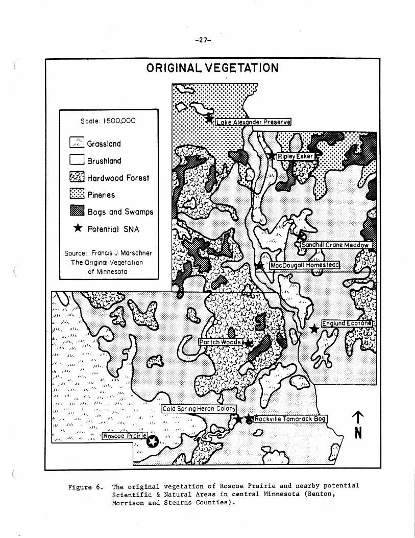
-27-
ORIGINAL VEGETATION
'·
Scale: 1:500,000
l:2J Grassland
D Brushland
t~~~J Hardwood Forest
[] Pineries
B Bogs and Swamps
* P0tential SNA
Source: Francis J. Marschner The Original Vegetation
of Minnesota
,1\ll,, ·'''··
·"'· ,,\/1,
,,, "11,
I • .1111
'· ,\ll. ,di,
Ill ,\\/,.
............. ··.<<<·:-:-:.:-:-:.:: :-
1' N
Figure 6. The original vegetation of Roscoe Prairie and nearby potential Scientific & Natural Areas in central Minnesota (Benton, Morrison and Stearns Counties).

II
• .
-28-
N
r
KEY
Bluestem/Indian Grass Prairie
Brome Grass/Disturbed Upland Prairie
Willow Shrub
Wet Sedge Marsh/Willow Shrub
Aspen Woods
Rocks
0 Disturbance Pockets
County Road 16
++++++- Railroad
Burn Units
Scale: 811: 1 Mile
Figure 7. Vegetative communities identified on Roscoe Prairie in 1977. The figure is based on a 1976 color infrared aerial photograph of the tract.

-29-
The Aspen Woods constitutes six acres or lOfo of the tract.
1rhe dominant species is Aspen ( Pdpulus tremuloides) . 'l1his com
munity has increased markedly in area since mowing stopped.
The Hrome Grass area is the one part of the tract which
was plowed. It covers 5 acres, or 9% of the total area. ~he
dominant grasses are brome Grass (bromus inermis) and/Kentucky
Blue Grass (Poa pratensis). Goldenrod (Solidago _§£.) is the
dominant forb.
A couple of small pockets in the southeastern corner of
the site are covered with Willow (Salix .§.E.) 'l'hese pockets
account for one acre or 2% of the site .
Scattered throughout the southern third of the prairie are
Disturbance Pockets (haystack sites and mima mounds). Dominant
forbs here include Evening Primrose (Genothera biennis) and
and Goldenrod (Solidago §_£.). Approximately one acre, or 2~
of the site, is covered with these pockets.
Significance of Roscoe Prairie's Vegetative Communities
One of Roscoe ~rairie's most significant elements is its
prairie. Indications are that relatively undisturbed native
prairie ,like Roscoe Prairie, is uncommon in the state. Further
more, it is uncommon in the state to have one site supporting
markedly different wet, mesic and dry prairie vegetation with
minimal topographic variation. Roscoe Prairie is also one of
the few protected prairies on a sandy outwash plain in the state
outside of the Anoka Sand Plain and some river terraces. F'in
ally the prairie is significant because it supports several plant
species which are infrequent on I'viinnesota' s prairies (See below).

-30-
Additional Research/Inventory Needs
Ros~oe Prairie's wet/mesic/upland prairie transition zones
offer wide opportunities for ecological research. The 1977
inventory team set up permanent transect lines marking the pre
irie/marsh· ecotone. These transects could be sampled period
ically to determine changes in the plant communities.
Sources of Information
Curtis, J.T. 1959. The Vegetation of Wisconsin. University of Wisconsin Press, ~adison. 651 p.
Kratz, T.and Jensen G.L.1977. An ecological geographic division of fv'.innesota. Unpublished.
~arschner, F.J. 19JO. The Original Vegetation of ~innesota (~ap). USDA. North Central For~st Exp. Sta., St. ~aul.
FLORA
Plant species are one of the primary components of the
state's natural heritages. Plants indicate the diversity of
an area, the type of biotic community present, and changes occur
ing in that area including the degree of human disturbance.
Rare plant species may be one reason for designating an area
as a Scientific & Natural Area.
Roscoe Prairie was visited on a weekly basis, when weather
conditions permitted, from 2J iviay to 2 September 1977. Each
vegetative community was randomly sampled during these visits.
Plants that were encountered in fruit or flower were collected,
identified and pressed. Usually whole specimens were collect
ed, but with some large plants only flowers and leaves were
collected. Rootstocks of uncommon species were left undisturbed.
After the plants had been positiyely identified they were given

-31-
a catalog number and housed in both the University of lv.innesota
Herbarium, Botany Department, St.Paul, and in St. John's Univ
ersity Herbarium, Collegeville.
A phenological. record of the site's flowering plants was
also kept. 'rhe phenolog.ical. record began on the first visit and
ended on the last visit.to the area. The first time a species
was encountered in flower was taken to be the start of the flow-
ering period. These dates were then extended o'n subsequent vis
its until floral senescene was noted.
Plants were identified through several sources (cited at ·
the end of this section). Dr. John W. ~core, retired botanist,
University of ~innesota, verified seventy-eight species. ~leven
species were observed but not collected. Seventeen specimens
could not be verified because they were accidently lost.
Roscoe Prairie's Vascular Flora
Table]_ is an annotated list of the vascular plants identi
fied on the tract.1 For its size rioscoe ~rairie supports a
diverse flora: a total of 106 species, representing thirty-
two families, were encountered during the 1977 inventory. unly
nine of these species have been introduced and are not native
to Minnesota. Eleven species had not been previously collected
from Stearns County and deposited in the University of rv1inne
sota Herbarium. The vast majority of species (94~ of the total)
grow on the Bluestem Upland ~rairie. (Only two species other
than sedges were found in the wet marsh: Lysimachia .Thyrsi-
1. Nomenclature is according to Gleason and Cronquist (1963). Additional plant lists alphabetically organized by common name, scientific name and family are on file, 'l'~C 1~1innesota Chapter.

-32-
Table. 3. Annotated Flora List of Rbscoe Prairie.
Format: Scientific name. Common name. Collection number of voucher specimen. Collection number in parentheses indicates specimen was lost before verification. (Notes on nomenclature and taxonomy.) Designated "introduced" if not native to Minnesota. Community in Roscoe Prairie. Special significance of collection, if any. Asterisk (*) if this constitutes the first collection from 8:tearnsCounty in the University of Minnesota Herbarium. A (+) indicates species was noted but not collected.
I. PTERIDOPHYTA - Spore-bearing Plan.ts Equisetum palustre L. - Horsetail, Scouring Rush. #12. Bluestem Prairie (*)
II SPERMATOPHYTA - Seed Plants
A. GYMNOSPERMAE - Gynmosperms
B. ANGIOSPERMAE - Angiosperms
1. MONOCOTYLEDONAE - Monocots
AMARYLLACEAE - Amaryllis Family Hypoxis hirsuta Gov. - Yellow Star-Grass. (#2). Bluestem Prairie.
COMMELENACEAE - Spiderwort Family Tradescantia bracteata L. - Long Bracted Spiderwort. (#13). Bluestem Prairie.
CYPERACEAE - Sedge Family Carex brevior Mackenzie - Fescue Sedge. #39. Bluestem Prairie.
GRAMINAE - Grass Family Andropogon gerardi Vitm - Big Bluestem. 1172. Bluestem Prairie. Andropogon scoparius Michx. -- Little Bluestem. #82. Bluestem Prairie. Bromus inermisLeyss. - Brome Grass. #29. Introduced. Bluestem Prairie-disturbed
areas. Bromus kalmii Gray - Brome Grass. #65. Bluestem Prairie. Muhlenbergia racemosa (Michx.) BSP - Muhly. (+). Bluestem Prairie-wetter
areas. Panicum leibergii (Vasey) Scribn - Lieberg's Panic Grass. #32. Bluestem Prairie. Phalaris arundinacea L. - Reed Canary Grass. #45. Bluestem Prairie - planted. Poa pratensis L. - Kentucky Blue Grass. #24. Introduced. Bluestem Prairie-
disturbed areas. Sorghastrum nutans Nash - Indian Grass. 1180. Bluestem Prairie. Spartina pectinata Link. - Cord Grass, Slough Grass. #68. Bluestem Prairie-
wetter areas. Sporobolus heterolepis Gray. - Prairie Dropseed. 1173. Bluestem Prairie. Stipa sp ... - Needle and Thread Grass. (+). Bluestem Prairie-uplands.
IRIDACEAE - Iris Family Sisyrinchium angustifolium Mill. - Blue-eyed Grass. #20. Introduced.

-33-
LILIACEAE - Lily Family #35. Bluestem Prairie-uplands.
#71. Bluestem Prairie. Allium canadense L. - Meadow Garlic. Allium stellata Ker. - Prairie Onion. Lilium philadelphicum L. - Wood Lily. Lilium superbum L. - Turk's Cap Lily. Zygadenus elegans Pursh. - White Camus.
ORCHIDACEAE - Orchid Family
#49. Bluestem Prairie-wetter areas. #61. Bluestem Prairie.
#27. Bluestem Prairie.
Cypripedium. calceolus L. - Yellow Lady's Slipper. (#23). Bluestem Prairiewetter areas.
Cypripedium candidum Muhl. - White Lady's Slipper. (#25). Bluestem Prairiewetter areas.
Spiranthes cernua Rich. - Lady's Tresses. #90. Bluestem Prairie-wetter areas.
TYPHACEAE - Cattail Family Typha sp. - Cattail. (+). Sedge Marsh-scattered pockets.
2. DICOTYLEDONAE - Dicots
APOCYNACEAE - Dogbane Family ~pocynum androsaemifolium L. - Dogbane. #51. Bluestem Prairie-uplands.
ASCLEPIADACEAE - Milkweed Family Asclepias incarnata L. - Swamp Milkweed. #56. Bluestem Prairie-wetter areas. Asclepias ovalifolia Decne. - Oval Leaved Milkweed. #14. Bluestem Prairie. * Asclepias speciosa Torr. - Showy Milk.weed. #78. Bluestem Prairie. * Asclepias syriaca L. - Common Milkweed. (+). Bluestem Prairie. * BORAGINACEAE - Borage Family Lithospermum canescens Lehm. - Hoary Puccoon. #3. Bluestem Prairie.
COMPOSITAE - Composite Family Agoseris glauca (Pursh) D. Dietr. - Prairie Dandelion. #52. Bluestem Prairie. Aster azureus L. - Azure Aster. #89. Bluestem Prairie. Aster ptarmicoides (Nees.) T & G - Upland White Aster. #62. Bluestem Prairie. * Echinacea pallida Nutt. var. angustifolia Cronq. - Purple Coneflower.
#48. Bluestem Prairie-uplands. Erigeron philadelphicus L. - Daisy, Fleabane. #17. Bluestem Prairie. Eupatorium maculatum L. - Joe-Pye-Weed. (+). Sedge Marsh. * Eupatorium perfoliatum L. - Boneset. (+). Sedge Marsh. *
" Heliopsis helianthoides (L.) Sw. - Ox-Eye. #47. Bluestem Prairie. Helianthes maximiliana Schrad. - Maximilian's Sunflower. #79. Bluestem Prairie. Hieracium ~~-Hawk.weed. (#93). Bluestem Prairie. Krigia biflora (Walt.) Blake - Dwarf dandelion. #34. Bluestem Prairie. Liatris ligulistylis K. Schum - Large-Headed Blazing Star. #77, #83. Bluestem
Prairie. Liatris punctata Hook. - Dot~ed Blazing Star. #84. Bluestem Prairie. Liatris pycnostachya Michx. - Prairie Blazing Star. #69. Bluestem Prairie. Prenanthes aspera Michx. - Rough Rattlesnake Root. #85. Bluestem Prairie. Rudbeckia hirta L. - Black-eyed Susan. #46. (Rudbeckia serrotina Nutt.).
Bluestem Prairie. Solidago missouriensis Nutt. var. fasciculata Holz - Missouri Goldenrod. #67.
Bluestem Prairie. * Tragopogon pratense L. - Goat's Beard. (#16). Introduced. Bluestem Prairie. *

-34-
CRUCIFERAE - Mustard Family Lepidium densiflorum Schrader. Pepper Grass.. (1191). Thlaspi arvense L. - Penny Cress. (#40). Introduced.
FABACEAE - Bean Family
Bluestem Prairie. Bluestem Prairie.
Amorpha canescens Pursh - Lead Plant. #59. Bluestem Prairie. Amorpha nana Nutt. - Dwarf False Indigo. #7. Bluestem Prairie.
*
Astragalus crassicarpus Nutt. - Prairie Plum; Buffalo Bean. #21. Bluestem Prairie. Desmodium canadense (L.) DC - Tick Trefoil. #58. Bluestem Prairie. Lathyrus venosus Muhl. - Vetch. #8. Bluestem Prairie. Medicago lupulina L. - Alfalfa. #74. Introduced. Bluestem Prairie. Melilotus alba Desr. - White Sweet Clover. #64. Introduced. Bluestem Prairie. Petalostemun candidum Michx. - White Prairie Clover. #60. Bluestem Prairie. Petalostemum purpureum Rydb. - Purple Prairie Clover. #70. Bluestem Prairie. Psoralea argophylla Pursh - Silverleaf Scurf Pea. #63. Bluestem Prairie. Trifolium procumbens L. - Low Hop Clover. #74B. Introduced. Bluestem Prairie.
GENTIANACEAE - Gentian Family Gentiana andrewsii Griseb. - Closed Gentian. #87. Bluestem Prairie-wetter areas. * Gentiana puberula Michx. - Prairie Gentian. #88. Bluestem Prairie.
LABIATAE - Mint Family Monarda fistulosa L. (var. mollus Benthum) - Wild Bergamot. #66. Bluestem Prairie. Pycnan~hemum virginianum Durand & Jackson - Mountain Mint. #81. Bluestem Prairie. Scutellaria galericulata L. - Marsh Skullcap. (#37). Wet Sedge Marsh-isolated
specimens. Scutellaria parvula Michx. - Prairie Skullcap. #54. Bluestem Prairie.
LOBELIACEAE - Lobelia Family Lobelia siphilitica L. var. ludoviciana DC - Great Lobelia. #92. Bluestem
Prairie-wetter areas. Lobelia spicata Lam. - Pale-spiked Lobelia. #57. Bluestem Prairie.
ONAGRACEAE - Evening Primrose Family Oenothera biennis L. - Evening Primrose. #95. Bluestem Prairie-disturbed areas. Oenothera serrulata Nutt. - Cut or Toothed Leaved Evening Primrose. #50.
Bluestem Prairie.
OXALIDACEAE - Wood Sorrel Family Oxalis stricta L. - Wood Sorrel. (#38). Oxalis violacea L. - Violet Wood Sorrel.
POLEMONIACEAE - Phlox. Family
Bluestem Prairie. * 114. Bluestem Prairie.
Phlox pilosa L. - Prairie Phlox. #10, #94. Bluestem Prairie.
POLYGALACEAE - Milkwort Family Polygala senega L. - Seneca Snakeroot. 1118. Bluestem Prairie.
PRIMULACEAE - Primrose Family Lysimachia quadriflora Sims - Prairie Loosestrife. #75. Bluestem Prairie. Lysimachia thyrsiflora L. - Marsh Loosestrife. #36. Sedge Marsh.

-35-
RANUNCULACEAE - Crowfoot Family Anemone canadensis L. - Canadian Windflower. (#11). Bluestem Prairie. Anemone cylindrica Gray - Anemone. (#43). Bluestem Prairie. Anemone patens L. - Pasque Flower. #97. Bluestem Prairie. Delphinium vitescens Nutt. - Prairie Larkspur. (#44). Bluestem Prairie-uplands. Thalictrum dasycarpum Fisch & Ave-Lall. - Tall Meadow Rue. #26. Bluestem Prairie.
ROSACEAE - Rose Family Fragaria virginiana Duchesne. - Strawberry. (#19). Bluestem Prairie. Geum macrophyllum Willd. - Avens. (+). Bluestem Prairie. Geum triflorum Pursh - Prairie Smoke. (#6). Bluestem·Prairie. Potentilla argentea L. - Silvery Cinquefoil. (+). Introduced. Bluestem Prairie-
disturbed areas. Potentilla arguta Pursh - Tall Cinquefoil. #42. Bluestem Prairie. Rosa blanda Ait - Smooth Rose. #15. Bluestem Prairie.
RUB IACEAE - Madder Family Galium boreale L. - Northern Bedstraw. #9. Bluestem Prairie.
SALICACEAE - Willow Family Populus tremuloides Michx. - Quaking Aspen. 1191. Aspen Woods. Salix~- Willow. (+). Sedge marsh-intruding.
SA.XIFRAGACEAE - Saxifrage Family Heuchera richardsonii R. Br. - Alum Root. #28. Blluestem Prairie.
SCROPHULARIACEAE - Figwort Family Veronicastrom virginicum (L.) Farw. - Culver's Root. #53. Bluestem Prairie.
SOLANACEAE - Nightshade Family Physalis heterophylla Nees - Clammy Ground Cherry. #86. Bluestem Prairie
disturbed areas.
VIOLACEAE - Violet Family Viola pedata L. - Bird's Foot Violet. (+). Bluestem Prairie~
UMBELLIFERAE - Parsley Family Cicuta maculata L. - Water Hemlock; Spotted Cowbane. Zizia aptera (Gray.) Fern. - Golden Alexanders. #1.
#53. Sedge Marsh. Bluestem Prairie.

-36-
flora and Scutellagria galericulata. A few other species were
found in drier areas of the marsh and on the degraded prairie).
Well-represented families on the site include the composites
with eighteen species (accounting for 17~ of the total species),
the grasses with twelve species ( 11/o of the total) , and the
bean family with ten species ( 10% of the total). 'l'he sedges
are also probably abundant, but due to problems in collection
and identification few examples were found.
Figure_Q_ records when Roscoe Prairie's flora flowered in •
1977.1 Sixty-nine species were observed in flower. ~he peak
blooming period was during the second week of June when twenty-
eight species were in flower. A seGond smaller peak occured
in the third week of July when twenty species were flowering.
Significance of Roscoe Prairie's Flora
Seven species encountered on Roscoe ~rairie are noted as
special and/or infreq.uent species occuring in 1\linnesota. lv1ost
of the plants have also been singled out for special considera-
tion in other states; one of the species has been proposed as
nationally threatened.
Amorpha nana (Fragrant Indigobush) and Asclepias speciosa
(Showy Milkweed) have both been noted as infrequent species
in Minnesota (Heitlinger, 1977).
Gentiana andrewsii (Closed or Bottle Uentian) has never
been col.1ected from Stearns County and deposited in the Univer-
sity of Iviinnesota Herbarium. It is noted as an infrequent spe
cies in lV1innesota (Hei tlinger, 1977). 'l'he plant has been class-
1. A list of the flowering periods of species found on the site is on file, TNC ~innesota Chapter.

-37-
30
r ,
25
20 , ....
' 15 l
. I- • - ,__ ,__ -+-i-++-l-++-+-+-~-++.i-+~·+~-IH-·+-1--+-+-I-+- +-t-t-++-t-+-+- ,t-+-Hl-+-hl-+4-1"++.i-1
Ill. ~ ~ ~~-~- ~· -~--~~~~-~
....... I- . .. ~-~· ~ ~ . t- ~ ~ ~ .
10 ·-i--ll--i-++--1- . ._._.._. ~ llli . . -+ -+-1r-+·-+-1~+-i-+-+-t-++
~~~~~..+-l-+--1. -'-4-+--4- ~- ~ . - .. -~- """'" . ~ .
5 . -~-~~
0
MAY JUNE JULY AUGUST SEPT
Figure 8. Numbers of plant species observed in bloom on Roscoe Prairie. Observations were recorded from 23 May to 2 September 1977.

-38-
ified as rare and endangered in South Dakota (Kartesz ~ Kartesz.
1977: 126).
Gentiana puberula (~rairie uentian) is an infrequent spe-
cies in .r~dnnesota (He i tlinger, 1977) . ·rhis species is threat
ened in lv4ichigan and rare in lV~ani toba (Kartesz & !\.artesz, 1977:
126).
Heitlinger (1977) cla~sified Lilium philadelphicum (~ood
Lily) as a special species and listed it as an infrequent spe
cies in lVlinnesota. This plant is also protected in the state.
Spiranthes cernua (Lady's Tresses) is another infrequent
species occuring in the state (heitlinger, 1977). South Dakota
has listed the plant as rare and endangered. (Kartesz
& Kartesz 1977:268).
Cypripedium candidum (Little White Lady-slippe~ was proposed
as a nationally threatened species in the 1 July 1975 Federal
Register. In the Midwest the species is endangered in Wiscon
sin, rare and endangered in South Dakota and rare in North Da
kota. In lV1innesota the species is protected and has been noted
to be a special and infrequent species (~1oyle, 1975; Heitlinger,
1977) . Nine other states plus N~ani toba and Ontario classify the
plant~ sratus as either threatened, probably extinct, rare, endan
gered or undetermined (Kartesz & Kartesz, 1977:85).
In addition to the above plants Roscoe Frairie's Furple
Coneflower (Echinacea pallida) stands are of special interest.
The Roscoe Prairie stands have been labeled "unique" by Dr.
David Grether, and " ... one of the finest in the state" by the
DNR SNA program.

-39-
Additional Inventory/Research Needs
Although a fairly complete record of Roscoe Prairie's vas
cular flora is now on hand the 1977 inventory did not survey
the site's non-vascular plants. A survey of the non-vascular
plants, such as the lichens, could be done. 'l'he site's sedges
could be re-inventoried since apparently the 1977 inventory is
not 9omplete. Also, the prairie flora is probably larger than
indicated by the 1977 inventory.
Sources of Information
Pernald, ivierri tt Lyndon. 1950. Gray's Manual of Botany. American Book Company, NY.
Gleason, Harry A. 1952. New Brittan and Brown Illustrated Flora of the Northeastern United States and Adjacent Canada. Eighth edition. Lancaster Press, Lancaster, PA •
. and A. Cronquis,t. 1963. rv,anual of Vascular F'lants --------o~f Northeastern United States and Adjacent Canada. Van
Nostrand Rheinhold Co. N.Y.
Heitlinger. N.ark. 1977, Checklist of selected vascular plants of l\'amesota including uncommon species. Unpub. Iv.innesota Chapter of '!'NC.
House, Homer D. 19J5. Wild Flowers. Iv~acua11an Co., NY
Kartesz, John T. and Rosemarie Kartesz. 1977. 'l'he Biota of North America·. Part 1: Vascular Plants. Vol. 1: rlare Plants. BONAC, Pittsburg, PA J61p ..
ll/ioyle, John D. 1975. The uncommon ones. lV1innesota Dept. of Natural Resources, St. Paul.

-40-
BUTTERF1LIESl
Butterflies are found in virtually all of ~innesota's nat
ural areas. 'l'hey are insect herbivores which feed on and pol
linate plants and affect plant distribution and abundance.
Butterflies as pr~mary consumers provide sustenance for animals
hjgler q>on the food chains. A butterfly inventory is necessary
to document an area's natural diversity, to identify rare spe
cies needing special protection, and to gain a better understand
ing of many species which are poorly known. F'inally, some but
terflies are sensitive ecological indicators, providing useful
information on changes occuring in the area.
lViethods
In 1977 a detailed inventory of Roscoe Prairie's butter
flies was carried out.2 Biweekly visits were made to the site I
from J Niay to 20 September 1977; twenty visits to .. · the area were
made during this time. 1.1.'he first intensive butterfly sampling•
however, was begun during June. Visits were made when possible
during hours and weather conditions favorable for butterfly
activity. Sampling was focused along the central axis of the
upland prairie. Other sampling was guided principally by the
researcher's expectation of where significant butterfly activity
was likely to be.
1. The term butterflies in this document refers both to the true butterflies (Papilionoidea) and the Skippers (hesperiodea).
2. A more detailed report of this study is on file, TNC, ~.innesota Chapter.

-41-
Observations of adult and immature butterflies were record
ed together with the location, haaitat type and associated plant
species. A rough estimate of each species' frequency was also
made. 1 Butterflies were usually identified by sight, but a
standard butterfly net was employed to capture the insects for
identification when necessary. All captured insects were re
leased except when reliable identification required a prepared
specimen, or when a voucher specimen was desired~ All specimens
were deposited in the Department of Entomology, Fisheries and
Wildlife collection, University of Iv.innesota, St. t-aul.
Scientific and common names used here are taken from ttuber
(1975a), with the addition of some subspecific names based on
Howe (1975). Subspecific names are given only when the popula
tions could clearly be assibrned to a subspecies other than the
nominate. In unclear classes the subspecific name is followed
by "ssp" ("subspecies").
Butterflies of Roscoe Prairie
Table~ lists in alphabetical order the butterflies ob
served on the site and two butterflies observed on immediately
adjacent land. 2 Thirty-seven species of butterflies including
eleven skipper species were observed at least once within the
1. An effort was made to quantitatively sample the Dakota ~kipper population however. For further information see TNC Minnesota Chapter files and Robert Dana, Univ. of l'v.1'4 Dept. of Entomology, Fisheries and Wildlife, St. Paul.
2. Table __!!-._also includes two species recorded on the site by Dana and others in 1976 but which were not observed in 1977. One other species, the Silvery Checkerspot (Chlosyne nycetis) was observed on the site in 1976, but only on adjacent lands in· 1977.

'!'able 4
-42-
Butterflies observed on rloscoe rrairie
Ancyloxypha numitor" (Least Skipper) Atrytone delaware (Delaware Skipper) Boloria bellona ( iw•eadow Fri tillary) Boloria selene (Silver bordered Fritillary) Celastrina argiolu~ (Spring Azure) Cercyonis pegala {Wood Nymph) [Chlosyne nyceteis (Silvery Checkers:pot) ]* Coenonympha tullia (Inornate Ringlet) Colias euf¥theme (Alfalfa butterfly) Colias ph1lodice (Common Sulphur)
· Dana.us plexipTus (IV,onarch) . Euphyes dion Dion Skipper)* Euptoieta claudia (Variegated Fritillary) Euptychia cymela (Little Wood Satyr) Everes comyntas (Eastern Tailed Blue) Hesperia dacotae (Dakota Ski:pper) Limenitis arch1ppus (Viceroy) Limenitis arthemis (Beaded Purple) Lethe eurydice (Eyed Brown) Lycaena thoe (bronze Copper)* Nymphalis antiopa (~ourning Cloak) Oarisma powesheik (Powesheik Skipper) Papilio polyxenes asterias (black Swallowtail) Pholisora catullus (Common Sooty Wing) Phyciod!s tharos (rearl Crescent) [Pieris protodice (Checkered White)] fieris rapai (European Cabbage ~utterfly) Plebejus me issa melissa (~elissa Blue) Poanes massaso1 t (iY1ulberry Wing) Poanes viator (Broad-winged Skipper) _ Polites coras(Feck's Skip:per) Pol1tes mystic (Long Dash) Pyrgus communis· (Checkered Skipper) Satyrium acadica (Acadian Hairstreak) Speyeria aphrodite (Aphrodite Fritillary) Speyeria cybele (Great Spangled Fritillary) Speyeria idalia (Regal Fritillary) Wallengrenia egeremet (Broken Dash) Vanessa atalanta rubria (Red Admiral)
- Vanessa cardui (Painted Lady) Vanessa virginiensis (American Fainted Lady) Euphyes dion (Dion Skipper)*
* - Observed in 1976 [ ] - Indicate the species was observed adjacent
to. but not on, the site in 1977.

-43-
boundaries of the tract during the 1977 study. The species
and species diversity reflects the various types of vegetative
communities found on the site and its surroundings.
The U»land frairie harbored the largest number of butter
fly species. The Dakota Skippers (Hesperia dacotae) were observ
ed in small numbers over a period of about two weeks (23 June
to 5 July 1977). An estimated twenty-five individuals were
sighted during this time. These observations together with
sightings made by Dana and· others in 1976 and by l'l1r.\ Jim fi"uggil
in 1966 (Huber. 1975b) establishes the presence of a small local
population of Dakota Skippers on Hoscoe ~rairie. r'igure _J_
shows where the skipper was observed on the site in 1977. ln
almost all cases the butterfly was spotted on flower heads of
the Purple Coneflower. Except for one sighting all the Dakota
Skippers were observed on the highest, best-drained parts of the
prairie.
Three other obligate prairie butterflies were identified
on the site. The Powesheik ·skipper was observed in about the
same numbers as the Dakota Skipper. This insect appears to be
rather generally distributed in the portion of l'viinnesota former
ly prairie (not in prairies on sandy outwash in the central part
of the state however), surviving along railroad rights of way
and in larger prairie remnants (Dana pers. obs.; huber, unpub.
date) .1 'l'he Regal Fri tillary was observed on the site in modest
1. lV.r. Ron Huber, Zoology Assistant with the ~cience i~1useum of ~innesota, St. faul has for a number of years been collecting data on the state's butterflies. This considerable body of information is not published and fV!r. huber•s generous assistance in making available this information to the researcher is gratefully acknowledged.

~ .. -.. -"5~
-44-
. ~·
,..,,--,·· .. ·· ... ~--~ (-· OP-!' w.ler
~,'
I I t I I
I ' I ,'
,' I
3a
•• -·3_!.
8
Figure 9.
! I
. i i \ !
• . • . • • • .
.· . .·. ..
\ I
~----
. .. .. .. 1
.. .. .. .. • ..
... ····· ... ·
~
..······ ...... ···
Approximate locations of four butterfly species observed in relation to Roscoe Prairie's major plant features in 1977. The key to the figure is on page 45.

-45-
Key to Figure 9.
SYIIi?ol Major Plant Features
l· Native upland prairie
la Prairie, nnre xeric in character
2 Previously plowed upland prairie
3a Wet prairie/ sedge-willow-do~ conm..nity (predominantly shrubby)
3b Wet prairie/ sedge-cattail coom.nity (predominantly open)
4 Aspen
5 Upland pasture .(predominantly open)
6a Wet pasture (predominantly open)
6b Wet pasture (predominantly willow)
7' Vk>oded pasture (aspen)
8 Cultivated land

-46-
numbers. With one probable exception all were males flying
above the upland prairie. The single probable female was flush
ed fro~ the longer grasses on one of the "mima mounds", but it
could not be captured for identification. r.Lhis species is found
only in association with native prairie remnants in ~.innesota
(including sand prairie in the southern part but not the central
part of the state; Dana pers. obs.; huber unpub. data). 'l:he
third butterfly, the l~1elissa .blue appears to be exIJanding its
range so that it is no longer confined to prairies. 1l 1he nomin
ate subspecies found on Roscoe Prairie is common throughout the
western parts of ~innesota usually in association with prairie
remnants (al though these may be very badly degraded). 1~,ost of
the adults observed on the site were in the limited part of the
prairie where Ground Plum (Astragalus crassicarpus) grew.
In addition to the above obligate prairie species twenty
common species were observed on the moist meadows and prairie
communities. Peck's Skipper and the Long Dash,two very common
skippers often found together in a variety of moist meadow situ
ations, were fairly 1common on the site. both were encountered
throughout the prairie parts, but they were most frequently ob
served in the disturbed prairie area and along the railroad.
A .small but typical number of the widespread Delaware Skipper
were observed in the prairie and disturbed· prairie areas. A
single male Broken Dash was seen at the extreme east end of the
prairie, and a single female ·rawny Edged Skipper was observed
on a Purple Coneflower blossom. These species are very widely
distributed. Two grassland satyrid butterflies, inornate Ring
let and Cercyonis pegala, were common throughout the prairie

-47-
parts including the disturbed area. '11he l\,onarch was common all
summer. Also the Great Spangled .. Fri tillary was common o:n the
site; adults were encountered everywhere on the tract. 'l'he
Aphrodite Fritillary was somewhat less common although it was
seen all over the tract. Two of the small fritillaries, the
Silver Bordered F·ri tillary and the lV,eadow Fri tillary were observ
ed in fair numbers mostly in the moister prairie areas and in
the formerly cultivated part of the prairie. 'l'he Pearl Crescent
was most commonly encountered in the moister areas although it;
was also common throughout the prairie. Only a few individuals
of the American Painted Lady were positively identified, all
·on the drier prairie (but several butterflies were sighted that
could have been this species). The tiny Eastern Tailed Blue
was found to be modestly frequent on the prairie upland espec
ially in the southeast part. The Black Swallowtail was seen
in small numbers on the s~te, usually on the prairie areas.
Two closely realted Sulphurs, the Alfalfa butterfly and the
Common Sulphur were recorded on the prairie, the former quite
frequently and the latter only a few times. The introduced
European Cabbage Butterfly was found in modest numbers mostly
on disturbed soil near the road edge. The Common Sooty v~ing
was encountered once in the drier part of the prairie.
Four butterflies, catagorized as irregular migrants or
"colonizers", were observed on the site. One female Checkered
Skipper was encountered on the prairie relatively early in the
season, but none were subsequently observed. The Variegated
Fritillary was recorded several times on the prairie upland.

-48-
In the early part of the season there was an unusually heavy
irmnigration from the south of the Red Admiral. Individuals
were seen rapidly flying across the area in a northerly direc
tion. The Painted Lady was positively identified only once
on the prairie upland. This species is more of an open habitat
butterfly than the above butterflies and also fluctua,tes greatly
in numbers from year to year (Dana, pers. obs.).
The }';;ulberry Wing (Poanes massaoi t), a small, intensely
local skipper, was observed once in the sedge meadow near the •
tract's north boundary. A single individual was also encoun-
tered a few yards beyond the west boundary in pastured sedges
where about four of the skippexshad been seen during one visit
in 1976 (See F'igure .. 2J. Only one specimen of the Broad vVinged
Skipper (Poanes viator) was encountered in the sedge slough just
north of the prairie (See Figure_.2_). In this same area several
of the Don Skipper (Euphyes dion) were observed in 1976, but
none were observed in 1977. The status of the Broad v~inged and
Don Skippers is unclear from this data, but indications are
that a small locally established population of both species
is present.
Five common species were observed in the Sedge-Willow com
munities in 1977. The Eyed Brown was surprisingly very uncominon,
with all sightings concentrated near the southern boundary of
the Sedge-dominated community. The Viceroy and Acadian hair
streak, two butterflies whose larva feed on Willows, were found
primarily in or near the Sedge-Willow community in modest num
bers. The ~ourning Cloak was frequently encountered on the

-49-
tract, p~rticularly along the railroad. ~he Spring Azure, a
nearly ubiquitous butterfly, was seen a few times. Another
species, the bronze Copper, was not observed this year although
it was recorded on the site in 1976.
Two butterflies were observed on the tract which are as-
sociated with forest communities. A couple Little Wood ~atyrs
were seen in the shrubby margin of the Aspen grove on the east
side of the tract. A couple Banded Purples were also seen back
in among the trees.
Finally, two butterflies were recorded next to the tract
but not within its boundaries. The Silvery Checkerspot usually
frequents the vicinity of woods. It was seen a few times alonG
the railroad track a few yards east of the tract. In 1976 it
was observed in the Shrub-Sedge area near the tract's east side.
One Checkered White was also seen at the junction of the rail
road and the road at the southwest corner of the tract. how-
ever, this area does not appear to provide fav·orable ha bi tat
for the butterfly.
Sisnificance of Roscoe Prairie's .Outterflies
The most noteworthy butterfly present on Roscoe Frairie
is the Dakota Skipper. Almost nothing is known about this spe
cies, other than its rarity.1 Roscoe Frairie is one of eibht
stations in ~jinnesota where the skipper has been reported since
1925.2 The only other records of the species since 1925 come
1. Rbbert Dana is olirrently .:doing graduate research on the Dakota Skipper.
2. This includes one station discovered by Dana in addition to those noted in Huber's (1975b) observations summary.

-so-
from seven counties scattered in North and South Dakota and
Iowa. The colony at Roscoe Prairie is on the ed~e of what was
undoubtedly the original range of the insect and is the eastern
most surviving colony known. In the 3 July 1978 Federal Re~ister
the Dakota Skipper was proposed as a nationally threatened species.
Roscoe Prairie supports several other uncommon butterflies,
including Powe-sheik Skipper; Regal Fri tillary; 4;,ulberry ~'Jing
and broad Winged Skipper. (In 1976 another uncommon species,
the Dion Skipper, was also observed on the site.) Uf these
butterflies the Powesheik Skipper is most in need of protection.
The continuing destruction of the skipper's prairie habitat
has raised concern for the survival of these species in the
state. Already the skipper appears to be uncommon or rare in
the rest of its limited range. ·(rlowe, 1975).
Sources of Information
dos Passos, C.F. 1965. Synonymic list of the nearctic Rhopalocera. OCem. Lepid. Soc. 1: 1-145.
Ebner, J. A. 1970. · Butterflies of ~lisconsin. i\dlwaukee 1-'ublic l\~useum, Milwaukee. 205p.
Howe, W.H. (co-ord. ed.) 1975. The Butterflies of ~orth Ameri-ca. Doubleday, Garden City, N.Y. 633p. ·
Huber, R.L. 1975a. No title (a revision of Huber, H.L., i.s. Nordin and O.R. Taylor Jr. 1966. A systematic checklist of Minnesota Rhopalocera (butterflies and skippers). 11'he Science ~useum of ~innesota, St. Paul. Unpub. mimeo. 10pp.
Huber, R.L. 1975b. Investigation into the proposal that Hesperia dacotae Skinner be considered for placement on either the threatened or endangered species lists: a preliminary survey of foinnesota populations (Lepidoptera: hesperiidae). (mimeo)

-51-
Klots, A.B. 1951. A Field Uuide to the Butte~flies East of the Houghton-1.Vdff~in, .Boston. J49p. Great Plains.
MacNeill, C.D. 1964. The skippers of th~ genus Hesperia in western North America with special reference to California (Lepidoptera: Hesperiidae). Univ. Calif. Publ. Ent. 35: 1-lJO.
Iv1cCabe, T.L. and Post, R.L. 1977. Skippers (Hesperioidae) of North Dakota. Univ. of North Dakota, Fargo, N.D. 70p.
BIRDS
Birds are another biotic component which adds to the natu
ral diversity of an area and the state. Indeed, there are more
bird species than all other vertebrates on Roscoe ~rairie.
An inventory is needed to record species diversity, identify
endangered, rare or sensitive species, and recognize changes
in species composition.
A bird census was made by walking through the area on five
occasions: 24 M.ay, JO l~1ay, 6 June, 19 June and 6 ·July 1977.
Birds were identified by sight, sound or a combination thereof.
Identification was aided by the use of a pair of binoculars and
a bird field guide.
Roscoe Prairie's Birds
Thirty-eight bird species were identified at least once
on, near or over Roscoe Prairie during the 1977 inventory. ~a
ble...i. lists the birds in phylogenetic order.1 ~ost of the birds
are common residents of the state's wetlands, grasslands, open,
semi-open and wooded areas. Two Upland Sandpiper nests were
1. The location and date the birds were observed are in a list on file, TNC Minnesota Chapter.

'l'able 5
-52-
~irds identified in 1977 on, near or over Hoscoe Prairie
(Ardea herodias) Great blue Heron* (Butorides virescens) Green Heron+ (Anas platyrhynchos) I~1allard* (~hasianus colchicus) Ring-necked Pheasant (Philohela minor) American Woodcock (Capella gallinago) Common Snipe (Bartramia longicauda) Upland Sandpiper (Limosa fedoa) Iv~arbled Godwi t*+ (Chlidonias niger) black Tern* (Zenaida macroura) l\1ourning Dove (Coccyzus erythropthalmus) black-billed Cuckoo (Tyrannus tyrannus) Eastern Kingbird (Empidonax traillii) Willow Flycatcher (Empidonax minimus)Least Flycatcher (Eremophila alpestris) horned Lark (Hirundo rustica) barn Swallow* (Telmatodytes alustris) Long-billed lv,arsh Wren+ (Cistothorus platensis Short-billed fuarsh wren (Dumetella carolinensis) Gray Catbird (Turdus migratorius) American Ribon (Dendroica petechia) Yellow Warbler (Geothlypis trichas) Common Y·ellowthroat (Dolichonyz oryzivorus) .bobolink (Sturnella magna) Eastern 1\.eadowlark (Sturnella neglecta) Western i~ieadowlark (Xanthocephalus xanthocephalus) Yellow-headed
Blackbird*+ (Agelaius hoeniceus) Red-winged Blackbird*+ (Icterus galbula Northern Oriole (Euphagus cyanocephalus) Brewer's blackbird (Quiscalus guiscula) Common Grackle + (IViolothrus ater) Brown-headed Cowbird (Pheucticus--rudovicianus) Rose-breasted Grosbeak (Spinus tristis) American Goldfinch (Passerculus sandwichensis) Savanna Sparrow (Ammodramus savannarum) Grasshopper Sparrow (Spizella pallida) Clay-colored Sparrow (lVielospiza georgiana) Swamp Sparrow (Melospiza melodia) Song Sparrow
* Observed flying over the site + Observed on land adjacent to the site

'-53-
found on the tract, and one nest adjacent to the tract. One
species, the fJ,arbled Godwit, is listed by Ivi.oyle (1975 as ,a spe
cies of concern. Four godwits were observed in aerial display
over the tract and on grassland to the south in 1977. 'l'hese
birds are primarily residents of the northwestern part of the
state. If i .• arbled Godwi ts are nesting in the area they are
near the far eastezn extent of their breeding range. Two other
Roscoe Prairie birds are near the edge of their ranges: American
~v oodock and bas tern iV,eadowlark.
Additional Inventory/Research Needs
Due to a limited field season the 1977 bird inventory may
be incomplete. Also, the inventory did not distinguish which
birds actually resided on the site. rhus a more detailed bird
inventory might be carried out to fill in these gaps.
Sources of information
Green, Janet C. and Robert B. Jans sen. 19? 5. iv,innesota .birds. University of ~innesota Press. kinneapolis.
~1.oyle, John. 1975. The uncommon ones. iv.N Dept. of Nat. rlesources, St. Paul.
Robbins, Chandler~ .• et al. 1966. birds of horth America. ~vestern Publishing Company, Inc. New York.

-54-
IV1AN1MA~S
~ammals must be inventoried to: 1) record the unit's natur
al diversitys 2) to obtain baseline data so changes in species
composition can be discerneds and J) to identify rare or sensi
tive species.
Ivi.ethods
Small mammals were censused using eighty live-traps placed
on two parallel lines set fifty feet apart. 1ach line consist
ed of twenty stations set at intervals of fifty feet. ~ach
station contained a 2x2x6 Sherman live trap and a Longworth
live trap. A peanut butter-oatmeal mixture was used to bait
the traps~ The traplines ran from the southern upland prairie
to the sedge meadow (which was dry during the trapping :t:ieriod).
The end stations of the western line of traps were permanently
marked with conduitss other stations in the same line were tem-
. porarily marked with bamboo stakes. On 8 August 1977 the traps
were all set. At approximately 7:00 Ffo that evening, 8:4.5 Alv~
on 9 August and 7:.50 Mi' on 10 August the traps were· checked.
The traps were then pulled. Specimens were deposited in the
James Ford Bell iv~useum of Natural History. University of l\.inne
sota, Minneapolis.
Large mammals were censused ·only through di~ect or indirect
observation during the bird census.
Roscoe Prairie• s IV1ammals
Nine mammal species were identified visually, by trap, or
by other signs in or adjacent to Roscoe frairie. (See Table

-ss-
_L),1 All of the mammals identified in the inventory are
widespread in N1innesota. Whitetail Jackrabbit were seen in a
field just west of the southwesteITl corner of the site. ~lains
Pocket Gophers were not seen but their presence was indicated
by mounds ·on the tract.
Sources of Information
Gunderson, Harvey L. and James R. Beer. 1953. '!'he l\.ammals of Minnesota. The University of rv.innesota Fress, lV.iinneapolis.
Table 6 N~1MALS IDENTIFIED ON ROSCO~ PRAIRIE IN 1977
(Ci tellus tridecemlineatus 'l'hirteen-lined Ground Squirrel (Geomys bur arius Plains Focket Gopher (Lepus to n · ·whitetail Jackrabbit (1"'ustela erminea) Shorttail ~~easel (Odocoileus virginianus) Whitetail Deer (Peromyscus leucopus) White-footed N1ouse ( Peromyscus manicula tus bairdi) }Jrairie Deer lV,ouse (Sorex cinereu$) ~asked Shrew (Sylvilagus floridanus) Eastern Cottontail
1. The location, dates and number of mammals recorded on Roscoe Prairie are on file, TNC Ndnnesota Chapter.

-56-
LAND USE HISTORY
Virtually all "natural area~" have been affected to some
degree by the past activities of people. Farming, grazing,
logging, hunting, drainage of wetlands and the preventipn of
fire are some of the ways people have affected the land. Know
ledge of historical land use practices helps explain the pres
ent condition of the land ~d its resources, and the origin
of human impacts on the area. Surrounding land use practices
also affect the viability of all natural areas.
Iv.ethods
p,iost of the land use information presented here is based
on interviews with local residents who are familiar with the
area. Aerial photographs were also compared to determine chan
ges in the land use over time.
Recent· Land Use·History
The St. Cloud region was first settled by ~uropeans in the
middle of the nineteenth century. ~ost of the land was cleared
for farming and grazing or used for timber production. 'l'oday
Roscoe Prairie is surrounded by cultivated fields and pastures.
Figure....lQ_ shows the owners and some of the lanp uses adjacent
to the Nature Conservancy land.
Roscoe Prairie has been affected in many ways by the acti
vities of people. The father of one resident noted deer were
rare in the area by the turn of the century. however, by the
1940's deer re-appeared and were present in fairly large num
bers by the 1950's.
The area's hydrology has also been affected by ~eople.

-57-
COUNTY ROAD 1 6
B R CULTIVATED
AND GRAZED
F CULTIVATED
3~---
HM CULTIVATED
M HH
KEY B Edmund M. & Viola Buerman, R
Paynesville, MN 56362 F James Fasbender, Rt. 1, Paynesville, S
MN 56362 HHH. & H. Farms Inc., Paynesville,
MN 56362 HM Marjorie Heitke, Rt. 3, Paynesville,
MN 56362 K Cliiford E. & Donna Knebel, Rt. 1,
Paynesville, MN 56362
K CULTIVATED
AND GRAZED
L
s
1/4 MILE
Louis Roesner, 707 Doronis Ave. Paynesville, MN 56362 Harvey F. & Fern Schultz, Rt.l, Paynesville, MN 56362
Roscoe Prairie
County Road 16
L Clarence Lauer, Paynesville, MN 56362 . +-++-+- Railroad
M Harvey W. & Alvin W. Mills, Rt. 3, Paynesville, MN 56362
Figure 10. Land uses and landowners adjacent to Roscoe Prairie. Names and addresses are from the Stearns County ~uditor's records as of 7 July 1977.

-58-
\~hen Europeans first settled in the area the land was much wet
ter than today. However,agriculture practices and drainage
ditches have reduced the steady water and accelerated the run
off rate in the region.
A 19)8 aerial photograph documents some of the changes which
occured on the tract. The photograph shows several drainage
ditches on the site (See Figure_11 .. J. In addition the
photograph indicates a field road which appears to come into
the tract from the east near the north boundary.
Hay mowing has occured on Roscoe 1-'rairie. 'fhe 19J8 aerial
photography, definitely shows the land was mowed for wild hay.
~owing also took place in the 1940's and 1950's. During this
time mowing only occured when wild hay was needed and the land
was sufficiently dry. Thus, for example, in the mid-1940's
mowing was restricted to the upland and generally happened once
per year. Wild hay was used to feed horses and when tractors
replaced horses in the 1950's and 196o•s hay mowing stopped.
Signs of the past mowing still, remain on Roscoe Prairie however:
two square features on aerial photographs (See F'igures _2_ and
Jl_) are the sites of former hay mounds. Furrows were dug around
the haystacks to protect them from fires.
The railroad abutting Roscoe Prairie has had a definite
impact on the tract. Railroads came in soon after the pioneers.
Hot sparks and cinders flying out of locomotive coal stacks
frequently ignited fires on adjacent lands. Fires were also
set purposely along the tracks t_o clear vegetation. iv.any times
these fires went out of control and the whole valley burned.

-59-
SCALE: 8":1 MILE
---------Drainage ditch (arrows indicate direction of flow)
Figure 11. 1938 aerial photograph showing past uses of Roscoe Prairie. Source: U.S.D.A.

-60-
When the trains converted to oil in the 1940's the frequency
of fires dropped although railroad~ have caused fires since
then. fn addition to causing fires the railroad also was re
sponsible for disturbing the tract's southeastern corner. Al
though it did not own the land the railroad parked some equip
ment there (date undetermined). As a result of this practice
there is QUackgrass, 1histle and S.Veet Clover present in the
area. F'inally, the railroad has sprayed herbicide on its right
of-way to clear away the vegetation. 11'his practice has probably •
affected the tract's plant and animal populations.
In the late 1940's Ervin Schultz plowed the upland in the
tract's northeast corner. Although many rocks made it difficult
to plow he did seed in Reed Canary Grass for better hay. how
ever, this practice was not continued for very long.
About 1966 the tract was rented to a h.r. lt.iller who owned
the adjoining land in the north. For about two years he grazed
feeder cattle on the site. Cattle paths along the electric fence
were one sign of this land use.
Two other noteworthy actions have affected Roscoe frairie.
About fifteen to twenty years ago someone deposited chicken man-
ure on at least two "mima mounds" in the northwest and southwest
portions of the tract. This manur.e was used to trap fox thought
to be responsible for reducing the pheasant population. iv1any
weeds were also brought into the prairie with the manure however.
The second action is the supression of fire. Roscoe Frairie
is thought to have burned annually before white settlement.
With recent fire supression efforts the frequency of fires in

-61-
the area has been reduced, which in turn has affected the vege
tation. Only six known fires hav~ occured on Roscoe Prairie
in the last twelve years. The only recent fire remembered by
the secretary of the Paynesville Fire Department occured about
1967 along a portion of the tracks near the woods~ One photo
graph taken by Dr. lV~ax. Partch, St. Cloud State University,
on 20 Aueust 1969 shows.,tne edge of a burn Dr. David Grether
conducted in both the upland and lowland. However, the exact
date and extent of this burn couldn't be determined. ~he Nature
Conservancy has done four more controlled burns on the tract.
(See Figure..!£_). One burn was done on the southwest ten acres
in late April 1977. Other controlled burns occured in the fall
of 1978on the northern half of the upland prairie, in the spring
of 1978 in the southeastern corner, and most recently in late
May 1979 in the southwestern corner again.
History of Preservation Efforts
The preservation of Roscoe Prairie is largely due to the
interest of the fouggli family of Roscoe. The iv1ugglis were res
ponsible for alerting scientists to the area, helped to acquire
the land, and have been involved in managing the tract. Dr.
Gerald Ownbey of the University of lYiinnesota also recommended
the tract be preserved. On 28 June 1968 the I'~ature Conservancy
bought the land to protect and preserve the prairie and the
significant elements of natural diversity it supports.

- 62 -
N
f
Figure 12. Controlled burns conducted by The Nature Conservancy on Roscoe Prairie, 1977 - 1979. See also figure 7.

-63-
Knowledt;Je of the number of visitors and visitor character
istics is. necessary to determine who is usir.1.t; the natural are.a
and what problems (if any) are beinb caused by various user
groups. Potential users should be identified to hel~ predict
future trends and Froblems.
Visitors were not surveyed in the 1977 inventory. however,
Roscoe }rairie hao apparently been vi~ited for many yearQ Ly
local school classes. Also, on 2.5 June 1973 approximately fifty
local residents visited the prairie on a field tri~.
~·,.any potential users exist for hoscoe 1-·rairie. J\4e to its
close proximity to Jt. Cloud a larbe increaoe in use could occur
when certain se(.;ments of the po:,t;ulation become aware of the area.
·i,.wo universi.ties, 8t. Cloud .State in st. Cloud and ~t . .:;ohn's
University in ~olleGeville and two collebes, the ~olle~e of .
. St. Lene di ct in :Jt. J ose:t-h and ~allmar ~ommuni ty ~ollebe in
il ilmar, are within half an hour's drive of the area and could
use the prairie for educational and research pur~,oses. .1...ight- ·
een public, middle and secondary schools in Stearns Jounty,
plus schools in ~enton, Candiyohi and 1:.eeker Counties, could
utilize the area for environmental education purposes. Some
users might also come up from the.twin Cities area which is
approximately two hours driving time from the 'site.

